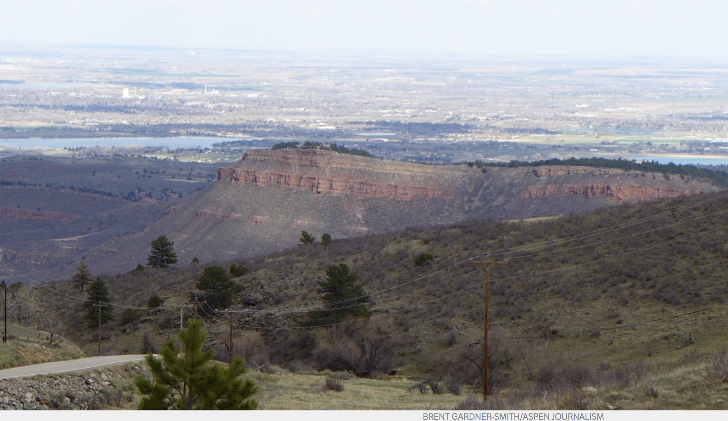
The city of Boulder signed a contract with the Tri-State Generation and Transmission Association for the sale of hydroelectric power generated at five of the city’s eight hydroelectric plants.
The deal is a 10-year agreement with an option to renew for another five years. It’s expected to generate about $500,000 per year in revenue, which will offset water utility capital improvements and operating costs that would otherwise be paid through higher water rates for customers.
The city had previously sold hydroelectric power to Tri-State from the Boulder Canyon Hydroelectric plant. This agreement renews the contract for Boulder Canyon and adds four facilities: the Kohler, Maxwell, Orodell and Sunshine plants…
Hydroelectric generation harnesses the energy generated during the downhill trip from water sources to the water distribution system. Boulder’s hydro program consists of eight plants that generate about 37 million kilowatt-hours of electricity annually, enough to power 4,600 households and displace 20,400 tons of coal.
Xcel truck at Shoshone plant. Photo credit: Brent Gardner-Smith/Aspen Journalism
The blown-out penstock in 2007 at the Shoshone plant. Photo credit: Brent Gardner-Smith/Aspen Journalism
Shoshone Hydroelectric Plant back in the days before I-70 via Aspen Journalism
Shoshone Falls hydroelectric generation station via USGenWeb
Shoshone hydroelectric generation plant Glenwood Canyon via the Colorado River District
FromAspen Journalism (Heather Sackett) via The Glenwood Springs Post Independent:
Very low flows in the upper Colorado River system are now expected to trigger calls from senior water rights tied to the Shoshone hydropower plant and irrigators in the Grand Valley. And, starting Friday, more water is to be released from Ruedi Reservoir into the lower Fryingpan River to bolster downstream flows.
The Shoshone plant has two water rights, a very senior 1902 right and a less-senior right for 158 cubic feet per second with a 1929 priority date. A call for the 1929 Shoshone right is expected to take effect on Thursday, meaning those upstream from the Shoshone hydro power plant in Glenwood Canyon who hold junior rights must stop diverting.
On July 1, another, larger call is expected to happen downstream on the Colorado — the Cameo call. The Cameo call is made up of the water rights of agriculture diverters near Palisade, including the Grand Valley Water Users Association and the Orchard Mesa Irrigation District.
The Cameo call, which is the second-most senior water right on the Colorado River, calls about 2,200 cfs down through the river system, but the diversion structures tied to the call also have the potential to nearly dry up the Colorado River in a 15-mile reach between the Palisade area and the confluence of the Gunnison River in Grand Junction. This 15-mile reach is critical habitat for endangered fish, including the Humpback Chub.
To help offset the effects of the Cameo call and other diversions on the river system, officials with the Upper Colorado River Endangered Fish Recovery Program have set a low-flow target of 810 cfs this year.
And, after meeting with other regional water managers on Wednesday, officials with the U.S. Fish and Wildlife Service plan to release on Friday 50 cfs of water that has been earmarked specifically for endangered fish from Ruedi Reservoir. Another 100 cfs will be added to the bolstered flows on Monday, bringing releases to about 260 cfs in the river below Ruedi Reservoir.
While a Cameo call is not unusual and often happens in late summer, this is the earliest it has ever taken effect, according to Don Meyer, Senior Water Resources Engineer with the Colorado River District. The previous record was July 14.
“It’s a brutal year,” Meyer said. “I think it’s going to be a dire situation for everybody, but especially the fish down there.”
This year is also the second earliest that “fish water” has been released from Ruedi Reservoir since the endangered fish program was established in 1988. During the most recent drought years, 2002 and 2012, fish water was released on June 24 and July 3, respectively.
Federal officials this year expect to be able to release 16,412.5 acre-feet of fish water from Ruedi Reservoir this year, including from a 5,000 acre-foot pool, a 5,412 acre-foot-pool and 6,000 acre-feet of water owned by Ute Water Conservancy District in the reservoir, which is to be leased for the endangered fish program.
In all, the fish program has a total of 28,000 acre-feet of water it can use from various reservoirs in the upper Colorado River system, including Ruedi, Granby and Wolford reservoirs.
The Cameo call will also put more water into the Roaring Fork River by “calling out” the transmountain diversion through the Twin Lakes tunnel under Independence Pass. The Twin Lakes Reservoir and Canal Company can move 625 cfs of water out of the Roaring Fork Basin to the Arkansas Basin, where it is used for East Slope municipal and irrigation purposes.
The tunnel is currently diverting around 50 cfs, but that will come to a halt when the Cameo call goes into effect.
“In one respect it’s a windfall for the Roaring Fork,” said Kevin Lusk, president of Twin Lakes Reservoir and Canal Company. “It’s not good for our customers, but that’s the law. It’s just part of owning a water right on a river in Colorado. This is one of those dry years so we are not surprised to see the Cameo call come on.”
Editor’s note: Aspen Journalism is covering rivers and water in collaboration with The Aspen Times and Glenwood Springs Post-Independent. More at http://www.aspenjournalism.org.
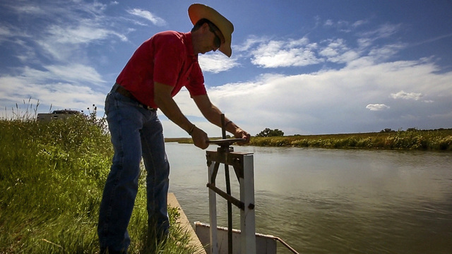
Jim Yahn turning a valve wheel. Photo by Havey Productions via a screenshot from TheDenverChannel.com.
Here’s an analysis of the legislation from Elaine Nolen writing for the University of Denver Water Law Review. Here’s an excerpt:
House Bill 17-1233 (“HB 1233”), titled Protect Water Historical Consumptive Use Analysis, accomplishes three objectives: (1) to expand application of a preexisting law to water Divisions 1, 2, and 3; (2) to clarify that participation in a government-sponsored program includes water conservation pilot programs; and (3) to limit state agencies that can approve a water conservation program to only those with explicit statutory jurisdiction over water conservation or water rights. Democratic House Representative Jeni Arndt of District 53, located in water Division 1, and Republican Senator Larry Crowder of District 35, located in water Division 2, introduced HB 1233 in the House on March 7, 2017. The House approved the bill on March 24, the Senate approved an amended version on April 17, and Colorado Governor John Hickenlooper signed HB 1233 on May 3.
A historical consumptive use analysis is part of a proceeding to change a water right. A water right owner may only change that right up to the amount of water historically consumed for a beneficial use. Prior to HB 1233, Colorado law provided that in Water Divisions 4, 5, and 6, historical consumptive use analyses were not to consider reduction in water usage resulting from participation in a government-sponsored water conservation program. In the initial draft of HB 1233, the sponsors sought to apply this rule to all seven of Colorado’s water divisions. However, at the Senate second reading, the Senate passed Senator Crowder’s proposed amendment to remove water Division 7 of southwestern Colorado from the bill. Senator Crowder explained that feedback from the representative from that water division led him to propose the amendment.
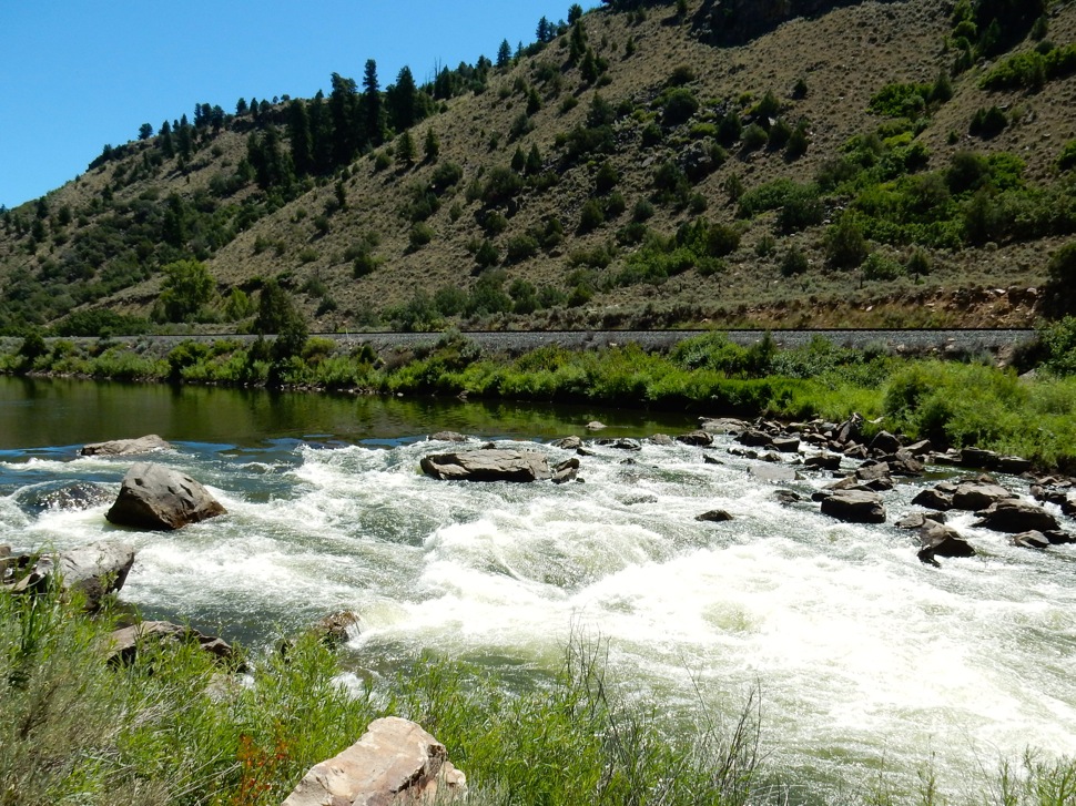
Rodeo Rapid on the upper Colorado River. Photo: Brent Gardner-Smith/Aspen Journalism
Click here to read the newsletter. Here’s an excerpt:
Colorado Basin Roundtable Integrated Water Management Planning Framework Project
The Colorado Basin Roundtable’s Integrated Water Management Planning Framework Project created guidance and on-line data tools to build a foundation for conducting comprehensive integrated water management plans in the mainstem Colorado River Basin in Colorado. The purpose of these plans is to identify ways to provide water for environmental needs in conjunction with the needs of agricultural, domestic and industrial water users. The Hutchins Water Center at Colorado Mesa University coordinated the project, and most of the technical work was conducted by Lotic Hydrological.
The Final Report for this project is available for review here.
The website that houses the on-line tools referred to in the report is here.
Issues surrounding the long-heralded CU Boulder South annexation plans continue to manifest most consistently within concerns over how eventual flood mitigation designs will play out on the property.
Those concerns were clear at a joint meeting between Boulder’s Water Resources Advisory Board and Open Space Board of Trustees on Monday, where dozens of residents from Boulder’s Frasier Meadows retirement community who wore bright orange shirts reading “Save our neighborhoods” and “Stop flooding of South Boulder Creek” urged officials to take quick action on those plans.
Upon annexation of the property by the city, the University of Colorado plans to build more than 1,000 housing units for students and employees, athletic fields and academic buildings on the 308-acre site over the coming decades. It also intends to devote nearly 100 acres of the site to a flood mitigation plan.
The parcel has proven controversial since its purchase in 1996, as neighbors have worried that university’s plans to eventually develop the site would put nearby homes at greater risk from floodwaters.
The chief flood mitigation concept — proposed under the South Boulder Creek Master Plan — includes a flood wall along the south side of U.S. 36 within the Colorado Department of Transportation right-of-way and a dam along the northern portion of the CU South parcel to contain flood waters, according to a staff report presented Monday.
Under this plan, vehicle access to CU South from Table Mesa Drive would be routed to a ramp up and over a portion of the dam. The flood wall would also include an overtopping spillway, which would be designed to discharge floodwaters “that exceed the design storm.”
After a dry winter and following with a hot summer, Colorado is looking at different waster conservation ideas to help protect their rivers. Can our rivers count on you to help move Colorado’s water future forward?
Rivers form the lifelines of Colorado’s economy, environment and lifestyle. They impact every aspect of our lives, providing most of our clean, safe and reliable drinking water, supporting thriving farms and ranches, and contributing to culture, heritage and recreation. During a dry summer like this, we can easily identify the impacts that healthy, flowing rivers have on our communities and quality of life.
Those who enjoy spending time on or near rivers have likely noticed the lower – and earlier – flows we experienced this year. The Colorado River peaked about 4 weeks earlier than normal, and at the GoPro Games in June, flows through Gore Creek were less than half of the normal discharge. On the upper Yampa above Steamboat Springs, fishing has been restricted below Stagecoach Reservoir to help protect fish in this reach. And farmers and ranchers are radically changing their normal operations to ensure they protect their livelihood at this time of dwindling irrigation water in their ditches.
As this summer presses on, we certainly will continue to be impacted by the dry year. But there is hope, and things each of us can do to help conserve our critical water resource, including reducing shower times, limiting outdoor watering, and educating yourself about the health of our rivers and streams – including ways you can support more conservation and flexibility across the state. It’s now more important than ever to increase your awareness about where your water comes from and how water moves throughout the state.
“Do You Know Your Water, Colorado?” map. Credit: American Rivers
Earlier this summer, we produced an illustrated guide, called “Do You Know Your Water, Colorado?” to explain the long, complicated journey a drop of water takes from its home in a river to your tap. As a Coloradan, it’s our responsibility to understand how water is moved from place to place across our great state and the role we all have in protecting our state’s flowing rivers and the clean, safe, reliable drinking water they provide.
Always, but especially in a dry year like this, we must meet future water demands without sacrificing our rivers and everything they support. Our communities, economies, environment and drinking water supply depend on all of us working together.
It’s 104 degrees in Sacramento and almost that in the gold-rush foothills where my folks live. I’ve dutifully come 600 miles to visit them but I’ve escaped, briefly, to the cool mountains above. I’ve settled into the duffy shade of a huge mountain hemlock, the sweat of a perfect dayhike is cooling me, and a snow cornice gleams above a silver-dollar lake set deep in its talused cirque.
I love this. The High Sierra.
I loved it in detail, over years of exploring, before I abandoned the sins and automotive savageries of California for the cool green urbanisms of Portland.
In my hand is a book of poetry — Stephen Dunn’s — and I’m about to enter a long, savoring poem listing his “Loves.” In detail. Things and people and … How much he loves! And with what precision and determination: The ocean in winter. Shifting from second to third.
I guess it’s a kind of epicure’s trick, to save a book like this for a moment like this. But it works for me, helps lift me from the pettiness of my familial disapprovals and frictions. You know what I mean: the morbid power a loved one’s ill-concealed faults can exert over you. In my family (as in yours, I bet) there is racism and fundamentalism and bigotry — smug, impervious to evidence, infuriating. I’m the gay son come home to make nice for a few days. Each night I call my partner — whose name is never uttered here — to try to draw strength from the thin stream of voice in the earpiece.
I hiked up here today across glacier-slick granite a-dance with streams and melts and trickles under that famous sharp and somehow divinizing light. Pines limber and lodgepole are gardened into it, a bonsai wide as the world, with tiniest greens of grass and flower lipping the pools and tumbles. I loved this, and I came here to love it again. But instead, for half the journey, I have been rehearsing the unspoken arguments that muddy up my heart: making the iron-clad Q.E.D. for global warming (yes it’s real!), for diversity and inclusion, for a bigger god…
We are all, too much of the time, captives of the wreck and the mistake. Can’t take our eyes off it, can’t stop thinking about it, can’t stop picking that scab. We slide into our merely negative identity — defined by what we refuse.
But it’s not enough, is it? Is our nation adrift, hijacked by mountebanks and neocons and thugs? It is not enough to hate them. We must remember what we love. Time spent saying no is, at some point, time robbed from the yes that must follow. A long time ago I read Jesus’ words “Do not resist evil” and wondered what in the world he could have meant. Maybe this: We must stand on what we love — live it, be it and bring it. And not waste time in the other direction, preaching up devil and denunciation. In mere reaction we become impotent and diminished — as I know well. It’s no place to live.
A bit tired and a lot refreshed, I return toward evening and find a meal set specially for me, of pork chops seethed in sweet apples and onions. A hundred-dollar-bill is tucked in at my place, to help with the trip. So wrong on the macro, on the micro these are good and loving folks. What can I do but love them back?
There’s a random dangerous rightness abroad in this wide shining world. It’s a rightness, not a correctness. We don’t need so much to counter other people’s errors as to bring the light and joy of that right and beautiful world: what we desire for our planet and ourselves, what we are doing instead of hating and denying and bombing.
If I live to be my parents’ age, I’ll have three more decades to help Portland develop its answers: how we’ll live in a warming world without cheap oil. Will it be a good life in 2036? Every day, in my adopted hometown, we struggle and argue, build and make choices toward a yes — one that might someday be useful all over our swaggering, sweltering, beloved land.
Our job is to work on what we love. Daily. In detail. With precision and determination.
David Oates is the author of City Limits: Walking Portland’s Boundary. He can be reached at david_d_oates@yahoo.com. Essay first published online at The High Country News on October 16, 2016.
Coors had appealed a water court decision that said any water not used by Coors in its augmentation plans must be returned to Clear Creek.
Coors wanted to reuse water after it left its treatment plant and lease water rights for that water to other companies, according to the appeal.
Coors’ water reuse plan was opposed by competing Clear Creek water users including the cities of Denver, Golden, Centennial, Arvada, Thornton, Georgetown and Northglenn along with private companies including the Farmers High Line Canal.
The Supreme Court ruled that Coors could not circumvent a requirement to obtain a new water right by amending its augmentation plans in order to reuse water leaving the plant.
“We further conclude that the diversion of native, tributary water under an augmentation plan does not change its character,” the court ruling says.
Currently a tributary of Clear Creek is diverted to the Coors plant. Water that is not used flows through its wastewater treatment plant and then back into Clear Creek.
Coors believed that it could reuse water leaving its wastewater plant or lease it to other users downstream.
But in 2014, the Colorado State Engineer did not approve a new lease request by Coors to send treated water to Martin Marietta Materials, Inc., according to the lawsuit.
The Supreme Court ruled that Coors’ water rights only allowed a single use of the water diverted by Coors. Any unconsumed water remains waters of the state and must be returned to the stream, the ruling says.
I’ve already cast my ballot for Amy Beatie, won’t you join me? The Colorado General Assembly will be well-served with a water attorney who knows how to work within the legal system and find environmental benefits. If you live on the Northside please cast your primary vote for Amy. If you know folks that live up here please let them know how important it is to vote for her.
Two years ago this weekend I was in British Columbia, with two must-see items on my agenda. I had spent the previous five days, courtesy of the Canadian government, visiting first Toronto and then Vancouver. The consulate in Denver, where I live, wanted journalists and others to see and hear about all the wondrous things being done in Canada’s two marquee cities to quell greenhouse gas emissions.
After our final Vancouver visit, on my own agenda and on my own dime, I rented a car and drove up the Sea-to-Sky Highway. In Whistler, I wanted to see how the ski company was helping save the planet. And in Squamish, 40 minutes why of Whistler, along Howe Sound, I wanted to see where a great experiment was underway that might help save Whistler’s snow. My curiosity about the Squamish project was well founded as recent news shows.
In Whistler, I was graciously given a tour of the mountain, the Peak 2 Peak gondola, the bike park, and more. Our last stop, the Fitzsimmons Creek run-of-the-river hydroelectric project, was the most important to me. Though it wasn’t all that much to look at, it represented perhaps the most important effort up until then of a ski company taking responsibility for its role in this giant energy challenge facing humanity.
Despite the Fitzsimmons hydroelectric project, despite the new solar farm that makes the Colorado ski area of Wolf Creek 100 percent solar powered, despite all the wondrous things Vancouver and Toronto are doing, we’re still speeding into an unmapped climatic wilderness.
In April, we tripped across the threshold of 410 parts per million, a 130 ppm increase since the start of the industrial age two centuries ago. Most of that increase has occurred since I was born in the 1950s. We’re accelerating our emissions, almost triple the annual rate from when I was a youngster, learning to ride a clunker of a bicycle. In the process we’ve already elevated our temperatures by 1.2 to 1.3 degrees C.
Now we’re racing toward 450 ppm. Unless we slow our emissions, says Scientific American, we’ll hit that mark in about 18 years.
Climate scientists don’t know for sure that anything calamitous will happen at 450 ppm. It could be just another increment, like a hair of once-brown head turning gray: deeper droughts, longer heat waves, more powerful typhoons and hurricanes. And, of course, warmer. Or it could be much worse, a big spurt of change. Some of the uncertainty has to do with the feedback mechanisms, such as the thawing of methane, a far more powerful heat-trapping gas, in the Arctic tundra. These are the unexpected, nonlinear, and frightening outcomes that scientists warn could result from pushing the climate system too hard.
Ice cores extracted from glaciers in Greenland, Antarctica, and elsewhere provide surprisingly insightful mirrors of the past. For example, the Greenland ice from 1,700 to 2,500 years ago shows levels of lead that indicate lead and silver mining and smelting by the Greeks and Romans. Ice cores also show CO2 in the atmosphere. Those now are 100 ppm higher than at any time in the last 800,000 years.
Writing in the New York Times Magazine last year, Jon Gertner noted the last time atmospheric CO2 levels were as elevated as now, three million years ago, sea levels were most likely 45 feet higher and giant camels roamed above the Arctic Circle.
The ski area Whistler Blackcomb several years ago put on line a run-of-the-river hydroelectric project on Fitzsimmons Creek. Photo credit: Allen Best/The Mountain Town News
That’s where Squamish and geoengineering comes in. Many scientists have concluded that the only way to avert the perhaps intolerable climatic changes is to conduct massive geoengineering, to reverse the effects of global warming. Geoengineering is an umbrella word, kind of like snow sliding, for two broad categories of activities.
One type of geoengineering seeks to deliberately tinker with the climate, to reverse existing and continued effects. One such idea, for example, would attempt to replicate the effect of volcanoes. In 1991, for example, Mt. Pinatubo, a volcano in the Philippines, exploded, pushing a plume of gas and ash—including nearly 20 million tons of sulfur dioxide—into the atmosphere, eventually reaching an altitude of 39 kilometers. The most particulates went skyward since the eruption of Krakatoa in 1883. The aerosols formed a global layer of sulfuric acid haze, cooling global temperatures.5 degrees C in the years 1991-93. Krakatoa had had a similar effect, depressing temperatures by as much as 1.2 degrees C in the northern hemisphere and also helping produce 38 inches of rain in Los Angeles, which averages 15 inches.
All manner of ideas have been formulated to intentionally disrupt the climate. One idea would have us deploying mirrors, perhaps in deserts or perhaps in outer space, to reflect back light into space. Another idea is to brighten clouds, to make them more reflective. Still another idea, crudely employed, would be to scatter materials over glaciers, once again to reduce the albedo effect of the native snow and ice. Then others have toyed with dumping iron into the ocean, to spur the growth of carbon-sucking algae. None of these ideas have gotten very far.
The second major type of geoengineering seeks to withdraw carbon dioxide from the atmosphere. The International Panel on Climate Change’s 2014 report surprised many by identifying 116 scenarios in which global temperatures could be prevented from rising more than 2 degrees C. Of these, 111 scenarios involve sucking massive quantities of CO2, from the atmosphere. As Wired magazine noted in a story last December, the goal is to attain “negative emissions,” perhaps lowering CO2, emissions below 400 ppm, even down to 350 ppm, as Bill McKibben proposes.
Trees suck carbon, but they do grow slowly, don’t they? Other ideas involve growing plants and then harvesting them, burning them, and producing energy in that way. Such ideas have generally been dismissed as impractical for the kind of carbon reduction needed in the next 30 years, simply because of the space required. As Wired noted, just growing the crops needed to fuel these bio-energy plants would require a landmass one to two times the size of India—and this transformation would have to occur within the lifetimes of the millennial generation.
In Squamish, a relatively new company called Carbon Engineering is capturing air then using industrial processes to remove the carbon dioxide. Several similar processes are being tried in other experiments around the world.
David Keith, now of Harvard University, founded the company in 2015. He obtained funding from two billionaires, Microsoft founder Bill Gates and Norman Murray Edwards, who has a big stake in the oil sands of Alberta and also owns the Fernie, Kimberley, Kicking Horse, and other resorts of British Columbia.
Being of a different income class than these billionaires, I stayed at the hostel in Squamish, sharing a room with about 35 other guys. (There are times, if rare, when I am actually glad for my hearing loss.) The next morning I drove around Squamish, visiting the Sikh temple, watching immigrant families frolic on the waterfront, and admiring the giant rock formation overlooking the town. Only later, after returning to Vancouver, did I learn that a base jumper had leaped to his death from the granitic monolith of the Stawamus Chief at almost precisely that same time. The parachute of the victim, an ex-Marine, had failed to deploy.
At length, I found Carbon Engineering on a sliver of land jutting into Howe Sound. Peering over the locked gate of the chain-link fence that Sunday morning I saw a long metal shed, several tanks, pipes, and a shaft.
The New Yorker’s Elizabeth Kolbert, when she arrived a year later, got a tour. She described the industrial plumbing but was struck more by the fact that the site had been previously used to process contaminated water. Carbon Engineering, she added, was engaged in a process that fell somewhere between a toxic cleanup and alchemy.
A story in the Guardian described the great challenge of this alchemy using the example of M&Ms. If you were allowed to eat every red M&M in a bag, it would be easy to do so if they were but one of every 10 in a bag. But, if the concentration fell to one in every 2,500—the concentration of CO2 in the atmosphere—you might just give up on the red M&M’s.
Carbon Engineering has been testing a method of extracting carbon dioxide from the atmosphere at Squamish. Photo credit: Allen Best/The Mountain Town News
Carbon Engineering in its plant at Squamish has modified old processes to address this challenge. The process uses a strong hydroxide solution to capture CO2 in a structure modeled on an industrial cooling tower and convert it into a carbonate. Next small pellets of calcium carbonate are precipitated from the carbonate solution. The calcium carbonate, once dried, is then heated, to break apart the CO2 and residual calcium oxide.
According to the company website, the plan is to move to commercialization, creating industrial-scale air-capture facilities outside of cities and on non-agriculture land.
But there’s more. Carbon Engineering’s vision combined this direct air capture technology with water electrolysis and fuels synthesis to produce liquid hydrocarbon fuels. In this process, the CO2 and hydrogen are thermocatalytically reacted to produce syngas and reacted again to produce hydrocarbons. In principle, a wide variety of hydrocarbons can be generated, but the company says it intends to focus on providing a product that replaces diesel and jet fuel. The plant at Squamish has been producing a barrel a day of synthetic fuel.
“If we’re successful at building a business of carbon removal, these are trillion-dollar markets,” Adrian Corless, then chief executive of Carbon Engineering, told Kolbert.
But could it do so cost-effectively? That has been the big question facing Carbon Engineering and every other company organized to suck carbon dioxide out of the atmosphere. Cost estimates had run up to $600 a ton or even more.
Scale is what matters. Can the process be scaled? That was the chief criterion in Richard Branson’s Virgin Earth Challenge. He offers $25 million for the first scalable solution for removing greenhouse gases. So far, the money has been unclaimed.
On June 7, Carbon Engineering announced publication of a peer-reviewed paper in the energy journal called Joule that declares that the process tested at Squamish since 2015 has been refined such that it can done for as low as $94 per metric ton. The news—if not all the paper’s qualifying statements about financial assumptions and so forth—was quickly splashed around on BBC and other international news organizations.
“Imagine driving up to your local gas station and being able to choose between regular, premium or carbon-free gasoline,” offered the National Geographic.
The BBC, after describing the “tangle of pipes, pumps, tanks, reactors, chimneys and ducts on a messy industrial site,” concluded that the process underway at Squamish “could just provide the fix to stop the world tipping into runaway climate change.”
“I hope this changes views about this technology from being this thing which people think is a magic savior, which it isn’t, or that it is absurdly expensive, which it isn’t, to an industrial technology that is do-able and can be developed in a useful way,” David Keith, a founder of Carbon Engineering, told BBC News.
In 2010, I had met Keith in Calgary, where he was then teaching, with dual appointments at the Massachusetts Institute of Technology and the University of Calgary. This was on the tail-end of a trip to Fort McMurray, also courtesy of the Canadian government, designed to show-and-tell why the oil/tar sands were not such a terrible thing.
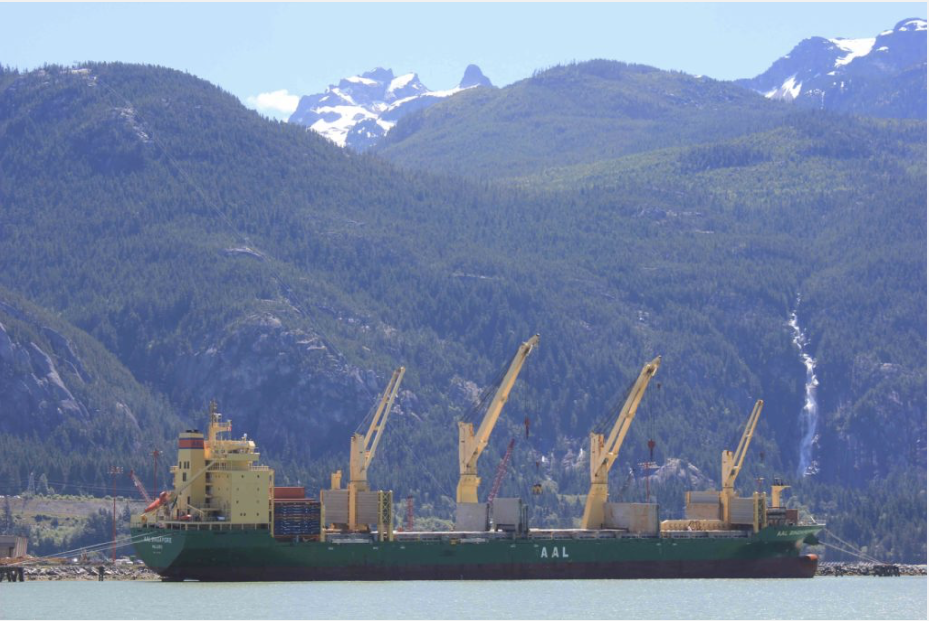
A freighter at the dock at Squamish, B.C. Photo credit: Allen Best/The Mountain Town News
To my surprise, the Canadian consulate media liaison in Denver—a former bump-skier from Vail—had wanted us to meet with David Keith. I was impressed, because even then I was aware of some of Keith’s big-picture thinking.
Keith, now 54, comes across as somebody deeply loving of the same things as most people in mountain towns do. He grew up in Canada, the son of a researcher with the Canadian Wildlife Service who did groundbreaking work on the insidious effects of pesticides; his mother was a historian.
After graduating from the University of Toronto with a degree in physics, Keith took journeys to the Arctic. In the first trip he camped alone in a remote region of Labrador for three weeks. Then he spent four months living in a plywood shack in the middle of the Arctic Archipelago, tracking walruses with a polar bear biologist. He has said it was one of the happiest times of his life.
He continues to seek out solitude in wonderful places. On a recent honeymoon he went backpacking in northern British Columbia. Protecting the climate of existing ecosystems and places clearly drives him.
Some of that thinking has been at meetings convened during the 1990s at the Aspen Global Change Institute. One of the speakers Keith heard had been a proponent of using nuclear devices for massive earth-moving goals, such as digging new canals. But the speaker by then was talking about geoengineering as a way of addressing the massive challenge of carbon dioxide emissions.
As a civilization, we’ve done our best to tinker with weather. Jeff Goodell, in his 2010 book “How to Cool the Planet,” offers a delightful history of the flimflam artists of the early 20th century who promised they could deliver rain to soak farmers’ fields and fill reservoirs in San Diego. After World War II, such efforts became more scientific, with the deliberate seeding of clouds with silver iodide and other substances to produce rain and snow.
Vail, the ski area operator, has been paying to seed clouds over Vail Mountain since a disastrous drought in 1977 as well as other of its properties. So do major water utilities, such as Denver. This is despite a major, 10-year study bankrolled by Wyoming that found only marginal success of cloud seeding.
The U.S. government, through a program called Project Plowshare, in the 1960s and early 1970s explored the idea of using nuclear devices to move massive amounts of Earth. One of the ideas was to thoroughly shake up the subterranean in order to unloose natural gas encased in tight rocks. Call it nuclear fracking. One of those blasts occurred west of Aspen and Vail in 1969, near the town of Parachute. It created rubble, all underground, but no natural gas worth anything. It was radioactive. At last, the U.S. government pulled the plug, in what one Cold War analyst says “the reluctant admission that a nuclear utopia was not imminent.”
In Calgary, Keith wouldn’t singularly bad-mouth the tar sands. (Because this was a Canadian government trip, it was always “oil sands,” and that’s what Keith said, too). But what stands out from my notes almost eight years later is his insistence that all our efforts to that day had been largely symbolic. “For the United States and Canada, motivation for action that goes beyond symbolic is very low,” he said.
“It’s important to be realistic about this,” he added.
In his 2013 book, “The Case for Climate Engineering,” Keith articulated the same thought about a disconnect between efforts and outcome. “Why has the spending on clean energy produced such meager results?” he asked. “Either the cost of cutting emissions is much higher than analysts’ estimates of what’s needed or the money is getting grossly misspent. Carbon emissions are so large that deep cuts can only be realized by actions that are cost-effective and scalable.”
Cost effective and scalable remain the key words. The paper in the journal published last week described a rate of “levelized cost per tonne of CO2 captured from the atmosphere ranging from $94 to $232.”
That is still a wide range, and, in any event, it’s well above the world’s highest carbon tax, British Columbia’s $35 per tonne; it is set to reach $50 a tonne by 2021. The point is that the price of carbon emissions must rise substantially or the cost of removing it must be lowered substantially before there will be any traction.
Keith has also been working in the other realm of geoengineering. Keith and another Harvard scientist, Frank Keutsch, had planned to launch a high-altitude balloon, tethered to a gondola with propellers and sensors, to spray a fine mist of materials such as sulfur dioxide, alumina, or calcium carbonate into the stratosphere above Arizona. The sensors, as he told MIT Technology Review, would measure the reflectivity of the particles, the degree to which they disperse or coalesce, and the way they interact with other compounds in the atmosphere.
Evening in Vancouver. Photo credit: Allen Best/The Mountain Town News
Should we even pretend to think that technology can come to our aid? Conferences and papers so far debate this very question. Some see it as akin to setting off bombs underground in Colorado. Even Keith has said repeatedly that geoengineering is secondary to reducing our emissions.
Many scientists have argued we shouldn’t even try. Even if successful, would it then allow us to dither on this path toward making a giant energy transition? We could just spew more and more carbon into the atmosphere. As the fracking revolution has taught us, we’re a very inventive species at figuring out how to get carbon from underground.
What about unintended consequences? When inventors in the Silicon Valley were creating smart phones, they probably weren’t imagining that people would be reading their phones as they drove down highways. For that matter, when Henry Ford began mass-producing cars in Detroit, he could not have imagined that one day transportation, primarily from cars and trucks, would be the leading emitter of CO2, emissions. He was creating a greater good, not a greater problem.
Then again, do we have a choice? We’re disrupting the climate through our small, unseen emissions of carbon dioxide millions and millions of times each day across the planet. We’ve already jumped off a cliff. Like the base jumper at the Chief, we had better hope we have a parachute to deploy. It’s too soon to say whether the industrial process for removing carbon dioxide from the air in the metal building in Squamish will be that parachute. But keep your eye on it. It’s terribly important.
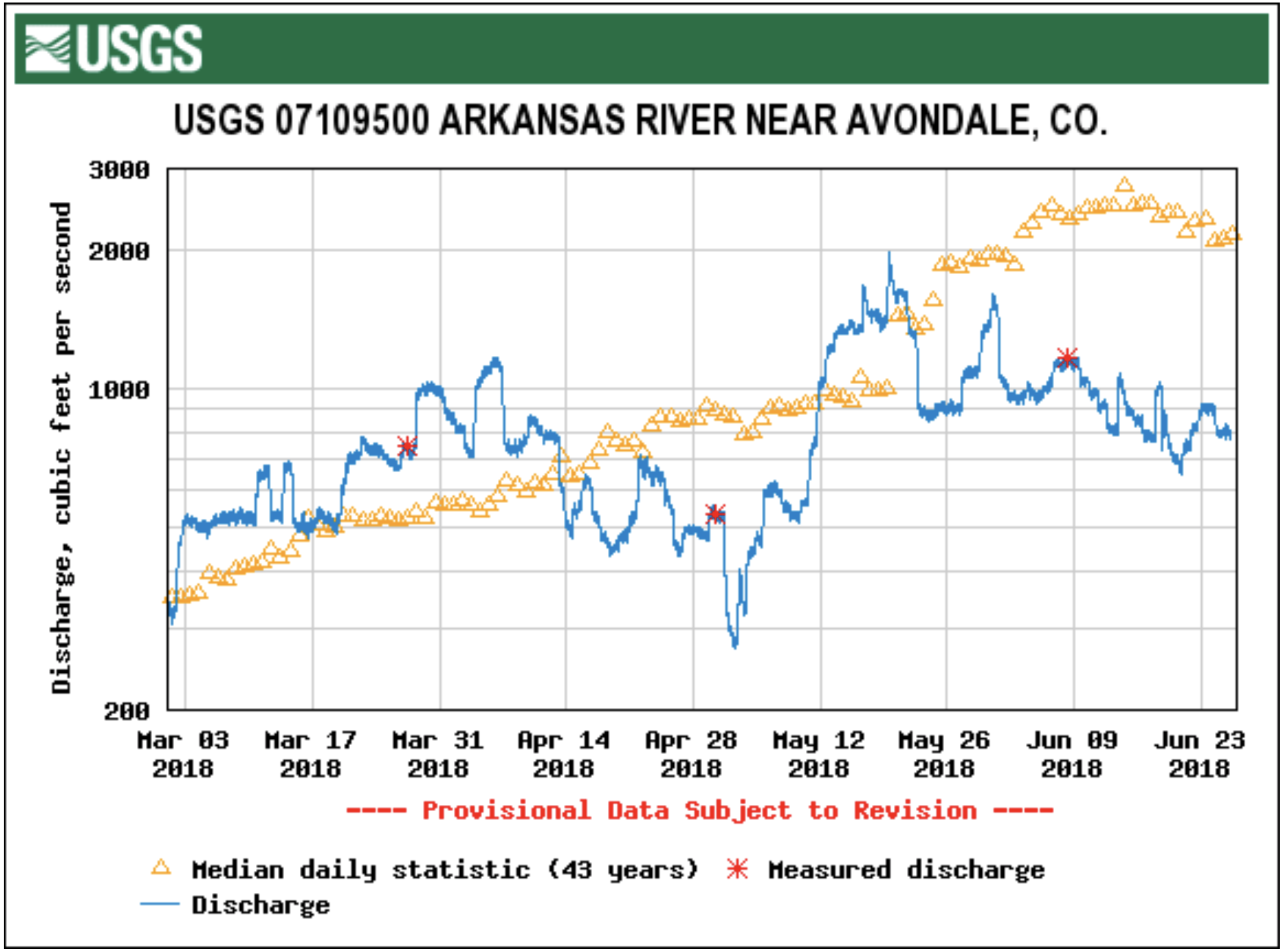
he Colorado Division of Water Resources says the levels this year are abnormal and putting the area in almost a drought situation. The conditions are making it difficult for water lovers to do their activities in Pueblo, particularly at the Whitewater Park. In turn, revenue is down at some businesses.
The park is usually a summertime hot spot that draws people from all over Colorado…
Philip Reynolds, reservoir operations specialist for the Colorado Division of Water Resources, said, “It would probably rank in one of the ten worst snow melt seasons for the Arkansas River.”
He says during a normal year at the park the rate of flow in the river is well over 1,000 cubic feet per second. Current conditions are only 600-800…
Surfers and kayakers are going to places like Florence where conditions are better. Reynolds says flows will increase part-time in July and August as part of the Voluntary Flow Management Program. Extra water will be released from the Clear Creek Reservoir to help out water enthusiasts.
Worried by growing demands and shrinking water supplies in the Colorado River Basin, Wyoming lawmakers are seeking legislation to authorize water banking in Wyoming and declare it a “beneficial use.”
The proposed changes to water law could allow Wyoming to “bank” Green River water for the purpose of meeting obligations to downstream states, and in doing so keep the state’s water users from running dry in the event of a shortage…
[The] message Wyoming State Engineer Pat Tyrrell gave the committees June 18 in Pinedale. “If critical elevations are breached, the system faces threats to [its] ability to control [its] own destiny – Compact compliance, irrigation, drinking water supply, power production, environmental resource preservation and overall sustainability,” his presentation said.
“Five years away or less we could have considerable problems at Lake Powell,” Tyrrell told committee members and the Wyoming Water Development Commission. Wyoming could see water diversions from the Green River curtailed as a result.
Lawmakers voted, without dissent, to draft a bill that would make water banking in Wyoming a beneficial use for contract obligations and drought contingency. The Agriculture, State and Public Lands and Water Resources Committee wants to consider a draft at its next meeting in September…
But Compact signers “were under the impression there was a lot more water in the system,” said Eric Kuhn, former general manager of the west-slope Colorado River Water Conservation District. Now, “the system is really fully used, and we have this almost 20-year drought,” he said.
The upper basin share, for example, was initially expected to be 7.5 million acre feet annually — or a little more than a million acre feet for Wyoming. But under today’s hydrology, upper-basin states get about 6 million acre feet annually, state engineer Tyrrell said. That brings Wyoming’s share to some 834,400 acre feet. It is currently using some 598,000 acre feet annually.
Just as Wyoming has yet to use it’s full entitlement, so too has the lower-basin never demanded the upper basin curtail use to meet the obligation at Lees Ferry. But the calculus is changing and the slack is being steadily drawn from the system.
A tamarisk eradication spray program begun almost ten years ago along a portion of the Arkansas River has transitioned into a restoration project this year by the Colorado Division of Natural Resources and Parks and Wildlife. Travis Black, Colorado Parks and Wildlife area manager, said a restoration program has begun which will re-seed the areas between Granada and the Kansas State Line. “The area will be re-vegetated with natural grass species along with willow shrubs and we’re planting cottonwood poles as well,” he explained, adding that the eradication program took some hops and skips between the towns along the river to the Kansas border.
Tamarisk, similar to Russian Thistle, is an invasive plant introduced into southeast Colorado decades ago. Unfortunately, it consumes hundreds of gallons of water per plant and is very hard to kill. Its growth along the Arkansas River allowed it to spread, siphoning off thousands of gallons of water and added to the salinity of the river. Another drawback was in flood mitigation as the plant, growing along the banks of the river, restricted the water flow along the channel which created backups and flooding. The trick to effectively killing off tamarisk is patience. Even after a comprehensive spraying program, it takes a minimum of three years to be sure the limbs, seed and especially roots are dead.
A collaboration of a number of groups including the NRCS and Prowers County sought grant funding to finance the aerial spraying of approximately 400 acres to begin with in 2009, but because of increased funding and a lower cost of service, the area was increased to 1,500 acres. Contributing groups included the Colorado Water Conservation Board, Colorado State Land Board, Holly Flood District, Tri-State G & T and the Northeast Prowers Conservation District among others and some private landowners.
Black said, some of the spraying was more effective than anticipated as a lot of the undergrowth was killed off along with the tamarisk and that eliminated the cover for local wildlife species. The revegetation program will help restore the riparian areas to their natural state and habitat. Not all of the funding is complete for the entire stretch of river into Kansas, but the acreage has been cleared along the Arkansas River, especially visible as you cross the bridge along Highway 50 just a few miles west of Holly. He said there’s no end date to the restoration program, but it will continue when new funding streams become available. The dead tamarisk plants were excavated and ground up on the spot, using specialized equipment that is loaned out to projects around the state.
Sangre de Cristo Land Grant, La Sierra Common, and Subdivisions. La Sierra is the 80,000-acre common land or ejido. Map courtesy of High Country News at URL: https://www.hcn.org/issues/104/3250.
Click through and read the entire article from KUNC (Luke Runyon). Here’s an excerpt:
For many people, spring is a time for deep cleaning, a time to take stock of and prepare for the year ahead. That’s also the case on farms in southern Colorado and northern New Mexico, where farmers spend their weekends banding together to clean out the irrigation ditches that bring snowmelt to their fields.
The clean up, known as the limpieza, is part of an irrigation tradition unique to this region for centuries.
If you irrigate here, Quintana says, you or one of your family members is expected to be here shoveling out muck, removing trash and tree limbs. The limpieza is an annual obligation…
If not for the clean up, water would pool in places it’s not needed, caught up in makeshift dams of trash and vegetation.
Small farm towns in portions of the San Luis Valley, like San Pablo, are organized around acequias, networks of irrigation ditches and canals dug nearly 150 years ago. It’s what makes farming possible in this dry stretch of land. While most Western law views water as property – a commodity people own and trade – acequias see it as a community asset, something tied to the land and shared.
Quintana, 61, grew up on a farm in San Pablo. As an adult, he left for a career in IT, always knowing his family’s land would be here for him to return to. He participates in the annual ditch cleaning now because he always has. But Quintana says there’s a growing sense that it will be difficult to bring the next generation back to the valley to keep the acequias functional and vibrant.
Sharing water in the West
On this day, the limpieza moves fast. The ditch is cleaned, and a group of middle-aged farmers pile into the back of an old pickup truck to head to the volunteer fire station for chicken fajitas.
It’s hard to overstate how radical the idea of sharing water in the West is. Everyone outside an acequia in states like Colorado, Utah, Arizona and Nevada, uses the prior appropriation system for water. That system, where your right to water is given to you based on when you claimed it, doesn’t allow for easy sharing, but it’s the core tenant of acequia management. Distribution of water is based on equity and need, not given out because you claimed it first.
Sharing water sounds easy if snowpack is high and runoff is plentiful. But in times of scarcity everyone within an acequia feels the shortage together.
Acequias vary in their style of governance. A common form is as a civic association, with members, the people who irrigate with water from a particular ditch, a board of directors and at least one employee who runs the ditch. That person is the mayordomo.
Augustin “Roy” Esquibel is the mayordomo for the ditch cleaned today. When he arrives at the fire station for lunch, he takes the time to shake everyone’s hand, and jokes that he’ll have to walk a lot more ditches to work off these fajitas.
He motions down the street, toward the church of San Isidro, the Catholic saint of farmers. This valley is sustained by agriculture, he says. Everyone here is either currently farming or a descendent of farmers. The land today is used to mostly grow hay or other grasses for cattle and horses, with some wheat and dry beans grown as well. As a water steward, Esquibel says his faith guides his decisions.
FromThe Norwood Post (April 19, 2018) by Regan Tuttle:
For decades, town officials have wondered if a raw water system might be possible. Now — after three years of study, group collaboration, grant applications and awards, engineering, numerous public meetings, and more — Norwood will complete its raw water system by end of summer. That means next spring, many people (those that purchased raw water taps for their residences) will be running a sprinkler, watering a garden, planting vegetable patches and growing flowers. And the system, officials say, also has other benefits…
Experts say that for farming and gardening, raw water is ideal. Raw water attracts pollinators, like bees and butterflies, and plants and flowers flourish quite well with the microbes and other naturally occurring particles present in it.
“Putting treated water on a plant, we take out the ingredients that a plant likes, the things that are good for them,” Norwood’s Public Works Director Tim Lippert said. “Using treated water on plants and vegetation isn’t a good thing. Raw water already has the nutrients in it.”
Because it doesn’t go through the treatment process, it’s a cheaper utility to deliver than potable water. Lippert said that in addition to being affordable, raw water is easy to manage, because no regulation of it is needed (other than making the pipe it comes out of purple, to distinguish it from treated water). Raw water is a seasonal product, available only during the growing season…
HOW NORWOOD’S SYSTEM CAME TOGETHER
It’s taken a community of people and organizations coming together to make Norwood’s raw water system possible. From the beginning, officials in the Norwood Water Commission and the Public Works Department had wondered if the town could make the project plausible. Lippert said the town explored the idea some 20 years ago, but citizens weren’t ready for it then.
He said that in the last few years, officials began to revisit the idea and wondered if the town’s existing water shares could be put to use as a raw water utility service for residents. The town does own 119 shares of Gurley water (managed by Farmer’s Water Development).
In 2015, town officials reopened the conversation with members of the Norwood Water Commission, Farmers Water and other regional water groups.
The first step included the Colorado Water Board Conservancy awarding a $47,000 grant to the Town of Norwood in 2016 to support a feasibility study on the project. (SGM, of Durango, did the study and continued with the engineering work.)
Along the way, the Norwood Lawn and Garden Group, spearheaded by Clay Wadman, who owns a home in Norwood and who wanted to see the project succeed, worked on education and outreach in town. The garden group worked to help the town sell residential raw water taps and supported Norwood in the fundraising process.
Soon, grants began rolling in from the Southwest Water Conservation District ($175,000), San Miguel Water Conservancy ($5,000), the Telluride Foundation ($5,000) and San Miguel County ($25,000). In 2017, the Department of Local Affairs made a decision to give Norwood’s project around $690,000 in a matching grant to make raw water in Norwood a reality.
The Town of Norwood also put money in — around $68,000 for final engineering — from the town’s reserves to move the project along. In 2017, town officials also budgeted $25,000 for the project; they’ve earmarked another $200,000 from the capital improvement fund if those funds are needed.
Norwood’s Town Administrator Patti Grafmyer said seeing the raw water system come to fruition is quite an accomplishment for the town.
“The idea of a raw water system has been discussed for many years, but with the help of a grant from CWCB, Norwood was able to complete a feasibility study. From the feasibility study came the grassroots Norwood Lawn and Garden Group, which became the public outreach group that assisted the Town of Norwood and Norwood Water Commission in this project,” she said. “There are so many people who were key players in this project. This project is the product of teamwork. So many people have shown their support for the raw water system.”
OTHER BENEFITS OF UNTREATED WATER
While it’s true that utilizing raw water makes flower and vegetable gardening possible, officials say it offers additional benefits, such as helping to increase property values.
The Kurtex Management Company, which owns Norwood’s Cottonwood Creek Estates, purchased 31 residential taps for raw water. Wadman has said the system there will no doubt transform the look of the neighborhood: rocky areas that comprise the lots can be replaced with landscaping, and raw water at each residence will sustain the lawns. At the same time, Cottonwood Creek Estates’ residents will have the option of gardening and producing their own food.
FromAspen Journalism (Lindsay Fendt) via The Aspen Times:
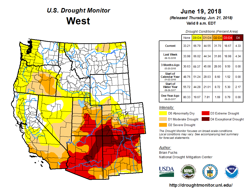
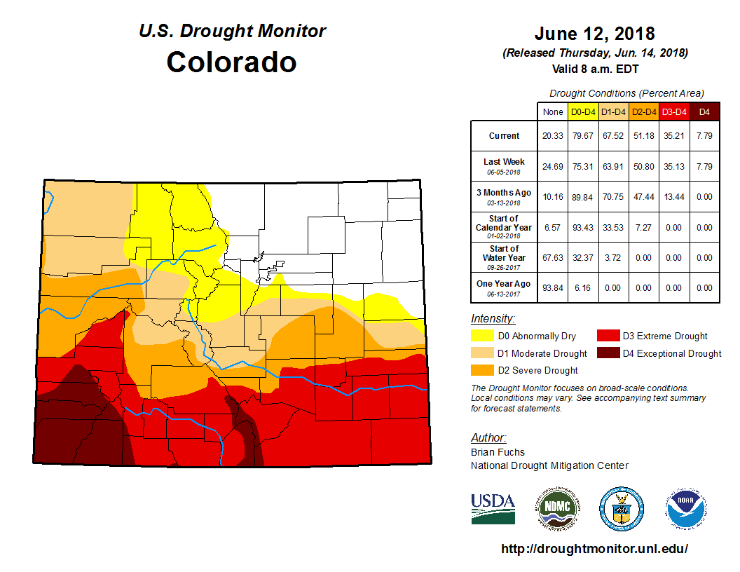
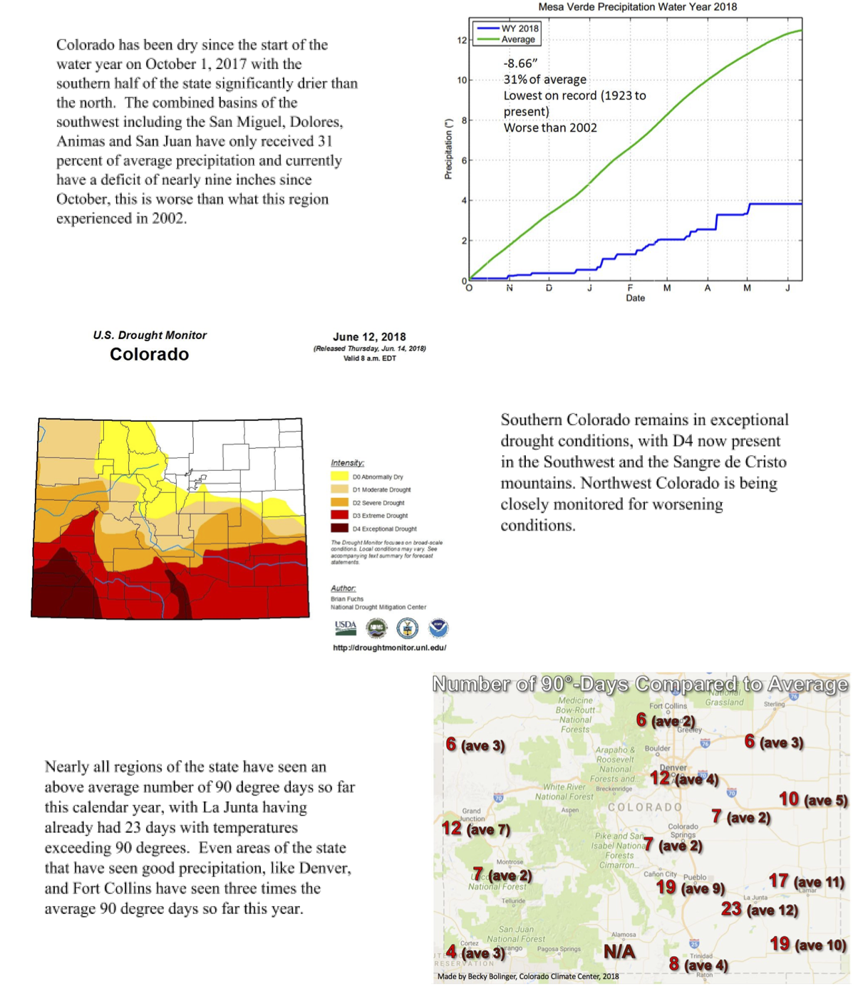
Low snowpack and a dry spring have pushed most of Colorado into a record-breaking drought.
According to an update by the U.S. Drought Monitor on Thursday, most of the state is at some level of drought, while extreme or exceptional drought — the two worst categories — now cover one-third of Colorado.
The Department of Natural Resources also projected worsening conditions for June in their drought update released Monday afternoon.
The conditions have heightened wildfire risk in some areas while areas already consumed by fire are at risk of flash floods if too much rain falls on the unstable soils of the land’s burn scars.
“We as a state are looking at the trifecta of flood, fire and drought right now,” said Taryn Finnessey, co-chair of the state’s Water Availability Task Force, during the group’s meeting Thursday. “We are definitely juggling a lot of what-ifs.”
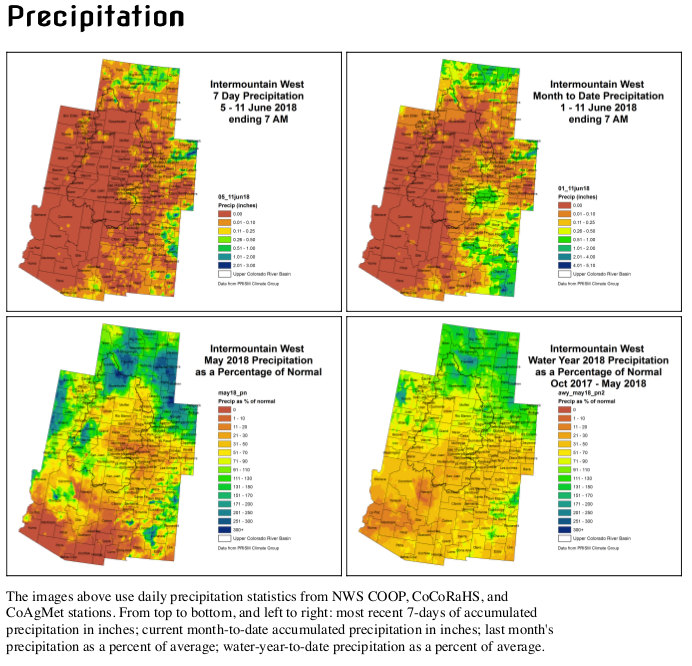
According to the Natural Resources Conservation Service, the statewide snowpack was the second-lowest on record, while temperatures for May were the second-highest.
This combination led snow to melt early across Colorado, with some areas losing their snow as much as three weeks earlier than normal. Precipitation also has lagged, reaching only 70 percent of normal for the year.
This perfect (lack of a) storm has rivers running low across the state. In mid-May, the Colorado River saw “some of the lowest peak flows in history,” according to Jim Pokrandt with the Colorado River District.
River levels remain well below normal, and last week rivers in the Roaring Fork Watershed were only flowing between 22 and 45 percent of normal. These conditions persist throughout the entire Upper Basin of the Colorado River and have drained Lake Powell to 52 percent of its normal level.
WATER TEMPS UP
The low flow rates also have led to above normal river temperatures, which can endanger fish populations and may lead to fishing bans later in the season.
Despite drought conditions, most water providers have been able to meet demand, and statewide reservoir storage remains at levels slightly above average. Still, some municipalities have had to tighten their belts.
The city of Aspen declared a Stage 1 water shortage May 18 after flows peaked about three weeks early on Castle and Maroon creeks, which provide most of the city’s drinking water. Stage 1 requires all city property to reduce their water use by 10 percent and urges the rest of the community to voluntarily reduce their water use. But even with improvements in efficiency, water demand hasn’t fallen.
“It’s an interesting thing, because when you have a dry year you need more water for your landscaping,” said Margaret Medellin, Aspen’s utilities portfolio manager. “But we don’t want people to dry up their landscaping right now. We think it’s important for the community and for fire prevention.”
According to Medellin, the inch of rain the city saw last weekend alleviated irrigation demands somewhat, but it would not help much on the supply side. While the city is able to meet demands for now, Medellin said it was likely that the city would declare a Stage 2 water shortage toward the end of the summer, an unprecedented drought measure in Aspen that would impose mandatory water restrictions on the community.
Pitkin County issued a Stage 1 fire ban earlier this month and reminded people last week that even with soaking rain June 16, the ban is still in effect and conditions are dangerous.
SOUTHWEST STRUGGLES
The situation is most dire in the state’s southwest, where some areas are the driest and hottest they’ve been since the dust bowl in the 1930s.
So far, the San Miguel, Dolores, Animas and San Juan Basins have received only 31 percent of their average precipitation for the year, and monitoring sites from Grand Mesa to Mesa Verde National Park have reached record lows for both peak snow accumulation and precipitation.
These dry conditions have helped fuel wildfires in the region, including the 416 Fire, which burned more than 34,000 acres near Durango and is the fifth largest wildfire in Colorado history.
In the southwest, the drought has forced some ranchers to sell off their cattle and has prevented some farmers from planting.
These losses prompted Gov. John Hickenlooper to activate the Drought Mitigation and Response Plan for agriculture at the beginning of May. The mitigation plan charges state officials with coordinating local plans to prevent agricultural losses.
The U.S. Department of Agriculture also has designated 33 of Colorado’s 64 counties as primary natural disaster areas, allowing farmers to apply for financial relief at the end of the season.
Despite these interventions, state agencies expect more cattle sell-offs and crop failures unless conditions improve.
The governor has not yet activated the municipal interventions laid out in the Drought Mitigation and Response Plan, but he may later in the summer. While the state government does not have the power to institute mandatory municipal water restrictions, this section of the plan would allow for more coordination and water sharing between municipalities.
While the situation is expected to worsen throughout June, July and August could bring some improvements, with the National Weather Service predicting a strong monsoon season.
“The monsoon is often a savior,” Pokrandt said. “We will just have to wait and see.”
Aspen Journalism is collaborating with The Aspen Times on coverage of water and rivers. More at http://www.aspenjournalism.org.
North American Monsoon graphic via Hunter College.
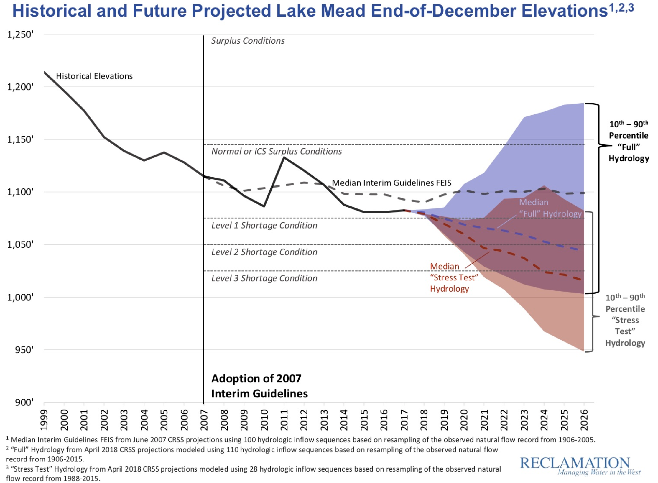
The conventional calculation of Colorado River shortage risk, which people like me frequently report, shows a 51 percent chance of Lake Mead dropping into “shortage”, below the magic trip line of elevation 1,075 at which mandatory cutbacks kick in, in 2020. But a new approach to modeling risk, which lots of folks (*cough* me *cough*) think more accurately represents the changing climate, shows a significant risk of a much quicker drop in Lake Mead’s levels, blowing quickly past 1,075, with a greater than 50 percent chance of dropping below 1,050 sometime in 2020. Absent actions to reduce water use, Lake Powell has a greater than one in four chance of dropping near power pool (the level at which it could no longer generate electricity) by the mid-2020s.
It is to the Bureau of Reclamation’s credit that they’re not only running the new modeling methodology in parallel with the more traditional approach, but that they’re doing this in a very public way, presenting both last week at the Basin States principals meeting in Santa Fe as part of the federal effort to get negotiations over water use cutbacks back on track.
Here’s the Mead graph showing the traditional modeling approach (the blue) and the newer “stress test” (shown in red):
I like this graph (kudos to Carly Jerla and the other wizards at the Bureau for coming up with such a clear visualization) because of how intuitively it shows how different the answers are when you use the two different approaches. Especially visually striking is the probability “cloud” showing the statistical range of possibilities. The old blue approach shows a decent chance of wetness refilling reservoirs. The newer red approach not only offers no such blue bits of optimism, but shows some statistically credible chances of Lake Mead seriously tanking very soon.
The difference between the two modeling approaches gets to the heart of the importance of the “period of record” you use to analyze river flows in support of decision-making.
The traditional (blue) approach uses historic river flows from 1906 to 2015 as the basis for a statistical simulation of the range of possible futures given current reservoir levels. This is classic “stationarity” – assume the future will be like the past. The specific model then uses what’s called the “index-sequential method” (ISM), which is a bog standard way of modeling the statistics of river flows.
The new approach (red), which has come to be known as the “stress test”, is based on the view of some water managers and scientists that the old full-record approach is understating risk, because the past climate – especially in the case of the Colorado River that exceptionally wet first quarter century of the record – is putting more water in the river in your simulations than we can realistically expect any more because of a warming climate. The stress test still uses the ISM, but instead of the full record, it uses 1988-2015, which seems more like a modern climate than the full thing back to 1906.
In a fast-growing state that places greater demands on its water supply each day, a state that regularly faces withering droughts, Hickenlooper has spent his eight years in office navigating water issues and leading the development of a state water plan that Denver’s chief water official calls a “real act of political courage.”
But not everyone believes the governor has made all the right choices on water. Colorado still faces daunting water-supply challenges. Some say Hickenlooper should have done more to promote dams and reservoirs and there’s no clear way to pay for the ambitious state water plan he fostered.
Still, many give Hickenlooper credit for reshaping how Colorado deals with water.
“He was the first governor to put water at the forefront,” said veteran northern Colorado water manager Eric Wilkinson.
Hickenlooper’s legacy may depend on what is done with the water plan that he is leaving for his successor. Colorado Politics talked to members of Colorado’s water community to see what they think his legacy in water looks like – and the governor weighed in on that, too.
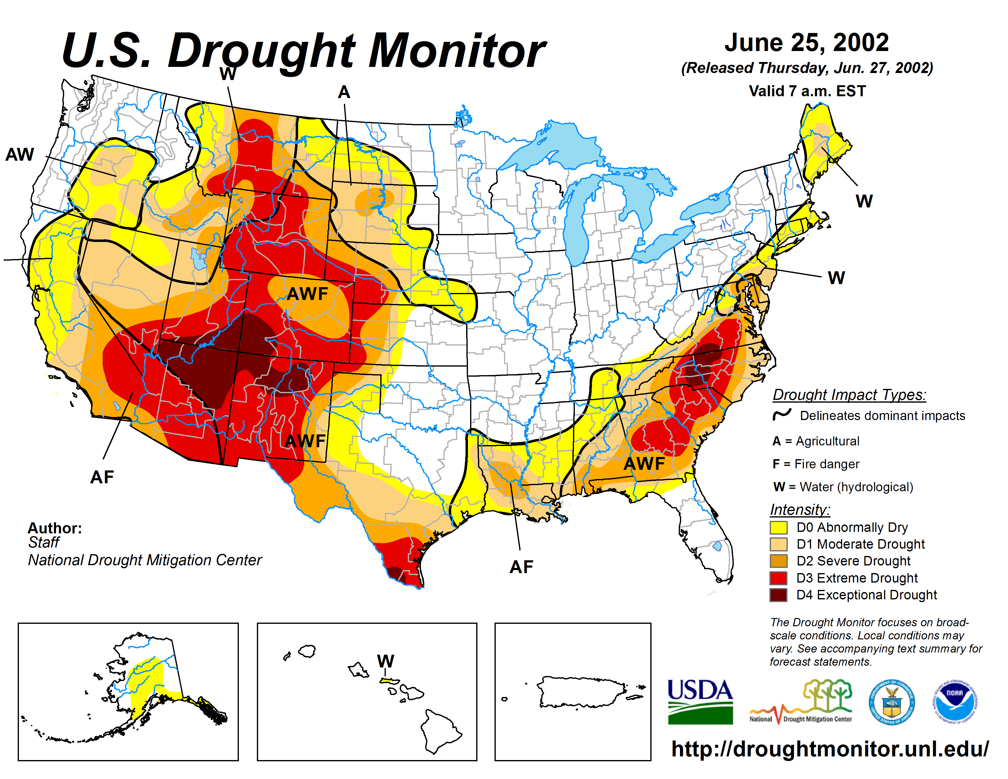
US Drought Monitor June 25, 2002.
The beginnings
When Hickenlooper became mayor of Denver in July 2003, the state was already entering the second year of a record-setting drought. Gov. Bill Owens, in his 2003 State of the State address six months earlier, claimed the 2002 drought was the worst in 350 years, with most of Colorado in what the U.S. Drought Monitor called “exceptional drought,” the worst stage in their rankings.
So water got into the future governor’s mind early on, although as mayor, his control was limited primarily to appointing commissioners to Denver Water, the state’s largest water utility.
But as he saw it, he wasn’t dealing with just Denver’s water. It was water that belonged to the entire state, he said.
At the time, state officials were also trying to figure out how to solve the water problem. In the midst of devastating drought, the General Assembly and Owens began working on several ideas that still hold water today, including a new assessment of Colorado’s water supply, known as the Statewide Water Supply Initiative (SWSI)…
In the 2005 session, the General Assembly approved a law setting up groups known as basin roundtables, which divided Colorado into nine regions, each representing a major river, plus one for Denver.
But the groups weren’t required to work with each other. There were differences among the regions, including claims from the Western Slope that the Denver area was seeking more “transmountain diversions” to channel water from the Colorado River and other western waters through the mountains to the Front Range. That claim still sticks today.
And there were long-standing hard feelings over what happened about 15 years earlier, when ski towns joined forces with environmentalists to help defeat a major Denver reservoir project…
Two Forks was a proposed dam on the South Platte River that would have created a million acre-feet reservoir, flooding 30 miles of canyon from Deckers south to the river’s confluence with its north fork.
Advocates said the project was vital to supplying growing metro Denver. But environmentalists sounded the trumpets, complaining of the potential drowning of much of Cheesman Canyon with its prime fishing, hiking and kayaking areas, and the Environmental Protection Agency vetoed a permit for the project in 1990.
Denver Water, which exhausted its appeals of the rejection in 1996, was forced to shift to conservation rather than looking for major new water supplies from storage.
That’s the environment that Hickenlooper walked into as mayor. And that’s when his water legacy started, says Eric Kuhn, who has spent 40 years working on the Colorado River, including as general manager of the Colorado River Water Conservation District.
It was then, he said, that the groundwork was laid with Denver Water board members to build cooperation with Western Slope water providers.
Knowing that Denver Water controlled a quarter of the state’s water supply, it meant new conversations with the Western Slope water community. Those discussions started in 2006 between Denver Water and 42 Western Slope partners, ranging from water providers to local governments to ski resorts.
That eventually became the groundbreaking Colorado River Cooperative Agreement, first reached in 2011 and signed by all parties by 2013. The agreement resolved at least some of the historic fights over the Colorado River. It focused on efforts to improve the river’s health and looked for ways to provide additional water supplies to Denver Water…
Hickenlooper got one other big advantage during his time as mayor: The Denver Water board selected a new general manager, Jim Lochhead, who would continue the agenda set forth by the board and with Hickenlooper’s vision in hand. That took place in 2010.
Hickenlooper “made very thoughtful appointments” to the Denver Water board, including people like Tom Gougeon, John Lucero and George Beardsley, Lochhead told Colorado Politics. They were “really strong leaders with the ethics for moving Denver Water forward but with having us take a far-sighted approach with the Western Slope,” he said.
Part of a strategic plan
Hickenlooper says he tackled water issues again shortly after being elected governor in November 2010. The state found itself in another multi-year drought starting in 2011, and that’s when Hickenlooper asked if drought would be the new normal and how Colorado would deal with it.
He talked to other governors to research the best practices they employed, and found that what Colorado lacked was a comprehensive water plan, which he called a “serious vacuum” in the state’s framework. It was a risky proposition, given that Coloradans were historically polarized around the issue of water, he said.
There were things – like boosting water conservation – that he knew would be difficult. He knew rural Colorado’s farmers and ranchers did not want to be told what to do. “We couldn’t deny people the right to sell their property,” he said, referring to water rights. But the plan would look at how to incentivize farmers to at least temporarily lease their water rather than sell.
With the traditional east-west divide over water evolving with the completion of the Colorado River agreement, the time to strike came early on in Hickenlooper’s first term. He began asking his cabinet about a water plan.
According to James Eklund, who first served as Hickenlooper’s senior deputy legal counsel and then as director of the Colorado Water Conservation Board (CWCB), the governor was asked if he was willing to spend his political capital by wading into the water wars.
“Some governors only touch (the issue) on a superficial level,” Eklund told Colorado Politics. Previous governors would go to the Colorado Water Congress (the state’s leading water advocacy organization), pound the table, say that water is the lifeblood of the West and then get out.”
After the discussions with the other governors, that wasn’t going to be Hickenlooper’s way. “We have no choice but to treat this as a serious discussion” and to engage in strategic planning, according to Eklund.
Hickenlooper – a former restaurateur – looks at everything through a business lens, Eklund said. That meant that if water is so important to Colorado’s bottom line and there isn’t a strategic plan, that’s not acceptable.
In May 2013, Hickenlooper announced he would task Eklund and the CWCB to come up with a state water plan…
In November 2015, the water plan was unveiled after more than 30,000 public comments from all over the state. “We wanted to make sure all the interests were represented, not just conservation,” Hickenlooper said. “We also put in water storage,” meaning reservoirs, but that also ruffled the feathers of environmentalists, he said.
Hickenlooper said he was most pleased with the ability of the basin roundtables – set up in that 2005 legislation – to take the long view, especially for groups historically polarized over water.
According to many in the water community, it’s the statewide water plan that most defines Hickenlooper’s water legacy…
‘Water at the forefront’
The water plan attempts to address what is now expected to be a 1 million acre-feet shortage of water in Colorado by 2050, based in part on projected population growth of another 3 to 5 million people on top of the state’s current population of 5.6 million.
It focuses on a number of strategic goals: 400,000 acre-feet of water to be gained through conservation, another 400,000 to be gained through new or enhanced storage (dams and reservoirs), and the rest from other steps, such as agricultural water sharing.
The plan has its detractors who have criticized it for lack of specific objectives in how to achieve those goals. And some lawmakers believe the General Assembly has been shut out of the process and that storage gets short shrift.
Senate President Pro Tem Jerry Sonnenberg of Sterling told Colorado Politics that he’s been frustrated with the plan’s lack of attention to storage and that there hasn’t been enough emphasis on how to avoid “buy and dry” – the practice of buying up agricultural land for its water rights and then draining the land dry…
Sonnenberg disagrees that the water plan is a positive legacy for Hickenlooper.
“He tried to put the plan together and it didn’t get a lot of attention other than from the environmental community that wants to make sure we leave more water in the rivers. If you want to be a water leader with a water legacy, you must support water storage that is paid for by the communities planning for growth,” Sonnenberg said, citing the Northern Integrated Supply Project (NISP), which plans two reservoirs – Glade, near Fort Collins and Galeton, east of Greeley.
Sonnenberg complained that the governor has not yet endorsed those projects, although Hickenlooper did endorse two other reservoir projects two years ago: Chimney Hollow, near Loveland, and expansion of Gross Reservoir, near Boulder.
But Eric Wilkinson, who recently retired as general manager of Northern Water, which runs NISP, does believe in Hickenlooper’s water legacy.
“He was the first governor to put water at the forefront,” Wilkinson told Colorado Politics. He was pleased with Hickenlooper’s endorsement of Chimney Hollow, a Denver Water reservoir project, which he said tells federal agencies that the project has cleared Colorado’s permitting and is ready to go forward. That was part of the state water plan, too, Wilkinson noted.
ilkinson also pointed to the people Hickenlooper put in charge of water issues as part of the legacy: Stulp, Eklund and Becky Mitchell, the current head of the CWCB; and both of his heads of the Department of Natural Resources, first Mike King and now Bob Randall.
In the water plan, the balance between conservation and new storage is a pragmatic solution for the state’s future, Wilkinson said. “We need to have a greater ability to manage the water resources, and to do that, conservation is first, but infrastructure is very much needed. The water plan calls that out.”
The timing was right and the leadership was right, Stulp told Colorado Politics.
Hickenlooper saw what had been taking place for the past seven to eight years, after the formation of the basin roundtables, which came up with projects for their own regions. The time was right to pull all that together, Stulp said.
Eklund, now with the law firm Squire Patton Boggs, is still involved in water issues, partly as Colorado’s representative on the Upper Colorado River Commission. He said Hickenlooper’s legacy isn’t only about the water plan; it’s also where he positioned Colorado internationally on water issues.
Colorado’s position as a headwater state that provides water to 18 downstream states and Mexico means “we punch above our weight on water policy,” Eklund said. The eyes of the water-stressed world are on the Southwest United States.
Colorado finally has a platform in that discussion by coming up with the water plan, which he called a “gold standard” for water planning. Other states and nations can look at what Colorado is doing and judge for themselves, he said.
Colorado now speaks with one voice on water, said Mitchell, who was in charge of water planning prior to becoming the CWCB’s latest director.
“The default starting point now on water talk is cooperation, not confrontation,” she told Colorado Politics.
The water plan shows what’s possible, she added, when people with polarized perspectives and faulty assumptions sit down together, listen and speak with civility and respect…
Hickenlooper told Colorado Politics he hopes the next governor recognizes the funding gap for implementing the plan. The General Assembly has so far devoted about $17 million over the past two budget cycles to funding projects in the water plan, but it’s a drop in the bucket compared to the need, which is estimated at around $20 billion.
Water providers are expected to shoulder most of that, but the state’s obligation is expected to be around $3 billion, at $100 million per year for 30 years, starting in 2020.
No one, including Hickenlooper, has come up with a solid plan for where that money is coming from. Lots of ideas have been floated, such as changes to the state’s severance tax structure on oil and gas operations – a no-go with Senate Republicans – bottle taxes, water tap fees and the like.
Hickenlooper said he believes funding for the water plan is sufficient for the next few years, but there is a gap, and at some point, the state will need to spend more money on water infrastructure…
That political courage, and part of the legacy, as Lochhead sees it, is that Hickenlooper opened the door for the next governor to come in and pick up where Hickenlooper ended and made it a little safer for a governor to jump into water issues.
So how does Hickenlooper view his legacy in water?
“If I was to look at the one thing that changed the most in my public life, it’s the collaborative approach,” the governor said. “This is everyone’s issue.”
Drought again? Or is something else going on in the slimming Colorado River?
Peak runoff in the Colorado River this year has arrived exceptionally early and with unusual modesty. It’s part of a pattern in the 21st century, one that scientists warn will become even more common in the future.
One measuring site is at Cameo, located amid sandstone cliffs coated with desert varnish two hours downstream from Aspen and Vail and a short distance from Grand Junction. There, runoff in the Colorado River reached 6,650 cubic feet per second on Monday. Unless surpassed by a second surge of runoff predicted for Saturday, it is likely to be the earliest date for peak runoff at the site in 50 years, according to the Colorado River Water Conservation District.
It’s also a runoff of modest flows, the fourth lowest in 85 years of record-keeping at Cameo. The lowest was in 1977, according to the Glenwood Springs-based River District, followed by those of 2002 and 2012—and now 2018.
Winter was warmer and drier than usual, and the last month has been the same: 2 to 4 degrees Fahrenheit warmer than average. Spring precipitation has similarly lagged across western Colorado.Also contributing to this year’s runoff story have been six dust storms since late March, the most recent last weekend. The darker desert dust sprinkled on the high-mountain snows absorbs more sunlight, helping speed melting.
“If you ask why there is so little runoff in the Colorado and other rivers this year and why it has come so early, the No. 1 reason is we didn’t get much snowfall. That explains the bulk of this anomaly,” said Jeff Lukas, a research integration specialist with the University of Colorado’s Western Water Assessment. “But the temperature, much warmer than normal, especially from November to January, is a part of the story.”
Lukas, the lead author of a 2014 state-commissioned synthesis report called “Climate Change in Colorado,” also points to the clustering of unusually low runoffs in the last 16 years. It is “suspicious, let’s say, and may speak to the contribution of human-caused warming,” he observes.
Taking the long view, Lukas notes there’s a lot of “noise” or natural variability in the climate records. But this clustering suggests a changed norm. What used to be the sort of runoff that might occur every 25 years could now, perhaps, be expected about every 10 years.
Lukas has also studied growth rings of trees in the Colorado River Basin to document past environmental conditions as far back as 762 A.D. Those tree rings directly correspond to wetter and dryer, hotter and colder periods during the last 1,000 years. The trees also reveal droughts longer than any in the roughly 150 years of recorded history on the Colorado River.
In 2007, a University of Arizona team reported finding evidence of 13 consecutive years of sub-average flows. It was part of a longer 60-year period of drought in the 11th and 12th centuries that archaeologists believe was at least a significant factor in why the ancestral Pueblo, also called the Anasazi, abandoned their cliff dwellings in Chaco Culture National Historic Park and Mesa Verde National Park.
West Drought Monitor June 19, 2018.
Even in 2007, scientists were saying that these mega-droughts of the past might be similar to the Southwest in a world warmed by greenhouse gas emissions. But the past is an imperfect guide to the future. “We need to consider that if these extended droughts occur, they will occur under warmer conditions than those of the past, so they won’t be analogous with respect to the impacts of temperature on drought, although the moisture deficits could be similar,” according to Connie Woodhouse, a co-author of that 2007 report.
In 2017, two climate and water researchers issued a paper that concluded that the warming world is producing drought-like conditions. Jonathan Overpeck, one of the authors, was in Santa Fe recently, where he warned against thinking of it as a drought as conventionally understood.
“Precipitation in this current drought is a contributor, a secondary contributor. The main cause of this drought is temperature,” he said at the Next Generation Water Summit. Showing a chart, he observed that the temperature line corresponds with declining flows.
“This is the kind of drought we will have to deal with in the future,” he said.
Temperatures in the region have increased, and as they do, the warming atmosphere needs more moisture. Overpeck and his co-researcher, Brad Udall of Colorado State University, concluded that the moisture is being induced into the atmosphere through increased evaporation and transpiration. “This turns out to be the very biggest consequence of the temperature-induced drought in the Colorado River Basin,” he said.
“Wildfire is going crazy in the Southwest, and it’s for the same reason,” added Overpeck, who is now dean of the School for Environment and Sustainability at the University of Michigan. He was formerly at the University of Arizona and still has a cabin in the San Juan Mountains near Telluride.
The Colorado River in De Beque Canyon, near Grand Junction, Colo. Photo/Allen Best
Can this be called a megadrought? He said he gets asked that often, and technically, no, it’s not. It’s only lasted 19 years, and the definition of megadrought that he and others agreed upon earlier in the century begins at 20 years. But, he added, this certainly looks a lot like the megadrought of 900 years ago discovered by dendrochronologists.
The pails of water in the West went from full to the brim to half empty or less in a short time. Lake Mead and Lake Powell, the two giant reservoirs of the Colorado River Basin, were full in 1998, as were most of the smaller reservoirs at the headwaters near the ski towns. They’ve been mostly ebbing ever since. The U.S. Bureau of Reclamation on Monday reported that Lake Powell was at 52 percent of capacity and Lake Mead, near Las Vegas, was down to 39 percent of capacity.
These shrinking reservoirs have caused some to call for what Edward Abbey mirthfully imagined in the “Monkeywrench Gang,” the dismantling Glen Canyon Dam and draining of Lake Powell. The argument is that this will reduce evaporation and more efficiently store the water that is likely in the warming Southwest.
The idea has received little traction, but University of Utah professor Jack Schmidt said it’s worth thinking about. “It’s an idea that, no after how much you think you understand the details, the idea won’t go away,” he said at the River District’s annual seminar in Grand Junction last September. He said he’s undecided, as there’s not enough yet known to understand the implications.
In April, a dispute about how much water is released from Lake Powell to flow downstream into Lake Mead flared among the seven basin states. Denver Water and representatives of Colorado, Wyoming, Utah and New Mexico dispatched letters to the Central Arizona Project accusing that water agency of manipulating water supplies and demands at the expense of teamwork and collaboration.
The Central Arizona Project delivers Colorado River water to Phoenix, Tucson and a host of towns and farms along the way. “It’s one water user taking advantage of a situation for their own benefit, to the detriment of a river that supplies nearly 40 million people,” Jim Lochhead, manager of Denver Water, told the Associated Press.
Denver Water gets about half its water from the Colorado River Basin and supplies about a quarter of all Colorado residents. Many other cities of the West not actually within the basin also get Colorado River water, including Cheyenne, Salt Lake City and Los Angeles, but even Santa Fe.
Speaking in Santa Fe, Overpeck noted the sharp words among formerly collegial water users in the basin as a reflection of the rising tension about declining flows.
Flows in this 21st century temperature-induced drought are down 19 percent, said Overpeck.
Future flows will almost certainly decline even more, he said. Even if greenhouse gas emissions get contained as outlined in the Paris climate accord, another 1 to 1.5 degrees C (1.8 to 2.7 degrees F) of temperature increase can be expected by 2100. If burning of fossil fuels continues unconstrained, temperatures might increase 5 to 7 degrees C (9 to 12.6 C).
This latter, even hotter climate, he said, will reduce flows in the river by 50 percent. An uptick in wildfire and spring duster storms can also be expected as well. “They’re all related to the same thing.”
Might a warmer atmosphere also produce more precipitation? Don’t bet on it, he said. Even if it does, as some colleagues have persuaded him is possible, he remains sure that warmer temperatures will cause that precipitation to vanish.
Why is he so sure? He points to the climate and hydroclimate modeling that, he said, have produced results consistent with experimental evidence and ongoing observations. In other words, the models seem to work.
As Lukas said, it looks suspiciously like this sort of drought year won’t be all that uncommon in the future.
Inflow into McPhee Reservoir from the Dolores River has dropped to a historic low, falling below the 2002 levels that were the previous driest year since the reservoir was built.
As a result, supply in the reservoir has also dropped slightly to 16.7 inches per acre, down from earlier estimates of 17 inches per acre for full-service irrigators. During full supply, the rate is 22 inches per acre…
Since April 1, estimates by the Colorado Basin River Forecast Center for Dolores River inflow into McPhee dropped by nearly half, from 89,000 acre-feet to 46,000 acre-feet…
Because of an extremely low snowpack this winter and a hot, dry summer, the runoff forecast is at 15 percent of the historical 30-year average of 295,000 acre-feet for April through July. Precipitation for the 2018 water year at McPhee Reservoir, as measured at the Great Cut Dike, is the lowest recorded in the last 35 years.
The town of Mancos is implementing mild water use restrictions to prepare for potential shortages later this year.
On June 14, Town Administrator Heather Alvarez announced that the town would be restricting residents’ outdoor water use. Residents will only be able to water on certain days, depending on their addresses, and only for four hours in the morning and evening. The town is not facing a water shortage right now, Alvarez said, but town staff want to be prepared for one if their water rights are temporarily called by the Colorado Division of Water Resources.
A rafter on the Colorado River looking upstream toward Glenwood Springs. The Middle Colorado Watershed Council has recently received a $104,000 state grant for its $415,000 integrated water management plan for the Colorado River between Dotsero and DeBeque. It will look at recreational and environmental flows, as well as consumptive use of water by ag and cities. Photo credit: Brent Gardner-Smith
Northern rivers are running at moderate levels or better and flows are excellent on the Arkansas, which ranks annually as the state’s most rafted river by far. Things are more challenging in the southern part of the state, which has been hit hardest by drought.
“For some outfitters, it’s very good right now,” said David Costlow, executive director of the Colorado River Outfitters Association. “Right now it’s very moderate levels on most of the streams. I talked to an outfitter that’s having a record year so far, another one that’s on track to having a record year. It’s a little bit of a mixed bag, but I think most people are doing quite well.”
The Arkansas, which typically accounts for 35-40 percent of the state’s rafting business, sits in the state’s largest river basin. Southern reaches of that basin had dismal snowfall, which bring down the average for the drainage as a whole, but things were better in its northern reaches to the benefit of prime rafting areas. That was true for other drainages in the north of the state as well…
In fact, conditions are said to be outstanding on the Cache La Poudre, west of Fort Collins, which could be Colorado’s best bet for rafting this summer…
Clear Creek west of Denver is the state’s second-busiest stream for rafting, accounting for 15 percent of user days last year, and it’s doing fine…
The Upper Colorado was running low last week, but that had more to do with water management to fill reservoirs than a lack of snowfall or precipitation, and the river rose this week…
Outfitters also are hopeful that the onset of monsoon season will augment water levels in the coming weeks.
Map of the Rio Grande watershed, showing the Rio Chama joining the Rio Grande near Santa Fe. Graphic credit WikiMedia.
One headwaters tributary curling around the Great Sand Dunes National Park has dried up. The main stem of the Rio Grande probably won’t make it out of Colorado to New Mexico this summer, state water authorities calculate, let alone Texas and Mexico.
The federal government has designated the San Luis Valley, like most of the land along the Rio Grande’s route to the Gulf of Mexico, as in “extreme drought.” And years of gains by farmers ordered to replenish a depleted underground aquifer, the water equivalent of a savings account, may be lost if farmers with wells turn back to pumping to survive…
The pressure hitting food growers along the Rio Grande headwaters in southern Colorado reflects a widening water squeeze that has revealed the precariousness of life across the southwestern United States, where prolonged dry times and climate change increasingly force adaptation.
Exceptionally low snow in the Rocky Mountain region this year, at 37 percent of “normal” atop the Rio Grande River Basin, is playing out in water volumes less than 20 percent of the 120-year average.
San Luis Valley agricultural leaders warn that the low flows may accelerate a projected loss of 100,000 acres of irrigated land, a fifth of the food production in an area dependent on farming. The low water also is hurting ecosystems, hastening the slide toward extinction of endangered species, including the southwestern willow flycatcher, western yellow-billed cuckoo and Rio Grande silvery minnow…
“The overall point is that river flows are being affected by climate change. We can expect lower flows than the historical average going forward. We need to prepare for that,” said former U.S. interior secretary for water and science Anne Castle, a senior fellow at the University of Colorado.
Southern Colorado, including the San Luis Valley, stands out — with water flows in the Gunnison, Animas, Dolores and San Miguel rivers all less than half of average this year — among the fastest-changing areas…
Like many people, [Cleave] Simpson has access to wells drilled into Rio Grande headwaters alluvial sediment. But he has avoided tapping this source. “I can pump groundwater, but there are consequences of us continuing to overdraft our aquifers,” he said…
Meanwhile, discontent festers downriver, despite the compact that locks in each state’s share of Rio Grande water.
That compact, finalized in 1938, ignores environmental needs. And this year, the low flows along headwaters already have led to a dry-up of the Rio Grande through sensitive stretches south of Albuquerque, hastening the demise of the silvery minnow, one of the nation’s most endangered fish.
“Climate change is exposing the flaws in our system, and these low flows are showing that we cannot continue to allocate water the way we do,” said Jen Pelz, an attorney for WildEarth Guardians, which has filed lawsuits under the Endangered Species Act seeking reduced human use to save species. “Farmers have been given the right to water. But the river does not have any right to water. And when a river does not have water, the trees, the ecosystems, do not receive water. If there’s another dry year, we will have a critical situation on our hands.”
During a special meeting held on June 7, the Pagosa Area Water and Sanitation District (PAWSD) board was presented with the re- sults of a rate study conducted by Stantec…
Rate presentation
Lay began the presentation by explaining the financial goals of the rate study. Some of the goals included:
• Maintaining a combined debt service coverage ratio of 1.25 per- cent.
• Maintaining adequate reserve requirements.
• Water and wastewater analysis performed as separate utilities and minimizing the rate impacts for both.
• Fund future utility operations and capital investments in the most financially prudent way possible.
Lay also explained that when it came to the water utility there were some assumptions factored into the rate study.
Those assumptions were:
• Utilizing annual cost escala- tion factors, 3 percent for both capital projects and operations and maintenance (O&M) fixed/variable expenses.
• Using a 2 percent growth rate for account growth based on PAWSD’s projections.
• Accounting for a consumption decrease in 2021 and 2025 to plan for a potential drought period.
• A decreased capital improve- ment fee in 2019 to $1,509 per equivalent residential unit (ERU) from $2,658 currently.
• Also decreasing the raw water acquisition fee to $1,726 per ERU from $1,959.
PAWSD projections
The presentation then moved to what PAWSD’s water rate revenue projections are, as well as projec- tions for funds with no rate adjust- ments for water utility.
Regarding water rate revenue projections, Lay explained that these projections are based on 2 percent account growth rates, but lso include a 5 percent reduction for consumption.
Lay also added that these water rate revenue projections do not include any rate increases from a revenue standpoint.
From the graph within the pre- sentation, PAWSD is projected to increase its water rate revenue each year aside from the fiscal years of 2021 and 2025 in which that 5 per- cent consumption decrease occurs.
Despite those decreases in those two years, in the fiscal year for 2028, PAWSD is projected to have about $4.2 million in water rate revenue.
Conversely, with no rate adjust- ments or debt in regard to water utility, PAWSD is projected to spend more funds than it currently has in the fiscal year for 2018.
This deficit is only projected to grow larger with each fiscal year, and, by 2022, PAWSD is projected to use about $10 million while only having about $4 million available.
For the years 2023-2028, PAWSD would be using about $6 million whilst having only about $4 mil- lion available with no debt or rate adjustments.
Water utility rate scenarios
Lay then presented the board with the three rate scenarios for water utility.
The first rate increase proposed would utilize a 12.5 percent rate adjustment, which was described by Lay as the “baseline scenario.”
This scenario would see rate increases from 2019 to 2021, three months of O&M reserve with no re- duction, 100 percent or $500,000 in annual waterline expenditures and the Snowball treatment plant project being debt funded by $3 million.
Waterline expenditures can also be described as waterline replace- ment, PAWSD District Manager Justin Ramsey added.
The proposed financial impact of this scenario on PAWSD custom- ers could raise their bill an addi- tional $19.35 from the current total of $68.16 to $87.51 in 2028.
All three proposed financial impacts also include the proposed rate increase for wastewater as well.
For all three scenarios, the Snowball treatment plant is debt funded, Lay added.
The second scenario presented by Lay was a 5 percent rate adjust- ment, which was described as the “alternative scenario.”
This scenario would have rate increases from 2019 to 2023, O&M reserves would be reduced below a three-month threshold in 2021- 2024, and waterline expenditures would also be reduced to 20 per- cent or $100,000.
Within the second scenario, PAWSD customers could see their bill increase from the current amount of $68.16 to $82.17 in 2018, an increase of $14.01.
The final alternative, which Lay noted as the “preferred” scenario, involves a 6.5 percent rate adjust- ment.
This scenario has the same rate increase and O&M reductions as described in the second scenario.
However, in this final scenario, only 50 percent or $250,000 would be allocated for annual waterline expenditures.
The financial impact within the preferred scenario would see PAWSD customers average bill in 2018 go from $68.16 to $85.56, an increase of $17.40.
In early June, more than 1,000 people near Durango, Colorado, had to leave their homes as the 416 Fire swept across the landscape. Following a dismal snowpack, the region experienced a spring so hot and dry that the U.S. Drought Monitor labeled conditions “exceptional drought,” the worst category.
Colorado wasn’t alone. An irregular bull’s-eye of dryness radiated outward from the entire Four Corners region, where Colorado meets New Mexico, Arizona and Utah. These circumstances offer something of a preview of the coming decades: While experts say the Southwest will continue to experience swings in precipitation from year to year, overall climate change is making the region and its river basins hotter and drier. That means humans must adapt to life with less water. “We have to fundamentally change the mindset of the public, and the way we manage this resource,” says Newsha Ajami, a hydrologist and the director of urban water policy at Stanford University’s Water in the West program. “And one of the ways you do it is, you have to change the terminologies that we use in dealing with water.”
The 416 Fire near Durango, Colorado, ignited on June 1, 2018. By June 21, the wildfire covered more than 34,000 acres and was 37 percent contained. Photo credit USFS via The High Country News
This spring, the Colorado River Research Group, an independent team of scientists focused on the river, labeled the climate transition in the Colorado River Basin “aridification,” meaning a transformation to a drier environment. The call for a move away from the word “drought” highlighted the importance of the specific language used to describe what’s going on in the Southwest: It could shift cultural norms around water use and help people internalize the need to rip out lawns, stop washing cars and refrain from building new diversions on already strapped rivers. As Brad Udall, a member of the research group and a water and climate researcher at Colorado State University, puts it: “Words matter.”
But beliefs are not behaviors. Reframing our understanding of the Southwest’s climate — thinking of it as a place experiencing aridification, a dry place getting drier, rather than a place simply waiting for the next drought to end — will have major ramifications only if it changes how people actually use water.
There is some evidence of the inverse — that when people conceive of the problem as a temporary one, they use more water after they believe the emergency has passed. During California’s recent five-year drought, residents of the Golden State cut their water use by a quarter or more amid intense media coverage and water use restrictions. This spring, a year after California Gov. Jerry Brown pronounced that drought over, Californians were using nearly as much water as they had before drought was declared.
How people perceive and value water is essential to shaping how much of it they use, says Patricia Gonzales, a doctoral student studying water resources at Stanford University. And those perceptions and values aren’t created in a vacuum. Officials, experts and the media frame and define the issues; social pressures also play a role. For example, when an entire community is aware that water is scarce, people might avoid washing their cars in order to duck the scorn of water-conserving neighbors. “Everyone can do something,” Gonzales says, even as she and other experts acknowledge that irrigation gulps up most of the West’s water. “But even the small pieces kind of add up when you look at the whole picture of how much water we have available.”
While climate change is already shrinking water resources in the Southwest, we shouldn’t throw out the word “drought” completely, says Connie Woodhouse, a paleoclimatologist at the University of Arizona. It’s important to recognize that even a drier future will contain variability. “We’re going to have periods that are wetter, and we’re going to have periods that are drier, within this baseline that almost certainly will be more arid.”
Still, people in the Southwest must adjust to a more parched landscape. “There’s a need to (fundamentally change) the way we talk about these things, to bring attention to the fact that drought is normal,” Gonzales says. In other words, even after the bulls-eye dissipates from this summer’s drought monitor maps, Southwesterners need to keep acting as if that red swath were permanent — a lasting marker of a more arid reality.
West Drought Monitor June 19, 2018.
Emily Benson is an assistant editor at High Country News.
This article was first published online at High Country News on June 22, 2018.
Wyoming rancher Freddie Botur walking across rocks that form the diversion structure at his headgate on Cottonwood Creek, a tributary of the Green River. Botur was paid to let water flow past these headgates and down the river system toward Lake Powell as part of the System Conservation Pilot Program. Photo credit: Jim Paussa via Aspen Journalism
A four-year pilot program that paid ranchers and farmers in Colorado, Utah, Wyoming and New Mexico about $200 per acre-foot of water saved by fallowing fields in order boost water levels in Lake Powell will be put on hold after 2018.
On Wednesday, the five members of the Upper Colorado River Commission unanimously passed a resolution to that effect at a board meeting.
“Although the pilot (program) has helped explore the feasibility of some aspect of demand management programs, it does not provide a means for the upper (basin) states to account, store and release conserved water in a way which will help assure full compliance with the Colorado River Compact in times of drought,” the resolution said.
“Demand management” generally means finding ways to save, or conserve, water by paying willing irrigators to divert less water from streams and rivers by fallowing some of their fields for all, or part, of an irrigation system.
The Upper Colorado River Commission, meeting in Santa Fe on June 20, 2018. Don Ostler, seated third from left, gets a round of applause as the outgoing executive director of the Commission, which helps manages the upper Colorado River system for Colorado, Utah, New Mexico and Wyoming. Ostler is leaving after 14 years and being replaced by Amy Haas of New Mexico, who currently serves as general counsel to the commission. Photo credit: Brent Gardner-Smith/Aspen Journalism
Still interested
This year, $3.9 million is expected to be paid out to ranchers and farmers in the upper basin, which will make it the biggest year of the program, but that will be it for the System Conservation Pilot Program in the upper basin.
The ending of the program in the upper basin does not mean the commission is giving up on getting more water into the upper Colorado River system in order to raise water levels in Lake Powell, as that interest continues to grow as the drought that began in 2000 lingers.
“I view it more of a change in direction rather than a value judgment of system conservation,” said Pat Tyrrell, who represents Wyoming on the commission and also is the Wyoming state water engineer.
In introducing the proposed resolution, Tyrrell said “there are some things (the pilot program) simply cannot do.”
The pilot program “does not allow the upper (basin) states to sufficiently investigate storage or the additional administrative, technical, operational, economic and legal considerations necessary to explore the feasibility of demand management as part of its ongoing emergency drought contingency planning efforts,” the resolution adopted by the commission states.
Andy Mueller, the general manager of the Colorado River Water Conservation District based in Glenwood Springs, supported the commission’s decision.
“I think it is an appropriate temporary halt in the Upper Colorado River Commission’s support for the SCPP,” he said after the meeting in Santa Fe. “Mainly because in order for a conserved consumptive use program like this to work, the upper basin needs a pool of water designated in Lake Powell that we can use as a water bank. We don’t currently have that, and until that’s there, it doesn’t make sense to spend a lot of our of society’s resources on the program.”
A wall bleached, and stained, in Lake Powell. Photo credit Brent Gardner-Smith @AspenJournalism.
Declining levels
Lake Powell is 53 percent full today, and if the water level in the huge reservoir falls much further, it will mean that first, hydropower can no longer be produced by the turbines in Glen Canyon Dam, which forms the reservoir, and second, that not enough water can physically be released to meet the upper basin state’s obligations under the Colorado River Compact to send water to the lower basin states, which include California, Arizona and Nevada.
So while there is room in Lake Powell to hold more water sent down from the upper basin states, there is no way to securely store the water from a legal perspective. Today, any water that reaches Powell is fair game to be sent on to Lake Mead and the lower basin states, which defeats the purpose of sending water there to bolster its operational water level.
But there is a legal way to protect such a pool of water in Lake Mead. It’s called an “intentionally created surplus” (ICS). Water managers in the upper basin states would like to see something similar created in Lake Powell through federal legislation, although they prefer the term “demand management storage” to distinguish it from “intentionally created surplus,” which is a term shaped by, and tied to, the 2007 interim guidelines that currently dictate how Lake Powell and Lake Mead are managed together.
The pilot program began paying ranchers and farmers in 2015 to fallow fields and let water run down the river system toward Lake Powell. Originally set-up as a two-year program, it was extended for one year in 2017, and then another in 2018.
The program has paid for fallowing in both the upper Colorado River basin states of Colorado, Utah, Wyoming and New Mexico and in the lower basin states.
The overall system conservation program initially was funded by an $11 million pool provided by the Central Arizona Water Conservation District, the Southern Nevada Water Authority, the Metropolitan Water District of Southern California and Denver Water, in partnership with Reclamation.
The Walton Family Foundation also contributed financially to the upper basin program through a contribution to Denver Water (the Walton Family Foundation also supports Aspen Journalism), and Trout Unlimited and The Nature Conservancy invested a lot of staff time to help make the program work.
The funding for the program, which includes both a lower basin and an upper basin component, grew over the years, with the upper basin eventually having access to a $9.5 million pool of funds, according to Amy Haas, the incoming executive director of the Upper Colorado River Commission.
(Haas is replacing Don Ostler, who is stepping down into a consulting role after 14 years at the commission. Haas, who is from New Mexico, is the current general counsel of the commission and officially starts as executive director on July 1).
Haas said she expects the system conservation program in the lower basin will continue if pending legislation in Congress is approved to re-authorize the program, and she clarified that the commission’s resolution passed this week only applies to the upper basin program.
In the first three years in the upper basin, 45 fallowing efforts were funded, including 15 in Colorado, at an average cost of $205 an acre-foot of conserved consumptive use — water that would have otherwise been consumed by various crops.
And not all of the funds in the system went to irrigators, as two municipal projects were also involved in the first three years of program, including one with the Pueblo Board of Water Works.
In those three years, about 22,116 acre-feet of water was left in the upper Colorado River system at a total cost of $4.6 million.
Individual contracts in the first three years of the program ranged from $6,300 to $635,000, depending on the number of acres fallowed and for how long.
The 22,000 acre-feet of water sent down to Lake Powell in the first three years of the pilot program represents a tiny drop in a big bucket, as the reservoir holds 24.3 million acre-feet of water when full.
It’s also not clear how much of the non-diverted water reached Lake Powell. Program administrators knew there was no guarantee the water would make it past other diverters without the legal ability to “shepherd” the water downstream.
On the other hand, fallowing projects were chosen in part because of their locations. Water from the Colorado River not consumed in the Grand Valley, for example, has a decent chance of making it through Westwater and Cataract canyons to reach Lake Powell.
However, officials said the experimental effort was not ever meant to physically change the level of Lake Powell, but to see what lessons could be learned from setting up such a program.
According to a candid report on the program released by the commission in February, the lessons learned in the upper basin included that the program was valued by some ranchers and farmers, but distrusted by others, that the program was hard to administer due to the many individual contracts required, and that in order for the program to really make a difference, it would need to be dramatically scaled up, and the resulting saved water would need to be securely shepherded to, and held in, Lake Powell or some other reservoir, and not just sent into the river system.
On June 22, Scott Yates, the director of Trout Unlimited’s Western Water and Habitat Program, issued a statement praising the program.
“We’re extremely proud to have worked with agricultural producers interested in the System Conservation Pilot Program,” Yates said. “The SCPP has proved the enormous potential for water demand management to address drought and climate impacts on the Colorado River Basin’s water supplies.
“We’ve learned that there is significant interest among ranchers and farmers for a program that compensates them for voluntary, temporary reductions in water use. That was a key question about SCPP — would agricultural producers respond to market-based incentives? The answer is an unqualified ‘yes.’
“TU believes that the SCPP in the Upper Basin has been successful in allowing producers to explore whether using their water right in this innovative way can benefit their operations. Many participants embraced the SCPP approach, especially if such a program can operate over the longer-term,” Yates said.
Editor’s note: Aspen Journalism is collaborating with The Aspen Times on the coverage of rivers and water. The Times published this story in its print edition on Friday, June 22, 2018.
Left: Fossil fuel emissions 1850 to 2010 and since 2000. Right: Amount of fossil fuel emissions to keep warming under 2 C, vs. potential emissions from proven reserves. Fossil fuel companies know that they cannot compete with renewable energy v. cost. The competitive cost advantage will be advanced if the fossil fuel companies are compelled to pay a cost for their pollution.
From The Fort Collins Coloradoan (Nick Coltrain):
Democrats
Cary Kennedy: Will “guarantee” all Colorado homes and businesses can choose 100 percent renewable energy and double the state renewable energy standard, which currently requires cooperative utilities to generate 20 percent of their electricity from renewables.
Jared Polis: Pledges to protect public lands from “Donald Trump and polluters.” Will create path to 100 percent renewable energy as way to protect the environment and create “good-paying green jobs that can’t be outsourced.” Says 100 percent renewable energy is achievable “by 2040 or sooner” (Colorado Independent).
Donna Lynne: Advocates for a “‘no slogans’ balanced approach to energy production” that includes local control on where and how energy production happens, property rights, and people who work in extraction industries. Says “health and safety of all Coloradans is our top priority when we are dealing with energy and the environment.”
Mike Johnston: Launched his campaign with the 100 percent renewable energy by 2040 pledge. Wants to increase setbacks for oil and gas wells, cap orphan wells and “avoid drilling in ecologically sensitive areas.”
Republicans
Walker Stapleton: Calls for a “stable business environment to ensure a low-cost energy supply that will attract and retain businesses in Colorado.” Says he won’t pursue “agenda-driven, burdensome, job-killing regulations.” Wants better state-federal communication on how federal lands are managed. Says he is running because he fears a Democratic governor would “end the energy industry” in Colorado (Colorado Independent).
Greg Lopez: Argues that the state coal industry “has been unfairly treated by bureaucrats” from out of state and reminds people that coal-fired plants are likely what’s charging their electric cars. Does not think 100 percent renewable energy is feasibly by 2040 and says diversification “remains the most prudent approach” to energy. (Colorado Independent)
Doug Robinson: Says the oil and gas industry “plays a vital role” in the state and can balance environmental protections “by supporting common sense regulations.” Supports all-of-the-above energy strategy and says “it is not the role of government to pick winners and losers,” in reference to a push for 100 percent renewable energy by 2040 (Colorado Independent).
Victor Mitchell: Says climate change “is likely real” and that the federal government should launch “moonshot” initiatives to reduce greenhouse gas emissions. Says government also should not choose “winners and losers,” either with subsidies or “excessive” taxes and regulations. Notes fossil fuels are currently most reliable and least expensive energy, but it could be different tomorrow. Calls preserving the environment, air quality and water supply “paramount to our future and quality of life.”
The amount of methane leaking from the nation’s oil and gas fields may be 60 percent higher than the official estimates of the Environmental Protection Agency, according to a new study in the journal Science.
The study, led by a group of scientists from the Environmental Defense Fund (EDF), presents some of the most compelling evidence to date that switching to gas from dirtier fuels like coal might not be as effective a climate strategy as its proponents suggest unless the gas industry improves how it controls leaks…
The authors estimated, conservatively, that methane equivalent to 2.3 percent of all the natural gas produced in the nation is leaking during the production, processing and transportation of oil and gas every year. That doesn’t count leaks from local delivery lines, another widespread problem.
This much leaked methane would have roughly the same climate impact in the short-term as emissions from all U.S. coal-fired power plants, the authors found.
Another way to put it: This rate of leaking methane is just as bad for the climate in the short term as the carbon dioxide that results from burning natural gas for fuel.
The fee, which was Ballot Issue 2A, was passed by 54 percent in the November 7, 2017 special combined election. The ballot measure approved a dedicated municipal government storm water fee that will generate $16 – $17 million in annual funding for critical storm water infrastructure, regulatory permit compliance, and maintenance operations for the City’s storm water program, according to the City.
What this means for Springs residents is all residential units with water services through Colorado Springs Utilities will be assessed a $5 per unit monthly fee that will be collected through residents’ utilities bill. The City said it has partnered with Colorado Springs Utilities to administer the monthly residential fee on its behalf as it is the most cost effective billing mechanism. Residential units within the city limits without an active water services agreement with Colorado Springs Utilities will be billed through a separate billing agency.
The monthly fee for non-residential parcels will be $30 per acre. Non-residential parcels over five acres will be individually assessed and undeveloped or unimproved land will not be counted as they do not significantly contribute to storm water runoff.
With this dedicated funding mechanism freeing general fund dollars, the City said it plans to hire an additional 20 police officers, eight firefighters and two fire inspectors in 2018. These positions are part of a larger plan to add 120 police officers over the next five years.
For more information about the storm water fee and the City’s storm water program, visit http://ColoradoSprings.gov/stormwater or call (719) 385-7876.
From Great Outdoors Colorado via The Monte Vista Journal:
The Great Outdoors Colorado (GOCO) Board awarded an $18,683 grant last Thursday to Creede State Wildlife Area to convert overgrown ponds to a youth-only fishing pond.
The grant is part of GOCO’s CPW Director’s Innovation Fund (DIF), a partnership between GOCO and CPW to create a funding source for one-time, innovative projects that would not otherwise receive funding from either organization. CPW receives half of GOCO’s funding each year for statewide programs, wildlife, and state parks through an annual investment proposal, however many innovative, small-dollar projects fall outside current funding parameters.
The nearest public fishing lake is more than 20 miles away, and the newly funded project at the state wildlife area will build a kid-friendly pond within walking distance of the local public school. In addition to being more convenient for families, creating a youth-only pond will give local kids an opportunity to learn to fish in a less competitive environment than the tourist-packed areas on the Upper Rio Grande.
Mineral County Road and Bridge has already donated a significant amount of heavy equipment and operator time for preliminary site preparation work. Mineral County re-contoured the pond, placed large boulders in it to improve fish habitat, and removed overgrown vegetation.
GOCO funding will help CPW rehabilitate a well that has not been used for at least 30 years. The agency owns water rights to the well, but it needs a new pump and water supply line to become operational again.
Fishing clinics will be scheduled through Creede Public Schools and other community organizations like the Creede Elks Club, which has also donated funding to the project. The pond will also host angler education events and fishing derbies for local kids.
The state wildlife area will begin removing sediment and rehabbing the well this spring, with construction on the pond wrapping up by the end of summer. The pond should be open to the public by fall 2018.
To date, GOCO has invested $5.5 million in projects in Mineral County and has conserved more than 4,200 acres of land there. GOCO funding has supported Creede’s Basham Park, San Luis Valley Inspire, and the Creede skate park, among other projects.
GOCO
Great Outdoors Colorado (GOCO) invests a portion of Colorado Lottery proceeds to help preserve and enhance the state’s parks, trails, wildlife, rivers, and open spaces. GOCO’s independent board awards competitive grants to local governments and land trusts, and makes investments through Colorado Parks and Wildlife. Created when voters approved a Constitutional Amendment in 1992, GOCO has since funded more than 5,000 projects in urban and rural areas in all 64 counties without any tax dollar support. Visit GOCO.org for more information.
Looking east toward the Chimney Hollow Reservoir site, which is just this side of the red ridge. On the other side is Carter Lake Reservoir and beyond that, the Loveland area.
Click here to read the newsletter. Here’s an excerpt:
New website offers better access to Windy Gap Firming Project info
Northern Water and the Municipal Subdistrict have launched a revamped website to provide easy-to-find data regarding the Windy Gap Firming Project and its chief component, Chimney Hollow Reservoir.
The site, http://chimneyhollow.org, offers answers to frequently asked questions, information for potential contractors and download-ready fact sheets. In addition, it offers a video from Gov. John Hickenlooper that discusses his endorsement of the project as well as its place in the the Colorado Water Plan.
As the project moves forward, the site will also present information related to the construction of Chimney Hollow Reservoir as well as the mitigation and enhancement efforts being conducted by Northern Water’s Municipal Subdistrict.
The project also has a presence on Facebook, found here.
Click here to listen to the podcast from H2O Radio. Here’s an excerpt from the transcript:
Agriculture uses a lot of water. But what if that water were used for more than growing food? What if it could generate energy—renewable energy? It can, and a program in Colorado is helping farmers harness hydropower to lower costs, save time—and conserve the water itself.
[…]
Tyler Snyder ranches just outside Yampa, Colorado, in the northwest part of the state, and he has several hundred acres that were part of several old homesteads. Back in the early 1900s, farmers grew potatoes, head lettuce, and strawberries on his fields by flooding meadows with diverted water.
Snyder is pretty impressed that those early settlers dug ditches in these rocky conditions using only picks and mules pulling plows—partly because he recently spent months digging miles of trench himself. It was slow going and time-consuming because he had to screen out rocks to make sure nothing would sit against pipe he was laying.
More than a century later, Snyder has installed pipelines that move water differently on his property than those historic ditches—a move that is saving him time, labor, and money—plus conserving the water itself.
A whooshing sound pierces the air as water starts to flow through the pipe. It’s going to a “center pivot” in the meadow where we’re standing. A center pivot is a way of irrigating that makes those bright green circles you see from airplanes. Water comes up in the middle of a field and motorized wheels move a long arm with sprinklers around in a circle.
But Snyder’s center pivot is different that ones you might see in other parts of the country. It’s a “hydro-mechanical” center pivot for irrigation. It’s called hydro-mechanical because it’s powered by moving water—no diesel or electricity are required to make it work—just gravity. The pressure that builds as the water is piped down the hillside is great enough to spin a turbine, which provides energy for its hydraulic motors.
After the pivot pressurizes, water starts to spray out of nozzles strung along the long arm that stretches over a quarter of a mile out into Snyder’s field, putting the droplets exactly where they need to go.
Snyder says that flood irrigation uses only about 30-40 percent of the water in order to grow the same quality crop as you do with an efficiency project that uses all the water that you put on because it doesn’t run off. He says when he was flood irrigating the water would collect at the bottom of his fields, often leaving the top land burnt and dry.
Click here to go to the US Drought Monitor website. Here’s an excerpt>
Summary
An active weather pattern brought rain to areas of the northern Rocky Mountains, northern Plains, Upper Midwest and Southwest and along the Gulf Coast from Texas to Florida. The rain in the Southwest was from the remnants of tropical storm Bud, which came up the Gulf of California and brought much-needed moisture into the region. Tropical moisture also flowed inland off the Gulf of Mexico, bringing heavy coastal rains at the end of the current U.S. Drought Monitor period. A series of events brought heavy rains from Montana to Wisconsin along the northern tier of the country, with up to 6-8 inches of rain over much of Wisconsin for the week. Temperatures for the week were at or above normal for most of the country, with only the northern Rocky Mountains, portions of the Southwest, and the Eastern Seaboard being below normal. Areas of the Plains had triple-digit heat, with areas of Nebraska and Kansas having departures of 6-10 degrees above normal for the week…
The northern portions of the region were cooler than normal with widespread rain over the western Dakotas while most of the rest of the region had temperatures that were 6-9 degrees above normal, and most areas from central and eastern Nebraska into eastern Kansas were drier than normal for the week. Precipitation amounts that were 1-2 inches above normal fell along the Nebraska and South Dakota border and in and around the Omaha metro area in eastern Nebraska. Improvements were made over most of northern and western North Dakota, where moderate and severe drought was improved and the extent of the abnormally dry areas was also reduced. A full category improvement was also made over western South Dakota as the short-term pattern has brought enough precipitation that only lingering long-term issues remain. The impact designation over the western Dakotas was also changed to long-term. In eastern South Dakota, the short-term dryness as well as the heat allowed for the expansion of both moderate drought and abnormally dry conditions to the south. Moderate drought was expanded in southeast Nebraska along the Kansas border…
Most of the region was near normal precipitation for the week, with portions of west Texas and areas along the Gulf Coast receiving above-normal precipitation. Some areas of south Texas and near the Louisiana border were 5-7 inches above normal for the week as tropical moisture flowed onshore, bringing good coastal rains. Widespread improvements were made over western Texas and into the panhandles of both Texas and Oklahoma, with a full category improvement where the best rains occurred. A full category improvement was also made along most coastal areas from southern Texas and into Louisiana. Degradation took place over much of eastern Texas and Oklahoma, Arkansas and northwest Louisiana. The short-term dryness and heat has allowed for drought to continue to develop quite rapidly. A large area of severe drought was introduced this week over southeast Oklahoma, northeast Texas and into southwest Arkansas. Moderate drought filled in most of east Texas and more of northwest Louisiana and southwest Arkansas…
Most of Montana has been quite wet over both the short- and long-term, but there are pockets of dryness remaining and developing in the northwest portion of the state. Widespread precipitation over much of eastern Idaho, Wyoming, and southern Montana has kept these areas drought free. Tropical moisture came up the Gulf of California and into the Southwest over the weekend, bringing cooler temperatures and widespread precipitation over both Arizona and New Mexico and into central Colorado. No changes were made in Arizona, but the rains allowed from some improvement to the severe and extreme drought over eastern New Mexico as well as some minor improvements in southeast Colorado. Abnormally dry conditions were introduced into northwest Montana, northern Idaho and extreme northeast Washington while moderate drought was introduced into north central Montana…
Looking Ahead
Over the next 5-7 days, an active weather pattern continues to slowly move east out of the Plains and into the Midwest, bringing with it cooler temperatures and very heavy rain. The areas forecast to have the greatest precipitation are in the northwest portions of Iowa southeast into southern Indiana, the Gulf coast of Texas, and northeast Oklahoma, northwest Arkansas, and southwest Missouri. Much of the eastern two-thirds of the country is expecting precipitation while the West and Southwest will remain dry. Temperatures will remain below normal in the areas of the Plains and Midwest where the greatest precipitation occurs while the West and Southwest should expect daily high temperatures to be 8-10 degrees above normal.
The 6-10 day outlooks show that the chances for above-normal temperatures remain quite high over most of the United States, with the exception of Alaska, the northern Rocky Mountains and the Pacific Northwest. The wet pattern looks to continue as the central and northern Plains, Midwest, and South all are showing above-normal chances of recording above-normal precipitation, with the greatest chances over the Midwest. Higher than normal chances of below-normal precipitation look to be projected from the Pacific Northwest southeast into Texas during this time as well.
Here’s the release from the USGS (Mia Drane-Maury, Cheryl Dieter):
Reductions in water use first observed in 2010 continue, show ongoing effort towards “efficient use of critical water resources.”
Water use across the country reached its lowest recorded level in 45 years. According to a new USGS report, 322 billion gallons of water per day (Bgal/d) were withdrawn for use in the United States during 2015.
This represents a 9 percent reduction of water use from 2010 when about 354 Bgal/d were withdrawn and the lowest level since before 1970 (370 Bgal/d).
“The downward trend in water use shows a continued effort towards efficient use of critical water resources, which is encouraging,” said Tim Petty, assistant secretary for Water and Science at the Department of the Interior. “Water is the one resource we cannot live without, and when it is used wisely, it helps to ensure there will be enough to sustain human needs, as well as ecological and environmental needs.”
Total water withdrawals by State, 2015 [1 Bgal/d = 1,000 million gallons per day].
In 2015, more than 50 percent of the total withdrawals in the United States were accounted for by 12 states (in order of withdrawal amounts): California, Texas, Idaho, Florida, Arkansas, New York, Illinois, Colorado, North Carolina, Michigan, Montana, and Nebraska.
Total water withdrawals by category and by State from west to east, 2015 [1 Bgal/d = 1,000 million gallons per day].
California accounted for almost 9 percent of the total withdrawals for all categories and 9 percent of total freshwater withdrawals. Texas accounted for about 7 percent of total withdrawals for all categories, predominantly for thermoelectric power generation, irrigation, and public supply.
Florida had the largest share of saline withdrawals, accounting for 23 percent of the total in the country, mostly saline surface-water withdrawals for thermoelectric power generation. Texas and California accounted for 59 percent of the total saline groundwater withdrawals in the United States, mostly for mining.
“The USGS is committed to providing comprehensive reports of water use in the country to ensure that resource managers and decision makers have the information they need to manage it well,” said USGS director Jim Reilly. “These data are vital for understanding water budgets in the different climatic settings across the country.”
For the first time since 1995, the USGS estimated consumptive use for two categories — thermoelectric power generation and irrigation. Consumptive use is the fraction of total water withdrawals that is unavailable for immediate use because it is evaporated, transpired by plants, or incorporated into a product.
“Consumptive use is a key component of the water budget. It’s important to not only know how much water is being withdrawn from a source, but how much water is no longer available for other immediate uses,” said USGS hydrologist Cheryl Dieter.
The USGS estimated a consumptive use of 4.31 Bgal/d, or 3 percent of total water use for thermoelectric power generation in 2015. In comparison, consumptive use was 73.2 Bgal/d, or 62 percent of total water use for irrigation in 2015.
Water withdrawn for thermoelectric power generation was the largest use nationally at 133 Bgal/d, with the other leading uses being irrigation and public supply, respectively. Withdrawals declined for thermoelectric power generation and public supply, but increased for irrigation. Collectively, these three uses represented 90 percent of total withdrawals.
Thermoelectric power decreased 18 percent from 2010, the largest percent decline of all categories.
Trends in total water withdrawals by water-use category, 1950-2015.
Trends in total water withdrawals by water-use category, 1950-2015.
A number of factors can be attributed to the 18 percent decline in thermoelectric-power withdrawals, including a shift to power plants that use more efficient cooling-system technologies, declines in withdrawals to protect aquatic life, and power plant closures.
As it did in the period between 2005 and 2010, withdrawals for public supply declined between 2010 and 2015, despite a 4 percent increase in the nation’s total population. The number of people served by public-supply systems continued to increase and the public-supply domestic per capita use declined to 82 gallons per day in 2015 from 88 gallons per day in 2010. Total domestic per capita use (public supply and self-supplied combined) decreased from 87 gallons per day in 2010 to 82 gallons per day in 2015.
The USGS is the world’s largest provider of water data and the premier water research agency in the federal government.
In a joint interview, Tom Buschatzke, the director of Arizona’s Department of Water Resources, and Ted Cooke, the general manager of the Central Arizona Water Conservation District, said they have been talking for the past several weeks.
Federal officials will visit Tempe next week for a briefing on the Colorado River. The event features a keynote speech from U.S. Reclamation Commissioner Brenda Burman, who in late May urged the Lower Basin to finish DCP.
“On the one hand, I don’t want to say that the only reason that Tom and I are [embarking on] this initiative is because we’ve been pressured to do so by folks,” Cooke said of the renewed effort to finish DCP. “On the other hand, I don’t want to say it’s a complete coincidence of timing.”
Having Burman kick off a public process will serve to remind people, Buschatzke said, that Arizona has been better off when it avoid lawsuits. “When the state’s moved with the federal government into that paradigm, away from ‘let’s have a bunch of big fights and litigation,’ we better controlled our own destiny,” he said.
The rest of the basin looks on
Fights and litigation would only delay a coordinated response to continued high temperatures and slipping water levels in Lake Mead and Lake Powell.
“The situation in Arizona is a topic of a lot of discussion in the upper basin,” said Jim Lochhead, CEO of Denver Water.
He said Arizona’s internal conflict has led to political problems in Colorado.
“It puts pressure on Denver Water as a municipal utility, taking water out of the Colorado River, and it exacerbates historic animosities and relationships between Western Colorado and Denver Water,” Lochhead said.
Lochhead sent a letter to the Central Arizona Project in April threatening to pull out of a program to conserve water unless the lower basin made real progress on its plan.
Shortage is so imminent, California has even agreed to take reductions — something the current rules don’t require it to do.
“And you have to ask yourself, given the position that you are in, why would you let that opportunity go by?” said Pat Mulroy, a longtime water leader in Nevada who is now at the University of Nevada Las Vegas.
Inside Arizona
But before it can sign a Lower Basin plan, Arizona needs its own internal deal.
One sticky subject is what to do about farmers in central Arizona, who would take a big hit under the current rules.
“How do we find a way to make things less painful for them? Not completely painless, but less painful,” Cooke said.
Another big issue is determining who gets to decide when certain conserved water stays on Lake Mead
It’s a major question that Buschatzke said was still “under discussion.”
“We will work that out,” Cooke said.
To get to “yes,” Buschatzke and Cooke agreed they’ll have to avoid letting side issues divert the talks.
Buschatzke said his task is “to find a collective way to create a package where everyone is better off with the package, even though there might be individual pieces of that package that they might not particularly like 100 percent.”
By rebooting negotiations, Arizona gets another chance at writing something it can live with.
Bret Jaspers reports for KJZZ in Phoenix. This story is part of Elemental: Covering Sustainability, a new multimedia collaboration between public radio and TV stations in the West, and part of a project covering the Colorado River produced by KUNC in northern Colorado.
Local, state and federal officials told residents in the western Boulder County area served by the Sugarloaf Fire Protection District they will meet soon to create a plan for future testing, as needed, for perfluorinated compounds in area well water.
Those intentions were shared with about 50 homeowners in the Sugarloaf area who attended a Tuesday evening board meeting of the Sugarloaf district at its Station 2.
The session was attended by, in addition to the concerned residents, representatives of the Environmental Protection Agency, the Colorado Department of Public Health and Environment, Boulder County Public Health and the fire protection district.
Inquiries by homeowners, according to county health department spokeswoman Chana Goussetis, included questions about “type B” firefighting foam, which has been discussed as a potential cause of the well contamination; how to select a lab for testing of private well water; recommendations for reverse osmosis filters to make water safe; and future testing plans…
Representatives from all of the agencies will meet soon to create a plan, “which will include where additional sampling is needed,” Goussetis wrote in an email. “This will involve looking closely at the geology of the area to identify homes that most likely will be impacted.”
[…]
Well water at both Stations 1 and 2 have now been tested, and they each tested positive for perfluoroocatanaic acid (PFOA) and perfluorooctane sulphate (PFOS) at levels far exceeding the EPA’s advisory level of 70 parts per trillion.
That prompted the district to test wells of 10 homeowners living within 1,300 feet of Station 1.
Sugarloaf volunteer John Winchester said that of those 10, six had no detectable PFCs, and the other four had “various” levels. He said specific data would not be released out of respect for homeowners’ privacy.
However, the Boulder County Health Department has said that only one of the 10 showed levels above the EPA advisory levels. That homeowner has not returned calls from the Camera seeking comment on the situation.
Goussetis on Wednesday reported that no other homeowners to date have been found to have wells showing contamination above the EPA advisory level. However, she added, there may be homeowners who had ordered tests whose results are not yet known.
Future testing, she said, “will likely” also include homes near Station 2, due to the levels of PFCs already detected there.
County health officials are recommending that mountain area residents test their well water not only for PFCs, but also for heavy metals, E. coli and other bacteria to fully understand the status of their water.
Meanwhile a report finds that PFCs are more toxic than originally thought. Here’s a report from Ellen Knickmeyer writing for The Associated Press via The Colorado Springs Gazette. Here’s an excerpt:
The chemicals are called perfluoroalkyl and polyfluoroalkyl. They were used in such goods as fire-suppressing foam, nonstick pans, fast-food wrappers, and stain-resistant fabric and carpet, but are no longer used in U.S. manufacturing. Water sampling has found contamination in water around military bases, factories and other sites.
Exposure at high levels is linked to liver damage, developmental problems and some forms of cancer, among other risks.
A draft of the report, by the Department of Health and Human Services’ toxicology office, had set off alarms within the Trump administration earlier this year. A January email from a White House official, released under the Freedom of Information Act, referred to the findings as a “potential public relations nightmare.”
The draft went under months of government review before Wednesday’s publication, but the key finding — that the chemicals are dangerous at specific levels much lower than previously stated — was not changed.
The EPA, which scheduled a series of hearings on the chemicals, said last month that it would move toward formally declaring the two most common forms of PFAS as hazardous substances and make recommendations for groundwater cleanup, among other steps.
U.S. manufacturers agreed in 2006 to an EPA-crafted deal to stop using one of the most common forms of the chemical in consumer products.
The findings will likely lead state and local water systems with the contaminant to boost filtering.
“The more we test, the more we find,” Olga Naidenko, a science adviser to the Environmental Working Group nonprofit, said Wednesday.
Colorado Springs Utilities administrators say they are already seeing some of the initial effects of low precipitation levels and snowpack.
Right now, the last bit of runoff from the winter snow is melting and draining into local reservoirs. Normally, the snowpack would stick around for a few more weeks…
Kalsoum Abbasi, a planning supervisor in water conveyance group at Colorado Springs Utilities, says the area had average levels of moisture and snowpack in the last few years, meaning the water storage levels are looking good, despite the drought.
Some of the major storage reservoirs like Pueblo, Turquoise, and Twin Lakes all have good water supplies right now. Abassi says there is about three years’ worth of water built up in storage, so there likely will not be any water restrictions for residents anytime soon.
Looking to some of the other bodies of water, like Rampart Reservoir west of Woodland Park, water levels are already seemingly low.
Abassi says last summer, average customer demand for water was about 85-90 million gallons per day. This year, Colorado Springs Utilities says demand is running closer to 120 million gallons per day on the hot and dry days we have seen so far.
Much of the water that leaves Colorado bound for Lake Powell passes through Westwater Canyon, An ongoing study suggests that in the face of a severe drought, not enough water is left in the Colorado River basin to keep Lake Powell high enough, or Westwater wet enough. Photo credit Brent Gardner-Smith.
Not so coincidental, really. [Jeffrey] Kightlinger and I converged with other Colorado River folks on Santa Fe for an Upper Colorado River Commission meeting this week. A bunch of side meetings are also underway to, in the words of one of the convergents, “try to jump start” the stalled Drought Contingency Plan discussions.
Kightlinger’s right about the “uncharted territory” thing. The DCP is an effort to cobble together a map of the water management terrain ahead as we’re speeding toward – well, speeding toward something that we’re not quite sure what it is but it’s probably really bad.
My main reason for tagging along to the Santa Fe meetings is the chance for some “side meeting” time with Eric Kuhn, my collaborator on a new book that is looking closely at how we got here. In particular, we’re looking at the “charts” (to borrow Kightlinger’s metaphor) that we did make beginning with the 1922 Colorado River Compact – the rules guiding how we would develop the river’s water, and our hydrologic understanding that was used to draw them. The reason this is so “uncharted” is because we (they?) didn’t do a good job at all of contemplating the “what if” scenario of river less than their rosy planning assumptions of a booming Colorado River with surpluses for all.
In fact, the framers did make a roadmap of sorts, with the Colorado River Compact’s long forgotten article III(f):
(f) Further equitable apportionment of the beneficial uses of the waters of the Colorado River System unapportioned by paragraphs (a), (b), and (c) may be made in the manner provided in paragraph (g) at any time after October first, 1963, if and when either Basin shall have reached its total beneficial consumptive use as set out in paragraphs (a) and (b).
So bad were their maps at the time that they actually thought there was not only plenty of water for full development of the farms and cities we now see, but that they would have to reconvene in 1963 to parcel out an additional allocation of more water!
By 1963, there was not only no discussion of a surplus, but active discussion of how to cope with the fact that there wasn’t enough water for even the basic allocations laid out in the compact. And yet, here we are today, 50 years later (and a nearly century after the compact was signed), still with no chart.
Wildfires can contaminate nearby streams and watersheds through mobilization of sediments, nutrients and dissolved organic matter, straining the capabilities of downstream municipal treatment facilities, a new report co-authored by CU Boulder researchers shows.
The research, which was funded by The Water Research Foundation (WRF) and presented at CU Boulder earlier this month, outlines a multitude of challenges posed by wildfires, including short- and long-term effects on the availability and quality of drinking water sources used by major metropolitan areas such as Denver, Colorado. The report also outlines potential remediation solutions to help utilities plan for worst-case scenarios.
“A great number of drinking water utilities draw water from forested watersheds,” said Fernando Rosario-Ortiz, an associate professor in CU Boulder’s Department of Civil, Environmental and Architectural Engineering and the lead author of the report. “When these watersheds are impacted by a wildfire, the impacts on source water quality can be severe, forcing utilities to respond in order to continue to provide safe drinking water to their customers.”
Wildfires have increased in duration and extent in recent decades due to climate change, creating concern about added strain to existing treatment resources. The 2012 High Park Fire burned sections of the Cache la Poudre watershed, which serves northern Colorado communities including Fort Collins. That same year, the Waldo Canyon Fire burned through Pike National Forest, temporarily jeopardizing water supplies for Colorado Springs.
While ecologists and land managers have studied fires extensively, the scope of post-wildfire effects on drinking water remains uncertain. Current research indicates that fires can degrade surface water quality through erosion, ash deposition, increased sediment loads and/or elevated nutrient runoff (i.e., nitrogen and phosphorus) that can spur algal blooms.
To simulate the effects of a medium-temperature wildfire, the researchers heated soil and organic deadfall in a furnace to 225 degrees Celsius (437 degrees Fahrenheit). The materials were then leached into tap water and treated using conventional processes.
The results showed that the heated materials increased the turbidity of the water and responded poorly to chemical coagulants, leading to additional downstream filtration difficulties.
“Our work has shown that source waters impacted by wildfires can be difficult to treat, resulting in additional costs in the form of additional chemical coagulants and the potential need for capital improvements,” Rosario-Ortiz said.
A recent workshop conducted at CU Boulder brought together representatives from different water utilities across the Front Range to discuss the challenges posed by wildfires, including the aforementioned issues with water quality and the need to coordinate the response with local and federal agencies.
The report recommends that utilities serving fire-prone regions of the U.S. expand water storage capacity, expand use of pre-sedimentation basins and diversify clean water sources in order to prepare for potential disasters.
Additional co-authors of the study include Amanda Hohner, Jackson Webster and Kaelin Cawley of CU Boulder.
Here’s a podcast on the same subject from CU Boulder News:
Studies done in Colorado have shown that wildfires contaminate fresh water sources. Fernando Rosario-Ortiz is a professor in CU boulders Department of Civil, Environmental and Architectural Engineering and was apart of this study. CU Lab R.A.T.S talks to Fernando about the findings
Click here to read the update from Taryn Finnessey and Tracy Kosloff:
In response to persistent and prolonged drought conditions throughout the southern half of the state and along the western border,the Governor activated the Colorado Drought Mitigation and Response Plan for the agricultural sector on May 2, 2018, additional information can be found HERE.
The month of May was, on average, the second warmest on record and the warmest since 1934. While daytime highs were above normal, night time highs were also well above normal, which may have contributed to early snowmelt across much of Colorado. June has continued to see well above average temperatures with most of the state experiencing temperatures 4-10 degrees above normal. Precipitation for both May and June to-date has largely been well below average statewide, these conditions contribute to fire danger.
■ SNOTEL sites from the Grand Mesa to Mesa Verde National Park have broken low records for both peak snow accumulation as well as water-year to date precipitation.
■ Water demand is increasing; and reservoir storage in the Southwest basins of the San Miguel, Dolores, Animas & San Juan, Gunnison and Rio Grande have seen significant decreases in reservoir storage in recent months. The reservoir storage for the Southwest basins of the San Miguel, Dolores, Animas & San Juan has dropped from 91 percent of normal storage last month to 75 this month and has the lowest storage levels in the state.
■ Isolated cattle sell off and prevented planting of some acreage has been reported. High hay prices make purchasing adequate supplies to maintain livestock a challenge. There are some reports of cattle being moved to alternative grazing areas, including out of state, and we anticipate additional cattle sell off. Unless conditions improve additional prevented and failed crop acres are likely.
■ Windy, dry conditions have continued to fuel fires in June leading to numerous large wildfires, including the 416 Fire near Durango that is now the 5th largest fire in Colorado history. Weather forecasts indicate the potential for large scale moisture statewide in the coming week and in particular in southwest Colorado. While this will help alleviate drought and fire potential, it also introduces the potential for floods near burn scars.
■ As of June 12, exceptional drought, D4, continues to affect southwest Colorado and the Sangre de Cristo mountains, covering eight percent of the state. Extreme drought, D3, covers 27 percent of the state; severe drought 16 percent and 16 percent is classified as moderate drought. An additional 12 percent of the state is currently experiencing abnormally dry conditions (see image on reverse side).
■ Reservoir storage statewide is at 106 percent of normal. The Arkansas basin is reporting the highest average storage at 127 percent. Front Range water providers are seeing an increase in demand but mainly draw water resources from areas of the state that received near normal winter precipitation, and therefore have adequate supplies and are not anticipating any water use restrictions outside normal operations.
■ The Surface Water Supply Index (SWSI) values have declined slightly in June, with most of the western slope classified as extremely dry. These values are largely driven by well below average streamflow forecasts. Low streamflows are also a contributing factor to aquatic wildlife impacts that have been reported in isolated areas.
Swim class on the San Juan River. Photo: Brent Gardner-Smith/Aspen Journalism
Click here to read the newsletter. Here’s an excerpt:
How Municipalities are Dealing With Drought
As one of the worst droughts on record continue to create havoc throughout Colorado, counties in the southern half of the state and along the western border are starting to see impacts to their water supplies.
The Water Information Program connected with a few authorities in the region to see how they are dealing with the drought conditions and what they are doing about it.
The U.S. Bureau of Reclamation projects a 52 percent chance of a water shortage on the Colorado River in 2020. In a statement from KNAU’s Melissa Sevigny’s report, Marlon Duke of the U.S. Bureau of Reclamation says reservoirs are depleted from 19 years of drought. He says, “This is the worst drought in at least the last 100 years of our recorded history, and as we look back further than that, we can see signs that this one of the worst droughts probably the last 1,200 years of the paleo-record.”
The city of Durango is in the process of drought planning for this season as well as long term. They are in the early stages of working with their 10 largest commercial water users for water conservation. Right now, the Florida River is meeting the city’s water demand, however, should that change, Fort Lewis College, the city’s Parks and Recreation, Durango School District 9-R and Hillcrest Golf Course will voluntarily cut back on irrigation by 10 percent.
“We can save a lot more water by working with our larger water user groups, be more productive and have a better relationship with them than by implementing voluntary or mandatory water restrictions on residents. That is the direction we want to go. Asking for voluntary water cutbacks from residents doesn’t work as a water management practice,” stated Levi Lloyd – City of Durango Utilities Director.
They are watching the flows being released from Lemon Reservoir and are anticipating by mid- June the release will be cut off and will then run the pumps out of the Animas River. At that point the city will work with Parks and Recreation and other users on conservation measures. The city is working to get grasses, turfs and vegetation health robust enough to get through any restrictions that may be implemented.
The Norwood Water Commission put into effect a conservation measure with a mandatory water cutback on outside watering. The provision stated that outside watering is to be conducted before 9AM or after 5PM on even calendar days for town customers and odd calendar days for rural customers. At the water fill station card holders are only allowed 5000 gallons at this point. “Wells are starting to dry up in the area. The Gurley Reservoir is releasing limited water for irrigation. This will be on our agenda in our town water commission meeting this week to discuss further water restrictions,” stated Patti Grafmyer – Town Administrator.
“We have not put restrictions in place yet but we have been planning drought contingencies (including water use restrictions) since April,” noted John Sites – Public Works Director, Town of Silverton. “We are gauging triggers for restrictions based upon the flows of our two main sources: Boulder and Bear Creeks. We have installed staff gauges and visually monitor the intakes twice a week. When the flows begin to show visible signs of deterioration, we will begin instituting staged restrictions. At this time, the Town of Silverton is using such a small amount of water (about 70 gallons per minute) that the vast majority of both stream flows reach the Animas.”
This story is a part of the ongoing Back 40 series, where HCN reporters look at national trends and their impacts close to home.
Following a dry winter, Colorado’s already low snowpack is rapidly dwindling and extreme drought has been declared in a third of the state. Many communities, not only in Colorado, but also in other parts of the West, are wondering about their future water security.
For the city of Aspen, located in the headwaters of the Upper Colorado River Basin, planning for a warmer climate is no longer about the distant future. The 6,500-population municipality relies on pulling water from creeks fed by the snowpack, which sat at just eight percent of its median as of June 11, according to snow monitoring data. And the future doesn’t look any better: Recent research suggests climate change will further disrupt the snowpack in the coming years.
In Aspen, the need for water security is being met with a search for alternative storage solutions that have less damaging environmental impacts than the big dams of yesteryear. Over the past two years the city has begun testing several potential water storage sites, including beneath the municipal golf course, as a means to deal with future water shortages. “We are at that point now were it is time to start putting those (storage) plans into action,” said Margaret Medellin, the city’s utilities manager.
The dam site of the potential Maroon Creek Reservoir. Photo: Brent Gardner-Smith/Aspen Journalism
While Aspen pulls its water from nearby Crystal and Maroon creeks, the city doesn’t have any storage capacity. Currently, the city can stockpile just a day’s worth of water, something Medellin said could be a problem this year. “People right now are conserving water and we could still be in a real hardship at the end of the summer because we have no way to store that water,” she said. “When talking about other communities in Colorado and the West that is a level of vulnerability that is not really acceptable as a water management practice.”
This vulnerability is part of the reason why, since 1965, the city has quietly renewed a filing in Colorado’s water court that kept alive the possibility of building two dams on Castle and Maroon creeks. In 2016, when area environmental groups including the Wilderness Workshop and Western Resource Advocates got wind of the renewal, they announced their opposition to the filing, urging the City of Aspen to relinquish its storage rights. If developed, those rights would have flooded some of the state’s most pristine landscape.
In May the city agreed to forego its conditional water storage rights in these wilderness areas, marking the end of Aspen’s ties to the era of large federal dams like Hoover and Glen Canyon. As part of the agreement, the city is now entering a new period for water storage and conservation policy. One option includes storing water under the city’s municipal golf course. The water could either be injected into the underlying aquifer, or would reach it through a basin specifically designed to draw water underground, Medellin said. This would allow the city to store up to 1,200 acre-feet, or about enough to supply 2,400 households for one year, and would eliminate evaporation, a problem that worsens with rising temperatures. “As a concept it really does help you preserve a lot of the water with minimal loss,” Medellin said.
The groups also identified a former gravel pit, and land adjacent to it, that could accommodate up to 8,000 acre-feet of water, which could be diverted from the Roaring Fork River, if the city transfers its water rights. Seen as a win-win by environmentalists, retrofitting old gravel pits has been used successfully on Colorado’s Front Range since the 1980s. The key would be diverting water from the river at the right time, which, according to Ken Neubacker, Colorado projects director at American Rivers, is right after the river reaches its peak flows. “It all depends on how they do it,” he said.
Aspen’s water management plans include irrigating with reused water and introducing a net metering system, which would help the city’s residents track — and reduce — water use. In collaboration with environmental groups, the city is also looking at a program which would allow farmers to temporarily lease some of their water rights during dry periods, letting the municipality use them instead.
For Aspen, much like other communities across the West, storage will increasingly become a part of water planning strategy, but at least now environmental groups are part of the discussion. “Coming to the table and talking these problems through will be essential,” said Robert Harris, an attorney with Western Resource Advocates. As climate change reduces available water, “we can’t depend on the past being any guarantee of the future.”
Jessica Kutz is an editorial intern at High Country News. This article was first published online at The High Country News on June 19, 2018.
A map provided by the city of Aspen showing the two parcels in Woody Creek it has under contract. The city is investigating the possibility of building a reservoir on the site, as well as looking at the possibility of a reservoir in the neighboring Elam gravel pit.
Wildfires have broken out across southwestern Colorado this June, burning thousands of acres in the San Juan National Forest and nearby private lands. The largest fire in southwestern Colorado, dubbed the 416 fire, has affected more than 33,000 acres (36 square miles) of land and was only 30% contained as of June 18.
According to the Denver Post, this fire, located about 16 miles north of Durango, led to the closure of San Juan National Forest for the first time in its 113-year history. The National Interagency Fire Center estimates that suppression costs are up to $17.3 million as of June 18. The fire got started during the beginning of month and grew rapidly, taking advantage of favorable fire conditions.
One of those conditions is the presence of plenty of fuel in the form of dry plants. It has been painfully dry in the Four Corners region of the country for quite a while. This part of Colorado in particular has been suffering through the worst category of drought (D4 or Exceptional Drought) for the last two months and some form of drought since November 2017.
Fortunately, some rain fell over the fire area over the weekend, which enabled scientists at the National Weather Service’s Storm Prediction Center to lower the fire weather risk. The 3-8-day outlook for critical fire weather issued on June 17 indicated no areas of elevated risk for several days.
Wildfire climatology in the Four Corners
The best chance of a wildfire in the southwestern United States occurs during the early summer months, peaking in early July. It is then that the desert southwest is sweltering under the summer sun, but still waiting for the rains of the North American Monsoon. This dry heat creates a relatively short window of peak fire risk that stretches from late June through the middle of July.
Afterwards, rains associated with the North American Monsoon normally begin to roll into the area. We have written before about the devastating flash floods that can accompany the Southwest monsoon (as it is known in the United States), but these showers also provide enough moisture to reduce (though not eliminate) the risk of wildfires, especially across mountainous terrain, where rainfall is often the highest.
Future wildfire risk
As has been noted in previous Event Tracker articles about wildfires across the United States, the nature of wildfires is already changing. In particular, the number of large wildfires in the western United States, like where the Colorado wildfire is burning, has increased over the last thirty years.
Many decades of forest management during which all fires were suppressed has contributed to the problem, as has widespread tree death due to insect damage (which itself may be linked to climate change). But human-driven climate change is also playing a significant role by warming and drying already fire-prone regions as well as by reducing the length of the spring and early summer snow melt season.
These trends toward larger fires in the West is very likely to continue into the future thanks to climate change as we continue to emit a high level of greenhouse gases. In recent research looking at trends in weeks where conditions are favorable for very large fires, scientists found that the potential for the development of very large fires is expected to be up to six times as likely by mid-century (2041-2070) compared to 1971-2000. For the Four Corners region, the number of weeks each year where conditions are favorable for the occurrence of very large fires is likely to increase by 200-400%.
These increases in very large, destructive fires have enormous economic and ecological costs.
Forest fires have been growing in intensity, frequency and cost across Colorado and the West. What do those fires mean for our watersheds, water supplies, and the millions of water users across the state? And how do we fund the fire treatment work that will maintain healthy forests and reduce the risk to our watersheds?
Join us to answer these questions and more. We’ll discuss the funding challenges posed by increased fire incidence, as well as the partnerships and creative funding strategies that could help Colorado build healthier forests, watersheds, and more water-secure communities.
Hear from speakers:
Steve Lohr, U.S. Forest Service
Rob Addington, The Nature Conservancy
Ellen Roberts, Colorado State Forest Service consultant, former state senator, and past chair of the Colorado legislature’s Wildlife Matters and Water Resources committees
When
June 26th, 2018 12:00 PM through 1:00 PM
Webinar Fee
WEco member $ 10.00
non-WEco member $ 15.00
The Mussel-free Colorado Act came from the interim water resources review committee and was signed into law by Gov. John Hickenlooper on April 23.
Since they were first found in a lake outside of Detroit in 1988, zebra and quagga mussels have become a huge problem for waterways in the eastern half of the United States, particularly the Great Lakes.
Sightings have been rare in Colorado but they have happened: at Lake Pueblo in 2008, at Green Mountain Reservoir in 2016 and in March outside of Grand Junction. In 2017, according to the state Division of Parks and Wildlife, 25 boats were found contaminated with mussels, up from 22 boats in 2016. Those boats had all come from other states, with Lake Powell in Arizona and Lake Havasu in California as the places where the mussels most likely came from…
Fears that the nuisance could to do to Colorado’s water system what it’s done to systems back east prompted lawmakers to ramp up the state’s aquatic nuisance detection program, which has been underfunded for years.
Under House Bill 1008 — the mussel-free law — beginning January 1, Colorado residents will pay $25 for an aquatic nuisance stamp for their boats in addition to the boat registration free. Non-residents will pay $50 to use their motorboats or sailboats in state waterways.
The fee is expected to raise $2.2 million that will help Colorado Parks and Wildlife keep boat inspection sites open for longer hours and for a longer season. Doug Kreiger of CPW told the interim water committee last year that budget cutbacks have meant boaters could avoid inspections, such as putting their boats in reservoirs on private land or at the public ramps when inspectors aren’t available.
The law also will allow the division to recoup the cost of decontaminating boats that show up with mussels attached to boat or boat motors, anchors, anchor ropes, fishing gear, and boat trailers.
The water committee also carried two of the recycled water bills: to allow recycled water to be used for industrial hemp and for irrigating marijuana crops.
Recycling water — the process for treating water and then reusing it — isn’t new in Colorado; it’s been a part of irrigation for agriculture for years. But it’s gaining new attention, thanks in part to the state water plan. It noted that 25 utilities, mostly on the Eastern Slope, are already treating and recycling non-potable water and would look for additional ways for using recycled water as a way of addressing Colorado’s looming water shortage, with a goal of finding 170,000 acre-feet through recycling.
The water plan cites as an example the Colorado Springs utility, which uses recycled water for irrigation at golf courses, parks and other properties, as well as for cooling towers at local power plants. The utility reported in 2016 that reuse saves one billion gallons of drinking water every year.
Senate Bill 38, signed into law on April 28, would add industrial hemp on the list of approved crops irrigated with recycled domestic wastewater and in accordance with existing water rights. Industrial hemp is a crop that under the bill could not be used for food production.
Sen. Don Coram of Montrose, the bill sponsor, explained that hemp is a high-protein crop, higher than alfalfa, and that it poses no risk to cattle, for example. The bill was supported by the Colorado Water Rights Association, the Colorado Water Congress and the hemp industry.
The bill was amended to address concerns about water quality.
The bill allowing recycled water for irrigation of marijuana — House Bill 1053 — wasn’t as lucky and died in the Senate Finance Committee, at the request of its sponsor. The marijuana industry opposed the bill, based on concerns that the law would require cultivators to use recycled water that could contain pesticides that cannot by law used on cannabis plants.
Would you use recycled water to flush toilets? Colorado law changed a couple of years ago to allow developers to build greywater systems in new homes, but left out existing homes and businesses.
House Bill 1069, signed on April 30, would let businesses and multifamily residences, such as apartments, condos and townhomes, to flush toilets with recycled domestic wastewater. The state’s plumbing code is changed under the law, and toilet plumbing would have to be retrofitted to accommodate the rerouting of recycled water.
The General Assembly also changed state law on water quality to allow recycled water to be used to irrigate food crops, but only if that water meets the water quality standards for commercial crops under the Food and Drug Administration’s Food Safety Modernization Act. That bill was signed into law on April 28.
The law does not apply to big agriculture, according to the sponsor, Democratic Rep. Jeni Arndt of Fort Collins. She said the intention is to use recycled water to replace drinking water that is used to irrigate indoor grows;l community gardens; community-supported agriculture, usually farms of one acre or less; and other forms of urban agriculture.
Finally, the General Assembly put another $7 million toward implementing the state water plan. Under Senate Bill 218, $3 million would go toward developing additional storage, recharging aquifers and dredging existing reservoirs to add capacity; $1 million for agricultural projects; $1 million for grants that would implement long-term strategies for conservation, land use and drought planning; $500,000 for grants on water education and $1.5 million for environmental and recreation projects. That bill was signed into law on May 30.
On June 19, the interim water resources review committee is scheduled to meet in Denver to review a study commissioned in 2016 to look for new or enhanced water storage opportunities along the South Platte River, primarily in northeastern Colorado.
Four filters supplied by the Air Force will allow Fountain residents this week to resume using groundwater that was found to be contaminated by firefighting chemicals more than two years ago.
Two filters were tested [June 18, 2018] and the other two are scheduled to be in operation next month.
The test had to be stopped, however, after the filtering system produced too much pressure, ruptured some seals and sprang a leak.
“We’ll try again (Tuesday),” said Curtis Mitchell, director of Fountain Utilities. “We only have one more set of seals, so we want to make sure we figure out what caused the problem before we risk rupturing the other seals.
Since the contamination from a firefighting foam at Peterson Air Force Base was discovered in the fall of 2015, the city stopped using water from its underground aquifer and began using surface water from the Pueblo Reservoir.
The filters cost around $700,000 to reduce the amount of the three most dangerous chemicals to well below levels deemed safe by the U.S. Environmental Protection Agency.
The filtering agent is a sandy, charcoal-like material that is inserted into the tanks.
But, according to research last year by the Colorado School of Mines, the same filters didn’t do well in reducing the levels of more than two dozen other chemicals.
“We know that customers will choose to use bottled water for drinking and cooking, as they have been,” Mitchell said. “But we want them to know we’ve tested the filtering system and the water is safe.”
City officials estimate that only 15 percent of the city’s water usage will come from the aquifer on peak days, and that groundwater is needed to supplement the surface water supply.
Many residents remain skeptical about the water quality, fearing that they’ve been exposed to the contamination for years.
City leaders say the water is now safe to drink, with a new process called Granular Activated Carbon (GAC) which gets rid of any PFC’s found in the water.
‘We did laboratory testing a week ago,’ said Fountain Utilities Dir. Curtis Mitchell, ‘the results came back non-detect, so now we’re comfortable that we can provide safe drinking water in addition to the surface water that we use from pueblo reservoir to our customers.’
Still, a majority of the water will come from the Pueblo Reservoir.
Additionally, the city will test the water every week for the entire lifespan of the water facility.
More facilities are on the way, but Mitchell says that’s about 2 years out.
The 416 Fire started at about 10 a.m. on June 1, 2018, approximately 10 miles north of Durango, CO. Rocky Mountain Type 1 Incident Management Team is managing the fire. The fire is burning on the west side of State Highway 550 on some private land and on the San Juan National Forest. The fire is burning in grass, brush, and timber. The Weather conditions remain critical and fuels are ideal for significant fire growth. The fire has been very active and continues to burn in rough and inaccessible terrain. Many homes have been evacuated and structure protection is in place. Map via Inciweb
For longtime Southwesterners, this year’s low snowfall and high temperatures bring back memories of 2002, a year that seemed to stand as the region’s come-to-Jesus climate moment. The snow cover was thin to nonexistent, even in the high country. Fields dried up and Lake Powell began its big shrink. Record-breaking fires burned across the region.
But as the warm spring of 2002 moved into a scorching summer, I wasn’t worried. I lived in Silverton, Colorado, at 9,318 feet in elevation, where extreme drought for everyone else just meant a more pleasant summer for us. We could actually barbecue on Memorial Day instead of suffering through a blizzard, ride our bikes up the high passes before July 4, and swim in the Animas River without instantly contracting hypothermia. I believed that Silverton, which at the time was looking for new economic engines after the loss of mining, offered a refuge people would flee to, not from, when climate change manifested elsewhere in the form of drought, fire and desertification.
And so, on an early June afternoon in 2002, while the lowlands broiled, my friends and I sat in the lawn sipping cold beverages and enjoying perfect temperatures in our T-shirts and shorts. It was an uncommon pleasure during any month in Silverton. If this is global warming, I declared, then bring it on.
Just moments later, we noticed what looked like a puffy cumulonimbus cloud rising up in the gap formed by the Animas River gorge. It wasn’t a cloud at all, but a billowing tower of smoke from what would become known as the Missionary Ridge Fire. Over the coming weeks the blaze would eat through 73,000 acres of parched scrub oak, aspen, ponderosa pine and spruce forest, burn 83 structures, and batter the regional economy.
Flash forward to June 2018. Much like the Missionary Ridge Fire, the 416 Fire has been ripping through forests north of Durango since June 1, sending up roiling clouds of smoke and diminishing the air quality for miles around. The current fire was sparked almost exactly 16 years after the former in similar vegetation. This time, though, the flames were no surprise. We knew that the dry winter of 2018 would usher in an explosive fire season, which is not to say that the region took enough precautions.
During the Missionary Ridge Fire, and in its immediate aftermath, Silverton did not become a destination for refugees fleeing fire, heat and drought. To the contrary, despite the fact that the flames never got anywhere near Silverton, the mining-turned-tourist town’s economy took the biggest blow of all the region’s communities.
This year looks to be no different. The Durango & Silverton Narrow Gauge Railroad — the primary artery for delivering tourist dollars to Silverton — has suspended service for the month of June because the coal-fired locomotives are a fire hazard. (In fact, the train is suspected of igniting the 416 Fire, though the official cause remains “unknown.”) One of just two highways connecting Silverton to the outside world has been closed on-and-off due to the fire, further hampering the ability of tourists to get to the town. Now, the Forest Service indefinitely closed the 1.8 million-acre San Juan National Forest, cutting off mountain bike and hiking trails, campgrounds and jeep roads —along with a major revenue stream for the entire region’s outdoor recreation-oriented businesses.
Eventually, the rains will come and the fire danger will diminish and television screens will no longer be alight with images of southwestern Colorado’s forests engulfed by hellish flames. But the pain undoubtedly will resonate through the rest of the summer, just as it did in 2002 after the Missionary Ridge Fire subsided.
Repercussions may still be felt for years to come, too, particularly when it comes to the steam-powered train. In the wake of the 416 Fire, social media has stoked a movement pushing the railroad to switch to diesel locomotives — or not run at all — during times of extreme fire danger, before a blaze can erupt.
Such suggestions spark fervent pushback from train-reliant sectors of the economy and their supporters. Since diesel locomotives lack the authenticity and aesthetic appeal of their steam-powered cousins, they argue, such a switch could result in fewer passengers and less tourism revenue overall. “You must be a complete IDIOT,” says a representative commenter on Facebook. “This town is alive because of that steam train! You must be a transplant trust funder to think we don’t need the train.”
Replace “train” with your local industry of choice — mining, say, or oil and gas drilling — and the exchange repeats one that has resounded around the West for decades. Concerned citizens ask the mining companies to stop polluting the rivers, or the oil companies to plug their methane leaks, or the train to stop spewing sparks, and the industry and its foot soldiers always lash back: Even minor protective measures, they say, could kill the industry and bring down the whole economy with it.
This sort of short-term thinking, of prioritizing today’s bottom line over future environmental or public health, rarely pays off in the long term. Yesterday’s failure to address mining pollution is the Gold King Mine disaster of 2015, and today’s unfettered methane leaks are tomorrow’s climate change-caused water shortage. Today’s yearning for the authenticity of coal-fired locomotives is tomorrow’s economy-obliterating megafire.
Thirty years ago, coal trains could run without consequence through the “asbestos forest” of the San Juan Mountain high country. The drought of 2002, however, woke up the railroad’s owners to a changing world, one in which the ravages of climate change can — and will — affect even a quaint little tourist train and the quaint little town that relies on it. The railroad adjusted accordingly, having a firefighting team follow behind each train to extinguish blazes in their infancy. The 416 Fire — particularly if it is found to have been started by the train — will prove an even more brutal moment of reckoning, a grim reminder that yet more adaptation is needed.
I had my own moment of reckoning following that unusually toasty day back in 2002 when Silverton’s economy went up in smoke for the remainder of that summer. I realized then that Silverton will never become the sanctuary from global warming that I dreamed it would. This year the point is being driven home. There is no sanctuary, not really. In one way or another, the climate catastrophe that we have wrought reaches into every corner of our planet and our lives — even at 9,318 feet.
Jonathan Thompson is a contributing editor at High Country News. He is the author of River of Lost Souls: The Science, Politics, and Greed Behind the Gold King Mine Disaster. This article was first published on June 15, 2018 by The High Country News.
The 416 Fire near Durango, Colorado, reached 30 percent containment [June 18, 2018] as temperatures rose and humidity dropped.
Firefighters don’t expect the fire to grow above the current 34,161 acres today, but say there’s a potential for things to pick up later this week.
“Much of the fire is now in a state of smoldering and creeping, and active flames have been infrequent,” the 416 Fire team reported in Monday morning’s roundup. “Today, however, starts a weather trend that will quickly dry out fuels and re-elevate fire potential as the week goes on.”
The fire team echoed a statement made Sunday at a community meeting in Durango: the blaze that has burned more than 50 square miles is down, but it isn’t over.
Lake Powell is expected to drop to just 45 percent full by the end of 2018, says Andy Mueller, the new general manager for the Colorado River District based in Glenwood Springs.
The lake, which Coloradans rely on as a water source when the rivers are low, will not have enough water in it to supply all of Colorado and its surrounding states, such as Wyoming, Utah and New Mexico…
Locally, the Colorado River east of Glenwood Canyon was declared unboatable last weekend.
The Colorado River below the Roaring Fork River confluence dipped below 4,000 cubic feet per second this week, and hovered around 3,200 to 3,400 cfs on Thursday, June 14. That’s well below the historical 50-year mean of around 10,300 cfs for this week of June.
In this extremely low spring runoff season, the Colorado at Glenwood Springs at Two Rivers Park peaked at less than 7,000 cfs back in mid-May.
As temperatures rise upstream on the Roaring Fork River in Aspen and Basalt, particularly in July and August, the Parks and Wildlife Commission may prohibit fishing in the area due to overheated waters, which will endanger the fish.
Shoshone Power Plant in Glenwood Canyon is expected to release water on June 20, which will sustain boatable flows throughout Glenwood Springs for the rest of the summer, Mueller said.
As intense drought continues to plague southern and western Colorado, two more counties have received designations as primary natural disaster areas by the United States Department of Agriculture.
This week, Elbert and El Paso counties were added to the list of designated counties. Primary counties now account for 33 of the state’s 64 counties. Ten more counties are eligible for assistance as neighboring counties…
Since December, drought conditions have been increasing across the state, with over one-third of Colorado in extreme or exceptional drought – the two worst categories.
As counties have been designated in groups since early March, varying eligibility dates have been created as neighboring counties received designations at different times. For example, a county surrounded by four other counties could become eligible up to five times: four if each of its neighbors receives a primary designation on different dates, and once for its own primary designation.
Further confusion arises when a county receives a primary designation, and a neighboring county is designated later. In most cases, the more recent date – whether primary or as an adjoining county – will determine the deadline for assistance applications. Applications are due eight months after the most recent designation date.
KiowaCountyPress.net has developed the interactive map below to help sort through designation and eligibility dates. Red shading indicates a county which has received a primary designation, while yellow shading indicates a Colorado county that neighbors a primary county. Counties in other states that share a border with a Colorado primary county are also eligible to apply for assistance. Counties shaded grey do not currently have a designation for drought. San Juan county is shaded blue since it received an SBA-only primary designation.
Additionally, the USDA has designated a number of Colorado counties eligible for disaster assistance due to blizzard, fire and high winds that occurred earlier in the year. Separate maps available here show those counties.
FromThe Grand Junction Daily Sentinel (Dennis Webb):
Hotchkiss-area ranchers Dixie and Dion Luke raise hay and registered Angus cattle, and sell some bulls and bred heifers.
But they’d never sold cows before. Not until this year, with its woefully low snowpack. They have second-in-line water rights on a creek at the bottom of McClure Pass in the upper North Fork Valley, and the creek never had enough water to let them irrigate and raise hay on some 60 acres of pastureland that Dixie Luke’s family owns there. Less than usual irrigation water also meant the Lukes got behind in watering some of their hay acreage near Hotchkiss.
After initially telling someone looking to buy cow-calf pairs that she wasn’t selling any, Dixie Luke reconsidered, deciding to part with some late-calving and older cows to take some pressure off when it comes to feeding their herd…
This is the kind of calculation a lot of area agricultural producers are having to make these days after one of the driest winters in memory in much of western Colorado has robbed streams of spring runoff that is counted on by irrigators. They face choices ranging from selling cattle at a discount, to looking to buy hay at premium prices for feed because of poor hay-growing and range conditions, to leasing water to others and fallowing land.
All the while, ranchers and farmers can only look to the skies for rainy relief this summer and hope for improved precipitation next winter so that what’s now a crisis doesn’t turn into a catastrophe…
[Bret Neal] said that irrigators will drain reservoirs on the Grand Mesa this year.
Jason Ullmann, assistant division engineer for state Water Division 4, based in Montrose, said that while it’s going to be rough for agricultural producers in the region this year, he thinks most will get through it. But it will be important to get adequate snowpack to refill reservoirs that will be drawn down this year, such as on Grand Mesa, or it could be hard for people to get through another such year, he said.
PERFECT STORM — OR LACK THEREOF
While snowpack levels held up better in northern Colorado basins this year, other river basins all had peak accumulation levels of less than 60 percent of normal, with southwestern Colorado faring particularly poorly, the Natural Resources Conservation Service has reported. The particularly low accumulations occurred as far north as Grand Mesa, resulting in paltry runoff in streams such as Surface Creek in the Cedaredge area and Plateau Creek in the Collbran area. And Ullmann noted that May and this month have continued to be dry and also have been windy, which exacerbates drought.
Ullmann said cumulative runoff flows in Surface Creek for April through July probably will end up around 26 percent to 29 percent of average. That would be less than in 1977, the driest in most people’s lifetimes in that area, he said.
While it’s hard to say how this winter fits in historically, “you hear some people say it was as bad as their grandparents said it was in the 1930s, back in the Dust Bowl years,” he said.
Ullmann’s office works as far south as the San Miguel River and Lower Dolores River region. He said some of the areas in the office’s jurisdiction are about as bad off for moisture as people have ever seen. The year 2002 was generally worse than 1977 in those areas in terms of snowpack and streamflows, “and we’re at or below 2002,” he said…
MAKING ADJUSTMENTS
[Paul] Kehmeier irrigates some of the land he grows on with water from Surface Creek, but his allocation this year is less than half of normal, he said.
He said that in April, conditions were dry and there was no lower-elevation snow to melt to satisfy irrigators. At the same time, headgates were still frozen on reservoirs on Grand Mesa. State water commissioners later began belatedly releasing that reservoir water, Kehmeier said…
But Kehmeier was speaking early this week, and he said those water releases were expected to end by late in the week, leaving little water in the creek as it runs just on natural flows.
Kehmeier said a reservoir his family owns on Grand Mesa almost always fills but filled to only about a third of capacity this year.
Kehmeier has about 105 acres he irrigates from Surface Creek but decided to put water on just 20 of those acres, to get one cutting of hay. He has better water rights in the nearby Tongue Creek drainage, so the situation is better there, he said…
He said he could have used reservoir water to irrigate more land, but instead decided to lease some water to orchard owners. He said there are more serious consequences for orchard growers if their trees die than if he temporarily stops watering crops like alfalfa.
Kehmeier also is leasing water to Orchard City for domestic uses. His actions are partly a community service and partly a business decision because he can make good money leasing water, although it still will be a financially tough year for him, he said.
He’s harvesting far less hay than normal.
Still, “I’ve been selling hay for the highest price that I’ve ever sold it for, and the highest price my dad (Norman) has ever sold it for,” he said.
MAKING HAY ON HAY
Dixie Luke said that last year on July 4 they paid $120 a ton for hay.
“If you can buy hay now, it’s every bit of $250” a ton, she said…
[Carlyle] He said a lot less hay than normal likely will be raised in Plateau Valley this year, meaning people will have to either pay high prices for hay or sell cows. And cow prices currently aren’t that good, as cattle owners in Colorado and beyond have been moving to cull herds.
Currier said he culled heavily this spring, just this week sending to market cows that failed to have good calves. He didn’t want to buy hay for unproductive cows…
Kehmeier said he knows of cattle people who are trying to decide between selling cows before prices get worse, or hoping for rain that would improve range and hay-growing conditions. The decision is complicated by the fact that most ranchers have built up a good set of cows, he said…
Currier, who is involved in water policy as a member of Colorado’s Interbasin Compact Committee, said Vega Reservoir filled to about 85 percent of capacity, which was probably a bit better than he expected. But with low creeks in the Plateau Valley, even water for most senior water right owners has been curtailed, and everyone is relying on reservoir water, he said.
A lot of years those senior water flows will last into late July or even August, he said. But this year, reservoir water that normally is being used later in the summer is being used now…
For now, Luke is glad that federal officials allowed Paonia Reservoir to begin filling Dec. 22 of last year because of forecasts for a below-average snowpack for the winter. That ensured it reached a full level now. Normally operators don’t begin filling it until the spring so it can play a role in flood-prevention during runoff…
She said that once the canal company begins pulling water from the reservoir, it will have about 45 days of supply, depending on factors such as wind and monsoon moisture. She said most farmers and ranchers have been cutting their first hay crop in anticipation of irrigating fields and growing a second crop, unlike the typical three crops in a normal year.
She said the drought is having other impacts on ranchers. Her nephew ranches on the Uncompahgre Plateau and has been hauling water up to a cow camp because of a lack of water there, she said…
That’s why Luke decided to sell some of her cows early.
“There will be a lot of cattle in the sale barn down here in Delta and in Loma the first of October if this thing doesn’t turn around,” she said.
A week after extreme drought expanded in southeast Colorado, conditions have also deteriorated in the northwest.
Jackson, Grand and Summit counties, which had been largely drought-free, shifted to abnormally dry. Moderate drought expanded to cover most of Moffat county and a larger portion of Eagle county. Severe drought expanded further into eastern Garfield county.
Slight improvements were observed in southeast Kit Carson and northeast Cheyenne counties…
Overall, 20 percent of the state is drought-free, down from 25 percent one week earlier. Abnormally dry conditions increased slightly to 12 percent, and moderate drought increased to 16 percent from 13 percent. Areas of severe, extreme and exceptional drought are unchanged from the previous week.
One year ago, 94 percent of the state was drought-free, while six percent was abnormally dry.
The U.S. Department of Agriculture on Thursday designated drought-stricken El Paso County a primary natural disaster area, making agricultural producers eligible for emergency loans.
The agricultural producers “who suffered losses and damages caused by a recent drought” can apply for the Farm Service Agency’s emergency loans until Feb. 4.
Much of El Paso County is in severe drought, according to a U.S. Drought Monitor report released Thursday. A northwest portion of the county is in moderate drought.
Producers in contiguous counties – Crowley, Douglas, Elbert, Fremont, Lincoln, Pueblo and Teller – also are eligible to apply.
“FSA will consider each loan application on its own merits, taking into account the extent of losses, security available and repayment ability,” a USDA news release says. “FSA has a variety of programs, in addition to the emergency loan program, to help eligible farmers recover from the impacts of this disaster.”
Dr. James E. Hansen, a NASA scientist and leading expert on climate change, testified before Congress in 1988. Photo credit: The New York Times
FromThe Associated Press (Seth Borenstein and Nicky Forster) via US News:
On June 23, 1988, a sultry day in Washington, James Hansen told Congress and the world that global warming wasn’t approaching — it had already arrived. The testimony of the top NASA scientist, said Rice University historian Douglas Brinkley, was “the opening salvo of the age of climate change.”
Thirty years later, it’s clear that Hansen and other doomsayers were right. But the change has been so sweeping that it is easy to lose sight of effects large and small — some obvious, others less conspicuous.
Earth is noticeably hotter, the weather stormier and more extreme. Polar regions have lost billions of tons of ice; sea levels have been raised by trillions of gallons of water. Far more wildfires rage.
Over 30 years — the time period climate scientists often use in their studies in order to minimize natural weather variations — the world’s annual temperature has warmed nearly 1 degree (0.54 degrees Celsius), according to the National Oceanic and Atmospheric Administration. And the temperature in the United States has gone up even more — nearly 1.6 degrees…
Warming hasn’t been just global, it’s been all too local. According to an Associated Press statistical analysis of 30 years of weather, ice, fire, ocean, biological and other data, every single one of the 344 climate divisions in the Lower 48 states — NOAA groupings of counties with similar weather — has warmed significantly, as has each of 188 cities examined.
The effects have been felt in cities from Atlantic City, New Jersey, where the yearly average temperature rose 2.9 degrees in the past 30 years, to Yakima, Washington, where the thermometer jumped a tad more. In the middle, Des Moines, Iowa, warmed by 3.3 degrees since 1988.
South central Colorado, the climate division just outside Salida, has warmed 2.3 degrees on average since 1988, among the warmest divisions in the contiguous United States.
When she was a little girl 30 years ago, winery marketing chief Jessica Shook used to cross country ski from her Salida doorstep in winter. It was that cold and there was that much snow. Now, she has to drive about 50 miles for snow that’s not on mountain tops, she said…
And then there’s the effect on wildfires. Veteran Salida firefighter Mike Sugaski used to think a fire of 10,000 acres was big. Now he fights fires 10 times as large…
In fact, wildfires in the United States now consume more than twice the acreage they did 30 years ago.
The statistics tracking climate change since 1988 are almost numbing. North America and Europe have warmed 1.89 degrees — more than any other continent. The Northern Hemisphere has warmed more than the Southern, the land faster than the ocean. Across the United States, temperature increases were most evident at night and in summer and fall. Heat rose at a higher rate in the North than the South.
Since 1988, daily heat records have been broken more than 2.3 million times at weather stations across the nation, half a million times more than cold records were broken.
Doreen Pollack fled Chicago cold for Phoenix more than two decades ago, but in the past 30 years night time summer heat has increased almost 3.3 degrees there. She said when the power goes out, it gets unbearable, adding: “Be careful what you ask for.”
The AP interviewed more than 50 scientists who confirmed the depth and spread of warming.
Clara Deser, climate analysis chief at the National Center for Atmospheric Research, said that when dealing with 30-year time periods in smaller regions than continents or the globe as a whole, it would be unwise to say all the warming is man-made. Her studies show that in some places in North American local — though not most — natural weather variability could account for as much as half of warming.
But when you look at the globe as a whole, especially since 1970, nearly all the warming is man-made, said Zeke Hausfather of the independent science group Berkeley Earth. Without extra carbon dioxide and other greenhouse gases, he said, the Earth would be slightly cooling from a weakening sun. Numerous scientific studies and government reports calculate that greenhouse gases in the big picture account for more than 90 percent of post-industrial Earth’s warming…
Others cautioned that what might seem to be small increases in temperature should not be taken lightly.
“One or two degrees may not sound like much, but raising your thermostat by just that amount will make a noticeable effect on your comfort,” said Deke Arndt, NOAA’s climate monitoring chief in Asheville, North Carolina, which has warmed nearly 1.8 degrees in 30 years.
Arndt said average temperatures don’t tell the entire story: “It’s the extremes that these changes bring.”
The nation’s extreme weather — flood-inducing downpours, extended droughts, heat waves and bitter cold and snow — has doubled in 30 years, according to a federal index.
The Northeast’s extreme rainfall has more than doubled. Brockton, Massachusetts, had only one day with at least four inches of rain from 1957 to 1988, but a dozen of them in the 30 years since, according to NOAA records. Ellicott City, Maryland, just had its second thousand-year flood in little less than two years.
And the summer’s named Atlantic storms? On average, the first one now forms nearly a month earlier than it did in 1988, according to University of Miami hurricane researcher Brian McNoldy.
The 14 costliest hurricanes in American history, adjusted for inflation, have hit since 1988, reflecting both growing coastal development and a span that included the most intense Atlantic storms on record…
Climate scientists point to the Arctic as the place where climate change is most noticeable with dramatic sea ice loss, a melting Greenland ice sheet, receding glaciers and thawing permafrost. The Arctic has warmed twice as fast as the rest of the world.
Alaska has warmed 2.4 degrees annually since 1988 and 5.4 degrees in the winter. Since 1988, Utqiagvik (oot-GAR’-vik), Alaska, formerly known as Barrow, has warmed more than 6 degrees yearly and more than 9 degrees in winter…
The amount of Arctic sea ice in September, when it shrinks the most, fell by nearly one third since 1988. It is disappearing 50 years faster than scientists predicted, said Michael Mann, a climate scientist at Pennsylvania State University…
The vast majority of glaciers around the world have shrunk. A NASA satellite that measures shifts in gravity calculated that Earth’s glaciers lost 279 billion tons of ice — nearly 67 trillion gallons of water — from 2002 to 2017. In 1986, the Begich Boggs visitor center at Alaska’s Chugach National Forest opened to highlight the Portage glacier. But the glacier keeps shrinking…
Ice sheets in Greenland and West Antarctica have also have shriveled, melting about 455 billion tons of ice into water, according to the NASA satellite. That’s enough water to cover the state of Georgia in water nearly 9 feet deep.
And it is enough — coupled with all the other melting ice — to raise the level of the seas. Overall, NASA satellites have shown three inches of sea level rise (75 millimeters) in just the past 25 years.
With more than 70 percent of the Earth is covered by oceans, a 3-inch increase means about 6,500 cubic miles (27,150 cubic km) of extra water. That’s enough to cover the entire United States with water about 9 feet deep.
Western spring snowpack has been below normal six of the past seven years, meaning less water during the traditionally dry summer months. Graphic credit: Climate Central
A group of community stakeholders traveled part way up Mount Elbert last Wednesday to evaluate the logistics of installing a head gate and flume on Corske Creek.
The group, which included representatives from the Lake County Board of County Commissioners and Public Works, Parkville Water District, the United States Forest Service, United States Fish and Wildlife Service, Colorado Department of Public Health and Environment and the City of Aurora, examined potential sites for the flume, as well as environmental impacts.
In January 2017, the Colorado Division Two Water Court approved Lake County’s augmentation plan after approximately six years in water court.
The court decision granted Lake County administrative use of 34-acre-feet of consumptive use water, stemming from the water right associated with Derry Ditch No. 3.
Additionally, the augmentation plan changed the water’s use from solely agricultural to also allow for commercial and residential uses.
In order to start storing and leasing the 34-acre-feet of water, Lake County must measure and report the amount of water physically flowing through the area. To do so, the county must construct a head gate and flume on the creek.
Last Wednesday’s outing clarified that installation of a flume will have to wait until at least next summer.
Obtaining a permit for the installation of the flume would take between six to 18 months, representatives from the USFS said.
Depending on the location of the infrastructure, wetland and beaver habitat disruption are also potential concerns.
Sean, recreating, on the Colorado River. Photo: via Aspen Journalism
From the Water Education Foundation (Gary Pitzer):
It’s high-stakes time in Arizona. The state that depends on the Colorado River to help supply its cities and farms — and is first in line to absorb a shortage — is seeking a unified plan for water supply management to join its Lower Basin neighbors, California and Nevada, in a coordinated plan to preserve water levels in Lake Mead before they run too low.
If the lake’s elevation falls below 1,075 feet above sea level, the secretary of the Interior would declare a shortage and Arizona’s deliveries of Colorado River water would be reduced by 320,000 acre-feet. Arizona says that’s enough to serve about 1 million households in one year.
The task of charting a path around shortage hasn’t been easy. The state’s main water agencies — the Central Arizona Water Conservation District (CAWCD), which runs the Central Arizona Project, and the statewide Arizona Department of Water Resources — have been unable to reach an accord regarding who should speak for Arizona before committing to a proposed Lower Basin Drought Contingency Plan (DCP). Their standoff — and particularly the Central Arizona district’s management of Colorado River water — has resulted in bruised relations between Arizona and Upper Colorado River Basin states — Colorado, Utah, New Mexico and Wyoming.
Still, there is an increased sense of urgency to get something done, with a record-low snowpack contributing to the driest 19-year period on record. A meager runoff this year from the Rocky Mountains into Lake Powell — the Upper Basin’s key reservoir — is expected to be 42 percent of the long-term average.
“It’s very important for us to start thinking about, what do we need to do to protect Lake Mead and to protect the water users?” Brenda Burman, commissioner of the Bureau of Reclamation, told the Imperial Irrigation District board May 22. “We need to be talking about what does a drought contingency plan in the Lower Basin look like? And we need action. We need action this year. If you take one message from what I’m saying today, it’s that we face an overwhelming risk on the system, and the time for action is now.”