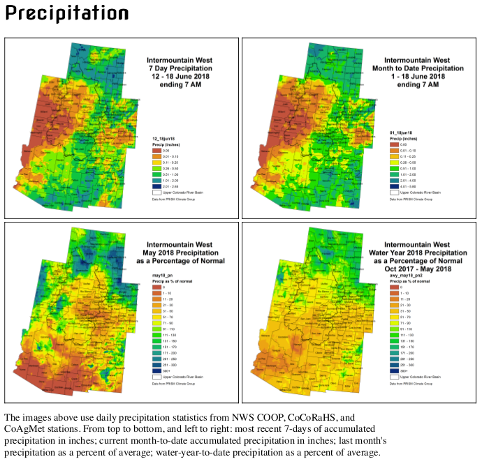
Eunice Foote is finally honored for her contributions 162 years later.
It was “blind luck” said Ray Sorenson, a retired petroleum geologist, regarding how he first came across Eunice Foote’s name. Sorenson, whose basement in Oklahoma is full of more than 300 pre-Civil War era technical books, discovered Foote’s name sometime in 2010.
Sorenson had found copies of the Annual Scientific Discovery by David A. Wells, and “I really liked them, and started collecting them,” he told ThinkProgress. It was while reading the 1857 volume that he stumbled upon Foote.
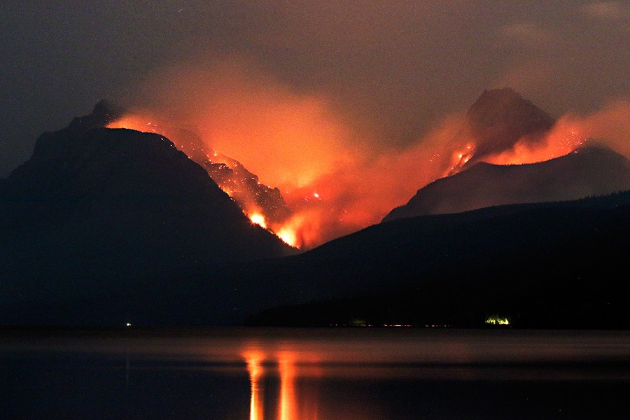
As he quickly realized, Foote was the first scientist to make the connection between carbon dioxide and climate change. She discovered CO2’s warming properties in 1856, more than 160 years ago and three years before John Tyndall, a British scientist who has widely been credited with first establishing the connection between increased global temperatures and carbon dioxide.
But for a number of reasons — chief among them the fact that she was a woman — Foote’s name was until recently lost to history, a minor footnote within climate science.
“I knew just enough about the history of climate science,” Sorenson said of his ability to grasp the significance of the name and date. “I recognized that it was something that had been missed by historians,” he explained, “and I felt she deserved recognition.”
In January 2011, Sorenson published his findings in the journal AAPG Search and Discovery as an independent researcher. “I’ve had more response to that than anything else I’ve ever written,” he said.
Fast-forward seven years — and more than a century — to a symposium titled, “Science Knows No Gender,” held Thursday at UC Santa Barbara with the sole purpose of acknowledging Foote’s contribution to climate science, and erasure from the history books.
“She basically laid the basis for modern climate change science,” said John Perlin, a research scholar in UCSB’s physics department who discovered Foote’s name through Sorenson’s paper. “What could be more significant?”
[…]
Eunice Foote’s story
Foote’s story is still unfolding the more researchers dig into it. It begins in upstate New York, where she lived. Foote, a short, oval-faced woman with dark brown hair and grey-blue eyes, was a student at Troy Female Seminary. While there, she was invited to attend a nearby science college where she learned the basics of chemistry and experimental techniques.
She wasn’t just a scientist, though. She was a central figure in the early women’s rights movement and lived next door to the famous suffragist Elizabeth Cady Stanton. In 1848, Foote was one of the signatories to the Seneca Falls Declaration of Sentiments — in which the final resolution adopted calls for “the securing to woman an equal participation with men in the various trades, professions and commerce.”
In addition to being a hub of feminism, the area where Foote lived also happened to be the final stop along the underground railroad before entering Canada. And as it happened, abolitionist Frederick Douglass, who ran a printing press nearby, published the Seneca Falls Declaration.
But back to the science. Eventually, Foote designed an experiment to better understand the role of atmospheric gases in temperature changes — an emerging topic of interest to a handful of scientists at the time. Her experiment was simple: Foote filled separate glass jars with water vapor, carbon dioxide, and air. She then compared how much they heated up in the sun.
As she wrote of her findings, “The highest effect of the sun’s rays I have found to be in the carbonic acid glass” (the term used at the time for carbon dioxide).
“The receiver containing the gas became itself much heated — very sensibly more so than the other — and on being removed, it was many times as long in cooling,” she continued.
In other words, the jar containing CO2 warmed up more from the sun’s rays than the other jars. And it held that heat for much longer.
Foote goes on to speculate about what this might mean for our atmosphere. “An atmosphere of that gas would give to our earth a high temperature,” she wrote, “and if as some suppose, at one period of its history the air had mixed with it a larger proportion than at present, an increased temperature from its own action as well as from increased weight must have necessarily resulted.”
Foote presented these findings — detailed in a paper titled, “Circumstances affecting the heat of the sun’s rays” — on August 23, 1856 at the annual meeting of the American Association for the Advancement of Science (AAAS). According to AAAS archivist Norma Rosado-Blake, Foote was able to have her paper presented because her husband, Elisha Foote, was a member of the organization. She did not present her own work, however. Instead, Professor Joseph Henry of the Smithsonian Institute, spoke on her behalf.
In acknowledging that it was Foote’s work, Henry introduced the findings by stating, “Science was of no country and of no sex. The sphere of woman embraces not only the beautiful and the useful, but the true.”
Ever since Foote’s name has come to the public’s attention, there has been a debate within the scientific community about whether her work was suppressed because she was a woman, and whether Tyndall deliberately used Foote’s work without due credit, or if it was just coincidental timing.
It’s unknown why Henry presented Foote’s paper on her behalf. However, according to climate scientist Katharine Hayhoe of Texas Tech University, who contacted AAAS with this very question, Foote did end up presenting a second paper published in 1857 at AAAS herself.
In addition, said Hayhoe, it seems there were several other instances of people’s papers being presented by proxy at AAAS regardless of gender. So, while “there were absolutely gender stereotypes [at play],” supporting the idea that Foote may have been discouraged to present, Hayhoe contends there isn’t enough evidence to prove Foote was actively forbidden from presenting her climate findings.
Who gets the credit?
With regard to Foote’s findings, it’s important to note that the concept of the greenhouse gas effect was discovered in the 1820s, by Joseph Fourier. What Foote and Tyndall’s work did was to connect that observed effect to a specific gas in the atmosphere. And Foote’s results, while not definitive (there were many uncontrolled factors in her experiment), were prescient.
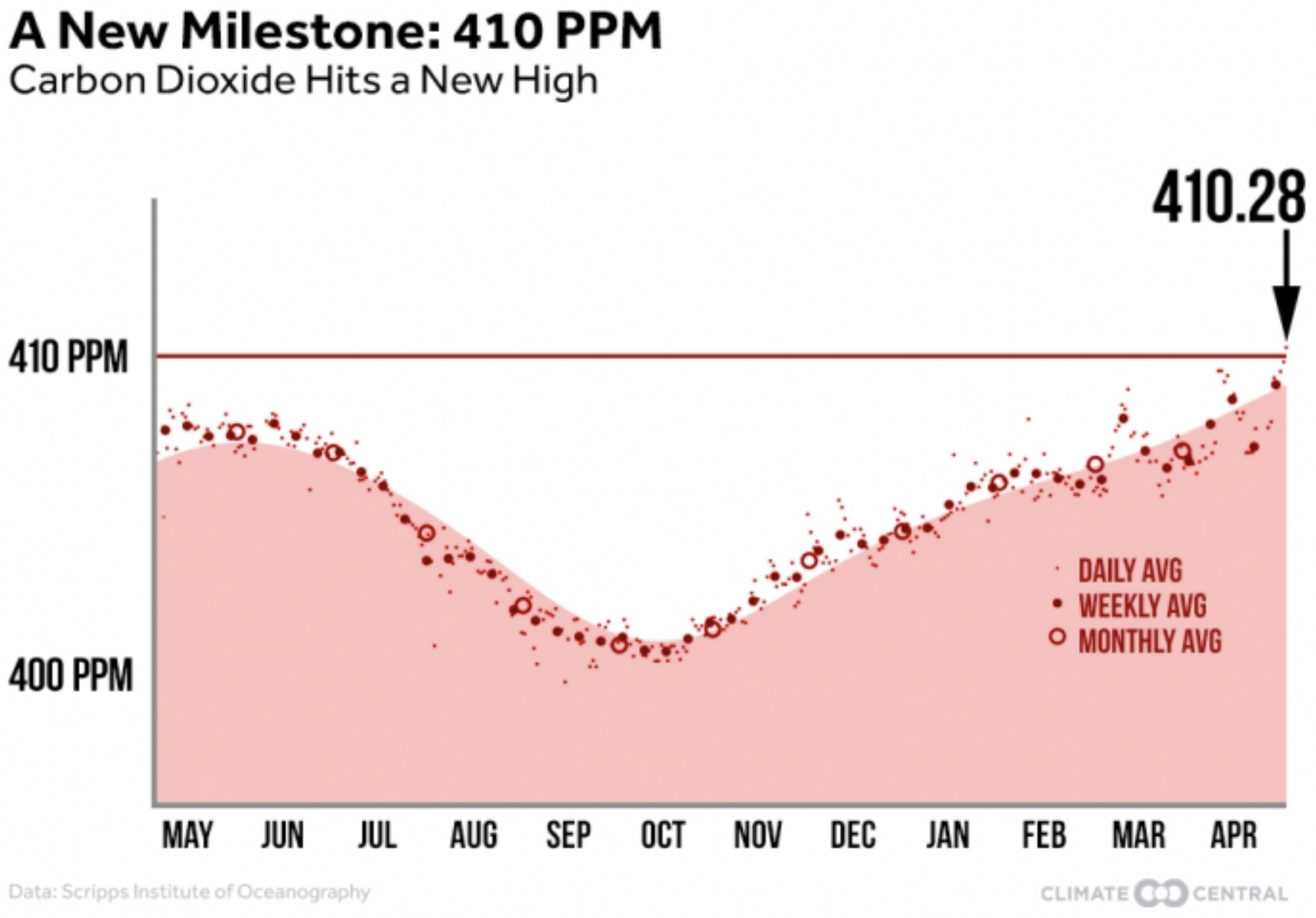
“When Eunice did her experiment, average carbon dioxide levels were about 290 parts per million in the atmosphere,” Hayhoe wrote in a 2016 Facebook post. “She probably never dreamed that by 2016, they’d be over 400 parts per million.”
Due to the rudimentary set-up of the experiment, Foote “wasn’t measuring what she thought she was measuring, but she actually serendipitously ended up with an understanding that is correct today,” Hayhoe told ThinkProgress.
“She very presciently speculated that the temperature of the planet would be higher if CO2 were higher and as far as I know she was the first person to speculate that,” said Hayhoe, who noted that she didn’t have enough information to be able to say whether Tyndall was aware of Foote’s work or not.
Tyndall’s work, meanwhile, used more sophisticated experimental techniques and could therefore correct for some of the issues Foote encountered in order to more precisely measure infrared light-waves absorbed by CO2.
Tyndall was ultimately able to more clearly prove that the greenhouse gas effect is tied to carbon dioxide and human activities — this work has been widely accepted as a critical piece of the foundation for modern-day climate science. The Tyndall Centre for Climate Change Research, for instance, a prominent research institute in the U.K., now bears his name.
Perlin, however, strongly believes Tyndall used Foote’s work.
“I was curious, I spent a long time on this, whether or not there was some relationship between Eunice’s work and Tyndall’s work,” he said. Then one night at 4 a.m. he says, “I came up with what I say is the real damning evidence.”
As Perlin said, his late-night inspiration eventually led him to look back at the 1856 American Journal of Science, where Foote’s article is published. Also in that same issue is an article by Tyndall about color blindness.
Perlin believes it would have been impossible for Tyndall to have missed Foote’s work. Having both authors published in the same journal issue “enhances the possibility that he would have this volume in his hand,” said Perlin, “because he’d like to see his article.”
“I have taken so much, pardon the word, shit, for suggesting that Tyndall may have looked at Eunice’s work,” Perlin added, arguing that her story “is a great rallying point” for today’s climate and women’s movements.
Regardless of where one stands on whether Tyndall was aware of Foote’s work, what everyone does appear to agree on is that she deserves much more recognition for her work than she has received until now.
“She really has been lost to history and I’m absolutely sure there’s a strong gender component to that,” said Hayhoe, adding that Foote also had to contend with being an amateur scientist, whereas Tyndall did not. “And the fact that she was not a professional scientist, well gender is there too.”
Looking forward
Rather than it being a story about suppression, Hayhoe believes it should be one of celebration. Foote achieved a remarkable amount during her time, and is “an incredible role model for women today.”
Tiffany Lohwater, chief communications director at AAAS, agreed. “The past is the past and the future is the future,” Lohwater said, adding that by understanding the past, we can look back “to say what can we learn from that that can help us do a better job in understanding and recognizing women today and in the future?”
Using Foote’s story as a reference point, added AAAS archivist Rosado-Blake, “to stimulate a new dialogue and engage new audiences is an important component in engaging a new generation.”


")