NISP: Fort Collins continues to try to influence final project

Northern Integrated Supply Project (NISP) map July 27, 2016 via Northern Water.

From The Fort Collins Coloradoan (Nick Coltrain):

With a key final report looming for two proposed Poudre River-fueled reservoirs, Fort Collins City Council will weigh whether staff will try to negotiate over the city’s remaining concerns.

Past city comments helped steer the Northern Integrated Supply Project in a more agreeable direction, according to a staff report for Tuesday night’s City Council meeting. But concerns still remain. Staff members hope a negotiation might quell, or at least mitigate, some of them…

According to city staff, the prime concerns are:

  • a reduction of peak flows in the river, and related loss of river health and increased flood risk;
  • the unknown effect the project may have on water quality;
  • an unclear and “inadequately funded” adaptive management plan;
  • concerns that there’s not enough money gong to mitigation or river enhancement.
  • Officially, the city does not support NISP, but it has engaged in conversations with project organizer Northern Water on the project that has been talked about for more than a decade.

    City staff is pushing for more formal negotiations — the City Council stripped that specific language in a similar resolution in February 2017 — because the permitting process is nearing its end. The Army Corps of Engineers is poised to release its final environmental impact statement at the end of June, according to the city.

    The city isn’t a direct participant in the Northern Integrated Supply Project, though it is considered a stakeholder. The Corps doesn’t usually accept public comment on final environmental impact statements but is poised to do so this time, according to city staff. However, it will also likely be late enough in the process that public comment alone won’t be able to make change much.

    Any negotiations would likely include a give-and-take with Northern Water, such as the city’s help in expediting remaining permits, though staff didn’t speculate about what else it may be.

    “As with any such discussions regarding complex matters and potential agreements, there are no guarantees of success,” according to the staff report [ed. Click through to the Coloradoan to read the report]. “Furthermore, the approach will depend on Northern Water’s willingness to participate.”

    #Drought news: Wildlife winners and losers

    Southwest Drought Monitor May 22, 2018.

    From The Cortez Journal (Ryan Simonovich):

    Birds and fish struggle with less water, but bears benefit from warmer weather

    Some animals, such as birds, do not need to drink much water because they metabolize water from the food they eat, said Colorado Parks and Wildlife spokesman Joe Lewandowski.

    But drought conditions decrease the moisture in vegetation, which is detrimental to animals’ hydration. This can be problematic for lactating females, for instance, because they need extra water to produce milk.

    For this reason, Parks and Wildlife hopes monsoons this summer will bring moisture to the vegetation, creating a larger inventory of food for animals.

    The warm spring, which has so far stayed clear of a major freeze, has been beneficial for bears, Lewandowski said.

    Last year, there was a late freeze that affected bears’ natural food supply. Bears then came into town to forage in humans’ trash. This year, food such as plants and berries are growing and available for the bears to eat.

    Dry years also affect fish habitats. Low river and creek water levels mean fewer places for fish to go. Fish eat bugs, and the more water there is, the more bugs there are. When water is warmer, there is less oxygen available in the water.

    At the Durango fish hatchery, Parks and Wildlife is releasing fish into the wild earlier than normal because there is less water available for the hatchery to use.

    Species have adapted to different climates for thousands of years, so there is no threat of a mass extinction, Lewandowski said. However, biologists are worried that long-term drought will have harmful effects on wildlife.

    @audubonsociety files lawsuit over Chatfield Reallocation Project

    Proposed reallocation pool — Graphic/USACE

    From TheDenverChannel.com (Marc Stewart):

    “Swim, or hike, or watch birds, if you have a boat you can go boating,” said Polly [Reetz].

    Yet the couple fears a construction project to build additional areas to hold water will ruin the place in the near future.

    It’s a project that supporters argue is necessary in order to store water in a state that is in the midst of a population boom and a drought.

    “I think aesthetically, it’s going to be a very different kind of park with mud flats instead of this rich riparian vegetation,” said Gene.

    Along with the Audubon Society, they fear that by getting rid of the green space around the reservoir, all of nature will be hurt… including the animals.

    “When you destroy the habitat, or alter it, so that it’s no longer usable for them, there really isn’t any other place to go, because other areas are already full too,” said Polly.

    Which is why the Audubon society has gone to court.

    They want a judge to throw out a previous decision allowing the project to move forward, saying among other things, that it violates the Clean Water Act.

    A hearing will take place in September.

    The Army Corps of Engineers is not commenting as the case is in litigation

    “Audubon recognizes the region is growing, and so were not against developing additional water supplies,” said Gene [Reetz]. He is pushing for more water conservation and alternative storage sites other than Chatfield.

    EPA and City of Colorado Springs negotiating end to Clean Water Act lawsuit? — The #ColoradoSprings Independent

    Colorado Springs with the Front Range in background. Photo credit Wikipedia.

    From The Colorado Springs Independent (Pamela Zubeck):

    Despite protests from fellow plaintiffs, the Environmental Protection Agency has agreed to revisit a possible settlement with the city Colorado Springs over alleged Clean Water Act violations caused by the city’s longterm neglect of stormwater management, according to documents obtained by the Independent.

    The renewed negotiations come as U.S. District Judge Richard Matsch scheduled an August trial in the lawsuit on May 22, the day after the state’s lead attorney in the case was reportedly fired for a reason the Colorado Attorney General’s Office won’t discuss.

    Margaret “Meg” Parish, first assistant attorney general in the Natural Resources & Environment Section, wrote several scathing letters to the EPA in recent months, calling the EPA’s action “shocking and extraordinary” and expressing “deep concern and disappointment” that the agency would unilaterally reopen settlement discussion without consulting co-plaintiffs. Besides the Colorado Department of Public Health and Environment (CDPHE), those include Pueblo County and the Lower Arkansas Valley Water Conservancy District.

    The move was particularly alarming, she noted, because the state and EPA had signed an agreement in which both agreed not to communicate with the city without the presence of the other.

    Some who couldn’t comment on the record due to confidentiality rules called the latest moves — reopening negotiations and the firing of Parish — as “pure politics” in an era when the EPA’s reputation is pivoting from protecting the environment to serving polluters.

    EPA Administrator Scott Pruitt, who has long-standing and close ties to the oil and gas industry and is under investigation for multiple alleged ethics breaches, met with the Housing and Building Association of Colorado Springs in October when the HBA paid for his night’s stay at The Broadmoor.

    A few months later, on March 19, the EPA wrote a letter to the city “as a follow up to the City’s recent request to re-initiate settlement negotiations.”

    The EPA’s co-plaintiffs were given two days notice that the letter would be sent to the city’s legal counsel, reportedly fueling outrage among those partners. Pueblo County has harbored distrust of the city of Colorado Springs for decades regarding sewage discharges and raging stormwater flows in Fountain Creek, which befouls the creek and threatens levees at Pueblo where the creek joins with the Arkansas River. Farmers in the Lower Ark region have complained for years that sediment blocks their irrigation headgates interfering with raising crops.

    #ColoradoRiver: Lower Basin folks hope to solve the #Drought Contingency Plan conundrum #COriver

    Colorado River Basin. Graphic credit: Water Education Colorado

    From The Arizona Daily Star (Tony Davis):

    The hope is that this will lead to approval by year’s end of a proposed Drought Contingency Plan for the Lower Basin states of Arizona, Nevada and California, to conserve more water now to prevent catastrophic declines at Lake Mead later.

    At stake is the future of your drinking water supply — the CAP’s canals bring river water to Phoenix and Tucson — and that of the 40 million people in seven states and Mexico who also depend on the Colorado River for water.

    Here are six things to know about this future:

    1. President Trump has called concerns about human-caused climate change bad science. But out West, his Bureau of Reclamation officials are saying the seven basin states must act to avert a crisis on the Colorado that many scientists have traced to climate change…

    2. CAP officials are concerned that conserving “too much” water in Lake Mead could trigger a premature shortage in water deliveries first for Arizona farms, and later for Phoenix and Tucson’s drinking water. Others say that isn’t valid…

    3. Without a drought plan, the bad tidings that many fear will befall Lake Mead in the distant future could arrive much sooner…

    4. The drought’s additional threat to Lake Powell could threaten Western power production as well as Lake Mead, which supplies water to Arizona…

    5. Arizona’s water agencies are making nice now, and a top CAP official sounds almost contrite. But approval of a drought plan remains uncertain…

    6. The drought plan is only a band-aid, but putting an end to the fighting is considered essential.

    Ouray “State of the River” meeting recap: “We can survive one bad drought” — Bob Hurford

    Uncompahgre River Valley looking south

    From The Telluride Daily Planet (Tanya Ishikawa):

    [Bob] Hurford’s general sentiment about this year’s drought was shared by all who presented reports at the Ouray State of the Rivers meeting at the Ouray County 4H Event Center May 16. The presentations came two weeks after Gov. John Hickenlooper activated the Colorado Drought Mitigation and Response Plan for the agricultural sector in 34 of the state’s 64 counties, including San Miguel, Ouray, Montrose, and Delta counties…

    Hurford explained that over half of the Rocky Mountains’ water supply is in its snowpack. As of April 1, Colorado’s snowpack was 68 percent of average and 64 percent of last year’s. Data maps show that the April 1 snowpack was between 50 percent and 69 percent for Ouray and Montrose counties, and below 50 percent for San Miguel County. Division 4, the eastern area around Gunnison, has the most snowpack; the San Juan Mountains have the least, with snowpack above Ridgway Reservoir at just 46 percent of average.

    Colorado, Utah, Arizona and California had the lowest amount of precipitation in the U.S. this winter, and those four states — plus Nevada and New Mexico — had the highest temperatures from November 2017 to January 2018, according to statistics in Hurford’s report.

    Data from reservoirs in October 2017 show that Colorado had one of its best years with close to 120 percent of average water levels statewide, 100 percent of average in Division 4 and around 116 percent of average in Ridgway Reservoir. Over the last two decades, reservoirs were at or above 100 percent for 11 years.

    “We can survive one bad drought. Two bad droughts in a row and that gets us,” Hurford said.

    Ridgway Reservoir Dam Superintendent Tony Mitchell, of Tri-County Water Conservancy District, showed National Weather Service forecast data that estimated January-April 1 flows into the reservoir at 88 percent of average in 2016, 111 percent in 2017 and 49 percent in 2018. For the period of April 1 through July, the main runoff season, flow estimates were 92 percent of average in 2016, 96 percent in 2017 and 40 percent in 2018.

    Responding to a question about why the reservoir has looked lower than usual this spring, Tri-County Water Conservancy District Manager Mike Berry said late-season releases to the Uncompahgre Valley Water Users Association (UVWUA) were larger than usual last year, precipitation was low last summer and storage levels are kept lower than normal to avoid water spilling over the dam, which would send non-native fish into the Uncompahgre River, endangering the trout there.

    UVWUA Manager Steve Andersen, who is also a director on the Colorado Water Conservation Board, said, “My association will be OK this year. There’s not as much water as we would like to have, but we will be able to make a crop this year.”

    However, to ensure its downstream water users have enough water, the association in Montrose may have to put a call on water use later in the season, shutting headgates to irrigators upstream in Ouray County (who have junior water rights). Andersen does not expect to make a similar call on water on the upper Gunnison River side because of better snowpack, which should maintain higher flows there. He said the association would use that Gunnison water before resorting to a call on the Ouray side…

    The last time that Ouray irrigators had to shut their headgates due to low stream flows and obligations to more senior water rights holders downstream was in 2012. That is when the Ouray County Water Users Association was founded…

    With the drought conditions came concerns about wildfires, and Ouray and Montrose counties implemented Stage 1 Fire Restrictions on [May 21, 2018]. Stage 1 limits the areas where fires, smoking and spark-igniting activities can take place, according to the State of Colorado Department of Fire Prevention. Stage 2 adds more restrictions, while Stage 3 is the strictest, limiting entry into closed areas and setting fines as high as $10,000 for violators, or imprisonment for six months.

    #Runoff news: Boating season — book now for the best water this season

    Arkansas River at Parkdale May 28, 2018 via USGS.

    From The Denver Post (Bruce Finley):

    Peak flows on the Arkansas River apparently happened May 18, more than a month earlier than usual. The water levels peaked at 1,870 cubic feet per second, far below the average 2,500 to 3,000 cfs and have fallen to 1,500 cfs…

    A deal has been done with downriver farmers and cities to help the whitewater industry get through difficult years like this one — by setting up a reserve of 10,000 acre-feet of water held in Turquoise Lake, Twin Lakes and Clear Creek Reservoir.

    CPW officials this week said they’ve notified agricultural water users and federal Bureau of Reclamation operators of the reservoirs that rafting companies probably will need to draw on that reserve to keep the river flowing at a level no lower than 700 cfs — crucial for boating — through Aug. 15.

    “They said they will have the 10,000 ace-feet available,” White said. “That feels great. It is invaluable. It is the difference between having a lousy summer and having a good summer.”

    […]

    Earlier high flows on rivers caused by earlier melting of reduced mountain snowpack — which this year measured as low as 40 percent of normal in some areas — exemplify the changes scientists have linked to a buildup of heat-trapping greenhouse gas pollution in the atmosphere.

    “Adapting to climate variability is something we are going to have to wrap our heads around in the future,” American Whitewater president Mark Singleton said Friday in an interview. That group represents boaters nationwide and serves as a central source of statistics on matters such as deaths. (Along the Arkansas River since 1986, only 13 rafting deaths on commercial rafting trips were reported, Singleton said, lauding careful state management of the river under a partnership with the federal Bureau of Land Management.)

    “These are all fundamental changes in the river systems,” Singleton said. “And if there’s no water in the reservoirs, there’s no river flow. … What we have seen is these really big swings. In all of our climate systems, we are seeing greater variability.”

    Yampa River at Steamboat Springs May 28, 3018 via the USGS.

    From Steamboat Today (Tom Ross):

    “I think the main stem of the Yampa has peaked,” forecast center senior hydrologist Ashley Nielson said Wednesday. “There is a chance for some rain this weekend, but it would take heavy precipitation over the Yampa and Elk rivers,” to send them to a new level.

    That means the Yampa reached its zenith for the season at 12:45 a.m. May 14, when the flow was 2,570 cubic feet per second. If that figure is confirmed, it would be the lowest peak since 2012 when the river topped out at 1,570 cfs on April 27.

    The great siphoning: Drought-stricken areas eye the Great Lakes — The Minneapolis Star-Tribune

    Great Lakes satellite photo via Wikipedia.

    From The Minneapolis Star-Tribune (Ron Way):

    Lake Superior is big, all right. It and the other Great Lakes contain one-fifth of the whole world’s fresh water and, get this, hold enough to submerge the continental U.S. under 10 feet.

    Those far-off onlookers thirst mightily for the Lakes’ 6.5 million billion gallons of fresh water that, to them, just sits there before running off to the ocean. Wasted.

    It’s easy for us lake-landers to dismiss such thoughts, but those in the American Southwest are up against a 17-year drought that keeps getting worse. After an unusually warm winter, it’s expected to worsen still more this summer due to a dearth of mountain snow that will again leave Colorado River flow far below normal, with forecasts of dry and very hot weather à la La Niña.

    What’s beyond scary is that NASA computer models indicate that the West could be facing a 50-year megadrought, the first such event since long before Europeans even knew North America existed. Moreover, higher temperatures and wind wrought by climate change dry things out and increase demand for irrigation water while at the same time increasing already problematic evaporation rates from reservoirs and canals.

    Primary water sources in Arizona, Nevada and Southern California are dangerously low. Benchmarks are the historically low Lake Mead reservoir behind Hoover Dam (built in 1930) and similar low levels of Lake Powell on the upstream end of the Grand Canyon. Las Vegas, which draws 90 percent of its water from Lake Mead, has twice lowered its intake “straw” due to falling levels.

    One relief option is desalination of ocean water, but scaling up that technology has proved frustratingly difficult and outrageously expensive. The largest existing plant, at San Diego, provides only 7 percent of that city’s needs.

    Another option is to strictly restrict water use, but that’s politically dicey and can’t get much beyond talk.

    Then there’s a plan to spend gazillions to capture several of Alaska’s free-flowing rivers with a grand network of dams, canals and tunnels to divert water south to the Colorado basin. It seems that the drought is getting serious enough so that even far-fetched ideas get a look.

    So OK, now what?

    To desert dwellers, an idea that makes intuitive sense is to pipe Lake Superior water to where it’s “needed.” Such a project would be staggeringly expensive but technically doable; besides, the Great Lakes surely wouldn’t miss, say, 50 billion gallons — would they?

    The populace all around the Lakes is rock-solid against shipping any water anywhere, and advancing any diversion plan would set off political warfare.

    Or perhaps one should say “renew hostilities.” This story isn’t new. In 2007, New Mexico’s then-Gov. Bill Richardson suggested a Great Lakes diversion when the Western drought was only six years old. Following bloodcurdling protest, fellow Democrat Jennifer Granholm, then Michigan’s governor, told Richardson to zip it. A year later the eight Lakes states, including Minnesota, adopted — and President George W. Bush signed — a compact banning diversions without concurrence of all signatories.

    Plus, an international pact gives Canada (along with the federal government in D.C.) a veto over any transfer.

    But because the ultimate power rests with Congress and the president, multistate compacts and international accords can be false security. What’s done can be undone, as evidenced by all the undoing from today’s Washington crowd. What’s more, some scholars say the compact could be vulnerable to legal challenge, especially if a national emergency were declared.

    A political knockdown would pit the Midwest vs. Westerners accustomed to no-holds-barred combat for water (to the death in the Wild West) and who have tended, when all else failed, to get what they wanted by simply taking it (for example, the lands of indigenous tribes).

    Fear the Westerners.

    #Drought news: The #RioGrande is in rough shape this season

    Southwest Drought Monitor May 22, 2018.

    From Utah Public Radio (Kerry Bringhurst):

    A group of western water advocates is focused on finding ways for western communities to work together to protect wildlife and the environment. Drew Beckwith is water policy manager with Western Resource Advocates, a team of scientists, lawyers and economists following drought conditions in the west.

    Beckwith said when water managers with the Central Arizona Water Project announced they were going to pull water from Lake Powell to address drought problems in their state, managers from other drought-stricken states responded.

    “There were some stern letters that were written from folks in Utah, Colorado and Wyoming,” Beckwith said. “That is sort of how the water community polices itself. There is no real legally binding argument that someone did something wrong. It is almost like a peer pressure and shaming.”

    Efforts taken by the Bureau of Reclamation, the seven Colorado River Basin states, along with water districts and Mexico are working to conserve water. Beckwith agrees these voluntary efforts help address the decline of water reserved in Lake Mead. This approach has delayed the onset of reductions to water users in Arizona, Nevada, Mexico and California. But he says it is becoming necessary for all players to create cooperative agreements that will protect Lake Mead and Lake Powell if drought conditions persist.

    “Let’s not focus on things that are individualistic that only benefit a few people,” he said. “Lots of different uses are important. We need to get everyone’s views to make sure those are all incorporated.”

    Reclamation Commissioner Burman would like drought contingency plans from each state to be in place before the end of this year. She is calling on states, tribes, water districts and non-governmental organizations to work together to meet the needs of over 40 million people who depend on reliable water and power from the Colorado River.

    On Tuesday Burman announced the Jordan Valley Water Conservancy District in Utah will receive $160,000 to develop a drought contingency plan for its service area in Salt Lake and Utah counties. The district’s service area includes 15 cities and is home to nearly 25 percent of Utah’s population and is expecting rapid population growth due to a healthy economy.

    According to the bureau’s Peter Soeth, the district will assemble stakeholders from all sectors to identify projects, actions and partnerships needed to prepare for and reduce water shortages and improve drought resilience for the areas water users.

    From The New York Times (Henry Fountain):

    “Nobody’s got a whole lot of water,” said David Gensler, the hydrologist for the Middle Rio Grande Conservancy District, whose job is to manage the river water that is delivered to Mr. Rosales and the others through diversion dams, canals and ditches. “If we use it up early in the season and don’t get any rain further on, the whole thing’s going to crash.”

    Parts of the state got some much-needed rain this week, which may help Mr. Gensler extend his irrigation water a bit. But whatever happens this spring and summer, the long-term outlook for the river is clouded by climate change.

    The Rio Grande is a classic “feast or famine” river, with a dry year or two typically followed by a couple of wet years that allow for recovery. If warming temperatures brought on by greenhouse gas emissions make wet years less wet and dry years even drier, as scientists anticipate, year-to-year recovery will become more difficult.

    “The effect of long-term warming is to make it harder to count on snowmelt runoff in wet times,” said David S. Gutzler, a climate scientist at the University of New Mexico. “And it makes the dry times much harder than they used to be.”

    With spring runoff about one-sixth of average and more than 90 percent of New Mexico in severe to exceptional drought, conditions here are extreme. Even in wetter years long stretches of the riverbed eventually dry as water is diverted to farmers, but this year the drying began a couple of months earlier than usual. Some people are concerned that it may dry as far as Albuquerque, 75 miles north.

    But the state of the Rio Grande reflects a broader trend in the West, where warming temperatures are reducing snowpack and river flows.

    A study last year of the Colorado River, which provides water to 40 million people and is far bigger than the Rio Grande, found that flows from 2000 to 2014 were nearly 20 percent below the 20th century average, with about a third of the reduction attributable to human-caused warming. The study suggested that if climate change continued unabated, human-induced warming could eventually reduce Colorado flows by at least an additional one-third this century.

    “Both of these rivers are poster children for what climate change is doing to the Southwest,” said Jonathan T. Overpeck, dean of the School for Environment and Sustainability at the University of Michigan and an author of the Colorado study.

    While both the Colorado and the Rio Grande are affected by warming, Dr. Overpeck said, the Rio Grande has also been hurt by declines in winter precipitation. “It’s a one-two punch,” he said.

    Last year, though, was a wet one on the Rio Grande, with a strong snowpack in the winter of 2016-17 that allowed the conservancy district to store water in upstream reservoirs. Using that water now should help Mr. Gensler keep the irrigation taps turned for several months.

    “In some ways I’m more concerned about 2019 than 2018,” he said. “There’s a possibility we’re going to drain every drop this year, and go into next year with nothing.”

    Temperatures in the Southwest increased by nearly two degrees Fahrenheit (one degree Celsius) from 1901 to 2010, and some climate models forecast a total rise of six degrees or more by the end of this century. As elsewhere in the West, warmer temperatures in winter mean that more precipitation falls as rain rather than snow in the San Juan and Sangre de Cristo mountains that feed the Rio Grande.

    Dr. Gutzler said spring temperatures have an impact, too, with warmer air causing more snow to turn to vapor and essentially disappear. A longer and warmer growing season also has an effect, Dr. Overpeck said, as plants take up more water, further reducing stream flows.

    Running for nearly 1,900 miles, mostly through arid lands, the Rio Grande is one of the longest rivers in the United States. It is also one of the most managed, having been controlled by dams and other structures for most of the last century. But use of the river for irrigation dates back much further: For hundreds of years its water nourished the crops of native Puebloan people and Spanish colonizers.

    In a typical year most water in the upper Rio Grande is diverted for irrigation. (Albuquerque, by far the state’s largest city, gets its drinking water from groundwater wells and from a project that diverts water from the Colorado River basin through a tunnel under the Continental Divide.)

    By law, some Rio Grande water must also be sent further downstream, to a reservoir that serves farmers in southern New Mexico and Texas. That section of the river, which forms the border with Mexico and empties into the Gulf of Mexico, has its own severe problems, and relies on a Mexican tributary for most of its water.

    As the river dries, crews from the United States Fish and Wildlife Service spring into action, working to rescue the Rio Grande silvery minnow, a federally protected endangered species that used to thrive along the full length of the river but now is found only in the upper reaches.

    Crews have been rescuing the small fish most springs and summers for about 20 years, running nets through pools that remain as the river dries up and delivering the fish to wetter areas upstream.

    Normally the crews would start this work in June, said Thomas P. Archdeacon, a Fish and Wildlife biologist who heads the minnow rescue operation. This year, he said, they made their first rescue on April 2 and have moved northward as stretches of the river dried up.

    “I look at it as an umbrella species,” he said of the minnow. “Because it has these federal protections, it’s protecting basically everything along the river.” The Rio Grande is still lined with willows, Russian olive and other vegetation along its banks, and together with the irrigated farmland forms a long, narrow oasis amid an otherwise parched brown landscape.

    But much of the riverbed itself is as dry as a bone…

    who farms 650 acres near San Antonio, has wells to pump groundwater onto his fields should the irrigation canals dry up and the rains not materialize. “I’m droughtproof,” he said. “When we plant in the spring we don’t even take into consideration how much snowpack or surface water there’s going to be.”

    North of Albuquerque, Derrick J. Lente, a member of the Sandia Pueblo, cultivates 150 acres, some of which is pasturage for cows that he raises. Under water laws, farmers in the pueblos would be among the last to lose water.

    His ancestors have farmed in this region for hundreds of years, through wet times and dry. But Mr. Lente, who is also a state legislator, recognizes that there is long-term trouble ahead. His father and uncles, who have been farming far longer than him, have seen changes.

    “This is the worst they’ve seen it in their lives,” he said. “The times are changing to where it’s hotter.”

    Mr. Lente does not have irrigation wells on his farm, but he has made improvements to conserve water, lining some of his irrigation ditches and replacing another with a tunnel.

    “I never built it with the idea we won’t ever have water,” he said. “I don’t want to think of that time, I really don’t. We’d have to make some hard decisions.”

    The drying riverbed of the Middle Rio Grande near the Bosque del Apache National Wildlife Refuge on April 4, 2018. Photo credit: USBR

    From The Albuquerque Journal (Ollie Reed Jr.):

    A map released Thursday by the U.S. Department of Agriculture’s drought monitor shows that more than 20 percent of New Mexico – scattered areas in the northern part of the state – is in exceptional drought, the most serious category, and more than 99 percent of the state is in some kind of drought. And the dropping of water levels in the Elephant Butte and Caballo reservoirs forced a restriction on storing additional water in northern New Mexico reservoirs.

    To make things grimmer, Fontenot said Thursday that the outlook for the next eight to 14 days is hot and dry.

    There is a silvery lining, however. David Gensler, water operations manager for the Middle Rio Grande Conservancy District, said the sudden increase in Rio Grande flows caused by the rain this week stimulated spawning among the endangered silvery minnow, as indicated by the number of minnow eggs collected in surveys…

    Reservoirs down

    “Twenty percent of the state in exceptional drought is pretty high,” Fontenot said. He said New Mexico has not had that degree of exceptional drought since August 2013. But it has been even worse in the past. In a drought that lasted from May 2011 to May 2012, as much as 49 percent of New Mexico was in that category.

    Some parts of New Mexico got a lot of rain from a system that moved into the state Monday and lingered into Thursday. A thunderstorm Monday broke a 54-day streak without measurable precipitation in Albuquerque. Albuquerque got 0.12 inch that day, Clayton 0.46, Roswell 0.51, Tucumcari 1.10 inches and Clovis 1.21.

    Some areas got more rain in the succeeding days. Fontenot said that on Wednesday up to 6 inches of rain fell within six hours along U.S. 84 in San Miguel and Guadalupe counties…

    This week’s rain, as vigorous as it was in some areas, did not stop the water levels in the Elephant Butte Reservoir, five miles north of Truth and Consequences, and Caballo Reservoir, 16 miles south of TorC, from dropping low enough to trigger a Rio Grande Compact provision prohibiting the storage of additional water in upstream reservoirs…

    The Conservancy District’s Gensler said the total water in Elephant Butte and Caballo dropped below 400,000 acre-feet Sunday, putting the Article VII restriction into effect for the first time since early this year. An acre-foot is the amount of water necessary to cover an acre to a depth of 1 foot.

    On Thursday, combined water in the two reservoirs was at about 394,000 acre-feet, Gensler said…

    OK for now

    Gensler said the Article VII restriction would probably not change much for the irrigators on the 70,000 acres of cropland served by the Conservancy District.

    “Opportunities for storage are pretty rare during the summertime anyway,” he said. And he noted that even though Article VII restricts the storage of additional water, it does not prohibit the release of water that had already been in storage. He said that adds up to 107,000 acre-feet in El Vado, Heron and Abiquiu…

    Gensler said, however, that things could get really bad if the state is still under the Article VII restriction next spring.

    Thornton Water Project update

    Map via ThorntonWaterProject.com.

    From The Fort Collins Coloradoan (Jacy Marmaduke):

    The [Larimer County Planning Commission] voted 4-2 [May 16, 2018] to recommend that county commissioners turn down the project at their July 9 meeting. The Board of County Commissioners doesn’t have to listen to the planning commission’s guidance, but it holds special weight.

    At the end of a packed five-hour hearing, several planning commissioners said Thornton’s application for the Larimer County portion of its proposed 75-mile pipeline lacked detail, especially when it came to potential alternatives and a proposed pump house that would sit adjacent to the Douglas Road section of the pipeline…

    Now county staff will convene with the planning commission to determine where Thornton’s proposal needs more detail. Thornton leaders will provide that information to county commissioners before their July meeting, Thornton Water project spokesman Mark Koleber said.

    Thornton hopes to begin construction of its pipeline in 2019 and use it for water deliveries by 2025. The pipeline would eventually funnel an average of 14,000 acre-feet of water annually along Douglas Road, then south…

    Thornton’s pipeline wouldn’t draw additional water from the Poudre because the city purchased the water rights in the ’80s from farms that have continued to use it. Still, opponents argued that adding additional water to the beleaguered Poudre through Fort Collins would offset other diversions and make the river healthier…

    [Mark] Koleber told the board running the water through the Poudre would present several issues for the city and its residents:

  • The water would run past three wastewater treatment plants and sections of urban runoff, degrading its quality and making it expensive and complicated to treat. Fort Collins and other municipal users divert their water upstream for the same reason.
  • Running the water down a roughly 18-mile section of the Poudre would result in a 9 percent loss of water.
  • Thornton’s water court decree requires diversion from the Larimer County canal upstream, and the city’s water rights could be reduced if it asked water court for a modification.
  • The city wouldn’t be able to use reservoirs north of Fort Collins for storage of its water, and building new reservoirs elsewhere “is no easy prospect,” Koleber said.
  • But some of the commissioners were unconvinced that Thornton did enough to fully evaluate all alternatives and declare the Douglas Road route the best option…

    Commissioners spent little time discussing Thornton’s larger plans during deliberation. Commissioner Gary Gerrard, who joined commissioner Curtis Miller in dissenting votes for the recommendation for denial, said he doesn’t have the right to “stand in the way” of another community’s access to water it legally purchased.

    “It’s not like they’re Russians,” he said. “They are our neighbors. …They’re people just like us; they need water. Clean, potable water is important to all of us.”

    Chairman Sean Dougherty, commissioner Mina Cox, Caraway and Jensen voted to recommend denial of the Thornton pipeline permit.

    From The Fort Collins Coloradoan (Jacy Marmaduke):

    Although it’s true that long-term plans could include more pipelines, the city is currently proposing just one, Thornton Water Project director Mark Koleber said.

    This much is clear: Thornton is moving through the permitting process for a single pipeline, not three, to convey water from reservoirs north of Fort Collins to the growing Denver metro city. The 70-mile pipeline, if approved, will eventually funnel an average of 14,000 acre-feet of Poudre River water annually along Douglas Road, then south to Thornton…

    The city has rights to more water that it could one day seek to transport through additional pipelines. Its long-term water plan could look a lot like what’s described in the decades-old documents, but nothing is for sure at this point.

    The operative word here is “could.” Thornton will only pursue additional pipelines if they prove necessary, Koleber said, and any additional infrastructure must be permitted through a lengthy review process similar to what’s going on now. The city would also need to go through water court proceedings to use its additional water rights.

    Thornton projects the single pipeline will meet its water needs through 2065, so additional pipelines wouldn’t be necessary for half a century, Koleber said…

    Construction along the pipeline route could begin in 2019. The project, currently estimated to cost $430 million, needs to be operational by 2025 to meet Thornton’s water supply needs, Koleber said…

    Dick Brauch, who owns the farm where Thornton plans to place its pump house, is worried the city will hurt his operations.

    “The farm’s been in my family for 60 years, and I have no desire to sell,” he said, but he’s negotiating with the city to avoid eminent domain.

    The planned location for the 2.8-acre pump house would “take a big chunk out of the middle” of Brauch’s land and be difficult to farm around, he said. Koleber said Thornton is working with Brauch and can probably accommodate his concerns.

    From The North Forty News (Theresa Rose):

    The plan would pull the water from the Poudre River from a location close to Ted’s Place where the river crosses U.S. 287, to be stored in a network of reservoirs north and west of Douglas Road. A pump station would be built near the intersection of Douglas Road and Starlight Drive just east of North Shields Street. The permit was filed in January 2018…

    In the 1990s, the case went to the Colorado Supreme Court to determine if Thornton could use the water rights to convert the water from agriculture to municipal use. At this time, Thornton leased some of the farms back to farmers along with the water. Many of these farmers were the same people from whom Thornton bought the land. Some of the farmers use the dryland grass cover as forage for their animals. In addition, Thornton has been making voluntary tax payments to Larimer and Weld counties, $45,000 to Larimer and $257,000 to Weld in 2017.Koebler estimated Thornton has paid close to $6 million in voluntary tax payments since 1985.

    Four years ago, Thornton attempted to address the concerns of their water program and pipeline. Open houses were held in Firestone, Johnstown, Windsor and Fort Collins. HOAs were consulted. The locals were asked for advice on the routing of the pipeline.

    Construction would begin in Windsor and proceed in Weld County. The pipeline is expected to be completed by 2025.

    City of Aspen reaches agreement with five parties on moving Maroon and Castle creek water rights — @AspenJournalism

    An illustration of the potential Maroon Creek Reservoir, prepared by Wilderness Workshop. Source: Wilderness Workshop

    From Aspen Journalism (Brent Gardner-Smith):

    The city of Aspen now has signed settlement agreements from five of the 10 parties opposing its efforts in water court to maintain conditional water storage rights tied to large potential dams on Maroon and Castle creeks, including Pitkin County, Wilderness Workshop, Western Resource Advocates, and two private-property owners in the Castle Creek valley.

    “Aspen agrees that it will forego the right to store water pursuant to these water rights at the original decreed locations,” a May 24 staff memo from the city states.

    The five parties that have yet to sign agreements include the U.S. Forest Service, American Rivers, Trout Unlimited, and two property owners in the Maroon Creek valley.

    According to a draft resolution that the city council is expected to approve at a regular meeting on Tuesday, city staffers and the city attorney “have diligently negotiated with the remaining opposers to seek settlement in regarding their opposition and staff and its attorney believe that stipulations substantially similar to the attached stipulations will be entered with the remaining opposers.”

    The city has said that none of the agreements are binding unless all 10 parties agree to the settlement terms.

    As the city works through settlement negotiations with the parties, the resulting agreements can become more restrictive, but not less so, which is a common approach to settling water court cases.

    For example, the agreement signed by an attorney for Pitkin County regarding Maroon Creek Reservoir does not include the county-owned Moore Open Space as one of the sites where the city may move its storage right, as did an earlier version of the agreement signed by Wilderness Workshop.

    Other potential water-storage sites include the current Woody Creek gravel pit site, a piece of vacant land next to the gravel pit recently purchased by the city for potential water storage, the city-owned Zoline open space between the Maroon Creek Club and the Burlingame housing project, the city-owned Cozy Point Open Space at the bottom of Brush Creek Road, and the city’s municipal golf course.

    Under the agreements, the city will seek to transfer its conditional water storage rights from the upper Castle and Maroon creek valleys to these other potential reservoir sites, with a maximum storage capacity of 8,500 acre-feet.

    A map prepared for the City of Aspen that shows the five potential water-storage sites in the Roaring Fork River valley.

    1971 decree

    The city has held the conditional water rights for the Castle and Maroon creek reservoirs since 1965 and they carry a 1971 decree date, which the city hopes to carry to the other potential locations.

    The potential Maroon Creek Reservoir would hold 4,567 acre-feet of water behind a 155-foot-tall dam on USFS property within view of the Maroon Bells. It would also flood a portion of the Maroon Bells-Snowmass Wilderness.

    The potential Castle Creek Reservoir would hold 9,062 acre-feet behind a 170-foot-tall dam, mainly on private property, two miles below Ashcroft.

    Western Resource Advocates and Wilderness Workshop issued a press release about their agreements with the city on Thursday afternoon.

    The release was sent out after the city of Aspen posted the meeting packet for a scheduled May 29 Aspen City Council meeting.

    Aspen Public Radio posted a story on Thursday afternoon with the headline, “Aspen agrees to never build dams on Castle and Maroon.”

    The Aspen Times and the Aspen Daily News also wrote stories Thursday evening about the city’s progress in reaching settlements with opposing parties.

    As part of the deal with the five parties who have signed agreements, or stipulations as they are called in water court, the opposing parties have agreed not to oppose the city’s efforts to change the water rights to the new locations for 20 years.

    Six of the 10 parties who filed statements of opposition in December 2016, in response to the city’s due-diligence filing in October 2016, filed in both the Maroon and Castle creek cases.

    But the two pairs of private-property owners filed in only one case each.

    Double R Creek Limited, and ASP Properties, which control property in the Castle Creek valley where the potential dam would have been built, only filed in the Castle Creek case. They have both signed settlement agreements.

    However, Larsen Family LP and Roaring Fork Land and Cattle Co., which own land in the Maroon Creek valley, have yet to sign agreements with the city.

    The cases are being processed in Division 5 Water Court in Glenwood Springs. The next status conference in the case is scheduled for June 26, and the 18-month mark in the case is June 30.

    From The Aspen Times (Carolyn Sackariason):

    Two of the opposers, Wilderness Workshop and Western Resource Advocates, announced the settlement Thursday evening.

    Will Roush, conservation director at Wilderness Workshop, commended the city for finding another way to store its water other than in a designated wilderness area.

    “It’s a big deal. … Everybody came to a consensus that these were not the right places for dams,” he said.

    Roush’s organization, along with nine other parties, sued the city after it applied to the state to extend existing conditional water rights for the two potential reservoirs. The city first applied for those rights in 1965.

    Since 2016, city officials have maintained that adequate water storage is needed in anticipation of climate change impacts like drought, fire and changes in runoff.

    “City Councils over the decades have worked to preserve Aspen water customers’ water supply, including storage options now and into the future,” Aspen Mayor Steve Skadron said in a statement. “We are pleased that we could achieve a solution with Wilderness Workshop and Western Resource Advocates, and hopefully all the parties invested in a mutually successful outcome, that protects pristine areas of wilderness while still prioritizing Aspen’s water needs for the coming decades.”

    In 2017, the city announced its intention to move the conditional storage rights out of both valleys. It has been in negotiations with the opposing entities since then.

    Stipulations with the five parties — which Aspen City Council is set to approve Tuesday — would result in the government relocating its water storage rights to six other potential locations in the Roaring Fork Valley…

    Roush said he has spoken to representatives of some of those parties and there are no substantial differences in the stipulations. He said he expects those agreements to be signed off on, but in the meantime there is no time like the present to advance his organization’s goal to keep water storage out of the valleys…

    “It’s a great day for Castle and Maroon creek valleys, and that those streams will remain free-flowing,” Roush said.

    2018 #COleg: Eagle County folks welcome extension of #Colorado Lottery

    Floating the tiger, Yampa River, 2014. Photo: Brent Gardner-Smith/Aspen Journalism

    From The Vail Daily (Pam Boyd):

    Last week, Colorado Gov. John Hickenlooper signed SB18-066 into law, extending the operation of the Lottery Division to July 1, 2049, 25 years past July 1, 2024, the date it was previously scheduled to terminate.

    “It’s great news and we’re pleased this avenue of funding has been extended to help ensure that everything we love about Colorado — its wildlife, natural resources, rivers and trails — will continue to benefit from the lottery proceeds for another 25 years,” said town of Vail Communications Director Suzanne Silverthorn.

    The Colorado Lottery is marking its 35th anniversary this year. After Colorado voters approved a state lottery in 1980, the General Assembly created a Lottery Division to administer the program as an enterprise fund, which means it receives no tax dollars. Since 1983, the Colorado Lottery has returned more than $3 billion in proceeds to the state to invest in outdoor recreation and land, water and wildlife conservation. Since 1992, this work been funded through three organizations: the Conservation Trust Fund, Colorado Parks and Wildlife and Great Outdoors Colorado…

    Sen. Jerry Sonnenberg and Sen. Leroy Garcia in the Colorado Senate and Rep. Jeni James Arndt and Rep. Cole Wist in the Colorado House of Representatives sponsored SB18-066. The bill netted a vote of 30 in favor and five opposed in the Senate and 48 in favor and 16 opposed (with one representative excused) in the House…

    In 25 years, Great Outdoors Colorado, which annually receives up to half of lottery proceeds against a cap, has funded more than 5,000 projects in all 64 Colorado counties through its partners: local governments, nonprofit land trusts and Colorado Parks and Wildlife. Projects include school yards, playgrounds and enriching outdoor education spaces for our state’s urban and rural youth; hundreds of miles of trails; and more than 1,600 parks and outdoor recreation areas. Great Outdoors Colorado funding has also supported the state park system, conserved critical wildlife habitat and protected farms and ranch land.

    Conservation Trust Fund, a program of Colorado’s Department of Local Affairs, receives 40 percent of lottery proceeds to fund conservation and recreation work across the state, and Colorado Parks and Wildlife receives 10 percent for state parks. In years when lottery profits exceed the Great Outdoors Colorado cap, which they typically do, spillover dollars go to the Colorado Department of Education’s Public School Capital Construction Assistance Fund, called BEST.

    WISE water arrives in Castle Rock; join the celebration June 8 — @crgov

    WISE System Map via the South Metro Water Supply Authority

    Here’s the release from the Town of Castle Rock:

    For years, Castle Rock Water has made providing long term, renewable water a priority. Now, a major milestone has been reached and the first drops of WISE water are headed to Town. Join the celebration to help commemorate this accomplishment and take a look at what’s coming up next for water in Castle Rock.

    The fun-filled family celebration will be from 4:30 to 6:30 p.m. Friday, June 8. Bring the kids, sunscreen and a great attitude to Gemstone Park, 6148 Sapphire Pointe Blvd., to join the festivities and celebrate the WISE water partnership.

    After stakeholders officially cut the ribbon, the community is invited for a festival full of games, food trucks, bump soccer, bounce houses, a foam party, giant bubbles, water colors and more. Plus, get a chance to meet the Most Hydrated Man in Castle Rock.

    Learn more about the celebration at http://CRgov.com/WISEWater.

    The celebration will help mark more than 9 years of planning and $50 million in infrastructure to help ensure the community’s strong water future. When the WISE partnership was created, many communities in Colorado were faced with a drought. With limited, non-renewable resources, communities knew they needed to come up with a plan. Regional water providers saw the opportunity to partner in a solution and share in the expense to buy, transport and treat renewable water.

    The WISE partnership is an arrangement between Denver Water, Aurora Water and 10 other south metro water providers to import renewable water. Castle Rock is the southernmost community partner.

    Castle Rock Water finished the last piece of infrastructure – connecting a pipeline from Outter Marker Road to Ray Waterman Treatment Plant – in late 2017. The first drops of imported WISE water came to Town in late April.

    Follow the entire journey for WISE water with the Most Hydrated Man at http://CRgov.com/WISEWater.

    May 2018 Southwest Drought Briefing — @DroughtGov

    Southwest Drought Monitor May 22, 2018.

    From NIDiS:

    For a written summary of the webinar, please click here.

    After Hearing Constituents’ Concerns, U.S. Sen. Thune Introduces Legislation to Improve Accuracy of U.S. Drought Monitor

    US Drought Monitor May 22, 2018.

    Here’s the release from Senator Thune’s office:

    “I can’t say it enough – no one knows what’s needed to improve agriculture policy more than the farmers and ranchers who work the land and raise livestock in South Dakota.”

    U.S. Sen. John Thune (R-S.D.), chairman of the Senate Commerce Committee and a longtime member of the Senate Agriculture Committee, today introduced the Improved Soil Moisture and Precipitation Monitoring Act of 2018, legislation that would provide tools and direction to the U.S. Department of Agriculture (USDA) to help improve the accuracy of the U.S. Drought Monitor and require the coordination of USDA agencies that use precipitation data to determine livestock grazing loss assistance and stocking rates. He also introduced legislation to strengthen and improve the Cooperative Observer Program (COOP) of the National Weather Service, of which the Commerce Committee has jurisdiction, in order to support state-coordinated programs that provide data for the Drought Monitor and other weather programs. The COOP system is the nation’s largest and oldest weather network and is entirely run by volunteers. Thune introduced these bills after hearing directly from several concerned ranchers at an agriculture roundtable event that he hosted in Rapid City in April 2018.

    “South Dakota farmers and ranchers are familiar with working through extreme weather conditions, especially drought,” said Thune. “And after the 2016 and 2017 drought conditions in much of Western South Dakota, some of them would probably say they’re all too familiar with it and are very concerned about accurate precipitation measurement. I recently heard some of those concerns firsthand, which is what led to the development of this legislation. Together, I’m hopeful that we can make the Drought Monitor a far more effective and efficient tool and, at the same time, ensure USDA programs are using accurate and consistent data in administering programs that are designed to help the agriculture community.

    “I can’t say it enough – no one knows what’s needed to improve agriculture policy more than the farmers and ranchers who work the land and raise livestock in South Dakota. I’m thankful for everything they do for our communities and state and can say with certainty that this is not the first, nor will it be the last piece of legislation that will move through the halls of Congress thanks to their suggestions and input.”

    Thune’s Improved Soil Moisture and Precipitation Monitoring Act would:

  • Grant the secretary of agriculture the discretion to improve soil moisture monitoring by increasing the number of monitoring stations or by utilizing other appropriate cost-effective soil moisture measuring devices;
  • Increase the number of precipitation and soil moisture monitoring stations in any area that has experienced extreme or exceptional drought for any six month period since the beginning of 2016, including South Dakota, and authorizes a $5 million per year appropriation to do so;
  • Require USDA to develop standards to integrate data from citizen scientists and to collect soil moisture data; and
  • Require USDA agencies to use consistent precipitation monitoring data and drought assessment across the programs that USDA administers.
  • Thune has heard a number of concerns with respect to the accuracy of the Drought Monitor, especially given its use in determining grazing disaster assistance through programs administered by the Farm Service Agency. Among these concerns is a frustration that USDA does not fully utilize data gathered by existing reporting stations to determine indemnities for insured grazing losses under the Pasture, Rangeland, Forage Insurance Program that is administered by the Risk Management Agency.

    Ranchers have also raised concerns about USDA’s differing rainfall and drought determinations during last summer’s drought that plagued Western South Dakota for several months. For example, the U.S. Forest Service (USFS) determined that some federal grazing lands were too dry and that stocking rates needed to be reduced on USFS grasslands. At the same time, the Drought Monitor classified the same area as not dry enough for ranchers to be eligible for Livestock Forage Program assistance. Thune’s legislation is aimed at addressing these and other concerns.

    #ColoradoRiver: “…we face an overwhelming risk on the system, and the time for action is now” — Brenda Burman #COriver #aridification

    From The Desert Sun (Ian James):

    The river basin, which stretches from Wyoming to Mexico, has been drying out during what scientists say is one of the driest 19-year periods in the past 1,200 years.

    Its largest reservoir, Lake Mead, now stands just 39 percent full. And the federal government has warned that the likelihood of the reservoir dropping to critical shortage levels is growing.

    With all indicators pointing to increasing risks of a water crash in the Southwest, the top official of the U.S. Bureau of Reclamation came to the Imperial Valley with a message for the district that holds the largest single entitlement to Colorado River water: It’s time for action to avert a worst-case scenario, and everyone will need to pitch in.

    Reclamation Commissioner Brenda Burman told the Imperial Irrigation District’s board that she wants to see water agencies in California, Arizona and Nevada restart stalled talks on a “drought contingency plan,” under which all sides would agree to temporarily take less water from Lake Mead to keep it from falling to disastrously low levels.

    “It’s very important for us to start thinking about, what do we need to do to protect Lake Mead and to protect the water users?” Burman told the IID board on Tuesday. She pointed out that four states in the river’s Upper Basin are working on a regional drought plan, and that during the past three years, the three Lower Basin states had, until recently, been negotiating their plan, too.

    “Those talks have sort of fallen off. And I’m here to say for this secretary, for this administration, those talks need to be starting again,” Burman said.

    “We need to be talking about what does a drought contingency plan in the Lower Basin look like? And we need action. We need action this year,” she said. “If you take one message from what I’m saying today, it’s that we face an overwhelming risk on the system, and the time for action is now.”

    Stressing the urgency of her appeal, Burman showed a chart with a range of possible reservoir levels for Lake Mead in the mid-2020s, including a worst-case scenario in which the reservoir falls to “dead pool” — too low for [releases].

    #Drought news: Four Corners in need of a robust North American #Monsoon

    Click on a thumbnail graphic below to view a gallery of drought data from the US Drought Monitor.

    Click here to go to the US Drought Monitor website. Here’s an excerpt:

    Summary

    The active weather pattern persisted across most of the nation, though unfavorably dry, hot weather lingered over parts of the South and Southwest. During the 7-day period ending Tuesday morning, areas of heavy to excessive rainfall provided widespread drought relief across the central and southern Atlantic Coast States and from Texas northward into Montana and the Dakotas. Conversely, short-term dryness intensified along the central Gulf Coast, while worsening drought conditions were noted in portions of Arizona and Oregon. Likewise, short-term dryness continued to develop in parts of New England. Please note the wet weather pattern continued through the week; any rain that fell after 12z Tuesday (8 a.m., EDT) will be incorporated into the following week’s drought assessment…

    High Plains

    The overall trend toward improving conditions in the south contrasting with increasingly dry weather in the far north continued, though some northerly areas benefited from locally heavy rain. In southern Kansas, another week with moderate to locally heavy showers (1-3 inches, as high as 3.72 inches in Longton, KS) led to widespread reductions of drought intensity and coverage. Nevertheless, 6-month precipitation in the state’s lingering Extreme Drought (D3) was less than half of normal, while the Exceptional Drought (D4) in the state’s southwestern corner stood at less than one third of normal over the same time period. Moderate to heavy rainfall (locally more than 3 inches) in northeastern Colorado likewise trimmed the coverage of Abnormal Dryness (D0). In south-central Nebraska and north-central Kansas, heavy rain (2-3 inches; Phillipsburg, KS, reported 3.95 inches) yielded a corresponding reduction of D0. In southeastern Nebraska, increasingly dry conditions over the past 90 days (40-60 percent of normal) led to a modest increase of Moderate Drought (D1) southwest of Lincoln. Farther north, sharply wetter conditions between Bismarck, ND, and Aberdeen, SD, (6.17 inches in Java, SD) resulted in a considerable reduction of D0. Beneficial rain (1-2 inches) was also reported in northeastern Montana, where D0 was reduced accordingly. Meanwhile, D1 and D2 were increased somewhat in North Dakota from Bismarck to the Canadian border, where 60-day rainfall shortfalls (locally less than 30 percent of normal) have added to the region’s lingering long-term drought…

    West

    Outside of beneficial rain in eastern-most portions of the region, lackluster water-year precipitation and unusual warmth have led to increasing drought despite the cool wet season having drawn to a close. Beneficial rain was reported during the period in northeastern portions of Montana and Colorado, resulting in reductions of Abnormal Dryness (D0) and as well as Moderate (D1) and Severe (D2) Drought. However, the overarching theme in the West continued to be the ongoing and intensifying drought in the lower Four Corners as well as the interior Northwest. In the latter region, Moderate and Severe Drought (D1-D2) were expanded over much of Oregon’s Harney Basin to reflect a sub-par water year (50-75 percent-of-normal precipitation, or 10-25th percentile) as well as protracted dryness over the past 60 days (less than half of normal). Farther south, Extreme (D3) and Exceptional (D4) Drought were expanded over Arizona. The numbers from the Four Corners Region as a whole tell a dire story, with water-year precipitation totaling a meager 10 to 30 percent of normal in the hardest-hit areas; the Standardized Precipitation Index (SPI), which puts these values in a drought-intensity equivalent, are D3- and D4-equivalent over much of central and northeastern Arizona. A sub-par snowpack and above-normal temperatures have left little water available through snowmelt. Furthermore, the satellite-derived Vegetation Health Index (VHI) — which incorporates both vegetation greenness and thermal stress — shows extremely poor conditions over most of Arizona as well as neighboring portions of southern California and southern New Mexico. This region will be in need of a robust Southwest Monsoon beginning in early July to help offset the impacts brought on by this season’s Extreme to Exceptional Drought in the lower Four Corners Region…

    Looking Ahead

    An active pattern will continue, with two significant areas of wet weather over the next 5 days. Forecast data continues to show a tropical or subtropical system developing over the eastern Gulf of Mexico and lifting slowly northward over the Memorial Day holiday weekend; if this were to verify, the potential exists for another round of heavy to excessive rain (2-6 inches, possibly more) over the lower Southeast. Meanwhile, a pair of slow-moving storms system will produce moderate to heavy rain (1-4 inches) from the northern Rockies eastward across northern portions of the Plains and Upper Midwest. A trailing cold front will trigger showers over the western Corn Belt and Mississippi Valley. Despite the continuation of a generally active weather pattern, the Southwest will remain unfavorably dry. The NWS 6- to 10-day outlook for May 29 – June 2 calls for below-normal rainfall over the Northwest and from Texas and the southern High Plains into the Great Lakes and New England. In contrast, wetter-than-normal conditions are expected from the northern Great Basin into northern portions of the Rockies and Great Plains, with a second higher-likelihood area of above-normal rainfall over the southeastern quarter of the nation. Abnormal warmth is expected over most of the nation save for near-normal temperatures in the aforementioned rainy and cloudy Southeast.

    From the Kiowa County Press (Chris Sorensen):

    Despite the start of spring thunderstorms, Colorado’s drought situation continued to deteriorate. One-third of the state is in the two worst categories of drought.

    Some areas showed improvements, with the northeast and north central areas continuing to lead that trend as the area benefitted from moderate to heavy rain, with some locations receiving up to three inches of rain.

    Morgan county moved into drought-free conditions, while parts of Elbert, Lincoln, Cheyenne and Kiowa counties shifted to moderate drought from severe. Northern Douglas county is now abnormally dry, an improvement from moderate drought last week.

    Extreme drought expanded northward over the southeast plains to cover the remainder of Otero and most of Bent county. Extreme conditions expanded into Crowley county, as well as a larger part of Pueblo county. Fremont and El Paso counties saw severe drought overtake areas previously in moderate conditions.

    Minor changes were observed in northwest Colorado.

    Overall, more than one-fifth of the state is drought-free, a slight improvement over the previous week. Abnormally dry and moderate drought conditions also decreased slightly to about 14 percent each. Moderate drought dropped to about 17 percent of the state, while extreme drought increased to nearly 26 percent, both changing roughly three percent over the prior report. Exceptional drought was steady at about eight percent.

    One year ago, 94 percent of Colorado was drought-free, while about six percent was abnormally dry.

    From The Grand Junction Daily Sentinel (Gary Harmon):

    The Colorado River at Cameo hit its peak May 15 with flows of 8,500 cubic feet per second.

    The average seasonal peak for the Cameo gauge is 13,600 cfs and it usually takes until June 9 to hit that high-water mark.

    “So not only is our seasonal peak below the average, it occurred over three weeks early and did not even reach the average flow on a day that is typically three weeks before the average seasonal peak date,” Knight said…

    Fontanelle Reservoir, which can hold 345,000 acre-feet of water, was 65 percent full on Wednesday and Flaming Gorge, which can hold back 357,000 acre-feet, was 87 percent full.

    Blue Mesa Reservoir, the largest body of water in Colorado with a potential volume of 830,000 acre-feet, was 61 percent full.

    Grand Valley water agencies already are asking consumers for voluntary reductions as they look forward to a long, dry summer.

    From Arizona Public Media (Anthony Perkins):

    Steven Miranda is fire staff officer for the Coronado National Forest. He says drought is bringing the threat of wildfires from the country to the city.

    “I would not say it could never happen,” said Miranda. “But when you look at some of the other places, like Colorado a couple of years ago, when things get in alignment, it’s very challenging.”

    Colorado suffered two straight years of deadly fire seasons in 2012 and 2013. In each case, more than 250,000 acres burned, and hundreds of homes were lost. More than three-quarters of Colorado baked under drought conditions just ahead of the wildfires.

    The National Oceanic and Atmospheric Association’s forecast for Colorado, Arizona, Utah and New Mexico for 2018 is warning of a similar setup. U.S. drought experts have categorized the region’s outlook as “exceptional,” and not in a good way. “Exceptional” is the worst drought condition. The forecast is leaving farmers, ranchers and water planners preparing for a tougher situation than last year, when only a fraction of the region was experiencing this much drought.

    Forestry officials are trying to get in front of wildfire danger. This week, they started closing parts of three national forests: Apache-Sitgreaves, Coconino and Tonto…

    Southern Arizona received some rainfall in the winter months, but forecasters maintain it wasn’t enough. The Arizona Department of Water Resources reported last winter was the driest on record.

    Arizona Game and Fish Department officer Karen Klima says the lack of moisture is significant for the state’s wildlife. She says desert wildlife can adapt to dry conditions, but animals are not accustomed to going through an entire season with little water.

    “Normally, when we have our monsoon precipitation, there are areas where water collects, and wildlife can use those areas in the drier months,” according to Klima. “We didn’t have that this year, so now they are really working down into areas where we have water, into areas where people have water out. People with fountains may see wildlife coming into their yard.”

    Klima says residents living near forest land shouldn’t be surprised to see unexpected visitors seeking to quench their thirst.

    Black Forest Fire June 2013 via CBS Denver

    2018 #COleg: Governor Hickenlooper signs the “Mussel-Free Colorado Act”

    Pueblo Reservoir

    From KRDO.com (Alexis Dominguez):

    Governor Hickenlooper was in Pueblo introducing the Mussel-Free Colorado Act.

    It provides funding for inspections of boats to help keep invasive species of mussels out of Colorado water.
    The mussels often create problems as they attach to rocks, docks and boats — clogging pipes.

    Under the law, Colorado residents will be required to buy a $25 Aquatic Nuisance Species sticker for their boat, while non-residents will pay $50.

    Colorado Parks and Wildlife Director, Bob Broscheid explains how this fee will help.

    “It’s paying into program that will allow us to continue to monitor, prevent any infested vessels from coming into the state of Colorado,” Broscheid said. “It’s basically the inspection system that we funded at all of our state parks that tries to intercept any contaminated boats.”

    Invasive mussels have not been a big problem in Colorado and lawmakers hope this act will keep it from becoming one.

    The fee will help pay for the cost of decontamination.

    @USBR provides $260,000 for two WaterSMART #drought contingency planning projects

    Drought impacted corn

    Here’s the release from the U.S. Bureau of Reclamation (Peter Soeth):

    Bureau of Reclamation Commissioner Brenda Burman announced that the El Dorado County Water Agency and Jordan Valley Water Conservancy District will receive $260,000, combined, to prepare drought contingency plans. The funding provided is part of the U.S. Department of the Interior’s WaterSMART initiative.

    “Preparing for drought is imperative for communities throughout the Western United States,” Commissioner Burman said. “Through drought contingency planning, communities can reduce impacts of drought, avoid the likelihood of catastrophic reductions and recover more quickly when drought conditions lessen.”

    The El Dorado County Water Agency in California will receive $100,000 to create a regional drought contingency plan for the upper American River and upper Consumnes River watersheds located east of Sacramento, California. These watersheds are an important source of water to meet residential, agricultural, recreation and hydroelectric generation water demands. There are numerous small rural communities and several concentrated populated areas within the planning area. The regional plan will build on existing planning efforts, including the on-going American River Basin Study, and the North American Basin Regional Drought Contingency Plan recently completed downstream under Reclamation’s Drought Response Program.

    The Jordan Valley Water Conservancy District in Utah will receive $160,000 to develop a drought contingency plan for its service area in Salt Lake and Utah counties. The district’s service area includes 15 cities and is home to nearly 25% of Utah’s population and is expecting rapid population growth due to a healthy economy. The district will assemble stakeholders from all sectors to identify projects, actions and partnerships needed to prepare for and reduce water shortages and improve drought resilience for the areas water users.

    Drought contingency planning is part of Reclamation’s Drought Response Program. It helps communities recognize the next drought in its early stages, learn how droughts will impact them, and protect themselves during the next drought. It is structured to encourage an open and inclusive planning effort to build long-term resiliency to drought. Learn more at https://www.usbr.gov/drought/.

    Through WaterSMART, Reclamation works cooperatively with States, Tribes, and local entities as they plan for and implement actions to increase water supply through investments to modernize existing infrastructure and attention to local water conflicts. Visit https://www.usbr.gov/watersmart for additional information about WaterSMART.

    Colorado Springs Utilities to raise rates

    The Crags are rock formations located south of Divide, facing the northwest slope of Pikes Peak. It’s a beautiful hike popular with families. Photo credit Colorado Springs Hikes.

    From The Colorado Springs Gazette (Conrad Swanson):

    Water rates are going up next year to pay for watering parks properties in Colorado Springs, the City Council decided Tuesday.

    The 6-3 vote – opposed by Councilmen Don Knight, Andy Pico and Bill Murray – will boost Parks, Recreation and Cultural Services’ foundering budget, still about $5 million shy of its 2008 level. The department’s current $3.3 million watering budget is about $1.2 million short of where it should be, Parks Director Karen Palus has said.

    Ratepayers of Colorado Springs Utilities can expect to pay a half percentage point more, on average, starting Jan. 1, and the money will be transferred to the city for parks watering. Rates then will increase another half percent a year later.

    Monthly bills for residential, commercial and industrial ratepayers will rise an average of 34 cents, $1.13 and $14.77, respectively, next year. Those increases will double in 2020.

    That boost is relatively minimal but will significantly help the parks, Council President Richard Skorman said during the Tuesday meeting.

    #Drought/#Runoff news

    Prior to 1921 this section of the Colorado River at Dead Horse Point near Moab, Utah was known as the Grand River. Mike Nielsen – Dead Horse Point State Park

    From The Associated Press via Colorado Public Radio:

    Rivers are drying up, popular mountain recreation spots are closing and water restrictions are in full swing as a persistent drought intensifies its grip on pockets of the American Southwest.

    Climatologists and other experts are scheduled Wednesday to provide an update on the situation in the Four Corners region — where Arizona, New Mexico, Colorado and Utah meet.

    The area is dealing with exceptional drought — the worst category. That has left farmers, ranchers and water planners bracing for a much different situation than just a year ago when only a fraction of the region was experiencing low levels of dryness.

    US Drought Monitor May 15, 2018.

    “We face an overwhelming risk on the system, and the time for action is now,” Bureau of Reclamation Commissioner Brenda Burman said Tuesday. She spoke before the Imperial Irrigation District in Southern California, one of the biggest single users of the Colorado River.

    The drought has hit the Colorado River hard. Forecasters say the river will carry only about 43 percent of its average amount of water this year into Lake Powell, one of two big reservoirs on the system.

    There’s a 52 percent chance that Mexico and the U.S. states of Arizona and Nevada will take a mandatory cut in their share of water in 2020 under the agreements governing the river, forecasters have said.

    In New Mexico, stretches of the Rio Grande — another of North America’s longest rivers — have already gone dry as federal biologists have been forced to scoop up as many endangered Rio Grande silvery minnows as possible so they can be moved upstream.

    The river this summer is expected to dry as far north as Albuquerque, New Mexico’s most populous city. The area saw its first major dose of rain Tuesday, bringing an end to a 54-day dry spell. It wasn’t enough to make up for months without meaningful precipitation.

    From the New Mexico Political Report (Laura Paskus):

    On Sunday, New Mexico entered into Article VII restrictions as storage in Elephant Butte and Caballo reservoirs dropped below 400,000 acre-feet. Under Article VII of the Rio Grande Compact, that means Colorado and New Mexico can’t store water in any upstream reservoirs built after 1929.

    In the Rio Grande watershed, reservoirs capture and store native Rio Grande water and water piped from northwestern New Mexico via the San Juan-Chama Project. Each drop is earmarked for particular users and managed under the legal strictures of the compact. Elephant Butte and Caballo reservoirs, for example, hold Rio Grande Project water for users in southern New Mexico and Texas. Heron, El Vado and Abiquiu reservoirs on the Chama River store water for cities like Albuquerque and Santa Fe, farmers and the six Middle Rio Grande pueblos. Cochiti Reservoir stores some San Juan-Chama water, but was built for recreation and flood control purposes.

    Entering into Article VII restrictions wasn’t a surprise. U.S. Bureau of Reclamation officials have been warning since earlier this year that it would happen, due to the low snowpack and low spring runoff.

    “Article VII restrictions are aimed at protecting the water supply of the Rio Grande Project,” explained Reclamation spokeswoman Mary Carlson. “However, with little to no runoff remaining upstream and the most optimistic [National Resources Conservation Service] forecast predicting zero inflow into Elephant Butte Reservoir, conditions on the project are unlikely to change much even with these restrictions.”

    The issue merits a close eye given the state’s drought conditions and an interstate lawsuit over the waters of the Rio Grande. Currently, New Mexico is being sued in the U.S. Supreme Court by Texas and the federal government. The two parties allege that by allowing farmers in southern New Mexico to pump groundwater from near the Rio Grande, New Mexico failed for decades to send its legal share of water downstream.

    Monsoon storms might provide some relief on the Rio Grande, but water from just one storm, or even several, can’t come close to making up the deficit. Speaking at a water conference last week, Bruce Thomson explained that flows in the Rio Grande are dominated by snowpack and receive little benefit from monsoons.

    “Summer precipitation is very nice, but in terms of actual runoff, there is very little actual contribution,” said Thomson, professor emeritus and research professor at the University of New Mexico’s Department of Civil Engineering.

    Pulse of water

    By the time New Mexico entered into Article VII restrictions on May 20, about 20 miles were already dry through the Bosque del Apache National Wildlife Refuge, extending upstream through San Antonio and toward Socorro. Drying began in early April, months earlier than in typical years.

    Carlson said water managers and biologists from Reclamation, the U.S. Army Corps of Engineers, the Middle Rio Grande Conservancy District, the six Middle Rio Grande pueblos and the U.S. Fish and Wildlife Service coordinate daily on river flows.

    “We are working closely with our partners who have already created two small operational pulses to help the Rio Grande silvery minnow to spawn,” she said. “The most recent appears to have been successful based on early egg detection in the Middle Rio Grande.” She added that the federal government continues efforts to lease all available San Juan-Chama Project water to supplement Rio Grande flows, as well.

    Combined with a planned release of water at the Isleta Diversion Dam, she said, water from Monday’s storm created a pulse that will help silvery minnows spawn. Crews collect the eggs, then bring them to hatcheries, where the fish are raised and eventually released back into the river.

    As for farmers in the Middle Rio Grande, hydrologist David Gensler says the storage restrictions shouldn’t affect deliveries. Gensler works for the Middle Rio Grande Conservancy District, which delivers water to farmers from Cochiti to south of Socorro.

    Article VII will prevent them from storing water, he said, but it’s a “moot point.”

    “Mainstem flows out of Colorado have been so low that we have been releasing from storage for the last 3 weeks just to meet [Middle Rio Grande] demand,” he wrote in an email prior to the official Article VII designation. “The runoff has come and gone, and there isn’t enough to store.”

    The restrictions could affect the district later in the summer.

    “Should we have a wet summer, and flows at La Puente do come up, then we will be unable to store excess water,” he said. La Puente is on the Chama River, above El Vado Dam. “That would be disappointing, but for the most part storing water in the summer is rare anyway.”

    Drones help researchers monitor High Plains wheat — Texas A&M

    Drones are being used to monitor weekly growth on the Texas A&M AgriLife Research wheat variety plots near Bushland. (Texas A&M AgriLife photo by Kay Ledbetter)

    Here’s the release from Texas A&M (Kay Ledbetter):

    The Texas A&M AgriLife Research dryland wheat variety nursery near Bushland is being monitored weekly by drone flights, offering wheat breeders a chance to see changes on a more real-time basis.

    Dr. Jackie Rudd, AgriLife Research wheat breeder in Amarillo, said the dryland wheat variety nursery typically has varieties yielding an average of 30 bushels per acre, but some years that can fall to 8-10 bushels per acre due to drought and other environmental conditions.

    “This year is undetermined,” Rudd said. “But it looks like it is out of moisture to survive on.”

    He said the dryland nursery was planted Oct. 11 into good moisture and it came up and really looked good, but the rain shut off and “we haven’t had rain since then.”

    The dryland variety nursery is mirrored across the state with locations in the Rolling Plains, South Plains and further south, all evaluating a large number of different genetic sets to determine how they will do throughout the Great Plains.

    “We take advantage of what environments we have,” he said. “It’s been very dry this year, matching close to 2011 when we yielded 8-12 bushels per acre. Some varieties, however, yielded 18 bushels per acre that year. That’s what we are looking at, comparing the genetics here and throughout the state under multiple locations and different conditions.”

    Rudd said they have been monitoring the situation to see the difference in color and growth rate, which has varied with how they started in the fall. Varieties with a good root system had a good stand establishment, got their root down and survived through the winter quite well.

    “They are surviving entirely on subsoil moisture at this time,” he said. “But the more we dig down and check, there’s not much moisture under it at all. A week of this hot, windy weather, and it won’t be a pretty sight.”

    Dryland wheat is suffering from no moisture since it has been planted. (Texas A&M AgriLife photo by Kay Ledbetter)

    He said some don’t have much of a root system left. Some might have had roots earlier but those have almost disappeared due to the dry weather.

    “Jointing and stem elongation started last week, and things were looking pretty good,” Rudd said. “But when I was walking the field taking notes last week, I kicked some plants and they literally fell over.

    The roots of dryland wheat in the Texas A&M AgriLife Research variety plots dried up. (Texas A&M AgriLife photo by Kay Ledbetter)

    “Many plants are not rooted at the crown. There may be some variety differences, but it seems to be uniform across the dryland nursery and several nearby dryland wheat fields. My first thought was an insect or a pathogen, but I really think that it is just dry.

    “I’ve never seen anything quite like this – a decent looking plant with almost no crown roots,” Rudd said. “An observation by our crop physiologist, Dr. Qingwu Xue, is that the plant is surviving on the seedling roots and it was just too dry to form crown roots.

    “The seedling roots can get the wheat seedling off to a good start and continue to grow down to deep soil for water uptake. However, a root system without crown roots is very difficult to sustain a large developing above-ground plant.”

    Some varieties, however, appear to be doing better than others, Rudd said.

    “We need to evaluate these 5,000 plots one at a time,” he said. “Our normal process is to walk around here and go plot by plot and write in the book what we are getting. This year we’ve had 16 flights over the plots using UAVs.”

    He said they are using the flights to visually measure how fast the stand established in the fall, how well it did when the cold temperatures hit – some lost a lot of leaf area while others kept right on growing — and the spring green-up.

    Drones help researchers monitor leaf color and growth rate between varieties. (Texas A&M AgriLife photo by Kay Ledbetter)

    “Some varieties started greening two weeks ago [March 12, 2018] and some started last week and some are really just now starting to green up,” Rudd said.

    “With drones flying over weekly, we can actually plot that through the year, the biomass or the leaf area collection, and measure the color differences with the camera and also spectral reflectance and what the greenness pattern really is,” he said. “We are measuring by ground and by air, and that’s very important information we can get in a short amount of time by drone.”

    To walk this dryland field, it would take three to four hours of walking and writing notes in the notebook, Rudd said. With the drone, it takes 10-15 minutes.

    “It’s a big change from having to walk the field, although we are still doing that now to ground-truth and make sure everything the drones are recording is correct,” he said. “But I’m gaining more confidence in the drone information, and I think it’s going to give us efficiency and a lot more data to make our selections. We can see plant development through the year and adjust what groups of material we are going to focus on at harvest.”

    Rudd said the same breeding lines growing in the dryland nursery are also in the irrigated nursery, which is on track for yields over 100 bushels per acre.

    “Comparing yields and drone data from the dryland plots with those collected from irrigated plots will provide an outstanding look at drought resistance,” he said. “Once harvest comes, we will know for sure how valuable the data we have been collecting really is, and most importantly this year, to visualize drought tolerance in each individual breeding line and variety.”

    Native Waters at Risk: Learning to Listen

    On April 7, 2016, the Environmental Protection Agency proposed adding the “Bonita Peak Mining District” to the National Priorities List, making it eligible for Superfund. Forty-eight mine portals and tailings piles are “under consideration” to be included. The Gold King Mine will almost certainly be on the final list, as will the nearby American Tunnel. The Mayflower Mill #4 tailings repository, just outside Silverton, is another likely candidate, given that it appears to be leaching large quantities of metals into the Animas River. What Superfund will entail for the area beyond that, and when the actual cleanup will begin, remains unclear.
    Eric Baker

    From Stanford University: Water in the West (Sibyl Diver):

    In 2015, 3 million gallons of drainage water came rushing out of the Gold King Mine near Silverton, Colorado, spewing 190 tons of heavy metals and other contaminants into a tributary of the Animas River, which flows into the San Juan River. The U.S. Environmental Protection Agency (EPA), which had been doing some excavation of the passage leading into the mine during an investigation at the site, had triggered pressurized water stored behind a plug at the mine portal. The damage was significant, taking a heavy toll on one community in particular: the Navajo Nation.

    “When the spill occurred, it was economically devastating to the region, which is the bread basket of the Navajo Nation,” said Karletta Chief, Assistant Professor of Soil, Water, and Environmental Sciences at the University of Arizona. “It also had a traumatic impact on people. They view the river as the male deity of the Navajo homeland. Seeing it turn yellow really devastated the people.”

    Indigenous Knowledge and Water Science

    Chief, a hydrologist and a member of the Navajo Nation herself, has spent her career integrating rigorous scientific study with Indigenous knowledge to address urgent water quality problems. Raised in a remote community of Black Mesa, Arizona, where she often served as a translator for her family, Chief went on to receive undergraduate and master’s degrees from Stanford and a PhD from the University of Arizona. Her work on the Navajo Nation on water issues has earned her a place in Stanford’s Multicultural Alumni Hall of Fame.

    “I grew up in a tribal community where we were taught to just listen to elders,” says Chief. “When I came to Stanford I had to unlearn that. You were expected to debate your issue, and we are trained to do that as western scientists. You want to interject. A lot of times this is for good reason. Scientists are curious and interested. But it’s important to sit back and just listen.”

    Working closely with Navajo Nation community members, Chief focuses on spill response, water quality testing, and supporting local decision-making on key water resource issues.

    Water quality is an important issue for the Navajo people, yet access to clean water is a real challenge. More than 8,000 homes on the Navajo reservation do not have access to potable water. Navajo people on the reservation travel an average of 24 miles each way to haul their drinking water. Groundwater contamination and depletion on native lands from mining activities is also a serious concern.

    After the Gold King Mine spill, many local Navajo farmers either couldn’t irrigate their fields due to the closure of irrigation intakes or chose not to for fear of contamination. As a result, crop yields were seriously impacted. As many as 2,000 Navajo farmers and ranchers are estimated to have been affected by the spill. Chief, who has been an active force in understanding the Gold King Mine disaster and its impacts, developed a study with tribal members on short-term exposure to mining contaminants.

    Typical environmental assessment methodologies do not adequately account for the social and cultural impacts of mining nor integrate Indigenous ways of knowing. “The elders gave us guidance and asked us to incorporate the fundamental Diné (Navajo) philosophy of hózhó,” Chief explains. Sa’ah Naaghái Bik’eh Hózhóón has to do with harmony, restoration, and healing, as well as following the Navajo approach to problem solving.

    “I don’t think the EPA considered traditional knowledge in their approach,” says Chief. “In ours, we did this through listening sessions and allowing people to talk and write down their experiences. We had the help of the traditional cultural experts and elders that were involved when we were writing the proposal. This is important because it raises the need to have more accurate ways to do these risk assessments, particularly with Indigenous communities where they use rivers in many more ways than recreation. They revere the river in spiritual ways.”

    Community-engaged research also requires communicating scientific findings back to communities in a language and format that is accessible. “When we reported back, we needed the help of cultural experts to make sure that we were doing that effectively,” says Chief. The goal for this work is to support tribal members in using research to make their own assessments, draw their own conclusions, and determine how to heal their community and environment. “Not everyone has gone back to farming,” explains Chief. “But [the research] has definitely helped in answering some questions.”

    Communicating the details of spill response to non-English speakers was a challenge. When the Navajo language lacked a word to describe a water contaminant like manganese, Chief and her team worked with traditional knowledge holders and medicine people to name the element. The community outreach “really helped in terms of people understanding what we’re doing and the results that we share; coming back to restoring harmony and healing for the people as a result of this traumatic event,” explained Chief.

    To share their results, Chief’s team participated in teach-ins organized by community environmental organizations. They broadcasted their findings over radio forums in Navajo language and presented at various chapter meetings, representing different parts of Navajo Nation.

    More recently, Chief has co-organized a conference on Indigenous perspectives on water, with community leaders taking a prominent role. Chief has also developed short 1-2 minute videos that can be streamed in the waiting rooms of hospitals. “When you’re engaging tribes, not everybody is the same. There are different sectors of the tribal community that need to be considered,” says Chief. “It is not always the young people. There are health experts and elders. It is not always the tribal leaders.”

    “I am still learning about how to report back to the community,” Chief explains. “There is such a large number of people in different sectors of the Navajo population, so it is a really daunting task to reach out to everybody.”

    Responding to the Gold King Mine Spill

    Chief is continuing her community-based research with tribal partners. This includes the Navajo Gold King Mine Exposure Project, a household-level biomonitoring initiative to investigate biological accumulation of toxins in community members over time. Initial findings have shown no significant evidence of long-term health impacts from the spill, although the research team did find slightly elevated arsenic levels for Navajo people compared to the general U.S. population. It remains to be seen what these results will look like as time goes on.

    Recent investigation by the EPA has also detected elevated lead levels at sites near the mine up to 100 times higher than the danger level for wildlife. There are approximately 5,105 abandoned mines in Colorado, 3,989 in New Mexico, 10,697 in Utah, and 24,183 in Arizona.

    “It’s a sleeping giant, and a wake-up call for everybody to act quickly on stabilizing the area and reducing risk in the future,” cautions Chief. “There are thousands of abandoned mines in the region and the risk of a spill like this is really high.”

    In 2016, about one year after the Gold King Mine disaster, the EPA added the Bonita Peak Mining District as a Superfund site. The district is made up of 48 mining-related sites including Gold King.

    Although the EPA has declared Superfund cleanups a priority the Gold King Mine cleanup remains lingering in the study stages. Meanwhile, the legal fight for fair compensation for the Navajo Nation continues. A ruling in the United States District Court for the District of New Mexico against Environmental Restoration, LLC. (the contract company that excavated the mine and caused the spill) upheld the Nation’s claims of negligence and also upheld their right to seek punitive damages. All of which harkens back to the importance of Chief’s meaningful engagement with Indigenous knowledge in her research. The issue in seeking damages for the Navajo is keeping accurate records and receipts, which may not fully reflect their losses in terms of the cultural importance of the river and surrounding lands.

    Chief’s next project supported by a million dollar grant through the National Science Foundation (NSF) Research Traineeship program is to develop a new training program at the University of Arizona. The program, which is currently accepting applications for graduate students, will include learning the fundamentals of energy and water efficiency and a project-based class working with Indigenous communities. The emphasis is on interdisciplinary thinking to encourage “a holistic view of problem solving that is needed to bring water to Native American communities,” says Chief.

    One of the principles that the program will cover is the importance of understanding the diversity of Native American tribes. “Across hundreds of tribal communities, they are diverse in many ways,” Chief explains. “Within a tribal community, there are many more ways that the tribal community is diverse. It’s not one size fits fit all. So, when scientists are working with tribal communities it’s important to remember that. We need to make sure that we do not apply other tribal experiences to the tribes we’re working with,” says Chief. “More and more it is really about listening, and especially working with grassroots organizations that are the movers and shakers.”

    Just Five Things About GRACE Follow-On, launch today

    Artist’s illustration of the GRACE-FO satellites in orbit. Credits: NASA

    Here’s the release from NASA:

    Scheduled to launch no earlier than May 22, the twin satellites of the Gravity Recovery and Climate Experiment Follow-On (GRACE-FO) mission, a collaboration between NASA and the German Research Centre for Geosciences (GFZ), will continue the work of monitoring changes in the world’s water cycle and surface mass, which was so well performed by the original GRACE mission. There are far more than five things to say about this amazing new-old mission; but here are a few favorite facts.

    1 Percent (or Less)

    GRACE-FO tracks liquid and frozen water by measuring month-to-month changes in Earth’s gravitational pull very precisely. More than 99 percent of our planet’s gravitational pull doesn’t change from one month to the next, because it represents the mass of the solid Earth itself. But a tiny fraction of Earth’s mass is constantly on the move, and it is mostly water: Rain is falling, dew is evaporating, ocean currents are flowing, ice is melting and so on. GRACE-FO’s maps of regional variations in gravity will show us where that small fraction of overall planetary mass is moving every month.

    2 Satellites, One Instrument

    Unlike other Earth-observing satellites, which carry instruments that observe some part of the electromagnetic spectrum, the two GRACE-FO satellites themselves are the instrument. The prime instrument measures the tiny changes in the distance between the pair, which arise from the slightly varying gravitational forces of the changing mass below. Researchers produce monthly maps of water and mass change by combining this information with GPS measurements of exactly where the satellites are and accelerometer measurements of other forces acting upon the spacecraft, such as atmospheric drag.

    3 Gravity Missions, Including One on the Moon

    The same measurement concept used on GRACE and GRACE-FO was also used to map the Moon’s gravity field. NASA’s Gravity Recovery and Interior Laboratory (GRAIL) twins orbited the moon for about a year, allowing insights into science questions such as what Earth’s gravitational pull contributed to the Moon’s lopsided shape. The intentionally short-lived GRAIL satellites were launched in September 2011 and decommissioned in December 2012.

    4 Thousand-Plus Customers Served

    GRACE observations have been used in more than 4,300 research papers to date — a very high number for a single Earth science mission. Most papers have multiple coauthors, meaning the real number of scientist-customers could be higher, but we chose a conservative estimate. As GRACE-FO extends the record of water in motion, there are sure to be more exciting scientific discoveries to come.

    5 Things We Didn’t Know Before GRACE

    Here’s a list-within-a-list of five findings from those 4,300-plus papers. Watch the GRACE-FO website to learn what the new mission is adding to this list.

    • Melting ice sheets and dwindling aquifers are contributing to Earth’s rotational wobbles.

    • A few years of heavy precipitation can cause so much water to be stored on land that global sea level rise slows or even stops briefly.

    • A third of the world’s underground aquifers are being drained faster than they can be replenished.

    • In the Amazon, small fires below the tree canopy may destroy more of the forest than deforestation does — implying that climatic conditions such as drought may be a greater threat to the rainforest than deforestation is.

    • Australia seesaws up and down by two or three millimeters each year because of changes to Earth’s center of mass that are caused by the movement of water.

    Bonus: The Fine Print

    JPL manages the GRACE-FO mission for NASA’s Science Mission Directorate in Washington, under the direction of the Earth Systematic Missions Program Office at NASA’s Goddard Space Flight Center in Greenbelt, Maryland. The spacecraft were built by Airbus Defence and Space in Friedrichshafen, Germany, under subcontract to JPL. GFZ contracted GRACE-FO launch services from Iridium. GFZ has subcontracted mission operations to the German Aerospace Center (DLR), which operates the German Space Operations Center in Oberpfaffenhofen, Germany.

    #Drought news

    US Drought Monitor May 15, 2018.

    From The Fence Post (Amy Hadachek):

    There are possible sources for rain opportunities in these spring/summer months, including anticipated periodic areas of low pressure and the dryline boundary (of instability) on the Plains, and possible rains if the El Nino sets up this summer, and then — the monsoonal flow (of seasonal reversal) up into the southern Rockies, among other storm-inducing features. Meanwhile, until the next rainfall, here’s the current drought impact.

    SOUTHWEST COLORADO

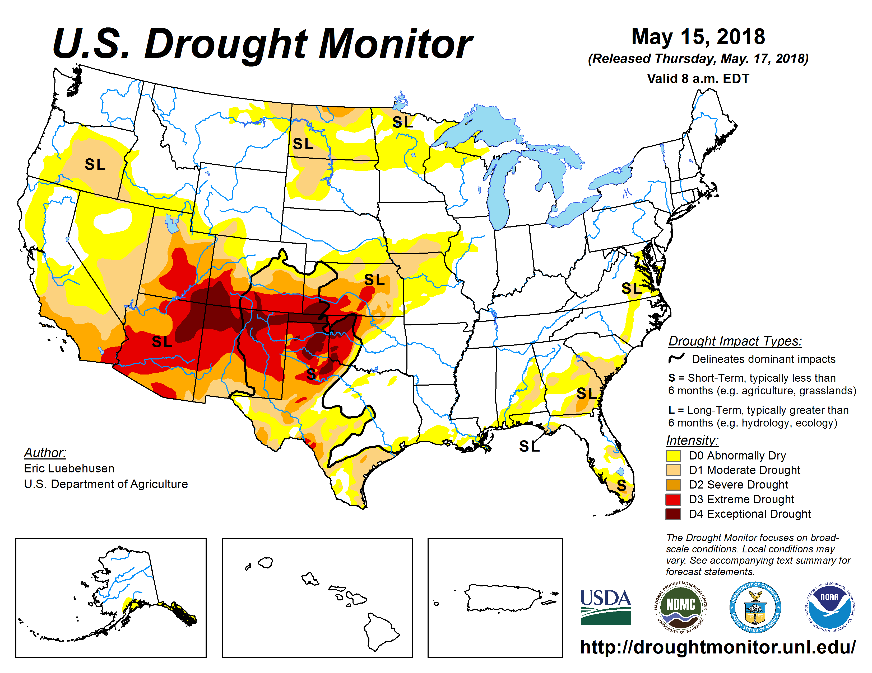
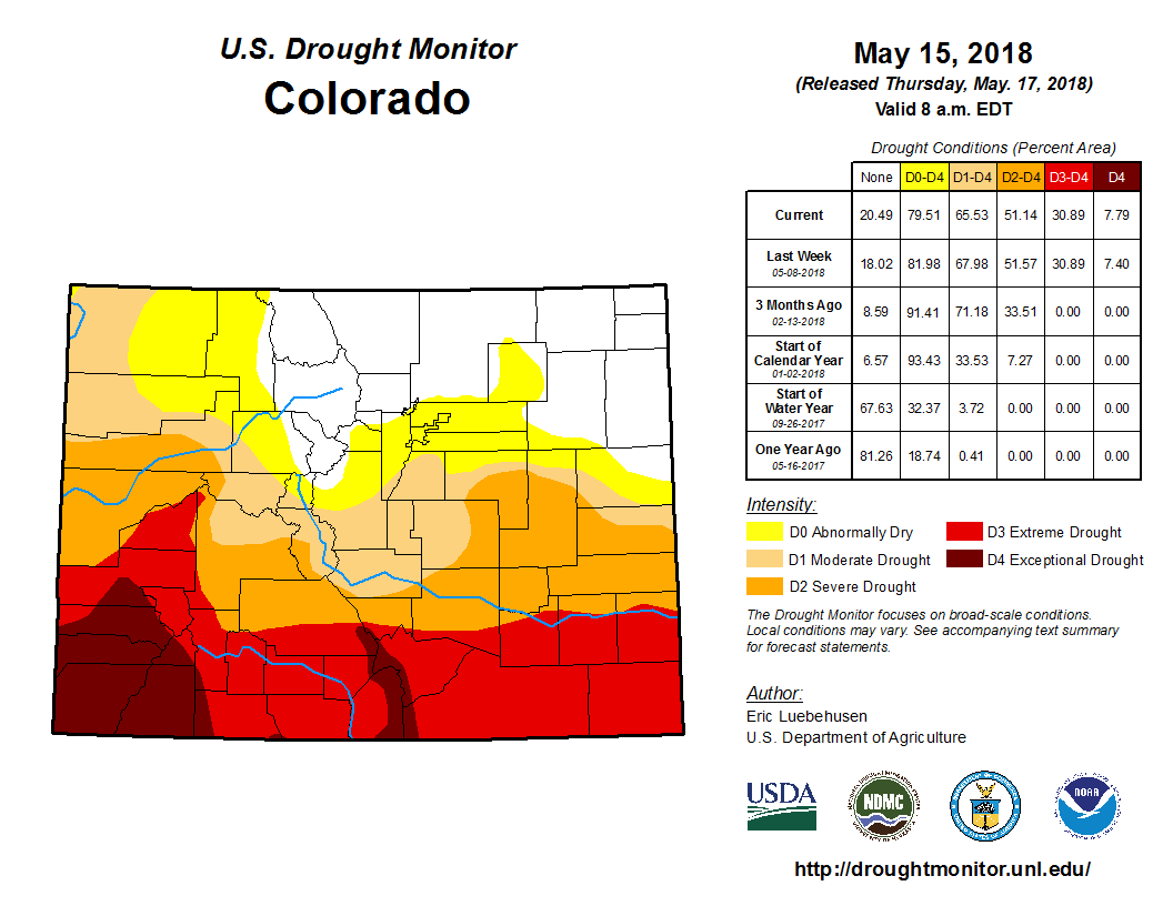
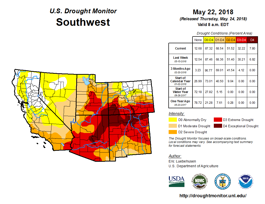
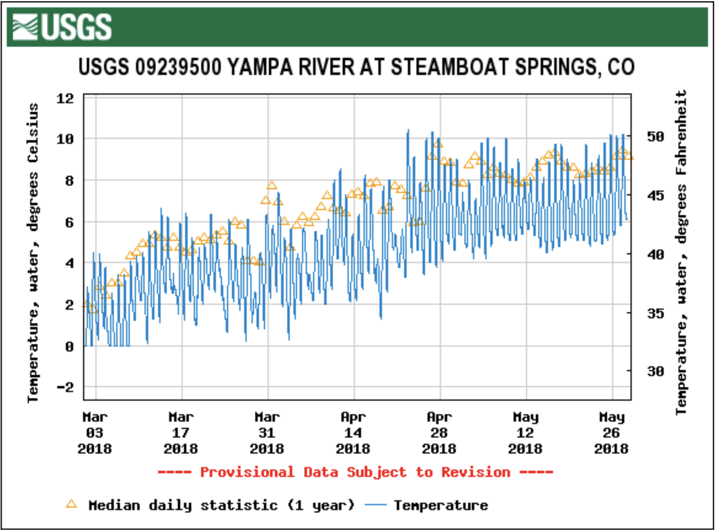
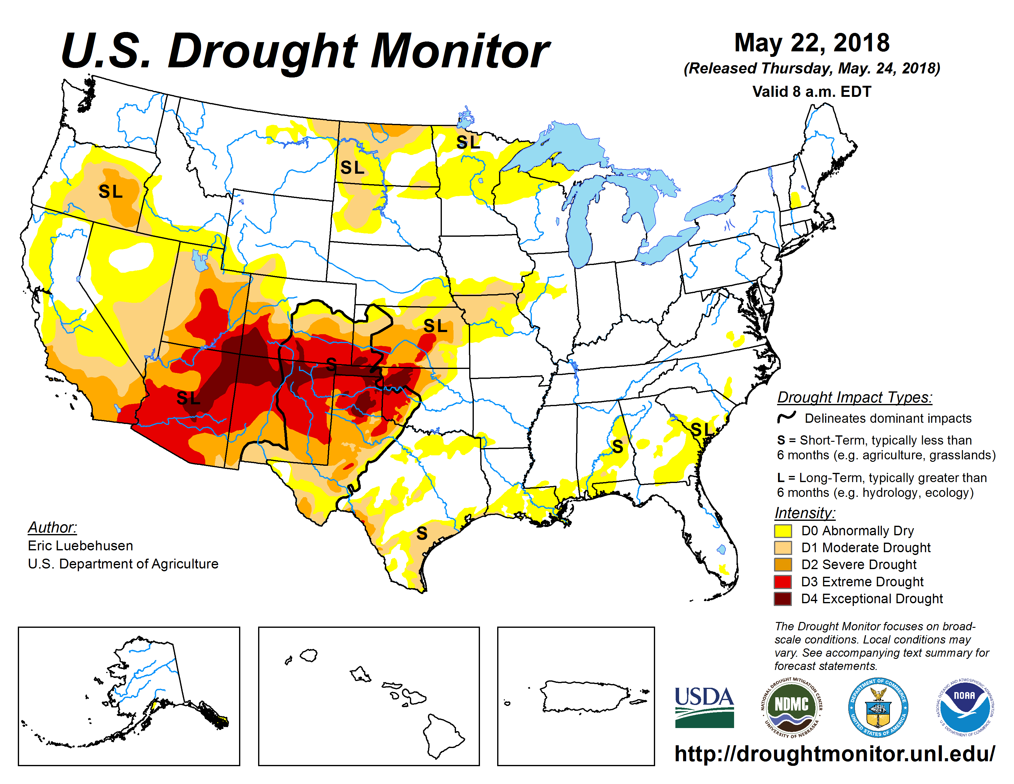
    For starters, extreme southwest Colorado including Durango are in exceptional drought, according to the Drought Monitor. Areas further north, including Grand Junction are in severe drought. Then further north into Steamboat Springs is classified as “abnormally dry.”

    “So far this year, Durango has received just 1.39 inches of precipitation. Normal for this date is 5.21 inches, said Scott Stearns, meteorologist intern at the National Weather Service, Grand Junction, Colo. “The lowest ever was 0.81 inches in 2002, so this year isn’t the worst we’ve ever seen, but it’s close.” The Grand Junction NWS forecast area covers from the Continential Divide near Vail and Aspen, west into eastern Utah.

    Grand Junction so far this year has received 2.91 inches of precipitation. Normal is 3.48 inches. The lowest ever received in Grand Junction was 0.77 inches. There’s potentially good news for southwest Colorado. “Some signals we’re seeing indicate the monsoonal moisture may come into our area a week or two earlier than normal, which is a good sign, although not a guarantee,” Stearns said.

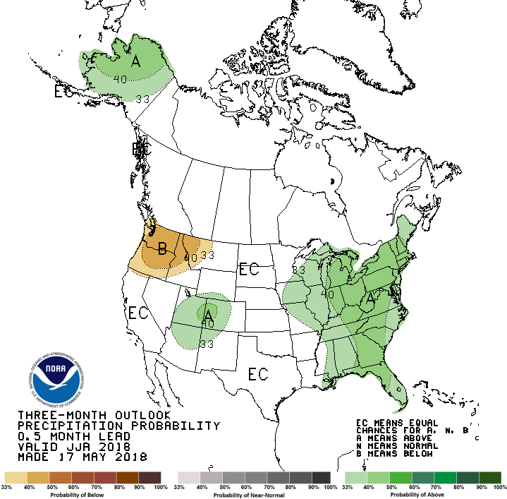
    “Western Colorado is favored to receive above normal precipitation, which is a change from last month’s outlook for June-July-August,” said Matthew Rosencrans, head of forecast operations, Climate Prediction Center, as he analyzed the latest 90-day outlook.

    SOUTHEAST COLORADO

    There’s also some hope for summertime rainfall in southeast Colorado, which is strongly needed to bust the current drought.

    “The drought is bad,” said Service Hydrologist Tony Anderson at the National Weather Service in Pueblo, Colo. “If we go back to Oct. 1, snow accumulation has been at or near historic lows in the Arkansas River Basin and Rio Grand Basin. According to the U.S. Drought Monitor, central and southeast Colorado have moderate to extreme drought conditions. The southern Sangre de Cristo Mountains are experiencing exceptional drought, which is the worst category.”

    Since Oct. 1, (when precipitation really dropped off, also called the “Water Year”) Colorado Springs has received 2.63 inches of precipitation. Average for this time of year is 4.64 inches. Pueblo has received 1.89 inches, compared with the average 4.53 inches.

    “The Climate Prediction Center indicates southeast Colorado is moving out of this drier pattern and closer to near-normal. A decent monsoon is indicated for the western Colorado/Utah area, but it’s highly variable regarding who gets rain and where thunderstorms set up each day,” Anderson said. “The CPC Drought Outlook indicates the drought may persist, but shows improvement mid-to late-summer.”

    COLORADO LIVESTOCK

    A Colorado Task Force overseeing Conservation Reserve Program and fire declarations, met on May 16, noting that because Colorado is a state with federally managed land, some decisions about when to turn cattle out, when to come off the land, when to graze or not, are actually out of the hands of producers, and are related to the environment.

    Executive Vice President Terry Fankhauser of the Colorado Cattlemen’s Association told The Fence Post, some stocking rate reductions are taking place in southwestern Colorado.

    “So, we have producers who are moving cattle to market early and are going ahead and selling because they’re concerned, if the drought persists they’d have to sell early, and they want to do it before cattle prices could possibly slip,” he said.

    He also said that if the drought continues into the summer without much rain, the U.S. Forest Service would likely remove cattle from the federal lands to preserve adequate forage for wildlife.

    “This would result in livestock producers finding alternative forage, which may not be available, or could be expensive to find and buy hay,” Fankhauser said.

    He was quick to note this decision isn’t affecting the majority, and that many producers are optimistic and believe they’ll be able to push through this. “This thinking is probably appropriate, because after de-stocking, then the cost of re-stocking, as we learned in the 2012 period, can be very costly. We have (cattle association) members from southeast Colorado who have not yet recovered from from de-stocking in 2002 and 2003 and then re-stocking,” he said. Fankhauser said the cow price doubled following that drought.

    “I believe that any de-stocking is a personal decision, and so, we work through issues and forecasting with producers so they’ll have ideas to bounce off about how their business is structured. You also have to live through feeding your family,” Fankhauser said. So, they only make recommendations, not decisions.

    Some producers, and sale barns in southwest Colorado are having more cow runs than usual for this time of year.

    “Remember, not all cattle can be raised at 8,000 feet so you can’t take a Kansas cow and bring it to Colorado and expect each one to survive in the mountains,” Fankhauser said. “A lot of these mountain ranches raise amongst themselves.”

    Producers have been adding in oats to supplement alfalfa, which they’ll use for forage/silage to get some value. Fankhauser said there will be a market for hay, which doubled in price this past winter.

    The southern half of Colorado is expected to make it through the summer with some irrigation water. “But that area looks like autumn right now; there’s been very little snowpack,” Fankhauser said. “The effect will be anyone down river, who counts on that snowpack.”

    “A short-term drought is not going to put someone out of business,” Fankhauser said. “In a longer term drought, there’s stress on families, and if someone is emotionally struggling, we have a Crisis Hotline.”

    As Agriculture Commissioner Don Brown recommends on the following website, “The agricultural economic crisis is real. The resulting stress is real. Let’s talk about it.” Call the hotline at (844) 493-TALK or text TALK to 38255 or go to https://www.colorado.gov/pacific/agmain/ag-financial-crisis.

    “We think of ranchers as tough men and women, and they are but they’re human too,” Fankhauser said. “We hope this will be a short-term drought.”

    SOUTHWEST KANSAS

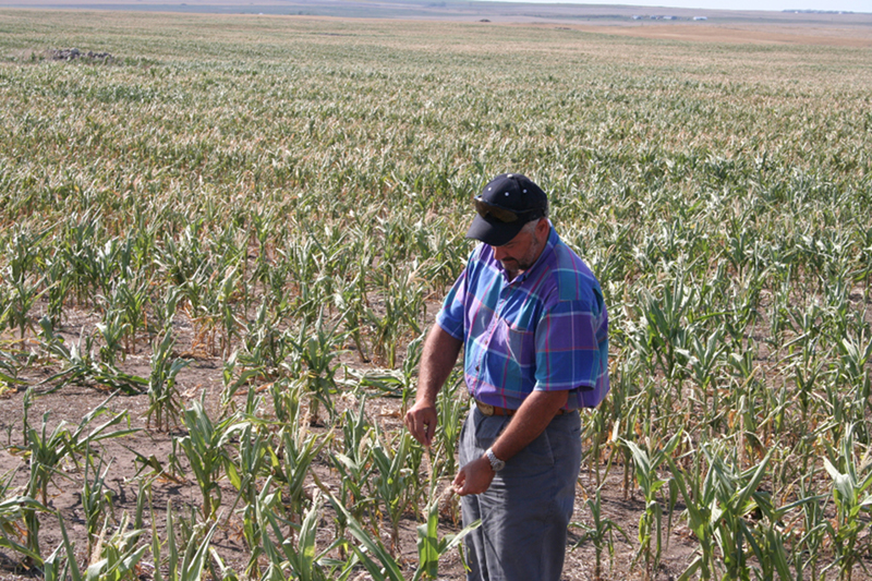
    “The drought has hit extremely hard here,” said southwest Kansas dryland farmers Marieta and Tom Hauser, who farm milo and wheat, and also planted some dryland corn last year for the first time on their farm in Ulysses, Kan. “We had some decent moisture last year, and now we’re right back in it,”

    They’ll plant more this year, and are hopeful.

    “We hope and pray we get enough rain to bring it up,” said Marieta Hauser, also the director of the Grant County, Kansas Chamber of Commerce, and on the Kansas Farm Bureau board of directors. “Also, the wheat is short this year and thin, but with a little moisture we could have a somewhat decent crop,”

    The couple got almost three-fourths of an inch of rain (0.70) a couple of weeks ago, which was the first measurable moisture since October. “People here talk about the Grant County split; storms will rain north and south of us,” she said. “You watch it come, then it doesn’t materialize.”

    As the chamber director, Hauser is also concerned that a drought hurts their retail businesses when people don’t have money to spend downtown.

    “We also battled the fires and some of our CRP grass caught on fire when a train passing produced a spark, catching dry weeds alongside the track.”

    Wildfires burned 30 minutes south and west of Ulysses.

    KANSAS COUNTIES

    Kansas Gov. Jeff Colyer, MD, issued an executive order March 13, 2018, declaring drought in all 105 Kansas counties due to below-normal precipitation and above-normal temperatures. Twenty-eight counties are classified in emergency status from central Kansas into southern Kansas and southwest Kansas. Twenty-nine counties in central, western Kansas and the east/central parts of the state are in a warning status, and 48 Kansas counties are in a watch status which includes the rest of the state: north/central, northwest, eastern and southeast Kansas.

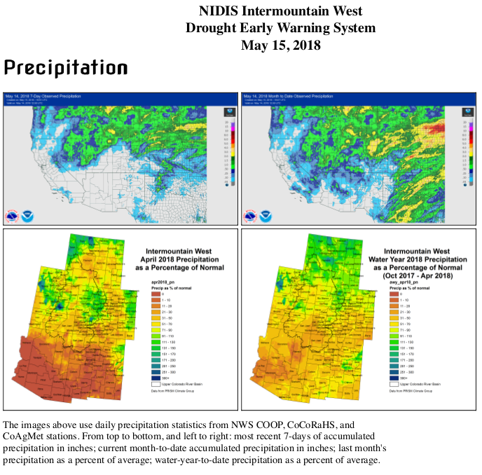
    The complete national map shows the 2018 Secretarial Drought Declarations with extreme drought conditions from central and southern Kansas into all of Oklahoma, south into northwest Texas, then west into southeast and southwest Colorado, New Mexico, Arizona and Utah.

    SOUTHWEST KANSAS LIVESTOCK

    Right in the heart of southwest Kansas’ hardest hit drought area, David Clawson of Englewood, Kan., the 2017 president of the Kansas Livestock Association said the drought has gotten worse.

    “We’re still supplementing on grass,” said Clawson, who has a cow/calf operation. “Livestock still come to our pickups for protein supplements, which tells you the grass doesn’t have enough to feed. It’s greening up, but we haven’t had enough moisture for growth, My neighbors are all in the same boat. We’re anxiously waiting to see if we get enough moisture to recover.”

    Over the past 60 days, Clawson has been selling cows. “We’re de-stocking to just hold onto the best cows we can,” he said. “We also went through this in 2011 and 2012 so experience makes it a little easier to deal with. It’s just part of a planned program to give the grass a chance to recover.”

    Just to their south, in Oklahoma, Clawson’s neighbors are in the drought area and have had to fight wildfires. “It’s just trying to green-up there,” he said. “We need a few inches of rain spread out over a couple of weeks. We got one of the best showers last night (May 15, with rainfall between 0.40 to 0.80 of an inch) and that’s encouraging, but we need much more.”

    NEBRASKA

    There are some areas that are now abnormally dry or beginning drought particularly in southern Nebraska, from Omaha westward to the area just east of McCook and then southward. However, an extension agent has some uplifting news.

    “We are on the dry side. But one positive aspect, we had enough moisture for planting, and we got good stands,” said Randy Pryor, Nebraska Extension educator/resident in Saline County. “That is, unless you till the ground. We have people who till the ground but had to run pivots this season. However, on the other side of the coin, farmers were able to plant areas that routinely you just cannot plant because they’re usually too muddy,”

    Also, in Jefferson and Saline Counties, there wasn’t the “flush of growth” in May that they typically get in cool-season pastures. “We were behind in April because of temperature, and then a growth in May in pastures,” Pryor said. “But, there’s going to have to be timely rains if we’re going to have a decent corn crop. We don’t have a full soil profile of moisture like we are used to in southeast Nebraska. Parts of Jefferson, Gage and Pawnee counties had some good rains, but you still have the ‘have nots.'”

    Normally, those Nebraska counties expect an average of 4 1/2 inches of rain in May, which is the highest precipitation month on average in southeast Nebraska. However, official recordings in Saline County, for example in Crete official recorders received 0.41 of an inch, Friend 0.17, and the town of Western 0.93.

    Pryor said in southeast Nebraska, they’re used to starting with a full profile of moisture on their silty, clay loam soils, which can mean 8-inches of water 4-feet deep, half of which is readily available for the crop. “Then, in dryland farming, you can figure on 6-feet deep, which would be 6-inches crop available water. We’re more used to that, which gives you resiliency in those times when you don’t have rains in the summer and gets you through a summer dry spell, but this is different when we’re starting out this way. For soybeans, our main concern comes in August to receive timely rainfall.”

    Meanwhile, Pryor said Nebraska hay prices have escalated and are almost double, and there’s a drought to the south. “A local producer recently had a third cutting that went for $150 (for a big round) bale.”

    Many pastures in these dry areas of southern Nebraska are heavily dependent on cool-season grasses, primarily bluegrass and brome grass.

    “The challenge we’re starting to face pretty critically is that unless these grasses get some good growing moisture before Memorial Day, we’re likely to be short of pasture for the rest of the year. Once we get into June, July and especially August, the heat prevents them from growing very well, even when they have a lot of moisture,” said Bruce Anderson, Ph.D., University of Nebraska-Lincoln Extensive forage specialist.

    WYOMING

    The director of the Wyoming Cattlemen’s Association said that Wyoming is not in a drought. “We’re in pretty good shape,” said William Doenz.

    There are, however, abnormally dry to moderate drought conditions reported over southwest Wyoming, and the next one to two weeks are forecast to be warmer than average. But there’s hope on the horizon.

    “During these next couple of weeks, there are slightly wetter than average conditions expected, with an active weather pattern of periodic showers,” said Senior Meteorologist Mike Jamski at the National Weather Service in Cheyenne, Wyo.

    Keeping a positive outlook can be challenging, but several folks believe it’s a choice.

    “The life we’ve decided to live in — agriculture,” Clawson said, “We’ve just gotta have faith.”

    “The weather cycles, you go through dry periods, and then there’s rain,” Hauser said. “So we keep at it.”

    #Runoff news

    West Drought Monitor May 15, 2018.

    From WesternSlopeNow.com (Marcus Beasley):

    The snowpack up in the mountains, which was below average for most places this year, is melting quickly…

    A drought isn’t just affected by the lack of precipitation, being abnormally warm can have an effect on the drought as well. The drought and low snowpack will have an affect our summer water supply…

    “Being in a drought now and having less snowpack now means that there will be less water for us as we go into the summer.”

    The drought we’re currently in could also have long term effects if we’re dry again next year.

    “If we start to continue to be dry and move into a year and a half to two years. that’s where it can really impact us, so it’s good to start conserving water now and to be thinking about that, conserve the water that we have so we can think about the future in case we don’t get those real good rains this summer that help us out or if the snowpack is low enoughnext year it could make it worse for the next year.”

    Hopefully this summer brings us some much needed rain.

    From The Vail Daily (Scott Miller):

    Local rivers seem to have hit peak flows. That isn’t good.

    The Colorado River at Dotsero hit its peak seasonal flow Tuesday, May 15. That peak was just more than 3,000 cubic feet per second. The median figure for that date — based on 77 years of data — is about 5,000 cubic feet per second.

    This year’s May streamflows aren’t the lowest ever recorded, but the news isn’t good. Still, local water supplies and recreation will survive for the season.

    At Minturn Anglers, guide Alex Garnier said fishing on the Eagle River has been good so far this season. The water is clearer than usual, and the flows are low enough to fish in a number of spots…

    While the Colorado River has probably hit its seasonal peak, there could be some spikes to come on Gore Creek and the Eagle River.

    In an email, Eagle River Water & Sanitation District Communications and Public Affairs Manager Diane Johnson wrote that a string of warm days could accelerate snowmelt in the upper reaches of Gore Creek and the Eagle River. That more-rapid snowmelt could spike flows above current peaks. Those peaks are now running ahead of seasonal medians.

    No one wants the snow to come off any faster, though, since snowpack makes up a major portion of the district’s water storage.

    “If it stays a little cooler we get to keep (runoff) flowing a little longer,” Johnson wrote.

    2018 #COleg recap

    View from the Pitkin County end of Homestake Reservoir. Photo: Brent Gardner-Smith/Aspen Journalism

    From The Grand Junction Daily Sentinel (Ken Salazar and Tom Gougeon):

    Colorado’s iconic mountain ranges, farms and ranchlands, parks, rivers and open spaces are an undeniable part of our shared identity as Coloradans. We live in a state where three in four residents consider themselves conservationists, and 87% understand that Colorado’s open lands and outdoor lifestyle give the state an economic advantage.

    That’s why we hope every Coloradan will take a moment to recognize two huge legislative wins achieved this month for conservation in our state – and what together these wins mean for future generations and their quality of life.

    The most lauded success happened on May 1, when Governor Hickenlooper signed into law a measure ensuring that Colorado lottery proceeds will continue to be a steady source of revenue for conservation and outdoor recreation through at least 2049. This measure extends and affirms the will of Colorado voters, who in 1992 passed a constitutional amendment that created Great Outdoors Colorado (GOCO), an independent body that annually receives up to half of all lottery proceeds.

    Over the past 25 years, GOCO has been the single most important tool for advancing conservation in Colorado. It has funded more than 5,000 projects – including dozens of school playgrounds, over 900 miles of trails, and more than 1,600 parks and outdoor recreation areas – benefitting all 64 Colorado counties, and permanently protecting more than 1 million acres of open space.

    For ensuring GOCO endures another 25 years, Coloradans can thank the efforts of a broad, bipartisan coalition of local governments, nonprofit partners, agricultural and business leaders, and thousands of individuals and other advocates who signed on to Keep It Colorado – a campaign to ensure lottery proceeds continue flowing to conservation for future generations.

    The second accomplishment was quieter, but also will have significant impact into the future. Last week, in the waning hours of the 2018 session, legislators passed a bill that paves the way for a new, forward-looking approach to conservation in Colorado.

    The bill, now awaiting Governor Hickenlooper’s signature, extends a tool that is a strong complement to GOCO funds in the conservation toolbox: a program that rewards private landowners with state tax credits in exchange for voluntarily restricting development on their land – in perpetuity. Since 2000, conservation tax credits have been used to conserve more than 2.2 million acres of private land – majestic vistas, working farms and ranches, forest and river ecosystems – 80 percent of which is now under the stewardship of nonprofit land trusts across Colorado.

    For years, a statewide coalition of these land trusts and landowners have been advocating for a number of refinements to the program. The measure will create a new Division of Conservation with a mandate to lead an inclusive workgroup of stakeholders to advance the program in a transparent, effective, inclusive manner.

    The opportunity presented by the creation of this new division and visioning process is hard to overestimate. The legislation moves oversight of this critical conservation program from the state’s Real Estate Division to a new body that is, by design, aimed at assessing conservation values more holistically and ensuring the effectiveness and success of the program. This step aligns with the current work of the field that is looking at conservation’s return on investment – not just in real estate value, but more broadly to include the value of ecosystem services (such as carbon sequestration, climate regulation, or water storage and purification), as well as conservation’s economic value to state and local communities. It also comes at a time when land conservation leaders statewide are embarking on the yearlong Conservation Futures Project — supported by the Gates Family Foundation, GOCO, and other funders – to re-envision the role and value of land trust organizations to the communities they serve.

    Thanks to these two legislative victories, the state’s conservation partners are positioned for even greater success over the next 25 years. With secure access to the resources, tools, and vision necessary to protect Colorado’s working lands and natural inheritance, both today’s Coloradans and future generations will benefit.

    Ken Salazar is former U.S. secretary of the Interior (2009-2013) and U.S. senator from Colorado (2005-2009); he authored the Great Outdoors Colorado amendment while serving as head of Colorado’s Department of Natural Resources.

    Tom Gougeon is president of the Denver-based Gates Family Foundation, which for the past two decades has been Colorado’s largest private match source for GOCO-funded land conservation, statewide.

    @CWCB_DNR: May 2018 #Drought Update

    Colorado Drought Monitor May 15, 2018.

    Here’s the release from the Colorado Water Conservation Board (Taryn Finnessey) and the Colorado Division of Water Resources (Tracy Kosloff):

    In order to respond to persistent and prolonged drought conditions throughout the southern half of the state and along the western border, the Governor activated the Colorado Drought Mitigation and Response Plan for the agricultural sector on May 2, 2018 , in the following counties:Montezuma, La Plata, Archuleta, Conejos, Costilla, Las Animas, Baca, Prowers, Bent, Otero, Huerfano, Alamosa, Rio Grande, Mineral, Hinsdale, San Juan, Dolores, San Miguel, Ouray, Montrose, Saguache, Custer, Pueblo, Crowley, Kiowa, Cheyenne, Lincoln, El Paso, Elbert, Gunnison, Mesa, Delta, Garfield and Rio Blanco. All of these counties are experiencing severe, extreme or exceptional drought as classified by the US Drought Monitor , and many have already received some level of drought designation from USDA . If present trends continue, other regions and sectors of the state’s economy may also be affected. Those areas will continue to be monitored closely.

    ■ October 2017 through April 2018 was the 5th warmest and the 5th driest on record for the state as a whole. Some locations throughout southern CO have experienced their driest and/or warmest Oct-Apr period on record.
    ■ Most regions of Southern Colorado reached their snow accumulation peak two to three weeks early and have experienced rapid snowmelt, resulting in melt out occurring three weeks earlier than normal.
    ■ Streamflow forecasts in the southern half of the state are extremely low, with multiple sites showing below 15 percent of normal.
    ■ Demand is increasing and reservoir storage in the most heavily impacted areas, the Southwest basins of the San Miguel, Dolores, Animas & San Juan have seen significant decreases in reservoir storage over the last two months. This combined basin currently has 91 percent of normal storage, the lowest storage levels in the state.
    ■ Isolated cattle sell off and prevented planting of some acreage has been reported. Due to high hay prices we anticipate additional cattle sell off, and unless conditions improve additional prevented and failed crop acres are likely.
    ■ Windy, dry conditions fueled fires in April leading to numerous large wildfires on both the west slope and the eastern plains. Current forecasts indicate above average potential for large wildfires through June (see image on reverse side) with late summer fire potential dependent on monsoon conditions.
    ■ As of May 15, exceptional drought, D4, continues to affect southwest Colorado and has also been introduced in the Sangre de Cristo mountains, covering eight percent of the state. Extreme drought, D3, covers 23 percent of the state; severe drought 20 percent and 14 percent is classified as moderate drought. An additional 14 percent of the state is currently experiencing abnormally dry conditions (see image on reverse side).
    ■ Reservoir storage statewide is at 111 percent of normal, with all but the southwest basins above average. The Arkansas basin is reporting the highest average storage at 129 percent. Front Range water providers mainly draw water resources from areas of the state that received near normal winter precipitation, and are therefore expecting reservoirs to fill, and are not anticipating any water use restrictions outside normal operations.
    ■ The Surface Water Supply Index (SWSI) values have declined slightly May 1, with much of the western slope classified as extremely dry. These values are largely driven by below average streamflow forecasts. The sub-basin with the highest value includes Lake Granby, a large reservoir.

    @ColoradoClimate: Weekly Climate, Water and #Drought Assessment of the Intermountain West

    Click here to read the current assessment from the Colorado Climate Center. Click here to go to the NIDIS website hosted by the Colorado Climate Center.

    #Snowpack/#runoff news: #SouthPlatte Basin update

    South Platte River Basin High/Low graph May 20, 2018 via the NRCS.

    From 9News.com (Jordan Chavez):

    “Snowpack in the South Platte collection system… is well below average,” said Travis Thompson, a spokesperson for Denver Water.

    The other half of Denver Water’s supply comes from the Colorado River Basin which also isn’t running at the level it usually does. The river’s water flows have already peaked, according to the National Weather Service.

    Colorado Water Trust told 9NEWS this is extremely early.

    “It looked like a very unusual year,” said Andy Schultheiss, Colorado Water Trust’s executive director. “It was a La Nina year and a lot of storms passed to our north. It was looking bad quite early this year.”

    The collection systems from both rivers are made up of snowpack which is important when it comes to putting out wildfires, according to Schultheiss.

    “People think summer storms help with wildfires but they don’t actually prevent it,” he said. “It’s those snowpacks that infiltrate into the soil that really control wildfires. So, when you have a year like this, when there’s very little snowpack, the potential for a serious wildfire goes way, way up.”

    New #Colorado rules prompt Garfield County to update septic system rules

    Septic system

    From the Glenwood Springs Post Independent (Jon Nicolodi):

    Garfield County is revising its onsite wastewater treatment system regulations following new regulations put forth by the state. Does this impact you? Considering the consequences of a poorly maintained onsite wastewater treatment system, and with approximately 3,500 out of about 17,000 housing units in Garfield County relying on onsite wastewater treatment systems, the answer could be “yes.”

    Some homeowners like septic systems because they don’t have a regular sewage bill from their municipality. Instead, they must properly maintain their system, but they have control, and more ownership, of what goes into their system and how much and how regularly they have to pay for maintenance. By only flushing human waste and toilet paper, by properly disposing of chemicals, and by using a compost collection service or backyard system to break down cooking grease and other food waste, all maintenance is preventative. With care and preventative maintenance, septic system owners can save in the long run.

    Septic systems go astray, however, when they aren’t cared for. Septic system leakage isn’t a foreign concept to health and environment officials. Toilet water leaking into the ground untreated might make its innocent way down through hundreds of feet of soil before being neutralized by the soil microbes. More likely, the wastewater will leak into a nearby stream, creating algal blooms and wreaking havoc on the balance of water quality in the ecosystem.

    If your home isn’t connected to a public sanitary sewer system, you may be utilizing a private drinking water well. This water source may be near your septic system. Phosphorus, nitrogen and bacteria aren’t exactly the constituents of quality drinking water.

    The Colorado Department of Public Health and Environment’s Water Quality Control Division adopted Regulation 43 nearly a year ago, and counties have until June 30th of this year to adopt versions of this regulation that are at least as stringent as the state’s. Among other items, the regulation specifies the categories and type of material installed in and around the leach field, and it requires additional inspection of systems to ensure that they meet industry standards.

    Septic systems should be inspected at least every three years, and typically pumped free of their settled solids every three to five years. Contact your local county officials to learn what you have on your site, and to learn who to call for a quality service provider. Be thoughtful about what you put down the drain and how much you use your garbage disposal. Mark the free hazardous waste collection day at the local landfill on your calendar. Practice water conservation by installing high-efficiency toilets, shower heads and laundry machines. Take one more step to being considerate of your local streams, and of your own and your community’s drinking water supply.

    The Past, Present, and Future of Carbon Pricing in #Washington State #ActOnClimate

    Fog rolls in below snow-dusted peaks on Washington’s Olympic Peninsula. In relatively humid places like the Pacific Northwest, more water melts from the snowpack during the wintertime than in more arid regions. Brooke Warren/High Country News

    From the Union of Concerned Scientists blog (Adrienne Alvord):

    Despite what’s shaping up to be a summer of uncertainty in DC, with President Trump’s EPA attempting to dismantle a generation’s worth of science-backed environmental protection and climate progress, momentum is building in Washington state to move forward on innovative climate policy.

    Washington has a lot at stake. Climate change impacts including increased wildfires, drought, flooding, sea level rise, ocean acidification, and changes to agriculture threaten the state today, and will get much worse unless we take action.

    To prevent the worst impacts of climate change, Washington voters and legislators in recent years have considered – but not approved — binding carbon pollution limits and a price on carbon pollution. This year, a proposed ballot initiative measure, Initiative 1631 would create a fee for carbon polluters. It is sure to add to a robust and healthy nationwide discussion about what are the best policies to reduce carbon and prevent the worst impacts from climate change.

    Carbon pricing is a way to help incentivize reducing climate pollution while providing revenue to invest in clean energy and fuels and provide transition assistance to workers and communities. The initiative could show how state-level action can be a potent antidote to retrograde motion in DC.

    Past progress and approaches to pricing

    Washington state, like the entire West Coast, is a leader on forward-thinking climate policy with legislative targets for emission reductions, a greenhouse gas inventory of major emitters, and a Clean Air Rule adopted by the Inslee Administration. The state has not yet instituted an economy-wide carbon price but has considered two approaches previously.

    In 2016, Washington debated ballot initiative I732, a carbon tax measure that would have instituted a carbon tax offset by a 1 percent cut in sales tax, a cut to manufacturing taxes, and a low-income tax credit. I732 was intended to be revenue-neutral and to provide a progressive tax rebate. However, the initiative failed decisively at the polls after drafting errors came to light, and other controversies divided climate action supporters . (UCS was neutral on the measure, for reasons we described here.)

    In 2017, the legislature considered a measure backed by Governor Jay Inslee, SB 6203 (Carlyle et al) that would have instituted price on fossil fuels that would rise gradually until 2035. The funds were to be used for carbon reduction measures, forestry, water improvements, low-income assistance, community investment, rural economic development, and utility rebates. The bill also exempted so-called “energy intensive, trade exposed” (EITE) industries that could be economic disadvantaged by competition from out-of-state entities not subject to a carbon fee. Despite diverse support from Washington business, labor, environmental, and social justice groups (and thanks to opposition from some industrial, business, and agricultural entities) the bill didn’t advance to a floor vote, in part because 2017 was a short, two-month session that didn’t allow sufficient time to consider the complexity of the measure.

    And now a unified proposal from a broad coalition

    While the other measures were being debated, a coalition of environmental, environmental justice, business, labor, tribal, public health, faith and other groups under the banner of the Alliance for Jobs and Clean Energy, has been hard at work finding common ground on climate policy. Now, the group has introduced initiative 1631 that incorporates both a polluter-pays carbon fee starting at $15 per ton of CO2 in 2020 and an investment plan for clean energy, forests, water, and healthy communities.

    The initiative provides exemptions for certain EITEs and provides rebates to utilities while investing heavily in job assistance for displaced fossil fuel workers and also in tribal and low-income areas. The fee is increased at a rate of $2 per year plus inflation to an estimated level of about $55 and stays at that level if the state is on track to meet its 2035 emissions reduction target of 25 percent below 1990 levels.

    The unique design of this carbon fee was arrived at after intensive consultation among many Washington communities, businesses, and groups. It differs from California’s cap and trade program, British Columbia’s carbon tax, and Oregon’s proposed carbon cap and invest policy (similar to California’s, to be taken up in the 2019 legislative session.)

    The fact that different jurisdictions are looking at different approaches towards carbon pricing shows that there is latitude among pricing design to meet local needs and conditions. Some programs, like California’s that is linked to Ontario and Quebec, are designed to encourage participation from other jurisdictions, in part to lower costs. Washington’s program would not link out of state, but would provide a level of price certainty in the fee structure that other programs do not have.

    For our future, the most expensive thing we can do is nothing

    Despite the hard work of a large group of interests who have found a common vision for carbon pricing in Washington, I 1631 is certain to generate intense opposition from the fossil fuel industry and their allies. They will invoke the usual pieties about how yes, climate change is real, but this approach is all wrong. They will say that it’s bad for the economy. Of course oil producers and other fossil fuel interests do not want to help the state transition away from their products and the harm they cause. The fact is that carbon prices are features of several state and national economies, including British Columbia and California, that are thriving.

    While carbon pricing is not the only approach to reducing emissions, it does start to internalize the costs of climate pollution and make the needed investments for a safer, healthier future. UCS has long supported carbon pricing and we recognize that there are different advantages to different approaches, along with numerous economic benefits. The greater threats to our economy, not to mention our well-being, are climate change-related impacts that are already costing billions of dollars, devastation of property and the environment, and loss of life. In fact, the most expensive thing we can do is nothing.

    Pagosa Springs: #Geothermal Resource Workshop set for May 23, 2018

    Photo credit: Colorado.com

    From the Geothermal Greenhouse Partnership (Sally High) via The Pagosa Sun:

    Geothermal Greenhouse Partnership (GGP) welcomes Colorado School of Mines (CSM) and Colorado Geologic Survey back to Pagosa Springs this week.

    CSM’s seventh Geophysics Field Camp builds on previous years’ research into Archuleta County’s geothermal plumbing.

    The GGP invites the public to a scientific retrospective of collected data and updated interpretations of the local geothermal resource on
    Wednesday, May 23. The workshop is at the Archuleta County CSU Extension building from 6 to 8 p.m. The GGP workshop contains two presentations.

    Dr. Andrei Swidinsky and Stephen Cuttler of CSM will present a seven-year retrospective of the geophysical data collected by CSM students. Each year’s field camp adds to our understanding of the underground structure of our geothermal aquifer.

    Dr. Paul Morgan is senior geo- thermal geologist at Colorado Geological Survey. In 2017, Morgan published Origins and Geothermal Potential of Thermal Springs in Archuleta County, including Pagosa Springs, Colorado, USA (Revisited). The paper was first presented at the international Geothermal Resource Council’s 2017 conference. The Archuleta County public can hear Morgan’s revised interpretations at the GGP workshop.
    The GGP is a 501(c)(3) nonprofit operating an educational park in downtown Pagosa Springs. The nonprofit park demonstrates geothermal direct energy use, year-round horticulture and environmental awareness. Twenty-first century water conservation and geothermal potential are priorities of GGP’s mission.

    GGP’s Education Dome is busy with student and volunteer activity, and the Community Garden Dome and Innovation Dome are being constructed. Pagosa Springs Centennial Park’s Riverwalk is the site of the GGP project.

    There is no charge for the GGP’s geothermal resource update work- shop, although donations to the nonprofit are accepted. The public is welcome.

    CDPHE fines Western Sugar $2 million

    Fort Morgan manufacturing facility. Photo credit: Wester Sugar Cooperative

    From KNOPNews2.com:

    The Western Sugar Cooperative has been fined $2 million as part of a settlement of air, water and solid waste violations and non-compliance found at the company’s Fort Morgan, Colo. plant.

    The Colorado Department of Public Health and Environment announced a settlement between the department and Western Sugar in a release Friday.

    Violations of Colorado’s Colorado’s Air Pollution Prevention and Control Act included exceeding the state’s regulatory odor limits. Water quality violations include discharges of pollutants, including fecal coliform and sulfide, which significantly exceeded the company’s permit limits. The department also cited Western Sugar for unauthorized spills, and said water quality violations likely contributed to odor issues affecting Fort Morgan residents.

    In addition to air and water quality violations, CDPHE says Western Sugar operated two large waste stockpiles of coal ash and precipitated in violation of state solid waste regulations. The piles of the manufacturing by-products are visible from Interstate 76 and Route 52…

    Under the terms of the settlement, Western Sugar agreed to:
    – Identify and implement wastewater treatment.
    – Eliminate and/or properly dispose of waste stockpiles and any new waste generated through its processes.
    – Investigate groundwater and soil impacts, and implement corrective measures if necessary.
    – Implement and comply with an odor management plan.
    – Retrofit existing coal-fired boilers with natural gas burners.
    – Establish financial assurance.
    – Provide funding for a local water quality restoration project.
    – Accept suspension of its environmental permits or licenses if it fails to comply with certain terms of the settlement.

    New water tank for Palmer Lake

    Palmer Lake via Wikipedia Commons

    From KOAA.com (Rachael Wardwell):

    The tank will be able to hold 250,000 gallons of treated water, doubling the town’s water capacity.

    “We’ll have 500,000 gallons of water to fight a fire with to drink, to do whatever and if whatever and if we ever had a problem with this tank that’s also subterranean, than we’d have another tank to back us up,” said Palmer Lake Mayor John Cressman.

    The tank will cost an estimated $1.3 million, and will be paid for through a low interest loan from the Colorado Water Resources and Power Development Authority.

    Canon City film screening: “The Arkansas River: Leadville to Lamar,” June 1, 2018

    The Arkansas River, at the Crowley County line. Photo: Brent Gardner-Smith/Aspen Journalism

    From the Pep Workgroup, Arkansas River Basin via The Pueblo Chieftain:

    Fremont Adventure Recreation and the Upper Arkansas Water Conservancy District will host a free screening of “The Arkansas River: Leadville to Lamar,” at 6 p.m. June 1 at Canon City High School, 1313 College Ave.

    The film will be followed by a panel discussion with Tim Payne, Fremont County Commissioner; Mannie Colon of Colon Orchards; Blake Osborne of the CSU – Water Institute; and moderators Chelsey Nutter of the Upper Arkansas Water Conservancy District and Ashlee Sack of Fremont Adventure Recreation.

    CPC hopeful for the North American #Monsoon

    From News 4 Tucson (Jeff Beamish):

    According to NOAA’s Climate Prediction Center, much of Arizona has slight chance for above average rainfall between July and September.

    Northeastern Arizona has the best odds for above average Monsoon rainfall. Coincidentally, the worst of the ongoing drought resides around the Four Corners region.

    Below average Monsoon rainfall can’t be ruled out, according to the CPC’s latest odds. Southern Arizona has a 67% chance for near or above average rainfall, but only a 33% chance for below normal Monsoon precipitation.

    The Monsoon officially begins on June 15th and ends September 30th. Climatology says Tucson’s average Monsoon rainfall is 6.08”.

    Three Top Threats of Climate Change in the West — @wradv #ActOnClimate

    Transmountain diversion, the Lost Man Canal, in the Roaring Fork River watershed

    From Western Resource Advocated (Erin Overturf):

    But climate change is impacting those of us who live in the West. It may not come in the form of “super storms,” but it can be just as devastating. These are three of the most prominent threats of climate change in the West:

    Threat #1: Water Supply

    Perhaps the most profound and immediate threat from climate change in the West is to our water supply. Our rivers help to sustain our iconic wildlife, feed our communities, power our economies, and offer an escape to play.

    Most of our precipitation falls as snow in the mountains, which acts like a water bank for downstream communities. Climate change has shortened the winter – when we stock up on snow – leaving our water supplies uncertain. In turn, our landscape is getting drier, leaving it more vulnerable to severe drought and bigger, more dangerous wildfires. And the effects compound each other: a drier landscape means more dust, and dust causes snowpack to melt and evaporate faster from our mountains, leaving less water flowing into downstream rivers and reservoirs.

    West Fork Fire June 20, 2013 photo the Pike Hot Shots Wildfire Today

    Threat #2: Wildfires

    Our mountains and canyons across the West are known for their gorgeous expanses of forests and grasses. Our prairies offer sustaining agriculture and the poetry of endless blue skies. Historically, natural wildfires have refreshed soil nutrients and maintained the forest ecosystem.

    But climate change has changed that natural fire dynamic on Western lands. Since 1970, the annual wildfire season has lengthened by 78 days. Since 1984, the area that burns annually has doubled. The Forest Service estimates that area may double again by 2050. Our forests and grasslands are drier and more susceptible to disease and pests, such as the mountain pine beetle. When they do burn, they burn hotter and longer, endangering ecosystems, wildlife, and homes.

    Severe smog and air pollution in Beijing

    Threat #3: Our Public Health

    We sometimes forget the effect that climate change has on our own health. Higher temperatures can cause air pollution, such as from ozone and dust. People who suffer from asthma, like my son and me, are particularly vulnerable when air quality is low. Smoke from wildfires can make it impossible to venture outside without wheezing. Increased ozone and poor air quality disproportionately impact those who suffer from heart disease, the elderly, the young, and low-income communities. And they make it harder to get outside and enjoy the beauty of the West.

    How Aspen’s troubles in getting slopes open aligns with climatic trends — The Mountain Town News

    From The Mountain Town News (Allen Best):

    Ski slopes in Colorado and other parts of the West were slow to turn white this now-departed winter. That’s not terribly unusual. For nearly all of the modern resort era, ski hill bosses have periodically summoned Native Americans to speak to the higher powers. Ski areas can announce opening dates months in advance, but weather keeps its own schedule.

    Snowmaking can overcome that varied natural schedule. But even snowmaking failed the Aspen Skiing Co. and many other ski areas in Colorado and elsewhere early in the past season. It was just too warm.

    Snowmaking begins at temperatures of 26 degrees F. or less, but the machines can really crank at temperatures of 10 degrees Fahrenheit, observes Victor Gerdin, mountain planner for the Aspen Skiing Co.

    “Not only did we have very few days of 26 degrees or less, we had practically no days of 10 degrees in November and December,” he told the Aspen Daily News.

    Aspen plans to plow $5.5 million into new snowmaking equipment before next winter at its four ski areas. Some of the new equipment will replace older, less energy-efficient infrastructure. But Aspen also hopes to expand terrain covered by snowmaking, especially so at its money mountain, Snowmass.

    Can snowmaking overcome the effect of global warming altogether? No—and some ski areas too low in elevation to sustain cold temperatures are almost certain to fall by the wayside. But for others, snowmaking can provide a crucial margin to sustain operations. The key, says Robin Smith, a snowmaking consultant, is that resorts invest in the most modern equipment, to maximize opportunities during shrinking windows of cold temperatures.

    Robin Smith. Photo credit: Allen Best

    Smith, who has several dozen clients among ski areas across the country, says some of his customers have lost 30 percent or more of their snowmaking windows in the last decade. “That makes snowmaking tougher,” he tells Mountain Town News.

    He foresees significant challenges for lower-elevation ski areas on the East Coast, the Midwest and elsewhere. Aspen, Vail and other higher elevation resorts in the Rockies will still have snow, but will face problems —similar to this year—of increased weather volatility produced by the warming atmosphere.

    In a 2016 study, the Environmental Protection Agency projected temperatures in decades ahead for 247 ski areas in the United States. The study concluded that warming temperatures will cut deeply into the 450 hours of sufficiently cold temperatures that ski areas commonly believe they need to make snow in time for Christmas openings. That study, however, did not address the potential savior of automated snowmaking systems, says Smith, of Snowconsult.

    This past winter was a challenge for many ski areas in Colorado, California and other regions. The National Oceanic and Atmospheric Administration released a map for December through February showing that much of western Colorado, including Aspen, had “much above average” temperatures.

    This fits with what Aaron Smith, a ski patroller at Aspen Highlands, told Auden Schendler, Aspen’s vice president for sustainability, during the early season struggles.

    “He said that it wasn’t that there was no snow coming down. It was that when any (solar) radiation hit it, it melted right away,” says Schendler. “That speaks to warmer temperatures I think.”

    This fits in with the conclusions of a paper published in February 2017 by Water Resources Research. The authors of the paper declared that the drought of the 21st century in the Colorado River Basin actually had more to do with temperature increases than precipitation declines.

    One of the researchers, Brad Udall, of Colorado State University’s Colorado Water Institute, laid out the thesis at a conference in downtown Denver recently. He said that a 20 percent decline in overall precipitation has been recorded in the basin from 2000 through 2017. This is despite a 5 percent increase in moisture content in the warming atmosphere.

    “Something very odd and unusual is going on,” Udall said at the inaugural Water in the West Symposium.

    “Something very odd and unusual is going on,” Udall said at the inaugural Water in the West Symposium.

    Udall’s partner in the research, Jonathan Overpeck, formerly of the University of Arizona and now dean of the School of Environment and Sustainability at the University of Michigan, further fleshed out the study a few days later at the 2018 Next Generation Water Summit in Santa Fe.

    The two big reservoirs on the river, Powell and Mead, were full in 1999, he pointed out. Powell was 52 percent full and Mead 39 percent fill as of April 28. Lake Mead, with a surface level now at 1,080 feet, is likely to drop below 1,075 feet, the place where shortage criteria kick in.

    A canal delivers water to Phoenix. Photo credit: Allen Best

    “That’s why we’re now starting to see fights over water again,” he said, alluding to a flurry of sharply-worded letters from upper-basin states to the Central Arizona Project. The upper-basin states accuse the Arizona agency of manipulating water demands and supplies for self-gain, at the expense of other water users.

    Why are the reservoirs emptying? It’s not drought, as conventionally understood. It’s what Overpeck and Udall call aridification.

    “Precipitation in this current drought is a contributor, a secondary contributor. The main cause of this drought is temperature,” said Overpeck.

    The warming atmosphere, he explained, demands more moisture. This is accomplished in various ways. Most significant is increased evapotranspiration from soil and plants Precipitation is also sublimated from snow, there is more rain and less snowpack, and the growing season is longer. Plus, of course, there is more evaporation from surface water.

    “Stop thinking about drought as precipitation,” he said.

    Modeling indicates that if we tamp down emissions that temperatures will rise only 1 to 1.5 degrees C (2.7 to 3.6 degrees F), he said. But at the top end, without changes, warming of 5 to 7 degrees C (9 to 12 degrees F) can be expected.

    Might the warming atmosphere produce more precipitation? Overpeck concedes that possibility. Climate models that cover Colorado have suggested a trend toward less precipitation in the Southwest and more precipitation in the northern half of the state. But water experts have warned that the models at this relatively micro-level have great ranges of uncertainty.

    But even more precipitation falling from the sky will not result in precipitation that lingers on the ground, said Overpeck.

    The Rio Grande Basin may be even harder hit. The river starts in the San Juan Mountains of Colorado, flowing past Taos and Santa Fe. U.S. Senator Tom Udall (a cousin to Brad Udall), speaking at the same conference, suggested more reservoirs are needed in the headwaters of the Rio Grande instead of at Elephant Butte, the big down-stream reservoir that loses so much water to evaporation.

    In Denver, Brad Udall said temperature-induced losses in the Colorado River Basin will triple by 2050 and increase almost six-fold by the end of the century.

    Earlier this year, Oregon’s Philip Mote and other researchers also fingered rising temperatures in a study of changing hydrology.

    This won’t end skiing in the high Rockies, but it does suggest that the warm temperatures that frustrated efforts by Aspen and many other ski areas from making snow last November and December will become more frequent in decades ahead.

    Nearly the full length of Lake Powell on the Colorado River in southern Utah and northern Arizona is visible in this photograph shot by an astronaut aboard the International Space Station, on Sept. 6, 2016. The view is toward the southwest. Water flow is from the lower right toward the top. (Source: NASA Earth Observatory)

    Some ski areas will have it worse than others. The EPA study concluded that given the current trajectory for greenhouse gas emissions, most skiing—even with snowmaking—will be gone in the East, Midwest and coastal Far West by 2090. Some of ski areas will be closed even sooner, within 30 years.

    Smith, writing in the May issue of Ski Area Management, said he “absolutely believes the temperature predictions” produced for individual ski areas by the EPA study. However, the EPA study failed to account for improvements in snowmaking as well as the durability and resistance to melting of machine-made snowpack, he says.

    Can snowmaking compensate? If the United States and other countries contain greenhouse gas emissions in line with the targets identified in the Paris climate accords, the answer seems to be yes, at least until 2050, and for most all resorts well beyond.

    “But that’s only if each resort can adopt today’s cutting-edge snowmaking technology on a significant enough percentage of its terrain,” wrote Smith, who previously worked for five years as the North American representative for Italian snowmaking manufacturer TechnoAlpino.

    “Automated snowmaking systems will be essential, because the windows of snowmaking opportunity will get smaller, and the available hours will become less. This has been happening already, of course. My clients in the last 10 years have observed 30 percent fewer total snowmaking hours under 28 degrees wet bulb. For clients with full automation, the diminished hours have not shortened their season at all.”

    That’s if the world constrains emissions. If not? What if we continue with business as usual?

    “Things get more difficult for all areas outside of the Central Rockies and the High Sierras, especially after 2050. We’d need some kind of technological breakthrough I don’t see coming.”

    About Allen Best
    Allen Best is a Colorado-based journalist. He publishes a subscription-based e-zine called Mountain Town News, portions of which are published on the website of the same name, and also writes for a variety of newspapers and magazines.
    View all posts by Allen Best →

    Climate Change Is Making Droughts Worse In The Western U.S. — @KUNC

    From KUNC (Luke Runyon):

    A new study from NASA reinforces the idea that droughts are getting worse and could become more frequent in the Western U.S.

    The culprit is human-caused climate change.

    Droughts aren’t just about precipitation, says NASA scientist and the study’s co-author Benjamin Cook. They’re also about the timing of snowmelt and the wetness of soil, both of which are upended by a warming climate…

    “We have pretty clear evidence now that climate change has already begun to make droughts worse or more likely in at least some regions,” he says. “So it’s a now problem, not a future problem.”

    Definitions of drought vary. A meteorological drought happens when snow and rain are diminished. An agricultural drought is tied to soil moisture and can be influenced by the type of soil and the crops and vegetation grown. A hydrological drought refers to lessened runoff from snow, which in turn means less water ending up in surface reservoirs.

    Here’s the link to my post about the late Kelly Redmond’s commentary, “The Depiction of #Drought,” required reading from professor Fleck.

    Nowadays you have to include the “hot drought” and “aridification” in your calculus. Read this publication from the Colorado River Research Group, “When is drought not a drought? Drought, aridification, and the “new normal.”

    The latest #ENSO discussion is hot off the presses from the Climate Prediction Center

    Click here to read the discussion:

    ENSO Alert System Status: Final La Niña Advisory

    Synopsis: ENSO-neutral is favored through September-November 2018, with the possibility of El Niño nearing 50% by Northern Hemisphere winter 2018-19.

    During April 2018, the tropical Pacific returned to ENSO-neutral, as indicated by mostly near- to- below average sea surface temperatures (SSTs) along the equator. The latest weekly Niño indices were near zero in all regions (between +0.2°C and -0.3°C), except for Niño-1+2, which remained negative (-0.6°C). Subsurface temperature anomalies (averaged across 180°-100°W) remained positive, due to the continued influence of a downwelling oceanic Kelvin wave. Atmospheric indictors related to La Niña also continued to fade. While convection remained suppressed near and east of the Date Line, rainfall near Indonesia was also below average during the month. Low-level winds were near average over most of the tropical Pacific Ocean, and upper-level winds were anomalous westerly over the eastern Pacific. Overall, the ocean and atmosphere system reflected a return to ENSO-neutral.

    The majority of models in the IRI/CPC plume predict ENSO-neutral to continue at least through the Northern Hemisphere summer 2018 (Fig. 6). As the fall and winter approaches, many models indicate an increasing chance for El Niño. Therefore, the forecaster consensus hedges in the direction of El Niño as the winter approaches, but given the considerable uncertainty in ENSO forecasts made at this time of year, the probabilities for El Niño are below 50%. In summary, ENSO-neutral is favored through September-November 2018, with the possibility of El Niño nearing 50% by Northern Hemisphere winter 2018-19 (click CPC/IRI consensus forecast for the chance of each outcome for each 3-month period).

    As warming continues, ‘hot #drought’ becomes the norm, not an exception — #NewMexico Political Report #aridification

    West Drought Monitor May 15, 2018.

    From the New Mexico Political Report (Laura Paskus):

    “Climate change for the Southwest is all about water,” said Jonathan Overpeck, who has spent decades studying climate change and its impacts in the southwestern United States. Warming affects the amount of water flowing in streams, and the amount of water available to nourish forests, agricultural fields and orchards. There’s also the physics of the matter: A warmer atmosphere holds more moisture, demanding more from land surfaces. Plants need more water, too. “Any way you look at it,” Overpeck said, “water that normally would flow in the river or be in the soil ends up instead in the atmosphere.”

    […]

    Past southwestern droughts were notable for declines in precipitation. But today’s droughts are different, he explained. Even in wet years, which will still occur as the climate changes, warmer conditions dry out the landscapes.

    “With atmospheric warming, we’re getting what we’re calling ‘hot droughts’ or ‘hotter droughts,’” he said. “That means that they’re more and more influenced by these warm temperatures, and the warm temperatures tend to make the droughts more severe because they pull the moisture out of plants, they pull the moisture out of rivers and out of soil—and that moisture ends up in the atmosphere instead of where we normally like to have it.”

    From 1952 until 1956, below-normal rainfall caused “critical water deficiencies in much of the southern half of the Nation,” according to a 1965 U.S. Department of the Interior report. The 1950s drought had widespread impacts on New Mexico’s communities and economy. Today’s drought conditions, which Overpeck explains have been moving around the Southwest for 19 years, are exacerbated by warmer temperatures. The global temperature is 1.8 degrees Fahrenheit higher than it was in 1880, and the Southwest is warming at an even faster rate.

    “What we’re seeing now in the drought that’s going on is that it’s more due to temperature increase and less due to precipitation deficit,” he said. And “hot drought” is what we should prepare to face in the future, too.

    “More and more so, the droughts will really be defined by hotness, by warm temperatures that just suck the moisture out of the soil, suck the moisture out of our rivers,” he said. “And leaves the droughts an ever more devastating manifestation.”

    The March/April “Colorado Water” newsletter is hot off the presses from the #Colorado Water Institute

    Click here to read the newsletter.

    #Drought news: Recent rainfall help NE #Colorado #aridification

    Click on a thumbnail graphic to view a gallery of drought data from the US Drought Monitor.

    Click here to go to the NIDIS website hosted by the Colorado Climate Center. Here’s an excerpt:

    Summary

    During the 7-day period ending Tuesday morning, areas of locally heavy rain provided drought relief from the Plains to the East Coast, though much of the Southeast was dry. Toward the end of the time frame, an influx of tropical moisture associated with a slow-moving disturbance generated heavy to excessive rainfall in Florida, with rain associated with this broad area of unsettled weather overspreading the Southeastern and Mid-Atlantic States after the data cutoff for this week’s analysis; any rain that falls after 12z Tuesday (8 a.m., EDT) will be incorporated into the following week’s drought assessment. In contrast, dry, hot weather maintained or exacerbated drought from the southern High Plains into the Southwest. Likewise, despite the generally unsettled weather pattern, pockets of dryness and drought lingered or intensified in the Upper Midwest and northern Plains…

    South

    Spotty heavy downpours brought localized drought relief to portions of Oklahoma and Texas, while dry, warmer-than-normal weather prevailed across the rest of the region. Locally heavy showers (2-4 inches) dotted drought areas from central Texas northward into western Oklahoma. Where rain was heaviest, reductions in drought intensity and coverage were made; however, considerable longer-term deficits remained, with the remaining Exceptional Drought (D4) areas reporting less than 25 percent of normal precipitation (locally less than 10 percent) over the past six months. Along the Gulf Coast, Abnormal Dryness (D0) was expanded eastward to reflect increasingly dry conditions over the past 30 to 60 days, while D1 and D2 were added in coastal locales where 90-day rainfall was less than half of normal. Farther inland, Moderate to Severe Drought (D1 and D2) were expanded in western Texas to reflect increasingly dry conditions at both the shorter term (60-day rainfall averaging 10 to 25 percent of normal) and longer time frame (6-month precipitation averaging less than 50 percent of normal, locally less than 25 percent)…

    High Plains

    The overall trend toward improving conditions in the south contrasting with increasingly dry weather in the north continued. From northeastern Colorado into central and southern Kansas, areas of moderate to heavy rain (1-3 inches) netted reductions in drought intensity and coverage. The most significant improvements were made in south-central Kansas, where a large area of 2 to 4 inches of rain (locally more) fell on areas of Severe (D2) to Extreme (D3) Drought. Moderate to heavy rain (1-3 inches) was similarly beneficial in northeastern Colorado, trimming the aerial extent of Abnormal Dryness (D0) and Moderate Drought (D1). Farther north, outside of locally beneficial downpours (1-3 inches) in northwestern South Dakota, acute short-term dryness over the past 30 days resulted in expanding D0 across southwestern South Dakota, southeastern North Dakota, and northeastern Montana, while a more prevalent dry signal over the past 90 days (50 percent of normal or less) led to expanding D1 and D2 in northeastern North Dakota…

    West

    Outside of beneficial rain and high-elevation snow in the north, pronounced short- and long-term dryness led to drought intensification and expansion across the Southwest. In southern Idaho, Abnormal Dryness (D0) was removed from most locales north of the Snake River, as recent rain and snow have pushed Water Year (to date) precipitation at or above the 35th percentile. However, sub-par seasonal precipitation coupled with increasingly dry conditions over the past 30 days led to the expansion of D0 in northeastern Montana and Moderate Drought (D1) in southwestern Idaho. Abnormal Dryness was expanded westward across central and northern portions of California’s Coastal Range due to a sub-par water year coupled with increasingly dry conditions over the past 30 days (deficits of 2 inches or more, locally less than 10 percent of normal). Farther south, Severe, Extreme, and Exceptional Drought (D2-D4) were increased from southern California into much of New Mexico. Changes were most pronounced in eastern portions of the region, where Water Year precipitation was in the 2nd percentile or lower, particularly across the northern third of New Mexico. Satellite-derived vegetation health data indicated conditions have deteriorated rapidly across the region, with the worst vegetation indices with respect to normal noted from Arizona southeastward into southern New Mexico. Drought Monitor authors are in close contact with local and regional experts from the Southwest, and further detailed analysis will likely result in additional intensification and expansion of drought as the situation is assessed over the upcoming weeks…

    Looking Ahead

    An active pattern will continue, with three significant areas of wet weather over the next 5 days. Moderate to heavy rain will continue to soak locales from the Appalachians to the East Coast, with totals approaching or topping 5 inches in parts of the Mid-Atlantic. Meanwhile, an area of low pressure will develop over the middle part of the nation, triggering moderate to heavy rain (locally more than 2 inches) from the central Plains into the Dakotas, while a trailing cold front producers similar rainfall amounts over north-central Texas and environs. Finally, a pair of upper-air disturbances will generate periods of rain across the northern two-thirds of the western U.S. Despite the unusually active pattern, dry weather will prevail from central and southern California into the lower Four Corners. The NWS 6- to 10-day outlook for May 22 – 26 calls for below-normal rainfall across central and southern Texas and from the Great Lakes into New England. Conversely, wetter-than-normal conditions are expected from northern portions of the Rockies and Great Basin to the central and southern Atlantic Coast, with the greatest likelihood for abnormally wet weather in the Southeast. Abnormal warmth is expected over most of the nation save for near-normal temperatures in California and New England.

    From CBS Denver (Ashton Altieri):

    The City of Salida is now encouraging residents to follow the voluntary restrictions “similar to past years”. This includes even street address watering on even numbered days and odd on odd days and not watering between 10 a.m. and 4 p.m.

    A year ago no part of Colorado was officially under drought. A few areas were “abnormally dry” including all of Park County and much of the Grand Junction area.

    Fast forward to May 2018 and nearly 70% of the state is under some state of drought, making it likely that voluntary water restrictions may become mandatory restrictions in some areas.

    Low #Snowpack year ramifications #drought #aridification

    Statewide Basin High/Low graph May 13, 2018 via the NRCS.

    From 5280.com (Jay Bouchard):

    With dangerously low snowpack levels across the state, Colorado is facing a severe water shortage. We take a look at what that means for rivers, wildfires, and the future of water use in the West.

    To put things in perspective, on April 9—which is historically the peak day for snowpack in Colorado—almost the entire state was sitting at below-average levels. Southern Colorado had it worst. The Upper Rio Grande basin, for instance, boasted a meager 43 percent of its normal snowpack. The Gunnison basin sat at only 57 percent. The Arkansas basin was at 63 percent. Only the North and South Platte River basins approached normal levels.

    A month later, little has improved. “We’re staring down a pretty bleak water year,” says Matt Rice, director of the American Rivers’ Colorado Basin Program. And what’s worse, he says, is that “This is absolutely part of a trend.” According to river and conservation scientists, Colorado is in the midst of a drought that dates back to the record-dry year of 2002. Although we have had some wet winters over the past two decades, dry seasons are now becoming “the new normal.” And that’s a problem—not just for our ski resorts, rivers, and lakes, but also for our farmers, cities and our neighboring states…

    Ask a climate scientist why water scarcity in Colorado has become so dire, and their most simple answer will likely be a two-part explanation: Climate change and population growth. Over the past several decades, Colorado has seen warmer temperatures with dryer winters and diminished snowpack. It doesn’t help that, since 2000, Colorado has gained approximately 1.3 million residents, all of whom in some way rely on the state’s water sources. “The population growth is very much compounded by climate change,” Rice says. “There is increasing demand on rivers for municipal and industrial water use.”

    […]

    Moreover, the Front Range gets about 50 percent of its water—roughly 160 billion gallons—via annual trans-mountain diversions from rivers on the Western Slope. These diversions draw water away from communities and rivers experiencing the most severe drought conditions in Colorado. “We’re all connected, says Bart Miller, Healthy Rivers program director for Boulder-based Western Resources Advocates. “Water use in Denver, in some ways, is having an impact on our West Slope neighbors.” A complicated diversion system, in conjunction with population growth and a changing climate, leaves us facing a stark reality: We’re running out of water.

    The Roaring Fork Conservancy is working to get Cattle Creek off the 303(d) list

    Map of the Roaring Fork River watershed via the Roaring Fork Conservancy

    From Aspen Public Radio (Elizabeth Stewart-Severy):

    Roaring Fork Conservancy has been studying the creek since 2015, and water quality coordinator Chad Rudow told commissioners Monday that research shows parts of the creek are healthier than the state thought.

    “We’re pretty excited and pretty hopeful that at least a section of Cattle Creek will come off of that 303(d) list,” Rudow said.

    Roaring Fork Conservancy has submitted its data to the Colorado water quality division, which will analyze it this year.

    Garfield County agreed to Roaring Fork Conservancy’s request for $10,000 to continue studying water quality and take steps to improve it. Rudow said the studies have identified some clear trends…

    There isn’t just one culprit; diversions, agriculture, septic systems and commercial development all contribute.

    Roaring Fork Conservancy is working with landowners to better manage riparian areas and septic systems, and Rudow said continued outreach is key.

    Because there are many diversions on Cattle Creek, the stream doesn’t see a typical spring runoff flow, which clears out pollutants and sediments. So Roaring Fork Conservancy is also working with water rights owners to discuss a pulse flow to mimic spring runoff.

    #ColoradoRiver solutions #COriver

    On the Colorado River. Photo: Brent Gardner-Smith/Aspen Journalism

    From The Sterling Journal-Advocate (Ken Mirr):

    Under the Compact, the Upper Basin States are obligated to deliver 7.5 million acre feet (maf) of water downstream to the thirsty Lower Basin states. Unfortunately, this requirement was derived from faulty baseline data as the rainfall patterns that occurred in the years prior were abnormally high and the flows were vastly overestimated. Delivery of this amount of water will be further impacted by warming climate projections that indicate that the region will become drier in the long-term, and we may be in an era of steadily declining river flows along the Colorado. To make matters worse, demand in all of the basin states like Colorado are increasing as populations in the area continue to grow, further stressing the already over-allocated river.

    These devastating impacts are evident in the water storage levels within the river’s two largest reservoirs, Lake Powell and Lake Mead, which are measured in order to determine if the Compact obligations are being met. Recently the reservoir levels have dropped to their lowest levels since 1937 and have shrunk to less than half their capacity. Until now, the system has worked, but if the Upper Basin states fail to deliver the mandatory volume of water to the reservoirs then the Lower Basin states could make a “Compact call” forcing the Upper Basin to curtail use of post-1922 water rights from the Colorado. That means Colorado’s growing population, amidst a warming and drier climate, will be forced to use less water so Lower Basin states can receive their legally obligated share.

    To address diminishing flows and greater demand for the water, agricultural producers in Colorado’s west slope are participating in a voluntary pilot program that compensates them for temporarily fallowing their crops and letting the water run down the river.

    In 2014, facing declining levels in lakes Mead and Powell, the Upper Colorado River Commission (UCRC), the Bureau of Reclamation and four water providers piloted a program in the Upper Basin to test water conservation strategies that could be part of a drought contingency plan. The goal of the Colorado River System Conservation Pilot Program (SCPP) was to demonstrate the viability of proactive, cooperative and voluntary compensated means to reduce the risk of reaching critical reservoir levels needed to protect the Compact entitlements. The program allows farmer and ranchers to voluntarily and temporarily let water run down the river and forego the use of their water to irrigate fields in exchange for compensation. The SCPP also reduces “buy and dry” scenarios where struggling farmers are bought out so developers can have access to their water for neighborhoods or transfer their water to municipalities.

    A shining example is the 9,177-acre Porcupine Ridge Ranch in Routt County, Colorado and the latest to take advantage of the UCRC’s program by voluntarily reducing consumptive use of its water rights and fallowing 1,941 acres of their irrigated hay fields, or nearly twenty percent of their ranch. In exchange, the ranch will receive up to $421,650, in addition to the current cattle and hunting leases that remain operative alongside the water fallowing. This is one of the largest awards given to a single property in Colorado and outlines a model of what’s to come, if ranchers and farmers take advantage of the opportunity while they can.

    As the Compact nears its 100th birthday, policymakers and landowners alike need to take an honest and accurate view at rainfall rates amidst a warming and migrating population to rebalance water needs and who gets what (and why.) The SCPP is a start in the right direction as it addresses water supply shortages and provides a possible hedge against potential future Compact calls. It also benefits agricultural producers by creating a potential income source by funding voluntary conservation measures while also avoiding buy and dry measures that separate their water from the land.

    Climate Prediction Center outlooks through August 31, 2018: Warm, precip = above average to equal chances W to E, #drought improvement

    @NOAA: National Climate Report – April 2018

    Click here to read the report:

    Climate Highlights — April

    Temperature

    April 2018 Statewide Temperature Ranks
  • During April, the average contiguous U.S. temperature was 48.9°F, 2.2°F below the 20th century average, making it the 13th coldest April on record and the coldest since 1997.
  • Below-average temperatures were observed from the Rockies to the East Coast. Twenty-two states had an April temperature that ranked among the 10 coldest on record. Eight states had their second coldest April on record and two states—Iowa and Wisconsin—were record cold.
  • Above-average April temperatures were observed across much of the West, with record warm temperatures for parts of the Southwest. Arizona had its second warmest April on record with a statewide temperature 6.3°F above average.
  • Above-average April temperatures were also observed in southern Florida.
  • The contiguous U.S. average maximum (daytime) temperature during April was 61.7°F, 1.7°F below the 20th century average, marking the 21st coolest value on record and coolest since 1997. Below-average maximum temperatures were observed from the Rockies to East Coast, with 19 states having a top 10 cold April maximum temperature. Iowa had a record cold April maximum temperature.
  • The location of record and near-record cold maximum temperature coincided with record-setting April snowfall. Above-average conditions were observed in the Southwest, where Arizona had its second warmest April maximum temperature on record.
  • Nationally, the April minimum (nighttime) temperature was the seventh coldest on record at 36.1°F, 2.6°F below average. Below-average conditions were observed from the Rockies to the East Coast, where nine states had an average minimum temperature for the month that was record cold with fourteen additional states having much-below-average minimum temperatures. Above-average minimum temperatures were observed across the West.
  • The Alaska average April temperature was 26.6°F, 3.3°F above the long-term mean. This ranked among the warmest third of the historical record. St. Paul and Cold Bay each had their fifth warmest April on record. Along the state’s west coast, sea ice continued to be much below average, contributing to the above-average temperatures. Some impacts of the low sea ice reported include coastal erosion and loss of hunting/fishing grounds.
  • During April there were 7,068 record cold daily high (3,778) and low (3,290) temperature records, which was about 2.8 times the 2,563 record warm daily high (972) and low (1,591) temperature records.
  • Based on NOAA’s Residential Energy Demand Temperature Index (REDTI), the contiguous U.S. temperature-related energy demand during April was 82 percent above average and was the fifth highest value in the 124-year period of record. The below-average temperatures in the Northeast and Midwest contributed to the above-average REDTI.
  • Precipitation

    April 2018 Statewide Precipitation Ranks
  • The April precipitation total for the contiguous U.S. was 2.41 inches, 0.11 inch below average, and ranked near the median value in the 124-year period of record.
  • During April, above-average precipitation was observed along the West Coast, Northern Rockies and much of the East. Record high precipitation was observed in parts of the Northwest, with Washington state having its third wettest April on record with 5.53 inches of precipitation, 2.70 inches above average. This was the wettest April for the state since 1996.
  • Below-average precipitation stretched from the Southwest, through much of the Great Plains, where five states had a monthly precipitation total that was much below average. The dry conditions in the Southern Plains provided ideal wildfire conditions with numerous large wildfires burning during the month. Record-low precipitation was observed in parts of the Southwest and mid-Mississippi Valley.
  • According to NOAA data, analyzed by the Rutgers Global Snow Lab, the contiguous U.S. snow cover extent during April was 508,000 square miles, 227,000 square miles above the 1981–2010 average. This was the fifth largest April snow cover extent on record for the Lower 48 since satellite records began 52 years ago, and the largest April snow cover extent since 1997. Above-average snow cover was observed for most northern locations in the nation, with below-average snow cover in the Southwest.
  • Most locations on the Hawaiian Islands had above-average precipitation during April with Lihue having its sixth wettest April and Kula its third wettest. On April 14-15, heavy rain fell across Kauai causing major flooding and landslides. According to preliminary data, a rain gauge near Hanalei, on Kauai’s North Shore, reported 49.69 inches of rain in 24 hours, potentially a new national record. It is pending review by the National Climate Extremes Committee.
  • According to the May 1 U.S. Drought Monitor report, 28.6 percent of the contiguous U.S. was in drought, down from 29.4 percent at the beginning of April. Drought conditions improved in California, the Northern Plains and the Southeast. Drought also improved in parts of the Alaskan panhandle. Drought conditions expanded and intensified in the Southwest and Central to Southern Plains. The percent area of the contiguous U.S. experiencing D4 – Exceptional Drought, the worst category, expanded to 2.2 percent, the highest since November 2016. D4 drought conditions stretched from the Southwest to Southern Plains.