Perfluorinated compounds found in Adams County groundwater wells

Graphic vis the National Institutes of Health

From The Colorado Springs Independent (Faith Miller):

Tests showed perfluorinated compounds, or PFCs, in certain groundwater wells that supply drinking water to north metro Denver, the Colorado Department of Public Health and Environment announced July 12. PFCs are toxic chemicals used in a variety of products, including firefighting foam, that have contaminated water supplies near military bases around the world — including in El Paso County.

So far, South Adams County Water and Sanitation District officials have detected PFCs in 12 municipal wells along Quebec Parkway near Interstate 270, The Denver Post reports. Those wells supply water to 50,000 residents across 65 square miles.

The District’s water system manager is quoted in the Post’s article as saying that the wells’ PFC levels ranged from 24 parts per trillion (ppt) to 2,280 ppt. That’s up to 32 times higher than the Environmental Protection Agency’s current acceptable limit for PFCs, which is 70 ppt. A study released June 20 by the Agency for Toxic Substances and Disease Registry suggests that safe drinking water should contain less than 12 ppt.

“We are working with our partners at EPA and local governments to address this issue and protect public health,” Ron Falco, safe drinking water program manager for the Water Quality Control Division, is quoted in the CDPHE’s statement.

Governor Hickenlooper signs executive order addressing orphaned wells

Wattenberg Oil and Gas Field via Free Range Longmont

Here’s the release from Governor Hickenlooper’s office:

Gov. John Hickenlooper today signed an executive order that aims to address safety concerns with more than 260 orphaned wells and 360 orphaned sites in Colorado. The executive order follows a review that the governor ordered in the aftermath of the Firestone house explosion in 2017 that killed Joey Irwin and Mark Martinez and injured Erin Martinez.

“That tragedy was a catalyst that compels us to improve the safety of Colorado’s oil and gas industry,” said Governor John Hickenlooper. “We send a strong statement of unity when stakeholders throughout the industry agree to take action to remediate orphaned wells and orphaned sites and prevent the issue in the future.”

The executive order provides the following directives:

  • A reduction in the backlog of high- and medium priority orphaned wells and orphaned sites to zero.
  • Engagement of the oil and gas industry in the plugging, remediation and reclamation of these wells and sites.
  • A system of financial assurance that prevents future orphaned wells and orphaned sites by providing sufficient funding for plugging, remediation and reclamation activities.
  • The public will have access to a list of known sites by Aug. 1, 2018. That list will be updated annually by the Colorado Oil and Gas Conservation Commission.

    “The order announced today will accelerate our ongoing work to properly plug and safeguard orphaned wells,” said Julie Murphy, director of the Colorado Oil and Gas Conservation Commission. “This approach is designed to address the issue comprehensively – through more effective prevention of future orphaned locations and more aggressive work to remedy existing priority sites.”

    View the executive order here.

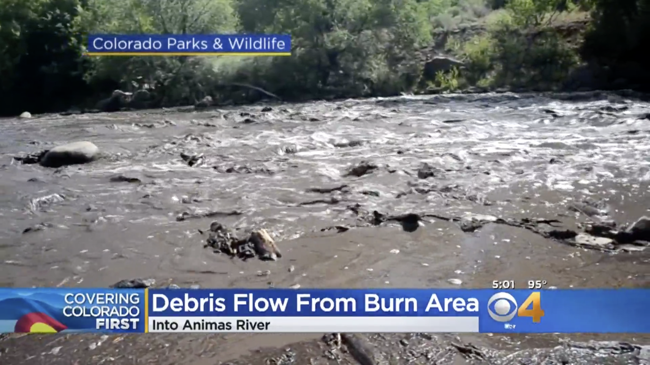
    #AnimasRiver: Sediment runoff from the #416Fire = fish kill

    Screen shot of Animas River debris flow July 2018 aftermath of 416 Fire (CBS Denver).

    Here’s the release from Colorado Parks and Wildlife via The Pagosa Daily Post:

    Drought, hot weather… and ash and debris flows from the 416 Fire… are meeting in an unfortunate sequence of events to hit the Animas River this summer, according to Colorado Parks and Wildlife officials.

    Because of the river’s low flow, the water temperature has been higher than normal and on some afternoons has risen above 70 degrees. Water temperature that high can cause fish to die. Consequently, CPW is requesting that anglers cooperate with a voluntary closure on fishing from noon to 7pm when the water temperature reaches 70 degrees.

    Historical records for the river show that in mid-summer the Animas River averages 58 degrees.

    “The temperature of the water does drop at night, so when the water clears we suggest fishing in the morning hours until noon,” said John Alves, senior aquatic biologist for CPW’s Southwest Region. “The fish are already stressed because of the warm water and their stress level only goes up when they start fighting a hook and line. Anglers can also go to high-elevation creeks where the water stays cool.”

    Besides the water temperature, ash and debris flow increased this week; the river is running brown and fish are dying.

    On July 10, after a local family reported dead fish in the river north of Durango, CPW determined that forest-fire ash flushed by heavy rain off the charred slopes killed the fish. Since then people are reporting seeing dead fish in the river from north of Durango all the way through town. The ash and debris flow came from the Hermosa Creek drainage which meets the Animas River about 10 miles north of Durango.

    “We inspected the fish and found their gills were coated in ash, which caused them to suffocate,” Alves said. “In burned areas, the absence of vegetation and the presence of hydrophobic soils can lead to flash flooding and debris or ash flows even after small thunderstorms.”

    The family that made the initial report collected 21 dead fish, 15 of them were brown trout. Those fish ranged in size from 16 inches to an inch or less.

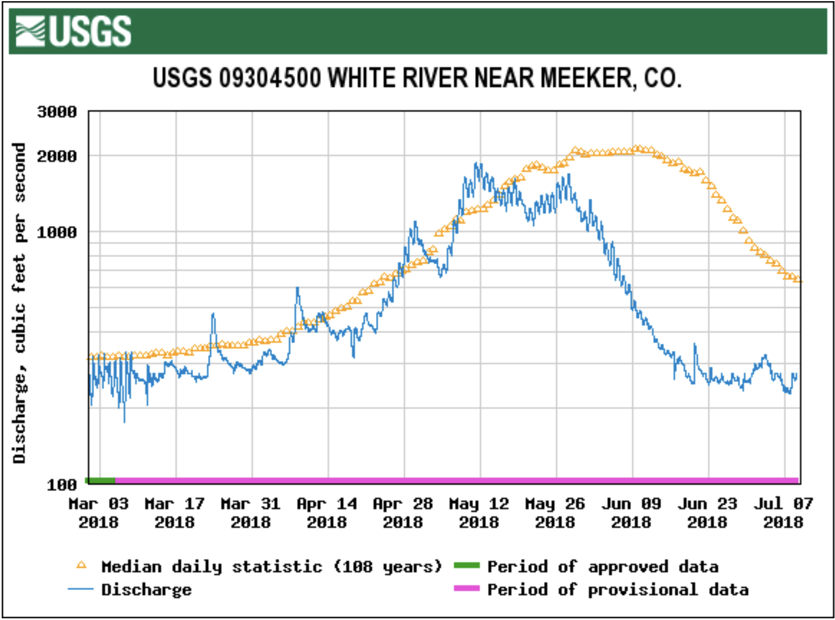
    Alves said that ash flows and sediment run-off are likely to continue throughout the summer as monsoon rains settle in; but some ash and sediment could continue to run off steep slopes for more than a year. The river, as of July 17, was running at about 300 cubic feet per second, compared to an average for this time of year of about 1,000 cfs.

    “The water in the Animas River is so low that it can’t dilute the ash and sediment flow,” Alves said.

    Trout are also stressed by all the float-craft on the river. When trout see something above they will seek cover in deep pools, behind rocks and under banks. When they’re forced to move they must use extra energy to stay safe; and because there is so little water in the river there are fewer places for fish to hide.

    For anglers, CPW offers these suggestions to reduce stress on fish:

  • Buy a small thermometer and take the temperature of the water. If the temperature is 70 degrees or above, stop fishing.
  • Fish in the morning when the water temperature is cool.
  • Fish high-elevation streams which usually stay cool.
  • Use heavier tippet and land the fish quickly. Don’t “play” or tire fish.
  • Use barbless hooks which allow a quick release. Those using spinning gear – who don’t intend to keep fish – should press down the barbs of metal lures.
  • Release fish as fast as possible; minimize handling of fish and the amount of time they’re out of the water. Skip the photos for now.
  • Be sure to know the regulations for the river you’re fishing.
  • “Monsoon rains and, hopefully, snow next winter will help the river and fish recover,” Alves said. “But we can all do a little now to reduce stress on fish and on the river.”

    CPW is an enterprise agency, relying primarily on license sales, state parks fees and registration fees to support its operations, including: 41 state parks and more than 350 wildlife areas covering approximately 900,000 acres, management of fishing and hunting, wildlife watching, camping, motorized and non-motorized trails, boating and outdoor education. CPW’s work contributes approximately $6 billion in total economic impact annually throughout Colorado.

    From The Colorado Springs Gazette (Liz Forster):

    Ash and debris carried by heavy rains from the 416 fire burn scar into the Animas River north of Durango suffocated thousands of fish, Colorado Parks and Wildlife officials said.

    “We’re seeing thousands of fish struggle for their last gasp of air on the river 10 to 15 miles north of Durango, likely down into New Mexico,” said the spokesman for the Southwest Region of Colorado Parks and Wildlife Southwest, Joe Lewandowski. “We can’t even get an exact number because the river is so dark and brown, and we can’t do much about it until the runoff flushes out.”

    Lewandowski added that the Animas River has not seen such a massive die-off from wildfire debris runoff in recent memory, though the Missionary Ridge fire wiped out the fish population in the Florida River northeast of Durango in 2002.

    The hardest rains hit areas of the 54,129-acre burn scar about 5 p.m. Tuesday, the Durango Herald reported. The flooding and debris flows forced the closure of U.S. 550 and halted the Durango and Silverton Narrow Gauge Railroad train. About 400 passengers were shuttled off the train, and about 200 campers at the KOA near East Animas Road were bused to the La Plata County Fairgrounds.

    Wildlife officials and members of the public are primarily finding dead rainbow and brown trout as well as flannel mouth and bluehead suckers. The flannelmouth and bluehead suckers are of particular concern, since the two species are native and endemic to the Colorado River basin.

    “They’re very hearty fish that have endured huge runoffs, low water levels, high temperatures and a variety of other pressures,” Lewandowski said. “But we’re not sure how they’re going to do with this type of ash and debris runoff because we’ve never seen anything like this.”

    Parks and Wildlife’s first gauge on the severity of the fish kill will likely come in September.

    Biologists plan to conduct a fish survey in 6 miles of the Animas River that run through downtown Durango in which they electroshock the fish and record their numbers, weight, size, species and other observations.

    Think it’s hot now in Colorado? Just wait — @COindependent #ActOnClimate #KeepItInTheGround

    From The Colorado Independent (Alex Burness):

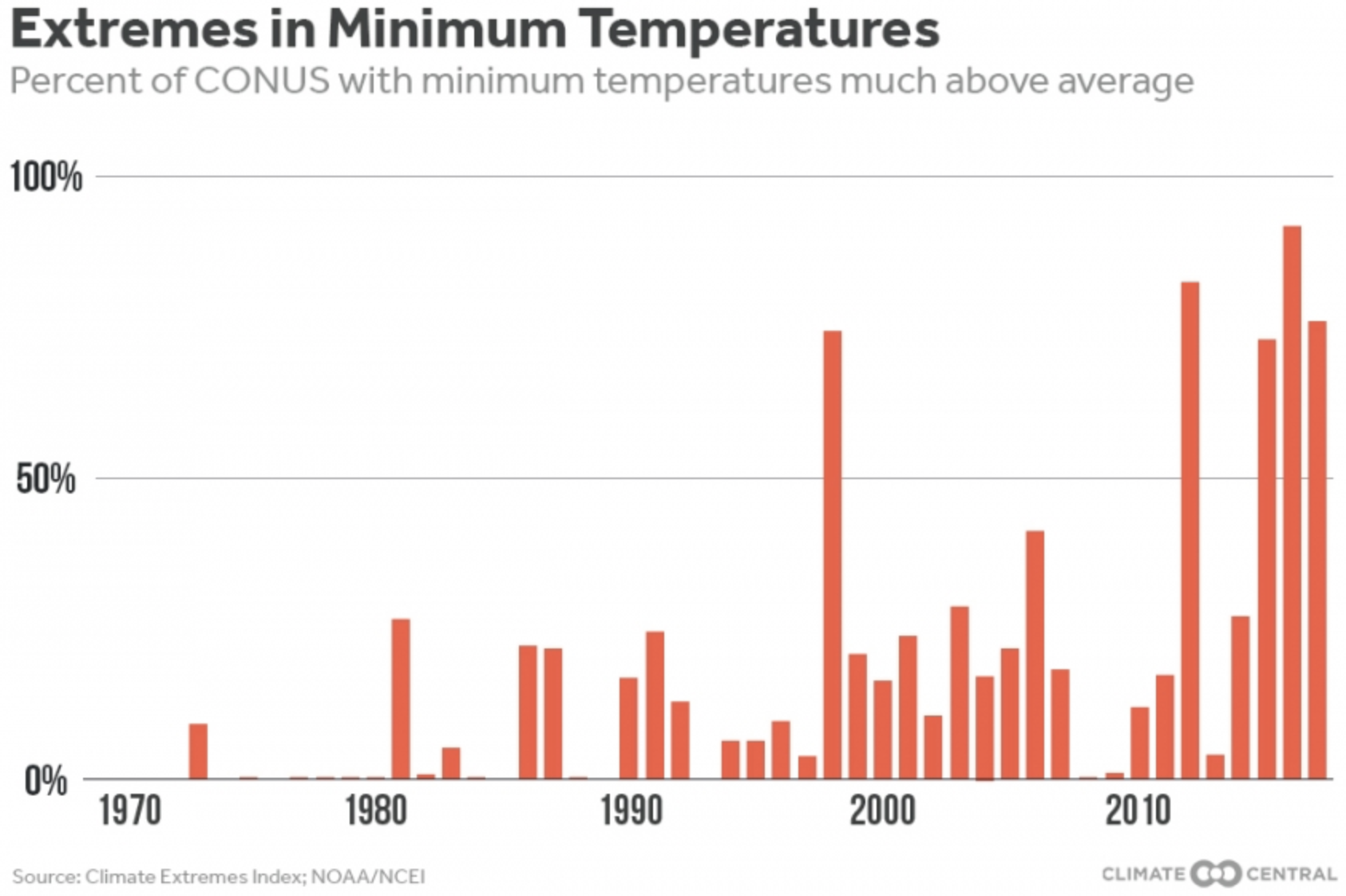
    Colorado’s scorching summer of 2018 may signal a new normal.

    Best-case scenarios show 100-degree days becoming seven times more common in coming decades, while worst-case scenarios show temperatures topping the century mark on roughly 10 percent of days by 2080.

    Much of this depends on the near-future global efforts o reduce emissions and stem global warming, but Colorado climate scientists are clear that emissions cuts won’t determine whether extreme heat becomes more common in the state, but how much more common.

    On July 11, Denver had its 30th day of 2018 at 90 degrees Fahrenheit or higher. That mark had never previously been crossed so early in the year.
    But, Stephen Saunders of the Rocky Mountain Climate Organization, warned, “What we’ve seen so far is probably only a small taste of what lies ahead of us.”
    Saunders was the lead author on a series of recent studies examining extreme heat scenarios in various segments of Colorado’s Front Range, including Denver, Boulder County and Larimer County.

    Those studies, conducted in 2016 and 2017 and funded by the Colorado Department of Local Affairs and the Denver Department of Public Health and Environment, present some almost unfathomably scorching scenarios.

    For example: At the current rate of global emissions, Denver will see 25 days per year above 100 degrees by mid-century during extreme summers, like the current one, the researchers found.

    It’s unlikely, though, that the current rate will be maintained. Every country in the world, other than the United States, is signed onto the 2015 Paris agreement, which calls on individual nations to voluntarily work to reduce their own greenhouse gas emissions.

    The central goal of the Paris agreement is, as the United Nations puts it, “to strengthen the global response to the threat of climate change by keeping global temperature rise this century well below 2 degrees Celsius (3.6 degrees Fahrenheit) … and to pursue efforts to limit the temperature increase even further to 1.5 degrees Celsius.”

    Saunders’s team wondered just how much hotter Colorado would get if the 2-degree Paris goal is reached.

    On average, the state will see 2 days per year with temperatures over 100, they found, under a scenario of enormous global success in limiting emissions. That might not sound like too many extra-hot days every year, but consider that over the past century, Colorado’s averaged only one day above 100 every three years, roughly.

    Kevin Trenberth, who holds the title of distinguished senior scientist at Boulder’s National Center for Atmospheric Research, isn’t optimistic that the world will achieve the Paris goals.

    “I personally think there’s no way that’s going to happen,” he said of the goal to limit temperature increase to 1.5 degrees Celsius, “and I think it’s very unlikely we meet 2 degrees Celsius. I think we’ll zoom right by that around 2050.”

    The United States’s lack of formal participation in the Paris accord — a reversal by President Trump of the country’s Obama-era course, inspired many cities and states, including Denver, to commit to their own, local 2050 emissions targets. But, Trenberth said, that’s likely not enough.

    The U.S. has, over time, produced far more heat-trapping pollution than any other nation, according to the Environmental Protection Agency.

    It’s fallen behind China in annual pollution, but in overall emissions, remains above everyone else. And while the country is economically, intellectually and industrially capable of dramatically shifting focus toward lowering emissions, its present administration has rarely even acknowledged the existence of human-caused climate change, much less taken steps to lead on the issue.

    “It’s been very hard to get across to the general public and to politicians that we can’t simply turn back the clock very easily on this issue,” Trenberth said. “There are long-term consequences.”

    Trenberth explains how he sees these consequences playing out:

    There is more heat beating down on our planet than can escape the atmosphere because of the blanket of greenhouse gases the U.S. helped knit. That blanket prevents heat from going out to space.

    So, the temperature goes up, on average, and the added heat means moisture evaporates more quickly. In turn, the extra water in the atmosphere fuels storms that are heavier and more vigorous than those we’ve historically seen.

    And, in the places it’s not raining, the heat saps needed moisture and the risk of wildfire goes up.

    This summer in Colorado already has seen a point at which eight different wildfires were burning at once. Gov. John Hickenlooper said this week that the state’s now over budget for addressing wildfires.

    And if our current June and July become the norm, Coloradans can come to expect worse fire seasons and government budgets unequipped to keep pace.

    “We can avoid a really fundamental transition of our climate if we reduce emissions,” Saunders said. “But that takes our entire planet doing it.”

    @WaterEdCO “Fresh Water News’: Aurora’s recycled water plant running at full-tilt

    From Water Education Colorado (Jerd Smith):

    Aurora’s futuristic recycled water project — Prairie Waters— is running at full-tilt for the first time in its eight-year history, a move designed to make the city’s water supplies last longer in the face of severe drought conditions.

    “We’re pushing it as hard as we can,” said Greg Baker, a spokesman for Aurora Water.

    In February, as mountain snows failed to accumulate, Baker said the city began mobilizing to ramp up plant operations, knowing its reservoirs would likely not fill this summer. “We were very worried.”

    By April, Prairie Waters was running at full speed, generating 9.7 million gallons a day (MGD), up from 5.1 MGD last summer, a 90 percent increase in production.

    “We could possibly push it to 10 MGD,” said Ann Malinaro, a chemist and treatment specialist with Prairie Waters, “but we consider 9.7 MGD full capacity.”

    […]

    “Prairie Waters was huge, not just in terms of volume, but also because it’s really helped us advance as a state in accepting potable [drinkable] reused water,” Belanger said. “Historically, there has been a yuck factor. But Prairie Waters has helped folks understand how systems can be designed so they are safe and effective.” [Laura Belanger]

    Twenty-five Colorado cities, including Denver, Colorado Springs, Fort Collins and Louisville, operate recycled water facilities, according to the Colorado Department of Public Health and Environment, but that water is used primarily to water parks, golf courses and to help cool power plants, among other nonpotable, or non-drinkable, uses.

    But Aurora, faced with fast-growth and a shortage of water, realized more than a decade ago that reusing its existing supplies and treating them to drinking water standards was the only way to ensure it could provide enough water for its citizens.

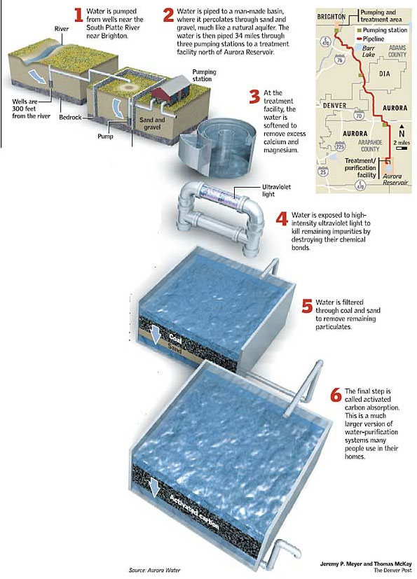
    Completed in 2010, the Prairie Waters Project recaptures treated wastewater from the South Platte River and transports it back to Aurora through a series of underground wells and pipelines. As the water makes its 34-mile journey from a point near Brighton back to the metro area through subsurface sand and gravel formations, it undergoes several rounds of natural cleansing.

    Once it reaches the Prairie Waters treatment facility near Aurora Reservoir, it runs through a series of high-tech purification processes using carbon filters, UV light and chlorine, among other chemicals. Then, before it is delivered to homes, the reused water is mixed with the city’s other supplies, which derive from relatively clean mountain snowmelt that is carried down from the mountains.

    @ColoradoClimate: Weekly Climate, Water and #Drought Assessment of the Intermountain West

    Click here to read the current assessment. Click here to go to the NIDIS website hosted by the Colorado Climate Center.

    What we know so far about Denver’s commitment to 100% renewable electricity by 2030 — @COindependent #ActOnClimate

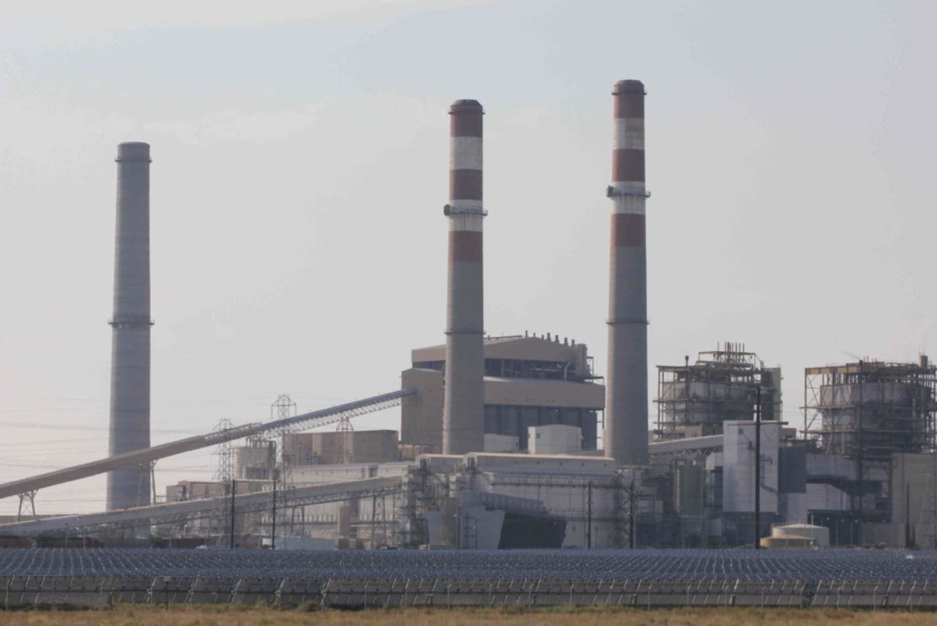
    Xcel Energy proposes to close two of its coal-fired generating units at Comanche, indicated by smokestacks at right. The stack at left, for the plant completed in 2010, provides energy for a portion of Aspen and for the Roaring Fork and Eagle valleys. In the foreground is the largest solar farm east of the Rocky Mountains at its opening. Photo/Allen Best

    From The Colorado Independent (Shannon Mullane):

    Denver has now become the 10th, and largest, Colorado municipality to commit to 100 percent of its electricity being powered by renewable energy.

    Mayor Michael Hancock announced the initiative at Monday’s State of the City address, then offered some details at a Tuesday news conference.

    The goal is part of Denver’s new 2018 80×50 Climate Action Plan, which targets sectors with the highest greenhouse gas emissions and establishes a strategy to reduce those emissions by 80 percent, compared to 2005 levels, by 2050.

    “While the White House has made a show of stepping back on this issue, it’s important to know that we listen to the people of our city; we listen to our stakeholders, and Denver can keep moving forward and we will remain committed,” Hancock said.

    Aspen already uses 100 percent renewable energy sources to power the city, and Boulder, Breckenridge, Lafayette, Longmont, Nederland, the City and County of Pueblo, and Summit County have each committed to doing the same, according to the Sierra Club.

    Denver currently ranks third in the nation for the worst urban heat island effect. Caused by human land uses like large paved areas, this effect causes Denver to heat up to 23 degrees hotter on average than nearby rural areas, according to the 2017 80×50 Climate Goal: Stakeholder Report. The report also says Denver can expect other climate impacts, such as increased frequency of extreme weather events, plus reduced snowpack and earlier snowmelt.

    “This isn’t just an environmental issue. … It’s about health, it’s about equity, … it’s about community and it’s also a jobs issue,” Hancock said. “We took all that information and the science behind it, and we developed a pathway to get us to 80 percent reductions by 2050.”

    Three sectors — buildings, transportation and electricity supply —make up 90 percent of greenhouse gas emissions in Denver. The 80×50 plan involves a series of interim goals to reduce emissions in each sector.

    For example, in 2025, all municipal buildings will use renewable electricity, Hancock pledged. By 2030, he said, the entire Denver community will use 100 percent renewable electricity.

    In order to achieve this goal, Denver must work closely with Xcel Energy Colorado, Denver’s main electricity provider. In early March, Hancock and Xcel Energy Colorado president David Eaves signed the Energy Future Partnership, a formal commitment to collaborate as Denver pursues its renewable energy goals.

    In August 2017, Xcel laid out a plan to draw 55 percent of its energy statewide from renewables by 2026, a proposal that is currently under review by the Colorado Public Utilities Commission.

    Right now, 44 percent of the electricity Xcel provides Denver comes from coal, while natural gas and renewable energy sources are almost equal, at 28 percent and 25 percent respectively, according to Xcel’s 2017 Annual Community Energy Report for Denver.

    With Xcel’s 2026 target, Denver would already receive 55 percent of its energy from renewable sources.
    “That allows us to chart a path to say, given what we know, what do we need for Denver to get to 100 percent?” said Thomas Herrod, climate and policy analyst for the city.

    Although Denver will still receive 45 percent of its energy from non-renewable sources after 2030, it will implement enough other renewable energy and energy efficiency projects to achieve net-zero non-renewable energy use, Herrod said.

    Many of these projects involve the building and transportation sectors, which will take until 2050 to reach their end goals, the city has said.

    While Denver plans to reach 15 percent electric vehicle registrations in Denver by 2025, its goal is that all passenger vehicles, taxis and transportation network vehicles, such as Uber and Lyft, will be electric by 2050. The hope is that all public transportation will be carbon-free, and after infrastructure expansion, more commuters will depend on telecommuting, biking, walking or using public transit to get to work.

    Denver’s population has also doubled since 1960, increased by nearly 25 percent since 2000, and was estimated at over 700,000 as of 2017.

    While the city expands, low-income families are pushed farther out, said Jeff Su, executive director of Mile High Connects. The city is partnering with Mile High Connects, a collaborative of 23 grassroots or philanthropic organizations and financial institutions, to make sure that public transportation is affordable for low-income families.

    “Families that are already spending 50 percent of their income on housing and transportation cannot afford any more increases on their energy bill as we make this shift to renewable energy,” Su said.

    For four years, the city and Mile High Connects have been working on a low-income transit fare. In September, the Regional Transportation District board will be voting on a 40 percent discount for all families at 185 percent or below the federal poverty level, Su said, asking that city and community groups urge the RTD board to accept this low-income fare.

    For building infrastructure, the plan includes six benchmarks, starting with a 15 percent reduction in energy use in commercial buildings by 2020, moving to a 20 percent reduction in residential homes, and ending with 50 percent reduction of energy use in commercial buildings in 2050. The plan also sets goals for reducing thermal heating emissions and making new buildings net zero energy.

    This means more aggressive energy codes, incentives for new buildings, and a home-energy rating system for residential buildings so that owners, renters and potential buyers can make informed decisions about a home’s efficiency and operating costs, according to the Climate Action Plan.

    Denver first began working to reduce greenhouse gas emissions in 2007 when it released the 2007 Climate Action Plan and current governor and then-mayor John Hickenlooper, signed on to the Mayor’s Climate Protection Agreement of the U.S. Conference of Mayors.

    In 2012, the city accomplished these goals when it reduced greenhouse gas emissions by 10 percent per capita relative to 2005 values. Then, in 2015, Denver released the first version of its 80×50 goal in its 2015 Climate Action Plan, followed by a two-year stakeholder input process that incorporated expertise from 44 different organizations.

    In order to meet The 2020 Sustainability Goals, the first set of benchmarks in the city’s long-term plan, Denver has two years to decrease its greenhouse gas emissions by about a million metric tons, from 12.79 million metric tons of CO2 equivalent to 11.8 mmtCO2e. and to meet a variety of consumption reduction targets and identified metrics for improving air quality, food, health and nine other quality of life categories.
    “Let’s be clear, there’s a lot that needs to be done to get us there, but we have a lot to build on as well,” Hancock said, referring to the Energize Denver Program and plans to build more electric charging stations, bike paths, walking paths and more efficient public transportation.

    “This plan shows that the tools to solve this generational challenge are available and affordable today.”

    @CSUtilities: Expanding our renewable energy portfolio #ActOnClimate #KeepItInTheGround

    Colorado Springs with the Front Range in background. Photo credit Wikipedia.

    From From the ReSources Blog (Amy T.)

    We are excited to announce the start of two utility-scale solar projects that will significantly increase our amount of renewable energy to power the Pikes Peak Region.

    “We are committed to offering our customers a cleaner, more diverse and affordable energy portfolio to power their homes and businesses,” says John Romero, general manager of Energy Acquisition Engineering and Planning.
    The two projects totaling 95 megawatts will add enough solar energy to power about 30,000 homes annually and increase our solar energy offering to 130 megawatts. Combined with hydro power, our renewable energy portfolio will total about 15 percent of our summer generating capacity when the projects come online.

    The peak use of electricity in Colorado Springs typically occurs in the afternoon on hot, sunny days. This high use coincides with the prime time for solar generation.

    “The contribution of solar energy to our grid during these peak times is extremely valuable,” explains Romero. “These projects will enable us to have a clean source of generation that decreases the demand on our grid and provides a fixed price for energy over the next 20 years.”

    We will purchase the energy generated by both projects combined for less than $31 per megawatt hour.

    Palmer Solar Project
    We signed a 20-year contract with Colorado-based renewable energy company juwi Inc. (juwi) to supply us with renewable energy from the Palmer Solar Project totaling 60 megawatts.

    The approximately 500-acre site selected for this project is part of Woodmoor Water and Sanitation District’s property, located in El Paso County. juwi will be responsible for developing, building and operating the facility planned to come online by December 2020.

    “Working with Springs Utilities has been a first-rate experience, and we’re grateful for their commitment to bring safe, clean, cost-effective and reliable energy to their customers,” says Mike Martin, juwi’s president and CEO. “We’re especially excited to be building once again in our home state, and we look forward to our continued relationship with Springs Utilities, the landowners and El Paso County as we operate the facility over the coming decades.”

    Grazing Yak Project
    We signed a 25-year contract with NextEra Energy Resources (NextEra), the largest generator of solar and wind power in North America, to supply us with renewable energy from the Grazing Yak Project totaling 35 megawatts.

    The approximately 270-acre site selected for this project located south of Calhan, Colo. NextEra will be responsible for developing, building and operating the facility planned to come online in late 2019.

    “We are pleased to work with our partners at Springs Utilities to develop another solar energy center,” says Kevin Gildea, vice president of development, NextEra. “Once operational, this project will provide an important source of additional tax revenue for the county and will generate cost-effective, home-grown solar energy for Springs Utilities customers for years to come.”

    #Drought news: “It feels like the edge of that desert has moved 50 or 75 miles in my lifetime” — Ed Zink #aridification

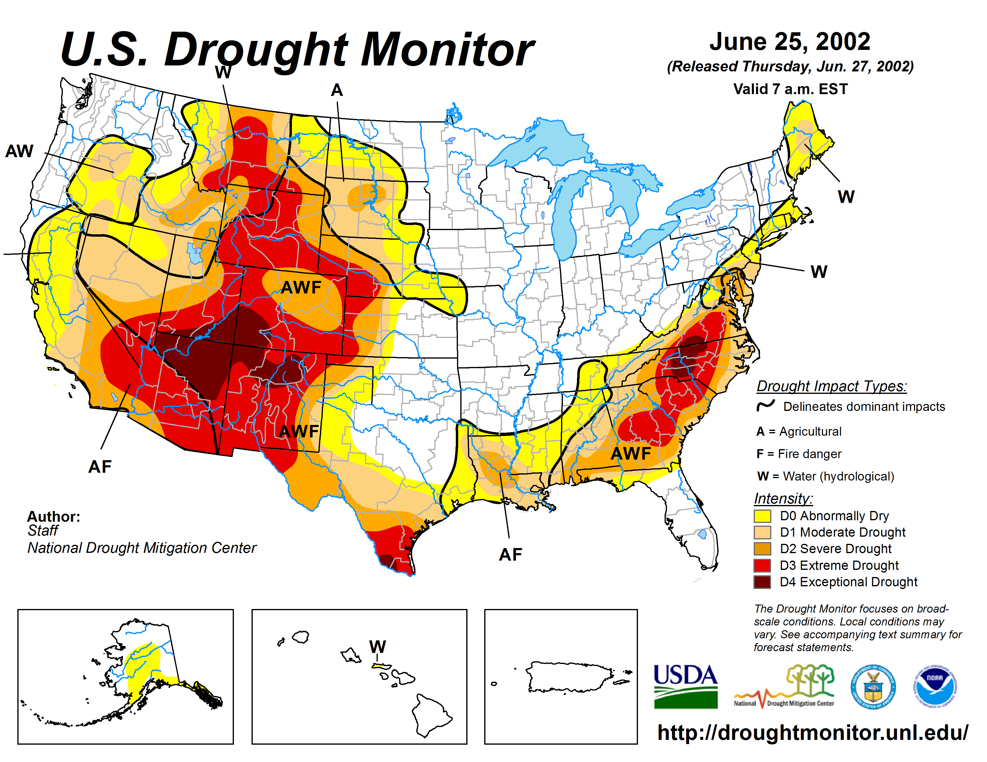
    West Drought Monitor July 10, 2018.

    From Colorado Public Radio (Grace Hood):

    “Most of the pasture we used last year we’re not using this year because there’s no moisture,” [Matt] Isgar said of the land he ranches in Hesperus, west of Durango. “There’s no new growth.”

    With the dark red bull’s eye of exceptional drought looming over the Four Corners region, Isgar has lowered his grazing standards. He sold off 35 cows to stave off financial bleeding, but there are still costs.

    “We’re spending more material and labor fixing fences and hauling water, and we’re supplementing with protein. So every day is more expensive to operate,” he said.

    Hot and dry conditions have become an insidious foe to Colorado ranchers and farmers. While dry summers aren’t new, a winter and spring with little snow and rain have pushed parts of the state to get drier, faster. June marked the third warmest on record for the entire state. Colorado should soon see normal monsoon moisture, but that won’t help Rocky Ford cantaloupe farmer Greg Smith. The legendary local crop grows out on the southern eastern plains, another region dealing with exceptional drought.

    Smith saw the writing on the wall with the spring’s low snow pack and only planted a third of his 100 acre farm.

    “It’s just brown dry,” he said. “A match gets started on fire and you have a prairie fire that may run for miles.”

    There’s a cost to leaving fields empty. Smith still treats the soil to prevent weeds. And financially, even with fewer acres planted, he has the same bills to pay. Even his retirement plans got delayed. His intention to build a second retirement residence was torched by the Spring Creek Fire…

    Nearby Baca County was the epicenter of the 30s dust bowl, so dryland wheat farmer Brian Brooks said he’s seen worse. His crop yields are down by about 5 bushels per acre. Prices have decreased slightly. His only saving grace at the moment was above average rainfall from last year that supercharged the soil. Farming advances have allowed him to conserve that moisture for his benefit for now.

    The future likely will mean hotter temperatures which can prolong drought. Roger Pulwarty, a senior scientist at the National Oceanic and Atmospheric Administration, said hotter temperatures can prompt flash droughts, like in 2012, when the majority of the U.S. dried in just a few months.

    “This idea of intensification in drought is what makes drought very unique … By the time it’s intensified, we’ve used up all the buffers we’ve relied on, [like] cheaper grain. And now we’re at the mercy of a very, very strong event,” he said.

    It feels like that hotter drier future has already arrived for hay grower Ed Zink. For 70 years he’s lived on Waterfall Ranch, near Durango. He typically sees the namesake waterfall on the nearby rocky cliffs — but not this year. It’s a first for Zink…

    Zink watched the 416 Fire come within a half mile of this property in June, another first. Ample water rights for his property have meant little difficulty for growing hay this year. But 70 years ago, Zink said his property was situated at the edge of alpine forest. He could see desert to the south. That desert has started marching northward toward his farm.

    “I don’t know how to exactly put it in perspective,” he said. “It feels like the edge of that desert has moved 50 or 75 miles in my lifetime.”

    Zink’s neighbor’s wells have started to dry up, another change in his lifetime. Groundwater is on the decline, and the cause is not fully known. La Plata County plans on a comprehensive study of the problem. The picture adds up to a landscape of more people making due with less water.

    @USBR provides 27 projects $2.6 million in WaterSMART Cooperative Watershed Management Program grants

    The Rio Grande flowing through the Colorado town of Del Norte. Photo credit: USBR

    Here’s the release from the Bureau of Reclamation (Peter Soeth):

    Funding supports the establishment or further development of watershed groups to address water quantity and quality issues in the West

    Bureau of Reclamation Commissioner Brenda Burman announced that 27 entities were selected to receive a total of $2.6 million to establish or further develop watershed groups in order to address water quantity or quality through Cooperative Watershed Management Program Grants. Of the 27 entities selected, 19 are existing watershed groups, including one from the Virgin Islands, and 8 are establishing a new watershed group.

    “Reducing conflict over water is an important goal,” Commissioner Burman said. “Working collaboratively with locally-led groups is the best path forward to reduce conflict and develop solutions that will lead to the long-term viability of watersheds.”

    Selected entities may use their funding to develop bylaws, a mission statement, complete stakeholder outreach, develop a watershed restoration plan, and to conduct watershed management project design.

    A complete list of the selected projects is available at https://www.usbr.gov/watersmart/cwmp.

    A cottonwood forest. Credit: Matthew Schmader/Open Space Division

    The Save Our Bosque Task Force in Socorro, New Mexico, is one of the groups selected to receive funding. It will receive $100,000 to update their 2004 conceptual restoration plan on the Rio Grande floodplain through Socorro County where flooding can devastate farms, infrastructure and small communities. Recent drought conditions have limited available surface water supplies in the watershed, increasing wildfire risk and reliance on groundwater, which also strains aquifers. The task force will work with the Middle Rio Grande Conservancy District, New Mexico State Forestry and numerous other local, state and federal agencies to complete outreach to stakeholders.

    The Coral Bay Community Council on the island of St. John in the U.S. Virgin Islands will receive $99,155 to complete a five-year update to its watershed management plan and develop a visioning document for the Coral Bay Watershed. The group has spent a significant amount of time characterizing source pollution into Coral Bay, including unmanaged stormwater, sediment transport and an inadequate solid waste system. In addition, back-to-back hurricanes in 2017 have increased the need for updated planning efforts. The council will hold stakeholder meetings to help inform the public of the importance of watershed planning and to incorporate diverse perspectives in the updated plan and visioning document.

    Through WaterSMART, Reclamation works cooperatively with States, Tribes, and local entities as they plan for and implement actions to increase water supply through investments to modernize existing infrastructure and attention to local water conflicts. Visit https://www.usbr.gov/watersmart for additional information about the program.

    Wildfire update #ActOnClimate

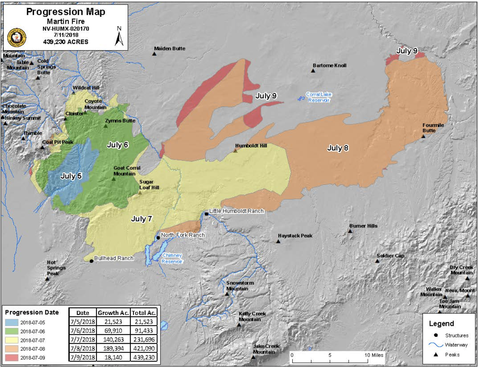
    The map, color-coded by day, shows the rapid daily progression of the fire. (Great Basin Interagency Incident Management Team)

    From The Nevada Independent (Daniel Rothberg):

    The Martin Fire broke out in the morning hours of July 5th and ripped through dry vegetation to quickly become the largest blaze in the United States, the largest this season and the largest single fire in Nevada history. As of Wednesday night, the fire had burned in more than 439,000 acres, or about 686 square-miles, an amount of land more than twice the size of New York City. It has not only destroyed grazing areas but has damaged an ecosystem for the sage grouse, the bird that has been a focal point of political wrangling because of the impact of its possible inclusion on the endangered species list.

    On Wednesday, less than one week later, Stewart said that the fire had burnt nearly all of the ranch’s 100,000 acres of grazing land controlled by the Bureau of Land Management.

    “It’s gone, it’s gone” he said. “Riding across there, it feels like you are on the moon.”

    Federal land managers and rangeland ecologists expect there to be lasting impacts on grazing, wildlife and sagebrush habitat in the burned areas, with a full recovery taking up to a decade…

    They also said that the fire is indicative of new dynamics on the range that leave more areas open to fire potential and make it possible for fires to grow faster and spread greater distances.

    A spokesperson for the Martin Fire response team said there was 200 to 400 percent more fuel on the range because of a wet winter followed by a dry winter this year. And even though less-than-average snow fell on the Great Basin this year, there was considerable precipitation in the spring, Gardetto noted, which resulted in vegetation growth. But in turn, an especially hot summer meant that much of the vegetation that grew had dried up when the fire started last week.

    “It’s creating a lot of extreme fire behavior that is making these fires very difficult to control,” Gardetto said. “That’s why you are seeing fires like the Martin Fire that just blow up.”

    At times, the 25-mile wide front of the fire moved at 11 miles per hour. High winds contributed to why the Martin Fire moved so rapidly, growing to about 421,000 acres in just four days. Another reason the fire grew to such a large size was the presence of cheatgrass, a highly flammable invasive species that has overtaken much of the range in several Intermountain West states.

    “Once cheatgrass is dominant, in a sense, the damage is done,” said Erica Fleishman, a professor at Colorado State University who has done work on the Great Basin ecosystem.

    The flammable invasive species is the most responsive grass to precipitation and once it has grown in an area, it is hard to eliminate. Its seeds are also resilient and grow in burnt areas. Although livestock can feed off of cheatgrass, ranchers prefer other grass species for cattle.

    The Nevada Department of Agriculture has received reports of burns at six ranches.

    “We are fielding reports from ranchers and will assist with anything from identifying livestock to traffic control, as requested by other agencies,” JJ Goicoechea, state veterinarian and deputy administrator for the NDA’s animal industry division, said in an emailed statement. “We are also standing by in case an emergency declaration is made or funding becomes available and will work with the [U.S. Department of Agriculture] to coordinate and assist affected ranchers.”

    Ranchers like Stewart, who saw most of their grazing areas burnt by the fire, face tough decisions about how to operate in the coming months and even years. They might have to decide whether to sell some of their cattle or find empty grazing areas in other parts of the state.

    Through the federal government, some ranchers might be eligible for compensation if their cattle were engulfed or injured during the fire, or if the fire burnt their grazing areas. At this point, there is no estimate for how many livestock or cattle had been killed during the fire…

    Greater sage grouse via Idaho Fish and Game

    The vast majority of the fire burned in sensitive habitat for sage grouse, land managers have said, and the blaze is likely to be a setback for sustaining habitat for the bird. For years, federal regulators have been working on a conservation framework to boost dwindling populations of the bird and keep it off the endangered species list, which would devastate rural economies.

    Sage grouse rely on the presence of sagebrush in the Great Basin for protection and food.

    “When we have these anthropogenic fires, based largely around the fact that we’ve introduced cheatgrass, it becomes a tremendous challenge for the bird to reproduce,” said Brian Rutledge, the vice president and director of the Audubon Society’s Sagebrush Ecosystem Initiative.

    The concern, among many, is that wildfire will put more pressure on sage grouse populations, which could land the bird on the endangered species list when the federal government revisits the issue. It’s an outcome that many Westerners have worked to avoid for decades. A listing would mean the curtailment of many activities in rural counties, including mining and ranching.

    The impact on sage grouse could depend, in part, on how the fire burned. Since the burn was not continuous — there was some land untouched — there might be some habitat within the 292 mile radius of the burn that is preserved, land mangers said. Although land managers are still assessing the damage, the fire has likely altered mule deer habitat and other wildlife.

    At a public meeting in Winnemucca on Wednesday evening, first responders said all of the parties affected by the fire, including ranchers and wildlife managers, will meet in the coming weeks to discuss how to rehabilitate the range and damaged ecosystems. They stressed they would take a collaborative process and undertake projects likely to include seeding and building new fences.

    “This is going to be a very, very large project,” said Donovan Walker, a fire management officer.

    But restoration can be difficult and expensive. Fleishman said cheatgrass seeds are so resilient it is hard to prevent the invasive species from growing and crowding out space for native grass.

    “Restoration is possible in small areas with a lot of labor and financial resources,” she said.

    Thad Heater, a former state biologist with the USDA’s Natural Resources Conservation Services, said there have been some effective sagebrush restoration efforts. He pointed to areas burned by the Soda Fire, a devastating blaze that eliminated valuable sagebrush habitat in Idaho.

    “It’s really bounced back well,” said Heater, who also works with grouse through as the coordinator of the Sage Grouse Initiative. “You can get the habitat responses for wildlife by working together.”

    According to land managers, the Martin Fire is the largest single fire that has burned in Nevada. The Southern Nevada Complex, a devastating burn in the Spring Mountains near Las Vegas in 2005, burned more acres but comprised multiple fires, whereas the Martin Fire was one blaze.

    In limited circumstances and on smaller scales, fires can benefit the range. Yet in the case of massive human-caused fires such as the Martin Fire, nearly everyone — ranchers, ecologists and land managers — agree they often destabilize the ecosystem and the activities that rely on it.

    “It’s becoming a determining factor of whether the primary stewards of land — ranchers — can succeed or not,” said Rutledge, who works on sagebrush ecosystems with the Audubon Society. “It’s a human challenge as well as an avian challenge and an ecosystem challenge.”

    As of Wednesday, the more than 600 personnel that responded to the Martin Fire had contained about 60 percent of the blaze. Nearly all of the western, eastern and southern edges of the fire have been blunted, but there is a possibility that islands within the boundaries could flare up.

    Three smaller fires are burning in Eastern Nevada near the Utah border.

    Across the country, Gardetto said this season has been above average for wildfires, and it’s part of a broader trend that land managers have observed across the West over the last decade.

    “What we do know is that over the last 10 and 20 years, we are seeing longer fire seasons, we are seeing more extreme fire behavior” due to cheatgrass and hotter temperatures, she said.

    Meanwhile the effort to restore burn scars is ongoing (The DenverChannel.com, Stephanie Butzer):

    As wildfires start to weaken around the state, the Colorado State Forest Service has offered up way you can help the areas affected by the new burn scars: replanting trees.

    The CSFS-administered Restoring Colorado Forests Fund uses donations to purchase seedlings and plant them in areas affected by wildfires, floods or other disasters. Every $2 donation purchases one seedling. The seedlings are grown at the CSFS Nursery in Fort Collins.

    The fund, which was established in 2003, has been used to provide more than 122,000 trees.

    “When a destructive wildfire hits, the first priority is protecting human life and property,” said Mike Lester, state forester and CSFS director. “But for the long-term recovery of our communities and forests, planting trees provides an important means to help stabilize soils, protect water supplies and restore the landscape.”

    In the past decade, this fund has been used to replant areas in the burn scars of the High Park Fire west of Fort Collins, the Waldo Canyon Fire near Colorado Springs and the Weber Fire near Durango.

    The loss of trees and other vegetation in those areas led to runoff and erosion, which resulted in damaged hillsides, polluted waterways, highway closures and road damage.

    This year, the Girl Scouts of Colorado made a donation that helped the Restoring Colorado’s Forests Fund provide 7,500 seedling trees for reforestation efforts.

    “We will forever be grateful for the seedlings we received because of the generosity of people giving to the Restoring Colorado’s Forests Fund,” said James Williams, a Larimer County landowner…

    To make a donation to the Restoring Colorado’s Forests Fund, visit http://www.advancing.colostate.edu/RestoringColoradosForests.

    From The Denver Post (Kirk Mitchell):

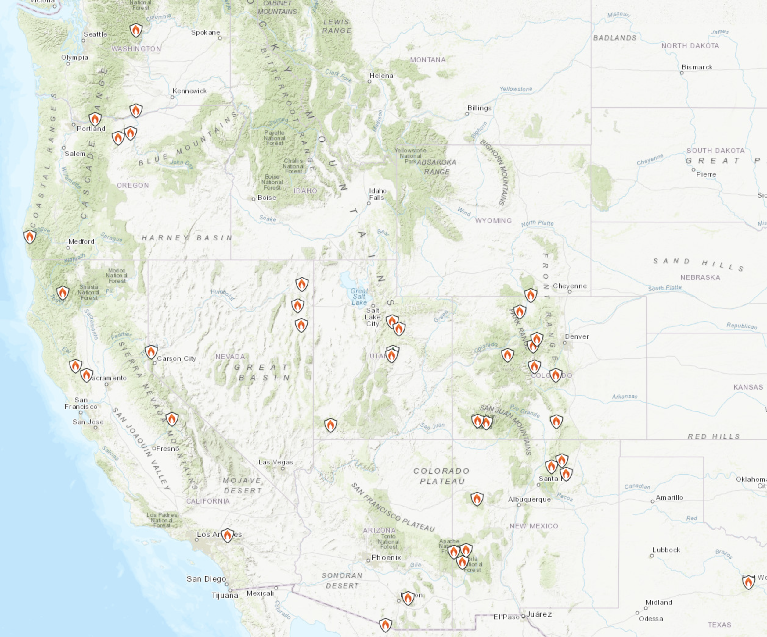
    Nearly a third of the 47 wildfires actively burning across the country are in Colorado, according to the U.S. Forest Service. The state’s 15 actively-burning wildfires don’t include previously-extinguished fires.

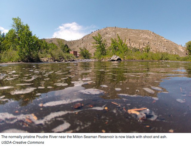
    Ash and silt pollute the Cache la Poudre River after the High Park Fire September 2012

    From Western Slope Now (Colette Bordelon):

    The Lake Christine Fire has burned over 6,800 acres, and it has many people hoping for rain. But, once the fire is put out, the rain could cause an entirely new problem. If a storm rolls through the area, it could wash all of the ash and debris into the waterways, and water providers in Mesa County could feel the ripple effect.

    If rain washes the remains of the Lake Christine Fire into the water, it could float to the Grand Valley. “That fire could result in being deposited into the Frying Pan, and then the Roaring Fork, and then eventually the Colorado River,” said Dale Tooker, the manager of Clifton Water District.

    Filtering the ash out of the water can be a difficult process. “Ash can be removed relatively easily, it’s the odor and the color… It does smell like liquid smoke if it’s at high concentrations,” said Tooker.

    Clifton Water District depends on their advanced treatment plant process and take daily samples of the river to test it. If worse comes to worse, there are other options. “We would actually step in and supplement their water supply and provide their customers with domestic water,” said Joseph Burtard, the external affairs manager for Ute Water Conservancy District.

    When it comes to our water, it all leads back to one common goal. “Anticipating the ash coming down, we’re preparing for that, we’re meeting, we’re having those discussions now. And so that when it does happen, our customers both Clifton Water and Ute Water customers don’t really even realize that it’s happening,” said Burtard.

    Domestic water providers are hosting a water workshop for HOA’s on July 19. Those with Ute Water Conservancy District said it’s a chance for people to ask questions about fires near our watersheds, among other topics. RSVP by visiting http://www.utewater.org.

    TV weathercasters hear about climate change — The Mountain Town News #ActOnClimate

    Atmospheric scientist Scott Denning of Colorado State University, left, and Kevin Trenberth of the National Center for Atmospheric Research. Photo/Allen Best

    From The Mountain Town News (Allen Best):

    Slipping in climate change amid the daily weather on TV in Colorado

    Television meteorologist Mike Nelson has two-and-a-half minutes each night to recap the day’s weather and inform viewers of Denver’s KMGH-TV what to expect in the hours and days ahead. Rarely does he have time to mention the changing climate.

    Nelson, though, does speak up when he can. “It’s not just about polar bears. It’s about our children and our grandchildren,” he said on a recent Saturday morning in downtown Denver as he showed a picture of his own grandchildren. “This is really important stuff.”

    A handful of representatives from TV stations in Denver, Colorado Springs and Grand Junction were at the session held on the Auraria campus. Nelson, chief meteorologist at Channel 7, had helped organize the program with the National Weather Service, bringing in two climate scientists to talk about how greenhouse gases are warming the planet and changing the climate.

    It was a low-key affair in an ordinary classroom in the Science building. There was coffee in the back and pink-glazed donuts, but also carrots and dip. Few of the faces were familiar to casual TV watchers. Other than Nelson, only Danielle Grant, a relatively recent addition to the prime-time slots at Channel 9, stood out. Nelson has been reciting the temperatures and dishing out predictions of rain, snow, and sunshine in Denver with his signature voice, smooth and calmly authoritative, since 1991.

    The scientists talked about weather and climate, physics and politics, despair and optimism.

    Greenhouse gas emissions have actually accelerated in the last three years, said Kevin Trenberth, distinguished senior scientist with the Climate and Global Dynamics Laboratory at the National Center for Atmospheric Research in Boulder. “We’re not making a dent in the problem so far,” he said. Half of all modern emissions have occurred since 1985.

    Trenberth, whose accent betrays his New Zealand roots, has been consulted frequently by reporters for national news organizations such as when Hurricane Sandy flooded Manhattan. While temperatures have clearly been rising, Trenberth was among the first to proclaim the increased energy could also be detected in extreme weather.

    About 90 percent of the increased heat goes into the ocean, causing expansion of the water and rising sea levels. Trenberth said he believes that hurricanes are a way that oceans use to shed heat, much as a body sheds heat perspiration. The warming climate may not result in more hurricanes, he said, but it is already increasing their severity by 5 to 15 percent. The effect of warming produced by accumulated greenhouse emissions can be found in the deeper droughts and more ferocious storms.

    Dealing with detractors

    In 2009, hijacked e-mails from Trenberth and others were cited by climate contrarians as proof that climate change, as President Donald Trump has said more recently, is nothing more than a giant hoax.

    One of the quotes cited as evidence had been sent by Trenberth to climate scientists in Great Britain. “We cannot show any warming, and it is a travesty that we cannot,” he had written. His detractors had conveniently neglected to provide the context. He was referring to the lack of an adequate monitoring system to show the warming in the deeper waters of the ocean.

    Nelson said that he, too, often gets angry e-mails and phone calls when he mentions climate change. “Spare me,” was in the subject line of one e-mail he got last October.

    “Stick to making erroneous forecasts like you always do and let the real scientists discuss climate change,” said the viewer. “BTW, we’ve had climate change for 4.5 billion years, always have always will. This is just a minor blip.”

    Detractors don’t stop Nelson. He speaks to about 50 schools per year, 15,000 students altogether. Youngsters want to hear about tornadoes, he said, but it’s important to also explain the basics of climate change. He also challenges the students to come up with inventions and innovations to solve the problem.

    “I tell students the problems are real, but the solutions can be found,” he said. “I thank them for the solutions they will find in the next 25 to 30 years.”

    Nelson also uses social media to occasionally push climate change education. He recently interviewed both Trenberth and another climate scientist, Scott Denning, of Colorado State University, for 20 minutes each on Facebook. Those interviews have had 25,000 views.

    Denning also spoke to the weathercasters, at first in deference. His audiences usually consist of maybe a couple dozen students. “Every day you talk to hundreds of thousands of people. It’s amazing.”

    Then he laid out Climate Science 101 to people with bachelor’s and master’s degrees. The basic mechanism of the greenhouse effect, he said, is really no more difficult to understand than the science taught in grade schools.

    “This really isn’t complicated.” The absorption spectrum of carbon dioxide, he said, was first measured by Irish scientist John Tyndall in 1863, when Abraham Lincoln was president. “This is not something we discovered 20 or 30 years ago.”

    Denver can expect the heat of Albuquerque, located almost 500 miles to the south, in coming decades, and Estes Park, at 7,500 feet in elevation, the heat now of Denver, 2,300 feet lower in elevation. Trail Ridge Road will be as warm as Estes Park.

    “This is huge, and it’s here,” he said. The warming now underway is the most rapid that has occurred on the Earth since the end of the last Ice Age. The post-glacial warming that took 100 centuries is now expected in just 100 years—some of it inevitably, even if rapid progress can be made in abating emissions.

    Denning calls his presentation “Simple. Serious. Solvable.” He brings a performer’s intensity to each theme. “This is so depressing I don’t even want to talk about it,” he said, flipping past one no-doubt serious slide.

    Then came the solvable, which he suggested is simple enough. Converting to 100 percent non-carbon energy will only cost about 1 percent of the gross domestic product. “That’s what it cost to retrofit the world’s cities with indoor plumbing a century ago,” he added. “It was so worth it.”

    Our future well-being need not be based on “stuff we extract from the ground,” he concluded. Changing our technologies will not require us to go back to shivering in the dark. “That is a grim, awful view of human progress.”

    What the survey results found

    Ten or 15 years ago, many TV meteorologist were deeply skeptical of the conclusions being reached by climate scientists. Some still are. At the Colorado Water Congress several years ago, Brian Bledsoe, chief meteorologist at KKTV in Colorado Springs, argued strongly that the vast majority of climate scientists had it all wrong. Bledsoe, who grew up in a ranching and farming area of eastern Colorado, retains a core audience in the agriculture community for his forecasting service, Weather5280.com.

    Even now, broadcast meteorologists altogether remain notably skeptical about the conclusions being drawn by climate scientists. A 2017 survey of 486 participating broadcast meteorologists by the American Meteorological Society found that 95 percent thought climate change is happening. However, only 49 percent of broadcast meteorologists said they were convinced that the changed climate observed during the past 50 years has been mostly or entirely due to human activity.

    Another 21 percent attributed the changes equally to human activity and natural forces, and the final 21 percent said the changes were entirely natural.

    Members of the American Meteorological Society altogether are far more accepting of the human role in the changing climate. So are Americans altogether. Gallup has asked Americans since 2001 whether they believe global warming is caused by human activities. The percentage has increased from 57 early in the century to a high of 68 percent last year. In the March poll, it fell back to 64 percent.

    Opinions differ sharply based on political affiliation. The Gallup poll in March found that 69 percent of Republicans think the seriousness of global warming is generally exaggerated, and 33 percent of independents agreed, compared to just 4 percent of Democrats.

    Democrats and Republicans even disagree in what they think they hear scientists saying. Some 86 percent of Democrats say most scientists believe warming is occurring, compared to 65 percent for independents and 42 percent of Republicans.

    Nelson likes to say that TV meteorologists like himself are as close as most people get to a scientist on a daily basis. He first encountered climate science as a student in the 1970s at the University of Wisconsin. “The talk was of global cooling due to dust, but even then, the majority of scientists thought the CO2 would eventually win out,” he says. By the 1990s, he began thinking about greenhouse gas emissions again and, eventually, his responsibility to insert climate change into his public conversations.

    “When we have a climate-related news story in the newscast, I try to have it positioned to lead into my report, so I can comment, perhaps have a supporting graphic or have something posted on social media that I can have the viewer check,” he says.

    Nelson had said he hoped the session at Auraria would embolden younger weathercasters to talk about climate change, despite the risk of what he calls “nasty-grams.”

    “The fact is we need to talk about it,” he told his younger colleagues while describing climate change as the “most existential threat” to civilization. But, he added, it’s a simple matter of physics—and solutions can be found.

    Afterward, Nezette Rydell, meteorologist in charge at the National Weather Service office in Boulder, defended the turnout to the session, despite the shortage of marquee faces. Like Nelson, she tilted forward with a glimmer of a smile. “Climate scientists used to be so depressing,” she said. “It’s not the end of the world anymore.”

    We need a new word for #drought (#aridification?) in the #West

    From Colorado Public Radio (Nathan Heffel):

    When is a drought so dry it can no longer just be called a drought? In Colorado, that time may be right now. At least, that’s what University of Colorado researcher Douglas Kenney thinks. Kenney directs the school’s Western Water Policy Program, which recently released a paper called “When is Drought, Not a Drought: Drought, Aridification, and the “New Normal.”

    Kenney talked to Colorado Matters about why he and his peers believe that aridification is the more appropriate word. [ed. Click through to listen.] Aridification describes a period of transition where an environment becomes increasingly and permanently water scarce — a new reality for the Western U.S.

    Take a trip down memory lane through mid-July West Drought Monitor maps.

    An Ode To The Toilet, A Water #Conservation Champion — @LukeRunyon

    Low flow toilet cutout via The Ultimate Handyman

    From KUNC (Luke Runyon):

    Since the 1990s, a strange phenomenon has played out in arid Western urban areas. Populations are booming while overall water use is staying the same or going down. The trend is clear in Denver, Albuquerque, Las Vegas, San Diego and Phoenix: Cities are growing and using less water in the process.

    It’s impossible to give credit to one single solution, but one could make a strong case that the M.V.P. award for water conservation efforts should go to the modern toilet.

    The toilet is the single largest user of water in the home. It uses more than the washing machine, the dishwasher, the shower or the kitchen faucet. About a quarter of all water that enters a home will flow through the toilet according to a 2016 study. Each day the average toilet will use about 33 gallons of water.

    That might sound like a lot, but it’s a big improvement. In 1999 the average toilet guzzled more than 45 gallons of water daily…

    The road to high-efficiency toilets began back in 1992. The concern was less about water scarcity in the West and more about overwhelmed sewage systems on the east coast.

    Congress was feeling pressure to pass national standards for water use and came up with the Energy Policy Act, a law that spawned a generation of low-flow fixtures.

    For the plumbing industry, it was a huge deal.

    “Absolutely, it was an extremely watershed moment, no pun intended,” says Pete DeMarco with the International Association of Plumbing and Mechanical Officials.

    The law mandated that toilets only flush using 1.6 gallons of water or less. Throughout the 1990s, low-flush toilets flooded the market. DeMarco says even though the regulations received input from toilet manufacturers, the new models received heaps of scorn from users who complained that their new and improved toilets performed worse, unable to finish the job in a single flush.

    “There were some poor-performing products back in the mid-90s. I think the regulation caught some manufacturers off guard,” he says.

    In many cases, DeMarco says, manufacturers had simply reduced the amount of water a toilet used without making significant changes to its inner workings. A lower flow just couldn’t cut it.

    The frustrated customers sent toilet-makers back to the drawing board. A new test from a company called Maximum Performance allowed manufacturers to demonstrate that their low-flow toilets could actually evacuate the bowl with one flush. In simulations, toilets would be loaded up with logs of miso paste to show their effectiveness.

    DeMarco says toilets can’t take all the credit, but this one innovation is a big reason why cities have been able to grow and still keep their water use in check. Indoor use dropped 22 percent nationwide between 1999 and 2016, much of that due to swapping out old fixtures.

    In recent years some states with water scarcity problems — like Colorado and California — have passed even tighter regulations on how much water toilets can use…

    Even though some conservationists feel like the indoor water use fruit has been plucked, a 2017 Alliance for Water Efficiency study found that more than 13 million non-efficient toilets — those that flush more than 1.6 gallons — remain installed in five states: Arizona, California, Colorado, Georgia and Texas.

    A nationwide push to rid the country of old toilets could have a significant effect.

    If all toilets were high-efficiency indoor water use could drop an additional 35 percent to below 40 gallons per person per day, the study projected…

    This story is part of a collaborative series from the Colorado River Reporting Project at KUNC, supported by a Walton Family Foundation grant, the Mountain West News Bureau, and Elemental: Covering Sustainability, a new multimedia collaboration between public radio and TV stations in the West, supported by a grant from the Corporation for Public Broadcasting.

    South Adams County Water and Sanitation shuts down 3 wells citing PFC pollution

    Typical water well

    From 9News.com (Allison Sylte):

    A news release about the contamination was distributed on Friday morning. This comes after the South Adams County Water and Sanitation District found perfluorinated compounds (commonly known as PFCs) in water samples from certain shallow groundwater wells. These chemicals are known to pose significant health risks if people are exposed to them – especially expectant mothers and young children.

    Now, the Environmental Protection Agency, Colorado Department of Public Health and the Environment, and the Tri-County Health Department are working to find the source of the contamination.

    However, health officials say the water distributed to the 50,000 customers in the South Adams County Water and Sanitation District is safe after three wells with the highest concentration of the PFC chemicals were shut down earlier this month. This means the district is taking 40 percent of its water supply from Denver rather than the usual 20 percent.

    The concern now, according to South Adams County Water and Sanitation District Water Systems Manager Kipp Scott, are private wells and the people who use them – which is what prompted the advisory to the public in the first place.

    “When we find something that is of a concern like this, we notify the health department,” Scott said. “The concern is, we are treating for that chemical here and removing it to levels below the health advisory, but the concern is with other people that maybe using wells that are not on our system and supplied water by our district.

    Scott said some wells tested positive for PFCs in May. When that happened, they tested the treatment process – and results took five weeks to come back. Next came contact with the health department.

    Brian Hlavacek, the director of environmental health at the Tri-County Health Department, issued a statement to 9NEWS that said:

    “Tri-County Health Department is working closely with EPA, CDPHE and SACWSD to identify the extent and source of contamination. TCHD is working to identify private drinking water wells in the initial area of investigation in order to sample for PFC’s. Sampling could begin as early as next week as we identify any wells. Residents who receive their water from a private drinking water well, are near this area, and are concerned about PFC levels can call Tri-County Health Department at 303-288-6816 or email questions to ehwater@tchd.org.”

    Gunnison: #Colorado Water Workshop recap

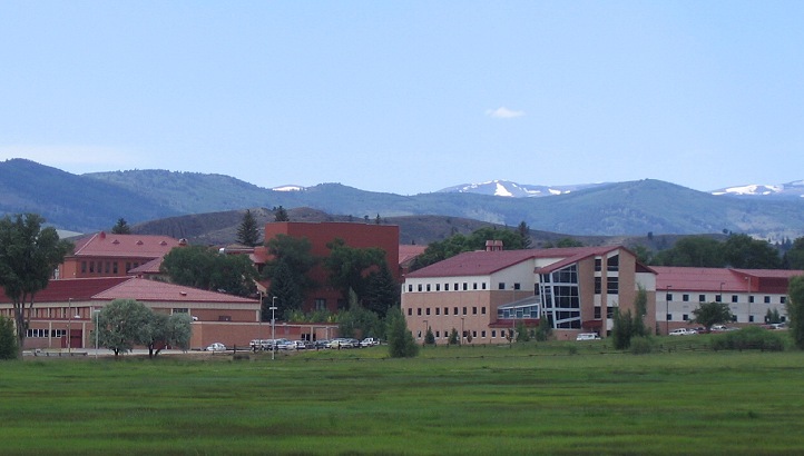
    Western State Colorado University Gunnison

    From The Grand Junction Daily Sentinel (Dave Buchanan):

    Which brings us to today’s topic: How do we prepare tomorrow’s decision-makers today, when we can’t be sure what tomorrow is going to look like?

    This is the trial facing the Colorado Water Workshop held annually at Western State Colorado University in Gunnison. This spring the workshop marked its 44th gathering by asking a select group of participants, most with long ties to the workshop, to look to the future and decide possible options for the workshop to follow.

    Even though the WSCU gathering is older than most, if not all, of its competitors, there are plenty of the latter. At last estimate, 11 similar workshops are conducted around the state. And they all (but for one or two notable exceptions) are cookie-cutter reproductions of “water geeks talking to other water geeks,” as one CWW participant said this year.

    And why attend the WSCU conference if it doesn’t provide something different?

    Workshop director and WSCU environmental studies professor Jeff Sellen admitted this year that although the Colorado Water Workshop is a “different kind of workshop, we recognize the need for change.”

    He called it a “retooling” of the workshop aimed at increasing involvement of WSCU students and connecting them to established water leaders and those water managers (a very broad category) early in their careers.

    It’s an opportunity, Sellen said, to design a “future for western water that acknowledges new challenges.”

    Which eventually boiled down to the existentialist question of why and for what does the conference exist? OK, that’s two existentialist questions.

    This year’s pared-down conference included in its invitation-only audience not only the well-experienced (including conference founder and longtime Gunnison water attorney Dick Bratton) as well as a half-dozen or more present-day WSCU students in Sellen’s environmental studies program…

    The 30 or so participants seemed to agree that inviting “water geeks” (and you know who you are) to talk arcane language and hydrologic philosophy to similarly inclined devotees has its place and certainly provides opportunities for education, although perhaps only to like-minded adherents.

    But does it reflect the best option for Western State and its role in the future of water education and management?

    Education seems to be the key and that, said John Hausdoerffer, director of the school’s Center for Environment and Sustainability, remains the provenance and function of Western State Colorado University.

    “What is it we add to the conversation?” Hausdoerffer asked during a thoughtfully taxing presentation.

    Focusing on the generations of students that will be needed to make effective decisions, Hausdoerffer urged the conference to explore at least 10 years ahead, developing the tools and skill sets needed to deal with climate change and similarly perplexing hurdles.

    These include communicating with the public, dealing with rapid environmental and climatic changes, and most of all, continuing to learn and adapt.

    “Who have we been educating and who do we want to educate?” posed George Sibley, author and former Colorado Water Workshop director and a well-respected voice in Colorado’s water matters. Education, he said, necessarily involves breaking away from the old regimes and means involving new voices.

    Some of those voices were heard from the handful of past and current WSCU students at the workshop, predominantly female and well-spoken on what they need to be successful in what is a mostly male-dominated field.

    “Speak to all levels” of water knowledge and “push for education disciple,” urged Sara Porterfield, former WSCU student and newly minted Ph.D (history). “The purpose of a discipline is to challenge assumptions.”

    And don’t be afraid to “cross-pollinate” among academic disciplines with collaboration and the sharing of educational resources, said Hannah Holm, coordinator for the Ruth Powell Hutchins Water Center at the Colorado Mesa University.

    “We don’t want (to seek answers in) traditional continuity,” added George Sibley. “What we’ve been doing won’t work for the future.”

    In closing, Jeff Sellen said educational institutions sometimes must “swim upstream against cultural currents” in developing answers to present and expected conditions.

    “I’m excited for the future of the Western Water Conference,” he said. “We just don’t yet know what it is.”

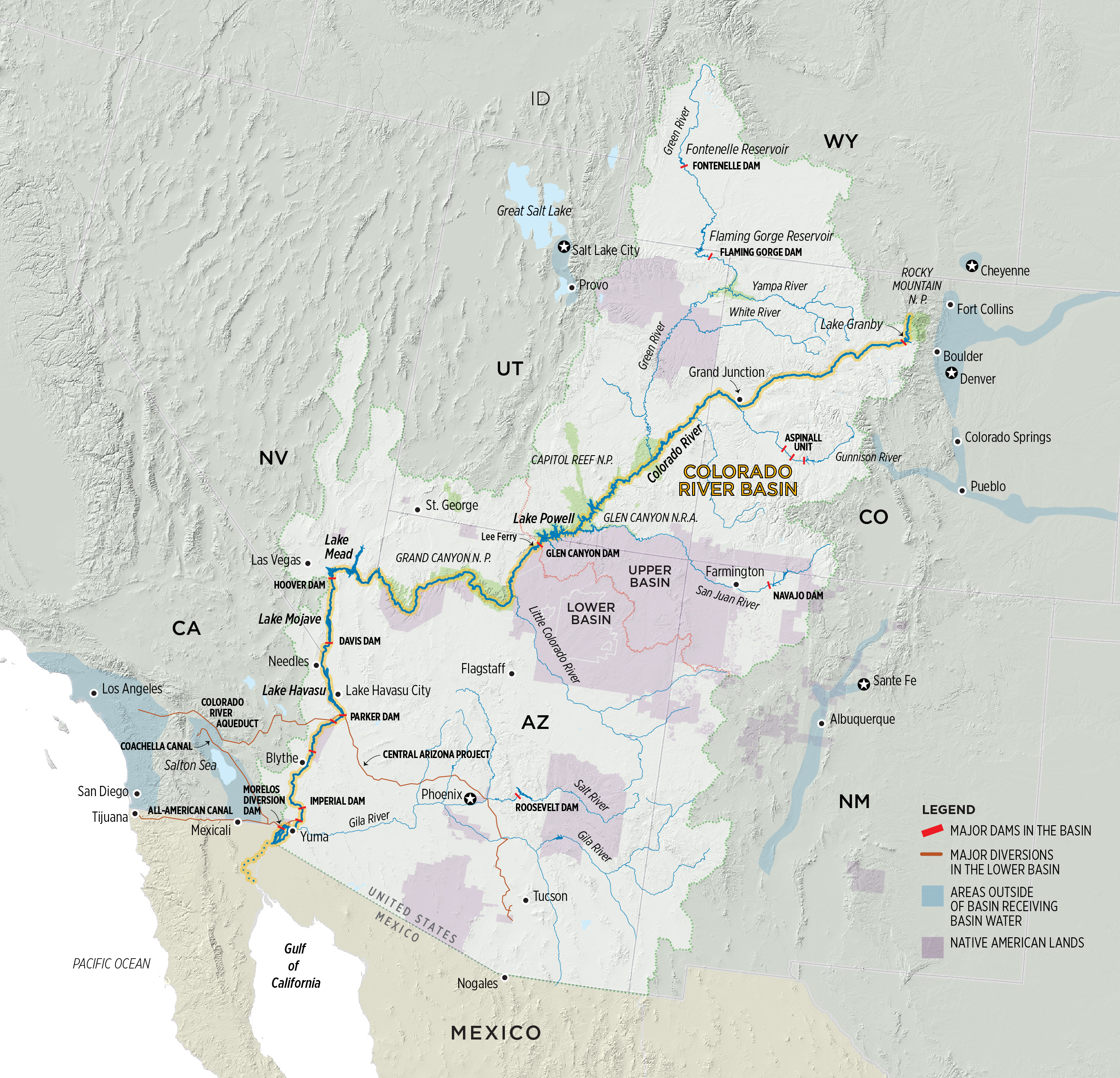
    #LakeMead and the lower #ColoradoRiver Basin DCP recap #dcpnow #COriver

    From The Arizona Daily Star (Tony Davis):

    At a presentation before hundreds of local and state officials, Bureau of Reclamation Commissioner Brenda Burman and a top aide warned that the risks to the lake are unacceptable. They said it’s urgent that Arizona officials resolve their differences over the drought plan and get on board with six other Colorado River Basin states that are moving toward adopting one.

    Since the seven states approved a set of guidelines for managing the river’s reservoirs in 2007, the risks of Lake Mead dropping to very low levels has increased by three to six times, the bureau officials said.

    They spoke at a briefing that also found once-warring Arizona Department of Water Resources and Central Arizona Project officials moving closer together on issues that had split them apart for well over a year. Both ADWR chief Tom Buschatzke and CAP general manager Ted Cooke enthusiastically endorsed the idea of a drought plan, although Cooke warned that the resulting reduction in river water use would boost water rates the CAP charges to Tucson, Phoenix and other municipal customers over time.

    “We are not here to scare you. We are just presenting the best information we have,” Burman told a gathering that virtually filled a 275-person auditorium at the Arizona Historical Society Museum in Tempe.

    “Keeping our fingers crossed, hoping for good hydrology” and waiting for the current and future interior secretaries to ignore the laws of the Colorado River that require protecting its reservoirs from depletion is not how to deal with this problem, she said.

    “It’s not how we’ve dealt with it in the past, and it’s not how Arizona wants to deal with it in the future,” said Burman, a longtime Arizonan who has worked for the Salt River Project utility and for former U.S. Sen. Jon Kyl of Arizona in the past.

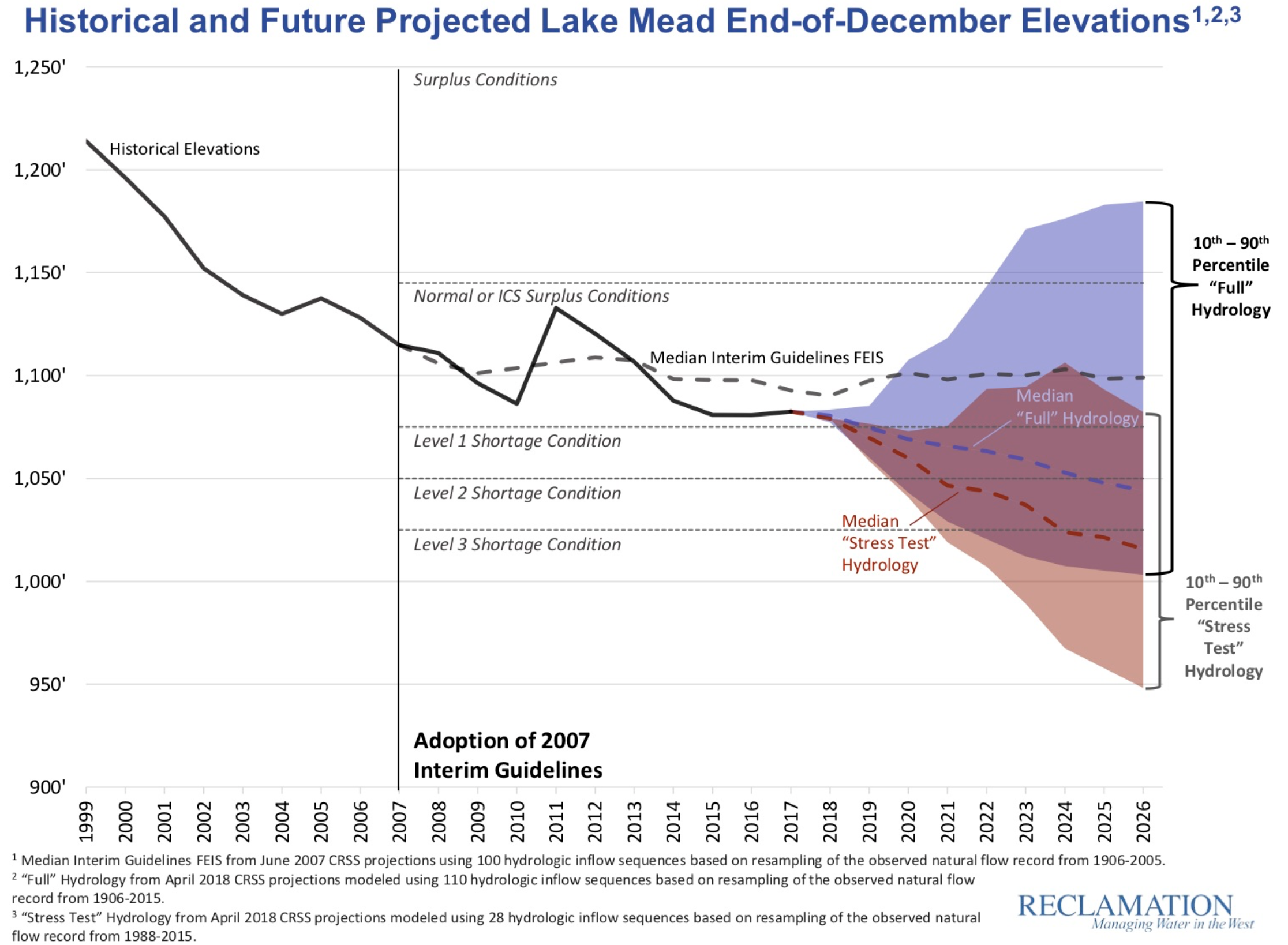
    The bureau’s forecasts for how far and fast Lake Mead’s elevations could fall were most severe when the forecasters used what they called a “stress test.” It relies on computer models assuming a continuation of the last 30 years of unusually dry weather.

    Less severe risks of such declines were predicted when the bureau relied on the river’s entire historical record, covering 1906 to 2015, which included several much wetter spells, including the wettest period on record for the river, in the early 20th century.

    In 1922, Federal and State representatives met for the Colorado River Compact Commission in Santa Fe, New Mexico. Among the attendees were Arthur P. Davis, Director of Reclamation Service, and Herbert Hoover, who at the time, was the Secretary of Commerce. Photo taken November 24, 1922. USBR photo.

    From The Arizona Republic (Joanna Allhands):

    And if we repeat the hydrology from 1988-2015 – where dry years were punctuated by a few wet ones, not a great scenario but certainly not the worst case – Lake Mead has a one in five chance of dropping to 1,000 feet of elevation before 2026.

    That should give you goosebumps, because it doesn’t just mean significant cuts to the water supply on which Pinal County agriculture and the state water bank relies. (That scenario, which will play out when the lake hits 1,075 feet, is already likely to happen in the next year or two).

    If Lake Mead drops to 1,000 feet, that means massive cuts have already hit the water supplies fueling Arizona cities, and we’ll need to cut even more to keep the lake from spiraling into dead pool, where water levels have fallen so low that none can leave the lake.

    That is a horrifying prospect.

    And let me repeat this: There’s a one in five chance of it happening sometime in the next few years if something doesn’t change…

    Here’s the bad news:

    Reclamation says that if the plan was in place, it wouldn’t lower the risk of a shortage being declared. In fact, even with the DCP, Lake Mead likely will hit 1,075 feet before 2026, cutting water from the state’s lowest-priority water users (mostly Pinal County farmers, though it wouldn’t be limited to them).

    That will hurt.

    But here’s the good news: It would significantly lower the likelihood of the lake reaching critically low levels, requiring heftier cuts from cities and other higher-priority water users.

    Here’s the video of the meeting. (Water folks on the hotseat.)

    And the good people of Phoenix are cutting water use. Here’s a report from (Joshua Bowling) writing for The Arizona Republic. Here’s an excerpt:

    Salt River Project officials say water use is down one-third, even though Arizona’s population has doubled.

    But even as a historically dry winter and low snowpack numbers set reservoir levels back, officials say it isn’t all bad news.

    Salt River Project announced in June that water use among its users has decreased by one-third since 1980, even though the state’s population has doubled since then.

    That’s due to conservation efforts, recycling wastewater and recharging water underground for future use, SRP officials say. The agency managers and delivers water from the Salt and Verde rivers to users in Maricopa County.

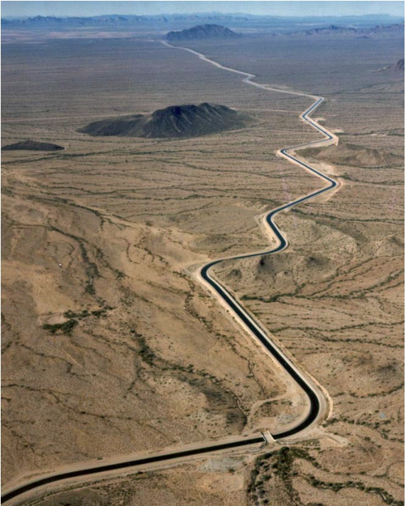
    The Central Arizona Aqueduct delivers water from the Colorado River to underground aquifers in southern Arizona. UT researcher Bridget Scanlon recommends more water storage projects like the aqueduct to help protect against variability in the river’s water supply. U.S. Bureau of Reclamation.

    From The Arizona City Independent (Jake Kincaid):

    Top officials in the Arizona Department of Water Resources and the Central Arizona Project shelved disagreements from the last legislative cycle and presented a united front along with the U.S. Bureau of Reclamation on the need for reductions of Colorado River water.

    Proposed reductions have the entire agriculture pool of Central Arizona Project surface water being slashed if Lake Mead goes into a Tier 1 shortage — below 1,075 feet elevation. This year analysts set Lake Mead at just 1,083 feet.

    In a best-case scenario presented in the brief, basing predictions on hydrology going back to 1906, there is a 65 percent chance Lake Mead will drop below this level in 2026.

    Making predictions using hydrology records going back to only 1988, which means assuming the hotter, drier climate is here to stay, there is a 90 percent chance Lake Mead will drop below 1,075 feet in 2020 without a drought contingency plan, and a 40 percent chance it will drop that year even with the plan.

    It is unlikely the agriculture pool of CAP water will survive even in the best of scenarios under the drought contingency plan.

    Paul Orme, who serves as general counsel to five special districts in Pinal County, including Central Arizona Irrigation and Drainage District and Maricopa–Stanfield Irrigation and Drainage District, said that DCP is not really designed to preserve the agriculture priority pool.

    But there is support for measures to mitigate the burden on agriculture. Stakeholders are working on fleshing out ideas that are “not ready for the press,” Orme said. He recently received a letter appointing him to represent Pinal County agriculture on the steering committee for the drought contingency plan.

    “I think people generally agree it’s not fair for agriculture to bear the entire burden of DCP when it’s not really intended to benefit us,” Orme said. “The real purpose of DCP is to keep Lake Mead above 1,020 (feet). That’s really what the primary focus is, and that only protects the long-term allocations of the tribes and the cities — agriculture is long gone.”

    Orme said that about 80 percent of the CAP surface water allotted to agriculture goes to Pinal County farmers, making up about half of their total water supply. Taking away CAP water would be economically devastating for agriculture and could ultimately result in about a third of farmland being taken out of production in Pinal County.

    Colorado River Basin. Graphic credit: Water Education Colorado

    From Audubon (Haley Paul):

    This almost 20-year drought is affecting water supplies across the Southwest. We already know the Colorado River System is over-extended — more water is taken out by water users than is put back in by snowpack and rainfall. Millions of people, businesses, birds, fish, and wildlife all rely on a healthy Colorado River and the water it provides.

    Given today’s hydrologic trends, in order to stabilize our water supply and reduce the chance that Lake Mead declines more rapidly, we’ll need to incentivize those who would take their water to leave it behind Hoover Dam instead. Enter the Drought Contingency Plan (DCP).

    The DCP, according to Bureau of Reclamation Commissioner Brenda Burman, is a seven-year agreement to “buy down risk” on the Colorado River system. She said it in the first word: BUY. In other words, DCP is going to cost money.

    A couple of reasons why DCP will cost money:

    Certain water users will need a financial incentive, aka payment, to leave their water in Lake Mead, instead of using it.
    Since some water users will be leaving more water in Lake Mead, less water will be coming down the 336-mile long Central Arizona Project (CAP) canal. When there is less water ordered, there is less water sold, yet the fixed costs to maintain this large piece of infrastructure remain. There are fewer units over which to spread costs. Therefore, cost per unit of water rises.
    However, not implementing the DCP, not implementing a formal mechanism to encourage water users to leave more water in Lake Mead is far too risky, and potentially more costly, or catastrophic, to our economic and environmental livelihood. The cost of no DCP may be much greater than the cost of having a DCP.

    DCP acts as an insurance policy to buy down risk. We buy down the risk of climate change and an over-allocated Colorado River system by using less water now. Our economies and our environment depend on it.

    Gila River watershed. Graphic credit: Wikimedia

    From The Phoenix Business Journal (Patrick O’Grady):

    Such a scenario is extremely likely, according to new federal studies, and deciding who gets water first could impact businesses from agriculture to home building throughout the state.

    The Wall Street Journal reported the Central Arizona Project and the Arizona Department of Water Resources are attempting to overcome differences on how to spread out less Colorado River water among its users. Arizona is the last of seven states using the river’s water to come up with a drought contingency plan.

    Currently, Lake Mead’s water elevation sits at 1,077 feet, two feet away from a level that would signify cutbacks to California, Arizona and Nevada, all of which rely on the the lake to store their allotment of Colorado River water.

    The challenge for Arizona is further cutbacks that could be triggered if the lake elevation falls to 1,025, which has a 40 percent chance of happening by 2026, according to a new U.S. Bureau of Reclamation report.

    CAP and ADWR have not been able to find agreement on where cuts to water deliveries should happen, according to the WSJ. Agriculture could get the biggest impact, but many businesses would be affected.

    Arizona gets about 40 percent of its water from the Colorado River.

    Central Arizona Project map via Mountain Town News

    From The Arizona Report (Ken Lynch):

    10 CAP Facts: The Canal that Made Modern Arizona

    About those ten facts! Here they are:

  • The 336 mile-long canal, its pumping stations, and turnouts are operated entirely remotely from a control room in north Phoenix. A rotating team of three or four operates the secure facility 24/7/365, running the entire system from a bank of computers while monitoring a display that takes up two walls of a room the size of your basic city council chamber. It’s efficient, cost-effective, and pretty damn cool.
  • The original Waddell Dam sits at the bottom of Lake Pleasant, intact. Completed in 1927, the dam was submerged when the lake was expanded to hold CAP water by the construction of the New Waddell Dam, completed in 1994.
  • An acre-foot equals 325,851 gallons, the volume required to cover a square acre to a depth of one foot. If you are a ‘typical family of four,’ you use about one-third of an acre-foot per year, around 108,000 gallons.
  • The CAP pumps water at a rate of roughly 3,000 cubic feet per second from Lake Havasu. That’s one acre-foot every 14 seconds. A typical family of four would be knocked into New Mexico standing in front of a stream that powerful.
  • Only 4% of CAP water is lost to seepage and evaporation. Covering the canal was discussed early on. It would have quadrupled the construction cost and required untold billions in ongoing maintenance, basically forever. Those costs would have been passed to y-o-u.
  • CAP water begins its journey by being pumped almost straight uphill more than 800 feet. This marvel of sheer power takes place at the massive Mark Wilmer Pumping Station (pictured below in 1981) at Lake Havasu and looks like the world’s most dramatic roller coaster climb. (Illustrating the importance of the legal water wars in Arizona, this very first facility on the CAP is named for Wilmer, a water attorney.)
  • The canal is bigger and deeper than it looks. It’s hard to appreciate when you are concentrating on your driving, but the CAP is 80 feet across, narrowing to 24 feet at the bottom. Average depth is between 16 and 17 feet. There is a section serving as internal storage that is 160 feet wide and 80 feet deep.
  • Water leaving Lake Havasu takes 3-4 days to make it to the end of the line. This means the canal is pushing relentlessly along at 3-5 miles per hour. It does not stop, and as mentioned above, it’s deep. Do NOT let the kids get near it and don’t ever enter the water yourself. It’s not meant for recreation. It’s dangerous. It’s against the law. You will be very sorry.
  • The end of the line is 12 miles southwest of Tucson. Water arriving there is used to replenish Tucson-area groundwater.
  • A woman named Nellie T. Bush commanded the “Arizona Navy” in the 1934 California water dispute. Bush owned the boats Arizona Governor Moeur commandeered in the mobilization, so he made her an admiral on the spot. A prominent Arizonan, Bush was a lawyer admitted to practice in California and Arizona. She became Justice of the Peace in Parker; was elected to the Arizona legislature, and was a delegate to the 1932 Democratic National Convention that nominated FDR for the first time. In 1982, Nellie T. Bush was inducted into the Arizona Women’s Hall of Fame.
  • Arizona Navy photo via California State University
  • The CAP uses 2.8 billion KwH of electricity per year: That’s enough energy to, well, push 1.5 million acre-feet of water 2,400 feet uphill for 336 miles. Water in Arizona also generates power, so part of almost everyone’s household electrical bill is water generated.
  • Bonus Fact:

  • The CAP canal in the Phoenix area is marked by “Hayden- Rhodes Aqueduct” signs. CAP and ADOT put up the signs to call attention to the canal and memorialize the contributions of Senator Hayden and former Rep. John Rhodes, who was a driving force in the House when the 1968 authorization bill was signed.
  • Bonus to the bonus:

  • Rhodes went on to become known as one of three political leaders (Barry Goldwater and Pennsylvania’s Hugh Scott were the others) who delivered the news to Richard Nixon that he did not have enough support in Congress to stave off impeachment and probably faced conviction, triggering Nixon’s resignation from the Presidency in 1974.
  • Lake Havasu is a large reservoir behind Parker Dam on the Colorado River, on the border between California and Arizona. Lake Havasu City sits on the lake’s eastern shore. Photo credit MyGola.com.

    From Parker Live (John Wright):

    The Colorado River Indian Tribes (CRIT) was one of many Arizona entities and stakeholders who met to discuss contingency plans to deal with the worsening drought conditions in the southwestern United States.

    The water officials committed last Thursday to reach a multi-state plan by the end of the year to stave off potential shortages. The move comes after the U.S. Bureau of Reclamation has been pushing western states to come up with solid plans about water usage, with steady declines in the Colorado River year on year…

    Tribal water is increasingly being seen as part of the solution to the problem, by both the representatives of metropolitan areas, which require the highest water usage, and by tribes like CRIT who have rights to many hundreds of thousands of acre-feet of water that they do not use.

    A proposed CAP program would potentially allow tribes, who have senior rights, to store water behind Lake Mead, which could be a way to mitigate the shortage-created loss of water rights by central Arizona farmers, who need it to keep producing crops.

    In such an environment, there are few such solutions, which has forced CRIT to the table. But the potential benefits to CRIT are also clear, according to the tribe’s water attorney Margaret Vick, with many of the state’s entities talking about creating positive solutions now rather than leaving it too late and having less desirable solutions imposed by the federal government later.

    “We can buy insurance now to provide more certainty for the coming years,” said Reclamation Commissioner Brenda Burman. “It’s Arizona’s history that we face problems head on.”

    Burman said other states would pressure her agency to limit Arizona’s water deliveries if it doesn’t agree on an effective drought plan, and predicted that there would be lawsuits. The agency has said it would rather the states negotiate a solution that includes all entities with rights to the river.

    Lake Mead December 2017. Photo credit: Greg Hobbs

    From The Arizona Daily Star (Tony Davis):

    For the first time in well over a year, a clear path exists for completion of Arizona’s share of a three-state drought plan for the Colorado River.

    The plan would step up already-approved requirements for cuts in water deliveries to Arizona, Nevada and eventually California as Lake Mead drops below certain key levels.

    While many hurdles and potential disputes remain, water officials said last week they’re ready to work together and hold public meetings to solicit comments on the plan from various water users and other interest groups. The first such meeting will be held July 26 in the Phoenix area.

    Officials hope to have a plan ready for the Legislature to approve next year, with “zero no votes,” said Arizona Department of Water Resources Director Tom Buschatzke at Thursday’s briefing in Tempe on the drought plan.

    Officials laid out four key elements of a drought plan Thursday but said the details will be worked out by a steering committee of water officials and interest group representatives that will meet publicly.

    The key elements are:

  • A plan for what to do with what officials call “excess water,” Central Arizona Project water that isn’t used in a given year by the city, irrigation district or Indian tribe that has the rights to it.
  • A plan to mitigate the drought plan’s impacts on farmers, who will take the biggest hit by far from future cuts in CAP water deliveries.
  • A plan to allow tribes to leave some of their water in Lake Mead and take it out later, when necessary.
  • An overall “Arizona Conservation Plan,” whose purpose and details were not made clear.
  • Unknowns include:

  • At the briefing, officials from the federal government, the state water department and the CAP said the tribes’ role in this plan will be crucial. But the details of setting up a program for how it would happen remain unknown.
  • When Lake Mead drops below 1,075 feet at the end of any year — the threshold for the first shortage on the river — Pinal County farmers would lose all their CAP water. That would likely force them to resume what everyone agrees is unsustainable groundwater pumping to stay in business. But at a news conference following the briefing, CAP General Manager Ted Cooke demurred in response to a question about whether and how some water belonging to other parties could be reallocated to agriculture. “I don’t really want to get ahead of the conversation,” Cooke said.
  • Whether to let the dwindling supply of “excess” CAP water stay in Lake Mead to prop it up, or whether CAP officials should continue to sell it to other parties such as its own sister agency that recharges it into the ground to serve future growth. With Lake Mead falling, Cooke said, “There will not be very much … excess water very much longer.”
  • Upper Basin States vs. Lower Basin circa 1925 via CSU Water Resources Archives

    From KJZZ (Bret Jaspers):

    The Rest Of The Basin Looks On

    Fights and litigation would only delay a coordinated response to continued high temperatures and slipping water levels in Lake Mead and Lake Powell.

    “The situation in Arizona is a topic of a lot of discussion in the Upper Basin,” said Jim Lochhead, CEO of Denver Water.

    He said Arizona’s internal conflict has led to political problems in Colorado.

    “It puts pressure on Denver Water as a municipal utility, taking water out of the Colorado River, and it exacerbates historic animosities and relationships between Western Colorado and Denver Water.”

    Lochhead sent a letter to the Central Arizona Project in April threatening to pull out of a program to conserve water unless the lower basin made real progress on its plan.

    Shortage is so imminent, California has even agreed to take reductions — something the current rules don’t require it to do.

    “And you have to ask yourself, given the position that you are in, why would you let that opportunity go by?” said Pat Mulroy, a longtime water leader in Nevada who is now at the University of Nevada, Las Vegas.

    Inside Arizona

    But before it can sign a Lower Basin plan, Arizona needs its own internal deal.

    One sticky subject is what to do about farmers in central Arizona, who would take a big hit under the current rules.

    “How do we find a way to make things less painful for them?” Cooke asked. “Not completely painless, but less painful.”

    Another big issue is determining who gets to decide when certain conserved water stays on Lake Mead.

    It’s a major question that Buschatzke said was still “under discussion.”

    “We will work that out,” Cooke said.

    To get to “yes,” Buschatzke and Cooke agreed they’ll have to avoid letting side issues divert the talks.

    Buschatzke said his task is “to find a collective way to create a package where everyone is better off with the package, even though there might be individual pieces of that package that they might not particularly like 100 percent.”

    The lower Colorado River. Photo: Brent Gardner-Smith/Aspen Journalism

    From Arizona Public Media (Casey Kuhn):

    Central Arizona Project General Manager Ted Cooke says partnerships will be crucial to finally getting a drought contingency plan (DCP) approved.

    “Or the result will be that somebody perceives that they’re being ‘stuck’ with the outcome of doing DCP and that will make it much more difficult to have the folks coming together when we do go to the Legislature: ‘We all think this is a good thing. Let’s do it. Please approve it.”

    The next step is assembling a large committee of stakeholders such as agriculture operations and tribal leaders who hold water rights.

    Water officials hope to craft a plan that gets Arizona lawmakers’ approval, and then have the Department of Water Resources director put it into action next year.

    @NOAA webinar: Detection and Attribution of Climate Change from the (Climate Science Special Report) U.S. Perspective, Thursday, July 19, 2018

    Click here for all the inside skinny and to register.

    Water treatment operators are in high demand across #Colorado

    Filter beds at a Denver Water treatment plant. Fluoride is added after filtration, prior to disinfection. Learn more about the treatment process: denverwater.org/WaterQuality/TreatmentProcess

    From KOAA.com (Caiti Blase):

    David Stanford, a water treatment operator in charge of Beulah’s water systems, says there’s a lot of opening in different parts of the state because older operators are retiring. However, between the years of training and sometimes small wages, replacing those people isn’t just a simple hire.

    Russell Chambers, an operator in training, said, “There’s a lot to learn. It’s a pretty challenging job if you like a challenge.”

    Chambers has been working at the water districts in Beulah for about four months and it’s just the beginning of his journey to get a Level B certification in order to become a qualified water treatment operator in the valley.

    Stanford said, “It does take a lot of learning, a lot of certification, a lot of on the job training.”

    The training can take several years.

    Stanford said, “You have to know and understand every facet of how to get the water here, get it through the plant, and get it to the customer.”

    Which is why it’s time to start training the next generation.

    “In the state of Colorado the operators from the 70’s and 80’s, that team is retiring for the most part so there’s a lot of openings in many, many places for training operators.”

    Stanford knows just how important this position is.

    “I’m responsible for the lives of nearly 600 people that live in this valley. On a daily basis it is my responsibility to deliver to them drinking water that is safe to drink.”

    Until Chambers is fully-certified, Stanford is “the guy that has to call the shots and is ultimately responsible for everything that happens with the water.”

    It’s why bringing in and training newcomers is an important facet for towns like Beulah.

    @CentralCOWater community meetings, July 18, 19

    Click here to register.

    @OmahaUSACE: Urban Waterways Study Recommendations. Join us July 31, Aug. 1 and 2

    This is an email update. The Corps of Engineers want to hear from everybody. From their email:

    This is a friendly reminder to come and learn about and provide feedback on the U.S. Army Corps of Engineers recommendations for the South Platte River, Weir Gulch, and Harvard Gulch.

    All meetings begin at 5:30 pm. There will be a presentation at 6:00 pm followed by an open house until 7:30 pm.

    July 31, Weir Gulch Study – Barnum Recreation Center, 360 Hooker Street.

    August 1, South Platte River Study – REI, 1416 Platte Street (3rd Floor).

    August 2, Harvard Gulch Study – Porter Hospital, 2525 S. Downing Street (Grand Mesa Conference Room).

    In 2015, the U.S. Army Corps of Engineers and the City and County of Denver began a feasibility study of three urban waterways in Denver. Previous rounds of public meetings were held in both 2015 and 2016. General study background and information on the previous public meetings is available for review at http://www.denvergov.org/denverwaterways.

    The ecological health of the South Platte River has been adversely affected by encroaching urbanization and past flood control projects. The primary goal of the South Platte River recommendations is to develop a cost-effective, multi-pronged approach to river restoration that will restore ecosystem habitat, with secondary goals to improve water quality and reduce flood risk, where feasible.

    Weir Gulch and Harvard Gulch have been primarily impacted by encroaching urbanization. For Weir Gulch, the primary goal is flood risk reduction, with a secondary goal of ecosystem restoration, where feasible. For Harvard Gulch, the primary goal is flood risk reduction through implementing nonstructural flood risk management measures to individual homes and businesses within the floodplain. On all three waterways, a complementary goal is to improve community access to recreational and environmental education opportunities.

    The draft feasibility report and environmental impact statement and study recommendations will be released on July 2nd and will be available at: http://www.nwo.usace.army.mil/Missions/Civil-Works/Planning/Project-Reports/

    The U.S. Army Corps of Engineers is partnering with the City and County of Denver, the Greenway Foundation, the Urban Drainage and Flood Control District, and the Colorado Water Conservation Board to complete the study.

    The Denver Urban Waterways Restoration Study is scheduled for completion in 2019. The study marks the beginning of a long-term partnership to secure funding, plan, design, and build the selected alternatives.

    From email from Zoeller Consulting (Hora Neureiter) via the City and County of Denver (Denver Urban Waterways):

    The public is invited to learn about and provide feedback on the U.S. Army Corps of Engineers recommendations for the South Platte River, Weir Gulch, and Harvard Gulch.

    All meetings begin at 5:30 pm. There will be a presentation at 6:00 pm followed by an open house until 7:30 pm.

    July 31, Weir Gulch Study – Barnum Recreation Center, 360 Hooker Street.

    August 1, South Platte River Study – REI, 1416 Platte Street (3rd Floor).

    August 2, Harvard Gulch Study – Porter Hospital, 2525 S. Downing Street (Grand Mesa Conference Room).

    In 2015, the U.S. Army Corps of Engineers and the City and County of Denver began a feasibility study of three urban waterways in Denver. Previous rounds of public meetings were held in both 2015 and 2016. General study background and information on the previous public meetings is available for review at http://www.denvergov.org/denverwaterways.

    The ecological health of the South Platte River has been adversely affected by encroaching urbanization and past flood control projects. The primary goal of the South Platte River recommendations is to develop a cost-effective, multi-pronged approach to river restoration that will restore ecosystem habitat, with secondary goals to improve water quality and reduce flood risk, where feasible.

    Weir Gulch and Harvard Gulch have been primarily impacted by encroaching urbanization. For Weir Gulch, the primary goal is flood risk reduction, with a secondary goal of ecosystem restoration, where feasible. For Harvard Gulch, the primary goal is flood risk reduction through implementing nonstructural flood risk management measures to individual homes and businesses within the floodplain. On all three waterways, a complementary goal is to improve community access to recreational and environmental education opportunities.

    The draft feasibility report and environmental impact statement and study recommendations will be released on July 2nd and will be available at:

    http://www.nwo.usace.army.mil/Missions/Civil-Works/Planning/Project-Reports/

    The U.S. Army Corps of Engineers is partnering with the City and County of Denver, the Greenway Foundation, the Urban Drainage and Flood Control District, and the Colorado Water Conservation Board to complete the study.

    The Denver Urban Waterways Restoration Study is scheduled for completion in 2019. The study marks the beginning of a long-term partnership to secure funding, plan, design, and build the selected alternatives.

    Eagle River Regional Water Efficiency Plan available for review

    From the Eagle River Water and Sanitation District:

    The draft Eagle River Regional Water Efficiency Plan is available for review by the public, which can submit comments through July 30.

    The plan is a joint effort by the Eagle River Water & Sanitation District and the Upper Eagle Regional Water Authority that outlines actions the organizations will take to meet increasing regional water demands with available supply into the future in an environmentally and fiscally responsible manner.

    Community members can review the draft plan at the district office in Vail during business hours and anytime online.

    Both the district and the authority are required to have a water efficiency plan on file with the Colorado Water Conservation Board, which is part of the Colorado Department of Natural Resources. The CWCB awarded grant funds to the district and authority to assist with plan development and there must be a period for the public to comment on the proposed plan. This public comment period follows an extensive stakeholder outreach process where the plan was presented to nearly 20 community groups, several of which can be viewed on the High Five Access Media website (watch a video). Feedback at those presentations has informed the current draft.

    All comments received will be considered for integration into the final plan and will be noted in a plan appendix. The district and authority boards of directors will review the final plan in August and approve its submittal to the CWCB, which makes the final determination that the plan meets state guidelines and accepts it.

    To submit comments, contact water demand management coordinator Maureen Mulcahy by email, phone (970-477-5402), or mail: 846 Forest Road, Vail, CO 81657. Written comments are preferred for better tracking and inclusion in the final plan.

    Click here to view the draft plan. For more information call Mulcahy at 970-477-5402.

    Report: The High Cost of Hot — @ClimateCentral #ActOnClimate

    Click here to read the report.

    From Climate Central:

    As additional carbon pollution continues to trap more and more heat in the atmosphere, the higher temperatures that result can come with a hefty price tag. Some of those costs hit our wallets in the form of higher energy bills from greater use of air conditioning. Warmer temperatures can also have major health impacts, increasing our vulnerabilities to allergies, asthma, heat stroke and even death. To better understand how this is impacting local communities, Climate Central analyzed trends in cooling degree days and minimum temperatures. Of the 244 cities analyzed, 93 percent had an increase in cooling degree days. Much of this warming occurs at night, demonstrated by the fact that of those same cities, 87 percent see an increase in the occurrence of overnight low temperatures above a threshold of either 55°F or 65°F.

    Warm Nights

    According to the National Sleep Foundation, the optimal temperature for sleeping is around 65°F. Unfortunately, daily minimum temperatures, which most often occur at night when our bodies rest and recover, have been increasing as a result of climate change. And in many places, those minimums have been increasing at a faster rate than the average temperature. The jump in overnight lows is driving much of the overall temperature increase in the United States. According to calculations by NOAA/NCEI, the rate of warming for overnight temperatures since 1900 is more than 20 percent higher than the daytime rate.

    Climate Central analyzed the trend in nights above 65°F for cities across the country. For a smaller set of cities that rarely experience nights above 65°F, we dropped that temperature to 55°F for this analysis. Overall, our analysis found that 87 percent of U.S. cities are experiencing more warm nights since 1970. El Paso, Las Cruces, and Fresno all see an increase of more than 50 nights over 65°F, while San Francisco had the biggest increase of 80 nights over 55°F.

    Why birders and wildlife advocates should care about #LakeMead — Audubon #ColoradoRiver #COriver

    Upper Lake Mead dawn patrol. Photo: Brent Gardner-Smith/Aspen Journalism

    From Audubon (Haley Paul):

    Audubon Arizona’s objective is to make sure that the solutions to our water challenges serve both people and wildlife. Water management policies that provide more certainty and reliability for all users are of critical importance to Arizona’s economy as well as its cities, farmers, birds, and other wildlife.

    As United States Bureau of Reclamation Commissioner Brenda Burman (her federal department manages the water on the Colorado River) highlighted in her recent visit to Tempe, Arizona, if the states cannot come together to stabilize Lake Mead through collective and collaborative agreements to leave more water behind Hoover Dam via the Colorado River Drought Contingency Plan (DCP) we face a potential crisis.

    But why care? Water in Lake Mead and the surrounding environment is not the only game in town when it comes to birding and valuable wildlife habitat (never mind the nine Important Bird Areas that surround the Grand Canyon and the Colorado River). But really, as a bird and wildlife advocate, why care about the stabilization of Lake Mead? What’s at stake?

    If Arizona-specific parties affected by DCP cannot get to yes, and instead hydrology catches up to us and Lake Mead declines to critical elevations, water users may look elsewhere for water to make themselves whole. Water resources like groundwater, and existing Arizona regulations that promote sustainable water planning, may come under increased scrutiny and pressure. Arizona’s valuable rivers, streams, and the habitats they provide for birds could be at risk if groundwater pumping increases. Not to mention the negative headlines that are sure to result if we cannot agree on a plan to use less Colorado River water.

    As opposed to unmitigated shortages that leave people out on the hunt to solve their water supply problems, a much better option is a plan that everyone agrees to. Some of what that currently looks like in Arizona is monetary compensation to use less water, and changes in the way accounting is done on Lake Mead so that willing water users can leave more of their water behind the dam. Through careful negotiation with the affected water users, people can get to yes, and there can be faith in the process and the result.

    Another reason to care? We’ll take Commissioner Burman’s lead on this one: Because if Lake Mead gets low enough, “dead pool” could be reached and that means no water is getting past the dam. No Colorado River water is flowing out of Mead. That’s a scary scenario for farmers, cities, and wildlife. Commissioner Burman is clearly worried about a situation like that—hence her urging of the states to commit to Drought Contingency Plans ASAP.

    We’d like to thank Commissioner Burman for amplifying the message on this critical issue. We anticipate more information in the weeks and months ahead from the Arizona Department of Water Resources and the Central Arizona Water Conservation District on progress toward a DCP. Then, it will be in the hands of state lawmakers and Governor Ducey to construct and pass legislation that allows Arizona to participate in getting DCP done.

    At Audubon Arizona, we’ll be watching and participating as the process continues. Being involved in the conversation when policymakers are talking water—one more way we are advocating for our rivers and the wildlife, habitat, and humans who depend on them.

    Say hello to the new @WaterEdCO website

    Water Education Colorado website July 13, 2018.

    From email from Water Education Colorado:

    It’s official! We are excited to announce the launch of our new website! We are confident that this innovative and user-friendly site will make interacting with Water Education Colorado easier and more useful!

    Click here to check it out

    Meanwhile, here’s the link to their latest “Fresh Water News” newsletter. Here’s an excerpt:

    Drought worsens in Colorado

    Fourteen people gathered around a table in a Denver conference room deep within the confines of the Colorado Parks and Wildlife complex and showed one another chart, after chart, after chart.

    Lines depicting vanishing snowpack fell farther and farther toward zero on their graphs and deep red stains on maps outlining the boundaries of this year’s dry season grew brighter and larger.

    It was mid-June and those members of Colorado’s Water Availability Task Force (WATF) gathered in Denver could see what was becoming clearer each week. That 2018 was shaping up to mirror three other alarming drought years this century that nearly brought Colorado to its knees: 2002, 2012 and 2013. The task force, a group of water managers, scientists and hydrologists, is charged with monitoring water supplies for farms, cities and industry statewide.

    Peter Goble, a staffer with Colorado State University’s Colorado Climate Center and a member of the WATF, had been anxiously watching precipitation levels for weeks. May, he reported, was the second driest May on record, based on measurements dating back to 1895. The absolute driest May occurred in 1934, the fourth year of the Dust Bowl.

    “It’s pretty startling,” said Taryn Finnessey, senior climate change specialist with the Colorado Water Conservation Board and chair of the WATF.

    Summer temps soar

    Though reservoirs are fairly full this year, demand is rising quickly in dry spots such as the Arkansas and Southwest Basins. And even on the Front Range, where snowpack was close to normal, weeks of searing 90-plus degree days have sprinklers running at full force and reservoir levels dropping quickly.

    In May, after a recommendation by Finnessey and the task force, Colorado Gov. John Hickenlooper activated the state’s drought response plan for 34 southern counties, making them eligible for millions of dollars in federal drought relief, among other forms of assistance.

    Within weeks, wildfires began chasing one another across the state, spreading at rates never seen in the dry southwestern counties. The Spring Creek fire is on track to becoming one of the largest ever in the state, while the 416 fire outside Durango temporarily shut down some of the state’s most treasured tourist spots, including the scenic Durango and Silverton Narrow Gauge Railroad.

    But unlike the earlier drought years of this century, 2018 is no longer viewed as a standalone event. It’s been given a much chewier title. Scientists and water managers call it an entry into a multi-decadal drought period, and some worry it may signal a transformation of Colorado’s climate. Where this was once considered a semi-arid region, this 18-year dry spell may signal a dramatic change in the landscape—one in which Colorado becomes known largely as an arid, rather than semi-arid region.

    Aridification is the term Brad Udall likes to use to describe what’s been going on since 2000, if not earlier. Udall is a scientist with Colorado State University’s Colorado Water Institute and a member of the multi-state Colorado River Research Group, based at the University of Colorado at Boulder.

    Finding the right word

    “Using old terminology, we could call it a drought,” Udall said. But he believes the term aridification is more accurate because of the ongoing reductions in snowpacks and subsequent river flows that have been seen this century.

    Here’s what Udall and others find worrisome:

    The Colorado River, whose headwaters lie in the Never Summer Mountains in Rocky Mountain National Park, has seen a 20 percent reduction in flows since 2000, the date many use to describe the beginning of this multi-decadal drought period, according to the Colorado River Research Group.

    In the same period, only five years have delivered above average flows into Lake Powell, which along with Lake Mead, serves as one of the two largest reservoirs on the river.

    Three of the four driest years on record in the Colorado River Basin have occurred during this 18-year period, with 2012 and 2013 being the driest consecutive years since 1906, according to the Colorado Water Conservation Board.

    Colorado, Utah, Wyoming and New Mexico are responsible for delivering roughly 8.23 million acre-feet (MAF) of water to the lower basin states each year by releasing it from Lake Powell. But since 2000, inflows into Lake Powell, where those deliveries are stored, have averaged just 5.74 MAF annually, meaning trying to keep up with the required deliveries is now a losing game.

    Shrinking river flows

    Adding to those concerns is this river-busting year of 2018, when just 2.64 MAF is expected to flow into Powell, 37 percent of average, according to data from the Colorado River Basin Forecast Center in Salt Lake City.

    “2018 will not be remembered as a good water supply year for the Colorado River Basin,” Finnessey said.

    Why should Coloradans care so much about the Colorado River? Because it keeps huge tourist, fishing and farm economies on the West Slope alive, it delivers roughly half the water used on Colorado’s Front Range, and it serves millions of people in Arizona, Nevada and California.

    If the hydrology is changing permanently, it means most of the state’s water users will be forced to use less, and in some years, if Colorado can’t deliver enough to Arizona, Nevada and California, as the law requires, they might have to do with a lot less.

    The grim scenario isn’t lost on Jesse Kruthaupt. He and his family operate a small 500-acre ranch outside Gunnison. For decades its luscious hay meadows have flourished along the banks of Tomichi Creek. Typically the creek will go dry late in the summer. “But right now,” he said, in late June “our diversion is totally dry.”

    Kruthaupt will see his hay production drop this year but at least he will have a crop and enough to feed his cows and calves. “I know we will be short,” he said. “I just don’t know by how much.”

    On the urban Front Range, 2018 has been a year to count blessings. In Highlands Ranch, Water Resources Administrator Swithin Dick watched his district’s reservoirs fill nicely, because in the South Platte Basin, which serves metro Denver and much of the urban north, snowpack came in at nearly normal levels.

    “The South Platte Basin is the place to be this year,” Dick said. Still, the district has permanent conservation measures in place that prohibit its 96,000 residents from watering between 10 a.m. and 6 p.m., among other things.

    “Our snowpack was diminished, but it’s not dire like it is for southern Colorado and southwestern Colorado,” he said.

    Looking ahead, if 2019 delivers the same brand of dry as this year did, it will be much harder to tolerate because reservoirs from Durango to Denver will be depleted and will struggle to refill.

    Front Range communities that lucked out this year, may not next year.

    Thirsty urban customers

    Denver Water, the largest municipal water utility in the state, has seen conditions deteriorate since April. It thought then that its reservoirs would fill completely, thanks to late spring snows.

    But that didn’t occur, and Greg Fisher, Denver Waters manager of demand planning, said the super hot temps this summer have everyone at the agency keeping a close watch on the weather and how much water customers are using.

    “We find ourselves in extremely hot, dry conditions and our use is up for sure,” Fisher said.

    To date there hasn’t been a huge spike in demand and as a result the agency does not intend to impose water restrictions.

    “We got very, very lucky this year,” Fisher said. “But the fact that our system didn’t fill is concerning. That often marks the start of a drought cycle for us.”

    Despite the growing frequency of dry years, Udall sees some cause for optimism. “We’ve learned a lot in the last 15 years in terms of how to work with each other and how to come up with solutions that benefit everybody. Colorado has more going on in water in a good way than anywhere else in the West,” he said.

    The state has, for instance, created nine regional roundtables representing its river basins and the metro area. These groups operate to address their own water issues, while working with other basins with whom they share supplies.

    Those collaborative efforts are evident every month at the Water Availability Task Force meetings, where Eastern Plains ranchers weigh in with West Slope water managers and others representing Denver Water, Colorado Springs Utilities and Aurora Water, among others.

    Still this year the work has been grueling. When one scientist asked if the group wanted to look at one more water supply index last month, John Stulp, Gov. Hickenlooper’s water policy adviser, smiled and said no, not really.

    “I think we’re depressed enough,” he said. And he was only half joking.

    Jerd Smith is editor of Fresh Water News. She can be reached at 720-398-6474, at jerd@watereducationcolorado, and @jerd_smith on Twitter.

    Swan River Restoration Project – BRWG Call to Action – July 10th July 24th Summit County BOCC Hearing

    Swan River. Photo credit: Summit Magazine

    Update: from email from Jennifer Hopkins:

    Good afternoon!

    I wanted to let you know that a request has been made to the BOCC by staff and the permit applicant to continue the Mascot Placer hearing to a date certain of July 24, 2018, to allow staff time to further analyze the cumulative traffic impacts this applicant presents for the use of Tiger Road. This request would be granted at the discretion of the BOCC at the meeting on Tuesday the 10th. The opportunity for public comment on Tuesday would also be at the BOCC’s Discretion.

    BRWG appreciates your support and we hope, instead of the meeting on the 10th, you can join us at the meeting on July 24th. It is at the same time and place, 1:30pm in the Commissioners’ Hearing Room in Breckenridge.

    Please let me know if you have any questions.

    Thanks,

    Jennifer
    Blue River Watershed Group

    From email from the Blue River Watershed Group (Jennifer Hopkins):

    The Blue River Watershed Group (BRWG) is reaching out to supporters and stakeholders of the Swan River Restoration Project to notify you of an upcoming Board of County Commissioners (BOCC) hearing that will have a significant impact on the project. As you know, the Swan River Restoration is a collaborative, multi-year effort to restore sections of the Swan River affected by historical dredge mining. The first section of the river has been restored on Summit County/Town of Breckenridge property. In order for restoration work to continue on additional reaches of the river, dredge rock tailings must be processed and removed from the sites.

    The Board of County Commissioners is holding a hearing on July 10th to decide on a Conditional Use Permit that would allow Peak Materials to add a rock crushing operation at the Mascot Placer, located along the Swan River on privately owned land (comprising the third phase of the four-phase restoration project). Peak Materials has been operating a rock screening and sales operation at the site since 2003. BRWG supports the approval of the Conditional Use Permit as it will confer a number of public benefits and allow the Swan River Restoration Project to continue.

    BRWG is asking supporters to attend the BOCC meeting on July 10th in support of the Swan River Restoration and approval of the Conditional Use Permit. Peak Materials is offering in-kind donations of significant crushed rock materials and other work at the site needed for the restoration (valued at approximately $1.5 million). Milling these materials on-site will decrease the amount of material taken off-site and reduce the need to import material for the restoration. The 5-year permit will expedite the removal of the dredge rock and preparation of the site for restoration activities. In addition, the private landowner has agreed to grant a public access easement covering a future stream and riparian corridor to perpetually ensure that the corridor remains undeveloped and available for public use. Without the permit, the restoration project would not receive these benefits and would likely not continue to move forward on this section of the river. At best, the restoration effort would need to find an additional $1.5M and at worst the project could be stopped entirely if the owner refuses to grant the easement if the crushing permit is denied.

    It is crucial that we show community support for this permit. I would love the opportunity to discuss this issue with you further and to answer any questions you might have. Please let me know if there is a time we can chat before July 10th and I will be happy to call you. And please join us at the BOCC meeting. Here are the details:

    Date: July 10th, 2018
    Time: 1:30pm
    Location: Commissioners’ Hearing Room, 208 E. Lincoln Ave., 3rd Floor, Breckenridge, CO 80424

    Thank you for your continued support of this important project.

    #Drought news: Warm water temperatures are stressing cold water fish across #Colorado

    The upper Colorado River, looking upstream toward Gore Canyon, near Pumphouse. Photo: Brent Gardner-Smith/Aspen Journalism

    From The Summit Daily (Deepan Dutta):

    Colorado’s fish are in hot water. Low river flows and high water temperatures are endangering trout in rivers and streams across the state, and wildlife officials are urging anglers to fish early in the day and take their lines out when water warms in the afternoon.
    “We’re experiencing some extreme high water temperatures in some of our rivers and streams, high enough to stress out trout,” said CPW aquatic biologist Jon Ewert, who oversees aquatic life in Grand and Summit counties.

    Ewert said that trout thrive around 50 degrees, get lethargic in the 60s and become very stressed in the 70s. Trout mortality is likely at 74 degrees and above.

    The worry about water temperature is verified by data from the water monitoring gauge at the Pumphouse recreation site near Kremmling, a very popular place for wade and float fishing. At one point this season water temperature there reached 70 degrees and has been holding steady between 60 and 70 since.

    “We’re in the worst shape when it comes to conditions,” said Lori Martin, CPW’s senior aquatic biologist for northwest Colorado. “The snowpack melted early, and it’s constantly hot and dry.”

    Martin referred to the snowmelt that peaked in mid-May in Summit, a month earlier than normal, causing water flows to bottom out much earlier in the season.

    Historical data from the Pumphouse gauge showed that the typical water flow at this point in July is usually around 1,200 to 1,400 cubic feet per second. But this year, water levels peaked in mid-June and have been hovering around 850 cfs for over a week.

    Water levels are important when it comes to temperature, as higher levels mean water warms up more slowly while the opposite is true for lower levels. With early melt-off, the hottest part of the summer is coinciding with the lowest water levels…

    Ewert said that anglers should not be fishing after 1 p.m., as it is the hottest part of the day and when fish are most stressed…

    “It’s a little frustrating that these reservoirs are full but they’re not letting any of it out,” said [Jack] Bombardier. “But the primary function of those reservoirs is for human consumption to mitigate low summer flows, and not for fish.”
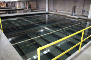
    As with anything water-related this summer, the hope comes in the form of rain. Monsoon season is expected to be wetter than average and the cloud coverage is expected to help cool streams enough to keep trout happy. Ewert said that the water temperature situation isn’t dire yet, but if rains don’t come soon the state may likely consider voluntary fishing closures in Summit County.

    The North American #Monsoon is expected to be active this weekend #ColoradoRiver #COriver #drought

    From AccuWeather (Renee Duff):

    Showers and thunderstorms will help ease drought conditions in the southwestern United States into the weekend, but also enhance the risk of flash flooding and dust storms.

    “Monsoonal moisture will remain in place from part of Southern California to Colorado and New Mexico,” said AccuWeather Meteorologist Jordan Root.
    Moisture will continue to stream into the region through the balance of the week.

    Graphic credit: AccuWeather.com

    As is typically the case when the monsoon kicks in at this time of year, storms will tend to blossom over the highest terrain during the afternoon hours and drift toward lower elevations into the evening and overnight.

    North American Monsoon graphic via Hunter College.

    Ireland votes to divest from fossil fuels #ActOnClimate #KeepItInTheGround

    By Jeff Schmaltz – NASA Earth Observatory, Public Domain, https://commons.wikimedia.org/w/index.php?curid=14627545

    From The Guardian (Damian Carrington):

    Bill passed by parliament means more than €300m shares in coal, oil, peat and gas will be sold ‘as soon as practicable’

    The Republic of Ireland will become the world’s first country to sell off its investments in fossil fuel companies, after a bill was passed with all-party support in the lower house of parliament.

    The state’s €8bn national investment fund will be required to sell all investments in coal, oil, gas and peat “as soon as is practicable”, which is expected to mean within five years. Norway’s huge $1tn sovereign wealth fund has only partially divested from fossil fuels, targeting some coal companies, and is still considering its oil and gas holdings.

    The fossil fuel divestment movement has grown rapidly and trillions of dollars of investment funds have been divested, including large pension funds and insurers, cities such as New York, churches and universities.

    Supporters of divestment say existing fossil fuel resources are already far greater than can be burned without causing catastrophic climate change and that exploring and producing more fossil fuels is therefore morally wrong and economically risky… [ed. emphasis mine]

    The Irish fossil fuel divestment bill was passed in the lower house of parliament on Thursday and it is expected to pass rapidly through the upper house, meaning it could become law before the end of the year. The Irish state investment fund holds more than €300m in fossil fuel investments in 150 companies.

    “The [divestment] movement is highlighting the need to stop investing in the expansion of a global industry which must be brought into managed decline if catastrophic climate change is to be averted,” said Thomas Pringle, the independent member of parliament who introduced the bill. “Ireland by divesting is sending a clear message that the Irish public and the international community are ready to think and act beyond narrow short term vested interests.”

    Éamonn Meehan, executive director of international development charity Trócaire, said: “Today the Oireachtas [Irish parliament] has sent a powerful signal to the international community about the need to speed up the phase-out of fossil fuels.”

    […]

    The bill defines a fossil fuel company as a company that derives 20% or more of its revenue from exploration, extraction or refinement of fossil fuels. The bill also allows investment in Irish fossil fuel companies if this funds their move away from fossil fuels.

    Gerry Liston at Global Legal Action Network, who drafted the bill, said: “Governments will not meet their obligations under the Paris agreement on climate change if they continue to financially sustain the fossil fuel industry. Countries the world over must now urgently follow Ireland’s lead and divest from fossil fuels.”

    #Drought news: Drought and dryness expands from SW to NE in #Colorado

    Click here to go to the US Drought Monitor website. Here’s an excerpt:

    Summary

    An active summer pattern continued over the central and northern Plains and into the upper Midwest, with several areas seeing well above normal precipitation associated with thunderstorms. Along the Gulf Coast from Texas to Florida, precipitation was plentiful and widespread as ample moisture continued to be transported into the region. The precipitation along the Gulf also helped to keep temperatures 1-3 degrees cooler than normal for this time of year. Some monsoon activity started up in the Southwest with some scattered precipitation while most of the rest of the West remained warm and dry with an increase in fire danger and active fires throughout the region…

    High Plains

    An active thunderstorm pattern helped to bring ample precipitation to North Dakota, northern South Dakota, central and eastern Nebraska, and portions of western Kansas. The precipitation last week along with recent rains has allowed for improvements in the Dakotas. Severe drought was eliminated from both North and South Dakota while abnormally dry and moderate drought conditions contracted as well. All of the abnormally dry conditions were eliminated from northwest South Dakota and southwest North Dakota. Eastern Kansas remained dry and severe drought expanded through northeast Kansas and was introduced into southeast Kansas while moderate drought expanded as well. Southwest Kansas had a full category improvement to drought conditions this week as the recent wetness has helped improve drought in this part of the state. In Nebraska, the recent rains in June and early July did not impact all of the state equally and portions of southern Nebraska are starting to show lingering impacts due to dryness going back to the autumn of 2017. This area will need to be monitored closely for development in the coming weeks.

    Portions of southeast Colorado improved this week in response to the recent wet pattern, but a new area of exceptional drought was introduced in eastern Colorado as conditions have been rapidly worsening in both the short and long term…

    South

    The southern portions of the region had the most precipitation as the Gulf Coast continued to be wet and also cooler where the most rain occurred. Areas of eastern Oklahoma and northern Arkansas into northern Mississippi continued to remain dry with some short-term impacts starting to develop. Areas of the Oklahoma and Texas panhandles had improvements this week as the rains continued in the short term and continue to improve the longer-term issues that allowed exceptional drought to be removed in Oklahoma. Severe drought was introduced into northeast Oklahoma, and abnormally dry and moderate drought were also expanded. Moderate drought and abnormally dry conditions were also expanded in northern and central Arkansas and into eastern Mississippi. Improvements were made in southern Louisiana where the most recent rains helped in the short term.

    In Texas, conditions improved along the Gulf Coast and Rio Grande regions where exceptional drought was eliminated and extreme drought contracted. Northeast Texas also saw some improvements to moderate and severe drought while abnormally dry conditions were also improved in east Texas into Louisiana. In central Texas, severe drought was introduced and moderate drought expanded, and extreme drought was expanded in northern Texas. West Texas had moderate drought introduced, while other areas had improvements to abnormally dry and moderate drought conditions…

    West

    Most of the region was dry this week and also recorded temperatures that were 3-6 degrees above normal. Portions of Arizona, New Mexico, southern Utah, and eastern Nevada did see some monsoon activity with scattered precipitation in both states. The hot and dry conditions have allowed for quite a rapid expansion of drought in portions of Utah and Colorado. A full category degradation was introduced over much of eastern Utah and western Colorado, bringing most of the area into exceptional drought conditions. Moderate drought was expanded to most of northwest Colorado while moderate drought and abnormally dry conditions migrated to the east in Colorado to include the Denver area. Moderate drought was introduced into northwest Montana and the panhandle of Idaho while abnormally dry conditions expanded over northeast Washington. Moderate drought and abnormally dry conditions were also expanded over central Oregon and Washington because of the short-term issues combined with dryness through the winter. Abnormally dry conditions were also expanded in southwest Wyoming. Eastern New Mexico did have some improvement where exceptional drought was retracted in the northeast portion of the state, and some improvements were also made along the border with Texas…

    Looking Ahead

    Over the next 5-7 days, the active precipitation pattern is expected to continue over the Southwest and into southern Colorado. The central Plains and Upper Midwest as well as areas of the Southeast also should see widespread rain. Temperatures will be warmest over the West and Great Basin as well as over most of the Midwest, Mid-Atlantic, and Northeast, with departures 6-9 degrees above normal in the West and 3-6 degrees above normal over the East.

    The 6-10 day outlooks show that greatest probabilities of above-normal temperatures are in the West and also from the southern Plains through the Midwest and across much of the East, while much of the central Plains and Alaska have the best probabilities of below-normal temperatures. The greatest probabilities of above-normal precipitation are from the Southwest into the central Plains and into the Mid-Atlantic and New England. The highest probabilities of below-normal precipitation are in the Pacific Northwest and northern Rocky Mountains, the northern Plains and much of Texas.

    Eagle turns dirt on second water treatment plant

    The water treatment process

    From The Vail Daily (Randy Wyrick):

    A groundbreaking ceremony saw the first shovels of dirt turned Tuesday, July 10. Excavation should continue through the summer, and concrete should follow in the fall.

    Water is scheduled to begin flowing in the fall of 2020…

    The town’s current and only water treatment plant runs at 90 percent capacity during peak demand, and some days it’s higher, said Brandy Reitter, Eagle town manager. The new plant will generate as much as 2.5 million gallons of water per day and can be expanded to 5 million gallons per day. It should fulfill the town’s projected growth needs for the next 20 years.

    “The town must accommodate its existing users. We also want to accommodate new customers and growth. We cannot consider new development unless we have the water to serve,” Reitter said. “Now is the time. The demands have increased significantly and we cannot wait any longer.”

    This new water plant will be on the Eagle River. The current plant is on Brush Creek and is the town’s only source of water.

    The town has good water rights on the Eagle River, thanks to tireless work by former town manager Willy Powell, Reitter said.

    Bryon McGinnis, Eagle’s public works director, said the second water plant will help the town preserve those hard-won water rights…

    A second water plant is also a public safety issue, McGinnis said, pointing out the many wildfires burning around Western Colorado.

    The Lake Christine fire near Basalt hit that town’s watershed and strained its system. However, Basalt has a system of wells near the Roaring Fork River, and that second water source kept the water flowing, McGinnis said.

    The town of Eagle saved $10 million and used it as a down payment on the new plant.

    “Development has, for many years, paid its own way. The town has collected and saved fees to help pay for this,” Reitter said.

    The remaining cost will be covered by a low-interest, 20-year loan from a state revolving fund.

    Broomfield-based MWH Constructors will build the plant.

    Proposed Northern Colorado Water Conservancy District Dedication of Mitigation Releases for Instream Flow Use in the Cache la Poudre River @Northern_Water @CWCB_DNR

    Cache la Poudre River. Photo credit: Greg Hobbs

    Here’s the notice from the Colorado Water Conservation Board (Rob Viehl):

    Proposed Northern Colorado Water Conservancy District Dedication of Mitigation Releases for Instream Flow Use in the Cache la Poudre River (Water Div. 1)

    The Colorado Water Conservation Board will be considering a proposal from the Northern Colorado Water Conservancy District (“Northern Water”) for a proposed donation of a contractual interest in “Protected Mitigation Releases,” as defined in section 37-92-102(8), C.R.S. for instream flow use in a segment of the Cache la Poudre River (“Poudre River”). The Board will consider this proposal at its July 18-19, 2018 meeting in Glenwood Springs. The agenda for this Board meeting can be found at:
    http://cwcb.state.co.us/public-information/board-meetings-agendas/Pages/July2018NoticeAgenda.aspx

    Consideration of this proposal initiates the 120-day period for Board review pursuant to Rule 6b. of the Board’s Rules Concerning the Colorado Instream Flow and Natural Lake Level Program (“ISF Rules”), which became effective on March 2, 2009. No formal Board action will be taken at this time.

    Information concerning the ISF Rules and water acquisitions can be found at:

    Click to access Final%20Adopted%20ISF%20Rules%201-27-2009.pdf

    The following information concerning the proposed lease of water is provided pursuant to ISF Rule 6m.(1):
    Subject Water Right:

    GLADE RESERVOIR
    Source: Cache la Poudre River
    Decree: 03CW0405
    Appropriation Date: 5/2/1980
    Adjudication Date: 12/31/1980
    Decreed Amount: 220,000 Acre Feet

    GLADE RESERVOIR FOREBAY
    Source: Cache la Poudre River
    Decree: 03CW0405
    Appropriation Date: 5/2/1980
    Adjudication Date: 12/31/1980
    Decreed Amount: 5,400 Acre Feet

    Proposed Reaches of Stream:

    The reach of stream proposed for use of Northern Water’s Mitigation Release water is the Cache la Poudre River extending downstream from the Poudre River Delivery Pipeline (the point where releases from Glade Reservoir enter the Poudre River) to the Poudre River Intake Diversion. The segment extends from near the mouth of the canyon through the City of Ft. Collins for approximately 13 river miles.

    Purpose of the Acquisition:

    The water rights proposed to be donated to the CWCB would be up to 14,350 acre-feet per year of water available to Northern in the to-be-constructed Glade Reservoir and Glade Forebay in Larimer County. Based upon discussions with Northern Water and Colorado Parks and Wildlife (“CPW”) regarding the need for and use of the donated water, Staff recommends that the CWCB acquire a contractual interest in the mitigation release water of up to 14,350 acre-feet.

    The acquired water would be used to preserve and improve the natural environment in the Poudre River to a reasonable decree by protecting Mitigation Releases up to 18-25 cfs to meet the Mitigation Plan targets and CPW’s recommended flows in the Poudre River. The CWCB shall use the Protected Mitigation Releases to help maintain stream flows in the Cache la Poudre River to preserve and improve the natural environment to a reasonable degree within the Qualifying Stream Reach in amounts up to the target rates of (a) winter flows of up to 55 cfs to preserve, and flows from 55 cfs to 85 cfs to improve, the natural environment to a reasonable degree, and (b) summer flows of up to 85 cfs to preserve, and flows from 85 to 130 cfs to improve, the natural environment to a reasonable degree.

    Proposed Season of Use:

    The CWCB does not currently hold an ISF water right within this reach of the Poudre River. Colorado Parks and Wildlife (“CPW”) and others have been studying and collecting field data in this segment of the Poudre River for over 10 years. CPW evaluated the studies and data by means including R2CROSS and PHABSIM modeling techniques to develop target flow rates for this section of the Poudre River. CPW’s preliminary target flow recommendations for this stream segment are as follows:

    Season of Use: Winter (approx. November-April), Preserve Target Rates: Up to 55 cfs, Improve Target Rates: Between 55 and 85 cfs.
    Season of Use: Summer (approx. May-October), Preserve Target Rates: Up to 85 cfs, Improve Target Rates: Between 85 and 130 cfs.

    Supporting Data:

    Available information concerning the purpose of the acquisition and the degree of preservation of the natural environment, and available scientific data can be found on CWCB water acquisitions web page at: http://cwcb.state.co.us/environment/instream-flow-program/Pages/NISPCacheLaPoudre.aspx

    Linda Bassi
    Stream and Lake Protection Section
    Colorado Water Conservation Board
    1313 Sherman Street, Room 721
    Denver, CO 80203
    linda.bassi@state.co.us
    303-866-3441 x3204

    Kaylea White
    Stream and Lake Protection Section
    Colorado Water Conservation Board
    1313 Sherman Street, Room 721
    Denver, CO 80203
    kaylea.white@state.co.us
    303-866-3441 x3240

    @ColoradoClimate: Weekly Climate, Water and #Drought Assessment of the Intermountain West

    Click here to read the current assessment. Click here to go to the NIDIS website hosted by the Colorado Climate Center.

    #Drought news: Yampa River Commercial & Voluntary Closures

    The Yampa River Core Trail runs right through downtown Steamboat. Photo credit City of Steamboat Springs.

    Here’s the release from the City of Steamboat Springs:

    Due to high water temperatures and low flow in the Yampa River, the City of Steamboat Springs is implementing closures for all commercial activities on the Yampa River and asking the public to abide by a voluntary closure for all recreational river use. The river closure, which began today, Monday, July 9, 2018, will remain in effect until rescinded.

    The Yampa River experienced water temperatures greater than 75 degrees for two consecutive days, July 7 & 8, which exceeds the threshold for a mandatory river closure as outlined in the Yampa River Management Plan. Low water flows, high water temperatures, and low levels of dissolved oxygen are all unfavorable conditions to aquatic life and any one of these factors can trigger a closure.

    Stream flows are currently hovering around 90 cubic feet per second (cfs); however, it is anticipated based on current trends to continue dropping and fall below the 85 cfs level. Average flow for this day in July is 445 cfs, which the river is well below at the current time.

    “A mandatory closure of the Yampa River isn’t something the city takes lightly and goes directly to the long-term health of the community’s number one natural resource,” said Craig Robinson, interim Parks & Recreation Director. “We would like to thank the community, especially our commercial operators, for their cooperation and support during this time.”

    Commercial tubing companies have suspended operations until river conditions return to acceptable levels. Commercial river recreation companies must also adhere to regulations adopted in the Yampa River Management Plan.

    River users – tubers, SUP-ers, swimmers, anglers – are requested to adhere to the voluntary closure and avoid river recreation. Please be mindful of the impacts your actions may have on the Yampa River and its wildlife.

    In addition to the mandatory closure of commercial activities on the Yampa River through Steamboat Springs, Colorado Parks and Wildlife is initiating a voluntary fishing closure between the Chuck Lewis State Wildlife Area and the western edge of Steamboat Springs.

    Although anglers are not prohibited from fishing in this stretch, CPW and Steamboat Springs is asking anglers to find alternative places to fish to protect the popular fishery.

    “Great fishing can be found at several area lakes and ponds, as well as the high-country,” said Bill Atkinson, area aquatic biologist for CPW. “Anglers still have great opportunities to fish while helping us protect this local resource.”

    Trout are cold water fish that have evolved to function best in 50-60 degree waters. When temperatures exceed 70 degrees, they often stop feeding and become more susceptible to disease.

    A wide range of temperature tolerances for trout have been reported, but upper lethal limits range from 74 to 79 degrees. According to local officials, water temperatures in the Yampa River are now exceeding 75 degrees in the afternoons.

    “When water flows are minimal, fish become concentrated in residual pool habitat and become stressed due to increased competition for food resources,” said Kris Middledorf, CPW’s area wildlife manager in Steamboat Springs. “Because the fish are already stressed by poor water quality conditions, any additional stress from being hooked could make them even more vulnerable to disease and death.”

    Middledorf reminds the public that the mandatory fishing closure on a six-tenth mile section of the Yampa River below Stagecoach Reservoir remains in effect, enforced by law.

    City staff will continue to monitor flows and river temperatures at the 5th Street Bridge. Water temperature monitoring was incorporated in November 2017 through a partnership with Mt. Werner Water, the Colorado River District and the USGS.

    Notices will be posted at popular river access points and requests everyone’s cooperation in protecting the Yampa River by staying out of the river until conditions improve. The health and protection of the Yampa River rates high with residents. Thank you for Respecting the Yampa and helping to protect the health of the river.

    Summitville Mine Superfund Site update: #Colorado to take over project for $2 million a year

    Summitville Mine superfund site

    From The Denver Post (Bruce Finley):

    After 27 years of EPA control, Colorado is preparing to take over the full financial burden — a forever bill for $2 million a year — of a high-mountain cyanide gold mine that became one of the West’s worst environmental disasters.

    The re-shaping of ravaged alpine tundra at the Summitville Mine through a $250 million federal Superfund cleanup stands out because scores of other toxic mines in Colorado still are contaminating headwaters of western rivers each day.

    But this fix requires constant work. Colorado must pay the $2 million, a bill that the EPA has been handling, starting in 2021 for cleaning a fluctuating flow of up to 2,100 gallons a minute of toxic water that drains down a once-pristine mountainside.

    The Colorado Department of Public Health and Environment will use the money to run a silver-domed $18 million industrial water treatment plant built at 11,500 feet elevation in a wild and spectacular valley, surrounded by snow-splotched jagged peaks.

    The plant houses huge stainless-steel vats of burbling brown sludge. Toxic metals are chemically coaxed and filtered out. Plant operators haul 4.1 million pounds a year of concentrated waste back up South Mountain (elevation 12,550 feet) in trucks for burial. This muck contains more than 690,000 pounds of cadmium, lead, copper, aluminum, iron, manganese and zinc. It is toxic metal that otherwise would flow down and degrade the Wightman Fork of the Alamosa River.

    Colorado also must oversee the artificial covering and drainage ditches across 1,100 acres of tundra scarred by open-pit mining. Mountainsides ripped and slashed to remove gold and silver have been re-contoured by contractors using bulldozers, and re-planted with native vegetation — the engineering equivalent of plastic surgery to make the place look as good as possible…

    The hand-off of responsibility for Summitville from the EPA to CDPHE in 2021 will mark a turning point in dealing with a severely damaged landscape using the nation’s Superfund system for handling disasters.

    This project was set in motion before Congress in 1995 killed automatic funding for Superfund cleanups.

    Complete restoration to a pre-existent state is considered impossible and the government aimed at best-possible repairs.

    “That was what the EPA and the state worked to do: bring it back to a sustainable protected state. Once there is mining in an area, it has long-term impact,” said Fran Costanzi, an EPA official who managed the Summitville cleanup for four years. “We worked to bring water quality back and also the vegetation into a long-term stable state.”

    An EPA spokesman issued a statement placing Summitville “among the more illustrious, or perhaps infamous, examples of the environmental damage a large mining operation can cause when resources for safely managing contamination sources disappear. The EPA’s initial response was an emergency situation in which the site was literally abandoned by the operator — in winter-time conditions — with a cyanide heap leach pad eroding into a headwaters stream.

    “After years of work and investment, we’ve essentially reclaimed a watershed in one of the most beautiful parts of the state. Protecting those gains will continue to require our attention.”

    Alamosa River. Photo credit: Wenck

    The cleanup improved water quality to where fish can live in Terrace Reservoir, about five miles below the mine, and in the Alamosa River.

    CDPHE officials now are required to monitor conditions.

    The financial burden falls to Colorado because the Superfund process shifts responsibility to states after initial federal remediation. Colorado lawmakers have arranged to pay about $2 million a year by tapping revenue derived from fees paid at municipal and other landfills around the state…

    At Summitville, Rio Grande County eventually will own the 1,100-acre site. State and county officials have been setting up placards conveying the history of mining in the area with an emphasis on environmental damage and evolving efforts to repair harm.

    Lower South Platte Water Conservancy District hopes to act as agent for Water Supply Reserve Fund Proposal

    Illustration shows water availability, in blue circles, compared with demand at various places along the South Platte River. The yellow area is the study area. (Illustration by Stantec).

    From. The Sterling Journal-Advocate (Jeff Rice):

    The Lower South Platte Water Conservancy District will submit a proposal to act as fiscal agent for the Water Supply Reserve Fund Proposal being drawn up by the South Platte Regional Opportunities Working Group. That decision came during Tuesday’s meeting of the district’s Executive Committee.

    The $390,000 project, described in the nearly impenetrable technical language of water experts, is essentially the next step after the South Platte Storage Study, which was completed late last year.

    The study, authorized by the Colorado General Assembly in House Bill 16-1256, looked at the stretch of the South Platte River between Kersey and the Nebraska state line in an attempt to find water storage to fill a crippling water gap that is just 12 years away. According to the 2015 Colorado Water Plan, by 2030 the need for water in Colorado will exceed supplies by 560,000 acre feet, or 182 billion gallons per year, and most of that is here in the South Platte River Basin.

    Joe Frank, general manager of the LSPWCD, said the study is good at indicating what can or should be done to meet the growing water gap, but it says nothing about how to do it or by whom. And it’s the “by whom” part that needs to be addressed next, Frank said, because without an entity to fund an promote projects, nothing gets done.

    Drawing pipelines and pumps is the easy part, for me, because I’m an engineer,” Frank said. “But we have to figure out who we are, and that’s the hard part. The institutional structure is what we still have to figure out, and that’s a big part of this (new project.)”

    The new project first establishes a fiscal agent and project sponsors, initially SPROWG members, to prepare a funding proposal and a work plan. It’s that fiscal agent part that Frank asked his executive committee to consider. LSPWCD was the fiscal agent on the South Plate Storage Study; the job entails making sure funds are paid to the right people at the right time and are properly accounted for.

    According to an Outline of Proposed Tasks, the next task – and the one Frank thinks will be most crucial – is to identify or create an organization to support “the development, operation, financing, ownership and governance of the South Platte Basin regional water development concept …”

    #Drought news: The Town of Beulah’s water supply is in rough shape

    This natural-color image was captured by NASA’s Aqua satellite with the Moderate Resolution Imaging Spectroradiometer, MODIS, instrument on October 17, 2016 at 19:50 UTC (1:50 pm MT). Actively burning areas, detected by MODIS’s thermal bands, are outlined in red. NASA image courtesy Jeff Schmaltz LANCE/EOSDIS MODIS Rapid Response Team, GSFC. Caption by Lynn Jenner with information from the Colorado Division of Homeland Security and Emergency Management. Image credit: NASA

    From KOAA.com (Caiti Blase):

    Extreme drought conditions, fire danger, and contaminated water in creeks: that’s the critical situation going on in the small town of Beulah.

    On Tuesday, News 5 spoke with residents on how these conditions are impacting them. Gary Kyte, chair of Pine Drive Water District wants people in Beulah to know that the water flowing into their homes is safe. It’s coming from water tanks that have already been treated. However, people are under a critical usage policy because of just how dry it is. The town did get some rain last week, but all it did was make things worse.

    Kyte said, “Evidently, that particular rain rained over the burn scar, the Junkins burn scar.”

    It’s been almost two years, but Beulah is still feeling the effects of the 2016 Junkins Fire. Last week’s rain caused debris and ash from the burn scar to flow into creeks.

    “We feel that it impacted our raw water intake.”

    What the town needs now is another good rain, but not on the burn scar.

    “It would flush or kind of scour out the creek bed and hopefully if it rains some more we could go back to treating water.”

    Kyte says between the contamination and the low water levels in the creeks doing treatment right now wouldn’t be worth it.

    “We’re entering into a critical drought state. We’re going to have to make water or we’re going to have to purchase water.”

    The town is trying to hold on as long as possible by restricting water to residents. Households supplied by the Pine Drive Water District are allowed to use 60 gallons of water a day. Those using the Beulah Water Works District are allowed 80 gallons a day…

    Kyte says he and the chair of the Beulah Water Works District have been speaking with Pueblo County’s emergency management staff. They are looking at various short and long-term options for assistance (such as hauling water) if conditions don’t improve.

    @NOAA: Assessing the U.S. Climate in June 2018

    Here’s the release from NOAA:

    The contiguous United States had its third warmest June on record

    The June contiguous U.S. temperature was 71.5°F, 3.0°F above the 20th century average. Only June 1933 and 2016 were warmer for the nation. Above-average temperatures spanned much of the Lower 48, with near- to below-average temperatures in the Northwest and Northeast. The first half of 2018 was marked by large month-to-month swings in temperature, but when averaged, the contiguous U.S. temperature was 49.4°F, 1.9°F above the 20th century average, and the 14th warmest January-June on record.

    The June precipitation total for the contiguous U.S. was 3.08 inches, 0.15 inch above average, and ranked near the middle of the 124-year period of record. Much-above-average precipitation fell in parts of the Midwest, Northern to Central Plains and Mid-Atlantic with below-average precipitation across parts of the West and South. Several significant flash-flooding events impacted the U.S. during June. For the year-to-date, the precipitation total was 15.78 inches, 0.47 inch above average, and ranked near the middle of the 124-year period of record.

    This monthly summary from NOAA’ s National Centers for Environmental Information is part of the suite of climate services NOAA provides to government, business, academia and the public to support informed decision-making.

    June Temperature

  • Above-average June temperatures were observed for much of the nation. Seventeen states across parts of the Southwest, Great Plains, Midwest and Southeast had a much-above-average temperature. Minimum temperatures, or overnight lows, were particularly warm across the central and southeastern U.S. Iowa, New Mexico and Texas each had a record warm June minimum temperature.
  • Near- to below-average June temperatures were observed across the Northwest and Northeast. In the Northeast, a heatwave that began in late June and persisted into early July was not enough to compensate for below-average temperatures in early- and mid-June.
  • June Precipitation

    Above-average precipitation was observed in a string of states from the Northern Rockies and Plains, through the Midwest, and into the mid-Atlantic. Indiana, Iowa and Kentucky each had a June precipitation total that was much above average. During June, there were several noteworthy heavy precipitation events that caused significant regional flooding.

  • On June 15-17, heavy rainfall caused fatal flash flooding in the Upper Midwest, washing out highways, with record crests along some rivers. One of the hardest hit communities was Houghton County, Michigan, where nearly 7.0 inches of precipitation fell in a short period.
  • A slow moving low pressure system, with tropical origins, dropped record-setting rainfall along the southern Texas coast on June 18-21. A report of 11.00 inches or more of precipitation near Premont, Texas, was received by the National Weather Service. The rain gauge reached its capacity of 11.00 inches before overflowing. Widespread flooding was reported during the event.
  • On June 22, 7.61 inches of precipitation was observed in Richmond, Virginia, causing flash flooding, power outages and the closure of the Richmond International Airport. This was the second highest daily rainfall total for the city, with a period of record that dates to 1887. Of the total precipitation, 4.09 inches of rain fell in just one hour, a new hourly record for the airport.
  • Below-average precipitation was observed across parts of the West, South, Midwest, Southeast, and Northeast during June. Utah tied its sixth driest June on record, receiving just 0.07 inch of precipitation during the month, 0.66 inch below average. Some locations in the Southwest received zero precipitation during June, a frequent occurrence during this time of year.
  • According to the July 3 U.S. Drought Monitor report, 29.7 percent of the contiguous U.S. was in drought, up from 26.4 percent at the end of May. Drought conditions worsened in parts of the West, Southern Plains, the Mississippi River Valley and the Northeast. Numerous large wildfires impacted parts of the Rockies and Southwest during June, where months of warm and dry conditions contributed to an abundance of wildfire fuels. Drought conditions improved for parts of the Great Plains, Midwest and the Texas Gulf Coast. Abnormally dry conditions expanded in Hawaii and Puerto Rico.
  • Year-to-Date (January-June) Temperature

  • Above-average January-June temperatures were observed across the West, Southern Plains, East Coast and much of the Midwest. Eight states in the West and South had much-above-average year-to-date temperatures, including Arizona and New Mexico that were record warm. The Arizona statewide average temperature was 59.5°F, 4.3°F above average, and the New Mexico temperature was 53.4°F, 4.1°F above average. Near- to below-average temperatures were observed in the north-central contiguous U.S.
  • The Alaska statewide average temperature for the year-to-date was 25.6°F, 4.3°F above average, and tied 2005 as the 10th warmest on record. Above-average temperatures were observed across western and northern areas of the state, with near-average temperatures in southern Alaska.
  • Year-to-Date (January-June) Precipitation

  • Above-average precipitation was observed in the Northern Plains, Midwest and along parts of the East Coast. Seven states had a January-June precipitation total that was much above average, with record precipitation observed for some localized areas.
  • Below-average precipitation was observed for locations across the Southwest, Southern Plains, Upper Midwest and Mid-Mississippi Valley. Colorado had its 11th driest year-to-date on record.
  • Billion-Dollar Weather and Climate Disasters

  • Through the end of June, there have been six weather and climate disaster events with losses exceeding $1 billion each across the U.S. during 2018. This was double the long-term average of three events for the January-June period since 1980, but slightly less than the 7.4 event average for the January-June period of the last five years. These events included four severe storm events and two winter storm events. Overall, these events resulted in the deaths of 36 people and had significant economic effects on the areas impacted.
  • Since these records began in 1980, the U.S. has sustained 233 weather and climate disasters where overall damages/costs reached or exceeded $1 billion (including CPI adjustment to 2018). The total cost of these 233 events exceeds $1.5 trillion.
  • #Drought news: The North American Monsoon won’t save Water Year 2018

    North American Monsoon graphic via Hunter College.

    From The New Mexico Political Report (Laura Paskus):

    The arrival of the Southwest’s summer monsoons is good news—good news everyone has been waiting for, especially since a dry, warm winter hit the state hard this year.

    But drought conditions still persist in New Mexico, and despite temporary bumps in flows, the state’s rivers are still experiencing lower-than-normal flows. At the Otowi Gage on the Rio Grande in northern New Mexico—a critical point for determining how much water New Mexico must send to Texas under the Rio Grande Compact—flows dipped over the weekend to just above 700 cubic feet per second. (One cubic foot per second is equal to about 448 gallons flowing past in a minute or 7 gallons per second.) In Albuquerque, Thursday’s rainstorm pushed the river up to about normal flows. But by Saturday, the Rio Grande through the city dropped back down to about 350 cfs, about half what its flows have historically been in early July.

    And it’s not just the Rio Grande.

    On Saturday, the Animas River in Farmington was running at about 20 cfs—compared with flows that should be about 1,000 cfs this time of year. The San Juan River in Farmington saw an uptick earlier in the week, but by Saturday it had dropped down to 1,000 cfs, when it should be closer to 1,800 cfs. The Pecos River above Santa Rosa Dam is running at about seven cfs, less than a quarter of the historic norm. And in southwestern New Mexico, the Gila River near the town of Cliff—near where the state plans to build a diversion on the river—is jumping between 15 and 30 cfs. Downstream, near Red Rock, the Gila’s been running at a consistent three cfs. And while it was exciting to see the Santa Fe River roaring after Thursday’s storm, by the next day, the river was down to about six cfs.

    To see stream flow measurements statewide, visit the USGS website here…

    As of late last week, the state’s largest river, the Rio Grande, was dry for about 22 miles in the San Acacia reach south of Socorro and for about four miles in the Isleta reach above Peralta…

    Meteorologists with NOAA’s Climate Prediction Center anticipate that drought will remain in the state, but that conditions will improve between now and September, thanks to monsoon rains. Even that won’t return things to normal. According to the Center for Western Weather and Water Extremes, the southwestern United States has such a precipitation deficit right now that even a historically-good monsoon won’t help the region recover enough to reach 100 percent of its normal water year precipitation.

    From The Grand Junction Daily Sentinel (Charles Ashby):

    The state’s low snowpack and lack of significant spring rains have caused several water suppliers statewide to put in place some mandatory restrictions, some of which go as far as to ban all outdoor landscape watering.

    While that hasn’t happened in the Grand Valley, water suppliers have placed the area on voluntary restrictions, meaning they are asking, but not requiring, area residents to be more judicious in how they use water.

    “(The year) 2018 has quickly become even more significant than the 2002 drought,” said Joe Burtard, external affairs manager for the Ute Water Conservancy District. “The domestic water providers along with the irrigation water providers moved Mesa County into a voluntary water restriction the earliest we’ve ever moved in, in early May of this year.”

    […]

    Burtard said the four main water suppliers in the valley — Ute Water, Clifton Water District, the city of Grand Junction and the town of Palisade — have created a Grand Valley Regional Water Conservation Plan.

    Part of that plan includes the Drought Response Information Project, a collaborative effort created by the four water suppliers after the 2002-03 drought to help instruct Grand Valley residents about water conservation.

    While that plan asks water users to voluntarily place themselves on restrictions — or at least be a little smarter about how they use water — it also comes with an agreement that if one of the water suppliers decides to make those restrictions mandatory, they all will.

    From The Albuquerque Journal (Maddy Hayden):

    A map released Thursday by the [New Mexico’s] Drought Monitoring Workgroup indicated that 87 percent of the state remains in severe or worse drought.

    That’s down from 89 percent last month, but conditions are still looking extremely dry in this part of the world.

    At the end of June 2017, that percentage was 0.

    Now, 18 percent of New Mexico – stretching from the Four Corners across much of the northern part of the state – is in exceptional drought…

    Only a small strip of land along the state’s southern border from Las Cruces eastward, making up around 1.3 percent of the state, is currently drought-free.

    Rivers around the state, including the Rio Grande, are dry or hardly flowing at some points.

    John Fleck, director of the University of New Mexico’s Water Resources Program, said the Rio Grande near Embudo north of Española was the lowest in history for Thursday’s date in more than 120 years of record keeping.

    A 22-mile stretch of the river in Socorro County is dry.

    There, the carcasses of fish litter the white sand of what should be a wet ribbon winding through the desert.

    Fleck said the the Rio Grande is still wet in Albuquerque only because of releases from the Heron, El Vado and Abiquiú reservoirs.

    “It’s not clear how much longer those supplies of stored water will last,” Fleck said.

    Depending on monsoon rains, Fleck said, the river could go dry in Albuquerque in August, which would be the first time that has happened since 1977.

    The Pecos River, too, is essentially dry above the Santa Rosa Reservoir.

    The winter’s abysmal snowpack has taken a toll on the state’s reservoirs.

    Conchas Lake was down more than 15,500 acre-feet, and Abiquiu Reservoir was down 13,000 acre-feet since the beginning of the month…

    In Albuquerque, water use has been kept under control, said Katherine Yuhas, water resources manager for the Albuquerque Bernalillo County Water Utility Authority.

    Water Utility Authority customers have used around 160 million more gallons than they had at this time last year.

    “That sounds like a lot, but that’s equal to about three-fourths of a gallon more a day,” Yuhas said.

    From The Deseret News (Amy Joi O’Donoghue):

    On Thursday, the U.S. Drought Monitor released drought details that show worsening conditions in Utah as areas already experiencing extreme or exceptional drought are continuing to grow.

    Those extremely dry conditions make the state ripe for more wildfires, the governor said, and it will likely get worse with the fireworks season looming…

    “The most severe places for drought are centered in the southeastern corner, but it is starting to spread northward,” said Shane Green, rangeland management specialist with the Natural Resources Conservation Service.

    West Drought Monitor July 3, 2018.

    Feds eye changes to a bedrock environmental law — @HighCountryNews

    Nixon Rock, in the Gunnison Gorge. Photo: Brent Gardner-Smith/Aspen Journalism

    From The High Country News (Carl Segerstrom):

    A clash over the National Environmental Policy Act follows familiar fault lines.

    A linchpin environmental law is now being scrutinized by the Trump administration and could be targeted for reforms. The National Environmental Policy Act, commonly referred to as NEPA, dictates the environmental planning process for federal agencies. Any changes to the NEPA process could have far-reaching impacts on the vast public lands and infrastructure of the West.

    The NEPA reform push broadly traces political dividing lines, as pro-business and anti-regulation Republicans, who want to see NEPA reworked, square off with environmental groups and conservation-minded Democrats hoping to preserve the law and implementation process. Caught between the vocal factions of each party are state governments and federal land managers arguing for a middle ground of limited reform.

    An August 2017 executive order, aimed at cutting environmental regulations and speeding up infrastructure projects, key goals of the Trump administration, prompted the ongoing review. The review looks at changing the implementing procedures for environmental reviews and offers some examples of what could be altered, including: limiting the time frame for environmental reviews, changing how agencies consider state and tribal input, and reducing the need to explore project alternatives.

    When federal agencies consider timber sales, build bridges, renew licenses on dams, pave highways, permit nuclear facilities or make any decision that will impact the local environment, they trigger the NEPA process. Contractors working on federal projects often commission and pay for NEPA reviews. The NEPA review process has three tiers that determine how rigorous an environmental review must be. The Categorical Exclusion designation exempts actions from environmental review if they are deemed to have no “significant effect on the human environment.” The next tier is Environmental Assessment, which compels agencies to prepare a formal review of potential impacts and decide whether the action has no significant impact or requires an Environmental Impact Statement. The Environmental Impact Statement is the most thorough review process and requires multiple drafts, a public comment period and that agencies explore alternatives to proposed projects.

    Heading the push for NEPA reform is Rep. Rob Bishop, R-Utah, who has had the law in his sights for the last decade. During a committee meeting on NEPA, Bishop, the chair of the House Committee on Natural Resources, complained the law has been warped by lawsuits and court interpretations and become “a weapon for litigants to force delays and denials on all sorts of activities.” Bishop, who has been a vocal proponent of loosening federal regulations on oil and gas companies and the transfer of federal lands to state control, said, “Environmental reviews should inform government of the actions they need to take, not paralyze it.”

    Conservation groups are digging in order to preserve NEPA and asking for an extended public commenting period on the current review. The “Protect NEPA Campaign,” which is a coalition of environmental, labor and civil rights group, such as the Sierra Club and Natural Resources Defense Council has called the Trump administration’s review an unprecedented attack on the law. More than 350 environmental organizations signed a letter to the Council on Environmental Quality, asking for an extension of the public comment period from 30 to 90 days. Raul Garcia, the senior legislative counsel for the environmental law group Earthjustice, said the month-long commenting process “is the latest in a long line of this administration’s efforts to silence public opinion and hinder democracy.”

    The Western Governors’ Association recently called for changes to the NEPA process that would give more influence to state governments. In a policy resolution, the association, which represents Western state executives, asked that federal agencies adopt more consistent NEPA planning processes and better engage with state and local governments. The group of Western lawmakers also asked that state environmental impact studies carry more weight in federal decision-making.

    Land management professionals say parts of the NEPA process could be reformed, but caution against sweeping changes to the law. Mike Ferguson, a retired Bureau Land Management land planner, first worked on NEPA implementation with the BLM in the 1970’s and has seen the implementation of the law become more convoluted over time. He says tightening the time frame for NEPA actions, clarifying the role of public comments, and investing in training and agency personnel could improve the process.

    Getting back to the basic language and intent of the law should be the goal of any NEPA reforms, says Ferguson. “A tug-of-war obliterates what NEPA was designed for in the first place, and I don’t care whether that’s from the left or the right,” he says. “Opening it up on either side will lead to a downward spiral that will dilute its effectiveness in the long-run.”

    The commenting period for NEPA reform is slated to be open through July 20, and a comment form can be accessed via the Council on Environmental Quality’s website. To date, the majority of the comments so far have either urged the council to keep NEPA intact or asked for an extended commenting period.

    Carl Segerstrom is an editorial fellow at High Country News. This article was published online on July 6, 2018.

    Fort Collins folks lower per capita water consumption

    US Drought Monitor June 25, 2002.

    From The Fort Collins Coloradoan (Nick Coltrain):

    As anyone who has watched as more and more cars stack up during the morning commute can attest, the population here keeps booming.

    But if that’s the case, why is the city’s water use continuously going down?

    Seriously. In 2000, the city of Fort Collins treated 31,594 acre-feet of water.

    In 2017, the city treated three-fourths of that, or 23,512 acre-feet — despite an additional 15,400 people tapping into the city’s water. (Fort Collins Water serves the majority of businesses and residences in the city limits, but not all.)

    […]

    People are paying attention and they’re asking about (water),” Fort Collins Water Conservation manager Liesel Hans said. “Are we going to be on restrictions this year? Is there enough water to go around? So I think people are more aware of it, for sure.”

    Hans traces the awareness back to the multi-year drought that gripped Colorado and the West starting in 2001. People, presumably in an effort to save their lawns and otherwise stave of the heat, were using on average 200-plus gallons of water per day. It was also when water conservation messages starting sprouting up in Fort Collins and statewide.

    Then, average gallon-per-capita use in Fort Collins started falling. In 2017, that measurement hit 141 gallons per capita per day, a 33 percent drop. Residential use dropped at an even greater clip: It went from 126 gallons of water per person per day to 73 — a 43 percent decline.

    That put overall water use within the city’s goal of 2020 water use. That is a moving target, however. The city has since shifted to a 2030 goal of 130 gallons per capita per day and plans to make another goal change come 2022.

    #AnimasRiver: Truck hauling sludge from the Cement Creek water treatment plant crashes and spills into Cement Creek

    From The Associated Press via The Colorado Springs Gazette:

    The driver wasn’t severely injured, but about 9 cubic yards of waste sludge spilled into the creek.

    The sludge is a byproduct of a U.S. Environmental Protection Agency treatment plant that is cleaning up water draining from the inactive Gold King mine. The EPA has said the sludge is not hazardous.

    Authorities say it doesn’t appear the truck spilled any fuel.

    #Wildfire update

    Screen shot of the Inciweb Website (https://inciweb.nwcg.gov) July 6, 2018.

    From The Canon City Daily Record:

    The Quarry Fire that erupted Saturday night near Fremont Peak is 90 percent contained, according to fire officials.

    In an update late Sunday afternoon, officials said 67 fire personnel are working the fire with one KMAX helicopter assigned to the incident.

    The fire, which officials said was started by a lightning strike, is estimated to be at 8.5 acres.

    Firefighters battled two fires in Fremont County on Saturday evening. The Twin Fire off of CR 3A near the former Buckskin Joes and the Royal Gorge Park was less than one acre and was fully contained Saturday night.

    From The Summit Daily (Lance Maggart):

    Grand County’s Sugarloaf Fire, located in a remote segment of US Forest Service land southwest of the town of Winter Park, continued its slow growth over the weekend.

    As of Sunday afternoon the fire was listed at 1,270 acres on the interagency information management website InciWeb. Sunday’s burn area represents only a slight increase from early last week when federal officials were listing the fire at slightly less than 1,200 acres. Fire officials calculate the Sugarloaf Fire’s containment at 20 percent and are still listing Aug. 31 as the estimated containment date.

    “With the existing weather conditions, the fire has slowed its spread, but it continues to creep and smolder, back down slopes with some single tree torching,” stated fire officials. “With fire behavior today, we expect the fire to continue to spread in the upper reaches of the Darling Creek drainage.”

    Officials stated they expect increased fire behavior and fire growth if the Sugarloaf blaze crosses Darling Creek. Weather in the Fraser Valley was overcast with scattered rain showers Saturday afternoon but according to officials no moisture had fallen in the area of the fire as of Sunday.

    All necessary work for structure protection, including homes in the area as well as Henderson Mill and Mine infrastructure, has been completed, according to federal reports.

    From The Aspen Daily News (Madeleine Osberger):

    The Lake Christine Fire, which has burned 5,916 acres outside Basalt, was 30 percent contained as of Sunday night, according to Keith Brink, chief of fire operations, during a public meeting at Basalt High School.

    That will allow for the release of about 200 people over the next few days, who can then be routed to some of the other wildfires that are raging across the west.

    “We’re making some good headway on this fire,” Brink shared with a crowd of more than 70 attendees on Sunday evening. However, he cautioned that heavy smoke on the hillside will still be visible for weeks and asked that people not call 911 to report the fire.

    Mike Almas, incident commander of the Northern Rockies Incident Management Team, told the audience at the high school: “The fuels have burned out around those larger fuels that you see as candles out there.”

    Brink confirmed that the fire had spread about 200 acres between Saturday and Sunday morning, but said the kind of containment progress made over the weekend was expected to continue.

    From The Denver Post (Kieran Nicholson):

    SPRING CREEK FIRE

    The human-caused Spring Creek fire, which has burned more than 60,700 acres in Costilla County, has destroyed at least 104 homes, fire officials said Monday night. A 52-year-old man from Denmark, Jesper Joergensen, has been arrested on suspicion of arson for starting the fire on June 27 about 9 miles northeast of Fort Garland. Joergensen is in the United States on an expired visa, according to an arrest warrant.

    The fire has formed two distinct columns, fire officials said. The Rocky Mountain Incident Management team blue will manage the north column and the RMIM team black with manage the south column. U.S. Highway 160 remains closed in the area because of fire activity and Colorado 12 is also closed in the Cuchara Valley area.

    On Monday, single-digit humidity, hot weather and winds prompted the National Weather Service to post a Red Flag Warning for “extreme fire behavior” in the area. Winds gusted to 30 mph and relative humidity dropped to 8 percent in some areas…

    416 FIRE

    “There are no remaining evacuation orders or pre-evacuation notices in place due to the 416 fire” as of late Monday afternoon, according to La Plata County officials.

    The fire, which started on June 1 about 10 miles north of Durango, has burned about 51,000 acres and was 37 percent contained on Monday afternoon, fire officials said.

    At 4 p.m. Monday, pre-evacuation notices were lifted for the Falls Creek and High Meadows subdivisions. The lifting of the notices affected 447 residences and five commercial structures…

    HIGH CHATEAU FIRE

    About 200 firefighters are battling the High Chateau fire, which has burned more than 1,300 acres about 7 miles northwest of Cripple Creek. The fire is burning through tall grass, ponderosa pine and mixed conifer, according to fire officials.

    On Monday afternoon, the “fire behavior on the northeast portion of the fire increased and the fire spotted across High Meadows Drive,” according to firefighters. Single engine air tankers dropped multiple loads of fire retardant and helicopter drops were also carried out on Monday afternoon.

    The fire has been moving north and east. There’s been no recent rain in the area and the fire’s size may continue to increase because of dry weather and fuel conditions. The active fire has been doing “short crown runs” and “group torching.” The blaze’s “resistance to control is high,” fire officials said. The fire started on June 29 and the cause is under investigation.

    WESTON PASS FIRE

    The fire grew to more than 6,400 acres Monday afternoon, fire officials said. The blaze, caused by a lightning strike, broke out on June 28 about 9 miles southwest of Fairplay. Firefighters expect the fire to grow as winds continue in the area. A containment date has been set for July 29. About 300 firefighters are battling the blaze.

    CHEDSEY FIRE

    A 5-acre fire was reported Monday in Jackson County, burning in Routt National Forest about 15 miles southwest of Walden. The Teal Lake campground was evacuated because of the fire, 80 firefighters are battling the blaze.

    ADOBE FIRE

    The 6-acre fire was reported Monday burning through timber about 6 miles west of Wetmore. Air support efforts on the fire included a lead plane, one heavy air tanker and two helicopters.

    From The Farmington Daily Times:

    Weekend storms that are expected to help douse some of the stubborn 416 Fire near Durango, Colorado, bring with them the possibility of flash floods in the fire zone.

    The 416 fire area was put under a flash flood watch today by the National Weather Service in effect from this afternoon through this evening.

    “Meteorologists are forecasting heavy rainfall over the burn area, which may lead to flash flooding and debris flows,” the fire team said. “Residents near this wildfire and along the Highway 550 corridor near Hermosa should prepare for potential flooding impacts. … The probability of rain increases through the weekend, with amounts ranging from .10 to .25 inches expected daily.”

    […]

    Clearing the air

    The fire has burned 54,129 acres and remains 45 percent contained as it keeps 383 personnel busy. The cost so far is $29.5 million.

    The rains will be good news to local communities suffering from smoke pollution.

    “As the amount of rain increases, it will penetrate the canopy, wetting fuels and making them less available to burn,” the team’s morning report said today. “Smoke impacts to surrounding communities should diminish rapidly as fuels become saturated.”

    Crews are redeploying or removing equipment as needed, and some areas are still off-limits to the public.

    From The Grand Junction Daily Sentinel (Kate Langford):

    A lightning-sparked wildfire burning seven miles northeast of Nucla has grown to 500 acres and is at 10 percent containment, according to officials with the Grand Mesa, Uncompahgre and Gunnison National Forests.

    The Tabeguache Fire was first reported Friday night and grew to 155 acres on Saturday.

    While firefighters were aided by rainfall over the weekend, the steep terrain and dry pinon-juniper and brush are a challenge for crews, said Spokesman John Abernathy.

    Crews are currently focused on securing the south and west flanks of the fire, Abernathy said, because they border Bureau of Land Management and private lands.

    From The Canon City Daily Record:

    Fremont County officials are reporting that the Twin Fire near the Royal Gorge Park is now out and those firefighters are attending to the Quarry Fire.

    The Quarry Fire is burning about 10 acres near Fremont Peak. According to the Fremont County Sheriff’s Office, the Eastridge Campground was evacuated as a precaution.

    #ArkansasRiver: Voluntary Flow Management Program helps rafting industry and Gold Medal fishing

    Browns Canyon via BrownsCanyon.org

    From The Pueblo Chieftain (Tracy Harmon):

    “The whitewater boating has been spectacular to date,” said Rob White, manager of the Arkansas Headwaters Recreation Area. “With the hot weather, (visitors can) cool off by enjoying a whitewater boating trip on the Arkansas River.”

    White credits the cooperation between federal, state and local officials working with public and private water users to manage flows in the river.

    “In such a dry year as this, it takes a lot of cooperation from a variety of water interests to ensure a great whitewater boating season,” White said. “We appreciate the fact that Pueblo Water moved some of its water from Clear Creek to Lake Pueblo in late June.

    “In addition, the Bureau of Reclamation and the Southeastern Colorado Water Conservancy District has assured us that we will have 10,000-plus acre feet of water available for the Voluntary Flow Management Program this summer.”

    The flow management program is used to buoy water flows of 700 cubic feet per second through Aug. 15, so rafters and kayakers can take advantage of summer boating opportunities.

    “The additional flow management program water helps ensure great flows for rafting and kayaking through the hottest of the summer months,” White explained…

    During the rest of the year, the flow management program is used to protect and enhance the fishery by boosting minimum flows to protect trout. As a result, the Arkansas River has been named a gold medal fishery because of its world-class brown and rainbow trout fishing opportunities.

    #Drought news: Temperatures in the White River nearing danger level for cold water fish

    Lake Avery. Photo credit: Colorado Parks and Wildlife

    From Colorado Parks and Wildlife via The Rio Blanco Herald Times:

    Due to low flows, dry conditions and extreme heat, water temperatures in the White River are nearing dangerous levels for cold-water fish. Colorado Parks and Wildlife officials are encouraging anglers to fish in the early morning, when water temperatures are cooler and less stressful to fish.
    To help mitigate current conditions, Colorado Parks and Wildlife is considering releasing water from Lake Avery to increase flow in the White River, and potentially lower river water temperature.

    To answer questions and address concerns about the possible release, CPW invites the public to a roundtable session, 7 p.m., July 9 at Kilowatt Korner (White River Electric Association—WREA), 233 Sixth St., in Meeker, Colo.

    “We’ve been here before, and we know what we need to do, “ said Bill de Vergie, Area Wildlife Manager from Meeker. “It’s important that ranchers, landowners, ditch users, fishing guides, anglers, and other members of the public attend our meeting so that we can work together to protect this important fishery.”
    Colorado Parks and Wildlife officials and the Colorado Water Conservation Board entered into a water lease agreement in 2012. The agreement allows the release of CPW’s water stored in Lake Avery to help meet the minimum instream flow on the White River of 200 cubic feet per second.

    Anglers at Lake Avery will see declining water levels in the lake beginning when the release is initiated.

    “When the flow from Lake Avery begins, we will ask users to avoid taking the additional water and instead leave it in the river to give fish a chance of surviving,” said de Vergie. “Everyone around here knows how important this river is to our economy, and we expect that people will comply to ensure the river continues to be a destination fishery.”

    It turns out that streamflow in the #AnimasRiver near Farmington was a monster 5 CFS rather than the 0 CFS reported

    West Drought Monitor July 3, 2018.

    From The Durango Herald (Jonathan Romeo) via The Cortez Journal:

    A U.S. Geological Survey river gauge in Farmington that recorded the Animas River flowing at nearly non-existent levels was the result of human error, the scientific agency said Friday.

    Fletcher Brinkerhoff, a supervisory hydrologic technician for the USGS in Albuquerque, said the reading of 0 cubic feet per second at the gauge was the result of incorrect information entered into the USGS’s database.

    The Durango Herald reported about record-low reading in a Page 1A story Friday.

    Still, water levels the past few weeks have been incredibly low, Brinkerhoff said, hovering around 5 cfs.

    @NOAA webinar Climate Science: What’s New? — @KHayhoe #ActOnClimate

    Here’s the release from NOAA:

    Climate Science Special Report (CSSR) Seminar Series

    Thursday, July 12, 2018 – 12:00 ET

    Click here to register.

    Climate Science Special Report (CSSR) Seminar Series, by the U.S. Global Change Research Program & in partnership with NOAA.

    Speaker: Katharine Hayhoe, Atmospheric Scientist, Texas Tech University. Presenting remotely.

    Sponsors: The U.S. Global Change Research Program and NOAA’s National Ocean Service Science Seminar; co-hosts are Katie Reeves (kreeves@usgcrp.gov) and Tracy.Gill@noaa.gov

    Webinar Access: Mymeeting webinar uses phone and internet. Audio is only available over the phone: dial toll-free from US or CAN: 1-877-708-1667. Enter code 7028688# For the webcast, goto http://www.mymeetings.com Under “Participant Join”, click “Join an Event”, then add conf no: 744925156. No code is needed for the web. Be sure to install the WebEx application when logging in – the temporary application works fine.

    Abstract: Human emissions of greenhouse gases now overwhelm the influence of natural drivers on Earth’s climate. How will our energy choices and resulting emissions affect temperature and precipitation, extreme events, sea level rise and more, over this century and beyond? What are the implications for meeting the targets of the Paris Agreement and avoiding dangerous change? And what about the potential for surprise, as we push the climate system harder and faster than any time in human history? Join Katharine as she highlights key results and new science from the first volume of the Fourth U.S. National Climate Assessment, and lays out what to expect from the second volume on how climate change is affecting regions and sectors across the U.S.

    About the Speaker: Katharine Hayhoe is an atmospheric scientist whose research focuses on understanding what climate change means for people and the places where we live. She served as a lead author on the Second, Third, and Fourth National Climate Assessments and is also known for her communication and outreach efforts, such as the PBS Digital Series Global Weirding. This year, she was the recipient of the Stephen H. Schneider Award for Outstanding Climate Science Communication. Katharine has a B.Sc. in Physics and Astronomy from the University of Toronto and an M.S. and Ph.D. in Atmospheric Science from the University of Illinois at Urbana-Champaign. She is currently a Professor of Public Administration and directs the Climate Science Center at Texas Tech University.

    Subscribe to the OneNOAA Science Seminar weekly email: Send an email to OneNOAAscienceseminars-request@list.woc.noaa.gov with the word `subscribe’ in the subject or body. See http://www.nodc.noaa.gov/seminars/

    #Wildfire update

    Screen shot of the Inciweb Website (https://inciweb.nwcg.gov) July 6, 2018.

    From The Aspen Times (Alex Zorn):

    On Friday, 214 fire personnel were working the fire with six hand crews (roughly 20 people per crew), 18 engines (varies with three to five fire personnel), two Type 2 helicopters, two Type 1 helicopters and a light helicopter that is used mainly for reconnaissance work, according to Friday’s on-duty public information officer Pat Thrasher.

    One of the heavy Chinook helicopters used to fight the fire also has been stationed out of the Glenwood Springs Municipal Airport, according to Amy Helm, manager of the small airport south of town.

    Friday was the first day that Single Engine Air Tankers, or SEATs, were not used to drop slurry, or retardant, on the fire line, though four were stationed at Rifle Airport on Friday just in case.

    “We are supporting ground personnel, they are doing the hard work,” SEAT pilot Bob DeRosier said. “Anytime we can clear them to save structures, that’s what we are there for.”

    While the SEATs were not necessary Friday, the tankers were used to drop slurry on the fire’s boundary to help solidify the fire line and allow ground crews access to the area.

    From The Fairplay Flume:

    As of Monday, July 2, the Weston Pass Fire (left) had grown to 6,417 acres. Park County issued mandatory evacuations for eight homes south of County Road 22 and for the Campground of the Rockies Association. Those living in the Black Mountain subdivision are under voluntary evacuation orders, and should be ready to leave at any time. For the High Chateau Fire (right) there were mandatory evacuations in place for Park Ridge, Doe Valley, Pike Meadow, Four Mile Ranch, Olson Slater Creek, and Ponderosa subdivisions between 8826 County Road 100 and County Road 102 and between County Road 71 and the Teller County line. The fire had grown to 1,422 acres.

    From The Denver Post:

    Containment estimates on the Spring Creek and 416 fires increased Friday as firefighters took advantage of improved weather conditions to close out the week.

    SPRING CREEK FIRE

    When rain came to the Spring Creek fire area, people stopped what they were doing and literally danced in the streets.

    The fire in Costilla and Huerfano counties in southern Colorado has burned more than 105,000 acres and was 35 percent contained as of Friday, according to fire officials.

    U.S. 160 over La Veta Pass is scheduled to reopen at 2 p.m. Saturday, according to the Colorado Department of Transportation. The pass has been closed since June 27…

    416 FIRE

    North of Durango the 416 fire has burned more than 54,000 acres, and containment was at 50 percent on Friday, fire officials said.

    Increasing subtropical moisture is expected to move into southwest Colorado through the weekend, including afternoon and evening thunderstorms. Rain accumulation of about a quarter inch is forecast Saturday, with up to the same on Sunday, fire officials said.

    “A quasi-monsoon pattern is setting up,” said Russell Danielson, a meteorologist and NWS spokesman. The current weather pattern is bringing much-needed moisture to the intermountain West in the form of isolated showers and storms.

    A high-pressure change in the near future could allow more moisture to stream into the fire area as the summer progresses, Danielson said. Slow thunderstorms are expected in the area Monday and Tuesday.

    WESTON PASS FIRE

    The fire, started by lightning on June 28 southwest of Fairplay, has moved into the Buffalo Peaks Wilderness area, which is now closed to the public.

    The fire has burned about 12,900 acres and was 32 percent contained as of Friday, fire officials said…

    LAKE CHRISTINE FIRE

    Mandatory evacuation orders were lifted at 7 p.m. Friday for the area north of Colorado 82 and west of El Jebel Road/Upper Cattle Creek road to the Garfield County line. The lifting of the order allows 150 families to return to their homes. All other evacuations orders remain in place.

    The 5,263 fire, about one mile northwest of Basalt, is 0 percent contained. The fire roared on the night of July 4, destroying three homes. It was first reported on July 3 racing through extremely dry fuels.

    At least 925 residences had been evacuated and potentially remain threatened in the Basalt, El Jebel and Missouri Heights areas.

    From The Durango Herald (Ryan Simonovich):

    About 250 homes were placed on pre-evacuation notice Friday afternoon for possible flooding around the 416 Fire burn area, but as of 8 p.m., no floods had been reported.

    The notice was issued for homes near the Tripp Creek and Dyke Gulch drainages north of Durango. It included High Meadows Ranch, Falls Creek Ranch and Sanctuary subdivisions, as well as Durango Regency mobile home park, Hermosa Circle and Tripp Creek, said Megan Graham, spokeswoman for La Plata County.

    Storm clouds developed Friday afternoon over the mountains north of Durango, but no significant rainfall resulted. Isolated thunderstorms producing heavy amounts of rainfall did occur west of the burn area in parts of Montezuma County.

    The evacuation notice was issued because soil conditions in the burn area of the 416 Fire cannot hold moisture, which can trigger floods and debris flows. The pre-evacuation notices, issued about 3:45 p.m., were meant to prepare residents in the event they have to evacuate in a moment’s notice, Graham said.

    Areas on alert were in zones that have historically experienced debris flows.

    A flash-flood watch was issued by the National Weather Service until 9 p.m. Friday.

    From The Grand Junction Daily Sentinel (Dennis Webb):

    Jennifer Costich, spokeswoman for the Lake Christine Fire near Basalt, reported late Friday afternoon that firefighting efforts were progressing well over the course of the day in terms of building a fireline in some areas. The fire had burned 5,263 acres as of the latest estimate, destroying three homes earlier in the week. About 350 firefighters were working on it Friday afternoon, with the help of five helicopters.

    Nearly 2,000 people have been evacuated as a result of the fire. The Garfield County Sheriff’s Office on Friday lifted a voluntary evacuation order applying to residents living in the Missouri Heights area of Garfield County, but other mandatory evacuation orders remain in place.

    Hickenlooper was joined by U.S. Sen. Cory Gardner, R-Colo., and U.S. Rep. Scott Tipton, R-Colo., at a stop at the Basalt fire that was to be followed by ground visits and flyovers of other blazes including the massive Spring Creek Fire in southern Colorado.

    “Where you get this many fires at one time you obviously stretch your resources,” Hickenlooper said during the Basalt stop, according to a video the Aspen Times posted to its website.

    He said the most firefighting assets ever deployed in Colorado may be currently active in the state, but he voiced confidence in the ability to access more if warranted…

    The Divide Fire about 32 miles northwest of Craig had burned about 13,500 acres as of Friday afternoon.

    That fire began June 29. Its cause remains under investigation.

    After several days of minimal activity it flared up Wednesday, growing by nearly 7,000 acres, and several aircraft responded to help ground crews. The fire made an additional push Thursday evening, and hot, windy weather contributed to further growth Friday, authorities say.

    BLM spokesman David Boyd said the fire burned a home June 29 and a seasonally occupied trailer on Wednesday. He said some structures are still threatened by the blaze, which is burning in sagebrush.

    About 75 firefighters were fighting the blaze Friday, along with four single-engine air tankers and a helicopter.

    Hickenlooper on Friday noted that it was the 24th anniversary of the day that 14 firefighters were killed while fighting a blaze on Storm King Mountain near Glenwood Springs.

    “Everybody is very aware of that and sensitive to that. We’ve got to make sure the highest priority obviously is the safety of the citizens but also the people fighting the fires,” he said.

    Hickenlooper also addressed the issue of the Lake Christine Fire’s reported cause — two people allegedly shooting tracer bullets at a Colorado Parks and Wildlife shooting range. While CPW has noted that the use of such bullets is never allowed at its shooting ranges, it has faced questions about allowing the shooting range to stay open even after Eagle County had gone into heightened, Stage 2 fire restrictions. The agency since has closed until further notice all its shooting ranges in northwest Colorado, including two in Mesa County.

    Here’s a photo essay from Tucson.com. From the article:

    More than 60 large blazes burn across the United States, mostly in the West, where whipping winds and increasing heat have made it easy for flames to spread.

    Fires exploded in Northern California, Utah and other areas, where a prolonged and severe drought has desiccated forests.

    Hotter, drier weather was forecast in Northern California, where thousands of firefighters were battling a wildfire that was already about three times the size of San Francisco.

    Smoke from the fire temporarily halted flights into the resort town of Aspen, Colo. A tornado was reported Thursday south of Fairplay, a central Colorado town about 10,000 feet (3,000 meters) above sea level. Tornadoes are rare at that elevation and are seldom seen at any wildfire.

    In Utah, scorching summer temperatures and winds quickly pushed flames through bone-dry vegetation. The 66-square-mile (171-square-kilometer) fire near Strawberry Reservoir has burned about 90 structures.

    From The Denver Post (Kirk Mitchell):

    Since the [Spring Fire] was ignited by a man cooking in a fire pit on June 27, wind currents out of the southwest have been mostly pushing the north end of the 100,000-acre-plus wildfire in a northeasterly direction. But a cold front swept in overnight turning the fire 180 degrees. It was a good thing for homes on the eastern flank, but an absolutely devastating turn of events for neighborhoods and pine forests on the western flank, Brack said.

    With wind gusts of 35 mph, the fast-moving blaze defied measurement, Brack said. Officials say the total number of damaged homes stands at 119 and the number of demolished homes is 132, although authorities know those figures are a small percentage of the affected homes. Dangerous conditions have made it too difficult for county officials to go into neighborhoods and count how many homes have been damaged or destroyed. Tallies are expected to rise significantly.

    Officially, the fire swept over an additional 15,000 to 20,000 acres at night, when wildfires normally lay down as temperatures drop.

    “We’re seeing unprecedented fire behavior that pushed this fire through the night. Because the fire has been moving so fast we don’t know exactly know how big it has become,” Brack said.

    The thermodynamics of this historic wildfire demand unusual tactics by firefighters. Crews have bulldozed trenches around subdivisions and homes, installed sprinkling systems and back-burned brush to create extremely wide fire breaks. But the blaze remains only 5 percent contained.

    From The Denver Post (Kirk Mitchell):

    Fire experts battling several wildfires across Colorado including the 416 fire north of Durango; Spring Creek fire in south central Colorado and the Lake Christine fire near Basalt are using terms like “unprecedented” and “unnatural” to describe fire dynamics this season. Wildfires typically burn uphill, not downhill. They lay down at night, not race faster than any man can run. A 300-foot-high tsunami of wildfire scorched 20,000 acres of heavy tall pine forests and grassland into stumps and ash, said Ben Brack, spokesman for the 103,000 Spring Creek fire…

    “I have never seen this kind of fire behavior in my 40 years of fighting fires,” said Chief Scott Thompson, of the Basalt and Rural Fire Protection District, about the Christine Lake fire in Eagle County…

    The unusual fire behavior triggered an emergency evacuation of the Missouri Heights trailer park at around 12:30 a.m. Thursday morning. Three homes were destroyed and the wildfire blew up from more than 300 acres to around 2,700 acres. The intense wildfire triggered power line explosions, he said.

    “We’re kind of bummed. We feel like we failed…” Thompson said.

    In the interest of safety, wildfire task forces have had to change up tactics, which has somewhat damaged morale, Brack said.

    “We’re not used to being pushed back by fire. We like being right on the fire fighting it. But this fire is moving too fast. Grass fires are moving up to 35 miles an hour. No human can outrun that,” he said.

    From The Cortez Journal (Stephanie Alderton):

    The Burro Fire continued to lie down Friday after two days of rain in the San Juan Mountains.

    Public information officer Kathy Russell said the fire remains at 4,593 acres with minimal activity after afternoon rains gave the area “a good soaking” on Thursday and Friday. On Saturday she said firefighters will continue to clear containment lines of any possible fuel sources, while the crews that have reached their 21-day limit prepare to demobilize. Despite its reduced movement, the fire will likely continue to smolder for a long time.

    The weather has been favorable for firefighting efforts ever since temperatures started cooling down earlier this week, Russell said.

    “The fire was calmed down already because of the increased humidity, and when that rain came, it calmed down even more,” she said. “We expect it to continue at very low levels.”

    The National Weather Service predicted more afternoon showers and thunderstorms on Saturday and Sunday, with temperatures in the low 70s. Although both Thursday and Friday’s showers came with lightning, Russell said it doesn’t seem to have caused any more fire activity. Firefighters always leave exposed places “at the first sign of lighting,” according to a Saturday morning press release.

    Crews have finished constructing a contingency line down to Colorado Highway 145, and the San Juan Hotshots who spearheaded that effort have left the scene, Russell said. Out of the remaining personnel, several planned to spend Saturday removing firefighting equipment from the area and bringing it to the U.S. Forest Service district office in Dolores.

    According to the release, all equipment must be inventoried, cleaned and shipped to the Rocky Mountain Interagency Support Cache, which supplies wildland firefighting efforts across the West.

    On Saturday there were about 45 firefighters working on the Burro Fire, but Russell said several personnel have completed their 21-day assignment and will be gone by Sunday. Members of the interagency incident management team are required to take some time off after three weeks at a fire.

    Other personnel, including the two new crews that arrived this week, planned to continue clearing and widening containment lines. Although Russell said firefighters don’t expect the fire to grow as long as the rain continues, it remains officially at 40 percent containment.

    Three year Prewitt Reservoir project improves spring habitat conditions and hunting opportunities

    Hunter in fog at Prewitt Reservoir via Colorado Open Lands

    From The Sterling Journal-Advocate via The Fort Morgan Times:

    Ducks Unlimited completed a three-year project on the Prewitt Reservoir State Wildlife Area in December, and officials are waiting to see whether the new concept works in the coming year.

    Jason Roudebush, a water resource specialist with DU, briefed members of the South Platte Basin Roundtable on the project during the roundtable’s April meeting in Longmont on Tuesday.

    Roudebush said DU installed a water-control structure on a marsh below the reservoir’s dam in 2016.

    Last summer DU installed a series of terraces near the inlet to the reservoir. The terraces will allow Colorado Parks and Wildlife managers to control water levels and create more open water in the marsh, improving spring habitat conditions and hunting opportunities.

    Jim Yahn, manager of the Prewitt, said after the presentation that the project doesn’t necessarily enhance the irrigation benefit of the reservoir, but it definitely improves the value as a recreation area. He said the Prewitt is now in a 25-year lease to the Colorado Division of Parks and Wildlife as a state recreation area.

    “Any enhancement that we can make to make it a better recreation area, that makes it more valuable to Prewitt water users in the future,” he said. “And if we can get those improvements at no cost (to the reservoir company) then it makes it just that much more valuable for recreation and hunting.”

    Yahn said the building of terraces in the reservoir is a new concept and it will take a season of irrigating to make sure the concept works.

    “They’re underwater now, so we’ll see how they hold together after we start irrigating,” he said. “It seems like it will work, but it’s still new. If it works, it could be done in other places. It might not work everywhere, but it could be incorporated into any new reservoir that’s built.”

    The project is in an area of the reservoir open to public hunting. According to Roudebush, the goal of the Prewitt project is to enhance more than 450 acres of habitat, including cattail-choked marshes below the reservoir’s dam and wetlands near its shore.

    On the Ducks Unlimited web site, DU regional biologist Matt Reddy said the terracing helps put water where it’s most useful to wildlife.

    “If you think of the reservoir as a big bath tub, you have to fill the bottom of the tub before the water can get up to the top where the best duck habitat is,” Reddy said. “We are putting the terraces in at the top of the reservoir so we don’t have to add as much water to flood habitat where wildlife can use it.”

    The project is part of DU’s Prewitt Reservoir Partnership with a goal to restore all of the waterfowl habitats in reach of the reservoir. To date, the partnership has spent more than $1 million conserving nearly 5,000 acres of habitat associated with Prewitt. Partners include the U.S. Fish and Wildlife Service, the North American Wetlands Council, the Playa Lakes Joint Venture, Colorado Parks and Wildlife, the Colorado Water Conservation Board, Great Outdoors Colorado, Colorado Open Lands and the Prewitt Reservoir Company.

    Colorado’s North Clear Creek & Tuthill

    For 150 years, the North Clear Creek in Black Hawk, Colorado has been contaminated from historic mining. A new water treatment plant that came online in 2017 is removing 350lbs of heavy metals every day from the stream with the hopes of reestablishing a brown trout population. The facility uses Tuthill’s Blower Packages to aerate the water to remove the heavy metals more easily. Learn more about Tuthill’s products here: https://www.tuthillvacuumblower.com/i…

    The facility was built and run by the Colorado Department of Public Health and Environment and the Environmental Protection Agency. The Colorado Department of Transportation was integral to this project.