By measuring the gravitational pull of water for more than two decades, NASA satellites have peered beneath the surface and measured changes in the groundwater supplies of the Colorado River Basin for years 2002 to 2024. Credit NASA
By measuring the gravitational pull of water for more than two decades, NASA satellites have peered beneath the surface and measured changes in the groundwater supplies of the Colorado River Basin for years 2015 to 2024. Credit: NASA
By measuring the gravitational pull of water for more than two decades, NASA satellites have peered beneath the surface and measured changes in the groundwater supplies of the Colorado River Basin. In a recent analysis of the satellite data, Arizona State University researchers reported rapid and accelerating losses of groundwater in the basin’s underground aquifers between 2002 and 2024. Some 40 million people rely on water from the aquifers, which include parts of Arizona, California, Colorado, Nevada, New Mexico, Utah, and Wyoming.
The basin lost about 27.8 million acre-feet of groundwater during the study period. “That’s an amount roughly equal to the storage capacity of Lake Mead,” said Karem Abdelmohsen, an associate research scientist at Arizona State University who authored the study.
About 68 percent of the losses occurred in the lower part of the basin, which lies mostly in Arizona. The research is based on data collected by the GRACE (Gravity Recovery and Climate Experiment) and GRACE-FO (GRACE Follow-On) missions. The data were integrated with output from land surface models, such as NASA’s North American Land Data Assimilation System, and in-situ precipitation data to calculate groundwater losses.
The conclusions were similar to those arrived at by Arizona State University Global Futures Professor Jay Famiglietti in an analysis of the Colorado River Basin published in 2014, when his team was at the University of California, Irvine. “If left unmanaged for another decade, groundwater levels will continue to drop, putting Arizona’s water security and food production at far greater risk than is being acknowledged,” said Famiglietti, previously a senior water scientist at NASA’s Jet Propulsion Laboratory and the principal investigator of both studies.
The maps above underscore the accelerating rate of groundwater loss detected by the GRACE missions. In the first decade of the analysis, between 2002 and 2014, parts of the basin in western Arizona in La Paz and Mohave counties and in southeastern Arizona in Cochise County lost groundwater at a rate of about 5 millimeters (0.2 inches) per year. Between 2015 and 2024, the rate of groundwater loss more than doubled to 12 millimeters (0.5 inches) per year. [ed. emphasis mine]
1950 – 2023
Two key factors likely explain the acceleration, the researchers said. First, there was a global transition from one of the strongest El Niños on record in 2014-2016 to a period when La Niña reasserted control, including the arrival of a “triple-dip” La Niña between 2020 and 2023. La Niña typically shifts winter precipitation patterns in a way that reduces rainfall over the Southwest and slows the replenishment of aquifers.
Second, there was an increase in the amount of groundwater being used for agriculture. “2014 was about the time that industrial agriculture took off in Arizona,” Famiglietti said, noting that large alfalfa farms arrived in La Paz and other parts of southern Arizona around that time. Dairies and orchards in southeastern Arizona likely impacted groundwater supplies as well, he added. Other “thirsty” crops grown widely in the state include cotton, corn, and pecans. Data from the U.S. Department of Agriculture’s Cropland Data Layer(CDL) shows that these crops are common in several parts of southern Arizona, including Maricopa, Pinal, and Cochise counties.
Irrigated agriculture consumes about 72 percent of Arizona’s available water supply; cities and industry account for 22 percent and 6 percent, respectively, according to Arizona Department of Water Resources data. Many farms use what Famiglietti described as “vast” amounts of groundwater in part because they use a water-intensive type of irrigation known as flood irrigation (or sometimes furrow irrigation), a technique where water is released into trenches that run through crop fields. The long-standing practice is typically the cheapest option and is widely used for alfalfa and cotton, but it can lead to more water loss and evaporation than other irrigation techniques, such as overhead sprinklers or dripping water from plastic tubing.
Captured by the OLI (Operational Land Imager) on Landsat 8, shows desert agriculture in La Paz and Maricopa counties on July 12, 2025. CDL data from the U.S. Department of Agriculture indicates that most of the rectangular fields around Vicksburg and Wenden are used to grow alfalfa, while the fields around Aguila are typically used for fruits and vegetables, such as melons, broccoli, and leafy greens. Some of the alfalfa fields in Butler Valley (upper part of the image) have gone fallow in recent years following the termination of leases due to concerns from the Arizona State Land Department about groundwater pumping.
The satellite image above, captured by the OLI (Operational Land Imager) on Landsat 8, shows desert agriculture in La Paz and Maricopa counties on July 12, 2025. CDL data from the U.S. Department of Agriculture indicates that most of the rectangular fields around Vicksburg and Wenden are used to grow alfalfa, while the fields around Aguila are typically used for fruits and vegetables, such as melons, broccoli, and leafy greens. Some of the alfalfa fields in Butler Valley (upper part of the image) have gone fallow in recent years following the termination of leases due to concerns from the Arizona State Land Department about groundwater pumping.
The new analysis found some evidence that managing groundwater can help keep Arizona aquifers healthier. For instance, the active management areas and irrigation non-expansion areas established as part of the Arizona Groundwater Management Act of 1980 lessened water losses in some areas. The designation of a new active management area in the Willcox Basin in 2025 will likely further slow groundwater losses. “Still, the bottom line is that the losses to groundwater were huge,” Abdelmohsen said. “Lots of attention has gone to low water levels in reservoirs over the years, but the depletion of groundwater far outpaces the surface water losses. This is a big warning flag.”
NASA supports several missions, tools, and datasets relevant to water resource management. Among them is OpenET, a web-based platform that uses satellite data to measure how much water plants and soils release into the atmosphere. The tool can help farmers tailor irrigation schedules to actual water use by plants, optimizing “crop per drop” and reducing waste.
This is the first part of the series from the summer issue of Headwaters Magazine. Click the link to read the series on the Water Education Colorado website. Click the link to read the article on the Big Pivots website (Allen Best):
July 20, 2025
To understand the predicament in the Republican River Basin of eastern Colorado, you need to appreciate the volume of water being hoisted from the underlying High Plains Aquifer. The most important component is the Ogallala.
Farmers and the few small towns in the Republican River Basin average 720,000 acre-feet of withdrawals annually. In one hot and dry year, 2012, they pumped 940,000 acre-feet. As a point of reference, Blue Mesa Reservoir, the largest water body in the state, can hold 947,435 acre-feet.
Groundwater mining cannot be sustained far into the future in many areas of the Republican River Basin. Wells in some areas have not declined while wells in other areas have declined 13 feet during the last decade. Pumping at existing rates cannot be maintained. Within 25 years, about a third of land that’s now irrigated will have no water. In other places, pumps already sputter.
“Sustainable” and “pumping” do not belong in the same sentence in this basin. The water of the Republican River Basin in the High Plains Aquifer accumulated from 18 to 4 million years ago.
Far from the snowmelt of the Rocky Mountains, it is recharged by minimal surface water. Based on studies, the Republican River Compact of Colorado, Nebraska and Kansas assumes that 17% of the water on the surface trickles down through the ground to the aquifers. So, only very slowly is the aquifer recharged. It’s mostly an ancient bank account with now small, almost tiny deposits and fast-and-furious withdrawals.
The Republican River Basin and several other regions of the state rely largely on groundwater. In a 2024 decision, Colorado Supreme Court justices pointed out that it would be difficult to overstate the importance of groundwater given the state’s population and arid climate. The 285,000 wells poked into the earth across the state deliver 18% of Colorado’s water.
The Republican River Basin, the San Luis Valley, and the south metro area of the Denver Basin are all, to varying degrees, rethinking water — both its sources and uses. All three have historically relied heavily on groundwater, and all have made at least limited progress in shifting toward more sustainable groundwater use in the last 20 years. The cities have adopted policies that foster smaller, less water-intensive lawns. They have diversified their sources. Two south-metro water utilities that 20 years ago pulled nearly all their water from wells, today have lessened that dependency to 60% to 65%.
Farmers in the Republican River Basin and San Luis Valley have somewhat different challenges. They have taken action to use less water and to save their communities, but whether those actions match the scale of the challenges they face is another matter. Changes can best be achieved before emergency sirens wail. In the Republican River Basin, some already see a swirl of red lights warning of catastrophe ahead.
Irrigation pipe and corn crop near Holyoke. Photo credit: Allen Best/Big Pivots
It’s going fast! What needs to be done in the Republican River Basin?
The Republican River Basin consists of 7,000 square miles, an area slightly smaller than New Jersey. It is largely located within a triangle between Julesburg, Limon and Cheyenne Wells. A few businesses cater to travelers but agriculture constitutes nearly all of the basin’s economic foundation.
An average 17 inches of precipitation falls per year across the basin, less in some areas. High-dollar agriculture depends almost entirely upon water drawn from the Ogallala. A 2010 state report found that of the basin’s 600,000 acres then under irrigation, only 1,000 were supplied by surface water. Locals suggest the true number is far, far less.
Dryland farming prevailed until the arrival of high-capacity pumps and rural electrification in the late 1940s. Farmers in the 1950s began converting dryland areas to irrigation, dramatically expanding crop yields. Other farmers arrived to plow hitherto virgin turf. Twice in the 1970s, groundwater extraction exceeded a million acre-feet per year.
Drafting of groundwater via 5,000 wells today produces a bounty of herbaceous crops. Most end up in the bellies of livestock. Two feedlots near Yuma alone can each hold more than 150,000 cattle and several others can accommodate 75,000. The basin also has three hog farms, several dairies, and an ethanol plant.
Republican River Basin map. Credit: Republican River Compact Administration
In 1942, Colorado, Nebraska and Kansas allocated the waters of the Republican River and its tributaries in an interstate compact. The state engineer in 1973 ordered a moratorium on new wells. The most powerful limitation did not come until 1990. Rules were changed, reducing the allowed rate of depletion, effectively precluding new well permits.
Existing wells, however, were drawing down the aquifers in the Republican River Basin. Kansas in the 1990s complained that it was getting shorted by Nebraska. Nebraska in turn blamed Colorado. A 2002 settlement stipulation among the three states represented a new line in the sand. By whatever means, Colorado had to figure out how to deliver water to the downriver states.
Colorado responded by forming the Republican River Water Conservation District. In effect, the state gave farmers and others in the eight-county district responsibility for figuring out how to comply with the compact. To help achieve compliance, legislators gave the district authority to levy fees on irrigators. The fee, originally $5 per acre, has been boosted twice and is now $30 per acre annually.
The Ogallala is plumbed by many wells in the Republican River Basin within Colorado.
This $15 million in annual revenue is used in several ways. An early project was a pipeline to boost the amount of water flowing into Nebraska. The pipeline carries water from eight wells previously used for irrigation. They had been drilled amid hills with sugar-like sand between Wray and Holyoke in the deepest part of the aquifer. The water from these wells flows 12.6 miles through the pipeline and into the North Fork near the Nebraska border. The wells are pumped from October to April, ensuring minimal loss to evaporation or riverine trees or grasses.
This pipeline, since its completion in 2012, has allowed Colorado to meet its compact delivery requirements. The cost of the wells, pipeline, and water rights was $72 million. Faced with declining production from these wells, the district in 2025 is planning four more wells and 9.5 miles of pipe at an estimated cost of $14 million to deliver what the compact pledges to Nebraska.
With members and staff of the Republican River Water Conservation District looking on, Colorado Gov. Jared Polis signed a bill in May 2023 that allocated $30 million to be used to retire irrigated acreage as necessary to meet a 2029 deadline. Photo/Office of Jared Polis
In another move toward compact compliance, Bonny Reservoir, a 165,238 acre-foot impoundment on the South Fork of the Republican, was drained. Prior to the 2011 draining, Bonny had delighted boaters and anglers but lost too much water to evaporation and seepage. Water now flows more efficiently downstream.
More actions were needed to ensure Nebraska and Kansas received their apportioned water. Beginning in 2006, Colorado removed 30,000 to 35,000 acres from irrigation. A multi-state agreement in 2016 specified that Colorado would remove an additional 25,000 acres in the South Fork drainage by 2029. Dick Wolfe, then Colorado’s state engineer, was asked at the time how this was to be done. He paused a moment, then likened it to getting a haircut: a snip here, a snip there.
This snipping of irrigated acreage has been encouraged with financial incentives assembled from pots of local, state and federal funds. The money is delivered via two federal programs: the Conservation Reserve Enhancement Program (CREP), and the Environmental Quality Incentives Program (EQIP). The latter allows farmers to use the land for dryland farming or grazing.
By early 2025, the Republican River Water Conservation District had retired 17,120 of the 25,000 acres as required by the 2016 settlement. It was a milestone, a time for momentary celebration. The harder work lies ahead. Nearly 8,000 additional acres must be retired to meet the December 2029 deadline. If the goal is not met, the state engineer has authority to shut down wells. Nobody wants that, least of all the state engineer. To help sweeten the incentives in 2025, state legislators appropriated $6 million. This adds $750 to the $4,500 per acre paid to farmers participating in CREP and $750 to the $3,500 per acre in EQIP.
By June 2025, Bonny Reservoir had a forest of trees, but the water that had drawn boaters and anglers was drained in 2011. Photo credit: Allen Best/Big Pivots
Using less water is the paramount challenge. This has been accomplished almost exclusively by taking land out of irrigation. There are other ways, too. Today, corn is king, responsible for about 85% of irrigated acres in the basin. It commonly receives 20 to 22 inches of supplemental water. A growing realization of late has been that less can be more. Planting fewer seeds — say 18,000 per acre instead of 30,000 — will save money and require less fertilizer. Fewer seeds will then require only 12 to 14 inches of supplemental water, meaning less pumping and shaving electricity bills. Lower crop yields can counterintuitively produce better profit margins.
Conversations are also underway about water-conserving crop alternatives: milo, millet and wheat, kidney and pinto beans, even black-eyed peas. It’s partly a matter of developing markets. Deb Daniel, the general manager of the district since 2011, has been toying with how to emphasize productivity strategies with the phrase “crop per drop.”
None of this adds up to the scale of the challenge, though.
Above: Most of the water in the Republican River comes from the aquifers, and by Wray, there’s little in the river. Photo credit: Allen Best/Big Pivots
Republican River in Colorado January 2023 near the Nebraska border. During winter, water is pumped from wells north of Wray for delivery into the North Fork of the Republican at the Nebraska state line. Photo credit: Allen Best/Big Pivots
Kenny Helling, a fourth-generation farmer from the Idalia area of Yuma County, believes more is needed than financial incentives to take land out of production. “Continuing to throw money at the problem won’t fix the problem,” he says. Ways must be found to keep land in irrigation, because irrigated land pays more in property taxes. Those taxes are crucial for operating fire departments, schools and other community purposes. “It’s a very big concern to me.”
The answers? Helling sees value in permits specifying reduced volume of pumped water. He would like to see more crop rotation.
Helling was a member of the Republican River Water Conservation District Board of Directors for nine years. He says the district needs other tools. The true authority for limiting pumping belongs to the eight groundwater subdistricts within the basin. They do not use it. Why?
“Everybody on those groundwater management districts are generally irrigators,” says Helling. “Most of them are neighbors. A lot of them go to church together. A lot of them might have kids and grandkids in school together. Nobody wants to make anybody mad. And so, unfortunately, the groundwater management districts do not use all the authority they could to restrict the amount of water used.”
Colorado legislators, he says, need to give the Republican River Water Conservation District more authority. It needs sticks, not just carrots. “We need to use less water.”
Tim Pautler told members of the Colorado Groundwater Commission something similar in May 2025. A dryland farmer from the Stratton area, he has served on the Republican River Water Conservation District’s Board of Directors for 21 years. He says that the board has accomplished almost no basin-wide conservation. It hasn’t figured out how to substantially reduce water use.
Most landowners who have taken advantage of the incentives have been irrigators who have less groundwater available in their wells. Nearly all in the southwestern portion of the basin, where many wells were already sputtering. He says if reduced water use is the goal, the fees charged to farmers must be based on acre-feet of water pumped and not just on irrigated acres.
There’s no pretense of sustainability in the Republican River Basin. The water deposited over millions of years is now being mined. The task is to maximize value of the remaining water, to prolong the availability of the High Plains Aquifer. Few have yet been willing to talk about the gravity of the challenge.
“I hope enough water remains in the hole to sustain society,” says Pautler. “I hope we don’t go completely dry.”
Part II: Entering the 20th century, the Denver metro communities of Castle Rock and Parker were growing fast — and almost entirely reliant upon Denver Basin aquifers. They still are, but they have started diversifying their sources while encouraging conservation of water. You can also download the entire story here in a magazine format.
Climate change is warming the North Pacific Ocean, leading weather patterns that drive drought in the U.S. Southwest to persist decades longer than they have in the recent past.
The drought in the Southwestern U.S. is likely to last for the rest of the 21st century and potentially beyond as global warming shifts the distribution of heat in the Pacific Ocean, according to a study published last week led by researchers at the University of Texas at Austin.
Using sediment cores collected in the Rocky Mountains, paleoclimatology records and climate models, the researchers found warming driven by greenhouse gas emissions can alter patterns of atmospheric and marine heat in the North Pacific Ocean in a way resembling what’s known as the negative phase of the Pacific Decadal Oscillation (PDO), fluctuations in sea surface temperatures that result in decreased winter precipitation in the American Southwest. But in this case, the phenomenon can last far longer than the usual 30-year cycle of the PDO.
“If the sea surface temperature patterns in the North Pacific were just the result of processes related to stochastic [random] variability in the past decade or two, we would have just been extremely unlucky, like a really bad roll of the dice,” said Victoria Todd, the lead author of the study and a Ph.D student in geosciences at UT Austin. “But if, as we hypothesize, this is a forced change in the sea surface temperatures in the North Pacific, this will be sustained into the future, and we need to start looking at this as a shift, instead of just the result of bad luck.”
Currently, the Southwestern U.S. is experiencing a megadrought resulting in the aridification of the landscape, a decades-long drying of the region brought on by climate change and the overconsumption of the region’s water. That’s led to major rivers and their basins, such as the Colorado and Rio Grande rivers, seeing reduced flows and a decline of the water stored in underground aquifers, which is forcing states and communities to reckon with a sharply reduced water supply. Farmers have cut back on the amount of water they use. Cities are searching for new water supplies. And states, tribes and federal agencies are engaging in tense negotiations over how to manage declining resources like the Colorado River going forward.
“Planners need to consider that this drought, these reductions in winter precipitation, are likely to continue, and plan for that,” said Tim Shanahan, an associate professor at UT Austin’s Jackson School of Geosciences and co-author of the study.
The research began with decades-old sample cores taken from lakes in the Rocky Mountains. Using modern geochemical techniques, Todd was able analyze drought conditions during the mid-Holocene period 6,000 years ago, a period in Earth’s history when the Northern Pacific warmed and the Southwestern U.S. experienced hundreds of years of drought.
But the sample cores suggest the drought was much worse than previously thought by scientists. Through a series of climate models, the researchers found vegetation change in the tropics darkened the Earth’s surface so that it absorbed more of the sun’s heat. That led to a warming of the North Pacific that was similar to the PDO that drives drought in the Southwest, but in this case, the drying lasted for centuries. “As soon as we saw that, you know, we started thinking about what’s happening today,” Todd said.
For the past 30 years, the PDO has been in its negative phase, which leads to drought in the Southwest by reducing winter precipitation and the runoff from mountain snowpack that fills many of the region’s rivers and recharges groundwater aquifers.
Using an ensemble of historical and future climate models forecasting climate and precipitation patterns until 2100, they found the PDO-like negative phase continues through this century. But unlike the mid-Holocene period’s warming, which was brought on by vegetation change, today’s is driven by greenhouse gas emissions. Certain models revealed that the change in the ocean pattern was less about vegetation absorbing solar radiation, Todd said, and more about warming in general.
The study also revealed that current climate models are underestimating drought conditions, Todd and Shanahan said, and they hope to find better ways to approximate aridity going forward.
Drought that continued until the end of the century would have major implications for water resources in the Southwest and how they are managed. The region currently sustains some of the country’s biggest cities and most productive agricultural areas.
Brian Richter, president of the water research and education group Sustainable Waters and a water researcher not involved in the study, said the research further proves the drought in the Southwest is more intense than previously thought and is not going away any time soon.
“Doesn’t it suck that every time the science improves, the outlook for the climate and water looks worse?” he said.
In many ways, Richter said, what people are seeing on the ground is outpacing science. Five years ago, he said, farmers would say they’ve been through droughts before, and this one would soon pass. Now, he said, their tone has changed to “This is a different kind of a drought.”
Udall/Overpeck 4-panel Figure Colorado River temperature/precipitation/natural flows with trend. Lake Mead and Lake Powell storage. Updated through Water Year 2024. Credit: Brad Udall
It's been a bit since I've done a meteorological deep dive, but the devastating flash #flood in central Texas this July 4th/5th deserve a closer look. #TXwxYes remnants of #Barry were involved helping enhance moisture. A remnant MCV from Mexico on 3 July also played a role.Full evolution below ⤵️
Click the link to read the article on the Grist website (Tik Root):
July 21, 2025
The country watched in horror as torrential rain drenched Texas earlier this month, sweeping at least 135 people to their death. Kerr County alone lost 107, including more than two dozen children at Camp Mystic.
From afar, it would be easy, even tempting, to think that the floods like these could never happen to you. That the disaster is remote.
It’s not.
As details of the tragedy have come into focus, the list of contributing factors has grown. Sudden downpours, driven by climate change. The lack of a comprehensive warning system to notify people that the Guadalupe river was rising rapidly. Rampant building in areas known to flood, coupled with incomplete information about what places might be at risk. ’
These are the same elements that could trigger a Kerr County-type of catastrophe in every state in the country. It’s a reality that has played out numerous times already in recent years, with flooding in Vermont, Kentucky, North Carolina and elsewhere, leaving grief and billions of dollars in destruction in its wake.
“Kerr County is an extreme example of what’s happening everywhere,” said Robert Freudenberg, vice president of energy and environmental programs at the Regional Planning Association. “People are at risk because of it and there’s more that we need to be doing.”
The most obvious problem is we keep building in areas prone to flooding. The Federal Emergency Management Agency, or FEMA, produces readily available maps showing high-risk locales. Yet, according to the latest data from the nonprofit climate research firm First Street Foundation, 7.9 million homes and other structures stand in a FEMA Special Flood Hazard Area, which designates a location with 1 percent or greater chance of being inundated in any given year.
FEMA Flood Zone Top Ten
Rank
State
Percent of Properties
Number of Properties
1
Louisiana
22.83%
542,756
2
Florida
17.15%
1,581,552
3
Mississippi
12.41%
240,526
4
New Jersey
10.57%
364,098
5
West Virginia
9.29%
126,918
6
Arkansas
7.27%
146,226
7
Texas
6.49%
806,827
8
Iowa
6.32%
154,217
9
New Mexico
6.28%
94,265
10
Nebraska
6.18%
71,235
Source: First Street Foundation
In Louisiana, a nation-leading 23 percent of properties are located in a FEMA flood zone. In Florida, it’s about 17 percent. Arkansas, New Mexico and Nebraska are perhaps less expected members of the top ten, as is New Jersey, which, with New York City, saw torrential rain and flooding that killed two people earlier this month.
Texas ranks seventh in the country, with about 800,000 properties, or roughly 6.5 percent of the state’s total, sitting in a flood zone. Kerr County officials have limited authority to keep people from building in these areas, but even when governments have the ability to prevent risky building projects, they historically haven’t. Although one study found that some areas are finally beginning to curb floodplain development, people keep building in perilous places.
“There’s an innate draw to the water that we have, but we need to know where the limits are,” said Freudenberg. “In places that are really dangerous, we need to work towards getting people out of harm’s way.”
Kerr County sits in a region known as Flash Flood Alley and at least four cabins at Camp Mystic sat in an extremely hazardous “floodway” and numerous others stood in the path of a 100-year flood. When the Christian summer camp for girls underwent an expansion in 2019, the owners built even more cabins in the water’s path.
“It’s an unwillingness to think about what future — and the present — have in store for us,” said Rob Moore, the director of the Water & Climate Team at the Natural Resources Defense Council, or NRDC, about Americans’ tradition of floodplain development. ”It’s a reluctance to own up to the reality we live in.”
Many people don’t even know they are in harm’s way. According to NRDC, 14 states have no flood disclosure laws and, in eight, they deem the laws ‘inadequate.’ FEMA maps are also flawed. For one, they can be politically influenced, with homeowners and communities often lobbying to be excluded in order to avoid insurance mandates and potential building costs. And experts say the science underpinning the maps is lagging too.
“[FEMA] only maps main river channels and coastal storm surge areas,” explained Jeremy Porter, the head of climate implications research at First Street Foundation. The agency, he added, specifically doesn’t model heavy rainfall, isn’t great about indicating the risk of urban flooding, and is behind on accounting for climate change.
First Street Flood Zone Top Ten
Rank
State
Percent of Properties
Number of Properties
1
West Virginia
30.25%
413,499
2
Louisiana
26.33%
626,120
3
Florida
19.04%
1,755,363
4
New Jersey
17.32%
596,521
5
Mississippi
15.46%
299,566
6
Kentucky
15.30%
328,283
7
Texas
15.19%
1,888,282
8
Pennsylvania
14.93%
856,889
9
New York
14.27%
771,605
10
Delaware
12.95%
55,535
Source: First Street Foundation
First Street built a flood model that tries to fill in those gaps. It found that 17.7 million people are at risk of a 100-year flood, a number that’s more than double what FEMA’s hazard area covers.The state rankings also change, with mountainous areas susceptible to inland flash-flooding jumping up the list. West Virginia moves into first, with a staggering 30 percent of properties built in flood prone areas. Kentucky climbs from 19th to sixth.
Texas remains at seventh, but the portion of properties at risk goes to 15 percent. In Kerr County, FEMA’s maps showed 2,560 properties (6.5 percent) in a flood zone. First Street’s model nearly doubled that.
“There’s a ton of unknown risk across the country,” said Porter, who says better maps are among the most important goals that policy makers can and should work toward. First Street has partnered with the real estate website Redfin to include climate risk metrics in its listings.
Rob Moore says political will is essential to making that type of systemic change when it comes to not only flooding, but other climate risks, such as wildfires or coastal erosion. Strengthening building codes and restricting development in high-risk areas will require similar fortitude.
“Governments and states don’t want to tell developers to not put things in a wetland, not put things in a floodplain,” he said. “We should be telling people don’t put them in a flatland, don’t build in a way that your home is going to be more susceptible to wildfire.”
Until then, hundreds of communities across the country could — and likely will — be the next Kerr County.
Grist has a comprehensive guide to help you stay ready and informed before, during, and after a disaster.
Indigenous youths with Ríos to Rivers’ Paddle Tribal Waters program head toward the shore where the Klamath River meets the Pacific Ocean in Northern California on July 11. The young kayakers were joined by a flotilla with dozens of tribe and community members on the final days of their monthlong, 310-mile journey. CREDIT: ERIK BOOMER / COURTESY OF RÍOS TO RIVERS
Click through to listen to an audio version of this story, produced for Aspen Public Radio.
In a thick forest along the remote northern California coast earlier this month, a group of mostly young Indigenous kayakers pushed off into the clear-emerald waters of the recently undammed Klamath River.
The 13- to 20-year-olds from more than six tribes in the Klamath Basin, along with several instructors, had been paddling for a month, covering over 300 miles.
In just a few hours, they would reach the Pacific Ocean, making the group among the first in over a century to descend the river from its headwaters in southern Oregon to its mouth in northern California. The expedition began in early June after the largest dam-removal project in history was completed last fall to restore salmon populations, improve water quality and support tribe-managed lands.
In the group was 15-year-old Hoopa Valley tribe member Carmen Ferris, who comes from a long line of fishing people along California’s Trinity River.
“The Trinity is the biggest tributary to the Klamath,” she said. “So I feel like I have a deep connection and ancestry with both of the waters.”
Carmen and about 40 other Indigenous kayakers had spent years training for the expedition with the help of Ríos to Rivers. Founded by Aspen resident Weston Boyles, 38, the nonprofit organization works with Indigenous youths around the world to protect rivers through advocacy, education and exchange programs.
Thirteen-year-old Scarlett Schroeder, left, and Coley Miller, 14, who belong to tribes on the Upper Klamath, stand with their paddles on the banks of the Klamath River. The Paddle Tribal Waters group of 13- to 20-year-olds from more than six tribes in the Klamath Basin, along with several instructors, were among the first in a century to paddle the free-flowing river after several major hydropower dams were removed last year. CREDIT: ERIK BOOMER / COURTESY OF RÍOS TO RIVERS
Historic paddle
In anticipation of the removal of four of the Klamath’s six dams, Boyles teamed up with local Indigenous youths and kayak instructors to launch the Paddle Tribal Waters program, with the goal of supporting young tribal members aiming to be the first to paddle the mostly free-flowing river since the first dam was built in 1918.
Although Carmen had heard about the dams growing up, it wasn’t until joining the program that she learned the full history of the decades-long effort by tribes and environmentalists, including her own Hoopa Valley people, to remove the dams from the Klamath and restore the salmon that local tribes once depended on.
“I was like, ‘Oh, my God, that is happening, and it’s nearby,’” she said. “I was in shock, and I learned about the history and what my ancestors and people before me have gone through for these dams to finally come out.”
Eighteen-year-old Ruby Rain Williams, of the Karuk tribe, and several other kayakers with Paddle Tribal Waters, navigate a section of whitewater on the Klamath River along the California-Oregon border. The group of local Indigenous youths trained for several years with the support of Aspen-based nonprofit Ríos to Rivers to be among the first in a century to paddle the recently undammed river. CREDIT: ERIK BOOMER / COURTESY OF RÍOS TO RIVERS
Carmen spent two years in the Paddle Tribal Waters program — taking tribe-led classes on river ecosystems, advocacy and cultural knowledge, as well as learning to whitewater kayak both in her own backyard and on exchange trips to Chile.
“I built a love for kayaking,” she said. “And then I was like, I’m definitely doing the descent, like I can’t stop kayaking now.”
The journey from the river’s headwaters to the Pacific Ocean wasn’t easy, from camping in a remote, rugged wilderness to tackling a number of Class 4 rapids on the upper Klamath, including one called “Big Ikes.”
“I got battered into this hole for a little bit, and if I didn’t know how to roll, I’d probably swim that day, which wouldn’t have been fun, because there were a lot of rocks,” she said. “I ended up being OK, but everyone was like, ‘Carmen, what happened?’”
Ruby Rain Williams of the Karuk tribe, who turned 18 on the trip, said the paddle group faced other challenges beyond navigating technical and dangerous rapids.
“There were definitely some hard parts, like getting up every morning around 6:30, and also the flat-water days on the lake with the headwind were quite treacherous,” Ruby said.
They also learned some valuable river-trip lessons, including the importance of sun protection.
“I remember the first couple days, we’re all like, ‘Oh, we don’t need sunscreen. We never wear sunscreen,’” Ruby said. “You know, we’re swimming in the river all day and I put pink Zinc on my face just to look cool and I had polka dots burned all over my cheeks and my ears were burnt, and even my eyes because I didn’t wear sunglasses. It was just gnarly.”
A map of the Klamath River Basin shows the four hydroelectric dams that were removed last year: Iron Gate, Copco 1, Copco 2, and J.C. Boyle. The two remaining dams in the upper river basin (located west and northwest of J.C. Boyle Dam and depicted as gray dots) are mostly used for farming irrigation.
The recently undammed Klamath River runs through the site of the former Copco Lake reservoir, named for the Copco 1 dam, in Northern California. Restoration efforts have begun at the former reservoir site, but signs of the former reservoir still remain on the landscape. CREDIT: ELEANOR BENNETT / ASPEN JOURNALISM & ASPEN PUBLIC RADIO
The recently undammed Klamath River runs through the site of the former Copco Lake reservoir, named for the Copco 1 dam, in Northern California. Restoration efforts have begun at the former reservoir site, but signs of the former reservoir still remain on the landscape.
CREDIT: ELEANOR BENNETT / ASPEN JOURNALISM & ASPEN PUBLIC RADIO
Reshaped landscape
Along the river, the young kayakers saw how the dam- removal and restoration effort had started reshaping landscapes and communities as they paddled through former reservoirs and dam sites, including Northern California’s Kikacéki Canyon, where for decades the water had been diverted to a power station, leaving a dry stretch of riverbed.
The four recently removed hydropower dams, which were built between 1918 and the mid-1960s, were still producing relatively low amounts of electricity. According to PacifiCorp, which operated the dams and is owned by Warren Buffett’s company Berkshire Hathaway, the sites were producing less than 2% of the operator’s total power generation — enough to power about 70,000 homes when they were running at full capacity.
In addition to losing a relatively low amount of power generation, there were other concerns about removing the dams. These included potential impacts of drained reservoirs such as exposed sacred burial sites that had been previously submerged, increased fire risk, loss of tax revenues for nearby counties, and decreased property values for former lakeside homes.
Still, scientists and advocates for dam removal maintained that the dams and their reservoirs worsened water quality in the river and that removing them would reduce the likelihood of sediment buildup, toxic algae blooms and diseases that thrive in warmer, stagnant waters and are harmful to salmon. They also maintained that the dams blocked salmon from returning to their upstream habitat where fish lay eggs and babies grow before migrating to the ocean.
Eventually, local tribes and other dam-removal advocates came to an agreement with PacifiCorp and federal regulators, and in 2022, the four dams on the lower Klamath were approved for removal.
In order to alleviate some of the community concerns, the Klamath River Renewal Corporation (KRRC), which helped broker the dam-removal deal, and Resource Environmental Solutions (RES) are now overseeing restoration efforts. These include working with fire officials concerned about the loss of a wildfire-fighting resource once the reservoirs were drained to set up dry-hydrant systems that allow crews to pull water directly from the river.
They also worked with the Shasta Indian Nation to mitigate the risk of damage to newly exposed cultural sites. Last year, the state of California also transferred some of the land near one of the former reservoirs back to the group.
Other restoration projects include excavating sediment that had built up behind the dams and planting billions of native seeds along the riverbanks and former reservoir sites.
The two dams that remain in the upper section of the river in southern Oregon are primarily used to divert water for irrigation and farming. During their monthlong river trip, which began in Chiloquin, Oregon, the Paddle Tribal Waters group carried their kayaks on land and portaged around these remaining dams.
Tribal Paddle Waters youths kayak below the Keno dam, one of the two remaining dams on the upper Klamath. The expedition group carried their kayaks on land and portaged around both of the remaining dams. CREDIT: ERIK BOOMER / COURTESY OF RÍOS TO RIVERS
Salmon returning
Brook Thompson, a scientist and Yurok and Karuk tribe member, researches salmon life cycles and water quality, and joined the paddlers for the last few days on the river.
Despite an unexpected salmon die-off after the first of four dams came down last year, Thompson said hundreds of miles of fish habitat on the Klamath and its tributaries have now opened up and dwindling salmon populations are already returning to spawn in greater numbers.
Chinook salmon on the Klamath River, Oct. 16, 2024. Photo: Oregon Department of Fish & Wildlife
“We really did not know what was going to happen with the salmon and if they would return right away, or if it would take years,” Thompson said. “So the fact that they immediately started going past where the dam sites were is so exciting for me as a tribal member.”
Researchers have also found lower rates of disease-carrying parasites and toxic algae since the dams were removed last year, according to Thompson.
Thompson decided to study environmental engineering, water infrastructure and ecosystems after tens of thousands of dead salmon clogged the lower reaches of the river during a major drought in 2002, after a decision by the Bush administration that reversed environmental protections and allowed upper Klamath farmers to divert much of the remaining water.
“Witnessing thousands of fish die on the river firsthand as a 7-year-old really devastated me, personally, because these salmon are not just a food source for my family, they weren’t just our income — I paid for all my school clothes and supplies through selling fish as a kid — but they’re also a connection to family, they’re my connection to my ancestors and they’re really the lifeblood of the tribes here,” Thompson said.
Now that the dams are out, Thompson hopes reconnecting with the river, including through salmon fishing and recreation opportunities, can help address a rise in health concerns such as cardiovascular disease and diabetes, as well as mental health challenges faced by tribes in the region, including addiction and suicide.
“When you lose out on that culture, you’re having all these issues health-wise, and you’re having people die because of it,” Thompson said. “I know for me, if I’m not by the river, and I don’t get a chance to fish and pray and be thankful for this food that feeds my body, that connects me to my ancestors, then I don’t feel as well mentally either.”
Although the Klamath was once the third-largest salmon-producing river on the West Coast, young people such as Ruby, the Karuk tribe member, had only heard stories about those days.
“My grandma and my dad always told me how there used to be so many salmon in the river, you used to be able to walk across their backs and almost make it across,” Ruby said. “There was such an abundance of them that my grandpa would go spearfishing and be able to see them swimming through the river, because it was so clean and healthy.”
During a fall scouting trip before their monthlong journey, Ruby and another young kayaker were some of the first to witness the salmon migrate past one of the former dam sites in Kikacéki Canyon.
“We looked down, and then there’s these salmon just flying up the river, and you could see their heads at the top of the river’s edge,” Ruby said. “I’ve never seen that before. And to be able to say that I saw some of the first set of salmon make it up above where the dams used to be was incredible.”
Ma-Kaych McConnell, right, and several of his fellow Paddle Tribal Waters kayakers get ready to push off into the Klamath River on July 10, the day before reaching the Pacific Ocean. About 15 of the young paddlers finished the full, 310-mile descent of the river, and about 30 more met up with the group for the second half of the journey. CREDIT: ELEANOR BENNETT / ASPEN JOURNALISM & ASPEN PUBLIC RADIO
Carmen Ferris, in the red kayak, of the Hoopa Valley tribe, and Ruby Rain Williams, in the blue kayak, of the Karuk tribe, float on a peaceful stretch of the Klamath River the day before reaching the Pacific Ocean. The two young paddlers grew up hearing stories from their elders about a time when the undammed river was plentiful with salmon. CREDIT: ELEANOR BENNETT / ASPEN JOURNALISM & ASPEN PUBLIC RADIO
‘Only the beginning’
John Acuna, a Hoopa Valley tribe member and Ríos to Rivers kayak instructor, helped lead the group of young people on the Klamath just a few years after being introduced to the sport.
Despite nearing the end of a long expedition with only a day left on the river, Acuna sees the monthlong descent as the beginning of something bigger.
“This is the biggest dam removal in history, and kind of the question is ‘What do we do next?’” Acuna said. “The hope is that this sets a precedent for other dam-impacted rivers and dam-threatened rivers, and I think our work has kind of just begun.”
Ríos to Rivers board member and river guide Jaren Roberson, who grew up in Arizona, agrees — and he hopes the recent dam-removal can be a model for how his own Diné (Navajo) and Hopi tribes can have a greater say in how water is allocated in the Colorado River basin.
“Indigenous people should be figures in these resource management areas because they’re the ones who have been taking care of them and have been living in these places for generations and generations and generations,” Roberson said.
During the last few days of the trip, Boyles, Ríos to Rivers’ founder, invited Indigenous groups from Bolivia, Chile and New Zealand to join a flotilla with dozens of local tribe and community members, which accompanied the long-distance paddlers as they neared the end of their journey.
Afterward, the visitors were invited to share their experiences with dams in their own communities during a two-day symposium on the Yurok Reservation, near the California towns of Requa and Klamath, where the river meets the ocean.
“In other basins, the mistakes of building dams, of destroying habitat, destroying culture, can be avoided if we learn from the past,” Boyles said, addressing the symposium crowd July 12. “And that’s a goal and a vision of ours, is to make sure that folks in river basins that have yet to be impacted or could avoid having the big impacts of dams, can come here to the Klamath and other parts of the world and learn from all of your lived experiences.”
Paddle Tribal Waters youths run to touch the ocean at the mouth of the Klamath River after finishing their monthlong journey July 11. Some of the young paddlers have already started their own kayak clubs in their communities to help other Indigenous youth reclaim their rivers. CREDIT: ELEANOR BENNETT / ASPEN JOURNALISM & ASPEN PUBLIC RADIO
Young kayakers with Paddle Tribal Waters embrace a loved one on the beach July 11 after completing a 310-mile journey to the Pacific Ocean. Community members welcomed the paddlers home with a traditional prayer ceremony on the beach. CREDIT: ELEANOR BENNETT / ASPEN JOURNALISM & ASPEN PUBLIC RADIO
Reaching the ocean
On July 11, the final day of the monthlong paddle, dozens of community members lined the beach and cheered as the flotilla, with the young kayakers leading the way, emerged from the mist and paddled toward the Pacific Ocean.
Clarence Hostler, of the Hoopa Valley, Yurok and Karuk tribes, and two younger men brought traditional drums to welcome the paddlers.
He grew up swimming on the river as a kid in the 1950s, but he had to stop after he got a rash from the toxic algae.
Clarence Hostler, of the Hoopa Valley, Yurok and Karuk tribes, waits on the shore at the mouth of the Klamath River to greet the young Indigenous paddlers as they reach the ocean. Having grown up on the river in the 1950s, Hostler witnessed decades of violence, protests and legal battles over fishing and water rights before the dams were removed last fall. CREDIT: ELEANOR BENNETT / ASPEN JOURNALISM & ASPEN PUBLIC RADIO
“So I hadn’t been on the water on the Klamath since 1965, and just a couple of days ago, I joined the paddle group and it was a stretch of river that I’d never been on because I didn’t want to get that rash again,” Hostler said. “And then being with the group, it settled with me that this was a triumph of a spirit coming back to the river, that we get to live with the river again after so many of us had to stay away from the river because of the contamination.”
Seeing the young kayakers paddle the river, after experiencing decades of violence, protests and legal battles over fishing and water rights on the Klamath, brought him to tears.
“A lot of the early warriors had to do the difficult work, and there are some of us, older ones, who carry the knowledge of old ways,” Hostler said. “But now, some real work starts with these young people who are activists on the water because there’s more contaminated water yet that needs to be worked on.”
As Carmen and her fellow kayakers reached the ocean and splashed in the waves, she felt the weight of that history.
“We shouldn’t be having to do this — like, there shouldn’t have been dams in the first place — but we fought a lot for nearly a century, for decades and decades, and now dams are finally out,” Carmen said.
Even with feelings of sadness and frustration over what her people endured, Carmen is proud of what she and her peers accomplished.
“We’re making history,” she said. “This is something I never thought I’d ever do, but I’m doing it today.”
Now that the dams are out, Carmen and several of the other young kayakers who have already started their own kayak clubs, are looking forward to returning to their communities to help the next generation of young paddlers reclaim their rivers and their ancestry.
This story was produced by Aspen Journalism and Aspen Public Radio, in partnership with The Water Desk at the University of Colorado Boulder’s Center for Environmental Journalism.
This story was produced through a social justice reporting collaboration between Aspen Journalism and Aspen Public Radio.
In response to last week’s dispatch on a potential new Colorado River sharing deal, Save The World’s Rivers! tweeted this compelling — but, for some, potentially opaque — tweet:
I say “opaque” because at first glance it might seem strange that a 50/50 split of the river’s waters between the Upper Basin and the Lower Basin would lead to ecological disaster. But it could, if, during a period of extremely low flow years, the 50% sent downstream was so low that it reduced daily flows through the Grand Canyon to a level that could not support fish or the ecology.
I’ve written about the faulty math of the Colorado River Compact many times here. Yet the assumptions of the river’s flow and the math are hardly the only, or largest, problems with the document. Most egregious was the exclusion of tribal nations from the original negotiations and the compact, itself, even though they collectively are entitled to a significant portion of the river’s waters. Under the compact, the tribal nations’ water rights must come out of the respective states’ allotments — that reduces tribes to subdivisions of the states, which they are not. They are sovereign nations and their water rights are negotiated with the federal government.
The other very big problem is that the compact never once considers the river, or the ecology that depends upon it. Instead, it apportions all of the water in the river and then some to “beneficial use,” which does not include environmental or even recreational uses. The compact also states that “the use of its waters for purposes of navigation shall be subservient to the uses of such waters for domestic, agricultural, and power purposes.” If we consider river-running and Lake Powell boating to be navigation, then the compact also deprioritizes those uses, i.e. recreation.
Because all of the Lower Basin’s water must flow through the Grand Canyon, the Lower Basin’s water rights serve as sort of de facto instream water rights through the canyon. In other words, the more water the Imperial Irrigation District and other Lower Basin users demand for irrigating alfalfa, the more water there is for fish and other critters in the Grand Canyon (including river runners). So, if the states were to strike a deal that might allow the Upper Basin to send only a trickle to the Lower Basin, it would also result in a mere trickle flowing through the Grand Canyon.
The thing is, the fish and even the river runners don’t really care much about the annual volume of water in the river, they care more about the daily streamflow. And that is currently regulated by a separate set of rules aside from the Colorado River Compact that were implemented in the 1990s.
But first, let’s go back in time to the years before there was a Glen Canyon Dam. Back then, the Colorado River through Glen Canyon, Marble Gorge, and the Grand Canyon was truly wild. Seasonal streamflow fluctuations were extreme, swinging from as low as 3,000 cubic feet per second in late summer, fall, and winter, to 80,000 cfs or more during spring runoff and late summer monsoonal floods. The water was often laden with orange-red sediment, and in the summer its temperature might reach 80° F or higher, giving it a viscous, dirty-bathwater feel. It may not have been great for swimming in, but the native fish reveled in it.
The completion of Glen Canyon Dam in 1963 changed all of that. Annual flows were evened out to build up storage in Lake Powell while also meeting Colorado River Compact obligations. Seasonal fluctuations were also no more, and the silt-free, murky green water emanating from the dam was a near-constant 46° F. Daily fluctuations of streamflow, however, could be erratic and downright manic, depending on the power grid’s need for more juice.
Before there was a Glen Canyon Dam, the Colorado River ran wild and free, often topping out at Lees Ferry at or above 100,000 cubic feet per second, which is ginormous. After the dam was completed, managers withheld flows to fill up the reservoir. Then, in 1983, they withheld too much water, and a massive spring runoff threatened the dam itself, forcing managers to release nearly 100,000 cfs once again and providing a wild ride for Grand Canyon river runners. After the 1996 operations plan was implemented, occasional high-flow releases occurred to help move sediment through the Grand Canyon in an effort to benefit the riparian ecology and build new beaches. But they still pale in comparison with pre-dam high flows. Data source: USGS.
During the first few decades after the dam was completed, the hydropower plant operators had ample leeway to “follow the load” by modulating the flow of water through the turbines. This occasionally caused huge fluctuations in the flow of water through the Grand Canyon. On one July day in 1989, for example, about 3,471 cfs was running through the dam at 5 a.m., a meagre flow by the Colorado’s standards. By 3 p.m., it had jumped to 29,000 cfs—the maximum flow through the turbines—to generate juice to the burgeoning number of air-conditioners on the Southwest power grid. This must have wreaked havoc on river runners in the Grand Canyon, who might have tied up their boats during high flow, only to find them beached out several hours later (or vice versa, depending on how far downriver they were). It probably wasn’t so good for the fish, either.
In the early ‘80s, dam operators wanted to maximize the potential for following the load by also installing turbines in the river outlets so they could generate even more power by releasing more water, which likely would have exacerbated daily fluctuations. The proposal was shot down following intense opposition, and sparked an effort to develop a more river-friendly plan for managing the dam.
Congress passed the Grand Canyon Protection Act in 1992, and in 1996 Interior Secretary Bruce Babbitt signed off on the Glen Canyon Dam Operations plan, selecting the “Modified Low Fluctuating Flow” alternative — a compromise between environmental and power-generating interests — and creating an adaptive management working group. The annual releases would remain the same (8.2 million acre-feet), but it imposed minimum and maximum release rates and maximum fluctuation rates, along with adding in occasional high-flow events meant to simulate pre-dam seasonal fluctuations. This limited Glen Canyon Dam’s flexibility as a hydroelectric plant, but it was far better for the downstream river and its users.
A profile of the Colorado River with potential future dam and reservoir sites. From the 1916 USGS paper “Colorado River and its utilization,” by E.C. La Rue.
Yet in the ensuing three decades, power-generation has often taken precedent over downstream ecological health, and the Grand Canyon’s riparian environment remains imperiled. (As long as we’re talking about ironies: A portion of revenues from Glen Canyon Dam’s power sales fund endangered fish recovery efforts.)
Whether a new deal to share the Colorado River becomes an ecological disaster would seem to depend less on the annual volume released from Glen Canyon Dam than it does on the daily and seasonal operations of the dam. And I would add this to the above tweet: It would be the second ecological disaster for the Grand Canyon; the first was the construction of Glen Canyon Dam, itself.
The back of Glen Canyon Dam circa 1964, not long after the reservoir had begun filling up. Here the water level is above dead pool, meaning water can be released via the river outlets, but it is below minimum power pool, so water cannot yet enter the penstocks to generate electricity. Bureau of Reclamation photo.
As long as we’re talking streamflows … here’s a hydrograph of the Animas River in Durango for the last year (July 17, 2024-July 17, 2025) and for the same time period during the previous year. You can see that spring runoff this year was lower, and less drawn-out than in 2024, and that the current streamflow is about 25% lower than it was on this date last year. Hopefully the monsoon will arrive soon and boost flows, at least for a bit.
🤯 Trump Ticker 😱
While everyone is going bananas over the Trump/Jeff Epstein brouhaha, the Trump administration is putting its fossil fuel fetish on garish display. This includes:
Yesterday the Interior Department said it would subject proposed solar and wind developments on public lands to elevated scrutiny in an effort to end “preferential treatment for unreliable, subsidy-dependent wind and solar energy.” Meanwhile these guys have been eliminating environmental reviews for and public input on oil and gas and mining projects. So who’s getting preferential treatment now?
Meanwhile, the Environmental Protection Agency is trying to block the state of Colorado from pushing dirty coal plants to close as part of its effort to reduce air pollution and, well, comply with EPA air quality regulations. CPR’s Sam Brasch has the story, and reports that Colorado’s not about to take this one lying down.
And, the EPA continues to defy its name by extending the deadline for compliance with regulations for managing coal combustion waste, or CCW. Coal combustion waste is the solid stuff left over from coal burning, like ash, clinkers, and scrubber sludge, and it contains copious quantities of nasty stuff like mercury, arsenic, boron, cobalt, radium, and selenium. This is an enormous waste stream, and is piled up outside coal plants and in coal mines all over the West. Check out this map from Earthjustice to see where the coal waste depositories are near you!
And finally, U.S. Energy Secretary Chris Wright, in an Economist column, wrote that climate change is “not an existential crisis,” merely a pesky little “by-product of progress.” He said he was willing to take the “modest negative trade-off” of climate change—along, presumably, with the heat waves, wildfires, and devastating floods—”for this legacy of human advancement.” It’s almost as if they like pollution! It would be funny if it weren’t so tragic.
😀 Good News Corner 😎
Colorado has new wolf pups! Yes, Colorado Parks and Wildlife has confirmed three new wolf families have joined the Copper Creek Pack with new pups, though they have not released the number of pups in each family. This is good news, indeed.
“Like so many Coloradans, I’m thrilled to hear of new wolf families and puppy paws on the ground,” said Alli Henderson, southern Rockies director at the Center for Biological Diversity, in a written statement. “The howl of wolves rising once more in this iconic landscape signals real progress toward restoring balance in Colorado’s wild places.”
For more background and history on wolves, check out my essay from a little while back on wolves, wildness, and hope. But you’ll have to sign up as a paid subscriber to read it, since the archives are behind the paywall!
La Plata Electric Association (LPEA) has signed a new 10-year power purchase agreement (PPA) with Ptarmigan Resources and Energy Inc. for locally generated hydropower from the Vallecito Dam, reinforcing the cooperative’s commitment to clean, reliable, and community-focused energy.
Effective April 1, 2026, through March 31, 2036, the agreement will provide approximately 5.8 megawatts of renewable capacity onto LPEA’s system – enough to power around 2,500 homes per year. It’s the first time LPEA has been able to purchase power directly from Vallecito, thanks to new flexibility under its evolving power supply strategy.
“This is a win for our members and our mission,” said LPEA CEO Chris Hansen. “For the first time, we’re contracting directly with a local hydropower provider right in our backyard.”
The hydropower facility at Vallecito Dam, located northeast of Bayfield, has long provided clean energy to the regional grid. However, LPEA’s previous long-term wholesale power contract limited its ability to work with independent producers like Ptarmigan.
“This project is exactly what we envision for the future of energy for our members: affordable, responsibly generated power produced right here in our community,” said Nicole Pitcher, LPEA Board President. “It’s meaningful that the same water sustaining our ranches and farms and bringing joy to recreationists will also be generating clean energy for homes across our service territory.”
“Selling power locally is a win-win,” said Sam Perry, CEO of HydroWest (contracted by Ptarmigan to oversee plant operations). “With this new partnership, Vallecito can provide consistent, renewable energy and grid stability to LPEA.”
This PPA follows LPEA’s launch of a competitive Request for Proposals (RFP) earlier this year, seeking additional long-term energy resources to serve its load after 2028.
I’m a little slow getting to this one, thanks mostly to being consumed by the whole public land sale brouhaha, but better late than never.
After years of bickering, wrangling, fighting, and digging in their heels, representatives of the seven Colorado River Basin states may have finally agreed on a “revolutionary” way to split up the river’s waters: They’re going to base it on how much water is actually in the river at any given time.
So, apparently, in this world, “revolutionary” is a synonym for the most common sense, obvious, and, really, necessary way to do things.
More specifically, the Upper Basin would release a percentage of the rolling three-year average of the“natural flow”* at Lee Ferry from Glen Canyon Dam, making it available to the Lower Basin. That’s opposed to the current model, where the Upper Basin is required to release at least 75 million acre-feet every ten years (or 7.5 MAF per year on average)**
Let’s pause for a moment and use an analogy to reflect on how short-sighted and dumb that original approach was. [ed. emphasis mine] Say someone has a potato farm and they die, leaving the farm to their two children, Upper and Lower, who must determine how to divide the farm and its yield between them. They look back at their parent’s ledgers, and determine that the farm has produced at least 15 tons of potatoes annually during the previous few years.
So they agree to divide it in half, with 7.5 tons going to each of them each year. But Upper will actually live on the farm, and has the keys to the lock on the gate, so they add into their Potato Farm Compact a clause that requires Upper to not prevent Lower from taking 75 tons of potatoes from the farm during every 10 year period.
This works out fine as long as the farm produces 15 tons per year. But what happens if you signed the Compact during an abnormally productive period, and the long-term average yield was far lower than 15 tons? Or what happens as the soil becomes less fertile and the irrigation water becomes more scarce and production drops far below 15 tons per year? Under the agreement, Upper still has to allow Lower to take 7.5 tons annually, leaving Upper with far less, maybe even nothing during a string of bad years. Obviously, this is untenable. And, just as obviously, it would have made far more sense for Upper and Lower to simply divide each year’s harvest in half and each take 50% of whatever the total might be. Just as obviously, that would have been the smartest way to divide up the Colorado River in the first place. Of course, a river is not a potato crop.
To determine how much potatoes you have, you just put them on a scale. Determining the “natural flow” of the Colorado River is far more difficult, and requires inputting:
data from 29 upstream streamflow gauges/gages;
historic outflow and pool elevations from 12 main-stem and 12 off-stream reservoirs;
upstream consumptive uses and losses.
While that doesn’t sound so complicated, gathering all of these inputs — reservoir evaporation, for example, or the exact amount consumed by agriculture — can require separate calculations and guesswork of their own.
Note that the would-be signatory’s of this deal haven’t agreed on what the “fixed percentage” would be, and that there still would be an unspecified “lower limit” to the annual release from Lake Powell. Those could both be sticking points in finalizing this plan. Source: Arizona Reconsultation Committee June meeting.
But the states wouldn’t be coming up with this from scratch. The Bureau of Reclamation already calculates the river’s natural flow at Lees Ferry along with Lake Powell’s unregulated inflow. As you can see from the graph below, the river has not consistently delivered 15 million acre-feet per year, forcing the Upper Basin to deplete their savings account (Lake Powell) in order to meet its Colorado River Compact obligations.
This shows the estimated natural flow of the river — or what it would deliver without any upstream dams, diversions, or human-related consumptive use — at Lees Ferry, several miles downstream from Glen Canyon Dam. The natural flow is calculated using upstream streamflow gages, consumptive use, and calculated reservoir evaporation. Source: Bureau of Reclamation.
If the supply driven concept is implemented, it will base Glen Canyon Dam releases on a fixed percentage of the previous three-year moving average. For example, the average of water years 2022, 2023, and 2024 was 13 million acre-feet. If the Upper Basin and Lower Basin were to each take 50%, then the Glen Canyon release this year would be 6.5 million acre-feet (plus something for Mexico, presumably, although this isn’t clear. I highly doubt the Lower Basin will settle for just 50%, given that it has far more people, more agriculture, and is just thirstier, overall, but let’s go with that figure since it’s what’s in the Colorado River Compact, sort of.
The Lower Basin states use far less water now than they did a decade or so ago, thanks in part to forced cuts and in part to general conservation measures. The increase between 2023 and 2024 is probably due to the fact that 2023 was an unusually wet year in most of the Colorado River Basin, meaning farmers and other irrigators needed less water. Source: Colorado River Accounting and Water Usage Report, Lower Basin, Bureau of Reclamation.
That would actually work: The Lower Basin states’ consumptive use last calendar year was about 5.8 million acre-feet, so they’d have enough to use, and a little on top for evaporation from reservoirs (which is not included in the Lower Basin’s accounting). It would leave the Upper Basin enough for consumption and some extra for reservoir storage.
But if you go with the previous three years (‘20,’21,’22), you end up with an average of just 9 million acre-feet, 50% of which would be a measly 4.5 million acre-feet, forcing downstream users — namely the Central Arizona Project, since their rights are junior to California’s — to take deep cuts. And it would leave the Upper Basin just enough to meet their needs, meaning they’d have to draw down Lake Powell or other reservoirs to fulfill their obligations.
Another tricky scenario would be if three decent water years were followed by an extremely dry year. Releases from Lake Powell could significantly exceed inflows, which might deplete the reservoir enough to bring it down to minimum power pool, which is no bueno.
While this may be the closest the states have come to reaching some sort of consensus on how to run the River beyond 2026, it seems as if there is still many sticky details to work out. How are they going to agree on a fixed percentage? What will the minimum release be? And how will that fly with the Upper Basin during years such as 2002, when the natural flow at Lees Ferry was a mere 5.8 million acre-feet? Time’s running out.
Now for some more data for your pondering pleasure:
The Upper Basin states use far less water than the Lower Basin, but the Lower Basin has generally been reducing overall use, while the Upper Basin has remained steady or even increased consumption, with Colorado overtaking Arizona in 2023. Note: The Arizona figure only includes the Lower Basin. Arizona also consumes about 13,000 acre-feet of Upper Basin water each year, down significantly from pre-2019, when up to 40,000 acre-feet was withdrawn from Lake Powell for steam generation and cooling at the now shuttered Navajo Generating Station. Source: Bureau of Reclamation.
The Imperial Irrigation District in southern California remains the River’s largest single water user, and one of the most senior water rights holders, using most of the water for alfalfa and various food crops. However, it has cut its consumption considerably over the years, in part thanks to state and federal programs that pay farmers not to irrigate. It’s not clear how long these programs and the payments can last, however. Nevada is included on this list because nearly all of the state’s Colorado River allocation is drawn from Lake Mead and goes to the greater Las Vegas area. Also note that it is only number 8 on this list. Source: Bureau of Reclamation.
Agriculture has been and remains the biggest single user of Colorado River water, by far. Of that amount, alfalfa and other hay crops take up the lion’s share.
This passage, from David Starr Jordan’s Fish Commission Bulletin 1889: Report of Explorations in Colorado and Utah During the Summer of 1889, remains relevant today:
Uggh. Fire season is getting ugly. The Dragon Bravo Fire blew up and burned the historic Grand Canyon Lodge on the North Rim. The Deer Creek Fire, burning near Old La Sal, Utah, just west of the Colorado state line, has grown to almost 12,000 acres and exhibited some erratic behavior (see video above). Just northeast of there, the Wright Draw and Turner Gulch fires have forced the closure of Hwy. 141 and numerous evacuations in the Unaweep Canyon area outside Gateway (the community of Gateway is not yet threatened). The South Rim Fire at the Black Canyon of the Gunnison is now at 4,000 acres. The Laguna Fire west of Abiquiu Reservoir in New Mexico has reached 15,200 acres. And the air in the West is basically full of smoke.
Here’s hoping for rain and lots of it, sans lightning, please.
📸 Parting Shot 🎞️
This one’s from “A notice of the ancient ruins of southwestern Colorado, examined during the summer of 1875,” by W.H. Holmes. The text is the beginning of the description of the sketch.
The latest Bureau of Reclamation 24-month studies show a clear risk of Lake Powell dropping below minimum power pool in late 2026, with Lake Mead dropping to elevation 1,025 by the summer of 2027. This should be hair on fire stuff.
The “clear risk” here is based on Reclamation’s monthly “minimum probable” model runs – what happens if we have bad snowpacks next year, and the year after? These are probabilistic estimates, not predictions. But the whole point of Reclamation doing this is so that we can be prepared. We need a robust public discussion about what our plan is if we end up on this fork in the hydrologic road.
The warning signs are clearly there in Jack’s analyses. Frustrated by the delay in the traditional metrics we use for measuring and monitoring the Colorado River, Jack’s been doing routine updates on reservoir storage contents. The traditional metrics we use – the Upper Basin Consumptive Uses and Losses Reports, the Lower Basin Decree Accounting Reports, the Natural Flow Database – have significant lags. The reservoir data is there in real time, integrating how much the climate system provides and how much humans use. The data here are all public. Jack’s value add is to sum them up and slice and dice the resulting data structures.
The somewhat arcane but incredibly useful framework he’s been using his his recent analyses is the period of accumulation, when reservoirs rise as river flows exceed human uses above them and extractions below them, following by the period of decline, when we’re drawing down the reservoirs. This is a tool, or a way of thinking, that we could use in real time to adjust our behavior, noting bad reservoir conditions and reducing our use. This is not something our water allocation framework is well suited to do.
The Negotiations
For more than a year, those involved in the delicate interstate negotiations over future Colorado River water allocation rules have repeatedly asked that we give them space to have the hard conversations they need to have in private. The results, or lack thereof, have done nothing to earn our trust.
The potential path forward.
When Arizona’s Tom Buschatzke moved the up-until-then super secret “supply driven” allocation concept into public view a month ago, it seemed like a good sign along two dimensions. First, the idea of basing the amount of water delivered from Upper Basin to Lower Basin past Lee Ferry on actual hydrology, on a percentage of how much water the climate is actually providing, seemed like an eminently reasonable approach. Second, Buschatzke was talking about this in public.
Folks from the Upper Basin followed suit, and a round of positive press followed.
But as this shifts from the brief sunshine of public statements back to the closed door negotiations, any glimmer appears dim indeed.
The problems were already visible in that brief, glorious bit of sunshine of public discussion last month.
There are two critical questions that need to be settled to make this work. The obvious one is the number – what percentage of the three year natural flow are we talking about shepherding down past Lee Ferry? The second is more subtle: What happens if the Lee Ferry flow falls short of that number?
Speaking to the Arizona Reconsultation Committee, Buschatzke was clear that whatever percentage number they settled on would be an Upper Basin “delivery obligation” at Lee Ferry. Becky Mitchell, speaking on behalf of Colorado, (but effectively as the de-facto Upper Basin voice, the role the other Upper Basin states seem to have for all practical purposes ceded to her) said (per Heather Sackett’s excellent reporting) it was in no way to be considered a delivery obligation.
When I suggested in a blog post that Upper Basin states might need to curtail water users in order to ensure the agreed-upon-percentage (whatever that is) is met, I got an angry call informing me that the Upper Basin was considering no such thing.
What this makes clear is that the same disagreement over the irreducibly ambiguous legal question in Article III of the Colorado River Compact – does the Upper Basin have a Lee Ferry delivery obligation or not? – is simply being shifted to a new modeling framework.
Never mind the equally intractable question of what the Lee Ferry don’t-call-it-a-delivery-obligation percentage might be. I don’t know anything more than gossip, but the gossip suggests the attempt to settle on a number, or even a range of numbers that Reclamation might model as part of its NEPA analysis, also is not going well.
If I was talking to Alex Hager today, I would no longer describe a glimmer of hope.
The Failure Mode
One of the most useful questions I learned to ask as a reporter covering water involved drilling down to the question of what happens when scarcity finally bites. What is the failure mode? Who actually doesn’t get water? How does that work? [ed. emphasis mine]
The combination of Jack’s analysis and Reclamation’s latest 24-month study suggests that we need to be asking that question in the near term. When Powell approaches minimum power pool, and Mead drops below 1030, whose water use will be curtailed to protect the system? If your answer involves a defense of why your own water supply should not be reduced, you’re doing this wrong. Everyone needs to be realistic about their risk of a legal outcome different from their agency lawyer’s position. But we also need to recognize moral obligations here, to find ways to share in this shrinking river. How are we going to come together, as a community, to respond?
The longer term argument also needs to begin to take this form.
Let us imagine going to the Supreme Court to settle the question of whether the Upper Basin does or does not have a legal delivery obligation under Article III of the Colorado River Compact to deliver 75 million or 82.5 million acre feet per year past Lee Ferry. If you lose that litigation, what is the failure mode? Who actually doesn’t get water? If your groupthink has convinced you that this is not a meaningful question, that you’re sure to win, and the other basin is the one that needs to be thinking about failure modes, you need a second opinion, to get out of your groupthink bubble.
Whatever “bring it on” enthusiasm for litigation you’re hearing from your groupthinkers needs to be tempered by an honest discussion about what happens to your communities’ water supplies if you lose.
I’ll also make a modest pitch here for a need to recognize moral obligations, to find ways to share this shrinking river.
Map of the Colorado River drainage basin, created using USGS data. By Shannon1 Creative Commons Attribution-Share Alike 4.0
against the state of Colorado to clear the way for construction of the Perkins County Canal, a contentious proposal to divert water from the South Platte River in Sedgwick County to a storage facility on the Nebraska side of the state line.
The lawsuit was filed in the U.S. Supreme Court on Wednesday and claims Colorado is threatening Nebraska’s water supply through “unlawful water diversions” that have deprived Nebraska’s farmers of water.
Nebraska’s Western Irrigation District, a beneficiary of the compact, was recently forced to shut off the majority of its surface water irrigation due to lack of supply from the South Platte River, according to the lawsuit.
“These breaches have harmed Nebraska and pose a significant, ongoing threat to Nebraska, from its agricultural economy to the water security of its major population centers,” the lawsuit said.
Perkins County Canal Project Area. Credit: Nebraska Department of Natural Resources
The complaint also alleges Colorado is obstructing Nebraska’s efforts to build the Perkins County Canal.
In February, landowners in Sedgwick County, where the river leaves Colorado and flows into Nebraska, received notices of condemnation, giving them 90 days to accept a buyout from the state of Nebraska or face eminent domain.
The letters escalated what was until then a simmering disputebetween the states over enforcement of the South Platte River Compact, an agreement ratified by the governors of Colorado and Nebraska in 1923.
The compact guarantees Nebraska a flow of 120 cubic feet per second from April 1 to Oct. 15 where the South Platte leaves Colorado just northeast of Julesburg. For the other half of the year, the compact allows Nebraska 500 cubic feet per second through a canal that would pull from the river near Ovid. Without a canal, Colorado gets first dibs on the South Platte’s winter flow.
Historically Colorado has sent significant winter water across the state line, but the state’s rapid development in recent years spooked officials in Nebraska.
The century-old compact permits Nebraska to use eminent domain to build the canal, but is unclear about whether eminent domain can be used in another state.
The lawsuit said the states are at an impasse about key terms in the compact.
Earlier this year, Attorney General Phil Weiser called the move onto Colorado soil “novel” and said that he was willing to challenge the move by Nebraska in court.
It appears he will get his chance.
In an emailed statement Wednesday, Weiser said that the lawsuit is “unfortunate and predictable given the misguided effort driving the proposed canal.”
“Nebraska has now set in motion what is likely to be decades of litigation. And if, after decades of litigation, the court allows Nebraska to move forward with its wasteful project, Nebraska’s actions will force Colorado water users to build additional new projects to lessen the impact of the proposed Perkins County Canal,” Weiser wrote.
At that point, Weiser started making trips to the northeastern corner of Colorado to brief people about the project, under the impression that it was unlikely to move forward based on the cost, the cross-border dealings and evaluations by a state water engineer.
“I also said I think this feels more like a political stunt. It doesn’t make sense,” Weiser told The Colorado Sun in February.
Nebraska hopes to complete the Perkins County Canal by 2032.
The Platte River is formed in western Nebraska east of the city of North Platte, Nebraska by the confluence of the North Platte and the South Platte Rivers, which both arise from snowmelt in the eastern Rockies east of the Continental Divide. Map via Wikimedia.
The last seven days was highlighted by dryness over much of the West, a continued active pattern bringing substantial rains to the southern Plains, and a wet week over much of the Mid-Atlantic and portions of the Midwest. Texas again stood out with several rain events that brought with them localized flooding. The long-term drought signal is still holding on in portions of southern Texas as recharge to depleted water systems has been slow, even with the rain in the region. Above-normal precipitation was recorded from eastern Nebraska through Illinois, bringing some much-needed rain to parts of northern Illinois. With the active rain pattern, temperatures over the southern Plains were 2-4 degrees below normal from Texas to Kansas and Nebraska while much of the West was 4-6 degrees above normal, with the greatest departures in Arizona and the Pacific Northwest. Warmer-than-normal temperatures dominated much of the eastern portions of the Midwest and the Northeast, where temperatures were 6-8 degrees above normal…
Temperatures were mixed over the region with the northern and western areas 2-4 degrees above normal while the southern and eastern areas were 2-4 degrees below normal for the week. The wettest areas this week were in southwest Kansas, northeast Nebraska and portions of northeast Colorado, where over 200% of normal rain was recorded. Dryness continued in eastern Wyoming and in areas of the Dakotas as well as in northeastern Kansas. The wetter pattern over Nebraska over the past several weeks has allowed continued improvement to drought in the state. A full category improvement was made over most of central and northeast Nebraska and into portions of southern South Dakota. Moderate drought and abnormally dry conditions were improved over northeast Colorado while abnormally dry conditions expanded over northeast Kansas…
Colorado Drought Monitor one week change map ending July 15, 2025.
Temperatures for the week were warmer than normal over the region with departures of 4-6 degrees above normal. The only areas that were at or below normal were coastal areas of California and eastern New Mexico. Much of the area remained dry and there was only some spotty monsoonal moisture over the Southwest. Some areas of Montana did receive some needed rain, but conditions have been dry overall in that region. Degradation dominated the region for changes this week with no areas seeing improvements on the map. Severe and extreme drought were expanded over western Colorado while moderate drought and abnormally dry conditions were expanded over much of central Wyoming. In northern Utah, severe drought expanded while a new area of extreme drought was introduced. Much of the panhandle of Idaho and into central portions of the state had a full category degradation while severe and extreme drought expanded over western portions of Montana. Moderate and severe drought expanded over much of Washington and Oregon and severe drought expanded over northeast Nevada…
The wettest areas of the region were over central and eastern Texas as well as into portions of eastern Oklahoma and western Arkansas. Dry conditions were mostly over west and southern Texas and along the Oklahoma border in northern Texas. With the rain, temperatures were cooler than normal over much of Texas, with some areas of central Texas 3-5 degrees below normal for the week. Only eastern Arkansas and south Texas were at or above normal for the week. Abnormally dry conditions were improved over southwest Arkansas while much of central Texas had the drought intensities reduced due to the ongoing rains. Some areas of Texas recorded enough rain where a multiple category improvement was made…
Looking Ahead
Over the next five to seven days, it is anticipated that the southern Plains and the West will be dry with only a burst in monsoonal moisture over the Four Corners region. The greatest amount of precipitation is projected over the Midwest and into the Mid-Atlantic as well as the central and northern Plains. A tropical disturbance forming over the Gulf is likely to come ashore in and around Louisiana, bringing significant moisture to the coastal and inland areas. Temperatures are anticipated to be below normal over the coastal areas of the West and into the northern Rocky Mountains with departures of 3-5 degrees. Temperatures will be warmest over the central Plains and into the Midwest with anticipated departures of 6-8 degrees above normal.
The 6-10 day outlooks show the greatest likelihood of above-normal temperatures is over the Midwest and into the Ozark Plateau. Outside of the coastal areas of the West, most of the rest of the country is projected to have the best chances of above-normal temperatures. The greatest chances of below-normal precipitation is over the Great Basin as well as in the southern Plains. It is anticipated that the best chances for above-normal precipitation will be along the Gulf Coast into Florida and along the northern tier of the country from Washington to the Great Lakes.
US Drought Monitor one week change map ending July 15, 2025.
In early July, Denver Water’s reservoirs filled nearly to the brim, holding the most water they’ll hold this year.
Nearly full reservoirs are certainly good news for Denver Water and the 1.5 million people who rely on the water stored in them every day. But for the utility’s water watchers, 2025’s “peak storage” moment was a letdown — and even a warning of sorts.
Dillon Reservoir, Denver Water’s largest reservoir is a popular spot for recreation. Photo credit: Denver Water.
Why?
Initial forecasts had suggested more water might run downhill, enough to fill the reservoirs and also provide extra water that could spill and boost river flows. But dry conditions in Colorado’s high country during April, May and June sapped that extra runoff, as drier soils and warmer air soaked up the potential excess.
“We thought we were going to have some excess water to play with this year,” said Nathan Elder, Denver Water’s manager of water supply. “But as it turned out we just barely saw enough runoff to fill our reservoirs.”
This year’s quick turn from abundant supplies to just-enough-to-almost-fill is another reminder that even in years when overall snowpack is reasonably good, such as this past winter, we can’t take water supplies for granted. That’s even more apparent in an era of climate change, when warming temperatures and longer dry spells can quickly shrink projected water supplies.
And as the hot summer irrigation season begins on the Front Range, it’s a reminder to residents to be thoughtful with outdoor water use: Adhere to watering rules, turn off irrigation systems during wet stretches, and think about changes to your landscape that, over time, will reduce watering needs.
And, keep in mind, half of Denver Water’s supply comes from the West Slope, where a dry spring is making supplies tight.
“Back on April 1, we thought we were going to be ‘filling and spilling,’” Elder said. “But we saw streamflow forecasts really drop and even in the Colorado River Basin, where we had a solid snowpack, it did not translate into the supplies we expected.”
The Snake River as it flows through Keystone toward Dillon Reservoir. Photo credit: Denver Water.
At least one key reason for the swift turn from a forecast for “filling and spilling” to just enough runoff to fill Denver Water’s reservoirs was lack of precipitation — just 50% to 70% of normal — in April, May and June in the mountainous counties of Park, Grand and Summit where Denver Water collects supplies.
That dry spell helped drive runoff down, especially in the South Platte Basin. The amount of spring runoff flowing to Strontia Springs southwest of Denver has been only 46% of normal, below an already weak forecast of 60%. Inflows into Dillon have also been lower than expected, just 75% of normal after forecasts of 100%.
As a result, Denver Water’s supply reservoirs peaked July 1, at just 95% of capacity and are now being drawn down as summer watering season gets into full swing. (One caveat: The peak storage number would have been a bit higher, closer to 97%, but for a storage limitation at Gross Reservoir while construction activities continue on the expansion project there.)
Denver Water hopes to see its reservoirs hit 100% of their storage capacity every year. This year’s shortfall across the reservoir system was about 7,500 acre feet, enough water to supply more than 15,000 households for a year.
“We missed filling by a relatively small amount, but we never know if this is a short-term situation or the start of the next drought,” Elder said. “We have filled up those saving accounts and now our reservoirs only go down from here with the peak of the heat season. So, we ask customers to stick to our rules and water with care.”
In addition to the lower-then-expected peak storage numbers, Denver Water also faces another “substitution year” on the West Slope.
That is a technical way of saying Denver Water must release water from its West Slope reservoirs to make up for a shortage of water in the federally operated Green Mountain reservoir downstream from Dillon Reservoir. The water will serve downstream water users on the Colorado River.
Substitution years are uncommon, usually required once or twice per decade. But, at least in recent years, that’s changing, with such “water refunds” from Denver Water required in 2021, 2022 and now, 2025.
“That is another thing that, like the spring dry-up in the mountains, we didn’t expect this year,” Elder said.
But other aspects of the state’s weather in recent months have been more positive.
Big rains in the metro region in May and June kept water usage down and sent a lot of water down the South Platte River to farmers and communities. That supply boost helped reduce calls for Denver Water to bypass additional water, leaving it in the streams, to meet those downstream demands.
“Those storms really helped us out; we haven’t had to run big exchanges and send our reservoir water down to meet those needs,” Elder said.
The wet weather locally also cut down on outdoor watering, as customers paid attention to weather and shut off sprinklers. June water use in Denver Water’s service area was just 94% of average, a system-wide water savings of 1,600 acre feet compared to anticipated demands during June.
Finally, as water watchers do every year about this time, we look to the monsoon season to bring helpful afternoon rainstorms in July and August, which can also drive down water demand.
“The less we can draw on our reservoirs,” Elder said, “the better chance we can fill up again next season.”
Nebraska Attorney General Mike Hilgers, at center, and Gov. Jim Pillen, at right, announce a lawsuit against Colorado before the U.S. Supreme Court seeking to assert Nebraska’s water rights to the South Platte River that crosses state lines. At left is Jesse Bradley, director of the Nebraska Department of Water, Energy and Environment. July 16, 2025. (Zach Wendling/Nebraska Examiner)
LINCOLN, Nebraska — Nebraska state leaders filed a lawsuit against Colorado on Wednesday seeking to have the U.S. Supreme Court assert the Cornhusker State’s century-old water rights to the South Platte River that crosses state lines.
Nebraska Gov. Jim Pillen, announcing the legal action at a news conference with Nebraska Attorney General Mike Hilgers and other state and local officials, said, “Every drop of water matters.”
Pillen and Hilgers accused Colorado officials of siphoning off more and more water every day, even as Nebraska had been “nice” with Colorado, which has seen increases in housing, agricultural and business development along the waterway.
“We’re here to put our gloves on,” Pillen said, to defend what he called a “multi-generation investment” afforded under the South Platte River Compact that took effect in 1926.
“We’re going to fight like heck. We’re going to get every drop of water,” Pillen continued Wednesday. “We’ve been losing to Colorado on this issue for too long. It’s time we win.”
Colorado Attorney General Phil Weiser called Wednesday’s lawsuit “unfortunate” and said Pillen and Hilgers “put politics above farming communities and the regional agricultural economy.”
“The failure to look for reasonable solutions and to turn to litigation is both unfortunate and predictable given the misguided effort driving the proposed canal,” Weiser said in a statement.
‘They want everything’
Hilgers said his team had exercised all options in communications with Weiser’s office before filing the 55-page complaint before the U.S. Supreme Court.
Governor Clarence J. Morley signing Colorado River compact and South Platte River compact bills, Delph Carpenter standing center. Unidentified photographer. Date 1925. Print from Denver Post. From the CSU Water Archives
The complaint accuses Colorado of violating the interstate compact between Colorado and Nebraska, which was ratified in the states in 1923 and enacted federally in 1926. Under the agreement, Nebraska is entitled to at least 120 cubic feet of water per second each day of the summer, during irrigation season.
State Sens. Kathleen Kauth, Carolyn Bosn, Jana Hughes, John Fredrickson and Dave Murman tour part of what could be part of the proposed Perkins County Canal in western Nebraska on Monday, May 1, 2023. (Courtesy of State Sen. Carolyn Bosn)
Hilgers said it’s hard to say precisely how long more water than allowed has been taken and that it’s getting worse, an assertion Colorado officials denied in 2022. So far this summer, Hilgers said, Nebraska has gotten its mandated water flows about half the time, averaging 75 cubic feet per second of water daily.
Nebraska’s Western Irrigation District was also recently forced to shut off the majority of its surface water irrigation due to a lack of water from the South Platte River, despite the compact, according to the lawsuit.
Pillen said Colorado is storing more water for its “upstream economy,” which he said comes at the expense of Colorado and Nebraska farmers, with Nebraska’s western neighbors having “no interest in anything being fair and just.”
“They want absolutely everything, they’re even stealing the water from their own farmers, for crying out loud,” Pillen told reporters.
‘All-front war’
The interstate compact also allows Nebraska to construct the “Perkins County Canal,” a major water project through Keith County and into Colorado that would allow Nebraska to divert at least 500 cubic feet of water per second in the winter, during non-irrigation season.
Nebraska is also afforded “eminent domain” over some Colorado land to build the canal, meaning the state could seize private land if needed.
Work on the Perkins County Canal near Ovid, Colorado, began in 1894, but the project halted after running out of money. (Courtesy of the Perkins County Historical Society)
State lawmakers, to the tune of more than $600 million, have approved funding to build a canal up to 1,000 cubic feet of water per second to capture more water flow in above-average water years. Nebraska officials say newly captured water would flow statewide and is not just focused on western Nebraska.
According to the court filing, Nebraska officials in January tried to purchase land from landowners in Sedgwick County, Colorado, at 115% of fair market value, deals that ultimately fell through. Nebraska pledged to take land “only if the parties failed to reach amicable terms.”
Hilgers said the situation escalated to an “all-front war” in the past year, with Hilgers and Pillen accusing Colorado officials of stepping up opposition, including through local Colorado landowners.
Nebraska-Colorado ‘impasse’ reached
Hilgers said he and his team have had many conversations with their Colorado counterparts but are at an “impasse,” largely over the project’s scope, including canal size, location and Nebraska’s eminent domain rights, a provision Weiser has said he is ready to challenge Nebraska on.
The eminent domain provisions are believed to be one of a kind among any interstate compacts in the nation’s history, according to Hilgers.
“There is no alternative forum capable of fully resolving the claims Nebraska asserts against Colorado, which are of such seriousness and dignity as to justify the exercise of the court’s jurisdiction,” the complaint to the Supreme Court states.
Weiser said that if the Supreme Court does greenlight the “wasteful project,” it will force Colorado water users to build additional projects to lessen the impact of the canal. He encouraged “collaboration and collaboration, rather than litigation,” which could lead to a “durable and thoughtful solution” that increases regional resiliency and agricultural strength.
In 2022, a spokesperson for Colorado Gov. Jared Polis called the project a “canal to nowhere” and a “boondoggle.”
Polis on Wednesday called the lawsuit “meritless” and said the state had continued to meet with Nebraska in “good faith” despite its efforts to intimidate some Colorado landowners. He reasserted that his state has always complied with the South Platte River Compact.
“This escalation by Nebraska is needless, and Colorado will take all steps necessary to aggressively defend Colorado water users, landowners, and our rural economy,” Polis said in a statement.
Pillen, asked whether he had talked to Polis about the canal or lawsuit, said plainly: “No.”
“The bottom line: He and I do not agree one iota. And there’s no sense in further conversations,” Pillen said. “I’m not playing goober politics on this. We’re going to fight for Nebraska.”
Then-Gov. Pete Ricketts joined other state officials in an unannounced visit in September 2022 to the area of the proposed Perkins County Canal. (Courtesy of Nebraska Governor’s Office)
Former Gov. Pete Ricketts, now a Republican U.S. senator for Nebraska, unearthed and reinvigorated the compact in 2022 with Hilgers, the then-speaker of the Legislature.
Hilgers said it was probably always “inevitable” that the U.S. Supreme Court would decide the issue. He acknowledged that while a minority of state senators have tried to claw back funding for the Perkins County Canal, he anticipated that future efforts to do so would continue to fail.
‘The future of Nebraska’
Jesse Bradley, director of the newly merged Nebraska Department of Water, Energy and Environment as of July 1, said his team would continue to move forward with the project, parallel to the litigation, estimating that permitting and design would finish by 2028 for construction to begin.
The hope is that water will flow through the new canal no later than 2032.
“This is critical to the future of Nebraska,” Bradley said. “We will continue to push forward aggressively.”
Also joining Wednesday’s news conference were representatives of the Nebraska Public Power District, Central Platte Natural Resources District, Central Nebraska Power and Irrigation District, Twin Platte Natural Resources District, the Nebraska Western Irrigation District, the South Platte Natural Resources District and the state’s chief water officer, Matt Manning.
Hilgers estimated the state lawsuit could cost a couple of million dollars, including hiring outside experts or legal counsel, and take three to five years before the Supreme Court decides.
Pillen said Nebraska would not “save pennies” on the project and would have the “A Team 100% of the time” to win, “not a shadow of a doubt.”
Weiser estimated that “when the dust finally settles,” more than a billion dollars would be spent over a possible decade of litigation, and “no one in Nebraska or Colorado will be better off.”
Hilgers said he’s thankful the U.S. Supreme Court will decide the issue.
“We could maybe not get everything we want in front of the Supreme Court. But if we don’t file, we will lose. Period, full stop,” Hilgers said. “And what we will lose will so far outstrip the cost of this particular project that will really be a ‘shame on us’ moment if we don’t actually follow through.”
Nebraska Examiner is part of States Newsroom, a nonprofit news network supported by grants and a coalition of donors as a 501c(3) public charity. Nebraska Examiner maintains editorial independence. Contact Editor Aaron Sanderford for questions: info@nebraskaexaminer.com.
The South Platte River Basin is shaded in yellow. Source: Tom Cech, One World One Water Center, Metropolitan State University of Denver.
Rio Grande looking upstream, taken from Albuquerque’s Central Avenue Bridge, 2:15 p.m. July 14, 2025
Click the link to read the article on the InkStain website (John Fleck):
July 15, 2025
The “official” call: the Rio Grande went dry in the Albuquerque reach, just upstream of the city’s wastewater treatment plant (click here for the map), on Sunday evening (July 13, 2025), for only the second time in the 21st century.
“Dry” in this case has a formal definition. The thinning ribbons of water you see in the picture above, taken mid-afternoon Monday (July 14, 2025) have to break. It’s still a muddy mess; the river’s subsurface manifestation, the shallow aquifer, still has water in it, the trees (look at their lovely green!) still have access to that part of the river. But if you’re a fish or a turtle, these are sad times.
The fact package
We got an excellent update on river conditions (as we do every month) at the meeting of the Middle Rio Grande Conservancy District, the government agency responsible for river flood control, drainage, and irrigation in New Mexico’s Middle Rio Grande. Most of what follows I learned by attending that meeting.
The last time the river dried in the heart of New Mexico’s largest city was 2022. Before that, it hadn’t happened since the 1980s.
Drying is common to the south, between Albuquerque and Elephant Butte Reservoir. Happens most every year. What’s new is drying in the heart of this large urban area.
Imported Colorado River water, via the San Juan-Chama Project, delayed the Albuquerque drying. The Middle Rio Grande Conservancy District used that water to supplement flows and get water to irrigators from June 16 to July 6, when their San Juan-Chama supplies ran out. (Source: Anne Marken’s report to the MRGCD board)
The Conservancy District is currently operating under the rules of “prior and paramount” operations, meaning a subset of the lands of the valley’s six Native American Pueblos get water, while all non-Indian irrigators upstream of Isleta Pueblo are being curtailed. (Source: Marken, if you wanna understand what’s happening on the Rio Grande, you can do no better than Anne’s monthly report to the board)
As of July 8, the federal government had ~31,545 acre feet of P&P water in storage in El Vado (there’s a bit of space available despite the dam’s problems) and Abiquiu. (Source: USBR report to the MRGCD board)
Downstream from Isleta, once the Pueblos have gotten their P&P water, some irrigation is possible using return flows. Because of the structure of the plumbing, this favors the river’s east side communities. (Source: Matt Martinez report to the MRGCD board, ditto what I said about Marken: “If you wanna understand….”)
The pumps that have kept water flowing to Corrales in the absence of the rickety old siphon that used to get water there were shut down June 26. (Source: Matt Martinez)
Current flow at the Central Avenue Bridge, as measured by the USGS: is it even worth trying to measure this? What does “1.78 cubic feet per second” mean in a river like the one you see in the picture above?
Click the link to read the article on the InkStain website (Jack Schmidt Center for Colorado River Studies, Utah State University):
July 14, 2025
Water stored in the reservoirs of the Colorado River represents the account balance from which we draw water for use. The amount in the account is especially important during dry times when the demand by water users throughout the Basin exceeds income to the account, primarily snowmelt runoff, and is met by account withdrawals.
The annual cycle of reservoir hydrology includes two seasons – a relatively short season when reservoir storage increases and a relatively long season when storage decreases. In wet years, the season when storage increases typically begins in March or early April and may last until late July. In dry years, this season might not begin until May and end in mid-June. During the rest of the year, the Basin’s reservoirs are progressively depleted.
Snowmelt in 2025 was low, similar to what it was in 2012 and 2013; in early June, the Colorado Basin River Forecast Center predicted that this year’s unregulated snowmelt inflow to Lake Powell will end up being 54% of the recent 30-yr average. In the 21st century, only 2002, 2018, and 2021 had lower inflows to Powell. Not surprisingly, the amount of water that accumulated in the Basin’s reservoirs during the 2025 snowmelt season was also unusually low. There are a few ways to consider the Basin’s reservoirs. We can consider every reservoir for which data are readily available[1]; we can consider the major reservoirs actively managed by Reclamation[2]; or, we can consider just Lake Powell and Lake Mead (hereafter, Powell+Mead). Considering only Lake Powell or only Lake Mead doesn’t tell us much, because all of the Rocky Mountain snowmelt is first stored in Lake Powell and subsequently transferred to Lake Mead. In 2025, the 46 Basin reservoirs gained only 0.55 million af (acre feet) of water, of which only 0.28 million af accumulated in the 12 federal reservoirs and only 0.11 million af accumulated in Powell+Mead. That is a very small amount, especially compared to 2023 and 2024 (Fig. 1). That accumulation is being quickly consumed. By 1 July 2025, all of the 2025 accumulation in Powell+Mead had been released downstream or evaporated.
Figure 1. Graph showing reservoir storage in different parts of the Colorado River Basin since 1 January 2023. Total storage in March 2023 was the lowest in the 21st century. Storage significantly increased due to 2023 snowmelt, but the accumulation from the 2024 snowmelt was entirely lost. This will also happen in the coming months. On 30 June 2025, active storage in 42 reservoirs upstream from Lake Powell was 8.58 million af, active storage in Lake Mead was 8.05 million af, and storage in Lake Powell was 7.88 million af.
In contrast to previous dry years, however, today’s account balance is unusually low, about the same as in late July 2021 (Fig. 2). Depending on how you think about the reservoir system, today’s contents are between 34 and 45% full in relation to their condition at the beginning of the 21st century (Table 1).
Figure 2. Graph showing reservoir storage in different parts of the Colorado River Basin since 1 January 1999. On 30 June 2025, total basin storage was comparable to what it was in late July 2021
Table 1. Present storage contents of reservoirs in the Colorado River Basin in relation to past conditions.
Storage contents, in million acre feet
on 30 June 2025
Last time storage was as low
Present storage as a percentage of storage in late July 1999
entire Basin (n=46)
26.8
25-Jul-21
45%
federal reservoirs (n=12)
23.64
4-Sep-21
42%
Powell + Mead
15.93
20-Nov-21
34%
The implications for Lake Powell depend on whether Reclamation decides to emphasize water storage in Lake Powell or in Lake Mead, and whether water presently in Flaming Gorge reservoir will be released to supplement storage in Lake Powell. As of June 30, 32% of the reservoir storage in the Basin was in 42 reservoirs upstream from Powell, 30% was in Mead, and 29% was in Powell (Fig. 1). if past management practices prevail, storage upstream from Powell will be quickly reduced, and storage in Powell and Mead will be reduced more slowly. If Reclamation emphasizes storage in Lake Powell by reducing releases to Lake Mead through the Grand Canyon, hydropower production at Glen Canyon Dam will be maintained and the risk of entrainment of smallmouth bass through the turbines will be reduced. But this management approach will cause Lake Mead to fall more quickl, thereby reducing hydropower production at Hoover Dam and perhaps the quality of water withdrawn to southern Nevada. Water storage can’t be maximized in both reservoirs at the same time. Indeed, we are living in dry times!
[2] There are 12 included in Reclamation’s monthly 12-month study reports (Taylor Park, Blue Mesa, Morrow Point, Crystal, Fontenelle, Flaming Gorge, Navajo, Vallecito, Lake Powell, Lake Mead, Lake Mohave, and Lake Havasu).
Click the link to read the article on the Big Pivots website (Caitlin Hayes):
July 10, 2025
In the late 2010s, when Flavio Lehner worked for the National Center for Atmospheric Research in Boulder, water managers often asked him about the drought in the Southwest. Was the low precipitation simply an unlucky draw in the cycle of long-term weather variations? What role did climate change play? Most importantly, was the drought there to stay?
No one had answers, but Lehner began pursuing them.
Now a study by Lehner and his team, published July 9 in Nature Geoscience, shows that climate change and aerosols have indeed led to lower precipitation in the Southwest and made drought inevitable.
The research is the first to isolate the variables of human-caused climate change and air pollution to show how they directly affect the region’s precipitation; the study predicts that drought conditions will likely continue as the planet warms.
“What we find is that precipitation is more directly influenced by climate change than we previously thought, and precipitation is pretty sensitive to these external influences that are caused by humans,” said Lehner, the senior author. He is now an assistant professor of earth and atmospheric sciences in the College of Agriculture and Life Sciences at Cornell University.
A trend towards lower precipitation in the Southwest started around 1980, with the onset largely attributed to La Niña-like conditions, a climate phenomenon that results in cooler surface temperatures in the tropical Pacific Ocean. The new research shows that even if El Niño-like conditions had prevailed instead, the Southwest would not have experienced a corresponding increase in precipitation.
“In our models, if we see a warming trend in the tropical Pacific, we would expect more precipitation in the Southwestern United States, but that’s not the case here,” said first-author and doctoral student Yan-Ning Kuo.
“On top of the El Niño and La Niña sea surface temperature trends, there’s a uniform warming trend because of historical climate change, as well as emissions from anthropogenic aerosols, that both create a certain circulation pattern over the North Pacific. Those two factors prevent the precipitation for the Southwestern U.S. from increasing, even under El Niño-like trends.”
Lehner said the results point to a bigger shift in the connection between the weather in the tropical Pacific and in the U.S., due to climate change and aerosols.
“What we call a teleconnection from that region to the Southwestern U.S. is changing systematically,” he said, “and these external influences really modulate that relationship, so it doesn’t behave exactly how we expect it to behave.”
There is some good news. Researchers expect that the concentration of aerosols – which includes the emissions from vehicles and industry – will drop as China and other countries in East Asia implement policies to improve air quality. But Lehner said warming temperatures may offset those improvements.
“Most experts expect the world as a whole to reduce air pollution, and globally, it’s already going down quite quickly. That’s good news on the precipitation side,” Lehner said. “At the same time, the warming is going to continue as far as we can tell, and that will gradually outweigh those benefits, as a warmer atmosphere tends to be thirstier, gradually drying out the Southwest.”
The researchers were able to determine the role of climate change and aerosols by eschewing prevailing climate models that in recent years have not been able to accurately reflect the sea surface temperatures observed in real-time. The team designed their own simulations that allowed them to plug in data from satellites and statistical models to understand the impact of each contributing factor.
Lehner said the research offers new methods for approaching questions about climate change’s impact on weather patterns, while also specifically helping water managers and other stakeholders in the Southwest plan for the future.
“In the Southwest, people really depend on what little water there is – every drop in the Colorado River, for example, is accounted for through water rights,” he said. “I am excited to go back and show the results to people who need them.”
Co-authors include Isla R. Simpson, Clara Deser and Adam Phillips from the National Center for Atmospheric Research (NCAR); Matthew Newman from the National Oceanic and Atmospheric Administration (NOAA); Sang-Ik Shin from NOAA and the Cooperative Institute for Research in Environmental Sciences; and Julie M. Arblaster and Spencer Wong from Monash University.
The study was supported by NOAA, the U.S. Department of Energy, the National Science Foundation and the Australian Research Council Centre of Excellence for Climate Extremes.
Click the link to read the article on the BBC website (Will Grant). Here’s an excerpt:
July 13, 2025
After the thirtieth consecutive month without rain, the townsfolk of San Francisco de Conchos in the northern Mexican state of Chihuahua gather to plead for divine intervention. On the shores of Lake Toronto, the reservoir behind the state’s most important dam – called La Boquilla, a priest leads local farmers on horseback and their families in prayer, the stony ground beneath their feet once part of the lakebed before the waters receded to today’s critically low levels…
“We’re currently at 26.52 metres below the high-water mark, less than 14% of its capacity.” — Rafael Betance, who has voluntarily monitored La Boquilla for the state water authority for 35 years
Now, a long-running dispute with Texas over the scarce resource is threatening to turn ugly. Under the terms of a 1944 water-sharing agreement, Mexico must send 430 million cubic metres of water per year from the Rio Grande to the US. The water is sent via a system of tributary channels into shared dams owned and operated by the International Boundary and Water Commission (IBWC), which oversees and regulates water-sharing between the two neighbours. In return, the US sends its own much larger allocation (nearly 1.85 billion cubic metres a year) from the Colorado River to supply the Mexican border cities of Tijuana and Mexicali. Mexico is in arrears and has failed to keep up with its water deliveries for much of the 21st Century…
Many in northern Mexico believe the 1944 water-sharing treaty is no longer fit for purpose. Mr Ramirez thinks it may have been adequate for conditions eight decades ago, but it has failed to adapt with the times or properly account for population growth or the ravages of climate change.
Doñana National Park (Aerial View of Santa Olalla). Photo credit: Spanish Ministry for the Ecological Transition and the Demographic Challenge (MITECO), 2022
The National Drought Mitigation Center at the University of Nebraska–Lincoln and the UN Convention to Combat Desertification have released a report outlining the impacts of drought around the world since 2023.
The report was released Wednesday, July 2, at the 4th International Conference on Financing for Development (FfD4) in Seville, Spain.
The last two years represent some of the worst drought effects seen on a global scale, said Mark Svoboda, report co-author and NDMC director.
“This is simply not just another dry spell,” he said. “This is a global catastrophe covering millions of square miles and affecting millions of people, among the worst I’ve ever seen. This report underscores the need for systematic monitoring of how drought affects lives, livelihoods and the health of the ecosystems that we all depend on.”
The report covers food, water, energy crises and human tragedies that have occurred as a result of drought events in dozens of countries across the world. It shares impacts within the most acute drought hotspots in Africa, the Mediterranean, Latin America and Southeast Asia based on over 250 studies, data sources and news reports.
“The Mediterranean countries represent canaries in the coal mine for all modern economies,” Svoboda said. “The struggles experienced by Spain, Morocco and Turkey and many others to secure water, food and energy under persistent drought offer a preview of water futures under unchecked global warming. No country, regardless of wealth or capacity, can afford to be complacent.”
El Niño triggered dry conditions across agricultural lands, ecosystems and urban areas in 2023–2024, compounding effects in regions already suffering from heat, population pressures and fragile infrastructure, said report co-author Kelly Helm Smith, NDMC assistant director and drought impacts researcher.
Drought impacts disproportionately affect vulnerable populations, including women, children, the elderly, those with chronic illness, subsistence farmers and agropastoralists, Smith said. Health risks include cholera outbreaks, acute malnutrition, dehydration and exposure to polluted water. People may also be forced to leave their homes and communities in search of work.
Coping mechanisms for drought events grew “increasingly desperate,” said Paula Guastello, lead author and NDMC drought impacts researcher. “Girls pulled from school and forced into marriage, hospitals going dark, and families digging holes in dry riverbeds just to find contaminated water — these are signs of severe crisis.”
To provide one example from the report, forced child marriages more than doubled in the regions of Ethiopia that were hardest hit by drought during this time. Despite being an outlawed practice in the country, child marriage can provide families with income in the form of a dowry while lessening the financial burden of providing food and other necessities to the child.
The report underscores the importance of protecting the most vulnerable people and ecosystems, Guastello said.
“As droughts intensify, it is critical that we work together on a global scale to protect the most vulnerable people and ecosystems and re-evaluate whether our current water use practices are sustainable in today’s changing world,” she said.
Future suffering and devastation could be reduced by acting now, Smith said.
“Drought is not just a weather event – it can be a social, economic, and environmental emergency,” Smith said. “The question is not whether this will happen again, but whether we will be better prepared next time.”
Guastello emphasized the need to invest in water-efficient infrastructure and nature-based solutions, equitably distributing resources to those affected by drought, and implementing policy changes regarding water use and human rights — particularly of women, girls, and Indigenous tribes.
It is crucial to act now to reduce effects of future droughts, Smith said, by working to improve access to food, water, education, health care and economic opportunity, especially for the most vulnerable people.
Enhancing support for the Sustainable Development Goals, a focus of the Seville meeting, would help reduce the effects of future droughts, she added.
“The nations of the world have the resources and the knowledge to prevent a lot of suffering,” she said. “The question is, do we have the will?”
First the river rose in Texas. Then, the rains fell hard over North Carolina, New Mexico and Illinois. In less than a week, there were at least four 1-in-1,000-year rainfall events across the United States — intense deluges that are thought to have roughly a 0.1% chance of happening in any given year…At least 120 people were killed across six counties in central Texas’ Hill Country region last week, after heavy rain caused catastrophic flash flooding. The Guadalupe River, near Kerrville, surged more than 20 feet in 90 minutes during the storm, washing away roads and causing widespread devastation. Days later, on Sunday, Tropical Storm Chantal drenched parts of North Carolina. Extensive flooding was reported across the central portion of the state, with some areas receiving nearly 12 inches of rain in only 24 hours. Local officials are still confirming the total number of deaths from the flooding, all while the region is under another flood watch Thursday. In New Mexico on Tuesday, at least three people were killed by devastating flash floods that swept through the remote mountain village of Ruidoso, about 180 miles south of Albuquerque. And in Chicago that same day, 5 inches of rain fell in only 90 minutes over Garfield Park, prompting multiple rescues on the west side of the city.
“The probability is 0.1% for your location each year, so it’s very unlikely to occur where you are, but over an entire country, some of them are going to happen somewhere each year,” said Russ Schumacher, director of the Colorado Climate Center at Colorado State University and the state climatologist…
It’s often tricky to untangle the precise influence that climate change had on individual weather events, but scientists agree that severe storms are more likely in a warming world — along with more intense rainfall.
“This is one of the areas where attribution science is more solid, because the underlying physics is relatively simple,” Schumacher said.
A warmer atmosphere can hold more water, making storms capable of dumping huge amounts of rain over land. Studies have shown that for every degree Fahrenheit that the planet heats up, the atmosphere can hold around 3% to 4% more moisture.
Pagosa Country could see above-normal temperatures and above-normal precipitation in mid-July, according to the National Weather Service (NWS) Climate Prediction Center’s outlook for July 14-18.
That aligns with Pagosa Weather’s July 8 forecast that suggests, “Weak monsoon activity will ramp up next week,” though the organization notes later in its forecast, “The 8-14 day period… Weak monsoon activity will ramp up. We’ll see more showers and thunderstorms most afternoons, but I don’t see any big soakings on the horizon.”
Drought
According to the U.S. Drought Monitor, all of Archuleta County continued to be in drought as of July 1 — the most recent drought map available. The northwest portion of the county is listed as being in moderate drought, most of the county in severe drought and 10.64 percent of the eastern portion of the county in extreme drought…
Colorado Drought Monitor map July 8, 2025.
River conditions
The San Juan River in Pagosa Springs was running at 41.9 cubic feet per second (cfs) as of noon on Wednesday, July 9, according to the U.S. Geological Survey (USGS). The July 9 median streamflow for July 9 is 255 cfs, according to the USGS, with the mean flow for the same date being 447 cfs. According to 89 years of data, the lowest river flow on July 9 came in 2002, when the river’s streamflow was at 16.4 cfs. The highest streamflow for that date came in 1995, when the river was at 2,290 cfs. Pagosa Weather’s Shawn Prochazka notes the current river conditions can be fatal for fish.
Earlier this week I was gazing with some amount of wonder at the Watch Duty fire map. Wildfires were cropping up in nearly every corner of the West, from the slopes of Navajo Mountain to the forests southwest of Window Rock; from the Gila Wilderness to two large blazes in southwestern Utah; from the Madre Fire north of Santa Barbara to the Gothic Fire in Nevada.
Oddly, however, Colorado seemed to be dodging fire season, despite ongoing drought conditions. That all changed a couple of days later, as blazes were sparked — mostly by lightning, it seems — along both rims of the Black Canyon of the Gunnison, on the Uncompahgre Plateau, and outside Buena Vista. Meanwhile, the Deer Creek Fire raced through 4,000 acres of forest and brush on the slopes of the La Sal Mountains just over the Utah border in just a matter of hours.
This isn’t surprising. Even in a not-so-dry year one would expect to see smoke in the air in July, especially when hotter than normal temperatures (Arches National Park recorded 106° F on July 10) combine with afternoon thunderstorms that bring a lot of lightning but not much rainfall.
But it does seem a little bit odd to be worrying about wildfires when, not far away, people and houses are literally being carried away by floodwaters. First came the horrible and heartbreaking tragedy in Texas’ Hill Country. Then, just a day or two later, more than three inches of rain fell over a couple of hours on the South Fork wildfire burn scar in southern New Mexico, sending mud-and-debris filled flash floods careening through the community of Ruidoso, killing three and damaging hundreds of houses and infrastructure.
Ruidoso can’t seem to catch a break from climate change-exacerbated disasters. In April 2022, the McBride Fire ripped through the area, killing two people and destroying more than 200 homes. Then, last June, the South Fork and Salt Firestogether burned nearly 25,000 acres and some 1,400 structures. Shortly thereafter heavy rains on the burn scar led to major flash flooding in the town.
This time there was even more rain in a shorter period of time, sending a massive wall of water down the Rio Ruidoso. In less than an hour, the river’s flow jumped from about 7 cubic feet of water per second, to 5,200 cfs (with the gage height leaping from 1.45 feet to 18.42 feet). That’s the highest flow by far since records began in 1958, and 700 cfs higher than last year’s post-fire flood. It turned the creek into a destruction machine.
Since record keeping began in 1954, the Rio Ruidoso did not even get close to 3,000 cfs until 2008. Since then it has exceeded that level four times, setting new records in both 2024 and 2025, which is likely because of increased runoff from the South Fork fire burn scar. Source: USGS.
But folks of a certain political bent think something else entirely is to blame: Deep-state “weather weapons” and cloudseeding. And they are serious enough about it that they are vandalizing weather radars and threatening to kill folks who work in the weather modification field. This WIREDarticle gives a good overview of the conspiracy theories at work.
It’s obviously a crock of cuckoo, for so many reasons. Deep state? Weather weapon? Targeting both red Texas and deep blue New Mexico? Yeah, no. Let’s say you do buy into all of that, then you might want to consider the questionable efficacy of said weather weapon.
Cloud-seeding graphic via Science Matters
Western water managers and ski areas have been trying to wring more snow from storms via cloudseeding for decades. Maybe, just maybe they’ve been able to increase precipitation from select storms by a as much as 10%, although that’s difficult to ascertain. And yet, they have not been able to end the megadrought that has seized the Southwest for two-and-a-half decades, they have not been able to concoct enough storms to fill Lakes Powell and Mead, and they have not delivered endless powder days to Rocky Mountain ski resorts.
Anyway, this is just an excuse to link to this old video on Project Skywater, which was the Bureau of Reclamation’s 1970s effort to use cloudseeding to increase snowpack in the Colorado River Basin to meet growing demands for water. It was a big, well-funded project. It didn’t yield much in the way of results. Nevertheless, it was the impetus for the San Juan Avalanche Project, which brought a herd of snow experts to Silverton to do a comprehensive study of avalanches and the potential impacts all of that new cloudseeding-yielded snow would bring.
Sorry for the poor production quality of the video, but it’s almost as old as I am, so what do you expect? Besides, it’s got a cool soundtrack.
🤯 Crazytown Chronicle 🤡
It’s funny, back in 1971, the Interior Department (via its Bureau of Rec) was putting out informative videos about attempted weather modification. Now they are spewing MAGA-cult propaganda that shouts Kim Jong Un. Oh how our public lands overseer has fallen! It refers to Trump as the “most iconic” president ever. Whatever the frack that means. Oh, also, expect an “iconic” fireworks show over Mt. Rushmore next year.
📈 Data Dump 📊
After pondering population growth and development in Kanab, Utah, in the last dispatch, I figured I’d take a look at where in the West folks are moving to in the post-COVID era. The answer: Arizona. Specifically Pinal County, which had the highest net in-migration rate1 from 2023 to 2024, and Maricopa County, which had the largest number of net in-migrants. San Juan County, Colorado, is also in the top 20 for migration rates, but that wasn’t exactly due to a massive population influx to the mountain town. It had a net in-migration of just 20 people, which is a lot in a county of 800 people.
Keep in mind this is not the population growth rate, which includes births and deaths, but just the migration rates (though the two closely correspond).
Many of these counties are the usual suspects, but there are some surprises. San Miguel (Telluride), Eagle (Vail), Hinsdale (Lake City), and Dolores (Rico) counties, all in Colorado, have some of the highest rates of out-migration in the West. These same counties had relatively high net in-migration between 2021 and 2023. The cause of the exodus is not clear, though it might have to do with high housing prices, which plague all of these places.
Pinal County’s appeal is probably related to it becoming an electric vehicle, battery, and other high-tech manufacturing hub in recent years, boosted by Biden-era incentives. Congress and Trump killed many of those incentives with their recent budget reconciliation bill, possibly jeopardizing at least some of the new firms and jobs. It will be interesting to see if the 2024 migration trends can continue. Neighboring Maricopa County continues to draw tens of thousands of new residents and air-conditioning-dependents each year, never mind that the mercury hit 118° F a couple of days ago.
On Thursday, July 3, Colorado Parks and Wildlife (CPW) Aquatic Nuisance Species (ANS) staff discovered a large number of adult zebra mussels in a privately owned body of water in western Eagle County.
“This news is a direct result of increased sampling efforts, ” said CPW Director Jeff Davis. “This discovery is a significant step toward identifying a potential source of zebra mussels and advancing our efforts for eradication. It would not have been possible without the commitment to protect Colorado’s bodies of water by our Aquatic Nuisance Species staff.”
During the survey, staff discovered evidence of and collected samples of suspected adult zebra mussels in various locations. Visual identification of the samples was performed by ANS Staff and samples were sent to Aquatic Animal Health Lab (AAHL) for DNA confirmation.
CPW staff is currently evaluating options for the next steps in eradicating zebra mussels from the body of water.
“Understanding the current extent of zebra mussels in western Colorado is a critical step in stopping their spread into new locations,” said CPW Invasive Species Program Manager Robert Walters. “Every new detection puts us one step closer to achieving this desired outcome.”
CPW, in collaboration with our partners at the local, state and federal levels, will continue our increased sampling and monitoring efforts. We also appreciate the willingness of private businesses and individuals who allow our staff to access their properties to conduct surveys.
In addition to the discovery found in western Eagle County, CPW also identified additional zebra mussel veligers in the Colorado River near New Castle, Highline Lake and Mack Mesa Lake at Highline Lake State Park.
Colorado River On July 3, CPW Aquatic Animal Health Lab (AAHL) confirmed three additional zebra mussel veligers in samples collected in the Colorado River between Glenwood Springs and Silt. Samples were collected on June 16 and taken to the ANS laboratory where the additional zebra mussels veligers were found. These samples were then sent to AAHL for DNA confirmation.
With the additional detections in sample results, the Colorado River is now considered “positive” for zebra mussels from the confluence of the Roaring Fork River to the Colorado-Utah border.
Since sampling efforts resumed in May, CPW has collected 225 water samples from various locations along the Colorado River, stretching from the headwaters in Grand County to the Colorado-Utah border. In addition to the samples from the Colorado River, ANS staff has collected 25 samples from the Eagle River and nine samples from the Roaring Fork River. There have been no detections of zebra mussel veligers in the samples from the Eagle and Roaring Fork rivers. To date, no adult zebra mussels have been detected in the Colorado, Eagle or Roaring Fork rivers.
Highline Lake On June 10, CPW ANS staff collected plankton samples from the patrol dock and inlet at Highline Lake as part of routine increased sampling efforts. ANS laboratory technicians identified one suspected zebra mussel veliger in each sample. The samples were sent to AAHL where they were genetically confirmed as zebra mussels.
“While we had maintained hope that our eradication efforts at Highline Lake would be successful, we have always known this was a lofty goal. This is the primary reason we have continued the implementation of the containment watercraft inspection and decontamination program at Highline Lake,” said Walters.
With Highline’s current designation as an infested body of water, boaters are reminded of the following protocols in place since 2023.
Boats launching at Highline Lake will be subject to inspection and decontamination protocols before launching.
All boats must be clean, drained and dry before launching at Highline Lake, or they will be decontaminated.
Upon exiting the lake, all boats will be inspected and decontaminated, and boaters will be issued a green seal and a blue receipt indicating the boat was last used on a body of water with a known aquatic nuisance species.
Mack Mesa On June 10, CPW ANS staff collected plankton samples in the area near the fishing pier at Mack Mesa Lake, located at Highline Lake State Park. ANS laboratory technicians identified one suspected zebra mussel veliger in the sample. The samples were sent to AAHL where the zebra mussel veliger was genetically confirmed.
On July 8, additional samples collected from Mack Mesa indicated additional zebra mussel veligers. With these additional detections, Mack Mesa is now considered “positive” for zebra mussels.
CPW is continuing to evaluate options for the future management of Highline Lake and Mack Mesa based on the latest sampling results.
Prevent the spread: Be a Pain in the ANS Everyone has a part to play in preventing the introduction and spread of invasive species in Colorado. Simple actions like cleaning, draining and drying your motorized and hand-launched vessels — including paddleboards and kayaks — and angling gear after you leave the water can make a big difference to protect Colorado’s waters.
Learn more about how you can prevent the spread of aquatic nuisance species and tips to properlyclean, drain and dry your boating and fishing gear by visiting our website. Tips for anglers and a map of CPW’s new gear and watercraft cleaning stations are available here.
CPW also encourages those who use water pulled from the Colorado River and find any evidence of mussels or clams to send photos to Invasive.Species@state.co.us for identification. It is extremely important to accurately report the location in these reports for follow-up surveying.
Colorado Parks and Wildlife (CPW) is an enterprise agency, relying primarily on license sales, state parks fees and registration fees to support its operations, including: 43 state parks and more than 350 wildlife areas covering approximately 900,000 acres, management of fishing and hunting, wildlife watching, camping, motorized and non-motorized trails, boating and outdoor education. CPW’s work contributes approximately $6 billion in total economic impact annually throughout Colorado.
July 20, 2023 – National Renewable Energy Laboratory (NREL) market research analysis researcher Brittany Staie gather samples of vegetables that are being grown at the at the Photovoltaic Central Array Testing Site (PV-CATS) and agrivoltaics/solar garden near NREL’s parking garage. Staie was part of a crew that was checking for differences between plants grown in full sunlight, compared to those vegetables that were grown between the solar panels. The solar garden is part of the Innovative Site Preparation and Impact Reductions (InSPIRE) agrivoltaics project, which is studying the effects that solar panels and crops have on each other. (Photo by Werner Slocum / NREL)
Agrivoltaic solar arrays can shade crops from sun while moisture from vegetation cools the panels to increase their productivity, researchers and farmers have found.
“We were getting basil leaves the size of your palm,” University of Arizona researcher Greg Barron-Gafford said, describing some of the benefits he and his team have seen farming under solar panels in the Tucson desert.
For 12 years, Barron-Gafford has been investigating agrivoltaics, the integration of solar arrays into working farmland. This practice involves growing crops or other vegetation, such as pollinator-friendly plants, under solar panels, and sometimes grazing livestock in this greenery. Though a relatively new concept, at least 604 agrivoltaic sites have popped up across the United States, according to OpenEI.
Researchers like Barron-Gafford think that, in addition to generating carbon-free electricity, agrivoltaics could offer a ray of hope for agriculture in an increasingly hotter and drier Southwest, as the shade created by these systems has been found to decrease irrigation needs and eliminate heat stress on crops. Plus, the cooling effects of growing plants under solar arrays can actually make the panels work better.
But challenges remain, including some farmers’ attitudes about the practice and funding difficulties.
Overcoming a Climate Conundrum
While renewable electricity from sources like solar panels is one of the most frequently touted energy solutions to help reduce the carbon pollution that’s driving climate change, the warming climate itself is making it harder for solar arrays to do their job, Barron-Gafford said. An optimal functioning temperature for panels is around 75 degrees Fahrenheit, he explained. Beyond that, any temperature increase reduces the photovoltaic cells’ efficiency.
“You can quickly see how this solution for our changing climate of switching to more renewable energy is itself sensitive to the changing climate,” he said.
This problem is especially pertinent in the Southwest, where historically hot temperatures are steadily increasing. Tucson, for instance, saw a record-breaking 112 days of triple-digit heat in 2024, according to National Weather Service Data, and the U.S. Environmental Protection Agencyreports that every part of the Southwest experienced higher average temperatures between 2000 and 2023 compared to the long-term average from 1895 to 2023.
Evaporation and transpiration graphic via the USGS
However, planting vegetation under solar panels—as opposed to the more traditional method of siting solar arrays on somewhat barren land—can help cool them. In one set of experiments, Barron-Gafford’s team found that planting cilantro, tomatoes and peppers under solar arrays reduced the panels’ surface temperature by around 18 degrees Fahrenheit. That’s because plants release moisture into the air during their respiration process, in which they exchange oxygen for carbon dioxide.
“This invisible power of water coming out of plants was actually cooling down the solar panels,” Barron-Gafford said.
Throwing Shade
While Barron-Gafford said some laughed him off when he first proposed the idea of growing crops in the shade of solar panels, this added sun shield can actually help them grow better, especially in the Southwest, where many backyard gardeners already employ shade cloths to protect their gardens from the blazing heat.
“Many people don’t understand that in Colorado and much of the West, most plants get far too much sunlight,” said Byron Kominek, owner/manager of Jack’s Solar Garden in Boulder County, Colorado, which began implementing agrivoltaics in 2020. “Having some shade is a benefit to them.”
Jack’s Solar Garden has integrated 3,276 solar panels over about four acres of farmland, growing crops like greens and tomatoes. Meg Caley with Sprout City Farms, a nonprofit that helps with farming duties at Jack’s Solar Garden, said they’ve been able to produce Swiss chard “the size of your torso.”
May 6, 2023 – Volunteers with the National Renewable Energy Laboratory’s (NREL’s) ESCAPES (Education, Stewardship, and Community Action for Promoting Environmental Sustainability) program lend a hand to Jack’s Solar Garden in Longmont, Colo. Bethany Speer (left) goes back for more while Nancy Trejo distributes her wheelbarrow load to the agrivoltaic plots. (Photo by Bryan Bechtold / NREL)
“The greens just get huge,” she said. “You have to chop them up to fit them in your refrigerator.”
She added that the shade seems to improve the flavor of the vegetables and prevents them from bolting, when plants prematurely produce flowers and seeds, diverting energy away from leaf or root growth.
“Plants when they’re stressed out can have more of a bitter flavor,” she explained. “So the arugula that we grow is not as bitter or spicy. It’s sweeter. The spinach is sweeter too.”
Barron-Gafford and his team are seeing the same thing in Arizona, where they grow a variety of produce like beans, artichokes, potatoes, kale and basil.
“We’ve grown 30-plus different types of things across different wet winters and dry winters and exceptionally hot summers, dry summers, average or close to average summers,” he said of the solar-shaded crops. “And across everything we’ve done, we’ve seen equal or greater production down here in the Southwest, the dry land environments, where it really benefits to get some shade.”
As in Colorado, some of those crops are growing to epic proportions.
“We’ve made bok choy the size of a toddler,” Barron-Gafford said.
All that shade provides another important benefit in a drought-stricken Southwest—lower water requirements for crops. Because less direct sunlight is hitting the ground, it decreases the evaporation rate, which means water stays in the soil longer after irrigation. Barron-Gafford and his team have been running experiments for the last seven or so years to see how this plays out with different crops in an agrivoltaic setting.
“What is the evaporation rate under something that’s big and bushy like a bean or potato plant versus something thinner above ground, like a carrot?” is one of the questions Barron-Gafford said they have tried to answer. “For the most part, I would say that we are able to cut back our irrigation by more than half.”
They are partnering with Jack’s Solar Farm on water research in Colorado and have so far found similar results there.
This shade has another benefit in a warming world—respite for farmworkers. Heat-related illnesses are a growing concern for people who work outside, and one recent study predicted climate change will quadruple U.S. outdoor workers’ exposure to extreme heat conditions by 2065.
But with solar arrays in the fields, “if you really carefully plan out your day, you can work in the shade,” a factor that can help increase worker safety on hot days, Caley said.
The AgriSolar Clearinghouse performed skin temperature readings under solar panels and full sun at a number of sites across the United States, finding a skin temperature decrease of 15.3 degrees in Boulder and 20.8 degrees in Phoenix.
“I Don’t Know What the Future Holds”
Despite the benefits of agrivoltaics, the up-front cost of purchasing a solar array remains a barrier to farmers.
“Once people see the potential of agrivoltaics, you run into the next challenge, which is how do you fund someone getting into this on their site?” Barron-Gafford said. “And depending on the amount of capital or access to capital that a farmer has, you’re going to get a wildly different answer.”
While expenses are dependent on the size of the installation, a 25 kilowatt system would require an upfront cost of around $67,750, according toAgriSolar Clearinghouse. For comparison, the median size of a residential solar array in 2018 was around 6kW, the organization stated, which would cost around $16,260 to install.
Kominek said the total initial cost of implementing a 1.2 megawatt capacity agrivoltaics setup on his farm in Colorado wasaround $2 million, but that the investment has paid off. In addition to the revenue he earns from farming, all of the energy produced by the arrays is sold to clients in the community through a local utility company, earning the farm money.
The Rural Energy for America program has been one resource for farmers interested in agrivoltaics, offering loans and grants to help install solar. However, it’s unclear how this program will move forward amid current federal spending cuts.
Meanwhile, some of the federal grant programs that Barron-Gafford has relied on have suddenly come to a halt, he said, putting his research in danger. But, as federal support dries up, some states are charging on with their own funding opportunities to develop farm field solar projects. For instance, Colorado’s Agrivoltaics Research and Demonstration Grant offers money for demonstrations of agrivoltaics, research projects and outreach campaigns.
There are other challenges as well. Caley, for instance, said farming around solar panels is akin to working in an “obstacle course.” She and her team, who mostly work manually, have found ways to work around them by being aware of their surroundings so that they don’t accidentally collide with the panels or strike them with their tools. This job is also made easier since Kominek invested between $80,000 and $100,000 to elevate his farm’s panels, which better allows animals, taller crops and farming equipment to operate beneath.
Still, a 2025 University of Arizona study that interviewed farmers and government officials in Pinal County, Arizona, found that a number of them questioned agrivoltaics’ compatibility with large-scale agriculture.
“I think it’s a great idea, but the only thing … it wouldn’t be cost-efficient … everything now with labor and cost of everything, fuel, tractors, it almost has to be super big … to do as much with as least amount of people as possible,” one farmer stated.
Many farmers are also leery of solar, worrying that agrivoltaics could take working farmland out of use, affect their current operations or deteriorate soils.
Those fears have been amplified by larger utility-scale initiatives, like Ohio’s planned Oak Run Solar Project, an 800 megawatt project that will include 300 megawatts of battery storage, 4,000 acres of crops and 1,000 grazing sheep in what will be the country’s largest agrivoltaics endeavor to date. Opponents of the project worry about its visual impacts and the potential loss of farmland.
Synopsis: ENSO-neutral is most likely through the late Northern Hemisphere summer
2025 (56% chance in August-October). Thereafter, chances of La Niña conditions increaseinto the fall and winter 2025-26, but remain comparable to ENSO-neutral.
During June 2025, ENSO-neutral continued, with near-average sea surface temperatures (SSTs) prevailing across most of the equatorial Pacific Ocean. The latest weekly Niño SST index values ranged from 0.°C to +0.4°C. Subsurface temperature anomalies were weakly positive and nearly unchanged from last month, with mostly above-average temperatures established along the thermocline. Over the east-central and eastern equatorial Pacific Ocean, low-level wind anomalies were easterly and upper-level wind anomalies were westerly. Convection remained enhanced over Indonesia. Collectively, the coupled ocean-atmosphere system in the tropical Pacific reflected ENSO-neutral.
The IRI predictions indicate ENSO-neutral is most likely through the Northern Hemisphere winter 2025-26. In contrast, the North American Multi-Model Ensemble favors the onset of La Niña conditions during the Northern Hemisphere fall, though lasting a shorter duration than NOAA’s requirement of five consecutive overlapping 3-month seasons. While the subsurface equatorial Pacific remains above average, easterly trade winds are predicted to strengthen in the coming month, which could portend cooler conditions. In summary, ENSO-neutral is most likely through the late Northern Hemisphere summer 2025 (56% chance in August-October). Thereafter, chances of La Niña conditions increase into the fall and winter 2025-26, but remain nearly equal to ENSO-neutral.
Millions of dollars in federal funding has been released to continue restoring lands and streams in the fire-scarred Upper Colorado River Basin watershed in and around Grand Lake and Rocky Mountain National Park.
The roughly $4 million was frozen in February and released in April, according to Northern Water, a major Colorado water provider and one of the agencies that coordinates with the federal government and agencies such as the U.S. Forest Service to conduct the work.
Esther Vincent, Northern Water’s director of environmental services, said the federal government gave no reason for the freeze and release of funds.
The amounts and timing of the freeze and release are being reported here for the first time.
U.S. Congressman Joe Neguse, who represents Grand County, did not respond to a request for comment regarding the funds.
The news comes as tens of millions of dollars in federal grants and budget allocations are being cut in Colorado and across the country as part of the Trump administration’s reorganization of federal agencies and associated budget cuts.
In June, Gov. Jared Polis’ office released an accounting of federal money that has flowed to state agencies. That analysis showed the agencies were able to retain $282 million in funding, but that $76 million had been lost, and another $56 million is at risk.
It’s unclear how much funding that flows through federal agencies to other Colorado entities and nonprofits such as those in the Upper Colorado River Basin, has been lost.
The U.S. Forest Service did not respond to a request for comment. The U.S. Bureau of Reclamation declined to comment on the funding actions.
In Grand County, $761,000 has been released from the U.S. Bureau of Reclamation to help move forward on a broad-based effort by the Kawuneeche Valley Restoration Collaborative, according to Northern Water. The valley has been damaged by drought, failing irrigation systems and overgrazing by wildlife and is a critical piece of the Colorado River’s upper watershed. The collaborative, established in 2020, is a major partnership of seven entities, including Northern Water, Grand County, the Nature Conservancy and Rocky Mountain National Park.
East Troublesome Fire. Photo credit: Northern Water
The $3.3 million in East Troublesome fire funding that has been released through the U.S. Forest Service will help restore the watershed around Grand Lake and land in Rocky Mountain National Park. The fire began in October 2020 and burned nearly 200,000 acres, making it the second largest fire in Colorado history.
The fire burned land that constitutes a sprawling water collection area for Northern Water, a major water provider that pipes Colorado River water from Grand County, under the Continental Divide and east to the Front Range, where it serves roughly 1 million residents of northern Colorado and hundreds of farms.
Steve Kudron, former mayor of Grand Lake who now serves as its town manager, said restoration work in both projects is critical to the economy and health of the historic tourist town, which lies at the western edge of Rocky Mountain National Park.
“The biggest concerns that we had were closing parts of the forest because there hasn’t been sufficient cleanup. Some mountainsides are unstable,” he said. “It’s the funding that makes it safe for the public to go into those areas. That’s why it was important to get the funding back.”
In summer 2021, 90% of the western United States (WUS) experienced drought, with over half of the region facing extreme or exceptional conditions, leading to water scarcity, crop loss, ecological degradation, and significant socio-economic consequences. Beyond the established influence of oceanic forcing and internal atmospheric variability, this study highlights the importance of land-surface conditions in the development of the 2020–2021 WUS drought, using observational data analysis and novel numerical simulations. Our results demonstrate that the soil moisture state preceding a meteorological drought, due to its intrinsic memory, is a critical factor in the development of soil droughts. Specifically, wet soil conditions can delay the transition from meteorological to soil droughts by several months or even nullify the effects of La Niña-driven meteorological droughts, while drier conditions can exacerbate these impacts, leading to more severe soil droughts. For the same reason, soil droughts can persist well beyond the end of meteorological droughts. Our numerical experiments suggest a relatively weak soil moisture-precipitation coupling during this drought period, corroborating the primary contributions of the ocean and atmosphere to this meteorological drought. Additionally, drought-induced vegetation losses can mitigate soil droughts by reducing evapotranspiration and slowing the depletion of soil moisture. This study highlights the importance of soil moisture and vegetation conditions in seasonal-to-interannual drought predictions. Findings from this study have implications for regions like the WUS, which are experiencing anthropogenically-driven soil aridification and vegetation greening, suggesting that future soil droughts in these areas may develop more rapidly, become more severe, and persist longer.
Key Points
Initial soil moisture conditions strongly impacted the meteorological to soil drought transition in the western United States in 2020–2021
Drought-induced vegetation feedbacks can influence the evolution of soil droughts in the western United States
Future soil droughts in the western United States are likely to become more severe, develop more rapidly, and persist longer
Plain Language Summary
In summer 2021, nearly all the western United States (WUS) experienced drought, leading to water shortages and agricultural losses. While previous studies have predominantly focused on oceanic and atmospheric drivers of droughts in the WUS, our study explores how land-surface conditions contributed to the evolution of this real-world drought. We find that the initial moisture level in the soil is crucial for the transition of precipitation deficits into more impactful soil droughts. Moist soils can delay the onset of soil droughts when precipitation is lacking, whereas drier soils can quickly result in more severe and long-lasting soil droughts. Low soil moisture levels can maintain soil droughts for several months, even after meteorological conditions improve. The vegetation degradation during droughts can lessen the rate of soil drying by reducing the amount of moisture that plants transfer to the atmosphere, which may help reduce the severity of soil droughts. Our findings emphasize the importance of accounting for land-surface conditions, such as soil moisture and vegetation conditions, in seasonal-to-interannual drought predictions. Moreover, our work suggests that as the WUS becomes drier and vegetation condition change due to climate change, future soil droughts in the region might become more severe, develop faster, and persist longer.
Click the link to read the article and listen to the Valley Pod on the Alamosa Citizen website:
July 9, 2025
A draft agreement settling the long-running Rio Grande Compact lawsuit dealing with New Mexico’s delivery of water to the Texas border is on the one-yard line and should be pushed across the goal line come fall, says Colorado Attorney General Phil Weiser.
Weiser was on a two-day tour of the San Luis Valley this week when he gave an update on the lawsuit to members of the Rio Grande Basin Roundtable. All three compact states – Colorado, New Mexico and Texas will be party to the settlement.
Earlier this week, Special Master D. Brooks Smith scheduled a hearing for the week of Sept. 29 on the parties motions toward a settlement.
The states had worked out a previous agreement to the 2013 case, only to have the federal government object when the proposed settlement was presented to the U.S. Supreme Court. This time, said Weiser, the federal government’s role has been addressed.
“We’re on track,” Weiser said during a recording of The Valley Pod. “We have a settlement that properly has the federal government in its place and resolves the concerns which were mostly between New Mexico and Texas.”
Listen here to the full Valley Pod episode with AG Phil Weiser.
Colorado has nine interstate water compact agreements, including the Colorado River Compact which dominates the headlines. At the Rio Grande Basin Roundtable meeting, Conejos Water Conservancy District Manager Nathan Coombs asked Weiser how the state and local water users could collaborate on more “creative ways” in administering the river compacts.
“We all agree with keeping our compacts whole. But I would ask what are some of the processes we could go through to make them more vehicles for the water users within the state as we see this drying?” Coombs said.
On The Valley Pod, Weiser addressed the Valley’s efforts to recover the Upper Rio Grande Basin’s confined and unconfined aquifers.
“We will have to continue looking at this situation of groundwater and have to keep asking ‘How do we best manage this precious resource?’ I don’t have any immediate views on what to do in the face of the challenging hydrology. I do believe we have to keep thinking hard about a series of strategies that include ‘How are we most smartly storing water, how are we re-using water, and how are we conserving water?’”
Weiser, a two-term attorney general, is a candidate for governor, seeking the Democratic Party nomination in 2026. In The Valley Pod episode he talks more about his candidacy as well as the 27 different lawsuits Colorado has been party to in the past six months in challenging the Trump Administration.
“This is an extraordinary moment unlike any in history,” Weiser said.
Rio Grande and Pecos River basins. Map credit: By Kmusser – Own work, Elevation data from SRTM, drainage basin from GTOPO [1], U.S. stream from the National Atlas [2], all other features from Vector Map., CC BY-SA 3.0, https://commons.wikimedia.org/w/index.php?curid=11218868
During June, much of the region experienced above average temperatures and below average precipitation. Record low precipitation fell across parts of northern Utah and southwestern Wyoming while much above average precipitation was observed in southern Utah and southwestern Colorado. As of July 1, seasonal snowmelt was completed with many mountain locations melting out 1-2 weeks earlier than average. Seasonal streamflow volume forecasts remained below to much below normal with the inflow to Lake Powell forecasted to be 42% of average. Regional coverage of drought expanded significantly from 53% in early June to 63% on July 1, driven largely by expansion of drought in Utah. Drought conditions are likely to persist or worsen as NOAA seasonal forecasts suggest above average regional temperatures and below average precipitation for Wyoming during July to September.
Above average June precipitation was observed in southern Utah, eastern Wyoming and the majority of Colorado. Much of Utah and Wyoming and northwestern Colorado received below average precipitation during June. Parts of southern Colorado and southern Utah received twice the average June rainfall while some locations in northern Utah and southwestern Wyoming observed record low June rainfall totals. Average June rainfall is typically low in the Intermountain West and areas of southern Utah and southwestern Colorado with 150-400% of average June rainfall observed total rainfall amounts of 1-2 inches.
June temperatures were above average for much of Colorado, Utah and Wyoming, except for eastern Colorado and Wyoming where temperatures were up to two degrees below average. The warmest temperatures were observed in Utah, northwestern Colorado, and western Wyoming where June average temperatures were in the top 10% of all observations since 1895.
As of July 1st, snowpack was melted out across the region and snowmelt occurred earlier than average across all basins except the Tongue River Basin in northern Wyoming. In Colorado, snowmelt occurred only a few days early in the Arkansas and South Platte River Basins, around a week early in the Animas, Colorado Headwaters, Dolores, Gunnison and Yampa River Basins, two weeks early in the San Juan River Basin and nearly four weeks early in the Rio Grande River Basin. In Utah, snowmelt was only a few days early in the Bear River Basin, 1-2 weeks early in the northern Utah, Price, Sevier and Virgin River Basins and 24 days early in the Escalante River Basin. In Wyoming, snowmelt occurred earlier than average in all basins except the Tongue River Basin, with the Belle Fouche, Cheyenne and Snake River Basins melting out 2-3 weeks early.
Regional drought coverage expanded from 53% in early June to 63% as of July 1 with all of Utah and about half of Colorado and Wyoming experiencing drought. Extreme (D3) drought conditions expanded in western Colorado but were removed from southwestern Utah and southeastern Wyoming where above average June precipitation was observed. Drought worsened by one to two classes in northern Utah and southwestern Wyoming, but drought conditions improved in portions of eastern and southern Colorado and southern Utah. In eastern Wyoming, drought conditions improved by one to three drought classes.
West Drought Monitor map July 8, 2025.
Seasonal streamflow volume forecasts remained below to much below average with the final forecasts of the year ranging from 33% of average for Utah’s Bear and Virgin River Basins to 86% of average in Wyoming’s Shoshone and Yellowstone River Basins. For nearly all regional river basins, streamflow volume forecasts significantly decreased from April 1 to June or July 1. The evolution of the Yampa River seasonal streamflow forecast exemplifies a pattern seen across the Intermountain West. After a near average winter snowpack, the April 1 forecast indicated an average seasonal streamflow volume, but by July 1, the Yampa River forecast declined to only 51% of average. Much below streamflow volume forecasts (<60% of average) were issued for the Colorado Headwaters, Dolores, San Juan and Yampa River Basins in Colorado, the Bear, Duchesne, Green, San Juan, Sevier, Virgin and Weber River Basins in Utah, and the Green, North Platte and Powder River Basins in Wyoming. The inflow forecast for Lake Powell was a paltry 42% of average on July 1.
ENSO neutral conditions currently exist in the eastern Pacific Ocean and remain most likely throughout the forecast period. The NOAA seasonal precipitation forecast for July-September suggests an increased probability of below average precipitation for Wyoming and northeastern Colorado. The seasonal temperature forecast suggests a high probability of above average temperatures for the entire region.
Drought coverage and intensity continued its decline throughout the Great Plains since the spring with additional heavy rainfall during the first week of July. Despite the extremely heavy rainfall and flash flooding this past week, long-term drought dating back multiple years remains across south-central Texas. Improving drought conditions were made to parts of New Mexico, southwestern Colorado, and Arizona, while drought expanded and intensified across the Pacific Northwest and Northern Intermountain West. Much of the Corn Belt and Midwest remains drought-free, but a continued lack of adequate precipitation led to worsening drought for northern Illinois. Following another week of summertime thunderstorms with heavy rainfall, drought ended for most of the central to southwestern Florida Peninsula. Nearly all of the East, Ohio and Tennessee Valleys, and Lower Mississippi Valley are drought-free. 7-day temperatures (July 1-7), averaged 2 to 4 degrees F above normal across the Pacific Northwest, Northern Great Plains, Midwest, and New England. Cooler-than-normal temperatures were limited to the Southern Great Plains and portions of the Southwest. Parts of northwestern Alaska and the Yukon River Valley are designated with short-term drought, while drought of varying intensity continues for Hawaii. Although Puerto Rico currently remains drought-free, short-term precipitation deficits have increased…
Another round of heavy rainfall (1 to 2 inches, locally more) supported a 1-category improvement to parts of the Northern and Central Great Plains. April through early July is a wet time of year and 90-day precipitation, valid April 9-July 7, averaged more than 150 percent of normal for much of the Dakotas, Nebraska, eastern Colorado, and eastern Wyoming. Conversely, moderate drought (D1) across northeastern North Dakota was expanded westward due to another dry week and above-normal temperatures. The D1 is supported by the 30 to 60-day SPIs along with soil moisture indicators. Eastern Kansas has missed out on the heavy rainfall recently and abnormal dryness (D0) was added to that part of the state. Although precipitation was not that heavy across southwestern Colorado, enough precipitation along with support from SPIs at multiple time scales and the NDMC drought blends warranted small 1-category improvements…
Colorado Drought Monitor one week change map ending July 8, 2025.
Based on rapidly declining soil moisture and low 28-day average streamflows, additional degradations were warranted this week for the Pacific Northwest with an expanding coverage of moderate (D1) to severe (D2) drought across Oregon and Washington. Farther to the east, extreme drought (D3) was expanded to include more of northern Idaho. Parts of Utah also had a few areas with degradations based on 28-day streamflow, soil moisture, and high evaporative demand recently. A drier end to the wet season, 60 to 90-day SPI, and low soil moisture supported an expansion of abnormal dryness (D0) across northern to central California. Following recent beneficial precipitation along with timely wetness back to the late spring, improvements were warranted for parts of north-central and eastern Montana. Drought intensity remained nearly steady for the Desert Southwest although locally heavier Monsoon showers led to a small reduction in extreme drought (D3) for eastern and southern Arizona…
A broad one to two-category improvement was made this past week to much of the ongoing long-term drought areas of Texas along with parts of New Mexico. The heaviest precipitation (5 to 10 inches, or more) occurred across the Edwards Plateau and south-central portions of Texas. According to CoCoRaHS gauge measurements from July 1-7, precipitation amounts ranged from 12 to 18 inches in eastern Burnet and western Williamson counties of Texas. Although 1 to 2-category improvements were made, a long-term drought dating back multiple years with low groundwater and reservoir levels continue. Therefore, an area of long-term drought (D1+) was maintained. The Edwards Aquifer Authority’s long-term observation wells at Medina and Uvalde counties remain in extreme (D3) to exceptional (D4) drought levels. Elsewhere, across the Southern Great Plains and Lower Mississippi Valley, no short-term or long-term drought is designated…
Looking Ahead
From July 10 to 14, a cold front is forecast to shift southeast across the central U.S. and provide the focus for thunderstorms. The most widespread, heavy precipitation (more than 1.5 inches) is forecast across the Upper Mississippi Valley and Western Corn Belt, but locally heavy precipitation is expected as far south and west as the Southern Great Plains and eastern New Mexico. Daily convection with locally heavy precipitation is forecast across the Mid-Atlantic and Southeast, especially east of the Appalachians. A lull in the Monsoon will be accompanied by above-normal temperatures across the Desert Southwest. Dry weather and increasing heat are likely for the interior Pacific Northwest.
The Climate Prediction Center’s 6-10 day outlook (valid July 15-19, 2025) favors above-normal precipitation across the eastern two-thirds of the contiguous U.S., most of Alaska, and the western Hawaiian Islands. The largest above-normal precipitation probabilities (more than 50 percent) are forecast for the Florida Panhandle, western Texas, and eastern New Mexico. Increased below-normal precipitation probabilities are limited to the Pacific Northwest. Above-normal temperatures are favored throughout the Pacific Northwest, Great Basin, eastern Texas, Lower Mississippi Valley, and the East. Increased chances for below-normal temperatures are forecast for the Great Plains. The outlook leans cooler (warmer)-than-normal for southern (northern) Alaska.
US Drought Monitor one week change map ending July 8, 2025.
Cooper Fieseler places stones intended to prevent erosion during a June 2025 Zeedyk structure-building outing on the White Acorn Ranch. (Mike Koshmrl/WyoFile)
Click the link to read the article on the WyoFile website (Mike Koshmrl):
Tom Christiansen drew a parallel to the human body as he described the purpose of the low-tech rock structures he’s been building for years within the creases of western Wyoming’s sagebrush sea.
The malady? Erosion. The treatment: A carefully placed stone.
“Each of these is a stitch on what we don’t want to become a sucking chest wound,” Christiansen told a group of rock-moving volunteers on Saturday in late June.
The group was assembled on the White Acorn Ranch, a picturesque cattle operation south of the Lander Cutoff Road that’s within the spectacular Golden Triangle — a 367,000-acre region along the flanks of the Wind River Range that houses the best remaining sagebrush habitat on Earth.
In a June 2025 outing near South Pass, Tom Christiansen, Mark Kot and Lindsey Washkoviak distribute stones that will be positioned into Zeedyk structures intended to protect wet meadows. (Mike Koshmrl/WyoFile)
The high desert’s sagebrush-steppe has enormous ecological value. That’s evidenced by the struggling species that depend upon the embattled biome. But it’s an arid environment, and certain nooks and crannies play an outsized role in nourishing the landscape’s native and domesticated inhabitants. High on that list are the grassy wet meadows that convey precious water, like arteries pump blood, through the contours of the sagebrush-covered hills.
“These areas are pretty small, but they’re very important,” said Christiansen, a retired sage grouse coordinator for the Wyoming Game and Fish Department. “These are the grocery stores.”
Youngsters Cooper Fieseler and Camryn Christiansen-Fieock check out a mega-sized Zeedyk structure built to address an especially broad “headcut” that was eroding into the green grass uphill. (Mike Koshmrl/WyoFile)
But those bottomlands can become barren of the biomass that feeds insects, sage grouse chicks and on down the food chain. Erosion, although a natural phenomenon, can be hastened by factors like overgrazing and extreme weather events made more likely by climate change. When erosion runs out of control into grassy gulches, they become incised gullies. Out goes the vegetation.
That’s where the simple rock structures come in.
The same spot before the mega-sized Zeedyk structure went in. (Tom Christiansen)
“Prevent that erosion, get more water into the soil, keep the water table up, keep the green vegetation — that’s the intent of these structures,” Christiansen said.
Known as Zeedyk structures, after their inventor, Bill Zeedyk, the stone assemblies come in different shapes and sizes. At the White Acorn Ranch and numerous other corners of the West, there are “one rock dams,” “zuni bowls,” “rock mulch rundowns” and other hand-built structures intended to arrest vertical “headcuts” in ephemeral streambeds.
By facilitating the flow of water and slowing it down, the structures can prevent erosion from spreading uphill. Although the ecological do-gooding tactic relies on simple concepts and materials — essentially well-placed rocks — building it out requires hard physical labor.
Mark Kot listens to a discussion about Zeedyk structures in June 2025. (Mike Koshmrl/WyoFile)
A bevy of volunteers flocked to South Pass on June 21 to erect new Zeedyk structures and shore up old ones.
Jared Oakleaf, Liz Lynch and Lindsey Washkoviak ventured up from Lander. Mark Kot, bad back and all, came from Rock Springs to move rock. Christiansen made the drive from Green River alongside his granddaughter, Camryn Christiansen-Fieock, of Big Piney. On a day off, Wyoming Game and Fish Department habitat biologist Troy Fieseler made the trek from Pinedale and with his son, Cooper.
A group of volunteers building Zeedyk structures in June 2025 aims to preserve the grassy bottoms pictured in this photo on the White Acorn Ranch. (Mike Koshmrl/WyoFile)
The rocks were donated, too. Robert Taylor, an avid sage grouse hunter from Washington state, ponied up for the materials the volunteers carefully placed.
Several of the bunch devoting their Saturday to moving rocks up on South Pass were seasoned. Fieseler even learned the ropes from the technique’s namesake himself.
“The very first time I did it, we had Bill Zeedyk come out,” he said. “He taught us to read the landscape.”
Troy Fieseler motions while talking with fellow volunteers during a June 2025 Zeedyk structure-building outing on the White Acorn Ranch. (Mike Koshmrl/WyoFile)
That 2021 workshop, held at Seedskadee National Wildlife Refuge, imparted Fieseler with lessons he hasn’t forgotten. Protecting uneroded wet meadows is a far more efficient use of time and resources than trying to restore those that have already washed out, he recalled.
Over the last decade, Zeedyk’s erosion-control tactics have gained traction in Wyoming and well beyond. The Natural Resources Conservation Service’s Sage Grouse Initiative gave the concept its legs, Christiansen said. Now there are thousands of structures dispersed across hundreds of projects, he said.
“Each of these, what’s its significance?” Christiansen said. “An individual one, it’s not so much, but when you start doing thousands of these across the West, there is significance.”
Zeedyk structures in action helping to control erosiion and retain moisture on a gulch in the White Acorn Ranch. (Tom Christiansen)
Enough time has passed since the technique’s inception that restoration specialists know it works, thanks to long-term monitoring.
The White Acorn Ranch’s Zeedyk structures also have proven hardy and able to withstand the worst that the harsh Wyoming environment can throw their way. Christiansen and his fellow volunteers labored in a corner of the state that got walloped during the winter of 2022-’23 by an unusually hefty snowpack.
“This ensured the runoff from the heavy snow,” Christiansen said. “They dealt with a lot of energy, and handled it. Very few rocks moved.”
Christiansen spoke of the rock structure’s resilience on the front end of a day of labor. From a section of state land, he motioned down a draw.
“There’s over 20 structures between here and where that slope toes off,” he said.
Every one of them had been erected by Christiansen, the crews of Zeedyk structure-building volunteers and agency folks that have also chipped in.
Frances Brennan, Cooper Fieseler and Camryn Christiansen-Fieock pose after a couple hours of playing and moving rocks that went into Zeedyk structures on the White Acorn Ranch. (Mike Koshmrl/WyoFile)
John Salazar, Governor Hickenlooper, and John Stulp at the 2012 DNR Drought Conference
From email from the Colorado Water Congress (Christine Arbogast):
The Colorado water family has lost a giant and a gentleman. To be able to stand by John’s side was an honor, as he exhibited such knowledge, integrity and humility in all he did.
A memorial service is pending for longtime Lamar resident John R. Stulp, Jr.
John was born on December 27, 1948 at Yuma, CO to John and Nina (Dunafon) Stulp Sr. and passed away on July 7, 2025 at the age of 76 at the Prowers Medical Center in Lamar with his family by his side.
John is survived by his wife Jane Stulp of the family home in Lamar; children John (Lyndsey) Stulp, III of Fort Collins, CO; Janea (Sunit) Bhalla of Fort Collins, CO; Jason (Megan) Stulp of Fruit Heights, UT; Jeremy (Christi) Stulp of Granada, CO; and Jensen (Annessa) Stulp of Lamar, CO; grandchildren Jackson, Cooper, and Eli Stulp; Brady, Kaitlyn, and Tyson Bhalla; Ethan, Nathan, and Addison Stulp; Mark and Brynn Stulp; and Zeke, Trenton, and Anneston Stulp.
He is also survived by his sisters, Clydette (Charles) DeGroot of Cabris, France and Patty Stulp of Denver, CO; his aunt Leta Smith of Joes, CO; his brothers-in-law Bill Ragsdale of Santa Clarita, CA; John Ragsdale of Santa Clarita, CA; and David Ragsdale of Fort Collins, CO; his sisters-in-law Cindy Stulp of Yuma, CO; Renel Ragsdale of Santa Clarita, CA; Judy (Gary) Barham of Halfway, MO; and Jean Ragsdale of Bolivar, MO; as well as many cherished nieces, nephews, cousins, and a host of friends.
He is preceded in death by his parents, his brothers D.V. Stulp and Tim Stulp, his parents-in-law Howard and Mary Ragsdale, and his brother-in-law Bob Ragsdale.
Click the link to read the report on the NOAA website:
Key Point:
A widespread late-June heatwave impacted much of the central and eastern U.S., and brought record-setting temperatures. More than 100 million people across 726 counties experienced record heat from June 22–25.
Map of the U.S. selected significant climate anomalies and events in June 2025
Other Highlights:
Temperature
June 2025 U.S. Mean Temperature Departures from Average Map
The average temperature for the contiguous U.S. (CONUS) in June 2025 was 71.2°F, 2.8°F above the 20th-century average, and ranked seventh warmest in the 131-year record. Temperatures were above average across most of the Lower 48, with much-above-average warmth affecting large areas of the western third of the country, along with parts of the Florida Peninsula, Mid-Atlantic, Northeast and Great Lakes regions. Rhode Island saw its second-warmest June on record and its warmest for nighttime minimum temperatures, which were 5.8°F above average.
Alaska’s average temperature for June was 50.8°F, 1.6°F above the long-term average and ranking in the warmest third of the 101-year record. While parts of the southeast Panhandle were slightly cooler than average, the North Slope was notably warm at more than 3 degrees above average.
The average temperature for the CONUS during the first half of 2025 (January–June) was 49.6°F, 2.1°F above the 20th-century average, ranking in the warmest third of the 131-year record. All states recorded temperatures above their long-term averages for the six-month period, with much-above-average warmth observed across parts of the West, Southwest and portions of the East Coast. Alaska’s year-to-date average temperature was 26.8°F, 5.5°F above its long-term average, tying as the fourth-warmest January–June in the 101-year record.
Precipitation
June 2025 U.S. Total Precipitation Percentiles
The average precipitation for the contiguous U.S. in June was 3.22 inches, 0.30 inch above the long-term average, ranking in the wettest third of the 131-year record. Much of the Southwest, the southern and central Plains, the middle and upper Mississippi Valley, parts of the Ohio Valley and Great Lakes region and areas of the Deep South recorded above-average rainfall. In contrast, drier-than-average conditions prevailed from the central West Coast through the Northwest and into the Rockies. The Northwest region experienced its third-driest June on record—and driest since 2003—with Washington and Oregon each receiving less than half an inch of rain for the month. Parts of north-central California and south-central Washington recorded no measurable rainfall for the entire month.
For the January–June period, the CONUS averaged 15.70 inches of precipitation, 0.40 inch above the long-term average, ranking in the middle third of the 131-year record. Most of the western half of the country, along with a narrow band from the central Plains through the mid-Mississippi Valley and parts of the Southeast, were drier than average. Above-average precipitation was recorded from the southern Plains through the lower Mississippi and Ohio Valleys into the Northeast, as well as in parts of the northern Plains and upper Mississippi Valley.
Alaska received 2.32 inches of precipitation in June, which was near the long-term average. Conditions were drier than average across the eastern interior and North Slope but wetter than normal in the western and southwestern parts of the state. For the first half of the year, Alaska recorded 16.58 inches of precipitation, 2.96 inches above average, marking its fifth-wettest start to the year on record.
Drought
US Drought Monitor map July 1, 2025.
According to the July 1 U.S. Drought Monitor report, about 32.4% of the contiguous U.S. was in drought, an increase of approximately 2.8% since the beginning of the month. Drought developed or intensified across much of the Northwest through the Rocky Mountains and in small areas of the Alaskan interior. Conversely, drought contracted or was reduced in intensity across parts of the Southwest and southern Texas, the central and northern Plains, the upper Mississippi Valley and parts of Florida.
Monthly Outlook
July temperatures are expected to be above normal across the entire contiguous U.S., with the highest likelihood of warmer-than-average conditions in the Mountain West, southern Texas and throughout much of the Great Lakes and the Northeast. For rainfall, parts of the Northwest and the southern and central Plains are expected to be drier than normal, while the interior East is favored to have a wetter-than-average July. Drought is likely to persist across much of the western U.S. in July, with some further development in the Northwest, while improvement is expected across southeastern Arizona, southern New Mexico and far West Texas, where above-average rainfall is favored.
Significant wildland fire potential is above normal for July across the Northwest, Hawaii and Puerto Rico. For additional information on wildland fire potential, visit the National Interagency Fire Center’s One-Month Wildland Fire Outlook.
For more detailed climate information, check out our comprehensive June 2025 U.S. Climate Report scheduled for release on July 14, 2025. For additional information on the statistics provided here, visit the Climate at a Glance and National Maps webpages.
A houseboat docks on the mudflats near Wahweap Marina during the summer of 2021, when reservoir levels dropped perilously low. Jonathan P. Thompson photo
If Lake Powell is like a big thermometer gauging the hydrologic health of the Upper Colorado River Basin, then it’s running a high fever.
In one case, the fever analogy is a bit too literal: The National Park Service has detected high concentrations of cyanotoxins in the reservoir around the mouth of Antelope Canyon, and is warning folks to limit their exposure to the water. Warm water is one of the drivers of cyanotoxin growth.
The surface level peaked out on June 19 at 3,562 feet above sea level, with about 7.8 million acre-feet of storage (or about one-third of its capacity). That means the big, white “bathtub” ring on the sandstone cliffs has grown by about 27 feet in the past year, re-revealing some landforms and rendering some boat ramps unusable. Levels will continue to drop throughout the summer.
This is because more water is leaving the reservoir via downstream releases and evaporation than is flowing into it. Reservoir inflows during June were a mere 883,000 acre feet, or about 41% of the median inflows. That’s far lower than the last two years and is only marginally higher than in 2002, 2018, and 2021, some of the worst years on record. And with the water year three-fourths of the way done, only 4.2 million acre-feet has flowed from the Colorado River and its upstream tributaries into the reservoir, setting the stage for a water year total of just about 5.5 million acre-feet — or 2 million acre-feet less than the minimum release from Glen Canyon Dam.
The only good news is that temperatures at the reservoir mostly have been in the 80s or 90s for the past several weeks, which is about normal for this time of year. Oh, and another sorta-kinda silver lining: As the reservoir levels drop, the surface area decreases, reducing the rate of evaporation. Yay?
Inflow volumes at Lake Powell have been pretty skimpy this water year, with June of 2025 delivering just 41% of the median flows for that month. 1983 was the biggest water year on record since Glen Canyon Dam was completed in 1963, and 2002 was the lowest inflows.
Meanwhile, many of the Colorado River’s users continue under the illusion that the Colorado River Compact and the Law of the River will trump nature and the reality of diminishing flows.
Take the Imperial Valley in southern California. The Imperial Irrigation District is the single largest water user on the river, consuming some 2.3 million acre-feet during the 2024 calendar year to grow various food crops and a lot of alfalfa. That’s about seven times more Colorado River water than all of southern Nevada’s casinos, hotels, golf courses, and homes consume.
Bales of alfalfa in the Imperial Irrigation District of southern Calfornia, grown with Colorado River water. Photo by Brian Richter
But it’s also about 200,000 acre-feet less than the irrigation district consumed in 2013. That’s in part because some farmers are being paid to not irrigate or to irrigate less, often meaning they must fallow their fields, at least temporarily. And some of those farmers have chosen to lease their land — about 13,000 acres — to solar companies for utility-scale energy installations, allowing them to continue to make money off the land without further depleting the Colorado River.
Thanks to Dustin Mulvaney for tipping us off to this resolution on Bluesky.
That irks the Imperial Irrigation District’s board, which recently passed a resolution“opposing the continued expansion of utility-scale solar projects on active or historically farmed agricultural land” in the district. “Our identity and economy in the Imperial Valley are rooted in agriculture,” said IID Board Chairwoman Gina Dockstader, in a written statement. “Solar energy has a role in our region’s future, but it cannot come at the cost of our farmland, food supply, or the families who depend on agriculture. This resolution is about protecting our way of life.”
The resolution doesn’t carry any legal weight, but the IID has a lot of influence, and could easily push the county to ban or heavily restrict solar installations on farmland as dozens of other counties across the nation have done.
Granted, taking land out of agriculture and irrigation has consequences. It can become a weed-choked, dust-spawning expanse. In the Imperial Valley, irrigation runoff feeds the Salton Sea. And, of course, you lose food production and farmworker jobs.
Nevertheless, the resolution seems somewhat short-sighted. It is based on the assumption that the IID will be able to flex its senior water rights in perpetuity, and never have to give up significant amounts of irrigation. It robs farmers of their private property rights, their ability to diversify their income sources, and an opportunity to conserve increasingly scarce water.
And, if the solar installations aren’t built there, they are likely to end up on public land in desert tortoise and other wildlife habitat that could require the removal of hundreds or even thousands of Joshua trees. Worse, it might result in new natural gas or even coal plants to meet the burgeoning demand for power driven by the proliferation of energy- and water-intensive data centers.
And on that note, there’s Kanab, in south central Utah. I’ve driven through Kanab many a time, but usually I just roll on through, finding more of interest in Ordervilleor Fredonia or even Colorado City and Hildale. I mean, Orderville does have “Ho-Made Pies,” or so the sign declares, and was founded as a bastion of the United Order, the tenets of which were communalism, cooperation, and equal distribution of wealth.
Kanab, meanwhile, was notable to me only as the home of former Utah state representative Mike Noel, who was a Wise Use/Sagebrush Rebel leader of the early 2000s, and I wasn’t going to stop in for a cup of coffee — er, a soda — with the guy. So I failed to notice that the little community was not only growing, but sprawling into the surrounding red-rock desert in the form of upscale resorts and housing communities and even a brand new town. A friend sent me this video, which enthusiastically offers details:
There is, for example, Catori Canyon “a premium housing development & luxury gated community” that “redefines modern indoor-outdoor living.” Prices start at $450,000 — for a bare lot. It also predictably has a pickleball court, which is what I think they mean when they say it “isn’t just home — it’s a lifestyle.” I call that real estate propaganda.
And Ventana Resort, which is on state trust lands and is described by the Utah Trust Lands Administration as an “ambitious project that includes townhomes, affordable housing, nightly rentals, single-family homes, and even a hotel.” The Kane County Water Conservancy District, headed by the aforementioned Mike Noel, had hoped to build a golf course on the land, but pickleball — yes, the development has courts — and four swimming pools won out, apparently. The townhomes are expected to begin at $650,000, according to the Southern Utah News.
The new town? It was originally just a huge subdivision called Willow Preserve Estates, which received county approval (after the county had denied its proposed public infrastructure district). But apparently the developers weren’t content with the limits of the subdivision approval, so they petitioned the state to incorporate their own municipality called Willow, which would allow them to approve their own PID with higher housing density. Kane County commissioners are miffed. If the state approves the municipality, it will include 1,200 to 1,400 home sites along with commercial areas on a big parcel of land east of Kanab and just south of Hwy 89.
That’s a lot of homes; Kanab has about 2,000 households, and that doesn’t count Catori Canyon or Ventana Resorts, let alone Willow. And, if you’re like me, you’re wondering where these folks — along with the other developments with their swimming pools and lawns — are going to get their water.
It appears the answer is: wells. Kanab currently supplies its 5,000 residents with several groundwater wells and springs. Willow will likely get its water from Kane County Water Conservancy District’s Johnson Canyon system, which is also fed primarily by groundwater. Which is to say, they aren’t taking it directly out of the Colorado River system, but they are taking it indirectly from the system, since groundwater and surface water is all connected. Plus, aquifers all over the Colorado River Basin are being depleted by over-pumping. Pulling more out of them is not sustainable.
But that’s not all. Kanab is also about to be home to two new ultra-exclusive resorts in a similar vein as Amangiri, the posh place frequented by the Kardashians and located just outside the (past and possibly present) polygamist community of Big Water, Arizona.
Canyon Country, my friends, is rapidly being gentrified.
Kaia, by Outdoor Citizen, bills itself as a “new ultra-luxury RURAL EB-5 investment opportunity.” That is, if you’d like to migrate to America, just fork out a million or so bucks for one of the 40 planned residences in Johnson Canyon outside Kanab and, voila!, you have permanent U.S. residency. In Europe they call that a “golden passport.” The project’s developer is FirstPathway Partners, whose sole purpose is to facilitate these EB-5 visas.
Kaia, by Outdoor Citizen, bills itself as a “new ultra-luxury RURAL EB-5 investment opportunity.” That is, if you’d like to migrate to America, just fork out a million or so bucks for one of the 40 planned residences in Johnson Canyon outside Kanab and, voila!, you have permanent U.S. residency. In Europe they call that a “golden passport.” The project’s developer is FirstPathway Partners, whose sole purpose is to facilitate these EB-5 visas.
Kaia’s website says the development …
Yeah, the BLM land might be protected for now. But a warning to the rich folks that might want to invest: Utah politicians are leading the charge to turn that lovely “Greenbelt” of public land over to housing developers. So instead of those fetching red rocks, you might one day have a view of a subdivision out your giant front window. And if Sen. Mike Lee and his ilk can’t sell the public land straight out, the Trump administration might just fast-track a uranium or coal mine, AI-crunching data center, or oil and gas development in that greenbelt just a few hundred meters from your luxury home.
Late light on Glen Canyon rock formations. Jonathan P. Thompson photo.
Sensitive satellite-based instruments enable scientists to measure relative variations of Earth’s gravitational field. Data gathered by NASA’s Gravity Recovery and Climate Experiment (GRACE) is used in a new study to show that many continental regions are experiencing long-term aridification. Credit: NASA/JPL/University of Texas Center for Space Research
The Rundown
President Trump’s budget bill targets a few water projects while eliminating some climate and environment programs.
Agencies move to constrain environmental reviews under NEPA.
EPA says it will loosen wastewater pollution rules for thermal power plants later this summer.
GAO reviews NASA’s major projects, including the third generation of a water-tracking satellite.
EPA intends to take public comments on its idea to narrow state and tribal reviews under Section 401 of the Clean Water Act.
White House orders higher fees for foreign tourists visiting national parks.
And lastly, EPA’s internal watchdog notes the risks of rising seas to federally owned Superfund sites.
“If contaminants from federal facility Superfund sites are released into the surrounding communities, the health, jobs, and environment of millions of U.S. residents may be threatened. Further, the federal funds expended to implement those remedies would have been wasted.” – Report from the EPA Office of Inspector General that identifies 49 federally owned Superfund sites at risk of flooding from rising seas and increased storm surge.
By the Numbers
$658 Million: Expected baseline cost of the third generation of NASA’s satellite mission that measures changes in the planet’s water storage. The GRACE-C mission is scheduled for July 2029, according to a Government Accountability Office review of NASA’s major projects. Operating for more than two decades, the GRACE satellites have been instrumental in tracking global groundwater depletion.
News Briefs
NEPA Overhaul Cabinet and other agencies – including the Interior Department, U.S. Department of Agriculture, and Army Corps of Engineers – announced they will revise their rules for environmental reviews of major projects and prioritize shorter and quicker assessments of potential harms.
The agencies are shortening the administrative timeline for implementing a new rule, arguing that the standard notice-and-comment process would be an unnecessary delay and “contrary to the public interest.”
The Council on Environmental Quality, the White House arm that traditionally oversees NEPA, revoked its regulations in April in response to an executive order promoting domestic energy production. The agencies, now seeking faster, more efficient reviews, are establishing their own rules.
Besides the arrival of the new administration, recent legal rulings have also rearranged the playing field for environmental reviews.
In justifying its action, each agency cited the U.S. Supreme Court’s ruling in May in Seven County Infrastructure Coalition v. Eagle County, Colorado. That ruling, in a case which centered on a railroad line in Utah for crude oil, allowed for narrowly focused environmental reviews that assess only a specific project and not the actions – like upstream oil drilling and downstream oil refining – it would enable.
Among the few call outs: The bill delivers $1 billion for surface water storage and water conveyance in the western United States. The money is for projects that increase or restore capacity of Bureau of Reclamation water conveyance systems or increase their use. Increasing reservoir storage capacity – such as raising Shasta Dam, a Republican-driven idea that’s been on the table for years – is also acceptable. The money is available through September 30, 2034.
More broadly, climate and environment programs were chopped. Unobligated Inflation Reduction Act funds – those not yet committed to a recipient – were yanked back for programs on climate data, environmental justice block grants, reducing air pollution at schools, and more.
National Parks Fees President Trump ordered the Interior Department to increase national park entry fees for foreign visitors. The additional revenue would be channeled to infrastructure improvements at the parks or to increase park access.
Still Storm Watching, For Now NOAA said it would delay by one month the termination of certain storm-tracking satellite data, the Associated Press reports.
Studies and Reports
Superfund Sites at Risk from Rising Seas The federal government owns 157 Superfund sites. Forty-nine of those sites are at risk of flooding from rising seas and increased storm surge.
The assessment comes from the EPA’s internal watchdog, which published the report to draw attention to federal liabilities related to climate change and the nation’s most toxic sites.
The at-risk Superfund sites are clustered at military sites around Chesapeake Bay, Puget Sound, and San Francisco Bay.
Arizona Groundwater Assessment The U.S. Geological Survey published a report on water quality in the Coconino aquifer in northern Arizona, where it could be a water source for the Hopi Tribe and Navajo Nation.
On the Radar
Water Quality Permitting The EPA is considering a rulemaking that would narrow the scope of Clean Water Act reviews undertaken by states and tribes.
These Section 401 reviews have been a target of the Trump administration. Energy companies complain that states have used their review authority to block fossil fuel infrastructure such as natural gas pipelines.
Before the rulemaking, the EPA is asking for public input. The agency opened a docket for written submissions, and it will hold two online events at a time to be announced.
File written comments at www.regulations.gov using docket number EPA-HQ-OW-2025-0272. The deadline is August 6.
Another Slogan Commission Through an executive order, President Trump established the President’s Make America Beautiful Again Commission.
The commission’s objectives – “promote responsible stewardship of natural resources while driving economic growth; expand access to public lands and waters for recreation, hunting, and fishing; encourage responsible, voluntary conservation efforts; cut bureaucratic delays; and recover America’s fish and wildlife populations through proactive, voluntary, on-the-ground collaborative conservation efforts” – in some ways conflict with the administration’s desire to cut budgets and greenlight fossil fuel projects.
One of the commission’s charges is to recommend to the president “solutions to expand access to clean drinking water and restore aquatic ecosystems to improve water quality and availability.” Stay tuned.
Power Plant Wastewater Lee Zeldin, EPA administrator, said his agency later this summer will relax wastewater pollution rules for thermal power plants that burn fossil fuel and nuclear fuel.
The Biden administration placed stricter limits on these wastewater discharges last year. In a press release, Zeldin said compliance deadlines would be extended. The agency will also reconsider technological requirements for preventing polluted discharges.
Federal Water Tap is a weekly digest spotting trends in U.S. government water policy. To get more water news, follow Circle of Blue on Twitter and sign up for our newsletter.
Mapping the Grand Canyon. In this photo we have Claude Birdseye (right) – expedition leader and Chief Topographic Engineer of the USGS, and Roland Burchard (left) – expedition topographer. Photo credit: USGS
Click the link to read the article on the Big Pivots website (Allen Best):
June 30, 2025
Becky Mitchell and Doug Kenney had much to say at Crested Butte. Just as important may have been what they did not say.
The apple cart of the Colorado River has been upset for 25 years, and Doug Kenney and Becky Michell were on stage June 24 at the Crested Butte Public Policy Forum to talk about the bruised apples.
There’s broad understanding that what worked in the past won’t work in the future. As to what will work — ah, well, that has yet to be resolved. “So far, we haven’t really been able to pull the demands down as quickly as supplies have been going down,” said Mitchell.
Adding tension to the conversation is another so-so or worse spring runoff in the river. Despite a decent snow year in northern Colorado, yet another early, warm and mostly drier-than-usual spring has produced an anemic projected runoff of a little over 9 million acre-feet. Average runoff into Lake Powell has been 12 million in recent years. The compact governing the river between the three lower-basin states and the four upper basin states assumed at least 20.
Douglas Kenney. Photo credit: University of Colorado Boulder
Kenney directs the Western Water Policy Program at the University of Colorado Boulder’s Getches-Wilkinson Center. The program puts on a conference each June that is considered one of several must-attend events for those drawn to the unceasing drama about Colorado’s namesake river.
The river and its tributaries provide water for farms almost to Kansas and Nebraska and, on the west side, to 23 million people crowded along the Pacific Ocean in southern California.
In Crested Butte, Kenney said that unlike other people in Colorado River discussions, whether they represent environmental or agriculture organizations, he enjoys a rare freedom. “I tell people sometimes, I don’t have a dog in the fight, and by that, I just mean I don’t have to represent an interest.”
Then he added: “That’s not entirely true.” He went on to confess that when he sees the Colorado River “sometimes it gives me goosebumps. And I’m not a goosebumps sort of guy.”
Colorado’s Becky Mitchell had a hearty laugh at the 2024 Getches-Wilkinson Center’s Colorado River conference. Photo/Getches-Wilkinson Center
Mitchell shared that she was a “solid B student” who had grown up in Hawaii before arriving in Colorado to pick up two degrees at the Colorado School of Mines. She worked primarily as a consulting engineer before becoming the director of the Colorado Water Conservation Board. In 2024, Gov. Jared Polis named her to a new position in Colorado government: the state’s negotiator on Colorado River issues. Unlike others in such roles, she’s not a lawyer.
“Often I think of everything as a math problem,” she said. “And a lot of what you see with the Colorado River is a math problem. It’s kind of simple math, almost like just addition and subtraction, not even algebra or multiplication.”
The two provided a high-level, yet sometimes detailed overview of the Colorado River during their hour on stage. However, students of the Colorado River, especially about the dramas, might have wanted another hour and the opportunity to ask additional questions.
For example, what do they make of the so-called “natural flow proposal” that was first formally discussed at a public meeting earlier that day in Arizona. As reported by the Las Vegas Review-Journal, this would base the release of water from Lake Powell on a three-year average of the “natural flows” of the river.
In their comments at Crested Butte, Mitchell and Kenney both broadly identified the need for the river to be shared in ways aligned with what Mother Nature is delivering, not a century-old compact.
Later, at a different meeting, Mitchell had this to say: “What we know today is that for any approach to work, it must be supply driven, perform well under both dry and varying hydrologies, and adapt to uncertain future conditions fundamental to this ‘divorce,’ or how we call it in Colorado, the conscious uncoupling.’”
Others might have asked Mitchell about the tensions behind the closed-door sessions — and the things that Kenney mentioned she could not really talk about in a public forum.
Or about the amount of water used to grow hay, including alfalfa, and other fodder crops for livestock. A 2020 study published in Nature Sustainability found that 55% of the water in the Colorado River Basin altogether goes to crops to feed primarily cattle. In the upper basin, it’s much higher.
Mitchell and Kenney did talk about Mead and Powell, the two big reservoirs in the basin, as all Colorado River conversations must.
“Those are the two biggest reservoirs in the United States, and they happen to fall on a river that’s not even one of the top 20 biggest rivers in the U.S. in terms of volume,” observed Kenney. The reservoirs were close to full 25 years ago. Now, they’re two thirds empty. “Optimists would say one-third full,” he said.
If you have more water going out than you have coming in, he explained, you have a mass balance problem. “That’s happening 8 out of 10 years. More water leaves than is coming into the reservoirs under guidelines adopted in 2007. Those interim guidelines govern operations, including how much water is released from the reservoirs and when.
“When we talk about Big River issues right now, the Big River issue is getting the system into balance and bringing back the sustainability of the system,” Kenney explained.
Management of the reservoirs was premised on meeting demand. To be more precise, demands of the lower-basin states. Until relatively recently, the lower-basin states were taking an average 10 million acre-feet even if the river delivered only 5 to 10 million acre-feet for the entire basin. Having two big reservoirs upstream allowed them to ignore the winters of scant snow in the headwaters and the rising spring temperatures that spiked evaporation and transpiration.
The first big shock was in 2002, when the river delivered only 3.8 million acre-feet. That was bad, very bad. But the reservoirs still had a lot of water. And there had been bad snow years before. In 1934, for example, the river delivered only 3.9 million acre-feet. And in 1977, a cold but uncommonly snowless winter, it had delivered 4.8 million acre-feet.
By May 2022, Lake Powell had dropped to the lowest levels since the 1960s, when it began filling after construction of Glen Canyon Dam. Photo/Allen Best
A big snow year did not soon follow 2002, so the states, guided by the Bureau of Reclamation, came up with a sort-of short-term set of solutions called the 2007 Interim Guidelines. Those guidelines remain in effect but are to be replaced with new guidelines. That’s a way of saying how the river is to be managed and, more precisely, who gets what and when. They’re called the post-2026 guidelines.
As were the 2007 guidelines, these will be interim, because the hydrology of the Colorado River Basin is not static. It is changing, with some concern that the river, already slimmed down from its 20th century average, will continue to shrink. The Colorado River Compact that was devised in 1922 to apportion the river’s waters assumed somewhere around 20 million acre-feet. This century the average has been 12.5 million acre-feet.
“The math problem is becoming worse,” said Kenney.
It will likely worsen. Some scientists have projected a further decline in decades ahead, conceivably to an average 10 million acre-feet or less.
How to shrink demands to correspond with the shrinking river?
Mitchell offered some thin optimism. Demands have ceased to rise. They have actually declined. The lower-basin states have reduced their take from the river to 7.5 million acre-feet.
That’s what the compact apportioned. But again, the compact from 1922 was flawed. It assumed more water than the river has delivered. Because of the two big reservoirs in the deserts of Utah and Arizona, the lower-basin states have been able to get their 7.5 million acre-feet (and more, until relatively recently). Arizona and California take way more than half of the river’s harvest. And because the upper-basin states were not taking their full allocation, they could get away with it without causing harm.
The 21st century combined with the aridification caused by rising temperatures have forced the issue. Even so, the reckoning has come slowly. The lower basin states did not reduce demand to stay within the compact until forced to by a declared shortage in August 2021.
While the decision was not a surprise to veteran Colorado River watchers, it vaulted the Colorado River troubles high into the national consciousness. The story ran on the front page of the New York Times: “In a First, U.S. Declares Shortage on the Colorado River, Forcing Water Cuts.” Arizona farms took the brunt of this declaration, but as the Times noted, wider reductions loomed as climate change continues to affect flows into the river.
The upper-basin states have been averaging 4.4 to 4.5 million acre-feet, far less than the 7.5 million acre-feet apportionment in the compact. How much they take depends upon how much it snows and rains.
“We have highs and lows because of hydrology. That can shift a lot. A really good example is from 2021 to 2022. Our use was 4.9 (million acre-feet), and then it went down to 3.9 the following year. That wasn’t because we’re amazing people.”
It was, Mitchell explained at Crested Butte, as she does in all of her talks, because the upper basin is limited by what Mother Nature actually delivers. The upper basin has no big dams upstream to serve as an aqua bank account. It has to moderate demand based on what kind of snow — and rain — year occurs.
Some 92% of all the water in the Colorado River originates in the upper basin states, including the Yampa River, seen here emerging from Cross Mountain Canyon in northwest Colorado. Photo/Allen Best
When there’s insufficient water, the state engineer in Colorado and his district engineers cut off water users, mostly ranchers irrigating grasses.
The compact struck among the four-upper basin states in 1948 used a more common-sense approach for how to allocate the 7.5 million acre-feet in the 1922 compact. It allocated the water among the four states based on proportions. Colorado gets a little more than half — and uses most of it. Wyoming has never come close to developing its share. Regardless, the rule of percentages makes sense for an uncertain hydrology.
“We realized real quickly that Mother Nature reigned supreme,” said Mitchell. I would be in big trouble if I said the lower basin should do the same. I think they should, but they’re not there yet.”
Mitchell used an analogy to describe the difficult transition for the lower basin. It is much harder to take candy from a baby after they have it,” she said.
“It’s going to be hard for them, and my heart goes out to them. But we have an example up here of how it works. Seniors work with juniors,” she explained, using the shorthand for senior and junior water uses under the prior appropriation system governing water use in Colorado and most Western states. Ag works with environment interests, utilities with agriculture, and so on. They cut deals in advance of water-short years.
“We have examples of how to make it work. You have a budget. You have to work within it. That’s the deal. And sometimes that budget might fluctuate.”
“We’ve not lost all of our junior water-right holders in Colorado because of one bad year or two bad years or three bad years, in a row, because we figure out how to make it work. And what we are saying to the lower basin is figure out where the deals are to be made.
And she drew upon her childhood for another dynamic.
“What my mom always said is, you can have anything you want, but you can’t have everything you want.”
Translated to the lower basins, that means “you can’t have chip factories and the largest agriculture in the world and golf courses and pools and Scottsdale and whatever. You can have the capability to have a strong economy, a sustainable system. You just can’t have it all.”
The federal government, through the Bureau of Reclamation, an agency housed within the Department of Interior, built the dams. Reclamation manages the dams. As Mitchell said, they turn the spigots. The onus is on the states to create a solution, an agreement of how to share the shrinking river, but the federal government could step in, if forced to. Mitchell said the feds don’t want to.
“They really want a consensus deal with the seven states,” she said. That’s a hard thing, because there’s no way to do this without change. The math is the math. The facts are the facts. There’s not the 50 million acre-feet in these reservoirs that there were when these (2007) guidelines started. And so the consensus is harder.”
Mitchell said she wouldn’t disparage those who created the now obviously flawed 2007 guidelines. Climatologists had suggested only a 3% probability of the runoff that has happened since then would come to pass.
“What we’re trying to create through this federal process is something that can handle all the hydrologies. How do we all suffer when the river is suffering? How do we all benefit when the river is flush? And what does benefit look like? That’s different in the upper basin than in the lower basin.”
The federal government in this case has been nudging the states toward agreement.
“They’re trying to say, ‘You know, you might be able to open up different project funding if you guys can get to a deal.’ We know we need a deal. I’m not going to promise you that we’re going to get there, but it is a goal. And (the federal agencies) are part of that goal. They don’t want to make the hard decisions of cutting people off. They are the water masters in the lower basin. They can turn the valves, and that’s their role.”
Added Kenney: “Typically the states are happiest when the federal government is silent, (but) sometimes it’s helpful to have a federal government that is throwing out some ultimatums and some deadlines and some threats.”
In the last six months, the federal involvement in the negotiations has grown, and it might grow yet. But a big part of the process — as Mitchell had said — is that the states need to be coming up with their wish list for Congress for consideration next spring.
“So there is a federal role,” Kenney summarized. “It evolves based on how the states are doing. But the tradition is you want the feds to stay away until it’s time for someone to write the check.”
MItchell had the last word. She again pointed to the meager runoff from this year’s upper-basin rivers, source of 92% of the river’s water. Runoff is projected at a little more than 5 million acre-feet into Powell, which is to release 7.48 million acre-feet to the lower basin.
Again, it’s a match problem. And it could get worse.
“If next year looks anything like this year, or even as a 12 million acre-foot river, actions absolutely have to be taken., and those actions are going to be greater than anybody has put on the table voluntary.”
Udall/Overpeck 4-panel Figure Colorado River temperature/precipitation/natural flows with trend. Lake Mead and Lake Powell storage. Updated through Water Year 2024. Credit: Brad Udall
It's been a bit since I've done a meteorological deep dive, but the devastating flash #flood in central Texas this July 4th/5th deserve a closer look. #TXwxYes remnants of #Barry were involved helping enhance moisture. A remnant MCV from Mexico on 3 July also played a role.Full evolution below ⤵️
On July 3, Larimer County District Court Judge Michelle Brinegar ruled that commissioners were justified in their decision to approve the application for 10 miles of pipeline through the county…In its lawsuit, Save The Poudre asked the judge to vacate the board’s decision to approve the pipeline. The nonprofit alleged that commissioners didn’t adequately follow the county’s standards for these kinds of applications. Specifically, Save The Poudre contends that commissioners should have required Thornton to present a plan for the so-called Poudre River option, which would have conveyed the water through the Poudre River downstream of Thornton’s current diversion point…But commissioners concluded that while they could encourage the Poudre River option, they couldn’t require it. Brinegar sided with commissioners, saying they can’t compel Thornton to present all possible alternatives, only those that are reasonable.
The clock is ticking for seven states to figure out how they’ll share dwindling water in the Colorado River for the foreseeable future. In a meeting at the Utah State Capitol Thursday [June 26. 2025], the river’s four Upper Basin state commissioners further embraced the idea of a “divorce” with their Lower Basin neighbors — an idea also floated at a meeting in eastern Utah last week, as reported by Fox 13.
“Today we stand on the brink of system failure,” said Becky Mitchell, the commissioner for Colorado. “We also stand on the precipice of a major decision point.”
…negotiations between the four Upper Basin states, which includes Utah, Colorado, Wyoming and New Mexico, have been in a standstill with the remaining three Lower Basin states for more than a year. The Interior Department’s acting assistant secretary for water and science, Scott Cameron, has met with leadership in the seven states that use Colorado River water since April, working to broker a deal.
Udall/Overpeck 4-panel Figure Colorado River temperature/precipitation/natural flows with trend. Lake Mead and Lake Powell storage. Updated through Water Year 2024. Credit: Brad Udall
“We all have to live in the physical world as it is,” he said, “not as we might hope it will be.”
On Thursday, Cameron presented water managers with a deadline. The Interior Department plans to release a draft environmental impact statement evaluating different alternatives for the river’s future in December, which will then open to public comment. The department will make its final decision on how to proceed by June of 2026.
“The goal is to essentially parachute in a seven-state deal as the preferred alternative,” Cameron said.
For that to work, the states will need to reach an agreement by Nov. 11. By Feb. 14, they’ll need to hand over the details of their plan. Whatever the states decide on, Cameron reminded commissioners, will likely take an act of Congress and new policy adopted by most of the affected states’ legislatures…
The idea of framing the future relationship of the river users as a “divorce” was first pitched by the Lower Basin states, Mitchell said. Under that proposal, the Upper Basin states would release water from Lake Powell based on the average natural flow measured at Lee’s Ferry, a point just downstream of the reservoir and upstream of both Grand Canyon National Park and Lake Mead.
“If done correctly,” Mitchell said, “it should provide the opportunity for the Upper and Lower basins to manage themselves, with the only real point of agreement being the Powell release.”
Last night’s storm (July 30, 2021) was epic — Ranger Tiffany (@RangerTMcCauley) via her Twitter feed.
Click the link to read the article on the Inside Climate News website (Bob Berwyn):
June 2, 2025
The current warming trajectory could bring 100-year rainstorms as often as every 2.5 years by 2100, driving calls for improved infrastructure and planning.
New research showing how global warming intensifies extreme rainfall at the regional level could help communities better prepare for storms that in the decades ahead threaten to swamp cities and farms.
The likelihood of intense storms is rising rapidly in North America, and the study, published Monday in the Proceedings of the National Academy of Sciences, projects big increases in such deluges.
“The longer you have the warming, the stronger the signal gets, and the more you can separate it from random natural variability,” said co-author Megan Kirchmeier-Young, a climate scientist with Environment Canada.
Previous research showed that global warming increases the frequency of extreme rainstorms across the Northern Hemisphere, and the new study was able to find that fingerprint for extreme rain in North America.
“We’re finding that extreme precipitation has increased over North America, and we’re finding that’s consistent with what the models are showing about the influence of human-caused warming,” she said. “We have very high confidence of extreme precipitation in the future.”
At the current level of warming caused by greenhouse gases—about 1.8 degrees Fahrenheit above the pre-industrial average—extreme rainstorms that in the past happened once every 20 years will occur every five years, according to the study. If the current rate of warming continues, Earth will heat up 5.4 degrees by 2100. Then, 20, 50 and 100-year extreme rainstorms could happen every 1.5 to 2.5 years, the researchers concluded.
“The changes in the return periods really stood out,” she said. “That is a key contributor to flash flooding events and it will mean that flash flooding is going to be an increasing concern as well.”
Better Science, Better Forecasts
The 2013 floods in Boulder, Colorado that killed nine people and caused more than $2 billion in property damage are a good example of how such climate studies can help improve flood forecasts, said Kevin Trenberth, a climate scientist with the National Center for Atmospheric Research in Boulder, Colorado.
“That was an exceptional event and the rain was like tropical rain. The radars greatly underestimated the magnitude as a result,” said Trenberth who returned to his home in Boulder during the floods with a broken foot, only to have to climb on his roof to direct the gushing water away from his house.
From: The Great Colorado Flood of September 2013
A subsequent study found that the rain resulted from an unusual atmospheric brew over Colorado. Mountain thunderstorms mingled with a juicy atmospheric river from the tropics, dropping up to 17 inches of rain in a few days, nearly as much as Boulder’s annual average total. Human-caused climate change “increased the magnitude of heavy northeast Colorado rainfall for the wet week in September 2013 by 30%,” the study found.
A separate study concluded that global warming actually decreased the likelihood of the 2013 floods. The conflicting results hint at the complexities of climate research, but, since then, the influence of human-caused climate change on extreme weather has become more clear.
The risks will continue to increase as the atmosphere warms, said David R. Easterling, a climate extremes researcher and director of the U.S. National Climate Assessment. “The detection has been there for a while on a lot of extreme events,” said Easterling, who was not involved in the new study. “We’re going to see increases in extreme events, and we need to be prepared.”
Easterling said most current infrastructure, such as dams and bridges, was designed based on rainfall values from the mid- to late-20th century and was not built to withstand the more frequent extreme rains identified by the new research.
“There are going to be much more damaging floods that are going to wash out a lot of the infrastructure,” he said. “You’ll see more floods and bigger floods and major impacts to our civil engineering infrastructure.”
According to the Environmental Protection Agency’s website, data from the National Oceanic and Atmospheric Administration indicates that the percentage of total precipitation coming from intense single day events has increased significantly since about 1980, with nine of the top 10 years for extreme one-day precipitation events occurring since 1990. The EPA’s precipitation indicator website also shows similar changes at the global scale.
Warmer Air, More Moisture and Shifting Storm Tracks
One way to visualize the planet’s climate system is as a heat-driven pump that tries to balance the planet’s energy by circulating it around the globe and cycling it from oceans, to land, to the atmosphere. Global warming puts more heat into the pump and that energy is manifested elsewhere in the system. For instance, for every 1.8 degrees Fahrenheit of warming, the atmosphere holds 7 percent more moisture that can fall as extreme rain, hail or snow.
But global warming can increase rainfall by much more than 7 percent in individual events. In Hurricane Harvey, for example, the estimated boost in rainfall was about 30 percent, said Trenberth.
“The outcome depends on the kind of storm. If the rainfall is in or near the center of the storm, as for a hurricane, then the extra oomph from the latent heat release intensifies the storm and makes it bigger and longer lasting,” he said. “This can also happen for an individual thunderstorm.” He was not involved in the new study.
For storms outside the tropics, the most rain happens away from the center, which doesn’t necessarily make the rain more intense, but can affect the way the storms move and develop, he added.
“This is the atmospheric river phenomenon and requires the weather situation to remain stuck for a bit, as a river of moisture from the subtropics, like the pineapple express, pours into a region,” he said. A 2019 study showed that atmospheric rivers cause most of the flood damage in the Western United States already, and global warming is projected to intensify those events.
In a 2019 study published in the journal Nature Climate Change, Pfleiderer and other scientists looked at how global warming changes weather patterns in ways that make heat waves, droughts or rainstorms longer or more intense. With global temperature increases of 2.7 to 3.6 degrees Fahrenheit (the range to which the Paris climate agreement hopes to limit warming), periods of heavy rain would increase 26 percent—the most of all the weather phenomena studied—the research found.
Friederike Otto, acting Director of the Environmental Change Institute at Oxford, said new research showing how global warming affects extreme rain regionally complements studies that identify the effect on individual events.
As a co-investigator with World Weather Attribution, Otto has been involved in a series of recent studies looking at how global warming affects droughts, heat waves and extreme rain. The strongest signal, as she expected, was with heat waves, but she expects rain events “far outside the observations so far.”
“One thing I only started to realize in the last year, is how important attribution is for making projections,” she said. Climate attribution studies show how the warming of the planet makes some extremes more likely, and intensifies other weather events. Linking measurements of what actually happens with model predictions “gives you more confidence that the changes are because of climate change,” she said.
Escalating Impacts Require Adaptation and Resilience
Floods caused by extreme rain are among the costliest climate-related disasters. A NOAA compilation of billion-dollar disasters lists a long string of deadly catastrophes caused, at least in part, by extreme rain. These include the January 2020 floods in New York, Michigan and Wisconsin, where significant damage along the shoreline of Lake Michigan was compounded by extremely high water levels in the lake, as well as a lack of seasonal ice cover.
In 2019, extreme and persistent spring rainfall in the Midwest led to one of the costliest inland flooding events on record. Floodwaters inundated millions of acres of farms, along with numerous cities and towns and Offut Air Force Base in Nebraska—the third U.S. military base to be damaged by a billion-dollar disaster in a six-month period. In all, that wave of flooding caused $10.9 billion in damage, NOAA estimated.
Earlier this month, persistent heavy rains contributed to the failure of a dam in Michigan, and Easterling said heavy rains were also implicated in the 2017 Oroville Dam failure that cost $1.1 billion and forced the evacuation of 180,000 people. The flooding caused by record rainfall from Hurricane Harvey in 2017 was a big part of the $125 billion worth of damage caused by the storm.
Extreme rain can also have an impact on a smaller scale. In mountainous areas, heavy precipitation over even a small area can be disastrous. In the Rocky Mountains, such cloudbursts have caused toxic floods of acidic water from abandoned mines, and in the European Alps, scientists say extreme rains are unleashing larger and more destructive rockfalls and landslides.
“We are going to get more intense, extreme precipitation, this is one of the things we are sure about,” said Hannah Cloke, a University of Reading natural hazards researcher and hydrologist specializing in flood forecasting.
The United Kingdom has been hit repeatedly by extreme rain in recent years, including Storm Desmond in 2015, which was linked with global warming and caused at least $550 million in damage, flooding nearly 10,000 homes and businesses. Cloke said the recent flooding has apparently even shaped her daughter’s world view. For a recent school assignment, the nine-year-old used plastic bottles to build a floating house reminiscent of the movie Waterworld.
“Most of the design standards for storm infrastructure are not high enough for the predictions, or even what we’re seeing right now,” she said. “We have to get away from the idea that you can just carry on business as usual. We have to adjust our expectations of what could happen. We need to get people out of harm’s way and be realistic about where we live.”
Cloke said the certainty of increased extreme rainfall means that communities have to adapt by creating or restoring natural areas that can soak up the rains in the uplands, and cities need to be redesigned with green roofs and other measures to prevent flood waters from piling up and destroying property. More and more, flood experts are thinking in terms of socio-hydrology, she said.
“You can’t just look at the water, at the heavier rain, and how fast it’s running down the rivers,” she said. “It’s about how humans and water interact at all levels, and how politics controls where the water is. It’s about who is at risk of flooding and whether those people have any agency to reduce the risk.”
New research like the PNAS study that shows the regional fingerprint of global warming on extreme rainfall can help reduce the risk, she said, because it enables better short-term forecasts.
“We have a lot of the right science in place but we still can’t predict the exact locations and amounts,” she said. “We don’t quite understand the development of the water cycle and we often underestimate rainfall for those reasons. But we shouldn’t be surprised that these rains are happening. We’re going to see entire cities at a standstill.”
It's been a bit since I've done a meteorological deep dive, but the devastating flash #flood in central Texas this July 4th/5th deserve a closer look. #TXwxYes remnants of #Barry were involved helping enhance moisture. A remnant MCV from Mexico on 3 July also played a role.Full evolution below ⤵️
The North Fork River valley. Photo credit: Colorado Farm & Food Alliance
Click the link to read the article on the KUNC website (Caroline Llanes). Here’s an excerpt:
July 1, 2025
At Thistle Whistle Farm in Hotchkiss, farmer Mark Waltermire grows a wide variety of crops on his 16 acres.
“A lot of greens, onions, shallots, cabbage, kohlrabi, carrots, beets, parsnips, burdock root, scorzonera and saltapie, and then heirloom tomatoes…” he lists when prompted.
Waltermire’s farm is in Colorado’s North Fork Valley, in the West Elk Range of the Rockies. The growing season is short, and the climate is semi-arid. As Waltermire notes, climate change is impacting how he operates…Waltermire is considering a solution [to the warmer atmosphere] that would create a dual use of his land. He wants to build five acres of solar panels on his land — about a megawatt of power — and continue growing his tomatoes, eggplants, potatoes, and leafy greens under them. The solar panels would provide shade, something that would benefit his many crops, as well as his goats, chickens, and ducks…It’s called agrivoltaics, combining agriculture with photovoltaic, or solar, panels…[Byron Kominek] explains that selling the energy from these solar panels can help farmers, even during bad years.
Click the link to read the article on the Big Pivots website (Allen Best):
July 3, 2025
Josh Shipley rides a Harley and drives a Jeep. He says ending federal tax credits for solar may upend his business.
Josh Shipley rides a Harley in his spare time and likes to take his family on off-road Jeep trips and has hunted across North America.
On Wednesday morning, Shipley had to fight tears as he talked about the impact on his business, Alternative Power Enterprises, and the families of the employees of the earthquake-inducing bill now being debated in Congress.
“Removing these tax credits at the end of the year is going to be extremely detrimental,” he said on a press call orchestrated by the staff of U.S. Sen. John Hickenlooper. “We actually don’t believe we’re going to be able to stay in business.”
The business is based in Ridgway, one of two smaller solar installation companies there. It has eight employees, and they have five spouses and seven children. They do work from Paonia to Silverton.
“It’s not just eight people that are going to be affected by this,” he said. The business, he explained, has been around for 30 years, and in recent years it has been able to start helping low-income families to get solar.
“I think in the last three years, 120 families in our area have benefited,” he said. “If I can’t survive, the other parts of this business are going away. I can’t be there to help those individuals.”
Shipley said he bought the business in 2020 with the assumption that federal tax credits would be phased out, but not until 2032.
The bill, he said, is a tragedy for U.S. energy policy.
“Republicans are always talking about independence and being — sorry, I’m getting a little emotional — getting and being dominant in our industries. This is how we become energy dominant. It’s not just wind. It’s not just solar. It’s not just natural gas plants. It’s not just nuclear power plants.
“It takes every single one of these technologies for us to create that — excuse me — and to keep these families — I’m sorry, excuse me — but it will take all of these forms of energy to create that dominance,” he said. This bill’s going to kill that. There are no if’s, and’s, or but’s about it. Small businesses will go out of business because of it. There will not be the workforce that is going to be required to create that energy dominance later, when they’ve realized what they’ve done.”
Hickenlooper, who had arrived late the night before from Washington D.C., touched on several provisions of what he called the “cruel, reckless bill” that the Senate had passed on Sunday morning.
“This was a vote that would strip 17 million Americans, including many, many children, of their health care, push more than 300 rural hospitals to close, gut investments in affordable clean energy,” he said “It would expand our national debt at a level that we have never imagined before, and all this just to accommodate these lavish tax cuts for wealthy Americans, most of whom aren’t asking for the tax cuts. It is a form of madness, fiscal madness, and I think it’s cruel.”
U.S. Sen. John Hickenlooper called the bill passed by his fellow senators “cruel.” Credit: Allen Best/Big Pivots
Later, he explained that the bill would gut the Inflation Reduction Act of 2022. “It was a major step towards addressing climate change, and now it’s been it’s like running into a brick wall,” he said.
“We’re going to lose over a million jobs in this country. I mean, these are careers, hundreds of billions of dollars of lost GDP, lost wages. We’re going to see the cost of electricity go up. We’re going to kill new renewable energy that prevents blackouts just when we’re in the process of trying to accommodate AI. We need more energy. We’ve got over 8,000 solar jobs just in Colorado.”
Speaking later, KC Becker described the bill as triggering an all-hands-on-deck moment for the solar industry in Colorado. In April, she became the executive director of the Colorado Solar and Storage Association.
“People are nervous from the smallest companies to the largest companies. It’s been a whirlwind,” she said. “The bill was expected to get better in the Senate. It actually got worse in the Senate because of the excise tax (on solar and wind production, now discarded).”
Right now, many solar providers are working hard, because they have inventories of panels. But the demand, if this bill gets passed as new constructed, will cause demand to drop off a cliff after Dec. 31.
The big question in Colorado — and part of the national dialogue — is whether any of Colorado’s representatives in Congress who are Republicans will buck the marching orders of President Donald Trump. Rep. Gabe Evans and Jeff Hurd, both freshman and both Republican, voted for the bill after saying nice things about renewable energy.
Fort Lupton-based Evans was barely elected last November from the Eighth District north of Denver, his first run at Congress. Grand Junction-based Hurd has a more comfortable position in the Third District, which covers much of the Western Slope plus much of southern Colorado.
Also speaking on the webcast press conference were the four Democrats who are members of Colorado’s delegation in the House of Representatives, Gov. Jared Polis, and various individuals from health care providers, most from more rural parts of Colorado.
The take-away message was that this bill will dramatically hurt poorer people who are unable to afford health care without governmental assistance. That, however, can also be true in urban areas.
U.S. Rep. Brittany Pettersen was momentarily reduced to fighting tears when she talked about the giant erosion of programs to help low-income people. “When I think about my mom who works a low-wage job, without access to medical care,” said Pettersen, who then choked up. For her, this was politics, but the bill was also deeply personal.
On the evening of June 24, the GWC’s Doug Kenney joined Becky Mitchell, Colorado’s lead negotiator on Colorado River matters, at the Crested Butte Public Policy Forum for a conversation about current and future Colorado River issues. Well over 100 people packed the Center for the Arts for the public event that in previous years has featured speakers as varied as Ted Turner, Sandra Day O’Connor, and the GWC’s Senior Fellow Anne Castle.
The primary focus of discussion was how “big river” issues—that is, the changing rules determining how Colorado River supplies are shared amongst the seven states—impact the availability of water on Colorado’s West Slope. This required a review of the three numbers in the basin that increasingly are out of step: the amount of water entering the system each year through snowmelt and rain; the amount of water consumed by water users throughout the basin; and the amount of consumptive use that has been promised to water users in the Colorado River Compact and other laws. This mismatch of supplies, demands and allocations is not a new problem, but is of particular urgency now as Lakes Powell and Mead are two-thirds empty, the EIS process for new determining new reservoir operations is well underway, and the current year runoff is shaping up as one of the worst in decades.
The conversation was led by Julie Nania, an icon in Crested Butte for her work with High Country Conservation Advocates in protecting Mt. Emmons—the so-called “Red Lady”—from development into a molybdenum mine, as well as her service on the Board of Directors of the Upper Gunnison Water Conservancy District and as Executive Director and Faculty Chair of the Coldharbour Institute based at Western Colorado University. Julie began her career at Colorado Law (class of 2011), which included a post-graduate fellowship with the GWC from 2013-2014 working on tribal water rights. Julie stands as a great example of the GWC’s ongoing influence in protecting the resources and places that we all value.
Udall/Overpeck 4-panel Figure Colorado River temperature/precipitation/natural flows with trend. Lake Mead and Lake Powell storage. Updated through Water Year 2024. Credit: Brad Udall
A serious mess, also known as the NE Hogback #53 well and associated infrastructure. Chuza, the most recent owner of the site in the Horseshoe Gallup oil field in northwestern New Mexico, went bankrupt. That left New Mexico and federal taxpayers holding the cleanup bill. The site has been partially reclaimed, but only partially. Jonathan P. Thompson photo.
A new report on New Mexico’s abandoned and orphaned oil and gas wells presents an alarming and expensive scenario for the state. It reveals that while the industry generates a lot of revenue for the state, cleaning up its mess is also poised to cost state and federal taxpayers hundreds of millions of dollars. No, this report was not put out by an environmental or progressive advocates, but by the state’s legislative finance committee.
New Mexico has been an oil and gas hotspot for more than a century, during which drillers have sunk at least 121,000 wells, mostly in the San Juan and Permian basins in the northwest and southeast portions of the state. Newly drilled wells typically kick out a large volume of oil and/or gas during the first months after drilling, generating a lot of cash for their operators and for state coffers, and helping to push production numbers for the state through the roof.
Decline curve generated by decline curve analysis software, utilized in petroleum economics to indicate the depletion of oil & gas in a petroleum reservoir. By Richard Banks – Sent to me personally, GFDL, https://commons.wikimedia.org/w/index.php?curid=33914059
But the wells are soon afflicted with what’s known as the decline curve, meaning that the longer they pump, the less they pump. You know, it’s kind of like aging in people. Eventually, aging will render all oil and gas wells into low-producing stripper wells (I’m not sure how this analogy extends to the human realm, but hey …) that kick out less than 10 barrels of oil per day. Thousands of New Mexico wells are extreme strippers, producing one barrel or less daily. Yet they continue to spew methane, hydrogen sulfide, and volatile organic compounds at the same as or an even higher rate than their younger, more vital counterparts.
This is problematic for a number of reasons. For one, the operators of stripper wells are likely to be smaller, less financially secure companies, and it’s easier and cheaper for them to keep the wells in a nearly inactive state — during which the wells continue to ooze pollutants into the air and groundwater — than to decommission, plug, and reclaim them. It may make economic sense to abandon these wells, or for the companies to cease to exist and “orphan” the wells, leaving them to the state or federal taxpayers to clean up, since reclamation bonds are woefully inadequate. And, finally, these wells generate almost nothing in production taxes, meaning that they aren’t contributing much to the state’s conservation fund, a portion of which is used to clean up abandoned and orphaned wells.
The near constant drone of drilling for over a century has resulted in a near-constant addition of low- to non-producing wells to New Mexico’s rosters. While responsible and financially solvent companies plug and reclaim their own wells, many smaller operators simply walk away.
New Mexico’s Oil Conservation Division is currently responsible for plugging close to 1,000 abandoned and orphaned wells, including 700 on state or private land, and for remediation and reclamation of an additional 500 well sites and 18 infrastructure sites (such as leaky tank batteries).
Detail of interactive map showing orphaned, inactive, and low-producing wells on state and private land in the San Juan Basin (this leaves out hundreds of additional such wells on federal lands).
At recent rates, plugging them will take close to a decade, not including remediation/reclamation. OCD is also responsible for remediation and reclamation of an additional 500 well sites and 18 infrastructure sties. In total, plugging, remediation, and reclamation of all currently orphaned wells and infrastructure on state and private land is estimated to cost a minimum of $208 million, and likely more. And that’s just for now.
The report goes on to say: “… in addition to wells the state already has legal authority to plug, thousands of inactive and low-producing wells are at risk of being orphaned, potentially increasing the state’s liability by many orders of magnitude.” There are about 1,400 inactive at high risk of being orphaned on state and private land, according to the OCD. And there are thousands more that are extremely low-producing wells — putting out less than one barrel of oil equivalent per day — for which the “expected cost of cleanup far exceeds predicted future revenues, increasing their risk of being orphaned.”
And the kicker: “Altogether, the state’s current and near-future liability for well plugging and site remediation is estimated to be between $700 million and $1.6 billion.”
More data from the report:
38,817 Number of stripper wells, meaning they produce less than 10 barrels of oil-equivalent daily, in New Mexico, making up about 64% of the state’s active wells. This number will continue to increase.
$100,000 Average cost to plug single oil and gas well.
450% Percent the average state-contracted cost to plug an oil and gas well in New Mexico has increased since 2019.
$250,000 Maximum amount of financial assurance an operator in New Mexico must post to cover the costs of plugging and reclaiming its wells. This cap applies whether the operator has five wells or 500 wells, meaning it actually provides almost no financial assurance whatsoever.
$46.4 million Amount spent by the New Mexico Oil Conservation Division to plug and reclaim 360 wells and associated infrastructure between 2019 and 2024.
9% Percent by which the cost of plugging a gas well exceeds that of an oil well. Most of the wells in the San Juan Basin are gas wells.
$208 million Estimated cost to New Mexico to plug, remediate, and reclaim all existing orphaned and abandoned wells and infrastructure on state and private land.
$5.6 million Amount in financial assurance associated with orphaned wells or their operators, meaning most of the costs will be shouldered by the taxpayers — either via the state reclamation fund or federal grants.
$66.7 million April 2025 balance of New Mexico’s oil and gas reclamation fund (which is funded by a portion of conservation tax revenues).
$6 million Tax revenue New Mexico’s 3,024 wells producing less than 1BOE/day would generate with the West Texas Intermediate oil price at $70/barrel (it’s currently lower than that). Plugging and reclaiming those same wells would cost an estimated $531 million to $885 million. “The vast majority of the wells—87%—are owned by private companies whose financial health is difficult for regulators to assess.”
$1.6 million Amount New Mexico paid in 2024 to plug six of Ridgeway Arizona’s wells under a 2023 settlement agreement with the company. Under the agreement, the state pays to plug 299 of the company’s wells, and the company reimburses the state $2 for each barrel of oil it sells, with a minimum payment of $30k per month. But at current rates, the total cost to plug the remaining wells could be $60 million or more, meaning it would take the company as long as 170 years to pay it off.
🌵 Public Lands 🌲
By now you’ve probably heard that Sen. Mike Lee pulled his public land sell-off provision from the budget reconciliation bill that the Senate just passed following intense backlash. And perhaps you’re planning on celebrating the salvation of America’s public lands on July 4.
There’s so much BS in Lee’s statement. How, for example, does selling public land to developers keep it from being ruined for the next generation? It doesn’t, it just locks up that land for every generation except those that can afford to buy a house in the new subdivision that would go there. Public land is not “locked away from the people who live there.” But it would be locked away if it was privatized. And while there is no property tax on public lands, there are federal payments in lieu of taxes, or PILT, which a county can use to fund schools and search and rescue operations. Plus, public lands generate billions in revenue for gateway communities through public land users’ sales and lodgers taxes and local spending.
Well, I hate to be Mr. Buzzkill, but while this victory may be sweet, it does little to offset the bitterness brought by continuing attacks on public lands, along with democracy, morality, decency, and, well, America, itself, this Independence Day week.
The “Big, Beautiful Bill” perpetuates and amplifies the massive transfer of wealth from low- and middle-income and working-class Americans to the richest 10%. It will slash Medicaid and other vital programs Americans have paid into and rely upon, while also dismantling tribal sovereignty. And yet, it will also drive up the deficit by trillions of dollars due to additional spending on the military industrial complex, which is reaching its tentacles further into immigration enforcement, wildlife blocking border walls, deportations, and $450-million-per-year concentration camps. With Trump threatening to revoke citizenship from U.S.-born citizens whom he considers threats (e.g. Zohran Mamdani and Elon Musk), those camps may end up housing his political opponents. I really hate to make this comparison, but that is some severe Nazi-esque nastiness.
The Senate’s bill gives more handouts to the oil and gas and coal industries, while revoking tax credits for wind and solar power, which could kill those industries when they are needed most.
And yes, some of you may cheer a weaker renewable-energy industry, since it will mean fewer utility-scale installations blanketing the desert. I get that. But it will also hurt rooftop solar and larger installations on big box stores, over parking lots, or in fallow agricultural land, brownfields or other appropriate sites. A western Colorado farmer’s plan to install solar panels to generate electricity and shade his crops, for example, is imperiled by the GOP’s plans.
This at a time when strain on the power grid is exponentially increasing due to the outsized demand of more and more AI-powering, hyperscale data centers. That power will come from somewhere, and if it’s not solar or wind or batteries, then it’s likely to be from pollution-intensive coal and natural gas (mined and drilled from public lands), fish-killing hydropower, or new nuclear reactors (that will require uranium mined from public lands).
And keep in mind, oil and gas leasing and mining claims represent a sort of quasi-privatization of public lands. Sure, the government retains title to the land, but the corporations get access to the minerals within, can rip the land apart to get to them, and can cut off public access with the necessary permits. With its accelerated 14-day “energy emergency” permitting process, the Trump administration is making it a heck of a lot easier for corporations to mine, drill, and otherwise develop public lands, sans public input. The latest beneficiaries include:
NorthWestern Energy, which was given the Bureau of Land Management green light to build a 74-mile natural gas pipeline between Helena and Three Forks, Montana.
Ormat got the BLM go-ahead to move forward on three separate geothermal projects in Nevada: • Exploration work at the Diamond Flat project near Fallon; • Upgrades at the McGinness Hills project in Lander County; • Exploration drilling at the Pinto Geothermal Project near Denio.
I’m not suggesting that these are horrible projects that shouldn’t have been approved. Geothermal holds a lot of potential as a relatively clean, round-the-clock baseline power source, and these are merely upgrades and exploration, not full on developments. Still, geothermal development and even exploration have impacts and can affect groundwater aquifers, springs, and wetlands. Land agencies should have as much time as it takes to adequately analyze potential effects, and tribal nations should be consulted and have time to do their own analysis. And if it’s happening on public lands, then the public deserves to know about it and have an opportunity to weigh in. None of that is possible under this 14-day permitting process.
So, yeah, happy Fourth of July, y’all and welcome to the Divided States of Project 2025. And on that note, the Land Desk will be taking the rest of the week off.
📸 Parting Shot 🎞️
Just getting into the ol’ July Fourth spirit with this picture of Raymond “Squeek” Hunt’s signs near his mutton meat slaughterhouse and shop in Waterflow, New Mexico. I mean, it does have an American flag in it, after all.
Water runs down a spillway at the Shoshone hydro plant in Glenwood Canyon. Rockfalls, fires and mudslides in recent years have caused frequent shutdowns of plant operations. Credit: Heather Sackett/Aspen Journalism
{The Colorado Water Conservation Board] unanimously agreed Tuesday to hear out Front Range water operators’ concerns about a Western Slope plan to purchase historic Colorado River water rights.
The Colorado River Water Conservation District, which represents 15 Western Slope counties, negotiated a $99 million deal to purchase water rights tied to the century-old Shoshone Power Plant, owned by a subsidiary of Xcel Energy.
The River District and the Front Range groups — Aurora Water, Denver Water, Colorado Springs Utilities and Northern Water — all want to maintain the historical flows past Shoshone to provide predictable water supplies long into the future. They mainly disagree about the amount of water involved. Front Range providers say, if the number is too high, it could hamper their ability to provide water to millions of people.
In June, the Front Range water managers asked the Colorado Water Conservation Board to hold a hearing to air concerns. That hearing will be held during the board’s meeting, Sept. 16-18.
“We look forward to the hearing, and we appreciate the effort and the time that you and the staff have put into this effort,” Andy Mueller, the River District’s general manager, said during the board meeting Tuesday. “[We] look forward to finishing this in September.”
The decision Tuesday also opened up a seven-day period, ending July 9, for others to ask to join the September hearing. The board will share updates with the public on its website.
The hearing is part of a larger [CWCB Instream and water court] process to decide whether Shoshone Power Plant’s water rights can become an environmental water right, called an instream flow right. These rights aim to keep water in rivers to help aquatic ecosystems.
Photo: 1950 “Public Service Dam” (Shoshone Dam) in Colorado River near Glenwood Springs Colorado.
In this case, the environmental water right would focus on a 2.4-mile stretch between Shoshone’s intake dam, which takes water out of the Colorado River, and the end of its penstocks, which return all of Shoshone’s water to the river. The power plant is tucked into Glenwood Canyon along Interstate 70 a few miles east of Glenwood Springs.
At times, the power plant sucks nearly all of the Colorado River’s flow — depending on the amount of water in the river above the dam — through its turbines before returning it to the river channel. When this happens, the 2.4-mile stretch immediately below the dam is reduced to a narrow channel of water.
The environmental flow right would allow water managers to keep more water in that stretch of the river to help fish and other aquatic species. If approved, it would be the largest, most influential instream flow right in the state’s portfolio. The Colorado water board has until Sept. 18 to make its decision.
The Colorado River District wants to purchase the water rights as part of a larger plan to permanently shore up water supplies for Western Slope communities, which have long worried that Shoshone’s flows could change if Xcel decided to shut down the power plant or sell the water rights.
The district has a purchase agreement with Xcel Energy to buy the rights and lease the water back to Xcel to generate electricity. One of the terms of the deal is getting the instream flow use approved by the state.
The Front Range water providers and water managers want to prevent any changes to Shoshone’s water rights from harming their water supplies.
Shoshone’s water rights are like the bottom blocks in a game of Jenga: change to the rights could cause ripple effects statewide, in part, because of their age, location and amount of water.
Shoshone’s oldest water right can impact up to 10,600 other upstream water rights because of the plant’s geographic location, according to the Colorado Division of Water Resources. Those junior water users include Front Range water managers, like Denver Water and Northern Water, that send water to millions of people.
Colorado transmountain diversions via the State Engineer’s office
The Front Range water operators want to resolve their concerns about the historical flows through Shoshone during the instream flow approval process this summer.
The Colorado River District says their questions can be resolved during the subsequent water court proceedings, where opposing parties will have another opportunity to voice their concerns and make sure their water supplies aren’t negatively impacted.
“We are deeply concerned that the Front Range entities requesting this contested hearing are asking the CWCB to encroach on the jurisdiction of water court,” the district said in a prepared statement Tuesday.
Over the past week, scattered heavy rains fell over parts of the central Great Plains and Upper Midwest. Rain amounts were especially heavy in parts of Nebraska and Minnesota, where locally 8 or more inches of rain fell. These rains helped to alleviate drought and abnormal dryness in some areas. A few areas of the Dakotas, Minnesota, Indiana and Illinois that missed heavier rains saw localized degradations. Heavy monsoonal rain and thunderstorms also occurred in parts of west Texas and New Mexico, leading to some improvements to ongoing drought and abnormal dryness there. Meanwhile, most areas west of the Continental Divide remained dry or mostly dry. This continued dry weather led to further degradation in drought and abnormal dryness, especially in the Northwest, where severe and extreme drought developed or expanded in coverage. Conditions in the Southeast and central Gulf Coast were mostly quiet this week, though a few areas in east Tennessee and southern Louisiana saw localized abnormal dryness develop given short-term precipitation deficits and declining soil moisture. Heavier rains fell across parts of Florida, leading to some reduction in drought and abnormal dryness coverage in the Florida Peninsula. Well-above-normal temperatures occurred in the Ohio Valley, Mid-Atlantic and Lower Great Lakes regions, where temperatures ranging from 4-8 degrees above normal, and locally 10 degrees hotter than normal, were common. The Northwest was also warmer than normal this week, with most areas checking in with warm anomalies of 2-6 degrees. Southeast New Mexico and west Texas finished the week 2-8 degrees cooler than normal owing to rain and clouds from the North American Monsoon, which became much more active this week.
A mix of improvements and degradations occurred across Hawaii, where vegetation and streamflows responded to recent rainfall or lack thereof.
Scattered heavier showers fell across parts of Alaska, while some locations that missed out saw fire danger increase, leading to a mix of improvements and degradations.
Short-term rainfall deficits continued to build in north-central and south-central Puerto Rico, leading to localized increases in abnormal dryness coverage…
Very heavy rain fell across parts of southwest and central Nebraska, which extended into portions of northern Kansas (north of Interstate 70) and portions of west-central and eastern South Dakota. Significant flash flooding occurred from rain amounts locally exceeding 8 inches in Grand Island, Nebraska, while very heavy rain, locally in excess of 5 inches, fell in parts of eastern South Dakota, where significant tornadoes also occurred on June 28. Heavier rain amounts fell in parts of south-central and northeast Colorado as well, though most of the heavier totals were in the 1-3 inch range. Primarily dry weather occurred west of the Continental Divide in Colorado and Wyoming. Temperatures across the region were mostly near normal to 2-4 degrees above normal, though parts of the eastern Dakotas were a few degrees cooler than normal. In areas that received heavy rain, soil moisture and precipitation deficits were alleviated and widespread improvements to ongoing drought or abnormal dryness occurred, including a two-category improvement in central Nebraska where some of the week’s heaviest rains fell. Meanwhile, degradations occurred in northwest Colorado and western Wyoming, where soil moisture and streamflow deficits mounted amid growing precipitation deficits…
Colorado Drought Monitor one week change map ending July 1, 2025.
Heavy monsoonal rains fell this week in parts of New Mexico, excluding the far northwest. Elsewhere, this week’s weather was almost entirely dry. Combined with warmer-than-normal temperatures (mostly by 2-6 degrees) in the Northwest states, this led to widespread degradation in drought and abnormal dryness for central and northern Utah, Idaho, parts of northern and much of western Montana, and Washington. Very low streamflows and large short-term precipitation deficits contributed to widespread expansion of severe and extreme drought in western Montana and adjacent Idaho. Short-term severe drought also occurred in parts of central and north-central Washington, where deficits in precipitation and streamflow continued to grow. In much of New Mexico, excluding the far west and northwest portions, near- or below-normal temperatures were common this week along with some heavier rainfall amounts exceeding 2 inches (locally exceeding 5 inches). The improved soil moisture and lessened precipitation deficits led to widespread improvements to ongoing drought and abnormal dryness in southeast, southwest and north-central New Mexico. Exceptional drought expanded slightly along part of the Arizona-New Mexico state line where deficits in groundwater and precipitation continued to mount…
Heavy monsoonal rains fell this week across portions of west Texas, with local amounts of 2-3 inches or more. Heavy rains of 2-3 inches or more also fell across parts of northeast Oklahoma, and southwest Tennessee. Elsewhere, rainfall amounts of at least 2 inches were less common, while southern Arkansas and northern Louisiana, northwest Oklahoma and portions of central Texas saw mostly dry weather this week. In west Texas, under the monsoonal rainfall, temperatures were 4-8 degrees cooler than normal in some areas. Elsewhere across the region, temperatures were mostly 2-4 degrees warmer than normal in Arkansas and northern Mississippi, while temperatures were mostly 2-6 degrees warmer than normal in Tennessee. Outside of Texas, the South region remained almost entirely free of drought or abnormal dryness. However, around a few localized areas of short-term precipitation and soil moisture deficits, a few small areas of abnormal dryness developed in southern Louisiana and eastern Tennessee. In west Texas, heavy rains from the North American Monsoon helped to partially alleviate short- and long-term precipitation deficits and improve soil moisture quantity…
Looking Ahead
The National Weather Service Weather Prediction Center is forecasting a few areas of rainfall exceeding 1 inch for the period through the evening of Monday, July 7. Localized 1-inch or greater totals are possible in locations in New Mexico, northwest Texas, central and eastern Oklahoma, northern Kansas and Nebraska into the Upper Midwest and northern Great Plains, western Montana, and the Florida Peninsula, perhaps extending to the Southeast’s Atlantic coastline as a weather disturbance moves through. Heavy rain amounts exceeding 3 inches are forecast in portions of the Florida Peninsula, especially along much of its Gulf coast. Mostly dry weather is expected from the Intermountain West to the Pacific Ocean and across much of south Texas, Mississippi, Alabama, Georgia and the southern Mid-Atlantic.
For July 8-12, the National Weather Service Climate Prediction Center forecast strongly favors warmer-than-normal temperatures in the western Contiguous U.S., especially west of the Continental Divide. Warmer-than-normal temperatures are also favored in the eastern U.S., especially from Virginia southward to Florida. Near- or below-normal temperatures are favored for parts of the southern and central Great Plains and western portions of the Midwest. Below-normal precipitation is favored from northern Arizona across Utah, Nevada, southern Idaho, much of Oregon and southwest Washington. Above-normal precipitation is slightly favored in southern Arizona and southern and eastern New Mexico eastward across much of the Contiguous U.S.
In Alaska, above-normal precipitation is favored across much of the state, especially in the eastern half and excluding the far west reaches. Cooler-than-normal temperatures are favored across most of Alaska, especially central and eastern portions of Alaska.
In Hawaii, warmer-than-normal temperatures are favored from Molokai westward. Above-normal precipitation is favored throughout Hawaii.
US Drought Monitor one week change map ending July 1, 2025.
Rifle ranch owners John Powers, left, and plant ecologist Lisa Tasker talk about the Rifle Creek restoration project at a tour of the property on June 3. The project has replaced invasive species with native plants. CREDIT: HEATHER SACKETT/ASPEN JOURNALISM
The banks of a previously degraded 1-mile stretch of Rifle Creek are now thick with willows and cottonwoods, and have signs that deer, elk and beavers are once again frequent visitors.
This summer marks 10 years since an ambitious, multiphase riparian restoration project began on John Powers’ ranch, located north of Rifle and off Colorado 325. Since 2016, the property has been a worksite of the Colorado Natural Heritage Program, which has cataloged species; replaced invasive Russian olive, thistles and weeds with native trees, flowers, shrubs and grasses; and trained the next generation of scientists and conservationists on how to restore the health of a stream.
On June 3, Powers, who is a self-described lover of the outdoors, along with friend and associate Janna Six, as well as interns from CNHP, hosted a public-outreach day with conservation professionals who worked on the project, including representatives from local governments, agencies and nonprofit organizations, for a tour of the project. Powers called it a living lab for education and hopes it can serve as a demonstration project for other ranches in the area that want to control erosion.
A decade ago, the banks of the creek were severely eroded — bare of vegetation in places and steep. Part of the reason for these conditions is the upstream Rifle Gap Reservoir, which was completed in 1967. Sediment collects behind the dam, meaning the water released downstream is clean and erosive, cutting into the streambanks. The three-phase project sought to remedy that.
“Rifle Creek used to be shallow, allowing horse-drawn hay wagons to cross it,” Powers said in a written response to questions from Aspen Journalism. “After the Rifle Gap Reservoir was built, severe erosion occurred downstream, making creek banks vertical and 12-15 feet deep.”
Powers said the goals of the project are to improve the habitat for songbirds, pollinators and wildlife; increase carbon sequestration, including cultivating healthy soil and minimizing erosion; and maintain the economic benefits of a working ranch while enhancing the ecological condition of the riparian area.
Small cottonwoods and other native trees have fencing to protect them from wildlife and livestock until they get established. The riparian restoration project on the Powers Ranch near Rifle planted thousands of native trees, shrubs and grasses. CREDIT: HEATHER SACKETT/ASPEN JOURNALISM
The thousands of native plants were put in over a three-year intensive effort by volunteers and interns, led by plant ecologist Lisa Tasker. Some are protected by fencing from wildlife and livestock until they become established, and are watered with a drip irrigation system.
“My hope is that I live long enough that I won’t be able to see one side of the creek from the other side of the creek,” Powers told tour participants.
David Anderson, director and chief scientist at CNHP, said conditions on the ranch have changed dramatically for the better over the past decade due to the restoration work.
“We’re seeing a lot more birds now that there’s some woody structure,” he said. “There’s just a whole different suite of wildlife that can utilize the riparian area there now.”
Anderson added that with the new vegetation providing shade to cool the stream, conditions for native fish will improve.
Sprinklers have replaced flood irrigation on part of the Powers Ranch property near Rifle. This summer marks the 10th year since the beginning of a creek restoration project on the ranch. CREDIT: HEATHER SACKETT/ASPEN JOURNALISM
Restoration tactics take time
Rivers and wetland habitats comprise a small amount of Colorado’s land area, but they are of outsize importance to wildlife. Improving the health of Rifle Creek is a focus of the Middle Colorado Watershed Council, a nonprofit organization that works to protect and improve watershed health. Between 2015 and 2019, the creek was the subject of a watershed assessment, which looked primarily at water quality.
The council has also been implementing the goals of its Riparian Restoration Implementation Plan, which spans the entire Colorado River watershed from Glenwood Springs to DeBeque. But the stretch of Rifle Creek from below Rifle Gap Reservoir to its confluence with the Colorado River is a main concern.
“We won’t be able to restore the whole thing right away,” said Kate Collins, executive director of the council, referring to plans to conduct additional restoration work along Rifle Creek beyond the Powers ranch. “But what we want to do is identify certain projects that are either the most urgent or perhaps they are the most low-hanging fruit — in other words, there’s the best opportunity for restoration.”
The health of many streams across the Western Slope is impacted by erosion, invasive species and agriculture. Collins said the tactics for fixing them are often low-tech, such as replacing invasives with native plants.
“Some of these techniques are being widely used, and this Rifle Creek project could be a model for others,” she said, referring to the Powers ranch restoration project.
Rifle Creek in 2015 before the riparian restoration project. The banks of the creek were severely eroded. CREDIT: JOHN POWERS
Future plans for the ranch include another bio blitz in 2026 in which CNHP interns will document as many species of plants and animals on the ranch as possible over a 24-hour period and compare the results to their bio blitzes in 2016 and 2017.
Powers and Anderson are also interested in potentially building what are called beaver dam analogs (BDAs), which are human-made structures that mimic beaver dams, helping to slow streamflow and keep water on the landscape. These temporary wood structures usually consist of posts driven into the streambed with willows and other soft materials weaved across the channel between the posts. Environmental groups and local governments are using BDAs to improve stream health and wildlife habitat.
“We’re really interested in doing some of those,” Anderson said. “I hope that maybe next year or in another subsequent year that we’ll work with the interns to build some of those structures right in Rifle Creek.”
For Powers, the Rifle Creek restoration on his ranch has been a passion project that keeps a riparian area thriving, as well as adapting to climate change and a future with less water. Collins sees the project as a step toward reconnecting the community to its local waterway.
“(Rifle Creek) is a vital part of what runs through that town and that community, and it’ll be exciting to see what positive ecological changes those bring about to virtually everything else,” Collins said…
Shoshone Falls hydroelectric generation station via USGenWeb
Click the link to read the article on The Denver Post website. (Elise Schmelzer). Here’s an excerpt:
July 2, 2025
Four major Front Range water providers — Denver Water, Aurora Water, Colorado Springs Utilities and Northern Water — will present their concerns about the purchase of the Shoshone Power Plant water rights by the Colorado River District during a hearing in September before the Colorado Water Conservation Board. The board during a special meeting Tuesday decided to hold the hearing to hash out the urban utilities’ concerns about how much water should be allocated to the right. The board must decide by September whether to approve the new use of the water right proposed by the district…The Colorado River District, a taxpayer-funded agency that works to protect Western Slope water, in 2023 announced a $99 million deal to buy the water rights from Xcel Energy, which owns the power plant. The purchase — a decades-long effort by the district — will ensure that water will continue to flow west past the plant tucked into Glenwood Canyon and downstream to the towns, farms and others who rely on the Colorado River even if the century-old power plant were decommissioned.
Each of the Front Range utilities have said they do not oppose the purchase itself. They do, however, question the river district’s calculations of how much water has been used historically under the rights. Under Colorado water law, that number will determine how much water must flow through the plant in the future. The district’s calculations are too high, the four utilities argue, and would leave them with less water from the Colorado River for their own uses. The river district has repeatedly said it plans to maintain the status quo and will not use more water than has been used in the past. Disputes about the amount of water historically used under a water right should be settled in water court, the district’s general manager Andy Mueller said Tuesday in a statement.
“We are deeply concerned that the Front Range entities requesting this contested hearing are asking the CWCB to encroach on the jurisdiction of water court,” Mueller said. “… We believe maintaining public trust relies on following the right path and avoiding political intrusion.”
Colorado transmountain diversions via the State Engineer’s office
Click the link to read the article on the WyoFile website (Angus M. Thuermer Jr.):
June 28, 2025
Utah Sen. Mike Lee withdrew his land-sale provision from the Senate reconciliation budget bill Saturday evening.
“I was unable to secure clear, enforceable safeguards to guarantee that these lands would be sold only to American families – not to China, not to Blackrock, and not to any foreign interest,” Lee posted on X. “For that reason, I’ve made the decision to withdraw the federal land sales provision from the bill.”
The Republican had sought to require the sale of Bureau of Land Management property — owned by all Americans — to help Western communities resolve affordable housing worries. Critics said existing laws allow such sales and that the measure violated a core western value — public access to public land.
More than one million acres of public land were at stake. The provision required the government to auction the property rapidly and with curtailed public involvement.
Conservationists, hunters and anglers and outdoor recreation businesses erupted in virtual applause after Lee conceded. Opposition across the West stirred thousands to rally in support of continued ownership of and access to their publicly owned property.
“Public lands are the cornerstone of our conservation legacy,” Chris Wood, president and CEO of Trout Unlimited said in a statement heralding the provision’s demise.
Others were less reserved.
“Total faceplant,” wrote Land Tawney, co-chair of American Hunters & Anglers.
“He rewrote his scheme multiple times,” Tawney said of Lee. “And tonight? He yanked his own language from the bill,” Tawney wrote in a statement.


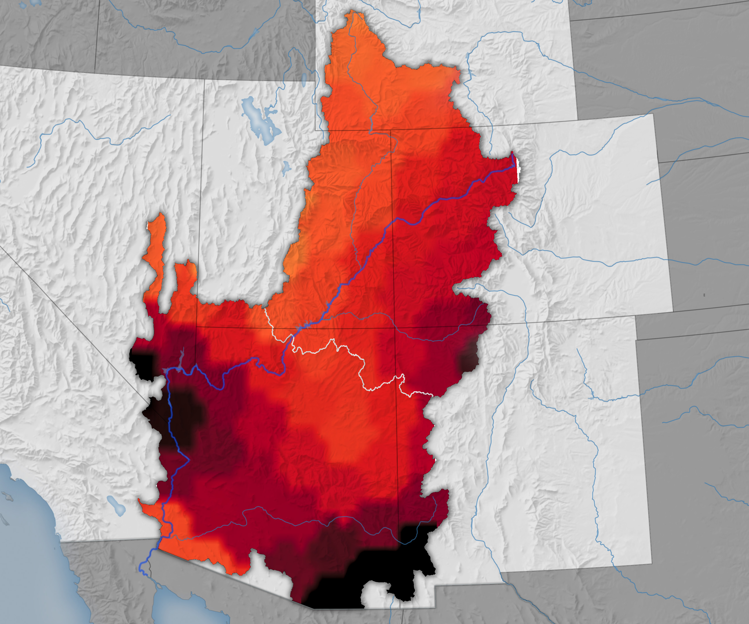


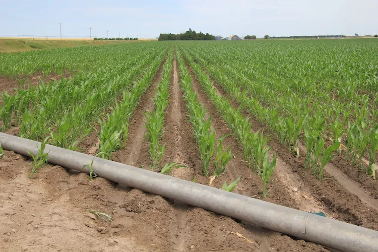
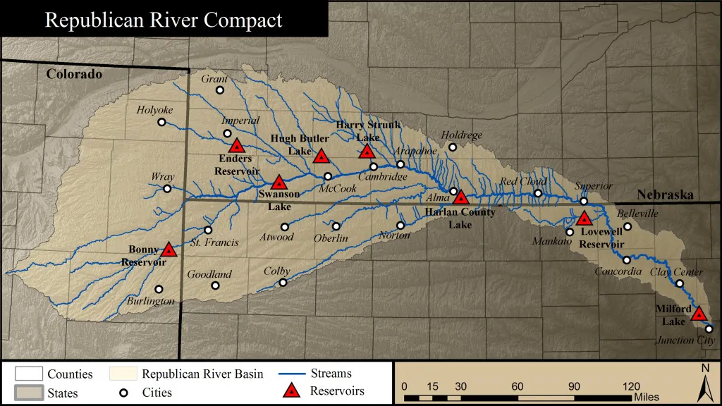
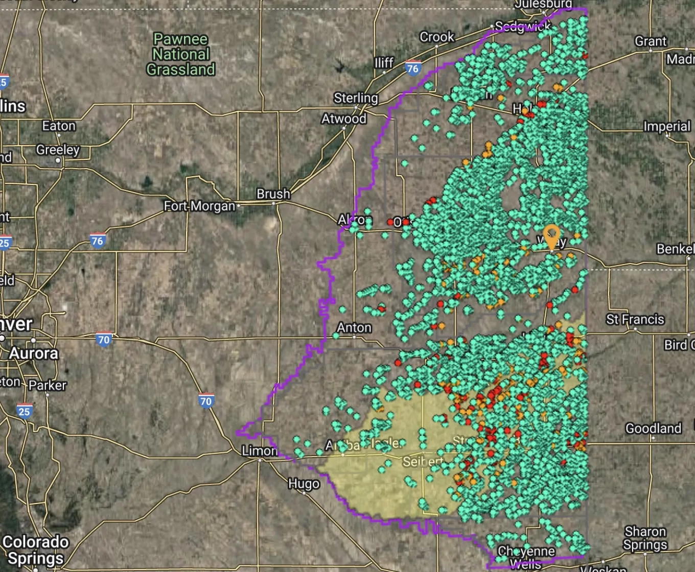


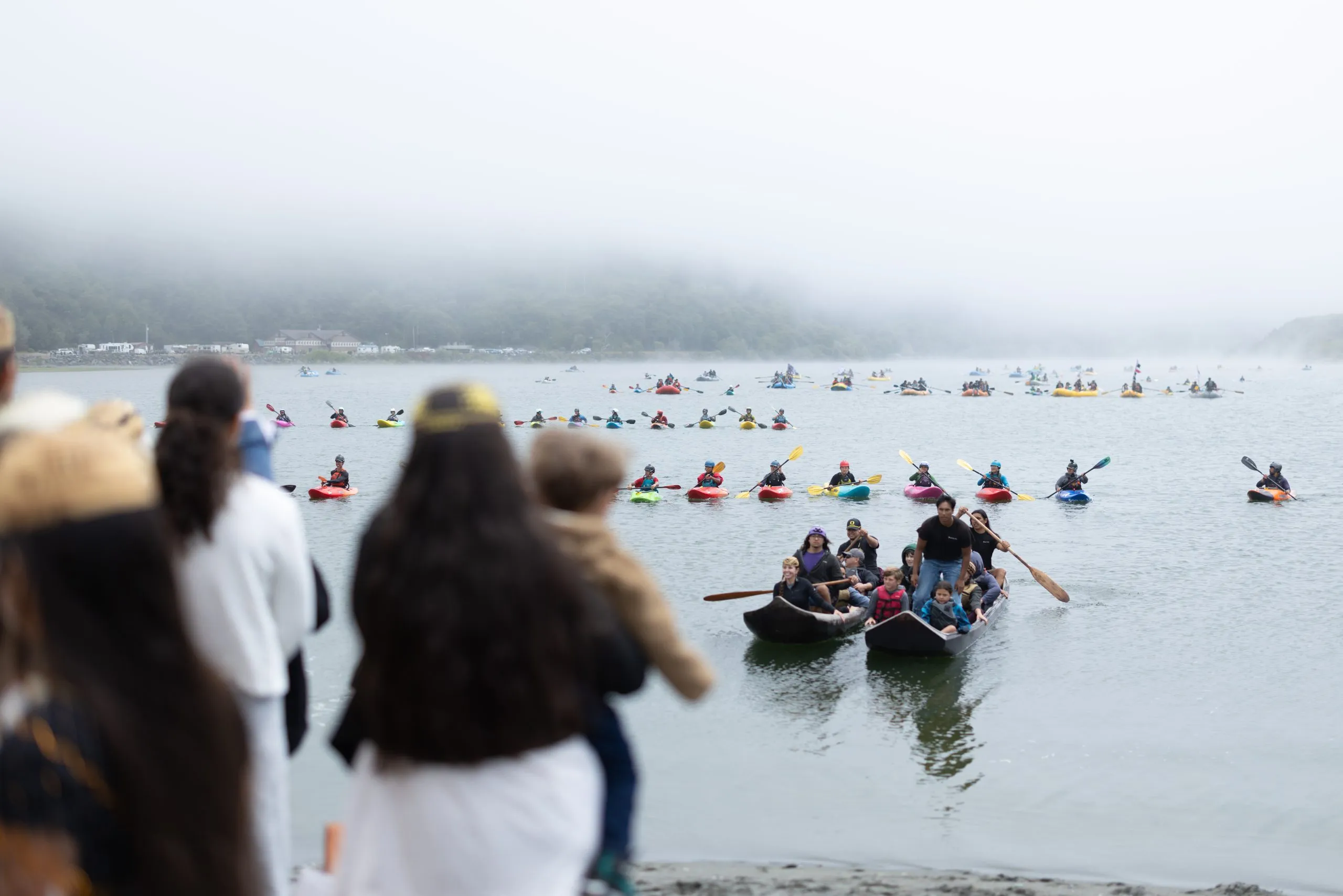

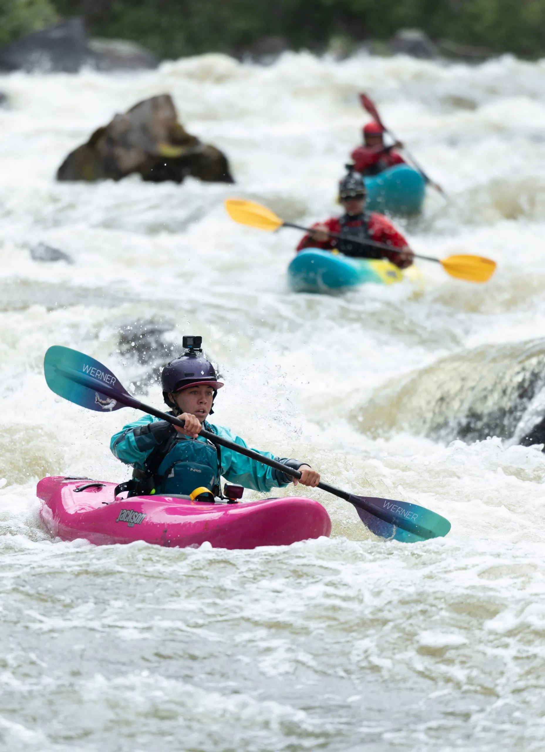

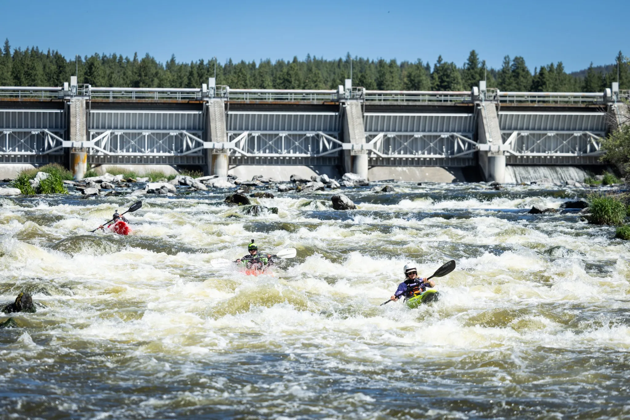
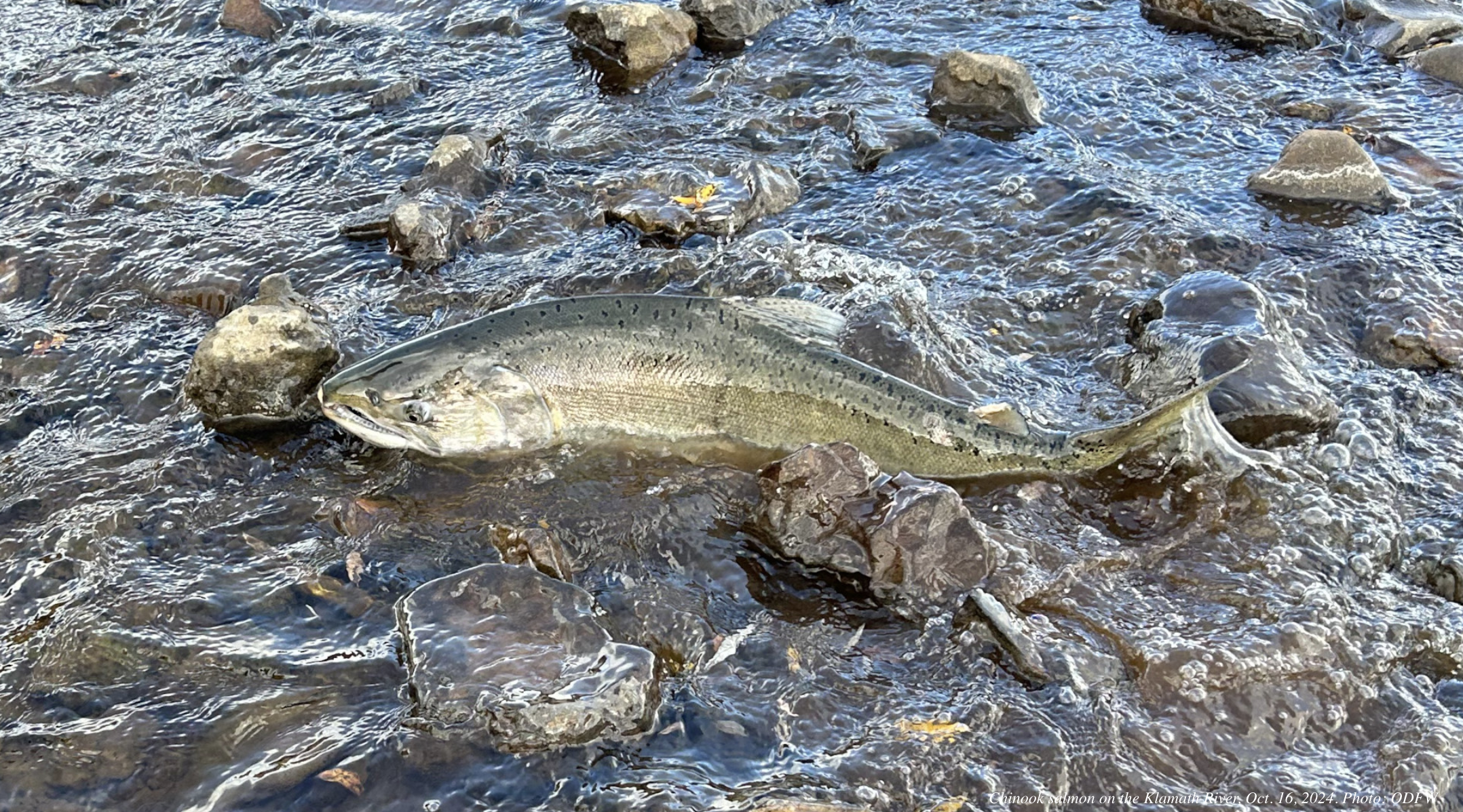


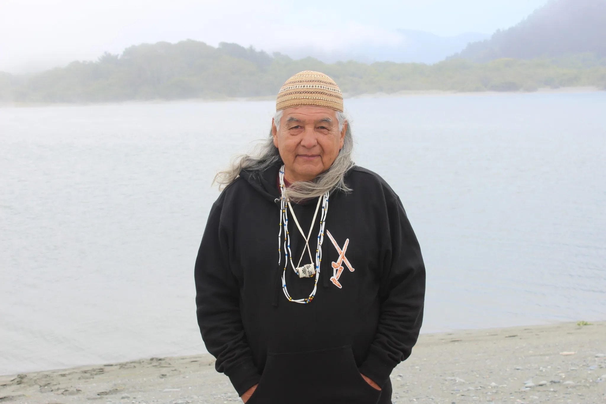

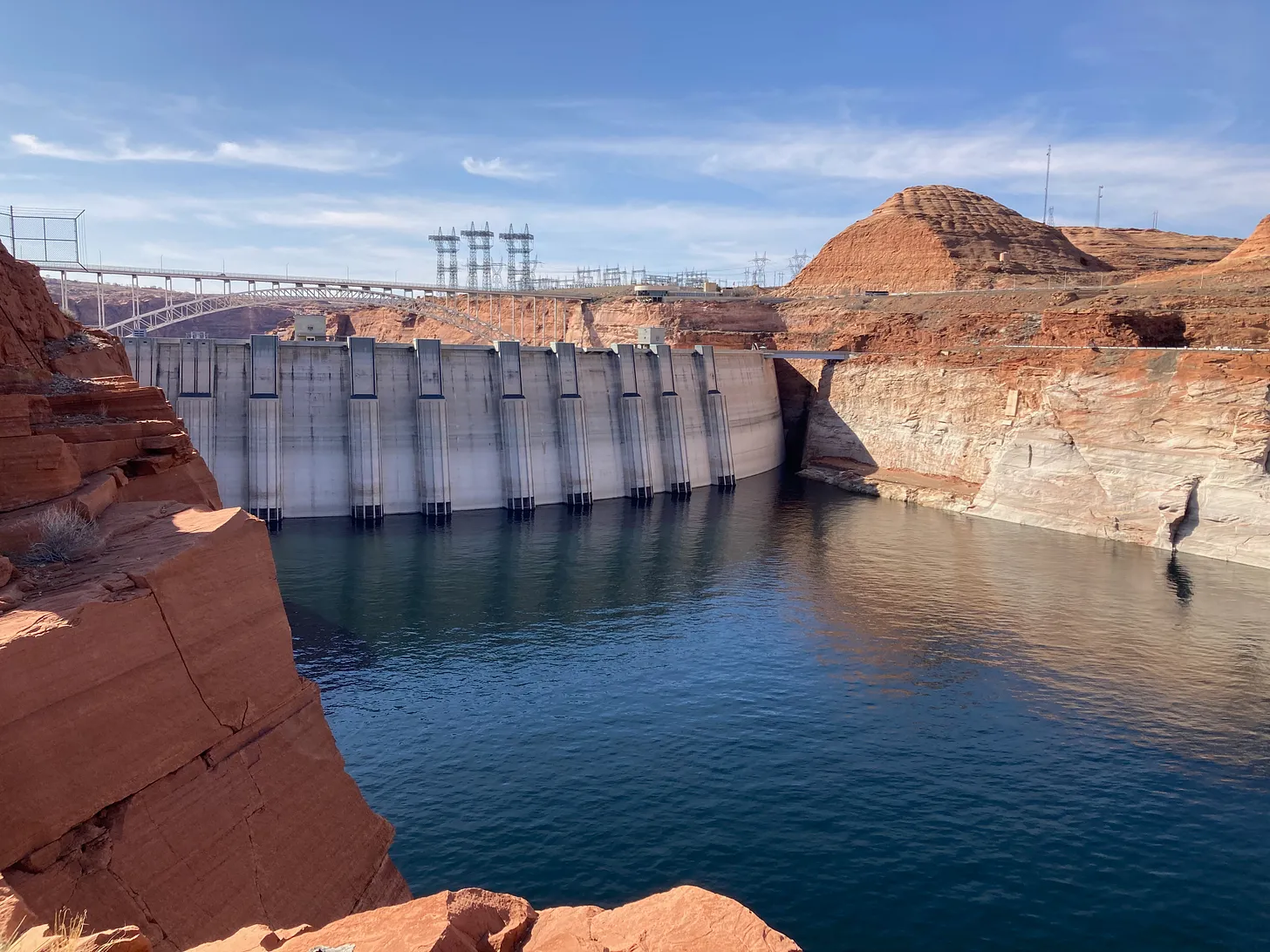
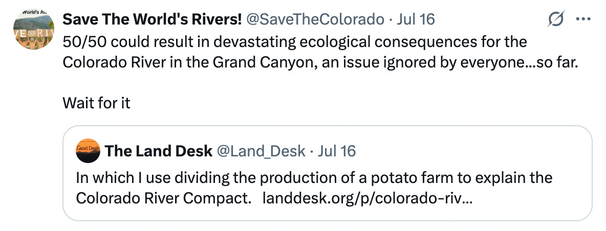
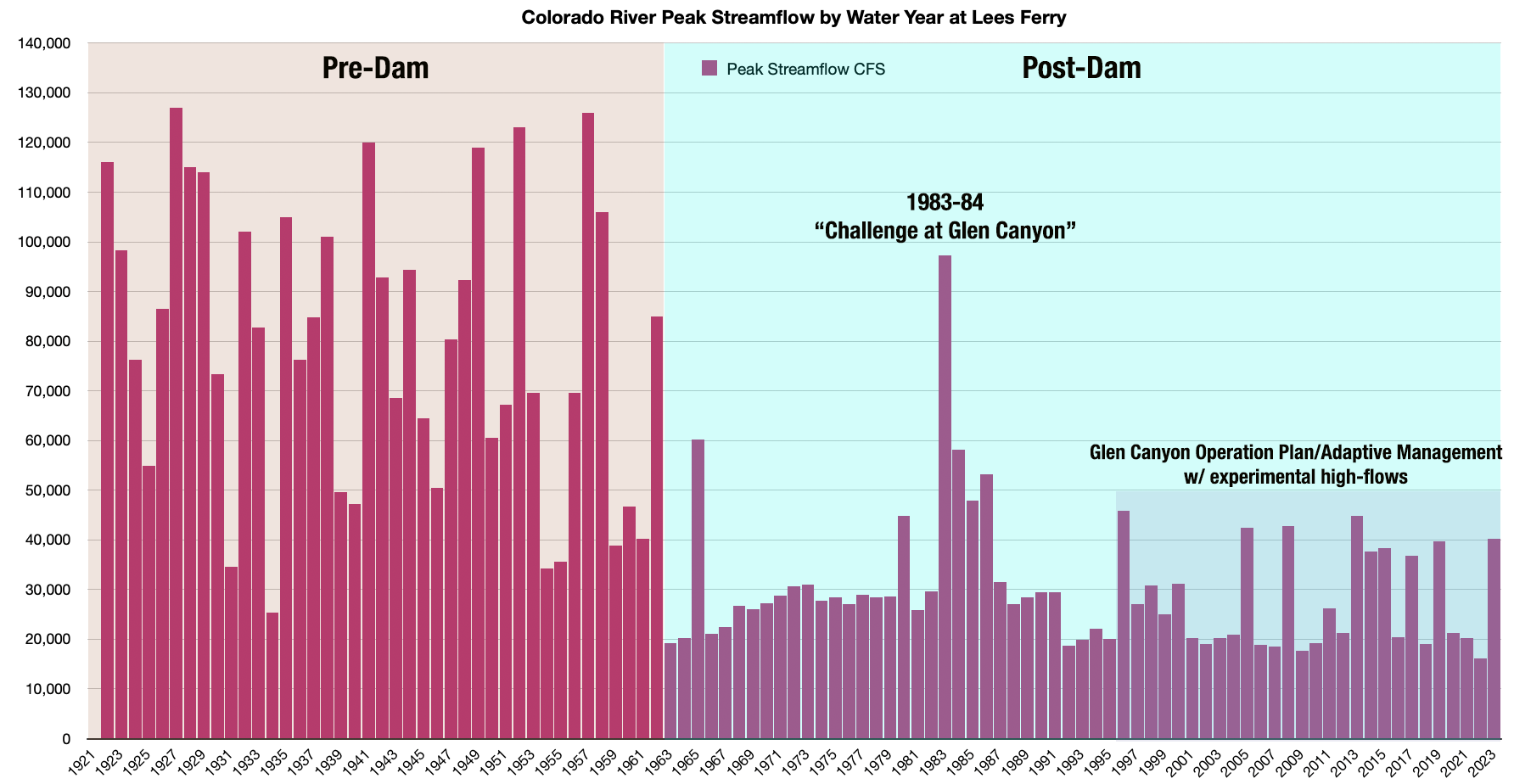


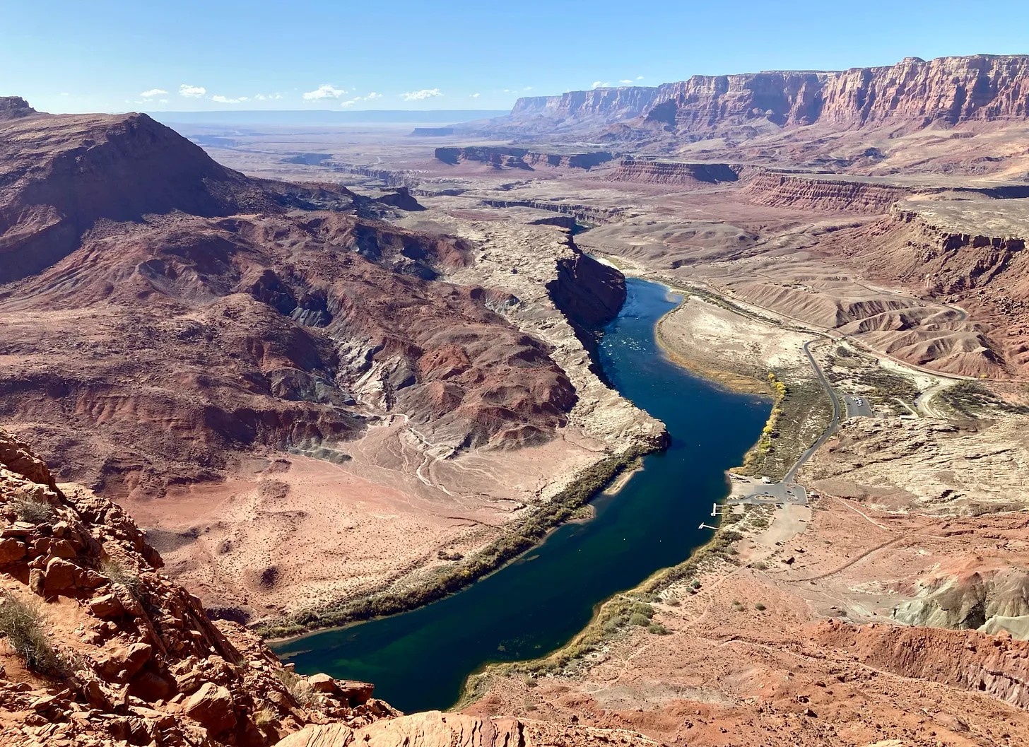

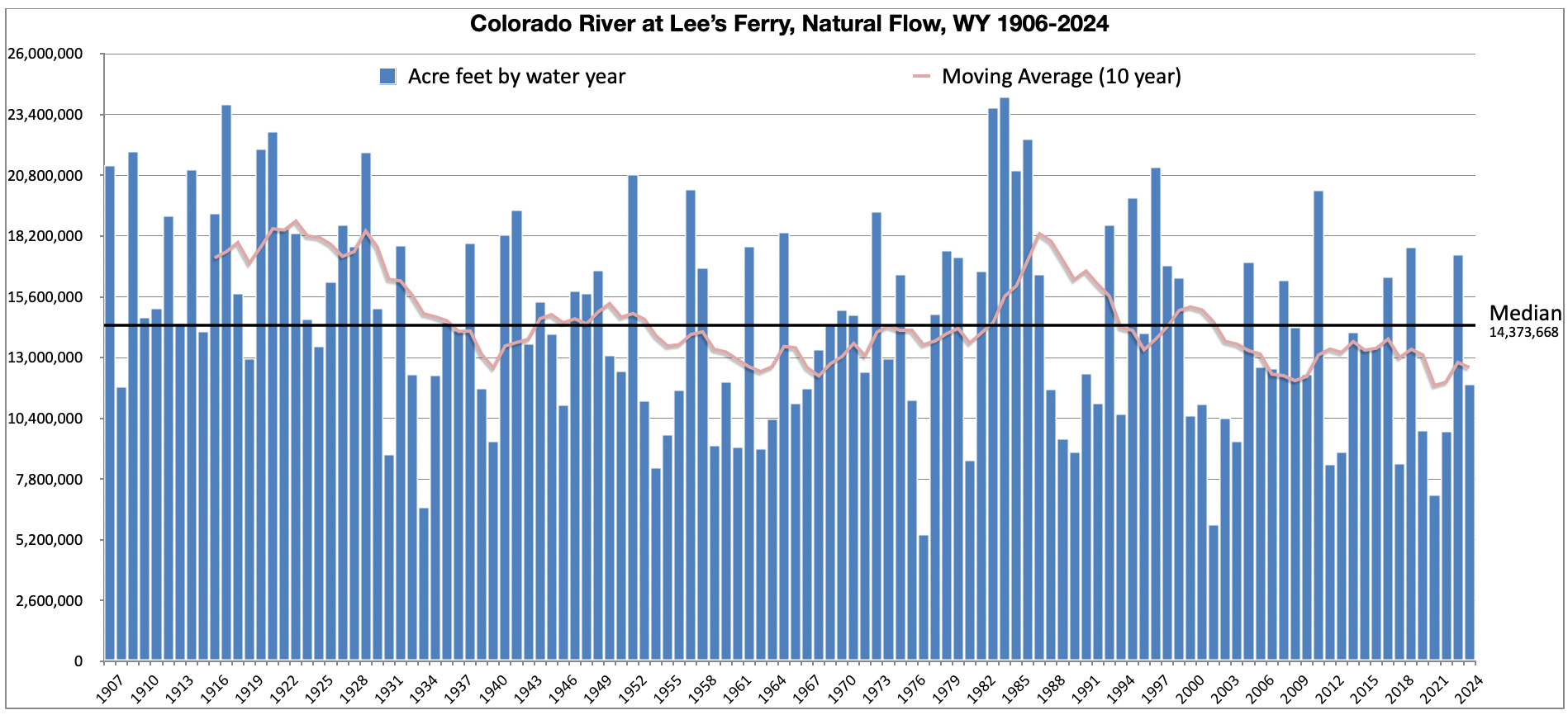
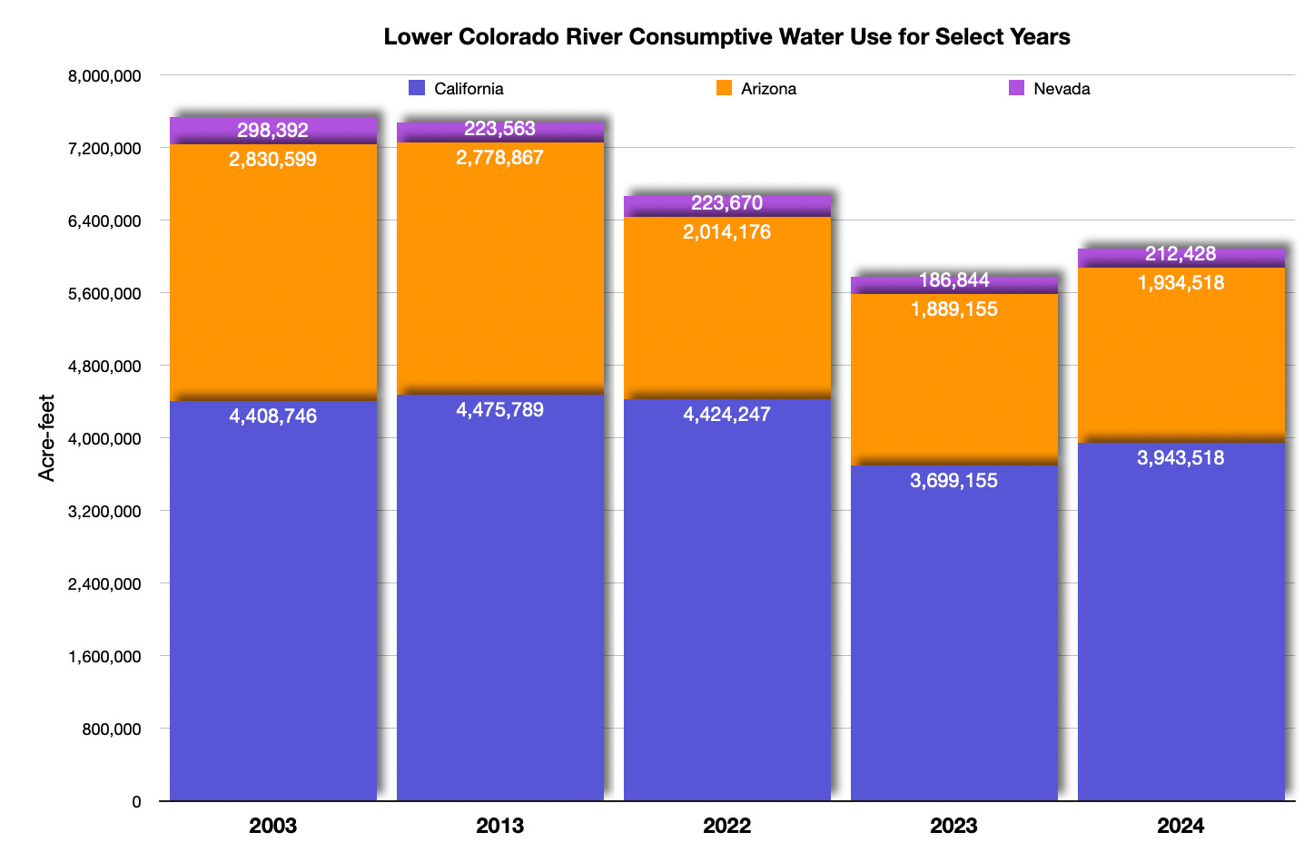

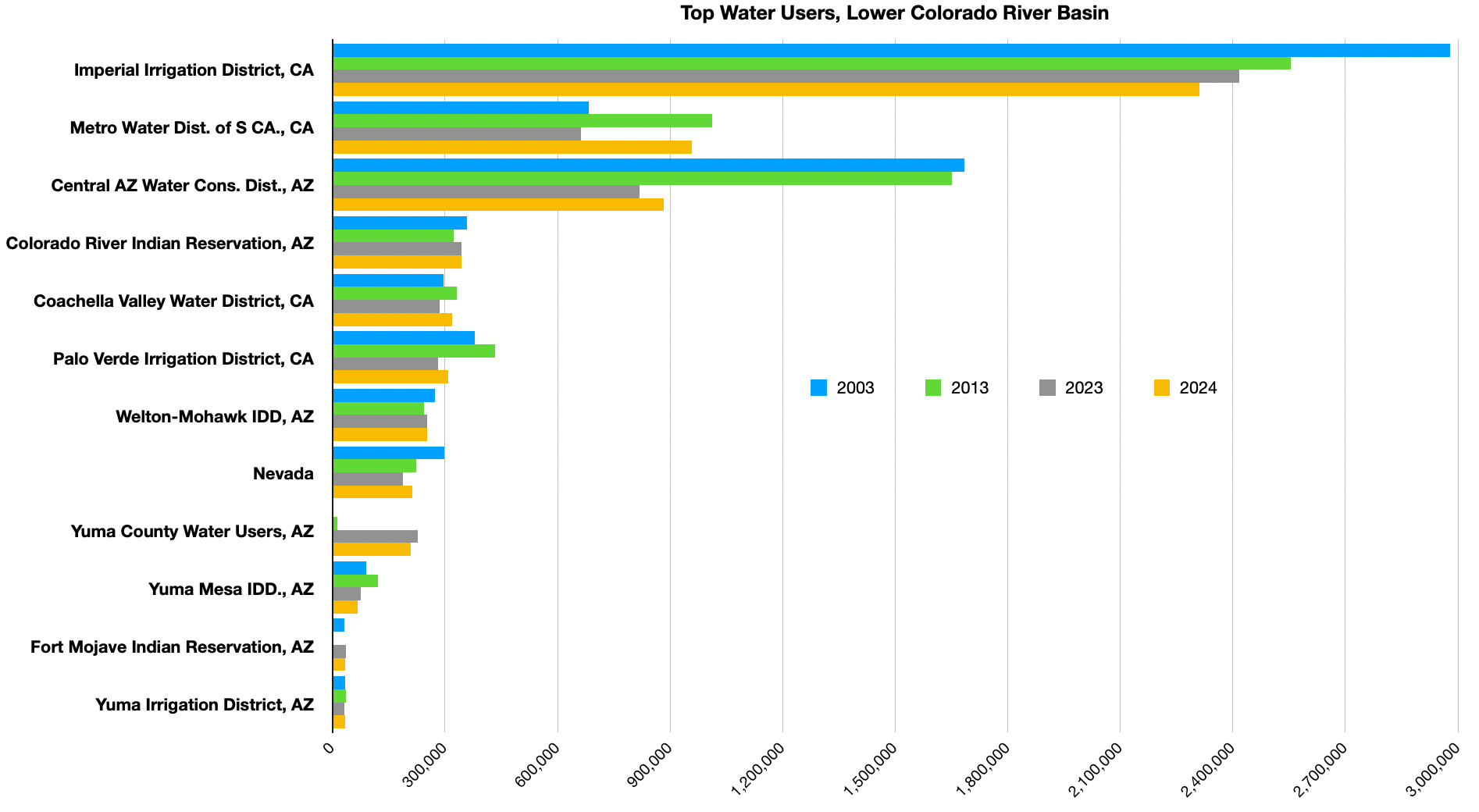


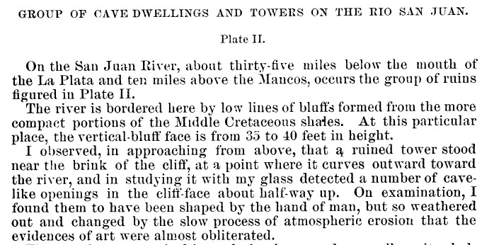


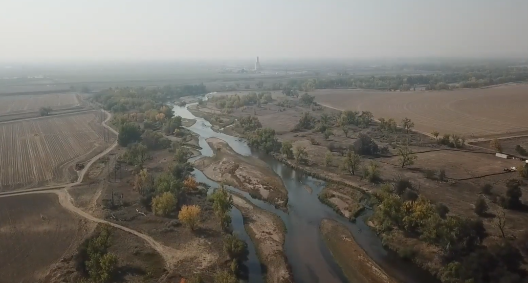


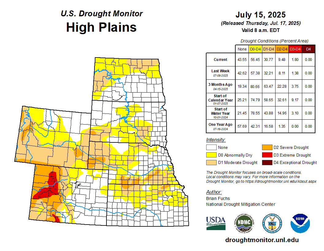


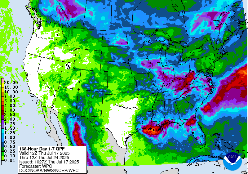

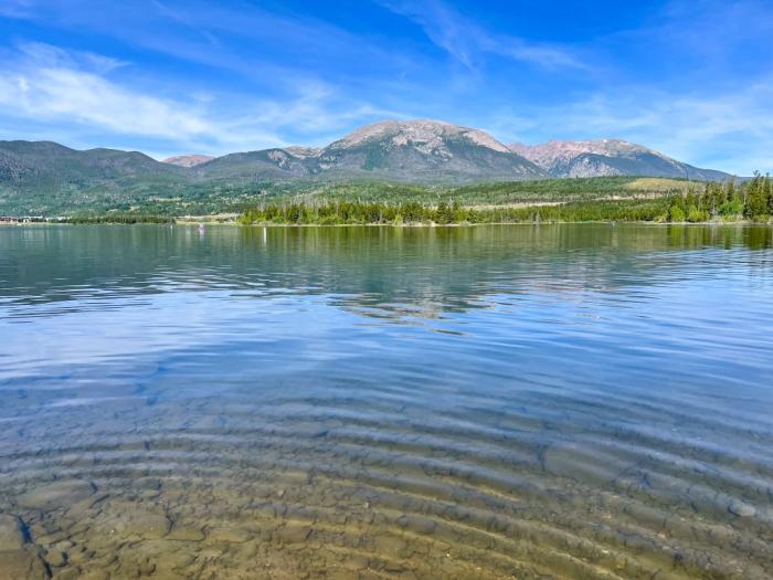


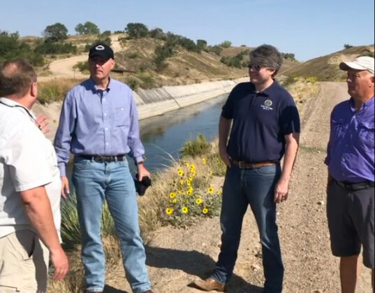


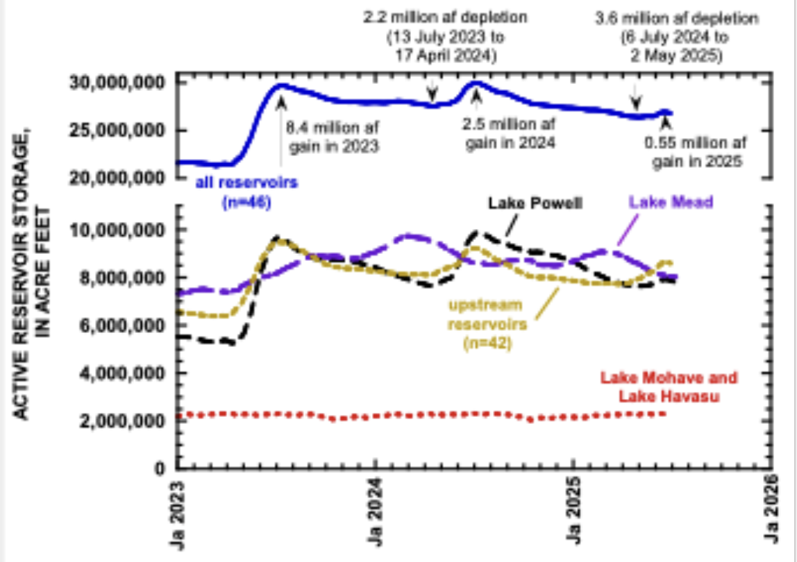
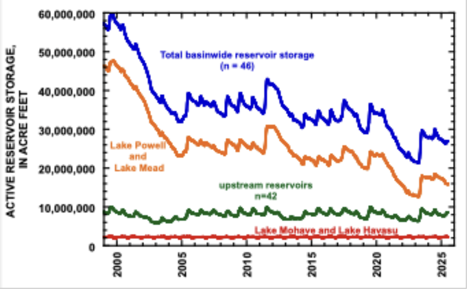

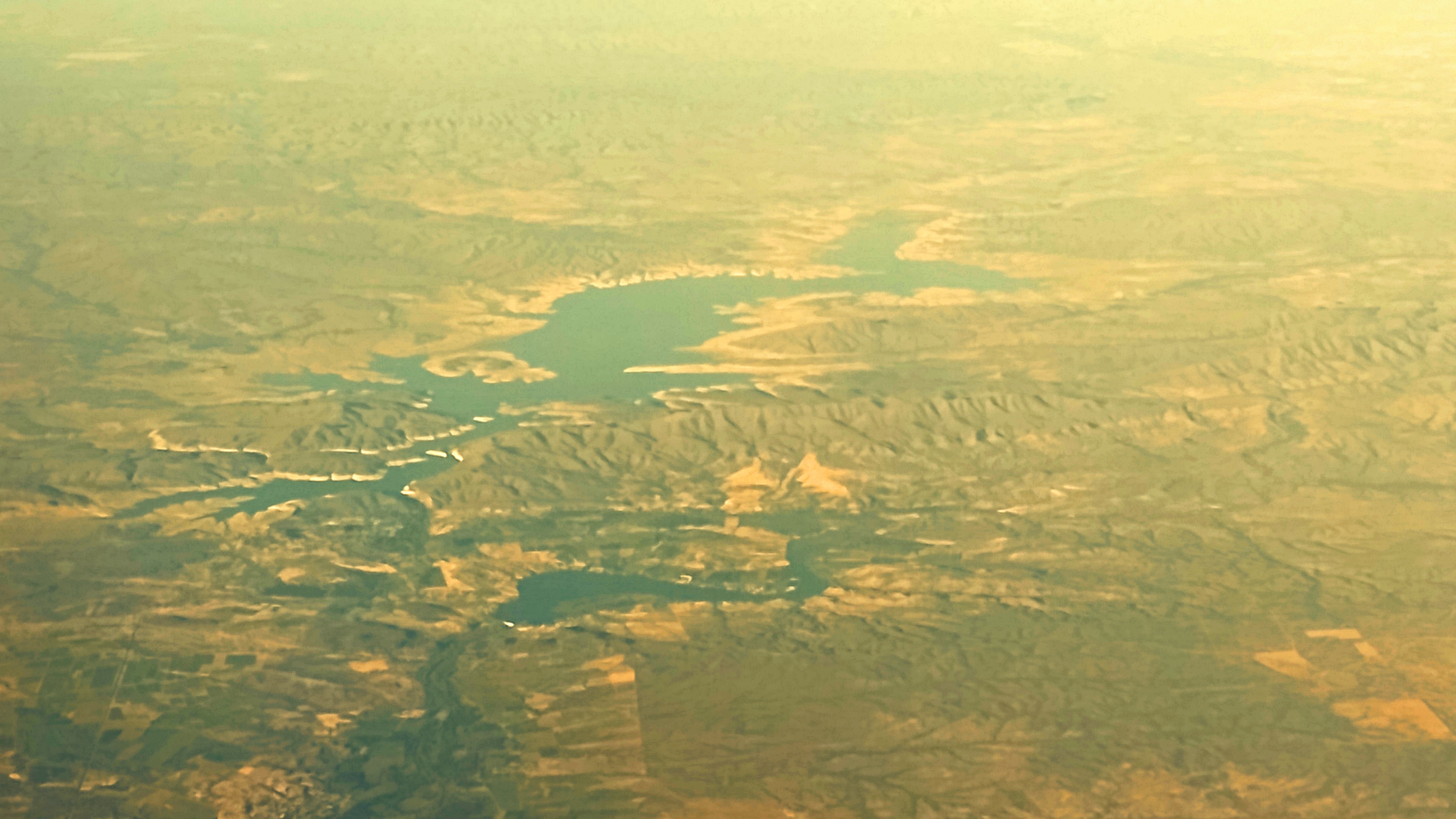

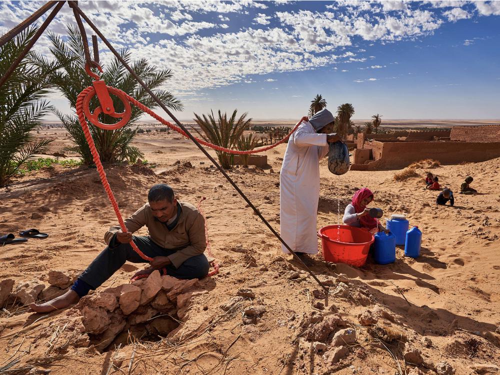


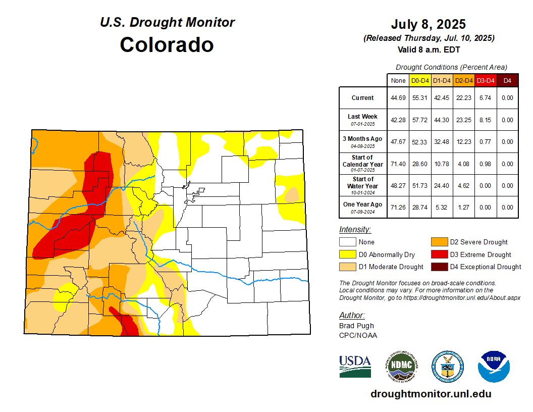

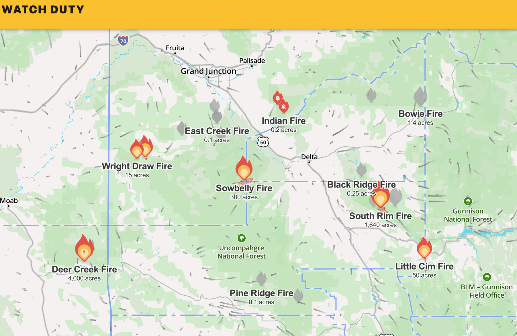
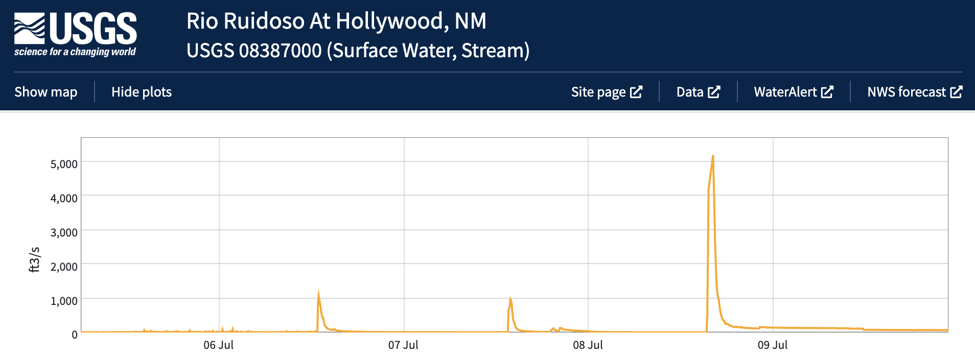
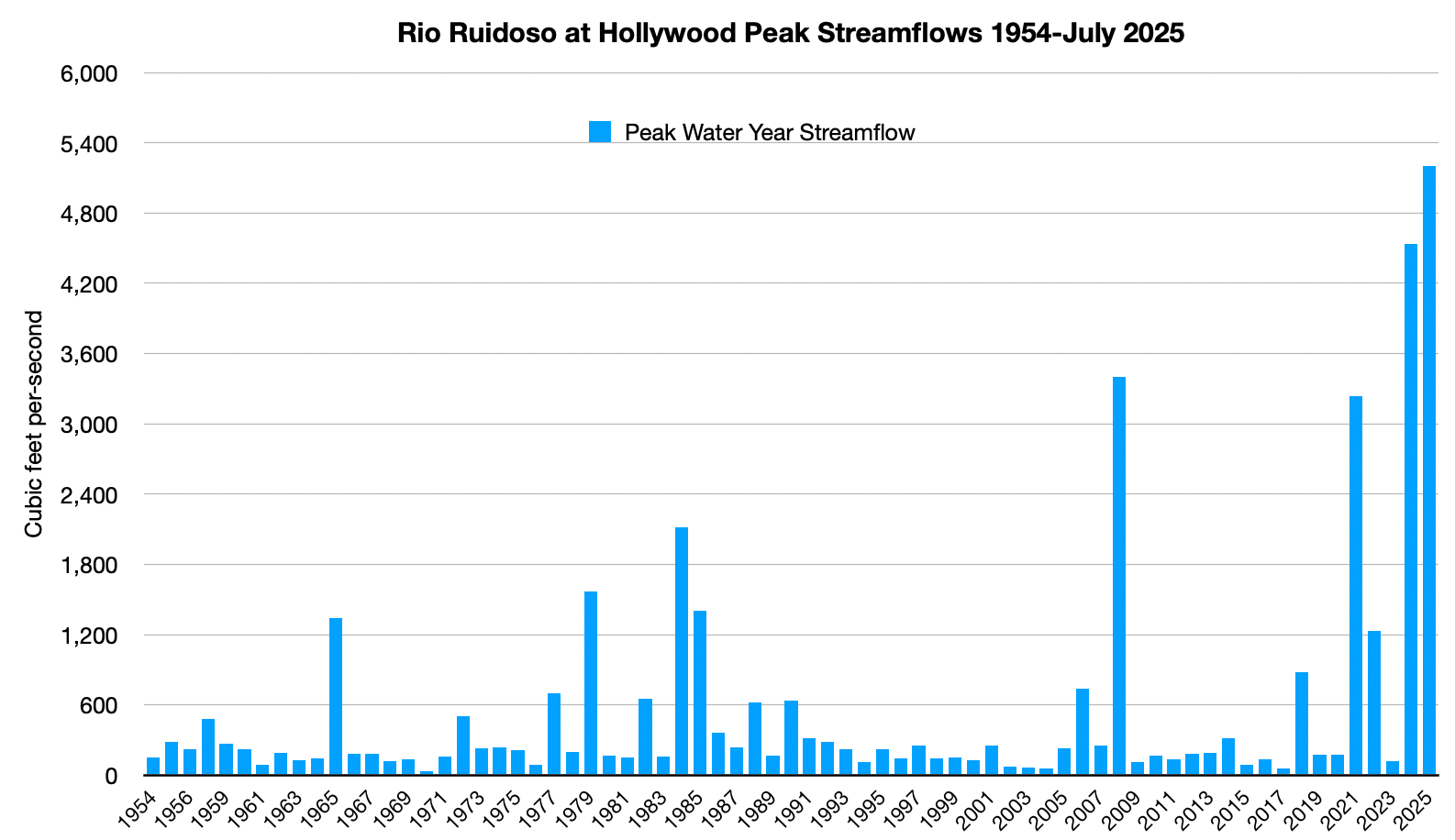


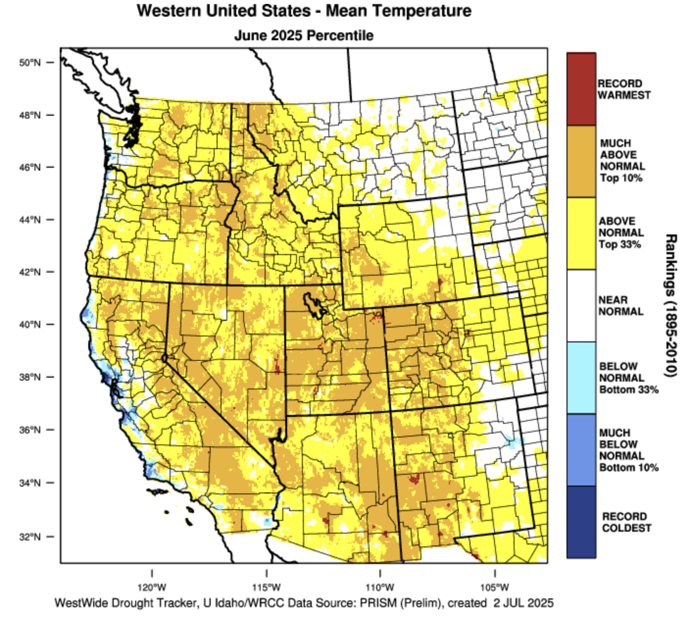
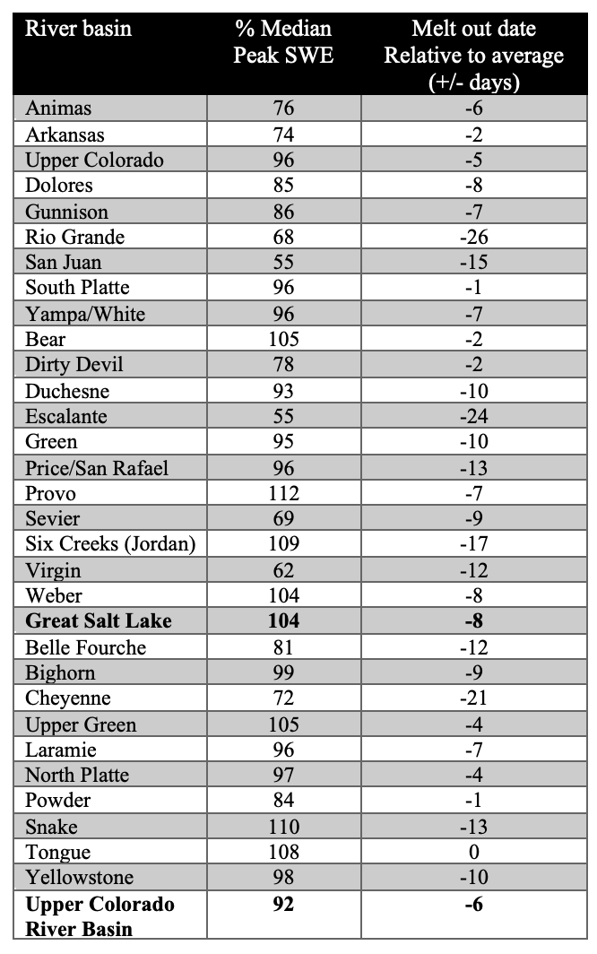
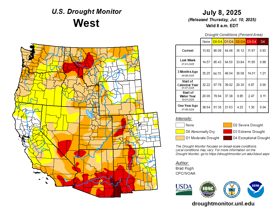
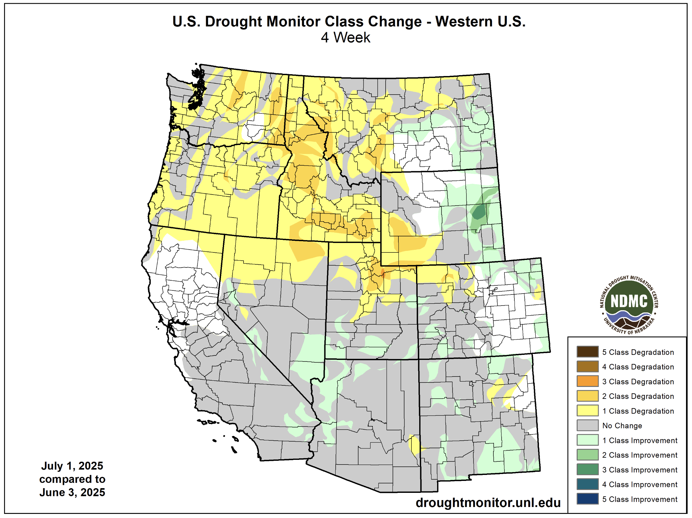
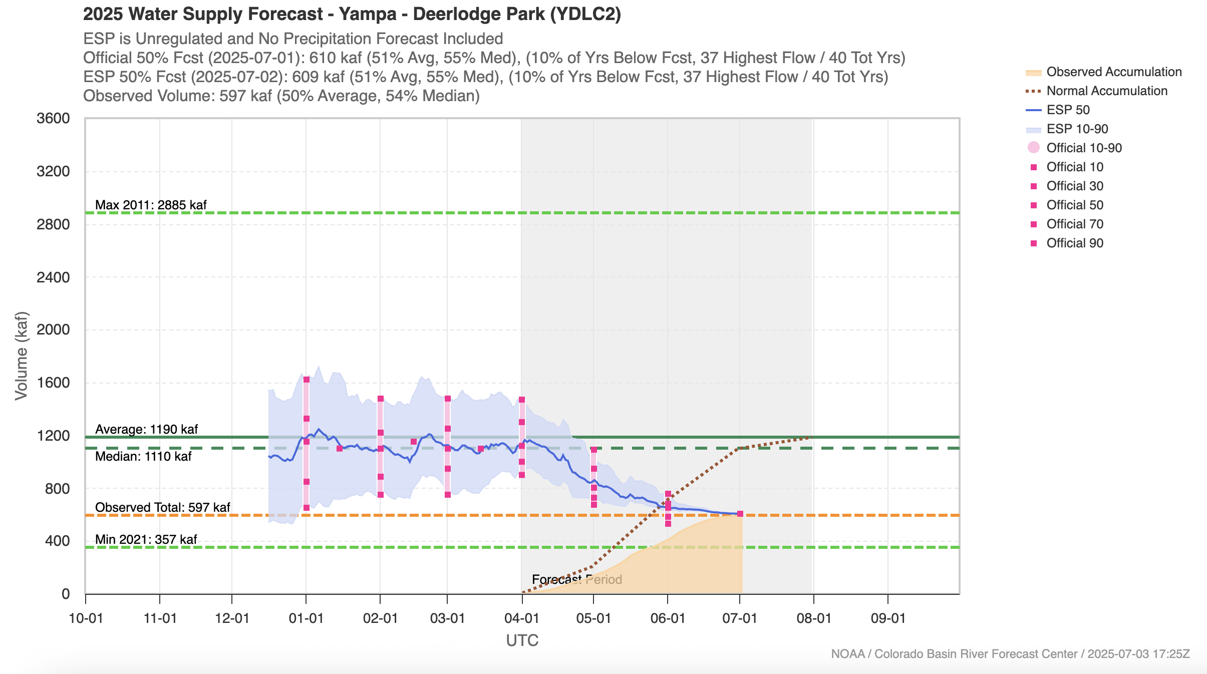

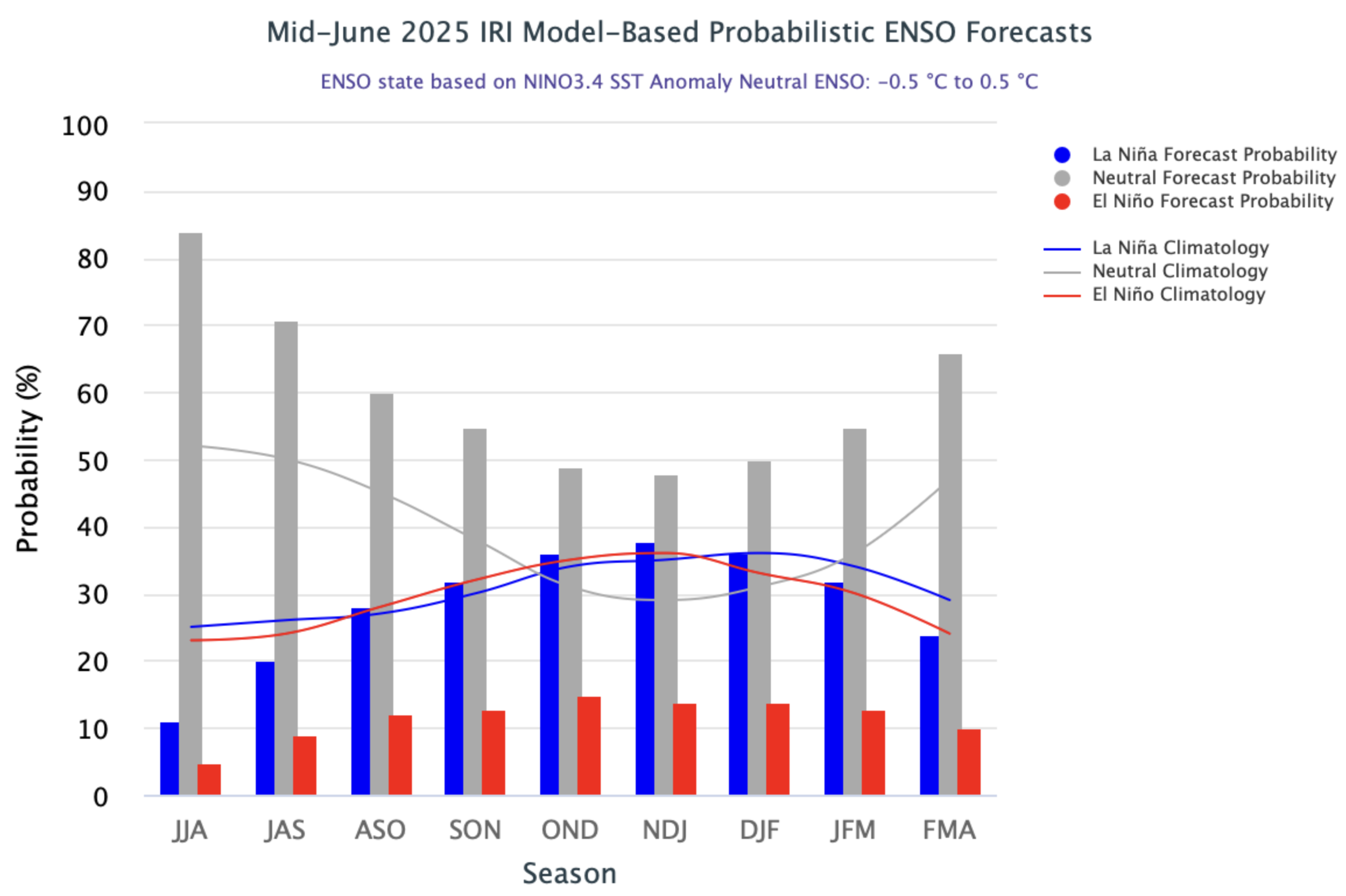
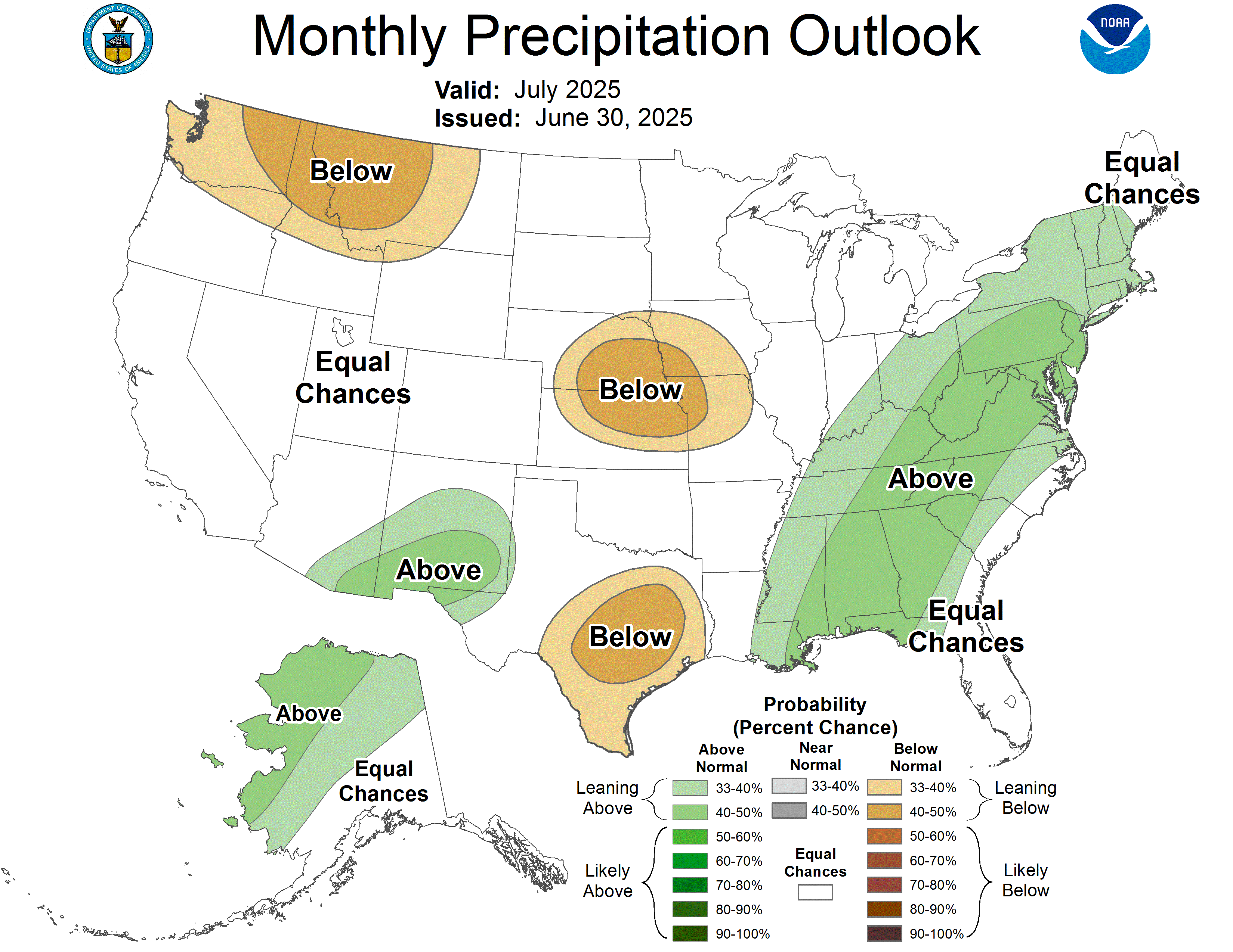
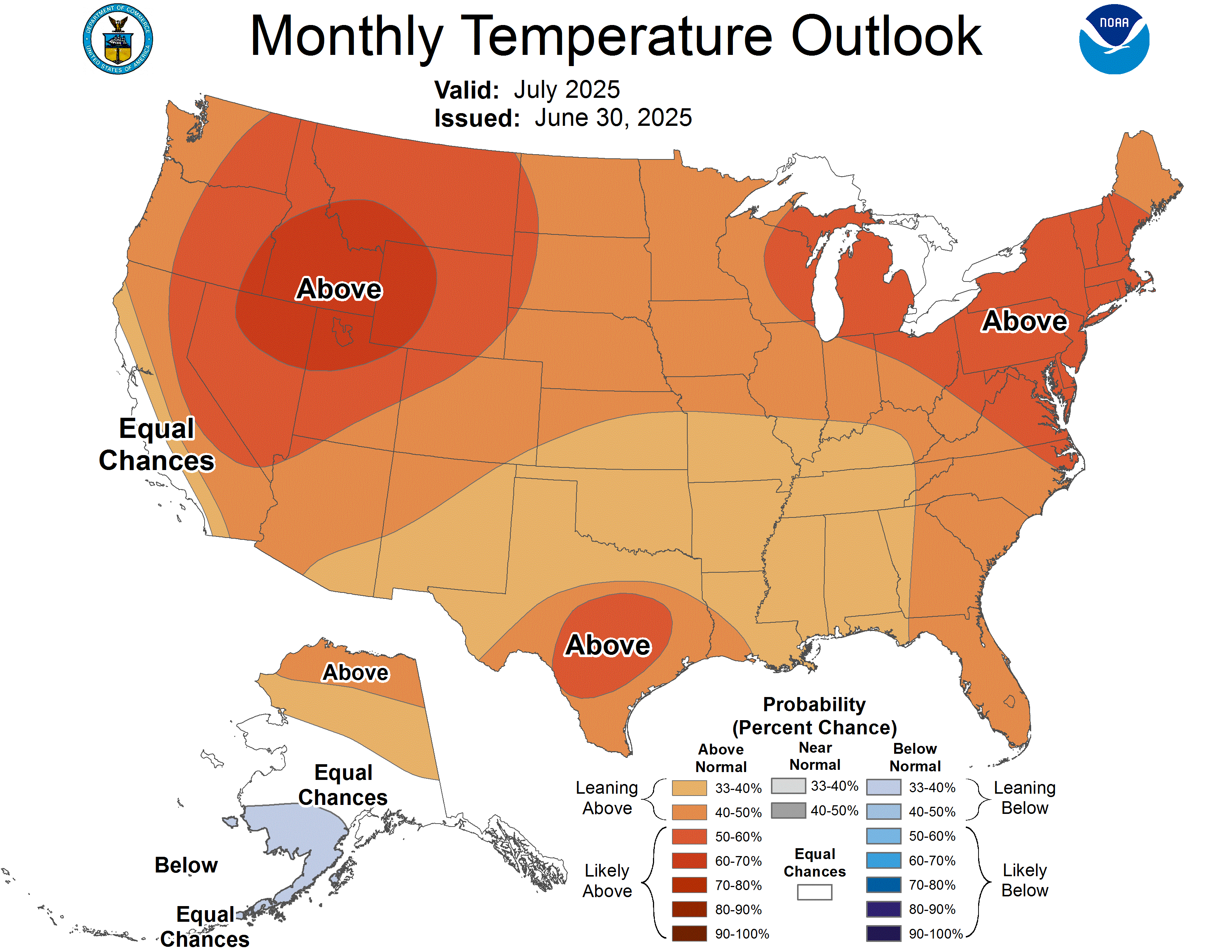
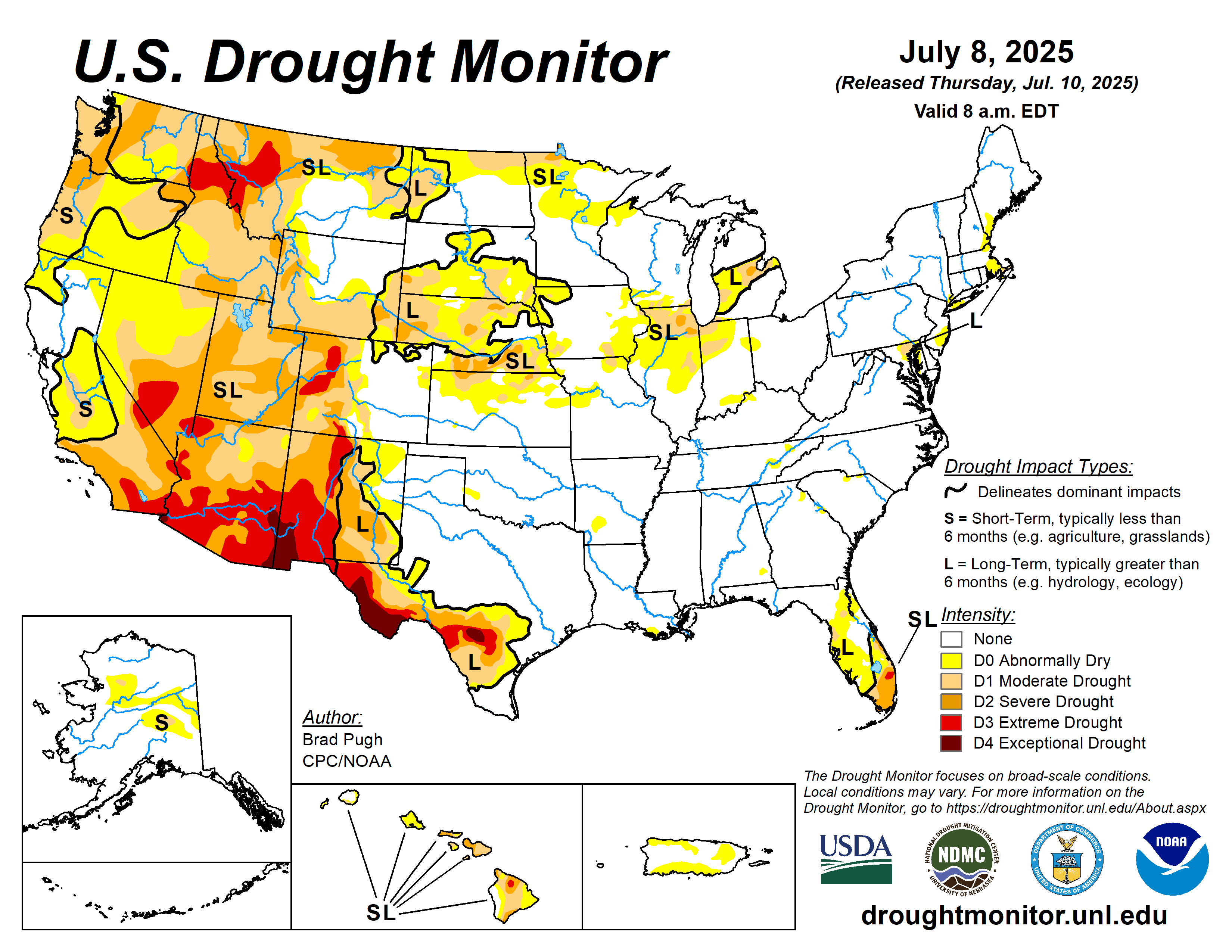

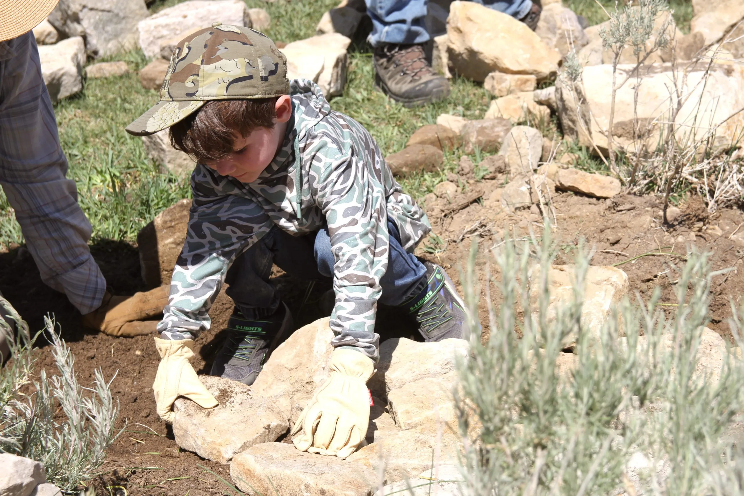
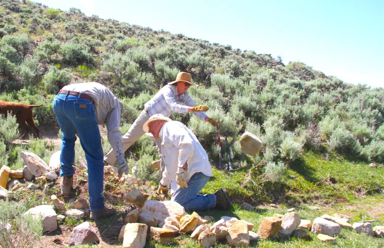


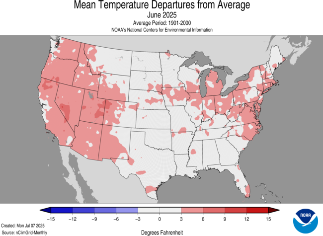
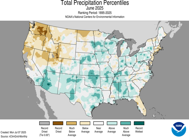
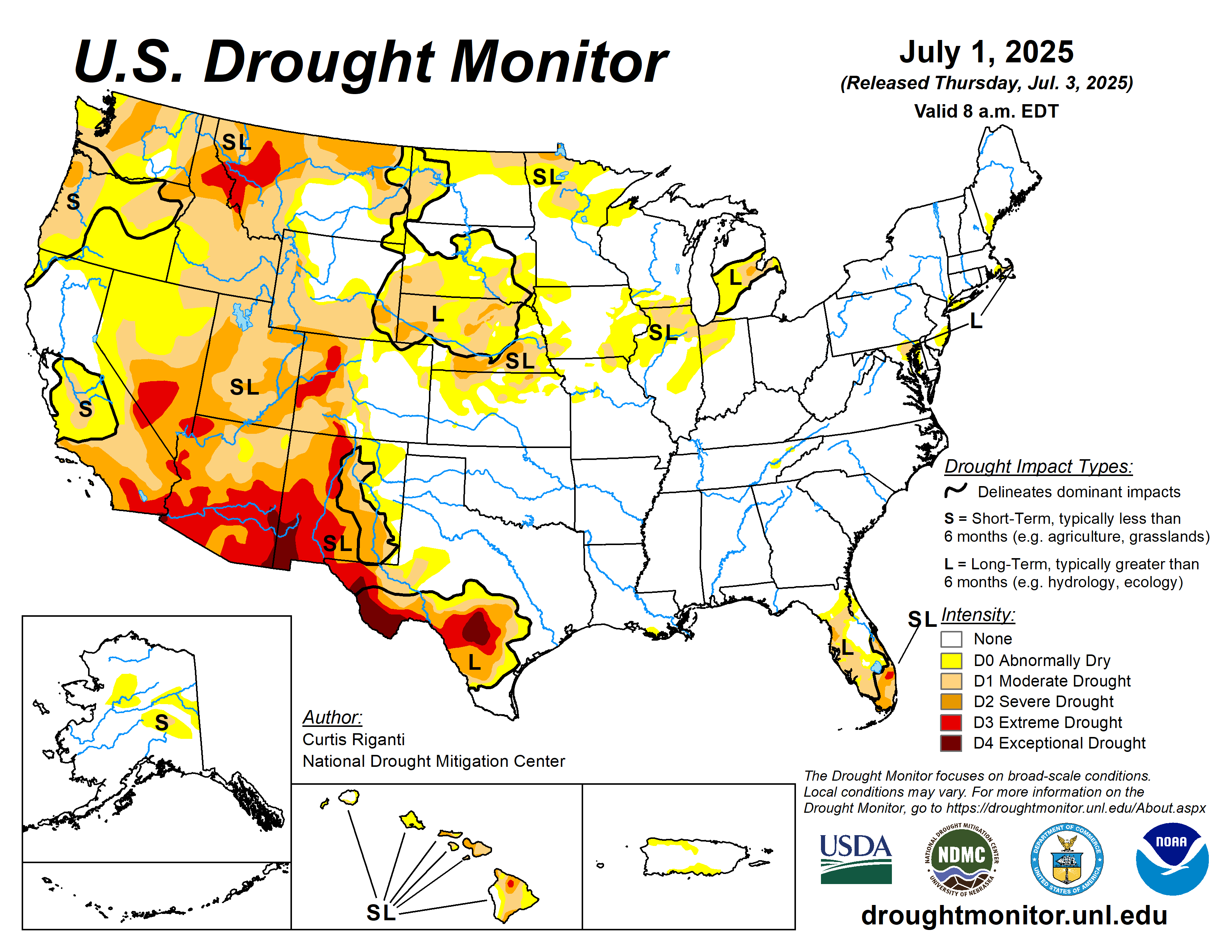
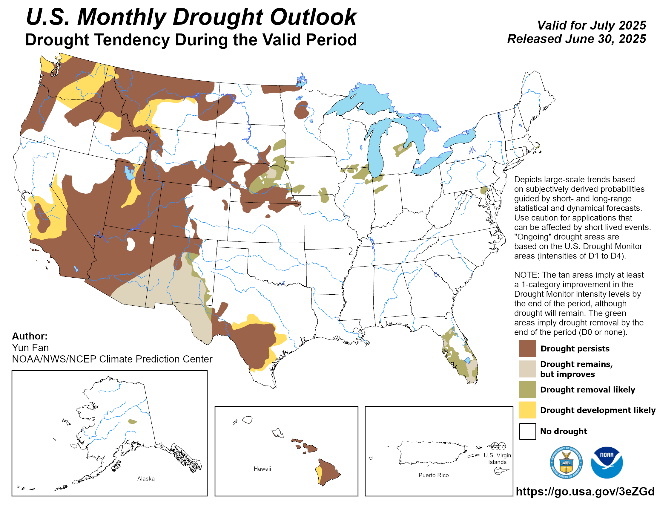


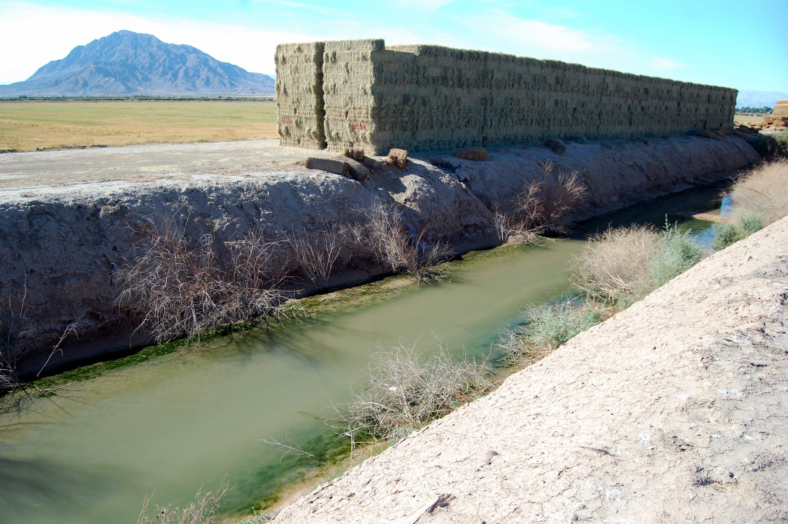


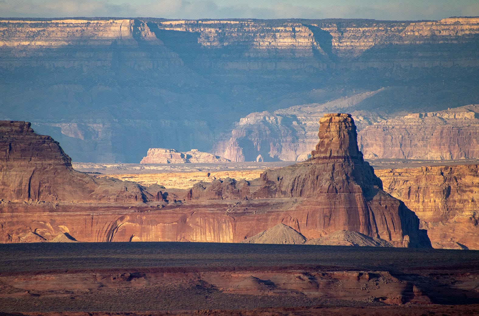


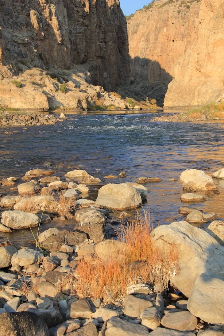


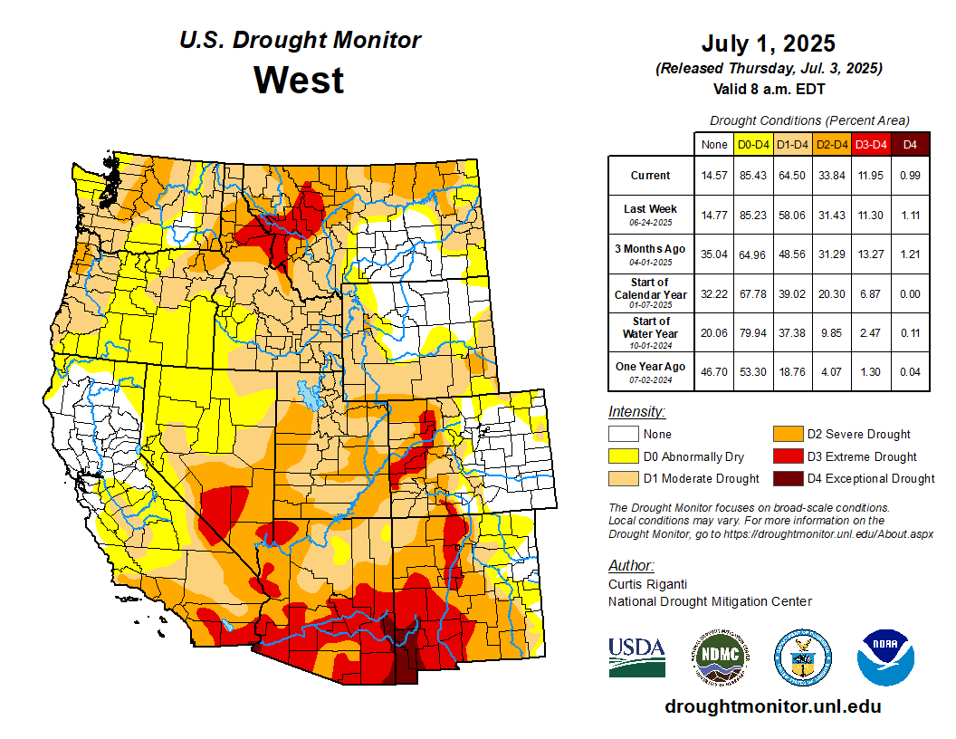
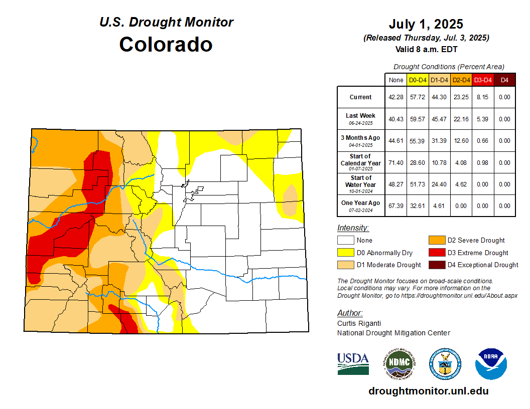
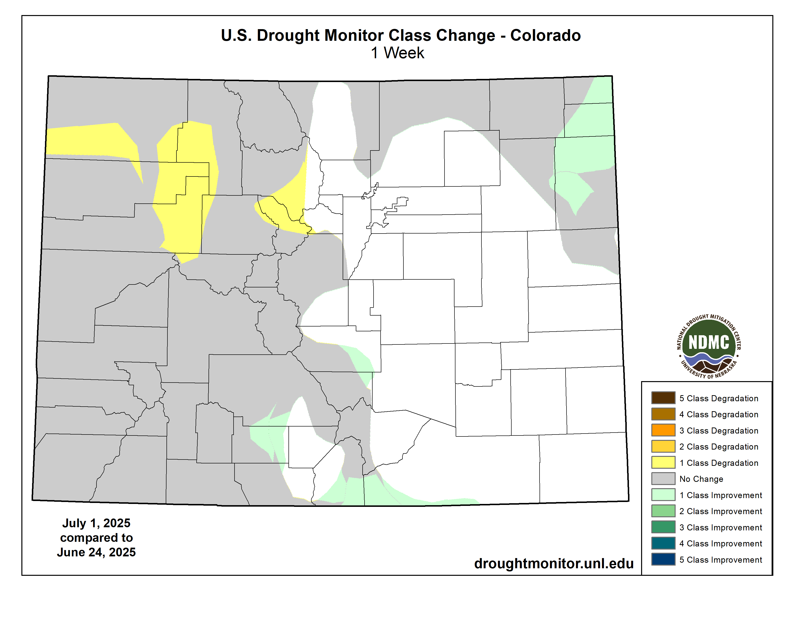
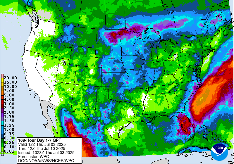


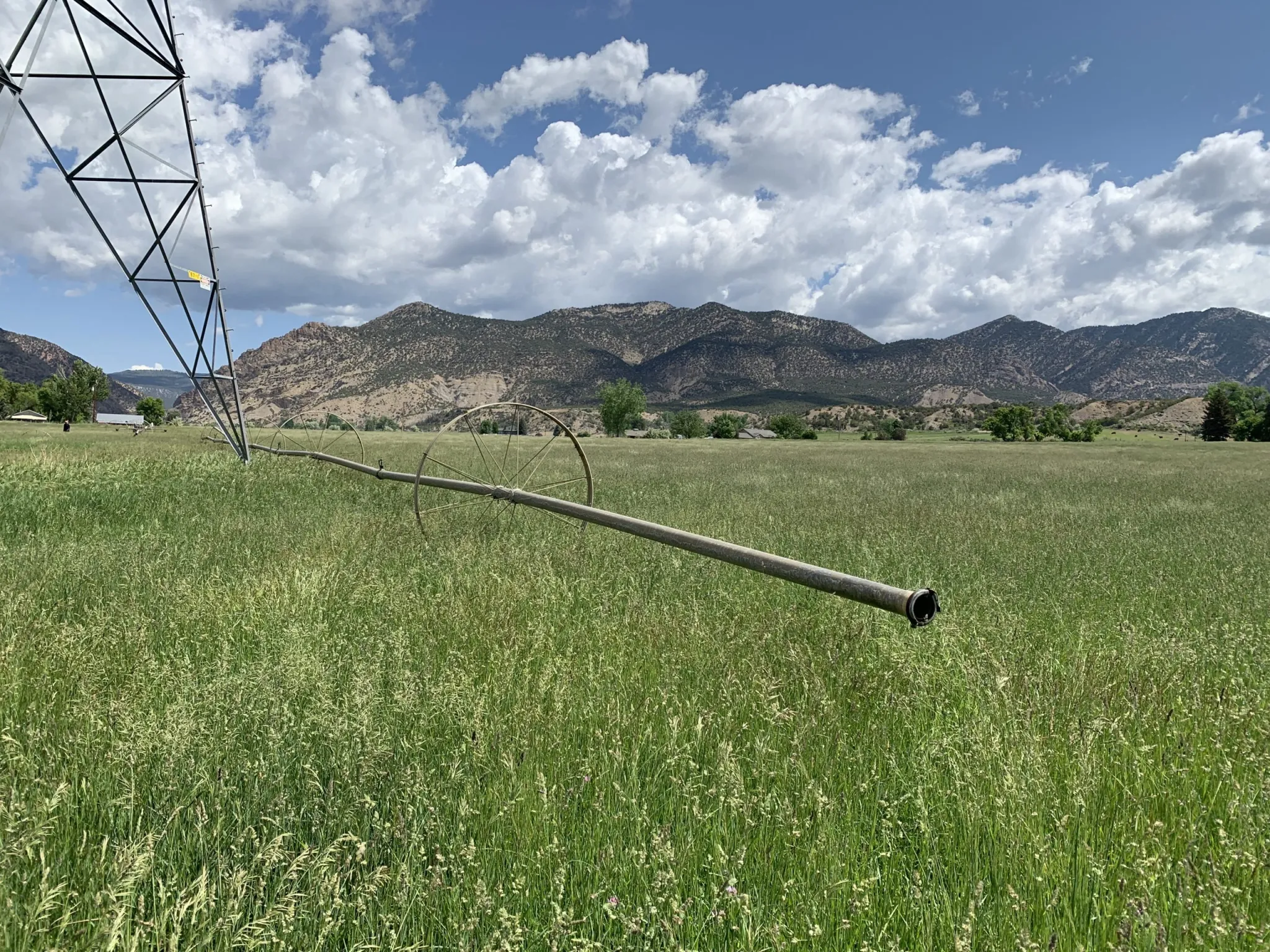

