Click on a thumbnail graphic to view a gallery of drought data from the US Drought Monitor website.
Click the link to go to the US Drought Monitor website. Here’s an excerpt:
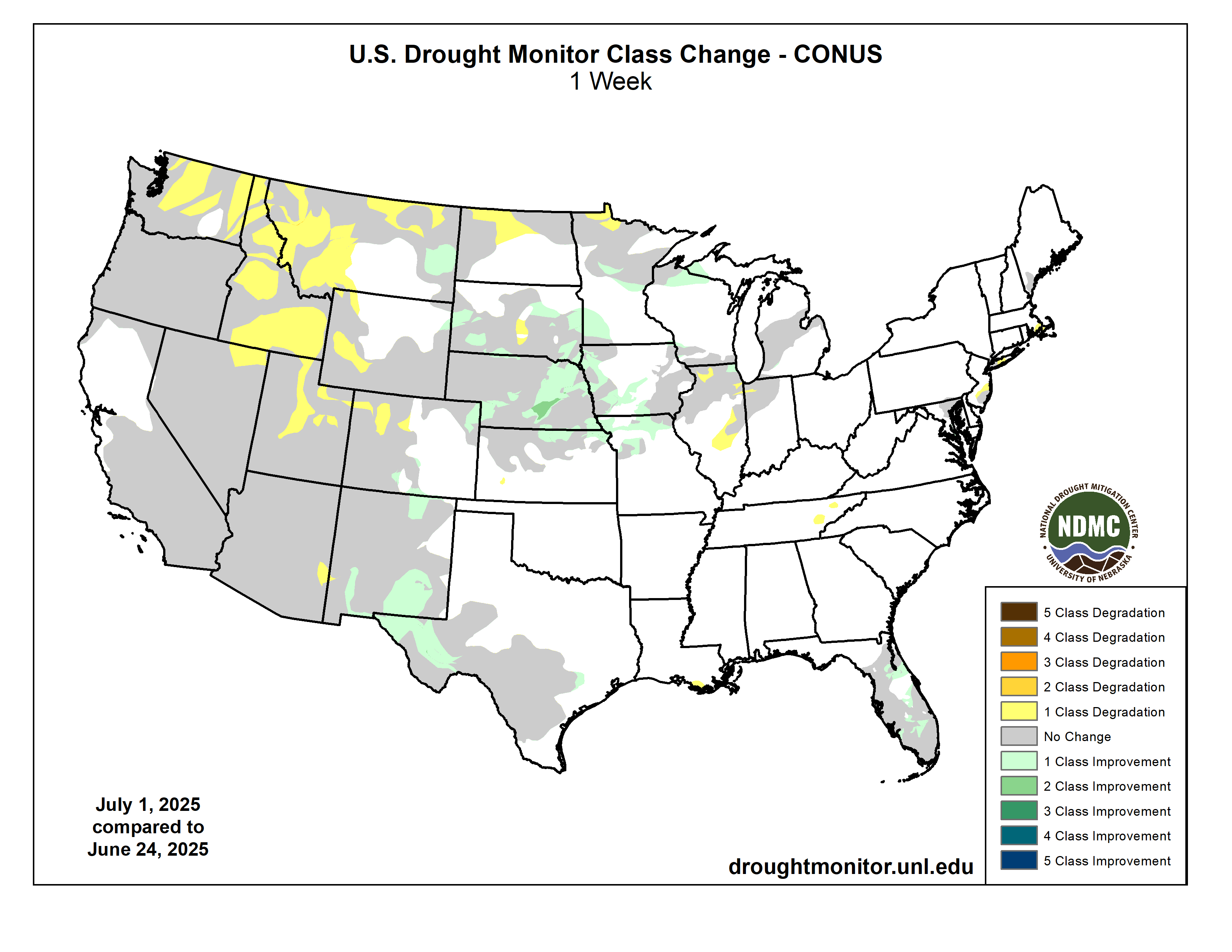
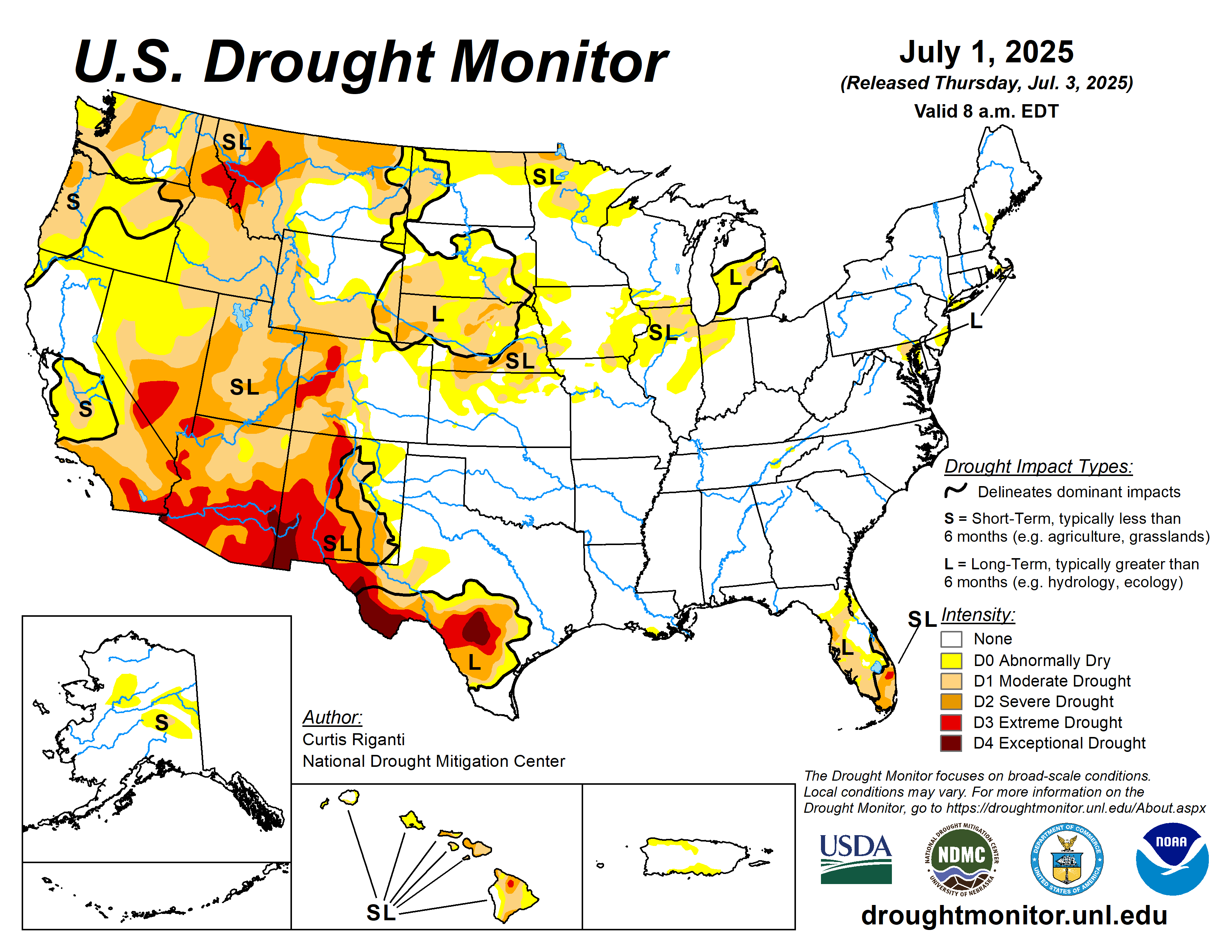
This Week’s Drought Summary
Over the past week, scattered heavy rains fell over parts of the central Great Plains and Upper Midwest. Rain amounts were especially heavy in parts of Nebraska and Minnesota, where locally 8 or more inches of rain fell. These rains helped to alleviate drought and abnormal dryness in some areas. A few areas of the Dakotas, Minnesota, Indiana and Illinois that missed heavier rains saw localized degradations. Heavy monsoonal rain and thunderstorms also occurred in parts of west Texas and New Mexico, leading to some improvements to ongoing drought and abnormal dryness there. Meanwhile, most areas west of the Continental Divide remained dry or mostly dry. This continued dry weather led to further degradation in drought and abnormal dryness, especially in the Northwest, where severe and extreme drought developed or expanded in coverage. Conditions in the Southeast and central Gulf Coast were mostly quiet this week, though a few areas in east Tennessee and southern Louisiana saw localized abnormal dryness develop given short-term precipitation deficits and declining soil moisture. Heavier rains fell across parts of Florida, leading to some reduction in drought and abnormal dryness coverage in the Florida Peninsula. Well-above-normal temperatures occurred in the Ohio Valley, Mid-Atlantic and Lower Great Lakes regions, where temperatures ranging from 4-8 degrees above normal, and locally 10 degrees hotter than normal, were common. The Northwest was also warmer than normal this week, with most areas checking in with warm anomalies of 2-6 degrees. Southeast New Mexico and west Texas finished the week 2-8 degrees cooler than normal owing to rain and clouds from the North American Monsoon, which became much more active this week.
A mix of improvements and degradations occurred across Hawaii, where vegetation and streamflows responded to recent rainfall or lack thereof.
Scattered heavier showers fell across parts of Alaska, while some locations that missed out saw fire danger increase, leading to a mix of improvements and degradations.
Short-term rainfall deficits continued to build in north-central and south-central Puerto Rico, leading to localized increases in abnormal dryness coverage…
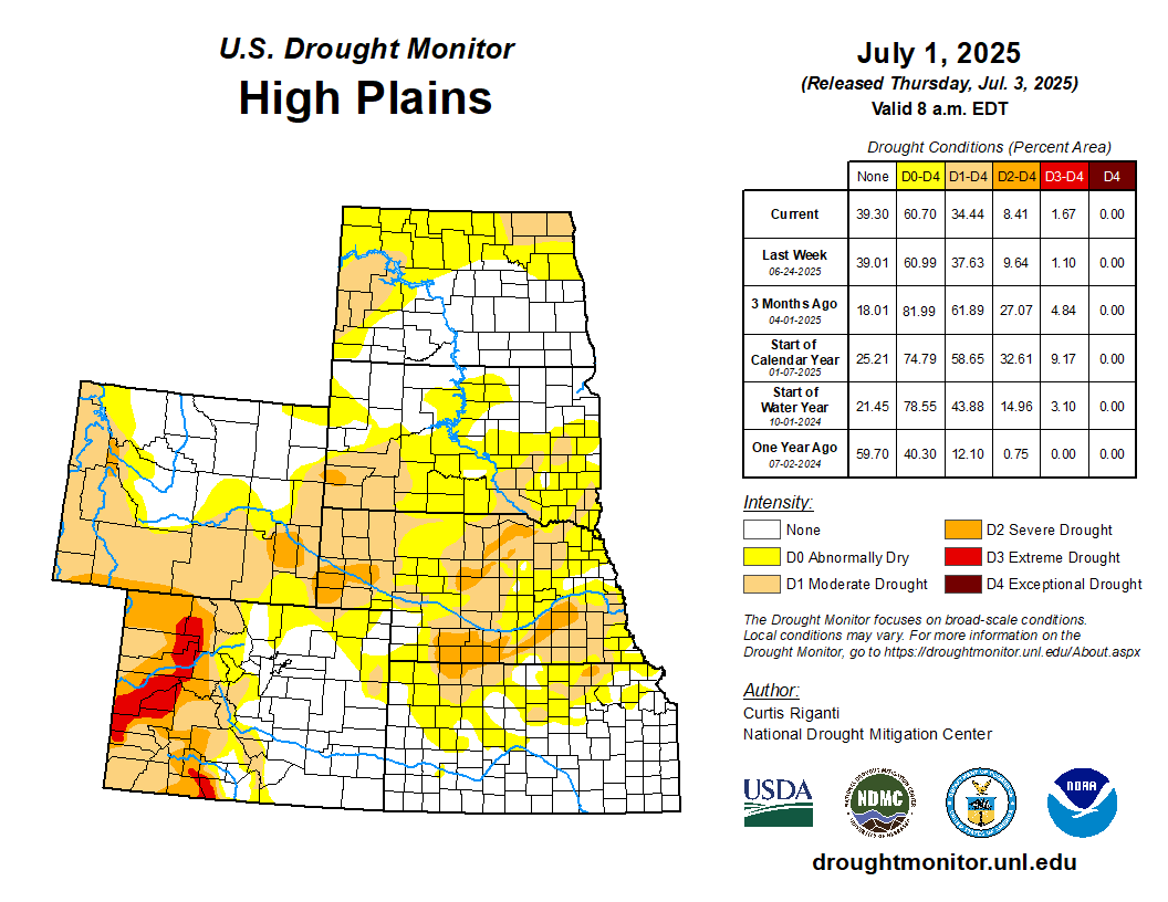
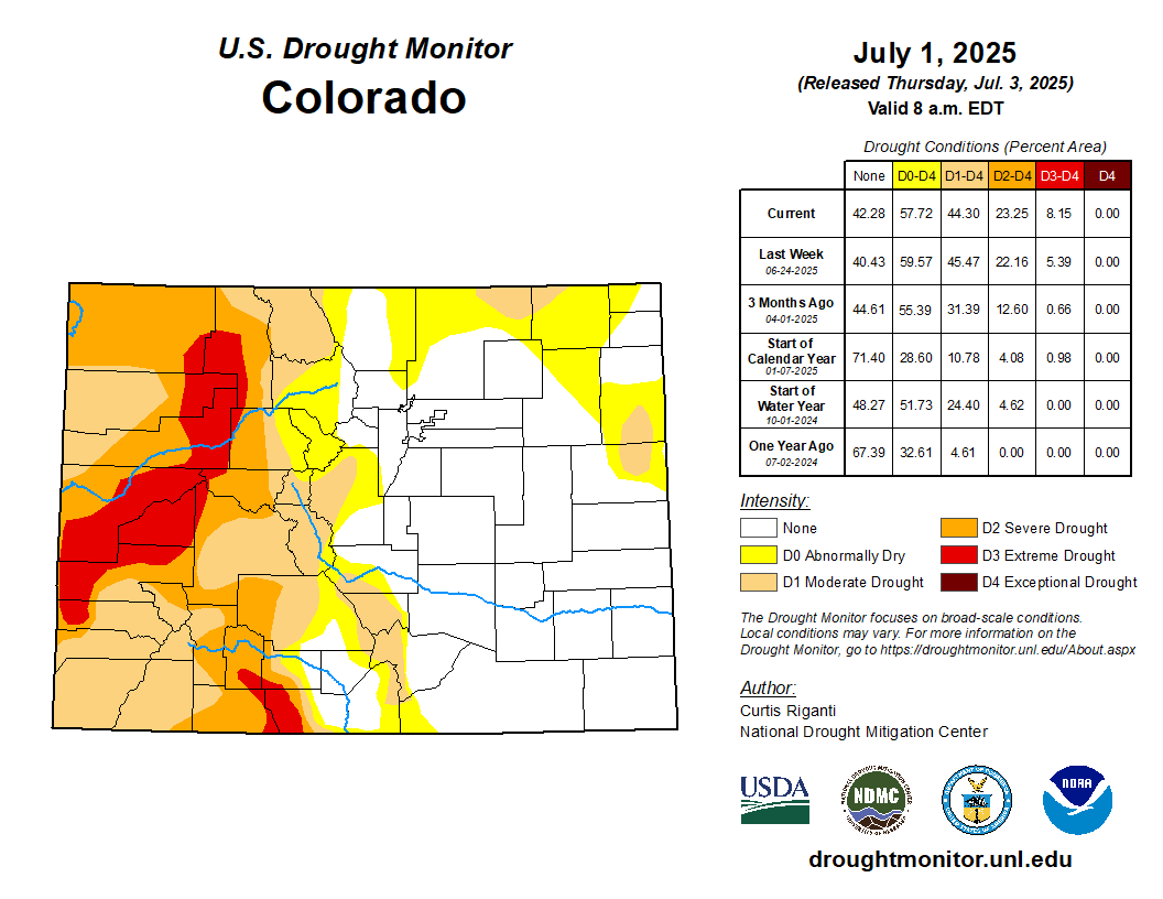
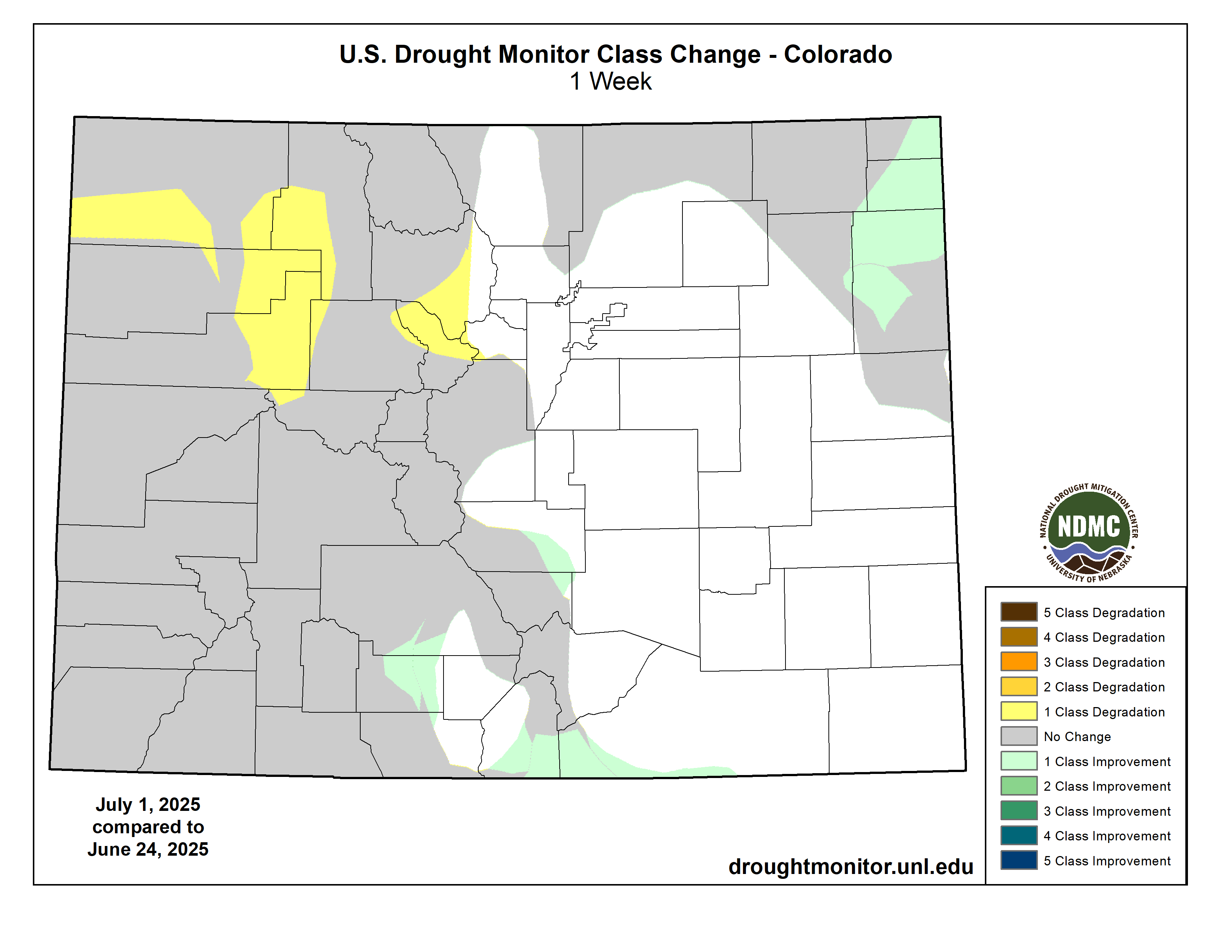
High Plains
Very heavy rain fell across parts of southwest and central Nebraska, which extended into portions of northern Kansas (north of Interstate 70) and portions of west-central and eastern South Dakota. Significant flash flooding occurred from rain amounts locally exceeding 8 inches in Grand Island, Nebraska, while very heavy rain, locally in excess of 5 inches, fell in parts of eastern South Dakota, where significant tornadoes also occurred on June 28. Heavier rain amounts fell in parts of south-central and northeast Colorado as well, though most of the heavier totals were in the 1-3 inch range. Primarily dry weather occurred west of the Continental Divide in Colorado and Wyoming. Temperatures across the region were mostly near normal to 2-4 degrees above normal, though parts of the eastern Dakotas were a few degrees cooler than normal. In areas that received heavy rain, soil moisture and precipitation deficits were alleviated and widespread improvements to ongoing drought or abnormal dryness occurred, including a two-category improvement in central Nebraska where some of the week’s heaviest rains fell. Meanwhile, degradations occurred in northwest Colorado and western Wyoming, where soil moisture and streamflow deficits mounted amid growing precipitation deficits…
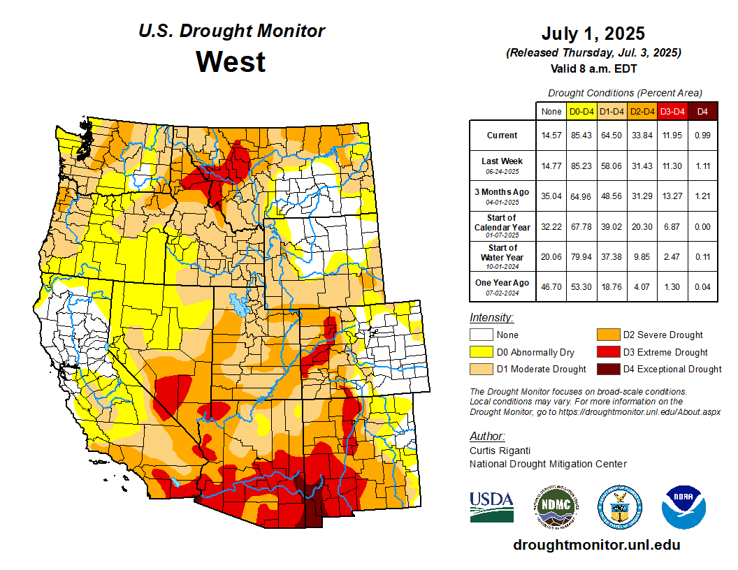
West
Heavy monsoonal rains fell this week in parts of New Mexico, excluding the far northwest. Elsewhere, this week’s weather was almost entirely dry. Combined with warmer-than-normal temperatures (mostly by 2-6 degrees) in the Northwest states, this led to widespread degradation in drought and abnormal dryness for central and northern Utah, Idaho, parts of northern and much of western Montana, and Washington. Very low streamflows and large short-term precipitation deficits contributed to widespread expansion of severe and extreme drought in western Montana and adjacent Idaho. Short-term severe drought also occurred in parts of central and north-central Washington, where deficits in precipitation and streamflow continued to grow. In much of New Mexico, excluding the far west and northwest portions, near- or below-normal temperatures were common this week along with some heavier rainfall amounts exceeding 2 inches (locally exceeding 5 inches). The improved soil moisture and lessened precipitation deficits led to widespread improvements to ongoing drought and abnormal dryness in southeast, southwest and north-central New Mexico. Exceptional drought expanded slightly along part of the Arizona-New Mexico state line where deficits in groundwater and precipitation continued to mount…
South
Heavy monsoonal rains fell this week across portions of west Texas, with local amounts of 2-3 inches or more. Heavy rains of 2-3 inches or more also fell across parts of northeast Oklahoma, and southwest Tennessee. Elsewhere, rainfall amounts of at least 2 inches were less common, while southern Arkansas and northern Louisiana, northwest Oklahoma and portions of central Texas saw mostly dry weather this week. In west Texas, under the monsoonal rainfall, temperatures were 4-8 degrees cooler than normal in some areas. Elsewhere across the region, temperatures were mostly 2-4 degrees warmer than normal in Arkansas and northern Mississippi, while temperatures were mostly 2-6 degrees warmer than normal in Tennessee. Outside of Texas, the South region remained almost entirely free of drought or abnormal dryness. However, around a few localized areas of short-term precipitation and soil moisture deficits, a few small areas of abnormal dryness developed in southern Louisiana and eastern Tennessee. In west Texas, heavy rains from the North American Monsoon helped to partially alleviate short- and long-term precipitation deficits and improve soil moisture quantity…
Looking Ahead
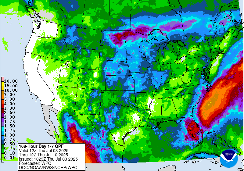
The National Weather Service Weather Prediction Center is forecasting a few areas of rainfall exceeding 1 inch for the period through the evening of Monday, July 7. Localized 1-inch or greater totals are possible in locations in New Mexico, northwest Texas, central and eastern Oklahoma, northern Kansas and Nebraska into the Upper Midwest and northern Great Plains, western Montana, and the Florida Peninsula, perhaps extending to the Southeast’s Atlantic coastline as a weather disturbance moves through. Heavy rain amounts exceeding 3 inches are forecast in portions of the Florida Peninsula, especially along much of its Gulf coast. Mostly dry weather is expected from the Intermountain West to the Pacific Ocean and across much of south Texas, Mississippi, Alabama, Georgia and the southern Mid-Atlantic.
For July 8-12, the National Weather Service Climate Prediction Center forecast strongly favors warmer-than-normal temperatures in the western Contiguous U.S., especially west of the Continental Divide. Warmer-than-normal temperatures are also favored in the eastern U.S., especially from Virginia southward to Florida. Near- or below-normal temperatures are favored for parts of the southern and central Great Plains and western portions of the Midwest. Below-normal precipitation is favored from northern Arizona across Utah, Nevada, southern Idaho, much of Oregon and southwest Washington. Above-normal precipitation is slightly favored in southern Arizona and southern and eastern New Mexico eastward across much of the Contiguous U.S.
In Alaska, above-normal precipitation is favored across much of the state, especially in the eastern half and excluding the far west reaches. Cooler-than-normal temperatures are favored across most of Alaska, especially central and eastern portions of Alaska.
In Hawaii, warmer-than-normal temperatures are favored from Molokai westward. Above-normal precipitation is favored throughout Hawaii.