Romancing the River: Is #GlenCanyon Dam an โ€˜Antiqueโ€™? — Sibley’s Rivers #ColoradoRiver #COriver #aridification

Graphic credit: Sibley’s Rivers

Click the link to read the article on the Sibley’s Rivers website (George Sibley):

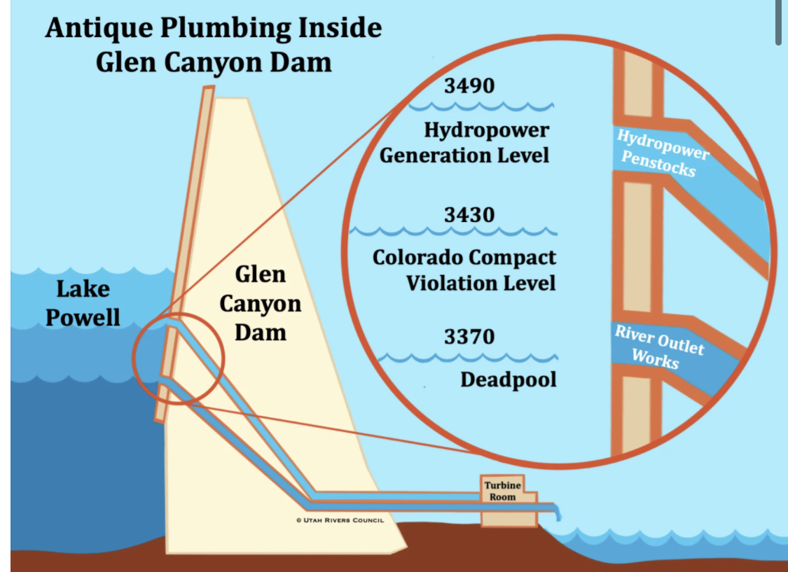
Yes, that diagram again. I was chastised by readersย last weekย for using it โ€“ partly for the โ€˜Antiqueโ€™ in the diagramโ€™s title, but also for not adequately explaining what the diagram shows. I apologize for the latter. These posts tend to run long and demand a lot more of readers than the 15-second attention span for which Americans are derided. But just to keep them down to a couple thousand words or so, I find myself having to go through some things too quickly in order to get to whatever point I was aiming for. Brevity unfortunately is not the soul of my wit.

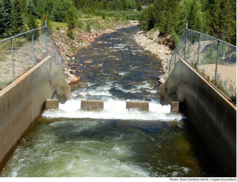
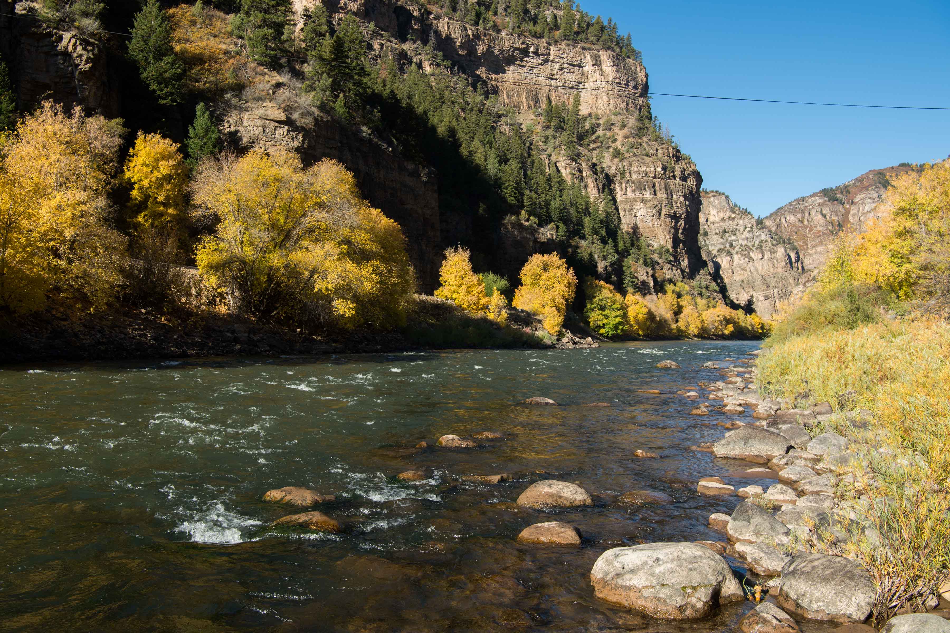
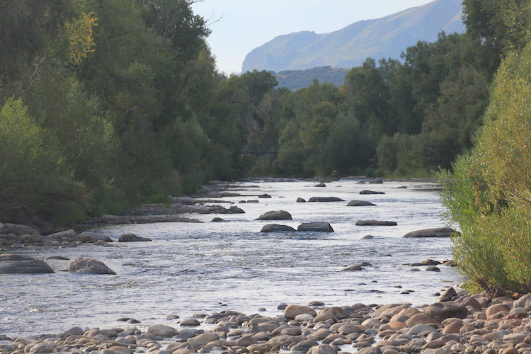
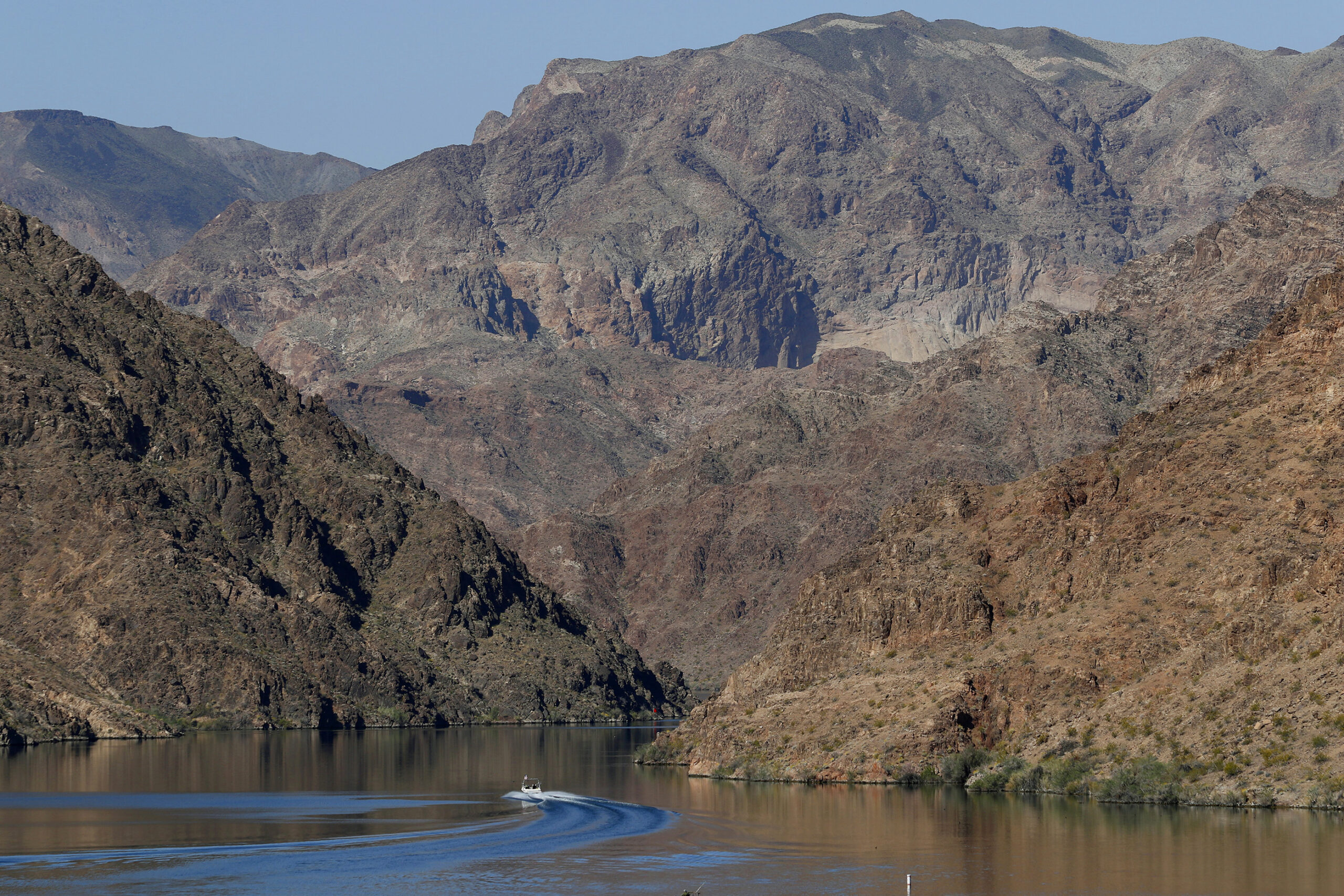
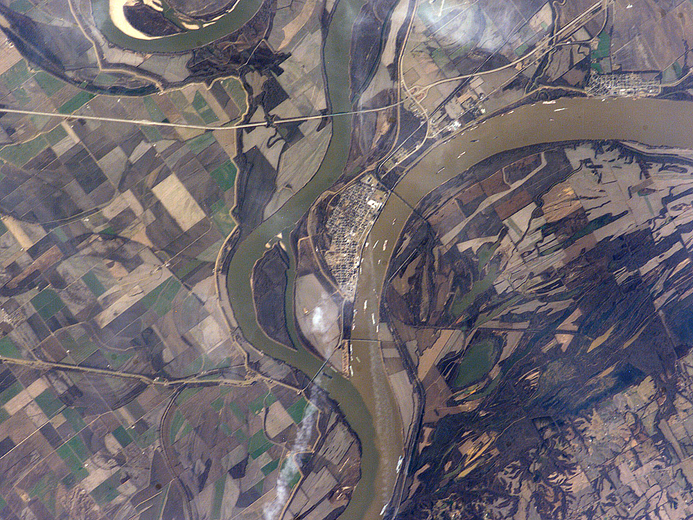
But having a sense of the structure and infrastructure of our big dams is critical to understanding what is going on along the Colorado River these days, where it is easy to confuse the river itself (which is experiencing chronic low flows but is not โ€˜drying upโ€™) with the โ€˜river management systemโ€™ (which really could dry up critical stretches of the river under the current management regime). The โ€˜river management systemโ€™ is the integrated set of physical structures along the river for storing the riverโ€™s water and distributing it to users โ€“ and the operating systems whereby those structures are managed.

The โ€˜Supplemental Environmental Impact Studyโ€™ the Bureau of Reclamation is doing now is basically an analysis of its own operating systems for the big structures on the Colorado River, and how those systems might be radically changed with an equitable distribution of impacts on humans โ€“ systems that could have been changed gradually over the past several decades, the past century even, to reflect undeniable evolving realities, both natural and cultural, but now must be done with radical surgery โ€“ the call for an almost-immediate reduction in Lower Basin uses of two million acre-feet.

This might be what life in the Anthropocene will mostly be on many fronts: learning how to live well enough with the world we have imposed on the world we found here. A recreated world where some cultural works were done naively and maybe profligately, under assumptions now needing correction โ€“ which one might hope we will learn to begin sooner rather than later โ€“ or too late, period.

Graphic via Holly McClelland/High Country News.

So it is fitting to look critically at what weโ€™ve done along the โ€˜First River of the Anthropoceneโ€™ โ€“ trying not to fall into hypocritical analysis, gnawing on the hands that feed us. And on that spectrum of critical analysis, I do need to explain, if not defend, using a diagram that calls the โ€˜plumbingโ€™ of a major element in the management system weโ€™ve imposed on the Colorado River โ€˜antique.โ€™

I will say first that I do not necessarily think of โ€˜antiqueโ€™ as a derogatory term (although that was probably intended by the creators of this diagram). If an automobile is fifty years old and still running, it qualifies for an โ€˜antiqueโ€™ license plate; thatโ€™s cool, an achievement for those who kept the car functional. I think of the word as more descriptive than judgmental: an antique is an artifact whose time is past but which reflects that time, something old but with an element of class, something that summons memories of a previous time, a time we want to remember but not necessarily carry forward.

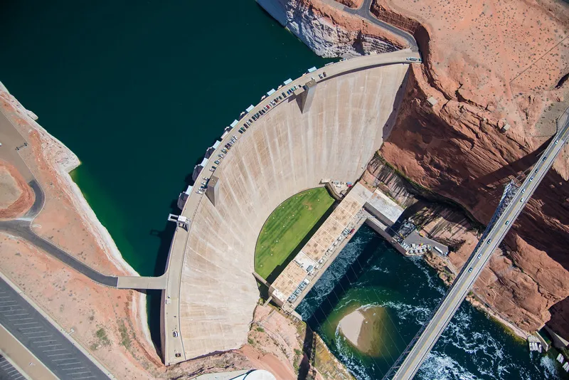
So, being more than 50 years old at this point โ€“ is Glen Canyon Dam an antique? We can start with an examination of its โ€˜plumbing,โ€™ which says something about its life and times. (My doctor uses colonoscopies for a similar analysis.)

1983 – Color photo of Glen Canyon Dam spillway failure from cavitation, via OnTheColorado.com

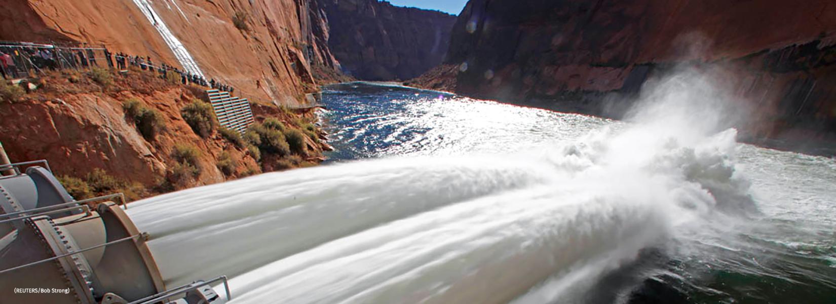
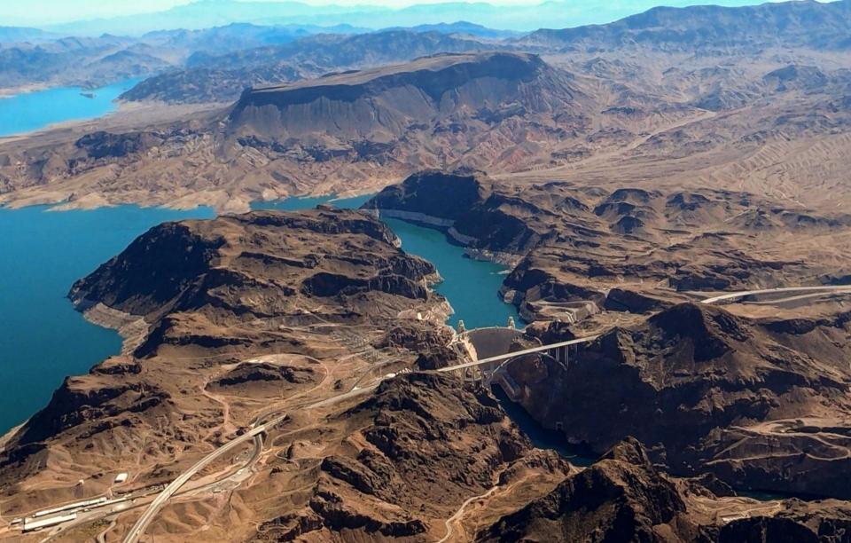
One piece of plumbing not shown on the diagram is the damโ€™s spillways โ€“ two huge โ€˜drainsโ€™ up at the 3,700-foot elevation, near the damโ€™s 3,715-foot crest (for context, 583 feet above the original streambed). The purpose of the spillways is to keep the reservoir from filling to the point where it would go over the crest. Glen Canyonโ€™s spillways have only been used once, in 1983, when a very wet May and hot June caught the dam managers unaware, with the reservoir already too full to perform its flood-control function. The spillways proved to be not up to the task of getting the flood waters past the dam; the water pouring down them caused a cavitation problem โ€“ a million tiny โ€˜air-hammersโ€™ beating on the concrete with enough cumulative force to break it up. The managers knew there was a problem when large chunks of concrete, then sandstone, started washing out the bottom of the spillway outlets. That threatened the integrity of the dam itself; it was necessary to close off the spillways, lining the top of them with sheets of plywood four feet high and praying that the water would stop rising before it topped the plywood. It did stop in time, and the dam was saved. The spillways were rebuilt, hopefully resolving the cavitation problem, and have not been used since โ€“ and at this point, given the projections about climate change, it is hard to imagine the reservoir ever being that full again. The spillways alone might qualify as โ€˜antiques,โ€™ built for a river that needed them (once) but may no longer exist. (Oh great river gods, please make me eat my words!)
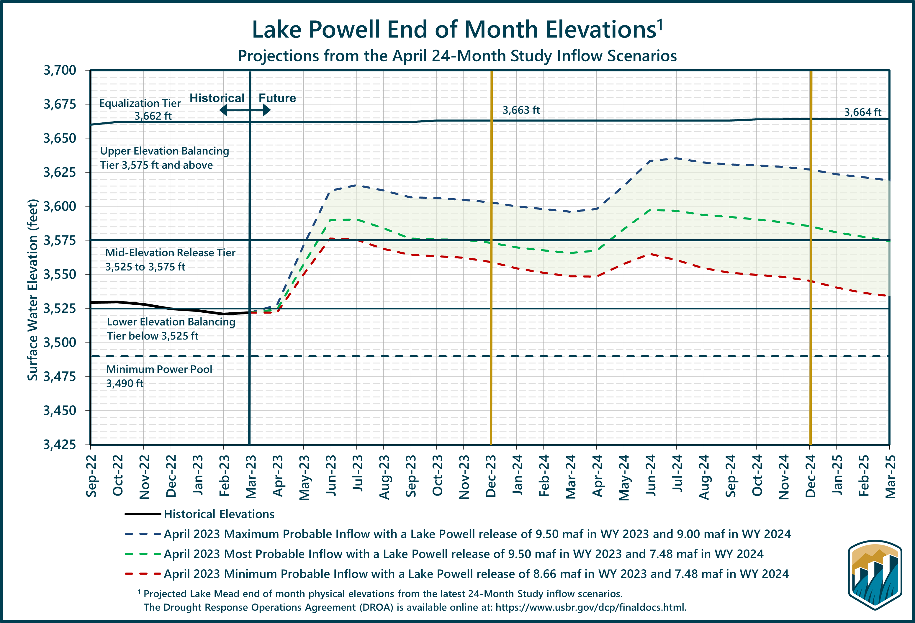
During the 1983 Colorado River flood, described by some as an example of a “black swan” event, sheets of plywood (visible just above the steel barrier) were installed to prevent Glen Canyon Dam from overflowing. Source: Bureau of Reclamation

For the dam managers, however, to โ€˜spillโ€™ water at all is a mark of bad management; their ideal is for every gallon of water contained by the dam to be released through openings 210 feet below the spillways, at hydropower generation level, the 3,490-foot elevation (see diagram). Those openings into the dam drop the water through pentstocks a couple hundred vertical feet to turbines in generators the size of small houses; on its way to its designated use downstream, the water generates electricity. The higher the reservoir level, the more pressure the waterโ€™s weight exerts in pushing the water through the turbines; with the reservoir at high levels, the Glen Canyon generators can produce annually up to five billion kilowatt-hours of electricity. In 2022, however, with the reservoir level only around 35 feet above the pentstock inlets, it only produced 2.6 kilowatt-hours. (Bureau figures)

The Bureauโ€™s semi-panicky call in 2022 for massive reductions in use basin-wide was based on projections forward of another couple water years like the 2020-22 period; under the current river management regime, the level of the reservoir would have dropped below the level of the pentstock intakes in a couple years, and year-round power generation would have been impossible.

The back of Glen Canyon Dam circa 1964, not long after the reservoir had begun filling up. Here the water level is above dead pool, meaning water can be released via the river outlets, but it is below minimum power pool, so water cannot yet enter the penstocks to generate electricity. Bureau of Reclamation photo.

Even if that were to happen, however, it would still be possible to move water downstream from Powell Reservoir, through river outlet works with intakes 120 feet lower down in the dam, at the 3,370-foot elevation. The river outlets there are four big pipes, each eight feet in diameter, with a total flow capacity of 15,000 cubic feet per second โ€“ when thereโ€™s a lot of water in the reservoir to push water through them. If the water pressure stayed at that level, and all four tubes worked 24/7/365, it would be possible to move around 10 million acre-feet (maf) through the dam annually and down to Mead Reservoir, roughly the amount the Bureau has been releasing from Mead for Lower Basin and Mexican use โ€“ plus the system losses for which no one has wanted to claim responsibility.

That 10 maf leaving the system at the lower end obviously becomes problematic if only 6-8 maf are flowing into the system at the upper end, as has been the recent situation. For one thing, the Bureau is not sure the outlet works can stand that kind of constant use; they are getting old, and may not have been built for constant use anyway. So if the Bureau were able to keep only three tubes running all the time, with one in maintenance mode, the amount of water that could be moved at full pressure would drop to just about the Upper Basinโ€™s Colorado River Compact commitment โ€“ 7.5 maf plus the Upper Basinโ€™s share of the Mexican obligation (750,000 af).

But as the water level in the reservoir dropped closer to the outlet works intakes โ€“ 6-7 maf inflow minus 8 maf outflow equals a storage decrease of 1-2 maf/year โ€“ the water pressure through the tubes would also drop, and below the 3,430-foot elevation, it would no longer be possible to push the full Upper Basin commitment to the Lower Basin and Mexico through the tubes.

Map credit: AGU

Worst case โ€“ if the reservoir level dropped below the 3,370-foot elevation, it would no longer be possible to move any water at all past the dam, even though there would still be just under two million acre-feet left in storage โ€“ the โ€˜dead pool.โ€™ At that point, the Lower Basin states would either have to do something completely nonconstructive like sue somebody (Upper Basin states? Interior Department? The Bureau?), or argue about which states should pay how much to Upper Basin water users to let their water (not federally controlled) flow to Powell to try to raise the level back above the 3,370-foot elevation. And most of the Upper Basin water rights junior to the Compact are not a bunch of rugged individualist farmers and ranchers; they are the big transmountain diverters โ€“ Coloradoโ€™s Front Range cities, the Santa Fe-Albuquerque corridor, the Salt Lake basin, who are already โ€˜lawyered up.โ€™

The ramshackle โ€˜Law of the River,โ€™ grounded in appropriation law and followed to the letter of the laws, would have nothing to offer to relieve that situation; it is easier to imagine Paolo Bacigalupiโ€™s โ€˜Water Knifeโ€™ war commencing.

That is an overview of Glen Canyon Damโ€™s plumbing โ€“ pretty standard for a big 20th century dam, designed to operate optimally when the reservoir is more than two-thirds full and able to maintain a full power head in releasing water through the turbines for โ€“ oh yeah, not primarily power generation, but the damโ€™s main job of providing dependable water for agricultural and domestic users downstream. A specific warning in the Colorado River Compact (IV(b)).

Now to the question: is Glen Canyon Dam an โ€˜antiqueโ€™? I think, at this point, given the prognostications for the future of the regional water supply, we could truly say that the dam was built for a different era, a different river โ€“ some of which river may have existed only in the minds of the dam builders. The โ€˜Hassayampa romance,โ€™ carried along, like Deacon Holmesโ€™ wonderful one-hoss shay, โ€˜for a century to the dayโ€™ โ€“ the day the Bureau finally abandoned its paper surplus calculations and called a shortage.

In addition to working on new river operation protocols, the Bureau now has a team working on ways to possibly modify the dam, undoubtedly at considerable cost, maybe enlarging the outlet works, maybe generating some flow of electricity through openings lower in the dam, and maybe constructing tunnels to bypass the dam entirely, leaving Mead Reservoir as the riverโ€™s major storage.

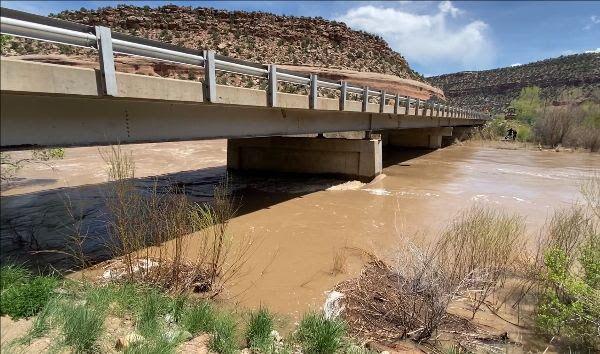
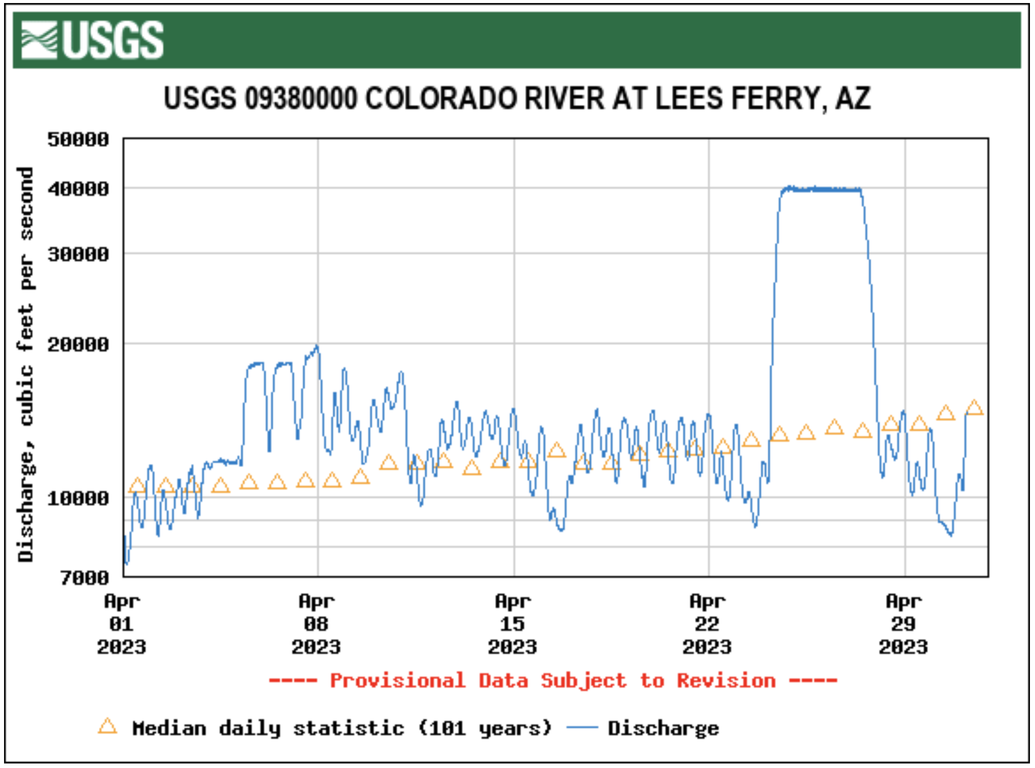
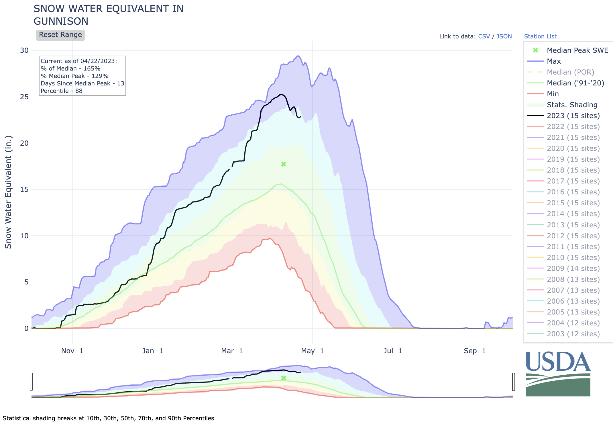
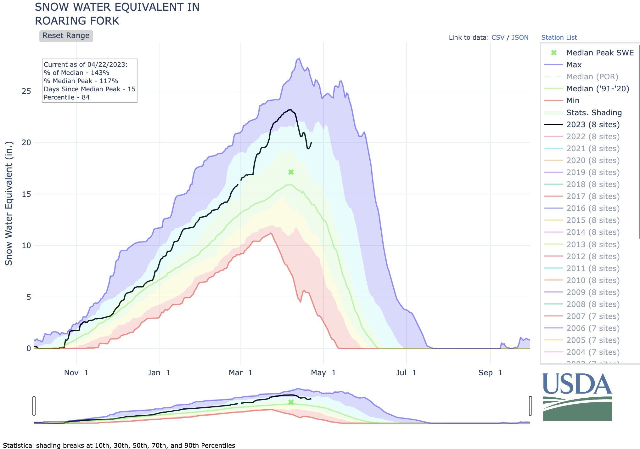
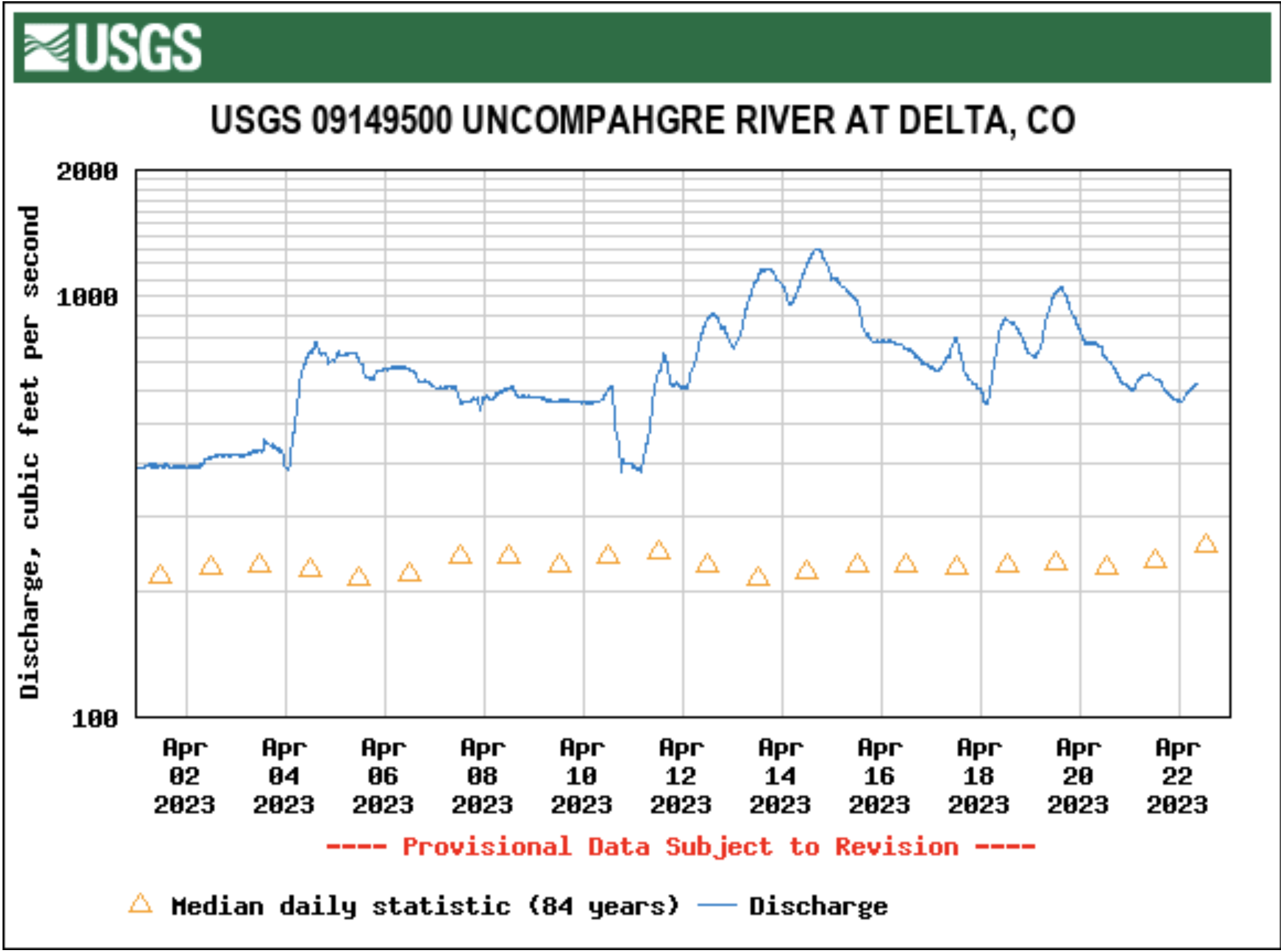
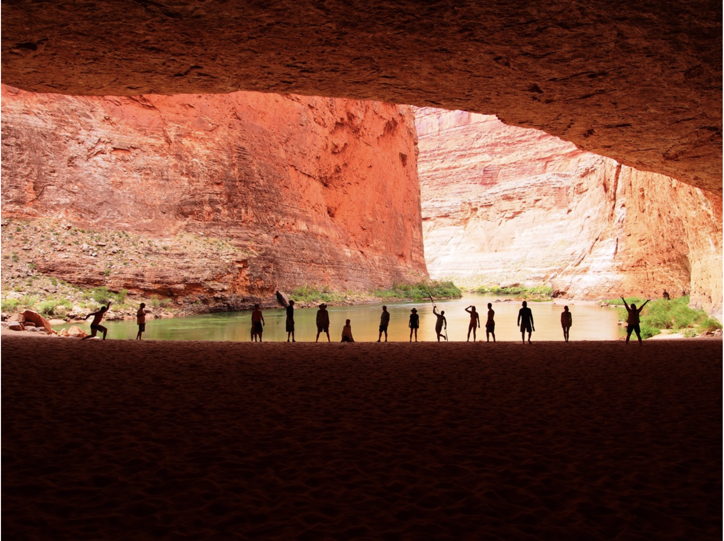
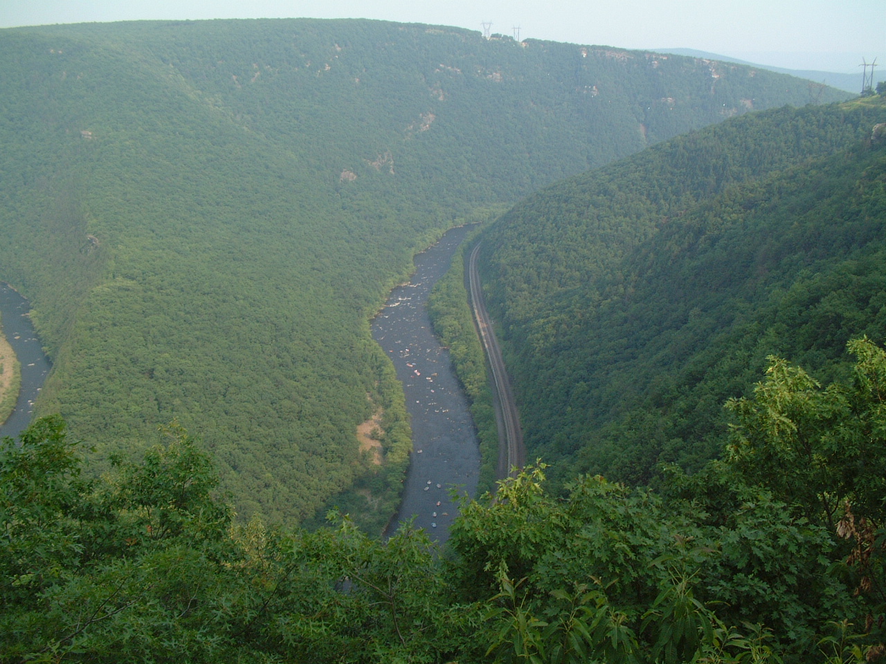
The latter concept could relieve a problem that the dam has created for โ€˜todayโ€™s riverโ€™ through the Grand Canyon: the beaches and sandbars that are essential as night stops for the billion-dollar Grand Canyon recreational boating industry are eroding away, with no replacement sand and silt getting past the dam. This is being dealt with now by occasional staged โ€˜floodsโ€™ like the one just recently: pouring 200,000-plus acre feet of water over 2-3 days down through the Grand Canyon to stir up sediment that has slumped from the beaches down into the riverbed, in hopes that it will be redeposited on a beach downstream. Ultimately this mostly just escalates the passage downstream of all the beach material with only irregular and inadequate deposits of new material from side streams. That this ultimate losing effort was done in April 2023, with Powell Reservoir under 30 percent full, but anticipating a runoff thatย mightย get it all the way up to half-full or only half-empty, depending on your psychological inclinationโ€ฆ. Thereโ€™s an underlying desperation there that is not goimng to let us look back on this period with any pleasant sense of nostalgia. But we might look back on antiquities like Glen Canyon Dam as a reminder of the consequences of operating on assumptions and standards not fully grounded in demonstrable reality.

A problem with this analysis, however, is that for better or worse, it evaluates Glen Canyon Dam out of context. To really understand why we have Glen Canyon Dam at all, it is necessary to see our riverโ€™s physical structures in the larger context of the less visible political and legal infrastructure that led us to pile five million yards of concrete (with internal plumbing) in the riverโ€™s path in that particular place. That is another great story in the evolution of this mixed bag we call America. Up next in a couple weeks; stay tuned.

Delph Carpenter’s original map showing a reservoir at Glen Canyon and one at Black Canyon via Greg Hobbs

River levels expected to close #Colorado 141 between #Naturita and #Gateway — The #Montrose Daily Press #DoloresRiver #runoff

A photo captured on May 3, 2023 shows the Dolores River flowing underneath a CDOT bridge structure located on Colorado Highway 141 at mile point 88.5. River flow rates are nearing 10-year flood event levels. (Courtesy photo/CDOT)

Click the link to read the release from the Colorado Department of Transportation on The Montrose Daily Press website:

The Colorado Department of Transportation is strongly considering closing Colorado 141 between Naturita and Gateway Friday evening, May 5, due to water levels on the Dolores River and extra caution over the structural integrity of the bridge at Roc Creek.

If the river reaches expected levels, CDOTย plans to close the highway at 5 p.m. Friday, with the highway remaining closed until the flood danger has subsided. According to a CDOT news release, the closure is dependent on various factors, including snowmelt and reservoir releases. As flow amounts fluctuate, the bridge over Roc Creek may require additional closures

โ€œRiver flows in the area have not been observed at these levels in 18 years. With the flood event expected to peak this Friday, we are taking proactive and cautionary measures at this particular bridge. Engineers and maintenance personnel will be assessing the structural integrity throughout this high-flow event,โ€ Regional Transportation Director Julie Constan said in the news release.

For safety, CDOT has determined that the bridge structure at Roc Creek should be closed to traffic while peak water flows are occurring. The structure is located approximately 27.5 miles north of Naturita at mile point 88.5. The northbound closure point is located north of Naturita and the County Road CC junction at mile point 64. The southbound closure point is just south of Gateway, at mile point 110.

CDOT hydraulics engineers are closely watching forecasts, as well as tracking the anticipated releases from McPhee Reservoir in Montezuma County, CDOT spokeswoman Lisa Schwantes said.

โ€œItโ€™s going to be a combination of those things that really have an effect on how high the water flow is,โ€ she said. With respect to whether CDOT in fact closes 141: โ€œWeโ€™re leaning toward the side of caution.โ€

The National Weather Service (NWS) has issued a flood advisory for the Dolores River due to the increased release of water from McPhee Reservoir. The flood advisory also includes the Dolores and San Miguel Rivers due to heavy runoff from snowmelt. The flood advisory is in place until further notice and covers Montrose County, as well as the counties of Montezuma, Dolores and San Miguel.

CDOT is less concerned that water will overflow the top of the bridge โ€” projections have the river hitting about 2 to 4 feet below. Rather, the concern is how the bridge structure might respond to a high flow at a rate not seen in close to 20 years, Schwantes said. There is some concern about the bridge piers, as well as large debris that could wash down and lodge beneath it.

โ€œWeโ€™re confident of the integrity of the bridge, but we donโ€™t want anyone driving over it when those high peak flows are occurring,โ€ she said.

The northbound closure point is located north of Naturita and the County Road CC junction at mile point 64. The southbound closure point is just south of Gateway, at mile point 110.

Mcphee dam

The National Weather Service (NWS) has issued a flood advisory for the Dolores River due to the increased release of water from McPhee Reservoir. The flood advisory also includes the Dolores and San Miguel Rivers due to heavy runoff from snowmelt. The flood advisory is in place until further notice and covers Montrose County, as well as the counties of Montezuma, Dolores and San Miguel.

2023 #COleg: #Colorado lawmakers โ€œbelly flopโ€ on #water crisis, opting for further study of #ColoradoRiver over action, experts say — The #Denver Post #COriver #aridification

West Drought Monitor map April 25, 2023.

Click the link to read the article on The Denver Post website (Conrad Swanson). Here’s an excerpt:

Coloradoโ€™s legislative leadership promised this year that the stateโ€™s water problems would be the โ€œcenterpieceโ€ of conservation efforts but their keystone proposal focused on the Colorado River and widespread drought plaguing the West is to study the issue further. At such a late stage in the drying American West, water experts tell The Denver Post that creating another study group amounts to procrastination while time is running out. And, they say, itโ€™s unlikely that evaluating the drought โ€“ย exacerbated and made permanentย by climate change โ€“ yet again will yield any new ideas.

Lawmakers introduced the bipartisan bill,ย SB23-295, late in their session. It is on its way to clearing the Senate and heading to the House of Representatives. Behind the measure are Western Slope Sens. Dylan Roberts, an Avon Democrat, and Perry Will, a New Castle Republican, Speaker of the House Julie McCluskie, and Marc Catlin, a Montrose Republican. The bill would create a 16-member task force, plus an advisory member, consisting of a cross-section of water users including representatives of the Department of Natural Resources, the Colorado Agriculture Commission, members of the Ute Mountain Ute and Southern Ute tribes, water commissions and environmental organizations.

On a day in late May [2022] when wildfire smoke obscured the throat of an ancient volcano called Shiprock in the distance, I visited the Ute Mountain Ute farming and ranching operation in the southwestern corner of Colorado. Photo credit: Allen Best/Big Pivots

Officials in Colorado could be doing far more, though, than convening another task force, Dan Beard, a former U.S. Bureau of Reclamation commissioner, said. He lambasted the proposal.

โ€œIt isnโ€™t a flop, itโ€™s a belly flop,โ€ Beard said.

Once formed, the task force would begin meeting by July and by December recommend ways Colorado could counter drought in the Colorado River Basin and related inter-state commitments. The group would have broad leeway for the types of recommendations it could offer…While Colorado isnโ€™t the biggest water user in the Colorado River Basin, it could still contribute meaningful water savings, [Dan] Beard said. For example, lawmakers could work to curb the amount of water piped out of the basin, Beard said. Major urban centers along the Front Range (like Denver) draw water from the river and move it across the Continental Divide to their taps. Farmers and Ranchers east of the divide also rely on Colorado River water. Trans-basin water transfers like those are problematic because all the water taken out of the basin is lost to the Colorado River forever. On the contrary, water used within the basin to irrigate crops will ultimately flow back into the river if itโ€™s not absorbed by the plants.

Colorado transmountain diversions via the State Engineer’s office

#YampaRiver anticipated to reach its highest level yet Thursday into Friday — Steamboat Pilot & Today

Click the link to read the article on the Steamboat Pilot & Today website (Kit Geary). Here’s an excerpt:

Routt County Emergency Management is warning residents to expect flooding Thursday, May 4, into Friday, May 5, with the Yampa River anticipated to reach its highest level yet this season. Emergency Operations Manager David โ€œMoโ€ย DeMorat told Routt County commissioners on Monday, May 1, that the river had hit 6,500 cubic feet per second, and warm temperatures are expected to continue through the week, which could cause the river to reach 7,000 cfs by Friday. DeMorat said this amount of water for the Yampa River is considered โ€œaction levelโ€ flooding by the National Weather Service. Action levels generally require municipalities to keep a closer eye on flooding and have potential mitigation plans and flood warnings in place…

To gauge what flooding will look like, the county uses snow-water equivalent gauges that provide estimates for the amount of snowmelt that could occur three to four weeks out. This looks at the amount of snow on the ground, but cannot predict at what rate it will melt. Because of this, no exact estimates can be given, as it is ultimately the weather and the freeze-and-thaw cycle that will determine at what rate the snow melts.

DeMorat explained to commissioners that these gauges show areas north of Steamboat and the Stagecoach Reservoir currently have the highest potential for flooding. Three snow-water equivalent gauges stationed north of Steamboat have helped emergency management identify these regions as problem areas for flooding due to the snowpack that could melt. All three are north of Steamboat with one near Dry Lake, one near Lost Dog Creek and another slightly farther northwest. DeMorat noted these locations range from 165-185% of the average snowpack. He told commissioners that Stagecoach Reservoir is another area of concern with 140% of its average snowpack.

Alongside the problem areas DeMorat named, the National Weather Service issued a flood warning for Elkhead Creek, particularly where the creek meets the Yampa River. This flood warning began on Monday and will end Friday unless communicated otherwise by the National Weather Service.

Debris and mud covers roads, trails, train tracks in #GlenwoodSprings — The Summit Daily #runoff

Click the link to read the article on The Summit Daily website (Cassandra Ballard). Here’s an excerpt:

After a quick weather jump from cold to warm over the past week, there have now been multiple areas of mud and debris flow throughout Glenwood Springs and the surrounding area due to the rapidly melting snow on Red Mountain and elsewhere. On Tuesday morning, a major debris flow blocked access to the wastewater treatment facility in West Glenwood, along with covering the Union Pacific Railroad train tracks in West Glenwood, causing a freight train to get stuck…

On Monday, local trails on Red Mountain and at Wulsohn Mountain Park, and on the higher trails of the South Canyon trail system were closed from mud flows, and the city was urging people to stay off the closed trails…

In addition, Garfield County emergency management officials reported late Monday that County Road 127 (3 Mile Road) was covered with water and mud and a private bridge was washed out at the half mile mark due to flooding on Three Mile Creek. Several residences were also being impacted. And, the Colorado Department of Transportation was reporting mudflow activity in Glenwood Canyon near Interstate 70.

Follow the Living River journey and take action by May 30! — @AudubonRockies

From email from Audubon Rockies (Abby Burk):

Hi all, and thank you for joining Audubon Rockies and conservation photographer Dave Showalter for his multimedia journey through the living Colorado River! In his new book, Living River: The Promise of the Mighty Colorado, Dave shares the beauty of the watershed and a story of resiliency and resolution to continue the work for healthy watersheds. You can watch last weekโ€™s virtual book launch event recording here.

The Colorado River existing management guidelines are set to expire in 2026. The states that draw water from it are about to undertake a new round of negotiations over the riverโ€™s future. The use of the river will be renegotiated amid climate change, reduced snowpack, and water shortages, presenting an opportunity to ensure universal access to clean water for more than 30 federally-recognized Native tribes and make the allocation of the Colorado equitable as well as sustainable.

This May is a critical time to be a voice for the river, as the United States Bureau of Reclamation seeks public comment on the Draft Supplemental Environmental Impact Statement (SEIS) to the 2007 Interim Guidelines. This SEIS evaluates different scenarios to better balance water supply in the Colorado River watershed, which will impact ecosystem health in the Grand Canyon and other areas.

The stories, art, and lifeways that deepen our relationships to water are what build the collective voice for healthy rivers that benefit wildlife and people. The Mighty Colorado changes everything it touches, including us. Here are a few ways you can join the Living River conversation:

  • Buy a copy ofย Living Riverย fromย Mountaineers Books, your local bookstore, or one of theseย online sellers.
    • *Audubon members, as a special thank you, get a 20% discount by using the code “LIVINGRIVERLOVE” at checkout from Mountaineers Books.
  • Attend another book launch event or encourage a friend to attend one. The Living River book tour is traveling the West and has both in-person and virtual events.
  • Explore the Living River website and follow the journey on Instagram.
  • Take action by May 30 and urge the Bureau of Reclamation to recognize the important links between human health, stable communities, and the environment and also implement measures that better balance water supply and protect the Grand Canyon ecosystem.

We also encourage you to sign up for Audubonโ€™s Western Water Action Network to stay up to date on Colorado River information and engagement.

Presently, there is less water in the Colorado River system than at any time in recorded history, threatening the vitality of its ecosystem. But wherever there is water, there is abundant, dynamic life. As Dave Showalter says: โ€œThe river is not dying. She flows with the same pure purpose as before we arrived.”

Thereโ€™s no giving up on the Colorado for riverkeepers engaged in riparian restoration. The hard work ahead requires widespread engagement in our future, which begins with all of us asking: Where does our water come from, and who does it connect us to?

All my best and hope to see you downstream,

Abby

Updated Colorado River 4-Panel plot thru Water Year 2022 showing reservoirs, flows, temperatures and precipitation. All trends are in the wrong direction. Since original 2017 plot, conditions have deteriorated significantly. Brad Udall via Twitter: https://twitter.com/bradudall/status/1593316262041436160

Data dashboard: #RoaringForkRiver #CrystalRiver #MaroonCreek #runoff — @AspenJournalism

Click the link to read the article on the Aspen Journalism website (Laurine Lassalle):

Streamflows down from last week

Streamflows in the Roaring Fork basin are down from last week.

Aspen Journalism is now compiling real time streamflow data. At Stillwater, located upstream of Aspen, the Fork ran at 39.7 cfs on April 24 at 1:30 pm. In terms of trends, the Fork ran at 40.1 cfs or 65.7% of average on April 23 after reaching 65.6 cfs on April 19. Thatโ€™s down from 55.2 cfs and 117.4% of average, on April 16.

You can find all the featured stations from the dashboard with their real-time streamflow on thisย webpage.

Credit: Laurine Lassalle/Aspen Journalism

The USGS sensor on the Roaring Fork river below Maroon Creek recorded the Fork running at 138 cfs on April 23, or 98.6% of average. Thatโ€™s down from 164 cfs on April 16.

At Emma, below the confluence with the dam-controlled Fryingpan, the April 23 streamflow of 364 cfs represented about 78.3% of average. Thatโ€™s down from 412 cfs, and 101.7% of average, on April 16.

The transbasin diversion that sends Roaring Fork basin headwaters to Front Range cities was flowing at 13.7 cfs on April 23, up from 5.9 cfs on April 16.

Meanwhile, theย Crystal Riverย above Avalanche Creek, which is not impacted by dams or transbasin diversions, flowed at 195 cfs, or 70.1% of average, on April 23. Last week, the river ran at 244 cfs, or 123.9% of average.

April 1 Brings Start of 2023 Canal Deliveries of Colorado-Big Thompson Project #Water — @Northern_Water #ColoradoRiver #SouthPlatteRiver

Click the link to read the article on the Northern Water website:

How many people does it take to get the Colorado-Big Thompson Project ready for the peak delivery season? For the Northern Water Operations Division, the answer is โ€ฆ just about everyone.

Crews have been working throughout the winter to maintain the 80-year-old infrastructure and make the necessary repairs. Sometimes just decades of freeze-thaw action will create the need for repairs and replacements.

Why work so hard in the winter? Because water users expect consistent and reliable deliveries throughout the spring, summer and fall, meaning there isnโ€™t room on the schedule to make repairs during warm, long days.

Map of the Colorado-Big Thompson Project via Northern Water

#Rico Reprieve + BLM revokes Moab-area lithium permit — @Land_Desk #DoloresRiver

Rico, Colorado, during its heyday in 1891. William Henry Jackson photo, Denver Public Library Special Collections.

Click the link to read the article on The Land Desk website (Jonathan P. Thompson):

CONTEXT: Iโ€™ve long been intrigued by Rico, a former mining town of about 300 people in  the western San Juan Mountains in southwestern Colorado. On paper, Rico looks a lot like Silverton: It was platted in the 1870s on Ute land as a mining hub and flourished during its early years; it sits at about 9,000 feet in elevation, surrounded by high mountains; and it was serviced by a railroad built by Otto Mears.

Yet Rico, just 20 miles as the crow flies from Silverton, ultimately followed a far different trajectory. The 1893 Silver Panic hit both towns hard initially, but Silverton ultimately recovered and its mining industry continued to support a fairly healthy population until the early 1990s. Rico, not so much โ€” the population in 1890 was about 4,000; by 1900 it had shrunk to 811 and continued to ebb, bottoming out at just 75 in 1980. 

Prior to mining, snowmelt and rain seep into natural cracks and fractures, eventually emerging as a freshwater spring (usually). Graphic credit: Jonathan Thompson

Mining in Rico didnโ€™t collapse after the Silver Panic by any means. Throughout the decades, big and little firms gouged and tunneled, drilled and blasted, stoped and mucked, milled and smelted in the Rico Mountains. Sulfide-bearing iron pyrite โ€” the active ingredient in acid mine drainage โ€” is abundant here. So much so that in the 1950s the Rico-Argentine Mining Company and Vanadium Corporation of America began mining pyrite to produce sulphuric acid at a plant at the St. Louis Tunnel. The acid was used mainly for uranium processing at mills in surrounding lowlands. In 1980 Anaconda, a subsidiary of Atlantic Richfield, bought the Rico Argentine Mine site and surrounding lands with an eye toward molybdenum mining, but never actually pulled any ore out of the ground.

All of the mining activity permanently scarred the land, sullied the waters of the Dolores River, which passes through town, and contaminated town soils with lead. But it was never enough to revive the townโ€™s early glory or population. Rico lost the Dolores County seat to the powerful Dove Creek pinto bean and Grange lobby in the 1940s, and the Rio Grande Southern railroad abandoned the community shortly thereafter. 

Silverton, meanwhile, held onto its branch of the Denver & Rio Grande Western railroad, helping that town to become the backdrop of many a mid-century western film and a major tourist attraction. And the relatively prosperous mining industry there had left behind infrastructure to support the new economy. Despite its scenic location, mining history, and proximity to public lands, Rico never developed a strong tourist economy โ€” perhaps by design. In 1990 Silvertonโ€™s population was about 800; Ricoโ€™s was roughly one-eighth of that. But what Rico lacked in economic development it made up for with a rough and rustic sort of charm. 

Over the years, various entities have hatched economic development schemes. In the 1980s, the Rico Development Corporation bought most of the Anoconda/Atlantic Richfield land and other property, compiling 1,800 acres of patented mining claims and hundreds of in-town lots (and in so doing took on responsibility for water treatment at the old Rico-Argentine mine site, which didnโ€™t end so well). Real estate developer Rico Renaissance acquired the land in the mid-1990s and worked with Rico officials to come up with a grand plan to revive, spiff-up, and build out the infrastructure needed to substantially grow the old mining town. Meanwhile, economic exiles from Telluride โ€” 26 miles and one mountain pass away โ€” began moving in and opening a few businesses, including a live music venue that attracted folks from around the region. 

Rico Renaissanceโ€™s plans fell apart in 2007 for various reasons, and they tried to sell the land to Bolero Mining, which wanted to build a molybdenum mine nearby, to the dismay of some and delight of other locals. The effort failed, in part because the global financial crisis diminished demand for minerals, in part because opening a new mine in this day and age ainโ€™t easy. As if to drive home the point, in 2011 the Environmental Protection Agency ordered Atlantic Richfield Company (ARCO) to clean up the Rico-Argentine Mine site just north of town; it had been oozing high concentrations of zinc and other heavy metals into the Dolores River since the mid-1990s. The company has spent at least $63 million on the effort so far, even though it never made any money off of the property. 

What was left of Rico Renaissance became Disposition Properties, which continued to toy with developing the properties, but never progressed very far. Meanwhile Ricoโ€™s population has continued to grow, albeit slowly, and real estate prices have climbed. There are no homes in Rico listed for sale on Zillow, just a couple of lots priced around $200,000. But a 12-bedroom log-cabin monstrosity a handful of miles downriver from town is priced at $2.95 million. Still, the place isnโ€™t what Iโ€™d call gentrified in any pervasive way; it retains its small-town funkiness. I passed through there last Fourth of July and was delighted to see the aftermath of a down-home parade and just dozens of folks milling about the sidewalks eating burgers (as opposed to the thousands that mob Silverton on the Fourth).

Map via The Land Desk.

Last April, Disposition finally threw in the towel and put 181 parcels covering 1,146 acres on the market for $10 million. Telluride Properties, the listing agent, marketed the property โ€” and its potential โ€” aggressively. It touted its geothermal properties (hot springs resort), the space for 300 new homes, potential for a land swap with the Forest Service, a parcel for a riverside lodge, and so on. It even suggested the possibility of building a chairlift, perhaps to access a Silverton Mountain-esque backcountry ski area. It did not mention the Superfund site or lead contamination; lack of infrastructure; floodplains and other geologic hazards; or Ricoโ€™s 2004 master plan objective of avoiding a โ€œpredominant resort character.โ€

Many locals were not amused. A resort and hundreds of new homes would certainly bring jobs and money to the area, but it would also completely overwhelm the existing community and smother its scrappy spirit. Rico townsfolk only needed to look around the region to see that amenity-economy-based prosperity has its downsides, ranging from housing crises to the widening abyss between the ultra-wealthy and everyone else. 

Rico still may get gentrified, but the threat of it becoming a glitzy destination resort appears to have subsided. On April 5, the Dolores County clerk recorded a real property transfer and a special warranty deed conveying dozens of Disposition Propertiesโ€™ parcels to Atlantic Richfield. While the property transfer document remains under wraps โ€” itโ€™s labeled a โ€œsensitive documentโ€ โ€” the warranty deed includes a list of what appears to be all of Dispositionโ€™s remaining properties. The transfer fee is listed as $778.94, indicating that the sale price was about $7.79 million. 

We werenโ€™t able to get in touch with anyone at Atlantic Richfield โ€” now the valleyโ€™s largest landowner โ€” about the purchase or their intentions. We can rest assured, however, that they arenโ€™t going to be building a Rico Mountain mega-resort. Rico Town Manager Chauncey McCarthy said the mining company likely will hold onto contaminated and mining-impacted claims in order to remediate and reclaim them (which is probably why they bought the property in the first place). They may sell off other parcels and have expressed an interest in working with the town to make use of the in-town properties. The Montezuma Land Conservancy reportedly wanted to buy the property and put conservation easements on some parcels while possibly building affordable housing on others. Those kinds of scenarios seem far more likely now. 

Rico, undoubtedly, will continue to grow. But what that growth looks like and how fast it will occur seems now to be far more within the control of the community and its residents.

Dolores River watershed

Mining Monitor

NEWS: In April, the Bureau of Land Management withdrew its permit for A1 Lithium Incorporatedโ€™s Paradox Lithium exploratory drilling project near Dead Horse Point State Park outside of Moab. 

CONTEXT: The Nevada firm and its many associated companies (Blackstone, Anson, etc) has been staking claims like crazy in the region, as reported by the Land Desk over the last six months or so, and has big plans to extract and mechanically process lithium. Last September, the Moab BLM office approved A1โ€™s proposal to drill two exploratory wells (actually, to reopen abandoned oil and gas wells for exploratory purposes) near the road to Dead Horse Point State Park and Canyonlands National Parkโ€™s Island in the Sky unit. Southern Utah Wilderness Alliance appealed the decision. 

The Utah BLMโ€™s acting state director Anita Bilbao decided to set aside the permit. Bilboa ordered the Moab Field Office to re-open its analysis to โ€œaddress SUWAโ€™s concerns regarding a reasonable range of alternatives and to complete additional analysis regarding the cumulative impacts to water quantity.โ€ 

A1/Anson also has the Green River Project in the worksย north of the aforementioned wells. In March, the company announced it hadย filed a notice of intentย with the BLM to drill three exploratory wells there.

Prior to 1921 this section of the Colorado River at Dead Horse Point near Moab, Utah was known as the Grand River. Mike Nielsen – Dead Horse Point State Park

The latest “E-Waternews” newsletter is hot off the presses from @Northern_Water #snowpack #runoff

The sun sets over the Never Summer Range in the headwaters of the Colorado River in 2020. Photo credit: Northern Water

From email from Northern Water (click to subscribe):

Strong winter snowpack has water managers optimistic

A parade of snowstorms through the American West this winter has water managers across the region cautiously optimistic about the near-term water supply.

According to data from the Natural Resources Conservation Service, the Upper Colorado River watershed is at about 113 percent of its annual average for precipitation. Further downstream in the Colorado River Basin, other tributaries such as the Gunnison River and San Juan River are showing even larger snowpack totals compared to historic averages. For communities throughout the basin, that is great news.

The above-average snowpack in the Upper Colorado River Basin means there is a strong chance that the Colorado-Big Thompson (C-BT) Project reservoirs will fill this summer, too. Thatโ€™s good news for residents of Northern Colorado who depend on the supplemental water supply that it delivers, but itโ€™s not as good for Windy Gap Project participants. They have an agreement with the U.S. Bureau of Reclamation that allows them to use available capacity in Lake Granby to store Windy Gap water for future delivery, but if Lake Granby is full of C-BT Project water, no storage capacity is available for Windy Gap water.

With the construction of Chimney Hollow Reservoir, Windy Gap Firming Project participants will have the opportunity to capture and store water for multiple-year deliveries with greater frequency and flexibility in years when Lake Granby would otherwise be full of C-BT Project water. The construction of reservoirs helps moderate the ups and downs of annual precipitation and has enabled Coloradoโ€™s population and food production systems to grow and prosper for more than a century.

Map of the Colorado-Big Thompson Project via Northern Water

High Flow Experiment 2023! — USGS

Glen Canyon Dam released higher flows over the past three days, with a peak discharge of over 40k cfs. This experiment aims to rebuild beaches, disrupt invasive fish breeding, and increase invertebrate abundance and diversity.

The latest “The Splash” newsletter is hot off the presses from the #Colorado Water Conservation Board @CWCB_DNR

Updated Colorado River 4-Panel plot thru Water Year 2022 showing reservoirs, flows, temperatures and precipitation. All trends are in the wrong direction. Since original 2017 plot, conditions have deteriorated significantly. Brad Udall via Twitter: https://twitter.com/bradudall/status/1593316262041436160

Click the link to read the newsletter on the Colorado Water Conservation Board website. Here’s an excerpt:

On April 11, the Bureau of Reclamation released a draft Supplemental Environmental Impact Statement (SEIS). The SEIS is a mechanism to adjust the current operating guidelines for Glen Canyon (Lake Powell) and Hoover Dams (Lake Mead), providing tools for Reclamation to adapt to potentially dry years in the next few water years. Several news outlets, includingย The Colorado Sun,ย Politico,ย Colorado Politics, andย AP News, covered the release with commentary from CWCB experts. CWCB Director and Colorado Commissioner Becky Mitchell is seeking public input to inform Coloradoโ€™s response to the SEIS.ย Share your feedback.ย 

Navajo Unit Spring Operations Forecast — Reclamation

From email from Reclamation (Susan Novak Behery)

High snowpack in the San Juan River Basin this year has led to an above-average inflow forecast into the reservoir.  The latest most probable inflow forecast from the Colorado River Basin Forecast Center is for 150% of average inflows from snowmelt runoff. 

While most of the releases will be made to recover reservoir storage, Reclamation is planning to conduct a channel maintenance release from Navajo Dam. ย The release will ramp up slowly, peaking at 5,000 cfs for at least 11 days before ramping back down. This operation is expected to begin the last week of May and last through the third week of June. The exact schedule dates are to be determined as they will be timed to coincide with the peak on the Animas River. ย A notice with the final start date will be sent out approximately one week prior to beginning this release. ย Please stay tuned for updates…

For more information, please see the following resources below:

Bureau of Reclamation:  

San Juan County, New Mexico, Office of Emergency Management:   

San Juan County, Utah, Office of Emergency Management:

Navajo Nation Department of Emergency Management:  

Pine River Marina at Navajo Reservoir. Photo credit: Reclamation

2023 #COleg: State legislators recently introduced bipartisan legislation โ€” โ€œSB23-295, #ColoradoRiver #Drought Task Forceโ€ โ€” to create a task force to address the historic drought conditions on the Colorado River — Western Resource Advocates #COriver #aridification

The Colorado River flows from its headwaters region, near Parshall, Colo. Credit: Mitch Tobin, The Water Desk, CC BY-NC-ND 4.0

Click the link to read the release on the Western Resource Advocates website:

Earlier this month, Colorado Senator Dylan Roberts, House Speaker Julie McCluskie, Senator Perry Will, and Representative Marc Catlin introduced bipartisan legislation โ€” โ€œSenate Bill 23-295, Colorado River Drought Task Forceโ€ โ€” to create a task force to make legislative recommendations to address the historic drought conditions on the Colorado River. The task force will be responsible for generating legislative recommendations that:

  • Proactively address climate-driven drought impacts on the Colorado River and its tributaries;
  • Avoid disproportionate economic/environmental impacts to any region of the state, ensuring acquisition of agricultural water rights is voluntary, temporary, and compensated;
  • Provide for collaboration among the Colorado River Water Conservation District, Southwestern Water Conservation District, and the State of Colorado in the design and implementation of drought security programs;
  • Explore ways new programs can benefit the environment and recreation;
  • Evaluate sources of revenue for the acquisition of program water; and
  • Establishes the Tribal Sub-Task Force to ensure there is appropriate space and time for their unique consideration.

A three-decade long drought threatens the Colorado River. Just last week, and previous years before, our allies at American Rivers listed it number one on their top endangered rivers in the United States. Coloradoโ€™s water security is decreasing as a result. These diminishing supplies are threatening our drinking water, agriculture, and environmental and recreational opportunities.

More flexible tools, that could be recommended by the task force established in SB23-295, can help Colorado communities respond to threats and impacts of drought exasperated by a warming climate and over allocation. Without clear action in the immediate future, these problems will only get worse.

Reach out to your legislator today to let them know you support action to make Colorado more resilient in the face of drought and climate change.

#Water and #sewer demands have Animas Valley residents concerned about proposed RV park — The #Durango Herald

View of Denver and Rio Grande (Silverton Branch) Railroad tracks and the Animas River in San Juan County, Colorado; shows the Needle Mountains. Summer, 1911. Denver Public Library Special Collections

Click the link to read the article on The Durango Herald website (Christian Burney). Here’s an excerpt:

Density concerns, soundscapes and dark skies, wildlife impacts, preservation of the Animas River Corridor, and water and sanitation demands are only half of the issues Animas Valley residents face if a proposed luxury RV park is approved by La Plata County. Residents of the Animas Valley have also questioned the legality of the proposed RV park in terms of zoning. A preliminary sketch plan of the development targeting 876 Trimble Lane (County Road 252) was approved by the La Plata County Planning Commission in January and is now moving through a minor land-use permit process. Arizona-based developer Scott Roberts wants to build a 306-stall luxury RV park, which includes 49 tiny homes the proposal calls โ€œadventure cabins.โ€ But some residents fear the scope of the potential development would impede on the rural lifestyle they enjoy.

The Animas Valley Action Coalition, a community group organized to protect the Animas Valley from developments that pose major impacts to the area, hosted a meeting Saturday at the Durango Public Library to discuss impacts and continue the conversation about Robertsโ€™ RV park. About 58 residents and friends of the Animas Valley gathered to hear two presentations about the history of the valley and an opportunity to protect the Animas River Corridor. Tom Penn said AVAC community members have different expectations of the RV park proposal. Some people donโ€™t want an RV park to be built at all and others would prefer a smaller development.

Community summit kicks off talks on how best to protect #CrystalRiver: Some say Wild & Scenic is not the only way — @AspenJournalism #RoaringForkRiver #ColoradoRiver #COriver

Spring runoff is just beginning in the Crystal River Valley (April 2023). A group of nearly 140 people gathered in Marble Thursday to voice their values and concerns as part of a stakeholder process aimed at exploring protections for the river. Heather Sackett/Aspen Journalism

Click the link to read the article on the Aspen Journalism website (Heather Sackett):

Keeping the Crystal River free-flowing with no dams and preserving its scenic qualities, ecosystems and water rights for agriculture were values that nearly all the attendees of a Thursday community summit at the Marble Firehouse agreed on. How best to achieve those goals is another matter.

The summit was organized by the Wild & Scenic Feasibility Collaborative, which is made up of representatives from the town of Marble, Gunnison County, Pitkin County, the Colorado River Water Conservation District and American Whitewater, and was facilitated by staffers from Wellstone Collaborative Strategies and P2 Solutions. The meeting drew nearly 140 people โ€” more than double the number expected โ€” and sent organizers scrambling for more chairs.

The summit kicked off a much-anticipated public stakeholder process aimed at evaluating community interest in pursuing protections for the Crystal River, which flows through the towns of Marble and Redstone, as well as Gunnison and Pitkin counties. In small groups, attendees outlined their most important values, long-term aspirations, biggest concerns and criteria for evaluating management options.

A faction of residents and conservationists, including Pitkin County, is pushing for a federal Wild & Scenic designation, which it says would carry the strongest protections for preserving the river in its current state. Pitkin County, through its Healthy Rivers program, has funded a grassroots campaign by Carbondale-based conservation group Wilderness Workshop to drum up support for Wild & Scenic, and has secured a resolution of support for Wild & Scenic from Carbondale Town Council.

But some say that approach is jumping the gun and that the stakeholder process should include other options for protection without the federal governmentโ€™s oversight.

Representatives from Pitkin County spoke about threats to the Crystal and the need for Wild & Scenic at a Gunnison Board of County Commissioners work session Tuesday.

โ€œOne of the concerns we are having is that the only foregone conclusion is that Wild & Scenic is the only tool,โ€ Gunnison County Commissioner Jonathan Houck told them. โ€œItโ€™s going to be tough if people feel like the foregone conclusion is Wild & Scenic.โ€

Although there may not be imminent, specific threats of dams or diversions on the Crystal, Wild & Scenic proponents say that doesnโ€™t mean there wonโ€™t be threats at some point. A hotter, drier future under climate change could push Front Range cities or downstream water users to look to one of the last rivers without a dam or transmountain diversion โ€” a rarity in western Colorado โ€” as a means to quench their thirst.

โ€œToday, there is nobody trying to take water out of the Crystal River basin,โ€ Pitkin County Commissioner Francie Jacober told Gunnison County commissioners at Tuesdayโ€™s meeting. โ€œBut I donโ€™t have faith the Crystal River or the Roaring Fork or the Gunnison wonโ€™t be targeted. I want to do everything we can to protect the Crystal River before the threat is at our doorstep.โ€

One of the biggest threats of a dam on the Crystal was removed a decade ago when, after a legal battle with Pitkin County, the River District and Rifle-based West Divide Water Conservancy District relinquished water rights tied to a potential reservoir at Placita, just below McClure Pass. In 2012, the River District walked away from rights tied to a second reservoir, Osgood, that would have inundated the town of Redstone.

Pitkin County Healthy Rivers administrator Lisa Tasker, left, and Matt Annabel of Back 40 Stories, write down their most important values about the Crystal River at a community summit in Marble on Thursday. The summit was the kickoff event in a stakeholder process aimed at exploring protections for the river. Heather Sackett/Aspen Journalism

Designation details

The U.S. Forest Service determined in the 1980s that 39 miles of the Crystal River was eligible for designation under the Wild & Scenic River Act, which seeks to preserve rivers with outstandingly remarkable scenic, recreational, geologic, fish and wildlife, historic, and cultural values in a free-flowing condition.

According to the National Wild & Scenic Rivers System Guide for Riverfront Property Owners, one of most important provisions of the act protects rivers โ€œfrom the harmful effects of project proposals within the riverโ€™s bed or banksโ€ and projects that need a federal permit or loan are subject to review under the act.

Any designation would take place upstream of the big agricultural diversions on the lower portion of the river.

There are three categories under a designation: wild, which are sections that are inaccessible except by trail, with shorelines that are primitive; scenic, with shorelines that are largely undeveloped but are accessible by roads in some places; and recreational, which are readily accessible by road or railroad and have development along the shoreline.

The initial Forest Service proposal for the Crystal included all three designations: wild in the upper reaches of the riverโ€™s wilderness headwaters; scenic in the middle stretches; and recreational from the town of Marble to the Sweet Jessup canal headgate. Each river with a Wild & Scenic designation has unique legislation written for it that can be customized to address local stakeholdersโ€™ values and concerns.

A first attempt at a Wild & Scenic designation around 2012 couldnโ€™t get buy-in from Marble residents or Gunnison County. Suspicions of the federal government still run high for some residents, even as they say they want to see the Crystal protected.

Larry Darien, who owns a ranch on County Road 3, which borders the river, has long been an opponent of Wild & Scenic. But he said he would be in favor of alternate protections. He does not want to see the river dammed or its waters transferred out of the basin and said the summit was a good start at working toward solutions.

โ€œIt seems to me like thereโ€™s a consensus on what we want and thereโ€™s more than one way to get there,โ€ Darien said. โ€œThere are other options [besides Wild & Scenic]. Iโ€™m not in favor of the federal government helping me with my property.โ€

Facilitators will bring people together again in September to evaluate what those alternative management options might be. In the meantime, they plan to form a steering committee โ€” on which Darien plans to serve as a representative of private-property owners โ€” to collect input and lead the process.

In addition to county officials and residents, the summit drew people from a wide range of water interests, including influential Boulder water attorney Glenn Porzak; managers from Crystal River Ranch, which has the largest agricultural diversion on the river; representatives of U.S. Sen. John Hickenlooper, a Democrat, and U.S. Rep. Lauren Boebert, a Republican; local business owners; a representative from Colorado Stone Quarries, which operates the Pride of America Mine above Marble; environmentalists; and anglers and kayakers.

Pitkin County Commissioner Kelly McNicholas Kury was pleased with the high turnout.

โ€œ[Wild & Scenic] is what we feel like our constituents have wanted for a long time, but we know that we donโ€™t own the solution by ourselves,โ€ she said. โ€œThatโ€™s why we have been willing participants in this process to evaluate whatโ€™s going to work best for the community. โ€ฆ There feels like a shared love for the river in this room tonight, and I think that is the most important thing to inspire the good conversations ahead.โ€

Editorโ€™s note: Aspen Journalism is supported in part by a grant from the Pitkin County Healthy Community Fund.

Map of the Roaring Fork River drainage basin in western Colorado, USA. Made using USGS data. By Shannon1 – Own work, CC BY-SA 4.0, https://commons.wikimedia.org/w/index.php?curid=69290878

Biden-Harris Administration breaks ground on Boone Reach trunk line of Arkansas Valley Conduit #ArkansasRiver

The outflow of the Bousted Tunnel just above Turquoise Reservoir near Leadville. The tunnel moves water from tributaries of the Roaring Fork and Fryingpan rivers under the Continental Divide for use by Front Range cities, and Pitkin County officials have concerns that more water will someday be sent through it.

Click the link to read the release on the Reclamation website (Anna Perea):

Major water infrastructure project funded by the Bipartisan Infrastructure Law to provide clean, reliable drinking water to 50,000 Coloradans once completed

PUEBLO, Colo. โ€“ The Bureau of Reclamation today broke ground on the Boone Reach trunk line of the Arkansas Valley Conduit (AVC), a major infrastructure project under President Bidenโ€™s Investing in America agenda that will bring clean, reliable drinking water to 39 communities in southeastern Colorado.

Deputy Assistant Secretary for Water and Science Gary Gold and Reclamation Commissioner Camille Calimlim Touton joined local and Federal leaders at the groundbreaking ceremony where they highlighted the $60 million investment provided through President Bidenโ€™s Bipartisan Infrastructure Law for the project. When completed, the projectโ€™s 230 miles of pipeline will deliver as much as 7,500 acre-feet of water annually from Pueblo to Lamar, where water providers in Bent, Crowley, Kiowa, Otero, Prowers and Pueblo counties will serve a projected future population of 50,000.

โ€œThe results of the historic investment from the Bipartisan Infrastructure Law are evident here today as we see this project moving forward,โ€ said Deputy Assistant Secretary for Water and Science Gary Gold. โ€œThis project will bring a long-term, clean water supply to so many communities in southeastern Colorado.โ€ 

โ€œThrough the Presidentโ€™s Investing in America agenda, Reclamation is now well positioned to help advance these important water projects that have been paused for decades,โ€ said Bureau of Reclamation Commissioner Camille Calimlim Touton. โ€œOur investment in this project, dedicated by President Kennedy more than 60 years ago, will provide the path forward for safe drinking water to so many residents of this area.โ€

โ€œThis long-awaited project is a vital step forward for the Arkansas Valley and shows what can be accomplished through a strong coalition of federal, state, and local partnerships,โ€ said Jeff Rieker, Eastern Colorado Area Manager.

โ€œGenerations of people of the Lower Arkansas Valley have waited for the AVC for more than 60 years, and now with construction starting, we are seeing the realization of that dream,โ€ said Bill Long, President of the Southeastern Colorado Water Conservancy District. โ€œThis is the culmination of years of determination on the part of Reclamation, the District and the AVC participants to get this job done.โ€

โ€œThis is a truly monumental achievement and marks the culmination of decades of hard work, dedication, and collaboration by those who have devoted their lives to the business of water,โ€ said Seth Clayton, executive director of Pueblo Water. โ€œPueblo Water is proud to be an integral participant in this important time in history.โ€

The Arkansas Valley Conduit was part of the 1962 Fryingpan-Arkansas Project Act, and its construction represents the completion of the project. Once complete the project will replace current groundwater sources contaminated with radionuclides and help communities comply with Environmental Protection Act drinking water regulations. The connection point for AVC is at the east end of Pueblo Waterโ€™s system, at 36th Lane and U.S. Highway 50, and follows the Arkansas River corridor from Pueblo to Lamar, with spurs to Eads and Crowley County. Reclamation is building the trunk line, while the Southeastern District will build the spur and delivery lines. Estimated total cost is about $600 million.

The Bipartisan Infrastructure Law allocates $8.3 billion for Bureau of Reclamation water infrastructure projects over five years to advance drought resilience and expand access to clean water for families, farmers, and wildlife. The investment will repair aging water delivery systems, secure dams, and complete rural water projects, and protect aquatic ecosystems. The funding for this project is part of the $1.05 billion in Water Storage, Groundwater Storage and Conveyance Projects provided by the Law.  

Michael Bennet, Colorado Senator; Bill Long, Southeastern Colorado Water Conservancy District; Camille Calimlim Touton, Reclamation Commissioner; Rebecca Mitchell, Director Colorado Water Conservation Board stand with pipe for the construction of the Arkansas Valley Conduit. Photo credit: Reclamation

Click the link to read “Arkansas Valley Conduit project breaks ground” on The Pueblo Chieftain website (James Bartolo/USA Today). Here’s an excerpt:

Advocates of the Arkansas Valley Conduit celebrated the groundbreaking of the conduitโ€™s Boone Reach 1 trunk line, which will connect Puebloโ€™s water system to Boone, on Friday, April 28, at Martin Marietta Rich Sand & Gravel east of Pueblo. The trunk line is the first 6-mile piece of the conduitโ€™s planned 230mile project stretching from Pueblo to Lamar and Eads. Once completed, the conduit will send up to 7,500 acrefeet of Pueblo Reservoir water to about 50,000 southeastern Colorado residents. WCA Construction LLC., a Towaoc, Colorado-based company owned by the Ute Tribe, was awarded a $42.9 million contract from the U.S. Bureau of Reclamation in September 2022 to complete construction of the Boone Reach 1 trunk line.

Communities benefitting from the conduit include communities in eastern Pueblo, Crowley, Otero, Bent, Kiowa and Prowers counties. Drinking water in many of these communities currently contains contaminants like radionuclides and selenium, according to Bill Long, board president of the Southeastern Colorado Water Conservancy District…

Estimates for the total cost of the project are between $600 and $700 million, Long said. Project leaders hope to receive upward of $500 million more from the federal government. After receiving $60 million from the Bipartisan Infrastructure Package, the Arkansas Valley Conduit continues to be a competitive project in the fight for future federal funding, according to U.S. Bureau of Reclamation Commissioner Camile Touton.

Arkansas Valley Conduit map via the Southeastern Colorado Water Conservancy District (Chris Woodka) June 2021.

Reclamation initiates construction on the Arkansas Valley Conduit Boone Reach April 29, 2023

The very bad math behind the #ColoradoRiver crisis — Grist #COriver #aridification

Arizona Navy photo via California State University

Click the link to read the article on the Grist website (Jake Bittleย &ย Daniel Penner):

California and Arizona are currently fighting each other over water from the Colorado River. But this isnโ€™t new โ€” itโ€™s actually been going on for over 100 years. At one point, the states literally went to war about it. The problem comes down to some really bad math from 1922.

To some extent, the crisis can be blamed on climate change. The West is in the middle of a once-in-a-millennium drought. As temperatures rise, the snow pack that feeds the river has gotten much thinner, and the riverโ€™s main reservoirs have all but dried up. 

But thatโ€™s only part of the story: The United States has also been overusing the Colorado for more than a century thanks to a byzantine set of flawed laws and lawsuits known as the โ€œLaw of the River.โ€ This legal tangle not only has been over-allocating the river, it also has been driving conflict in the region, especially between the two biggest users,ย California and Arizona, which are both trying to secure as much water as they can. And now, as a massive drought grips the region, the law of the river has reached a breaking point.

The Colorado River begins in the Rocky Mountains and winds its way southwest, twisting through the Grand Canyon and entering the Pacific at Baja California. In the late 19th century, as white settlers arrived in the West, they started diverting water from the mighty river to irrigate their crops, funneling it through dirt canals. For a little while, this worked really well. The canals made an industrial farming mecca out of desert that early colonial settlers viewed as โ€œworthless.โ€

Even back then, the biggest water users were Arizona and California, which took so much water that they started to drain the river farther upstream, literally drying it out. According to American legal precedent, whoever uses a body of water first usually has the strongest rights to it. But other states soon cried foul: California was growing much faster than they were, and they believed it wasnโ€™t fair that the Golden State should suck up all the water before they got a chance to develop.ย 

September 21, 1923, 9:00 a.m. — Colorado River at Lees Ferry. From right bank on line with Klohr’s house and gage house. Old “Dugway” or inclined gage shows to left of gage house. Gage height 11.05′, discharge 27,000 cfs. Lens 16, time =1/25, camera supported. Photo by G.C. Stevens of the USGS. Source: 1921-1937 Surface Water Records File, Colorado R. @ Lees Ferry, Laguna Niguel Federal Records Center, Accession No. 57-78-0006, Box 2 of 2 , Location No. MB053635.

In 1922, the states came to a solution โ€” kind of. At the suggestion of a newly appointed cabinet secretary named Herbert Hoover, the states agreed to split the river into two sections, drawing an arbitrary line halfway along its length at a spot called Lee Ferry. The states on the โ€œupperโ€ part of the river โ€” Colorado, Utah, Wyoming, and New Mexico โ€” agreed to send the states on the โ€œlowerโ€ end of the river โ€” Arizona, California, and Nevada โ€” what they thought was half the riverโ€™s overall flow, 7.5 million acre-feet of water each year. (An acre-foot is enough to cover an acre of land in a foot of water, about enough to supply two homes for a year.)

This agreement was supposed to prevent any one state from drying up the river before the other states could use it. The Upper Basin states got half and the Lower Basin states got half. Simple.

But there were some serious flaws to this plan. 

First, the Law of the River overestimated how much water flowed through the river in the first place. The statesโ€™ numbers were based on primitive data from stream gauges placed at arbitrary points on the waterway, and they took samples during an unusually wet decade, leading to a very optimistic estimate of the riverโ€™s size. The river would only average about 14 million acre-feet annually, but the agreement handed out 15 million to the seven states.

While the states werenโ€™t able to immediately use all this water, it set in motion the underlying problem today: The states have the legal right to use more water than actually exists in the river.

And youโ€™ll notice that the Colorado River doesnโ€™t end in the U.S. โ€” It ends in Mexico. Initially, the Law of the River just straight-up ignored that fact. Decades later, Mexico was squeezed into the agreement and promised 1.5 million acre-feet, further straining the already over-allocated river.

On top of all of this, Indigenous tribes that had depended on the river for centuries were now forced to compete with states forย their share of water, leading to these drawn-outย lawsuitsย that took decades to resolve.

But in the short-term, Arizona and California struck it rich โ€” they were promised the largest share of Colorado River water and should have been primed for growth. For Arizona, though, there was a catch: The state couldnโ€™t put their water to use.

The stateโ€™s biggest population centers in Phoenix and Tucson were hundreds of miles away from the river itself, and it would take a 300-mile canal to bring the water across the desert โ€” something the state couldnโ€™t afford to build on its own. Larger and wealthier California was able to build all the canals and pumps it needed to divert river water to farms and cities. This allowed it to gulp up both its share and the extra Lower Basin water that Arizona couldnโ€™t access. Californiaโ€™s powerful congressional delegation lobbied to stop Congress from approving Arizonaโ€™s canal project, as the state wanted to keep the Colorado River to itself.

Arizona was furious. And so, in 1934, Arizona and California went to war โ€” literally. Arizona tried to block California from building new dams to take more water from the river, using โ€œmilitaryโ€ force when necessary.

Arizona sent troops from its National Guard to stop California from building the Parker Dam. It delayed construction, but not for very long because their boat got tangled up in some electrical wire and had to be rescued.

For the next 30 years, Arizona and California fought about whether Arizona should be able to build that canal. They also sued each other before the Supreme Court no fewer than 10 times, including one 1963 case that set the record for the longest oral arguments in the history of the modern court, taking 16 hours over four days and involving 106 witnesses.

That 1963 case also made some pretty big assumptions: Even though the states now knew that the initial estimates were too high, the court-appointed expert said he was โ€œmorally certain that neither in my lifetime, nor in your lifetime, nor the lifetime of your children and great-grandchildren will there be an inadequate supply of waterโ€ from the river for Californiaโ€™s cities.

A few years after that court case, in 1968, Arizona finally struck a fateful bargain to ensure it could claim its share of the river. California gave up its anti-canal campaign and the federal government agreed to pay for the construction of the 300-mile project that would bring Colorado River water across the desert to Phoenix. This move helped save Arizonaโ€™s cotton-farming industry and enabled Phoenix to eventually grow into the fifth-largest city in the country. It seemed like a success โ€” Arizona was flourishing! 

But in exchange for the canal, the state made a fateful concession: If the reservoirs at Lake Powell and Lake Mead were to run low, Arizona, and not California, would be the first state toย make cuts. It was a decision the stateโ€™s leaders would come to regret.

US Drought Monitor June 25, 2002.

In the early 2000s, as a massive drought gripped the Southwest, water levels in the riverโ€™s two key reservoirs dropped. Now that both Arizona and California were fully using their shares of the river, combined with the other statesโ€™ usage, there suddenly wasnโ€™t enough melting snow to fill the reservoirs back up. A shrinking Colorado River couldnโ€™t keep up with a century of rising demand.

Today, more than 20 years into the drought, Arizona has had to bear the biggest burden. Thanks to its earlier compromise decades earlier, the state had โ€œjunior water rights,โ€ meaning it took the first cuts as part of the drought plan. In 2021, those cuts officially went into effect, drying out cotton and alfalfa fields across the central part of the state until much of the landscape turned brown. Still, those cuts havenโ€™t been enough.

This century, the river is only averaging around 12.4 million acre-feet. The Upper Basin states technically have the rights to 7.5 million acre-feet, but they only use about half of that. In the Lower Basin, meanwhile, Arizona and California are gobbling up around three and four million acre-feet respectively. In total, this overdraft has caused reservoir levels to fall. Itโ€™s going to take a lot more than a few rainy seasons to fix this problem.

So, for the first time since the Law of the River was written, the federal government has had to step in, ordering the states to reduce total water usage on the river, this time by nearly a third. Thatโ€™s a jaw-dropping demand!

These new cuts will extend to Arizona, California, and beyond, drying up thousands more acres of farmland, not to mention cities around Phoenix and Los Angeles that rely on the Colorado River. These new restrictions will also put increased pressure on the manyย tribes that have used the Colorado Riverย for centuries: Tribes that have water rights will be pressured to sell or lease them to other water users, and tribes without recognized water rights will face increased opposition as they try to secure their share.

And Arizona and California are still fighting over who should bear the biggest burden of these new cuts. California has insisted that the Law of the River requires Arizona to shoulder the pain, and from a legal standpoint they may be right. But Arizona says further cuts would be disastrous for the stateโ€™s economy, and the other five river states are taking its side.

Either way, the painful cuts have to come from somewhere, because the Law of the River was built on math that doesnโ€™t add up.

#Colorado leaders are rallying against a railway project that would carry crude oil along the #ColoradoRiver — Colorado Public Radio #COriver #ActOnClimate #KeepItInTheGround

Photo shows the Colorado River flanked by fall colors east of Glenwood Springs, Colorado. Photo credit: USBR

Click the link to read the article on the Colorado Public Radio website (Tom Hesse). Here’s an excerpt:

The Uinta Basin Railway project would build around 80 miles of train tracks connecting oil production to Americaโ€™s rail network. That would allow producers to ship crude oil on trains through Colorado to refineries elsewhere in the country. The U.S. Surface Transportation Board and the United States Department of Agriculture have given the project the go-ahead, prompting a letter from U.S. Sen. Michael Bennet and U.S. Rep. Joe Neguse criticizing the federal review of the project

โ€œFirst, it focused solely on the Projectโ€™s risks in Utah with no evaluation of its potential harm to Colorado, including the risk of a derailment and oil spill in the headwaters of the Riverโ€, the March 28 letter read. โ€œSecond, this review also failed to include any analysis of the Projectโ€™s effect on greenhouse gas emissions and climate change. We urge you to conduct a supplemental review to fully account for these potential harms.โ€

[…]

While opponents of the project note the catastrophic consequences of a major spill into the Colorado River, those working to get the rail built say the likelihood of contamination is overstated. Thatโ€™s because the crude oil is high in paraffin wax content, which means it turns to a solid below about 110 degrees Fahrenheit, according to Keith Heaton, director of the Seven County Infrastructure Coalition in Utah thatโ€™s advocating for the rail. 

โ€œThe only times that the crude is a liquid is when it is heated and loaded into the railcars and when it is reheated back above the 110 degrees pour point, so it can be unloaded and processed,โ€ Heaton said in an email. โ€œIn short, Uinta Basin waxy crude is transported as a solid, not a flammable or hazardous liquid. It does not present an environmental concern if there were a derailment.โ€ 

Luis Zerpa, associate professor at the Colorado School of Mines Petroleum Engineering Department, says those waxy properties have historically been seen as a barrier to shipping that type of oil. 

โ€œSo thatโ€™s the problem with the waxy oils is they have a lot of these paraffinic molecules or components โ€ฆ that create the petroleum jelly or the candles, that when the temperature decreases it will solidify,โ€ Zerpa said, adding that those properties make it very difficult to move the oil via a pipeline. 

However, what makes the crude oil difficult to ship, should make it easy to clean up โ€” at least in the event of a spill. Heaton says the studies done on the rail estimate less than one derailment a year and, if there was an accident, clean-up would be like โ€œpicking up a bunch of candles.โ€ 

โ€œThis is the safest and most ecological way to transport material. And the material, the waxy crude that we have in the basin, is a much sought after and superior product in ways when it comes to environmental concerns and those types of things. I guess you could characterize it as a little bit perplexing from time to time that thereโ€™s so much opposition to this,โ€ Heaton said in a phone call with CPR News. 

The #YampaRiver was graded for the first time ever. What score did the waterway earn? — Steamboat Pilot & Today #GreenRiver #ColoradoRiver #COriver #aridification

Yampa River. Photo credit: Allen Best/The Mountain Town News

Click the link to read the article on the Steamboat Pilot & Today website (Suzie Romig). Here’s an excerpt:

In the first official scorecard of Yampa River system health, the middle section of the Yampa earned an overall score of B. That B means the middle Yampa River from Pump Station boat launch east of Hayden to South Beach about 2 miles south of Craig is a โ€œhighly functional river where some stressors are present but in general it remains largely resilient to disturbances and may rely on limited management,โ€ said Jenny Frithsen, environmental program manager with Friends of the Yampa, which is managing the scorecard project. Within the overall score of B as part of the Yampa River Scorecard Project, the middle Yampa earns an A for dissolved oxygen, PH levels and metals in the water, โ€œthe only ecological indicators that got an A,โ€ Frithsen reported.

The first results of the long-term scorecard project will be released fully in early May with information available at YampaScorecard.org. Data collection started in the middle Yampa in summer 2022, and the overall project will include five river sections.

During summer 2023, data collection will focus on the stretch starting from Chuck Lewis State Wildlife Area to the Pump Station boat launch.

The river scorecard is derived via approximately 45 different indicators in and around the Yampa River that fall under three main areas: ecological health and function, river uses and management, and people and community benefits.

โ€œBy seeing what areas are a C, D or F, we can now focus on action and how to improve these numbers,โ€ said Lindsey Marlow, executive director for Friends of the Yampa. โ€œWe now have a template to start conversations with people in this basin about the health of the river and its ecosystem services.โ€

Marlow said another key finding that stands out is riverscape connectivity, or a measurement of the ease in which a river can move around such as a connected flood plain and river channel.

โ€œThere are areas that score so well at 95% and others that need help at 65%, and now we get to embark on the exciting task of figuring out how to improve floodplain connectivity,โ€ Marlow said.

Record #snowpack expected to put 14.5 million acre-feet of water into upper #ColoradoRiver, lift drought-depleted reservoir from its record low — The Salt Lake Tribune #COriver #aridification

Glen Canyon Dam high flow release photo 2018.

Click the link to read the article on The Salt Lake Tribune website (Brian Maffly). Here’s an excerpt:

Under a plan approved in 2012, the bureau had been conducting high-flow experiments almost annually until 2018. Since then, a string of dry years and excessive water use have depressed levels of Lake Powell, which today is only 23% full, sitting at 3,525 feet above sea level. That is about to change drastically in the coming weeks as the upper Colorado basinโ€™s snowpacks, which are 157% of normal, melt and flow into Powell and upstream reservoirs. The lake level is projected to climb by more than 50 feet this year, according to Bart Leeflang, the CRAUโ€™s hydrologist…What happened in those months was a big snowpack getting bigger, holding twice as much water in some places as normal for this time of year, coming after back-to-back years of skimpy snow accumulations. According to Bureau projections, the lake level is expected to peak in July at 3,591 feet, 71 feet above its historic low recorded April 13…

At 3,576 feet, Powell would still remain 124 feet below full pool, holding just 39% of its capacity. This yearโ€™s bounty doesnโ€™t put an end to the crisis on the Colorado River, which supplies 40 million Westerners and irrigates 5 million acres, but it buys Utah and the six other basin states time to find a lasting solution to the riverโ€™s chronic deficits. It may even rescue boating this summer at Lake Powell, among Utahโ€™s top recreation draws, where most of the ramps are high and dry and marinas are unusable…This year, the Bureau plans to increase releases from Glen Canyon Dam to 9.5 acre-feet to bring up the level of Powellโ€™s downstream big sister, Lake Mead. Thatโ€™s the maximum amount released under the damโ€™s operating guidelines and 2 million more than what is typically released in a year. The big spike in Lake Powellโ€™s projected โ€œregulatedโ€ inflows, expected to total 13.2 million acre-feet, has enabled federal river managers to resume the high-flow experiments.

Romancing the River: Beginning to Face Reality — Sibley’s Rivers #ColoradoRiver #COriver #aridification

Graphic credit: Sibley’s Rivers

Click the link to read the article on the Sibley’s Rivers website (George Sibley):

As you no doubt already know, if you follow Colorado River news, the Bureau of Reclamation and Department of Interior have issued a โ€˜Near-term Colorado River Operations: Supplemental Environmental Impact Statementโ€™ (SEIS) analyzingย twoย alternatives for making massive cuts in the consumptive use of the Colorado Riverโ€™s waters, beginningย in 2024. The SEIS analyzes strategies for cutting use by two million-acre feet (maf)ย next year,ย with cuts up to four maf in following years if the water supply in storage continues to decline โ€“ย roughly aย thirdย of the total volume of the river as it has run since the turn of the century.

Table of Cuts
2025-26 cuts

โ€‹The alternatives discussed in the SEIS will look familiar to those who have followed the river news for the pastย coupleย months; they areย similar toย the plans for large reductions created by the seven River Basin states: one plan by six of the states, the other by the seventh, California.ย One of the Bureauโ€™s โ€˜action alternativesโ€™ divides the big cuts equitably among the three states based on the size of their allotments, like the six statesโ€™ plan; the other adheres mostly to priority of water rights in dishing out the cuts, like the California plan.

If there is anything to be learned for the future from the past, it should be noted now that this sudden dramatic need for really major cuts in consumptive use in the lower part of the river basin is the consequence of problems that could have been dealt with gradually โ€“ intelligently, one might say, far-sightedly โ€“ over at least the past 30 years, if not the whole last century since the discovery that the Colorado River Compact was based on false numbers.

โ€‹But through the 1940s and 50s, there was a lovely sense of abundant water in the Lower Basin. The four states of the Upper Basin were considerably slower in developing than the three in the Lower Basin, so a lot of the river was still flowing freely to the desert states below the canyons and eventually being โ€˜wastedโ€™ to the ocean, then regarded as a sad end for freshwater.

โ€‹Even before Hoover Dam was completed, the Californians, with Bureau permission, decided to borrow some of that water to grow on โ€“ with really no firm plan about what to do when the Upper Basin developed its water. They did not really know how much (or how little) water the river really carried, and the spirit of the times decreed that the engineers would figure something out to solve the problems of the future. Californiaโ€™s 1931 โ€˜Seven Parties Agreementโ€™ divvied up more than 900,000 af ย of borrowed water โ€“ and built their permanent systems large enough to carry that along with their legal allotment.

The structural deficit refers to the consumption by Lower Basin states of more water than enters Lake Mead each year. The deficit, which includes losses from evaporation, is estimated at 1.2 million acre-feet a year. (Image: Central Arizona Project circa 2019)

The Lower Basin states were also, kind of semiconsciously, depending on that โ€˜surplusโ€™ water to cover all of the substantial โ€˜system lossesโ€™ in the Lower Basin โ€“ evaporation and conveyance losses โ€“ and also the Lower Basinโ€™s 750,000 af share of the commitment to Mexico: all told, at least 2 maf of water for which the Lower Basin states were accountable, but none of which was deducted from their allotments as set by the Boulder Canyon Project Act. They developed their 7.5 maf Compact allotment to the max, and this ambiguous but very real 2 maf became known as โ€˜a structural deficit,โ€™ as though it were just inherent in the structure of the system and nothing could be done about it, not unlike an Act of God.

โ€‹But the Upper Basin states eventually got up to around 4 maf of consumptive use (includingย Upper Basina system losses) late in the century, withย big out-of-basin projects like the Colorado-Big Thompson, San Juan-Chama, Dillion Reservoir, Homestake, and Arizonaโ€™s big Central Arizona Project came on line in 1993 โ€“ and everyone knew by then how little water the river actually carried, with no big river augmentation projects on the horizonโ€ฆ. Common sense would seem to dictate that, at least by the 1990s, the Californians would have begun a schedule for weaning themselves from the borrowed water, and all three Lower Basin states would have begun figuring out how to deal with the โ€˜structural deficit.โ€™ But that kind of sense was of course completely contrary to the naive energies of the Early Anthropocene that still prevailed in the Basin, and the Lower Basin states โ€“ graciously enabled by the Bureau โ€“ continued using consumptively somewhere around 800,000 af of borrowed Upper Basin water in addition to their full 7.5 maf Compact allotments, and ignoring any responsibility for the 2 maf structural deficit.

During the 1983 Colorado River flood, described by some as an example of a “black swan” event, sheets of plywood (visible just above the steel barrier) were installed to prevent Glen Canyon Dam from overflowing. Source: Bureau of Reclamation

โ€‹The water, by then, was no longer flowing freely through the canyons to the Lower Basin, but was being released by the Bureau from Powell Reservoir, requiring some complex definitions of โ€˜surplusโ€™ โ€“ possibly trying to disguise its decline โ€“ and some big water years in the 1980s and 90s allowed them to continue to cover the profligate release of more than 10 maf to cover Lower Basinโ€™s legal allotments, plus borrowings, plus ignored system losses.

Updated Colorado River 4-Panel plot thru Water Year 2022 showing reservoirs, flows, temperatures and precipitation. All trends are in the wrong direction. Since original 2017 plot, conditions have deteriorated significantly. Brad Udall via Twitter: https://twitter.com/bradudall/status/1593316262041436160

But the climate and the river turned against them with the turn of the century. For the five water years 2000-2004, inflows into Powell Reservoir averaged a measly 6 maf, less than two-thirds the 20th-century average inflows. Meanwhile, however, the Bureau continued to release more than 8 maf annually from Powell to Mead, and then the usual Compact allocation plus borrowings from Mead to the desert states with no accounting for the system losses: basically, 6 maf in, and 10+ maf out of the system. Predictably enough, storage took a dive in both reservoirs, and everyone realized that something different needed to be done soon.

โ€‹The first thing done was in 2003; Interior Secretary Gale Norton, mustered the gumption to tell California that it was time to stop borrowing no-longer-existing surplus water. To the surprise of all the Caliphobics, California complied, and began to work its way back to its 4.4 maf allotment. But nothing was said then about the โ€˜structural deficit,โ€™ so between their full consumptive use of their 7.5 maf Compact allotment, and the 2 maf of system losses and Mexican obligations for which they continued to decline responsibility, the Lower Basin states were still consuming between nine and ten million acre-feet annually; storage was still declining and something really different still needed to be done.

For two years representatives from the seven states and other stakeholders met with the Bureau, to address that need, and the result was a 2007 agreement called โ€˜Colorado River Interim Guidelines for Lower Basin Shortages and the Coordinated Operations for Lake Powell and Lake Mead.โ€™ This was essentially an attempt to try out some ideas for more carefully coordinating the use of the two big reservoirs while encouraging Lower Basin users to cut their use and leave some of their water in Mead (โ€˜Intentionally Created Surpluses), making it possible to draw less from Powell. The โ€˜interimโ€™ for these temporary guidelines was the 20 years to 2026, at which time, according to plan or hope, the Bureau and the seven states would have developed a new longterm management regime that actually incorporated the realities of a desert river.

โ€‹The Interim Guidelines rely on a โ€˜balancingโ€™ of the water in the two reservoirs, to keep both reservoir levels high enough so the generation of electric power can continue โ€“ an elevation of 3,490 feet (above sea level) for Powell Reservoir and 1,000 feet for Mead Reservoir. And if that proved to be impossible in an extended period of aridification, then the last-ditch effort would be to keep levels above each reservoirโ€™s outlet works โ€“ an elevation of 3,370 feet in Powell and 895 feet in Mead. If the reservoirs fell below those outlet levels for either dam, then it would be impossible to convey any water at all beyond the dam. Dead pool.

A complex table of โ€˜Lake Powell Operational Tiersโ€™ is the heart of the Interim Guidelines, definingย the various levels at which releases from Powell should increase or decrease depending on both the level in Powell and how the level in Mead was increasing or (generally) decreasing. And if levels continued to decline (which they have), the grinding gut of the Interim Guidelines is a set of โ€˜shortage conditionsโ€™ โ€“ levels at which delivery cuts will be imposed on the Lower Basin states. In 2022, the Bureau finally acknowledged the reality of the situation and declared the first level of cuts, on Arizona and Nevada.

Hoover Damโ€™s intake towers protrude from the surface of Lake Mead near Las Vegas, where water levels have dropped to record lows amid a 22-year drought. (Source: Bureau of Reclamation)

โ€‹Why not California too? More history: Back in 1968, when Arizona was lobbying desperately for approval of the legislation that would finally enable the CAP, California had said that it would only support the project if Arizona would accept a junior status for the CAP to all of Californiaโ€™s Colorado River water rights. For Arizona, even in the late 1960s, that seemed like a gamble worth taking; who could imagine water shortages that might shut down Hoover Dam and the vast array of urban-industrial development it watered? So the Arizonans agreed to Californiaโ€™s condition โ€“ and half a century later the unimaginable happened.

But California did not entirely employ the Shylock gambit; they reluctantly agreed in a neighborly way to accept some Interim Guideline cuts before Central Arizona was completely dried up; their cuts begin at about the fourth level of escalating cuts for Arizona and Nevada.

โ€‹Everywhere in the Colorado River region today, it is entirely too easy to get lost in the numbers, all those abstract thousands and millions of acre-feet. Suffice it to say for now that under the Interim Guidelines, by the time the balanced levels of Powell and Mead Reservoirs dropped to within 30-40 feet of the power generation cutoff levels, central Arizona would be giving up 720,000 af, Nevada 30,000 af, and California 350,000 af, for a total of 1.1 maf. Substantial pain โ€“ but only about half of the 2 maf structural deficit, the number to keep in mind for this unfolding melodrama. Because there is simply no way, short of constant climate miracles, to avoid an eventual dead-pool situation if the Lower Basin continues ignoring the structural deficit, with inflows to Powell way below the outflowsย plusย system losses from the Lower Basin storage and distribution systems.

What about the Upper Basin states? They get a bye on this round. For one thing, the federal government does not control their water supply, nature does; and they are also way under their 7.5 maf Compact allotment. Also since the beginning of the drought period, the Bureau had already let more than 10 maf of โ€˜theirโ€™ water flow down to Mead above and beyond the Compact requirement. They also have no โ€˜structural deficitโ€™; their usage includes their system losses โ€“ although the half-million acre-feet, plus or minus, evaporated out of Powell should probably be included in the unaccounted-for reservoir system losses since it occurs after the measured inflow. But people in the Upper Basin know their opportunity to participate in the reductions will come.

Even as the first level of shortages was being executed on Arizona and Nevada in 2022 (with the second level promised for this year), Powell was in its third consecutive year of inflows of 6 maf or less with outflows and system losses from Mead still in excess of 9 maf, and the Bureau realized that even the Interim Guidelines reductions might not get them all the way to 2026. Facing that, the Bureau and Interior Secretary issued a somewhat desperate announcement that it would be necessary to quickly implement much heavier cuts โ€“ at least two and maybe four million acre-feet. The Bureau Director and Interior Secretary asked the seven states to come up with a plan for how that might happen โ€“ and said that if the states did not come up with a plan, they would impose one of their own.

Graphic credit: Colorado Water Wise

โ€‹They actually said this twice, midsummer in 2022, and midwinter in 2023; the first time I think the states were too stunned to respond, and no plans emerged from either the states or the Bureau. But now, after the second call, there are four alternatives on the table, two from the states and two from the Bureau. Two of these alternatives argue for using the foundational โ€˜Law of the River,โ€™ the appropriation doctrine, to distribute the necessary cuts; a big faction (mostly those with senior water rights) believes appropriations law can and should resolve every issue involving water in the arid West.

The other two alternatives seem to see the 2 maf structural deficit as a foundational mistake that needs to be corrected outside or below the rules governing the use of the riverโ€™s water; the structural deficit is water that isnโ€™t there to use, and therefore shouldnโ€™t be dealt with through the laws for the use of water. It thus makes the most sense to share those โ€˜structuralโ€™ losses out proportionally among the three states rather than trying to apply the use-allocation law to them.

โ€‹It is clear enough that the resolution will have to involve a middle ground, similar to that arrived at in the Interim Guidelines, when Californiaโ€™s priority was acknowledged but the state conceded to take some cuts before completely drying up the CAP. The Bureauโ€™s second alternative comes closest to seeking that middle ground. If it were implemented, that accommodation to seniority would be carried forward with reduced assessments to California despite their use of more than half the Lower Basinโ€™s water. In getting to the 2.083 maf goal, Arizona would take the hardest hit (1.087 maf), more than a third of their 2.8 maf allotment; and California would lose 927,000 af, only a fifth of their 4.4 maf allotment. Nevada would lose 69,000 af, about a fourth of their 300,000 af allotment.

Ultimately something along those lines has to sound better to California than going to court on principle for the usual decade, and driving the river into a dead-pool status under which they would get no water at all much of the year. Laws that canโ€™t bend or open up to fit changing situations eventually break under the stress.

โ€‹And then โ€“ well, the 20-year interim period for the water mavens to figure out what to do for the next century has shrunk to three years. And the last I heard, they are still trying to figure out who does and doesnโ€™t get to sit at the table to figure it out the future.

โ€‹The Bureau encourages comments on the SEIS, by May 30:ย Crinterimops@usbr.gov.

Map credit: AGU

#Coloradoโ€™s big #snowpack powers massive โ€œpulseโ€ of #water being shot through #GrandCanyon — The #Denver Post #ColoradoRiver #COriver #aridification

Glen Canyon Dam, January 2022. Jonathan P. Thompson photo.

Click the link to read the article on The Denver Post website (Bruce Finley). Here’s an excerpt:

The water gushing out of dam jets this week normally would have flowed gradually over the month of April out of Lake Powell into the river. Eventually, the water will end up in Lake Mead, the key supply for Arizona, California and Nevada. Federal officials based their recent decision to allow the simulated floods on the relatively heavy high mountain snowpack this year along headwaters of the Colorado River, which begins west of Denver near Grand Lake…

Federal hydrologists have estimated 14.7 million acre-feet of water this summer will flow from Colorado, Wyoming and Utah into Lake Powell. Since 2018, federal dam operators have declined to release water for simulated flood surges due to long-term drought and anxieties around record-low reservoir water levels, linked by scientists to climate warming and aridification of the Southwest โ€” transformations that have left Lake Powell and Lake Mead less than a quarter full. Yet the nationโ€™s 1992 Grand Canyon Protection Act requires efforts to ensure ecological health in the canyon, and officials established a program that includes simulated floods…

Denver Water โ€œis supportive of the environmental flow programโ€ in the Grand Canyon, utility manager Jim Lochhead said, lauding the effort by multiple agencies that โ€œcome together to shift water releases โ€” not increase overall releases โ€” in order to mimic spring hydrology through the basin, which helps to improve beaches, sandbars and aquatic habitats.โ€

[…]

In 1963, the construction of the Glen Canyon Dam atop the Grand Canyon disrupted essential natural processes and created Lake Powell. Sand and other sediments that for centuries moved downriver, scouring surfaces and creating beaches, suddenly were backed up on the reservoir side of that dam. And the regularized, steady flows of clear water, devoid of sediment, gradually are transforming the canyon.

2023 #COleg: Lawmakers propose #ColoradoRiver #Drought task force as session nears an end — Water Education #Colorado @WaterEdCO #COriver #aridification

Colorado River “Beginnings”. Photo: Brent Gardner-Smith/Aspen Journalism

Click the link to read the article on the Water Education Website (Jerd Smith):

A new, late-session bill creating a statewide task force designed to shore up the stateโ€™s Colorado River drought protection efforts will be heard this week by Colorado lawmakers, with the Senate Agriculture and Natural Resources Committee considering the bill today.

The Colorado General Assembly adjourns May 6, giving lawmakers just days to deliberate on the bill.

Senate Bill 23-295 is sponsored by Sen. Dylan Roberts, D-Avon; House Speaker Julie McCluskie, D-Summit County; Sen. Perry Will, R-New Castle; and Rep. Marc Catlin, R-Montrose. It would create a task force that has six months to come up with ways to protect the state from water shortages due to the ongoing megadrought in the Colorado River Basin, and to ensure that efforts to temporarily fallow West Slope farms and ranches to help keep more water in the Colorado River donโ€™t impose undue burdens on West Slope farms and ranches and other water users.

โ€œThis legislation โ€ฆ will bring us one step closer to addressing one of the most pressing issues our state has ever faced โ€“ the endangered Colorado River โ€“ and ensure every Colorado community has access to the water resources they need now and into the future,โ€ Roberts said in a statement.

The Colorado River Basin covers seven states. The Lower Basin is made up of Arizona, California and Nevada, and the Upper Basin comprises Colorado, New Mexico, Utah and Wyoming.

The majority of the riverโ€™s supplies are generated here in the Upper Basin, with Colorado being the largest contributor to the system.

And the majority of the riverโ€™s water, roughly 80%, is used to grow food. If states can find ways to reduce agricultural water use, it would help rebalance the system. But it is a complicated undertaking, and could harm rural farm economies and food production if not done properly.

Map credit: AGU

Major water districts on Coloradoโ€™s West Slope, including the Glenwood Springs-based Colorado River District, as well as the Durango-based Southwestern Water Conservation District, represent many growers who rely on the Colorado River. They have been frustrated by what they say is a failure by the state to include them in decision making about new federal farm fallowing pilot programs, among other things. The proposed task force would be charged with devising a formal structure for including water districts and other interested parties.

Last month these districts were alarmed when the Colorado Water Conservation Board, the stateโ€™s lead water policy body, opted not to give them the opportunity to review fallowing proposals submitted to the Upper Colorado River Commission as part of what is known as the System Conservation Pilot Program (SCPP), a short-term initiative that would pay growers to voluntarily fallow their fields, or switch crops, or use other techniques to reduce their use of Colorado River water.

Steve Wolff is general manager of the Southwestern Water Conservation District. He said state water officials need to be more inclusive and transparent about decisions being made about the Colorado River.

Wolff said the CWCBโ€™s decision to exclude the water districts from the SCPP review process is an example of the lack of transparency that is driving concern on the Western Slope.

He said the task force bill is a major undertaking and may not be finished before the session ends.

โ€œItโ€™s moving very fast,โ€ he said.

The CWCB did not immediately respond to a request for comment. But CWCB Director Becky Mitchell has acknowledged previously that the SCPP initiative was rolled out very quickly, and its processes could be improved. Mitchell also represents Colorado on the Upper Colorado River Commission.

This year, due to historically deep mountain snows in Colorado and elsewhere, lakes Powell and Mead, the two largest reservoirs in the Colorado River system, will see more water flowing in than they have in decades. But because both reservoirs have sunk to less than 30% full, the bountiful runoff wonโ€™t be enough to restore the system.

In the coming weeks, major decisions loom on how to restore the river and to sustain it as climate change and lingering drought continue to sap its flows.

This week, for instance, the Upper Colorado River Commission, which represents the four Upper Basin states, will likely make decisions about which growers will participate in the $125 million SCPP.

Later this summer, the U.S. Bureau of Reclamation will announce how much Lower Basin states will have to cut their water use and which states will take the largest cuts.

Last summer, U.S. Bureau of Reclamation Commissioner Camille Touton ordered the seven states to cut 2 million to 4 million acre-feet of water this year, but negotiations have failed to produce a consensus.

The Upper Basin states, along with Nevada and Arizona, have agreed to a six-point plan that includes the SCPP, as well as a longer-term plan to create a special protected drought pool in Lake Powell, an initiative known as demand management. At the same time, California has offered its own plan that proposed cuts that are largely opposed by Arizona.

The new Colorado task force, if approved, would include West Slope and Front Range water district members, as well as environmental, agricultural and industrial interests.

Brad Wind is general manager of the Berthoud-based Northern Colorado Water Conservation District. It is one of the largest users of Colorado River water on the Front Range, and serves hundreds of farmers and more than a million urban water users.

He said his board wonโ€™t have time to take a formal position on the bill, but he said heโ€™s concerned that it favors West Slope districts over those on the Front Range.

โ€œThere will be a lot more work between now and then [the end of the session],โ€ Wind said. โ€œItโ€™s going to be a lively discussion.โ€

Jerd Smith is editor of Fresh Water News. She can be reached at 720-398-6474, via email at jerd@wateredco.org or @jerd_smith.

Feds start 3-day flood experiment of the #GrandCanyon to improve #ColoradoRiver conditions in the canyon — AZCentral.com #COriver

Glen Canyon Dam during high flow experimental release about a decade ago. These occasional releases are just about the only time the river outlet works (where water is gushing out above) operate. Photo credit: Jonathan P. Thompson/The Land Desk

Click the link to read the article on the AZCentral.com website (Shaun McKinnon). Click through for video and a photo gallery. Here’s an excerpt:

The Bureau of Reclamation opened the bypass tubes at Glen Canyon Dam early Monday and began three days of high water flows from Lake Powell to help improve environmental conditions on the Colorado River through the Grand Canyon. It’s the first such high-flow experiment at the dam since 2018 and the first during spring runoff season. The goal is to move accumulated sediment downstream and begin to rebuild beaches on the river that have eroded in recent years. The engineered flood mimics some of the river’s pre-dam flows, when snowmelt runoff from the mountains far upstream would raise water levels and redistribute sediment. Since Glen Canyon Dam’s completion in 1963, the water flowing into the Grand Canyon has carried less sediment, much of the river’s sand and other materials trapped behind the dam.

Releasing more water from Lake Powell won’t change the total amount of water that flows through the system this year, bureau officials said. The water will arrive at Lake Mead earlier than it would have otherwise and remain there until it’s needed downstream. Dam operators began raising water flows early Monday, first through the power plant turbines and then through bypass tubes on the side of the dam. By mid-morning, water gushed from the tubes into the river at the dam’s base, the start of a journey downstream through the Grand Canyon toward Lake Mead. The amount of water released will fluctuate over the three days, but the bureau said the high flows will peak at about 39,500 cubic feet per second, or as much as quadruple the average output from the dam. The water releases will return to normal operations by Thursday.

Why average #snowpack in #Colorado is something to celebrate this year — CBS Colorado #runoff

Click the link to read the article on the CBS Colorado website (Spencer Wilson). Here’s an excerpt:

Let’s get to the good news: Colorado got snow this year, and it’s going to help fill up our reservoirs, some of them almost to average! Yes, that doesn’t sound great, but considering our last few years, the average is something to celebrate.ย Travis Thompson, Denver Water spokesperson, pointed to the snowpack just starting to melt into the Colorado River Basin, where he said Denver gets about half its water.ย  If these next rounds of storms coming through are able to drop off some moisture, our pack levels will likely hit 100% normal and we’d be in good shape, for this year at least.,,

…in Colorado, it’s more spread out, some parts got hammered, like the San Juan Mountain Range, and some parts of Colorado got what they usually got, or even less in some spots. To look at an overall state average would to be instilling a false sense of confidence, Thompson said.

Elkhead Reservoir expected to top spillway again this year similar to 2011: Streambank erosion expected in lower #ElkheadCreek — Steamboat Pilot & Today #runoff

The Colorado River Water Conservation District predicts Elkhead Reservoir will overtop its spillway in mid-May with water exiting the spillway and outflow at a combined rate of about 2,000 cubic feet per second, or about the same level of peak water as in 2011, shown here on June 14, 2011. Stream bank damage is expected downstream in Elkhead Creek in May. Photo credit: Colorado River Water Conservation District

Click the link to read the article on the Steamboat Pilot & Today website (Suzie Romig). Here’s an excerpt:

Last year, Elkhead Reservoir operators carefully managed the reservoir that straddles the Routt and Moffat countyline due to low water issues, but this year reservoir managers are facing challenges due to high water from abundant snowmelt in the Yampa Valley. Managers predict Elkhead Reservoir will top its spillway in mid-May with water exiting the spillway and outflow at a combined rate of about 2,000 cubic feet per second, or cfs, or about the same level of peak water as in wet 2011, said Don Meyer, senior water resources engineer with the Colorado River Water Conservation District based in Glenwood Springs.

โ€œThe current outflow is about 550 cfs with valves 100% open,โ€ Meyer said. โ€œWhen (the reservoir is) full, the release will be 590 cfs. When spilling, we will likely keep the outlet discharge at 590 cfs, and the rest will go over the spillway.โ€

Meyer, who has managed Elkhead Reservoir releases since 2007, said high water flows in 2011 recorded 1,800 cfs on May 8 and more than 2,000 cfs on May 16, May 24 and June 4. He expects 2023 spillage will follow a similar path…

The watershed upstream of Elkhead Reservoir drains a 205-square-mile basin, according to the river district that owns or controls water supplies that are available for contract to agricultural, municipal, industrial and other water users.

Yampa River Basin via Wikimedia.

Learn more about the The #ColoradoRiver Cooperative Agreement — #Colorado #Water #Wise #COriver #aridification

Denver Water is one of 18 partners who signed the Colorado River Cooperative Agreement in 2013, ushering in a new era of cooperation between the utility and West Slope stakeholders, all with the vested interest in protecting watersheds in the Colorado River Basin. As part of that agreement, a process called โ€œLearning by Doingโ€ was created, which has helped the utility stay better connected on river conditions in Grand County. The partnership is a collection of East and West Slope water stakeholders who help identify and find solutions to water issues in Grand County. โ€œDenver Water has been part of Grand County for over 100 years, and we understand the impact our diversions have on the rivers and streams,โ€ said Rachel Badger, environmental planning manager at Denver Water. โ€œOur goal is to manage our water resources as efficiently as possible and be good stewards of the water โ€” and Learning By Doing helps us do that.โ€

Upper #ColoradoRiver states add muscle as decisions loom on the shrinking riverโ€™s future — Water Education Foundation #COriver #aridification @WaterEdFdn

Flows in the White River (pictured above) and other Upper Basin tributaries have declined dramatically over the last 20 years, a trend experts warn will worsen as the West becomes hotter and drier. (Source: The Water Desk)

Click the link to read the article on the Water Education Foundation website (Nick Cahill):

Western Water Notebook: Upper Basin States Seek added Leverage to protect their river shares amid difficult talks with California and the Lower Basin

The states of the Lower Colorado River Basin have traditionally played an oversized role in tapping the lifeline that supplies 40 million people in the West. California, Nevada and Arizona were quicker to build major canals and dams and negotiated a landmark deal that requires the Upper Basin to send predictable flows through the Grand Canyon, even during dry years.

But with the federal government threatening unprecedented water cuts amid decades of drought and declining reservoirs, the Upper Basin states of Wyoming, Utah, Colorado and New Mexico are muscling up to protect their shares of an overallocated river whose average flows in the Upper Basin have already dropped 20 percent over the last century.

They have formed new agencies to better monitor their interests, moved influential Colorado River veterans into top negotiating posts and improved their relationships with Native American tribes that also hold substantial claims to the river.

While the Upper Basin has had a joint-bargaining arm in the Upper Colorado River Commission since 1948, the individual states are organizing outside the commission and doing more to look out for their own interests.

Pat Mulroy, who helped shape Colorado River water policy for nearly 30 years as former general manager of the Southern Nevada Water Authority, said the moves signal a political shift in the Upper Basin to become a tougher negotiator and force California, Nevada and Arizona to live with less.

โ€œI see [the Upper Basin states] absolutely gearing up and being ready for a full-blown confrontation with the Lower Basin,โ€ Mulroy said.

Unprecedented Federal Action Looms

The 1922 Colorado River Compact divided the river into Upper and Lower Basins and entitled each with 7.5 million acre-feet of water per year. While the Upper Basin routinely uses far less than its yearly apportionment, the Lower Basin commonly uses its full share even during dry years. The discrepancy in usage as drought depletes key reservoirs on the river remains a chief source of discontent between the two Basins, a century after the Compactโ€™s signing.

Currently, the seven Basin states and tribes are negotiating immediate water-use reductions. They must reach a deal in the coming months to fend off the federal government, which is threatening to intervene if the Basinโ€™s water users donโ€™t come up with an acceptable plan to address chronic water shortages.

Long-term drought, rising demand and the changing climate have severely diminished the riverโ€™s main reservoirs,ย Lake Powellย behind Glen Canyon Dam on the Arizona-Utah border andย Lake Meadย behindย Hoover Damย near Las Vegas.

A key negotiating priority for the Upper Basin is forcing the Lower Basin to shoulder evaporative losses at Lake Mead (pictured above) and elsewhere downstream of Lee Ferry, the dividing point between the basins. (Source: The Water Desk/Lighthawk)

With both reservoirs falling to record-low levels, the Department of the Interior gave the Basin states and tribes an ultimatum: Agree to buoy the reservoirs and keep the giant dams producing hydropower, or weโ€™ll unilaterally decide who takes cuts. Interiorโ€™s Bureau of Reclamation directed the parties to trim their combined usage by 2 million to 4 million acre-feet, or 16 percent to 33 percent, of the riverโ€™s average annual flow dating back to 2000.

Earlier this month, Interior officials presented three options it may take absent a seven-state consensus. One would cut supply to senior water-rights holders, including Californiaโ€™s Imperial Irrigation District, the biggest single user of Colorado River water. Officials said they will make a final decision this summer and that the revised rules will go into effect next year if the states canโ€™t make a deal.

Mulroy, aย senior fellowย for climate adaptation and environmental policy at the University of Nevada, Las Vegas, called the plans โ€œambitiousโ€ and said they would likely spark a lawsuit from California if senior rights are targeted. She said the federal governmentโ€™s probable goal is to push the states into further negotiations.ย 

JB Hamby, chair of the Colorado River Board of California, pushed back on the federal proposals and argued that they wrongly shield the Upper Basin.

โ€œThe pain is moved around between the three Lower Basin states without even modeling or considering participation from our partners in Mexico or the Upper Basin states,โ€ Hamby said.

In addition to a short-term drought fix, the Basin states and 30 tribes are also scrambling to replace the riverโ€™s operating rules, which expire in 2026. The states have a golden opportunity to craft a framework that addresses climate change and the riverโ€™s changing hydrology, said Eric Kuhn, a former Colorado water manager and co-author of a book on the 1922 Compact.

โ€œThereโ€™s a structural deficit that needs to be solved and we have to go beyond the structural deficit because we allowed reservoirs to get as low as they are without taking action,โ€ he said.

Muscling Up to California and the Lower Basin

California, the largest user of Colorado River water with a 4.4 million acre-feet annual entitlement, has been a dominating presence in the Basin dating back to the 1870s when Palo Verde farmers and miners filed the first claim to the riverโ€™s water. ย 

The Colorado River Compact divided the basin into an upper and lower half, with each having the right to develop and use 7.5 million acre-feet of river water annually. (Source: U.S. Geological Survey via The Water Education Foundation)

California lawmakers played a pivotal role in convincing Congress in 1928 to help fund construction of the All-American Canal and Hoover Dam. Nine years later, in 1937, the state created the Colorado River Board of California to protect its water rights.

In the current negotiations over a dwindling river, the Upper Basin states are seeking to maximize their leverage by taking a page from Californiaโ€™s playbook.  

In 2021, the Utah Legislature approved the Colorado River Authority of Utah, a seven-member board created to manage the stateโ€™s river interests. Founded during an extended period of population growth, the authority was tasked with improving Utahโ€™s bargaining position on the river. Utah is entitled to 23 percent of the Upper Basinโ€™s river share and uses around 1 million acre-feet per year.

The creation of the authority has given Utah for the first time a united approach to handling Colorado River issues, said Gene Shawcroft, who chairs the authority. He added that the 2021 law removed some red tape and gave the authority more flexibility than the state engineer, who previously led Utahโ€™s river management.

โ€œThe state engineer was woefully underequipped to deal with the issues on the river,โ€ said Mulroy, the former Nevada water official. โ€œThe [authority] will hopefully provide some level of forum for unified decision-making.โ€ย 

Utah diversified the authority in 2022, adding a board seat designated for a tribal member. The inaugural seat is held by Paul Tsosie, an attorney who is a member of the Navajo Nation and previously served as Interiorโ€™s Indian Affairs chief of staff.

Pat Mulroy, former general manager, Southern Nevada Water Authority, has helped make water policy on the river for decades. (Source: Water Education Foundation)

โ€œMy service does not replace official Native American tribal consultation, but I will serve as a voice to ensure that Indian Country is included in decisions made by the Colorado River Authority,โ€ Tsosie said in a statement.

As the largest user of river water in the Upper Basin, Colorado is also attempting to increase its political clout.

Colorado Gov. Jared Polis has asked the Legislature to expand the Colorado River Water Conservation Board and create an executive position within the Colorado Department of Natural Resources that would focus directly on river issues. If lawmakers approve the budget item, Rebecca Mitchell would move from director of the conservation board into the new executive position this summer.

Meanwhile, a bipartisan group of Colorado lawmakers want to create 15-member task force that would study Colorado River issues. The panel would include the stateโ€™s top water officials and managers and representatives from tribal, farming and environmental groups.  

โ€œI see it as the Upper Division states and the Upper Colorado River Commission scaling up to respond to the importance of these negotiations,โ€ said Mitchell, the stateโ€™s main river negotiator and representative on the Upper Colorado River Commission.

The riverโ€™s main reservoirs are expected to get a boost in the coming months from the Basinโ€™s largest snowpack since 1997, but Mitchell said keeping the pressure on the Lower Basin to rein in its usage is one of Coloradoโ€™s top priorities.

โ€œWe need to head-on address the overuse in the Lower Basin and provide for a complete accounting of depletions and evaporation,โ€ she said.

Currently, Upper Basin states are charged for evaporation losses but the Lower Basin is not. Federal officials estimate as much as 10 percent of the riverโ€™s flow evaporates annually, including more than 1 million acre-feet from the Lower Basin.

Arizona and Nevada have said in the past year that they are open to new rules that would account for water lost to evaporation, seepage and other system leaks in the Lower Basin, but California remains the lone holdout.ย 

Hamby, Californiaโ€™s new top negotiator, cast the push to pin evaporative losses on California as an oversimplified argument that punishes the state for developing its rights to the river faster than others. He said projects that were developed well after Californiaโ€™s, such as the Central Arizona Project, which serves more than 80 percent of Arizonaโ€™s population, have added to the imbalance between what Mother Nature provides and what the Lower Basin states, tribes and Mexico use.   

While he agrees that fixing the structural deficit in the Lower Basin will be a key piece of the ongoing negotiations, Hamby hinted that progress is drying up on an evaporation deal. โ€œThe [existing evaporation proposals] would hit California, Mexico and Lower Basin tribes disproportionately hard. Is that an equitable approach?โ€

Crafting a path for tribes to be included in water policy decisions has been a high priority recently for Colorado as well as Utah.

In March, Lorelei Cloud of the Southern Ute Indian Tribe in southwest Colorado becameย the first tribalย member appointed to the Colorado Water Conservation Board. Cloud was also among the tribal participants in aย historic forumย last August hosted by the Upper Colorado River Commission that focused on tribal water issues.

โ€œItโ€™s essential that the seven Basin states include and consult with the Colorado River Basin tribes in the post-2026 reservoir operations negotiations,โ€ Mitchell said.

New Mexico & Wyoming

Wyoming (14 percent) and New Mexico (11 percent) receive the smallest portions of the Upper Basinโ€™s annual apportionment but are nonetheless looking to play big roles in the discussions.   

To bolster its stake in the river, New Mexico last year reappointed Estevan Lopez, a former Reclamation commissioner, to handle its river negotiations. Lopez, who as Reclamation commissioner helped negotiate theย Lower Basin Drought Contingency Planย that was eventually signed in 2019, said New Mexico wants to see evaporative losses in the Lower Basin settled.ย 

Estevan Lopez, New Mexico’s top river negotiator and former head of the Bureau of Reclamation. (Source: Water Education Foundation)

Securing federal resources to improve tribal water development, particularly a drinking water pipeline for the Navajo Nation, is another top priority for New Mexico. Lopez said the state is doing more now than ever to involve tribes that hold rights to the Colorado River โ€“ Navajo Nation and Jicarilla Apache Nation โ€“ in water policy conversations. 

โ€œI think we have as much transparency with the tribes as weโ€™ve ever had and weโ€™re trying to build on it,โ€ Lopez said.

Meanwhile, Wyoming Gov. Mark Gordon last month approved an advisory committee that will aid the State Engineerโ€™s Office in river issues. The 11-member committee includes farmers, environmentalists, municipal water managers and elected officials. Gordon also approved legislation that funds studies for new water developments and creates a full-time position that will focus partly on Colorado River issues.

The Upper Basin states are digging in, solidifying their bargaining capabilities and pushing for new rules that reflect the Westโ€™s changing climate and hydrology. They hope the added focus will result in a new approach that avoids litigation and causes everyone on the river to tighten their belts, regardless of priority rights. 

โ€œEveryone recognizes that weโ€™re going to have to learn to live on less, I think thatโ€™s a given,โ€ said Shawcroft, Utahโ€™s top water official. โ€œWeโ€™ll get there on a deal thereโ€™s no doubt about it, but everyone will have a little less water.โ€


Reach Writer Nick Cahill at ncahill@watereducation.org.

Know someone else who wants to stay connected with water in the West? Encourage them to sign up for Western Water, and follow us on Facebook Twitter,  LinkedIn and Instagram.

It’s happening: County sees first round of flooding from heavy #snowpack as runoff roars down — The #Montrose Daily Press

Click the link to read the article on the Montrose Daily Press website (Katharhynn Heidelberg). Here’s an excerpt:

When Luz Marquez returned to her Heritage Estates home off Marine Road Wednesday morning, she was prepared for an ordinary day. What she found was water โ€” lots of it, pooling in her backyard, flowing under a raised shed, and carving small trenches through her parking area to dump the gravel there into the street…

Montrose County had been anticipating flooding this year, based on high snowpack and the potential for a quick melt and runoff. The county was getting sand and sandbags ready for distribution, cleaning ditches and had a contractor lined up for the work. But the water came even sooner than expected.

โ€œIt came a little quicker than we thought,โ€ Montrose County Road and Bridge Superintendent Brandon Wallace said, as he and other county staff worked at Heritage Estates. โ€œWe watched all night and it decided it really wanted to release. We were trying to get a game plan to clear out some of these drainage ditches cleaned out to alleviate some of this water.โ€

Montrose County was on alert for weeks, in light of intense snowpack, which just weeks ago stood at record highs in parts of the Gunnison River Basin…The water came roaring about a week sooner than was expected, upending the countyโ€™s plans to clear out drainage ditches when things are a bit drier. โ€œThe water just beat us to it. We really thought we had a little bit bigger window to get it cleaned when it was dry,โ€ Hawkins said.

Snowmass topped 400 inches of snowfall before closing — The #Aspen Daily News #snowpack

Click the link to read the article on the Aspen Daily News website (Scott Condon). Here’s an excerpt:

Snowmass ski area reaped another 36 inches of snow before it closed last weekend, boosting its 2022-23 season total to 409 inches, according to Aspen Skiing Co. Snowmass was at 143% of its season average for October through March, based on records back to the 1994-95 season…The season started with a bang and never let up. There were 35 inches of snow in October, or 137% of the average of 28 inches. The 53 inches in November were 121% of the average of 44 inches…December brought 66 inches of snowfall to Snowmass, or 136% of the average of 49 inches. Another 72 inches of snow fell in January, or 141% of the average of 51 inches. In February there was 60 inches, or 110% of the average of 54 inches. March was the big winner with 87 inches of snowfall, or 151% of the average of 57.5 inches, according to data shared by SkiCo. For those five months, Snowmass collected 372 inches of snow compared to the average of 260.5 inches.

Meanwhile, the snow keeps falling. Aspen Mountain was prepped for closing weekend with 9 inches of fresh snow on Wednesday and Wednesday night. More snow is forecast for the closing weekend.

Big snow means big water, and local outfitters are happy to see it — The #Montrose Daily Press

Click the link to read the article on The Montrose Daily Press website (Kylea Henseler). Here’s an excerpt:

A way-above-average snowpack has already begun melting, meaning rivers on the Western Slope will likely be rushing this year โ€” and some nearby adventure outfitters will be happy to see it.ย  The increased flows will likely have both positive and negative impacts on the services, but owners and managers agreed: southwestern Colorado needs water, and nobodyโ€™s complaining about it…

As of March 21, the Daily Press reported SnoTel sites above nearby waterways and their reservoirs show big-time snowpack, with the gauge at Columbine Pass sitting at 262% of normal and more than 41 inches of snow water equivalent on the Uncompahgre Plateau. Itโ€™s already melting, as evidenced by the flooding seen earlier this week at the Heritage Estates neighborhood off Marine Road.

Biden-Harris Administration Announces Over $140 Million for #Water #Conservation and Efficiency Projects in the West

Photo credit: Reclamation

Click the link to read the release on the Department of Interior website:

84 projects in 15 western states expected to conserve over 230,000 acre-feet annually once completedย 

WASHINGTONโ€”The Department of the Interior today announced a $140 million investment for water conservation and efficiency projects as part of the Presidentโ€™s Investing in America agenda to enhance the resilience of the West to drought and climate change. Funding for 84 projects in 15 western states, provided through the Bipartisan Infrastructure Law and annual appropriations, will go to irrigation and water districts, states, Tribes and other entities and are expected to conserve over 230,000 acre-feet of water when completed. This is equivalent to 77 billion gallons of water, enough water for more than 940,000 people.

โ€œAs we work to address record drought and changing climate conditions throughout the West, we are bringing every resource to bear to conserve local water supplies and support the long-term stability and sustainability of the Colorado River System,โ€ said Deputy Secretary Tommy Beaudreau. โ€œThe projects we are funding today are locally led and will support increased water conservation through innovative efficiency measures.โ€

โ€œDelivering water more efficiently is key to helping Western communities become more resilient to drought,โ€ said Bureau of Reclamation Commissioner Camille Calimlim Touton. “For more than 120 years, Reclamation and its partners have developed sustainable water and power solutions for the West. With increased funding from the Bipartisan Infrastructure Law and Inflation Reduction Act, weโ€™re able to expand that work, extending collaboration and expanding conservation.โ€

The leaders returned last week from visits across the West as part of the Administrationโ€™s Investing in America tour to highlight the opportunities that the Bipartisan Infrastructure Law and Inflation Reduction Act are creating.

The Bipartisan Infrastructure Law includes $8.3 billion for Reclamation water infrastructure projects over five years to advance drought resilience and expand access to clean water for families, farmers and wildlife. The investment will revitalize water delivery systems, advance water purification and reuse techniques, expand water storage capacities and complete rural water projects. The Inflation Reduction Act is investing another $4.6 billion to address Western drought. Combined, these laws represent the largest investments inโ€ฏclimate resilience in the nationโ€™s history and provide unprecedented resources to support the Administrationโ€™s comprehensive, government-wide approach to make Western communities more resilient to drought and climate change.

In the Colorado River Basin, 12 projects will receive more than $20 million in federal funding from todayโ€™s announcement, resulting in more than $44.7 million in infrastructure investments. Once completed, the projects will result in a combined annual water savings of more than 29,000 acre-feet in the Colorado River System. Another 32 projects selected in California will receive $46.7 million in federal funding. The projects will result in more than $164.3 million in infrastructure investments in the state and a combined annual savings of more than 65,000 acre-feet once completed.

Todayโ€™s announcement is part of the efforts underway by the Administration to increase water conservation, improve water efficiency, and prevent the Colorado River Systemโ€™s reservoirs from falling to critically low elevations that would threaten water deliveries and power production. The ongoing implementation and effectiveness of these essential efforts through new investments, as well as any voluntary system conservation agreements between Basin states, will help determine the degree to which revised operations will be implemented.

Selected projects include updating canal lining and piping to reduce seepage losses, installing advanced metering, automated gates and control systems, and programs in urban areas to install residential water meters and other water conservation activities.

One-third of the selected projects advance the Administrationโ€™s Justice40 initiative, which aims to deliver 40 percent of the overall benefits of climate, clean energy and related investments to disadvantaged communities that are marginalized, overburdened and underserved.

This funding is part of Reclamationโ€™s WaterSMART Program, which focuses on collaborative efforts to plan and implement actions to increase water supply sustainability, including investments to modernize infrastructure. More information is available onโ€ฏReclamation’sย WaterSMART program webpage.

Map credit: AGU

Navajo Dam operations update: Bumping releases to 500 cfs April 21, 2023

Navajo Dam spillway via Reclamation.

From email from Reclamation Susan Novak Behery:

The Bureau of Reclamation has scheduled an increase in the release from Navajo Dam from 300 cubic feet per second (cfs) to 500 cfs for Friday, April 21st, at 4:00 AM.

#Snowpack peaks, shifting view toward #runoff — The #Aspen Times

Click the link to read the article on The Aspen Times website (Josie Taris). Here’s an excerpt:

This season, snowpackย peakedย on April 7 with 23.2 inches of snow-water equivalent, about five inches above average, according to the USDA. Consistent snowfall throughout the season contributed to the 35% above-average count โ€“ the highest snowpack for the second week of April since 2019. Experts said it is still too soon to tell exactly what the snowmelt pattern will look like. Factors like temperature, wind, and dust will play into that rate…

If temperatures continue to rise and wind storms blow away top layers of snow or carry in dirt โ€” the most detrimental to snowpack โ€” rivers could swell and lead to strong flow or even flooding. Or if cold weather like Friday continues, the snowmelt could come at a more even pace all the way into July. Normal peak runoff season in the Roaring Fork watershed is mid-May through mid-June.ย  [Erin] Walter said elevation also plays a huge role in the rate of snowmelt. The highest elevations hold out the longest.ย Another factor in extending the runoff season is better soil moisture at the beginning of winter than in seasons past.ย 

โ€œThis winter, weโ€™re heading in with better soil moisture. And so the hope is that then that water finds its way into the river rather than into the ground,โ€ said Roaring Fork Conservancy water quality technician Matthew Anderson.ย 

U.S. senators Bennet and Hickenlooper on potential revisions to #ColoradoRiver operations: Wet year no excuse to ignore a drier future — The #Vail Daily #COriver #aridification

Water levels at Lake Powell have plummeted to lows not seen since the days when the reservoir was filling for the first time. Credit: Alexander Heilner, The Water Desk with aerial support from LightHawk, CC BY-NC-ND 4.0

Click the link to read the article on the Vail Daily website (John LaConte). Here’s an excerpt:

The Bureau of Reclamation on Tuesday [April 11, 2023] issued a set of potential options to revise the current operation of the Colorado River system, catching the attention of many residents and stakeholders within the system…The options were laid out in a draft Supplemental Environmental Impact Statement, which determined that some action would be required to protect the Glen Canyon and Hoover Dam operations, system integrity, and public health and safety in the years to come…

Sen. Michael Bennet, following Tuesdayโ€™s announcement, issued a statement saying as much.

โ€œThis yearโ€™s good snowpack canโ€™t be an excuse to kick the can down the road,โ€ Bennet said. โ€œThis SEIS is a constructive step toward sustaining the Colorado River system for the long term, and I continue to urge all seven Basin states to come to an agreement. We have no time to lose.โ€

The Supplemental Environmental Impact Statement contemplates an โ€œabsence of consensus among all entities affected by changed operations,โ€ saying sound and prudent operation of the reservoirs on the system โ€œwill almost certainly lead to objection by specific entities to the impacts of one or more aspects of water management decisions.โ€

Sen. John Hickenlooper called the statement โ€œan important step in planning for a drier West, saying states โ€œmust work towards a collaborative, seven-state solution for managing water scarcity that honors our communities, the sovereignty of Tribes, and the concerns of agricultural producers.โ€

Hickenlooper also mentioned the lure of the no-action alternative in the shadow of the historic winter of 2022-23.

โ€œNo matter how promising this yearโ€™s snowpack is, we must prepare for less water in the river on which we rely,โ€ he said.

Reclamation releases April 2023 24-month study projections #ColoradoRiver #COriver #aridification

Click the link to read the release on the Reclamation website:

The 24-Month Study projects future Colorado River system conditions using single-trace hydrologic scenarios simulated with the Colorado River Mid-term Modeling System (CRMMS) in 24-Month Study Mode. Three Studies, the Most, Minimum, and Maximum Probable 24-Month Studies, are released monthly, typically by the 15th day of the month.

  • Initial Conditions: The 24-Month Study is initialized with previous end-of-month reservoir elevations.
  • Hydrology: In the Upper Basin, the first year of the Most Probable inflow trace is based on the 50th percentile of Colorado Basin River Forecast Center (CBRFC) forecasts and the second year is based on the 50th percentile of historical flows. To represent dry and wet future conditions, the Minimum Probable and Maximum Probable traces use the 10th and 90th forecast percentiles in the first year and the 25th and 75th percentiles of historical flows in the second year, respectively. The Lower Basin inflows are based only on historical intervening flows that align with the Upper Basin percentiles.
  • Water Demand: Upper Basin demands are estimated and incorporated in the unregulated inflow forecasts provided by the CBRFC; Lower Basin demands are developed in coordination with the Lower Basin States and Mexico.
  • Policy: Reservoir operations are input manually in the 24-Month Study by reservoir operators and align with Colorado River policies.
  • Drought Response Actions:ย CRMMS projections contain actions undertaken with theย 2022 Drought Response Operations Plan,ย 2022 Glen Canyon Dam operational adjustment, and the 2023 operations described in the 24-Month Study.
    • The 2022 Drought Response Operations Plan includes an additional release of 500 kaf from Flaming Gorge from May 2022 through April 2023.
    • The reduction of releases from Lake Powell from 7.48 maf to 7.00 maf in water year 2022 will result in a reduced release volume of 0.480 maf that normally would have been released from Glen Canyon Dam to Lake Mead as part of the 7.48 maf annual release volume, consistent with routine operations under the 2007 Interim Guidelines. The reduction of releases from Glen Canyon Dam in water year 2022 (resulting in increased storage in Lake Powell) will not affect future operating determinations and will be accounted for โ€œas ifโ€ this volume of water had been delivered to Lake Mead. The August 2022 24-Month Study modeled 2023 and 2024 operations at Lakes Powell and Mead as if the 0.480 maf had been delivered to Lake Mead for operating tier/condition determination purposes for the Lower Basin States and for Mexico.
    • Because the 2022 operations were designed to protect critical elevations at Lake Powell, Reclamation will implement Lower Elevation Balancing Tier operations in a way that continues to protect these critical elevations, or preserves the benefits of the 2022 operations to protect Lake Powell, in water year 2023. Specifically, Reclamation modeled operations in WY 2023 as follows in the 24-Month Studies:
      • The Glen Canyon Dam annual release has initially been set to 7.00 maf, and in April 2023 Reclamation will evaluate hydrologic conditions to determine if balancing releases may be appropriate under the conditions established in the 2007 Interim Guidelines;
      • Balancing releases will be limited (with a minimum of 7.00 maf) to protect Lake Powell from declining below elevation 3,525 feet at the end of December 2023;
      • Balancing releases will take into account operational neutrality of the 0.480 maf that was retained in Lake Powell under the May 2022 action. Any Lake Powell balancing release volume will be calculated as if the 0.480 maf had been delivered to Lake Mead in WY 2022; and
      • The modeling approach for WY 2023 will apply to 2024.

Consistent with the provisions of the 2007 Interim Guidelines, and to preserve the benefits to Glen Canyon Dam facilities from 2022 Operations into 2023 and 2024, Reclamation will consult with the Basin States on monthly and annual operations. Reclamation will also ensure all appropriate consultation with Basin Tribes, the Republic of Mexico, other federal agencies, water users and non-governmental organizations with respect to implementation of these monthly and annual operations.

Reclamation will continue to carefully monitor hydrologic and operational conditions and assess the need for additional responsive actions and/or changes to operations. Reclamation will continue to consult with the Basin States, Basin Tribes, the Republic of Mexico and other partners on Colorado River operations to consider and determine whether additional measures should be taken to further enhance the preservation of these benefits, as well as recovery protocols, including those of future protective measures for both Lakes Powell and Mead.

For more detailed information about the approach to the 24-Month Study modeling, see the CRMMS 24-Month Study Mode page. All modeling assumptions and projections are subject to varying degrees of uncertainty. Please refer to this discussion of uncertainty for more information.

Projections

The latest 24-Month Study reports for each study can be found at the links below:

Archived 24-Month Studyย results are also available. Descriptions of the 24-Month Study hydrologic scenarios are also documented inย Monthly Summary Reports.ย Lake Powellย andย Lake Meadย end-of-month elevation charts are shown below.

Projected Lake Powell end-of-month physical elevations from the latest 24-Month Study inflow scenarios.
Projected Lake Mead end-of-month physical elevations from the latest 24-Month Study inflow scenarios.

For additional information or questions, please contact us via email at: ColoradoRiverModeling@usbr.gov.

Last updated: 2022-08-16

Reclamation: Above-average #snowpack and projected #runoff will send more #water from #LakePowell to #LakeMead #ColoradoRiver #COriver #aridification

Colorado River Allocations: Credit: The Congressional Research Service

Click the link to read the release on the Reclamation website:

WASHINGTON โ€“ The Bureau of Reclamation today released its April 24-Month Study, which includes an increase to downstream flows from Lake Powell to Lake Mead of up to 9.5 million acre-feet (maf) this water year (Oct. 1, 2022 through Sept. 30, 2023).

Glen Canyon Damโ€™s annual release volume for water year 2023 was initially set at 7.0 maf, based on the August 2022 24-Month Study, and is now projected to increase to up to 9.5 maf because of high snowpack this winter and projected runoff in the Colorado River Basin this spring. The actual annual release volume from Glen Canyon Dam is adjusted each month throughout the water year and is determined based on the observed inflow to Lake Powell and the storage contents of Lake Powell and Lake Mead.

While this water yearโ€™s projections are above average, the Colorado River Basin is experiencing severe drought conditions and system reservoirs remain at historically low levels. In response to this historic drought, Reclamation recently released a draft Supplemental Environmental Impact Statement to potentially revise the current interim operating guidelines for the near-term operation of Glen Canyon and Hoover Dams.

โ€œThis winterโ€™s snowpack is promising and provides us the opportunity to help replenish Lakes Mead and Powell in the near-term โ€” but the reality is that drought conditions in the Colorado River Basin have been more than two decades in the making,โ€ said Commissioner Camille Calimlim Touton. โ€œDespite this yearโ€™s welcomed snow, the Colorado River system remains at risk from the ongoing impacts of the climate crisis. We will continue to pursue a collaborative, consensus-based approach to conserve water, increase the efficiency of water use, and protect the systemโ€™s reservoirs from falling to critically low elevations that would threaten water deliveries and power production.โ€ 

Lake Powell is currently operating in the Lower Elevation Balancing Tier, and Reclamation is required to โ€œbalance the contentsโ€ of Lake Mead and Lake Powell, as outlined in Section 6.D.1 of the Colorado River Interim Guidelines for Lower Basin Shortages and Coordinated Operations for Lake Powell and Lake Mead (2007 Interim Guidelines).  

Reclamation utilized the Colorado Basin River Forecast Centerโ€™s (CBRFC) April forecasts and other relevant factors such as Colorado River system storage and reservoir elevations to make balancing adjustments to Lake Powell operations.

The CBRFCโ€™s April through July unregulated inflow forecast for Lake Powell is 11.3 maf (177% of average) โ€” an increase of 3.3 maf from March, which was 125% of average. Reclamationโ€™s April 24- Month Study projects Lake Powellโ€™s elevation at 3,576.50 feet at the end of the water year (Sept. 30, 2023). This is approximately 40 feet higher and 2.74 maf of additional storage than projected in the August 2022 Most Probable 24-Month Study, which was used to set the annual operations for Lake Powell and Lake Mead.

For the past several years, Reclamation has had to take drought response operations, including modifying monthly releases from Glen Canyon Dam, to keep water in Lake Powell and help prevent it from dropping to critically low elevations. ย 

The higher annual release volume for the remainder of this water year is inclusive of water previously kept in Lake Powell:

  • 480,000 acre-feet of water kept in Lake Powell by reducing the annual release volume in water year 2022 from 7.48 maf to 7.0 maf
  • 523,000 acre-feet of water held back this winter to increase Lake Powell elevations during the lowest point in the water year until post-runoff months of May through September

Reclamation has already increased the monthly release volume for April from Glen Canyon Dam from 552,000 acre-feet to 910,000 acre-feet to be better positioned to release up to 9.5 maf by the end of the water year (Sept. 30, 2023). Monthly releases for May through September will also be adjusted as needed.

Reclamation will take advantage of Aprilโ€™s higher water releases and will conduct a 72-hour high-flow release from Glen Canyon Dam later this month. This will involve a release of water from Glen Canyon Dam that is more rapid than normal โ€” up to 39,500 cfs during its peak โ€” to move sediment stored in the river channel and redeposit it onto beaches, which will benefit conditions at Grand Canyon National Park and aid in management of invasive species in the Colorado River. The release will not change the annual release volume of up to 9.5 maf from the dam.

“The steps announced by the Bureau of Reclamation today respond adaptively to the unusual conditions this year with an action grounded in the sound science of the Grand Canyon Monitoring and Research Center scientists,โ€ said National Park Serviceโ€™s Grand Canyon National Park Superintendent Ed Keable. โ€œThis release is critical to rebuild the sandbars and protect the archeological resources and restore the camping beaches in the canyon in compliance with the 1992 Grand Canyon Protection Act.โ€

Based on the April 24-Month Study, Lake Meadโ€™s elevation is also projected to improve in calendar year 2023, with a projected end of calendar year elevation of 1,068.05 feet โ€” approximately 33 feet higher than the March 24-Month Study. With this improvement in Lake Meadโ€™s elevation, a mid-year review of Lake Mead operations is not expected in 2023.

While improved hydrology and projected forecasts have provided an opportunity to recover upstream reservoir storage and use the higher runoff to take positive action in the Grand Canyon, the Colorado River system remains at risk, with Lake Powell and Lake Mead at a combined storage capacity of just 26%.

Reclamation is committed to protecting and sustaining the system and is undertaking an expedited, supplemental process to revise the current interim operating guidelines for the Glen Canyon and Hoover Dams. This process will provide the alternatives and tools needed to address the likelihood of continued low-runoff conditions and reduced water availability across the basin over the next two years. This draft SEIS is available for public review and comment until May 30, 2023. The document can be found on the project website, www.usbr.gov/ColoradoRiverBasin/SEIS.html, as well as information on how to submit written comments and when virtual public meetings will be held.

Additional information about the planned high-flow release will be posted and updated online at: https://www.usbr.gov/uc/progact/amp/ltemp.html.

Rural Renewables & Agrivoltaics Get a Leg Up in North Fork Valley — #Colorado Farm & Food Alliance

NREL researcher Jordan Macknick and Michael Lehan discuss solar panel orientation and spacing. The project is seeking to improve the environmental compatibility and mutual benefits of solar development with agriculture and native landscapes. Photo by Dennis Schroeder, NREL

Here’s the release from the Colorado Farm & Food Alliance:

PAONIA, CO. (April 20, 2023) – Today the Colorado Farm & Food Alliance was named by the National Community Solar Partnership (NCSP) as a recipient of a Community Power Accelerator Phase 1 prize to study and advance community-owned farm-based renewable projects in the North Fork Valley.

The Community Power Accelerator Prize is a U.S. Department of Energy led initiative to spur development of community-owned solar and renewable projects. The North Fork award is for a collaboration that involves the CO Farm & Food Alliance and other organizations, community leaders and businesses. In March this group submitted a proposal to help plan a small solar project that will benefit area farms and farm-related businesses and to use that project as a springboard for additional renewable energy to benefit rural communities. Phase 1 prize recipients can compete for additional awards.

โ€œOur goal is to promote rural climate leadership and to show that the clean energy transition can support agriculture, boost local enterprise, and work toward greater energy equity,โ€ said Pete Kolbenschlag, director of the Colorado Farm & Food Alliance. โ€œWe are extremely excited to move our project forward, and we see it as a model for rural climate action that puts land health, people and local community first.โ€

The North Fork team first coalesced around a small agrivoltaic project being scoped near Hotchkiss, and saw this as an opportunity to consider how the area might advance more community-owned renewables that integrate with agriculture and serve local residents. 

โ€œWe see agrivoltaics as part of our effort to pursue sustainability, adding renewable energy to our efforts to improve the health of our land and soil and to better feed our local community,โ€  said Mark Waltermire, owner of Thistle Whistle Farm in Hotchkiss, Colorado. โ€œThis project will give a handful of farms like this one, and a few food-related businesses that use our produce, a way of accessessing cleaner power, while benefiting our farm by giving us more gentle growing conditions under the panels to grow some of our crops. Our whole farm community benefits. And, we can set the stage for similar projects in areas around the valley that can help other producers,โ€ he added.

Agrivoltaics is an emerging field of solar development that is paired with agriculture. In the U.S. Southwest, as we head into a warmer and drier future, interest in agrivoltaics, as a means to adapt farming to a changing climate while co-locating clean energy production, is high. Some studies show that growing certain crops under solar panels can provide shade benefits, help regulate soil-moisture, and can also help to cool the panels, which increases their efficiency.ย 

Rogers Mesa

The projects being considered by the North Fork team will involve working agriculture, grid energy production, and scientific research conducted in partnership with the Colorado State University Western Colorado Research Center at Rogers Mesa, to gather more data on how renewable energy and agriculture can co-exist and can even benefit each other. 

โ€œInnovative solar projects involving agrivoltaics and community ownership models promise significant benefits for rural agricultural communities and there isnโ€™t a better place than the Western Slope to demonstrate that potential and to provide a model that can be replicated,โ€ said team-member Alex Jahp, who works at Paonia-based Solar Energy International. โ€œReceiving the Community Power Accelerator Prize demonstrates that we aren’t alone in our thinking.โ€ 

The North Fork Valley is named after a major stem of the Gunnison River, which is the second largest tributary to the imperiled Colorado River system. The region is at the epicenter of the global climate emergency, as a critical headwaters area and due to its heating at a more rapid rate than many places in the nation. The North Fork Valley is home to both the stateโ€™s largest operating coal-mine and its highest concentration of organic farms. Many in the region still see both agriculture and energy as key parts of a diverse economic future, but also see the critical need to act to address climate change. 

โ€œWith Delta County warming double the national and global average, the impacts of local warming are upon us. Building community resilience–through community-driven projects like the ones being considered here, at the nexus of agriculture, water, and energyโ€“is critical if we are to survive and thriveโ€ said Natasha Lรฉger, Executive Director, Citizens for a Healthy Community. She added that โ€œfarms play a critical role in transitioning away from oil and gas as energy sources for running farm operations, and will be leadership models for new approaches to land use.โ€ 

Citizens for a Healthy Community has recently completed a Climate Action Plan for Delta County, hoping to help local governments act more boldly to address the climate crisis. In its recent report, Gunnison Basin: Ground Zero in the Climate Emergency, the Colorado Farm & Food Alliance also made a pitch for the potency of rural-based climate action โ€“ including the expansion of farm-based renewables. The North Fork Valley agrivoltaic team is not waiting to act.

โ€œThe Community Power Accelerator Prize is a key award that will allow us to take the great work already being done by local community groups and turn it into tangible results,โ€ said Kolbenschlag on behalf of the Colorado Farm & Food Alliance which accepted the prize for the community collaboration. โ€œWe have an exceptional team and an exceptional project. We think this can be a model for rural climate action and community resilience. We thank the Department of Energy and Solar Partnership for this opportunity to prove it.โ€ย 

Gunnison River Basin. By Shannon1 – Own work, CC BY-SA 4.0, https://commons.wikimedia.org/w/index.php?curid=69257550

Local officials prepare for spring runoff (April 19, 2023) — The #Gunnison Country Times #GunnisonRiver #ColoradoRiver #COriver

Click the link to read the article on The Gunnison Country Times website (Bella Biondini). Here’s an excerpt:

On Monday, April 17, Gunnison County Emergency Services hosted a multi-jurisdictional meeting to discuss spring runoff and the possibility of flooding in the Gunnison Valley as temperatures rise. Although the upcoming weather forecast is favorable and no cause for alarm, local officials and law enforcement made sure plans are in place and sandbags are available in the case of rapid snowmelt. Snowpack for the Gunnison Basin sat at approximately 160% of normal on April 9 with more snow on the way. After an exceptionally wet winter, rapid warming has the potential to overfill streams and rivers โ€” putting low-lying areas at risk as the snow finally starts to melt away.ย 

Temperatures above freezing overnight at higher elevations for several days can lead to expedited snowmelt, National Weather Service (NWS) Hydrologist Erin Walter said during a weather briefing at the start of the meeting. But transitioning into the middle of the week, she said the basin will see the influence of a low pressure system carrying snow and cooler temperatures. 

โ€œThis downward turn in temperatures is what we want to see for snowmelt,โ€ Walter said. โ€œIf we saw a ridge of high pressure over us and all of these temperatures climbing for a prolonged period of time, thatโ€™s when we need to be on high alert.โ€

Federal officials lay out options for #ColoradoRiver cuts if no consensus is reached — The #Nevada Independent #COriver #aridification

A boat is shown on the Colorado River near Willow Beach Saturday, April 15, 2023. Willow Beach is located approximately 20 miles south of the Hoover Dam. Photo by Ronda Churchill/The Nevada Independent

Click the link to read the article on Nevada’s only statewide nonprofit newsroom The Nevada Independent website (Daniel Rothberg):

Earlier this week [April 11, 2023], federal water officials released theย draftย of a much-awaited document outlining potential major short-term cuts to stabilize a Colorado River shrinking due to overuse and drought โ€”ย unless the seven states that rely on the watershed come up with an alternative.ย 

The last part is key. 

Officials made it clear that they still wanted the states to reach a consensus on what painful cuts might look like as any action that is taken by the federal government faces a risk of litigation.

Speaking in front of Lake Mead, with its prominent bathtub ring โ€” one of the most apparent illustrations of the Colorado River shortage โ€” Tommy Beaudreau, deputy secretary of the Department of Interior, said the choices federal water officials laid out โ€œprovide room for additional work and solutions.โ€

The document, he said, โ€œis intended to drive those conversations and negotiations forward.โ€

The announcement served as a step in an ongoing environmental impact study, led by the U.S. Bureau of Reclamation, to analyze the cuts needed to stabilize the Colorado Riverโ€™s reservoirs, which serve about 40 million people across the West and have hit record lows in recent years. 

The Colorado River and its tributaries form a watershed that spans a massive geography, which includes seven U.S. states, 30 Native American tribes and Mexico. The river supports millions of acres of agricultural land, countless ecosystems, aquatic species, recreation and many of the Westโ€™s largest cities, including Las Vegas, Los Angeles, Phoenix, Salt Lake City and Denver. 

Southern Nevada receives about 90 percent of its water directly from the Colorado River. All of the states below Lake Mead โ€” Arizona, California and Nevada โ€” comprise the Lower Colorado River Basin and face the possibility of major cuts. In recent years, the Southern Nevada Water Authority has taken proactive steps to offset future cuts with aggressive conservation measures, including the removal of decorative water-guzzling turf and limiting the size of residential pools. 

The water authority is still conducting a detailed analysis of the nearly 500-page draft document, authority spokesman Bronson Mack said. But conversations among the states continue. 

On Friday, John Entsminger, the head of the water authority, met with counterparts in Arizona and California. In a statement, he called the draft โ€œthe next step in the process to find workable solutions to protect water supplies for 40 million Americans and more than a trillion dollars in economic activity.โ€

The document released Tuesday is a draft of what is known as a Supplemental Environmental Impact Statement, or an SEIS. It amends the current set of guidelines that govern shortages on the river.

As the Western U.S. experienced its worst drought in 1,200 years, it became clear that the existing shortage guidelines, finalized in 2007, were not sufficient to keep the riverโ€™s largest reservoir, Lake Mead, from crashing so low it would threaten water deliveries across the West.

Federal water officials launched the SEIS process last year after the seven states tried but failed to reach a consensus over how the painful cuts to the Colorado River should be allocated within a framework of law, known as the Law of the River, that gives California a priority to its Colorado River share over Arizonaโ€™s major diversion, a 336-mile canal called the Central Arizona Project.

Eventually, by January, six of the seven states had reached a consensus framework, but without California, the largest user of the river and a meaningful player in making any sizable cutbacks.

The draft SEIS outlines three approaches that the federal government could take:

  1. The do-nothing approach: Federal operations would implement the existing operating agreements for the Colorado River reservoirs, which would risk the possibility of one or both major reservoirs โ€” Lake Mead and Lake Powell โ€” declining so low they would effectively become inoperable in future years if dry conditions continue.
  2. Rely on the water rights system: Follow what is known as the priority system outlined in the Law of the River, a compilation of the many compacts, settlements, decrees and treaty documents pertaining to the Colorado River. In general, this system often gives  priority to those who have the oldest or โ€œseniorโ€ rights, including agricultural districts and tribal nations. This more closely aligned the proposal that California had advocated for.
  3. Apportion additional cuts evenly: The other action alternative outlined by federal water managers calls for building on existing agreements, which reflect priority, and applying cuts on a proportional basis by assigning an across-the-board cut of up to 15.6 percent. The cuts in this scenario would more closely align to the cuts outlined in the six-state plan and backed by Arizona, putting a larger burden of cuts on California.

But federal officials were clear: This draft document is not the last word. Notably, federal officials did not endorse a preferred option, instead framing the actions as โ€œtoolsโ€ they could implement.

โ€œIt was interesting that they did not do what they said they were going to do and offer a federal [preferred] option,โ€ said John Fleck, a University of New Mexico professor who focuses on the Colorado River and water governance. โ€œThey simply offered a federal-lite version of the six-state proposal and the California proposal, and a positive โ€˜power of collaborationโ€™ argument.โ€

At a press conference Tuesday, negotiators for California and Arizona signaled willingness to reach a consensus deal and avoid either option, both of which come with risks for each state.

People recreate on Colorado River-fed Lake Mojave near Katherine Landing Saturday, April 15, 2023. Katherine Landing is located just north of Laughlin, Nevada. Photo by Ronda Churchill/The Nevada Independent

Between two bookend scenarios, a possible deal?

J.B. Hamby, the chair of the Colorado River Board of California and on the board of the Imperial Irrigation District, which holds the single largest entitlement to the Colorado River, said โ€œit is our hope and our fervent desire that the tools laid out in the [document] never have to be used.โ€ 

The best way to get there, he said, โ€œis through ongoing work with collaborative processes.โ€ He said that the ideal situation would be to develop a seven-state consensus in the coming months, if not weeks. 

During the press conference Tuesday, Tom Buschatzke, who directs the Arizona Department of Water Resources, also echoed the continued need for states to come up with a negotiated deal, noting that officials from Arizona, California and Nevada have been discussing paths forward.

Buschatzke said the goal is to avoid litigation. 

โ€œSo we have to avoid that outcome,โ€ Buschatzke said, arguing that it could take decades to settle any lawsuit, time that negotiators do not have to reach major agreements on cutbacks. โ€œOnce litigation occurs, if it does, it’s going to be very difficult to negotiate something moving forward.โ€

Setting up  bookend alternatives could give the states more boundaries by which to negotiate a path forward that balances the priority system and equity, water experts said.

โ€œWhat they are trying to do is set up the worst-case scenario for Californiaโ€ by showing what could be done if officials deviate from a strict application of priority, said Elizabeth Koebele, a UNR professor who focuses on water policy and has followed the negotiations over the cuts.

Each state has internal dynamics to sort through

Much of the rhetoric around the Colorado River negotiations has focused on the long-held and ongoing tensions between California and Arizonaโ€™s share of water on the river.ย 

While California has priority rights over water that flows through the Central Arizona Project โ€” water that is delivered to cities, tribal nations, agricultural districts and industrial users โ€” each state has internal dynamics that will influence what happens next.

What priority looks like within โ€” and between โ€” the three states is extremely complicated. 

For instance, although California is often seen as the senior user on the river, the Metropolitan Water District โ€” the major municipal water purveyor for Southern California โ€” has rights that have less priority relative to other water users and could be cut off in either of the alternatives. 

In a statement, the water agencyโ€™s general manager said neither alternative is ideal.

โ€œBoth include significant supply cuts that would hurt Metropolitan and our partners across the Basin,โ€ General Manager Adel Hagekhalil said. โ€œThere is a better way to manage the river.โ€

Arizona also faces complicated internal dynamics when it comes to what curtailment by priority would actually look like. Although Arizona supported an equitable approach and is often seen as  junior to California, several Arizona water users have high-priority water rights to the Colorado River. During the Tuesday press conference, Buschatzke said that the several water users in Arizona, including Colorado River Indian Tribes and farmers in the Yuma area, wrote letters urging officials to respect the priority system.

Last week, federal water officials began a 45-day comment period on the SEIS as talks continue. A final version of the document will be released after the comment period ends.

โ€œOptimistically, the next 45 days look like meeting some middle ground between the priority approach and the equity-based approach,โ€ said Rhett Larson, law professor at Arizona State University. “It’s going to require a fair amount of give and take, including intrastate negotiations.โ€

People recreate on Colorado River-fed Lake Mojave at Telephone Cove Saturday, April 15, 2023. The cove is located just north of Laughlin, Nevada. Photo by Ronda Churchill/The Nevada Independent

Still searching for a long-term agreement

The two options weighed by federal officials are part of a larger dialogue over the long-term management of the river. The cuts are meant to stabilize Colorado River reservoirs until 2026. 

The 2007 guidelines for operating the river are set to expire in 2026, and officials must renegotiate a new set of rules in the coming years.

Since last year, drought conditions in the Colorado River Basin have improved with large storms increasing the snowpack โ€” the primary source of the Colorado River โ€” to well-above average. 

As the snow melts this summer, reservoirs could start recovering from record lows. But one year of low runoff after 2023 could quickly put the river back into a dire situation, especially given the existing deficit. In addition, many water experts believe significant cuts are still needed to ensure the basin is able to rebuild storage in the reservoirs, rather than continuing to overuse water.

โ€œThe hydrology this year has been nothing short of amazing and I think itโ€™s up to us to ensure that we donโ€™t squander it,โ€ said Estevan Lรณpez, the Colorado River negotiator for New Mexico. โ€œWe have an opportunity here to rebuild supplies that were kind of loaned to the system, if you will, under the emergency drought actions that were taken over the course of the last year.โ€

Even with one good year of snowpack, the Colorado River faces significant challenges โ€” with more rights to water than there is water to go around. On top of these structural problems and continued overuse, a changing climate and warmer temperatures are making the region more arid, contributing to less runoff in recent decades and more uncertainty about water supply. 

As negotiators focus on long-term river management and renegotiating the 2007 rules, they must also address inequities embedded in the riverโ€™s foundational documents, which excluded tribal governments and gave little consideration to the riverโ€™s ecosystems, which have been damaged by overuse.

At the press conference Tuesday, Rosa Long, vice chair of the Cocopah Indian Tribe and chair of theย Ten Tribes Partnership, urged all states to focus on conservation measures.

โ€œIn closing, let us commit to continuing our collaboration and to work together in the spirit of mutual respect and understanding,โ€ Long said in her remarks Tuesday. โ€œBy doing so we can ensure that the Colorado River remains a vital and thriving resource for generations to come.โ€

Healthy #snowpack provides water for long-delayed Grand Canyon environmental flood — AZCentral.com

Glen Canyon High Flow Experiment November 2013 via Jonathan Thompson

Click the link to read the article on the AZCentral.com website (Brandon Loomis). Here’s an excerpt:

Grand Canyon advocates are celebrating a decision by federal water managers to unleash a three-day pulse of high water from Glen Canyon Dam to rebuild beaches and improve environmental conditions on the Colorado River. The high-flow experience is scheduled to start Monday. Environmentalists, river runners and others had sought such a flood release, outlined under the damโ€™s adaptive management program, for years. Healthy monsoon rains had pushed tons of sand into the river, but had also gouged the beaches and sandbars that create natural backwaters and campsites for river trips. Opening the damโ€™s floodgates before the fresh sediment gradually washed downstream could push the sand up to form new beaches. Their efforts previously ran into the reality of declining water behind the dam in Lake Powell, where the U.S. Bureau of Reclamation was trying to hold back enough water to keep generating hydropower. In response under the Grand Canyon Protection Act of 1992, the agency can release floodwaters when the Paria River dumps sufficient sand below the dam, butย had not done so since 2018.ย This winter, the Rocky Mountains piled up more snow than at any time since 2011, with enough water content to raise the reservoir by dozens of feet.

Before and after photos of results of the high flow experiment in 2008 via USGS

Reclamation’s Upper Colorado Region confirmed the plan on Tuesday. On Friday, the agency sent interested parties a memo explaining its decision to go ahead with a 72-hour release of extra water beginning Monday. Dam operators will open bypass tubes to roughly quadruple the riverโ€™s flow to 39,500 cubic feet per second.

The government has conducted several such high-flow experiments in the past, but this will be the first to occur in spring, the natural time for flooding before Glen Canyon Damโ€™s completion in 1963.

โ€œA springtime (flood) is an opportunity to see all the natural processes that are kicked in by a high flow and see how they respond,โ€ said Kelly Burke, who directs Wild Arizonaโ€™s Grand Canyon Wildlands Council.

Navajo Dam operations update April 19, 2023 #SanJuanRiver #ColoradoRiver #COriver

The San Juan Riverโ€™s Navajo Dam and reservoir. Photo credit: U.S. Bureau of Reclamation

From email from Reclamation (Susan Novak Behery):

At 9:00 AM on April 20thย (Thursday), the release at Navajo Dam will be transferred to the 4×4 Auxiliaryย outlet for a period of 2 hours to allow for SCADA testing.ย ย During this time, the release volume will not change.ย The release will be transferred back to the power plant after the 2-hour test has concluded. You may expect some silt and discoloration downstream in the river during this time due to the location of the 4×4.

America’s Most Endangered Rivers of 2023 — @AmericanRivers

Click the link to read the article on the American Rivers website:

A workgroup, of sorts, on the Colorado River in the Grand Canyon. Photo credit: Brent Gardner-Smith/Aspen Journalism

#1 COLORADO RIVER IN THE GRAND CANYON

THREAT: CLIMATE CHANGE AND OUTDATED WATER MANAGEMENT

The Colorado Riverโ€™s Grand Canyon is one of our nationโ€™s, and the worldโ€™s, greatest natural treasures. A sacred place of deep cultural significance, it is also a beloved recreation and travel destination, and home to endangered plants and animals. But rising temperatures and severe drought driven by climate change, combined with outdated river management and overallocation of limited water supplies, put this iconic river at serious risk. As it makes critical decisions about water management along the Colorado River, the Bureau of Reclamation must consider the environment a key component of public health and safety and prioritize the ecological health of the Grand Canyon.

The confluence of the Mississippi and Ohio rivers is at Cairo, Illinois. By ISS Crew Earth Observations experiment and the Image Science & Analysis Group, Johnson Space Center, NASA – http://earthobservatory.nasa.gov/Newsroom/NewImages/images.php3?img_id=17177, Public Domain, https://commons.wikimedia.org/w/index.php?curid=735327

#2 OHIO RIVER

THREAT: POLLUTION & CLIMATE CHANGE

The Ohio River unifies 30 million people across 15 states, from New York to Mississippi. Protecting this precious resource is essential to ensuring the endurance of cultural identity, historical significance, biodiversity, vibrant river communities, and safe drinking water. But the upper river is threatened by industrialization and pollution, recently exemplified by the East Palestine train derailment. This ongoing chemical disaster underscores the vulnerability of the Ohio River and need for increased safeguards and durable funding for additional and continuous monitoring. To protect the Ohio River, Congress must designate the river as a federally protected water system and commit to significantly fund both the Ohio River Restoration Plan and Ohio River Valley Water Sanitation Commissionโ€™s technical upgrades.

#3 PEARL RIVER

THREAT: DREDGING & DAM CONSTRUCTION

The Pearl River is one of the most biodiverse rivers in the U.S. and the primary drinking water source for Jackson, Mississippi. But this natural treasure is threatened by a devastating private real estate development scheme masquerading as a flood control project. This โ€œOne Lakeโ€ project would dredge and dam the Pearl River to create new waterfront property, destroying vital fish and wildlife habitat, worsening Jacksonโ€™s flooding and drinking water crisis, increasing toxic contamination, and reducing freshwater flows critical to the regionโ€™s important seafood and tourism economies. The Biden administration must stop this project and invest in environmentally-sustainable flood relief for the predominantly Black community of Jackson while protecting the Pearl River and all the communities and economies that rely on it. 

Ansel Adams The Tetons and the Snake River (1942) Grand Teton National Park, Wyoming. National Archives and Records Administration, Records of the National Park Service. (79-AAG-1). By Ansel Adams – This tag does not indicate the copyright status of the attached work. A normal copyright tag is still required. See Commons:Licensing., Public Domain, https://commons.wikimedia.org/w/index.php?curid=118192

#4 SNAKE RIVER

THREAT: FOUR FEDERAL DAMS

Salmon in the Columbia-Snake River basin are on the brink of extinction in large part due to four dams on the lower Snake in eastern Washington. Restoring salmon runs and honoring treaties and responsibilities with Tribal Nations across the region requires removal of these four dams. Momentum and support for this river restoration effort is growing, but it is critical that the hydropower, transportation, and irrigation services of the dams are replaced before dam removal can begin. The regionโ€™s congressional delegation and the Biden administration must act with urgency to invest in infrastructure so that the dams can be removed, setting the Northwest on a course to climate resilience, economic strength, abundant salmon, and cultural revitalization.

Clark Fork River, Missoula, Montana, USA. By The original uploader was Sooter at English Wikipedia. – Transferred from en.wikipedia to Commons., CC BY-SA 3.0, https://commons.wikimedia.org/w/index.php?curid=6067994

#5 CLARK FORK RIVER

THREAT: PULP MILL POLLUTION

The Clark Fork is a regional boating and angling destination and supplies some of the richest habitat in the lower 48. Throughout European settlement and industrial development, the Clark Fork was the backbone of large-scale enterprises that left a legacy of pollution and ecological damage. Community members, advocates, Tribes, and government officials are among many who have been helping to heal the river, however, the shuttered Smurfit-Stone pulp mill threatens to reverse the gains made. Sitting along four miles of the Clark Fork downstream of Missoula, Montana, Smurfit-Stone is poisoning the groundwater and river with dioxins and heavy metals. These pollutants threaten fish and wildlife and put the health of Tribal subsistence fishers at risk. Through federal Superfund law, the polluters are responsible for cleaning up the site.

#6 EEL RIVER

THREAT: DAMS

The Eel River once teemed with abundant native fish and other wildlife, supporting the Wiyot, Sinkyone, Lassik, Nongatl, Yuki and Wailaki peoples, who have lived along the river since time immemorial. Today the riverโ€™s Chinook salmon, steelhead, and Pacific lamprey are all headed toward extinction in large part because of two obsolete dams that make up Pacific Gas and Electricโ€™s Potter Valley Hydroelectric Project. Together the dams completely block salmon migration and harm river habitat. The license for the dams recently expired and PG&E no longer wants to operate the facilities. Itโ€™s up to federal regulators to require PG&E to remove the dams as part of the decommissioning plan, expected during the fall of 2023.

The Lehigh River near Jim Thorpe, Pennsylvania, 24 June 2002. By The original uploader was Malepheasant at English Wikipedia. – Transferred from en.wikipedia to Commons by Matthiasb using CommonsHelper., CC BY-SA 2.0, https://commons.wikimedia.org/w/index.php?curid=4495692

#7 LEHIGH RIVER

THREAT: POORLY PLANNED DEVELOPMENT

The Lehigh River, flowing out of the Appalachian Mountains and through the densely populated Lehigh Valley region, is the โ€œbackyard riverโ€ for half a million people, and the keystone to Northeastern Pennsylvaniaโ€™s outdoor recreation industry. The areas that surround the river offer outdoor gathering spaces and accessible recreation opportunities for folks throughout the watershed, but especially in the cities of Allentown, Easton, and Bethlehem. But as the region becomes the logistics hub of the eastern seaboard, with over four square miles of warehouses and distribution centers built to date, the riverโ€™s health is at risk. Unless federal, state and local decision makers act to improve protections for local waterways, the areaโ€™s clean water and wildlife habitat could suffer irreversible harm. 

Uppermost cataract of Klehini Falls. By Mbochart – Own work, CC BY-SA 4.0, https://commons.wikimedia.org/w/index.php?curid=46448893

#8 CHILKAT AND KLEHINI RIVERS

THREAT: MINING

But the Palmer Project, a proposed copper and zinc mine, is about to move to the next stage of development, which could release hundreds of thousands of gallons of toxic wastewater per day into nearby creeks that feed directly into the Klehini and Chilkat rivers, potentially crippling the entire ecosystem of the Chilkat Valley. This is in addition to the already concerning impacts of climate change, such as rapid glacier melting and a historic increase in rainfall. Congress and the Environmental Protection Agency (EPA) must act now to ensure the fundamental protections guaranteed by the federal Clean Water Act are not abandoned and a grave environmental injustice is not allowed.

Fishing on the Gallinas River near Las Vegas, New Mexico, Date: 1886 – 1888? J.R. Riddle Collection, Palace of the Governors Photo Archives, New Mexico History Museum, Santa Fe, New Mexico.

#9 RIO GALLINAS

THREAT: CLIMATE CHANGE AND OUTDATED FOREST AND WATERSHED MANAGEMENT

New Mexicoโ€™s waterways are among the most vulnerable in the United States. The Rio Gallinas is the poster child for the adverse impactsโ€”both ecological and cultural โ€” of climate change on Southwestern watersheds. The river provides water for Las Vegas, New Mexico, and for the traditional acequia irrigation system. Drinking water, farming, and overall watershed functionality are all threatened by climate change and outdated forest management practices. Furthermore, without a good connection to its floodplain and a loss of wetlands, the Rio Gallinas is less able to naturally store the water needed to maintain flows during periods of drought. 

#10 OKEFENOKEE SWAMP

THREAT: MINING

The Okefenokee Swamp โ€” a unique wetland nearly half a million acres in size โ€” is threatened by a proposed titanium mine, which government agencies predict would result in permanent and unacceptable damage to this special place. In 2022, the U.S. Army Corps of Engineers abdicated its responsibility for oversight of the proposed mine. The Corpsโ€™ decision leaves permitting to the Georgia Environmental Protection Division, which must deny the permit applications for this ill-advised project. The Corps should make it clear that a federal Clean Water Act permit is required for the proposed mine. Perhaps no clearer case exists for why meaningful wetland protections at the federal level under the Clean Water Act are so important. 

2022-23 officially second snowiest season on record at Steamboat Resort: #Snowpack in Northwest Colorado might have peaked earlier this month — Steamboat Pilot & Today #runoff (April 17, 2023) #YampaRiver #GreenRiver #ColoradoRiver #COriver #aridification

Click the link to read the article on the Steamboat Pilot & Today website (Shelby Reardon). Here’s an excerpt:

Five inches of snow falling ahead of closing day made 2023 the second snowiest season ever recorded at Steamboat Resort.ย  Flakes fell throughout Friday, April 14, and continued into early Saturday, April 15, bringing the mid-mountain snow total on Steamboatโ€™s snow report to 448 inches. There are some discrepancies on the resortโ€™s snow report atย Steamboat.com/the-mountain/mountain-report, as the sum of monthly totals is 459 inches. Nevertheless, 448 was all that was needed to become the second snowiest season at the resort, according to data collected by the resort since 1980.ย  In order to become the second snowiest season on record, this yearโ€™s snowfall had to surpass the 447.75 inches that collected at mid-mountain in the 1996-97 season.ย  The record of 489 inches set in 2007-08 will continue to stand at least for another year, as the resort will close on Sunday, April 16, and stop documenting snowfall…

While the melt was slowed by Fridayโ€™s snow and cold temperatures, the fluffy stuff is diminishing quickly. The snowpack or snow water equivalent in the Yampa, White, Little Snake Basin seems to have peaked on April 7, according to data from the United States Department of Agriculture…The presumed peak, which came 24 hours before the median peak based on 30-year averages, was 30.1 inches.ย The past two years peaked at 18 inches, or just below. The last year to have a similar peak was 1997.ย  Between April 1 and 8, the area had record snow water equivalent as the measurement surpassed 29 inches and reached 30. With the melt, the 2023 snowpack is back below the record trajectory, which was set in 2011.

Yampa River flow hit 817 cubic feet per second on Thursday evening, April 13, which is four times greater than the flow of 204 cfs on the same day the year before, according to U.S. Geological Survey data.ย  The Elk River hit a high flow of 1,700 cfs on Friday, April 14, more than six times the flow on the same day in 2022.ย 

Airborne #snowpack measurement hits the #RoaringForkRiver Watershed — #Aspen Daily News #ColoradoRiver #COriver #aridification

An aerial view from the Airborne Snow Observatories’ survey aircraft during mapping of the Roaring Fork Watershed last week. The extensive dust-on-snow coverage is strikingly evident. Photo by Dan Berisford/Airborne Snow Observatories

Click the link to read the article on the Aspen Daily News website (Austin Corona). Here’s an excerpt:

Last week, geospatial technology company Airborne Snow Observatories completed its first survey of the Roaring Fork River Basin. Flying at 25,000 feet, a Beechcraft King Air B200 roved over the headwaters of the Roaring Fork River and its tributaries like a high-altitude lawn mower for a total of six hours. Meanwhile, an onboard LiDar system scanned the mountains below, capturing a three-dimensional image of the landscape, and spectrometers measured light reflecting off the snowโ€™s surface. The data from this survey will provide western Colorado water managers with unprecedented information about spring snowmelt and runoff in the watershed.ย ASO operated these flights through contracts with eight public entities, including the Colorado River District, the city of Aspen and Pitkin County.ย  After flying the watershed, ASO compared the data they collected with data takenย last summer, when the mountains were snow-free. The difference in the two scans represents how much snow is lying on the landscape and provides insight into how much runoff will flow into the Roaring Fork River and its tributaries this spring and summer.ย 

In total, ASO found that there are a little less than 600,000 acre feet of water stored in snowpack within their measurement area. For perspective, thatโ€™s three times the amount of Colorado River water used by the state of Nevada last year, according to data from the Bureau of Reclamation. And it doesnโ€™t even include snowpack above the Crystal River, which adds significantly to the Roaring Forkโ€™s total flow. While some of that water will be absorbed into the soil, much of it will ultimately become river water, sustaining riparian habitats and human communities in the valley and beyond.ย Using data on snow โ€œalbedo,โ€ or the light that reflects off the snowโ€™s surface, ASO also examined the impact that dust deposited by high winds have on snowmelt in the basin…

Colorado water managers say ASOโ€™s technology is a major step forward from existing snowpack measurement tools in the Roaring Fork Watershed. First developed as a project under NASA, ASO says the technology is superior to both ground and satellite-based snow measurement methods. Dave Kanzer, Director of Science and Interstate Matters at the Colorado River Water Conservation District, said it wouldnโ€™t be inappropriate to call the tech โ€œrevolutionaryโ€ for Colorado snowpack measurement.

โ€œIt is a game changer,โ€ he said. 

Map of the Roaring Fork River drainage basin in western Colorado, USA. Made using USGS data. By Shannon1 – Own work, CC BY-SA 4.0, https://commons.wikimedia.org/w/index.php?curid=69290878

Game & Fish: West Fork Dam would cause โ€˜substantial negative impactsโ€™ — @WyoFile #LittleSnakeRiver #YampaRiver #GreenRiver

A technician measures flow in the Little Snake River near Dixon in 2018. (USGS)

Click the link to read the article on the WyoFile website (Angus M. Thuermer Jr.):

Wyoming Game and Fish Department comments cast doubt on irrigatorsโ€™ claims that a 264-foot-high dam proposed in Carbon County will benefit fisheries, riparian zones and wetland-wildlife habitats.

The dam proposed for the West Fork of Battle Creek above the Little Snake River on the Medicine Bow National Forest would provide 6,000 acre-feet of late-season irrigation to ranches near Baggs, Dixon and Savery and in Colorado. The 700-foot-long concrete dam and associated 130-acre reservoir would also provide a โ€œminimum bypass flowโ€ to improve fisheries in downstream creeks and rivers, according to the proposal.

The reservoir itself could be a โ€œbrood facilityโ€ and refuge for native Colorado River cutthroat trout, a species of conservation concern, the Wyoming Water Development Commission and others say.

As dam backersโ€™ plans were opened to formal public review and comment earlier this year, however, critics challenged the rosy ecological picture and accounting of public benefits claimed by water developers.

Among these critics is Wyomingโ€™s own Game and Fish Department, which says construction and operation of the dam would cause โ€œsubstantial negative impacts on the aquatic and fisheries resources in the West Fork Battle Creek, Battle Creek and Little Snake River drainages.โ€

Even though mitigation efforts are โ€œlikelyโ€ to offset such impacts and may conserve and enhance fish and wildlife habitat, the wildlife agency expressed reservations about the project. 

โ€œGiven the complexity of ecological systems and inherent uncertainties about project operation and impacts and future climate and hydrology,โ€ Game and Fish wrote in nine pages of comments, โ€œit is not known if the proposed project will benefit fisheries, riparian, and wetland wildlife habitats, as suggested by the proponents.โ€

In-stream flow vs. bypass

Wyomingโ€™s wildlife agency made its comments along with 935 other individuals and organizations as the Natural Resources Conservation Service, a federal agency tasked with aiding agriculture on private lands, analyzes the project through an environmental impact statement. Eight hundred ninety-nine commenters opposed dam construction and an associated land swap with the Medicine Bow National Forest that would enable it.

Game and Fish offered six pages of recommendations for how to potentially alleviate some of the damโ€™s impacts. Those include a program to wipe out non-native trout from a network of creeks that extends about six miles upstream of the dam site. Colorado River cutthroat trout would then be planted in an artificial โ€œbrood facilityโ€ in the reservoir and upstream.

The valley in which the West Fork dam and reservoir would be constructed. (Angus M. Thuermer, Jr./WyoFile)

In launching the plan to dam the West Fork of Battle Creek, dam backers declared benefits would accrue to โ€œfisheries, riparian and wetland wildlife habitats, and water-associated recreation,โ€ according to a legal notice published in the Federal Register.

โ€œEcological objectives โ€ฆ include improvements to aquatic ecosystems and riparian habitats by supplementing stream flows during low-flow periods, and โ€ฆ to terrestrial habitat associated with irrigation-induced wetlands,โ€ the notice posted by the NRCS states. โ€œBenefits are expected to accrue to these attributes [downstream] to the confluence with the Yampa River including improvements to both cold water and warm water sensitive species.โ€

Fisheries below the dam could benefit from 1,500 acre-feet earmarked for bypass flow, a 483-page Wyoming study says. Bypass water that would be released from the dam would maintain a minimum flow for about 4 miles downstream.

Nothing in the plan as currently written, however, would prevent any irrigator from taking water out of the creek below that point and using it for irrigation.

โ€œWithout an in-stream flow water right, once released from the bypass flow account in West Fork Reservoir, the water could be used or diverted for other purposes,โ€ Jason Mead, interim director of the Wyoming Water Development Office wrote in an email. Nevertheless, โ€œ[m]ost of the water released solely for habitat flow purposes, according to hydrologic models, occurs during the non-irrigation season months,โ€ Mead wrote. โ€œ[T]here are no irrigation diversions below the [proposed] West Fork Reservoir on the West Fork of Battle Creek or Battle Creek until it runs on to private land.โ€

โ€˜Habitat unitsโ€™

The 4.8-mile reach of Battle Creek that runs across private land would benefit from approximately 1,414 new fishery โ€œhabitat unitsโ€ if the dam were built, according to Wyomingโ€™s study. A โ€œhabitat unitโ€ supports about one pound of trout per acre. Together, the new aquatic productivity โ€œcould facilitate additional private enterprise investment which could generate direct private fishing benefits of $144,228 annually,โ€ the Wyoming Water Development Office says in the 2017 study.

That money would increase through an economic theory known as an โ€œindirect benefit multiplier,โ€ producing $379,320 in private benefits annually and $8.2 million over 50 years, Wyomingโ€™s plan states.

Little Snake River agricultural lands along the Colorado-Wyoming border. Angus M. Thuermer, Jr./WyoFile)

That, plus other โ€œinstream flow benefits,โ€ are estimated to generate $35 million in public benefits in the damโ€™s half-century life, the WWDO study states. All told, the state forecasts $73 million in public benefits. That sum justifies the state paying for most of the 2017-estimated $80 million project price tag.

โ€œGiven the unique location of the West Fork Reservoir project, its most valuable recreation attribute may be its isolated location which provides a sense of solitude that some recreationalists seek and consider priceless,โ€ the state study reads.

In a comment letter, downstream ranch owners Sharon and Pat Oโ€™Toole said the proposed dam โ€œoffers multiple benefits,โ€ and would offset the city of Cheyenneโ€™s water diversions from the Little Snake River Basin.

โ€œAn environmental benefit would include creating and enhancing wetlands and riparian habitats upstream from the West Fork Reservoir, and improving stream habitat to sequester copper and other metalsโ€ from an abandoned mine, the Oโ€™Tooles wrote. โ€œThe created wetlands and improved stream channel could also provide wetland and stream channel mitigation for the project.

โ€œOur family owns all the private land on Battle Creek,โ€ the couple wrote, adding that โ€œin the lower reaches we have Colorado Cutthroat Trout,โ€ along with other species.

โ€œHaggerty Creek [above the site of the proposed reservoir] used to provide habitat for this species of interest, and could again, with the benefit provided by the dam. The proposed dam would offer value to the recreating public. It would provide a fishery on Haggerty Creek and downstream that does not presently exist.โ€

John Cobb, chairman of the Little Snake River Conservation District, an irrigation group, wrote that there are โ€œmany self-mitigating aspects of this [dam-building] alternative with the potential to drastically offset any potential negative impacts.โ€ Dam construction could โ€œresult in a net benefit to the native ecosystems and human economies that thrive within the proposed service area of this project,โ€ his comment reads.

The project would also contribute to the goals of the Colorado-based Yampa, White, Green Roundtable, a consortium of river users, according Jonathan Bowler, watermaster for the Savery-Little Snake River Water Conservancy District that applied to build the dam. Among those is a goal to develop a system to reduce water shortages and meet environmental and recreation needs, he said in a presentation to the group.

Professional, expert critique

In addition to Game and Fish comments on the plan, reaction includes reviews and criticism from angling and conservation groups.

Wyoming proposes to swap state property for federal land to enable construction, and budgets $594,000 of the estimated $80 million project cost for wetland and stream mitigation, public documents state.

Without endorsing construction, Wyoming Trout Unlimited recommended that any plan include funding for non-native brook trout removal and other conservation measures, Kathy Buchner, Wyoming TU Council chair and two other TU officers wrote. Other groups were more critical.

Little Snake River watershed S. of Rawlins, Wyoming via the Wyoming Water Development Office.

โ€œFive years of construction will destroy the present aquatic habitat for all populations of vertebrate and invertebrate species and terrestrial wildlife habitat,โ€ wrote Brian Smith, a former Wyoming water development technician who operated the nearby High Savery Dam and Reservoir where Game and Fish established a similar Colorado River cutthroat trout reserve. โ€œSpawning migrations that have occurred [in and above Battle Creek] presumebly (sic) since the last ice age by CRCT will be terminated. The Little Snake River Drainage is one of only 3 in the State of Wyoming, where the CRCT exist.โ€

The nonprofit American Rivers also criticized the state plan saying the proposed project could threaten year-round water in the Belvidere Ditch upstream of the proposed reservoir. That ditch is โ€œa WGFD stocking source of cutthroat trout,โ€ and disruption there could harm โ€œthese valuable populations.โ€

Matt Rice, the groupโ€™s Colorado River Basin program director, said threats to the ditch could damage โ€œone of the only remaining healthy populations of cutthroat trout [and] could perhaps push the species sufficiently to the brink to merit a federally endangered listing.โ€ The dam would further reduce flows downstream, including in the Yampa River โ€œwith additional consequences for protection and recovery of pikeminnow and other sensitive species,โ€ Rice wrote.

A promise of ecological benefits downstream is unsubstantiated, wrote Ben Beall, Friends of the Yampa president. He said that was โ€œa questionable claim given the projectโ€™s stated primary purpose is to supply late season irrigation water and the limitation of capacity of the bypass account in the reservoir.โ€

Forest staffer worried

Worries about the damโ€™s impacts and a lack of critical review emerged well before the NRCS opened the issue for comments. When the Medicine Bow began preparing for a potential land swap two years ago, a staff hydrologist became alarmed that the damโ€™s effects wouldnโ€™t be thoroughly analyzed.

The Medicine Bow distributed a briefing paper to its staff that included language โ€œtaken from the water development justifications/benefit promotional material and adopted by FS management/lands staff w/o consultation of fisheries professionals,โ€ Medicine Bow hydrologist Dave Gloss wrote to colleagues.

The Medicine-Bow distributed the briefing paper after dam backers had held several meetings with national forest officials and put the bureaucratic wheels in motion for the land exchange, according to an email chain obtained by WyoFile through a Freedom of Information Act request.

โ€œThere is much more to the aquatics story,โ€ Gloss wrote, โ€œincluding the upstream reaches above the reservoir not supporting fish populations due to metals contamination and dewatering from an irrigation ditch, the in-reservoir and downstream trade-offs from altered flow, etc.

โ€œIf I could achieve one thing related to this project, it would be an honest and critical look at the social and environmental effects โ€ฆโ€ Gloss wrote.

He held out little hope for that โ€œhonest and criticalโ€ look. โ€œThere are a lot of factors in play making that approach very unlikely at the moment โ€ฆโ€ his email read.

A Medicine-Bow spokesman earlier this year wrote that Glossโ€™s worries are now unfounded. In briefing papers like the one Gloss complained about, โ€œexternal opinions are encouraged to be included in the full range of information, as they help give situational awareness,โ€ spokesman Aaron Voos wrote in an email. Information in the briefing paper was appropriately cited to make clear it came from project proponents, he wrote.

Further the Medicine Bow will consider the social and environmental effects of the dam and a wide range of public input and values for the public lands, water and resources involved, Voos wrote. โ€œThat will be accomplished with the EIS. We are a cooperating agency in that process and will be involved.โ€

The Medicine Bow, however, has no plans to peer-review Wyomingโ€™s study of public benefits that justifies state funding of the dam, Voos wrote. The NRCS also said it will not peer-review the 483-page Wyoming Little Snake River final report of 2017.

โ€œAt this time we cannot say whether or not the Little Snake River Supplemental Storage Level II Phase II Study Report will be used in the land exchange feasibility analysis,โ€ Voos wrote. โ€œ[H]owever, it could be used as a reference document during the feasibility analysis or at other points in the land exchange and NEPA processes.โ€

Yampa River Basin via Wikimedia.

Upper #SanJuanRiver #runoff report — The #PagosaSprings Sun #ColoradoRiver #COriver #aridification

Click the link to read the article on the Pagosa Springs Sun website (Randi Pierce). Here’s an excerpt:

The San Juan River peaked at 1,700 cubic feet per second (cfs) at midnight and 12:45 a.m. on April 12 โ€” above the medians for those times that are near 400 cfs.

Before Western States Suck the #ColoradoRiver Dry, We Have One Last Chance to Act — Bruce Babbit in The New York Times #COriver #aridification

Lake Mead, December 2022. Itโ€™s not about the bike. Photo credit: John Fleck/Inkstain

Click the link to read the article on The New York Times website (Bruce Babbit). Here’s an excerpt:

Instead of taking the lead, [the Interior Deparment] urged the seven states โ€” Arizona, California, Colorado, Nevada, New Mexico, Utah and Wyoming โ€” to figure out how to make the cuts themselves. Since then the states have engaged in futile discussions about how much water each must forgo. Tensions have been most acute among Arizona, California and Nevada, the three states that get their water primarily from large reservoirs instead of stream flow and therefore are the only ones who can be ordered to make reductions. Arizona and California, whose allotments areย much largerย than Nevadaโ€™s, should make the biggest cuts, but they have been sharply divided over how to carry them out.

This week, Interior Secretary Deb Haaland at last entered the negotiations over how the cuts โ€” revised down to two million acre-feet โ€” should be allocated. Her agency released aย draftย with three options, but it clearly favors one in which the water delivered to Arizona, California and Nevada is reduced by the same percentage for each state…

Coming to agreement will not be easy. To date, California has offered insufficient reductions in its water use, claiming thatย a federal law enacted more than 50 years agoย โ€” before climate change reared its head โ€” places much of the burden of cutting back on Arizona. Arizona has responded that Californiaโ€™sย proposalย would effectively shut down water deliveries to Phoenix, Tucson and other cities, devastating Arizonaโ€™s economy…

Interior has some firepower to pressure the parties toward agreement. All water users, cities and farmers alike, that take water from Lake Mead must have a contract with the department detailing the terms and conditions on which water is delivered from the reservoir. Aย regulationย known as Section 417 empowers the department to periodically review those contracts to assure that water is being delivered and used with maximum efficiency; contracts can be adjusted to reduce water use that is not absolutely necessary.