Colorado Division 3 Water Court Judge Michael Gonzales said from the bench Friday that he wants to hear from former State Engineer Kevin Rein and without his testimony it will be “very hard for this court” and its decision on whether to allow the Fourth Amended Plan of Water Management in Subdistrict 1 to go into effect.
And that’s how Week 3 of the most important water trial in the past 25 years affecting the Upper Rio Grande Basin ended in Alamosa water court – the judge telling the state Division of Water Resources as it defends the plan that he would like to hear from the state engineer who approved the plan.
“Without hearing from Mr. Rein, it’s a concern,” Gonzales said.
Earlier during Friday’s afternoon session, he cautioned attorneys on their tone and their questioning of witnesses in a week when emotions inside the courtroom ran high.
“Let’s everybody cool their jets,” the judge said before he added an extra 10 minutes to the afternoon courtroom break.
The week opened with State Engineer Jason Ullman telling Gonzales that without the Fourth Amended Plan in action, Subdistrict 1 faces widespread curtailment since it will not meet the “sustainable” level of the unconfined aquifer by 2031 when the current plan of water management expires.
In 2018 Rein first alerted the Rio Grande Water Conservation District that broad curtailment could be on the table given the lack of progress in restoring the unconfined aquifer. It was then the subdistrict began working on a fourth amendment to its water management plan, which was ultimately adopted by the Subdistrict 1 board and then the Rio Grande Water Conservation District before Rein gave his sign off.
Ullman, who succeeded Rein as state engineer, told the court as he wrapped up his testimony that in his view the Fourth Amended Plan of Water Management, which features a one-for-one pumping mechanism, is the “most reasonable I can think of that would be likely to cause the aquifer to increase in level.”
The one-for-one features means the subdistrict would offset its groundwater withdrawals by returning an acre-foot of water for every acre-foot pumped during the irrigation season. The new plan also contains an overpumping fee of $500 per acre-foot which groundwater irrigators would pay if they cannot offset their groundwater withdrawals with their own surface water or surface water credits.
“Like I said, I understand that that decision has consequences, but there’s pretty significant consequences to doing something. And at some point as the policy decision makers, we have to make a decision to do something to meet these goals the General Assembly has set out. And I feel like that’s what we’ve done here. The consequences of doing nothing are much more drastic and draconian than the consequences of this plan,” Ullman told the court.
It was Rein’s review and sign off on the Fourth Amended Plan that has come under scrutiny by opponents to the plan. Rein retired at the end of 2023 after approving the plan and conducted this exit interview with Alamosa Citizen. During the conversation for an episode of The Valley Pod, he was reluctant to dive into the details of the plan because it was headed to water court and Judge Gonzales for a legal review.
“Without saying too much about that and the groundwater management plan for the subdistrict, from my perspective as a state engineer, there’s one critical aspect of that for both cases and that is the sustainability of the unconfined aquifer. As we know, that’s a difficult component of groundwater management in the Valley because we have a statutorily required sustainability objective. And that has found its way into the rules and into the groundwater management plan for the subdistrict,” he said at the time.
He added that under the existing plan of water management for Subdistrict 1, “it’s going to be very difficult to meet that sustainability objective … And I know that the subdistrict has worked hard toward an alternative in this current plan that I approved and is before the court, and the way that plays out is going to be so important to the irrigators in the Valley.”
Ken Knox, a former employee of state Division of Water Resources who at one point served as acting state engineer for approximately 18 months, criticized Rein during his testimony Friday for not conducting a thorough review and that the plan in sections was “devoid of necessary information” to approve the plan by the state engineer.
Rein’s review was a “dramatic step backwards for professionalism of agency standards,” Knox told the court. He was the final expert witness for the Northeast Water Users Association and Sustainable Water Augmentation Group, who are asking Gonzales to throw the plan out on legal grounds.
Rein’s review was a “dramatic step backwards for professionalism of agency standards,” Knox told the court. He was the final expert witness for the Northeast Water Users Association and Sustainable Water Augmentation Group, who are asking Gonzales to throw the plan out on legal grounds.
The farmers opposing the plan are trying to thread a few legal arguments to persuade Judge Gonzales to reject the plan. Their contention is the Northeast Water Users Association and Sustainable Water Augmentation Group are being asked to bear a disproportionate share of the burden in the aquifer recovery efforts because they are groundwater irrigators. They contend Rein didn’t conduct a full legal review of the sustainability and proportionality rules contained in state statutes governing recovery of the unconfined aquifer and the $500 fee makes the plan beyond the economic means of all the irrigators who hold water rights in the subdistrict.
“My land would have no value,” groundwater farmer Asier Artaechevarria testified, acknowledging that his operations rely 100 percent on groundwater withdrawals.
Ernie Myers, another farmer opposing the plan and who served on the Subdistrict 1 board for a several years, said it was after 2002, when the Upper Rio Grande Basin first experienced historic low flows from a lack of snow runoff, that he first began to feel targeted as a groundwater irrigator and had the feeling that surface water farmers were trying to put him out of business.
“I was pumping their water. I had no right to pump their water. I had a few farmers telling me, ‘I’m third, fourth generation. You’re a newcomer. You came in ’73 with your father. You have no right to do what you’re doing,’” Myers testified.
“And were there actually people saying that they intended to put you out of business?” a SWAG attorney asked.
“Yes, yes,” testified Myers.
Myers was the first to testify on behalf of SWAG and the Northeast Water Users Association. Knox was their final witness, and it was after his testimony that Gonzales made his interest in Rein testifying known.
“Common sense means a great deal to me,” the judge said.
Common sense tells the judge he should hear from the person who approved the plan he’s being asked to give legal approval to.
The trial resumes Monday with the L Cross Ranch, another legal opponent to the plan, making its arguments before Gonzales.
Rio Grande and Pecos River basins. Map credit: By Kmusser – Own work, Elevation data from SRTM, drainage basin from GTOPO [1], U.S. stream from the National Atlas [2], all other features from Vector Map., CC BY-SA 3.0, https://commons.wikimedia.org/w/index.php?curid=11218868
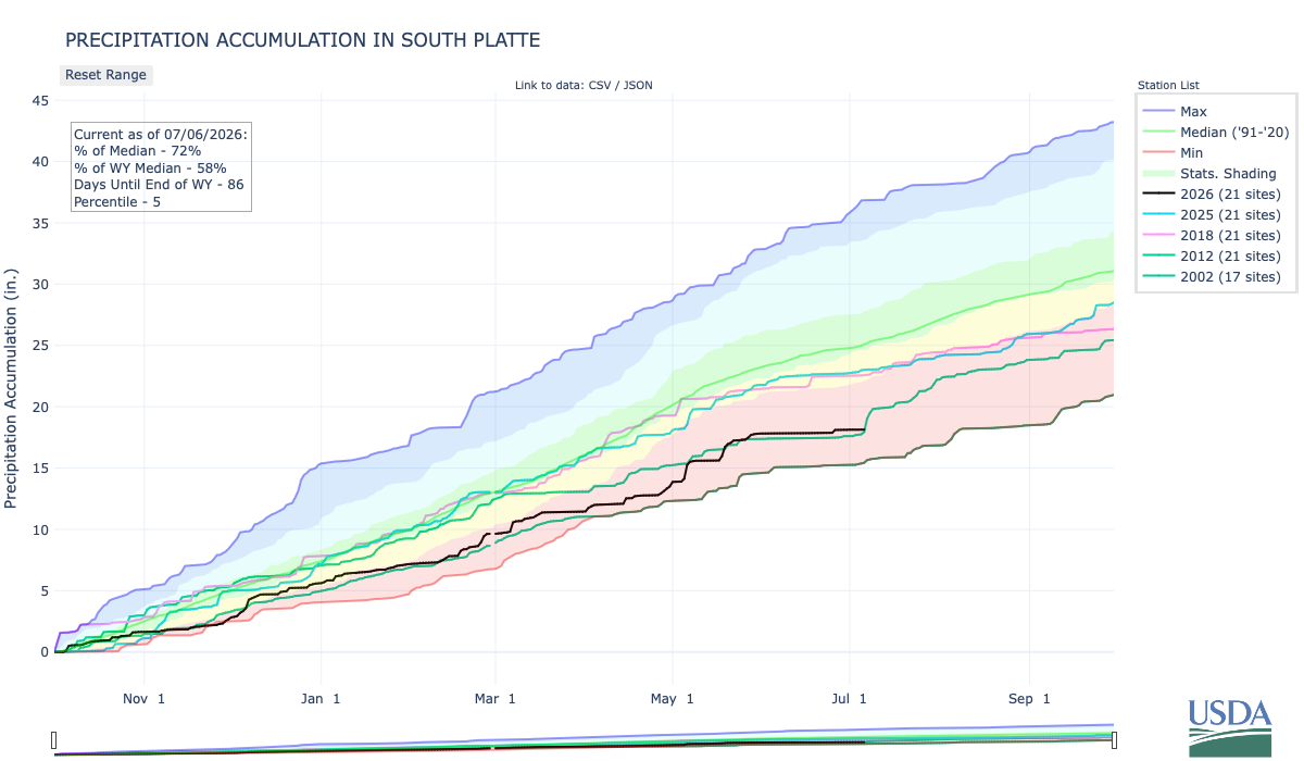
Below is the Precipitation Accumulation in South Platte graph from the NRCS for July 20, 2026. Precipitation is at 72% of the median (no change one week), and 60% of the water year median (up 1% one week), this morning. There are 72 days left in the water year.
There is a chance for thunderstorms today and Tuesday, and thunderstorms are likely Wednesday, with thunderstorms/showers likely Thursday, Friday, Saturday, and Sunday, in the central mountains. There is a chance for thunderstorms today and Tuesday, showers are likely Wednesday and Thursday, with thunderstorms likely Friday, and showers and thunderstorms likely Saturday and Sunday, in the northern mountains. There is a slight chance for thunderstorms today, a chance for thunderstorms Tuesday and Wednesday, with thunderstorms/showers likely Thursday, and a chance for thunderstorms/showers Friday, Saturday, and Sunday, down here about 5 miles from 17th & Market St in Denver where Soapy Smith operated his illicit gambling and bunco business. From the Denver Center for the Performing Arts:
Denver has had its share of secret societies over the years trying to avoid police investigation, but none was more colorful than a gang of criminals known as “The Soap Gang.” It was led by a handsome, black-bearded scoundrel named Jefferson Randolph Smith. Or “Soapy Smith” as he came to be known. Soapy arrived in Denver in 1886 and started a love affair with the city that lasted 11 years. He was probably the most skilled and accomplished sleight of hand artist and swindler in the West…To operate a con game of this nature, Soapy needed confederates: bunco steers to bring in the marks; cappers, stooges, and shills to get the suckers buying, and strong-arm men in case someone caused trouble. So Soapy formed a secret gang. The Soap Gang was the greatest collection of billwrappers, con artists and thugs in the West. There was Fatty “Shoot-Your-Eyes-Out” Gray, a mean 300-pound bodyguard. “Troublesome Tom” Cady, who carried a sword cane. “Ice Box” Murphy, who got his name when he accidentally blew up what he thought was a safe only to be showered with cold cuts. The “Reverend” Bowers was a pious-looking man who mastered every “secret” handshake of every fraternal organization and would lead his new “friends” directly to Soapy for a plucking. Soapy’s gang became so powerful that no criminal could pull a job in Denver without his permission, and through bribes and extortion, he controlled the police and politicians. He based his operations out of the Tivoli Saloon and Gambling Hall on the corner of 17th and Market. Once when he was hauled into court for operating a crooked game, he spoke in his own defense. “At the Tivoli, I am running an educational institution that provides a cure for gambling. The man who steps into my place has, of course, no chance of winning a cent, because in my games the player cannot win. When he leaves, he is disappointed, naturally, but he has had an experience of the greatest value.” Case dismissed…David H. Waite was elected Governor of Colorado on a reform bill. In a rash move, and knowing the level of corruption that existed, he fired everyone at Denver City Hall and ordered them to leave the building, then located at 14th and Larimer. Insisting the governor had no authority to do that, the politicians refused. Governor Waite called on the state militia. City officials called on Soapy. Within hours, Soapy armed dozens of thugs and placed them in strategic windows, while he took a position in the tower of City Hall with dynamite bombs he intended to throw on any attackers. On March 15, 1894, 300 state troops gathered before the building and trained cannon and Gatling guns on it. The Denver Post reported that Soapy in the tower shouted down to the troops, “I’m closer to heaven than you are, but if you come any closer, you will get there first.” General Brooks, commanding the militia sent a hurried message to Governor Waite. “If a single shot is fired, they will kill me instantly and they will kill you in fifteen minutes. But if you say fire, we’ll fire.” Horrified citizens stormed the Capitol and Governor Waite backed down. “Colonel” Smith, as he now called himself, was the king of the underworld and ruler of Denver.
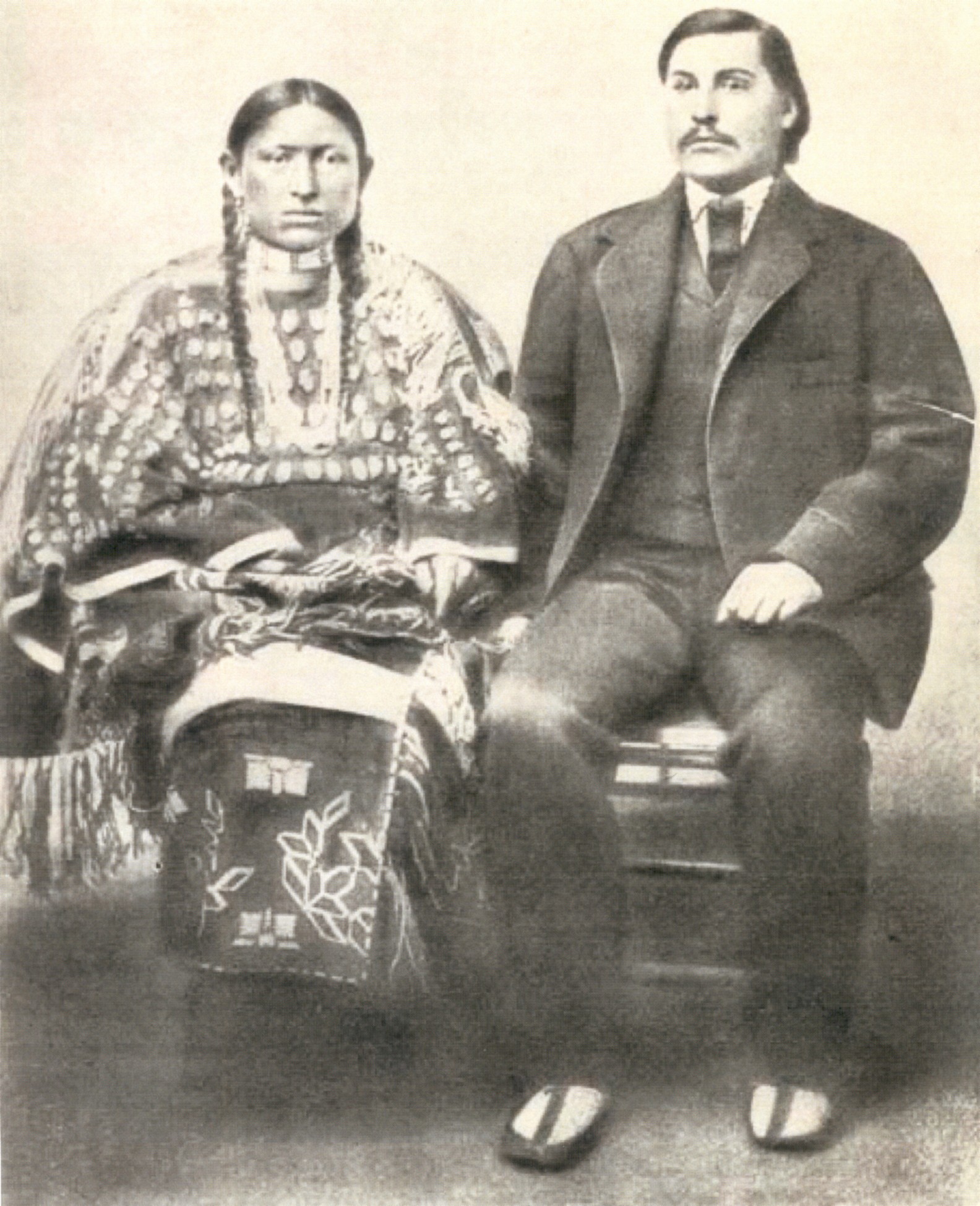
Portrait of Jefferson Randolph (Soapy) Smith, gambler and con-man. Date: 1890-1898. Denver Public Library Special Collections,
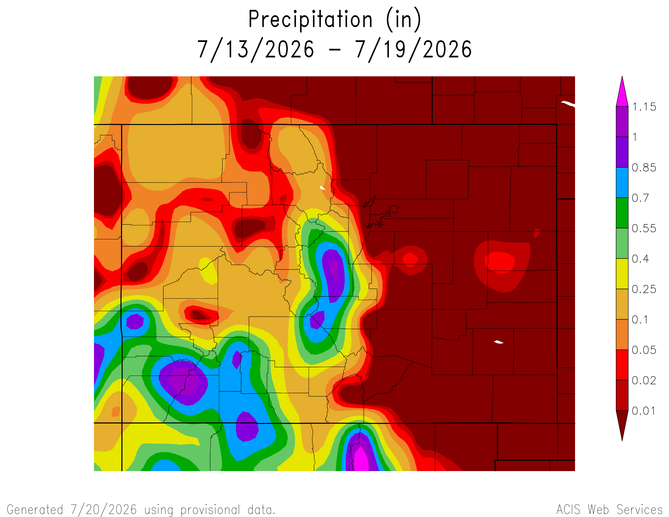
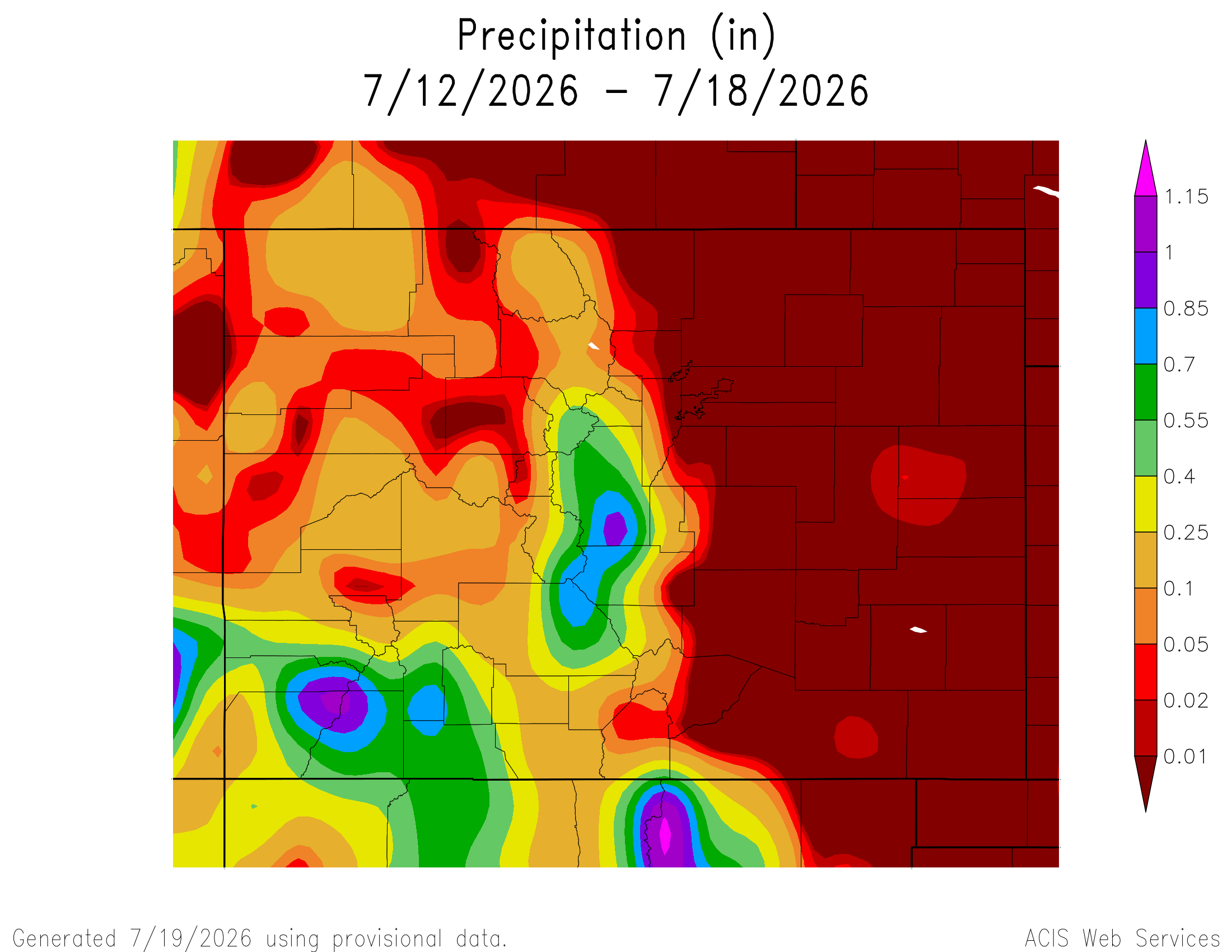
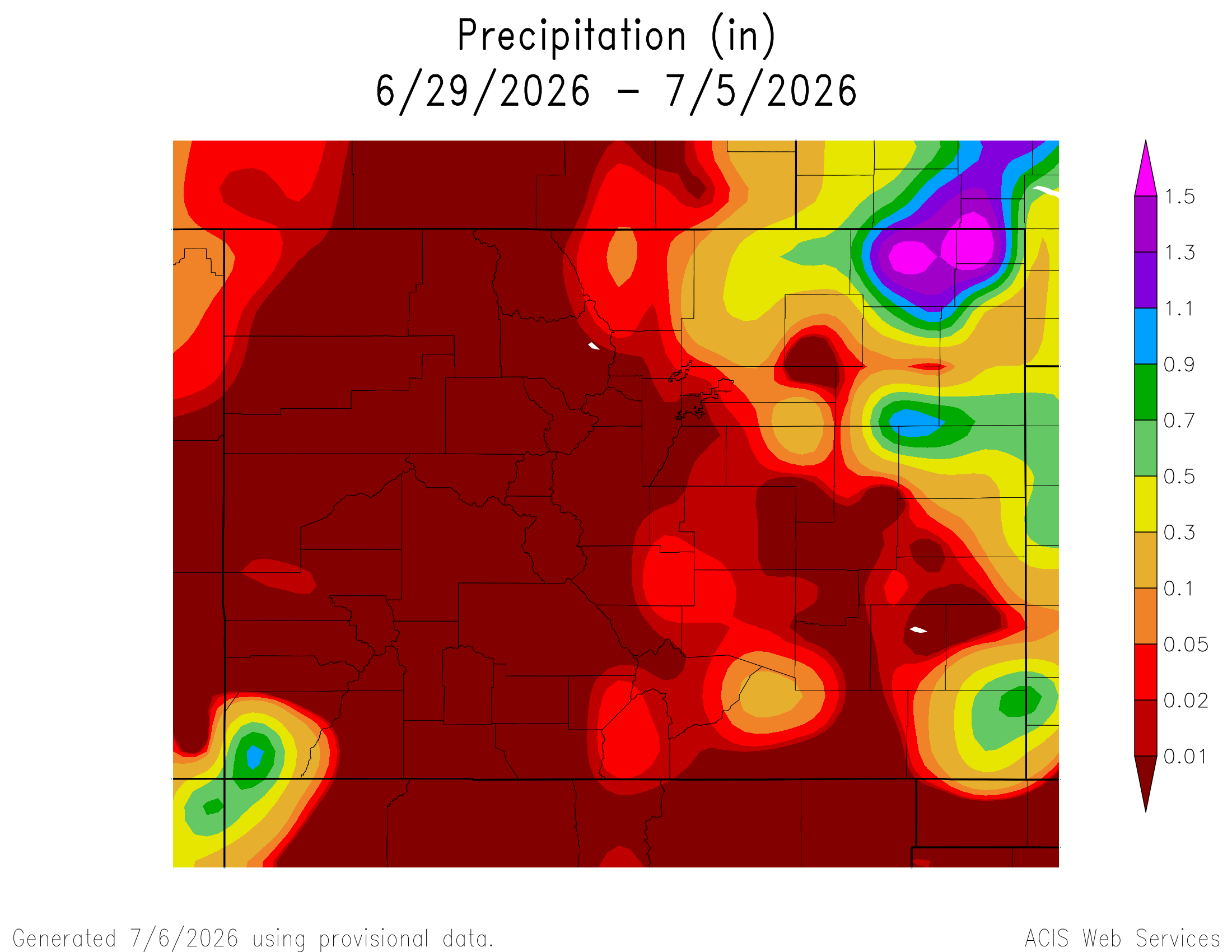
Here’s a look at the 7-Day Colorado precipitation map through July 19, 2026 from the High Plains Regional Climate Center. Precipitation in the South Platte Basin along the Continental Divide of the Americas ranged from 0.10” to 1.15”.
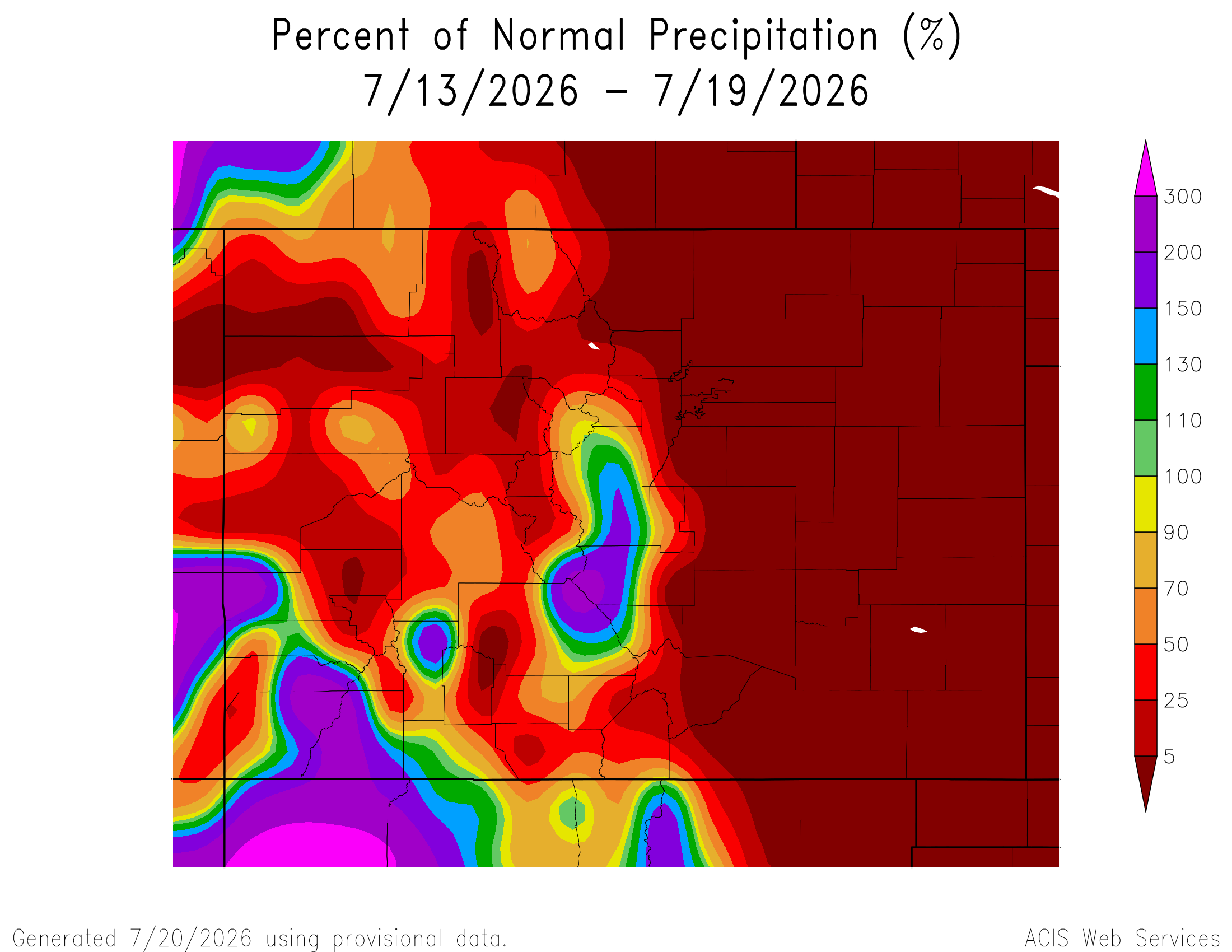
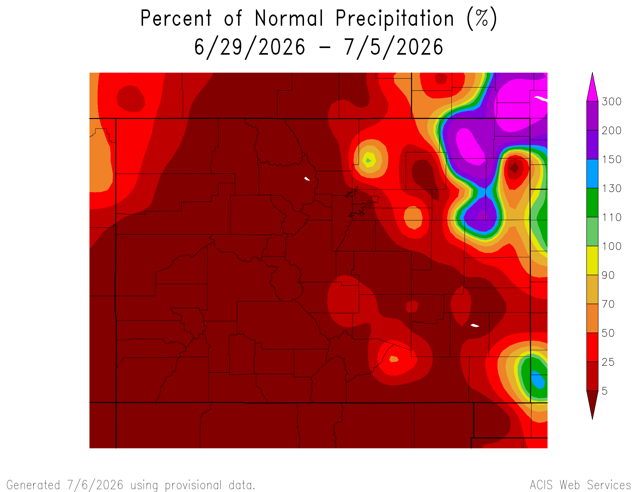
Here’s the 7-Day percent of normal precipitation map through July 19, 2026 from the High Plains Regional Climate Center. Precipitation in the South Platte River Basin along the Continental Divide of the Americas ranged from 25% to 150% of normal.
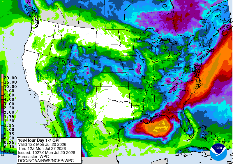
Below is the 7-day Quantitative Precipitation Forecast for the week of July 20, 2026. Precipitation is anticipated for the mountains of the South Platte River Basin and may total up to 1.00″.
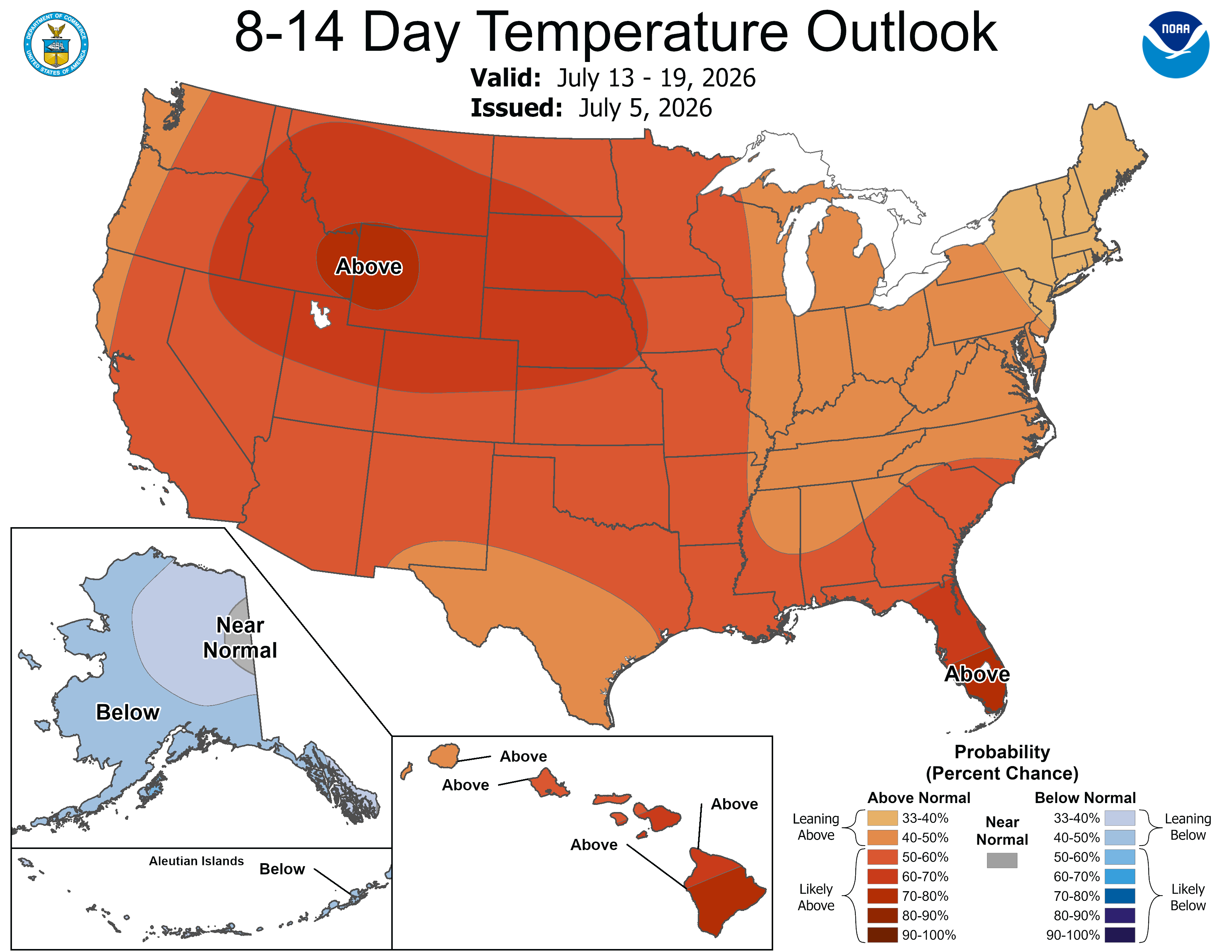
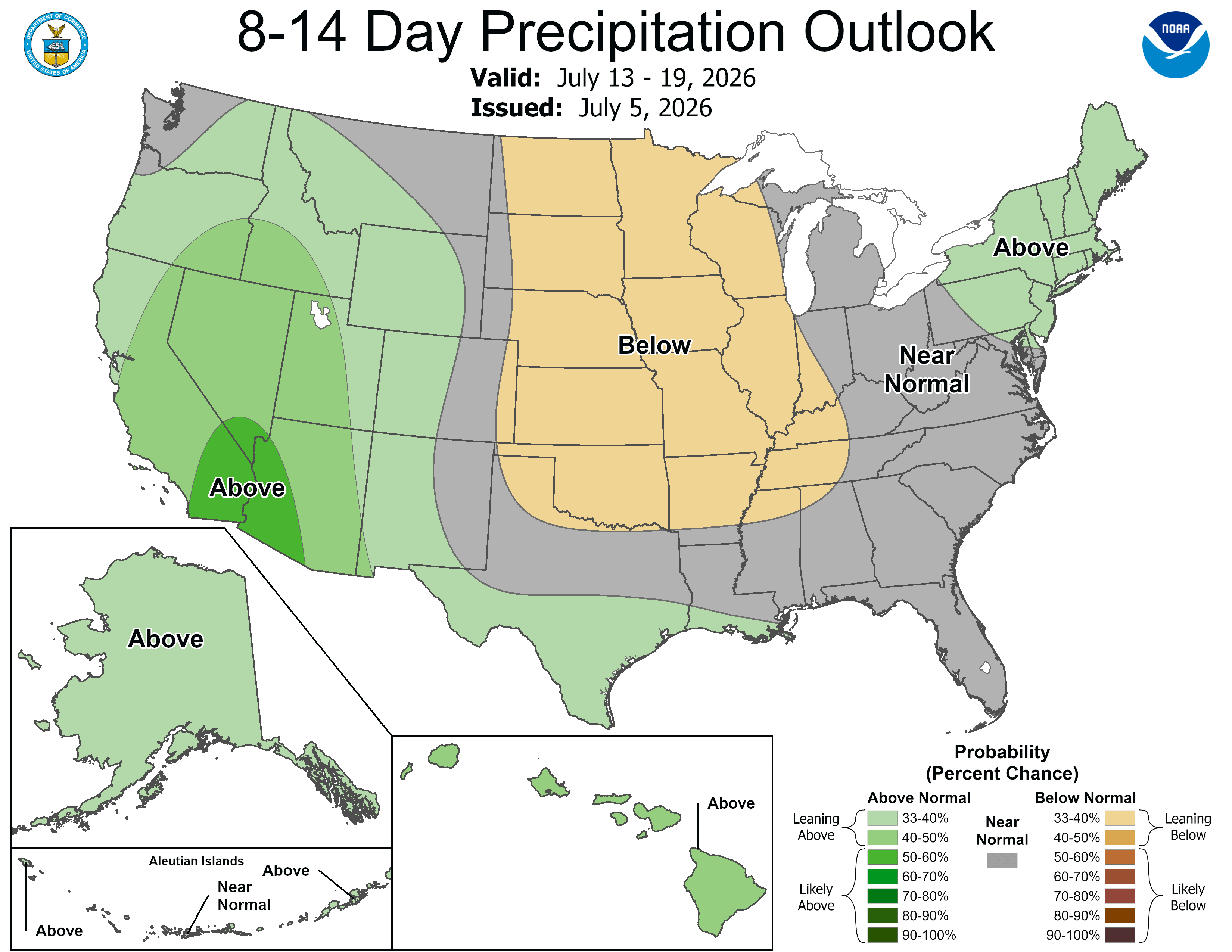
Below are the 8-14 day outlooks from the Climate Prediction Center, issued July 19, 2026, for temperature and precipitation, for the week starting July 27, 2026. The CPC expects above normal temperatures and near normal precipitation for the mountains of the South Platte River Basin.
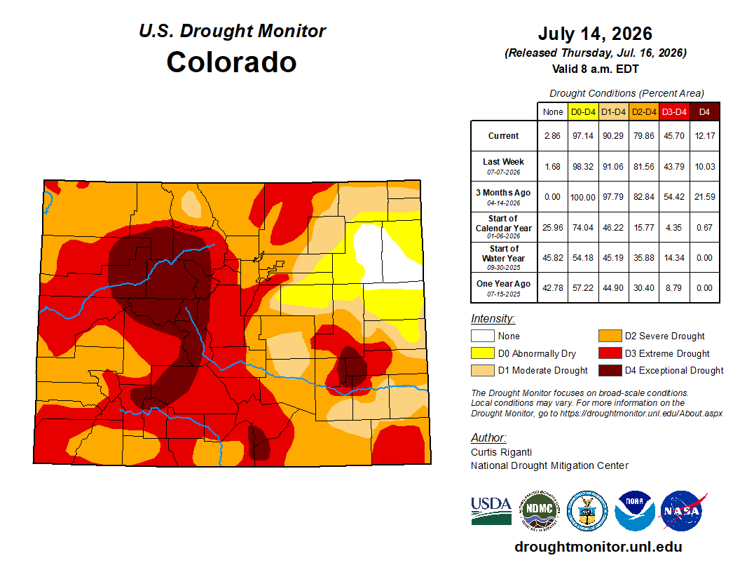
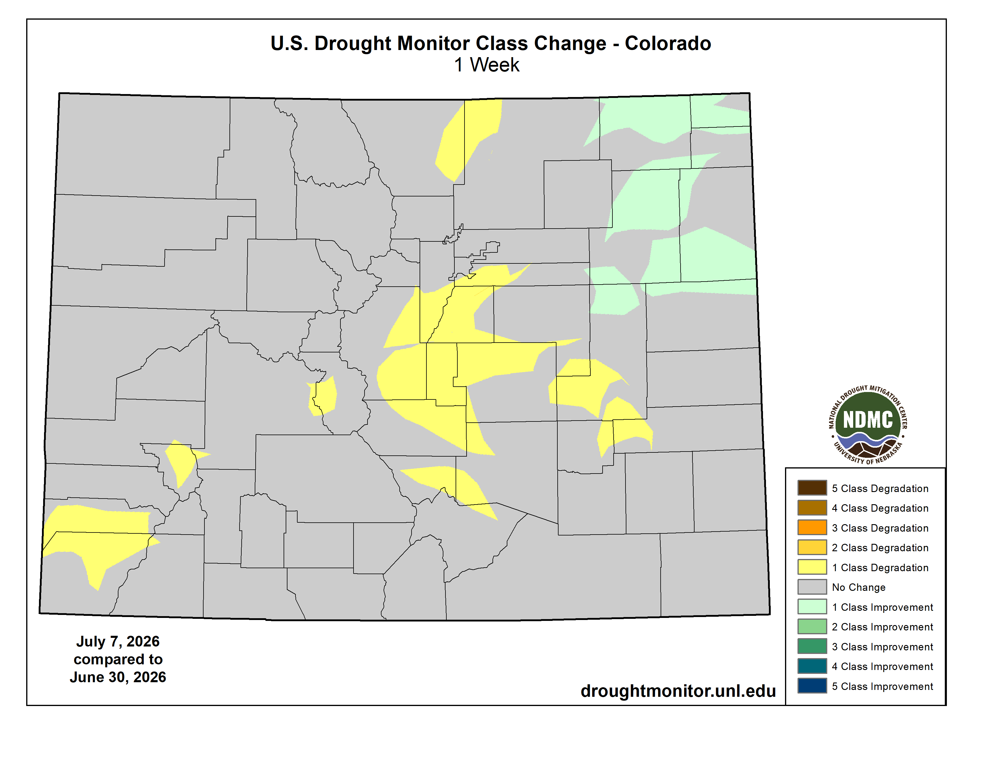
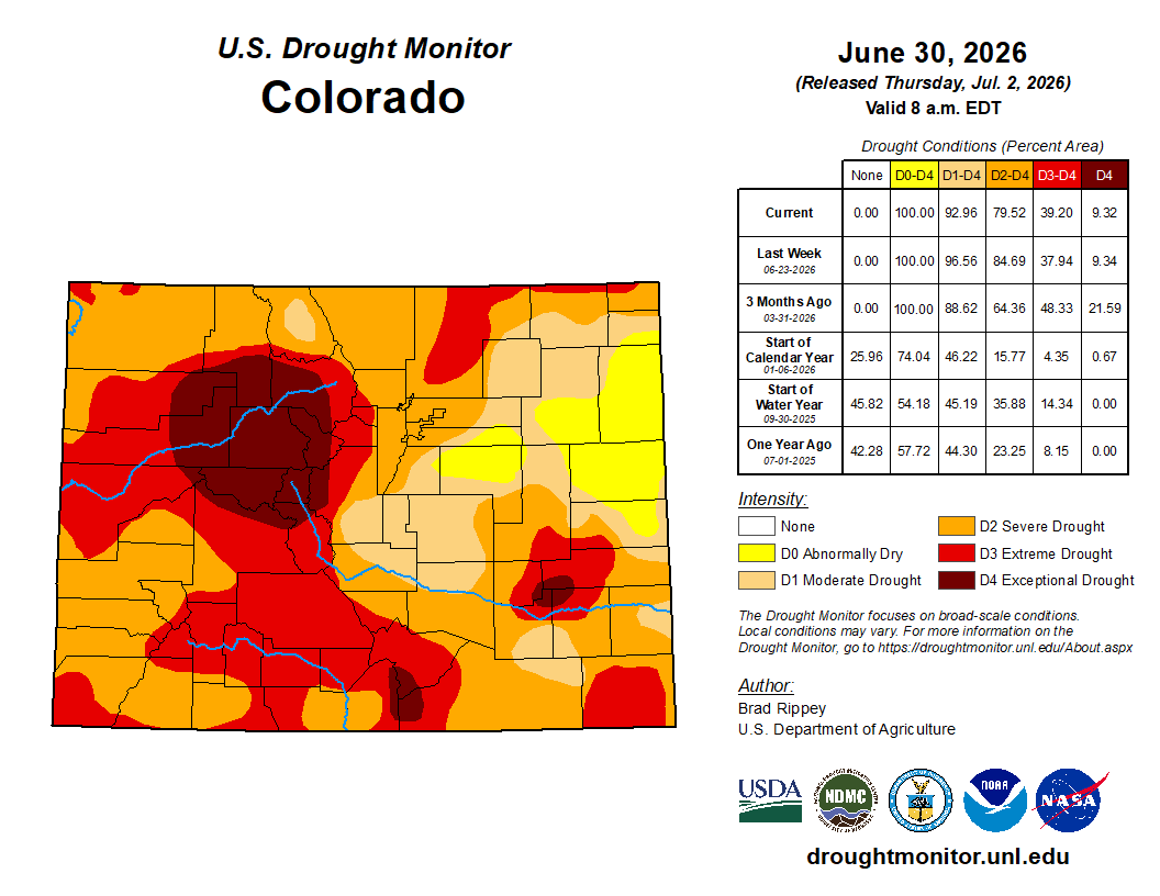
Below is the Colorado Drought Monitor map from June 14, 2026. There were one class degradations in Park and Douglas counties, in the South Platte River Basin. There were one class improvements in Arapahoe, Adams, Weld, Morgan, and Logan counties. Drought and abnormal dryness covers 97.14% of Colorado. The South Platte Basin is experiencing Abnormally Dry, Moderate, Severe, Extreme, and Exceptional drought conditions.
Colorado Drought Monitor map July 14, 2026.
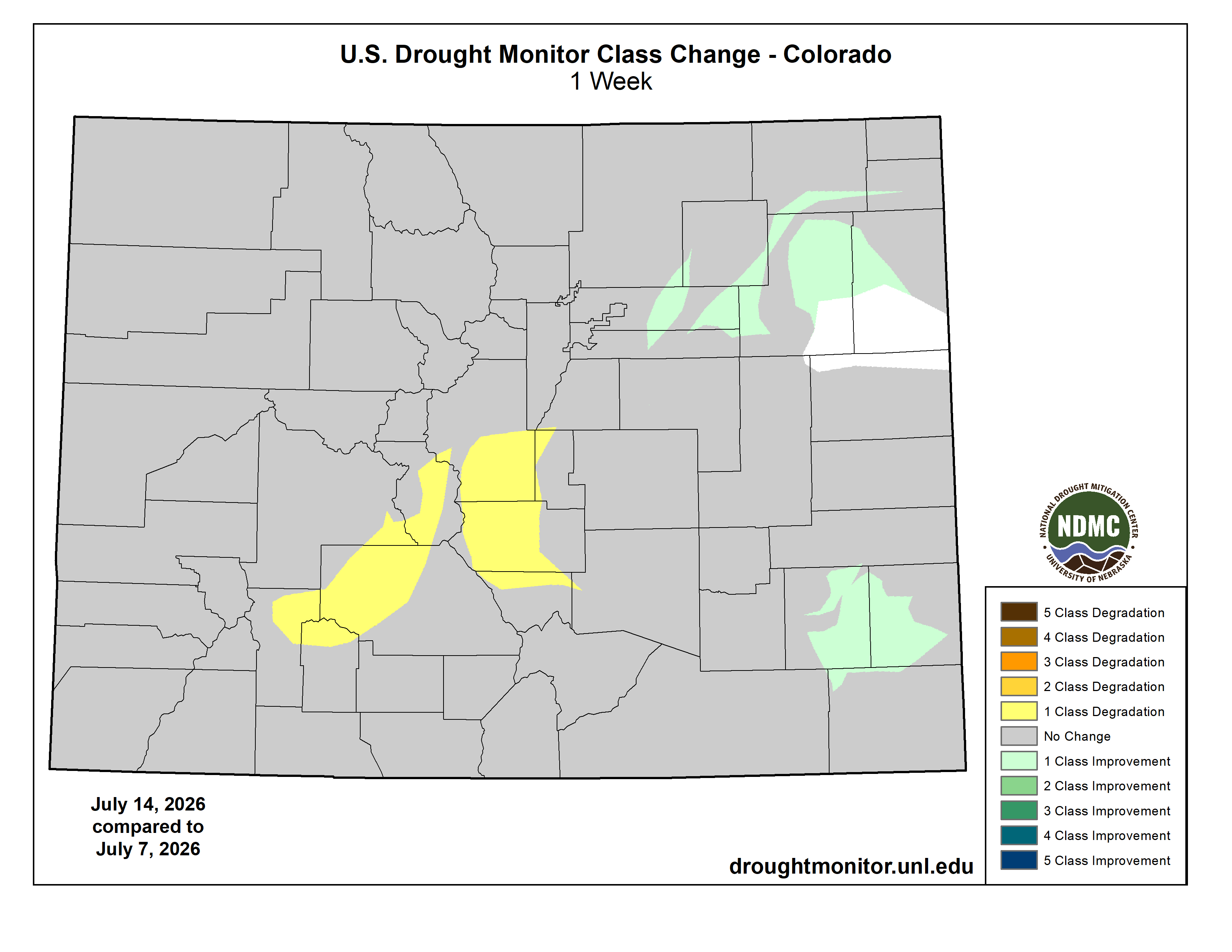
Below is the Colorado Drought Monitor one week change map ending July 14, 2026.
Colorado Drought Monitor one week change map ending July 14, 2026.
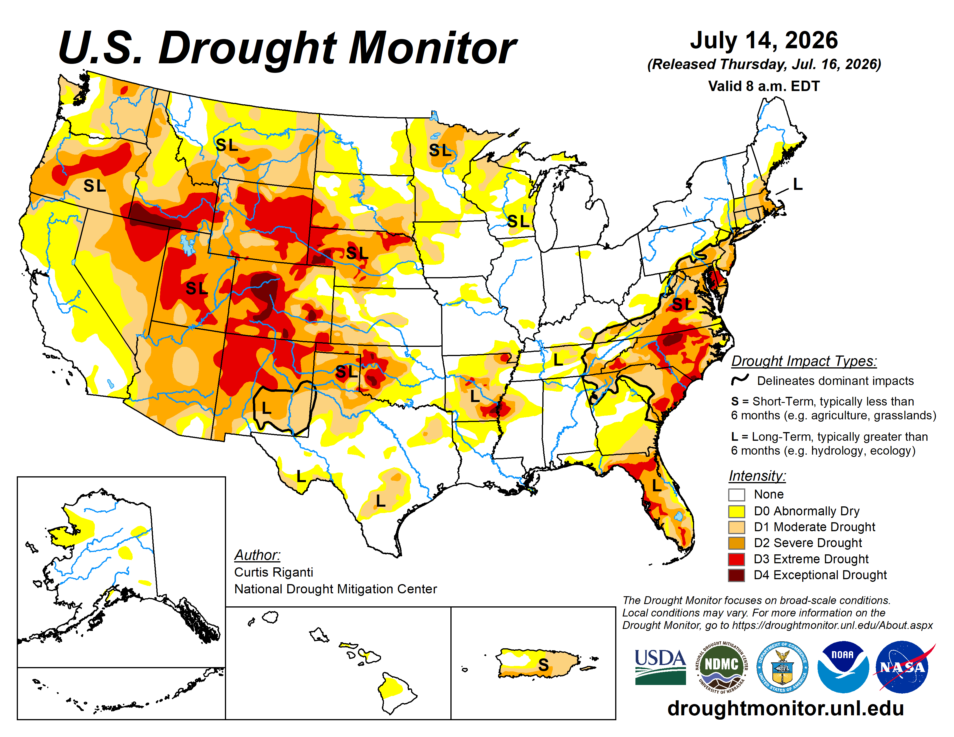
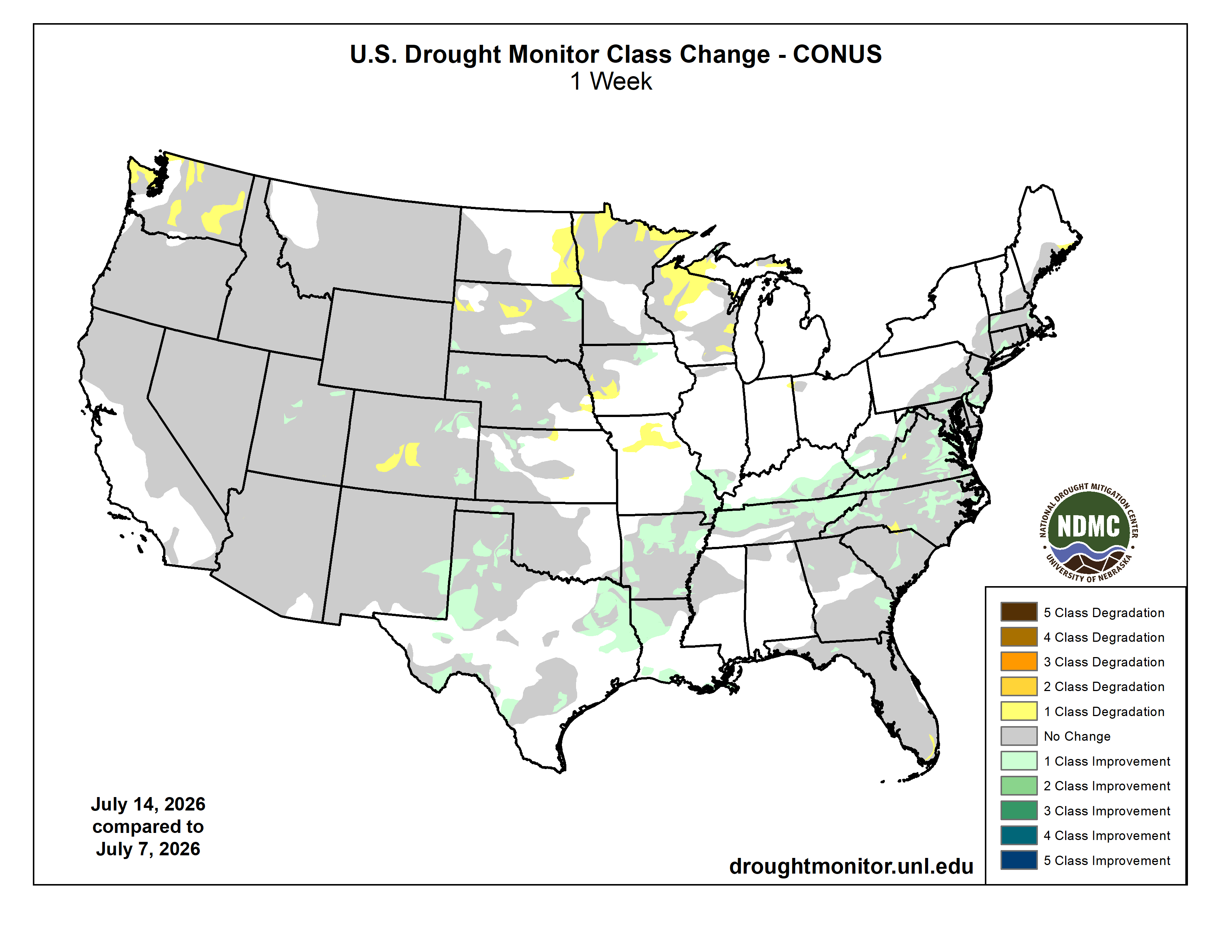
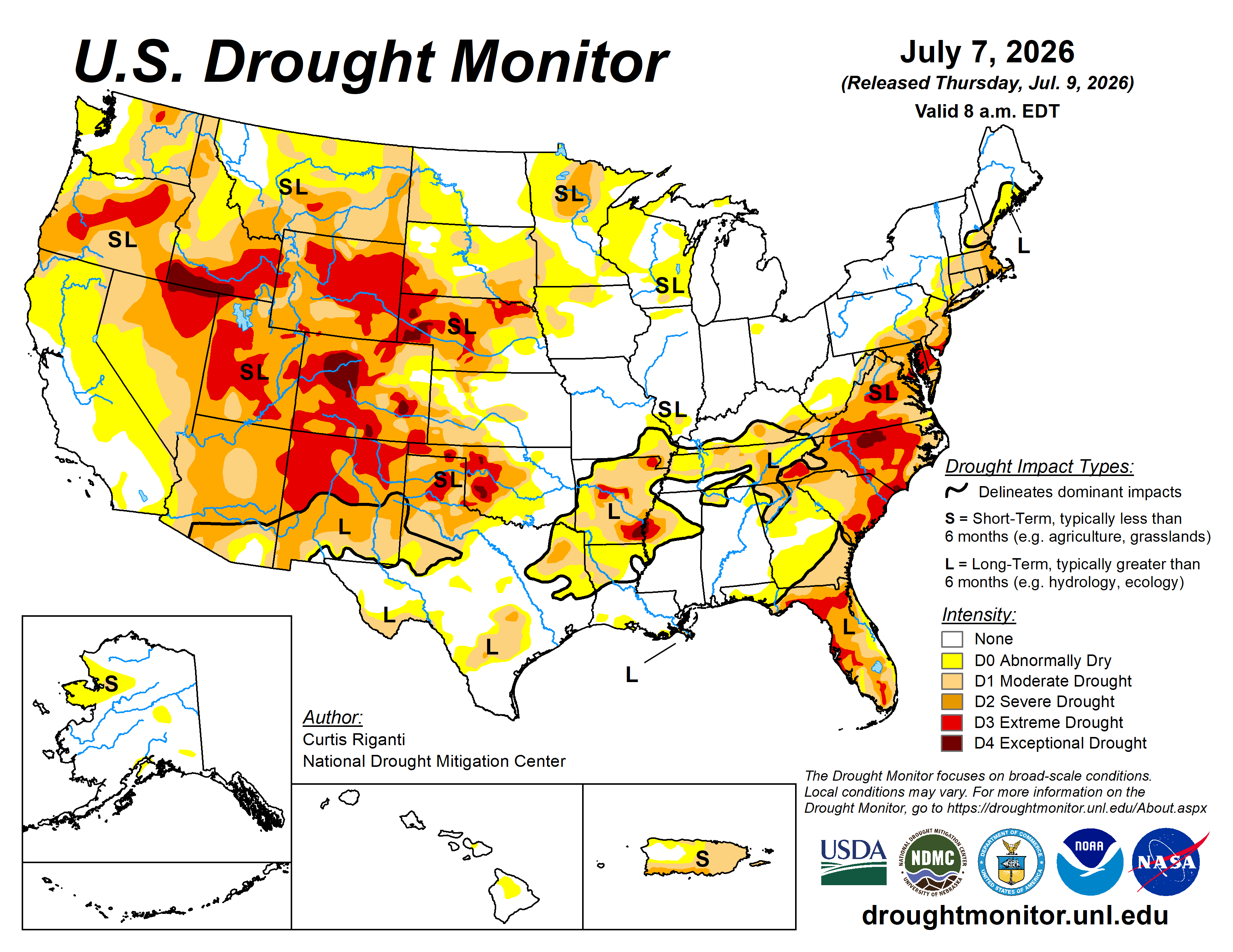
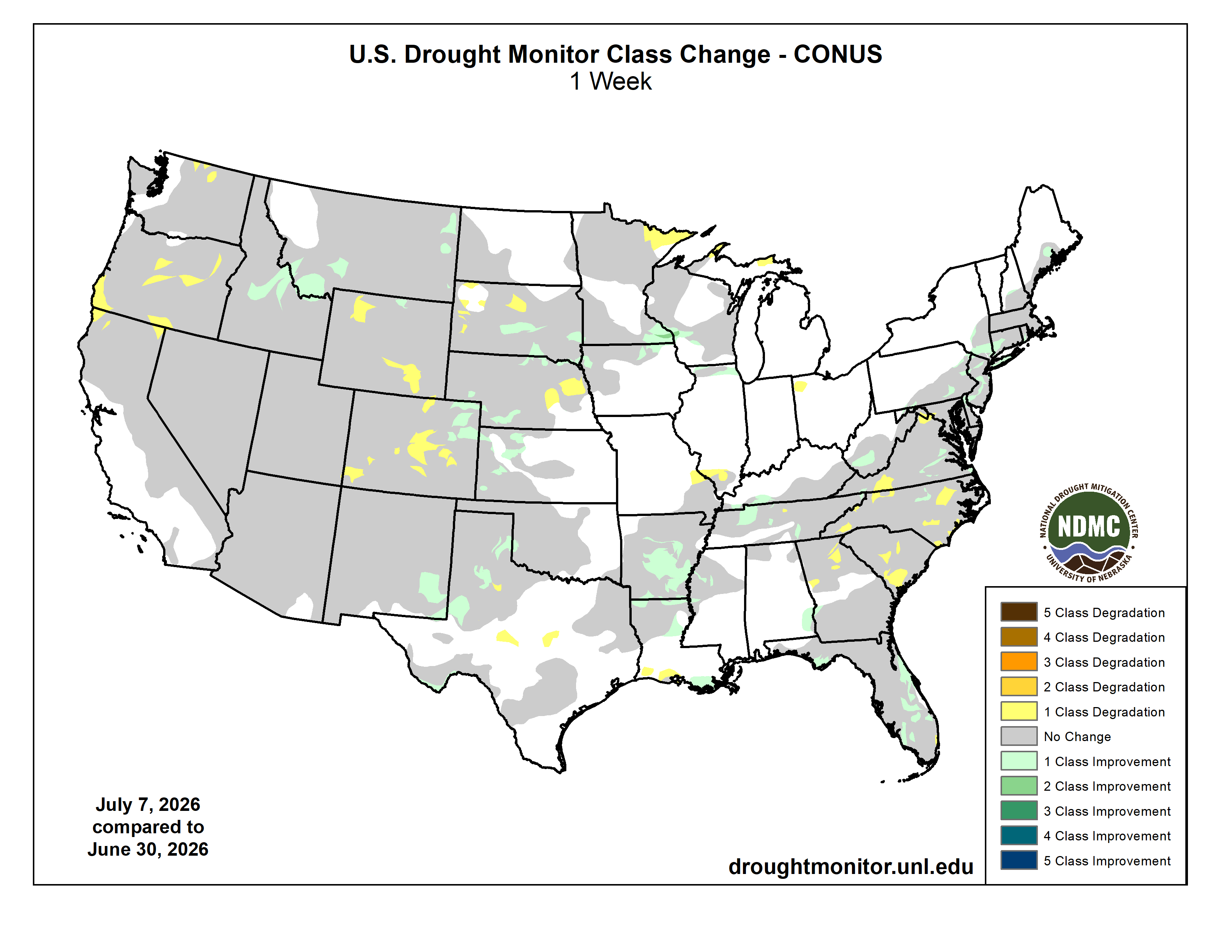
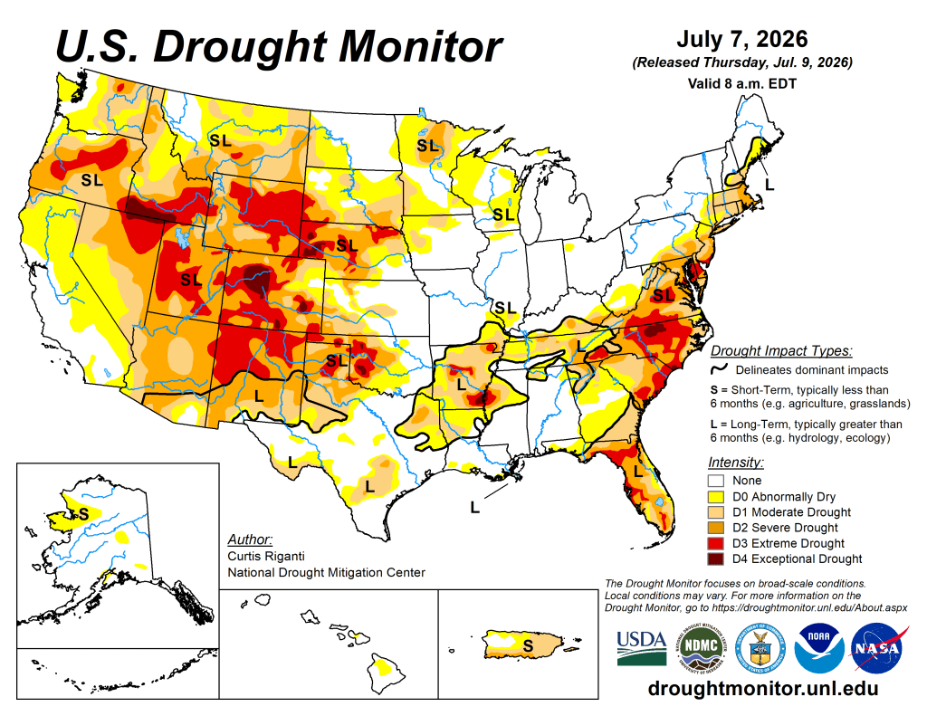
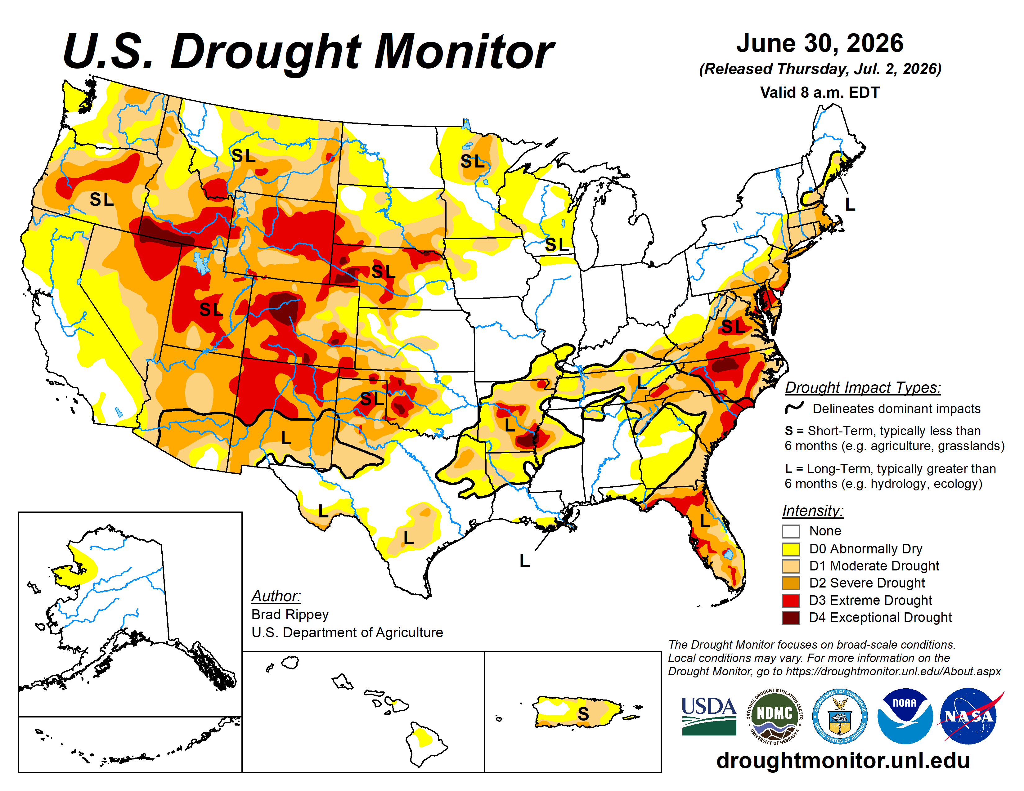
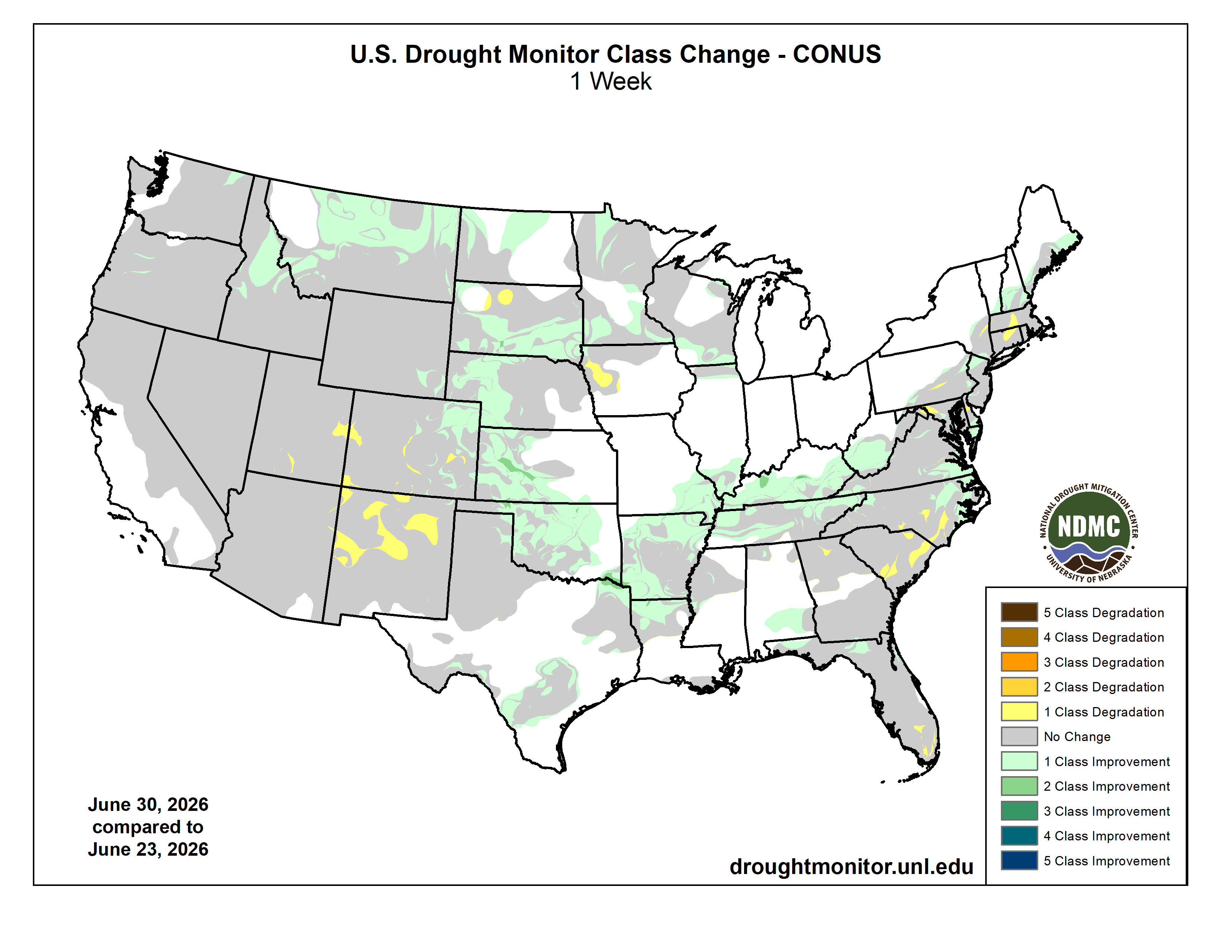
Here’s the US Drought Monitor Map from last week along with the one week U.S. change map.
US Drought Monitor map July 14, 2026.
US Drought Monitor one week change map ending July 14, 2026.
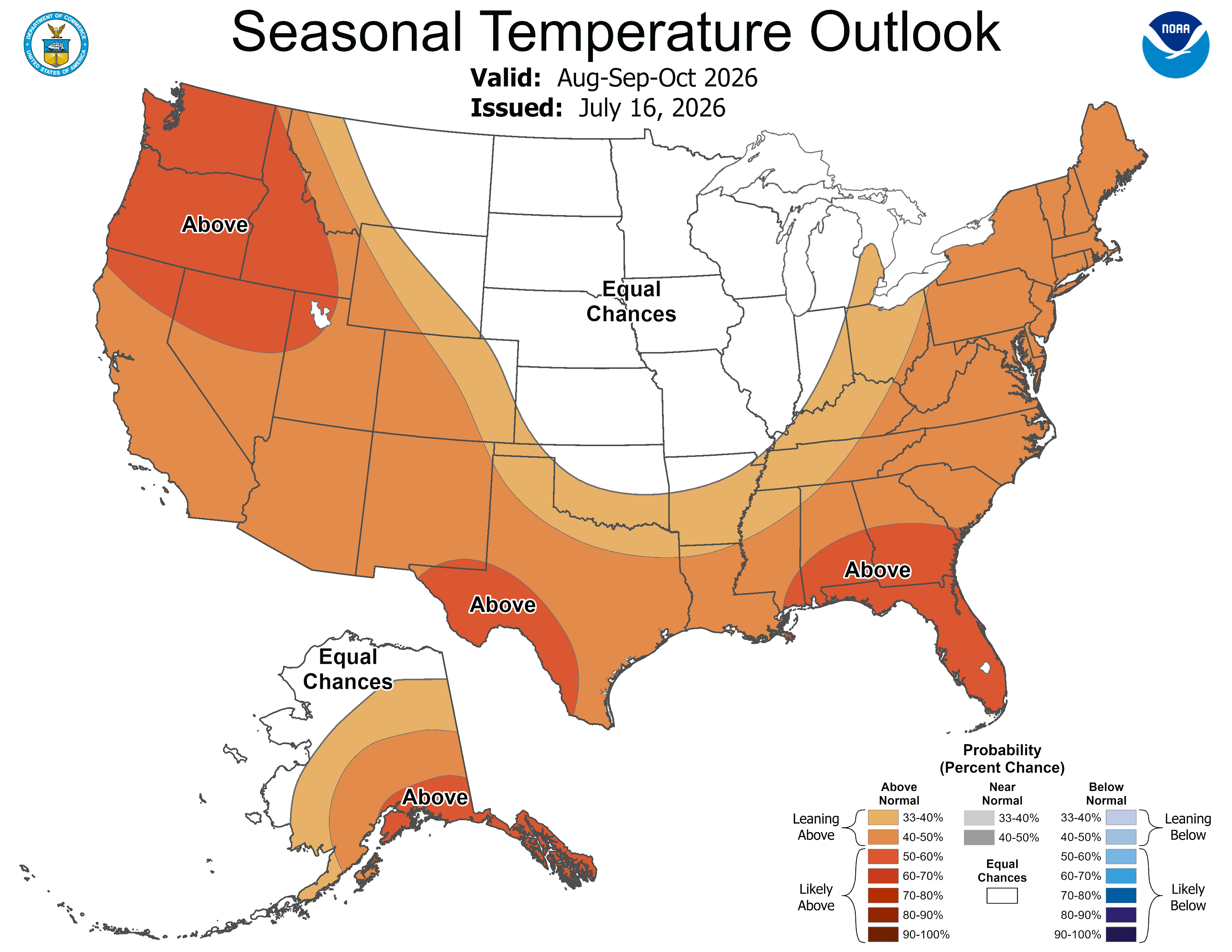
Finally, last week the Climate Prediction Center released their Seasonal Outlooks through the end of the water year (October 31, 2026). They are expecting above normal temperatures, above normal precipitation, and drought removal/improvement in the South Platte River Basin.
This week, rain returned to Pagosa Country, bringing some relief from the dry heat that dominated June and early July and heralding the start of the summer monsoon season. Weather modeling by the National Integrated Drought Information Center (NIDIS) suggests that the summer monsoon season is likely to bring average or above average precipitation to the region — a bounty compared to the approximately 25 to 50 percent of average precipitation Archuleta County received in last month. The National Weather Service Climate Prediction Center forecasts that drought conditions in the area will improve by Sept. 30, although it suggests that current severe and extreme drought levels calculated by the U.S. Drought Monitor will persist through July.
The Pagosa Area Water & Sanitation District is currently in drought stage two, which includes a number of restrictions on outdoor irrigation, as well as additional fees for high water use. In stage two, irrigation is allowed only between 9 p.m. and 9 a.m. every other weekday, with even-numbered addresses able to irrigate on even-numbered days and odd-numbered addresses on odd-numbered days. Weekend irrigation is prohibited. However, drip irrigation and hand watering edible or ornamental gardens is allowed at all times. Residential water use above 4,000 gallons per month is subject to a two times rate multiplier. PAWSD District Manager Andrew Connor explained that, while the rains associated with the monsoons might eventually impact the district’s drought restrictions, changes would require a large amount of rain and would not be immediate. In the summer, the drought stage is primarily driven by the water level in Hatcher Reservoir, flows in the San Juan River and the date…
PAWSD District Engineer Justin Ramsey explained that the district’s drought management plan focuses on irrigation since it composes a large portion of the district’s water use in the summer and because losing green lawn grass or other plants has a smaller impact on people’s lives than restrictions on showering, dish washing or other indoor water uses…The drought stages in the district’s drought management plan align with this goal, imposing progressively tightening restrictions on when irrigation can occur while placing no restrictions on indoor water use except increasing fees for high water consumption. However, for all but the most severe drought stage, these restrictions only cover irrigation done with sprinklers and other automated devices, with the use of drip irrigation devices and hand watering allowed at all times…Manual and drip irrigation encourage people to be more conscious about how they use water by involving them more deeply in the process and requiring more hands-on time, he added. Another way to increase the water available for gardens and landscaping without paying more fees is to reduce water waste in your home, Connor and Ramsey highlighted.
By Tuesday morning, June 30, 2026, four CPW aquatics trucks were headed to Leadville. With fire conditions continuing to change and the window to move the fish uncertain, federal hatchery staff and CPW crews began moving fish by hand with dip nets.
Burning pine needles were falling from the sky as Josh Homer finalized evacuation plans for some of Colorado’s most important fish from the path of the Willow Fire on June 29.
Homer, complex manager for the U.S. Fish and Wildlife Service’s Leadville and Hotchkiss national fish hatcheries, was sitting near a pavilion at the Leadville National Fish Hatchery, coordinating with Bryan Johnson, Colorado Parks and Wildlife’s Mount Shavano Hatchery manager, to determine where rare cutthroat trout could safely go.
While they talked, smoldering pine needles landed around Homer. A firefighter approached and told him his team was getting nervous about conditions and was considering pulling out. The Leadville National Fish Hatchery, Colorado’s oldest, had operated since 1889.
Firefighters work near Leadville National Fish Hatchery during the Willow Fire response. (Photo credit: Josh Homer)
Homer made the call to evacuate the fish.
The Willow Fire had started the previous afternoon about two miles northwest of the hatchery. Homer and Johnson had been watching the rapidly changing fire and preparing to move fish they had spent years working together to protect.
Andy Claus, Colorado Parks and Wildlife Mount Shavano fish culturist; Josh Homer, U.S. Fish and Wildlife Service Leadville and Hotchkiss national fish hatcheries complex manager; Jackson Baroni, Colorado Parks and Wildlife Leadville district wildlife manager; and Taylor Woolmington, Colorado Parks and Wildlife property technician, help during the evacuation of fish from Leadville National Fish Hatchery. (Photo credit: Bryan Johnson)
Johnson first learned of the fire while driving home from Fort Collins, when a former seasonal employee in Leadville sent him a photograph of smoke. He alerted CPW leadership, lined up drivers and had CPW aquatics trucks disinfected and prepared.
By Tuesday morning, June 30, four CPW aquatics trucks were headed to Leadville. With fire conditions continuing to change and the window to move the fish uncertain, federal hatchery staff and CPW crews began moving fish by hand with dip nets.
One person netted fish from a tank. Nets moved down a line of people to a waiting truck, where the fish were transferred into a transport tank.
John Sutton, U.S. Fish and Wildlife Service seasonal; Andrew Thatcher of the U.S. Fish and Wildlife Service in Leadville; Taylor Woolmington, Colorado Parks and Wildlife property technician; and Bryan Johnson, Colorado Parks and Wildlife Mount Shavano State Fish Hatchery manager, load fish during the evacuation of Leadville National Fish Hatchery. (Photo credit: Josh Homer)
“My big goal was just to get them on trucks,” Johnson said. “Once we had them on trucks, I knew we could take care of them.”
Over the next three days, federal and state crews moved more than 148,000 fish, including rare native broodstocks, to CPW hatcheries and waters across Colorado.
Chris Lashmett, Colorado Parks and Wildlife seasonal, and DaNelle Ellington-Martinez, Colorado Parks and Wildlife seasonal, offload fish from Leadville National Fish Hatchery at Durango State Fish Hatchery. (Photo credit: Sarah Gump)
Among the fish facing evacuation were Greenback cutthroat, Colorado’s state fish, and Hayden Creek cutthroat trout.
The greenbacks are a critical broodstock used in ongoing recovery work for a fish struggling to survive in the wild. Broodstock are adult fish kept to produce eggs and future generations. Leadville maintains one of only two broodstocks CPW relies on for the recovery effort.
“If we were to lose that stock, it would have been detrimental to the future survival of this species, period,” Homer said. “I trust CPW implicitly to do what’s best for these fish.”
That trust and the relationships behind the rescue had been built over years.
The federal hatchery maintains the greenback broodstock that produces future generations for recovery efforts. Colorado hatchery teams help manage the brood fish, raise their offspring and move fish to carefully selected waters across the state.
Hayden Creek cutthroat trout. Photo credit: Colorado Parks & Wildlife
Those fish trace to a population rescued as wildfire burned through their drainage in 2016. Survivors eventually were moved to Leadville, where hatchery professionals worked to raise the population and return fish to waters in the Arkansas River basin.
Now they faced wildfire again.
Johnson’s history with the greenbacks stretched back even further.
“I was there in 2008, the day we picked them up from Bear Creek and brought them into the hatchery,” Johnson said. “We’ve invested a lot of time in this.”
By Homer’s estimate, crews moved roughly 1,500 pounds of greenback cutthroat trout and several hundred pounds of Hayden Creek cutthroat trout by hand. The rainbow trout that followed represented nearly 10,000 more pounds of fish.
Crews estimated more than 90 combined hours physically moving fish Tuesday and another 48 hours Wednesday. That does not include driving time nor unloading at their destinations.
Seth Firestone, Colorado Parks and Wildlife Roaring Judy State Fish Hatchery manager, and Joe Lagasse, Colorado Parks and Wildlife Roaring Judy fish culturist, receive greenback cutthroat trout from Leadville National Fish Hatchery. (Photo credit: Adam Pierce)
Sarah Green, U.S. Fish and Wildlife Service AmeriCorps seasonal hire, and Paige Moran of the U.S. Fish and Wildlife Service in Leadville help evacuate fish from Leadville National Fish Hatchery as the Willow Fire approached. (Photo credit: Bryan Johnson)
For hatchery crews accustomed to handling fish, the work itself was familiar. The scale and urgency were not.
Moving the fish also required precision. Multiple age classes of greenbacks and Hayden Creek cutthroat trout had to remain separate to protect genetics that hatchery professionals had spent years preserving. Crews assigned specific groups to individual transport tanks and labeled each movement.
Kristi Lauerman, Colorado Parks and Wildlife Roaring Judy fish culturist, and Mark Haver, Colorado Parks and Wildlife Mount Shavano assistant manager, receive Hayden Creek cutthroat trout from Leadville National Fish Hatchery. (Photo credit: Seth Firestone)
“Everything was labeled and everything was moved purposefully to their new homes,” Johnson said.
At the same time, hatchery managers across Colorado were rearranging fish and searching for isolated space to receive the rescued broodstocks. Hatcheries already had been preparing for possible drought, low-water or wildfire rescues. The Willow Fire changed those plans and made the greenbacks the priority.
“When situations like this occur, we prioritize our workload and then we rally to get the job done. This was a prime example of that,” said Jeff Spohn, CPW Aquatic Branch deputy assistant director. “I couldn’t be more proud of the team’s communication, dedication and collaboration with not only our internal CPW staff, but also with our federal partners.”
Approximately 5,000 greenback cutthroat trout and about 1,500 Hayden Creek brood fish were moved from Leadville.
The fish were divided among CPW’s Mount Shavano State Fish Hatchery in Salida, Roaring Judy State Fish Hatchery in Almont, John W. Mumma Native Aquatic Species Restoration Facility in Alamosa, and Durango State Fish Hatchery in Durango. Greenbacks no longer needed for the broodstock were moved to Joe Wright Reservoir near Cameron Pass, where they can provide a recreational fishing opportunity. About 200 retired Hayden Creek brood fish were released into the Arkansas River south of the fire zone.
DaNelle Ellington-Martinez, Colorado Parks and Wildlife seasonal, and Bryan Johnson, Colorado Parks and Wildlife Mount Shavano State Fish Hatchery manager, offload fish from Leadville National Fish Hatchery at Durango State Fish Hatchery. (Photo credit: Sarah Gump)
One group remained on a truck Tuesday night while Johnson cared for the fish and hatchery staff searched for appropriate isolation space. On Wednesday, July 1, Johnson drove them to Durango.
The rescue also included approximately 142,000 rainbow trout from the Leadville hatchery. Rather than risk losing the fish, crews stocked them earlier than planned into available waters.
Sarah Green, U.S. Fish and Wildlife Service AmeriCorps seasonal hire; Grace VanDenBerg, Colorado Parks and Wildlife Arkansas Headwaters Recreation Area seasonal; Tom Ellenwood, Colorado Parks and Wildlife Arkansas Headwaters Recreation Area; and Brandon White, Colorado Parks and Wildlife headquarters warm water production supervisor, load rainbow trout for early stocking at Twin Lakes. (Photo credit: Josh Homer)
Just more than three days after the Willow Fire started Sunday afternoon, nearly all fish had been moved from the hatchery.
Homer also praised his hatchery staff, some of whom worked long hours in heavy smoke while worrying whether their own homes might be threatened by the fire.
“I couldn’t be more proud of them,” Homer said. “They’ve done a tremendous job working in these adverse conditions.”
As of July 9, the Willow Fire had burned approximately 4,463 acres and was 16 percent contained. The Leadville National Fish Hatchery had not had any direct impact by fire at the time, and active fires appear to have skirted the property. In a fire-resistant facility at the center of the property, staff continue to care for the brood year 2022 Hayden Creek Cutthroat Trout with a fish relocation truck at the ready.
Crews work during the evacuation of Leadville National Fish Hatchery.
For CPW hatchery crews, safely evacuating the fish was only the beginning.
The rescued brood fish now are spread among CPW hatcheries, where populations and age classes must remain isolated to protect their genetics. Hatchery staff are monitoring their health and caring for brood fish moved in the middle of spawning.
“We’re going to do whatever it takes to keep these fish healthy,” Johnson said.
When the Willow Fire is no longer a threat and conditions allow, the hope is to return the fish to Leadville.
Until then, some of Colorado’s most important fish remain in the hands of people Homer knows well.
And trusts implicitly.
Sarah Gump, Colorado Parks and Wildlife Durango fish culturist, checks dissolved oxygen levels in a tank housing rescued greenback cutthroat trout from the Leadville National Fish Hatchery. Hatchery staff monitor oxygen levels daily to support the fish until they can safely return to Leadville. (Photo credit: DaNelle Ellington-Martinez)
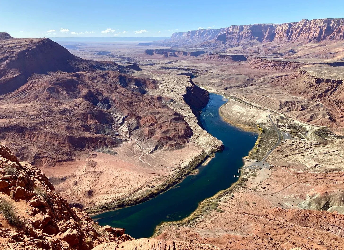
Looking down at the Colorado River, Lees Ferry, and the Paria River. Jonathan P. Thompson photo.
Click the link to read the article on the KJZZ website (Alex Hager). Here’s an excerpt:
July 16, 2026
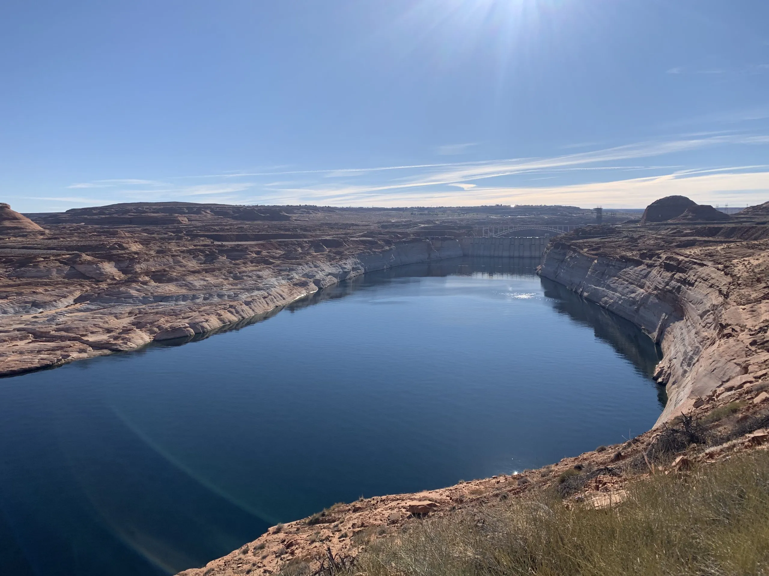
Sara Porterfield, Colorado River program director with the conservation nonprofit Trout Unlimited, stood on a narrow, rocky river beach, about as close to Glen Canyon Dam as a boat can go.
“This is not a zero sum game,” she said. “Investing in watershed health is not an either-or. We need the system to be healthy from an ecological perspective in order for the rest of it to function.”
The river, Porterfield said, cannot deliver big volumes of clean water if it does not, at least partially, function like a normal, healthy river. For example, if the river’s upper reaches are dried out, they’ll be susceptible to wildfires and wetland degradation, which make it harder for them to hold on to water and release it slowly into the streams where humans have been able to reliably divert and collect it for generations.
“It’s not just plumbing, but it’s also not just water in a river,” Porterfield said as the dam’s hydroelectric generators emitted a whining hum in the background. “We’re not separate from the natural world, we’re part of it. When we recognize that, and we take help to take care of it, we get a lot further than when we’re just thinking about a plumbing system.”
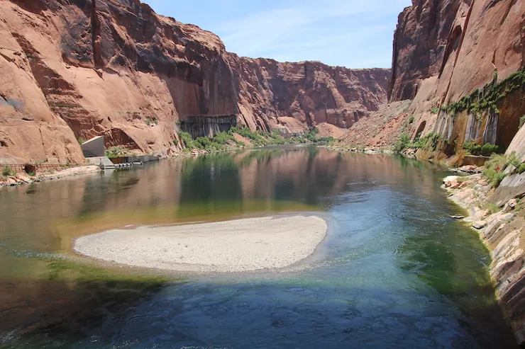
Glen Canyon downstream from Glen Canyon Dam. Photo credit: Allen Best/Big Pivots
Porterfield, who has a Ph.D. in Colorado River history, said calling the river a “plumbing system” is a useful way to think about one of its jobs, but not the whole picture. Environmental advocates say the river can be protected while still flowing through the dams and canals that keep the West wet for humans. Those protections can even be part of the wonky and rigid legal policies that dictate where water goes. John Berggren, a water policy manager at the conservation nonprofit Western Resource Advocates, had some recommendations for the next set of river-sharing rules. An important one, he said, is to get the river out of “crisis mode.”
[…]
“You can be much more proactive and thoughtful and careful and intentional about how you manage the river and include river health,” he said.
Another way to help protect the river’s ecosystems, creatures and flows, Berggren said, is by carefully timing the release of water from reservoirs. For example, policymakers can write flexible rules about where and when water is stored, so water that is flowing downstream to cities and farms can also help make life better for native fish. The water can be used to help the environment without being taken away from humans downstream.
“They’re going to move the water anyway,” he said. “Let’s do it in a way that actually benefits ecological conditions.”
Map of the Colorado River drainage basin, created using USGS data. By Shannon1 Creative Commons Attribution-Share Alike 4.0
Retired farmer Ernie Myers spoke Tuesday to the threats and hostilities he faced as a groundwater irrigator and how he felt like a “whipping boy” for surface water farmers who complained “that I was pumping their water.”
Myers was the first to testify in protest of the Subdistrict 1 Fourth Amended Plan of Water Management as part of the Northeast Water Users Association and Sustainable Water Augmentation Group opposition to the plan.
He served on the Subdistrict 1 board of managers from 2012 to 2016 and told Division 3 Water Court Judge Michael Gonzales that “I was exhausted,” when he stepped down. “They beat me up mentally and financially.”
Myers and his family, along with Asier Artaechevarria, are asking Gonzales to reject the plan, which is designed to recover the unconfined aquifer through a one-for-one pumping mechanism — for every acre-foot of water pumped, an acre-foot of water must be returned to the aquifer — that limits pumping to the amount of natural surface water that comes into the subdistrict.
Groundwater irrigators with little or no natural surface water coming into their fields will have to offset their pumping either by purchasing surface water credits or paying a $500 per acre-foot fee, which Myers and Artaechevarria told the judge would put them out of business.
The plan has been approved by the Subdistrict 1 board of managers, the Rio Grande Water Conservation District board of directors, and the state engineer with the Colorado Division of Water Resources.
Artaechevarria told the court that he didn’t think enough had been done under the current plan of water management to try to make it work. Both Artaechevarria and Myers said they were willing to retire more acreage under the current plan and that the $500 acre-foot fee is beyond the economic means of groundwater irrigators.
“My land would have no value,” Artaechevarria testified, because he wouldn’t be able to market it for sale and wouldn’t be able to pay the mortgage as a result.
“You can see the issue there,” he told the court.
Myers said it was after 2002, when the Upper Rio Grande Basin first experienced historic low flows from a lack of snow runoff, that he first began to feel targeted as a groundwater irrigator and had the feeling that surface water farmers were trying to put him out of business.
“I was pumping their water. I had no right to pump their water. I had a few farmers telling me, ‘I’m third, fourth generation. You’re a newcomer. You came in ’73 with your father. You have no right to do what you’re doing.’”
“And were there actually people saying that they intended to put you out of business?” SWAG’s attorney asked.
“Yes, yes,” testified Myers.
The Division 3 water trial is in its third week at the Alamosa Judicial Center.
Rumors of data centers have local government agencies in the San Luis Valley preparing for the inevitable – an application for a data center.
Costilla County and the town of South Fork are the latest local governments to place moratoriums on artificial intelligence data centers. Though no applications or projects are being proposed, local governments want to give themselves time to create land use codes to address data centers.
A packed room and a packed Zoom at the Costilla County Planning Commission meeting Wednesday morning saw tensions high as the public continues to express opposition to data centers. The commission approved a year-long moratorium. The moratorium will now go to county commissioners for approval.
The town of South Fork’s planning and zoning board is poised to do the same thing during a public hearing Wednesday night’s planning and zoning commission meeting as the town does not have specific zoning regulations that address data centers. The board will use the public hearing for feedback as members begin their work over the next year to devise specific codes.
At Wednesday morning’s Costilla County meeting, planning commissioner Joseph Quintana dispelled rumors and reassured the public that a data center application has not been submitted to the county and that “nobody’s approved anything.”
He said that when the planning commission was first formed the commission came up with a mission plan with a set of goals that were aimed at protecting the environment and the way of life.
“A data center is the antithesis, the complete opposite of what we would want in this community,” he said.
He went on to say, “Our job here is to follow that mission that was established 30 years ago with public comment. So I just want to make sure everybody understands, nobody’s approved a data center that I’m aware of. Nobody’s even applied for a data center here. There’s nobody that’s asked to build one or tried to get a permit or anything like that.”
In June, the Costilla County Commissioners asked the planning commission to address data centers “and get ahead before a problem develops,” Quintana said.
Commissioner Frank Vigil said they wanted the year to create a “thoughtful” ordinance that “reflects the feelings of the general public.”
“Our code doesn’t even have the two words ‘data center’ in it anywhere at all,” said county attorney Carle Turnetzer-Decker. “We were just concerned, I think, the board of county commissioners and the commission here, that if someone did approach us we have absolutely no way to handle it, restrict it, regulate it, do any of that.”
South Fork made a public statement on Tuesday that said, “To dispel rumors that are circulating within the community. The Town instituted a moratorium on Data Centers within the Town of South Fork last month which will last one year. The Town has not had any companies approach the town about data centers. We are simply trying to get ahead of any that may approach the Town. Obviously, there are concerns with them and rest assured your Board of Trustees share your concerns. Please come share your thoughts so we know how best to represent the community in making policy on this.”
Saguache County was the first local government in the Valley to place a moratorium on data centers while it figures out how its land use codes would address any data center application.
Earlier in June, the Rio Grande Basin Roundtable heard from Lindsay Rogers of Western Resources Advocates, who noted how rural markets are becoming targets for data center applications because of the assumption of “less red tape.”
Western Resources Advocates, Rogers said, has a particular interest working in the San Luis Valley as part of a grant process for local policy decision-making around large water users.
“One concern that we have which we’ve seen playing out in other states in our region, is that developers may target rural communities where they feel there may be less red tape to developing these data centers. Our communities may not have the time or resources needed to ensure the proposal fits within their own goals and their own resource availability. So we think it’s really important to think about these policy options proactively before developers come to town instead of responding to them once they’ve arrived.”
Solar panels San Luis Valley. Photo credit: Allen Best/Big Pivots
Richard Hubler, planning director for Alamosa County, said at the roundtable, “There’s a very real possibility, as we move forward, that because of our fiber networks here and our broadband capacity, our cheap land and what may end up being a glut of solar production that we could be a target in the Valley for somebody who says, ‘Hey, there’s more power than the Valley could use there.
“I could take a circle next to that 600 megawatt project and use the other 400 megawatts they may have.’ And we don’t know how to handle that now as a county or as a Valley. I think that this is timely because we really do want to get ahead of it before we have to deal with an application.”
In May, SLV Rural Electric Cooperative CEO Eric Eriksen said the Valley has underutilized energy capacity and that “rural data centers” are the “most relevant for us.” Rural data centers are described as smaller, more efficient facilities that are often housed within buildings no larger than small commercial buildings and operate anywhere from 50 kilowatts up to 50 megawatts.
These centers commonly use air-cooling or closed-loop refrigeration instead of consuming water.
In May, SLV Rural Electric Cooperative CEO Eric Eriksen said the Valley has underutilized energy capacity and that “rural data centers” are the “most relevant for us.” Rural data centers are described as smaller, more efficient facilities that are often housed within buildings no larger than small commercial buildings and operate anywhere from 50 kilowatts up to 50 megawatts.
These centers commonly use air-cooling or closed-loop refrigeration instead of consuming water.
In SLVREC’s position, the agriculture’s energy demand is declining and that company sees “the underutilized capacity” as an opportunity “to serve five, 10, 20, 50 megawatts or more of rural data centers.”
According to SLVREC, there are seven long-haul fiber routes into and out of the Valley, “with terabytes of unused capacity that is ideal for data centers.”
Rio Grande and Pecos River basins. Map credit: By Kmusser – Own work, Elevation data from SRTM, drainage basin from GTOPO [1], U.S. stream from the National Atlas [2], all other features from Vector Map., CC BY-SA 3.0, https://commons.wikimedia.org/w/index.php?curid=11218868
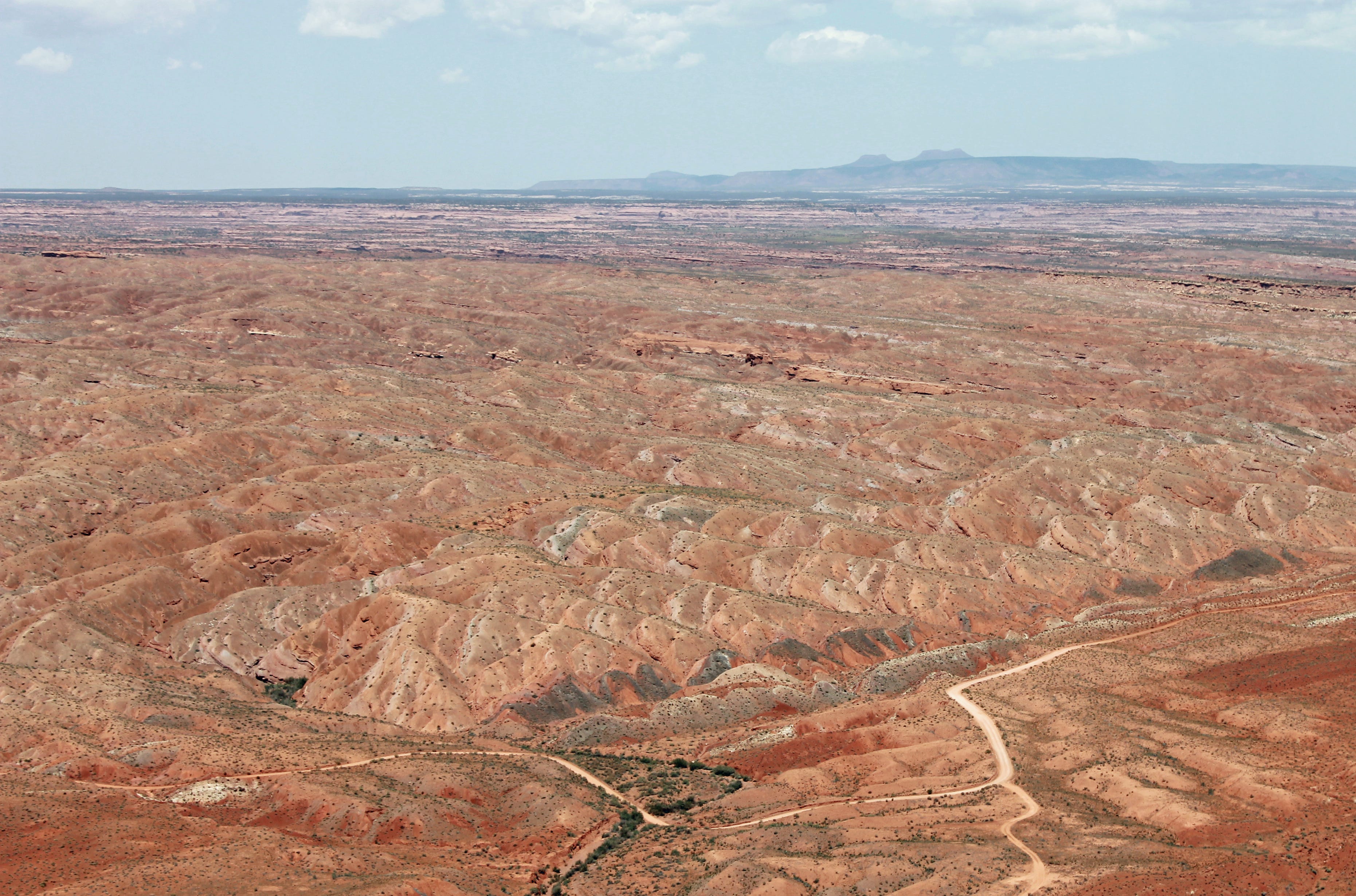
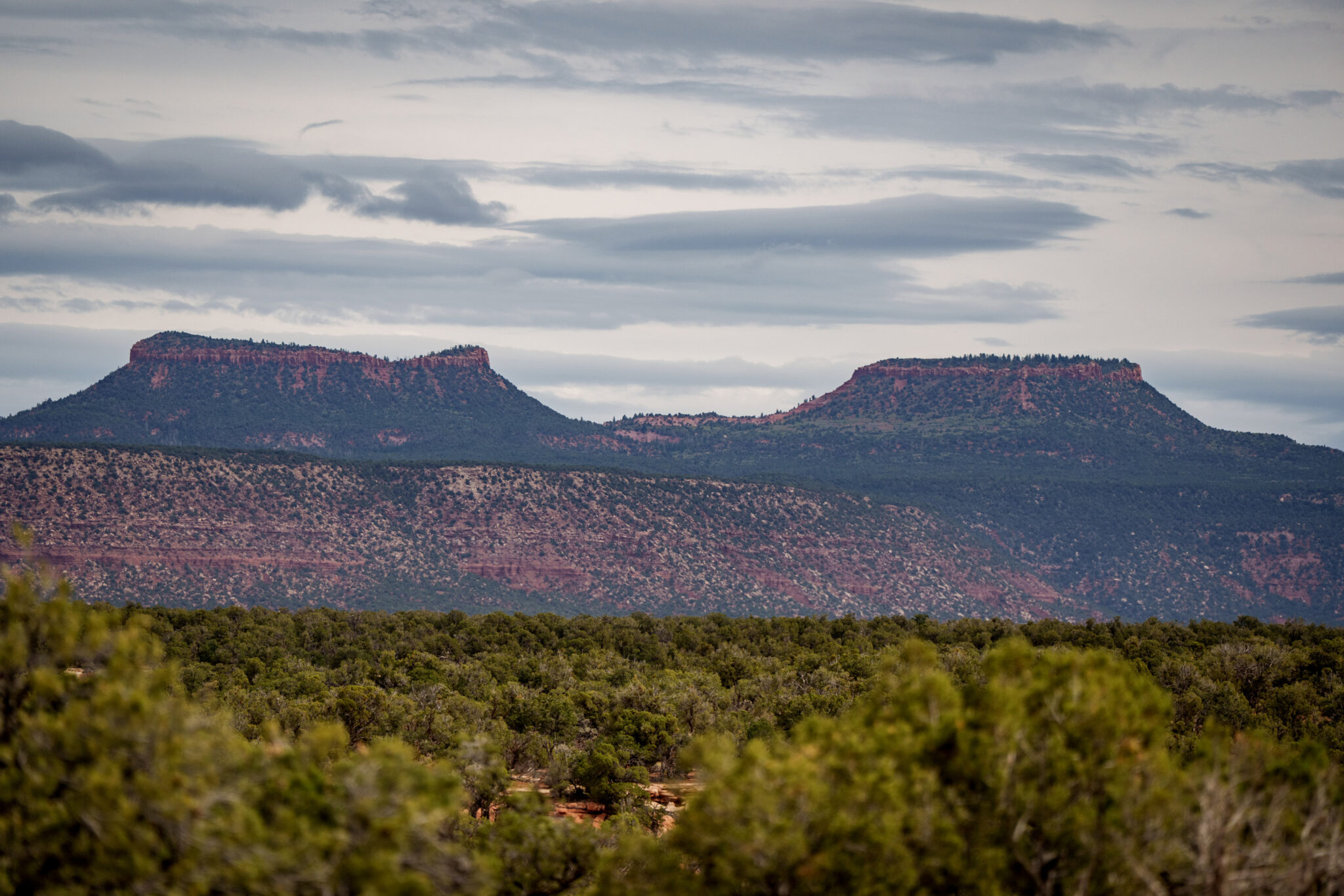
Looking toward the Bears Ears from Comb Ridge with Cedar Mesa in the mid-ground. Everything in the image was included in Bears Ears National Monument. Yesterday, Trump’s proclamations removed 1.24 million acres — including most of Cedar Mesa — from protected status. Jonathan P. Thompson photo.
THE NEWS: On Monday, President Donald Trump pulled out his figurative Sharpie pen — i.e. he issued two presidential proclamations —- and dramatically reduced the size of Bears Ears National Monument and Grand Staircase-Escalante National Monument, both in southern Utah, thereby removing national monument protections from more than 2.9 million acres of public lands and the antiquities therein. He also disbanded and terminated the Intertribal Bears Ears Commission, a direct attack on the tribal nations that first proposed a national monument for their homelands and that have been co-managing it until now.
The move reopens huge swaths of Utah’s canyon country to new mining claims and mineral leasing, reviving the potential for oil and gas drilling, uranium mining, and potash, lithium, and coal extraction in previously protected areas. It also scraps the existing resource management plans for both national monuments, throwing even the remaining shards of protected areas into regulatory uncertainty.
Additionally, the proclamations order the managing agencies, the Bureau of Land Management and the U.S. Forest Service, to ease restrictions on motorized travel, vegetation management, and livestock grazing within the remaining national monuments.
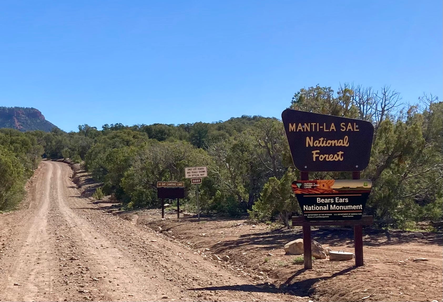
The road to the Bears Ears Buttes. Jonathan P. Thompson photo.
THE SORDID DETAILS: The administration has not yet released a map of the shrunken boundaries, but from the proclamation’s description it would appear that at Bears Ears they roughly follow the same lines as those created in 2017 when Trump downsized the national monument the first time. The difference is that he cut an additional 100,000 acres from the national monument. At GSENM, however, he appears to have eliminated the former Grand Staircase Unit on the southwest side of the national monument, and slashed the Kaiparowits Unit to a fraction of its previous size.
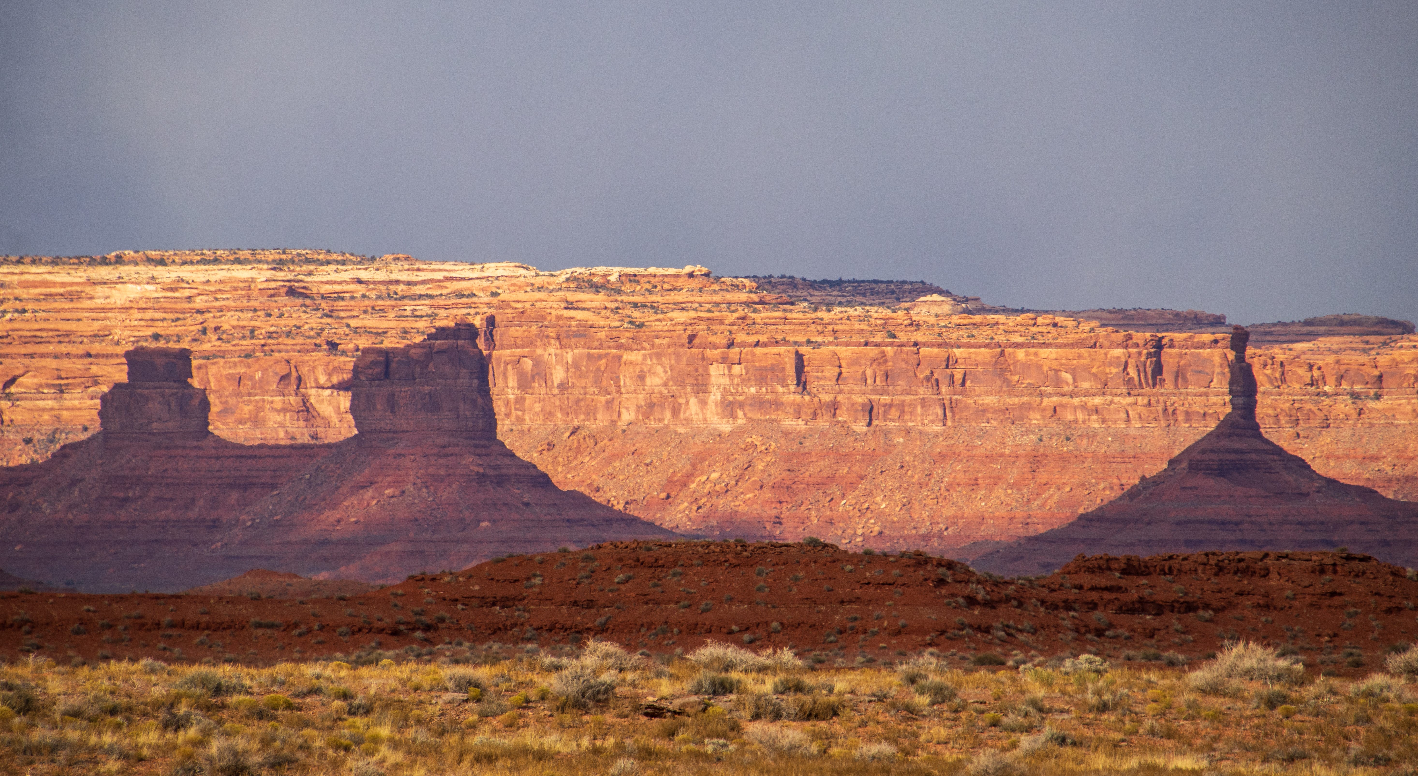
The Valley of the Gods was also removed from Bears Ears National Monument in Trump’s latest shrinkage. Jonathan P. Thompson photo.
For Bears Ears:
Yesterday’s proclamation removed 1.24 million acres from national monument status, reducing the 1.36 million-acre monument to just 121,096 acres (91% reduction). When Trump shrunk it in 2017, there was more than 200,000 acres remaining.
The reduced national monument includes two main units:
The 106,816-acre Shash Jaa Unit that contains the Bears Ears Buttes, Arch Canyon, Mule Canyon, Comb Ridge, and portions of the Butler Wash Archaeological District.
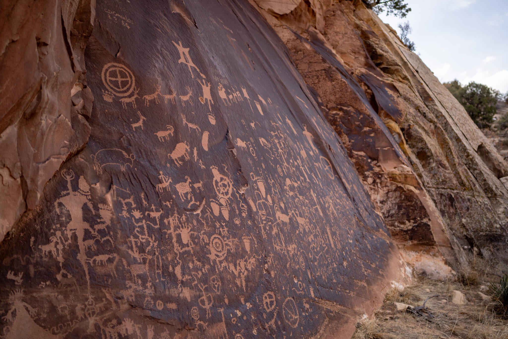
And the 14,279-acre Indian Creek Unit, which includes Newspaper Rock.
Also included are small non-contiguous parcels that lie outside the two main units, such as:
Doll House Ruin (157 acres);
Scorup Cabin, which was used by the “Mormon Cowboy” J.A. Scorup when he ran cattle in the Bears Ears region in the late 1800s and early 1900s. This likely burned in the Babylon Fire. (314 acres)
The Rig Canyon Mining Exploration Site, an oil well from 1926. Yes, these knuckleheads are preserving a drilling site from mining claims and oil and gas development, while opening up thousands of Ancestral Puebloan sites to “multiple use,” including oil and gas drilling. This may be in the Babylon Fire burn zone as well. (693 acres)
Moon House, an Ancestral Puebloan cliff dwelling on Cedar Mesa. (318 acres).
The Citadel, an Ancestral Puebloan dwelling on Cedar Mesa. (88 acres).
This removed national monument status from huge swaths of spectacular and significant natural and cultural landscapes, including nearly all of Cedar Mesa, White Canyon and its tributaries, Cottonwood Wash, most of Butler Wash, Valley of the Gods, and Dark Canyon.
monument protections from he White Canyon drainage, which includes most of the White Canyon Uranium District. Jonathan P. Thompson photo.
For Grand Staircase-Escalante:
Trump’s proclamation removed 1.69 million acres from national monument status, reducing the formerly 1.87 million-acre monument to just 181,541 acres(90% reduction). When Trump shrunk it in 2017, there was more than 1 million acres remaining under national monument status.
The reduced monument will consist of two main units:
The 172,641-acre Canyons of the Escalante Unit, which includes the Escalante River, the Escalante Natural Bridge, Calf Creek Canyon, the Hundred Hands pictograph panel, and the Boulder Mail Trail.
8,900-acre Kaiparowits Horizon Unit. Yes, you read that right: This unit has been reduced to less than 9,000 acres, which is a tiny fraction of what it was after Trump shrunk it the first time. It appears that the entire post-2017-shrinkage Grand Staircase Unit is just gone. This makes available at least 11 billion tons of coal, some 10.5 trillion cubic feet of coalbed methane, and 550 million barrels of oil from tar sands.
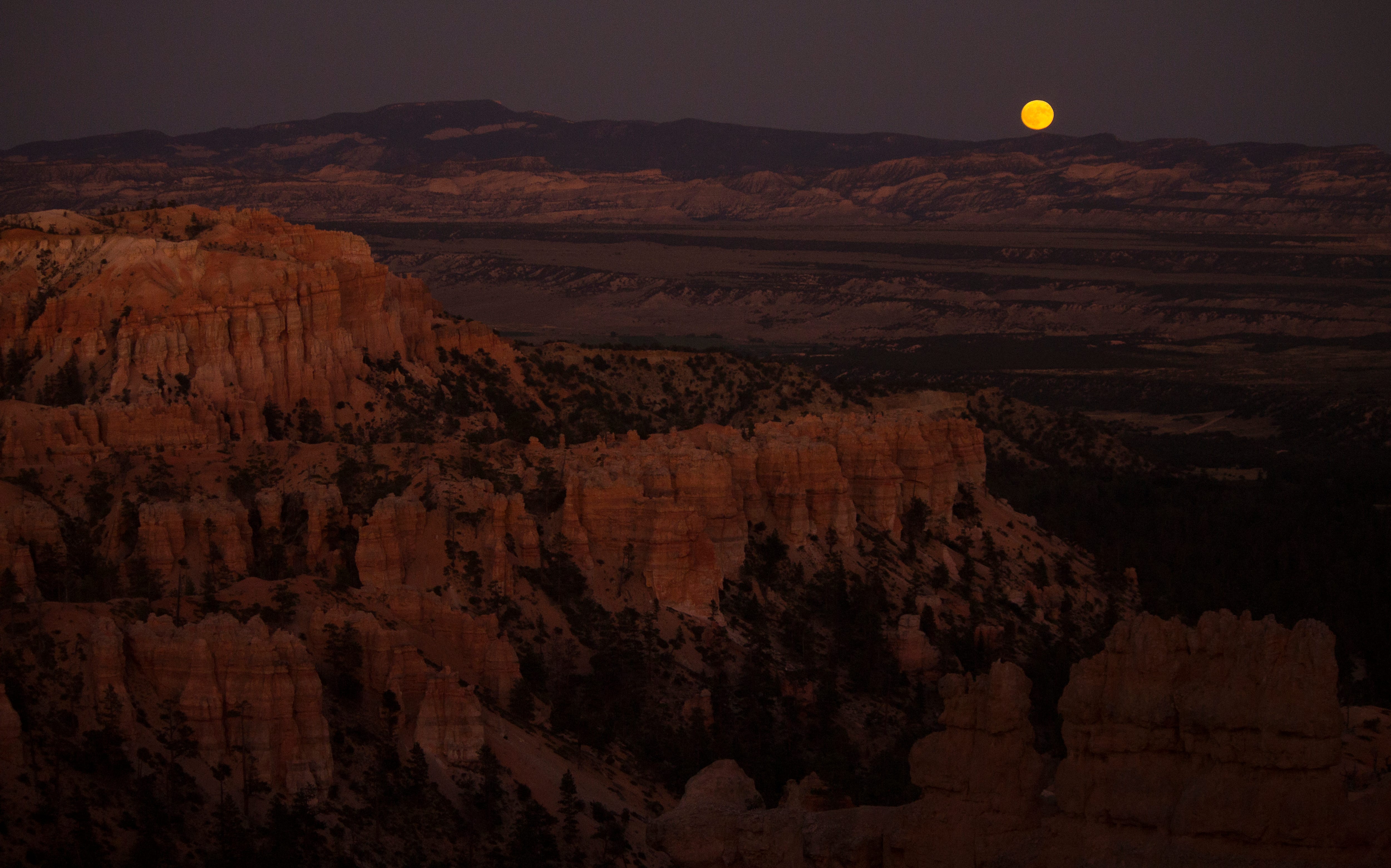
The moon rising over the Kaiparowits Plateau from Bryce Canyon National Park. Jonathan P. Thompson photo.
For both national monuments:
The proclamation orders the managing agencies (USFS and BLM) to consider livestock grazing lands to constitute a “traditional cultural place” and to “consider how proposed activities will impact” those lands. They also order the agencies to re-allocate voluntarily relinquished grazing allotments. Under the Biden proclamation, voluntarily relinquished allotments were permanently retired.
The proclamations order new transportation plans that endeavor “to maximize public access” by “designating roads and trails on which motorized and non-motorized vehicle use will be allowed.
The proclamations call on agencies to “consider the full range of vegetation management tools, including mechanical mastication, and grazing” and to authorize the use of mechanical, natural, and chemical tools, along with livestock grazing, to mitigate noxious weeds and fuel management.
WHAT’S NEXT: The lawsuits filed by tribal nations and advocates after Trump’s previous national monument shrinkage will be revived, and new ones likely filed, challenging the legality of proclamations (see below). However, unless a judge orders an injunction on the proclamations, the shrinkages will likely stand as the cases wind their way through the courts.
That means huge amounts of land once again will be open to new mining claims and oil and gas and coal leasing.
Shortly after Trump shrunk the national monuments in 2017, companies owned by the Kimmerle family of Moab staked a number of mining claims in the newly opened parts of Bears Ears National Monument, specifically in the White Canyon drainage and upper Cottonwood Creek. Whether they were actually interested in mining, were speculating, or merely trying to gain standing for a lawsuit when Biden restored the boundaries isn’t clear. In any event, Kyle Kimmerle did join Utah’s lawsuit challenging the Biden restoration, saying it blocked his ability to mine those claims.
While I doubt that any large mining companies will stake a lot of claims in the newly reopened areas, given the legal and regulatory uncertainty, smaller interests might come in and stake claims for uranium mining in the hopes of selling them if the shrinkage sticks.
Neither Bears Ears nor GSENM are exactly oil and gas drilling hotspots, but that won’t stop Trump’s BLM from putting up huge swaths of land on the auction block, in hopes of enticing some speculator to pay $2/acre for drilling rights on some of the most spectacular pieces of Canyon Country. Same goes for coal: Big firms are highly unlikely to bite on the Kaiparowits reserves, given sluggish demand, its remoteness, lack of transportation routes, and regulatory uncertainty. But then, who knows, maybe someone will decide to build a coal mine, power plant, and giant data center on the plateau; I bet the Trump’s BLM would permit it.
THE CONTEXT: We knew this was coming. After all, Trump radically shrunk the national monuments — mostly out of spite — during his first term. This time he also had orders from Project 2025 not only to shrink or eliminate these protections, but to destroy the Antiquities Act itself, the bedrock law that allows presidents to establish national monuments.
Yesterday’s move appears to be aimed at achieving both of Project 2025’s objectives. The proclamations will draw advocates’ and tribal nations’ lawsuits, which will eventually reach the Supreme Court. The justices — many of whom have proven hostile toward environmental protections — then will decide the fate not only of these national monuments, but of the Antiquities Act as a whole, thereby imperiling the future of public land conservation.
Any judge with integrity would block Trump’s proclamations. The Antiquities Act of 1906 gives a president the power to establish national monuments on federal land to protect landmarks, structures, and “other objects of historic or scientific interest.” However, it does not overtly give a president the power to rescind or reduce a national monument. The one time a president — Franklin D. Roosevelt, in 1938 — set out to abolish a national monument, his attorney general opined that the Antiquities Act gave him no such power. A May 2017 legal analysis by Mark Squillace, a law professor at the University of Colorado, and three other scholars, argues that the Federal Land Policy and Management Act of 1976 “makes it clear that the President does not have any implied authority to (abolish or modify monuments), but rather that Congress reserved for itself the power to modify or revoke monument designations.”
Trump, however, has never been too keen on the rule of law, and the current Supreme Court Chief Justice John Roberts has invited folks to bring an Antiquities Act case to him so he could eviscerate one of the nation’s bedrock conservation laws.
Trump’s proclamations are based on the theory that the two national monuments are simply too big. The Antiquities Act says the president may, at their discretion, reserve parcels of federal land, “the limits of which in all cases shall be confined to the smallest area compatible with the proper care and management of the objects to be protected.” Last year, Trump’s Deputy Assistant Attorney General Lanora C. Pettit argued that if another president decides the monument violates the “smallest area compatible” requirement, they can shrink it accordingly.
Of course, that’s not what the Antiquities Act says, nor is it what Congress intended when it wrote the law in the first place. It is the very permanence or irreversibility that makes the Antiquities Act special and distinguishes it from other types of public land withdrawals and executive orders. It’s what sets, say, Bears Ears National Monument apart from the 20-year oil and gas leasing bans around Chaco Culture National Historical Park and on the Thompson Divide. The former can’t be reversed by an executive order because it was established under the Antiquities Act; the latter two can because they were implemented by executive orders.
If the courts — and ultimately the Supreme Court — were to fall for Pettit’s arguments, it would render impotent one of the nation’s foundational environmental and cultural protection laws. After all, the Grand Canyon, Zion, Chaco, Capitol Reef, Arches, and many more of America’s treasured national parks first were established as national monuments under the Antiquities Act. Imagine if a later president, out of spite for his predecessor, had decided to simply abolish with a stroke of a pen any of these designations and open these special places to drilling and mining before Congress gave them national park status.
In 1908, President Theodore Roosevelt used the Antiquities Act to establish the 800,000-acre Grand Canyon National Monument. If the Trump administration’s (and Utah’s and other national monument opponents’) logic were to be applied, the national monument would have been cut down to several thousand acres surrounding a handful of landmarks such as Havasu Falls, Mather Point, Vishnu Temple, and Bright Angel Point, and the rest of it would have been opened up to the extractive industries.
But what is Vishnu Temple without the rest of the Grand Canyon? What these folks are missing is that these discrete “objects” — whether they are landforms, dwellings, or other cultural sites — cannot be separated from the landscape itself, because to do so robs them of their meaning. So in order to protect them — as the Antiquities Act authorizes the President to do — one must protect the entire landscape. Therefore, the combined pre-shrinkage 3.2 million acres of both GSENM and Bears Ears National Monuments was, in fact, the “smallest area compatible with the proper care and management” of those landscapes. In fact, it may not be large enough.
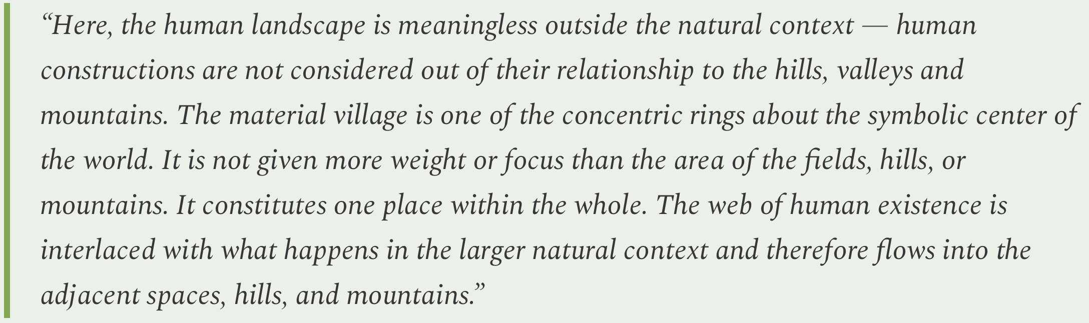
I’ll leave you with what I find to be a powerful and succinct argument for landscape-scale preservation. It’s from a 1991 paper on Ancestral Puebloan culture in the Four Corners region co-written by the late Rina Swentzell, a scholar from Santa Clara Pueblo:
***
I’ve written about Bears Ears, Grand Staircase-Escalante, and the Antiquities Act many times in the past and won’t repeat it all here. Instead, I’ve removed the paywall from some of the most popular, notable dispatches from the archives, so anyone can read them for a limited time. If you like them, consider becoming a paid subscriber!
The Antiquities Act of 1906 was signed into law by Theodore Roosevelt, for “… the protection of objects of historic and scientific interest” through the designation of national monuments by the President and Congress. National monuments are one of the types of specially-designated areas that make up the BLM’s National Conservation Lands. Some of the earliest national monuments included Devils Tower, the Grand Canyon, and Death Valley. They were initially protected by the War Department, then later by the National Park Service. More recently, the BLM and other Federal agencies have retained stewardship responsibilities for national monuments on public lands. In fact, the BLM manages more acres of national monuments in the continental U. S. than any other agency. This includes the largest land-based national monument, the Grand Staircase-Escalante National Monument in Utah featured here. National monuments under the BLM’s stewardship have yielded numerous scientific discoveries, ranging from fossils of previously unknown dinosaurs to new theories about prehistoric cultures. They provide places to view some of America’s darkest night skies, most unique wildlife, and treasured archaeological resources. In total, twenty BLM-managed national monuments, covering over five million acres, are found throughout the western U. S. and offer endless opportunities for discovery. Photos and description by Bob Wick, BLM.
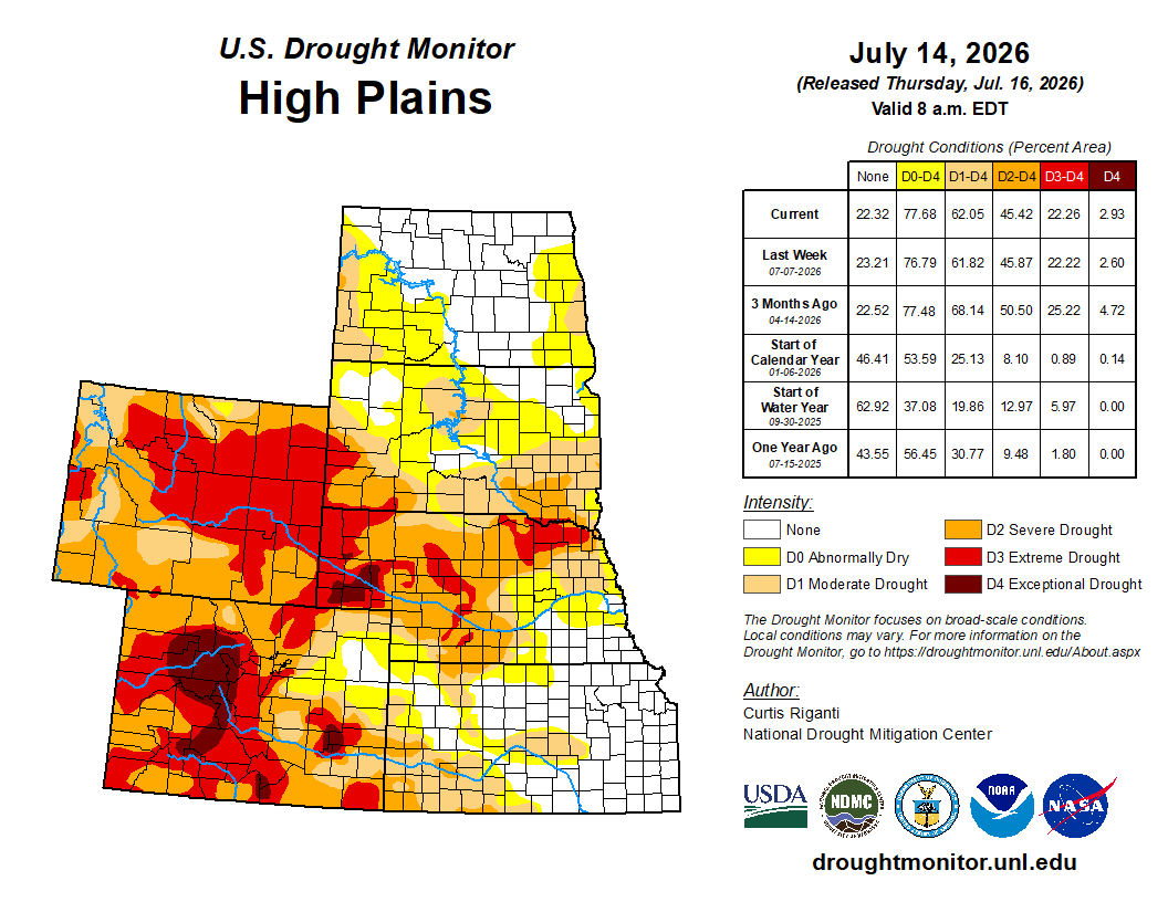
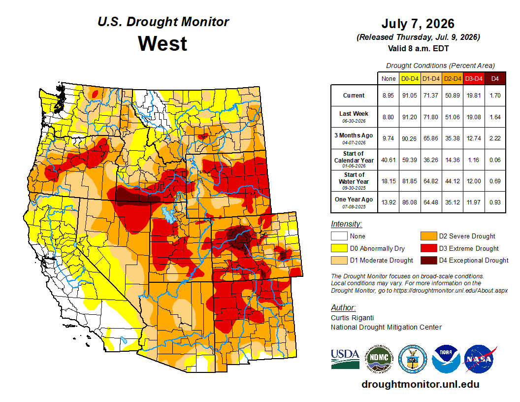
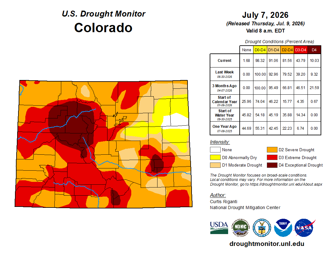
Heavy rain fell this week across parts of the United States, bringing widespread relief from ongoing drought and abnormal dryness from northeast Texas northeast through the Mid-Atlantic. Recent rains shifted drought impacts more towards the longer term in some areas. Localized improvements after recent precipitation occurred in parts of southern New York and southern New England and in portions of the central Great Plains. Localized improvements occurred in small areas of northwest Alaska and north-central Puerto Rico after heavy rains this week. An assessment of shorter-term conditions in Utah and portions of western Oklahoma and western and southern Texas led to a few improvements. Warm and dry weather occurred this week in the western Great Lakes, especially in far northern Wisconsin, parts of the Michigan Upper Peninsula, northern Minnesota and eastern North Dakota. These areas saw widespread degradation given this week’s conditions. Drier areas in central Colorado also saw the expansion of extreme and exceptional drought this week. Abysmal streamflow and short-term precipitation deficits continued across parts of Washington, leading to widespread degradation there. Severe drought expanded in both south-central Puerto Rico and southeast Florida owing to short-term rainfall deficits in both areas…
Rains exceeding 2 inches fell this week in northeast South Dakota and from parts of south-central Nebraska southeast through parts of northeast Kansas. Spotty heavy rain, locally in the 1.5-2-inch range, fell across eastern Colorado, western Kansas, western Nebraska and southwest South Dakota, as well as a few areas in North Dakota. These rains led to localized improvements in eastern Colorado, western Kansas and western Nebraska, where soil moisture improved and precipitation deficits decreased in severity. Widespread improvement to ongoing drought and abnormal dryness occurred in northeast South Dakota where the heaviest rains fell there. In eastern North Dakota, short-term precipitation deficits combined with reduced soil moisture, resulting in widespread expansion of abnormal dryness with a small area of moderate drought. A few areas in north-central and northwest South Dakota had a few degradations where short- and mid-term precipitation deficits and low soil moisture occurred. Temperatures in the northern portions of the High Plains region, particularly from northwest Nebraska north, were 3-9 degrees above normal this week as a heat wave took hold. The impacts of this heat and locally drier weather will be assessed in the coming weeks…
Colorado Drought Monitor one week change map ending July 14, 2026.
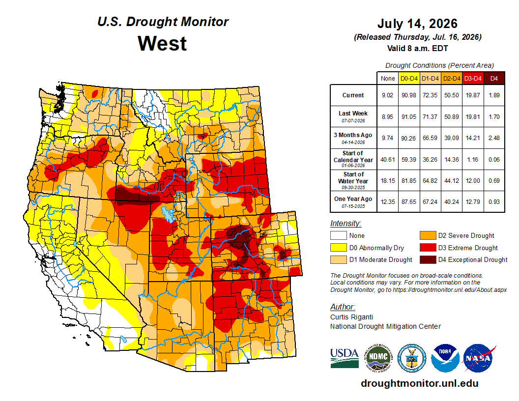
Aside from some moisture in southeast Arizona from the North American Monsoon, mostly dry weather occurred in the West this week to the west of the Continental Divide. In southeast Arizona, rains totaling 1-2 inches fell, though these were not enough to improve conditions. In southeast New Mexico, conditions were reassessed along with those in western Texas, leading to localized improvements where soil moisture, streamflow and mid-term precipitation deficits have recently improved. Localized improvements also occurred in parts of Utah where short-term precipitation deficits lessened. However, widespread severe and extreme drought was still taking place across most of the state amid poor streamflow across Utah. In eastern Washington, short- and mid-term precipitation deficits, recent warm temperatures and poor soil moisture led to the expansion of moderate drought. Moderate and severe drought also developed or intensified across several other parts of the state, where precipitation deficits persisted and soil moisture and streamflow decreased. Hot temperatures occurred from Arizona and western New Mexico northward to Montana and Wyoming. Temperatures were 3-6 degrees above normal for the week across most of these areas, while northeast Wyoming and south-central and eastern Montana were 6-12 degrees warmer than normal. Several cities in southern and eastern Montana set all-time record highs on Sunday, July 12, including readings of 115 F in Miles City and 111 F in Billings. The impacts of this heat wave on ongoing drought conditions will be assessed in the coming weeks. Temperatures along the Pacific Coast were generally within 3 degrees of normal…
Wet weather occurred this week across much of Tennessee, portions of northern Alabama, much of south-central and western Louisiana and portions of eastern and south-central Texas. The heaviest rains exceeded 5 inches in parts of Texas and Louisiana, while 2-5 inches of rain were common in parts of Tennessee. Temperatures across the region were mostly within 3 degrees of normal, except for the southern Texas Panhandle and western north Texas, where temperatures were commonly 3-6 degrees warmer than normal. Temperatures from 3-6 degrees below normal occurred along the Rio Grande near Del Rio, Texas. From eastern Texas across southern Louisiana, and in Tennessee and far northeast Arkansas, this week’s rains lessened or locally eliminated precipitation deficits and led to improvements in soil moisture and streamflow. Conditions were reassessed and improved in parts of western and southwest Texas, adjacent western Oklahoma and the Oklahoma Panhandle and in parts of western and northern Arkansas, where recent precipitation has lessened mid-term precipitation deficits and locally improved streamflow and soil moisture…
Looking Ahead
The National Weather Service Weather Prediction Center is forecasting mostly dry weather across much of the Great Plains and Midwest through the evening of Monday, July 14. Heavier rain, locally in the 2-5 inch range in parts of Arizona, is forecast to fall in areas of south-central and southwest Texas and from Arizona and western New Mexico north into southwest Colorado, portions of Utah and a few parts of Wyoming and far south-central Montana. Heavy rains of 1-2 inches are forecast in the Florida Big Bend region, though the heaviest amounts are forecast to mostly stay offshore. Rain amounts of 0.75 inches or more are forecast from the southern Appalachian Mountains to the Northeast, and in parts of coastal North Carolina. Rains of 0.75 inches or more are also forecast in the Michigan Upper Peninsula and northern Lower Michigan. Mostly dry weather is forecast along the West Coast.
Looking ahead to July 21-25, the National Weather Service Climate Prediction Center’s forecast favors wetter-than-normal weather in parts of the southwest United States, especially in Arizona, New Mexico, Utah and Colorado. The forecast also favors above-normal precipitation from southeast California north through Montana and from the Texas Panhandle to North Dakota, though at lower confidence than in the Four Corners states. The forecast favors above-normal precipitation across most of the eastern U.S. to the east of the Appalachian Mountains, with the exception of south Florida, where near-normal rainfall is expected. Below-normal rainfall is slightly favored in Deep South Texas. Above-normal temperatures are favored in the western United States (except for parts of Arizona and New Mexico) and across the South and Southeast regions. The forecast favors near-normal temperatures in the northern Great Plains, while cooler-than-normal temperatures are more likely in the Upper Midwest, Great Lakes and Northeast.
For July 21-25, above-normal precipitation is favored in all of Alaska except for the southeast region of the state, where below-normal precipitation is more likely. Warmer-than-normal temperatures are favored in southeast Alaska and far-eastern interior Alaska. In south-central and southwest Alaska, the forecast favors cooler-than-normal conditions. In Hawaii, both above-normal precipitation and temperatures are favored.
US Drought Monitor one week change map ending July 14, 2026.
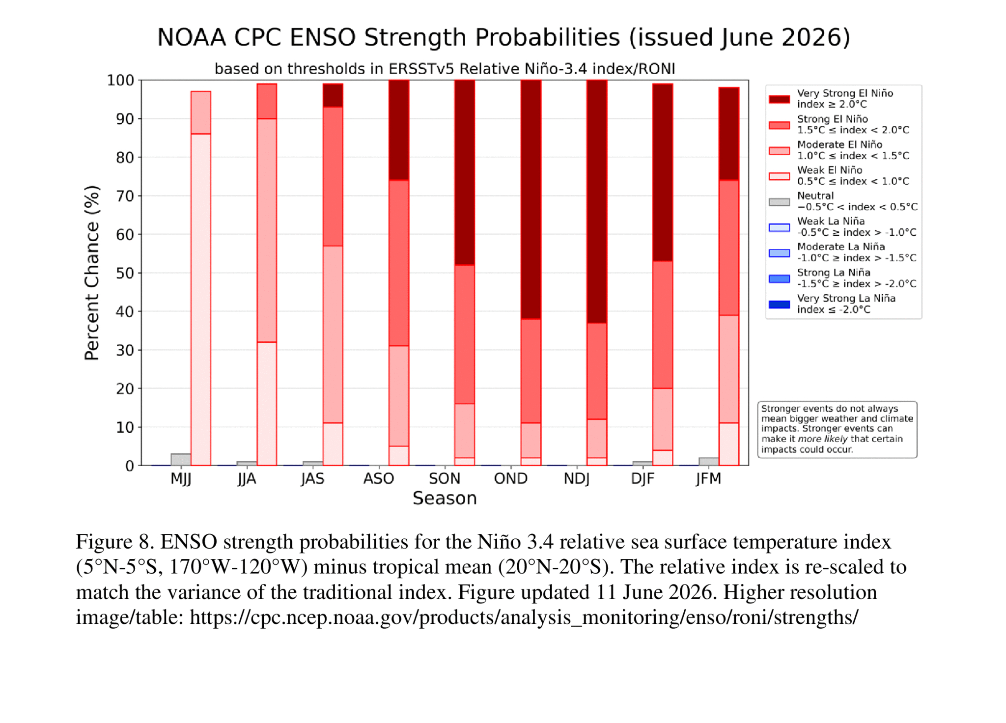
Our planet’s long-term, human-driven heating trend is almost certain to push into new record territory in 2027 – perhaps even this year – as an emerging El Niño event is on track to propel a vast storehouse of oceanic heat into the atmosphere. New results this month from an array of the world’s top climate models have only strengthened the outlook for a potential record-smashing El Niño event, most likely peaking toward year’s end.
In a detailed post at The Climate Brink on Substack, and in summary threads on Blueskyand X, climate scientist Zeke Hausfather, who has contributed to Yale Climate Connections, paints a stark picture of top-end climate models hurtling into truly uncharted territory – and of El Niño conditions now taking shape even more quickly than the jaw-dropping multi-model forecast.
According to Hausfather: “With the July runs now in from 667 ensemble members across 14 different seasonal forecast models, it looks like this year’s El Niño is not only very likely to be the strongest event since reliable records began – it may end up the strongest by a truly mind-blowing margin.”
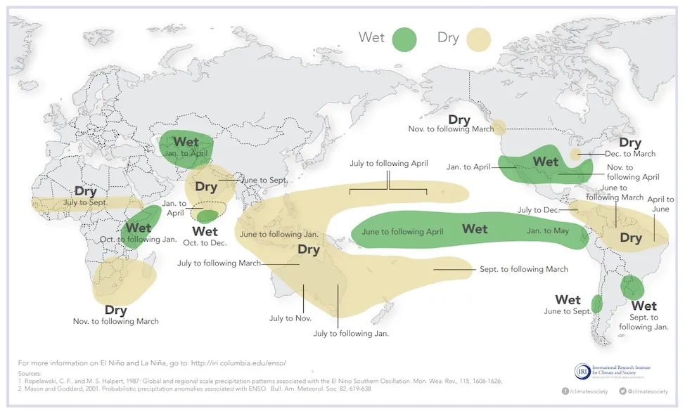
El Niño – a periodic warming of the waters of the eastern tropical Pacific – is the world’s single biggest shaper of global temperature and regional climate over periods of a few months to a year or more. Heat that’s stored in the ocean during the cool counterpart phenomenon, La Niña, rises from the eastern tropical Pacific during El Niño. The result is a spike in global temperature, as well as climatic reverberations that typically include drought over Indonesia and parts of South America and Africa, wet winters over the southern U.S., and a shift away from Atlantic hurricanes toward North Pacific hurricanes and typhoons (a shift already in progress).
Leading models have been predicting a 2026-27 El Niño for months now. What’s startling, as Hausfather outlines, is that the models have come into closer agreement even as their outlooks move further into record-strength territory.
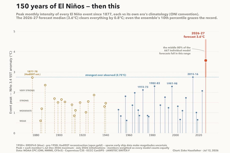
Fig. 1 below shows every El Niño event in reliable data going back to 1877. Each one is assessed against the oceanic climatology of its era in order to distinguish the El Niño warming spikes from longer-term global warming. Pooling all the models, the consensus forecast for 2026-27 is for the El Niño to peak at around 3.6 degrees Celsius (6.5 degrees Fahrenheit) warmer than average. As shown in Fig. 1, that’s almost 1°C above the previous record over the past 149 years – a massive margin for such a broad range of models.
As Hausfather notes, “the models are forecasting something outside the envelope of anything we have ever observed.”
Figure 1. Ranking of each El Niño event since 1877 (departures from the seasonal norm for sea surface temperature in the Niño3.4 region of the eastern tropical Pacific, measured against the multi-decade average preceding each event). Shown at right is the collective ensemble model forecast for 2026-27, with the bold red line encompassing the middle 80% of ensemble members. (Image credit: Zeke Hausfather/The Climate Brink)
One caution: even though long-term warming is filtered out of the anomalies in the chart above, it’s clear that any El Niño event is now pushing against an ever-warmer ocean and atmosphere. Recent studies suggest this warmer context can influence the strength and even the locations of the seasonal reverberations driven by El Niño.
As a result, NOAA has moved from its original Oceanic Niño Index (ONI) to a Relative Oceanic Niño Index (RONI), which adjusts the strength of each event by the average sea surface temperature across the world’s tropics.
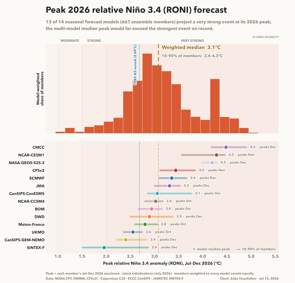
When RONI is used, it shifts the rankings of various El Niño events: For instance, the strongest to date becomes 1982-83, rather than 2015-16 as shown above. Because tropical ocean warming has been so dramatic in recent years, it’s made the RONI forecasts for the upcoming event slightly more muted than the ONI values in Fig. 1 above. Even so, using this updated yardstick, Fig. 2 below shows that the 2026-27 event remains an odds-on favorite to be unprecedented, with roughly a 77% chance of becoming the strongest El Niño on record.
Figure 2. Outlooks from 14 model ensembles produced by forecasting centers around the world for the 2026-27 El Niño event, using the Relative Oceanic Niño Index, or RONI. The range of forecasts above is less dramatic than in the red bracket in Figure 1 because recent warming across tropical oceans brings down the RONI values for present-day events. (Image credit: Zeke Hausfather/The Climate Brink)
Hausfather notes that the current El Niño has emerged at record speed, adding: “Seasonal forecast systems have real, demonstrated skill at this lead time for ordinary events, but no ensemble has ever forecast (and then verified against) a 3.6°C El Niño, because one has never happened. Model agreement is reassuring, but it is not proof. But the uncertainties can cut both ways, and the observed ocean, not just the models, is already in uncharted waters.”
What can we expect – and what could surprise us?
Just as a model agreement isn’t a guarantee of model skill, even a record-setting El Niño event wouldn’t guarantee the usual impacts on regional weather and climate. However, it would certainly boost the odds of some of the more reliable outcomes, as shown below.
Figure 3. El Niño conditions tend to shift rainfall patterns in many different parts of the world, especially across the tropics and subtropics. Shown above are the most consistently observed shifts, although these can vary from one event to the next. (Image credit: IRI, via weather.gov)
One of the most populous regions where El Niño has profound effects is South Asia and Southeast Asia. The rising motion over the eastern tropical Pacific typically triggers chains of atmospheric effects known as teleconnections. The result is favored areas of rising and sinking air and favored tracks for disturbances as they progress through the subtropical and polar jet streams. As they evolve, these teleconnections are modulated by whatever natural variations happen to be percolating through the global atmosphere.
In the case of Southeast Asia, the effects are most straightforward and reliable. “El Niño moves the precipitation to the east,” says Isla Simpson, a climate scientist at the National Center for Atmospheric Research, or NCAR. “It’s not so much a teleconnection as a feature of the coupled dynamics of El Niño in the tropics.”
As the entire warm pool of the western tropical Pacific, which nurtures rainfall across southeastern Asia, shifts into the El Niño region, areas to the west can be left largely high and dry for months, especially during northern winter. Massive fires have often broken out in Indonesia, fouling the air for tens of millions of people, and bushfires are a particular threat in Australia during El Niño.
During the build-up to El Niño, India’s summer monsoon is often less moist than usual, and that’s exactly what is happening now. India’s nationwide rainfall in the 2026 monsoon through July 13 was about 20% below the long-term average.
t’s easy to see the fingerprints of El Niño on this year’s tropical cyclones north of the equator. The Atlantic is off to its slowest start since 2009: as of July 13, there had been only one named storm, the weak and short-lived Tropical Storm Arthur. The NOAA/NWS National Hurricane Center was predicting no development in the Atlanticfor at least the next week, though there have been fleeting hints of possible development in the Gulf of Mexico more than a week out. Meanwhile, NHC was tracking a crop of four systems in the eastern and central Pacific, including three with greater-than-even odds to develop into at least tropical depressions by Friday, July 17. (None were expected to pose any immediate threat to land areas.)
As for North American weather, the biggest impacts from El Niño tend to be in fall and winter, as the seasonally strengthening polar and subtropical jet streams interact with a peaking El Niño event. Rainfall is boosted across much of the Sun Belt, with unusual dryness becoming more likely over the Midwest and the Pacific Northwest. Strong El Niño events tend to be wetter than average for California as a whole, but these outcomes vary widely, as emphasized by Jan Null of Golden Gate Weather Services.
For the time being, we’re getting a sneak preview of the temperature patterns that often prevail across the United States during El Niño winters: warmer-than-average toward the north and cooler-than-average toward the south. This week’s pattern is being driven by a sprawling upper-level ridge pushing slowly across the northern tier of states. Since it’s midsummer rather than winter, the setup includes scorching conditions spreading east from the Northern Rockies and Northern Plains toward New England. Several all-time record highs were set on Sunday in Montana, including Miles City (115°F), Billings Airport (111°F), Baker (110°F), and Sheridan (109°F), as well as in Utah, where Salt Lake City topped out at 109°F.
Meanwhile, slightly less-hot-than-usual weather has prevailed near the western Gulf Coast, where an upper-level disturbance has been moving slowly westward. The clouds and rain kept temperatures in the 70s and 80s Fahrenheit across parts of southern Texas on Sunday and Monday, which is unusually mild for mid-July, and the pattern has led to some serious localized flooding in Texas and Louisiana. We’re likely to see an uptick in flooding across parts of the southern United States as we move into fall and winter.
Up to 3-5 inches of rain per hour could pour in some areas of southeast Louisiana. Here’s what to know.
What about that weird cooling in the eastern tropical Pacific?
One wild card in play with this highly ambitious El Niño: will it be strong enough to overpower a countervailing influence that’s been surprising scientists and stakeholders alike? That influence is the tendency toward long-term cooling over much of the eastern tropical Pacific since the 1980s. It runs contrary to the warming of almost every other ocean basin on the planet (see our in-depth 2023 report and 2025 update).
The Pacific Decadal Oscillation, an index that reflects broad patterns across the Pacific, has been negative every month since January 2020 – an unprecedented stretch in 216 years of NOAA data.
Another part of this still-not-fully-explained trend: the increased prevalence of La Niña over El Niño events over the last several decades. For physical reasons, La Niña conditions are more likely than El Niño conditions to extend over two or more consecutive winters. With that in mind, over the past 30 years of the RONI dataset (1996-2025), there have been 15 northern winters with La Niña in control, compared to just eight with El Niño in place and seven with neutral conditions. Over the prior 30 years (1966-1995), the count was seven La Niña, 11 El Niño, and 12 neutral.
A 2025 study in the Journal of Climate, led by NCAR’s Clara Deser, analyzed how the atmospheric patterns associated with the recent decades of cooling sea surface temperatures in the eastern tropical Pacific and warming in the tropical Indian and Atlantic Oceans tend to run counter to El Niño, and how this can work to mute the strength of teleconnections. After running models to simulate the 2023-24 El Niño – whose effects were less intense than expected in many areas – Deser and colleagues found that overall warming in the tropical Indian and Western Pacific oceans likely played a role in tempering the broad impacts of the 2023-24 event in North America as well as Europe.
According to Deser and colleagues, “The evolving contributions of natural and anthropogenic influences on background SST trend patterns will undoubtedly interfere with teleconnections driven by El Niño and La Niña events in the future. Thus, historical precedent may no longer be a reliable guide to ENSO teleconnections as anthropogenic warming patterns intensify.” [emphasis added]
Since most long-term climate models still project warming in the eastern tropical Pacific for later this century, it’s also entirely possible that the classic El Niño effects could eventually get amplified rather than muted – which only adds to the complexity of planning for a world of human-caused climate change.
Jeff Masters and Irene Sans contributed to this post.
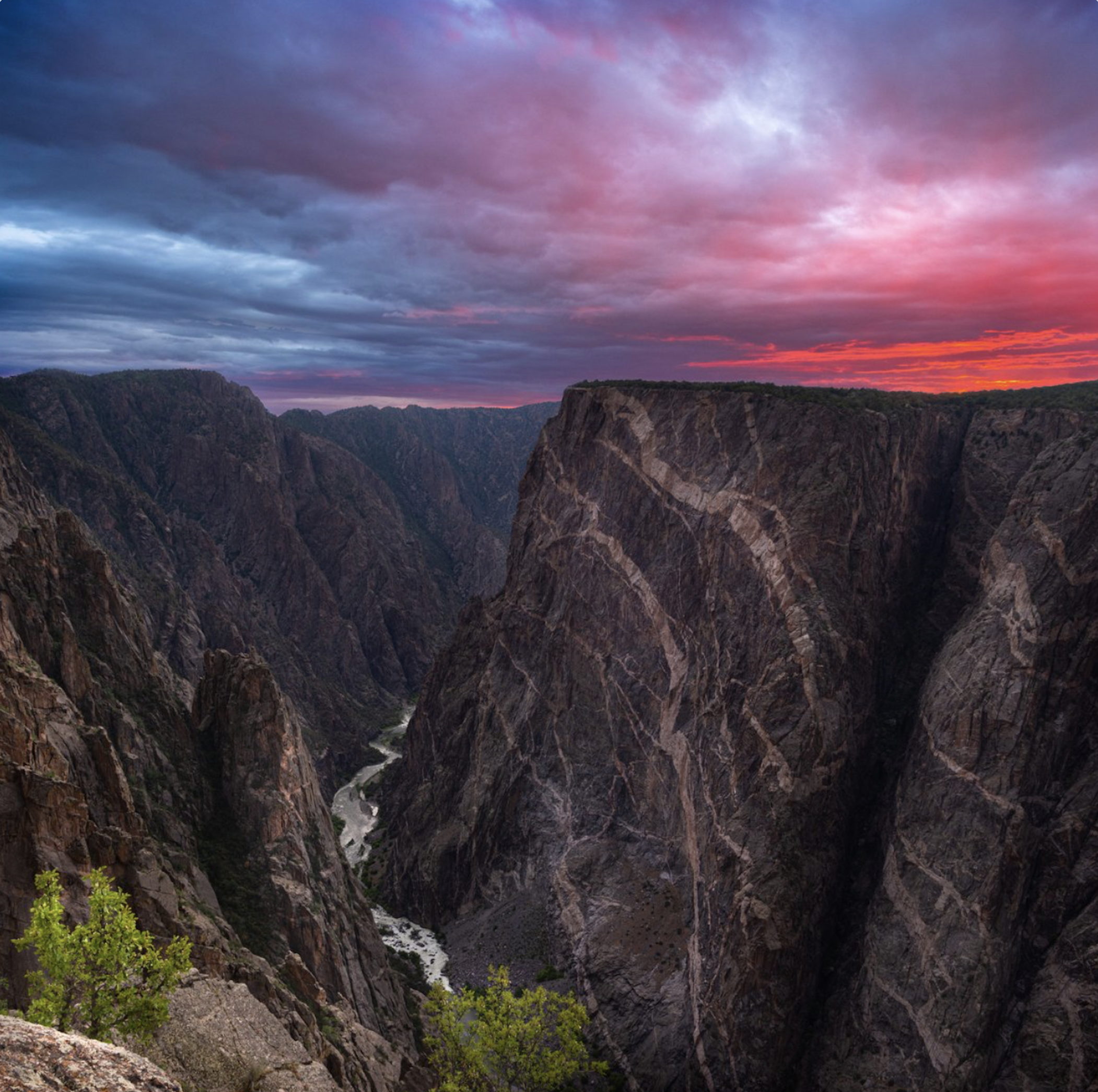
Black Canyon National Park July 2020. Photo credit: Claire Codling/The Department of Interior
From email from Reclamation (Andrew Limbach):
July 14, 2026
Aspinall Unit Operations Update – Release scheduled change to 1,390 cfs on Wednesday, July 15th.
On Wednesday, July 15th, the adjusted scheduled releases from Crystal Dam will decrease to 1,390 cfs from 1,465 cfs.
Gunnison River flows in the Black Canyon/Gunnison Gorge will decrease to 360 cfs.
On Thursday, July 16th, the adjusted scheduled releases from Crystal Dam will decrease to 1,315 cfs from 1,390 cfs.
Gunnison River flows in the Black Canyon/Gunnison Gorge will decrease to 290 cfs.
Reclamation will continue to monitor flows in the Gunnison River, and on Friday, July 17th, the scheduled releases from Crystal Dam may decrease to 1,265 cfs from 1,315 cfs.
Gunnison River flows in the Black Canyon/Gunnison Gorge would decrease to 250 cfs. An additional notification will be sent out confirming any change after Wednesday.
In response to the extreme drought conditions, the BOR has collaborated with US Fish and Wildlife and the National Park Service to reduce the target flows to 500 cfs at Whitewater and 200 cfs through the Black Canyon of the Gunnison until further notice. These releases are made for the authorized purposes of the Aspinall Unit, and to attempt to maintain a target base flow through the endangered fish critical habitat reach of the Gunnison while preserving critical storage in Blue Mesa Reservoir.
Contact Andrew Limbach (alimbach@usbr.gov or 970-248-0644) for more information regarding Aspinall operations or the Operation Group meeting.
President Donald Trump signed a pair of executive orders on Monday to again shrink Bears Ears and Grand Staircase-Escalante national monuments in Utah — this time more dramatically, by about 3 million acres or 90% of their original size.
Utah’s all-Republican congressional delegation, Gov. Spencer Cox and House Speaker Mike Schultz stood around Trump’s desk in the Oval Office during the closed-door signing that was live-streamed on YouTube by the White House.
“Let’s sign,” Trump said as he put pen to paper. “This is very nice. I’m very happy about this. And better than the first time.”
While signing the second executive order, Trump added: “Almost 3 million acres, going to be well taken care of now.”
The move continues a longstanding game of tug-of-war between multiple presidential administrations that has changed the boundaries of the national monuments several times over nearly a decade.
It also marks the second time Trump has slashed the size of the monuments.
In 2017, during his first term as president, Trump shrank Bears Ears from about 1.35 million acres to roughly 228,000 acres and Grand Staircase-Escalante from about 1.87 million acres to roughly 1 million acres. In 2021, former President Joe Biden restored both of the monuments to their original sizes, to frustration from Republicans and applause from conservation groups and tribes.
This time, Trump shrunk Bears Ears to about 121,000 acres and Grand Staircase-Escalante to about 182,000 acres, according to a news release issued by Utah Gov. Spencer Cox’s office.
When he cut the national monuments the first time nearly 10 years ago, Trump’s cuts were applauded by Republican state elected leaders, saying it freed the land from federal control and allowed more public access for hunting, ranching and economic development. Conservation groups and tribes reacted with outrage and lawsuits, arguing Trump lacked the authority to downsize the protections. Bears Ears in particular has deep spiritual and cultural significance for tribes.
Utah Republicans cheer
On Monday, Utah’s top Republican leaders again lauded Trump’s reduction of both monuments, saying it will better allow the lands to be managed and preserved while also enabling better public access. They said the monuments’ smaller sizes provides more targeted protection for valuable land, arguing the original designations spanned too large.
“We deeply value these natural, cultural, and scientific treasures,” Cox, Utah’s governor, said in a prepared statement. “The question has never been whether to protect them, but how to protect them best. The historic landmarks and other nationally significant resources remain under federal protection, while allowing agencies to direct limited resources toward caring for these specific sites rather than millions of surrounding acres.”
A sign welcomes visitors to a Grand Staircase-Escalante National Monument Visitor Center in Big Water, Utah on Sunday, Feb. 2, 2025.
Utah Sen. Mike Lee, while standing in the Oval Office behind Trump, said the Antiquities Act has been “abused” by turning larger than necessary swaths of land into monuments. Trump, he said, “is right-sizing it to bring it in compliance with what the law says.”
“These are 3 million acres. As I explained to President Biden, that’s two Delawares,” Lee said.
Utah Rep. Celeste Maloy said both monuments were created “over the unanimous opposition of Utah’s federal delegation, our governors, county commissioners, the locals who were worried about losing multiple uses on these federal lands.”
She applauded Trump for “listening to the people of Utah and saying, ‘We know you value this land, you want it used for multiple use and not locked up.’ And so this is a very different process in how the monuments were created.”
Trump’s orders also come after Lee and Maloy crafted a proposal to repeal Biden-era standards for managing the vast Grand Staircase monument, calling them too restrictive on uses like road access and too far from what neighboring communities wanted. That plan, however, has since stalled.
The Bears Ears buttes, namesake of the Bears Ears National Monument, are pictured on Friday, Sept. 19, 2025. (Photo by Spenser Heaps for Utah News Dispatch)
Environmental groups, tribal leaders and Utah Democrats express outrage
Members of the Grand Staircase-Escalante Inter-Tribal Coalition issued a lengthy statement strongly condemning the move to “virtually eliminate” the monuments while calling for “the defense and protection” of their ancestral lands.
“Our Tribes were not informed of or asked about this decision, and that’s unacceptable. The federal government must honor its Trust and Treaty obligations to our Tribes — it is not optional,” Autumn Gillard, inter-tribal coalition coordinator who is a descendent of the Cedar Band of Paiutes, said in a prepared statement. “Today’s action is a direct strike against the federal government’s duty to consult with Tribes. It also profoundly disrespects our intergenerational Traditional Knowledge by destroying a framework for Tribal co-stewardship over our ancestral lands in which we invested years of effort. Today’s action cannot stand.”
Utah House’s top Democrat, Minority Leader Angela Romero — who is the first and only enrolled member of a federally recognized tribe to serve in the Utah House — said in a prepared statement that “this back-and-forth with every administration has to stop.”
“These lands deserve the protections that come with national monument status,” she said. “Less than a decade ago, the Trump administration reduced protections for these same monuments despite overwhelming public support and the objections of the Tribal Nations whose ancestors have lived on these lands for thousands of years.”
The Citadel, an Ancient Puebloan structure in the Cedar Mesa area of Bears Ears National Monument, is pictured on Saturday, Sept. 20, 2025. (Photo by Spenser Heaps for Utah News Dispatch)
Romero said the federal government “should honor Tribal Nations’ wishes by protecting these sacred lands from unnecessary development and overuse.”
“These are places where Tribal history, culture, and spiritual traditions continue today. Future generations deserve the opportunity to experience these places as they have existed for centuries,” Romero said.
The Center for Western Priorities, a conservation advocacy group, issued a news release after Monday’s signing saying Trump shrunk the monuments “based on false information.”
The group pointed to a moment during the signing when Trump falsely said: “You can’t do anything. You can’t go hunting. You can’t go fishing. You can’t do anything. You can virtually not even walk on it.”
“That’s exactly right, sir,” Deputy Interior Secretary Kate MacGregor told the president in response. “So you are remedying that today.”
Bears Ears and Grand Staircase “explicitly allow hunting, fishing and outdoor recreation inside the monuments,” the Center for Western Priorities said, while also pointing to Utah’s own hunting regulations.
The Newspaper Rock Petroglyphs are pictured along Indian Creek in Bears Ears National Monument near Monticello on Wednesday, Jan. 29, 2025.
The Center also said McGregor “misled” Trump when she said the first monuments established by former President Teddy Roosevelt with the Antiquities Act were small in size.
“In fact, Teddy Roosevelt used the Antiquities Act to protect 800,000 acres of public land at the Grand Canyon,” the center said. “The Supreme Court later confirmed that such landscape-scale protections were proper under the Antiquities Act, and that large landscapes were considered ‘objects’ under the Act.”
Aaron Weiss, executive director of the Center for Western Priorities, accused MacGregor of misleading the president.
“We all know that President Trump has very little understanding of what he’s told to sign,” Weiss said. “But Kate MacGregor knows better. Giving the president documents to sign based on false information is unconscionable. If she’s going to take over running America’s public lands while Doug Burgum plays pool boy, the least she can do is be honest with the president and the American people.”
Cattle grazes on along Indian Creek in Bears Ears National Monument near Monticello on Wednesday, Jan. 29, 2025.
Tracy Stone-Manning, president of The Wilderness Society, pledged the group “will fight this attack and stand with everyone working to protect these remarkable places.”
“National monuments protect extraordinary wildlife, irreplaceable cultural and Tribal heritage, and our freedom to explore some of our country’s iconic landscapes. They belong to all of us,” she said in a prepared statement.
Stone-Manning said Trump’s administration is “on the wrong side of history here, ignoring the voices of Tribal Nations, local communities, and the millions of Americans who want these places protected for future generations.”
“As our nation marks 250 years, these public lands should be handed down, not over to drilling and mining interests,” she said.
A group of Democratic members of Congress and tribal leaders plan to hold a virtual news conference Tuesday morning to condemn the “attacks” on the monuments.
Ben McAdams — who is likely to return to Congress as Utah’s only Democrat next year — also issued a statement vowing to fight the reductions.
“Utahns deserve a say in what happens to the land that belongs to them. I’m not backing down from this fight, and I’m not going to stop until it’s reversed,” McAdams said.
Legal challenges loom
Trump’s latest pair of executive orders are sure to draw legal challenges, as did the first time he shrank the monuments. Lawsuits from tribes, conservation groups and businesses challenging those 2017 cuts were put on hold in early 2021 and remained pending in federal court before Biden restored the monuments later that year.
On Monday, Scott Braden, executive director of the Southern Utah Wilderness Alliance, vowed in a prepared statement that the nonprofit devoted to protecting Utah’s red rock wilderness would “challenge this unlawful decision in federal court.”
“Today’s action makes it clear that Utah is the epicenter of Republican efforts to dismantle and obliterate America’s system of public lands,” Braden said in a prepared statement issued Monday. “President Trump’s outrageous attack on Grand Staircase-Escalante and Bears Ears national monument was taken at the urging of Utah politicians – Sens. Mike Lee and John Curtis, Governor Spencer Cox, and the others – who championed this action. These two landscapes deserve to be protected for current and future generations of Utahns and Americans, not opened to exploitation.”
The Center for Western Priorities argued the Antiquities Act — a 1906 law that allows presidents to protect federal lands of historic or scientific interest by establishing them as national monuments — is a “one-way statute” that can’t be reversed.
In 1996, former President Bill Clinton first designated the Grand Staircase-Escalante National Monument. In 2016, former President Barack Obama designated Bears Ears National Monument at the request of five sovereign Tribal nations.
“The Antiquities Act was a one-way statute when Teddy Roosevelt signed it into law. It was a one-way statute when President Trump tried to ignore it in 2017. It’s still a one-way statute today,” the Center for Western Priorities said in a prepared statement issued Friday, when news of Trump’s expected executive orders broke.
The Center for Western Priorities also noted that “just last month, Congress had a chance to weaken the management plan for Grand Staircase-Escalante and declined,” pointing to the failure of Maloy and Lee’s proposal.
“The American people have made it clear over and over again that they want our national monuments protected, not sold out to drilling and mining companies,” the Center for Western Priorities said. “President Trump and Interior Secretary Doug Burgum would be wise to remember that.”
Braden also called Trump’s orders “unlawful, unwise and unacceptable.”
“These spectacular landscapes deserve to be protected for current and future generations, not opened to exploitation at the behest of Utah politicians,” Braden said in a prepared statement issued Friday ahead of the executive orders. “This action will only bring uncertainty and chaos to places that should instead be protected for their rich biodiversity, unique geology, and remarkable cultural values.”
Braden called Grand Staircase-Escalante a “crown jewel of America’s public lands” and Bears Ears an “incomparable cultural landscape.” He said the protection of both moments is “overwhelmingly popular with Utahns and Americans,” pointing to a 2024 poll conducted for the Grand Canyon Trust that found 71% and 74% of Utah voters supported keeping Bears Ears and Grand Staircase-Escalante national monuments, respectively.
Northern spotted owls living in old growth forests in the Pacific Northwest were listed as threatened species because of habitat loss. Kyle Sullivan/Bureau of Land Management, CC BY
It wouldn’t make much sense to prohibit people from shooting a threatened woodpecker while allowing its forest to be cut down, or to bar killing endangered salmon while allowing a dam to dry out their habitat.
For 50 years, the U.S. government has interpreted the Endangered Species Act as protecting threatened and endangered species from actions that either directly kill them or eliminate their habitat. A new federal rule change, announced July 10, 2026, keeps the first part – protecting against the direct killing of the species – but removes habitat destruction.
That matters, because most species on the brink of extinction are on the Endangered Species list because there is almost no place left for them to live. Their habitats have been paved over, burned or transformed. Habitat protection is essential for their survival.
Green sea turtles, like this hatchling in Florida, are endangered due in part to habitat destruction and fishing nets. Keenan Adams/USFWS
As an ecologist and a law professor, we have spent our entire careers working to understand the law and science of helping imperiled species thrive. We recognize that the rule change could green-light the destruction of protected species’ habitats, making it nearly impossible to protect those endangered species.
Since 1975, regulations have defined “harm” to include habitat destruction that kills or injures wildlife. Developers and logging interests challenged that definition in 1995 in a Supreme Court case, Babbitt v. Sweet Home Chapter of Communities for a Great Oregon. However, the court ruled that the definition was reasonable and allowed federal agencies to continue using it.
In short, the law says “take” includes harm, and under the regulatory definition at the time, harm included indirect harm through habitat destruction.
The Trump administration has now changed the definition of “harm” in a way that leaves out habitat modification.
Critical habitat throughout the U.S., including many coastlines and mountain areas. Note: Alaska is not to scale. U.S. Fish and Wildlife Service
This narrowed definition unravels the most significant protections granted by the Endangered Species Act.
Why habitat protection matters
Habitat protection is the single most important factor in the recovery of endangered species in the United States – far more consequential than curbing direct killing alone.
A 2019 study examining the reasons species were listed as endangered between 1975 and 2017 found that only 17% were primarily threatened by direct killing, such as hunting or poaching. That 17% includes iconic species such as the red wolf, American crocodile, Florida panther and grizzly bear.
As natural landscapes are converted to agriculture or taken over by urban sprawl, logging operations and oil and gas exploration, ecosystems become fragmented and the space that species need to survive and reproduce disappears.
The Catalina Island fox is endemic to Catalina Island. Habitat loss, diseases introduced by domestic dogs, and predators have diminished the population of these small foxes to threatened status. Catalina Island Conservancy/Wikimedia Commons, CC BY-SA
Under the new change, development could be accelerated in endangered species’ habitats.
Gutting the Endangered Species Act
The definition change is a quiet way to gut the Endangered Species Act.
It is also fundamentally incompatible with the purpose Congress wrote into the act: “to provide a means whereby the ecosystems upon which endangered species and threatened species depend may be conserved [and] to provide a program for the conservation of such endangered species and threatened species.” It contradicts the Supreme Court precedent, and it would destroy the act’s habitat protections.
The golden-cheeked warbler breeds only in Texas, primarily in Texas Hill Country. It has been losing habitat as development expands in the region. Steve Maslowski/USFWS, CC BY
But altering an existing species to look like an extinct one is both wildly expensive and a paltry substitute for protecting existing species.
The administration has also didn’t conduct the usual analysis of the environmental impact that changing the definition could have. That means the American people won’t even know the significance of this change to threatened and endangered species until it’s too late, though wildlife groups are already planning to sue over the change.
The ESA is saving species
Surveys have found the Endangered Species Act is popular with the public, including Republicans. The Center for Biological Diversity estimates that the Endangered Species Act has saved 99% of protected species from extinction since it was created, not just from bullets but also from bulldozers. This regulatory rollback seeks to undermine the law’s greatest strength: protecting the habitats species need to survive.
Congress knew the importance of habitat when it passed the law, and it wrote a definition of “take” that allows the agencies to protect it.
Click the link to read the release on the USFS website:
June 26, 2026
Today the White River National Forest released the Draft Environmental Impact Statement for the Sweetwater Lake Recreation Management and Development Project for public review.
The project will determine the recreation management approach for 844 acres at Sweetwater Lake in Garfield County — 433 acres acquired in 2021 through the Land and Water Conservation Fund and 413 acres of previously existing National Forest System lands. The acquisition greatly increased public access, leading the Forest Service to begin developing a proactive management plan to address the potential increase in recreation while maintaining the area’s sensitive resources.
The Draft EIS analyzes four potential alternatives covering a wide range of potential management options for the Sweetwater Lake area. While the draft identifies a proposed alternative, the entire range of alternatives is being considered, and the final plan may be a blend of alternatives.
“Public involvement is an important part of determining the future of the Sweetwater Lake,” said Eagle-Holy Cross District Ranger Leanne Veldhuis. “We developed these alternatives with significant input from the public and other stakeholders.”
The Proposed Alternative would authorize a 20-year special use permit to Colorado Parks and Wildlife to manage the Sweetwater area.
“We have proposed partnering with Colorado Parks and Wildlife because they have the expertise to effectively manage this long-cherished area,” Veldhuis said. “We could achieve more working together.”
The Forest is hosting public meetings to provide additional information and answer questions July 22 at the Glenwood Springs Library, Glenwood Classroom, 815 Cooper Ave; and July 23 at the Gypsum Town Council Chambers, 50 Lundgren Blvd. Both meetings are open house formats, and the public can stop by any time between 4 p.m. and 7 p.m.
Sweetwater Lake Recreation Management and Development Project
The draft environmental impact statement for the Sweetwater Lake Recreation Management and Development Project provides a detailed analysis of four potential management alternatives that were developed with public involvement.
The final plan could be a combination of components from any alternative, based in part on public and stakeholder comments.
The White River National Forest developed these alternatives working closely with the public and the project’s Cooperating Agencies: Colorado Parks and Wildlife, Garfield County, Eagle County, and the Town of Gypsum.
Alternative 1 is the No Action Alternative, meaning there would be no change to the current Forest Service management direction or level of management intensity for the Sweetwater Lake area.
Alternative 2 is the Proposed Action, which emphasizes maintaining and improving the existing recreational opportunities at Sweetwater while protecting sensitive resources. The Proposed Action would create eight recreational zones to help spread out recreational use and minimize user conflicts. Colorado Parks and Wildlife would manage the area under a Special Use Permit.
Alternative 3 was developed to consider managing the Sweetwater area with fewer recreation improvements and facilities compared to the Proposed Action. Rather than a state-managed developed recreation site, the objective of Alternative 3 would be to provide a primitive recreation experience with limited facilities and limited staffing. A long-term partnership with Colorado Parks and Wildlife would not be included.
Alternative 4 was developed to manage site capacity to the full potential visitor market availability without limiting visitation. This alternative would contain more facilities and infrastructure to accommodate a greater number of day and overnight visitors than the Proposed Action. Colorado Parks and Wildlife would manage the area under a Special Use Permit.
Colorado’s Roan Plateau, a favorite backcountry zone for hunters, anglers and hikers because of its high-quality wildlife habitat, is once being proposed for oil and gas development. The Bureau of Land Management, in accordance with direction from the Trump administration’s One Big Beautiful Bill Act to hold lease sales in Colorado every quarter, has listed four leases on top of the plateau in its proposed December sale, with two additional leases nearby.
The wildlands of the Roan Plateau and animals that rely on them draw hikers, hunters and anglers to the area. The potential for oil and natural gas below the surface draws attention from industry, too, and sets the stage for a confrontation over how to fulfill the multiple-use mandate that governs federal lands.
Hunters, anglers and conservationists are also raising the alarm that implementation of federal law and proposed changes to BLM rules are stripping the public of its voice in public lands management.
The BLM has identified 114 parcels across Colorado available for oil and gas leasing in its December sale. Four of those parcels, totaling 4,645 acres, are on top of the Roan Plateau near Rifle, on the site of two undeveloped leases that were not canceled as part of a 2014 settlement between leaseholders and 10 conservation, trade and wildlife organizations.
*NCAs include a landscape area that encompasses Potential Conservation Areas (PCAs) that share similar species or natural communities and ecological processes; or a mostly intact, lightly fragmented landscape that supports wide- ranging species and large scale disturbances. Sources: BLM, CPW, Colorado Natural Heritage Program, CDPHE. Credit: Laurine Lassalle – Aspen Journalism. Click to enlarge.
In that settlement, the BLM canceled 17 of 19 leases that had been issued in 2008 on top of the Roan Plateau and refunded leaseholders; the agency updated its resource management plan, which guides land use, and closed about 34,000 acres, roughly 54 square miles, to future leasing.
But two leases, whose holders did not agree to cancellation as part of the settlement, remained open for future development, although the leaseholders were meant to contribute to a conservation fund that would be used for restoration and conservation efforts. Although the fund was established, no money was invested. The leases changed hands and were eventually relinquished, but their existence during the land-use planning process meant that that area remained available for future development, and conservation groups have foreseen this moment.
“We had unleased, unprotected land on top of the plateau, and that was very concerning to us,” said Juli Slivka, senior director of policy and programs at Carbondale-based nonprofit Wilderness Workshop, which was one of 10 plaintiffs in the lawsuit that lead to the 2014 settlement. “We immediately began urging BLM Colorado to close that area to new leasing.”
Slivka and other conservationists have argued that the BLM could have removed the potential for new leases because Colorado Parks and Wildlife has found that the area is home to high-priority habitat for a range of species, including an endemic species of Colorado cutthroat trout, elk, deer and greater sage grouse.
Brittany Parker grew up in Rifle, hiking and camping on the plateau. As an adult, she hunts there nearly every year, she said. Parker works for the trade group Backcountry Hunters and Anglers — which advocates for protections for the Roan — as the field operations coordinator for seven states, including Colorado. She said she’s passionate about protecting the Roan Plateau after watching it “change drastically” under development pressures in her lifetime.
The area has seen significant oil and gas development on private lands atop the plateau.
“It’s already pretty developed with oil and gas, so to imagine even more up in that region, it just seems like there would be nothing left,” Parker said. “It would so significantly fragment the habitat that the sense of refuge would be seriously diminished for our wildlife.”
There is heavy natural gas production at the base of the Roan Plateau. The BLM has proposed new leases on public lands at the top plateau in a December sale. CREDIT: COURTESY OF ECOFLIGHT
A recent flight over the Roan Plateau by Aspen-based conservation organization EcoFlight showed the extent of the development from above; there’s a sharp contrast between the development below the top of the plateau and on private lands compared with the untouched public lands. The flight path followed Parachute Creek, to the west of which is highly developed private land.
“You forget how heavily drilled it is up there. It’s just nonstop, roads and wellpads” on the private lands, said Jane Pargiter, executive director of EcoFlight, who has been working to protect the Roan since 2008. (Pargiter is an Aspen Journalism board member.)
The view changes quickly to the east side of the creek.
“It instantly transitions into this pristine landscape, which is where they have proposed these lease parcels for the December lease sale,” Pargiter said. “It’s just beautiful, pristine, and it’s green still.”
Parker and Backcountry Hunters and Anglers are quick to point out that they are not against energy development on public lands but are, rather, focused on ensuring that leasing happens in appropriate places.
“We’re advocating for protections on specific landscapes that have exceptional habitat and watershed values that are worth protecting,” Parker said.
The state wildlife agency, conservation groups and recreationalists have argued for nearly two decades that the Roan Plateau is not the right place for oil and gas development, which has been shown to lead to declines in wildlife populations. The Roan has prime habitat for elk calving, which is a particularly sensitive time, and is a migration corridor for elk and mule deer. It also provides habitat and breeding grounds, known as lek sites, for the greater sage grouse, which are particularly sensitive to industrial disturbance.
Dean Riggs retired in 2020 as the deputy regional manager for Colorado Parks and Wildlife and spent years working with the BLM and leaseholders to avoid, minimize and mitigate impacts to wildlife when there is industrial development, including on the Roan Plateau. He says he has hunted, including elk and grouse on the Roan Plateau, since he was big enough to pick up a rifle.
In his time at CPW, Riggs advocated for science-based, species-specific protections, which in some cases means avoiding development in certain areas altogether, such as breeding sites for grouse.
“If a company wants to pluck a five-acre site right down on top of a lek, you’re going to lose the lek,” Riggs said. “With that being a really sensitive species, every lek counts. Every lek keeps us from the endangered species list.”
Diagram showing critical reservoir levels at Glen Canyon Dam and Lake Powell. Land Desk diagram with data from the Bureau of Reclamation. Click to enlarge.
The Colorado River watershed’s spring runoff — if you can call the measly increase in streamflows “runoff” — peaked in mid-May and was pretty much over by mid-June.
The variations in streamflow showed up as a little bump in Lake Powell’s total inflows, which were augmented by extra releases from Flaming Gorge reservoir on the Wyoming-Utah border, many miles upstream. That buoyed Lake Powell’s surface level to a high point of 3,528 feet in early June, before it began its long decline that’s likely to continue until next year’s runoff.
The reservoir’s surface level is currently at about 3,525 feet, the lowest it has been since 2023 and the lowest it has been on this date since it was filled. It’s also the level that would trigger a reduction in releases from Glen Canyon Dam to 7.48 million acre-feet per year. This year that’s not going to happen, because releases are already on track to be closer to 6 MAF.
The data show why, even with reduced releases, the surface level is falling at about two inches per day as of the beginning of July.
3,527.97; 3,524.99 feet above sea level: Surface elevation of Lake Powell on June 1 and July 6, respectively.
2.1 million acre-feet: Median total inflows into Lake Powell (1991-2020).
399,304 acre-feet: Total inflows into Lake Powell during the month of June 2026, or about 19% of “normal.” The “unregulated inflow,” which is what the inflow would be without augmentation from upstream reservoirs, was just 305,000 af.
507,747 acre-feet: Total releases from Glen Canyon Dam in June 2026. At this level, all releases go through the hydroelectric turbines and generate power.
20,475 acre-feet: Estimated amount of water lost to evaporation from Lake Powell in June 2026.
8,951 acre-feet: Inflow into Lake Powell on July 7, 2026.
15,546 acre-feet: Release from Glen Canyon Dam on July 7, 2026.
788 acre-feet: Estimated evaporation from Lake Powell on July 7, 2026.
(7,383 acre-feet): Lake Powell’s daily water deficit on July 7, 2026.
In other words, as of early July the reservoir was losing nearly 7,400 acre-feet of water each day, or about 220,000 acre-feet per month. If this rate of decline continues or speeds up, then we can expect the reservoir to reach de facto deadpool — or 3,500 feet — before the end of the year.
If the level drops below 3,500 feet, dam operators will no longer be able to release water through the penstocks and hydroelectric turbines, meaning they must rely entirely on the river outlets lower on the dam for all releases. This would not only zero out the dam’s hydropower output, but could also damage the outlet tubes, since they aren’t engineered for long-term, sustained use.
One possible scenario: Dam operators switch to the river outlets for releases, the reservoir’s surface level is drawn down to, say, 3,475 feet, then the river outlet tubes begin deteriorating due to cavitation, forcing them to be shut down. This would then make it impossible to release any water from the dam until the outlets were repaired or the lake level rose back up to 3,500 feet, meaning the Colorado River in the Grand Canyon would effectively dry up completely.
That’s why the Bureau of Rec is so intent on “defending” that 3,500-foot level, presumably even if it means going to a run-of-the-river operation, in which water is released from the dam at the approximate rate that it is flowing into the reservoir, minus evaporation. On July 7, this would have amounted to about 2,800 cubic feet per second, or about one-third of current releases, diminishing hydropower output, and affecting downstream recreation and aquatic life.
If — or more likely, when — this occurs, it will render Lake Powell useless as a water savings account, and reduce it to a marginal power generator, silt collector, and evaporation pool. Boating will still be possible, but most existing boat ramps will no longer be usable. This will lend strength to calls to drain the reservoir, either by decommissioning the dam altogether, or by building bypass tunnels that can be shut down if climatic conditions change and aridification is reversed.
In the video above Katrina Grants from Reclamation explained how her agency is planning operations of Glen Canyon Dam for the next few years and emphasized that they can operate safely with just the outlet tubes, with increased maintenance activity. The planning shows the river hydrology is the primary driver of releases rather than limitations from the tube design. “We can release the water if it is there,” she said.
⛏️ Mining Monitor ⛏️
The U.S. Forest Service granted final approval to South32’s proposal to re-open and expand the Hermosa Mine in southern Arizona to extract battery materials such as manganese and zinc, along with silver and lead.
The mine is on patented claims (private land), but would be expanded onto unpatented claims in the Coronado National Forest in southern Arizona’s Patagonia Mountains, an area long inhabited by the Sobaipuri O’odham and Hohokam people. The mountains occupy the nexus of several different biological provinces and are home to hundreds of species of birds, bees, bats, and butterflies, as well as the unique Madrean Pine-Oak Woodlands.
The approved plan of operations includes:
Disturbance of about 400 acres of Forest Service land, including 225 acres for tailings and waste storage.
Mining will be done by the long-hole open stope method at a projected rate of about 4.7 million tons of ore per year.
The Australian company has approval to discharge up to 4,500 gallons per minute of treated water into Harshaw Creek, Mowry Wash South, and Goldbaum Canyon.
During operations the plan anticipates 169 heavy truck round trips per day and 76 light vehicle or bus round trips per day on the main access road, which will be constructed for the project.
The Biden administration expedited the environmental review for the proposed plan back in 2023 because the materials extracted are considered “critical.” Manganese is used in large capacity batteries; zinc is used to galvanize steel.
Area residents and advocates worry this sort of industrialization will harm the delicate and unique ecosystem and the diverse array of wildlife that depends on it. As is often the case with underground hardrock mining, a primary concern is for its effects on water quality and quantity. Groundwater pumping is expected to deplete area aquifers, which could affect springs and wells. Acid mine drainage is expected to occur in the sulfide ore body, which, if not treated properly, could contaminate groundwater or streams in the arid region.
The West these days is teeming with so many fly-by-night mining companies and speculators staking claims on public lands and launching exploratory drilling projects that it’s hard to tell which ones to take seriously. Most of these bids will likely fizzle out as soon as commodity prices fall.
Faraday Copper’s Copper Creek Project, however, seems to be worth paying attention to, if only because they have some serious financial backing.
The Canada company just finalized its agreement to acquirethe shuttered San Manuel copper mine in southern Arizona from BHP Group Limited. BHP, a global corporation and a co-proponent of the proposed Resolute copper mine at Oak Flat, will take a 30% equity interest in Faraday when the deal is completed later this year.
The San Manuel mine, just outside Mammoth, Arizona, was once the nation’s largest underground copper mine and a significant producer up to its closure in 1999. “The definitive agreement provides a pathway for the development by Faraday of a new copper hub in Arizona,” said a BHP press release, “combining existing infrastructure and mineral inventory at San Manuel with Faraday’s adjacent Copper Creek project.”
Faraday’s Copper Creek Project properties near Mammoth, Arizona.
The proposed Copper Creek mine covers about 78 square kilometers in the Galiuro Mountains about nine miles east of Mammoth. Its open pit would likely be in the middle of Copper Creek, a tributary to the Lower San Pedro River. Last June, the Bureau of Land Management approved Faraday’s plan to construct 67 drill pads, along with associated roads and infrastructure, and the company recently completed the first round of water-intensive drilling. The firm reports that the drilling identified oxide mineralization that “supports potential open-pit resource expansion.”
Faraday’s preliminary mining plan for the Copper Creek Project. Source: Faraday Copper.
For now, at least, Faraday is not really a mining company. It holds mining claims at the Copper Creek project in Arizona and another “pre-feasibility” project in Nevada, but it has yet to do any actual mining. It’s an exploratory company that last year posted a net loss of nearly $28 million.
Still, it’s getting some help from some very deep-pocketed interests. First off there’s BHP, assuming the San Manuel deal goes through. And then there’s the backing of the Lundin Group, which owns metal and diamond mining, petroleum, and renewable energy companies around the world. Lundin, which was founded in Sweden, is also known for human rights violations. Two executives of Lundin Oil (now Orrön Energy and owned by another company) allegedly aided and abetted war crimes in what is now South Sudan in the late 1990s and early 2000s. Their trial in Stockholm ended in late May and a verdict is expected later this year.
The development has sparked pushback from residents, advocates, and tribal nations, who worry about the drilling’s potential impacts to water quantity and quality in the Lower San Pedro River, which flows nearby, not to mention the prospect of a giant open pit mine in the biodiverse mountain range. The proposed mine site is also near the Aravaipa Wilderness Area, a stunning canyon and desert riparian zone.
For now, at least, Faraday is not really a mining company. It holds mining claims at the Copper Creek project in Arizona and another “pre-feasibility” project in Nevada, but it has yet to do any actual mining. It’s an exploratory company that last year posted a net loss of nearly $28 million.
Still, it’s getting some help from some very deep-pocketed interests. First off there’s BHP, assuming the San Manuel deal goes through. And then there’s the backing of the Lundin Group, which owns metal and diamond mining, petroleum, and renewable energy companies around the world. Lundin, which was founded in Sweden, is also known for human rights violations. Two executives of Lundin Oil (now Orrön Energy and owned by another company) allegedly aided and abetted war crimes in what is now South Sudan in the late 1990s and early 2000s. Their trial in Stockholm ended in late May and a verdict is expected later this year.
Copper Creek Canyon. Photo credit: Russ McSpadden/Center for Biological Diversity
The development has sparked pushback from residents, advocates, and tribal nations, who worry about the drilling’s potential impacts to water quantity and quality in the Lower San Pedro River, which flows nearby, not to mention the prospect of a giant open pit mine in the biodiverse mountain range. The proposed mine site is also near the Aravaipa Wilderness Area, a stunning canyon and desert riparian zone.
There’s also an ironic twist to this situation. In order for Resolution Copper — a BHP/Rio Tinto partnership — to move forward on its Oak Flat mine near Superior, Arizona, about 40 miles northwest of the Copper Creek project, the company had to do a land exchange. It would take ownership of Oak Flat — USFS land that had been withdrawn from mineral entry in 1955 — in exchange for various private parcels in the region with environmental or recreational significance. One of those gained by the federal government is a 3,050-acre parcel along the Lower San Pedro just east of Mammoth; putting it in federal hands should have protected the stretch from development. But it also covers the Copper Creek-Lower San Pedro confluence, and lies between Faraday’s Copper Creek Project and BHP’s San Manuel Mine. In other words, it would potentially be affected, directly or indirectly, by Faraday’s project.
Actual mining isn’t going to happen anytime soon; Faraday has paused its drilling program for the summer and doesn’t plan to resume until the fall. But the deal with BHP and the funding from Lundin are reason enough to keep an eye on this one.
🥵 Aridification Watch 🐫
Speaking of the San Pedro River, one of southern Arizona’s iconic streams and biodiversity zones, it reportedly has gone dry for only the second time in the last century at its Charleston gage. To be clear, the San Pedro is not a huge river, and it has been reduced to a mere trickle at times. But for it to completely vanish at this particular gage — the last time it happened was in 2005 — is a sign that aridification and groundwater overpumping are coming together to destroy one of the last un-dammed desert rivers in the Southwest.
USGS hydrograph for the San Pedro River at Charleston for the last year. While it normally plummets to below 3 cfs in late June, it also normally starts rebounding in early July when the monsoon arrives. Source: USGS.
Of course, the San Pedro is not alone. Nearly every stream in the Interior West is running at below normal flows currently. The Dolores River below McPhee Dam is so depleted that a helicopter searching the stream for water to dump on the Ferris Fire came up empty. The San Miguel River at Uravan, Colorado, is flowing at just 6 cubic feet per second, which is about 2% of the median flow for this date. And the Animas River below Aztec, New Mexico, is running at a measly 16 cfs, which is far too low for Farmington’s surf wave.
And of course, we can’t forget about the beleaguered Rio Grande. Laura Paskus reports that 87 miles of the Middle Rio Grande have gone dry. She has a heartbreaking account of walking a stretch of the dry zone near Albuquerque at her Substack newsletter.
Unfortunately, conditions are likely only to get worse this weekend, as a heat wave moves in and scorches the West, especially parts of the central and northern Rocky Mountains. Temperatures are forecasted to reach the triple digits in places like Hotchkiss and Grand Junction, Colorado. And check out this weekend forecast (7/11-7/14) for Thermopolis, Wyoming.
107° F in Thermopolis, Wyoming?!? Ouch. I think I’d avoid the hot springs this weekend [July 11, 2026] and stick to the river. Source: NWS.
🤯 Oh, the Humans! 😱
The San Miguel County Sheriff’s Office is a bit irritated, if their social media posts are any indication. This week they received a Garmin SOS signal from someone who had apparently fallen 150 to 200 feet in the Columbine Basin above Telluride, broken his leg, and needed search and rescue’s help.
Following an extensive rescue team deployment, which included a CARE Flight helicopter flying into the scene at 13,000 feet in elevation, the SAR team found the victim walking around. He told them he was BASE jumping on his own, his chute didn’t open, and he was injured in the fall. But the broken leg thing? Nope: He not only refused a helicopter flight, but any assistance at all. Adding to the annoyance: The purported victim had previously triggered a massive SAR operation while BASE jumping in the Swiss Alps that included a $175,000 air evacuation.
“Our SAR team consists of skilled professionals who risk their own lives to help others in need,” said Sheriff Dan Covault in a statement. “This individual chose to participate in an extremely dangerous activity alone, and particularly given his prior rescue history, his actions demonstrated a disregard for the risks involved and the resources required to rescue him. His decisions unnecessarily diverted emergency resources, including a Care Flight helicopter, that may have been needed for other emergencies. The fact that he was able to hike back down shows a profound lack of respect for the tremendous effort and resources devoted to this rescue.”
📸 Parting Shot 🎞️
Images from badlands in northwestern New Mexico that Georgia O’Keefe painted and called the “Black Place.”
Below is the Precipitation Accumulation in South Platte graph from the NRCS for July 13, 2026. Precipitation is at 72% of the median (no change one week), and 59% of the water year median (up 1% one week), this morning. There are 79 days left in the water year.
There is a slight chance for thunderstorms today and Wednesday, a chance for thunderstorms Thursday, a chance for thunderstorms Friday, with a chance for showers/thunderstorms Saturday and Sunday in the central mountains. There is a slight chance for thunderstorms Thursday, a chance for thunderstorms Friday, with a chance for showers/thunderstorms Saturday and Sunday in the northern mountains. There is a slight chance for showers/thunderstorms Saturday and Sunday, down here, about 101 miles from Leadville, where Doc Holliday fought the last gun battle of his life. From Old Historical Pictures Facebook page:
By the summer of 1884, Doc Holliday had long since become one of the most recognizable—and feared—figures of the American West. His days as a dentist were far behind him, replaced by years of gambling, gunfights, and a constant battle against tuberculosis. The illness had steadily weakened his body, but it had done little to dull his instincts. On August 19, 1884, in the booming mining town of Leadville, Colorado, Holliday found himself involved in what would become the last gunfight of his turbulent life. The confrontation began over a surprisingly small matter: a five-dollar debt. Billy Allen, a local bartender who had also served as a policeman, repeatedly demanded payment from Holliday. Under ordinary circumstances, the disagreement might have ended with harsh words. But the mining camps of the Old West were anything but ordinary, and Allen’s demands soon escalated into public threats. According to witnesses, Allen openly declared that he intended to settle the dispute by force if necessary…Holliday entered Mannie Hyman’s Saloon and quietly took a position where he could watch the entrance. Beneath his coat he concealed a revolver, waiting for whatever might come…When Billy Allen finally walked through the doorway, his hand was inside his pocket. Holliday believed Allen was reaching for a weapon. Acting on that belief, he drew his revolver and fired before Allen could make another move. The first shot missed its target, but the second bullet struck Allen in the upper arm. The wound severed an artery, causing heavy bleeding and sending Allen crashing to the floor…Although Allen survived his injuries, Holliday’s freedom immediately came into question. He was arrested and charged with attempted murder, setting the stage for another courtroom battle in a life already filled with violence and controversy. The trial concluded in March 1885. Witnesses testified that Allen had repeatedly threatened Holliday’s life in the days leading up to the shooting. The jury accepted that Holliday had acted out of a genuine fear for his own safety, and he was acquitted. It was his final legal victory…By then, however, tuberculosis had gained the upper hand. Leadville’s high elevation only worsened his condition, forcing him to seek relief in the lower elevations of Glenwood Springs, Colorado. Hoping the famous sulfur hot springs might ease his suffering, Holliday spent his remaining months there as his strength steadily faded.
Portrait of John H. (Doc) Holliday. Creator: Rose, Noah H. Credit: Denver Public Library Digital Collections
Leadville
Here’s a look at the 7-Day Colorado precipitation map through July 12, 2026 from the High Plains Regional Climate Center. Precipitation in the South Platte Basin along the Continental Divide of the Americas ranged from 0.00” to 0.40”.
Here’s the 7-Day percent of normal precipitation map through July 5, 2026 from the High Plains Regional Climate Center. Precipitation in the South Platte River Basin along the Continental Divide of the Americas ranged from 0% to 70% of normal.
Below is the 7-day Quantitative Precipitation Forecast for July 13, 2026. Precipitation is anticipated for the mountains of the South Platte River Basin and may total up to 0.50″.
Below are the 8-14 day outlooks from the Climate Prediction Center, issued July 12, 2026, for temperature and precipitation, for the week starting July 20, 2026. The CPC expects above normal temperatures and above normal precipitation for the mountains of the South Platte River Basin.
Below is the Colorado Drought Monitor map from June 7, 2026. There was a one class degradations in Park, Jefferson, Denver, Douglas, Elbert, Arapahoe, Larimer, and Weld counties, in the South Platte River Basin. There were one class improvements in Arapahoe, Elbert, Weld, Morgan, Logan, and Sedgwick counties. Drought and abnormal dryness covers 98.32% of Colorado. The South Platte Basin is experiencing Abnormally Dry, Moderate, Severe, Extreme, and Exceptional drought conditions.
Colorado Drought Monitor map July 7, 2026.
Below is the Colorado Drought Monitor one week change map ending July 7, 2026.
Colorado Drought Monitor one week change map ending July 7, 2026.
Here’s the US Drought Monitor Map from last week along with the one week U.S. change map.
US Drought Monitor map July 7, 2026.
US Drought Monitor one week change map ending July 7, 2026.
Widespread June Warmth: The average temperature for the contiguous U.S. (CONUS) in June ranked in the warmest third of the 132-year record, with much of the West, Southwest, Mid-Atlantic and Northeast observing above-average temperatures.
Hot and Dry Year-to-Date: The West and Southwest climate regions experienced their warmest January–June period on record and received less than 70 percent of their average year-to-date precipitation.
Midwest Severe Weather: According to NOAA’s Storm Prediction Center, there were 374 preliminary tornado reports during June, with historic activity across the Midwest. Illinois (91 reports), Indiana (69 reports) and Missouri (32 reports) each set new June records.
Drought Footprint: Drought coverage across the CONUS fell below 50% in June, though drought persisted across much of the interior West and developed in Puerto Rico.
Hawai’i Precipitation: Following its wettest June since 1997, Hawai’i’s year-to-date precipitation reached a record 54.6 inches—more than two feet above normal.
Some kind of “biblical flood” would have to occur over the next few years for the unconfined aquifer of the Upper Rio Grande Basin to recover, given the current downward measurements and the anticipated negative trajectory of the shallow aquifer’s storage area. That according to State Engineer Jason Ullman, whose testimony Friday wrapped up week 2 of the Subdistrict 1 Fourth Amended Plan of Water Management trial underway in Alamosa state Division 3 Water Court.
Ullman followed by telling the water court that without such a historical climate event, the current Subdistrict 1 Plan of Water Management is unlikely to meet its goal of reaching a sustainable aquifer by 2031, or five years from now and 20 years since the plan was first approved.
His option over the next five years without a new plan of water management, he told Division 3 Water Court Judge Michael Gonzales, would be to not approve annual replacement plans, which is the mechanism groundwater well pumpers use for irrigation.
If annual replacement plans don’t get approved, wells cannot pump.
San Luis Valley Groundwater
“I think I would say that it’s nearly impossible outside of some kind of biblical flood,” he testified of the current state of the unconfined storage area. “And even if that was to happen, there’s a limit to how much water can infiltrate into the aquifer on an annual basis or a monthly basis. So I don’t know that you can infiltrate enough water into the aquifer to reach that level by the 2031 deadline.”
According to monthly readings by Davis Engineering, the unconfined storage study area is measuring as low as it ever has since measurements by the consultant firm began in 1976, the court heard.
“In your opinion, will the current plan’s method of dry-up be able to achieve aquifer sustainability?” Rio Grande Water Conservation District lawyer Pete Ampe followed up with Ullman.
“No,” the state engineer told the water court. “I think it’s clear that based upon previous testimony that the goal in the previous plan was to reach 40,000 acres of dry-up that would’ve resulted or estimated to result in 80,000 acre-feet of reduction in use from the aquifer. And I think previous graphs showed that that has occurred, and yet we still see this precipitous decline.
“I mean, I think some folks have talked about how it’s maybe leveled out some, but if you look here at the graph, if I was to plot a longer term or a longer than five-year average, I think you could agree that the trend is downward. It’s not upward, which is problematic when we have very limited time, five years to reach the sustainable water supply level defined in the current plan.”
The sustainable measurement definition is a five-year running average of water storage at negative-400,000 to negative-200,000 below surface and toward the 1976 readings.The current measurement, according to court exhibits, is 1.2 million acre-feet below and declining.
The state engineer’s office approved the fourth amended plan in June 20203, and it is the state engineer who would order widespread groundwater well curtailment. Gonzales must approve the new plan for it to move forward and Ullman to take that option off the table.
During testimony throughout week 2 of the subdistrict plan of water management trial, state Division 3 engineer Craig Cotten and state engineer Ullman testified to the limited amount of time left, without court approval of the updated plan, before wells are shut off.
“We have other impacts because of the lower aquifer supply that are occurring to other water users, to well owners,” Cotten told the water court. “As I’ve discussed, the amount of electricity costs that it takes to pump water out from a lower aquifer, the lowered efficiency of getting flood irrigation across a field, the impact to the environment from not having a water table at the near surface and potentially some ponds around. So lots of impacts. And I do think that we do need to recover the aquifer in a reasonable time period.”
The water trial is moving along speedier than anticipated during pre-trial conferences when Gonzales set the case to be over five weeks. William Schreüder, who created and maintains the Rio Grande Decision Support System Groundwater Model which is a key exhibit in the case, faced limited cross examination to his testimony, and Clinton Phillips, who maintains the unconfined aquifer storage area study for Davis Engineering and whose monthly storage graph provides key data for the state Division of Water Resources decisions, faced no cross examination.
One attorney, Mirko Kruse who is arguing his family’s specific concern around ditch decrees but overall supports to new plan, told the judge that in trying to be efficient with the court’s time he was prepared to make the very specific legal points to his client’s objections next week, if the judge wanted to hear those early.
The judge declined and said he preferred to hear all the expert witness testimony first.
There is little argument to the problem that the unconfined aquifer storage is declining due to groundwater withdrawals and the warming climate of the era, which is hugely problematic for any natural recovery through high elevation snow melt.
After two weeks, the arguments before Judge Gonzales center around surface and groundwater water rights, recharge decrees, and whether the fourth amended plan was crafted legally and openly and creates an economically fair playing field for all the irrigators in the subdistrict.
“Dr. Schreüder, what in your opinion does this all just come down to?” came the question from RGWCD attorney Pete Ampe toward the end of Friday.
“Well, your Honor, the basic premise of the fourth plan is that they will do one-for-one (pumping) which means we’re going to put more water into the aquifer than we’re going to take out and it’s common sense that under those conditions the aquifer should recover.”
The trial moves into week 3 on Monday, July 13, with State Engineer Ullmann still on the witness stand.
Rio Grande and Pecos River basins. Map credit: By Kmusser – Own work, Elevation data from SRTM, drainage basin from GTOPO [1], U.S. stream from the National Atlas [2], all other features from Vector Map., CC BY-SA 3.0, https://commons.wikimedia.org/w/index.php?curid=11218868
Click the link to read the article on the Pagosa Springs Sun website (Josh Pike). Here’s an excerpt:
July 8, 2026
On July 6, Pagosa Area Water and Sanitation District (PAWSD) District Engineer Justin Ramsey issued a clarification to the district’s stage two drought restrictions, indicating that outdoor irrigation is allowed between 9 p.m. and 9 a.m. In his clarification, he explains that the district’s drought management plan had sections that indicated that irrigation was restricted to between 6 p.m. and 9 a.m. and sections that indicated the limitation was between 9 p.m. and 9 a.m. He adds that the district has now settled on the latter interpretation, which is different from some previous sources of information about the drought restrictions. The other restrictions for drought stage two remain the same. Irrigation is allowed every other day at the designated times on weekdays, with odd-numbered addresses watering on odd-numbered days and even-numbered addresses watering on even-numbered days. Weekend watering is prohibited. Edible and ornamental gardens can still be hand watered or drip irrigated. Residential water use above 4,000 gallons a month is subject to a two times rate multiplier under drought stage two. Restaurants are required to serve water only on request, and hotels are encouraged to only replace towels and bed linens for new guests and at the request of current guests. The goal of drought stage two is to reduce water usage by 20 to 30 percent, according to the PAWSD drought management plan…
The U.S. Geological Survey’s (USGS’s) water flow monitoring data is the primary window into local river flows, which factor into PAWSD’s drought stage calculations. The primary monitoring station for the San Juan River in Pagosa Springs is located underneath the bridge where U.S. 160 crosses the river near 1st Street. The reported flows have undergone significant recalibrations this month, with flows in the San Juan River appearing at times in later June to drop below the historic low flows in 2002 before being revised upward. These revisions are partially driven by last year’s flooding events, explained Kyle Raimer, who works as a hydrologic technician for the USGS Colorado Water Science Center’s Western Colorado Office in Durango. Raimer stated that the monitoring system sends out a radar pulse every 15 minutes, which contacts the water below the monitor and returns to the sensor, allowing it to measure how high the water level is. The flooding event and other construction work near the site have changed the shape of the channel and altered this relationship between water level and river discharge, Raimer indicated. USGS staff are working to rebuild accurate estimates by taking manual river flow measurements of the river at different water levels, Raimer stated, which can then be used to establish the correct correlations between water level and discharge.
Map of the San Juan River, a tributary of the Colorado River, in Arizona, Colorado, New Mexico and Utah, USA. Made using USGS National Map data. By Shannon1 – Own work, CC BY-SA 4.0, https://commons.wikimedia.org/w/index.php?curid=47456307
The Northern Water Board of Directors has unanimously approved a change to Colorado-Big Thompson Project accounting procedures concerning C-BT water tracking.
During a rule-making hearing at the June 11 Board meeting, Directors heard about the changes to the rules surrounding the tracking of water from the Project. The new accounting procedures will require accounting of tracking data to be provided in a manner to allow for the administration of C-BT Project water return flows, which will help Northern Water protect them as described in the District’s Repayment Contract with the Bureau of Reclamation, the Water Conservancy Act and contracts with allottees.
The modifications affect only domestic and municipal users, and Northern Water staff met or contacted 26 municipalities, water districts and treatment plants in the months before the rule change was approved.
Map of the Colorado-Big Thompson Project via Northern Water
Click the link to read the article on the NOAA website:
July 9, 2026
Key Takeaways:
Widespread June Warmth: The average temperature for the contiguous U.S. (CONUS) in June ranked in the warmest third of the 132-year record, with much of the West, Southwest, Mid-Atlantic and Northeast observing above-average temperatures.
Hot and Dry Year-to-Date: The West and Southwest climate regions experienced their warmest January–June period on record and received less than 70 percent of their average year-to-date precipitation.
Midwest Severe Weather: According to NOAA’s Storm Prediction Center, there were 374 preliminary tornado reports during June, with historic activity across the Midwest. Illinois (91 reports), Indiana (69 reports) and Missouri (32 reports) each set new June records.
Drought Footprint: Drought coverage across the CONUS fell below 50% in June, though drought persisted across much of the interior West and developed in Puerto Rico.
Hawai’i Precipitation: Following its wettest June since 1997, Hawai’i’s year-to-date precipitation reached a record 54.6 inches—more than two feet above normal.
Map of the U.S. notable weather and climate events in June 2026.
Other Highlights:
Temperature
The average temperature for the CONUS in June was 70.6°F, 2.2°F above the 20th-century average. Above- to much-above-average temperatures were observed across much of the West, Southwest, southern Plains, Florida, Mid-Atlantic and Northeast. Parts of the northern Rockies and Plains experienced below-average temperatures, while portions of the Midwest and Southeast were near average.
June 2026 U.S. Mean Temperature Percentiles Map.
The Southwest climate region tied for its fifth-warmest June on record, averaging 4.9°F above the 20th-century average. Nine states ranked among their 10-warmest Junes on record, including Rhode Island and New Mexico, which each recorded their third-warmest June. Rhode Island also recorded its warmest June average maximum temperature on record, with daytime highs averaging 80.7°F—the first June since 1943 with an average high above 80°F.
Average daytime temperatures were near or below average across much of the South and Gulf Coast, while overnight temperatures were above average. Texas tied its warmest June average minimum temperature at 71.9°F, and neighboring New Mexico and Louisiana each recorded their second-warmest June minimum temperatures. In contrast, several states observed below-average daytime temperatures, including Alabama, where average maximum temperatures were 2.0°F below the 20th-century average.
Alaska’s average temperature was 50.5°F, 1.3°F above the 1925–2000 average, ranking in the warmest third of the 102-year record. Above-average temperatures were observed across southern portions of the Alaska mainland and the Panhandle. Hawai’i’s average temperature was 68.0°F, 0.3°F above the 1991–2020 average, ranking in the middle third of the 36-year record.
Precipitation
Total precipitation averaged across the CONUS in June was 3.23 inches, 0.31 inch above the 20th-century average, ranking in the wettest third of the 132-year record.
June 2026 U.S. Total Precipitation Percentiles.
Above- to much-above-average precipitation was observed across portions of the far northern tier, central and southern Plains, South, Gulf Coast, Midwest and Great Lakes. Kansas, Illinois, Indiana and Kentucky each ranked among their 10-wettest Junes on record. In contrast, below-average precipitation was observed across parts of the West, Northwest, central and southern Rockies, as well as much of the Florida Peninsula, Carolinas and Mid-Atlantic region.
June precipitation patterns reinforced some of the spatial contrasts observed during the first half of the year, with above-average precipitation across parts of the Midwest and Great Lakes and persistent below-average precipitation across much of the western CONUS and portions of the East Coast. Michigan recorded its wettest January–June on record, 6 inches above average, while Nevada, Arizona, Utah, Wyoming and Colorado received only about half to two-thirds of their average precipitation. Meanwhile, nine East Coast states from South Carolina to Massachusetts ranked among their eight-driest January–June periods on record.
Alaska recorded 1.78 inches of precipitation in June, 0.56 inch below the 1925–2000 average, ranking in the driest third of the 102-year record. Below-average precipitation was observed across portions of the western and southern mainland, the Alaska Peninsula and Aleutians, and the Panhandle.
Hawai’i averaged 7.03 inches of precipitation in June, nearly double the 1991–2020 average of 3.60 inches—its second-wettest June on record. Year-to-date precipitation totaled 54.62 inches, 24.87 inches above average, marking the highest January–June total in the record (1991–present).
US Drought Monitor map July 7, 2026.
Drought
According to the June 30 U.S. Drought Monitor report, about 47.8% of the CONUS was in drought, a decrease of about 10.5% since the beginning of June. Drought persisted or intensified across much of the Northwest, Southwest, Great Basin and Rockies, as well as parts of the western Plains and the Mid-Atlantic from the Carolinas to the Northeast. Drought contracted or decreased in intensity across portions of the Plains, Midwest, lower Mississippi and Ohio Valleys, Southeast and far Northeast. Drought developed across portions of Puerto Rico and the U.S. Virgin Islands.
Monthly Outlook
Above-average July temperatures are favored across the West, South and East, with the greatest likelihood over the Northwest, southern Plains and Southeast. Above-average July precipitation is favored in the Great Basin and parts of the Southwest and Northeast, while below-average precipitation is favored for parts of the Pacific Northwest and western Gulf Coast. Visit the Climate Prediction Center’s Official 30-Day Forecasts for more details.
Drought is expected to persist or expand across much of the Northwest and Rockies, as well as portions of the Plains, Mid-Atlantic and Puerto Rico, while drought improvement or removal is expected for parts of the Southwest and Southeast. Visit the U.S. Monthly Drought Outlook website for more details.
Significant wildland fire potential for July is above normal across much of the Northwest, Great Basin and southern Rockies, as well as parts of the southern Plains, Carolinas, Florida Peninsula and Puerto Rico. For additional information on wildland fire potential, visit the National Interagency Fire Center’s One-Month Wildland Fire Outlook.
Coloradans can expect some rain this week before high temperatures return over the weekend. After that, experts have high hopes for monsoons to swing into Colorado from the southwest this month — though when exactly that will happen is still up for debate.
Large fires have ignited across the state, killing three firefighters, destroying homes, causing evacuations, and prompting air quality concerns around Colorado. National Weather Service meteorologists were tracking storms this week that dropped moisture on the Western Slope before raising the chance of rain for the Front Range and Eastern Plains. It’s not quite the start of the monsoon season, they said, but the moisture and humidity are offering a short reprieve from the hot, dry and windy conditions that contribute to rapid fire growth.
By this weekend, forecasters are warning of critical fire conditions once again, urging residents and visitors to carefully put out cigarettes, avoid dragging chains from their vehicles and keep a close eye on campfires (where they’re allowed).
“Just do the things to keep everybody safe,” Cameron Simcoe with the National Weather Service in Pueblo said. “Don’t start a wildfire.”
The benefits of this week’s showers in parts of Colorado are likely to dry up over the weekend as a summer heatwave brings triple-digit temperatures to parts of the state. After that, some relief may come this month in the form of monsoonal rains, a weather pattern that brings moisture from the southwest into Colorado. These rains typically arrive in mid-July.
Come fall and winter, Colorado may be able to expect more moisture from a strong El Niño swinging up from the Pacific Ocean. In mid-June, there was a 70% chance that the El Niño would become a “super El Niño,” a rare, strong pattern that impacts weather worldwide, according to climate experts.
“That there will be El Niño by this fall is pretty much guaranteed at this point,” state climatologist Russ Schumacher said. “The chances are better than not that it’ll be pretty strong.”
The Aspen Acres wildfire area is not expected to see critical fire conditions over the next few days, although that could change over the weekend into early next week, he said.
Looking ahead for the north and north-central region
In Boulder, Paul Schlatter, a meteorologist for the NWS Boulder office, does not expect critical fire conditions over the next few days for the north and north-central regions of Colorado, but that will change by Sunday.
“We’re hoping that nobody causes any sparks, especially on Sunday and beyond,” he said.
He is tracking chances for afternoon thunderstorms Wednesday through Friday. By Sunday, temperatures could reach the upper 90s while humidity is expected to hover between 10% and 15%. Wind speeds are likely to be 20 to 25 mph, slightly below the threshold for critical fire conditions. East of Denver, temperatures could reach close to 100 degrees with gusts over 25 mph Monday and Tuesday, Schlatter said.
Coloradans should find ways to stay cool — whether that’s shade, open windows or air-conditioning indoors, he said. Don’t leave pets or children in vehicles, which will reach high temperatures quickly in the summer heatwave.
Colorado Drought Monitor map July 7, 2026.
Even with this week’s storms, fuels are primed to burn because of the drought, he said.
About 93% of the state was experiencing drought as of June 30, and 9% was in exceptional drought, the worst of four categories used by the U.S. Drought Monitor. This time last year, about 44% of the state was in drought and no areas were in exceptional drought, according to the Drought Monitor.
“Just the way things have been going around here, it doesn’t take a lot of wind. Because the fuels are so dry, because of the drought, any fire will quickly get going on a day like that,” Schlatter said.
The monsoon is coming — eventually
Colorado’s dry conditions are driven, in large part, by a record-poor snowpack in Colorado’s mountains this winter.
Colorado’s reservoir storage was 64% of the norm as of Tuesday, according to federal data. Its waterways were already struggling by June — typically the driest part of the summer. As of July, some of the major rivers, like the Colorado River which runs through the Western Slope toward Utah, are very likely to have record low flows in total for this water year, which started Oct. 1 and ends Sept. 30, Schumacher said.
The Colorado River, and major tributaries like the Eagle and White rivers, are at or near their record lows for the water year up to this point. For the Gunnison River, only two years have been worse than this year so far out of 100 years of data, he said.
“It’s not surprising to see the flows come down,” Schumacher said. “But they’re coming down from very low peaks and low water levels.”
That makes it hard for prized native, sport and threatened fish to swim through warmer-than-usual waters or make it through shallow areas as they search for refuge in deeper pools. Less water in rivers and streams means less water entering reservoirs and adding moisture to fields that grow food for Colorado and beyond. Some fire officials have worried about strained supplies to fight fires.
With a wet monsoon season, Colorado’s rivers and streams might escape reaching new record lows, Schumacher said.
The forecasts are showing a likelihood that Colorado will receive monsoon rains, which don’t always come to the state in the summer. When they will arrive this year is less certain. They might start within a week or two, on the optimistic side, experts said.
These southwestern storm patterns come with the promise of more humidity in the air, more afternoon clouds and regular chances for rain. How much rain actually falls is unpredictable, but the higher humidity levels should help mitigate fire risk, Schumacher said.
“It’s the days when it’s warm, no humidity, no clouds — those are the days where it’s ripe for fires to grow quickly,” Schumacher said. “When there are chances for rain and it’s cloudy, that all helps. It may not solve the situation, but at least, it moves things in the right direction.”
The Colorado River, from one viewpoint, is a mess.
The iconic waterway, fundamental to the region’s modern existence – its desert metropolises, its high-tech industries, its agriculture, and its recreation economy – is on the verge of crashing. A two-decade drying trend, aided by carbon pollution in the atmosphere and water use that exceeds supply have nearly drained the basin’s liquid savings accounts.
Nature is now threatening to overwhelm human interventions. Lake Powell is 28 percent of its capacity. Lake Mead, just 24 percent. Climate pressures abound in these hot, dry times. A March heat dome obliterated temperature records. Snowpack was the worst on record. At least five fires larger than 25,000 acres are currently burning in the parched basin.
The basin’s seven states, unable to find consensus on how to live with a shrinking supply, are deadlocked after four years of attempting to negotiate the river’s management rules. State and federal authorities are deciding how much less Colorado River water will be available, anticipating that the reductions will hurt. Knowing that water enables economic growth, they don’t want to be viewed as selling out their constituents.
Look closer, however, and the narrative of warring factions fades a bit. At the local level, water managers are collaborating to ensure residents and businesses have adequate water supplies. They are signing multiparty deals and pursuing joint projects to share resources and keep water flowing to homes and businesses. Such dealmaking is not a remedy to all that ails the basin. But it is viewed as essential in a time of deep climate uncertainty and anxiety.
In June, six water suppliers in Arizona, California, and Nevada signed a memorandum of understanding with the Bureau of Reclamation, a federal agency, to facilitate interstate exchanges of desalinated and recycled water for Colorado River water. The exchanges, taking advantage of spare treatment capacity on the California coast, would introduce new water into a depleting basin.
Earlier this spring, Phoenix, Tucson, and other Arizona water users announced a venture to create an emergency reserve of water for cities facing shortages and to simplify voluntary water transfers in the state – “an easy button” to move water to where it is needed, said Max Wilson, Phoenix’s water resources management adviser.
The Grand River Diversion Dam, also known as the “Roller Dam”, was built in 1913 to divert water from the Colorado River to the Government Highline Canal, which farmers use to irrigate their lands in the Grand Valley. Photo credit: Bethany Blitz/Aspen Journalism
And in New Mexico, Santa Fe’s water utility is in early talks with neighboring pueblos about joint infrastructure for storing water underground, recycling water, and sharing water between systems in case wildfire pollutes a water source and renders it unusable.
“Cities have the ultimate responsibility to make sure there’s tap water,” said Kathryn Sorensen of Arizona State University and the former director of the Phoenix water utility. “And that means they have to be constantly vigilant and constantly innovate and constantly find new arrangements and new supplies.”
These arrangements, while not a new development, have taken on greater significance as the American West struggles through record heat and aridity this year that is an indicator of worsening water supply challenges in the drying region. Based on a decades-long track record, these arrangements also illustrate that neighbors helping neighbors can be a cost-effective form of climate adaptation.
“It makes sense to me that this happens at the local level because that’s where the risk is,” Sorensen said. She cited the Central Arizona Project, or CAP, as another example. CAP delivers Colorado River water to Phoenix, Tucson and other customers in the state’s populous midsection.
“The risk to the CAP of there not being water in the canal is that the CAP doesn’t deliver water to its contractors and subcontractors,” she said. In other words, a contractual failure.
But for the cities who hold those contracts? A failure to deliver water would hasten a public health and economic crisis. “The risk to a city is there’s no tap water,” Sorensen said. “And that’s just a totally different level of risk. So you see these types of innovations happen at the level where the risk exists.”
Collective Action
Partnerships do not happen spontaneously. They are the product of months and years of discussion, negotiation, and relationship building.
“The biggest challenge is communication, understanding the needs of your partners and clearly their sensitivities,” said Bill Schneider, the Santa Fe water resources manager.
Schneider is part of discussions with four pueblos in the Santa Fe area on joint water infrastructure projects, including water recycling and underground storage.
One clear possibility is that Santa Fe could connect its water system to the Pojoaque Regional Water System, which will serve Pojoaque, Nambé, San Ildefonso, and Tesuque pueblos with Rio Grande water.
Connecting neighboring systems is a form of insurance, Schneider explained. Wildfires are a perpetual risk in the watersheds of northern New Mexico. If a severe wildfire sends ash and debris into the Rio Grande, the polluted water could force water systems to shut off their river intakes. It has happened before on the Rio Grande. The Albuquerque Bernalillo County Water Utility Authority had to close its intake for two months in 2011 after the Las Conchas fire. With an interconnected system, water could be delivered to the pueblos from Santa Fe’s other sources, which include the Santa Fe River and groundwater.
Due to the high cost of building infrastructure, system interties and similar partnerships make financial sense, Schneider said. “It means you don’t have to go out and build an entirely new system.”
These infrastructure arrangements already exist in many places, but especially in Arizona. Nevada, for instance, has banked part of its Colorado River allocation underground in Arizona for more than two decades.
A decade ago, when Sorensen was the director of Phoenix Water Services, Phoenix and Tucson signed a trailblazing water deal. It allowed Phoenix to bank some of its Colorado River water underground in Tucson. When the water is needed, Tucson will be able to pump the groundwater and, in exchange, Phoenix will take some of Tucson’s share of Colorado River water. The deal, which has not yet had to be exercised, makes the most efficient use of the water treatment capabilities and infrastructure in the two cities.
That agreement, Sorensen said, paved the way for other exchange partnerships in central Arizona. Mesa, in a project completed this year, provides treated wastewater to the Gila River Indian Community in exchange for 8,000 acre-feet of Colorado River water. (An acre-foot – 326,000 gallons – can supply about 3.5 households in urban Arizona for a year.)
In Sorensen’s view, dealmaking is fundamental for utility leaders.
“They’re good horse traders, right?” she said. “That’s part of the job. ‘How can we make a win-win exchange or trade here that makes everyone happy and maximizes the resource?’ The water managers are really good at that.”
The latest iteration is the Secure Water Arizona Program, or SWAP, that Phoenix and Tucson are developing with other central Arizona cities.
Details are still being finalized, but the program will have three components. One is an emergency reserve of water that cities can tap as a last resort. A second piece is facilitating water exchanges between willing sellers and willing buyers. The third element is what Wilson calls “the sandbox” – a forum for collaboration on the next generation of central Arizona water projects.
The idea, said Max Wilson, the Phoenix water adviser, is a form of mutual aid. “At its core, the assumption of the SWAP is that water users shouldn’t be letting other water users go dry.”
Even with the benefits, Wilson acknowledged that collaboration needs to be carefully calibrated.
“People don’t want to see water being forcibly reallocated, for sure,” he said. “People don’t want to see their water going to uses that they necessarily wouldn’t see as beneficial. But when people have legitimate needs, I’ve been really impressed by how the water user community has come together and been willing to say, ‘Let’s talk and let’s figure out what a potentially mutually beneficial solution to those needs could be.’”
Attorney: ‘In order to evaluate the current state of the aquifer in context, you would need to know how much the aquifer holds, wouldn’t you?’
Engineer: ‘I don’t believe so’
How much water is in the storage area of the unconfined aquifer? That was a question SWAG attorney Brad Grasmick posed to state Division 3 Water Engineer Craig Cotten and left the Alamosa water court hanging on at the conclusion of Wednesday’s day in water court.
In his first full day of cross examining Cotten, Grasmick covered a variety of territory from surface water credits to the one-to-one pumping feature of the new plan to Cotten’s responsibility to administer the plan. At times he got so deep into the proverbial weeds in grilling Cotten that Gonzales spoke of his own frustration in trying to follow along.
“You’re losing me on focus,” Gonzales told Grasmick as he called for a lunch break.
The question Grasmick posed at the end of his nearly six hours of cross examination offered a unique exchange. Grasmick started by saying he hasn’t seen a figure on how much water the unconfined storage area can hold. It’s been well-established in the testimony of Cotten and HRS hydrologist Matt Seitz that the unconfined aquifer functions as an underground reservoir and was built up initially through early subirrigation practices and then canal diversions.
Storage readings of the unconfined aquifer that go back to 1976 show it responsive to strong spring runoff seasons but now transitioning through the process of aridification to the San Luis Valley floor as it adapts to 25 years of drought and the lack of consistent snow melt.
“Nor have I seen how much water is presently in storage in the unconfined aquifer. Do you agree with that?” Grasmick asked.
Cotten: “Well, we have the Davis Engineering service change in storage, so we know the change in storage from 1976. The total amount of water in storage at the present time, I’m not aware of that number.”
Grasmick: “OK. In order to evaluate the current state of the aquifer in context, you would need to know how much the aquifer holds, wouldn’t you?”
Cotten: “I don’t believe so.”
Grasmick: “Well, and you would also need to know how much is in the aquifer in order to evaluate this decline in context, correct?”
Cotten: “No, I don’t believe so.”
Grasmick: “Well, as an example, if there was a one million acre-foot decline in storage, that’s very different if the reservoir holds one and a half million acre-feet than if it holds say four million acre-feet, isn’t it?”
Cotten: “There again, I don’t believe so if you’re shooting for an actual storage amount, change in storage amount as your goal.”
In the Fourth Amended Plan of Water Management under consideration, Subdistrict 1 is charged with recovering the unconfined aquifer to a “sustainable” level of negative-200,000 to negative-400,000 acre-feet of water storage.
Grasmick continued his questioning: “So you disagree that contextual analysis of data is necessary to ensure that it’s not misinterpreted?”
Cotten: “I don’t agree that we need to know the total storage or the actual storage right now in developing this plan.”
The exchange continued for about another three minutes before Grasmick began to shift to another subject and Gonzales intervened.
“I apologize. I think it’s been a long day, so I think it’s probably a good place to stop,” the judge said.
The water trial on the Subdistrict 1 Fourth Amended Plan of Water Management resumes Thursday [July 9. 2026].
Click the link to read the article on the Nature Sustainability website (Jennifer Skerker, Christian Klassert, Baptiste Francois, Aniket Verma, Casey Brown & Sarah Fletcher). Here’s the abstract:
July 8, 2026
Climate change intensifies water stress globally, necessitating expensive infrastructure interventions to maintain reliable supply. To fund infrastructure, utilities often raise rates, increasing water bills for low-income households. The resulting affordability impacts depend on utility costs and interactions between rate design, financing, climate and household demands. Here we develop a city-scale modelling framework to estimate climate change impacts on water affordability, integrating climate, utility adaptation decisions and demand. In Santa Cruz, California, we find that climate change alone could double water bills by mid-century, leaving an additional 7–16% of Santa Cruz households with unaffordable water. Our results suggest that climate change may lead to greater water affordability challenges than previously estimated in hotspots where supply is vulnerable to climate change. This highlights the need for policy intervention and financing to ensure climate adaptation does not compromise affordability. The magnitude of climate-related affordability challenges depends on local context, requiring city-scale assessments.
The Roaring Fork River in Aspen on July 8. Pitkin County Commissioners gave initial approval to buying more shares of Twin Lakes water to boost low flows on the Fork. CREDIT: HEATHER SACKETT/ASPEN JOURNALISM
Against the recommendation of an advisory board, Pitkin County commissioners on Wednesday gave preliminary approval to buy more water to boost flows in the often-depleted Roaring Fork River.
Commissioners approved on first reading a resolution and ordinance to spend $442,500 to buy 4.68 shares from the Twin Lakes Reservoir & Canal Co., which is about 3.5 acre-feet of water, according to a staff memo. The deal is in addition to the $6.5 million Pitkin County already agreed to spend earlier this year for about 71 acre-feet from Twin Lakes and another ditch company.
Twin Lakes collection system
The water is currently taken across the Continental Divide to the Arkansas River basin to be used by entities on the Front Range. The deal would allow the water to be released out of Grizzly Reservoir to Lincoln Creek and could help boost the Roaring Fork through Aspen and upstream, which suffers from low flows in dry years.
“I think it’s really critical that we purchase water rights when we can, and this is an opportunity that we can, and we should,” District 1 Commissioner Patti Clapper said.
Pitkin County has long had a goal of increasing the amount of water in the Roaring Fork, a river that has about 40% of its headwaters diverted to the eastern side of the state through the Independence Pass Transmountain Diversion System to be used by Colorado Springs, Pueblo and Aurora. These diversions can often contribute to the depletion of the Roaring Fork through Aspen, and purchasing Twin Lakes water represents a rare opportunity to return water to the Western Slope.
Commissioner Greg Poschman said he supports acquiring the water shares.
“I think it’s great that we are doing this,” he said. “I know it’s expensive; there are some raised eyebrows about that, but I think this is something we have to do.”
Poschman added that he was concerned that the Healthy Rivers board members recommended against buying more water and said he would like to fully understand their reasons. County staff said they were trying to schedule a joint meeting with the Board of County Commissioners and the Healthy Rivers board in August.
Members of the county’s Healthy Rivers board, which advises the BOCC, are concerned that the water will have a small impact on river health but a big impact on the program’s budget. The board held a special meeting June 25 to consider acquiring the shares and approved a motion saying the water yield would potentially be only 1 additional cubic feet per second for two days.
“Additionally, the deleterious effects of the purchase price on the long-term fund balance of the Healthy Rivers Fund will reduce the Healthy Rivers Program’s ability to support programs to address other ballot measure mandates, including water quality, ecological health, recreation opportunities, wildlife and riparian habitat, and promoting water conservation,” the motion reads.
The motion goes on to say that in the future, the county should implement a framework for evaluating the true value of water shares to the Roaring Fork.
At Wednesday’s meeting, County Budget Director Connie Baker told the BOCC that the Healthy Rivers board will have to trim or reallocate about $500,000 from next year’s budget to account for the combined impact of this year’s two water purchases.
Healthy Rivers board member Ned Andrews said he is against the purchase, citing the impact that it will have on the program’s budget.
“None of the analysis or details that would justify such a purchase or a strategy going forward has been done,” Andrews told Aspen Journalism. “I think before you commit essentially a quarter of your budget for the next 15 years, you’d want to have an analysis that shows you what could be accomplished. My gut feeling is that it wouldn’t really accomplish much.”
Andrews also opposed the earlier, larger water share purchase, although the rest of the Healthy Rivers board was supportive.
At their regular June meeting, Healthy Rivers board members went through the budget line by line and considered where they could trim, although those cuts have not yet been finalized.
Spending big bucks in an effort to rescue rivers is not new for Pitkin County, which has spent at least $3.5 million on the Roaring Fork River Park in Basalt, including a water court battle to secure the water right for recreation, several redesigns of problematic waves, and improvements to the riverbank and boat launch.
Grizzly Reservoir, a forebay that collects water to send through the Twin Lakes Tunnel to the Front Range, sits in the middle of the Lincoln Creek watershed and connects water users on both sides of the Continental Divide. Pitkin County commissioners gave initial approval to a deal that would allow more water to be released from Grizzly for the benefit of the Roaring Fork. CREDIT: HEATHER SACKETT/ASPEN JOURNALISM
Bond for original purchase approved
The BOCC at Wednesday’s meeting also approved issuing a bond for the original purchase of Twin Lakes shares. That deal cost the county $6.5 million, although only 45 of those acre-feet represent Western Slope water that is currently diverted to the Front Range. The county plans to sell or trade the other 26 acre-feet, which is owned by the Fountain Mutual Ditch Co. in El Paso County and decreed for use on the east side of the divide.
The 45 acre-feet of water can be released down the Roaring Fork during the irrigation season when flows are low, and it must be used by a downstream water user on the Colorado River before the town of DeBeque. Instream flow for the benefit of the environment is not a decreed use of the water.
This year, according to Colorado Water Resources Division 5 Engineer Tyler Benton, at least some of Pitkin County’s Twin Lakes water was released as part of the Colorado River Water Conservation District’s emergency substitute water supply plan, which the district enacted in response to this year’s historic drought. Benton said he expects the River District to provide a full accounting of how much Pitkin County water has been released Friday.
Grizzly Reservoir is currently drained for dam maintenance, which may have affected how much water could be released under the River District’s plan.
At a time when drought impacts are being acutely felt across the state and climate change continues to rob rivers of their flows, for some, the unique opportunity to put water back into a depleted stream is worth the cost.
“This is expensive water, but it’s the only water you can get up at the headwaters of the Roaring Fork,” said Pitkin County Deputy Attorney Anne Marie McPhee. “So that scarcity makes it more valuable.”
The issue is scheduled for a public hearing and second reading July 22.
The fire situation in the Four Corners area is not improving. The weather remains hot, dry, and windy, and this week’s forecast calls for more of the same. Next week may even be hotter, if longer-range models hold. Meanwhile, air quality has deteriorated in some places that previously seemed to avoid the worst of the smoke. The good news is that the Fourth of July weekend came and went without any new major fire starts in the region.
So far this year some 37,209 fires have burned through about 3.3 million acres, according to the National Interagency Fire Center. That’s the second highest acreage for the first half of the year in the last decade.
Here’s a rundown of some of the Four Corners area fires. By no means is this a complete list.
The Babylon Fire, burning in the higher elevation parts of Bears Ears National Monument in southeastern Utah, had grown to over 96,000 acres by Monday night, making it the nation’s largest active blaze (the Cottonwood Fire in the western part of the state has gone through about the same amount of acreage, according to Watch Duty). The two are also tied for the fourth largest fires in the state’s recorded history. The Babylon Fire is at 0% containment, with the most active area moving up the west slope of the Abajo Mountains, between Shay Mountain and Mount Linnaeus. Air tankers are pulling water from Lake Powell, and officials are asking boaters to avoid the area between Dangling Rope and Rainbow Bridge.
Closed public lands include: The Needles District of Canyonlands National Park, Manti-La Sal National Forest lands within the Monticello Ranger District, and BLM lands in the Indian Creek Corridor, Beef Basin, Dark Canyon, and the Sweet Alice Wilderness Study Area. Still Open: Natural Bridges National Monument, Cedar Mesa, Grand Gulch, and other lower elevation areas in the southern reaches of Bears Ears National Monument.
The Ferris Fire along the Dolores-Montezuma County line in southwestern Colorado initially burned in a northeasterly direction toward the Disappointment Valley. Then the winds shifted and the most active front of the fire curved back to the northwest, crossing the Ponderosa Gorge of the Dolores River, and is within about 12 miles of the town of Dove Creek. As of Monday night the fire was at 51,622 acres and 22% containment.
The Gold Mountain Fire north of Ouray, Colorado, has burned across almost 29,300 acres of San Juan Mountain high country and was 2% contained as of Monday night. Firefighters on Monday conducted strategic backfiring operationseast of Ridgway to provide more protection for structures in that area. There is a chance of thunderstorms this afternoon and evening, which could bring dry lightning along with gusty and erratic winds, with high temperatures reaching the high 80s and low 90s.
The Pocket Fire north of Sedona, Arizona, has reached 26,442 acres and was at 48% containment as of Monday night. Forecasters are predicting more hot and dry weather today, with the mercury topping out around 100° F and sub-20% relative humidity.
On July 6, the Arizona Department of Environmental Quality approved Energy Fuels’ request to amend its aquifer quality permit for a groundwater monitoring well at its Pinyon Plain Mine near the Grand Canyon. The change raises the allowable concentration of arsenic from .050 milligrams per liter to .055 milligrams per liter and the associated alert level from .040 to .050 mg/l.
The Havasupai Tribe strongly condemned the change in a written statement, calling the approval a “profound attack on the Tribe’s inherent responsibility to guard and protect the waters of the Grand Canyon.”
Energy Fuels asked for the revision — and ADEQ granted it — after finding that construction of the mine’s shaft had created a hydraulic sink that allowed naturally occurring arsenic — a known toxic substance — to move toward the facility’s perimeter wells, putting them in violation of their permit.
So, regulators simply altered the permit’s limits and, according to the tribal nation’s statement, “chosen to weaken environmental protections instead of strengthening them.”
Dr. Bradley K. Esser, a retired Lawrence Livermore Laboratory scientist, submitted technical comments on the proposed revision last year. He cast doubt on Energy Fuels’ hydraulic sink explanation, and demonstrated that the arsenic concentrations detected in the monitoring wells are far higher than regional natural background levels. He posited that it was far more likely the elevated arsenic concentrations came from sump water from the mine’s workings contaminating the groundwater.
Uranium, arsenic, and lead concentrations shot up in the Pinyon Plain Mine’s “sump water,” or groundwater that had flowed into the mine shaft, after active mining began in 2023. While an independent scientist acknowledges that it’s possible elevated arsenic levels in perimeter monitoring wells are the result of a mining-related hydraulic sink pulling naturally occurring arsenic to the wells, he posited that it’s more likely that sump water made its way into the groundwater in the wells. Source: Grand Canyon Trust.
Esser also writes:
🥵 Aridification Watch 🐫
Monsoon season officially kicked off in the Southwest in the middle of last month, but it has yet to bring significant amounts of moisture. Earlier forecasts predicting higher than average precipitation beginning later this month are still in place for some parts of the West, but they likely will be accompanied by above-normal temperatures just about everywhere.
Next week isn’t looking so hot for fire-dousing moisture in the Southwest, but after that the chances of above-normal precipitation start climbing.
Smoky skies and three-digit heat? Ick.
The drought situation has grown worse over the last year in most of the Interior West, though there has been improvement in the deep Southwest. Source: U.S. Drought Monitor.
‘As you might expect, the hot, dry weather is taking a toll on streams around the region. The Animas River through Durango is running at 190 cubic feet per-second; the median flow for this date is over 1,000 cfs.
📸 Parting Shot 🎞️
Red rocks and crazy clouds in Utah before fire season had arrived and sullied up the skies. Jonathan P. Thompson photo.
Dry weather enveloped much of the western U.S. this week, with a few exceptions, leading to persistence or worsening of ongoing drought in the Northwest and in the Rocky Mountains in Wyoming and Colorado. Farther east, in the Great Plains, a mix of degradations, improvements or no changes to drought status or lack thereof occurred, as scattered hit-or-miss showers and thunderstorms moved across the Great Plains this week. Improvements were most prevalent in western Kansas and northeast Colorado, in parts of west Texas and southeast New Mexico and along the Missouri and Big Sioux Rivers in Nebraska and southeast South Dakota. Degradations occurred in parts of central and north-central Colorado, in north-central and northwest South Dakota and in parts of central and east-central Nebraska. This week’s rainfall and continued assessment of the impact of previous rains led to widespread improvements in Arkansas, northern Louisiana and portions of Kentucky and Tennessee. Heavy rains, locally exceeding 5 inches, drenched areas in central and northeast Iowa, southeast Minnesota and west-central Wisconsin, leading to widespread one- and isolated two-category improvements in areas where drought or abnormal dryness was ongoing. Short-term abnormal dryness emerged in parts of the Michigan Upper Peninsula and northeast Minnesota, and in areas just southeast of St. Louis after a drier-than-normal last couple of months. Heavy rains, locally exceeding 4 inches, drenched parts of the northern mid-Atlantic region, the New York City area and southern New England, leading to localized improvements. Ongoing groundwater shortages and long-term precipitation deficits somewhat tempered this week’s categorical improvements, though the rain improved the short-term picture in many areas. Similarly, localized heavy rains, in some places exceeding 5 inches, fell in the Florida Peninsula, locally improving conditions amid remaining low lake levels and longer-term precipitation shortfalls. Short-term dryness began to emerge again across parts of northern Georgia, the Carolinas and parts of adjacent Virginia, leading to low soil moisture and streamflow in areas already experiencing long-term dryness or drought. Recent very dry weather continued in much of Puerto Rico, leading to expansion of moderate drought and the expansion of severe drought along parts of the island’s southern coast. Short-term moderate drought also developed this week in northwest Alaska, while several areas of abnormal dryness developed or expanded…
Temperatures in the High Plains region were mostly near- or warmer-than-normal this week, with temperatures in eastern Nebraska and eastern South Dakota ranging from 3-6 degrees above normal. (Temperatures west of the Continental Divide were mostly below normal, though conditions in Wyoming and Colorado will be discussed in the West section.) Deficits in precipitation and soil moisture grew in parts of eastern Nebraska, where abnormal dryness and moderate drought expanded. North-central and western South Dakota also saw expansion of abnormal dryness and drought as short- and long-term precipitation deficits grew amid declining soil moisture and streamflow. Parts of central Colorado, especially near and east of Denver and Colorado Springs, saw conditions degrade this week as precipitation deficits grew. Similar conditions in north-central Colorado and south-central and northwest Wyoming, leading to degradations there. A small area of improvement occurred in north-central Wyoming, where vegetation conditions improved after recent precipitation. Scattered heavier rains fell in showers and thunderstorms that moved across parts of the Great Plains of northeast Colorado, the northern half of Kansas, parts of southwest and southeast Nebraska, and the Missouri and Big Sioux River corridors in South Dakota and northeast Nebraska. These rains locally improved drought or abnormally dry conditions…
Colorado Drought Monitor one week change map ending July 7, 2026.
Precipitation fell in portions of the Idaho-Montana border and across parts of southern and eastern Montana, and in a few areas of northwest Washington. Rainfall amounts around an inch fell in parts of New Mexico, though heavier amounts were mostly confined to east-central and southeast parts of the state, where conditions were re-assessed and local improvements occurred. Otherwise, much of the West region was dry this week. Conditions worsened in parts of central and southwest Colorado, where multiple large wildfires were occurring in areas of low soil moisture and large precipitation deficits. Degradations also occurred in parts of Oregon and adjacent far northern California and in north-central Washington. In these areas, streamflow levels remained low and precipitation deficits at both short- and long-term timescales grew. Water deliveries to properties near Bend, Oregon, were shut off this week as water supplies rain low. Widespread severe and extreme drought also continued in the eastern half of Nevada, Colorado, Wyoming, New Mexico, Utah and southern Idaho. Temperatures across the West region were mostly near- or cooler-than-normal, with temperature anomalies of 3-6 degrees below normal spreading across much of California, Nevada and parts of Arizona.
Near- or warmer-than-normal temperatures covered most of the South this week. Rainfall amounts varied, with some areas staying completely dry, though amounts over 2 inches fell in parts of southern Arkansas, northern and southern Louisiana, central and western Tennessee, northeast Texas and a few parts of the Texas Panhandle and western Texas. Deficits in soil moisture and precipitation lessened in parts of far western Oklahoma, the Texas Panhandle and other areas of western Texas, leading to some improvements in ongoing drought. Likewise, long-term drought conditions were improved in portions of central Tennessee, aided by rains this week. A small area of severe drought developed in north-central Tennessee, where precipitation deficits grew and soils dried. Recent rainfall also improved soil moisture, streamflow and lessened precipitation shortages across much of northern and southeast Louisiana and central and southern Arkansas, leading to widespread improvements to drought or abnormal dryness. Isolated improvements also occurred in northwest Mississippi, though conditions across Mississippi were mostly stable as far as drought or dryness…
Looking Ahead
Through the evening of Monday, July 13, the National Weather Service Weather Prediction Center’s precipitation forecast shows mostly dry weather west of the Continental Divide, with rain amounts over 0.5 inches in southeast Arizona and in some areas near the southern New Mexico-Arizona state line. Mostly dry weather is also likely in the northern and southern Great Plains, though parts of the central Great Plains, especially in the southern half of Nebraska and northern half of Kansas, may receive rain amounts locally over an inch or higher. Rainfall amounts near or over an inch are expected in parts of the Southeast, Mid-Atlantic, Louisiana, Mississippi and Arkansas, plus portions of Missouri. Heavier rain amounts ranging from 1.5-3 inches are forecast from southern Illinois eastward through southern Indiana, Kentucky, eastern Tennessee and parts of West Virginia. Isolated rainfall totals at or above 0.75 inches are possible from Iowa eastward through the lower Great Lakes, though most areas should stay drier. Primarily dry weather is forecast in New England, especially in the southern half of the region.
For July 14-18, the National Weather Service Climate Prediction Center forecast favors drier-than-normal weather across the Great Lakes and central and northern Great Plains. Drier weather is also favored in far southern Florida. Wetter-than-normal weather is favored mostly across the Gulf Coast states and Carolinas, and in parts of the Desert Southwest, especially in southern Arizona. Hotter-than-normal weather is very likely across the northern Great Plains and West, and in the Florida Peninsula. Warmer-than-normal weather is also favored, though at lesser confidence, across most of the rest of the contiguous U.S., with a few exceptions. The forecast favors near-normal temperatures in southwest Texas and southeast New Mexico and in the eastern Great Lakes and most of the Northeast. Northern Maine is slightly favored to see cooler-than-normal temperatures.
The forecast in most of Alaska favors cooler-than-normal temperatures, except for the far northeast portion of the state and in the central and western Aleutian Islands, where temperatures near- and above-normal are favored, respectively. Above-normal precipitation is favored across most of Alaska, aside from a small part of northeast Alaska and the central Aleutian Islands.
US Drought Monitor one week change map ending July 7, 2026.
Just for grins, here’s a slideshow of early July US Drought Monitor maps for the past few years.
A man fills his water tank at a well a few miles from the Hopi village of Mishongnovi, on the tribe’s northern Arizona reservation.
Click the link to read the article on the Pro-Publica website (Mark Olalde and Alex Hager):
June 29, 2026
ProPublica is a nonprofit newsroom that investigates abuses of power. Sign up for Dispatches, a newsletter that spotlights wrongdoing around the country, to receive our stories in your inbox every week. This story was co-published with KJZZ News-Phoenix.
Reporting Highlights
Certainty on the River: Tribes have negotiated a settlement to resolve the largest outstanding claim to the Colorado River, while providing billions of dollars for water infrastructure.
Upper Hand: Colorado, New Mexico, Utah and Wyoming — the Upper Basin states — are resisting the deal because it allows the Navajo and Hopi to lease water outside their reservations.
Unfulfilled Promise: It has been 118 years since the Supreme Court ruled that the federal government owes tribes water, but many are still fighting to resolve their rights.
These highlights were written by the reporters and editors who worked on this story.
A deal to bring Colorado River water to Native American communities in northern Arizona, where a third of homes lack running water, is being blocked by neighboring states, caught up in a broader battle over how to divide the dwindling river.
The largest tribal water rights settlement in U.S. history — the product of decades of negotiations to secure water for the Navajo Nation, Hopi Tribe and San Juan Southern Paiute Tribe — was on the verge of being realized before Colorado, New Mexico, Utah and Wyoming stepped in to oppose it being codified by Congress.
Those four states, known collectively as the Upper Basin, are at a stalemate with the Lower Basin states of Arizona, California and Nevada over new rules governing how they share the Colorado River, a key water source for nearly 40 million people. Congress and the White House, under both Democratic and Republican leadership, have declined to approve the settlement until all parties reach an agreement.
For 83-year-old Marilyn Tewa, the stalemate means her family will continue to go without running water. Tewa serves on the Hopi Tribal Council, where her duties include working on the water rights agreement, but her village of Mishongnovi, on the tribe’s northern Arizona reservation, lacks indoor plumbing.
Every other day, she loads 5-gallon buckets into her pickup and drives 5 miles to a windmill originally built for livestock that draws untreated water from underground.
“That’s what keeps us alive,” Tewa said, tapping the spigot on a May afternoon.
Back home, Tewa bustled about her kitchen while her daughter kneaded dough for dinner. There’s no faucet in the kitchen, which is decorated with a framed American flag and a painting of a katsina, a figure with spiritual significance in Hopi culture. Instead, the family stores water in large plastic containers. Because of the lack of indoor plumbing, the Tewa family and its neighbors use portable toilets that stand among the houses.
If passed into law, the Northeastern Arizona Indian Water Rights Settlement Actwould resolve the largest outstanding claim on the Colorado River while providing about $5 billion in federal funding to build infrastructure to transport the water across the reservations. The legislation would also go beyond water rights, creating a reservation for the San Juan Southern Paiute. The tribe’s effort to secure a permanent homeland was added to the settlement due to their difficulty getting it through Congress independently.
“That’s my prayer,” Tewa said, “that we get this settlement through for all three tribes.”
Marilyn Tewamain sits in her chair inside her home Saturday afternoon. Photo credit: Sharon Chischilly
The tribes need pipes, pumps and treatment plants to use the water secured through the settlement. To defray the cost beyond the federal government’s expected contribution, the Navajo and Hopi plan to lease some of their water rights, almost certainly to growing towns around Phoenix. The towns would pay to use the tribes’ water for a set number of years.
While the Lower Basin states support the settlement, the Upper Basin states have latched onto this provision in particular as they stand in the way of the settlement.
The Colorado River’s upper and lower basins don’t precisely follow state borders. Some states have portions in both sections, and the line dividing the two basins cuts across northeastern Arizona and directly through the Navajo reservation. If water moves across that line, they argue, the rules governing the river give them veto power over the settlement. (It’s an open legal question whether approval from all seven states is necessary.)
The Upper Basin states fear that, in the future, water they currently control might be leased on an open market. They view any monetary transaction that moves water downstream as setting a precedent that could allow the highest bidder — possibly thirsty cities with money such as Los Angeles, Phoenix and Las Vegas — to buy vast quantities of their water.
In an effort to assuage that concern and close the deal, the Navajo and Hopi made major concessions over the volume of water and length of time they could lease. The tribes also offered to leave some of their water in one of the river’s drought-depleted reservoirs to help keep water levels high enough that it could continue flowing downstream. But the Upper Basin has not wavered in its opposition.
Tewa’s family travels 5 miles each way to haul water in 5-gallon plastic buckets from a well initially drilled for livestock. Photo credit: Sharon Chischilly
ProPublica and KJZZ News-Phoenix reached out to the governor, senators and lead negotiator from every Upper Basin state for comment. Utah’s and Wyoming’s lead negotiators deferred to the letter they co-signed. A spokesperson for New Mexico Gov. Michelle Lujan Grisham said in a statement that the tribes addressed most of the state’s concerns but that questions remain as to whether the water that the tribes would lease to Arizona cities could be counted as part of what the Upper Basin states are legally required to send to the Lower Basin. “New Mexico remains committed to finding a workable solution,” the spokesperson said.
A spokesperson for Colorado Gov. Jared Polis also said the state is “committed to finding a path forward” and pointed to the letter that Becky Mitchell, the state’s lead river negotiator, submitted to Congress. Mitchell wrote that the settlement’s leasing provisions violate laws governing the river and that the state was concerned about what the sale of water across the basin would mean for “the security and certainty” of Colorado’s share of the river.
Heather Tanana is an assistant professor at the University of Denver’s law school, where she focuses on federal Indian law. She is also a citizen of the Navajo Nation and said the Upper Basin is “trying to hide behind” how the river has traditionally been managed rather than find a way to give the tribes access to a resource that is rightfully theirs and one that they need to survive.
“It’s a fundamental human rights issue,” she said.
While negotiations drag on, the three tribes continue waiting for water they say will help them to build more housing, grow sustainable economies, better protect public health and preserve cultural practices.
The Hopi believe their ancestors return as clouds to bring the rain that nourishes their corn, but drought is wracking the region. An overreliance on groundwater has dried up springs that have been used for ceremonies and agriculture for centuries. When the settlement brings more water to the reservation, Tewa said, aquifers will have a chance to recharge, restoring the springs.
“I’m speaking on behalf of my children, my grandchildren and their children that haven’t come yet,” she said. “I hope, in the future, that they will have water.”
The village of Mishongnovi, which Tewa represents on the Hopi Tribal Council, sits atop a rocky mesa. Photo credit: Sharon Chischilly
Tewa washes her hands with untreated water she hauled from a well. Photo credit: Sharon Chischilly
Fighting for Water Since Elvis Was on TV
That the settlement even reached Congress seemed like a small miracle to those involved.
If the tribes were to use every drop to which they are entitled, the system of sharing the river that supports more than $1 trillion in annual economic output would collapse.
“Everybody’s getting free Navajo, Hopi and San Juan Southern Paiute water right now. The seven basin states are all benefiting in the absence of a settlement,” said Ethel Branch, a former Navajo attorney general who was involved in the negotiations, adding that the water had been “stolen for over a century.”
In 1908, the Supreme Court ruled that, if the federal government confined tribes to reservations, then it owed them enough water to sustain an agrarian economy on that land. But securing that promised water, referred to as “Winters rights,”has proven arduous.
Tribes were excluded from the compacts that apportioned the river. The Navajo in particular were barred from joining a seminal case quantifying other users’ rights, and members of the tribe themselves rejected a proposed settlement in 2012 when they viewed the deal as unfair. So the tribe went back to the Supreme Court, asking that the justices force the federal government to quickly settle the claims. The Navajo once again lost, with the court’s majority deciding that their treaty with the U.S. didn’t require the government to take any “affirmative steps” to deliver the water it owed the tribe.
“At each turn, they have received the same answer: ‘Try again,’” Justice Neil Gorsuch wrote of the Navajo in his dissent. “When this routine first began in earnest, Elvis was still making his rounds on The Ed Sullivan Show.”
Arizona politicians and tribal leaders have since concluded that they needed to combine all three tribes’ claims to finally settle their rights.
That was no simple feat. The Navajo and Hopi have long had a contentious relationship. Underlining their thorny partnership, leaders of various tribes around the region have accused Navajo, the largest tribal nation in the U.S., of flexing their political strength to the detriment of other tribes.
About a third of homes on the Navajo Nation lack the pipes and other infrastructure necessary to deliver running water, including near Page, Arizona, close to a large reservoir on the Colorado River. Photo credit: Sharon Chischilly
But Navajo and Hopi struck a deal, and Arizona moved off its bargaining position. Now in lockstep, the settlement’s supporters turned to Congress, only to hit more roadblocks: The House of Representatives balked at the spiraling price tag to fund the deals; presidential administrations were unwilling to expend political capital on such settlements; and more than a dozen settlements are in the works, clogging the system. (No settlement has been enacted since 2022.)
“Partisanship has gone to a new low in this country, and Indian water settlements have gotten swept up into that,” said Pam Williams, who spent about two decades as director of the Secretary’s Indian Water Rights Office in the Department of the Interior before she retired last year.
In November 2024, as President Donald Trump prepared for his return to the White House, the tribes believed they had an opening to get their settlement through Congress while President Joe Biden was still in office.
Navajo leadership had supported the Democratic presidential ticket and feared the incoming administration would be vindictive toward them.
Every basin state’s lead negotiator, tribes’ staff and a federal representative descended upon the Arizona Department of Water Resources’ offices in Phoenix for what several attendees described as a “Hail Mary.” At the meeting, the Navajo offered a major compromise: limiting how much water they could lease and for how long they could lease it.
But the Upper Basin states showed up with a list of grievances, multiple attendees told ProPublica and KJZZ News-Phoenix, and weren’t interested in negotiating over the Navajo leasing concessions.
“It’s difficult for the Upper Basin to wrap their heads around this settlement,” said Tom Buschatzke, Arizona’s Colorado River lead.
Navajo President Buu Nygren says the fact that his tribe’s reservation straddles the upper and lower divisions of the Colorado River Basin should not be held against the tribe as it negotiates for water. Photo credit: Sharon Chischilly
In March 2026, leaders from the tribes traveled to Washington for a Senate hearing where they made an impassioned plea for Congress to pass a version of the bill that now included the concessions they had offered in the Hail Mary meeting. Sen. Lisa Murkowski, the Alaska Republican who ran the hearing, expressed support for the settlement but worried its $5 billion price tag was too high, a concern echoed by an Interior Department official who testified. (The tribes and department are currently negotiating to shrink that cost.)
All four Upper Basin states submitted comments opposing the settlement. Their main concerns were about the ability to lease across the basin and whether the water for the settlement would be counted against the upper or lower division of the river.
Leasing would last only as long as it’s needed to pay for infrastructure to distribute their newly acquired water, said Navajo President Buu Nygren. It would not set a precedent, he said, because no other tribe straddles both basins.
“We shouldn’t be punished for being in two basins,” Nygren said, “because other tribal nations, other settlements have been able to lease water.”
A construction crew installs pipes at the new LeChee Water Treatment Plant near Lake Powell, along the Arizona-Utah border. Photo credit: Sharon Chischilly
The former Navajo Generating Station’s intakes, which drew water from Lake Powell to cool the coal power plant, sit unused, awaiting funding from the stalled settlement. Photo credit: Sharon Chischilly
“How Precious Water Is to Us”
During the decades that the tribes fought to access their water, they helped quench the thirst of growing cities in the Colorado River Basin.
A water intake plant on Navajo land drew from Lake Powell to cool the nearby Navajo Generating Station. The coal plant powered pumps for the Central Arizona Project, the 336-mile series of canals that sends Colorado River water to Phoenix and Tucson.
The power station shut down in 2019, and the intake plant was handed over to the Navajo for the iiná bá-paa tuwaqat’si pipeline, which means “for life” in Diné and “water is life” in Hopi, to deliver water to the three tribes. But for now, the massive pumps remain mothballed, the building sitting musty and dark like a tomb, and the pipeline remains an engineering schematic, waiting for funding from the stalled settlement.
The irony is not lost on tribal leaders, they told ProPublica and KJZZ News-Phoenix: After helping deliver water beyond their lands, they are now blocked from using that same water and infrastructure to sustain their communities. The insult is compounded, they said, by the fact that water use is drastically lower on reservations.
“It’s not about green-grass lawns or golf courses or swimming pools,” said Crystalyne Curley, speaker of the Navajo Nation Council. “It’s just basically turning on the faucet and getting water to boil eggs for your children or turning on a faucet to wipe and clean the table or washing your hands after butchering a sheep.”
San Juan Southern Paiute Vice President Johnny Lehi Jr. is fighting for the settlement because it would finally ratify a treaty with the Navajo that would create a reservation for his tribe. Photo credit: Sharon Chischilly
For the San Juan Southern Paiute, the settlement is also about having a permanent homeland. They have no reservation but struck a deal with Navajo in 2000 to transfer some of its land. Since the tribes already reached an agreement, it’s an uncontroversial proposition. But, without political clout to get Congress to take it up, the land transfer was pulled into the water settlement.
“During the COVID era, it took a lot of the tribal elders, and there are only a handful that saw the treaty signed and are really wanting to see this before their time is up,” said San Juan Southern Paiute Vice President Johnny Lehi Jr., whose father signed the 2000 agreement. Finally securing a reservation, he said, means the ability to build housing and develop an economy for a tribe that currently rents its government building.
Nearby, on the Hopi reservation, Councilmember Marilyn Fredericks grabbed a pair of hiking poles, donned a hat with a roadrunner pin on it and set out from her village on a recent spring afternoon. To stay fit as she grows older, she walks up and down the hand-carved steps of a terraced garden that used to produce food for her community.
Seven natural springs once fed the garden, but only two still flow. Ponds that stored their excess sit dry, stains on the rock now just a memory of the water. It’s been six years since there was enough to plant.
The settlement would fund a pipeline that would be “our umbilical cord,” Fredericks said. Future generations of Hopi have a right to clean, reliable water, she said. “This is evidence of how precious water is to us.”
Native America in the Colorado River Basin. Credit: USBR
The Colorado State Engineer’s office opened its defense this week of Subdistrict 1’s approved Fourth Amended Plan of Water Management with a history lesson on the origins of the San Luis Valley and the development of irrigated agriculture over the past 174 years when the first water right was issued to the San Luis People’s Ditch.
Featured in the state engineer’s defense was testimony by Matt Seitz of HRS Water Consultants, who took the state Division 3 Water Court through ancient history and into the era of early irrigation and storage practices of farmers in the Valley.
“Yeah, so we covered 25 million years pretty quickly, see how long the rest of it takes here,” he said from the witness stand Tuesday. Seitz stayed on the witness stand for the better part of the week, working to bolster to the state engineer’s defense of the Fourth Amended Plan of Water Management and then under cross-examination from a Sustainable Water Augmentation Group attorney, who worked to show faults in Seitz’ testimony and undermine the case of the state engineer in the eyes of Division 3 Water Court judge Michael Gonzales.
It is Gonzales who will decide this case. He will take in all the testimony around the various takes on the Fourth Amended Plan of Water Management to rule on whether the plan will be implemented.
Plan of Water Management Equation
The subdistrict itself is charged with recovering the shallow unconfined aquifer of the Upper Rio Grande Basin and its Fourth Amended Plan of Water Management is the latest attempt to do so. The complexity of the basin’s hydrology has been an early theme.
“I think there’s been a lot of great research over the years,” Seitz said in speaking to the state’s modeling of groundwater in the Upper Rio Grande Basin and other studies on the Valley’s hydrology. “So I think we’ve made some good progress, but there’s a lot of complexity. Again, I’ve been saying that word a lot, but there certainly is and I think we’re on our way, but it’s never going to be fully understood.”
Week 1 of the trial ended with Craig Cotten taking the witness stand. He is witness number three for the state engineer’s defense of the plan, following Cleave Simpson, the general manager of the Rio Grande Water Conservation District who was the lead witness, and then Seitz, the hydrologist consultant who endured four days on the witness stand.
“Wonderful way to start the Fourth of July weekend,” quipped Gonzales as Cotten, the state water division engineer for the San Luis Valley area, stepped into the witness box at 1:50 p.m. on Thursday. He spent the initial two hours testifying to his background and his credentials before Gonzales broke for the Fourth of July weekend.
Cotten is the enforcer of the state’s groundwater management rules in the San Luis Valley. His testimony will reignite the trial when it resumes on Monday for week two of the water trial.
Map of the Rio Grande watershed. Graphic credit: WikiMedia
GOES-18 satellite imagery showing wildfire smoke in Colorado and Utah on June 29, 2026. Imagery courtesy of NOAA and CSU/CIRA.
July 3, 2026
For the Interior Rockies, June marks peak wildfire season. This year, the risk of large wildfires is elevated due to record low snowpack and drought. For Colorado and Utah, wildfire activity was relatively quiet through the first half of June. So what led up to the explosion of activity in the last week of June?
THE DELAYED SETUP
Despite record low snowpack, some late season storms in May helped delay meltout and keep fuels a bit more moist than they would have been otherwise. Although precipitation was still below average, and drought conditions persisted, moisture in the air into early June limited the onset of wildfires.
July 3, 2026
For the Interior Rockies, June marks peak wildfire season. This year, the risk of large wildfires is elevated due to record low snowpack and drought. For Colorado and Utah, wildfire activity was relatively quiet through the first half of June. So what led up to the explosion of activity in the last week of June?
THE DELAYED SETUP
Despite record low snowpack, some late season storms in May helped delay meltout and keep fuels a bit more moist than they would have been otherwise. Although precipitation was still below average, and drought conditions persisted, moisture in the air into early June limited the onset of wildfires.
THE SWITCH TO DRY
Like flipping a switch, dry air took over the region. The graphic below shows EDDI, a drought index that estimates the dryness of the atmosphere due to a combination of temperature, solar radiation, wind, and humidity. Higher values (denoted in the map with oranges and reds) shows where the atmosphere is much drier than normal as of the end of June. The change map on the right shows the drying trend over the last 30 days. This rapid trend dried out the vegetation, on top of the existing drought conditions, setting the stage for enhanced wildfire activity.
Evaporative Demand Drought Index (EDDI) for the Intermountain West as of June 23, 2026. Map from NOAA’s Climate Prediction Center.
All the ingredients for wildfires are present – hot temperatures, dry air, and windy conditions on top of a drought landscape. Once an ignition occurs, either from human activities or lightning, the wildfires start. But what is needed for large and uncontrollable wildfires?
A CLOSER LOOK AT WILDFIRE METRICS
One of the surprising contributors to wildfire activity begins months in advance, where precipitation provides the necessary growth for vegetation that ultimately dries out and becomes fuel for a fire. Prior to the onset of the snowpack season, The Four Corners region received much above average precipitation in October thanks to two tropical systems coming from the Pacific Ocean. Fast forward to spring, drought conditions have dried out that vegetative growth, adding fuel for fires. The graphic below shows 3 different wildfire indices. The first index is the Energy Release Component (ERC), which is a measure of the energy and heat of a wildfire. The second index is the Burning Index, which measures flame length and the difficulty of containing a fire. The third index is 100-hr fuel moisture, which measures the moisture content in dead vegetation. By June 27, all three indices indicated very high or extreme fire danger. The Burning Index was record high for many parts of the Four Corners area.
Wildfire indices for Colorado and Utah as of June 27, 2026. Maps from the Climate Toolbox.
THE STAGE IS SET
With all the ingredients in place, the last week of June brought a sudden surge of wildfires to Colorado and Utah, with 11 wildfires starting between June 26th and June 29th. Wildfires have now burned more than 400,000 acres in Colorado and Utah. Unfortunately, extreme heat and dry conditions are expected into the middle of July, bringing little relief to the current wildfire situation.
Active wildfires across Colorado and Utah as of July 3, 2026. Data from the National Interagency Fire Center and Watch Duty.
Below is the Precipitation Accumulation in South Platte graph from the NRCS for July 6, 2026. Precipitation is at 72% of the median (down 1% one week), and 58% of the water year median (no change one week), this morning. There are 86 days left in the water year.
There is a slight chance for showers today, showers are likely Tuesday, with a chance for thunderstorms Wednesday, Thursday, and Friday, in the central mountains. There is a slight chance for showers today, showers are likely Tuesday, Wednesday and Thursday, with a chance for thunderstorms Friday, in the northern mountains. There is a chance for thunderstorms Tuesday, Wednesday, and Thursday, down here about 181 miles from Julesburg where the Battle of Julesburg took place on January 7, 1865. From Wikipedia:
The Battle of Julesburg took place on January 7, 1865, near Julesburg, Colorado between 1,000 Cheyenne, Arapaho, and Lakota Indians and about 60 soldiers of the U.S. army and 40 to 50 civilians. The Indians defeated the soldiers…The Julesburg Battle is unusual in that the main source of information about the battle comes from the Indian side, mostly from George Bent…a Cheyenne warrior who participated in the battle.
Here’s a look at the 7-Day Colorado precipitation map through July 5, 2026 from the High Plains Regional Climate Center. Precipitation in the South Platte Basin along the Continental Divide of the Americas ranged from 0.00” to 0.30”.
Here’s the 7-Day percent of normal precipitation map through July 5, 2026 from the High Plains Regional Climate Center. Precipitation in the South Platte River Basin along the Continental Divide of the Americas ranged pretty much 0% of normal.
Note: the 7-Day Quantitative Precipitation Forecast by NOAA is not rendering for me this morning.
Below are the 8-14 day outlooks from the Climate Prediction Center, issued July 5, 2026, for temperature and precipitation, for the week starting July 13, 2026. The CPC expects above normal temperatures and near normal precipitation for the mountains of the South Platte River Basin.
Below is the Colorado Drought Monitor map from June 30, 2026. There was a one class degradation in Park County. There were one class improvements in Park, Clear Creek, Gilpin, Jefferson, Boulder, Weld, Logan, Morgan, Sedgwick, Adams, Arapahoe, and Elbert counties. Drought and abnormal dryness covers 100% of Colorado. The South Platte Basin is experiencing Abnormally Dry, Moderate, Severe, Extreme, and Exceptional drought conditions.
Colorado Drought Monitor map June 30, 2026.
Below is the Colorado Drought Monitor one week change map ending June 30, 2026.
Colorado Drought Monitor one week change map ending June 30, 2026.
Here’s the US Drought Monitor Map from last week along with the one week U.S. change map.
US Drought Monitor map June 30, 2026.
US Drought Monitor one week change map ending June 30, 2026.
Below is a screenshot of the USGS streamgages this morning that includes the South Platte River Basin.
What cannot be contested is Becky Mitchell’s assertion that demands cannot exceed supplies. This year, we’re robbing Peter to pay Paul. Water is being taken from Flaming Gorge and other federal upstream reservoirs to keep water in Powell. Blue Mesa Reservoir near Gunnison may have too little water to release any downstream, a condition called dead pool. The Bureau of Reclamation similarly sees that possibility for Navajo, the reservoir on the Colorado-New Mexico border.
The Bureau intends to release six million acre-feet from Powell for the lower-basin, leaving Powell 80% empty. The agency’s “most probable” projections see reservoir levels at Glen Canyon Dam early next year being too low to generate electricity.
In Grand Junction this week, people stood in the rain with sheer delight. It was a feel-good moment. But will El Niño save us from calamity? Maybe, but don’t bet on it. The warming climate seems to be rewriting the rules about how much water from the Pacific Ocean arrives on our mountains.
That was the takeaway from a recent presentation by Brad Udall, a scientist scholar affiliated with Colorado State University. El Niños in the past have produced big water years. One was in 1983, the year that flood waters nearly broke Glen Canyon Dam. Often, though, an El Niño produces no more moisture than a La Niña. Video ⬇️.
The full impact of this past winter’s record-low snowpack is rearing its ugly head in the form of:
Record-low spring stream flows.
Low reservoir storage levels.
An empty reservoir.
And one incredibly rare statistic.
On June 17, Denver Water’s reservoir system hit its peak storage level following a diminished spring runoff.
Water levels in the utility’s reservoirs collectively hit 81% of the system’s storage capacity — the second-lowest peak storage level on records dating back to 1983, considered the beginning of the modern Denver Water collection system.
“Peak storage” is the moment, or day, when the utility’s collection system holds the most water it will hold for the next year. It’s akin to topping off a swimming pool once a year in June to carry the pool through the next year of use.
Typically, the “peak storage” moment happens in mid-June, after the spring runoff.
But in 2026, due to the record-low winter snowpack and low spring runoff, Denver Water’s collection system held more water on Jan. 1 — 83% of capacity — than on June 17, as the runoff dwindled and storage levels inched to 81% of capacity.
There’s only one other year since 1983, when the Strontia Springs Dam was completed, that Denver Water’s storage was higher in the dead of winter than the dawn of summer — the drought year of 2002.
“Having our highest amount of water happen in January is incredibly rare. It speaks to how little snow we saw this winter and the impact of the record-setting warm weather,” said Nathan Elder, Denver Water’s manager of water supply.
“We’ve seen many records fall this year, and unfortunately, they were not good ones.”
Dillon Reservoir reached 80% capacity on June 17, the highest elevation it is expected to see in 2026. Dillon is the largest reservoir in Denver Water’s collection system, storing roughly 38% of the utility’s water supply. Photo credit: Denver Water.
During the spring peak, the amount of water stored in Denver Water’s reservoirs typically hits an average of 97.5% of capacity.
And since 1983, the utility’s peak storage levels have hit at least 95% of capacity (considered sufficient for normal operating conditions) in all but six years.
“Ideally, we like to top off our mountain reservoirs during the spring runoff, but this year our storage levels came up well short,” Elder said.
Record low ‘paycheck’
Why do water managers focus on peak storage numbers?
The peak reservoir storage figure is critical to determining how much water is available until next year’s spring runoff. It’s comparable to a family determining how much money they have to pay the bills until the next paycheck comes through.
“The spring runoff is our annual paycheck from Mother Nature,” Elder said. “The water filling our reservoirs is the cash that fills our bank account. But in our case, that paycheck only comes once a year — and this year we didn’t get anywhere close to the normal amount.”
Tenmile Creek in Frisco, as it enters Dillon Reservoir on June 12. Denver Water saw record low flows into the reservoir in 2026. Photo credit: Denver Water.
This year’s meager paycheck was reflected in the record-low peak flows on the rivers and streams that feed Denver Water’s reservoirs.
Mountain snowmelt accounts for 90% of Denver Water’s supply, which provides water to 1.5 million people in metro Denver.
In Summit County, Denver Water recorded this year’s peak stream runoff into Dillon Reservoir at just 404 cubic feet per second, or cfs, on May 29. That’s a record-low “peak inflow” and less than a quarter of the normal peak inflow into the reservoir of 1,750 cfs, which typically happens on June 7.
In Park County, the South Fork of the South Platte River experienced a double-whammy, with record-low flows that occurred abnormally early in the season.
Flows on the South Fork peaked on March 25 at a record-low flow of just 18 cfs. That’s 15% of the normal peak flow of 120 cfs, which usually happens on June 10.
The South Fork of the South Platte River south of Fairplay on May 22. The river peaked at a record low flow of just 18 cfs in 2026. Photo credit: Denver Water.
“In a typical year, the rivers and streams start rising in late-April as the snow starts to melt, then they peak in early June, and then they start to ease back to normal flows throughout the summer,” Elder said.
“This year the runoff started about six weeks early in March, and the normal spring surge of water we usually see was basically nonexistent.”
Reservoir impact
The results of the record-low spring flows are having a significant impact on three of Denver Water’s most popular reservoirs.
Dillon Reservoir in Summit County topped off on June 17 at 80% of capacity, with water levels about 18 feet below normal for this time of year. Water levels are expected to drop over the next year until the 2027 spring runoff — hopefully more boisterous than this year’s meager flow — begins.
Dillon Reservoir in Summit County reached 80% capacity on June 17. This picture shows the low levels at the Snake Inlet on the southeast corner of the reservoir on June 12. Photo credit: Denver Water.
In Grand County, Williams Fork Reservoir topped off June 21 at merely 53% of capacity, about 35 feet below normal for this time of year and forcing the closure of the reservoir’s boat ramp.
At the Williams Fork Reservoir in Grand County, the boat ramp will be closed all summer due to low snowpack and record-low runoff. Photo credit: Denver Water.
Because of the low snowpack, Denver Water also dipped into its emergency water supply at Antero Reservoir in Park County.
Using water from Antero Reservoir is only done in extremely dry years. It’s comparable to someone having to dip into their 401(k) savings to pay bills until their next paycheck.
Denver Water moved water out of Antero this spring and sent it downstream to Cheesman Reservoir to avoid losing water in shallow Antero due to evaporation.
Denver Water moved water from Antero to Cheesman reservoir in 2026 to reduce losses from evaporation. The water in Antero Reservoir, pictured above, is only used in extreme dry years. Photo credit: Denver Water.
Early forecasts for the abysmal spring runoff and low peak storage were two factors that led Denver Water to issue a Stage 1 drought declaration in March.
The declaration, which calls on customers to reduce water use by 20% and includes mandatory watering restrictions of two assigned days per week, seeks to stretch existing water supplies until next spring’s paycheck is deposited in the reservoirs.
“While the reservoirs are low this year, they are doing what they were built for, which is to help us get us through a dry year,” Elder said.
“We hope customers notice the low reservoir levels and take steps to conserve water at home so we can stretch our water supplies over the coming months.”
A new Colorado law requires water users that buy water tied to farms in the Arkansas Valley to revegetate land before using water elsewhere…
“When that water leaves, the impacts of the dry-up don’t leave with it. They stay with the land and the people who live here,” said Jack Goble, general manager of the Lower Arkansas Water Conservation District, which advocated for the legislation.Revegetation involves restoring native plant cover to the land to reduce erosion, maintain soil moisture and manage noxious weeds…
In Crowley County, where productive farmland has declined by more than 90% since the 1970s because of water transfers, so-called “buy-and-dry” transactions have spawned a sea of dirt that supports little more than weeds. According to a recent report from ProPublica, these water transfers have caused an “environmental catastrophe,” in Crowley County, in which birds, bees and wildlife have fled. A 2026 report from Colorado State University estimates that every acre of irrigated land taken out of production leads to an annual economic loss of $1,400 to $1,600. Governor Jared Polis (D) signed House Bill 26-1340 into law June 1. The new law, sponsored by representative Ty Winter (R), gained broad support in the House and Senate. The law takes effect January 1, 2027.
“If you look at other natural resources — coal, gravel, oil and gas — when that’s mined from the land the requirement is on the entity that profits off of, and mines that, to go and reclaim that land. We think water should be no different,” Goble said.
Maybell Irrigation District’s headgate on the Yampa River, September 2022. Photo credit: Heather Sackett/Aspen Journalism
Click the link to read the article on The Denver Post website (Noelle Phillips). Here’s an excerpt:
June 18, 2026
For the 18 ranchers who rely on the Maybell Irrigation District’s canal to funnel water to their fields, the 127-year-old headgate that diverted flow from the Yampa River meant a two-hour round trip through a rocky canyon whenever they needed water. The rusted structure was barely hanging on, and its operation was time-consuming for the busy ranchers, who had to lug special tools on all-terrain vehicles and on foot to open or close the mechanism. But it seemed impossible for the tiny district to find the $6.8 million needed to replace the headgate and the rocky diversion dam that pushed water into the canal. Then legalized sports betting came along, and, with it, millions of dollars for Colorado water projects. The tiny irrigation district, in Moffat County in the far northwest corner of the state, soon became the poster child for how gambling money is benefiting Colorado’s waterways. The district received a $750,000 grant from the Colorado Water Conservation Board, which doles out money from sports betting tax revenue, said Diana Lane, sustainable food and water program director for The Nature Conservancy in Colorado, which helped the district land the grant. That led to a matching grant from the U.S. Bureau of Reclamation’s WaterSMART program. With those two grants in hand, other organizations jumped on board, and money poured in, she said. In 2024, the Maybell Irrigation District installed a new headgate that can be opened or closed via cellphone. If a rancher is cutting hay and doesn’t need to irrigate, he can close the gates to match the amount of water he actually needs at that moment, Lane said. And the diversion structure no longer uses boulders to control the water flow. Instead, it’s a modern structure that is the right height for water control. The project also benefited four fish species, including the threatened humpback chub, and it made river navigation easier for boaters, helping the region’s outdoor recreation economy.
“That $750,000 was really the ball that got it all rolling, that showed people, ‘Oh, this is going somewhere,’” Lane said of that initial state grant.
Since sports betting became legal in May 2020, the state has collected more than $154 million in taxes, and the Colorado Water Conservation Board has funneled $140 million to various projects that preserve and conserve Colorado’s precious water. Supporters say the gambling money is a godsend for ranchers, fishermen, paddlers and others who want to protect the state’s water and those who depend on it for their livelihoods. Critics, however, say legalized sports betting has come at a cost — fueling an addiction crisis that the state was unprepared for and is underfunding.
Today’s Colorado River Delta is a far cry from the lush waterway that thrived before the river was forced behind dams that diverted much of its flow for half a century. Now, with just small amounts of water and funding, stretches of the parched riverbed have been transformed into healthy riparian habitats.
Click the graphic to download a copy of the report.
A new report from a University of Arizona-led team of researchers has evaluated the effects of the 2014-2025 controlled water releases along the lower Colorado River in Mexico to restore natural habitat. The report also lays out a roadmap for continuing the current binational restoration efforts. The report was published today by the Center for Colorado River Studies at Utah State University.
“It’s hard to find some good news about the Colorado River, but we believe we have some to share,” said first author Karl Flessa, professor emeritus in the U of A Department of Geosciences. “The lessons learned from more than a decade of work show that a small amount of water can do big things.”
The controlled water deliveries to the Colorado River streambed from 2014-2025 were mandated by two addenda of the U.S.-Mexico Water Treaty of 1944, which governs the allocation of Colorado River water between the two countries. The current addendum expires at the end of 2026.
To ensure the restoration sites continue to thrive, Flessa said sustaining this binational success will require a renewed commitment of water and funding by the United States, Mexico and non-governmental organizations.
The report reveals that bird numbers and diversity have increased since restoration began in 2014. The delta is an important rest stop for birds migrating along the Pacific Flyway. Beavers and other wildlife have also increased.
Graphic credit: USGS
The restoration of the Colorado River Delta began in 2014, in the form of a so-called pulse flow, a one-time water release from Morelos Dam that lasted 57 days. Before that, the riverbed below Morelos Dam was dry. The pulse flow was conducted to allow researchers to assess the effects on the ecosystem once water returned.
The pulse flow of 2014 kickstarted a concerted, binational effort to systematically restore riparian habitat along certain stretches of the formerly dry river delta. Environmental NGOs, both in the U.S. and in Mexico, developed three designated restoration sites by terrain-shaping and planting of native riparian vegetation, including cottonwood trees, mesquite trees and willows – species that once dominated the landscape when the Colorado flowed through a healthy delta.
In 2019, AZPM produced a story on revitalizing the Colorado River delta five years after the 2014 pulse flow.
“These NGOs actually have nurseries on site, in which they germinate an array of Sonoran Desert riparian plants. Those seedlings are then planted and carefully irrigated according to the habitat needs,” said Martha Gomez-Sapiens, a U of A research scientist and co-author on the study. “In some cases you will see irrigation drip lines that go to each individual tree – a system designed to maximize water efficiency in this desert environment.”
Subsequent creation, irrigation and maintenance of 1,381 acres of riparian vegetation attracted birds and other wildlife. Deliveries to the river channel raised water tables, supported existing vegetation and increased the length of the flowing river.
In addition, local communities have benefited from recreational, educational and job opportunities. All three restoration sites have visitor programs that cater to local communities and schools, and one – the Laguna Grande complex, managed by the Tucson-based Sonoran Institute – even boasts a visitor center. All offer recreational opportunities in a region dominated by water scarcity.
While the pulse flow of 2014 demonstrated the feasibility of revitalizing former habitats with controlled and planned water releases, the authors conclude that releasing large amounts of water during a limited timeframe has limited benefits for a long-term revitalization of the delta.
“Most of the pulse flow water infiltrated into the groundwater before it could be used by new vegetation,” Flessa said. “Since then, we have learned how to use the water more efficiently for restoration of riparian habitat.”
Importantly, the report points out that restoration sites are not self-sustaining. Revitalizing degraded river habitat will require continuing maintenance, occasional water allocations and monitoring.
According to the authors, just 6,890 acre-feet per year, which represents approximately 0.05% of the Colorado’s total annual average flow, would suffice to preservethe existing restoration sites. With a little more water and a little more funding, the number or size of the sites could be increased even more, according to the report.
“Effective and sustainable habitat restoration can be done with a little bit of water, a small amount of funding and a lot of hard work.” Flessa said.
Other co-authors on the report are Eduardo González-Sargas in the Department of Biology at Colorado State University and Roberto Real Rangel, of The Nature Conservancy in Mexicali, Mexico.
Fig. 1. The Colorado River Basin covers parts of seven U.S. states as well as part of Mexico. Credit: U.S. Geological Survey
Click the link to read the article on the Pagosa Springs Sun website (Clayton Chaney). Here’s an excerpt:
July 1, 2026
The Archuleta County Board of Health (BoH) held a special meeting on June 15 to consider approval of Regulation 43, pertaining to on-site wastewater treatment system (OWTS), also known as septic systems…
According to the regulation attached to the meeting agenda, “The purpose of these Regulations is to establish the minimum standards for the location, design, construction, performance, installation, alteration, and use of OWTS with a design capacity equal to or less than 2,000 gallons per day within the Jurisdiction.”
[…]
It also states that the regulations apply to all OWTS in the unincorporated areas of the county and over all municipal corporations within the territorial limits of Archuleta County.
Furthermore, it explains that an “OWTS permit must not be issued to any person when the subject property is located within a municipality or special district that provides public sewer service, except where such sewer service to the property is not feasible according to the determination of the municipality or special district, or the permit is otherwise authorized by the municipality or special district.”
The document explains that Archuleta County Water Quality Department “may enter upon a private property at reasonable times and upon reasonable notice for the purpose of determining whether or not an operating OWTS is functioning in compliance with the OWTS Act and applicable regulations adopted pursuant thereto and the terms and conditions of any permit issued and to inspect and conduct tests in evaluating any permit application.”
Map of the San Juan River, a tributary of the Colorado River, in Arizona, Colorado, New Mexico and Utah, USA. Made using USGS National Map data. By Shannon1 – Own work, CC BY-SA 4.0, https://commons.wikimedia.org/w/index.php?curid=47456307
Confluence of the Little Colorado River and the Colorado River. Climate change is affecting western streams by diminishing snowpack and accelerating evaporation. The Colorado River’s flows and reservoirs are being impacted by climate change, and environmental groups are concerned about the status of the native fish in the river. Photo credit: DMY at Hebrew Wikipedia [Public domain]
Click the link to read the article on the InkStain website (John Fleck):
June 18, 2026
A grab bag from my friends and colleagues working on Colorado River issues….
The good news
From friend of Inkstain Karl Flessa (the guy who helped get me started thinking about the Colorado River Delta), a new analysis concluding that despite the terrible hydrology and political difficulties, environmental restoration work in the delta is working:
Figure 1. Graph showing total storage in 46 reservoirs in the Colorado River Basin since January 1, 2023. The minimum amount during this period occurred in mid-March 2023, when total storage was less than at any time since late May 1965. The amount of increase or decrease in total Basin storage during the accumulation and depletion periods of each year are shown. Updated to June 14, 2026. Credit: Traveling Wilburys of the Colorado River
Last month, U.S. Agriculture Department Undersecretary Michael Boren issued a memo, with a preamble by Agriculture Secretary Brooke Rollins, to Forest Service employees directing them on “advancing grazing on Forest Service” lands. It’s a curious, sometimes alarming memo. And, as is customary for the Trump administration, its authors are a bit confused about history.
While most public lands grazing occurs on Bureau of Land Management land, the memo reminds us that national forests also host more than 2 million cattle, sheep, and horses and burros. The current administration desperately wants more livestock on America’s forests, although it’s not clear why.
The memo directs the agency’s staff to streamline the permitting process, to treat public lands1 ranchers with deference and respect, and to bring more “flexibility” to prairie dog “management,” which I assume means they want more efficient ways to kill the animals. It also guides line officers to offer up unallocated forage “to the maximum extent possible” and work to “solicit interest/applications from the eligible ranching community” to occupy vacant and closed grazing allotments. The goal? To add 500,000 head months2 of cattle and other livestock to national forest lands over the next two years, purportedly in part to “maintain the fabric of rural America.”
The fabric of rural America very well may be frayed, but throwing a bunch of half-ton methane dispensers onto drought-addled national forests to gobble up what grass and wildflowers remain in high-country meadows, trample stream banks, sully trout habitat, and make a mess out of trails, isn’t going to repair it.
Boren acknowledges that grazing on national forests has declined over the last 60 years in part due to “changing rangeland conditions” and “catastrophic wildfire and variable moisture levels.” But he seems oblivious to the fact that in most of the West, moisture levels remain at an all time low, and putting livestock on that land would not only lead to some pretty skinny cows, but also would further decimate the drought-stressed soils and vegetation.
Ranchers nationwide are actually thinning their herds due to drought and rising overhead costs, and cattle numbers are at record lows this year despite high beef prices. That reduces the chances that Boren will actually have many takers for the vacant allotments.
Still, it’s concerning. With the top brass pressuring the entire agency to pull out all of the stops to get more livestock on the forests, it’s not hard to imagine a district ranger succumbing and permitting a vacant allotment — even one that a conservation organization bought out from a willing rancher to help wildlife or reduce conflicts.
Rollins, meanwhile, seems confused about the origins of the agency she oversees. She writes:
But she doesn’t seem to consider what Congress was trying to “protect” the forests from, because in the next paragraph she writes: “From those early beginnings, grazing has been an integral part of our nation’s national forests …” Yeah, not quite. Let’s step back a bit, shall we?
During the early and mid-1800s, the United States stole, conquered, purchased, or acquired by treaty hundreds of millions of acres of land in the West and declared it the “public domain.” The government then went about “disposing” of the land, giving it away or selling it for virtually nothing via the Homestead Act, the General Mining Act, the Pacific Railway Act, the Desert Land Act, and so forth. By the end of the 1880s, huge tracts of public land had been handed over to the railroads, to mining interests, to states, and to homesteaders, yet across the West hundreds of millions of acres still remained in the public domain, and nearly all of those lands were open to unrestricted grazing, timber-cutting, and the devastation that came with them.
Gifford Pinchot would later describe the period like this:
Albert Potter, the USFS’s first chief of grazing, called the 1880s the era of “spoilation,” writing:
Unfettered livestock grazing wasn’t just diminishing the forage, but also wrecking watersheds. In southeastern Utah, the big livestock companies, notably the New Mexico and Kansas Land and Cattle Company, ran thousands of cattle and sheep across the once abundant grasslands on the slopes of the Abajo and La Sal Mountains, reducing them to denuded, dusty, gullied, flash-flood-prone wastelands. At one point, allegedly out of spite, the Carlisle livestock concern turned out thousands of sheep on the upper branches of Montezuma Creek, Monticello’s source for drinking water. Bacteria from the sheep feces contaminated the water, leading to a typhoid outbreak in Monticello that killed eleven people.
In hopes of mitigating the wreckage, in 1891 Congress passed the Forest Reserve Act, giving the president the authority to withdraw areas from the public domain3 as forest reserves, to be overseen by the Interior Department. Six years later Congress passed the Forest Management or Organic Administrative Act, which gave the previous law some teeth by providing a framework for managing the reserves. In 1905 President Theodore Roosevelt transferred management of the reserves to the Department of Agriculture and named the agency the Forest Service, appointing Gifford Pinchot as his chief forester.
Together, Pinchot and Roosevelt represented a major shift in the way the government managed and society perceived and treated the public lands. Roosevelt set aside some of the nation’s most cherished landmarks as national monuments. Pinchot believed that humans should utilize the forests and grasslands but that they should do so in a more sustainable manner so as to save some of the timber and forage for future generations. This conservationist ethos came to be known as Pinchotism, a term spit derogatorily by western politicians who were beholden to the extractive industries, such as Republican senator Weldon Heyburn from Idaho. Employing the same rhetoric that would later be used by the Sagebrush Rebels, Heyburn derided the forest reserve laws, suggesting that they amounted to theft of the “people’s forests.”
The question of livestock grazing on the forest lands was a contentious one for years. Under the Forest Reserve Act, grazing was effectively banned on the new reserves. After the Organic Act passed, the General Land Office began permitting grazing by cattle and horses, but not sheep — which were generally seen as far more destructive4— on the condition that it didn’t harm the forests. Eventually, Pinchot succumbed to the sheep industry lobby and grudgingly allowed grazing on some forests, causing a schism between him and John Muir, who was strongly opposed to sheep in forests.
Over the ensuing years, the Forest Service developed a grazing policy, permitting system, and set fees — very low ones — based on the number of animals, much to livestock operators’ dismay. This was in stark contrast to the lands in the public domain, where grazing remained a free-for-all until Congress passed the Taylor Grazing Act in 1934.
These minimal restraints, however, were not enough to stop the destruction. In the years following World War I, Forest Service officials found that grazing was still wreaking havoc on vegetation and spawning more erosion. Yet every time they tried to reduce the number of livestock on the land, they were hit with legal challenges, lobbying campaigns, and political pressure.
Ultimately the backlash to Pinchotism elevated Warren G. Harding, a friend to the industries that wanted free rein over the public lands, to the presidency. Harding chose Albert Bacon Fall to be his interior secretary, who immediately went about rolling back regulations and doing his best to erase the legacy left by Pinchot and Roosevelt, including opening up the public domain and Indian land to coal mining and oil and gas drilling. While Trump and his minions like to compare themselves to Teddy Roosevelt, in reality they much more closely resemble Harding and Fall.
A number of ferocious wildfires continue to rage across the Interior West. One of the largest is the Babylon Fire in Bears Ears National Monument, which had grown to over 81,000 acres as of Thursday night. It’s also on Forest Service land and is burning through some large, active grazing allotments, including the Babylon, Gooseberry, Twin Springs, and Cottonwood, and looks like it’s making its way onto some BLM allotments as well.
The Gold Mountain Fire near Ouray, Colorado, had grown to about 21,000 acres, with the Ferris Fire near Dove Creek reaching nearly 29,000 acres. Fire weather is expected to continue through the weekend.
🗺️ Messing with Maps 🧭
Note: On the occasion of America’s 250th birthday, I’m rerunning this piece from a couple of years ago on the July 1776 Escalante-Dominguez expedition that occurred even as the American Revolution was unfolding far to the east.
Don Bernardo Miera y Pacheco’s map, drawn following the 1776 Escalante-Dominguez expedition via The Land Desk
I’ve been fascinated by maps of all sorts for as long as I remember. Don Bernardo Miera y Pacheco’s map, drawn following the 1776 Escalante-Dominguez expedition, has intrigued me for nearly as long. And the more I look at old maps of the region, the more interesting this one becomes, in part because it’s far more accurate, especially in its depictions of the Four Corners Country, than maps made a century later by U.S. surveyors.
In July of 1776, Atanasio Dominguez and Silvestre Vélez de Escalante, a couple of Franciscan priests, headed out with a motley crew from Santa Fe in search of a route to California. Instead, they ended up going up what is now Colorado’s Western Slope and through the heart of Ute territory, across to the Great Salt Lake, dropping down through western Utah, and finally looping — somewhat erratically — back to Santa Fe. But if they didn’t find California, they did leave behind relatively detailed journals and maps that give us insight into what the region looked like prior to the Euro-American invasion, and into early European colonists’ perception of the region.
The party set out from the Pueblo of Santa Rosa de Abiquiu, on the first day of August, effectively leaving the Spanish Empire. The country beyond was the domain of the Weenuchiu, Tabeguache, Caputa, and Mouache bands of Ute. Not wanting to provoke the Ute people any more than necessary — they had made that mistake before — the Spanish Crown forbade settlers from wandering into the territory of or trading with the Utes.
Still, the path they followed was well-established. Juan Rivera had travelled it a decade earlier, and he had followed well-established routes through a land that had been inhabited for millennia, and that had been intimately mapped in the collective consciousness of oral histories. Rivera probably wasn’t even the first Spaniard to tread these paths; mavericks defied the travel and trade ban to acquire deerskins or to try their luck in the mineralized slopes of the high San Juan Mountains. The Spanish mavericks, in turn, were merely following paths already well trodden by Ute, Diné, Paiute, and Pueblo travelers long before.
So it shouldn’t be much of a surprise that current day routes more or less follow Escalante’s and Dominguez’s path. From Abiquiu the party traveled northwest, roughly following Hwy. 84 about to Los Ojos/Tierra Amarilla, which they described as:
This sort of assessment of a site’s suitability for a settlement is common in Escalante’s journals. Most places he deemed good for a village now have a village on them, from Arboles to Ignacio to Dolores to Hotchkiss, though none would be established for another century or more after Escalante’s journey.
They then cut westward, meeting up with the Navajo River near Dulce, which originates in what they called the Sierra de la Grulla, or the Mountains of the Cranes — now known as the South San Juans. Later they note that the headwaters of the Rio de Los Pinos are in the Sierra de la Plata, indicating that the entirety of what we now think of as the Western San Juans were then called the La Plata Mountains. When they reach the confluence with the San Juan River near Carracas, they write:
They called their camp “Nuestra Señora de las Nieves,” or Our Lady of the Snows, because they could see snow-capped peaks from there. This seems odd given that it was early August and they would have been looking at the south faces of the San Juans, where the snow should have melted months earlier. Maybe 1776 was a cold year, because later, they describe the passage between Durango and Hesperus like this: “the terrain is very moist, since it rains very frequently because of its proximity to the Sierra; as a result, both in the mountain forest — which consist of very tall and straight pines, scrub oak, and several kinds of wild fruits — and in its narrow valleys there are the prettiest of pastures. The climate here is excessively cold even in the months of July and August.”
On this version of the map, Miera did not include the route of the expedition. But the little circles with crosses indicate places they stopped, camped, or named. Via The Land Desk
They make it to the Big Bend of the Dolores River and then do some bending of their own, deviating from their westward course by 90 degrees for reasons I can’t figure out. Were their guides trying to avoid the rugged Canyon Country of southern Utah? Were they blindly following the path of their predecessor, Rivera? For whatever reason, they ended up heading north, encountering the Dolores River a second time near Cahone and a third time near Slick Rock.
The party tried to follow the Dolores River downstream (north), but was stymied by the narrow, twisty gorge, writing: “The canyon we named El Laberinto de Miera because of the varied and pleasing scenery of rock cliffs which it has on either side and which, for being so lofty and craggy at the turns, makes the exit seem all the more difficult the farther one advances.” They turned eastward into the Big Gypsum valley, then toward Naturita and Nucla, before crossing the Uncompahgre Plateau where they found “deer and roe and other animals breed, and certain chicken fowl the size and shape of the common domestic ones, from which they differ in not having combs. Their flesh is very tasty.”
They dropped down to what they call the El Rio de San Francisco north of Montrose and that the “Yutas” call Ancapagri — i.e. Uncompahgre — or “Red Lake”, “because they say that near its source there is a spring of red-colored water, hot and ill-tasting.”
It seems that part of the reason Miera’s maps somewhat accurately depict areas the party never journeyed to is because they spoke with the Indigenous people who intimately knew the country. This is in sharp contrast to U.S. maps drawn a century later, which depict much of southeastern Utah as a big blank spot, with the San Juan River vanishing into the desert after passing the Four Corners. Miera y Pacheco’s map, meanwhile, accurately shows the stream meeting up with the Colorado in Glen Canyon.
That said, Miera y Pacheco does make some errors. He has the Gunnison River (San Xavier) running into the Dolores River near the present site of Gateway (passing through the Unaweap Gorge, perhaps?), and his maps appear to have the Green River (Rio San Buenaventura) flowing through the Wasatch Range and into Utah Lake.
Miera’s depiction of the Great Salt Lake and Utah Lake. Via The Land Desk
At Montrose the party again took an odd route, going up the Gunnison River, in a northeasterly direction, rather than following it downstream to the northwest, up and over Sierra del Venado Alazan (Mountain of the Sorrel-Colored Deer), or Grand Mesa, before getting back on course (sort of) and making their way to the Great Salt Lake. It wasn’t until that point, when winter was starting to set in, that they realized maybe they should have taken a different route, and that Monterey, their final destination, was still a long ways off.
From the Great Salt Lake, the expedition went southward, roughly following I-15, before cutting east at St. George and encountering the Colorado River where it passes through the Marble Gorge. As you might imagine, crossing the river and the canyon wasn’t easy. Via The Land Desk
So they went south, all the way down to St. George, before turning back to the east, Santa Fe-bound. This is where it gets interesting, because their guides were not familiar with the country (what we would now call the Arizona strip) they were headed for. And yet, even though their route-finding was sometimes determined by drawing lots, they somehow managed to encounter the Colorado River at one of the few places they could get down to it, just downstream from the Paria River. Crossing the river, itself, wasn’t so easy.
So they built a raft of logs, and “Father Fray Silvestre, accompanied by the servants, tried to cross the river; but although the poles they used to propel it were about five yards long, they did not touch bottom even a short distance from the bank.”
It was late October by then and, “Not knowing when we would be able to leave this place, and having already eaten up the meat of the first horse, the pine kernels and the other provisions we had bought, we ordered another horse killed.” Desperate, they hiked up the Paria until they were able to climb up to the plateau, then dropped back down to the Colorado River in Glen Canyon in a place they called San Diego. Finally they found a place where the canyon and river widened — now inundated by Lake Powell — and they were able to cross. After climbing out of the canyon: “We found today many Indian tracks, but saw no one. So many wild sheep flourish here that their tracks look like great herds of domestic sheep. They are smaller than the domestic variety, of the same shape but much swifter.”
The party finally reached Santa Fe and in the ensuing years Miera y Pacheco created at least two maps of the country they had traveled through.
1 When I use the term “public lands” I’m referring not only to BLM lands, but also to national forests, national parks and monuments, and national wildlife refuges.
2 Head Month is the U.S. Forest Service term for a cow-calf pair eating public forage for one month. It’s similar to an Animal Unit Month on BLM land.
3 When land is “withdrawn” from the public domain, it simply means that it is no longer available for “disposal.” That is, it can’t be privatized via homesteads or mining claims.
4 During a meeting with Colorado stockmen in 1905 to discuss grazing fees, Teddy Roosevelt reportedly pounded the arm of his chair with his fist and declared: “Gentlemen, sheep are destructive.”
Three federal firefighters were killed and two seriously injured when the Knowles and Gore fires overtook them southwest of Grand Junction near the Utah-Colorado line. The fires joined with others to become the Snyder Fire, which had grown to 30,000 acres as of Monday.
The fatalities were the tragic result of what has become a downright terrifying wildfire situation in the Interior West, with more than a dozen 1,000-acre-plus blazes tearing through forests in Utah, Colorado, Arizona, and New Mexico during the last days of June. Without substantial and soaking rainfall soon, it’s likely to get even worse.
The fury of these conflagrations is evident in their rapid rate of growth.
The Babylon Fire within Bears Ears National Monument, for example, was first reported on the afternoon of June 26 on Elk Ridge north of the Bears Ears Buttes. By the evening of June 29 it was mapped at over 48,000 acres and was spreading northward. The National Park Service closed the Needles District of Canyonlands National Park as a result and the Manti-La Sal National Forest shut down the entire Elk Ridge area.
Further east, in Colorado, the Ferris Fire was first reported late on June 27 just north of the Dolores River along the Dolores and Montezuma county line. It quickly tore through piñon and juniper, then scrub oak and ponderosa forest toward the Disappointment Valley, and had reached about 20,600 acres as of Monday night.
The Gold Mountain Fire, apparently ignited when a tree fell on a powerline, was first reported Saturday afternoon near the Bachelor Syracuse Mine Tour north of Ouray. By Monday night it was over 8,300 acres and had forced evacuations and the closure of Highway 550.
On the eastern side of the Divide the Aspen Acres Fire grew to 23,000 acres in less than 24 hours, driven through a parched landscape by 100-mile-per-hour winds, and was threatening the towns of Beulah and Rye. The Willow Fire in Lake County is at a relatively small 1,900 acres, but is perilously close to Leadville.
Many factors contribute to the intensity, size, and frequency of the fires, from decades of fire suppression, to human encroachment in forests, to flammable noxious weed infestations. But the biggest driver of this regional calamity is clearly the hot, dry weather, which has been exacerbated by human-caused climate change.
Winter was an utter dud as far as the snowpack was concerned, in large part because of the unusually high temperatures. The hot, dry weather continued into the spring — with July-like temps at the end of March — sucking moisture from the soil and vegetation, and pushing huge swaths of the Interior West into severe to extreme drought conditions. Throw in gusty wind and a June heat wave — nearly 1,000 daily high temperature records were tied or broken in the West this month — and you’ve got a recipe for disaster.
There have been hot and dry years in the past, along with catastrophic wildfires: In 1879 the Lime Creek Burn charred 26,000 high-country acres south of Silverton, burning through what later became known as the “asbestos forest” due to its apparent blaze-resistance.
Back then, however, 1879-like dry and warm years were anomalous, as were mega fires. The Lime Creek Burn stood as the state’s largest blaze until 2002; now it’s not even in the top 20 for acreage burned. This year, while relatively extreme, is no outlier. The West’s temperatures have been trending upward since reliable record-keeping began some 130 years ago, and the Southwest is suffering through year 26 of an ongoing megadrought, the most severe in at least 1,200 years.
Nor is the phenomenon isolated to the arid West. A heat dome is on its way to the Midwest and East Coast. And a record-breaking heat wave has gripped much of western Europe. France has recorded over 1,000 heat-related fatalities in recent days, and was forced to shut down nuclear reactors because the rivers from which they pull their cooling waters are too warm (and the discharged water is even warmer, threatening river ecosystems).
So it’s utterly surreal to, on the one hand, breathe in the blanket of smoke that’s settling into the West’s valleys, to observe new flame icons popping up on the Watch Duty map, and see satellite imagery smoke plumes stretch across the region, and on the other to hear U.S. Energy Secretary Chris Wright downplay the deaths in Europe. Unlike his boss, President Trump, Wright acknowledges that human-related greenhouse gas emissions are heating the planet, but he says it’s not a crisis and that its effects are “manageable.”
Wright’s disrespect for the victims, including the injured and killed firefighters in Colorado, is dumbfounding. And his willful ignorance of the science and reality on the ground in order to perpetuate Trump’s drill-baby-drill agenda and bolster oil company profits is simply sickening. The same goes for Trump’s Interior Secretary Doug Burgum. His department now oversees the nation’s wildland firefighting force. And yet he is also leading the charge to deregulate the oil and gas industry and allow them to spew more planet-warming methane in order to spur more oil and gas drilling on public lands — ultimately leading to more fossil fuel burning, carbon emissions, warmer global temperatures, and more severe fires.
It reminds me a little bit of the story of the California firefighter who admitted setting dozens of fires as a job-creation scheme, allowing him and his colleagues to earn overtime pay. The difference here is that Burgum is not only playing his dangerous game with the lives of the firefighters under his command, but also with the planet as a whole.
Sprinklers on the Great Sage Plain in southwestern Colorado. Jonathan P. Thompson photo.
One of the many things I’m interested in is the water-energy nexus: The way a coal plant requires vast amounts of water to make steam to turn turbines to generate electricity to run the pumps on the Central Arizona Project canals, for example. Now, with dry times in full-swing and electricity prices on the rise almost everywhere, the spotlight is on the water-energy-agriculture/food nexus.
In the arid West, most agriculture is of the irrigated kind. In many cases, this means relying on pumps to move the water across the land, to bring groundwater up from a well, and to pressurize sprinkler systems. And pumps require energy, in the form of electricity from the grid, from distributed solar or wind systems, or from diesel or gasoline motors or generators.
During a dry year like this one, farmers need to start irrigating earlier in the season, meaning their pumps run more often and consume more energy, which costs more money. That’s the situation Wyoming farmers and ranchers Tim Teichert and Jason Thornock are up against this year, according to a June 11 WyoFile report by Dustin Bleizeffer. These guys fork out up to $150,000 annually for electricity, the drought is pushing that bill higher, and now Rocky Mountain Power — a subsidiary of Berkshire Hathaway — is looking for a 37.7% rate increase on irrigators. Ouch.
Here’s where the nexus comes in: If the rate hike goes through, it will make it prohibitively expensive for other farmers to switch from flood irrigation to more efficient sprinkler systems. While this would seem to be the perfect opportunity for farmers to go solar, that’s not so easy in Wyoming, either. State law caps the size of solar arrays eligible for net metering, or the system by which the utility credits a customer for exporting excess power into the grid, at 25 kilowatts, which is far smaller than most farmers would need to power their pumps.
Down in Arizona the stakes are even higher, according to a study by Andrew Berry and Mikhail V. Chester published in 2017 in Environmental Research Letters. They highlighted the fact that in Arizona, most irrigation is powered by electricity.
The Central Arizona Project’s 15 pumping stations guzzle 2.8 gigawatt-hours of electricity annually to move water more than 300 miles from the Colorado River to the middle of the state, with a total vertical climb of about 3,000 feet. Then the farmers have to pump it from the canal to their fields and rely on pumps to power sprinkler systems. Arizona farmers that don’t rely on the canals use groundwater, which also requires pumping.
When temperatures go up or precipitation decreases, the farmers need more water, which means they also use more energy, putting more strain on the electrical grid. And even without all of those irrigation pumps churning away, heat stresses the grid in other ways, primarily because power demand surges in the afternoons, when everyone cranks up their air conditioners. Also, hot power lines are less efficient, wildfires can take out transmission lines and other electricity infrastructure, smoke diminishes solar output, and low streamflows can deplete hydropower generation.
All of this has the potential to take down the power grid, which would cause the irrigation and water-movement systems to shut down, which would affect crops and food supplies.
Over the last century and a half, especially in the years following World War II, the federal and state governments, utilities, and private interests have created huge networks for generating and moving power and for diverting, storing, and delivering water. Research and stories like the ones mentioned here just go to show how inextricably intertwined the two systems have become, how important they both are to Western communities, and how fragile they can be. Climate change — along with increasing demand — is raising the risk of a catastrophic, cascading failure in these systems, which would be calamitous for the entire region.
Brad Udall always lays out the hydrology and climate in an easy to understand, and often frightening, way. This YouTube video is well worth your time, particularly if you are a climate skeptic. Our political leadership needs to start paying attention to the scientists, the Colorado River Basin is a bellwether for the future. If you add energy to a system it responds and we are adding energy (heat) to the Water Cycle. As Brad has said, “Climate Change is water change.”
Glen Canyon Dam has four bypass tubes, also referred to as river outlet works (ROWs).
In the video above Katrina Grants from Reclamation explained how her agency is planning operations of Glen Canyon Dam for the next few years and emphasized that they can operate safely with just the outlet tubes, with increased maintenance activity. The planning shows the river hydrology is the primary driver of releases rather than limitations from the tube design. “We can release the water if it is there,” she said.
The back of Glen Canyon Dam circa 1964, not long after the reservoir had begun filling up. Here the water level is above dead pool, meaning water can be released via the river outlets, but it is below minimum power pool, so water cannot yet enter the penstocks to generate electricity. Bureau of Reclamation photo. Annotations: Jonathan P. Thompson
Last year the agency coated the tubes with Epoxy primer– applied directly to the blasted steel for corrosion protection and adhesion and Polysiloxane topcoat – a highly durable finish that provides abrasion resistance, chemical resistance, and long-term protection in a submerged environment. The coating was applied using a robotic sprayer after robotic abrasive blasting removed the old lining. Grants said that every six months one tube will need to be taken offline for a while for inspection and repair while using the other 3 tubes for releases. So, Reclamation does not believe that modifications to the dam are necessary at this time.
Colorado River “Beginnings”. Photo: Brent Gardner-Smith/Aspen Journalism
Green Mountain Reservoir is owned by the U.S. Bureau of Reclamation and located in Summit County north of Silverthorne along the Blue River. Photo credit: Denver Water.
Historic water shortages are drying out the scenic mountains that lie at the heart of Colorado’s tourist economy, prompting the state to issue emergency orders earlier this month allowing water to be shifted to the towns and ranches most likely to run dry.
The Colorado River District, which represents 15 Western Slope counties, is running the emergency response effort and with financial support from the Colorado Water Conservation Board has anted up nearly $1 million to make sure even towns that can’t afford it, will have access to drinking water should it be needed.
To make the plan work, the river district opted not to lease portions of the water it normally holds in two high country reservoirs, Ruedi in the Roaring Fork Basin and Wolford Mountain, near Kremmling, on a first-come, first-served basis, as it normally does. Instead, the water is being doled out based on community need, with people and food production getting the water first, according to Andy Mueller, manager of the river district.
“We had a number of requests to lease that water out, but a lot of it would have gone to wealthy gentlemen rancher … but it wouldn’t have been for the common good,” he said.
Under Colorado law, water can only be diverted, stored and used for a designated purpose, such as city drinking water, farm irrigation, environmental streamflows, and industrial uses. Water rights are also tied to seasons, with some available only in the winter or summer.
But this spring, the river district, seeking more flexibility than the laws typically allow, went to Colorado State Engineer Jason Ullmann and asked for emergency authorization to use its water supplies differently. The state agreed, giving the district until the end of August to conduct emergency releases.
At the same time, large agricultural water users in the Grand Valley agreed to cut their water use in an effort to lessen strain on the Colorado River, and protect some of the small towns and ranchers who would have been cut off otherwise.
At issue is a special pool of water that lies within Green Mountain Reservoir, near Heeney, known as the historic users pool, or the HUP. The water is meant as a backup source that allows towns to pump wells and divert from streams even when their water rights are not in priority on the giant mainstem of the Colorado River.
But this year, because of the drought, Green Mountain’s HUP isn’t projected to fill, something that hasn’t occurred since the 1960s when the pool was created to protect mountain water users who had junior water rights, according to Ullmann. The emergency order means that even without the backup from Green Mountain, these communities and ranches will be unlikely to have their water supplies cut off.
The Eagle River Water and Sanitation District, which serves Vail and other small towns in Eagle County, has water in the HUP.
Working in the shadow of a nearly snowless winter, the Eagle River District moved early to enact watering restrictions, limiting outdoor use to just two days a week back in April, after March saw temperatures soar to 80 degrees and the patchy snow cover evaporate months earlier than normal.
“The writing was on the wall,” said Siri Roman, CEO of the Eagle River Water and Sanitation District. “This is a benefit of being in the headwaters and being a resort,” she said referring to the headwaters of the Colorado River. “Our whole community is so connected to snowpack and snow-water equivalencies and what that means. By February we knew there wasn’t enough snow to change the picture for us. We wanted to get to the decision-makers early and say the red lights are flashing. We need to prepare for a water shortage this summer.”
Eagle residents took conservation messages seriously
In Eagle, Tom Gosiorowski, the utilities manager, was standing in Brush Creek shooting videos for the town’s Facebook page, letting its 10,000 water customers know that the stream was the community’s only source of water and it wasn’t looking good. Eagle also relies on the HUP for some of its backup supplies.
“We are really wholly dependent on the streamflow and the water that is in the creek. It’s different from the big Front Range utilities” that have reservoirs, he said.
The district is limiting outdoor water use to two days a week and is sharply limiting the filling of hot tubs and swimming pools. Gosiorowski said he expects golf courses to be restricted as well as the summer wears on.
“We could get to a point where they can only irrigate tees and greens on the golf course,” he said. “We’ve never had to reduce use, but this is so extreme that I think there will be some.”
Gosiorowski said the town was still working on worst-case scenario planning for the end of summer, when streams are normally at their driest. “It’s hard to know exactly what’s going to happen. We’ve never experienced a drought to this degree in recorded history.”
Aspen has also enacted two-day-a-week watering and is prohibiting the filling of pools and hot tubs.
Grand Lake, another community that could be impacted by the shortages at Green Mountain, is not showing signs of strain yet, though officials there are concerned about lake levels.
Grand Lake, the deepest natural lake in Colorado, is linked to two other reservoirs, Shadow Mountain and Lake Granby. All three are part of Northern Water’s Colorado-Big Thompson Project. The C-BT delivers water from the Colorado River to 1 million customers and hundreds of farms on the northern Front Range.
Mike Cassio is a citizen activist who tracks Grand Lake’s health and works with a coalition of community groups and water agencies to help manage the system. Cassio said he’s worried about late summer water levels falling.
“We know Mother Nature controls everything,” Cassio said. If levels in Lake Granby and Shadow Mountain fall too low, water quality will suffer and that “will be the biggest issue.”
Kathy Chandler-Henry sits on the river district’s board and is a former Eagle County commissioner. She said the brown hillsides and dusty streambeds are unnerving.
“Before it was never a question,” she said. “There was always snowfall, there was always water. … Nothing like this year, when it was 80 degrees in March in Vail.”
Back in the 1980s, she said she participated in some regional planning efforts to help the Western Slope learn how to manage its growth. That there could be a winter without snow was unthinkable, if not downright funny.
“One planning consultant in the workshop asked folks what it would be like without snow,” she said. “And everyone just laughed.”
Despite this summer’s deep dry spell, water users say they are encouraged by recent light rains and cool weather. Just weeks ago, the HUP was projected to barely fill at all, but now the 66,000 acre-foot pool is rising again. It recently topped 33,000 acre-feet and is expected to move higher, providing some relief.
But Mueller, of the river district, said this summer is a dress rehearsal for what lies ahead as climate change and warmer temperatures continue to hamper mountain snows and spring stream levels.
“We are just beginning to grapple with the impacts of climate change. Science indicates that 30 years from now, this year may be on the wetter side.”
Last month, leaders from across Colorado’s Western Slope celebrated the release of $40 million in federal funding for the Shoshone Water Rights Preservation Project. At a time when Colorado is celebrating its 150th anniversary and our nation approaches its 250th birthday, this investment represents more than a funding milestone; it marks one of the most significant water preservation achievements our state has seen in generations. It also would not have happened without the determination of our congressional representative, Jeff Hurd, who made this project a priority and worked tirelessly to deliver results for the communities he serves. What Rep. Hurd understands is the same thing that has united more than 100 local, state, and federal elected officials and leaders in support of preserving these critical senior water rights: the future of the Western Slope is inseparable from the future of the Shoshone water rights. Protecting these rights protects the flows of the Colorado River, sustains our agricultural heritage, strengthens our recreation- and tourism-based economies, and helps preserve the rural communities that make this part of Colorado unique…
I believe that 150 years from now, our grandchildren’s grandchildren will look back on the Shoshone Water Rights project as a turning point. They will see a generation of leaders who understood what was at stake and chose to act. They will see communities that put aside differences, came together, and made a long-term investment in the future of the Colorado River. History will remember the Shoshone project as a major milestone in the stewardship of our most precious resources. From Western Slope ditch companies and water conservancy districts to local governments, state leaders, and members of Congress, countless individuals are still working together to turn this vision into reality. The lesson is an important one. On the Western Slope, progress happens when we pull in the same direction. It takes communities working in harness together to move mountains and sometimes to move water. And it takes elected leaders like Jeff Hurd who are willing to put their shoulders into that work. The Shoshone project demonstrates what is possible when rural Colorado speaks with one voice about protecting its water, its economy, and its future.
The main boat ramp at Wahweap Marina was unusable due to low water levels in Lake Powell in December 2021. Water levels are projected to soon fall even lower than this at the nation’s second-largest reservoir. CREDIT: HEATHER SACKETT/ASPEN JOURNALISM
Western Slope lawmakers had harsh words for water managers at a state committee hearing last week, questioning whether Colorado has done enough to avoid a lawsuit with its downstream neighbors.
Colorado Sen. Dylan Roberts, a District 8 Democrat who represents several Western Slope counties, including Eagle, Grand, Garfield, Routt and Summit, asked Colorado’s lead negotiator, Becky Mitchell, whether the people of Colorado should have confidence that negotiations among the seven states that share the Colorado River have put the state in the best possible position. The states have been at an impasse for more than two years without a deal for future management as reservoirs continue to decline to record-low levels.
“My constituents just see fighting and intransigence,” Roberts said. “And it’s concerning to me, especially as a Western Slope lawmaker … that the strategy is just ‘Let’s hire more lawyers; we’re going to court no matter what.’ That doesn’t give me confidence, because I don’t think Colorado fares well when we go to court against Arizona and California and Nevada, throwing our fate to the nine justices on the U.S. Supreme Court.”
The remarks came at Thursday’s meeting of the state Water Resources and Agriculture Review Committee in Denver. Along with Mitchell, in the hot seat were state engineer Jason Ullmann and Amy Ostdiek, interstate section chief at the Colorado Water Conservation Board. The three are employees of the state Department of Natural Resources and have the backing of the Attorney General’s office in negotiations.
Roberts’ line of questioning seemed prompted by recent projections that show river flows dipping below a threshold that could trigger litigation. The Lower Basin states (Arizona, California and Nevada) believe that the Upper Basin states (Colorado, New Mexico, Utah and Wyoming) are bound by the 1922 Colorado River Compact to deliver 82.5 million acre-feet of water over a 10-year rolling average. According to the Upper Colorado River Commission, the 10-year average will dip later this year to about 81.3 million acre-feet because of persistent drought.
Some experts believe that this amounts to a “tripwire” that could trigger a lawsuit from the Lower Basin states (Arizona, in particular, has been openly preparing for litigation) that could result in mandatory cuts in water use for the Upper Basin. Upper Basin water managers don’t subscribe to this interpretation, saying their states are only required not to deplete the river’s flows by more than 75 million acre-feet over 10 years.
Mitchell was reluctant to share details of Colorado’s legal strategy in a public forum, but she answered “absolutely” that her team’s work was putting Colorado in the best position. She said cutting back prematurely just to satisfy the Lower Basin’s interpretation of the century-old agreement would be bad for the state.
“If we initiate curtailment now, that is worse for Coloradans,” Mitchell said. “I think that is an important thing to remember.”
Wracked by drought, climate change and a management crisis, the situation on the river has never been more dire. The current management guidelines expire this year, and in the absence of a seven-state deal to share shortages and operate the nation’s two largest reservoirs, Lake Powell and Lake Mead, the feds are poised to step in. The U.S. Bureau of Reclamation plans to release a more detailed, short-term plan to manage the river for the next two years by mid-to-late summer.
State Rep. Julie McCluskie, a District 13 Democrat, said communities in her district have been living with the incredible angst, anxiety and pain of no snow and low reservoirs.
“The frustration I hear in my community is that we have missed multiple deadlines; they are becoming a funny joke,” McCluskie said. “There is such a fear about the lengthy litigation process, the fear of an outcome that is far worse for Colorado than a compromise that we have some control over.”
Lake Powell is formed by Glen Canyon Dam. In a concept pitched by a conservation organization, a flexible pool of water could be moved between Upper Basin reservoirs to wherever it’s needed most. CREDIT: HEATHER SACKETT/ASPEN JOURNALISM
Conservation conversation is the ‘bare minimum’
Lawmakers also had strong words for state officials regarding conservation, saying legislators must be involved in the creation of any program.
Colorado has dabbled with pilot conservation programs in the past, but traditional programs that pay farmers and ranchers to temporarily cut back on water use remain controversial. This is especially true on the Western Slope, which has long been the target for these types of programs, and where some worry that they could harm rural communities if not done carefully. After two years of exploring how the state could set up a temporary, voluntary and compensated conservation program, officials shelved the idea in favor of focusing on drought-resilience initiatives.
“Other states out of the seven have very clear and actionable roles for their general assemblies, their legislatures,” McCluskie said. “We have less so, and yet the stakes are so high. So I beg of you, decision-makers, that it is essential that we be a part of those next steps.”
Julie McCluskie. Photo credit: Colorado General Assembly
Ostdiek said that any program would need to start slow and make sure it incorporates input from people throughout the state.
“I think that we can continue to assess as we go what we might need from you all, and what a program like that might look like,” Ostdiek said. “I think what we can certainly commit to is continuing this dialogue and continuing the discussion about what we might need to make this a success.”
In 2023, Colorado lawmakers tried to force stakeholders to come up with recommendations on conservation programs by creating a statewide task force, which met 10 times over six months. But the group failed to find a consensus, with some saying it was “premature” to create a conservation program.
As part of a post-2026 framework, the Upper Basin states plan to create a “contribution” pool in Lake Powell, which could be used to help stabilize the system, keeping water levels above critical thresholds to protect hydropower at Glen Canyon Dam and acting as an insurance pool against forced cutbacks. In a May 22 letter to federal officials, the Upper Basin states said they have a goal of saving 100,000 acre-feet by the end of water year 2028, but only if sufficient federal funding is available and hydrologic conditions allow.
Three Upper Basin states have different methods for contributing to this pool: Utah has its own demand management program; Wyoming lawmakers passed a law this year allowing for a conservation program; and New Mexico plans to release water from Navajo Reservoir.
But precisely how — and how much — Colorado would contribute to this pool is unclear. The state’s share of the Upper Basin’s allocation is 51.75%, meaning Colorado could be on the hook for 51,750 acre-feet.
And ensuring that saved water actually gets into a pool in Lake Powell remains part of the problem. Currently, conserved water that stays in the river can just be picked up by a downstream user, with no net gain to Lake Powell. Colorado officials say they do not have the authority to “shepherd” water past other water users to the state line unless it is specifically for compact compliance. [ed. emphasis mine]
Last year, some Delta County ranchers asked lawmakers to take up the issue and pass a law that would address this issue, allowing water users to conserve and get credit for contributing water to a Lake Powell pool. But legislators did not take up a bill in the 2026 session.
Colorado officials told lawmakers they were continuing to explore what a program might look like and whether legislation would be needed.
Roberts said conversations with the legislature should be the bare minimum if Colorado is going to have a conservation program.
“If the department or any agency of the state were to pursue a conserved consumptive use program or demand management program that used state tax dollars to pay for it and did not go through the legislature in a formal process, I imagine that all of us on this panel and many of our colleagues would raise holy hell about the unilateral decision-making coming from Denver about programs impacting all parts of the state,” Roberts said. “So, please, let’s just cut that off at my recommendation. Let’s work together on this.”
Officials opened the hearing by highlighting the impacts of this year’s severe drought on Colorado’s farmers and ranchers, noting how even some of the most senior water users will experience shortages as streamflows dwindle. Orchards in the North Fork Valley and row crops in the Uncompahgre River Valley already have unprecedented shortages.
In response to Roberts’ concerns about the failure to find a compromise among the seven states, Mitchell posed a high-stakes rhetorical question: “I would ask, ‘What else do you think we can give?’”
The Colorado River Basin spans seven U.S. states and is divided into Upper and Lower Basins. Lake Powell, upstream from the Grand Canyon, and Lake Mead, near Las Vegas, are the two principal reservoirs in the Colorado River water-supply system. (Bureau of Reclamation)
Active weather delivered heavy showers and locally severe thunderstorms east of the Rockies, with a few exceptions. Some of the heaviest rain, locally 4 to 8 inches or more, fell from portions of the central and southern Plains into the Ohio and Tennessee Valleys, leading to pockets of flash flooding and lowland flooding. At least five flood-related fatalities were reported in Kentucky and Tennessee. Exceptions to the wet pattern included the western Gulf Coast region, parts of the Southeast, and an area stretching from the east-central Plains into the lower Great Lakes region. At the start of the drought-monitoring period, hot, dry weather dominated the West. However, a pattern change soon delivered cooler weather across the western U.S., along with widespread Northwestern precipitation. Wet snow blanketed some high-elevation sites in the northern Rockies. During the transition from hot to cool weather, gusty winds and low humidity levels favored wildfire ignition and rapid expansion, especially in portions of the eastern Great Basin and Four Corners States. At the end of June, more than a dozen active Western wildfires had scorched more than 10,000 acres of vegetation apiece, with the largest being the 94,000-acre Cottonwood Fire near Beaver, Utah. On June 28, three federal firefighters perished in the Knowles Fire, west of Grand Junction, Colorado…
Like other areas in the central and eastern U.S., a patchwork quilt of showers provided drought relief in some areas. Some of the heaviest rain, occasionally accompanied by thunderstorm-driven high winds and large hail, fell in portions of all six states in the region. However, southeastern Nebraska was one area that missed all the rain. One of the most impressive outbreaks of severe weather occurred on the night of June 28-29, when a swath of wind damage stretched from northwestern Nebraska into southeastern North Dakota and beyond. An unofficial wind gust to 131 mph was clocked in Hyde County, South Dakota, while a gust to 112 mph was recorded at a mesonet station near Ree Heights in Hand County, South Dakota. Despite all the rain, the U.S. Department of Agriculture reported that rangeland and pastures continued to struggle. On June 28, statewide rangeland and pastures were rated 66% very poor in Nebraska, along with 63% in Colorado…
Colorado Drought Monitor one week change map ending June 30, 2026.
During the transition from hot weather to cooler conditions, gusty winds fanned recently ignited wildfires across portions of the eastern Great Basin and the Four Corners States. Fire ignition and spread was also abetted by dry thunderstorms, low humidity levels, and near-record to record-setting dry fuels. Pockets of worsening drought were observed in the Four Corners States, including a notable expansion of extreme drought (D3) across the northern half of New Mexico. In the Northwest, however, heavy precipitation—including high-elevation snow—eased drought from central Idaho into western and northern Montana. Less significant precipitation fell in the Pacific Northwest. According to the U.S. Department of Agriculture on June 28, Western States reporting rangeland and pastures rated at least one-half very poor to poor included Arizona (70%) and Colorado (63%), while states with topsoil moisture more than one-half very short to short were Colorado (89%), Wyoming (81%), Utah (69%), New Mexico (68%), Nevada (65%), and Oregon (62%)…
The South experienced a second consecutive week of widespread reductions in drought coverage. In fact, flash flooding and lowland flooding plagued some of the hardest-hit areas, including the Arklatex and the southeastern corner of Oklahoma, where 2-week rainfall totals locally exceeded 10 inches. Much of the northern tier of the region, from Oklahoma to Tennessee, also received multiple rounds of heavy rain. Although mostly dry weather prevailed in south-central Texas, some additional improvements were introduced, as impacts of recent downpours on long-term drought became more apparent. By June 28, the U.S. Department of Agriculture indicated that statewide topsoil moisture in agricultural regions was 28% surplus in Louisiana…
Looking Ahead
Hot, humid weather will persist through the Independence Day weekend in most areas along and east of a line from the southern High Plains into the upper Midwest. Some of the most extreme heat will affect the middle Atlantic States, parts of which will experience multiple days with triple-digit (100-degree) heat. Although the Midwest will remain hot, temperatures in most areas will barely reach stressful thresholds (95°F of higher) for corn and soybeans entering the weather-sensitive reproductive stage of development. Furthermore, many Midwestern crops are progressing through the hot spell with adequate to locally surplus soil moisture. Meaningful precipitation during the next 5 days should be limited to parts of Florida’s peninsula and the upper Midwest; both areas could see 1 to 4 inches, with locally higher totals. Other areas of the central and eastern U.S. should receive spotty thunderstorms, while little or no rain will accompany a Western warming trend.
The NWS 6- to 10-day outlook for July 7 – 11 calls for the likelihood of hotter-than-normal weather nationwide, except for near-normal temperatures along and near the Pacific Coast, extending as far south as central California. Meanwhile, odds will be tilted toward near- or above-normal rainfall across most of the country, with drier-than-normal conditions expected to be limited to the Great Basin and environs.
US Drought Monitor one week change map ending June 30, 2026.
While the Trump administration 2.0 has so far rexfrained from trying to shrink or eliminate national monuments, its non-executive-branch proxies just keep on trying.This week the 10th Circuit federal appeals court issued a decision keeping alive Utah’s lawsuit challenging Joe Biden’s 2021 re-establishment of Grand Staircase-Escalante and Bears Ears national monuments following Trump 1.0’s shrinkage of the same.
The state and Garfield and Kane counties filed one lawsuit in 2022, with the Blue Ribbon Coalition and other parties filing their own suit. In 2023, a federal court dismissed both lawsuits; that ruling was appealed.
This week’s decision confirmed the dismissal of the Blue Ribbon suit. But it also determined that presidential national monument designations under the Antiquities Act are subject to federal judicial review, and sent Utah’s case back to the district court.
***
Photo credit: Jonathan P. Thompson/The Land Desk
The Bureau of Land Management is moving forward with three travel management plans in Utah that will determine which roads, trails, and areas of the respective field offices’ jurisdiction are open to motorized vehicles. Given that the stated aim is to bring the plans in line with Trump’s recent executive order rescinding restrictions on motorized vehicles on public lands, we can assume that the idea here is to expand motorized access to some remote areas. The plans include:
The Moab Field Office has released preliminary alternatives for the Dolores River Travel Management Plan on about 127,000 acres in Grand County, Utah, east of Moab and abutting the Colorado border. This would include roads along the Utah section of the Lower Dolores River, and on mesas and in canyons on either side of it. Maps of the alternatives can be found here. This one is not yet open to public comment.
The Kanab Field Office has released a draft environmental assessment for its Trail Canyon Travel Management Plan on nearly 330,000 acres in Kane County. It is open to public input.
And the Vernal Field Office has also released a draft review for the Dinosaur North Travel Management Plan. The public comment period is open.
***
I typically stay away from electoral politics, especially the horse-race part of it and polls and such. But sometimes a particular contest or candidate can provide a lens on bigger trends or phenomena, and so are worth looking into.
The latest race that has caught my interest is the one to replace Sen. Cynthia Lummis, the Wyoming Republican who is retiring at the end of this term. Since it’s Wyoming in 2026, it’s safe to assume the winner will be a Republican (though this wasn’t always the case), meaning the primary is the contest that matters. The front-runner, I suppose, is Rep. Harriet Hageman, the Trump sycophant and MAGA extremist who unseated Liz Cheney back in 2022 after Cheney failed to show adequate fealty to Trump.
But it’s one of her challengers that I’m interested in: Sam Mead. Mead is a fifth-generation Wyoming rancher, comes from a long line of Republican Wyoming politicians, and is the nephew of former governor Matt Mead. Mead is young (36), charismatic, has strong conservative credentials on fiscal issues and gun-rights, and a background in engineering and business, having run a whiskey distillery in Kirby. But what really distinguishes him from his opponents is his willingness to speak out against some of Trump’s policies, and his priority on protecting public lands and keeping them in the public’s hands.
Mead, in other words, appears to be an old-school, pre-MAGA Western Republican. He reminds me a bit of Wyoming Gov. Mark Gordon, back before extreme polarization pulled him more and more rightward and into MAGA land. Wyoming’s primary is on Aug. 18.
Meanwhile, Utah just held its primaries, with some surprising results. Utah State Senate President Stuart Adams, a Republican, was defeated by challenger Stephanie Hollist. Adams was a strong supporter of the controversial proposed Stratos Project data center complex on the north shore of the Great Salt Lake. Also, incumbent Rep. Celeste Maloy trounced challenger Phil Lyman in the GOP primary for the 3rd Congressional District, with about 70% of the vote.
While Maloy was endorsed by Trump, and has plenty of extreme views, Lyman is the more MAGA of the two. And Trump pardoned Lyman after his conviction for leading an OHV rally down Recapture Canyon in the southeastern part of the state. Political consultant Taylor Morgan told the Utah News Dispatch that Lyman’s resounding defeat showed that his “very angry, very conspiracy-based, populist, toxic form of Republicanism (is) frankly wearing very thin, especially here in Utah.” Let’s hope he’s right!
Pumpjack in the Aneth oil field. Jonathan P. Thompson photo.
I wrote Tuesday about how the Trump administration is eviscerating Biden-era oil and gas rules aimed at reducing methane emissions and ensuring companies clean up their own messes rather than foisting them onto the taxpayers. Now the changes are open for public comment.
Here are a few of the changes Trump and co. are proposing:
Bring back pre-Biden reclamation bond rates, which amount to just over $2,000 per well, which is insane, since the cost to reclaim and plug a single well easily can exceed $100,000. These numbers incentivized petroleum companies to walk away, forsake the bond, and abandon the well, leaving the tab for the taxpayers.
Reduce the current $10 minimum per-acre bid for leasing public land to $2, restore noncompetitive leasing, and slash royalties and filing fees for oil and gas companies.
Implement a new fee for protesting leases. And they plan to cut the 90-day public input period to just 10 days. In other words, they’re trying to cut out the public from decisions regarding public lands.
Gut the waste prevention rule (they wanted to roll it back altogether, but chose to revise it instead because it wasn’t clear which rule would replace it) by removing limits on royalty-free flaring and killing requirements that companies develop leak detection and repair plans.
Trump’s changes to the waste prevention rule will turn back the regulatory clock to the days when oil and gas operations on federal and tribal land vented and flared an average of 44.2 billion cubic feet annually of methane, which is usually accompanied by nasty volatile organic compounds and other dangerous compounds. That’s as bad for the climate as burning around 9 million tons of coal. But it also amounts to lighting money — your money — on fire and throwing it away. That vented methane is basically the same stuff you pay for to run your furnace, or to generate much of the electricity running through the grid. And since operators don’t pay royalties on gas they throw away, that cost American taxpayers some $166 million in lost revenue over a decade.
The result of all of this (and more) will be to rob taxpayers and sacrifice public lands and the climate to subsidize the same energy corporations that are raking in obscene profits thanks to Trump’s disastrous war on Iran. The administration argues that their proposed changes will save petroleum corporations operating on federal lands $17 million annually in compliance costs.
That sounds like a lot of money, until you realize that high oil prices have driven corporation’s profits to absurd highs. During the first quarter of 2026 alone, ExxonMobil raked in $8.8 billion in underlying, adjusted profits. Somehow, I don’t think several million in compliance costs is going to deter them from drilling.
🐟 Colorado River Chronicles 💧
Many of the West’s streams have entered their summer low-flow phase, a period that falls between the end of snowmelt and the beginning of the monsoon, while irrigation diversions are in full-swing. One of the most dramatic cases of this is, perhaps, the Colorado River itself as it flows through Grand Junction. This morning, the river was running at just 366 cubic feet per second near Palisade, which as reader Dave Grossman pointed out is low enough to allow someone to walk across the sprawling river bed.
Some other notably low flows:
Animas River in Farmington, NM: 104 cfs.
Dolores River at Bedrock, CO: .76 cfs (effectively dry)
White River near Watson, UT: 76.4 cfs
Green River above Flaming Gorge: 551 cfs
Green River below Flaming Gorge: 1,590 cfs
San Juan River near Caracas, CO (above Navajo Reservoir): 85 cfs
Colorado River near Hite, UT: 4,300 cfs
This has reduced daily average inflows into Lake Powell to about 4,800 cfs and dropping. It would be much lower than that, except that flows are being bolstered by upstream reservoir releases. Either way, inflows are far less than Glen Canyon Dam releases, which are averaging about 8,500 cfs daily (approx. 6,500 cfs at night and 10,600 cfs during the day). This disparity, exacerbated by reservoir evaporation, is lowering Lake Powell’s surface level, which currently sits at about 3,526.75 feet. Without substantial upstream rain, it will likely drop to 3,520 feet by early August.
📖 Reading (and watching) Room 🧐
Matt Jenkins wrote an excellent overview for the Water Education Foundation of the potential “Grand Bargain” on the Colorado River, which would require both the Upper and Lower basins to give up some of their Colorado River Compact claims not only to keep the system from collapsing, but also to avoid litigation.
The piece lays out the fact that the Compact is not only outdated, but also internally conflicted, in that it apportions the Upper Basin 7.5 million acre-feet of water per year, while also obligating it to allow the same amount of water to flow to the Lower Basin annually. That’s just not possible these days, given that there’s far less than 15 MAF in the river.
Southeastern Utah is known mostly as a mining hotspot for uranium, copper, with lithium emerging more recently. But it also hosts a potash extraction industry, and at least one company is looking to expand the potash footprint. Sage Potash says it has secured permits from Utah and San Juan County to begin drilling at is Sage Plain Potash project.
While this is only exploratory drilling, it’s notable in that it’s not occurring in the Lisbon Valley or near existing potash sites near Moab. Rather it is on the Great Sage Plain southeast of Monticello, in the archaeologically rich zone north of Hovenweep National Monument.
***
Prior to mining, snowmelt and rain seep into natural cracks and fractures, eventually emerging as a freshwater spring (usually). Graphic credit: Jonathan Thompson
Yet another reason to worry about spewing more carbon dioxide into the atmosphere via fossil fuel burning: It can exacerbate acid mine drainage, the phenomenon that leads to toxic heavy metal loading in streams and other waterways. That’s the conclusion of a peer-reviewed study published in Communications Earth & Environment this April.
Acid mine drainage occurs when a mine excavation exposes once-buried sulfide-bearing rocks such as iron pyrite (FeS2) to oxygen and water. The hydrogen, sulfide, and oxygen come together to form sulfuric acid (H2SO4). Thus, the water becomes acidic, or its pH drops. The acidity dissolves heavy metals and the water picks them up. As the pH level of the water drops below 4.8, acidophilic bacteria begin feeding off the metals, releasing more acid into the solution and causing metal loading to occur up to 1 million times faster than in water with higher pH. Metal loading is bad for fish and other aquatic life.
The study found that elevated atmospheric carbon dioxide levels enhance the acidophilic bacterial activity, which accelerates iron and sulfur oxidation, acid formation, and metal loading. Zinc and cadmium, both of which are harmful to aquatic life, are more sensitive than other metals to rising carbon dioxide levels. Zinc loading is especially problematic in the Upper Animas watershed in southwestern Colorado.
***
Okay, I really don’t care that Anfield bought its first underground haul truck for its Velvet-Wood uranium mine in the Lisbon Valley of southeastern Utah. But I found this press release interesting for another tidbit: The haul truck was built by Young’s Machine Company, located in Monticello, Utah. I never knew Monticello had this sort of manufacturing industry. I gotta say, it’s kind of cool.
The Hoback River joins the Snake River following a landslide upstream on June 18, 2026. Robert Frodeman photo.
🚣🏽 Water Watch 🌊
Water Quality in the Greater Yellowstone
A Guest Post by Robert Frodeman
Four million people visit Teton County, Wyoming, each year. They come to hike, float, and ski, snap pictures under the elk antler arches, and to partake in the myths of the American West. As the sign at the top of Teton Pass says, “Welcome Stranger. Yonder is Jackson Hole, the Last of the Old West.” Visitors expect to find a pristine environment. They don’t expect water quality problems reminiscent of a developing nation.
Teton County has some of the best drinking water in the country. Or most of Teton County does: Hoback, in the southern part of the County, has a nitrate problem. Nitrate is a health risk — most acutely to infants under six months, in whom nitrate is converted to nitrite by gut bacteria, interfering with oxygen transport in the blood and causing methemoglobinemia (blue baby syndrome). Many of the water systems in Hoback are on their last legs: two weeks ago, I had no running water and then a boil order at my home.
Jackson is the town, Jackson Hole is the valley that runs north of town in front of the Tetons. (‘Hole’ was what mountain men called a valley.) If you drill 20,000 feet into the valley floor you will hit the same sandstone layer that sits on top of the Tetons. This implies that the Tetons have risen some 25,000 feet over the last 10 million years.
Of course, mountains come down as they go up: the Tetons have been shedding sediment across all that time, piling up thousands of feet of gravel on the valley floor. Still more gravel was brought by the glaciers that flowed down from the Yellowstone Plateau. The Snake River meanders in front of the Tetons, but much of the river passes unseen below the surface, forming what is known as the Snake River Aquifer.
In effect, Jackson and Jackson Hole sit on top of a huge bathtub filled with gravel and water. This provides an abundant source of high-quality water for the town. But the bathtub only extends so far. The southern rim of the tub comes up at Munger Mountain five miles south of town. This is where the Yellowstone glacier stopped, and where the Snake River Canyon begins, which runs for 30 miles to Alpine and the Mormon communities of Star Valley.
Hoback lies four miles south of Munger Mountain — beyond the reach of the aquifer. Local residents must drill for their water. Local wells reach 200 feet down to the Bear River Formation. The water isn’t ideal – it’s brackish and can have a distinct sulfur smell (as do some of the local hot springs). The groundwater is also contaminated from horse farms and pig farms and (mainly) septic tanks and leach fields. Septic tanks can leak, and there is not enough biotic activity at this elevation and latitude for leach fields to function well. The result is nitrate levels in our drinking water which sometimes exceed EPA daily maximums.
Hoback is distinctive not only because of its geology. The billionaires live elsewhere in the County. There are two trailer parks nearby. Historically, local politicians have directed their attention to the Town of Jackson, Wilson, and the ski resort of Teton Village. But this has changed in recent years. Carlin Gerard of the Teton Conservation District formed a Hoback Stakeholders Group in 2019 to highlight drinking water problems. Covid disrupted that effort, but then a local non-profit called Protect Our Water Jackson Hole brought its energy and resources to southern Teton County.
In 2023 Hoback residents formed a water and sewer district. The district has now raised $7 million from the County and the State to build a municipal drinking water system. Water will be drawn from the Snake River just above the confluence with the Hoback. Construction should begin this fall and be done in a year or two depending on the weather.
At first it will only serve 125 residents: the district was made small out of fear of opposition. Teton County is solid blue, but past attempts had failed because of Hoback’s history of Red State, don’t-tread-on-me politics. In any case, it turned out that the demographic transition had already occurred: when the election was held the vote was 36-0 in favor. And there are now plans to annex a new affordable housing development that Teton County hopes will help address the local housing shortage.
Of course, the new system will only isolate residents from the nitrate problem. The environment will remain polluted, and people outside the district will still be on wells. The district has begun to price out a wastewater system, which is liable to be quite expensive. But you’d hope for nothing less for the Greater Yellowstone Ecosystem – and officials would hate to see an article in the New York Times about Teton County’s leaky septic systems.
Map of Greys River in Wyoming, United States. By Feydey – Nasa World Wind 1.3.5 public domain NLT Landsat 7 satellite photo, layered with PD vmap0 vector data. Image:Map_of_USA_highlighting_Wyoming.png was used for the smaller image., CC BY-SA 3.0, https://commons.wikimedia.org/w/index.php?curid=1589723
Click the link to access the report (Jeff Lukas and Juli Vano). Here’s an excerpt:
As water utilities expand climate considerations across business functions and climate hazards—amid a rapidly growing landscape of climate model datasets—selecting data that are truly “fit for purpose” has become increasingly complex. To address this, the Water Utility Climate Alliance (WUCA) Climate Modeling Work Group sought to develop several case studies that would illuminate the factors behind the selection, processing, and application of climate model datasets in planning analyses.
The purpose of the case studies was not to identify general “best practices” or create formal guidance, which has been done elsewhere (here,1here,2 and here3). Rather, it was to capture the specific circumstances and priorities that drove each utility’s decisions—what climate data to use, in what ways, and for what analyses—providing practical, real-world examples for other utilities to learn from. The case studies were informed by interviews with key utility staff and consultants as well as supporting project documents.
Each of the four case studies follows a WUCA member utility through selecting and processing climate model data, establishing a data workflow, conducting project analyses, and applying the results to planning and decision-making. Three of the projects centered on future water supply and/or demand, and the fourth focused on infrastructure flood risk. Two projects were complete at the time of writing, and the other two were in their final phases. Each case study begins with a brief overview of the utility, followed by sections addressing:
Project context
Project methods, including data selection and processing
Results of the analyses
Use of results in decision support (intended and realized)
Lessons learned
Each case study also includes links to additional resources that describe the project, climate data, and workflow—such as utility reports and peer-reviewed studies—and a utility contact for further questions.
In all four projects, the workflows began with an ensemble of runs from 15 to 35 CMIP5 or CMIP6 climate models. From there, they followed quite different paths in processing those model runs to construct discrete climate and hydrology scenarios for the subsequent impact modeling (Table 1), illustrating that there is no one “right” approach to using climate models to effectively inform planning. Unsurprisingly, the results from all four projects showed the potential for greater climate-related stresses and risks to the utility in the decades ahead—more severe droughts, larger flood events, reduced water supply, and/or increased water demand.