Arkansas River Basin: “Those releases help keep the rafting industry afloat” — Alan Ward

Twin Lakes collection system

From The Pueblo Chieftain (Chris Woodka):

After a wet spring, summer has been relatively dry, and drought conditions are creeping back into Colorado, particularly over the Rocky Mountains in the center of the state and the Rio Grande basin.

River flows have dropped, so Reclamation and Pueblo Water are running water from accounts in upper reservoirs to Lake Pueblo. This serves two purposes: Creating space for imports next spring and providing water for the voluntary flow program that extends the commercial rafting season.

Finding the additional space in Clear Creek, Twin Lakes and Turquoise reservoirs was problematic this year, because reservoirs still were full from a very wet 2015. Twin Lakes filled early with native water and delayed imports from the Western Slope.

The Fryingpan-Arkansas Project has delivered more than 58,760 acre-feet so far, about 90 percent of what had been expected when allocations were made in May.

The Southeastern District, which determines allocations, will adjust agricultural deliveries, because cities already had requested less water than they were entitled to receive.

Pueblo Water imported about 13,500 acre-feet of water, about 92 percent of normal. Part of the reason was the lack of free space at Twin Lakes, and part was due to maintaining long-term limits since storage space was scarce anyway, said Alan Ward, water resources manager.

Pueblo Water will lease more than 21,700 acre-feet of water this year because of the potential storage crunch earlier this year.

Even so, Pueblo Water had 49,133 acre-feet of water in storage at the end of June, which was down from last year, but 17,600 acre-feet more than was in storage at the end of May. Most of the gain came in the upper reservoirs, and is now being sent to Lake Pueblo, where it is needed for leases and to make space, Ward said.

“Those releases help keep the rafting industry afloat,” Ward said.

SECWCD seeks $17.4 million for Pueblo Dam hydroelectric project

Hydroelectric Dam
Hydroelectric Dam

From The Pueblo Chieftain (Chris Woodka):

A hydropower project at Pueblo Dam has been given a green light by the Bureau of Reclamation and is in line for a $17.4 million state loan.

A finding of no significant impact was issued last week for the project being spearheaded by the Southeastern Colorado Water Conservancy District. Other partners in the project are Pueblo Water and Colorado Springs Utilities.

The Southeastern district will seek a $17.4 million loan for the project from the Colorado Water Conservation Board today. The loan would be for 30 years at 2 percent interest.

The new north outlet works at Pueblo Dam -- Photo/MWH Global
The new north outlet works at Pueblo Dam — Photo/MWH Global

A 7 megawatt hydropower facility is anticipated at the north outlet works, which was constructed by Utilities as part of the Southern Delivery System.

“A hydropower plant and associated facilities will be constructed at the base of Pueblo Dam, utilize the dam’s north outlet works and immediately return flows to the Arkansas River downstream of the dam,” said Signe Snortland, area manager of Reclamation’s Eastern Colorado Area Office.

The next step will be negotiation of a lease of power privilege contract.

About 1.4 miles of new power and fiber optic lines also will be constructed to connect the hydropower plant to Black Hills Energy’s substation at Lake Pueblo.

Construction is expected to begin later this year, with the first power generation to begin in 2018.

Lake Pueblo: Reclamation sets comment deadline on excess capacity water storage contract

Pueblo Dam
Pueblo Dam

From The Pueblo Chieftain (Chris Woodka):

Negotiations are continuing with participants in a master contract for the excess capacity storage of water in Fryingpan-Arkansas Project facilities, primarily Lake Pueblo.

The Bureau of Reclamation released a public notice in The Pueblo Chieftain on Saturday seeking comments on its draft master contract with the Southeastern Colorado Water Conservancy District.

The deadline for comments to the Eastern Colorado Area Office in Loveland is Sept. 15.

The contract was negotiated in January, but did not include storage amounts. The district is in the process of meeting with each of the participants on the details of subcontracts, which will be submitted to Reclamation in order to finalize the contract, said Jim Broderick, executive director of the district.

“We’ll be meeting with all the participants in August,” Broderick said.

In the environmental impact statement for the master contract, there were 37 participants seeking nearly 30,000 acre-feet (9.7 million gallons) annually.

More than half of those were participants in the Arkansas Valley Conduit, but others included several communities in the Upper Arkansas Valley, Pueblo West and El Paso County communities.

Senate bill would ease conduit cost to Lower Ark towns — The Pueblo Chieftain

Arkansas Valley Conduit Comanche North route via Reclamation

From The Pueblo Chieftain (Chris Woodka):

A bill that would ease the cost burden of the Arkansas Valley Conduit to local communities got its first hearing in the U.S. Senate water and power subcommittee Tuesday.

The bill, S2616, would allow miscellaneous revenues from the Fryingpan-Arkansas Project to be applied to the local match of the conduit.

Legislation in 2009 allowed those revenues to be applied to the federal cost of building the $400 million conduit.

Because of the 65-35 cost share, however, the Southeastern Colorado Water Conservancy District will face heavy expenses. The bill would allow the district’s share to be paid first, with any funds not needed being used to repay the federal share.

Under the new law, the costs of Ruedi Dam, the Fountain Valley Conduit and South Outlet Works still would be repaid before funds could be used for the conduit. Like the Arkansas Valley Conduit, they are all parts of the Fryingpan-Arkansas Project which was authorized in 1962.

The district is anticipating up to $100 million in loans from the Colorado Water Conservation Board — $60 million already has been committed, said Bill Long, president of the district board.

He presented the committee with a letter of support from the CWCB.

Long, a Las Animas businessman and Bent County commissioner, detailed the water quality problems faced by the Lower Arkansas Valley. Those include radioactivity, salts and sulfates. The 40 communities involved in the project serve more than 50,000 people and face increasingly strict regulatory standards, he said.

“S2616 will achieve the goal of significantly reducing federal outlays while providing a reliable, safe drinking water supply to the rural communities in the Lower Arkansas River Valley,” Long said. “The alternative — contaminated supplies which pose a significant threat to public health and prohibitive costs for individual system improvements — is unacceptable.”

Sen. Cory Gardner, R-Colo., a member of the committee, and Sen. Michael Bennet, D-Colo., are co-sponsors of the legislation.

“Water is a precious resource in Colorado and throughout the west. As home to the headwaters for 20 states, our communities continuously look for ways to conserve water,” Bennet said.

During the hearing, Estevan Lopez, commissioner for the Bureau of Reclamation, lent his support to the bill.

“While we are still undertaking a detailed analysis of the full implications of such a reallocation of federal receipts, the reallocation of federal revenues to a non-federal entity for the benefit of that non-federal entity should be given careful consideration,” Lopez said.

Lopez said about $21 million in appropriations already has been provided through this year. At least $3 million is anticipated this year.

Construction on the conduit is expected to begin in 2019.

Once the conduit is completed, there would be a 50-year repayment of the 35 percent local share that is addressed in S2616.

Pueblo County Children’s Water Festival recap

From The Pueblo Chieftain (Chris Woodka):

You could sit all day and stare at the Pueblo Dam and not have a clue about why it’s there, who built it and what it’s for.

Or, if you’re lucky enough to be a fourth- or fifth-grader in Pueblo County, you could spend a day filled with fun activities and learn everything from water safety to the water cycle — including the Pueblo Dam and the kitchen sink.

The Children’s Water Festival began in 1999 and continues each year since, except for 2015, in early May at Colorado State University-Pueblo. About 1,800 fourth- or fifth-graders attend each year from Pueblo City Schools (D60), Pueblo County School District 70 and private schools.

In 2015, the festival was canceled, ironically, because of weather. It was wet and cold the entire month of May, but the big concern was the possibility of thunderstorms. The 2016 program was geared for fifth-graders, who had missed their chance as fourth-graders last year.

“The kids have always enjoyed it,” said Linda Hopkins, a retired employee of the Bureau of Reclamation, who helped coordinate the festival for many years.

She explained that the Pueblo event was patterned after the Nebraska Groundwater Festival, which started in Grand Island, Neb., in 1988.

Internally, Reclamation decided a Pueblo festival would be a good idea in 1999. By then, there were a few other water festivals for children in some other parts of Colorado.

Reclamation in 1999 was involved in one of its most controversial periods in Pueblo since it built Pueblo Dam in the 1970s. The dam was being reinforced to improve its stability, a move that some interpreted as a precursor to enlargement that could benefit large municipal users such as Colorado Springs and Aurora.

“Part of it was to get the bureau’s name out there in a positive way, but mostly it was to expose the kids to water information,” Hopkins recalled. The idea was that the children would take the information home and discuss it with parents or other family members.

Local water providers were immediately supportive, and continue to contribute resources and people each year. The festival has operated smoothly, organizing squadrons of teachers, students and parents armed only with coolers of sack lunches and a big appetite for a six-hour course of water games, lessons and contests.

This year’s festival, held last Tuesday at CSU-Pueblo, was sponsored by Reclamation, the Lower Arkansas Valley Water Conservancy District, the Southeastern Colorado Water Conservancy District, the Pueblo Board of Water Works, Pueblo West and the St. Charles Mesa Water Conservancy District. CSU-Pueblo makes the entire campus available for activities.

“We have a closeout meeting after the festival each year, then start meeting in September or October to plan the next year,” said Toni Gonzales, of the Southeastern district.

The presenters range from high school students to water professionals. With the exception of the Mad Science demonstration — a crowd-pleasing experience that goes beyond water — all of the presenters are volunteers.

“I came to one of these when I was in fourth grade,” said Tony Valenzuela, a member of the Future Farmers of America and Pueblo County High School student.

On Tuesday, he was demonstrating how to set irrigation siphon tubes. The process involves coaxing water through a 4-foot metal tube by capping one end and firmly jiggling it. Farmers use the skill to flood irrigate crops planted in furrows.

“Our family used to farm,” Valenzuela said.

Erik Duran, fire inspector for the Pueblo Fire Department, went over a math lesson with the visual aids of 1-gallon and 5-gallon water cans and a pumper truck that can hold up to 3,000 gallons.

“That hose can pump 1,500 gallons per minute, so how long would it take to empty the tank?” Duran said.

“Two minutes!” the students responded, but you could tell they were thinking: “How long before we get to shoot the hose at those targets?”

Nearby, other students were solving a simpler equation as workers from Pueblo Water demonstrated in real time what happens when a pipe leaks under pressure. Water was shooting out in a 20-foot plume and the goal appeared to be finding out the minimum time running through water (while screaming) in order to soak the maximum amount of clothing.

About three seconds, apparently.

If you go to a water festival, chances are good you’ll get wet.

On the stage of Hoag Hall, Pueblo County High School students gave a theatrical demonstration of the hydrologic cycle, including the popular song: “Evaporation, Condensation, Precipitation, Runoff.”

Well, it was mostly popular because the high school students invited all the teachers in the auditorium to join them onstage in an impromptu line dance.

Other outside displays demonstrated the water cycle, how to stay safe while boating or forest health. Inside, students in one room conducted a mock water court, applying Colorado’s water law to a manufactured dispute. In another, Water Wizards from competing schools answered some tough questions that ranged from global to local in scope.

Tough?

Such as: “How many gallons are used to produce the typical Pueblo lunch (hamburgers, French fries and a soda).”

That’s downright cruel to a kid who hasn’t eaten lunch yet and can look forward only to the peanut butter and jelly sandwich in the cooler. Still, one young lady had the gumption to answer: 1,500 gallons?

Correct, or roughly half a fire truck.

Water festivals are becoming more popular. Trinidad hosted its first in 2012, at the height of a drought. Salida and Colorado Springs are looking at starting their own.

After 17 years, Pueblo’s version continues to give kids a chance to soak up water knowledge.

Arkansas River: Voluntary flow program renewed — The Pueblo Chieftain

Caddis fly hatch photo via http://ValiValleyAnglers.com

From The Pueblo Chieftain (Chris Woodka):

Flows on the Upper Arkansas River support the most rafted river in the country and gold medal fisheries on a 102-mile reach.

A large part of that is the voluntary flow management agreement that has been in place for 25 years among Colorado Parks and Wildlife, the Southeastern Colorado Water Conservancy District and other water users.

The Southeastern district board unanimously renewed the agreement [April 21].

“Some of us have concentrated on the rafting, but there’s an awful lot of fishing going on,” said Jim Broderick, executive director.

The agreement maintains flows at Wellsville, just outside Salida, at 700 cubic feet per second from July 1 to Aug. 15 to support rafting. That’s achieved by timing the release of up to 10,000 acre-feet of Fryingpan- Arkansas water from Turquoise and Twin Lakes in Lake County.

“What a backyard we have here!” said Bob Hamel, an outfitter representing the Arkansas River Outfitters Association. “July is our busiest month, so the help you can give us is much appreciated.”

The program also helps fish by stabilizing flows during late summer, winter and spring.

For instance, during the caddis fly hatch which began this week, the flows on the Arkansas River are kept lower than they might naturally be, and even though it might be advantageous to move water in April.

“It’s an amazing balance. All these things are benefiting from the way you’ve been operating,” Hamel said.

Browns Canyon via BrownsCanyon.org

Mark Pifher and Dallas May join the Southeastern #Colorado Water board of directors

Fryingpan-Arkansas Project via the Southeastern Colorado Water Conservancy District

From The Pueblo Chieftain (Chris Woodka):

Two new board members from opposite ends of the water spectrum joined the Southeastern Colorado Water Conservancy District Thursday.

Dallas May, 58, a farmer and rancher from the Lamar area, and Mark Pifher, 65, a former director of Aurora water, were appointed to the board by 10th Judicial District Chief Judge Deborah Eyler and sworn in Thursday.

Eyler consults with district judges from the areas where appointments are made, because the Southeastern district covers a nine-county area. Terms are for four years.

May is a fourth-generation farmer who owns water shares on the Fort Lyon Canal, Amity Canal, Lower Arkansas Water Management Association and other ditches in the area. He replaces Leonard Pruett, who served one term on the board.

“I’ve been passive and always thought someone else would make the decision,” May said. “But given some of the controversial issues going on, I decided it was time to get involved.”

May said he is most concerned with protecting the water rights of those who choose to continue farming.

“My concern is that irrigation water does not depart the valley and leave it a wasteland,” May said.
He also would like to see the completion of the Arkansas Valley Conduit, the top priority project of the Southeastern district.

“It’s ironic and absurd that Rocky Mountain snowmelt flows past us and we have to buy bottled water,” May said, regarding the need for the conduit. “It’s absurd that people try to buy it and pipe it into another water basin.”

Pifher, 65, of Colorado Springs, replaces Harold Miskel on the board.

Miskel, a retired Colorado Springs Utilities executive, had served since 2002.

Pifher four years ago left Aurora water to work on the Southern Delivery System for Colorado Springs Utilities, retiring last year. He continues as a consultant on SDS and water quality issues. He is the former executive director of the Colorado Water Quality Control Commission.

His expertise on state water issues and additional time on his hands since his retirement led him to apply.

“I hope to continue the work already started by the district on the Arkansas Valley Conduit, the use of water resources and the opportunities for storage,” Pifher said. “I will give a municipal point of view to the board.”

Reappointed to the board were: Gibson Hazard of Colorado Springs, who has been on the board for 28 years; Kevin Karney, an Otero County rancher and commissioner, now in his eighth year; and Vera Ortegon of Pueblo, a former City Council and water board member, who has been on the board for 12 years.

Officers were elected as well. Bill Long of Las Animas is president; Gary Bostrom, Colorado Springs, vice president; Ortegon, secretary; and Ann Nichols, Manitou Springs, treasurer.

Southeastern #Colorado Water board meeting recap

From The Pueblo Chieftain (Chris Woodka):

Full reservoirs in the Arkansas River basin point to the need for even more storage when dry years return, the Southeastern Colorado Water Conservancy District learned Thursday.

“I don’t think people realize how close we were to spilling water this year,” said Jim Broderick, executive director. “This is the reason you need more storage. People think of storage only during drought and when it’s flooding. We need to get past that and look at additional storage to capture more water.”

The storage situation may not be entirely settled, because heavy rain in May could mean some water safely stored may be released.

“Unless we have another Miracle May, we’ll be all right,” said Phil Reynolds, of the Colorado Division of Water Resources.

To get to “all right,” however, water users have cooperatively released water from Lake Pueblo to meet flood control requirements.

Capacity in Lake Pueblo was decreased by 11,000 acre-feet, to a total of 245,000 acre-feet, this year because of sedimentation. Space for 93,000 acre-feet is reserved for flood control after April 15. That was complicated this year because of high residual storage from 2015.

Aurora, whose water would be first to spill, leased its stored water to farmers last year. The Pueblo Board of Water Works used early leases to move some of its water out of storage, but still has higher than usual levels in reserve.

The Lower Arkansas Valley Water Conservancy District moved about 1,500 acre-feet into the permanent pool at John Martin. Colorado Parks and Wildlife moved 5,000 acre-feet of water it leased into Trinidad Reservoir.

But the valley may be running out of places to store water.

“Moving forward in how we move and manage water, storage is a key component,” said Alan Hamel, who was president of the Southeastern district board when the Preferred Storage Option Plan was developed and now represents the basin on the Colorado Water Conservation Board. “This basin needs water storage in the upper basin, more in Pueblo and below Pueblo.”

PSOP, which developed in the late 1990s, was abandoned by the district after multiparty negotiations broke down in 2007, but certain elements moved ahead. One of those was how excess capacity in Lake Pueblo could be better used.

Right now, there are about 27,000 acre-feet of water in the so-called if-and-when accounts that might be vulnerable to spills. Another 57,000 acre-feet of winter water likely would not spill this year, unless more water than expected is collected through the Fryingpan-Arkansas Project.

About 65,000 acrefeet of Fry-Ark water is expected to be brought into Turquoise Lake through the Boustead Tunnel, if conditions remain average, said Roy Vaughan, manager of the project for the Bureau of Reclamation.

“But that’s a moving target,” Vaughan said.

"Miracle May" -- Upper Colorado River Basin May 2015 precipitation as a percent of normal
“Miracle May” — Upper Colorado River Basin May 2015 precipitation as a percent of normal

SECWCD and Reclamation sew up master storage contract

lakepueblomarinanearpueblowest

From The Pueblo Chieftain (Chris Woodka):

In the world of water it happened in the blink of an eye.

Terms for a master contract for excess capacity storage in Lake Pueblo were negotiated between the Bureau of Reclamation and the Southeastern Colorado Water Conservancy District in January in a four-hour session.

“That’s unheard of in recent history,” attorney Lee Miller said.

The negotiations for Aurora’s storage contract in Lake Pueblo, Southern Delivery System and the Windy Gap project by the Northern Water Conservancy District took weeks or months to complete and were hotly contested.

The Southeastern district used those negotiations to streamline its own process. The district had the advantage of preparing for the meeting for 13 years, Miller added.

The terms are essentially the same as SDS gained during its negotiations with the Bureau of Reclamation in 2010. The storage rate will be $40.04 cents per acre-foot (325,851 gallons) in 2017, and increase in subsequent years.

Colorado Springs Utilities, which led SDS negotiations, was stunned in 2010 when Reclamation announced it would use a market rate rather than cost of service in determining storage charges for long-term contracts.

Southeastern avoided the surprise.

“We worked hard for the last four years to determine the factual basis for the rates,” Miller said.

The contract potentially could be used by water providers from Salida to Eads. In its environmental impact statement, Reclamation modeled impacts for 37 water providers who would need nearly 30,000 acre-feet of storage through 2060.

Many of the participants are planning to use the Arkansas Valley Conduit, while others (Fountain, Security and Pueblo West) also have a contract through SDS.

“Now that we have a contract, we will begin working on subcontract with the participants,” Miller said. “Once we get a contract with an actual number (for storage), Reclamation will put it out for public review.”

“…eventually land use planning and water planning will have to come together” — Alan Hamel

From The Pueblo Chieftain (Chris Woodka):

Nearly 20 years ago, Alan Hamel was fretting about the need for more water storage in the Arkansas Valley.

He’s still on the case.

“This is a good year to talk about water storage, as we did in 1999,” Hamel told the Lower Arkansas Valley Water Conservancy District board this week. “If we had built it, we would have an additional 75,000 acre-feet of storage.”

At the time, Hamel was president of the Southeastern Colorado Water Conservancy District, which had come up with the Preferred Storage Options Plan. The plan proved unworkable because of disagreement among water users over the future purposes of storage.

Today, the need for storage in the Arkansas River basin is closer to 100,000 acre-feet, and most likely will be found in smaller projects, repairs that remove restrictions, better use of existing structures and aquifer storage, Hamel said.

The retired executive director of Pueblo Water is now a member of the Colorado Water Conservation Board, which in November approved Colorado’s Water Plan. The plan was ordered up by Gov. John Hickenlooper in 2013 and developed after hundreds of meetings throughout the state.

It built on the 2004 Statewide Water Supply Initiative, which identified a municipal gap in future supply, and the 2005 creation of the Interbasin Compact Committee and Basin Roundtables. Those activities drew thousands of Coloradans into a conversation about water.

“Going on 56 years in water, I have never seen an effort like this,” Hamel said. “It includes protection of agriculture, and watershed health is a critical component that wasn’t envisioned when we began.”

Hamel credited the Lower Ark district, itself created by voters during the drought of 2002, and its General Manager Jay Winner as constant advocates for protection of Arkansas River water.

“I see Jay in every corner of the state,” Hamel said.

But the Lower Ark board is not entirely convinced the state water plan does enough to protect agriculture.

“As long as growth is the highest and best use for water, you can’t see any way ag can sustain itself, can you?” asked Beulah rancher Reeves Brown, a Lower Ark board member.
Without a plan, Colorado stands to lose 700,000 acres of farmland, Hamel replied. He commended the Lower Ark board for pioneering solutions like the Arkansas Valley Super Ditch to find ways water without permanent dry-ups.

“Agriculture was one of the many forces that drove the discussion,” Hamel said. “Some cities are growing on to ag land, but eventually landuse planning and water planning will have to come together.”

Arkansas River Basin via The Encyclopedia of Earth

Pueblo West official tells Pueblo County to renegotiate the SDS 1041 permit

Pueblo West
Pueblo West

From The Pueblo Chieftain (Chris Woodka):

A Pueblo West Metropolitan District board member wants Pueblo County commissioners to renegotiate the 1041 agreement for the Southern Delivery System.

“There are numerous, fatal flaws in the present 1041 agreement; too many to mention,” Pueblo West board member Mark Carmel told the Pueblo Board of Water Works this week. “I respectfully suggest that the 1041 permit must be renegotiated to create a true agreement.”

It’s a significant development because Pueblo West is a partner in the SDS water pipeline project, and has already benefited from an emergency use of SDS last summer.

The metro board took a position on Jan. 12 that its water should not be held hostage during the current SDS discussions, but Carmel made it clear that he was speaking as an individual at Tuesday’s water board meeting. The metro board will meet with Colorado Springs Utilities at 5:30 p.m. Tuesday to address Carmel’s concerns.

Both the water board and Pueblo City Council are pondering resolutions requiring more action on stormwater in relation to SDS. Pueblo County commissioners are in the process of determining 1041 compliance on stormwater and other issues in the permit.

The Lower Arkansas Water Conservancy District has requested action by the Bureau of Reclamation under the federal SDS contract and by the Pueblo County commissioners under the 1041 permit to delay SDS until a stable source of stormwater funding is found.

Carmel, a former Pueblo County engineer, said he has seen firsthand the damage Fountain Creek causes in Pueblo. He wants to make sure Colorado Springs has adequate stormwater control measures in place.

“As Colorado Springs’ partner in the SDS project, I believe perhaps Pueblo West bears the most local responsibility to ensure SDS is implemented in such a way that the city of Pueblo does not get wiped out by floodwaters, in our name, if we stand by and do nothing,” Carmel said.

He said politicians’ current assurance of $19 million in annual funding for stormwater improvements in Colorado Springs is not adequate because future councils could easily reverse the action.

“A 10-year intergovernmental agreement is not worth the paper it is written on under the Taxpayer’s Bill of Rights, because it may be canceled at any budget cycle,” he said.

Carmel said the 1041 agreement should be renegotiated to avoid future misunderstandings.

“Now is the time to ask Colorado Springs to cooperatively renegotiate the terms of the SDS 1041 permit to ensure that it is a win-win deal for both communities,” Carmel said. “Any deal that fails to prevent flooding in Pueblo — through a permanent funding mechanism that cannot change with each election — is not a win for Pueblo.”

#ColoradoRiver: The latest newsletter from the Water Information Program is hot off the presses

CLick here to read the newsletter. Here’s an excerpt:

Connor: Find a Fix or We Will

At the 70th Annual Conference of the Colorado River Water Users Association (CRWUA), Deputy Interior Secretary Michael Connor implied that if the lower basin states of Arizona, California, and Nevada can’t find a fix for their Colorado River’s problems, the interior secretary will find it for them. In an Arizona Daily Star article, Connor referenced the need to prevent Lake Mead from falling to dangerously low levels. Should this be the case there would be huge cutbacks in water deliveries to the agricultural sector, cities, and Indian tribes.

According to the Star, the lake has dropped more than 120 feet since 2000. It’s expected to close 2015 at 1,082 feet elevation. The first shortage in the river would be declared at 1,075 feet and Connor indicated that the risk is now up to 30 percent that Lake Mead will drop to potentially dangerous levels in five years. The article also indicated that by next year’s CRWUA conference, Connor hopes the states will have reached agreement and that Interior Secretary Jewell will come to celebrate, either that or contingency plans will need to be implemented.

The Colorado River Basin is divided into upper and lower portions. It provides water to the Colorado River, a water source that serves 40 million people over seven states in the southwestern United States. Colorado River Commission of Nevada

Pueblo Dam hydroelectric project DEIS is on the street

Pueblo dam releases
Pueblo dam releases

From The Pueblo Chieftain (Chris Woodka):

A draft environmental assessment statement has been completed for a proposed 7-megawatt hydroelectric plant at Pueblo Dam.

The Bureau of Reclamation is accepting comments until Jan. 30 on the project.

The project is a joint eort of the Southeastern Colorado Water Conservancy District, Colorado Springs Utilities and the Pueblo Board of Water Works.

Two generators designed to operate at both high and low flows would be constructed on the North Outlet Works, which was built as part of the Southern Delivery System. A separate connection for hydropower was included in the design.

Electrical generation would not consume any water, operating on flows that already are released from the dam.

The Western Area Power Administration would have first opportunity to purchase power, which would be available to Black Hills Energy or Utilities if WAPA declines.

However, the power lines would be connected to the Black Hills substation that provides electricity to the Juniper Pump Station that provides power for SDS to pump water to Pueblo West and El Paso County.

The assessment notes there would be potential temporary impacts on air quality, water quality and wildlife (including some fish die-o) during construction.

Long-term eects would be less noticeable and not significant, because the flows into the Arkansas River, state fish hatchery, South Outlet Works or the SDS pipeline are not altered, according to the document.

The draft environmental assessment statement may be found at http://usbr.gov/gp/nepa/sopa.

Comments should be addressed to TStroh@usbr.gov.

For copies or more information, call Terence Stroh, 970-962-4369.

“We’re going to do everything we can to protect the ag economy in Bent County” — Bill Long

From The Pueblo Chieftain (Chris Woodka):

Water once destined to be exported to feed growth on the Front Range could fuel economic growth in the Lower Arkansas Valley, but Bent County officials are wary of unforeseen consequences.

“Where is the water going to move to?” asked Bent County Commissioner Lynden Gill after Monday’s presentation by Arkansas River Farms at the Fort Lyon Canal’s annual meeting. “Are they going to double up water on sprinklers near Las Animas or move it somewhere else? I had assumed the water would be staying in Bent County.”

Arkansas River Farms outlined its plans to dry up 6,700 acres on the Fort Lyon while improving another 5,700 acres with surface-fed sprinklers, rather than flood irrigation. The company owns 18,400 shares of Fort Lyon water, about one-fifth of the total.

The water was purchased by High Plains A& M 15 years ago with grand plans to market it statewide. Those were shot down, first in water court and then by the state Supreme Court.

C&A Companies, one of the Arkansas River Farms partners also unveiled its plan to pipe Lamar Canal water to the Front Range in 2011.

But now, the plan is to use the water to open up new farming opportunities in Bent and Prowers counties, said Karl Nyquist, one of the principals in C&A.

“We could be the biggest job creators in this area,” Nyquist said at Monday’s Fort Lyon meeting.
And what about those pipeline plans?

“You haven’t heard me talk about it lately, have you?” Nyquist answered, adding the company will be more open as plans progress.

Bill Grasmick, the largest farmer on the Lamar Canal and a board member of the Lower Arkansas Water Management Association, said wells that have not been used in several years would be operated thanks to the water taken off the Fort Lyon.

They have talked to Bent and Prowers counties about building dairies, feed lots or vegetable farms that would provide an additional boost to the local agricultural economy. But the plans are not specific.

The water from the Fort Lyon would be used in LAWMA well-augmentation plans, which are not limited to historic boundaries for use. “About 22 percent of our local economy comes from agriculture, so any reduction will have a negative impact,” said Bill Long, another Bent County commissioner.

But looking at map of Arkansas River Farms plans, most of the improved farms are located near Las Animas, while dry-ups largely are further east, where farmers are just as likely to trade in Lamar as Las Animas, he said.

“Ultimately, there’s a chance it could be very beneficial,” Long said.

Of more concern to Long is the upcoming water court change case. That would quantify the consumptive use of the Fort Lyon shares and open them up for other uses.

“That’s one step closer to getting it in a pipeline,” said Long, who is president of the Southeastern Colorado Water Conservancy District, which took the lead role in the legal battle to stop High Plains.

There are too many unanswered questions to pass judgment, Gill said. Tuesday, the commissioners met with conservancy districts that want to supervise revegetation. And the Fort Lyon shareholders have set aside Jan. 28-29 to question the company about its impacts on the canal itself. Primary concerns so far are the revegetation question and the proposal to leave some water behind to cover losses on shared laterals.

Gill, who is also chairman of the Lower Arkansas Valley Water Conservancy District, is alarmed that dry-up could begin next year under a substitute water supply plan concurrent to a water court filing.

Long pointed out that in previous cases where revegetation was insufficient and caused problems later with weeds and blowing dust. If the Fort Lyon water is used outside Bent County, 1041 regulations also could be applied, Long said.

“We’re going to do everything we can to protect the ag economy in Bent County, and make sure if anything is done, it is beneficial to the county,” Long said.

Straight line diagram of the Lower Arkansas Valley ditches via Headwaters

Southeastern Colorado Water Conservancy District board approves 2016 budget

Fryingpan-Arkansas Project via the Southeastern Colorado Water Conservancy District

From The Pueblo Chieftain (Chris Woodka):

A $22.5 million budget was reviewed Thursday by the Southeastern Colorado Water Conservancy District board.

The board will meet at 11 a.m. Dec. 3 to give final approval to the budget.

Most of the budget, about $12.3 million, goes toward repaying the federal government for construction of the Fryingpan-Arkansas Project. Of that, $5.3 million repays the Fountain Valley Conduit through an assessment only on the portion of the district in El Paso County, according to a presentation by Leann Noga, finance coordinator.

Districtwide, a 0.9 mill levy will collect about $7 million to repay the Fry-Ark debt. The rate will not change.

A total operating budget of $4 million is projected, funded by a 0.035 mill levy, specific ownership tax, enterprise contract revenues and grants.

The district’s primary projects in the coming year will be continued work on the Arkansas Valley Conduit, negotiating a federal contract for an excess capacity master contract to store water in Lake Pueblo and adding hydropower to the North Outlet Works at Pueblo Dam.

The hydropower project is a joint venture with Colorado Springs Utilities and Pueblo Water and is expected to total $5.2 million, but the cost is reflected in the Southeastern district budget since it is the lead agency.

Snowpack news: Good start to the water year

From The Pueblo Chieftain (Chris Woodka):

Although it’s way too early to make a prediction, the water year so far is shaping up better than last year.

“We’re in much better shape than we were at this time last year,” Alan Ward, water resources manager for Pueblo Water, said Tuesday.

All the indicators are good — maybe too good if there is such a thing when it comes to water supply.

Snowpack, boosted again by a storm this week, is above average in both the Arkansas and Colorado river basins.

Pueblo is storing nearly 50,000 acre-feet of water (16.3 billion gallons) in four reservoirs (Lake Pueblo, Clear Creek, Turquoise and Twin Lakes).

“We have more than we’d like at Twin Lakes, but we’re waiting to see how likely a spill (at Lake Pueblo next spring) will be before we move it down,” Ward said.

Lake Pueblo began storing winter water Sunday and is likely to reach capacity in April, when water above a certain level has to be evacuated to make room for flood control.

That depends, however, on whether conditions stay wet over the next few months. The National Weather Service Climate Prediction Center shows it is likely that conditions will be wetter than average through next May.

From The Pueblo Chieftain (Chris Woodka):

Lake Pueblo is likely to fill to the brim and some water stored there released to make room for flooding next spring.

The prognosis came Thursday at the meeting of the Southeastern Colorado Water Conservancy District.

“The bad news is the (Army) Corps (of Engineers) will not provide deviation this year,” said Jim Broderick, executive director of the Southeastern district. “The good news is they would be glad to take an informal look at our requests.”

The Corps has granted a deviation from a regimen that requires a certain level in Lake Pueblo by April 15, allowing water to remain in the reservoir until May 1, when flows increase and calls for water typically increase.

By that time, the reservoir is usually swollen from winter water storage and more water from upstream reservoirs that has been moved by the Bureau of Reclamation or other users.

Going into the winter, Lake Pueblo is at 138 percent of average, storing about 185,000 acre-feet of water. If average amounts of water are moved in over the winter, almost 20,000 acre-feet of water stored in Lake Pueblo by then could “spill,” or be released early.

One of the ideas Broderick mentioned was to use a sliding pool, based on the likelihood of flooding, that would allow for additional storage later in the season.

Opening the concept up formally could have the drawback of the need for an environmental impact statement that potentially could result in an even more restrictive storage regime.

This year resulted in nearly record flows on the Arkansas River, said Bill Banks, new chief of the U.S. Geological Survey in Pueblo. Nearly 1 million acre-feet of water flowed past the gauge at Avondale this year, which is at the top of the range over the past 40 years and nearly twice the typical year.

The Corps has granted deviation in storage criteria in recent years, partly for repairs and construction on the Arkansas River levee. That would not be needed this year.

Last spring’s high flows resulted in filling some of the flood-control capacity in Lake Pueblo.

Tamarisks: They’re back . . . they never left — The Pueblo Chieftain

From The Pueblo Chieftain (Chris Woodka):

Just because there hasn’t been as much talk about tamarisk lately doesn’t mean the invasion is over. Now, talk has begun again, but the message has changed.

Eradication is out; control is in.

While tamarisks, or saltcedars, are watergulpers, a fully grown tree uses only about 20 gallons a day, not 200 gallons as mistakenly was often reported in the past.

And trees should be taken out for a reason, and with a plan, not just because they are bad invaders.

Those messages have been conveyed twice in the last week by the Tamarisk Coalition to area conservancy districts. Based in Grand Junction, the group incorporated in 2002. The group works with other organizations to improve habitat, not just wipe out saltcedars.

“In a nutshell, what we do is help people restore rivers. We’re focused on that,” Stacy Beaugh, executive director of the Tamarisk Coalition, told the Southeastern Colorado Water Conservancy District board last week. “You can’t just cut them down and walk away.”

She assured the Southeastern board, which took the lead in earlier tamarisk removal programs for the Arkansas Valley, that Southeastern Colorado remains a high priority.

A few days later, the Lower Arkansas Valley Water Conservancy District heard from Rusty Lloyd, program director with the Tamarisk Coalition.

Lloyd explained that the group no longer is concerned with completely removing the trees, many of which were purposely planted for erosion control. But it supports efforts to remove pockets of the plant where possible and natural controls such as beetles to knock back the numbers.

“The beetle can weaken the plants, and some plants don’t come back,” Lloyd said. “It seems to be doing its job, but it’s sporadic.”

Lloyd said there are water quantity and quality benefits from removing tamarisk, but the purpose for any program should look at other issues such as improving wildlife habitat. A plan should be in place to replace tamarisk with more beneficial species.

“There are lots of invasive species we are concerned with,” Lloyd said. “We don’t blindly advocate people tearing out plants. You need to have a purpose.”
Past efforts to remove tamarisks have not always worked and sometimes cleared the way for other invasive species to take hold.

“We learn as much from our failures as we do from our successes,” Lloyd said.

The Arkansas Basin Roundtable and the Arkansas River Forum pony up $50,000 for water education

Arkansas River Basin via The Encyclopedia of Earth

From The Pueblo Chieftain (Chris Woodka):

Each month, a roomful of water wonks has convened monthly to iron out the Arkansas Valley’s water issues for the past decade.

Soon, if a state grant is approved, more people may be able to join in the fun.

The Arkansas River Basin Water Forum and the Arkansas Basin Roundtable want to spend $50,000 annually for a three-year program to increase public awareness.

Specifically, the grant would fund a water video specific to the Arkansas Valley, increase the number of water festivals, public library activities and host community meetings to explain water policies. In addition, it would be used to hire a part-time coordinator for the events.

“You can hit a broader audience than any one organization can do,” said Julia Gallucci, water educator for Colorado Springs Utilities. She spoke at Wednesday’s roundtable meeting.

The roundtable moved the grant request to the Colorado Water Conservation Board, which will consider funding it. The program would require about $72,000 in matching funds and $24,000 in in-kind services from area water groups as well.

It builds on existing activities. The water forum has been held each year for more than 20 years. The Pueblo Children’s Water Festival at Colorado State University-Pueblo in May began as a water education tool for fourth-graders 18 years ago. Ironically, rain canceled the event this year. Several valley water groups have had other water education efforts over the years.

The idea is to create toolkits for minifestivals and add large water festivals in Salida and Colorado Springs

Now, with the state water plan and the accompanying basin implementation plan nearing completion, the roundtable wants more chances for water education.

Don’t worry. It’ll be fun.

ROUNDTABLE OFFICERS

The Arkansas Basin Roundtable Wednesday elected officers for the coming year.

Sandy White, a water attorney now with the Huerfano Conservancy District, will be the chairman.

Terry Book, executive director of Pueblo Water, and SeEtta Moss, of the Arkansas Valley Audubon Society, are vice chairs. Jay Winner, of the Lower Arkansas Valley Water Conservancy District, and Jeris Danielson, of the Purgatory Water Conservancy District, are representatives to the Interbasin Compact Committee.

Terry Scanga, of the Upper Arkansas Water Conservancy District, is secretary-recorder.

Alan Hamel is a member of the Colorado Water Conservation Board.

Jim Broderick, executive director of the Southeastern Colorado Water Conservancy District, is past-president and IBCC alternate.

Arkansas River winter storage program update: “We can’t predict where the water will be stored” — Phil Reynolds

Pueblo Dam
Pueblo Dam

From The Pueblo Chieftain (Chris Woodka):

Conditions are right for a big year of winter water storage, but the problem may be where to put it all.

“We can’t predict where the water will be stored,” Phil Reynolds of the Colorado Division of Water Resources told the annual meeting of the winter water storage group.

The group is made up of the large canals east of Pueblo. After Pueblo Dam was completed in 1975, irrigators were able to curtail flows during the winter months and use the water later in the season. Under a court decree, water is stored from Nov. 15-March 15 under the program administered by the Southeastern Colorado Water Conservancy District.

Last year, more than 128,000 acre-feet (41.7 billion gallons) of water was stored in Lake Pueblo, John Martin Reservoir or oŸ-channel reservoirs operated by some of the ditch companies. That’s more than the five-year average and close to the 20-year average.

The problem this year is that record rains in May and early June filled up most reservoirs.

While some of the water was used during the relatively dry months at the end of summer, reservoirs in the Lower Arkansas Valley are well above normal.

Winter conditions could be wet because of a strong El Nino condition. In similar years, that has meant a heavy spring runoff, said Terry Dawson of the Bureau of Reclamation.

Lake Pueblo is already at 138 percent of capacity — a capacity that recently was deemed smaller because of sedimentation in the reservoir.

“We are afraid at this point we may be in danger of spilling,” Dawson said.

But it won’t be the farmers’ water that spills. There are still 22,723 acre-feet of this year’s winter water that will be released next spring, and an estimated 50,000 acre-feet of new water that could come into Lake Pueblo this winter.

Before that could spill, however, water stored in temporary accounts or under long-term municipal contracts would be released.

Anticipating that, Aurora, whose water would spill first, already is making plans to drain its account through leases to Colorado Parks and Wildlife, which will use the water in the Great Plains Reservoirs that are part of the Amity Canal system.

Reynolds identified more than 100,000 acrefeet of practical storage space that could be used downstream of Lake Pueblo. There are also 140,000 acre-feet available in the Great Plains Reservoirs.

However, winter water must be distributed equally to canal companies, and John Martin or the large reservoirs operated by Amity and the Fort Lyon Canal cannot be used by everyone.

The space in Lake Pueblo will get even tighter during the winter water program because Reclamation plans to run some water from Turquoise and Twin Lakes into the reservoir to make room for next year’s Fryingpan-Arkansas imports.

“We’ll need to know where and how much you plan to store, so we know what’s stored in Lake Pueblo and what can be moved,” said Jim Broderick, Southeastern executive director.

Straight line diagram of the Lower Arkansas Valley ditches via Headwaters Magazine, Colorado Foundation for Water Education

Southeastern Water board meeting recap: Lake Pueblo sedimentation discussed

Pueblo dam releases
Pueblo dam releases

From The Pueblo Chieftain (Chris Woodka):

Lake Pueblo is slowly filling with sediment that has reduced its capacity to hold water by about 7 percent over the last 40 years.

The equivalent of 19 feet of dirt over a football field, or 19 acre-feet, is coating various parts of the bottom of the reservoir, a natural consequence for any lake fed by streams and rivers.

The capacity for conservation storage — accounts that can be emptied and refilled — is down to 245,800 acre-feet.

The Bureau of Reclamation made the determination to apply the new limits at the beginning of the water year on Oct. 1 based on data collected in 2012, said Roy Vaughan, manager of the Fryingpan- Arkansas Project. It’s the first detailed look at sedimentation since 1994, when Reclamation found deposits were less than expected because the Arkansas River maintained its current at the bottom of the lake.

At Thursday’s meeting of the Southeastern Colorado Water Conservancy District board, the impact on future storage was discussed.

“We’re looking at water for the next generation,” said Jim Broderick, executive director of the Southeastern district. “We’ve been in a wetter period for the last couple of years, and reservoir levels have been near the top.”

About 25,000 acre-feet — nearly the amount Pueblo Water pumps in a year — could spill next spring if weather conditions are normal through the winter months and water is used in the same fashion as in the past. Lake Pueblo water levels still are about 138 percent of average, even though some water has been released over the past three months.

“What are the solutions?” Broderick asked Vaughan.

“Enlargement or dredging,” Vaughan replied quickly. “It’s been a 7 percent reduction over (40) years. That’s not to say something could be put in place. But what are the costs and who’s willing to pay?”

A third option would be to time storage and releases among users of the dam.

Two of the options, enlargement and re-operations, were considered in the district’s Preferred Storage Options Plan, largely abandoned when it stalemated after a decade of contention among Arkansas Valley water users.

Re-operations have largely been addressed by long-term federal contracts that overlay the basic protocol for Pueblo Dam’s operation.

Physical enlargement of the dam likely would mean reopening negotiations.

Dredging has its own issue. For one thing, the sediment is broadly spread over the floor of the lake, and is not lying in a big chunk that could be scooped out. According to the Reclamation report, it’s not settling in the area immediately above the lowest outlet on the dam.

Dredging might also worsen water quality, adding costs for treatment.
There are other economic considerations.

“The Fry-Ark water will stay in place because it’s cheap,” Broderick said. “But can you get your water out if you bring it in from transmountain sources? How much is the water worth? If we lose storage, how do we replace that?”

Board member Vera Ortegon said water users have managed water in the past so it does not spill. Water does not actually shlosh out of the dam, but is released to keep levels low enough to contain potential floods from upstream.

“We have not spilled much, have we?” Ortegon asked.

“No,” Vaughan said. “But we use additional storage in wet years, and then it’s pulled down in a dry cycle. You have to figure out what to do in wet years, so enlargement still comes into play.”

More from the Chieftain:

Lake Pueblo

  • Lake Pueblo began storing water in January 1974 and released water the next year.
  • Its total crest is almost 2 miles long, with 23 concrete buttresses in the center of the earthen dam.
  • Its original capacity to store 265,000 acrefeet for conservation use has been reduced to 245,800 acrefeet
  • The 550foot spillway at an elevation of 4,898 feet is designed to carry 191,500 cubic feet per second when the reservoir is at maximum elevation, 4,919 feet. That has never happened.
  • There are five outlets on the dam, all with multilevel intakes: Bessemer Ditch (393 cfs), the north outlet works (1120 cfs), the spillway outlets (8,190 cfs), the fish hatchery (30 cfs) and the south outlet works (345 cfs). To reduce flooding downstream, releases to the river are usually kept below 6,000 cfs.
  • Flows below the dam are timed to match water coming into the reservoir, except when water is being released from accounts or stored by exchange or in the winter water program.
  • Sedimentation could be accelerated if erosion increases on tributaries above Lake Pueblo, including runoff from areas damaged by large wildfires (such as the Royal Gorge Fire in 2013) or prolonged rain (such as road washouts in Fremont County earlier this year).
  • Fountain Creek: Kansas is keeping a watchful eye on potential dams

    Fountain Creek photo via the Fountain Creek Watershed Flood Control and Greenway District
    Fountain Creek photo via the Fountain Creek Watershed Flood Control and Greenway District

    From The Pueblo Chieftain (Chris Woodka):

    Kansas has concerns that the effects of a large dam on Fountain Creek are not adequately modeled in a study of flood control and water rights that is nearing completion.

    But comments from Kevin Salter of the Kansas Division of Water Resources indicate the modeling done by the Fountain Creek Watershed Flood Control and Greenway District is “reasonable” when it comes to side-detention ponds.

    Kansas is an important player because its 1985 federal lawsuit over the Arkansas River Compact raised storage issues along with wells. The Supreme Court ruled in Colorado’s favor on the storage questions, but new dams would be untested waters.

    “The methodology in this draft report appears reasonable to protect water rights below the confluence of Fountain Creek and the Arkansas River for the scenario involving side-detention facilities,” Salter said.

    “As for the scenario to construct a multipurpose reservoir on Fountain Creek; Kansas is concerned.”

    In an email to a committee looking at engineer Duane Helton’s draft report, Salter said more study is needed to look at the full impact of a 52,700 acre-foot reservoir that would include a 25,700 acre-foot pool for recreation and water supply and 27,000 acre-feet for temporary flood storage.

    “Should the actual implementation of detained flood flows on Fountain Creek impact compact conservation storage Kansas would fully expect that those flows be restored,” Salter said.

    Larry Small, executive director of the Fountain Creek district, said a more complete evaluation would be made of water rights if a large reservoir is pursued.

    “The district will complete a full evaluation of alternatives and a feasibility study of the preferred alternative in the future before any decision is made on flood control facilities, to include multipurpose facilities,” Small said in an email reply.

    Helton’s study shows there would be little impacts on water rights if flood control structures allowed a flow of 10,000 cubic feet per second to flow through Pueblo during large floods. Water would be released as quickly as possible following the peak flow.

    The study discounted extremely high flows, such as the 1999 or 1965 floods, saying there would be little damage to water rights because the high volume would fill John Martin Reservoir, creating a free river.

    Division Engineer Steve Witte said Kansas concerns must be treated carefully, so a new round of litigation isn’t triggered.

    Witte would like the 2015 flooding to be studied. Flows on Fountain Creek exceeded the 10,000 cfs mark on three occasions during six weeks of elevated flows. John Martin Reservoir did not fill, so it would be an ideal opportunity to explore how flood storage could be administered, he said.

    “I think we need to be careful in any scenario to make sure there isn’t some material depletion,” Witte said.

    After the 1999 flood, when Kansas and Colorado were in litigation over the Arkansas River Compact, Kansas raised questions about how such large flows should be divided. Those issues have not been resolved, Witte said.

    Another downstream party, Tri-State Generation and Transmission Association which owns half of the Amity Canal in Prowers County, said more study is needed to determine the damage if water is detained at lower flows and how water would be allocated after a flood.

    The committee looking at the report, which includes some downstream farmers, Kansas, Colorado Springs Utilities, Tri-State and others, will meet again at 10 a.m. Oct. 14 at the Southeastern Colorado Water Conservancy District offices.

    Fryingpan-Arkansas Project operations update: Surplus supply going into water year 2016

    From The Pueblo Chieftain (Chris Woodka):

    What to do with all the water?

    The Southeastern Colorado Water Conservancy District tackled the question Thursday by approving additional allocations requested by cities and farms in the Arkansas Valley.

    But more than half of additional water brought in by the Fryingpan-Arkansas Project will be carried over to next year and added to next year’s allocations.

    In May, the district allocated about 46,000 acre-feet (15 billion gallons), with about one-third going to cities and two-thirds to farms. But continued wet conditions added another 22,500 acre-feet to the amount available for allocation.

    A total of 72,000 acrefeet were imported, but some of it goes for other obligations or to account for losses.

    Wet conditions and the way water has to be delivered or accounted for cut down on demand for the additional water, Executive Director Jim Broderick explained.
    Most cities had plenty of water in storage and not many places to store additional water.

    “A lot of people were at their limit and not making request,” Broderick said. “It’s been a wet year and there is no place to put the water. Everything got full.”

    The big exception was the Pueblo Board of Water Works, which did not take any water from the first allocation. Pueblo Water took 6,500 acre-feet. All told, cities added 8,200 acre-feet to their supplies.

    The large canal companies downstream did not jump at all of the additional water either, because there was no way to store it for when it would be needed. About 2,600 acre-feet were allocated during the second round.

    That still leaves about 11,700 acre-feet that was brought over from the Fryingpan River basin through the Boustead Tunnel into Turquoise Lake for later distribution in the Arkansas River basin.

    “It will be applied to the first allocation next year,” Broderick said. “My guess is that a lot of the water is going to be available to agriculture.”

    That could create a problem even with average moisture next spring, raising the possibility that water stored in excess capacity, or if-and-when accounts, could spill.

    About 55,000 acre-feet of if-and-when water is stored in Lake Pueblo now, about one-quarter of the water in the reservoir.

    Some winter water could also spill, if the amount exceeds 70,000 acre-feet. About 24,000 acre-feet are now in storage. However, winter water could be stored downstream as well.

    Turquoise and Twin Lakes are nearly storing at capacity. Lake Pueblo is at 80 percent of capacity, but 145 percent of average for this time of year, according to Roy Vaughan, manager of the Fry-Ark Project for the Bureau of Reclamation.

    If water conditions are typical, 26,000 acre-feet could spill next spring, but it is too soon to make an accurate prediction, Vaughan said. But he said most forecasts are calling for at least 100 percent of snowpack.

    “Part of the question is are we bringing water in and using it that year, or are we storing it?” Broderick said. “For the past few years, we have been using other water and storing (Fry-Ark) water.”

    Fryingpan-Arkansas Project via the Southeastern Colorado Water Conservancy District
    Fryingpan-Arkansas Project via the Southeastern Colorado Water Conservancy District

    Watching the mouth of the Roaring Fork River — Aspen Journalism

    railroadbridgeoverroaringforkrivermay2015viaaspenjournalismjeremywallaceaspentimes

    From Aspen Journalism (Brent Gardner-Smith):

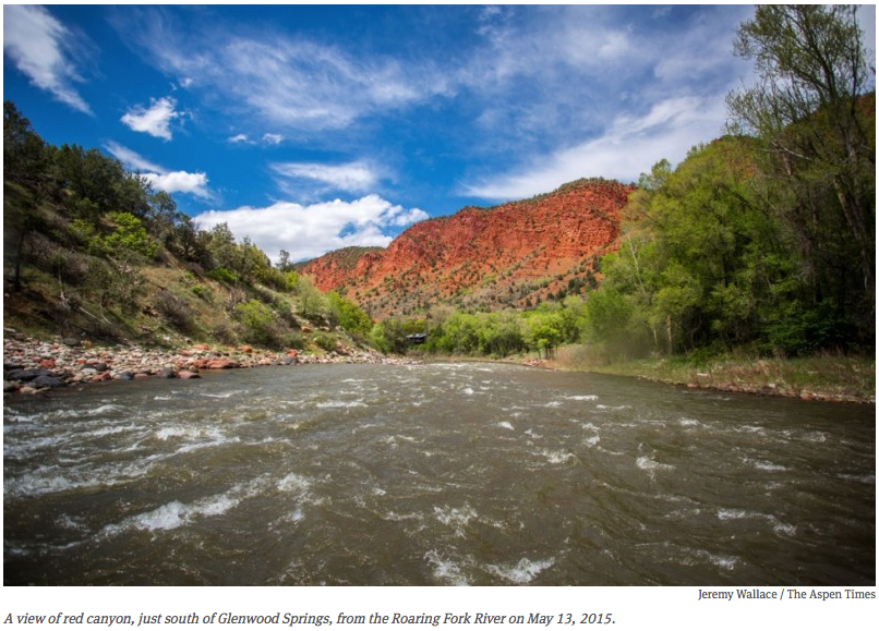
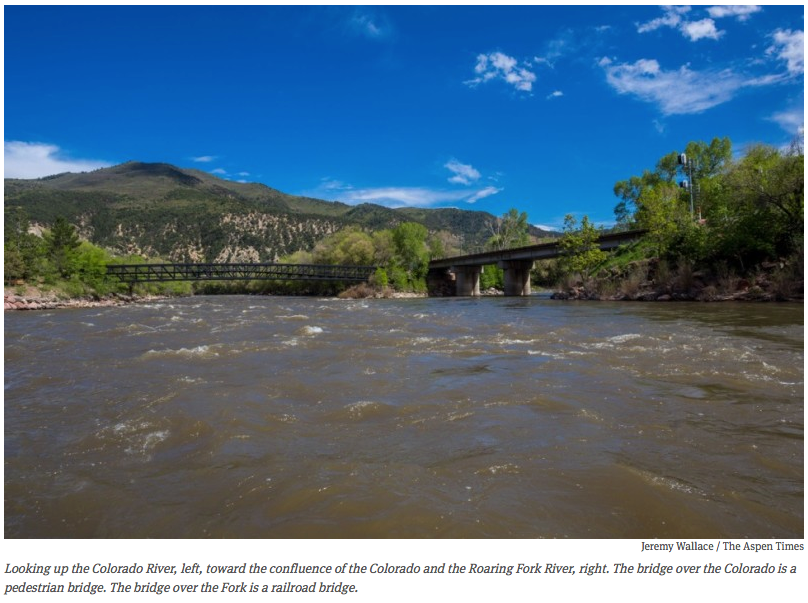
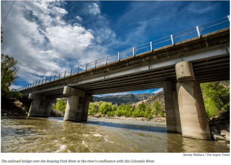
    As my raft floated under the railroad bridge at the confluence of the Roaring Fork and Colorado rivers last week, I was wondering just how much water would flow out of the Fork and into the Colorado this year.

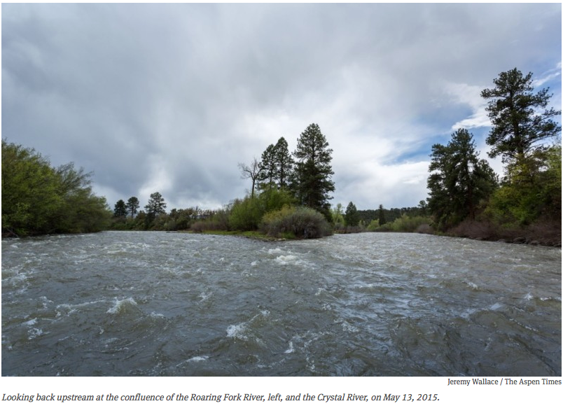
    Certainly less than average, given that the snowpack peaked in March and began melting off, I mused, taking a stroke to catch the big eddy that forms just shy of the mighty Colorado, where the Fork comes in across from Two Rivers Park in Glenwood Springs after draining 1,543 square miles of land.

    Perhaps the wet and cold weather of late April and much of May will continue to forestall a sudden flash of melting snow, so what snow we still have in the high country will come off in a nice steady fashion.

    But spinning around the eddy, I knew how easy it was, as a boater, to be wrong about water and weather. It is also, as it turns out, a tricky time of year for professional hydrologists to predict run-off, as data from low-elevation snow-measuring sites tapers off and daily weather conditions can play a big role in shaping how much water flows, and when it does.

    In mid-March, which felt like summer already, a trip on the Green River starting April 12 seemed like a good bet this year to enjoy some warm weather. But a big storm swept in that week and blasted the river with freezing rain.

    The same storm laid down 11 inches of snow on Aspen Mountain by Friday, April 17, making for a memorable closing weekend for some.

    After warming up from that trip, I ventured optimistically out again during the first full week of May, this time on the Colorado River west of Loma. And I was soon engulfed in the downpours of May 5 and 6 that lead to river levels across the region jumping up.

    Between May 5 and May 7, for example, the flow in the lower Fork doubled from a 1,000 cubic feet per second to over 2,000 cfs.

    So when I went out on May 13 for my first trip of the season down the Roaring Fork from Carbondale to Glenwood, I wasn’t surprised that it started raining. It’s just been that kind of season so far — in fact, through May 19, total precipitation in the Roaring Fork River watershed was 204 percent, or double the normal amount of precipitation. according to the Natural Resource Conservation Service (NRCS).

    But the Fork was flowing that day at 1,110 cubic feet per second, which was enough water to have a perfectly nice float, especially as I did see some sun (and some red-wing blackbirds).

    But will the river get much bigger this year, I wondered as I rowed toward Glenwood.

    redcanyonfromroaringforkmay132015apenjournalimsjeremywallaceaspentimes

    Below average flows

    The Colorado River Basin Forecast Center in Salt Lake City forecast on May 19 that the Roaring Fork will most likely peak this year in mid- to late June at 4,300 cfs, as measured at Veltus Park, just above the Fork’s confluence with the Colorado.

    That’s 73 percent of the Fork’s average annual peak of 5,920 cfs, which typically occurs between May 29 and June 23.

    While this year’s likely peak flow of 4,300 cfs is certainly better than the lowest peak flow on record — 1,870 cfs on June 3, 2012 — it’s also way below the historic peak of 11,800 cfs on July 13 in 1995.

    The forecast peak flow has increased given the cool and wet weather in May. So, if April showers bring May flowers, May showers are likely to bring better boating on the Fork in June.

    “I would say it is very likely (the Roaring Fork) will see a below average peak flow this year,” said Brenda Alcorn, a senior hydrologist with the Forecast Center.

    However, she added that what snowpack we do have “is in better shape than it was in 2002 and 2012, so I do not expect a record low peak.”

    But just how much water comes, and when, is now weather dependent.

    “Spring temperatures and precipitation play a significant role in the pattern of snowmelt runoff and consequently the magnitude of peak flows,” Alcorn said. “An extended period of much above normal temperatures or heavy rainfall during the melt period can cause higher than expected peaks, while cool weather can cause lower than expected peaks.”

    On Friday, May 15, Julie Malingowsky, a meteorologist with the National Weather Service in Grand Junction, said the period to at least May 25 looked cooler and wetter than normal, and longer-range forecasts indicate that the next several months could be wetter than normal.

    (Also, see the Intermountain West Climate Dashboard of indicators at Western Water Assessment)

    But probably not wet enough make up for the skinny snowpack.

    “Even though it has been a wet month, we are still drier than normal,” Malingowsky said.

    confulenceroaringforkcrystalriver05132015aspenjournalismjeremywallaceaspentime

    Below average supply

    Another view of this year’s water picture is available from the Natural Resources Conservation Service’s “Colorado Water Supply Outlook Report,” which was published on May 1.

    The report shows that the “most likely” amount of water to reach the bottom of the Roaring Fork between April and the end of July is 450,000 acre-feet, according to Brian Domonkos, a data collection officer with NRCS.

    That’s below the 30-year average of 690,000 acre-feet flowing down the Fork for the period from April to August. (The Roaring Fork delivers, on average, 871,100 acre-feet of water to the Colorado River over a full year, according to the Colorado Division of Water Resources).

    The water-supply report said that current conditions point to “a below normal streamflow forecast picture for much of the state heading into spring and summer of 2015.”

    However, Gus Goodbody, a forecast hydrologist with NRCS, said the amount of water expected to flow out of the Roaring Fork is likely to increase from the May 1 forecast by five to 10 percent, given May’s weather so far.

    “It’s going to go up,” he said.

    Another indicator of potential run-off is the measure of the “snow water equivalent” at SNOTEL measuring sites in the Roaring Fork basin.

    The average from the eight SNOTEL sites in the Roaring Fork basin was 108 percent on May 19, but that’s without complete data from four of the sites.

    That number — 108 percent — has been climbing steadily since May 1, but it’s not an indicator that the snowpack has been growing. What it does show is that the cool and wet weather has slowed the run-off and moved the data closer to the historic average — which, again, bodes well for June boating. But in addition to the snowpack and the weather, there are other factors that dictate the flows in the Fork at Glenwood Springs.

    lookingupthecoloradoriverconfluenceroaringforkaspenjournalismjeremywallaceaspentimes

    Off the top

    An average of 40,600 acre-feet of water a year is collected from the upper Roaring Fork River basin and sent through a tunnel under Independence Pass and into Twin Lakes Reservoir, destined for Aurora, Colorado Springs, Pueblo and Pueblo West.

    The Twin Lakes diversion takes 40 percent of the water out of the upper Roaring Fork basin above Aspen, according to the 2012 Roaring Fork Watershed Plan.

    Another 61,500 acre-feet is collected on average each year from tributaries of the upper Fryingpan River and sent east through the Bousted and Busk tunnels. That accounts for 37 percent of the water in the upper Fryingpan headwaters.

    As such, there are many days when there are rivers heading both east and west out of the Roaring Fork River watershed, and the ones heading east can often be bigger.

    For example, on May 13, while I was floating on 1,110 cfs at the bottom of the Fork, there was 136 cfs of water running under the Continental Divide in the Twin Lakes — Independence Pass Tunnel, which can, and does, divert up to 625 cfs later in the runoff season.

    And the Bousted Tunnel, which transports the water collected from the headwaters of the Fryingpan River, as well as Hunter and Midway creeks in the Roaring Fork basin, was diverting 101 cfs on May 13.

    Meanwhile, the gauge on Stillwater Drive on May 14 showed the main stem of the Fork was flowing, just east of Aspen, at 111 cfs.

    Then there is the water diverted out of the rivers in the basin and into one of the many irrigation ditches along the Fork, the Crystal and other streams in the basin.

    Ken Ransford, a member of the Colorado River Basin Roundtable, estimates that the 12 biggest irrigation ditches on the Roaring Fork and Crystal rivers divert about 115,000 acre-feet of water a year.

    Most of that water eventually finds its way back to the rivers, but the diversions also leave many stream reaches lower than they otherwise would be, and few tributaries are left untouched.

    According to the Roaring Fork Watershed Plan, “flow-altered stream reaches include the Roaring Fork, Fryingpan, and Crystal rivers, as well as Hunter, Lincoln, Maroon, Castle, West Willow, Woody, Snowmass, Capitol, Collins, Sopris, Nettie, Thompson, Cattle, Fourmile, and Threemile creeks.”

    Another factor shaping the flows in the lower Fork are decisions made by regional water managers, including irrigators near Grand Junction and municipal water providers in Denver, that can shape releases from reservoirs such as Green Mountain and Ruedi.

    Who needs water, and when, can also dictate the size of that eddy at the bottom of the Fork. So for now, I’m just glad it’s big enough to float a boat.

    Editor’s note: Aspen Journalism is collaborating with The Aspen Times, the Aspen Times Weekly, and The Glenwood Springs Post Independent on coverage of rivers and water. The Aspen Times Weekly published this story on Thursday, May 21, 2015.

    More Roaring Fork River watershed coverage here.

    Southeastern Water board meeting recap: Lake Pueblo, swollen by 12,000 acre-feet of flood water

    Fryingpan-Arkansas Project via the Southeastern Colorado Water Conservancy District
    Fryingpan-Arkansas Project via the Southeastern Colorado Water Conservancy District

    From The Pueblo Chieftain (Chris Woodka):

    Water, water everywhere.

    Not going to be a problem later in the year, right?

    Hold on.

    The Southeastern Colorado Water Conservancy District Thursday considered the possibilities of how water comes through the Boustead Tunnel into Turquoise Lake under the Fryingpan- Arkansas Project.

    All signs are pointing toward a more-or-less normal year in terms of water supply. Lake Pueblo, swollen by 12,000 acre-feet of flood water, is 132 percent of average. The flood water already was being released on Thursday, raising Arkansas River levels in the wake of the flood surge.

    Turquoise and Twin Lakes are above average in the upper reaches of the Arkansas River, while John Martin Reservoir has begun filling again to its highest level since 2010, about 82,000 acre-feet on Thursday.

    Snowpack levels in the headwaters of both the Colorado and Arkansas Rivers are back to normal, but it’s late in the season and both basins fell short of peak moisture levels this year.

    But very little transmountain water has come over so far, just 4,254 acre-feet of a projected 53,000 acre-feet for the season.

    “It all depends on how it comes off,” said Roy Vaughan, Fry-Ark manager for the Bureau of Reclamation.

    Cold temperatures are preventing the snow from melting at prime rates, as it does at this time of year in some cases.

    “The tunnel hasn’t started to run at full capacity, so we’re behind,” Vaughan said.

    If it warms up too quickly, the Fry-Ark structures won’t be able to capture it. And river levels have to be met on the Western Slope, Vaughan explained.

    In the past decade, the Southeastern district has adopted new policies to avoid over-allocating water early in the season, so it holds back 20 percent of the allocation.

    More coverage from Chris Woodka writing for The Pueblo Chieftain:

    Farms will get a boost in water supply, with nearly average allocations from the Fryingpan- Arkansas Project, but reduced requests from cities for water.

    The Southeastern Colorado Water Conservancy District Thursday approved allocations from the project, based on snow forecasts, which have improved since projections of water supply were made May 1.

    The district projects that 53,000 acre-feet (17 billion gallons) of water will be brought through the Boustead Tunnel into Turquoise Lake. That would mean almost 45,700 acre-feet available for allocation.

    Of that, about one-third will go to cities and two-thirds to farms. Under the district’s allocation principles, the split would be closer to 53 percent municipal and 47 percent agricultural.

    Initially, just 80 percent of the water will be allocated in case conditions change and imports are less than expected. The remaining 20 percent will be available when imports reach the target.

    If more water above the target is brought over, there could be a second allocation.

    Cost of the water is $9 per acre-foot for farms and $9.75 for cities.

    Municipalities reduced their requests significantly this year.

    The Fountain Valley Authority (Colorado Springs, Fountain, Security, Stratmoor Hills and Widefield) requested and received 7,216 acrefeet, but was eligible for 11,625 acre-feet.

    The Pueblo Board of Water Works was eligible for 4,568 acrefeet, but requested and received no water, since Pueblo Water has ample water in storage this year.

    Cities east of Pueblo took slightly less water than authorized, mainly because St. Charles Mesa Water District took just one-sixth of its share. Fowler, Crowley County and Joseph Water all took significantly more water than authorized, while most others were close to average.

    Cities west of Pueblo took slightly more. All received the full amount requested.

    Pueblo West and Manitou Springs, which get water that was redirected from agriculture when Crowley County farms were dried up by Aurora, will each get full allocations of about 155 and 160 acre-feet, respectively.

    The net effect was moving about 9,000 acre-feet to the agricultural side of the ledger, said Garrett Markus, district engineer.

    On the agricultural side, Fort Lyon Canal will received the largest allocation, with 10,653 acre-feet, and it will use 3,135 acre-feet of return flows under a pilot project that allows the ditch to use its own return flows for replacement water under state irrigation rules. Only 58,618 acres of the ditch are eligible for Fry-Ark water. The ditch irrigates 93,000 acres, but owners with more than 960 acres, including Pure Cycle (which has 14,600 acres) are not eligible.

    As usual, requests for ag water far outpaced the available water.

    Farmers asked for 106,570 acre-feet to cover 146,000 acres on 25 canals, ditches or farms. Only 30,024 acrefeet were allocated.

    Another 7,431 acre-feet of agricultural return flows were allocated, 95 percent to the three major well augmentation groups in the Arkansas Valley.

    More Fryingpan-Arkansas Project coverage here.

    A look at the current southwestern Colorado #drought #ColoradoRiver

    Colorado Drought Monitor February 24, 2015
    Colorado Drought Monitor February 24, 2015

    From The Durango Herald (Mary Shinn):

    Years of drought and overgrazing have dried out the fields in southwestern La Plata County. Dust easily blows away in the wind.

    Last year, from March until May, dust storms caused problems for students, drivers and farmers, and without enough precipitation, the dirty storms could return…

    The area from Breen into New Mexico and west of Black Ridge to the La Plata County line was hit hard last year by dust, said Sterling Moss, district conservationist for the Natural Resources Conservation Service office in Durango.

    The recent snowfall earlier this week dumped about a foot of snow near Breen and Kline, and more snow is expected to accumulate this weekend.

    “This is a huge blessing, but we are still way far from being out of the woods,” said Trent Taylor, owner of Blue Horizons Farm Inc.

    The entire river basin, which includes the Dolores, Animas, San Juan and San Miguel rivers, would need to receive 218 percent of historical snowfall to get back on track, said Bruce Whitehead, executive director of the Southwestern Water Conservation District.

    “I don’t think we’ll make it to normal snowpack this year,” he said.

    A long dry spell in January and February left local conservationists and farmers nervous. In mid-February, Moss dug down to test soil moisture as wind dried the field of winter wheat all around him.

    In southwestern La Plata County, snow should have blanketed the field near County Road 119 for weeks. But instead, Moss didn’t even find enough moisture in the soil to support the wheat through harvest.

    “I’ve never seen a February like that,” Taylor said.

    The newly fallen snow could ease the situation. If it melts slowly, it can soak deeper into the soil than rain does.

    But re-establishing healthy fields is key to preventing dust storms through the spring winds.

    Moss and his office have been working with landowners to plant grass in areas dedicated to conservation reserves to keep the top soil from blowing away. These areas are dedicated to wildlife habitat, and landowners receive a government subsidy for not working the land. This helps farmers survive in the worst drought years, Taylor said.

    But it has been challenging.

    “A lot of grass has been planted that hasn’t been established yet,” Moss said.

    The stands of grass are key to keeping valuable topsoil in place. An inch of topsoil can take 100 years to accumulate, he said.

    But without precipitation at the right time, the grasses won’t grow. This year, Moss might recommend planting grass or another cover crop in mid-summer in hopes the monsoons will come.

    In the past few years, fall rains have brought most of the moisture for the year.

    Leaving the stems from last year’s crop in place also can prevent wind and rain erosion and keep the soil cooler, said Abdel Berrada, a soil scientist with Colorado State University.

    This stubble helps conserve soil, but it also provides habitat for pests, like cut worms that may require herbicide, Taylor said.

    Planting trees as wind breaks or setting up snow fences can help keep the dust down. But trees can’t thrive when there’s very little water…

    “Growing plants on bare bones soil with little to no water can be an uphill challenge,” said Darrin Parmenter, county extension agent for Colorado State University.

    San Miguel, Dolores, Animas, and San Juan Basin High/Low Graph February 25, 2015 via the NRCS
    San Miguel, Dolores, Animas, and San Juan Basin High/Low Graph February 25, 2015 via the NRCS

    Pueblo Reservoir winter operations update

    Pueblo dam releases
    Pueblo dam releases

    From The Pueblo Chieftain (Chris Woodka):

    Water users are playing the annual guessing game of how much water will be in Lake Pueblo when it comes time to ensure enough space is left for flood protection.

    While there could be a slight chance for a spill, the Bureau of Reclamation is working with other water interests to reduce the odds.

    “The long-term forecast for this spring is for cooler temps and increased precipitation,” said Roy Vaughan, Reclamation’s local manager for the Fryingpan-Arkansas Project.

    Right now the reservoir holds about 247,000 acre-feet, and at the current pace of filling would be at 267,000 acre-feet by April 15 — about 10,000 acre-feet above the limit for flood control.

    Of the total, nearly 49,000 acre-feet is in “if-and-when,” or excess capacity, accounts subject to spill if there is too much water in Lake Pueblo. Fry-Ark Project water would be the last to spill.

    However, the Southeastern Colorado Water Conservancy District is again seeking a waiver to hold a little more water until May 1, the deadline for releasing about 14,500 acre-feet of holdover water.

    At the same time, flows below Pueblo Dam are increasing to balance the winter water program, Division Engineer Steve Witte said.

    “That’s not good news for the work that’s going on along the levee,” Witte said.

    Some winter water also is stored in John Martin Reservoir, which is very low, or in reservoirs owned by ditch companies. Winter water storage ends March 15 and is running close to the 20-year average for the first time in years.

    Southeastern Colorado Water Conservancy District 2015 budget update

    Pueblo dam releases
    Pueblo dam releases

    From The Pueblo Chieftain (Chris Woodka):

    The Southeastern Colorado Water Conservancy District board is expected to approve a $17.9 million budget at its next meeting, 11 a.m. Dec. 4.

    The district last week reviewed the details of the budget and hosted a public hearing. No member of the public attended.

    A mill levy of 0.94 mills is planned, the same as 2014. One mill is an assessment of $1 for every $1,000 of assessed valuation. The district covers parts of nine counties, including Chaffee, Fremont, Pueblo, El Paso, Crowley, Otero, Bent, Prowers and Kiowa.

    The district also makes money through sales of water and grants.

    More than $12 million will go toward repayment of the Fryingpan-Arkansas Project, including the Fountain Valley Conduit. The conduit serves El Paso County communities that pay a dedicated mill levy on top of the district mill levy.

    The district will spend $2.34 million for its own operating expenses, and $3.5 million on enterprise, or business, activity.

    Included in the enterprise fund are the Arkansas Valley Conduit, and an ongoing project to develop hydroelectric power at Pueblo Dam.

    More Southeastern Colorado Water Conservancy District coverage here.

    Souteastern Water winter water storage meeting recap

    From The Pueblo Chieftain (Chris Woodka):

    Lower Arkansas Valley water users could face a different sort of challenge next year, especially if it’s a wet winter: Finding places to store the water. The possibility was discussed Friday at the annual meeting of the winter water storage program, hosted by the Southeastern Colorado Water Conservancy District.

    “I think the way we’re managing reservoirs is shifting a bit,” said Jim Broderick, executive director of the Southeastern Colorado Water Conservancy District. “We need to start planning. If one area gets full, you can’t move the water there.”

    The winter water program is a court-decreed plan that allows most major ditch companies east of Pueblo to store water from Nov. 15 to March 15 each year. Rather than irrigating during the winter months, the companies can store the water for use later in the season.

    But the storage is not all in one place.

    About one-third of last year’s water was stored in Lake Pueblo, with the rest being stored by individual canal companies or in John Martin Reservoir.

    Not all ditch companies have storage.

    Lake Pueblo has more water than usual going into the winter water storage season because cities were able to beef up their storage in Fryingpan-Arkansas Project space this year. In addition, the Bureau of Reclamation is moving water from Turquoise and Twin Lakes to Lake Pueblo to make room for next spring’s transmountain imports.

    If rainfall and snowpack are above average in the Arkansas River basin, Lake Pueblo could fill more. If it gets too full, some water would have to be evacuated, or “spilled,” next spring in order to leave space to contain potential floods.

    It’s a problem the valley hasn’t really faced since 1999. In 2011, the Southeastern District got permission from the Army Corps of Engineers to delay releases of water from the flood pool by several weeks because of conditions at the time.

    Roy Vaughan, Fry-Ark Project manager for the Bureau of Reclamation, said a spill is unlikely next year if weather conditions remain in the average range. But Lake Pueblo should be nearly filled to the flood pool level by next spring.

    “I have been proud to work for years to ensure the [support for] the Arkansas Valley Conduit” — Sen. Mark Udall

    Arkansas Valley Conduit Comanche North route via Reclamation
    Arkansas Valley Conduit Comanche North route via Reclamation

    From The Pueblo Chieftain (Chris Woodka):

    A draft federal energy and water funding bill includes an additional $90 million for projects such as the Arkansas Valley Conduit, U.S. Sens. Michael Bennet and Mark Udall, both Democrats, said Thursday. The Senate appropriations committee approved the bill, which contains a provision supported by both senators that explicitly makes data collection and design work eligible for funding through these accounts. It will help ensure the Arkansas Valley Conduit is eligible for these funds and sends a clear signal to the Bureau of Reclamation that the conduit is a priority project.

    The board of the Southeastern Colorado Water Conservancy District, conduit sponsor, was dismayed earlier this year when it learned only $500,000 was budgeted for the conduit next year. It is hoping to get at least $3 million for continuing data and design tasks that will lead to construction of the $400 million conduit.

    The conduit is the final piece of the Fryingpan-Arkansas Project, authorized in 1962. When complete, the 130-mile pipeline will provide clean drinking water to 50,000 people in 40 communities east of Pueblo.

    “For more than five decades, folks in Southeastern Colorado have been waiting for the federal government to fulfill its promise to build the Arkansas Valley Conduit.

    That’s far too long for these communities to wait for a reliable source of clean drinking water,” Bennet said.

    “I have been proud to work for years to ensure the federal government supports the Arkansas Valley Conduit. This funding brings the people of Southeastern Colorado one step closer to having a clean, safe and reliable source of water,” Udall said.

    More Arkansas Valley Conduit funding here and here.

    Southeastern Colorado Water Conservancy District board meeting recap

    Arkansas Valley Conduit Comanche North route via Reclamation
    Arkansas Valley Conduit Comanche North route via Reclamation

    From The Pueblo Chieftain (Chris Woodka):

    New wrinkles in the federal budget process have improved chances for funding of the Arkansas Valley Conduit.

    Appropriations bills in the U.S. House and Senate have increased funding for the Bureau of Reclamation, with emphasis on capital projects that are in the design phase.

    While that does not provide an increase for the conduit’s $500,000 funding level next year, it could mean a shift in funding to the conduit by Reclamation, lobbyist Christine Arbogast told the Southeastern Colorado Water Conservancy District Thursday.

    “We have incredible support from those in Congress who represent the area to be served by the conduit,” Arbogast told the board. “They are fighting for the funding of it. Clearly, it is unprecedented, the levels they are going to for this.”

    She was referring to U.S. Sens. Michael Bennet and Mark Udall, both Democrats, and U.S. Reps. Cory Gardner and Scott Tipton, both Republicans.

    For instance, during meetings in Washington, D.C., last week, the senators met with top Department of Interior and Office of Management and Budget officials to make the case for more funding for the conduit.

    The $400 million Arkansas Valley Conduit would have a main line of 130 miles from Pueblo Dam to Lamar, serving 50,000 people in 40 communities.

    Federal money for the project would be repaid through Fryingpan-Arkansas Project excess storage contracts and user fees.

    More Arkansas Valley Conduit coverage here.

    Northwest Pipe Co. is major supplier for the Southern Delivery System #ColoradoRiver

    Southern Delivery System construction celebration August 19, 2011 via The Pueblo Chieftain
    Southern Delivery System construction celebration August 19, 2011 via The Pueblo Chieftain

    From The Denver Post (Aldo Svaldi):

    Orders at the Northwest Pipe Co. plant in Denver were drying up in 2010 when bid requests started coming for a massive water project linking the Pueblo Reservoir and Colorado Springs called the Southern Delivery System.

    “The start of the SDS project couldn’t have come at a better time,” Northwest’s vice president of sales Eric Stokes said.

    At a cost of $841 million, the water project is the largest the region has seen in decades. Starting in 2016, it will pipe water held in the Pueblo Reservoir to consumers in Colorado Springs, Pueblo West, Security and Fountain.

    “This is our water security for many years to come, 50 years into the future,” said John Fredell, program director of the water services division for SDS.

    Northwest Pipe’s Denver plant won almost all the contracts to supply 50 miles of steel pipe, and the company celebrated the completion of the last piece Thursday afternoon. Northwest produced 7,000 pieces of the pipeline, each averaging 50 feet in length and 66 inches in diameter. The orders allowed Northwest’s employment in Denver to grow from 116 full-time workers to more than 231 at the peak of manufacturing.

    Of about $500 million spent so far on the project, $359 million has gone to 333 Colorado businesses, including more than 75 based in metro Denver, Fredell said.

    Northwest Pipe alone received about $110 million, including $23 million spent on payroll. Given that the next closest competitor was in California, Stokes said Northwest had a distinct advantage.

    “Proximity was part of it,” Fredell said.

    Back in 1997, Northwest Pipe, which is based in Vancouver, Wash., acquired Thompson Pipe & Steel Co., a manufacturer with Denver roots going back to the late 1800s. For decades, Thompson built pipes in the Curtis Park area that continue to help move water across much of the state. Thompson moved its plant to a 45-acre facility at 6030 Washington St., where workers continued to convert steel coil arriving by rail car into water pipes shipped out on trucks.

    Once formed, the pipes are pumped full of water and pressure-tested to ensure there are no leaks. They are moved into a cavernous ⅛ – mile-long warehouse where they are rotated rapidly while concrete is poured inside to make a lining designed to last for decades. In a third building, the pipes are primed, painted and prepared for shipping.

    “It is nice to know you have finished on time,” said Jason Cheng, a welder from Westminster who joined Northwest in October to work on the SDS order.

    Cheng and other workers lined up to sign the last piece of pipe, undeterred as the rain poured down Thursday afternoon. Their signatures, in white ink, quickly smeared down the bright-blue pipe.

    “We want the water on the inside of the pipe, not the outside,” one person commented.

    From the Denver Business Journal (Cathy Proctor):

    Northwest Pipe, (Nasdaq: NWPX) is based in Vancouver, Washington. Its Denver manufacturing plant had a $110 million contract to build the project’s 50 miles of pipeline to carry the water. It was the biggest contract for materials under the project.

    Northwest Pipe started making its 50-foot sections of pipe for the project, each section 66 inches in diameter, in 2011.
    And the last pieces are now coming off the manufacturing line and awaiting a truck for transport to the project site.

    “This is one of the largest programs that we’ve seen,” said John Moore, manager of Northwest Pipe’s manufacturing plant at 6030 N. Washington St. in north Denver.

    During peak production, as many as 25 trucks a day left Northwest Pipe’s manufacturing facility.
    Being in Denver meant trucking costs were less and Northwest Pipe could submit a more competitive bid for the project, Moore said.

    And the project meant jobs for Northwest Pipe, which ramped up to 231 people during peak production, from a low of 116 people prior to work on the project, said John Moore, the plant manager. The company currently has 131 people on staff.
    Northwest Pipe, which supplies pipes to carry water and waste water, has delivered pipes to other big water providers, including Denver Water and Aurora.

    More Southern Delivery System coverage here.

    CWCB: Does the draft #COWaterPlan rely too much on unproven alternative ag transfers?

    Colorado Water Plan website screen shot November 1, 2013
    Colorado Water Plan website screen shot November 1, 2013

    From The Pueblo Chieftain (Chris Woodka):

    A state water plan may be putting too much weight on alternative transfer programs that seek to temporarily provide water to cities from farm lands. While the goal of such programs is to reduce the possibility of permanent dry-up of agriculture, there is little evidence to prove they would work, said Patricia Wells, a member of the Colorado Water Conservation Board, meeting in Pueblo this week.

    “Has any transfer method actually happened with rotational fallowing?” Wells, general counsel for Denver Water, asked during Wednesday’s CWCB meeting at the Pueblo Convention Center.

    The board was reviewing draft chapters of the state water plan being developed by CWCB staff. Other topics included conservation, water quality and project permitting.

    “This chapter paints a rosy picture of alternative transfers,” Wells added. “This doesn’t mean alternative transfer methods can’t be done, but they haven’t been done.”

    The Arkansas Valley Super Ditch formed in 2008, but has had difficulty launching pilot programs because drought reduced water availability, permit complications and farmer participation.

    In 2013, the Legislature passed HB1130, which set up a framework for long-term lease arrangements, and HB1248, which allowed for 10 pilot programs that have not materialized.

    Super Ditch attempted to run a pilot program under HB1248 with the town of Fowler this year, but plans fell through.

    This year, a proposal to create a flex marketing water right failed because opponents said it amounted to legalizing speculation.

    In 2004-05, Aurora and the Rocky Ford High Line Canal engineered a temporary transfer program that was successful, although it raised questions of moving water from one river basin to another.

    Since then, the state has spent millions of dollars on grants to study alternative transfer methods, but large metro providers are reluctant to enter long-term deals without more certainty.

    “Unless we find some way to do this, there are barriers,” Wells said.

    Board member John McClow, a Gunnison attorney, questioned CWCB staff for using language from the Interbasin Compact Committee’s report rather than taking a fresh approach.

    Travis Smith, a board member of both the CWCB and IBCC, responded that the IBCC reached agreement on using alternative transfers several years ago, and thought that should be reflected in the state water plan.

    Meanwhile the Arkansas Valley Conduit was also a topic at yesterday’s CWCB meeting in Pueblo. Here’s a report from Chris Woodka writing for The Pueblo Chieftain:

    The state showed more support for the Arkansas Valley Conduit Thursday, pledging cooperation in helping to obtain federal funding for the $400 million project.

    “This is the last piece of the Fryingpan-Arkansas Project,” said Jim Broderick, executive director of the Southeastern Colorado Water Conservancy District. “It’s been a long wait for something that was promised 50 years ago.”

    Broderick gave an update of the conduit to the Colorado Water Conservation Board, which met Thursday at the Pueblo Convention Center.

    Contract negotiations will begin later this year for the conduit and two associated federal contracts to provide a master storage lease in Lake Pueblo and a cross-connection between south and north outlets on Pueblo Dam.

    More Colorado Water Plan coverage here. More Arkansas Valley Conduit coverage here. More CWCB coverage here.

    The Southern Delivery System has been a long time coming

    Southern Delivery System route map -- Graphic / Reclamation
    Southern Delivery System route map — Graphic / Reclamation

    Here’s part one of an in-depth look at the Southern Delivery System from John Hazlehurst writing for the Colorado Springs Business Journal. Click through and read the whole article. Here’s an excerpt:

    Contending that the denial [of Homestake II] had been arbitrary and capricious, the two cities [Aurora and Colorado Springs] appealed the decision to the courts. In a comprehensive description of the city’s water system and possible future sources of supply given to City Council in 1991, CSU managers said that “extensive litigation is expected to continue.”

    Denied by the Colorado Court of Appeals and the Colorado Supreme Court, the cities appealed to the U.S. Supreme Court, which declined to hear the case.

    City officials were stunned. They couldn’t believe that a coalition of Western Slope “enviros” and ski towns had prevented them from developing water to which the city had an undisputed right. They had believed the Environmental Protection Agency’s 1990 decision to scuttle Denver’s proposed Two Forks Dam near Deckers on the South Platte River was an outlier, not a sign of things to come…

    Slow to recognize that mountain communities now had the power to kill their water development plans, Utilities officials looked at another alternative. Instead of taking water directly from the wilderness area, the city proposed to build a dam on the mainstem of the Arkansas at Elephant Rock, a few miles upstream of Buena Vista.

    A grassroots rebellion against the project was soon evident, as hand-lettered signs appeared along U.S. Highway 24, which parallels the Arkansas. The signs carried a simple message: “Don’t Let Colorado Springs Dam this River!”

    It soon became clear that Chaffee County commissioners would not issue a construction permit for any such project, dooming it before the first planning documents were created…

    If trans-mountain diversions or dams on the Arkansas were no longer feasible, that left a single alternative for developing the city’s water rights. CSU would have to let its water flow down to Pueblo Reservoir, construct a diversion structure on the dam, and pump it uphill to Colorado Springs.

    It would be, water managers believed, the easiest project to build and permit.

    “It was just a pipeline,” said CSU water resources manager Gary Bostrom, who has worked 35 years for Utilities. “What could go wrong?”[…]

    “We didn’t really understand the importance of partnering with and involving the public in decision-making,” said [Gary Bostrom], “until the Southern Water Project.”[…]

    The plan for the Southern Delivery System was presented to City Council in 1992. Among the material submitted to councilmembers was a comprehensive description of the city’s existing water system. Water managers made sure Council was aware of the importance of the task before them.

    “The massive scope of this project,” CSU staff noted, “requires a very long lead time to allow for complexities of numerous permitting processes, land acquisition, litigation, design, financing and construction.”

    Of all the variables, CSU managers and elected officials gave the least weight to those that may have been the most significant…

    “We weren’t worried about hydrology,” said Bostrom. “The years between 1980 and 2000 were some of the wettest years on record. The water was there for the taking. Shortages on the Colorado weren’t part of the discussion.

    “We knew about the Colorado River Water Compact of 1922 (which allocated Colorado River water between Mexico and the upper and lower basin states), but it wasn’t something we worried about.”

    Then as now, 70 percent of the city’s water supply came from the Colorado River. SDS would tap the city’s rights on the Arkansas, diversifying the portfolio.

    “We have to plan for growth,” said Bostrom. “That’s what history tells us. We know that it will be expensive, but the cost of not building a system well in advance of need would be much greater. People complained about the cost of the Blue River (trans-mountain diversion) project in the 1950s, but we wouldn’t have a city without it — we wouldn’t have the Air Force Academy.”

    But even as the project moved slowly forward, the comfortable assumptions of a wet, prosperous future began to unravel.

    “Exactly 15 years ago today (April 29, 1999),” said Bostrom, “we were in the middle of a flood — remember? We didn’t know it, but that was the day the drought began.”

    More Southern Delivery System coverage here and here.

    The Southern Delivery System is on time and under budget, according to @CSUtilities

    The new north outlet works at Pueblo Dam -- Photo/MWH Global
    The new north outlet works at Pueblo Dam — Photo/MWH Global

    From the Colorado Springs Business Journal (Marija B. Vader):

    Wayne Vanderschuere, general manager of the Colorado Springs Utilities water services division, said the Southern Delivery System will be completed on schedule and $150 million under the original budgeted amount.

    More Southern Delivery System coverage here and here.

    Southern Delivery System: Colorado Springs Utilities has spent $26.6 M on land-related expenses

    Southern Delivery System route map -- Graphic / Reclamation
    Southern Delivery System route map — Graphic / Reclamation

    From The Pueblo Chieftain (Chris Woodka):

    Colorado Springs has spent $26.6 million to acquire land for its $984 million Southern Delivery System. Most of the money was spent in El Paso County, although properties in Pueblo West and on Walker Ranches were purchased either permanently or for temporary easements.

    Pipeline easements totaled $961,681 for 388 acres in Pueblo County, compared with $2.5 million for 486 acres in El Paso County.

    Another $1 million was paid to buy homes in Pueblo West.

    The big money was paid for other features of the project in El Paso County, a total of about $22 million.

    “It would be misleading to simply do the math on the values above and conclude that more was paid for land in El Paso County than Pueblo County,” said Janet Rummel, spokesman for Colorado Springs Utilities, in an e-mail responding to a request from The Pueblo Chieftain.

    Permanent easement prices ranged from 50-90 percent of fee value, while temporary easements are valued at 10 percent per year, varying from one to four years.

    “The fee value of land depends primarily on location, but also is subject to size, shape, development entitlement and improvements, if any,” Rummel explained.

    “Within the raw water pipeline alignments for SDS, fee values for easements and facilities ranged from $1,389 per acre to almost $20,000 per acre,” Rummel said. “Pueblo West properties were generally valued in the range between $10,900 to $13,000 per acre.”

    At the high end of that scale were 6 homes on about 10 acres in Pueblo West purchased for $1.044 million.

    But even below that scale were 103 acres, two-thirds in permanent easements, on Walker Ranches, which could be purchased for $82,900, or about $804 per acre. Utilities also paid Walker $600,000 to relocate cattle during construction, as required by Pueblo County’s 1041 permit.

    Gary Walker will contest the amount of the easement payment in court this November, one of four cases still in dispute.

    Walker also has raised complaints, most recently during a county public hearing, about erosion along the pipeline route. The bulk of the money, however, has gone for the treatment plant, pump station and reservoir sites in El Paso County.

    Utilities paid $259,519 for 43 acres for the Bradley Pump Station; $2.4 million for 124 acres at the treatment plant and $19.3 million for a future reservoir site on Upper Williams Creek.

    At the reservoir site, T-Cross Ranches, owned by the Norris family, received $9,500 per acre for 791 acres ($7.5 million), while the state land board received $10,500 per acre for 1,128 acres ($11.8 million).

    SDS is a pipeline project that will deliver up to 96 million gallons of water daily from Lake Pueblo to Colorado Springs, Fountain, Security and Pueblo West.

    The figures do not include money Utilities paid to purchase homes in Jimmy Camp Creek at a reservoir site that later was abandoned.

    Arkansas Valley Conduit: Reclamation issues record of decision

    Arkansas Valley Conduit Comanche North route via Reclamation
    Arkansas Valley Conduit Comanche North route via Reclamation

    From The Pueblo Chieftain (Chris Woodka):

    It would make sense to include as few turns as possible in a mostly gravity-fed pipeline from Point A to Point B. But the realities of geography, land ownership and a complex network of large and small water districts make the Arkansas Valley Conduit a much more complicated proposition.

    The Bureau of Reclamation signed off on a record of decision last week that clears the way for the conduit to be built, once funding is approved by Congress. While the main trunk of the conduit will run 130 miles, spurs and loops will increase its total length to 227 miles under the concept approved by Reclamation.

    “The total includes everything, all the pipes to where the water providers have facilities to do final treatment and deliver the water,” said Jim Broderick, executive director of the Southeastern Colorado Water Conservancy District, sponsors of the conduit.

    The pipe, all of which will be buried underground, will range in size from 36 inches to just 4 inches as it delivers water to 40 sites serving 50,000 people. An estimated 10,256 acre-feet of water will be delivered annually through the system to large users such as St. Charles Mesa, La Junta and Lamar, to smaller water companies that use only a fraction as much water.

    The most circuitous reach of the pipeline will be used in moving the water from Pueblo Dam to its first stop at St. Charles Mesa. It will first flow from the south outlet on the dam to the Pueblo Board of Water Works’ Whitlock Treatment Plant on the north side of the Arkansas River. From there, the pipeline will run south, again crossing the Arkansas River, through City Park to Thatcher Avenue. It will cross to the west side of Pueblo Boulevard somewhere along Elmwood Golf Course and then head to the prairies west of Pueblo along Red Creek Springs Road, then jog south, under the conceptual plan included in Reclamation’s study.

    “Any time you get out into rural land, it drops the cost and cuts down the time needed for construction,” Broderick said.

    The pipeline will swing east by the Comanche Power plant, then head north to the St. Charles treatment plant, and then north to Avondale and Boone (crossing the Arkansas River again). Spurs will take water to six districts in Crowley County and 24 districts in Otero County. Near the end of the line, the conduit will head about 25 miles north to Eads. While the total cost of the conduit is estimated to be about $400 million, the engineering phase is expected to be about $28 million.

    “A lot depends on which segments we are working on,” Broderick said.

    Getting a stream of federal funding to begin that process is a top priority for the Southeastern district.

    More Arkansas Valley Conduit coverage here.

    I am proud the U.S. Bureau of Reclamation heeded my calls and quickly approved the Arkansas Valley Conduit — Senator Mark Udall

    Arkansas Valley Conduit Comanche North route via Reclamation
    Arkansas Valley Conduit Comanche North route via Reclamation

    Here’s the release from the US Bureau of Reclamation (Tyler Johnson):

    Bureau of Reclamation Great Plains Regional Director Michael Ryan has signed the Record of Decision for the Arkansas Valley Conduit and Long Term Excess Capacity Master Contract Final Environmental Impact Statement. The selected alternative is construction of the Arkansas Valley Conduit using the Comanche North Alternative.

    “This project will help water providers throughout the Arkansas River Basin meet existing and future demands,” said Ryan. “While funding details remain to be coordinated, it is prudent this project move forward to be in a position to take advantage of federal, state or local funding opportunities when they arise.”

    The Arkansas Valley Conduit is a feature of the Fryingpan-Arkansas Project. It will provide treated water to communities in southeastern Colorado. When complete, the pipeline for the Arkansas Valley Conduit could be up to 227 miles long. The Comanche North Alternative includes three federal actions:

  • Construct and operate the Arkansas Valley Conduit and enter into a repayment contract with Southeastern Colorado Water Conservancy District.
  • Enter into a conveyance contract with various water providers for use of a pipeline interconnect between Pueblo Dam’s south and north outlet works.
  • Enter into an excess capacity master contract with Southeastern Colorado Water Conservancy District to store water in Pueblo Reservoir.
  • “For the many small rural water providers the conduit will serve, this critical step in the process of building the project is greatly welcomed. Facing the water quality and waste water discharge compliance challenges has been daunting for this area, and the congressional approval in 2009 and now the Record of Decision from the Bureau of Reclamation provide real hope for an effective and efficient way to meet those challenges,” said Bill Long, President of the Southeastern Colorado Water Conservancy District.

    A Record of Decision is a decision document; it concludes the environmental impact statement prepared in compliance with the National Environmental Policy Act. It does not provide or allocate funding for the project. Reclamation published the final environmental impact statement in August, 2013.

    “The District is grateful for this decision, which is one more milestone in a half-century journey to a clean water supply for southeastern Colorado. As federally-mandated standards have changed, the need for the solution the preferred alternative provides is even greater. The promise to build this piece of the project was first made in 1962 by President Kennedy and was restated in 2012, right here in Pueblo, Colorado, by President Obama. Now let’s move forward to the next phases of design and construction,” said Jim Broderick, General Manager for the Southeastern Colorado Water Conservancy District.

    For more information on the Record of Decision, please visit http://www.usbr.gov/avceis. To obtain a hard copy of the Record of Decision, contact Doug Epperly at (406) 247-7638 or depperly@usbr.gov.

    From The Pueblo Chieftain (Chris Woodka):

    The Bureau of Reclamation approved the final construction plan for the Arkansas Valley Conduit Thursday.

    “It’s been a long haul,” said Bill Long, president of the Southeastern Colorado Water Conservancy District, sponsors of the conduit. “This critical step in the process of building the project is greatly welcomed.”

    The record of decision for the project was signed by Michael Ryan, Reclamation’s regional director. The record of decision includes the environmental impact study for the conduit, but the next step will be to obtain funding from Congress to build the project.

    Long, a Bent County commissioner and Las Animas business owner, has been working to get the conduit built since he joined the Southeastern board in 2002. The conduit was included in the 1962 Fryingpan-Arkansas Project legislation, but never built because of the expense.

    “In the last few months, it’s become clear that this will help, not only with drinking water, but at the other end with wastewater quality as well,” Long said.

    Reclamation Thursday approved a record of decision for the Comanche North route of the 227-mile pipeline from Pueblo Dam to Lamar. The chosen route includes initial treatment at the Pueblo Board of Water Works’ Whitlock treatment plant and a pipeline that swings south of Pueblo near the Comanche power plant.

    The conduit will deliver fresh drinking water to 50,000 people in 40 communities east of Pueblo. It is estimated to cost $400 million, which would be repaid partly through revenue from Fry-Ark contracts.

    Also included in the decision is a master storage contract in Lake Pueblo for the Southeastern district and a cross-connection between north and south outlets at Pueblo Dam.

    The storage contract will set aside space for conduit participants and other water users in the district.

    The Southeastern district is focused on funding the project. Political wrangling delayed the record of decision and federal belt-tightening limited appropriations to about $2 million this year, rather than the $15 million the district hoped for.

    “I think this is a really important step forward, and I’m very happy,” said Jim Broderick, executive director of the Southeastern district. “We still have a lot of work to do in funding the project.”

    From the Colorado Springs Independent (Pam Zubeck):

    The Bureau of Reclamation signed the Record of Decision today for a project that’s been in the planning stages since Pueblo Dam was built in the 1960s.

    Part of the Frying Pan-Arkansas project, the conduit has never been built due to lack of money.

    U.S. Sens. Michael Bennet and Mark Udall, Democrats of Colorado, issued a news release after the ROD was signed, which follows approval of an Environmental Impact Study last year.

    Here’s a release from Senator Udall’s office:

    U.S. Senators Mark Udall and Michael Bennet welcomed today’s signing of the Record of Decision for the Arkansas Valley Conduit, which represents a major milestone for the project that will bring clean water to communities in southeastern Colorado. The decision comes after Bennet and Udall urged the Bureau of Reclamation to quickly approve the Conduit’s Environmental Impact Study (EIS) that was finalized last August.

    “I am proud the U.S. Bureau of Reclamation heeded my calls and quickly approved the Arkansas Valley Conduit. This project, the final component of the Fryingpan-Arkansas Project, will help strengthen Colorado’s agricultural economy, our quality of life and rural communities throughout southeastern Colorado,” Udall said. “Water is our most valuable resource in Colorado, and we need to make every drop count. This project will ensure we continue to smartly develop our water resources.”

    “Colorado knows well that water is an extremely precious resource, and the Arkansas Valley Conduit will help ensure families in southeastern Colorado have access to a safe and healthy water supply,” Bennet said. “Today’s announcement couldn’t be more important to southeast Colorado, and it demonstrates the Interior Department’s commitment to getting this project done. With today’s announcement, we are one step closer to completing this historic conduit that will benefit many future generations of Coloradans.”

    Udall and Bennet have led efforts to secure resources and move forward with the construction of the Conduit. In addition to advocating for quick approval of the EIS, the senators have written to the Department of Interior to provide adequate resources for construction of the Conduit in future federal budgets.

    The Arkansas Valley Conduit is the final component of the Fryingpan-Arkansas Project, a water diversion and storage project in the lower Arkansas Valley. Once constructed, the Conduit will deliver clean drinking water to families, producers and municipalities throughout Southeastern Colorado. Bennet and Udall worked together to enact legislation in 2009 authorizing the construction of the Conduit, and have pushed ever since for funding to keep the project on schedule.

    More Arkansas Valley Conduit coverage here and here.

    Arkansas Valley Conduit update: Project caught up in the federal Record of Decision slog

    Preferred route for the Arkansas Valley Conduit via Reclamation
    Preferred route for the Arkansas Valley Conduit via Reclamation

    From The Pueblo Chieftain (Chris Woodka):

    Plans for the Arkansas Valley Conduit continue to be in a holding pattern. Federal processes have slowed the completion of a record of decision for the conduit, a master storage contract and interconnection of outlets on Pueblo Dam.

    The conduit is a plan to bring clean drinking water to 40 communities and 50,000 people from St. Charles Mesa to Lamar.

    The master contract would allow conduit users and others to purchase long-term storage in Lake Pueblo, while the cross-connection would give water users redundancy of water supply sources.

    An environmental impact study was finalized in August, but changes in the Bureau of Reclamation leadership and a federal shutdown have delayed the ROD for five months, said Christine Arbogast, lobbyist for the Southeastern Colorado Water Conservancy District, sponsors of the projects.

    “Five months seems like a long time, but it’s looking good,” Arbogast said.

    She said a decision could be made in a few weeks.

    The lack of the ROD for the projects means very little work is progressing.

    “Anything moving forward will be on hold until we get to the point where we have a ROD,” said Jim Broderick, executive director of the Southeastern district.

    This year’s federal budget includes $1 million for the conduit, but larger appropriations are needed in future years to move the project ahead.

    More Arkansas Valley Conduit coverage here and here.

    Text of the Colorado Basin Roundtable white paper for the IBCC and Colorado Water Plan

    New supply development concepts via the Front Range roundtables
    New supply development concepts via the Front Range roundtables

    Here’s the text from the recently approved draft of the white paper:

    Introduction
    The Colorado River Basin is the “heart” of Colorado. The basin holds the headwaters of the Colorado River that form the mainstem of the river, some of the state’s most significant agriculture, the largest West Slope city and a large, expanding energy industry. The Colorado Basin is home to the most-visited national forest and much of Colorado’s recreation-based economy, including significant river-based recreation.

    Colorado’s population is projected by the State Demographer’s Office to nearly double by 2050, from the five million people we have today to nearly ten million. Most of the growth is expected to be along the Front Range urban corridor; however the fastest growth is expected to occur along the I-70 corridor within the Colorado Basin.

    Continue reading “Text of the Colorado Basin Roundtable white paper for the IBCC and Colorado Water Plan”

    ‘Don’t goddamn come here [#ColoradoRiver Basin] any more’ — Lurline Curran

    Colorado transmountain diversions via the State Engineer's office
    Colorado transmountain diversions via the State Engineer’s office

    Here’s an article about the white paper approved last week by the Colorado Basin Roundtable, from Brent Gardner-Smith writing for Aspen Journalism. Click through and read the whole article. Here’s an excerpt:

    “Don’t goddamn come here any more,” was the way Lurline Curran, county manager of Grand County, summed up the roundtable’s position just before the group voted to approve a white paper it has been working on for months.

    “We’re trying to tell you, Front Range: Don’t count on us,” Curran said. “Don’t be counting on us to make up all the shortages.”

    The actual paper crafted by the Colorado roundtable states its case in a more diplomatic fashion, but it is still blunt.

    “The notion that increasing demands on the Front Range can always be met with a new supply from the Colorado River, or any other river, (is) no longer valid,” the position paper states…

    “There is going to have to be a discussion and plan for developing a new West Slope water supply,” the South Platte roundtable stated in a June memo directed to Committee.

    Together, the South Platte, Metro and Arkansas roundtables are pushing that discussion. They’re asking the state to preserve the option to build “several” 100,000 to 250,000 acre-foot projects on the Green River at Flaming Gorge Reservoir, the lower Yampa River, and/or the Gunnison River at Blue Mesa Reservoir…

    On Nov. 25, the members of the Colorado River roundtable clearly wanted to inform the Committee that they don’t support the idea of new Western Slope projects.

    Jim Pokrandt, a communications executive at the Colorado River District who chairs the Colorado roundtable, said the group’s paper, directed to the Committee, was “an answer to position statements put out by other basin roundtables.”

    The Committee’s eventual analysis is expected to shape a draft statewide Colorado Water Plan, which is supposed to be on the governor’s desk via the Committee and the Colorado Water Conservation Board in 12 months.

    And while there has been a decades-long discussion in Colorado about the merits of moving water from the Western Slope to the Front Range, the language in the position papers, and the roundtable meetings, is getting sharper as the state water plan now takes shape.

    “It’s not ‘don’t take one more drop,’ but it is as close as we can get,” said Ken Neubecker, the environmental representative on the Colorado roundtable, about the group’s current position.

    The paper itself advises, “the scenic nature and recreational uses of our rivers are as important to the West Slope as suburban development and service industry businesses are to the Front Range. They are not and should not be seen as second-class water rights, which Colorado can preserve the option of removing at the behest of Front Range indulgences.”

    That’s certainly in contrast to the vision of the South Platte, Metro and Arkansas basin roundtables, which in a draft joint statement in July said that the way to meet the “east slope municipal supply gap” is to develop “state water projects using Colorado River water for municipal uses on the East and West slopes.”[…]

    The white paper from the Colorado roundtable states that “new supply” is a euphemism for “a new transmountain diversion from the Colorado River system.”

    “This option must be the last option,” the paper notes.

    Instead of new expensive Western Slope water projects, the paper calls for more water conservation and “intelligent land use” on the Front Range.

    It goes on to note that Front Range interests are actively pursuing the expansion of existing transmountain diversions — many of which are likely to be blessed by the Committee because they are already in the works.

    It says the Western Slope has its own water gap, as the growing demands of agriculture, energy development, population growth and river ecosystems are coming together in the face of climate change.

    It calls for reform to the state’s water laws, so it is easier to leave water in Western Slope rivers for environmental reasons, and it rejects the Front Range’s call to streamline the review process for new water projects.

    “Streamlining as a means of forcing West Slope acquiescence to any new supply project ‘for the good of the state’ is unacceptable,” the paper states.

    Finally, the document advises the state not to endorse or get behind a Western Slope water project unless it “has been agreed to by the impacted counties, conservancy districts and conservation districts from which water would be diverted.”

    More IBCC — basin roundtables coverage here. More Colorado Water Plan coverage here.

    Southeastern Colorado Water Conservancy District board meeting recap

    Fountain Creek swollen by stormwater November 2011 via The Pueblo Chieftain
    Fountain Creek swollen by stormwater November 2011 via The Pueblo Chieftain

    From The Pueblo Chieftain (Chris Woodka):

    Water rights and cost issues still must be decided, but a study of the effectiveness of dams in Fountain Creek should be finalized in January. The study’s release was delayed a month because of a federal government shutdown, but the results have been reported for months.

    “There has been no study of costs and benefits,” David Mau, head of the Pueblo office of the U.S. Geological Survey told the Southeastern Colorado Water Conservancy District board Thursday. The USGS did the study in conjunction with the Fountain Creek Watershed Flood Control and Greenway District. The local share of funds for the $500,000 study was provided through $300,000 paid by Colorado Springs Utilities as part of its Pueblo County 1041 permit conditions for the Southern Delivery System.

    The study looks at a 100-year storm centered over downtown Colorado Springs, and the effectiveness of dams or diversions at various locations along Fountain Creek. The most effective alternatives were a large dam on Fountain Creek or a series of detention ponds south of Colorado Springs. Mau said the number of ponds was not as important as the volume of water that could be stored.

    There were some snickers in the room when Mau pointed out that roads and railroad tracks would have to be moved to build a large dam approximately 10 miles from the confluence of Fountain Creek. But it was pointed out that a large flood also could relocate roads, railroad tracks and utility lines, as was the case in Northern Colorado in September. Pueblo County lost the Pinon Bridge in the 1999 flood.

    Mau said the amount of sediment trapped by a dam would amount to 2,500 truckloads, but said smaller ponds also would require extensive maintenance to remain effective.

    Board member Vera Ortegon asked Mau which alternative he would recommend.

    “We look at the science,” Mau said. “I could give you my personal opinion, but I won’t.”

    Meanwhile property owners continue to chip away at the Fryingpn-Arkansas Project debt. Here’s a report from Chris Woodka writing for The Pueblo Chieftain:

    Property owners in nine counties will continue to make a dent in the federal debt for the Fryingpan-Arkansas Project next year. The Southeastern Colorado Water Conservancy District, the agency in charge of repaying the debt, will collect another $6.5 million in property taxes next year, most of which goes toward reducing the debt. The board reviewed the budget Thursday and is expected to pass it on Dec. 5. The district began paying off $129 million in federal loans in 1982 on a 50-year loan. The amount represents the region’s share of the $585 million cost to build the Fryingpan- Arkansas Project. About $36 million of the debt will remain at the end of the year, Executive Director Jim Broderick told the board Thursday.

    The district collects 0.944 mills in property taxes in parts of Bent, Chaffee, Crowley, El Paso, Fremont, Kiowa, Otero, Pueblo and Prowers counties. Of that, 0.9 mills goes toward federal repayment and the rest toward operating expenses.

    It also will collect $5.3 million in pass-through revenues from El Paso County to repay the federal government for building the Fountain Valley Conduit.

    The district also collects funds through sale of Fry-Ark water, fees and grants.

    The district’s operating budget is $2.24 million next year, with an additional $1.07 million in capital projects planned.

    The enterprise budget, paid mostly by user fees, totals $2.8 million, which includes $880,000 in capital projects.

    The district is responsible for paying the Bureau of Reclamation to operate and maintain the project. The district also allocates water to cities and farms, and provides legal protection of Fry­Ark water rights.

    More Southeastern Colorado Water Conservancy District coverage here.

    Six cities eyeing gravel pit storage east of Pueblo at Stonewall Springs

    Stonewall Springs Reservoir site via The Pueblo Chieftain
    Stonewall Springs Reservoir site via The Pueblo Chieftain

    From The Pueblo Chieftain (Chris Woodka):

    Developing reservoirs east of Pueblo remains an important component of a 2004 agreement to protect Arkansas River flows through the city. So far, the participants in the six-party intergovernmental agreement have relied on stop-gap measures to recover water, but recently there has been more activity that could lead to long-term changes.

    The situation was reviewed last week by the Southeastern Colorado Water Conservancy District, which is a minor player in the effort, but shares some of the planning costs.

    Colorado Springs, Aurora and the Pueblo Board of Water Works are the major players, and they have each had a role in the recovery of yield program. Fountain and the Southeastern district have smaller parts.

    “This is an important regional effort to understand the allocation costs,” said Gary Bostrom, water chief for Colorado Springs Utilities, and a Southeastern board member.

    The Pueblo water board took the lead in locating a reservoir site in 2005, trying to lease the Stonewall Springs site near the Pueblo Chemical Depot. When the cost proved too high, it was bought by private developers who proceeded with reservoir plans and a gravel mining operation.

    Colorado Parks and Wildlife has an agreement to purchase a reservoir being developed by Stonewall Springs LLC, and it could be a candidate for municipal storage, said Bob Hamilton, Southeastern’s engineering director. Cities could participate by contributing water or money.

    A nearby reservoir plan by Two Rivers Water and Farming Co. on Southwest Farms appears less likely. Alan Hamel, chairman of the Colorado Water Conservation Board, said Two Rivers’ loan application for the project will be “de-authorized” in November.

    Both sets of reservoirs would be filled and emptied by gravity flows on the Excelsior Ditch.

    A third plan is being tested by Colorado Springs that involves pumping between gravel pits just east of the Pueblo wastewater treatment plant.

    Up until now, Colorado Springs and Aurora have bypassed the most water, recapturing some of it in a reservoir on the Holbrook Canal north of La Junta under an agreement brokered by Aurora.

    More insfrastructure coverage here.

    Colorado Water Plan: ‘We’ve got ample crises’ — James Eklund

    From The Pueblo Chieftain (Chris Woodka):

    Colorado has suffered through drought, wildfires and floods in the six months since Gov. John Hickenlooper ordered up a state water plan. While simply having a plan would not have prevented any of it, state response might have improved if a plan were in hand.

    “We know the plan isn’t a silver bullet. I’m reminded of that quote by the great water philosopher Mike Tyson: ‘Everyone has a plan until they get punched in the face. We’ve been punched in the face,” said James Eklund, director of the Colorado Water Conservation Board.

    Eklund addressed the Southeastern Colorado Water Conservancy District Board Thursday, explaining the progress CWCB has made so far in developing the plan. The plan will be on the governor’s desk after the 2014 election, even if a new governor would be coming on board. That’s a parallel situation to 2010, when the Interbasin Compact Committee wrote a letter to outgoing Gov. Bill Ritter and Hickenlooper detailing its progress toward addressing a looming municipal supply water gap. That laid the groundwork for Hickenlooper to step up the effort of statewide water planning and his vow to develop a state plan before 2016. The planning process needs to continue regardless of whether Hickenlooper wins reelection, Eklund said.

    “We’ve got ample crises, and we need to respond in a way to address the problems,” he said.

    The plan would address the needs of agriculture, cities, recreation and environment in a way that avoids further dry-up of farms to support urban needs. To do so, the state will have to find new ways to cooperate in water projects, improve forest health in watersheds, protect property rights, preserve water systems and remove regulatory barriers to new projects, Eklund said.

    More Colorado Water Plan coverage here.

    Arkansas Valley Conduit update: $15 million needed for engineering

    arkansasvalleyconduitproposed.jpg

    From The Pueblo Chieftain (Chris Woodka):

    The exact route and cost of the Arkansas Valley Conduit won’t be known until engineering is complete, but the water line to serve 40 communities in Eastern Colorado is becoming a reality. “There are a whole lot of people who thought we’d never get to this point,” Jim Broderick, executive director of the Southeastern Colorado Water Conservancy District told the board Thursday. “The work we’ve done so far is preliminary. We still have to get this done.”

    The Bureau of Reclamation’s environmental impact statement on the project was released Aug. 9. A record of decision is expected to be issued after a 30-day comment period, meaning work on the actual project can begin. It took just two years for the EIS to be completed, which is less time than a typical project would take. However, the conduit was approved by Congress in the 1962 Fryingpan-Arkansas Project Act.

    District officials and members of Congress are working on strategies to get the estimated $15 million needed for engineering in the 2015 fiscal year, and possibly to shift some Reclamation funding sooner than that. Construction of the conduit could begin as soon as 2016, largely depending on funding. The EIS also covers Southeastern’s master storage contract that will serve 37 communities and a federal project to interconnect the north and south outlet works.

    Negotiations still are ongoing to build the first leg of the conduit, which would go from the south outlet works to Pueblo Boulevard. From there, the pipeline would head to the Pueblo Board of Water Works Whitlock Treatment Plant, where it would be filtered and moved south through City Park, along Pueblo Boulevard and then south of Pueblo and the Comanche Power Plant. It would run east from there to the St. Charles Mesa treatment plant, then head north of the Arkansas River where it would begin its route eastward with spurs to serve communities along the way.

    In all, there would be 227 miles of pipeline tapering from 48 inches in diameter to 6 inches.

    More Arkansas Valley Conduit coverage here and here.

    Arkansas Valley Conduit: Reclamation is expected to complete an environmental impact statement by this fall

    arkansasvalleyconduitproposed

    From The Pueblo Chieftain (Chris Woodka):

    The Arkansas Valley Conduit would swing south of Pueblo, crossing to the north side of the Arkansas River at Avondale in a preferred option identified by the Bureau of Reclamation. Reclamation is expected to complete an environmental impact statement on the conduit, a master storage contract and a cross-connection of outlets at Pueblo Dam by this fall. The pipeline route takes parts of several alternatives that have been considered for the past two years in the EIS.

    “By studying all of the elements separately, we were able to take a piece of each to create a new alternative,” said Jim Broderick, executive director of the Southeastern Colorado Water Conservancy District, sponsors of all three projects. “This project alternative addresses the concerns that have been raised.”

    More Arkansas Valley Conduit coverage here and here.

    The Arkansas Valley Conduit scores and extra $4 million from Reclamation funds

    arkansasvalleyconduitproposed.jpg

    From The Pueblo Chieftain (Chris Woodka):

    The Arkansas Valley Conduit will receive an additional $4 million in federal funds this year thanks to reallocation of unused or leftover funds within the Bureau of Reclamation. “It will allow us to start working on engineering and the drafting of a design,” said Jim Broderick, executive director of the Southeastern Colorado Water Conservancy District, sponsors of the project.

    Broderick learned of $3.79 million in additional funds being steered to the conduit during a visit with Reclamation Commissioner Mike Connor in Washington, D.C., earlier this week. The money comes at a time when the district anticipated getting far less than it needed to keep the project moving. Last month, the district’s board received the grim news that under sequestration, only $1 million would be included in the 2014 budget. The district had sought $14 million.

    More Arkansas Valley Conduit coverage here and here.

    Salida city councilor Jay Moore joins the Southeastern Colorado Water Conservancy board

    puebloreservoir.jpg

    From The Mountain Mail (Joe Stone):

    Salida City Councilman Jay Moore was sworn in recently as a director on the Southeastern Colorado Water Conservancy District board. Moore replaced Reed Dils as the Chaffee County representative on the board, and he also serves on the Upper Arkansas Water Conservancy District board and the Arkansas Basin Roundtable.

    A retired physician, Moore moved to Salida about 9 years ago and was elected to Salida City Council in 2005. He said the fact that he is term-limited as a Salida councilman should help assure county residents that he will not “over-represent Salida.”

    Moore stressed the importance of water issues to the local economy and said his experience with water issues through the Upper Ark district and the roundtable makes the new position a good fit. Moore said he promised local municipal and county officials prior to his appointment to the board that he would pass along important water information.

    As an example, Moore said, he will be reporting to local officials that flows at the Thomasville gauge recently exceeded 100 cubic feet per second, allowing water to be imported into the Arkansas Basin from the Western Slope – good news for everyone from Arkansas Basin irrigators to rafting companies. Moore added that his first task as a board member is simply to get educated: “The Southeastern district gives me a huge expansion of information I need to learn.”

    The district, which now encompasses a nine-county area, was created April 29, 1958, to develop and administer the Fryingpan-Arkansas Project. On Aug. 16, 1962, Congress authorized the construction of the Fry-Ark Project, which transports water via tunnel under the Continental Divide into the Arkansas River basin for storage in mountain lakes and Pueblo Reservoir. The project delivers an average of 69,100 acre-feet of fully consumable water per year into the Arkansas Basin. But as Moore pointed out, the amount of imported project water can vary greatly. For example, the project imported 97,000 acre-feet of water in 2011 but only 12,000 acre-feet in 2012.

    “Water is terribly important to us,” Moore said, which is why he takes his role as a “water information conduit” seriously. On the other hand, “just knowing this stuff is fun,” Moore said.

    More Southeastern Colorado Water Conservancy District coverage here.

    Arkansas Valley Conduit funding at risk

    arkansasvalleyconduitproposed

    From The Pueblo Chieftain (Chris Woodka):

    The funding pipeline for the Arkansas Valley Conduit has sprung a leak. Federal funding pressures could reduce conduit funding to one-third of its current levels and far less than Southeastern Colorado Water Conservancy District officials had hoped for in next year’s budget. “The conduit is not the only project affected. There are projects under construction that got cut,” Southeastern lobbyist Christine Arbogast told the board Thursday. “Delays cost money, so it’s going to make it more difficult as we move forward.”

    The district discussed a figure of $14 million to begin design and construction of the conduit in 2014. However, the budget President Barack Obama submitted to Congress last week included only $1 million for the conduit. The Bureau of Reclamation is on pace to complete an environmental impact statement for the conduit by the end of this year. But several other water projects already being built saw cuts of 75 percent or more in the president’s budget.

    If Congress adopts another continuing resolution, rather than a budget, the conduit might retain its current level of funding, $3 million, in 2014, said Executive Director Jim Broderick. Otherwise, the district appears to be out of options to increase funding. “It’s clear the game is different than it used to be,” Broderick said, recounting last week’s visit to Washington, D.C. “This doesn’t stop the project, but it will move at a different pace.”

    A federal law in 2009 provided a way to repay the federal government for conduit costs through storage contract payments to Reclamation for use of the Fryingpan-Arkansas Project. But payments would not start until after the project is completed.

    The conduit could cost up to $500 million to build and would deliver fresh drinking water from Pueblo Dam to 50,000 people in 40 communities along the Arkansas River. “We’re concerned about the drop in funding, but we’re still in the pre-construction phase,” Broderick said.

    More Arkansas Valley Conduit coverage here and here.

    The CWCB approves dough for three Arkansas Basin Roundtable projects

    arkansasriverbasin

    From The Pueblo Chieftain (Chris Woodka):

    Three Arkansas River basin projects gained approval last week from the Colorado Water Conservation Board. A new water line for the Ordway Feedyard, bank stabilization on the Frost Ranch on Fountain Creek and a study of historic flows and diversions were approved.

    The Ordway Feedyard received a $275,000 grant and $2.5 million loan for a $3.2 million project to complete a 10.5-mile pipeline. The pipeline would provide fire protection, as well as saving about 800 acre-feet of water, said Alan Hamel, CWCB board member. The new pipeline would replace a gravity-flow pipeline from Lake Henry with a system that pumps the water uphill. The feedlot needs as much water as a city of 5,500 people would require for its 65,000 head of cattle. It’s the third-largest employer in the county and has a $50 million impact annually on the local economy. It was built in 1972, but the owners subsequently sold off most of the water rights to large cities.

    The Fountain Creek Watershed Flood Control and Greenway District received $105,000 for a bank stabilization project on the Frost Ranch on Fountain Creek in El Paso County. The project would demonstrate methods that other landowners along the creek could use to reduce erosion and sedimentation. The total project is about $160,000.

    The Southeastern Colorado Water Conservancy District received a grant of $300,000 for a study of weather patterns and water diversions, with a goal of better understanding how water is used in wet and dry years. The study will also distinguish between native water and water imported into the basin. “We need an accounting tool that tells us how much water is available through native or imported sources, how much is in storage and how much can be exchanged,” said Jim Broderick, executive director of the Southeastern district.

    All three grants were approved by the Arkansas Basin Roundtable and funded through the water supply reserve account, which comes from mineral severance taxes.

    More CWCB coverage here.

    Arkansas River Valley well users may end up owing water to the river from 2012 #codrought

    typicalwaterwell

    From The Pueblo Chieftain (Chris Woodka):

    More bad news for farmers. Earlier this year, groundwater associations determined that there would be limited or no replacement water for wells in the Arkansas Valley. Upon reviewing plans submitted March 1, the state is working with the well groups to determine if more water still is owed from 2012. “Depletions have occurred that have not been paid back,” Division 2 Engineer Steve Witte told the Southeastern Colorado Water Conservancy District Thursday.

    Witte’s staff is reviewing wellpumping plans from the three large well groups to determine how much water might be owed under Rule 14 of the 1996 Arkansas Valley groundwater rules. It could mean a ban on pumping or allowing minimum pumping to occur this year. The state also is looking at domestic and municipal users who may need to implement restrictions in order to keep wells operating this summer. “We are encouraging conservation measures to meet critical needs,” Witte said.

    One well association, the Arkansas Groundwater Users Association, factored the 2012 depletions into its 2013 Rule 14 plan, said manager Scott Lorenz after the meeting. He said farmers should be able to pump at 30 percent on the mainstem of the Arkansas River and 48 percent on Fountain Creek. The Colorado Water Protective and Development Association informed its members who did not have their own sources of replacement water that no water would be available. The Lower Arkansas Water Management Association plan called for 30 percent pumping.

    The Southeastern board received more gloomy news about snowpack and stream flow conditions. Fryingpan-Arkansas Project Flows could be as low as last year — the second-lowest on record — while storage and soil moisture conditions are even worse.

    arkansasvalleyconduitproposed

    Meanwhile the Southeastern board also heard an update for the Arkansas Valley Conduit. Here’s a report from Chris Woodka writing for The Pueblo Chieftain:

    A route for the Arkansas Valley Conduit will be recommended when the final environmental impact statement is released later this year. It could be a hybrid of alternatives being studied by the federal Bureau of Reclamation, which can match components of various alternatives. “The Pueblo routes have raised concerns about what’s already in the ground, so the goal is to find a route that alleviates concerns without additional costs,” Southeastern Colorado Water Conservancy District Executive Director Jim Broderick told the district board Thursday.

    Reclamation still is working on cost-benefit ratios for the project, which includes storage in Lake Pueblo for the conduit and other needs.

    The estimated cost of the conduit, which will provide clean drinking water to 50,000 people in 40 communities east of Pueblo, is $500 million. But that could be high because of standard contingency rates added to early stages of construction projects. Benefits are likely to be in the $500 million range as well, said Broderick, who traveled to Washington, D.C., last month to discuss the project with federal officials.

    No route for the pipeline was recommended in the draft environmental impact statement last year, but routes through Pueblo and south of the city are being considered. But the routes generated concern with the city of Pueblo. On Oct. 29, Pueblo interim City Manager Jim Munch, in a comment to Reclamation saying that any of the routes for the underground pipeline through the Pueblo area have the potential to interfere with infrastructure. Pueblo’s letter also detailed concerns about how water quality could be affected by reduced flows in the Arkansas River through Pueblo.

    The city’s comments were among 25 received by Reclamation. Most dealt with mapping errors or water quality concerns.

    More Arkansas River Basin coverage here and here.