The precipitation gages within the canyon have been up and running all summer, reporting rainfall every five minutes. In mid-June, soil moisture sensors were collocated with 4 of the rain gages.
The chart below shows the precipitation and soil moisture from the Deadman’s Creek location. Prior to the rainfall the week of August 14, the soil moisture content was not reactive to the smaller rain events. Several storms during the week of August 14 dropped significant rain at the Deadman’s Creek rain gage. The final storm on August 16 dropped enough water to finally infiltrate down to the depth of the soil moisture sensor and cause a measurable change in the soil moisture content.
The storm events on August 20 through August 21 again increased the soil moisture at Deadman’s Creek. So far, no debris flow events have been triggered due to over saturated soil conditions.
Turbidity remained high through summer in Colorado River and returns to normal levels second half of September
Since the end of August, the turbidity in the Colorado River has slowly been trending downwards. With no major debris flow events the last week of August or in September, the turbidity has remained under 200 FNU.
The turbidity has finally returned below 20 FNU in the last two weeks of September. While we do not know exactly why the base level of turbidity in the water has remained elevated all season, it may be due to continuous re-mobilization of sediment from previous debris flow piles and from sediment that has settled previously within the riverbed.
Big Thompson Canyon before and after September 2013 flooding. Photo credit: Flywater.com
Click the link to read the article on the Fort Collins Coloradoan website (Mile Blumhardt). Click through and read the whole article with video and photos. Here’s an excerpt:
Deaths, damage caused by 2013 flood in Colorado
– At least nine people were killed
– The flood covered 4,500 square miles, or the size of more than 10 Rocky Mountain National Parks
– The damage estimate reached nearly $4 billion
– More than 19,000 people were evacuated and 3,000 had to be rescued
– 26,000 homes were damaged or destroyed
– 200 businesses were destroyed and 750 were damaged
– 485 miles of road were damaged or destroyed statewide, including U.S. Highway 34 in the Big Thompson Canyon
– 50 major bridges were damaged
– There were 65 flash flood warnings
Storm pattern over Colorado September 2013 — Graphic/NWS via USA Today
“The surprise of the 2013 flood was that it happened that time of year,” state climatologist Russ Schumacher said in a Coloradoan story on the eight-year anniversary of the flood. “Events like this that come to mind tend to come in late July and early August during monsoon storms or in May and June with intense thunderstorms.”
This image was taken during the peak outflow from the Gold King Mine spill at 10:57 a.m. Aug. 5, 2015. The waste-rock dump can be seen eroding on the right. Federal investigators placed blame for the blowout squarely on engineering errors made by the Environmental Protection Agency’s-contracted company in a 132-page report released Thursday [October 22, 2015]
Click the link to read the article on the Ark Valley Voice website (Jan Wondra). Here’s an excerpt:
On Tuesday, August 30, Judge Armando Bonilla of the U.S. Court of Federal Claims issued a decision from the bench in favor of New Civil Liberties Alliance’s (NCLA) client and denying a motion to dismiss in Todd Hennis v. The United States of America.
“Today, the Court of Federal Claims recognized what we have long known. EPA must answer for the bad decisions it has made and the unlawful actions it has taken since 2015, said New Civil Liberties Alliance (NCLA) Litigation Counsel Kara Rollins. “We are pleased that Mr. Hennis’s case is moving ahead, and we look forward to presenting the facts about what the EPA did to him—and took from him.”
Hennis filed a lawsuit against the United States for the physical taking of his property without just compensation in violation of the Fifth Amendment to the United States Constitution. He took this step after years of waiting for action. On August 5, 2015, EPA destroyed the portal to the Gold King Mine, located in Silverton, Colorado. Upon doing so, the agency released a toxic sludge of over 3,000,000 gallons of acid mine drainage and 880,000 pounds of heavy metals into the Animas River watershed. According to Hennis, the Environmental Protection Agency (EPA) caused an environmental catastrophe that preceded and culminated in the invasion, occupation, taking, and confiscation of Hennis’s downstream property. Ever since, he has been trying to recover damages. This ruling means the U.S. Court of Federal Claims is allowing Mr. Hennis’s lawsuit to go forward to discovery, and ultimately to trial…
[The EPA] eventually mobilized supplies and equipment onto Hennis’s downstream property to address the immediate after-effects of its actions, but it apparently ignored Hennis’s explicit instructions on how to protect the land and the scope of the access that he granted. Instead, the EPA constructed a multimillion-dollar water treatment facility on his land, without permission, compensation, or even following a procedure to appropriate his property for public use. After seven years, Hennis says the U.S. Government has been “squatted on his lands”, and he wants financial compensation. Hennis says he didn’t voluntarily give EPA permission to construct and operate a water treatment facility on his property. It was built without his knowledge or consent, and it later coerced him into allowing access to his lands by threatening him with exorbitant fines (over $59,000 per day) should he exercise his property rights. When Hennis refused to sign an access document, the EPA preceded to occupy his property by operation of the agency’s own administrative order—and threatening him with fines if he challenges it.
Cement Creek aerial photo — Jonathan Thompson via Twitter
Coyote Gulch’s good friend had just sold his mobile home near Prospect Road and S. College Avenue in Fort Collins when the July 28, 1997 flood hit. The buyers were safe.
Witnesses could hear yells for help, see trailers wash off their foundations and smell the propane that streaked the debris-filled floodwaters…
As July 28, 1997 ended and a new day began, Fort Collins was faced with a new city — one full of twisted debris, totaled cars and forever-changed families.
Twenty years later, walk through the events of that night with this timeline of the Spring Creek Flood. See how heavy rain turned a creek into a deadly river. Watch as a festival-like atmosphere — with people kayaking in the streets — gave way to a somber city the next morning. And revisit the places that were washed away and rebuilt.
How it started — Heavy rainfall pounded parts of Fort Collins, with isolated storms wetting the city on July 27, 1997. The following day, it was about to get worse…
Photo shows rescuers at Coyote Gulch’s good friend’s mobile home near Prospect Road and S. College Avenue in Fort Collins when the July 28, 1997 flood hit. The buyers were safe.
Worries rise with water — What started as heavy rain and minor flooding took a turn as the night of July 28 wore on. With a sprinkling of students, staff and facilities workers on campus at CSU, many witnessed unprecedented damages.
The night turns deadly — “It was a night of terror at a trailer park,” televisions across Colorado boomed as footage from a 9News broadcast showed the hellish landscape along Spring Creek. Fires erupted, trailers washed off their foundations and residents clung to trees as two mobile home parks became targets for the devastation.
July 27, 1997 5 p.m. – After a mostly dry July, torrents of heavy rain begin northwest of Laporte. The storm expands southward into Horsetooth Reservoir.
6:30 p.m. – Heavy rain mostly stops. The air remains humid.
Midnight – Southeasterly winds behind a cold front push more moist air against the eastern foothills.
July 28, 1997
1 a.m. – Steady rain develops, at first limited to a narrow band along the foothills.
2 a.m. – Rainfall rates in excess of 1 inch per hour develop northwest of Laporte. Residents wake up to standing water.
8 a.m. – After early morning letup of overnight rains, a brief, soaking shower catches Fort Collins morning commuters. To the northwest, major flooding begins around Laporte.
Noon – Skies remain cloudy over the Fort Collins area Monday afternoon. Dewpoint temperatures hover in the low 60s.
6 p.m. – A first wave of heavy showers moves into Fort Collins. Rain increases with hourly accumulations of close to 1 inch in southwest Fort Collins.
7 p.m. – Rainfall rates approach 3 inches per hour, according to a rain gauge at the CSU Foothills Campus.
8 p.m. – Flooding of homes and streets in Fort Collins intensifies. The water is 2 feet deep at Elizabeth and Shields streets. Flow rate along Elizabeth is comparable to that of the Poudre River.
8:30 p.m. – Extremely heavy rain falls locally over a few square miles approximately at the corner of Drake Road and Overland Trail. Rainfall totals for a 90-minute period exceed 5 inches. The heaviest-hit area includes the Spring Creek watershed.
9:30 p.m. – The National Weather Service issues a flash flood warning for Larimer County.
10:30 p.m. – Floodwater bursts open the Lory Student Center’s west doors.
11 p.m. – The water level in a nearby mobile home park rises 5 feet in 3 minutes. Five people die. A train derails. A gas leak causes an explosion south of Prospect Road and east of the railroad tracks.
July 30, 1997
Summer classes are back in session on campus.
August 1997
Fall classes at CSU begin on time.
September 1997
A picnic is added to President Al Yates’ annual fall address to thank the campus and community for its resilience in the wake of the disaster. The tradition continues today.
Aerial mulching. Photo credit: Colorado State Forest Service
Click the link to read the article on the KUNC website (Alex Hager):
Work to protect water quality on the northern Front Range resumes this week with a whir of helicopter blades in Poudre Canyon. For the second year in a row, those aircraft will drop mulch on areas burned by the Cameron Peak Fire in 2020 — an effort to stabilize burned soil and keep ashy debris out of rivers.
Colorado’s largest-ever wildfire left a charred moonscape, with soil turned into gray dust and shards of blackened trees and plants littering the ground. When it rains, ash and sediment can be swept downhill into rivers that supply water to town pipes. In 2021, that forced the City of Fort Collins to stop treating water from the river and switch to an alternate supply from Horsetooth Reservoir…
Last year, crews dropped wood shards on 5,050 acres in the Cache La Poudre and Big Thompson watersheds. This summer, they hope to cover nearly 5,000 more — with 3,500 acres identified near the Poudre and 1,200 acres near the Big Thomspon. Those efforts aren’t cheap. Last year’s aerial mulching work cost $11 million. Keeping a helicopter in the air costs $87 each minute, but local utilities justify the expense as a precaution against even more costly treatment that would be necessary without it.
Contractors will begin 2022’s aerial mulching campaign on Thursday, July 14, 2022 starting in the Pingree Park area. It will continue through the summer and fall.
The South Platte River Basin is shaded in yellow. Source: Tom Cech, One World One Water Center, Metropolitan State University of Denver.
Today, Colorado Governor Jared Polis urged the Colorado Department of Public Health and Environment (CDPHE) and other state agencies to take additional steps to improve air quality for Coloradans.
In a letter to key leaders within his administration at the agency level, the Governor wrote: “Clean air is critical to the Colorado way of life. We value protecting our environment, ensuring environmental justice, and promoting better health for all Coloradans. This past legislative session we made substantial progress toward improving our air, including:
Wildfire smoke and ozone have been a daily blur for long range views along the Front Range this summer [2021]. Photo credit: Chase Woodruff/Colorado Newsline
A significant investment over three years to increase resources available to our Air Pollution Control Division (APCD) to right size and modernize the Division. Recent expansion in core responsibilities specifically related to the EPA Ozone non-attainment did not come with adequate resources. These investments now empower the Division to expand monitoring and emissions work, accelerate the transition to cleaner technologies across various industries, and to more thoroughly engage with communities across the state, particularly those most affected by air pollution.
West Grand School District electric school bus. Photo credit: The Mountain Town News/Allen Best
Hundreds of millions of dollars of state money to clean up our transportation system, including resources to position Colorado as a national leader in the electrification of our school bus fleet; substantial resources to decarbonize the industrial and aviation sectors above and beyond current and future greenhouse gas emissions rules; saving people money on transit with free and reduced-cost fares, and significant investments to reduce pollution from the buildings sector.
New plating at the Glenwood Springs water intake on Grizzly Creek was installed by the city to protect the system’s valve controls and screen before next spring’s [2021] snowmelt scours the Grizzly Creek burn zone and potentially clogs the creek with debris. (Provided by the City of Glenwood Springs)
Expanded capabilities across the State to mitigate, prepare for, and respond to disasters such as wildfires, mudslides and flooding and other devastating impacts of climate change.”
The Governor acknowledged that CDPHE and the Air Quality Control Commission have an ambitious agenda over the next 12 months to establish new plans, and standards to improve air quality, reduce greenhouse gas pollution, and reduce paperwork for Colorado businesses.
The Governor also urged CDPHE and the Colorado Oil and Gas Conservation Commission (COGCC) to take steps to improve air permit modeling, the permitting process, and oil and gas emissions reporting, evaluate cumulative impacts, reduce emissions from heavy duty off-road engines, improve collaboration between COGCC and APCD, and provide greater access to air quality information for the public.
Editor’s note: This story was originally posted on TAP in 2017, 15 years after the Hayman Fire, then the largest in Colorado’s history, burned 137,760 acres in the summer of 2002. But following the summer and fall of 2020, the Hayman Fire fell to fourth on the list of Colorado’s biggest fires.
Colorado’s biggest wildfires are: the Cameron Peak fire, which started Aug. 13, 2020, and burned 208,913 acres; the East Troublesome fire, which started Aug. 14, 2020, and burned 193,812 acres; and the Pine Gulch Fire, which started July 31, 2020, and burned 139,007 acres.
The Hayman Fire is the state’s largest recorded wildfire. Smoke from the massive blaze could be seen and smelled across the state. Photo credit to Nathan Bobbin, Flickr Creative Commons.‘
The ominous plume of smoke rising in the skies southwest of Denver. The ash falling on cars like large dried-up snowflakes. Many who lived in Colorado in the summer of 2002 will never forget the Hayman Fire, which burned 137,760 acres before it was over. Hayman still holds the dubious title as Colorado’s largest recorded wildfire.
This June marks the 15th anniversary of the destructive blaze, and Denver Water continues to deal with the aftermath. The fire seared through sizable portions of Denver Water’s watershed, reaching Cheesman Reservoir on its second day, where it destroyed 7,500 of the 8,500 forested acres Denver Water owns at the reservoir.
Front-row seat
Bill Newberry, one of Denver Water’s caretakers at Cheesman, got a front-row seat to the fire’s destruction. Newberry, who retired in 2014, stood near the reservoir’s shoreline as the fire blew through the area. He said the firestorm roared like a hurricane as it approached, and there was considerable heat and smoke, though he didn’t have to go into the water to escape the blaze.
Thankfully, the fire spared all of Denver Water’s caretakers, homes and buildings at Cheesman other than three small storage sheds. But what it left in its wake was a blackened landscape with only a few trees lining the reservoir, creating a danger of erosion and sedimentation problems from subsequent rains.
Traps and racks
Sediment traps made of straw bales and trash racks were fashioned from downed trees following the fire. The traps and racks were positioned across drainages to catch ash and debris after heavy rains to prevent it from entering the reservoir and causing operational challenges. Photo credit: Denver Water
Immediately following the fire, Denver Water sent employees to help erect sediment traps made of straw bales and trash racks fashioned from downed trees. The traps and racks were positioned across drainages to catch ash and debris after heavy rains. Denver Water then built more permanent rock sediment traps to capture ash, sand and other debris from Turkey and Goose creeks, preventing that material from entering the reservoir and causing operational challenges.
US Drought Monitor August 6, 2002
The crews building the traps were used to spending their days laying new pipe in Denver’s streets, and many had never even used a chainsaw. But given the 2002 drought that had parched the city and led to severe watering restrictions, Denver Water had suspended new pipe installation. Each day, 40 to 45 workers were bused from Denver to Cheesman to help build the sediment traps.
Bobby Padilla saws timber to build a sediment trap to slow runoff.
“I was on a pipeline crew in Denver, and they moved us up there after the fire hit,” said Bobby Padilla, now a senior work planner at Denver Water. He worked at Cheesman for three years after the fire, helping with the restoration efforts. “I’ll always remember the devastation. The burnt trees looked like telephone poles with nothing on them, and everything was burnt and dark. When it rained, there were rivers everywhere — there was nothing to slow down the water.”
Fifteen years after his unusual work assignment, Padilla is still in awe at the damage of the fire. “I can’t believe how fire damages and ruins land. You could tell it was intense,” he said.
Financial flames
When Hayman tore through the watershed, Denver Water was still dealing with fire fallout from the 1996 Buffalo Creek fire, which burned 11,900 acres near Cheesman. In the aftermath of both fires, Denver Water has spent more than $27 million on water quality treatment, sediment and debris removal, reclamation techniques and infrastructure projects.
The combination of the two fires, followed by significant rainstorms, resulted in more than 1 million cubic yards of sediment accumulating in Strontia Springs Reservoir. Prior to the wildfires, the reservoir had approximately 250,000 cubic yards of sediment, which had been accumulating since 1983, when the dam was completed. Increased sediment creates operational challenges, causes water quality issues and clogs treatment plants.
Sprouts of recovery
A ponderosa pine seedling peeks out of the Hayman-Fire scarred landscape near Cheesman Reservoir. After the fire, Denver Water spent more than 10 years working with volunteers and Colorado State Forest Service crews to plant about 25,000 trees per year on the 7,500 acres of Denver Water property destroyed by Hayman. Photo credit: Denver Water
After the fire, Denver Water spent more than 10 years working with volunteers and Colorado State Forest Service crews to plant about 25,000 trees per year on the 7,500 acres of Denver Water property destroyed by Hayman.
Following the tree-planting effort, the From Forests to Faucets partnership began in 2010 between Denver Water and the U.S. Forest Service – Rocky Mountain Region. More than 48,000 acres of National Forest System lands have been treated so far, accomplishing important fuels reduction, restoration and prevention activities.
But in many areas, the fire burned so hot it changed the chemistry of the soil in the months following the fire. Natural regeneration has been difficult, which is why Denver Water continues to work to reduce the risk of catastrophic wildfires.
After signing the renewal for the From Forests to Faucets partnership in February 2017, Denver Water CEO/Manager Jim Lochhead reiterated the need to stay vigilant. “We have a responsibility to our customers to provide safe, reliable water,” he said. “We also have an obligation to be a good steward of our natural resources. By protecting our watersheds, we’re also preserving our water.”
More photos of the Hayman Fire aftermath:
The devastation following the Hayman Fire, coupled with the crippling effects of a severe drought, stretched as far as the eye could see in this photo of Cheesman Reservoir taken in August 2002. The fire destroyed 7,500 of the 8,500 forested acres Denver Water owns at Cheesman Reservoir. Photo credit: Denver Water
Subsequent rains following the Hayman Fire in 2002 led to erosion problems and silt buildup in the creeks surrounding the reservoir. Photo credit: Denver Water
Immediately following the Hayman Fire, Denver Water sent employees to help erect sediment traps made of straw bales and trash racks fashioned from downed trees. The crews building the traps were used to spending their days laying new pipe in Denver’s streets, but given the 2002 drought parched the city and led to severe watering restrictions, Denver Water suspended new pipe installation. Photo credit: Denver Water
Following the Hayman Fire, Denver Water built large sediment traps to capture ash, sand and other debris from Turkey and Goose creeks, preventing that material from entering the reservoir. Photo credit: Denver Water
Ohio’s Cuyahoga River Water Trail passes through the national park. NPS / D.J. Reiser
Click the link to read the article on the Revelator website (Rona Kobell):
Some rivers and lakes wouldn’t be swimmable today without this critical law. But it could use a refresh to help meet our current challenges.
The Clean Water Act came to life the same year I did, kicking and screaming and full of promise. Now we’re both turning 50 — me and the law formally known as the Federal Water Pollution Control Act Amendments of 1972.
The half-century mark is a good time to take stock of one’s performance, and it’s fair to say that, like me, the Clean Water Act has some wrinkles and blemishes. As a longtime environmental journalist covering the Chesapeake Bay, I’ve seen the Act struggle as it reached middle age. At times, it hasn’t been all it could be, or all it should be.
It tackled the easy problems first, like factory pollution and sewage discharges, while putting off the harder lifts like agriculture and stormwater. And it’s become weak in the face of problems it doesn’t regulate, like manure runoff from small operations. It can seem, well, tired. As if it’s lost its fight, its verve, and it’s still following routines that don’t quite get the job done. We’re still wrangling over what waters fall under its jurisdiction, and what we define as a waterway. At 50, we should know what we are, right?
But I’ve seen major improvements that wouldn’t have happened without the law. So even if a blowout party is unwarranted (it’s still Covid times, after all), I think the Act is entitled to at least a nice glass of clean H20.
Fifty years after its passage, the Clean Water Act has restored fisheries in many rivers, lakes and estuaries. In Chicago, Pittsburgh, Chattanooga and Washington, D.C., residents can kayak on rivers that were once so fetid no one would dare go near them. Bostonians have taken clean water a step further; they can swim in the Charles. Musicians Randy Newman and Michael Stipe immortalized the burning smell of Cleveland’s Cuyahoga River in their songs; today, largely thanks to the Act, the river has a state scenic river designation and has become a centerpiece of Cleveland’s downtown.
Kayakers on the Cuyahoga River in downtown Cleveland, Ohio. Photo: Erik Drost (CC BY 2.0)
With its cousin, the Clean Air Act, regulators forced polluters to stop emitting nitrogen, phosphorus, mercury and other pollutants into the air. Steel production, coal mining, oil and gas drilling, nuclear power generation — all these industries were put on notice. If they polluted the water, they wouldn’t be in business long. The government and citizens could file suit under the Clean Water Act. Not wanting to face the negative publicity or the fines, many industries worked with regulators to clean themselves up.
The Clean Water Act doesn’t celebrate its 50-year-milestone alone. It had help. On June 14, 1972 — the day I was born — the administrator of the U.S. Environmental Protection Agency banned the use of the pesticide DDT, which was killing eagles and ospreys in massive numbers. That October, Congress passed the Marine Mammal Protection Act to safeguard ocean mammals from poaching and other threats.
Thanks to these efforts, Chesapeake Bay now has more nesting pairs of bald eagles than any other place on the U.S. East Coast. The nation’s bird soars at Conowingo Dam, a power-generating station on the Susquehanna River, and at Aberdeen Proving Ground, which was once on the nation’s list of most hazardous sites for its legacy of pollution from munitions testing. Crabbers ply the waters from Baltimore to Norfolk; oyster dredgers work steadily in the Tangier Sound.
No species could thrive without clean water — nor could the fishers whose livelihoods depend on it. Aquaculture, too, has taken a hold in the Chesapeake. The most important consideration for where to locate an oyster farm or hatchery? The water’s salinity, and its cleanliness.
A bald eagle works on a mid-day fish along a dock pile at Mill Creek in Hampton, Virginia. Photo: Aileen Devlin/Virginia Sea Grant (CC BY-ND 2.0)
I’ve long admired the fortitude of the bipartisan Congress that overrode President Richard Nixon’s veto and passed the law to forever protect the waters of the United States. It wasn’t the first law to do it — the Rivers and Harbors Act of 1899 made it illegal to discharge refuse of any kind into navigable waters, and it later required federal permits to put structures in the water. But the Clean Water Act expanded protections to all waterways.
Monumental as it was, though, now the Clean Water Act at 50 needs a bit of a refresh, since the pollution it’s meant to stop has changed. In the Chesapeake Bay, our problem today is largely not industrial smokestacks but rather the detritus of how we live our lives. The Act doesn’t regulate these “nonpoint sources,” as we call them: the pesticides coming off our lawns, the motor oil and mercury in our stormwater, the nitrogen and phosphorus from the manure that farmers apply to their fields. We’ve made huge strides in sewage treatment, in standards for nitrogen emissions that end up in our waterways from cars, and in regulations for large animal facilities. But we have yet to figure out how to regulate the pollution that doesn’t come out of a tailpipe or a smokestack.
Another area that needs improvement: EPA officials regularly pass most of the Act’s enforcement to states, and states chronically understaff inspection units. Earlier this year Maryland Environment Secretary Ben Grumbles promised the legislature he would ramp up efforts, but only after lawmakers reviewed reports of how much the situation had deteriorated. If enforcement is lousy in a blue state bordering Washington, D.C., imagine how it looks in other states. All of them need to look at the teeth in their laws.
Laws like the Clean Water Act are good at stopping bad things, but they’re not always up to date for allowing good things. And that’s what we need now, whether it’s large-scale wind turbines in our oceans or manmade islands to protect crucial habitat for shorebirds. We need to eliminate barriers to beneficial uses of natural material, such as living shorelines, and not make the process of farming oysters so onerous. We need developers to understand that filling a wetland and creating another is nothing like no-net-loss; it’s a capitulation of everything we hold dear. Water ecosystems take decades to evolve and grow; laws that protect them must take into account the importance of legacy plants that hold roots together and protect land and water.
Despite the wear and tear, the Clean Water Act is holding up. The women’s magazines keep telling us 50 is still young and vibrant. And I hope that’s true for this law. There’s a lot more to do.
The Colorado Department of Public Health and Environment’s Water Quality Control Division is proposing the limits for 11 Colorado River tributaries in the valley with impaired water quality because of high levels of dissolved selenium and total recoverable iron, and in the case of two of the tributaries, E. coli. The river itself along that stretch, which meets water quality standards for selenium and E. coli, but not iron, is not itself targeted by the proposal, although it would benefit from it.
As required by the federal Clean Water Act and by Environmental Protection Agency regulations, the state is developing what it calls total maximum daily loads (TMDL) that would establish how much of those pollutants can enter each of the tributaries each day while maintaining water quality standards.
The Government Highline Canal flows past Highline State Park in the Grand Valley. CREDIT: BETHANY BLITZ/ASPEN JOURNALISM
The area being targeted by regulators altogether encompasses about 138 square miles, stretching from Lewis Wash in the Clifton area to Salt Creek in western Mesa County. The area is all north of the Colorado River and is bounded on the northern end by the Government Highline Canal. That location beneath the canal is noteworthy because selenium is naturally occurring in the Mancos shale geological formation in the area, but at high levels in water can be harmful to fish and aquatic birds. The Water Quality Control Division, in its draft Grand Valley TMDL public notice, says that “the predominant source of selenium in all of the watersheds is likely groundwater inflow from canal seepage and deep percolation from irrigated lands.” Put another way, the valley’s irrigated agriculture, lying downgrade of the Government Highline Canal, is mostly driving the selenium problems in the drainages.
But as it happens, state water-quality regulators have little say over that agricultural activity. The Water Quality Control Division holds permitting authority over point sources of surface water discharges. Agricultural stormwater discharges, and return flows from irrigated agriculture, aren’t considered point sources under the Clean Water Act. The state relies on incentive-based approaches to encourage partners to work on voluntary measures to address contaminants, something that grant funding is available to support. This can include measures such as lining or piping canals and changing irrigation methods and schedules to reduce the leaching of selenium…Still, a concern for some people, including Trent Prall, public works director for the city of Grand Junction, is that because of the state’s lack of authority over the agricultural side of things, it will lean on permitted sources of surface water discharges to fix a problem that is largely agriculture-driven.
Bulkheads remain relatively obscure except to those involved in mine remediation, but their purpose is to plug mines and limit the release of mine waste while reversing the chemical processes that contribute to acid mine drainage. They can be simple fixes for extraordinarily complex mining systems and produce unintended consequences. But they are also a critical tool for the EPA and those working to improve water quality and reduce the lingering effects of more than a century of mining in the Bonita Peak Mining District…
The role of bulkheads in the Gold King Mine Spill
In its October 2015 technical assessment of the incident, the U.S. Bureau of Reclamation argued that bulkheads were at least partially responsible for the Gold King Mine spill. The Gold King Mine is a maze of tunnels, faults and fissures located at different elevations inside Bonita Peak and the surrounding mountains in Gladstone. The mine opening that drained when the EPA crews struck a plug holding back water was actually what’s known as the “Upper Gold King Mine,” or Gold King Mine Level 7. A short distance away lies the “Gold King Mine,” which refers to a mine adit called American Tunnel…
With oversight from the Colorado Division of Reclamation, Mining and Safety, Sunnyside Gold Corp. first installed a bulkhead in American Tunnel in 1995 to stop mine drainage from entering Cement Creek. The company closed the valve on the first bulkhead in October 1996 and would go on to install two other bulkheads in American Tunnel. With the installation of the bulkheads, the flow of toxic mine waste into Cement Creek decreased from 1,700 gallons per minute to about 100 gallons per minute. But as the impounded water rose behind the bulkheads, the water rose elsewhere, including in Gold King Mine Level 7, which sits about 750 feet above American Tunnel, according to the Bureau of Reclamation’s assessment…The EPA has yet to determine if it was faults and fractures in the rock or other internal mine workings that carried water from American Tunnel to Gold King Mine Level 7, but the EPA and the Bureau of Reclamation have both said the spill was in part the result of this buildup from the bulkheads in American Tunnel. Bulkheads have been used in mine remediation efforts in Colorado for more than three decades, and there are about 40 installed across the state, said Jeff Graves, director of Colorado Division of Reclamation, Mining and Safety’s Inactive Mine Reclamation Program…Bulkheads back up water and fill mine tunnels. When they do so, they limit the air rocks can come into contact with, preventing the chemical reaction that creates acid mine drainage…
Prior to mining, snowmelt and rain seep into natural cracks and fractures, eventually emerging as a freshwater spring (usually). Graphic credit: Jonathan Thompson
Acid mine drainage can also still make its way into river systems. Water naturally moves through rock and can turn into acid mine drainage when exposed to oxygen, though in smaller volumes.
The “Bonita Peak Mining District” superfund site. Map via the Environmental Protection Agency
A long-planned project to restore healthy ecosystems along the South Platte River and two other waterways in central Denver got a major boost from the federal government this week, in the form of $350 million in funding from the U.S. Army Corps of Engineers.
The funding for the South Platte River Project, spearheaded by Denver and Adams counties, will cover nearly two-thirds of the $550 million that civic leaders plan to spend restoring wetland habitats, improving recreation and mitigating flood risk along a 6.5-mile stretch of the river, along with Weir Gulch and Harvard Gulch.
The funds awarded Tuesday by the Biden administration are part of the $17 billion appropriated by a new federal infrastructure law to the Army Corps of Engineers to support flood mitigation projects across the country.
GET THE MORNING HEADLINES DELIVERED TO YOUR INBOX
“I’m delighted to welcome funding from the bipartisan infrastructure bill for the South Platte River and surrounding communities after years of urging Washington to support this project,” Sen. Michael Bennet said in a statement. “For decades, the neighborhoods bordering the South Platte River have experienced environmental hardship. This project is an important part of Denver’s efforts to protect communities and businesses from flooding, build resilient infrastructure, and help ensure that anyone who wants to live and work in Denver is able to.”
The Army Corps of Engineers finalized a feasibility and impact study on the project in 2019, concluding more than a decade of planning and environmental reviews. In addition to restoring aquatic, wetland and riparian wildlife habitats along the South Platte, supporters say the plan will create more than 7,000 jobs and protect hundreds of homes and other structures from flood risk.
In December, Denver Mayor Michael Hancock convened a coalition of two dozen interest groups that signed a memorandum of understanding on the project in order to secure federal funding. Signatories included the Colorado Water Conservation Board, Denver Water and multiple environmental and conservation organizations — as well as business and real-estate groups like the Denver Metro Chamber of Commerce and Revesco Properties.
Revesco is the developer behind the massive, multi-billion-dollar River Mile project, which aims to redevelop 62 acres along the Platte south of Confluence Park over the next 25 years, adding homes for new 15,000 residents and ultimately displacing the Elitch Gardens amusement park. The river restoration project, too, is likely to take decades to complete, with city officials estimating in 2018 that the project could be finished in 10 to 20 years.
“The restoration and conservation of the South Platte River ecosystem is a phenomenal opportunity,” Hancock said in a statement. “Infrastructure investments like this do more than just improve our waterways, they build lives, they build communities and they build futures.”
SUPPORT NEWS YOU TRUST.
Colorado Newsline is part of States Newsroom, a network of news bureaus supported by grants and a coalition of donors as a 501c(3) public charity. Colorado Newsline maintains editorial independence. Contact Editor Quentin Young for questions: info@coloradonewsline.com. Follow Colorado Newsline on Facebook and Twitter.
El Paso County is accepting applications for its American Rescue Plan Act Water and Wastewater Infrastructure Grant funding opportunity. According to a news release, “[t]he county has allocated $20 million in ARPA funding for necessary investments in water and wastewater infrastructure, to include improvements to drinking water infrastructure, upgrading facilities, managing sewage and other eligible uses.”
“The community has expressed great interest in this particular grant, and it truly is going to be a once-in-a-lifetime opportunity for many communities and projects,” Commissioner Holly Williams said in the release. “This grant will have a monumental impact for decades to come, as it increases peoples’ access to clean drinking water, and replaces many aging infrastructures.”
According to the release, “[a]ll levels of infrastructure have seen increased demands during the pandemic, and our water and wastewater infrastructures are no exception. This $20 million allocation will help El Paso County preserve and be better stewards of our most precious and scarce resource, and is an investment directly allowed under ARPA guidance.”
The application opens Monday, March 28, 2022, and will remain open through 5 p.m. Friday, April 22.
Application Eligibility:
All projects must meet federal eligibility requirements, which include 17 project categories under guidelines published through the Environmental Protection Agency’s Clean Water State Revolving Fund and the Drinking Water State Revolving Fund.
Projects must be located in El Paso County.
The entire allocation for this funding is $20 million and the county expects to fund several projects, the release said, adding a portion of the funding will be reserved specifically for smaller communities and projects.
El Paso County will be hosting a pre-application webinar at 11:30 a.m. on April 4 to answer specific application related questions. To participate in the webinar, join using this link. Participants are encouraged to send questions ahead of time to ARPArequests@elpasoco.com. If you require accommodations or need a translator, send an email to JyotsnaKhattri@elpasoco.com by March 30.
The application is a fillable PDF available here and on El Paso County’s ARPA page. All completed applications and supporting documentation must be submitted electronically to ARPArequests@elpasoco.com. For more information, visit http://admin.elpasoco.com/arpa.
After the 2013 flood did massive damage in Loveland, the city led efforts to do repairs to public infrastructure, spending $37 million over the next six years. But city staff members, briefing the Loveland City Council on Tuesday on the Big Thompson River Financial Plan, said there’s much more that needs to be done to make the city resilient when future floods occur…Stormwater engineer Kevin Gingery said records of flooding on the Big Thompson River go back to 1906, and show historically the river has flooded on average every eight years — 12 damaging floods in a century…Since 1987, the river has flooded twice, in 1999 and the massive flood in 2013. Both of those floods and one in 1951 are considered of a 100-year magnitude or greater, according to the Federal Emergency Management Agency (FEMA) Flood Insurance Rate Study…
The new mapping effects future development of the 402 corridor, all bridge crossings of the river, and implementation of the Big Thompson River Corridor Master Plan, city officials said…Many of the bridges on the river are undersized, and sometimes silt builds up under them. The plan calls for removing the excess silt so more water can pass under the bridges.
Other problems include large trees that block river flow, and logs that fall into the river can create a safety hazard for river users.
Carlson pointed to the bridge on South Lincoln Avenue. Crews repaired damage there from the 2013 flood, but the bridge needs to be substantially bigger to withstand future floods, he said. Before the flood, the highest discharge recorded there was 19,000 cubic feet per second; the new 100-year discharge level is 20,429 cfs, so city staff wants to build a larger bridge that can handle a greater flow. Work also is needed in Fairgrounds Park and Barnes Park to better channel flood waters under the bridge, something that could help property owners in the floodplain in that area, Carlson said.
Click the link to read the release on the FEMA website:
Updates to Archuleta County’s flood insurance rate maps are nearing completion. The new maps will provide Archuleta County with more accurate flood risk information that can help local officials and residents make informed decisions about reducing flood risks and purchasing flood insurance.
The mapping project is a joint effort between Archuleta County, the Colorado Water Conservation Board, and FEMA. It is part of a nationwide effort led by FEMA to increase local knowledge of flood risks and support actions to address and reduce those risks.
Before new flood insurance rate maps become effective, there is a 90-day appeal period during which local residents and business owners can provide additional data for consideration before the maps are final. This appeal period starts on March 10, 2022.
Officials encourage residents and business owners to review the proposed flood insurance rate maps to learn about local flood risks, potential future flood insurance requirements, and any concerns or questions about the information provided.
Appeal packages may be submitted during the 90-day appeal period. The sole basis of the appeal must include the possession of knowledge or information indicating that the proposed flood hazard determinations are scientifically and/or technically incorrect.
The Chaffee County Risk Mapping, Assessment and Planning (Risk MAP) Study is underway across the county through the Colorado Water Conservation Board (CWCB). The Chaffee Risk MAP Study will collect data on field conditions in areas of the county believed to be at risk for impacts from future flooding, erosion, debris flow, or related hazard events. This information will be used to update flood risk information and floodplain mapping in certain watersheds and create tools that provide a data-driven framework for land use and other decision-making in affected areas. The study is funded by the Federal Emergency Management Agency (FEMA).
Buena Vista
The Local Risk
Based on assessments performed for the 2021 Chaffee County Hazard Mitigation Plan, overall flood risk is an important consideration due to precipitation and snowmelt runoff, and is categorized as medium to high risk in most populated areas of Chaffee County. Countywide, an estimated $34.5 million in property losses is at risk to a one-percent annual chance flood hazard. The unincorporated areas of the county together make up the majority of this exposure, with an estimated $26.7 million in losses at risk. Of the municipalities in Chaffee County, Buena Vista is at the highest risk with $6.1 million in estimated losses in a one-percent annual chance flood, followed by Poncha Springs and Salida with approximately $1.1 million and $460,000 in estimated losses respectively.
Floodplain survey activities are currently planned between March and June
The survey work will be focusing on several flooding sources in all of the incorporated communities and the unincorporated county areas. According to the CWCB, the survey crews will be collecting elevation and other basic information on the land around the waterways being studied, and will not dig around nor disturb the areas…Wood and Merrick & Company are the floodplain mapping and field surveying contractors working with CWCB for Chaffee County’s study. Wood is also familiar with Chaffee County through their work with the 2021 update of Chaffee County’s Hazard Mitigation Plan.
Click the link to read the release on the USDA website:
President Joe Biden and Agriculture Secretary Tom Vilsack announced that the U.S. Department of Agriculture (USDA) is investing more than $166.5 million in 108 infrastructure projects as part of implementing the Bipartisan Infrastructure Law, also known as the Infrastructure Investment and Jobs Act (IIJA). USDA’s Natural Resources Conservation Service (NRCS) is working with local communities in 23 states to invest in new dam and flood prevention projects and in repairs on existing watershed infrastructure, which are all part of USDA’s broader national infrastructure investment.
Through this first round of projects the Bipartisan Infrastructure Law is funding, NRCS prioritized projects in communities heavily impacted by drought and other natural disasters as well as historically underserved and limited resource communities.
“The Biden-Harris Administration is committed to building back better, and this starts with our infrastructure,” Vilsack said. “Protecting our watersheds and saving lives is paramount. These investments in our watershed programs will provide much needed support for communities to build resilience in the face of climate change. We can extend financial assistance to underserved communities that live in constant fear of flooding, help with the effects of severe weather events, and put systems in place that will ensure a climate resilient future to help communities thrive in the years to come.”
Bipartisan Infrastructure Law, signed in November by President Biden, provided $918 million for NRCS watershed programs, which includes the Watershed and Flood Prevention Operations (WFPO) Program, Watershed Rehabilitation Program (REHAB) and Emergency Watershed Protection (EWP) Program. Through NRCS watershed programs, NRCS works with local, eligible sponsors, including state government entities, local municipalities, conservation districts and federally recognized tribal organizations.
REHAB focuses on repairing existing infrastructure, and examples include:
Athens, Ohio: This investment includes two rehabilitation projects for two dams on Margaret Creek near Athens, Ohio. Funds will enable the Margaret Creek Conservation District to raise the embankment of the Meeks Lake Dam, armor its spillway, and extend its lifespan by at least another 50 years. Meanwhile, for the second project, the Margaret Creek Conservation District will bring the Fox Lake Dam into compliance with Ohio’s safety regulations and restore the original flood protection benefits of the structure to last another 50 years or more.
Añasco, Puerto Rico: This investment focuses on two dams in the the Añasco River Watershed, Site 3 (Daguëy Dam) and Site 2A (Ajies Dam), which help prevent flooding. These structures were able to perform their intent and prevented major flooding to the Añasco valley communities and industries during Hurricane Maria in 2017, but both dams suffered damages. With the funds, the Department of Natural and Environmental Resources (DNER) bring both structures to compliance with current safety criteria and performance standards, extend their lifespan and in turn reduce flood risk to life and property.
Meanwhile, WFPO projects focus on new infrastructure, and examples include:
Alakanuk, Alaska: Funds will support planning, design, construction, and the removal of damaged property from the floodplain. This work will assist the Alakanuk community with flood damage reduction and mitigation measures.
Duchesne County, Utah: Funds will support projects that address water use, improve agricultural operations and reduce flood damage throughout the watershed. Specifically, the project will address drought concerns by improving irrigation canals that serve approximately 38,000 acres of cropland and increased flood protection in four communities within the watershed.
Glacier County, Montana: Funds will be used to help implement a new ag-water management strategy for the St. Mary Canal and address areas of deterioration that need to be repaired. Modernization will help the surrounding agricultural community build towards climate resiliency.
IIJA also provided EWP funds and those funds are available for communities to respond to natural disasters. NRCS will continue to assist communities as it receives disaster requests.
The El Paso County Board of Commissioners wants to be transparent about the allocation of the American Rescue Plan Act Funds, saying $25 million will go to surface and stormwater infrastructure.
El Paso County ranks second in receiving the most funds in the state, with nearly $140 million in funds. County Commissioner for District 4 Longinos Gonzalez says they are planning to use the leftover funds on water, storm, and road infrastructure…
This comes after the U.S. Treasury Department released the final rule for the state and local recovery funds in January allowing counties to use those dollars for the provision of government services…
As for stormwater infrastructure, the El Paso County Department of Public Works has identified seven projects which amount to $10 million, an additional $5 million will be allocated for future projects…
The county is also asking the community to submit proposals for an additional $20 million in water infrastructure grants.
Highline Canal trail map. Credit: Google maps via Water Education Colorado
Click the link to read the article from Denver Water (Jay Adams and Steve Snyder):
The High Line Canal Conservancy has formalized a public-private partnership with Denver Water and 11 jurisdictions to preserve, protect and enhance the 71-mile High Line Canal.
Members of the new Canal Collaborative will work together to support the canal corridor as it evolves from its role as an irrigation channel owned by Denver Water and expands into a new linear park and emerging stormwater management system.
enver Water CEO/Manager Jim Lochhead takes part in a signing ceremony held Jan. 26 to officially launch the Canal Collaborative, a public-private partnership aimed at guiding the future of the High Line Canal. Photo credit: Denver Water.
The agreement creating the collaborative formalizes roles and responsibilities for the long-term management, funding and governance of the canal.
“This partnership was built on the premise that together we can do more for the canal than any one entity can do alone. The deep respect for varied local perspectives, combined with the power of the community’s vision and commitment has been a winning strategy that has resulted in a common vision and new governance structure to ensure the canal is cared for as a vital backbone of our region’s open space system for generations to come,” said Harriet Crittenden LaMair, executive director of the High Line Canal Conservancy.
“Denver Water has a century-old canal that has outlived its usefulness,” said Jim Lochhead, CEO/Manager at Denver Water. “We wanted to transform the canal into a recreational and environmental crown jewel for the region and with the help of a dozen partners who shared the vision, we have come together to realize that vision through the Canal Collaborative.”
Watch the High Line Canal Conservancy’s State of the Canal news conference and learn about new projects along the canal in this TAP story.
Several members of the newly formed Canal Collaborative gathered along the High Line Canal on Jan. 26, to celebrate the signing of the landmark partnership. Left to right in the picture above are: Jim Lochhead, Denver Water CEO/Manager; Paula Herzmark, HLCC board chair; Harriet Crittenden LaMair, HLCC executive director; Nancy Sharpe, Arapahoe County Commissioner; Shannon Carter, Arapahoe County Open Spaces director; Tom Roode, head of Denver Water operations and maintenance; Kendra Black, Denver City Councilwoman; Scott Gilmore, deputy executive director of Denver Parks and Recreation. Photo credit: Denver Water. Photo credit: Denver Water.
The city plans to spend upward of $500 million over 20 years to put the brakes on the volume of water pouring into Fountain Creek and points south from storm drainage…
But while the city currently complies with the federal consent decree imposed in 2020 and the 2016 agreement with Pueblo County, city officials are walking a tightrope to avoid stiff penalties and more onerous oversight.
Rich Mulledy, as head of the city’s water resources engineering division, manages that tightrope walk, which is reshaping existing drainage systems. That’s no easy trick, considering some waterways have carved 40-foot-tall cliffs along creek beds, and others sped storm runoff into tributaries via concrete channels adding to the consequent flooding downstream.
Come April, the city will mark six years under the $460 million, 20-year intergovernmental agreement (IGA) with Pueblo County to fix the city’s drainage problems. The IGA emerged as a condition of Pueblo County’s approval of activation of Colorado Springs Utilities’ $825 million Southern Delivery System pipeline from Pueblo Reservoir to Colorado Springs.
Last fall, the city passed the one-year mark in the $95 million settlement of the lawsuit filed by the Environmental Protection Agency and state regulators alleging Clean Water Act violations stemming from its neglected stormwater system.
Mulledy and a regiment of inspectors and planners are working under those two edicts, engineered by Mayor John Suthers, who inherited the problem when elected in 2015. Besides negotiating the two agreements, Suthers persuaded voters to pony up millions of dollars to fund the city’s catch-up game.
Last week’s $90 million settlement relating to the 2015 Gold King Mine Blowout that turned the Animas and San Juan Rivers TANG-orange for over 100 miles downstream did not bring an end to the legal saga that has dragged on for more than six years (lawsuits against the federal government are still pending). But when the agreement is finalized, Sunnyside Gold Corp—the owner of the nearby, now-shuttered Sunnyside Mine—will finally be free of the mess. Extricating themselves from any further liabilities has cost them about $67.6 million: $40.5 million to the feds; $6.1 million to the State of Colorado; $11 million to the State of New Mexico; and $10 million to the Navajo Nation, not to mention the tens of millions they’d already spent cleaning up a century’s worth of mining mess.
In agreeing to the payments, Sunnyside and its parent company, Canada-based global mining giant Kinross, have made it clear that they are not admitting wrongdoing or liability. They don’t own the Gold King Mine and never did. So why did the company fork out so much money?
The simple answer is that the bulkheads Sunnyside installed in the American Tunnel in the 1990s and early 2000s caused water to back up inside Bonita Peak and make its way into the Gold King Mine, resulting in the 3 million-gallon blowout. The truth is a bit more complicated.
Bulkheads, like this one at the Red and Bonita Mine, help stop mine water discharges and allow engineers to monitor the mine pool. Credit: EPA.
The real question is not whether Sunnyside’s bulkheads backed up water into the Gold King Mine. That’s pretty much a given. More important is exactly where the water came from in the first place. And to get at that answer, we need to go back in time a century and some to the days when the Gold King Mine was one of the most profitable operations in Colorado.
To see the photos in full resolution, please view this at http://LandDesk.org.
A Timeline of the American Tunnel
1887 Olaf Arvid Nelson, while working at the nearby Sampson Mine, surreptitiously locates the original Gold King claim on the slopes of Bonita Peak, and goes to work on it immediately. He eventually digs a 50-foot shaft and a 50-foot drift, but never makes money from it.
1891 Nelson dies, perhaps from pneumonia, silicosis or just overwork. A year later his widow, Louisa, patents the Gold King claim, taking title to it. And in 1894 Louisa sells the Gold King claim to Northeastern capitalists Cyrus W. Davis and Henry Soule, for a mere $15,000. They hire local Willis Z. Kinney to run the mine.
1897 About 40 employees pull ore from the Gold King mine’s 2,000 feet or so of underground workings and ships it down a 5,600-foot long tramway from the mine opening’s lofty perch on Bonita Peak’s slope to a new mill at Gladstone for processing.
1898 The Gold King owners form the American Mining and Tunnel Co. and begin construction on a lower-elevation, safer access to the Gold King Mine several hundred feet below the current access adit (Gold King Level #1). They originally name the lower access point the American Tunnel, but after it is completed in 1903 and becomes the mine’s primary portal, it will be renamed the #7 Level of the Gold King Mine. This is level that will blowout in 2015 and is not the same American Tunnel in which Sunnyside placed its bulkheads many years later.
1900 USGS geologist Frederick Ransome visits the Gold King Mine, noticing that the main adit—or opening to the mine—is not draining any water, which is highly unusual for the area. He hypothesizes that the American Tunnel #1 (aka Gold King Level #7)—which at the time was under construction—is “deep draining” the water from the Gold King’s upper operations.
1900 The Gold King Mine owners begin construction on another American Tunnel (still known by that name today) at Gladstone. They plan to burrow into Bonita Peak until they are directly below the Gold King workings, then connect the two via a 1,000+ foot shaft. This will enable them to bring ore directly to the Gladstone mill, obviating the need to move it by tram across avalanche-prone terrain. But the project is abandoned after only 700 feet of tunneling (they need to go more than a mile underground before they will be in position to link with the Gold King).
1906 (or thereabouts) A photo of the Gold King Mine #7 Level appears to show about 200 to 300 gallons of water draining from the mine adit.
Gold King Mine drainage. Photo via The Land Desk
1908 The structures at the mouth of the Gold King #7 Level catch fire, destroying the tram terminal, boardinghouse, compressor house, carpenter shop, and stables, killing six. The mine rebuilds, but it will never be the same. In 1909 the new boardinghouse burns, killing a waiter, and in 1911 an avalanche hits the boardinghouse, killing four people. After that operations are on-again, off-again and profits hard to come by.
1921 The Gold King miners are working again to open the Gladstone tunnel, aka. the American Tunnel, that goes from the Gold King mill at Gladstone into Bonita Peak and under the Gold King Mine, about 860 feet below the Gold King #7 Level. The intent is to provide a long haulage tunnel for Gold King ore, thereby rendering the treacherous trams obsolete, but the connection to the upper mine is never made. A later report indicates that the American Tunnel is 6,233 feet deep when work is finally halted. The tunnel “deep drains” the groundwater of Bonita Peak, leaving the Gold King mine virtually dry.
This shows the relative elevations of different levels of the Gold King and the American Tunnel. The Gold King was accessed via adits (mine openings) on Level 1 and Level 7. The other levels were mined, but did not have their own adits. Gold King Level 7 was called the American Tunnel when it was first built in the late 1890s, but the name was transferred to the far lower and longer American Tunnel that was originally built to link Gladstone with the Gold King Mine workings. The link was never completed and Standard Metals later took over the American Tunnel to access the Sunnyside Mine. Credit: The Land Desk
1922 The Gold King Mine’s parent company goes bankrupt, leaving the Sunnyside Mine, on the opposite side of Bonita Peak, as one of the region’s biggest mines. But it struggles because the mine opening is above the workings, meaning water and ore must be pulled up and out of the mine, against gravity, which increases operational expenses.
Text from a 1918 proposal to extend the Gold King Mine to meet up with the Sunnyside Mine workings. Credit: The Land Desk
1960 Standard Metals takes over the dormant Sunnyside Mine and plans to revive it by extending the unused, partially complete American Tunnel to access it. The tunnel will provide gravity-assisted ore-haulage and water drainage for the Sunnyside by way of Gladstone. When it’s finished, the tunnel is 11,000 feet long, and brings mining, and prosperity, back to Silverton.
General view of the Sunnyside Mine and Lake Emma, southwestern Colorado photo via the Denver Public Library
1978 On a Sunday, when no miners are working, the floor of Lake Emma collapses into the Sunnyside Mine, sending tens of millions of gallons of water shooting out the American Tunnel at Gladstone and shutting the mine down for months. To this day some folks remain suspicious of the collapse, theorizing that it was planned by a beleaguered company looking for an insurance payout: Miners had warned management about increasing amounts of water pouring into the mine and worried that they were getting too close to the lake’s floor. Ultimately, Standard Metals received $9 million, but they had to drag the insurance company to court to get it. The company will go bankrupt in the early 1980s and sell the Sunnyside Mine to Echo Bay, a Canadian company, doing business as Sunnyside Gold Corp.
1986 Meanwhile, a company called Gerber Minerals takes over the Gold King and sets about to re-open it. They apply for a mining permit for the Gold King, but not a discharge permit, because: “No drainage occurs from any of the portals—the district is deep-drained by the American Tunnel located at Gladstone.” As a result, the American Tunnel flows with about 1,600 gallons per minute of acidic, heavy-metal laden water draining into Cement Creek and, ultimately, the Animas River. Note: The first mile and some of the American Tunnel runs through Gold King Mine patented claims, meaning it belongs to the owners of the Gold King.
1987 Donald “Donnie” Goode killed when a 100-pound rock falls from the ceiling of Gold King #7 Level, about 2,500 feet underground, striking him in the head.
1988 Sunnyside overhauls the old American Tunnel water treatment plant. It uses one ton of lime per day to raise pH levels, causing toxic metals to precipitate out of solution and settle into ponds, cleaning the 1,600 gallons per minute of discharge to a level that can support sensitive fathead minnows. The process costs approximately $500,000 per year, and results in 365 tons per year of metal-laden sludge.
1991 The Sunnyside Mine closes for good. A year later the re-born Gold King suspends operations, as well, but holds onto its permits. In preparation for plugging, or bulkheading, the American Tunnel, Sunnyside Gold and Washington Mining Co. commission an exhaustive hydrological study of the Sunnyside, which concludes that bulkheads in the American Tunnel should not cause flooding of the Gold King, and that it would take 150 years for mine pool water to reach Cement Creek.
Cement Creek aerial photo — Jonathan Thompson via Twitter
1994 Animas River Stakeholders Group is formed as a citizen-led effort to study and address mining pollution in the watershed and propose realistic water quality standards. It’s seen as a collaborative alternative to Superfund. Bill Simon is chosen as coordinator. Other notable members include Peter Butler, who had just received his Ph.D. in natural resource management, Larry Perino of Sunnyside Gold, and Steve Fearn.
1996 Sunnyside enters into a consent decree with the state, a sort of pollution trading scheme. Sunnyside will install three bulkheads in the American Tunnel, one on its property to back up water into the Sunnyside’s workings, and two more on Gold King property nearer to the surface. They will also clean up a list of abandoned mines in the watershed in order to offset the increased heavy metal loading that will result when Sunnyside turns off its American Tunnel water treatment plant. At about the same time, the state division of minerals and geology inspects the Gold King and finds that it’s draining just one to two gallons of acidic, metal-laden water per minute, a mere trickle.
1996 The valve is shut on the first bulkhead over 6,000 feet into the American Tunnel, beyond the Gold King property line. Water backed up behind this will inundate the Sunnyside Mine workings and create what’s known as the Sunnyside mine pool. By robbing the system of oxygen, it should slow acid mine drainage reactions. Sunnyside also dumped 625 tons of lime in from the top of the mine to raise pH levels.
1991 The Sunnyside Mine closes for good. A year later the re-born Gold King suspends operations, as well, but holds onto its permits. In preparation for plugging, or bulkheading, the American Tunnel, Sunnyside Gold and Washington Mining Co. commission an exhaustive hydrological study of the Sunnyside, which concludes that bulkheads in the American Tunnel should not cause flooding of the Gold King, and that it would take 150 years for mine pool water to reach Cement Creek.
1997 A Gold King Mines environmental protection plan notes that the mine is discharging between 4 gpm and 30 gpm, with a pH as low as 2.25. However, the authors of the report theorize that it’s groundwater, not Sunnyside mine pool water, based on the 1992 hydrology report. A 1998 inspection finds that the Gold King #7 level portal had collapsed, just inside the portal, and is impassible. It does not say how much water is draining from the mine.
An aerial view of the Gold King Mine days after the 2015 blowout showing the approximate path of the American Tunnel, which runs beneath the Gold King. The Sunnyside Mine is beneath Lake Emma. Jonathan P. Thompson photo enabled by EcoFlight.org.
1999 A water analysis report of the Gold King Mine finds that the mine is discharging between 11 gpm and 30 gpm with a very low pH and very high concentrations of dissolved metals. The following year Steve Fearn buys the Gold King mine from CCTC, trustee for Pitchfork “M” Corp. The state inspection later that year notes: “Though this year has been abnormally dry, the No. 7 level discharge appears to have increased significantly … from around 30 gpm to around 45 gpm.”
2001 The Sunnyside Mine Pool is thought to have reached equilibrium, based on the findings of the 1992 hydrological study. The mine pool, some 1,200 feet deep, exerts nearly 500 psi on bulkhead #1. Sunnyside then installs bulkhead #2, which is closer to the surface and, in 2002, bulkhead #3, which is right at the surface, in preparation for its exit from the area. By now Sunnyside Gold has spent upwards of $25 million on cleanup and reclamation. Discharges from both the Gold King and the nearby Mogul Mine—which was also mostly dry prior to the first bulkhead installation—continue to increase.
2003 A byzantine agreement transfers ownership of the Sunnyside water treatment plant to Gold King owner Fearn, allowing Fearn to treat Gold King water, and allowing Sunnyside to leave—in theory. Also involved in the deal is Todd Hennis, owner of the Mogul Mine in the Cement Creek drainage, who acquires most of the Gladstone townsite. The deal will go bad a year later when Hennis evicts Fearn, and thus the water treatment plant, from his property at Gladstone, shutting down water treatment for good (proving detrimental to downstream fish populations). Meanwhile, Fearn’s mining ventures have gone broke. Hennis will acquire the Gold King and in coming years set about to mine it, first with a new company called Colorado Goldfields, and then on his own.
When treatment of water draining from the Gold King Mine ceased in 2004, downstream water quality—and fish populations—were negatively affected. Credit: The Land Desk
2005 Gold King mine discharges have increased to 200 gallons per minute or more. Animas River Stakeholders Group calls in the Environmental Protection Agency to help figure out the cause and potentially fund a solution. In its annual report to the Security Exchange Commission, Colorado Goldfields says it intends to re-open Gold King #7 Level, and that it hopes to enter into an agreement with the EPA allowing it to deal with increasing flows of acid mine drainage, which the company believes are coming from the “2150 vein workings of the Sunnyside Mine.” The report also notes the danger for a “blow out of potentially impounded mine waters.”
2009 The State Division of Mining Reclamation and Safety calls the Gold King, now dumping nearly 200,000 pounds of metals into the watershed per year, “one of the worst high quantity, poor water quality draining mines in the State of Colorado.” It backfills the mine portal, or opening, because it had collapsed, and installs drainage pipe.
2014 Sunnyside Gold Corp. offers $10 million towards water treatment and other upper Cement Creek cleanup—as long as Superfund isn’t declared.
2015 EPA contractors begin excavating dirt piled up at the opening of Gold King Mine #7 Level until the operator notices a “spring” spurting from the dirt. Within minutes, the tiny fountain has grown to a 3-million gallon torrent of electric-orange, acidic, heavy metal-laden water pouring into the North Fork of Cement Creek far below.
Prior to mining, snowmelt and rain seep into natural cracks and fractures, eventually emerging as a freshwater spring (usually). Graphic credit: Jonathan Thompson
So, yeah, I know: That made it about as clear as the Animas River was in the days following the blowout. This puzzle will never be solved definitively. Bonita Peak’s hydrology is all a tangled maze of fractures and faults and veins, a sort of lithic Swiss cheese comprised of hundreds of miles of drifts, shafts, crosscuts, and tunnels, creating innumerable potential paths the water could follow.
But from what we can glean from the history we can conclude:
• The Gold King Mine had water flowing through it early on. When the first American Tunnel, aka #7 Level, was dug, it deep drained the upper levels, making them appear to be dry.
• About 200 to 300 gallons of water per minute flowed out of the #7 Level adit until the new American Tunnel was drilled under the Gold King in the 1920s, deep draining the entirety of Bonita Peak.
• It wasn’t until after Sunnyside installed bulkheads in the American Tunnel that drainage returned to the Gold King #7 level (as well as to the Mogul Mine). It’s safe to conclude in this case that correlation is causation: The installation of the bulkheads caused drainage to return to the Gold King.
Not clear, though, is precisely where the water was coming from: Did the Sunnyside mine pool water back up, then find a pathway through to the Gold King Mine? If so, then it would seem that Sunnyside is at least partially responsible for the resulting 2015 blowout, since that nasty orange water originated on its subterranean property. Or did the lower two bulkheads—which are on Gold King property—simply return Bonita Peak’s hydrology to a pre-American Tunnel state of affairs, or a “natural flow regime,” as one Sunnyside employee put it in the early 2000s? In that case it is not Sunnyside Gold’s water, it’s the Gold King’s, which would absolve Sunnyside of responsibility.
While conclusive answers to those questions aren’t exactly forthcoming, a look at the timeline suggests that the water that spewed from Gold King #7 Level on Aug. 5, 2015, may have come from both sources. Drainage from the Gold King first started increasing—albeit only marginally—in 1997, after bulkhead #1 had been installed but before the next two were sealed. But flows remained pretty low until after the valves on bulkheads #2 and #3 were closed. It was only then that the Gold King became a major source of acid mine drainage and conditions established that would lead to the blowout.
But at this point maybe it doesn’t matter: Even if Sunnyside could prove that it’s not liable for what happened in 2015, it still would have been the last and only viable mining concern in the vicinity when it happened. Whether it’s culpable or just happened to be in the wrong place at the wrong time is probably irrelevant. In either case, the company would have had to take responsibility or else risk damaging its corporate image. That’s the price one pays for playing the mining game.
A map shows detour routes motorists can use when the Garfield Harrison Storm Drainage Improvements Project closes First Streets at times during 2022. (Courtesy City of Loveland)
From the City of Loveland via The Loveland Reporter-Herald:
The city of Loveland will begin the first phase of the Garfield Harrison Storm Drainage Improvements Project the week of Jan. 17.
The city has selected Connell Resources as the project contractor and ICON Engineering for project design.
According to a news release, the four-year project is designed to:
Replace and upgrade existing stormwater infrastructure to address existing drainage issues and meet current stormwater standards.
Install 18- to 60-inch diameter storm sewer pipes.
Replace existing waterlines and valves to address aging infrastructure.
Replace pavement where project components are installed.
Rehabilitate and replace concrete as well as add necessary ADA improvements.
Provide stormwater quality treatment measures within the stormwater system.
“Local street flooding will decrease and we can also better clean the stormwater going into our waterways like the Big Thompson Canyon. The quality of the water distribution system will be improved greatly and lead to fewer leaks,” Eric Lessard, city of Loveland civil engineer, said in the release.
The project will have four separate phases; it’s anticipated one phase will be completed per year.
Phase 1 will include sidewalk and road closures for a portion of West First Street from North Taft Avenue to Cleveland Avenue. River’s Edge Natural Area and Centennial Park will remain open to local traffic.
Detours will be in place through the duration of Phase 1, but travelers should be prepared for delays, the release said.
Eastbound detours will direct traffic south on South Taft Avenue to Colo. 402 (14th Street Southwest) and north on Lincoln Avenue to First Street. Westbound detours from West First Street will direct traffic to North Lincoln Avenue to Eisenhower Boulevard and back down North Taft Avenue to First Street.
Typical working hours will be Monday through Friday from approximately 7 a.m. to 5 p.m.
Night and weekend work will be occasional and announced in advance.
The total project budget is approximately $18 million, to be funded by the city’s stormwater, water and power enterprise funds.
Residents can sign up for weekly project updates or contact the project team by email garfieldharrisonstormdrain@gmail.com or by calling the project hotline at 970-716-5155.
Greeley Water and Sewer customers can expect about 10% rate increases starting this month, as the department funds more than $200 million in investments over the next several years.
The Greeley Water and Sewer Board recently approved the new rates in a unanimous vote, according to a city news release. On average, residents can expect a utility rate increase of about $10 a month, or about 9.8%.
The increases take effect this month, but residents may not see the changes until their February utility bills.
The increases break down as follows, according to the release:
Water: An average increase of $4.16 per month will help cover the city’s participation in a new water storage reservoir to provide enough water for more than 4,500 new residents.
Sewer: An increase of $4.22 per month will cover the cost of state- and federally mandated sanitary sewer upgrades. The mandates reduce the amounts of nitrogen and phosphorous allowed in the city’s treated wastewater discharge to reduce algae growth.
Stormwater: An increase of $1.54 per month will help the city resolve downtown flooding issues. The city will upgrade its storm drainage to handle large rain events, such as the one in July that damaged businesses and homes.
In the release, Harold Evans, chairman of the water and sewer board, cited the regulatory changes and providing for the city’s rapidly growing population as drivers behind the rate increases.
Flood damage Big Thompson Canyon September 2013 — photo via Northern Water
FromThe Fort Collins Coloradoan (Miles Blumhardt):
Eight years ago this week, Colorado experienced one of its worst natural disasters when a week of rain flooded 20 counties, caused nearly $4 billion in damages, killed nine people and destroyed more than 2,000 homes.
Not only was the devastation staggering, but it marked only the second time in Colorado weather history that such a flood happened in September.
The National Weather Service ranked the 2013 flood its top weather story of the 2010-19 decade…
On Sept. 10, it started raining and didn’t stop for virtually a week, dropping copious amounts of precipitation from the Colorado-Wyoming border to Colorado Springs…
Fort Carson near Colorado Springs set a state record of 11.85 inches of rain in a 24-hour period, according to the National Weather Service. Boulder received 9.08 inches in one day and 18.16 inches in the week, which equates to more than the area’s average precipitation for a year.
Fort Collins reported 5.3 inches, Buckhorn Mountain west of the city 9.87 inches and Estes Park 9.31 inches for the week. For Buckhorn Mountain, 7.62 inches of that rain fell Sept. 11-12…
At one point, [Fort Collins] was cut off with all roads leading in and out impassable, including Interstate 25 where it crosses the Poudre River and the Big Thompson River near Loveland.
The flood is one of the reasons the I-25 bridge over the Poudre River is being raised 8 feet as part of the North I-25 Express Lanes project.
The devastation was staggering:
The flood covered 4,500 square miles, or the size of more than 10 Rocky Mountain National Parks
The damage estimate reached nearly $4 billion
More than 19,000 people were evacuated
26,000 homes were damaged
200 businesses were destroyed and 750 were damaged
200 miles of road were damaged or destroyed, including U.S. Highway 34 in the Big Thompson Canyon
50 major bridges damaged
[…]
Storm pattern over Colorado September 2013 — Graphic/NWS via USA Today
Schumacher said a blocking ridge of high pressure parked over the Pacific Northwest and western Canada prevented other weather patterns from moving into the area.
A low pressure sat stationary in the Four Coroners area drawing up large amounts of tropical moisture and swinging that moisture out east then back west, creating an upslope condition against the foothills and mountains.
It rained early that week but then on the evening of Sept. 11 a weak disturbance coincided with the showers and thunderstorms, resulting in a slow and almost stationary area of heavy rain along the Front Range that lasted through much of Sept. 12.
The rain intensity lightened up, but rain continued through Sept. 16 with many areas of the Front Range receiving 6 to 18 inches of rain over the week.
Schumacher said another anomaly of the storm was at how high of elevation it rained. He said conventional wisdom is that intense rain rarely happens above 7,500 feet because in upslope conditions the moisture is pushing up the mountainsides, running out of moisture as it moves up in elevation.
However, the 2013 storm produced up to 10 inches of rain at 10,000 feet and higher…
Schumacher said the only other September rain that comes close to 2013 was in May of 1938.
South Fork of the Republican River
He said heavy rain flooded the Republican River in eastern Colorado then. In 1938 and even in 1997 when Fort Collins was flooded, rainfall measurements were taken by measuring rain found in buckets, old tires or anything that collected rain, Schumacher said.
Some measurements in 1938 recorded more than 20 inches of rain, but the measurement never became official because the rain was not recorded in a gauge…
For more information about the 2013 flood, read the Bulletin of American Meteorlogical Society [report].
The work managed by the Fountain Creek Watershed, Flood Control and Greenway District can be “unrecognizable,” but its leaders want citizens to recognize the importance of its flood control projects, as well as understand why it’s crucial to find more funding.
One of those projects in Pueblo is the restoration of approximately 3,000 feet of the creek that runs under the US Highway 47 bridge near Jerry Murphy Road, completed in November 2018.
“It was $6.6 million for something you would drive by and not recognize, while at the same time it protects a major thoroughfare,” District Executive Director Bill Banks said while giving the annual tour of the district’s projects on Sept. 10.
After Highway 47 Project. Photo credit: Fountain Creek Watershed Flood Control And Greenway District
In this instance, a 2015 flooding event catalyzed the Colorado Department of Transportation to partner with the district to realign the creek in order to protect the bridge. CDOT contributed $1.5 million to the project, which also included major landscaping design to provide bank and floodplain stabilization…
Pueblo Channel Project at 13th Street before. Photo credit: Fountain Creek Watershed Flood Control And Greenway District
Another large project the district completed in June 2021 is a 2,600 feet stretch of the creek that ends at the 8th Street bridge on the East Side. That $3.4 million project narrowed the creek channel from 600 feet to an average of 150 feet. This both stabilized the channel and made it easier for the water to push sediment through, rather than dumping it haphazardly along the banks.
“A lot of conventional wisdom is to make a channel really wide in order to convey as much water as possible to prevent flooding,” said Aaron Sutherlin, who oversaw the 8th Street bridge project with Matrix Design Group. “When you make things as wide as possible, you lose the ability to transport sediment. What you get in a system is sediment that dumps out in places you don’t know where it’s going to go. That’s exactly what happened at this site.”
That project also built the creek to withstand up to 6,000 cubic feet per second, a so-called “100-year flood.”
Pueblo Channel Project at 13th Street after. Photo credit: Fountain Creek Watershed
That influx was a $50 million payout from Colorado Springs Utility to offset the impact of its water delivery system from the Pueblo Reservoir to the cities of Colorado Springs and Fountain. So far, Banks said the district has spent about $27 million from those funds and has identified over $200 million worth of projects.
checking in from a twitter break…was looking at the rain that caused the awful flash flood in the Poudre Canyon on Tues. Nearly 2" in 2 hours at that elevation (9500+ ft) is really unusual, and happened in about the worst possible location with respect to the burn scar 1/ #cowxpic.twitter.com/lMIbeIJTNh
FromThe Fort Collins Coloradoan (Miles Blumhardt):
Two Larimer County floods in July caused $2 million in damages to roads and other infrastructure and prompted a report that concluded the risk to residents of Black Hollow from another flood is too great for them to stay overnight in their homes.
Lori Hodges, the county’s director of Emergency Management, said most of the damage to county roads and culverts has occurred in Buckhorn Canyon west of Fort Collins and the Retreat area just east of Glen Haven. About 6 miles of the newly rebuilt Buckhorn Road from the 2013 flood sustained damage.
Because of the ongoing risk of another flood in the Cameron Peak Fire burn scar, the county will take a wait-and-see approach to rebuilding the roads and replacing culverts, she said, which were damaged during July 20 and July 30 flash floods.
“We have a few more weeks to get through the monsoon season, and so we will have to figure out the best way to rebuild to better be able to withstand more flooding,” she said.
She said a Colorado Geologic Survey assessment of the Black Hollow neighborhood in the upper Poudre Canyon stated the danger from the instability of the area is so great that no one should spend the night.
This image was taken during the peak outflow from the Gold King Mine spill at 10:57 a.m. Aug. 5, 2015. The waste-rock dump can be seen eroding on the right. Federal investigators placed blame for the blowout squarely on engineering errors made by the Environmental Protection Agency’s-contracted company in a 132-page report released Thursday [October 22, 2015]
Here’s the release from the New Mexico Office of the Natural Resources Trustee (Elysia Bunten):
The New Mexico Office of the Natural Resources Trustee (ONRT) is in the preliminary stages of soliciting ideas for projects that will restore natural resources in New Mexico injured by the 2015 Gold King Mine release.
We welcome stakeholder engagement in our process and invite you, as a stakeholder who was affected by the contamination, to participate in this process. Please see the attached letter containing details about ONRT’s funding, process, upcoming information session, and timetable.
Prior to mining, snowmelt and rain seep into natural cracks and fractures, eventually emerging as a freshwater spring (usually). Graphic credit: Jonathan Thompson
“It has not taken a whole lot of rain to move what has moved so far so I anticipate there will be more movement in some of those same drainages but it’s hard to measure and know exactly so much,” said Elizabeth Roberts, an ecologist with the White River National Forest who has spent most of the past year planting grasses in the burn scar to stabilize soil and restore damaged terrain.
New plating at the Glenwood Springs water intake on Grizzly Creek was installed by the city to protect the system’s valve controls and screen before next spring’s snowmelt scours the Grizzly Creek burn zone and potentially clogs the creek with debris. (Provided by the City of Glenwood Springs)
The seeds Roberts and her team sow will eventually become the rooted plants that keep soil from moving in the dozens of debris fields that funnel into Glenwood Canyon’s Colorado River. But since the Grizzly Fire burned into winter last year, she’s racing to get seeds into every path of scorched earth. Many of the Grizzly Creek Fire’s 32,631 acres are in steep, rocky chutes where seeds would not take anyway.Everyone knew the runoff and rains of 2021 would pose a threat to Glenwood Canyon. The City of Glenwood Springs spent more than $10 million on emergency watershed protection projects that included replacing and upgrading water intakes and filtering systems in the No Name and Grizzly Creek drainages where the city collects its water.
Swift protection for the highway from rain-loosened debris was much more difficult, if not impossible…
Burned Area Emergency Response (BAER) specialists recently completed their data gathering and verification field work of the Grizzly Creek Fire burn area. The Soil Burn Severity map has been finalized. Soil Burn Severity levels are Unburned, Low, Moderate, and High. The map shows that in the Grizzly Creek Fire area, approximately 45% of the 32,370 acres analyzed by the BAER team is either unburned (12%) or low (33%) soil burn severity, while 43% sustained a moderate soil burn severity, and 12% burned at high soil burn severity. Map credit: Inciweb
The U.S. Geological Survey created a landslide hazard map following the Grizzly Creek Fire that identified dozens of drainages where the likelihood of debris flows was increased if the area saw only 15 minutes of rain that fell at a rate of roughly an inch an hour. That map was spot on. Debris flows that shoved tons of mud onto the highway have come from three separate areas where the USGS estimated the chance of debris flows was between 40% and 100%.
Forest and transportation officials were working with models, so the actual amount of mud coming down and where it might end up was impossible to predict…
Roberts has been doing most of her seeding work on the rim above the canyon. She’s been surprised to see lots of natural vegetation coming back in the first year. The growth of herbaceous shrubbery — known as forbs, which are neither grassy nor woody, like snowberry, chokecherry and fireweed — has been “quite significant,” Roberts said.
That’s been helpful because forest botanists are generally speeding native grasses, which can take a couple years to firmly establish, depending on the health of the soil…
Mitigation in the narrow canyon is complicated. The stretch of interstate built between 1980 and 1992 is an engineering marvel, heralded not only for its ingenious efficiency but how its minimal footprint protected as much of the canyon as possible. When a fire hit perhaps the worst place on Interstate 70 for a burn scar, there just isn’t much room for barriers and other strategies for protecting roads from rain-riding debris. That isn’t stopping CDOT from trying to find ways to divert flows of mud and rock.
The city of Colorado Springs posted a request for proposals (RFP) on June 3 for Flying Horse Pond 1 Retrofit, a detention pond noted as a potential violation of the Clean Water Act in the lawsuit filed by the Environmental Protection Agency against the city in 2016.
Deadline for proposals is July 8.
The EPA lawsuit has since been settled, and the city is expected to pay up to $45 million for additional projects to satisfy the EPA and the Colorado Department of Public Health & Environment. City Council raised stormwater rates, which kick in on July 1, to fund the settlement.
The scope of work for the Flying Horse pond is stated this way in the RFP: “Reconstruct existing detention pond with new concrete facilities that include sediment forebays and outlet structure. Construct soil rip rap trickle channels and overflow spillway, maintenance/access roads, MSE retaining walls, boulder lined permanent aesthetic pond and extensive riparian and upland plantings.”
[…]
But how much is this project costing and who’s paying for it?
Stormwater manager Rich Mulledy says via email that this pond project cited in the RFP is, indeed, the same pond referenced in the lawsuit.
The budget for the project is $2,541,419, he says. Design will cost $284,878 and the construction costs are estimated at $2,256,541.
But the city’s Stormwater Enterprise will pay for only the design. Construction is being picked up by a grant the city received, he says.
“The developer is not responsible to contribute for several reasons,” Mulledy says.
“First, the City reviewed and accepted the facility as designed and constructed when it was built. The City believed then and believes now that the facility was designed and constructed correctly and in compliance with our criteria at the time,” he says.
Mulledy emphasizes that the pond issue wasn’t ever ruled upon by the court as to whether it, in fact, was a water quality regulation violation.
The city settled the case before that happened.
Mulledy continued, “The main reasons we are reconstructing the facility are to make it easier to maintain and to eliminate any potential water rights issues with the permanent pool of water. We are also redesigning the facility to accept future flows from the Powers Blvd. extension.”
Stormwater fees generate $16 million to $17 million a year, which will grow by several million dollars through the rate hike set by a Feb. 23 City Council vote that takes effect next month.
Residential rates will rise to $7 this year, $7.50 next year and $8 in 2023, a cumulative increase of 60 percent. Non-residential rates will increase to $40.50 per acre this year, $43 in 2022 and $45 in 2023, an overall hike of 50 percent.
Click here for all the inside skinny and to register:
Join us June 11 or 12 along Cottonwood Creek for the inaugural Urban Water Cycle Bike Tour in Colorado Springs!
Join us for a fun, free regional bike tour along Cottonwood Creek in Colorado Springs. This tour will connect community members to local water and recreation resources through an approximately 9-mile (mostly downhill) ride.
Both tour days start at Frank Costello Park, with a short ride to Cowpoke Flood Detention and Development. You will then ride downhill all the way to a creek restoration site on Monument Creek. With a short ride back uphill, you will end at Crit Cafe for our final speakers, networking and refreshments on your own.
Tour topics include:
What are the Cottonwood Creek, Fountain Creek, and Arkansas River watersheds?
Why water quality is important? What is stormwater? What is point source and nonpoint source pollution?
How is Colorado Springs conserving water and planning for its future water supply?
How are community partners connecting neighborhoods to trails and creeks?
How can maintaining pipes allow us to restore creeks?
How do we ensure our water is clean and safe?
How can you protect stream health?
We thank our supporters at Colorado Department of Public Health & Environment, Colorado Springs Utilities, El Pomar Foundation, and Fountain Creek Watershed District. In addition, our partners at the Trails and Open Space Coalition and the City of Colorado Springs Stormwater Enterprise (SWENT) and Parks, Recreation, and Cultural Services made this tour possible. We look forward to a fun and educational day along Cottonwood Creek!
Over three days in June 1921, Pueblo experienced a natural disaster that forever changed the course of its history.
Even a century later, the effects of the Great Flood of 1921 can be seen throughout the Home of Heroes, particularly in the city’s infrastructure and economy, which were completely transformed by the devastating flood and Pueblo’s decades-long recovery.
Many Pueblo natives know most of the city’s seminal story by heart: a cloudburst brought heavy rains to the area on June 2, causing the Arkansas River – which was already prone to seasonal flooding – to swell. More intense rain on June 3 caused the Arkansas River to overflow Pueblo’s levee at just more than 18 feet and envelope downtown Pueblo in water.
By midnight on June 4, according to the Colorado Encyclopedia, the flooding peaked at more than 241 2 feet. The im- mense volume was enough to break levees in several spots and it took only two hours for Pueblo’s entire business district to become submerged.
Men stand outside the Union Depot in Pueblo (Pueblo County), Colorado. One man wears a badge. Shows water, mud and debris on the ground, and a flood damaged passenger car wrecked beside the stone depot. Probably a cleaning crew works on mud covered tracks nearby June 1921. Photo credit: Denver Public Library Special Collections
Damage from the flood, most of which occurred on the second day when both the Arkansas River and Fountain Creek overran their banks, was unimaginable. The flood inundated 300 square miles. More than 500 homes were carried away in the floodwaters along with 98 businesses or industrial buildings, 61 stores, 46 locomotives and more than 1,200 railroad cars. A local lumberyard caught fire; burning lumber was sent floating down flooded city streets. Telephone lines were destroyed, and corpses of cows, horses and other livestock littered the valley. A 1921 report on the flood by the United States Geological Survey estimated the total property damage to be more than $19 million. Adjusted for inflation, that equates to more than $280 million today. Other estimates go as high as $25 million in damage, or nearly $373 million today. The death toll was also catastrophic, though there’s no universally accepted total. Estimates range from fewer than 100 deaths to more than 1,500. The USGS report said 78 bodies were recovered in the aftermath, which is likely a fraction of the actual lives lost. Many bodies washed downstream and were either recovered months later or never found. And many of the dead were poor immigrants, making their absence more difficult for authorities to detect. But even after the water receded, mud and debris had been removed from city streets and the recovered dead were buried, the impacts of the flood on Pueblo were just beginning.
View of damage from the Arkansas River flood at the Union Depot rail yard in Pueblo (Pueblo County), Colorado. Denver and Rio Grande Western passenger cars are near the passenger platform. Damaged cars are turned over and logs and lumber is scattered across the rail yard June 6, 1921. Photo credit: Denver Public Library Special Collections
A recovery with dire consequences
In the aftermath of the flood, it became apparent that Pueblo’s infrastructure was not sufficient to prevent another devas- tating flood event. The city needed a new, larger river channel to ensure that when the Arkansas swelled from spring rains and Rocky Mountain snowmelt, it could not cause such destruction again. Legislation was passed at the Colorado Capitol to create the Pueblo Conservancy District, which set about building a new channel to divert the river away from Downtown Pueblo. “When it was set up years ago, the conservancy district had to move the river to its current location,” said Corinne Koehler, the current president of the Pueblo Conservancy District.
“Back then, that’s where a lot of the train tracks were, so they had to tear up and move the train tracks, they had to rebuild bridges, it was a multi-faceted project. It wasn’t just putting up a levee, they had to redo roads, bridges, anything that was destroyed that would have been crossing over the Arkansas River.” The levee was completed ahead of schedule in March 1926. And although its completion was a breath of relief for Pueblo in terms of preventing future floods, the creation of the conservancy district came with dire conse- quences to the Pueblo economy.
Peggy Willcox, a researcher with the Pueblo County Historical Society who helped write a recently published book about the flood entitled, ‘Mad River,’ said the district’s creation was a necessity following the flood, but the legislation enacted had major drawbacks for Pueblo.
“In order to create the conservancy district to pay for the flood control, they had to get the legislature to approve it,” Willcox said.
“Well the northern counties, some of them had been wanting a tunnel west from Denver ever since (Gen. William Jackson Palmer) built the (Denver & Rio Grande Western Railroad), because there was no viable way to ship goods from Denver west on the D& RG.” Prior to that time, every train going west had to come through Pueblo. So northern Colorado counties, particularly in the Denver area, sought to bypass Pueblo by building a tunnel that could ship freight or passenger trains directly west.
West Portal Moffat Tunnel.
To get its conservancy district, Pueblo would have to approve the construction of the Moffat Tunnel – a railroad and water tunnel that cuts through the Continental Divide. It officially opened in 1928.
“They held Pueblo hostage,” Koehler said, “And said, ‘If you want a conservancy district and a levee, you have to vote for the Moffat Tunnel.” The creation of the Moffat Tunnel was the beginning of the end of Pueblo’s prominence as a railroad hub…
Aerial view of the flooded Arkansas River in Pueblo (Pueblo County), Colorado. Shows freight cars at the washed out Missouri Pacific Railway Company yard, railroad bridges over the river and the Nuckolls Packing Company building beside standing water. Photo credit: Denver Public Library Special Collections
Economic impacts in the aftermath of Pueblo’s great flood
Pueblo’s eventual fall from grace as Colorado’s primary railroad hub was far from the only way the flood devastated the city’s economy. In the days immediately following June 5, many businesses were severely damaged and closed their doors, some forever. “After the flood there were industries that never reopened,” Willcox said. “Pueblo was then the smelter capital of the world, that’s what they called it, and there were only two smelters left and both of them were severely damaged by the flood and never really reopened. ‘So that was a large number of jobs.” Not long after the flood, Willcox said, the CF& I steel mill shut down for several months due to a shortage of raw supplies as well as a lack of railroad access, as the flood heavily damaged lo- cal rails. Several smaller manufactories in flooded areas closed. Many of those that eventually reopened did so in cities outside of Pueblo where there were more workers and easier access to rail transporta- tion. But the bigger impact, Willcox said, was how the flood seemed to dry up investments from out-ofstate capitalists, which were common prior to 1921. “That money kind of dried up after the flood,” Willcox said. “The investment from outside of Pueblo diminished greatly.”
There was a decades-long recovery effort in Pueblo after the flood
With some of its most prominent economic drivers devastated by the flood, Willcox said Pueblo’s economy seemed to become more one-di- mensional. “It’s not so much that Pueblo never recovered, it’s that it never recovered the growth rate that it had prior to the flood,” Willcox said. “When you look at the city’s population and the number of industries that were here prior to the flood Pueblo was a manufacturing center it was really a diverse group of manufactories. “And then after the flood some of them never came back but some of them were no longer as prevalent in the market as they had been and eventually died out. So I think, anecdotally, we became more dependent on the steel mill because of that.” Jonathan Rees, a history professor at Colorado State University Pueblo who has researched the flood extensively, said one of the biggest impacts of the flood was the opportunity cost Pueblo paid in the years that fol- lowed. “There’s the cost of rebuilding the town, there is the economic damage caused by the lost business but there’s also a cost as to what doesn’t happen because Pueblo has to spend so much time rebuilding from the flood,” Rees said. “Different things could have happened to Pueblo but didn’t because we were too busy trying to prevent future disasters.” In the 1920s, the United States economy was seeing one of its strongest periods of prosperity. But while other communities were able to leverage those desirable economic factors for improvement, Pueblo was stuck rebuilding. “You’re investing in the future in the sense that you’re trying to prevent future floods, but you’re not growing businesses, you’re not helping businesses that might not have been able to reopen, you’re not doing the kinds of things that cities that aren’t effected by the flood are doing at the same time,” Rees said.
“So when America is roaring, Pueblo isn’t.” After the Great Depression came the New Deal, and Rees said although Pueblo did benefit some from the New Deal, it likely would have had a greater effect on Pueblo and its growth if flood recovery efforts were not still taking place. As Pueblo struggled, its neighbor to the north, Colorado Springs, was put in a position to pros- per. “I would simply imagine that any program that came to Colorado Springs between 1921 and 1965, could have come to Pueblo under different circum- stances,” Rees said. “It’s safe to say that before World War II we were a much bigger place. We have certain advantages over Colorado Springs like our steady supply of water. However, we are engaged in rebuilding the entire downtown for a very long time.” Rees said that rebuilding Pueblo and redesigning its infrastructure was a necessary endeavor, but one that set Pueblo’s development back years, if not decades.
“While we’re doing that to guarantee our future existence, other places are taking advantage of good economic times or government programs in bad economic times to help become bigger and more economically active than they had before,” Rees said.
“And Pueblo was essentially holding in place for most of the 20th century.”
View of a flood on Fountain Creek in Pueblo (Pueblo County), Colorado. Shows a washed out railroad bridge partly buried in mud and silt in the creek. A Denver and Rio Grande Western train is beside the creek in the distance. June 1921. Photo credit: Denver Public Library Special Collections
When it came to covering the flood of June 3, 1921, The Colorado Daily Chieftain, also known as The Pueblo Chieftain, went to extraordinary measures to keep the citizens of Pueblo informed as news of the devastation unfolded. It all started with a Saturday, June 4, 1921, special edition emblazoned with the all-caps headline, “FLOOD EXTRA.” The two-page special edition had no photographs and no advertisements. It even had empty space at the bottom of the second page, a testament to how hastily it was put together. A June 9 edition of the Chieftain reported, “it was utterly impossible” to print regular editions of the paper, “because of the failure of electric power and gas,” and the editor promised to republish the extra editions “when regular conditions are restored.” That first extra edition was chock full of stories about “The largest flood visiting Pueblo since Decoration Day 1894,” which “gutted the business and wholesale business districts of the city.” Initially, the paper announced, “More than a score of lives were reported lost when both the Missouri Pacific and the Denver and Rio Grande passenger trains were swept into the river near Nuckolls Packing company. Many others were reported dead.”
View of flooded buildings, debris and flood water from the Arkansas River in Pueblo (Pueblo County), Colorado. Shows submerged commercial buildings, houses and telephone poles in Goat Hill (Tenderfoot Hill) in northeast Pueblo June 6, 1921. Photo credit: Denver Public Library Special Collections
Puebloans faced rebuilding one-seventh of the city
By June 12, the newspaper reported the city faced “the necessity of rebuilding about one-seventh of its present area. It is inconceivable that this great industrial city, so favorably located for commerce, should drop out of existence or shrink to the proportions of a village.” That same issue shared stories of large objects moved by the flood waters like a freight car forced sideways through a brick apartment house, another freight car carried a block and a half and a 3,000-pound safe that traveled across Union Avenue.
There also was an instance of a body in a steel casket that traveled a distance of more than a mile. Tales of Puebloan’s generosity were shared as both known and unidentified bodies were laid to rest with flowers paid for by “warm sympathetic hearts. Pueblo’s undertakers and florists have bestowed the humane tribute in every case, whether high or low, rich or poor, black or white, known or unknown.” Official water depths were reported including the McCarthy block, at North Main and Union, where the water reached a depth of 12-feet-6 inches. The width of the flood was reported as one mile “through the center of the city’s business section, with losses totaling more than $3 million.” The city’s drinking water was finally declared safe to drink on June 12. One story reported that P.A. Payne of Pueblo, who had been arrested by Colorado Springs police on a bootlegging charge, was saved from certain death as “the flood sweat away every vestige of the house.” Another story reported the body of Missouri Pacific passenger train Engineer S.G. Evans was recovered 10 miles downriver and shortly afterwards, “the body of a two-day old baby was recovered in the same district.” By June 15, the newspaper looked to the future and urged, “The matter of making the Arkansas flood proof is the big subject now in hand. ‘Pueblo’s flood was not one of something breaking, accidental or unforeseen, but has been a real live danger of the past and is a remaining danger of the future unless checked,” one prominent businessman, who was unnamed, was quoted. The June 15 issue also had a story under the headline, “How the flood left the heart of Pueblo,” indicated that once the water subsided, the mud was “over 2 feet deep” and “workers prodded through the mud in search of victims buried in the slime.” The June 16 issue of the newspaper had a story about the brave dog “Casabianca” who stayed on a shed roof for three days even though the distance to the dry land was short. Other dogs even waded out to visit her, but she stayed put until her owner arrived and carried her to safety along with a bundle of clothes which she had apparently been guarding. By June 16, the newspaper also was reporting on damage downstream of Pueblo in La Junta.
View of a small house that was carried by the flood waters of the Arkansas River and came to rest against the side of a brick garage in Pueblo, Colorado. The garage has damaged walls. Two men pose beside the garage. Ruts in the deep mud are near the buildings. Photo credit: Denver Public Library Special Collections
Meteorologically speaking, an event like this can and will happen again. The largest floods in state history generally happen along the front range, specifically along main rivers (Arkansas, Cache La Poudre, Big Thompson, South Platte, etc.).
The north-south oriented Rockies create a barrier for wind flow, forcing air to rise and condense along the front range, creating rain and thunderstorms.
During the June 1921 flood, a persistent easterly flow of warm and humid was funneled along the Arkansas River from wide-open Pueblo county into the sharper canyon in Fremont county. This led to 5 days of heavy rain totaling over 6 inches in Florence and Pueblo. This rain was most intense the night of June 3rd and the morning of June 4, where a cloudburst (extremely heavy burst of rain) led to the Arkansas river cresting at a whopping 24.66 feet.
At its peak, the Arkansas river flow was at 103,000 cubic feet per second (cfs), where the levees were built for 40,000 cfs at the time.
Pueblo levee Arkansas River.
The main concern about future floods is whether infrastructure can withstand them. Pueblo was able to rebuilt just a few years after the flood and increased the city’s ability to withstand another flood of 1921.
The lowered section of I-70 opened May 24, taking traffic off the remaining portion of the viaduct near the Purina plant.
Before the roadway was built, pipes were laid down. Some are 20 feet by 6 feet and can be driven through. Others are 6 feet by 6 feet and big enough to walk through.
The water from Central 70 flows to one of eight detention ponds. According to CDOT, the largest can hold 26 football fields worth of water: 8.5 million gallons. The smallest can hold 6,400 bathtubs full of water: 320,000 gallons.
The water from the tunnel portion of Central 70 gets some help getting back to the surface.
“We pump it to a very large holding tank,” said Inzeo…
A pump station near York Street brings the water to one of the detention ponds. From there, the water goes through a micro-pool, to get the solids and sediments taken out before the water ends up in the South Platte River behind the Denver Coliseum.
Half of the pump station is for taking water out, the other half is to support the fire suppression system inside the tunnel.
Mount Werner Water and Sanitation District is currently seeking funding for $6.5 million in improvement projects set for completion in 2022 and 2023 at the Fish Creek Water Treatment Plant that processes drinking water for Steamboat Springs.
The district received the final Water Treatment Facility Master Plan report in April from Carollo Engineering, which outlines 20 years of recommended work in four implementation phases at a substantial cost of $53 million, said Frank Alfone, general manager at Mount Werner Water.
The first phase of improvements addresses operational needs and updated regulatory requirements issued within the past five years from the U.S. Environmental Protection Agency and Colorado Department of Public Health and Environment related to copper and lead rules, as well as measurement of residual chlorine in the water, Alfone said…
The district is working with the financing arm of Carollo to investigate funding options, such as loans, grants and possible customer rate hikes. The district board will decide this fall if the necessary work will lead to future rate increases for customers of the district, which serves the city south of Fish Creek. Alfone said the district rates will not increase in 2021, also noting that current rates are, on average, lower than the statewide average.
Following the required regulatory improvements, the next phase in the master plan would be $6.5 million for work in 2028 to boost efficiencies in water filtering and processing capabilities for sediment and taste and odor issues from increased debris flow in the case of wildfire in the Fish Creek Watershed, Alfone said.
Fire experts say the Fish Creek Watershed represents one of the highest wildfire risks in Routt County due to the topography and fuel types…
The topography upstream from the water treatment plant includes the forested Fish Creek drainage that is a steep canyon several hundred feet deep. The canyon normally stays very wet, but during dry years, a fire in the canyon could be very destructive. The box canyon could function as a powerful funnel for flames during wildfires, said Drew Langel, a local forester with the Colorado State Forest Service.
The Colorado River divides Glenwood Canyon slurry on the ridge from the Grizzly Creek Fire on Monday, August 24, 2020. (Kelsey Brunner/The Aspen Times via Aspen Journalism)
FromColorado Public Radio (Michael Elizabeth Sakas):
The burn scars around places like Glenwood Canyon, Estes Park and Grand Lake are now dangerous in a different way: Areas downhill and downstream from these burned regions are now highly susceptible to flash flooding.
“A third of an inch of rain in 15 minutes is all it’s going to take to start the low-end part of that flooding,” said Greg Hanson, a meteorologist with the National Weather Service in Boulder.
The Boulder office has already issued multiple flood advisories for burn areas. The Colorado Climate Center warned in a tweet that the threat of flash flooding in burn scars will be a recurring issue.
Hanson hopes there won’t be many flash flood warnings this summer, but he believes it’s inevitable…
Why are wildfire burn areas at a higher risk of flooding?
After a wildfire moves through an area, it burns up most of the plants and material that would absorb a lot of that rain, like the tree canopy and the leaves on the ground. Burned vegetation also coats soil with a wax substance that can cause soil to become hydrophobic, meaning it will repel water instead of absorbing it…
The first two years after a fire is when the worry is highest, Hanson said. But the flash flood risk often remains for much longer…
Glenwood Canyon/Colorado River. Photo credit: Allen Best/The Mountain Town News
One area to watch out for? Glenwood Canyon
The stretch of Interstate 70 through Glenwood Canyon was closed for more than a week in the aftermath of the 2020 Grizzly Creek fire. The burn scar that remains is vulnerable to a greater chance for flash floods and debris flows that rush down the canyon walls and affect the drivers and people recreating below.
CDOT is prepared for mudslides and rockfall in Glenwood Canyon, which are “very likely” if there is moderate to extreme rainfall, said agency spokesperson Elise Thatcher.
There’s a safety closure protocol in place to evacuate the canyon, Thatcher said. If there’s a certain amount of rain in the 24-hour forecast or a Flash Flood Watch, rest areas and recreation paths will be evacuated and closed.
CDOT will evacuate all traffic from the canyon if there is a Flash Flood Warning and stage crews to be on standby to clear the road of debris and assess the damage before reopening, Thatcher said.
Recently, the Middle Colorad Watershed Council was awarded a grant from the Colorado River District to help fund water quality testing related to the impacts of the Grizzly Creek Fire burn scar. This $50,000 grant is matched by resources from the United States Geological Survey (USGS). The USGS will provide real-time data to downstream water users about the quality of water flowing down the Colorado River…
This grant ensured that four USGS Next Generation Water Observing System continuous water quality testing locations were installed or enhanced between the east end of Glenwood Canyon and the west end of De Beque canyon. The grant also covers discrete sampling at four sites between Grizzly Creek and South Canyon. Timing was critical for the organizations to capture baseline water quality data before spring runoff and any monsoon events began transporting material off the scar and into streams.
Continuous observing systems test water quality as it passes by, in-stream. According to USGS Supervisory Hydrologist Cory A. Williams, “concentrations of suspended sediment, nutrients, dissolved organic carbon and other naturally occurring constituents from a burned landscape can increase in downstream water bodies after wildfires.” The monitoring equipment measures water temperature, specific conductance, dissolved oxygen, pH and turbidity, and sends it to the USGS National Water Information System (NWIS) website…
According to Stepp, most of the towns along this section of the river rely on water directly from the Colorado River, though some have multiple sources. MCWC is eager to provide outreach to regional water managers, to make sure they have access to this new data in hopes it protects regional water infrastructure. Anyone can visit the USGS site and set up an NWIS water alert, which will send automated email or text messages when water quality measurements exceed a threshold for selected criteria at a specific location…
As of May 5, the USGS had not yet seen unusual data from spring runoff due to the burn scar. Again, Williams: “So far, recent rainfall has decreased water temperatures and specific conductance levels, and has increased turbidity levels, with minor changes to dissolved oxygen and pH. These changes follow the typical ranges and patterns we would expect at this time of year and do not appear to show a strong influence from the wildfire.”
FromThe Boulder Daily Camera (Katie Langford) via The Burlington Record:
The Colorado Department of Public Health and Environment designated a stretch of Boulder Creek from the mouth of Boulder Canyon through Boulder’s Eben G. Fine Park as impaired in December 2019, and that assessment has not changed…
The city is continuing its program to better understand sewer sheds and creek inflow, Owen said, though it continues to be a “very challenging problem” not only in Boulder, but across the state.
City officials cannot prevent people from entering the creek, but the city has installed signs cautioning people about entering the water, Owen said…
The state continues to monitor Boulder’s progress on reducing E. coli levels, Nason said, and will likely reevaluate water quality in 2023 and updating the creek’s impairment status in 2025.
Water pollution concerns have prompted the Colorado Department of Public Health and Environment to issue separate notices to two developers in Grand County.
In Kremmling, Blue Valley Ranch received notice dated April 13 for allegedly failing to submit monitor data for its wastewater treatment plant since December 2019. For that violation, Blue Valley Ranch faces a $3,000 fine.
At the Grand Park development in Fraser, a state representative inspected the Elk Creek Condos, the Meadows and a storage facility in early April and found the facilities were discharging “sediment-laden stormwater” into Elk Creek and the Fraser River.
In the report, the inspector noted there were no control measures around multiple locations at the Elk Creek Condos and the Meadows that allowed stormwater discharges or increased the potential for them…
Altogether, regulators found three sites they believed were operating in violation of the Colorado Water Quality Control Act, its regulations or a discharge permit.
In addition, based on inspections in September 2019 and August 2020, Elk Creek Condos and the Meadows were found to have incomplete stormwater management plans, multiple stormwater control measure concerns and incomplete inspection records. The storage facility on Old Victory Road is alleged to not have a discharge permit.
The notices alleged that “Grand Park Development failed to implement, select, design, install, and maintain control measures in accordance with good engineering, hydrologic, and pollution control practices to minimize the discharge of pollutants from all potential pollutant sources.”
[…]
The state also issued a notice of violation for the Mill Avenue apartments for starting construction without a discharge permit, but Lipscomb said state officials did so by mistake. The project had a permit under the Grand Park name before it was updated later with the Byers Peak Properties, according to permit documents provided by Grand Park.
Lipscomb said he expects that all of the notices will be addressed without consequence. Grand Park has 30 days from April 20, when the notices were issued, to respond to each alleged violation. A response has already been sent regarding the Mill Apartments.
If the state rejects the developer’s responses, the Colorado Department of Public Health and Environment could impose up to $10,000 per day in penalties. The state could also require Grand Park to hire a consultant to ensure compliance.
The notices state that the CDPHE investigation is ongoing and may supplement the notice with additional violations and required further actions.
CDPHE also issued a notice of violation to Blue Valley Ranch for failing to submit monitoring data for its wastewater treatment plant since December 2019, and the ranch is required to begin submitting the monitoring data for the treatment plant.
The notice received by Blue Valley Ranch adds that the CDPHE investigation is ongoing and may supplement the notice with further violations and required actions.
Like Grand Park, Blue Valley Ranch has 30 days to respond. Blue Valley Ranch representatives did not return the newspapers’ requests for comment.
As the city’s infrastructure grows older and federal and state governments increase their standards for environment and watershed health, the city’s general fund has faced a significant strain in trying to keep up, Steamboat Water Resourced Manager Kelly Romero-Heaney and Steamboat Public Works Director Jon Snyder told council members Tuesday…
The idea is still under consideration, but if council chose to move forward, Steamboat residents would pay a small fee that would go toward protecting water quality. While an exact amount has not been decided yet, Romero-Heaney said the fee would be less than what residents currently pay for water and sewer bills. Aspen and Silverthorne recently enacted a storm water utility fee, and Romero-Heaney said the city would likely look to those communities for guidance.
Tuesday was the first time council members discussed such a move, and their first step would be to hire a consultant to study whether or not the idea is feasible in Steamboat…
City staff estimated the consultant would cost between $50,000 and $100,000, which could either be included in the 2022 budget proposal, or if the council would like to move sooner, could be added as a supplemental ordinance to the 2021 budget…
Council members tabled the discussion until their July work session.
Adjacent areas that receive Colorado River water. Map credit: Los Alamos National Laboratory
Here’s the release from the Los Alamos National Laboratory (Charles Poling):
Climate change will drive more drought, heat waves, floods, and low river flows in seven western states
In the vast Colorado River basin, climate change is driving extreme, interconnected events among earth-system elements such as weather and water. These events are becoming both more frequent and more intense and are best studied together, rather than in isolation, according to new research.
“We found that concurrent extreme hydroclimate events, such as high temperatures and unseasonable rain that quickly melt mountain snowpack to cause downstream floods, are projected to increase and intensify within several critical regions of the Colorado River basin,” said Katrina Bennett, a hydrologist at Los Alamos National Laboratory and lead author of the paper in the journal Water. “Concurrent extreme events of more than one kind, rather than isolated events of a single type, will be the ones that actually harm people, society, and the economy.”
Another example of concurrent hydroclimate events might be low precipitation accompanied by high temperatures, which cause drought as an impact. Other factors such as low soil moisture or wildfire burn scars on steep slopes contribute to impacts.
“You never have just a big precipitation event that causes a big flood,” Bennett said. “It results from a combination of impacts, such as fire, topography, and whether it was a wet or dry summer. That’s the way we need to start thinking about these events.”
The Los Alamos study looked heat waves, drought, flooding, and low flows in climate scenarios taken from six earth-system models for the entire Colorado River basin. The basin spans portions of Wyoming, Colorado, New Mexico, Utah, Nevada, Arizona, and California.
Using indicators such as maximum temperature, maximum precipitation, dry days, maximum and minimum streamflow, maximum and minimum soil moisture, and maximum evapotranspiration, the team ran the models for a historical period (1970-1999) and a projected future period (2070-2099). They studied the difference between the two periods (future minus historical) for events at four time scales: daily, monthly, seasonal, and annual.
Overall, precipitation across the Colorado increased by 2.1 millimeters between the future and historical periods, with some models showing increases in precipitation and some showing decreases. Nonetheless, the team found that in all cases, precipitation changes still drove an increase in concurrent extreme events.
Brad Udall: Here’s the latest version of my 4-Panel plot thru Water Year (Oct-Sep) of 2019 of the #coriver big reservoirs, natural flows, precipitation, and temperature. Data goes back or 1906 (or 1935 for reservoirs.) This updates previous work with @GreatLakesPeck
Unsurprisingly, temperature increased across all six models and was an even stronger catalyst of events. Consistently across the entire basin, the study found an average temperature rise of 5.5 degrees Celsius between the future and historical periods.
In every scenario, the number and magnitude of each type of extreme event increased on average across the Colorado River Basin for the future period compared to the historical period. These numbers were given as a statistical expression of the change in frequency between the historical and future period, not as a count of discrete events.
Those increases have significant social, economic, and environmental implications for the entire region, which is a major economic engine for the United States. The study identified four critical watersheds in the Colorado basin — the Blue River basin, Uncompahgre, East Taylor, Salt/Verde watersheds — that are home to important water infrastructures, water resources, and hydrological research that would be particularly vulnerable to extreme events in the future.
More than 40 million people depend on the Colorado River basin for water, and it directly supports $1.4 trillion in agricultural and commercial activity — roughly 1/13 of the U.S. economy, according to 2014 figures.
In Utah, Colorado, Arizona, and New Mexico, flooding, drought, freezing events, wildfire, severe storms, and winter storms have cost approximately $40 billion between 1980–2020.
The Paper: “Concurrent Changes in Extreme Hydroclimate Events in the Colorado River Basin,” Katrina E. Bennett (corresponding author), Carl Talsma, and Riccardo Boero, in Water 2021, 13, 978, April 1, 2021. https://doi.org/10.3390/w13070978
The Funding: This work was funded by the Early Career Laboratory Directed Research and Development (LDRD) program at Los Alamos National Laboratory.
The Senate on Wednesday confirmed Michael S. Regan, the former top environmental regulator for North Carolina, to lead the Environmental Protection Agency and drive some of the Biden administration’s biggest climate and regulatory policies.
As administrator, Mr. Regan, who began his career at the E.P.A. and worked in environmental and renewable energy advocacy before becoming secretary of North Carolina’s Department of Environmental Quality, will be tasked to rebuild an agency that lost thousands of employees under the Trump administration. Political appointees under Donald J. Trump spent the past four years unwinding dozens of clean air and water protections, while rolling back all of the Obama administration’s major climate rules.
Central to Mr. Regan’s mission will be putting forward aggressive new regulations to meet President Biden’s pledge of eliminating fossil fuel emissions from the electric power sector by 2035, significantly reducing emissions from automobiles and preparing the United States to emit no net carbon pollution by the middle of the century. Several proposed regulations are already being prepared, administration officials have said.
His nomination was approved by a vote of 66-34, with all Democrats and 16 Republicans voting in favor..
Mr. Regan will be the first Black man to serve as E.P.A. administrator. At 44, he will also be one of Mr. Biden’s youngest cabinet secretaries and will have to navigate a crowded field of older, more seasoned Washington veterans already installed in key environmental positions — particularly Gina McCarthy, who formerly held Mr. Regan’s job and is the head of a new White House climate policy office…
But most of the opposition centered on Democratic policy. Senator Mitch McConnell of Kentucky, the Republican leader, called Mr. Biden’s agenda a “left-wing war on American energy.”
“Mr. Regan has plenty of experience,” Senator McConnell said. “The problem is what he’s poised to do with it.”
In his testimony before the Senate last month Mr. Regan assured lawmakers that when it comes to E.P.A. policies, “I will be leading and making those decisions, and I will be accepting accountability for those decisions.”
Mr. Regan has a reputation as a consensus-builder who works well with lawmakers from both parties. North Carolina’s two Republican senators, Thom Tillis and Richard Burr voted to support his nomination. Even Senate Republicans who voted against him had kind words.
Photo credit from report “A Preliminary Evaluation of Seasonal Water Levels Necessary to Sustain Mount Emmons Fen: Grand Mesa, Uncompahgre and Gunnison National Forests,” David J. Cooper, Ph.D, December 2003.
Property owners affected by changes in the federal flood plain maps will have a 90-day period to appeal map changes once preliminary maps reach the comment stage, which is expected to occur soon.
Communities throughout Colorado are undergoing changes to maps as a result of new surveys. Those maps, when final, will control flood-insurance rates and local building codes.
Rigel Rucker, project manager with engineering firm AECOM, reviewed during a city of Loveland meeting Tuesday where property owners can find information and how to navigate the process.
The remapping process is part of the National Flood Insurance Program. Cities and counties participate in order to be eligible for federal disaster assistance should a flood occur and to permit property owners to buy flood insurance at federal rates…
Preliminary maps can be found online at http://coloradohazardmapping.com. Users will select their county to zero in on changes specific to them.
On a granular level, property owners can input their addresses to see whether the map changes are affecting them. In most cases, they won’t see changes.
Changes have moved some properties in and others out of the flood zones. Rucker said 183 fewer properties are included in Larimer County but 12 more properties are listed in Loveland.
People who choose to appeal the mapping decisions were advised to work through city or county officials, who will forward those appeals to FEMA for consideration. Kevin Gingery, senior civil engineer with the city of the Loveland, is the person to contact with questions or appeals.
Rucker cautioned those who might appeal a decision that they must challenge errors based upon mathematical or measurement mistakes or changed physical conditions. Impacts of the 2013 flood were not the basis for the new maps, Rucker said, but rather assessments based upon aerial surveys coupled with on-ground review. A typical appeal might involve a building that was lifted out of the flood plain and is physically higher than the elevation shown on the maps.
Once FEMA rules on appeals, a letter of final determination will be issued — which is expected by the end of 2021 — followed by a six-month period in which communities will adopt the data.
Denver drainage carries contaminants into waterways at levels up to 137 times higher than federal safety limit
Colorado health officials this week declared water quality in the South Platte River as it flows through Denver highly deficient, pointing to E.coli contamination at levels up to 137 times higher than a federal safety limit.
This intestinal bacteria indicates fecal matter and other pollution from runoff after melting snow and rain sweeps Denver pollution through drainage pipes into the river. To deal with the problem, the Colorado Department of Public Health and the Environment has imposed, in a permit taking effect next month, stricter requirements for managing runoff water pollution.
But Denver officials are fighting those requirements and twice petitioned the state health department to relax the new permit.
“What the new requirements do is drastically increase the amount of expensive system maintenance beyond what could make a meaningful impact on E.coli concentrations,” city spokeswoman Nancy Kuhn said.
Colorado public health officials last month rejected Denver’s latest appeal. They issued a statement standing by their demands for the city to reduce its water pollution, saying the agency hopes to avoid litigation.
A more aggressive approach is required, state health officials said in the statement, “because the South Platte remains in bad shape for pathogens.”
Denver officials told The Denver Post on Wednesday “no lawsuit has been filed” challenging the permit in state court and that they are “having conversations with the state on five or so new requirements with the hope of reaching compromise.”
[…]
“Denver’s storm sewer system is a clear part of the problem,” CDPHE permitting officials said in an email. When inspectors in 2019 sampled water flowing out of city drainage “outfall” pipes into the South Platte, they detected E.coli at levels as high as 1,970 cfu from one pipe and 8,400 cfu from another, state data shows…
“Denver has never opposed the numeric limit of 126 cfu per 100 milliliters,” [Nancy Kuhn] said, but opposes “the specific measures that CDPHE is mandating to achieve that limit.”
A consultant analyzing Denver stormwater runoff in 2018 proposed, in a document included in a 419-page state fact sheet accompanying the new permit, a comprehensive effort to slow down drainage flows, treating runoff water as a useful resource for re-greening in a semi-arid area. He recommended wide use of low-cost measures such as flattening crowned streets, installing small dams in alleys to re-direct culvert-bound gushing runoff, and converting sidewalks to “semi-pervious” surfaces that let water sink between stones into the soil.
Denver’s population growth and development boom have worked against greening to improve water quality. Developers have paved over more surfaces, leaving Denver as one of the nation’s most paved-over cities — especially in newly developed areas — sluicing away runoff water at high velocity without removing contaminants.
Denver officials directed contractors at the city’s new Globeville Landing outfall drainage pipe, in a park built over a former toxic dump site, to install an ultraviolet light. This light, city officials say, zaps away more than 90% of E.coli before runoff water reaches the river.
Wild animals such as raccoons in storm sewers add to the fecal pollution contaminating runoff, Kuhn said, and “dog waste that people don’t pick up is a huge problem and a significant source of E.coli.”
Colorado Springs City Council on Tuesday unanimously approved three years of stormwater fee increases that take effect in July.
Several council members acknowledged the fee increases are needed to make up for the city neglecting to maintain stormwater infrastructure and failing to require developers to meet stormwater standards for years, leading to a recently settled lawsuit that will require stormwater control projects to be built…
Residential fees paid through utility bills are to go increase to $7 per month from $5 per month. Residential rates will then go up to $7.50 per month in 2022 and $8 per month in 2023, according to the approved fee structure.
Commercial properties’ monthly fees will go up to $40.50 per acre per month from $30 per acre. In 2022, commercial fees will increase to $43 per acre per month and in 2023 to $45, the proposal shows. The fees are then expected to remain flat through 2035, said Richard Mulledy, Colorado Springs stormwater enterprise manager.
The fee increases are needed to help cover $45 million in projects required by a consent decree approved in the case brought against the city by the EPA, Pueblo County and the Lower Arkansas Valley Water Conservancy District. The lawsuit stated, in part, that stormwater management in the city was underfunded.
Stormwater fees also must cover $460 million the city is spending over 20 years to build 71 stormwater projects as part of its 2016 agreement with Pueblo County. The agreement was needed to allow Colorado Springs to start pumping water needed to fuel city growth from Pueblo Reservoir through its Southern Delivery System pipeline.
Fountain Creek photo via the Fountain Creek Watershed Flood Control and Greenway District
Drivers between Granby and Walden will encounter many scenes of hillsides where only snags remain from the 193,000-acre East Troublesome Fire in October. Water managers say the worst impacts of the fire may be felt with summer rains. Photo credit: Aspen Journalism
For some ranchers in Troublesome Valley, the worst impacts of the wildfire that began near there in October might not arrive until summer — or even summers beyond.
Experts say the greatest danger of sedimentation from the East Troublesome Fire will occur during and after a hard rain, especially of an inch or more. That is when the severe soil damage from the fire will cause sediment to wash into the east fork of Troublesome Creek and into a diversion ditch used to irrigate 10,000 acres of hay.
“It’s a real concern for us,” said Kent Whitmer, one of seven ranch owners who get water from the ditch owned by the East Troublesome Mutual Irrigation Co.
Whitmer said he most fears sediment filling the ditch so badly that it overflows.
“That would be disastrous,” he said.
Agricultural and municipal water users will see broad, lingering effects of the 193,812-acre fire.
The East Troublesome Fire, which had been burning east of Colorado Highway 125, exploded on the afternoon of Oct. 21, driven by 70 mph winds. In all, the fire grew 100,000 acres in 24 hours, eventually becoming the second-largest wildfire in the state’s recorded history. The fire was formally designated as contained Nov. 30, although small plumes of smoke could be seen in the golf course area as recently as Christmas Day. All but about 5,000 acres of the fire burned in Grand County.
Denver Water may offer lessons useful to water managers, who will be dealing with impacts from the East Troublesome Fire for years, perhaps decades. Denver Water has struggled with sediment and debris clogging its two major reservoirs in the foothills southwest of Denver. The fires that caused problems for those reservoirs — Buffalo Creek in 1996 and Hayman in 2002 — fried soils, removing their ability to absorb moisture. Sediment has been washed up to 11 miles into Strontia Springs and Cheesman reservoirs, pushed by water during summer cloudbursts.
Denver Water has spent $28 million in reservoir dredging, facilities repair and landscape-restoration projects. It discovered that debris and sediment can travel downstream to cause problems in critical water infrastructure. At Strontia Springs, Denver Water dredged for sediment as recently as five years ago but may need to do so again this year.
“Dredging is very costly,” Denver Water watershed scientist Christina Burri said during the recent post-fire water impacts webinar. Retrieving sediment and debris can be challenging, and then there’s the issue of what to do with the debris. “Do you pile it? Do you burn it? Where can you take it?” Burri said.
The East Troublesome Fire might produce fewer problems. A fire assessment called burned-area emergency response was conducted by U.S. Forest Service land managers and shows mostly low to moderate soil burn severity, suggesting lesser impacts to water quality.
But water managers still expect significant challenges come spring, when melting snow produces debris and sediment that can clog bridges, culverts and reservoirs.
This house north of Windy Gap Reservoir was among the 589 private structures burned in the East Troublesome Creek Fire. Water managers worry soil damage by the fire will cause sediment to clog irrigation ditches and municipal water infrastructure alike. Photo credit: Aspen Journalism
Assessing the damage
The fire came through in October “so quickly that it didn’t have a chance to do long-term scarring of the soil,” said Jeff Stahla, public information officer for the Northern Colorado Water Conservancy District. “However, this is still a sobering assessment because it really lays out the challenge we have going forward.”
Northern Water operates the Colorado-Big Thompson diversion project, which employs Willow Creek, Granby and Shadow Mountain reservoirs as well as Grand Lake to deliver water to more than a million people and 615,000 irrigated acres along the northern Front Range and in northeastern Colorado.
The district estimates the fire burned as much as 94% of the Willow Creek watershed, 90% of the area drained by Stillwater Creek, 29% of the Colorado River drainage above Shadow Mountain Reservoir and 42% of the North Inlet watershed. A more detailed assessment will be needed in the spring after snow has melted, Strahla said.
“It’s not as bad as Hayman, but that doesn’t mean it’s not bad,” Stahla said, referring to the 138,000-acre fire in 2002 that was the largest forest fire in Colorado’s recorded history until last year. In size, Hayman was eclipsed by the three Colorado fires in 2020: East Troublesome, Cameron Peak and Pine Gulch.
In assessing the damages caused by the East Troublesome Fire, resource specialists estimated 5% of the soil suffered high severity, 48% of it moderate severity and 37% of it low severity burns. Within the fire perimeter, 10% of the land was unburned.
The mapping for the 22,668 acres of the East Troublesome Fire within Rocky Mountain National Park has not yet been released.
Soil in severely burned areas has lost its structure, as the fire burned the forest litter and duff, weakening the roots of trees and other material that hold soil together.
Areas of severe damage include the basin drained by the east fork of Troublesome Creek, where the fire was first reported Oct. 14. There, the fire hunkered down, moving slowly but burning most everything. Other notable severe burn areas are near Willow Creek Pass, between Granby and Walden, and a gulch immediately north of Windy Gap Reservoir. Some areas near Grand Lake burned with surprising severity.
Erosion in high or moderate soil burn areas depends on the specific characteristics, such as the slope and soil texture, of each area, according to the burn report.
Little that was live remained standing in this area along Colorado Highway 25, north of Windy Gap Reservoir, after the East Troublesome Fire. Agricultural and municipal water users will see broad, lingering effects of the fire. Photo credit: Aspen Journalism
Watching the water
Impacts to drinking water in Grand County will vary. Well owners generally should have no problems with the debris.
“These folks will want to make sure that wellheads and components are not damaged, to test for coliform bacteria before drinking the water post-fire and to treat it if necessary,” said Katherine Morris, water-quality specialist for Grand County. “If a well is located in an area known to be down-gradient from an area where homes burned, it may be prudent to ensure that your water treatment is adequate.”
At Grand Lake, the town draws water from 80-foot wells.
“We have not seen anything yet,” said Dave Johnson, the water superintendent for Grand Lake. He said he doesn’t expect problems but that the water will continue to be monitored, as it has been.
But Grand Lake’s microhydro plant could have problems. Located on Tonohutu Creek, the small plant constantly generates 5 kilowatts of electricity used in treating the town’s domestic water.
“We can only filter out so much debris before we have to close the intake,” Johnson said.
In that case, the water treatment plant will be operated solely by electricity from Mountain Parks Electric.
Hot Sulphur Springs, which draws water from wells that tap the river aquifer, will be the only town in Grand County with municipal water supplies directly impacted by the fire. Kremmling also can tap the Colorado River, but it does so only in emergencies.
Hot Sulphur Springs Mayor Bob McVay said his town expects challenges when the snow melts this spring, producing ash-laden water and debris. The town already has set out to take precautions, but it’s not yet clear what will be required.
Upgrading of the filters in the town’s water treatment plant, a project that began a year ago, probably will be completed in January, providing duplicate filtering systems. But that might not be enough. Secondary wells in the groundwater along the river remain an option.
In Troublesome Valley, Whitmer hopes to consult the expertise of the Natural Resources Conservation Service about how to mitigate effects of the fire on the irrigation ditch. He also wonders whether beaver dams in the East Fork will trap at least some sediment.
For Northern Water, this was just one of several fires affecting its operations in 2020. It was impacted by fires on both sides of the Continental Divide, including the Cameron Peak Fire, the state’s largest wildfire, which affected the Poudre River and other creeks and drainages.
Stahla said managers attempt to prepare for wildfire and other contingencies, but they did not prepare for such a severe wildfire season.
“If you had come to us with a scenario that there is wildfire burning above Grand Lake, above Estes Park and throughout the Poudre River Basin, we probably would have pushed back, thinking that’s a little too over the top,” he said.
Aspen Journalism covers water and rivers in collaboration with Swift Communications newspapers. Our water desk is funded in part by the Catena Foundation. This story ran in the Jan. 16 edition of the Summit Daily News and the Jan. 15 edition of Sky-Hi News.
The historic wildfire season of 2020 could impact drinking water for more than a million Colorado residents. Environmental researchers and natural resource specialists have conducted a BAER Survey, which stands for Burned Area Emergency Response.
The survey evaluated how the record-breaking Cameron Peak and East Troublesome fires could impact Colorado’s snowpack and watershed.
The Colorado Big Thompson Project, which Northern Water operates for the U.S. Bureau of Reclamation, lies between the Cameron Peak fire, shown at the top of the map, and the East Troublesome Fire, shown at the bottom left. Credit: U.S. Forest Service
The Poudre and Upper Colorado River Basins provide drinking water for more than a million people in northern Colorado, and soon those in Thornton. The Colorado River also flows from Willow Creek Reservoir near Granby to Las Vegas and farther southwest.
The months-long battle with both blazes charred the natural filters along rivers and creeks, which eventually provide drinking water for most of the northern front range.
“Our concerns really are actually about the entire watershed,” said Jeff Stahla, spokesperson for the Northern Colorado Water Conservancy District.
In an interview with CBS4’s Logan Smith, Stahla said the approach to preserving and protecting the watershed in the years to come was directly altered by the High Park Fire of 2012, where researchers learned what to do and what not to do.
A helicopter drops water on the Cameron Peak Fire near CSU’s Mountain Campus. Photo credit: Colorado State University
For example, pulling undersized culverts and digging water bars is more effective than reseeding or spreading hay bales.
“This is something you won’t be able to resolve by dropping seeds from a helicopter, the scale is so large,” Stahla said. “The concern is that if there is a large weather event that occurs over that area, that you will have uncontrolled removal of debris and sediment that will go in to our reservoirs.”
Ecologist Heidi Steltzer evaluates the site of a 2018 wildfire within 10 miles of her Colorado home. Changes in snow affect the disturbance regime of U.S. mountain regions. (Credit: Joel Dyar)
During the fires of 2020, water conservation experts monitored how the burn scar could impact drinking water.
“We recognized that it was no longer just a small localized event, but it was something that would effect the entire Upper Colorado River shed,” Stahla said.
Due to the extended period the fires burned, especially the Cameron Peak Fire, not every area of the burn scars impact nearby rivers and streams equally. While some portions of the terrain were significantly burned with hot fire that “resided” in the same spot for an extended period, others were more fortunate.
The East Troublesome fire as seen from Cottonwood Pass looking north on the evening of Wednesday, Oct 21, 2020. (Andrew Lussie via InciWeb via The Colorado Sun)
Stahla said many local water districts are now teaming up to help protect the health of the watershed in the years to come. By unifying and prioritizing the health of the water system as a whole, Stahla said the strength of the landscape and watershed can bounce back quicker…
Researchers hope to return to the burn scars in the spring once snow has melted to evaluate next steps. Local municipalities are working with the Bureau of Reclamation to expedite the process.
esidential properties will be charged $10 per quarter and commercial properties will be charged $50 per quarter. The fee was passed by Silverthorne Town Council as part of the stormwater management plan to help maintain stormwater drainage facilities and the quality of local rivers, ponds and drinking water.
Town Manager Ryan Hyland noted in a news release from the town that the fee will allow Silverthorne to conduct projects outlined in the 2020 Drainage Master Plan, which include preventative measures against property damage from floodwaters and negative impacts to water.
The release also stated that the fee will help pay for new curb, gutter and sidewalk infrastructure to improve pedestrian corridors.
Silverthorne seen from Ptarmigan Peak. In the background Buffalo Mountain is on the left, while Red Mountain and Mount Silverthorne are located adjacent to each other to the right. By Av9 – Own work, CC0, https://commons.wikimedia.org/w/index.php?curid=15733158
Glenwood Springs is spending more than $10 million on repairs and upgrades to water supply infrastructure following Grizzly Creek Fire.
The Grizzly Creek Fire was not even 10% contained. Jumbo jets still were dousing flames as firefighting teams from across the country scrambled to protect Glenwood Springs and a critical watershed above the Colorado River. And teams of scientists were in Glenwood Canyon, too, battling alongside firefighters.
Those hydrologists, biologists, geologists, archaeologists and recreation specialists are still there, even after the flames are gone, waging a behind-the-scenes battle to protect water and natural resources…
Burned Area Emergency Response — or BAER — teams typically come in when a fire is 50% contained to assess damage and create a multi-year restoration plan. Roberts and the Grizzly Creek Fire BAER crew were on the ground when less than 10% of the fire was contained as both forest and fire managers recognized threats to water supplies. In less than three weeks, they had a map detailing where the Grizzly Creek Fire burned hottest, which helped the Colorado Department of Transportation identify areas where rockfall hazards increased in the fire.
In a twist on the BAER assessment — which usually focuses on protecting resources after a fire — the team helped build an emergency communication plan that helped firefighters in the canyon, and identified areas where they could swiftly take cover in the event of rockfall or a sudden rainstorm that could sweep debris and rocks off canyon walls…
It was this early assessment that sparked an urgent plea for help from Glenwood Springs. As firefighters battled back flames on the western edge of the wildfire, the city’s leaders rallied politicians far and wide to acknowledge damage to the city’s water supply infrastructure. Barely three weeks after the wildfire sparked along Interstate 70 in Glenwood Canyon, the city had a list of immediate work needed to protect the city’s watershed.
Sen. Michael Bennet prodded the U.S. Department of Agriculture’s Natural Resource Conservation Service (NRCS) to unleash millions from the federal Emergency Watershed Protection program. Glenwood Springs was first in line, with a clear message that spring snowmelt, or even a rainstorm, could cripple the city’s water supply…
It didn’t take long for Glenwood Springs to identify immediate repairs and upgrades to protect water systems from expected sediment and debris flowing from scorched canyon walls. First on the list were intake systems on Glenwood Canyon’s Grizzly and No Name creeks. The city also needed an upgrade to a backup water intake on the Roaring Fork River, should the systems in the canyon go down. And finally, the city is eager to finish a long-planned bridge that could help residents flee a wildfire on the south end of town.
By early September, less than a month after the Grizzly Creek Fire started, the city had a list of $86 million in projects. And the money started flowing almost immediately.
The city secured more than $1 million from the NRCS’s Emergency Watershed Program for projects to protect intake infrastructure on No Name and Grizzly creeks, high above the Colorado River…
The Grizzly Creek Fire jumped Grizzly Creek north of Glenwood Canyon. (Provided by the City of Glenwood Springs)
The city asked the NRCS for wiggle room on the requirement that municipalities pay 25% of the total grant. The service agreed to an 80-20 split, which meant the city needed a little less than $200,000 to protect the structures that funnel millions of gallons of water a day into the city’s water treatment plant.
Work on the Grizzly Creek intake started first, with helicopters ferrying workers 3.8 miles up the drainage. The workers put in steel plates to protect the diversion and valve systems from debris that could clog the intake during the next big rain or spring melt. They stabilized the banks upstream and downstream of the intake, which required flying 11 cubic yards of cement up the drainage.
New plating at the Glenwood Springs water intake on Grizzly Creek was installed by the city to protect the system’s valve controls and screen before next spring’s snowmelt scours the Grizzly Creek burn zone and potentially clogs the creek with debris. (Provided by the City of Glenwood Springs)
The team finished in October and then turned to No Name Creek, where intake diversions and valves are accessible by truck. That work included similar protections as Grizzly Creek, plus a concrete wall to keep debris from hitting a city structure on No Name Creek.
The No Name work also included upgrades to a 1962 tunnel near the bottom of the creek, with new strainers and filters designed to remove bulky sediment before water reaches the treatment plant. The No Name work is ongoing but will be completed before the spring melt.
In addition to the intake repairs and upgrades, Glenwood Springs this month secured an $8 million loan from the Colorado Water Conservation Board. The money was among the first awarded through the board’s 2020 Wildfire Impact Loan program, which streamlines funding for municipalities racing to protect watersheds after a wildfire. The program offers 30-year loans with no payment necessary for the first three years.
The $8 million will help design and construct new pipelines from the city’s pump station on the Roaring Fork River, which delivers water uphill to the Red Mountain Water Treatment Plant. Glenwood Springs has two water sources: the intake systems on No Name and Grizzly creeks and the pumps on the Roaring Fork River. The Roaring Fork water is a backup in case either of the intakes on the creeks above the Colorado River go down. But the intakes in Glenwood Canyon and the pumps on the Roaring Fork cannot run at the same time, and the city is building a second pipeline into the Red Mountain Water Treatment Plant so the two sources can deliver water simultaneously, if needed.
“This will give us a lot of resiliency moving into the future. Not just fire resiliency, but it gives us a lot of water resource resiliency,” said Matt Langhorst, the public works director for Glenwood Springs. “Having one water source is not acceptable. We need two or three and this would give us three.”
Glenwood Springs is applying for a Department of Local Affairs grant for the pipeline running from the Roaring Fork River, which would reduce its loan amount from the CWCB.
A third project, still part of that $8 million from the Colorado Water Conservation Board, will plan and construct a concrete basin above the Red Mountain Water Treatment plant that will mix water coming from the Grizzly Creek and No Name intakes with the water from the Roaring Fork River. The mixing basin helps remove sediment and creates a consistent type of water so technicians do not need to overhaul various treatment processes to accommodate different sources of water.
A fourth project — and the biggest — would upgrade the entire Red Mountain Water Treatment Plant, which has not been updated since 1977. An upgraded plant, with new technology, would be able to more quickly and efficiently remove sediment from higher volumes of incoming water…
Sprinkling special-made seeds
The Colorado Water Conservation Board’s emergency loan program was developed in response to the 2013 floods. The idea was to get emergency funds approved by the board ahead of time so communities do not have to wait through a prolonged application and review process. The board’s emergency loan program distributed $23 million in emergency watershed protection funding following the devastating floods in September 2013…
With the fire climbing out the canyon by the middle of September and the risk to crews reduced through communication plans and safety maps, Roberts’ BAER team of specialists started their work on emergency stabilization and long-term restoration.
They created a second burn severity map along with a satellite-derived data map of vegetation in the burn zone. The U.S. Geological Survey’s Landslide Hazards Program also created a similar map identifying areas where debris flow could be heaviest during a rainstorm.
The BAER team started hiking into the canyon, sometimes driving up to the top of the canyon and dropping in from above, and sometimes hiking up. They scoured the soil in burn areas for organic, woody debris and intact roots, which raise the likelihood of natural recovery. Roberts said new plants already are pushing through the charred topsoil.
“What we have seen to date is there is a lot of that organic material and native seed left in the soil that is allowing a lot to come back,” Roberts said, describing a patchy burn in a “mosaic” pattern. “We see good potential for recovery.”
[…]
Roberts and her team assisted the natural recovery process, sprinkling seeds as soon as rain and snow dampened the soil. They walked all the fire suppression lines where bulldozers hastily cleared entire swaths of forest and yanked out non-native weeds that took root. And they threw seeds everywhere.
Roberts collected native grass seed from the nearby Flat Tops to create a seed mix for Glenwood Canyon. The mix will produce resilient grasses that help stabilize soil and combat invasive weeds. The team’s reseeding of suppression lines is nearing completion as the snow piles deeper. The stabilization work will continue into next summer.
Emergency trail and road stabilization will pick up in the spring, when Roberts will move into the restoration phase, which includes aggressive mitigation to prevent non-native weeds and monitoring vegetation growth.
Researchers with Utah State University also joined Roberts in the field and launched a year-long study of how the Grizzly Creek Fire impacts runoff and erosion. The researchers expect the data — gathered from USGS gauges upstream and downstream of the burn zone as well as monitoring equipment inside the canyon — will help better calibrate the models used to predict debris flow in areas burned by wildfire.
The Cameron Peak fire soon after it started on Aug. 13, 2020. By Sept. 11, the fire had grown to more than 102,000 acres (now >200,000 acres) and was not expected to be considered out until Oct. 31. Photo credit: InciWeb via The Colorado Sun
Fort Collins City Council members approved the rate increases, 3% for electricity and 2% for water, with some hesitation in light of COVID-19’s continued economic impacts on the community. For the typical household in Fort Collins, the rate increase will mean an average monthly increase of $2.36 for electricity and $0.96 for water.
Several council members said the city should consider a possible moratorium on service shut-offs if COVID-19 risk factors trigger another stay-at-home order. Cases and hospitalizations continue to mount in Larimer County, and the health department elevated restrictions on public gatherings Wednesday.
Fort Collins Utilities recently notified about 4,000 customers that service shut-offs will resume after Nov. 13. The city is encouraging residents and businesses to apply for financial assistance with their bill or set up a payment plan…
The 3% electricity rate increase will cover a bump in wholesale power costs and bolster Utilities reserves to prepare for future capital improvements. The 2% water rate increase is a result of the Cameron Peak and East Troublesome wildfires, which have ripped across Fort Collins’ watershed and are expected to cost the city between $1 million and $4.3 million in mitigation costs…
The city had planned to request a 2% water rate increase for 2022, but moved it ahead one year because of the fire, said Lance Smith, Utilities strategic finance director. Utilities is likely to propose another modest rate increase for 2022.
The Cameron Peak Fire, approaching full containment at nearly 209,000 acres, is the biggest fire in Colorado history. Utilities staff said earlier in October they expect its impact on the city’s water quality to be similar to the 2012 High Park Fire, which filled the Poudre River with ash, soil and sediment and infamously turned the stream black for a brief period. The 2013 flood eventually washed out much of the remaining debris, but city leaders consider it unlikely that Fort Collins will get another flood of that magnitude again soon…
That means the Cameron Peak Fire’s fallout will probably persist for longer, degrading water quality in the river that makes up about 50% of Fort Collins’ water supply. The city’s share of post-fire recovery work will drain an estimated $1 million to $4.3 million from Utilities funds, and the projected 2021 rate increase will produce roughly $600,000 to offset that cost.
Fort Collins Mayor Wade Troxell said he understands the necessity of the unexpected water rate increase given the “extraordinary” circumstances…
The electricity rate increase will cover a 0.3% wholesale cost increase from Platte River Power Authority and partially address a gap between Utilities’ revenues and operating expenses. Utilities has also put a hiring freeze in place and won’t give salary increases in 2021 to address the gap between revenue and expenses…
Council members agreed to approve the rate increases but keep the door open for future discussion about lingering utility rate issues. The time-of-day rate structure, which charges customers higher rates for electricity used during peak-use hours, has been in place for about two years. But council members are still hearing from residents who are dissatisfied with the perceived unfairness of the change and uncertain about how to navigate the rate structure without significantly disrupting their daily routines.
Time-of-day rates, which use cost signals to flatten the community’s peak electricity demand, make “logical, connect-the-dots, engineering sense,” council member Ross Cunniff said, “but it has not made intuitive sense for most of our residents, and that’s risky.”
The city would pay a fine of $2 million and commit to an additional $43 million in stormwater projects over 15 years, Mayor John Suthers announced earlier this week.
Suthers said “an agreement in principle” exists for a settlement between the city — the defendant in the case — and the plaintiffs including the Environmental Protection Agency, the Colorado Department of Public Health and Environment, Pueblo County and the lower Arkansas Valley Water Conservancy District.
“We’re now entering a 30-day comment period,” he said. “At the end of it, the judge will evaluate whether he wants to approve the settlement. I suspect he will.”
The mayor said that in the next few weeks, city officials will explain settlement details to the public, and that he already has City Council approval to pay the penalty.
“The federal government would get $1 million of the fine, and the state would get the other half,” he said. “The state’s share actually goes into a current project in the Arkansas River. That’s a lot better than a $12 million fine that was initially discussed.”
As a result of the penalty, however, Suthers said the city will have to raise its stormwater fee to homeowners and businesses over the next 15 years to pay the penalty…
Suthers said the city’s stormwater issues were a result of inaction by previous city councils, but upon his election as mayor in 2015 he pledged to address the issue and heal the rift between Pueblo County leaders, who had threatened to sue the city.
In fact, in the spring of 2016, Pueblo County agreed on a long-range plan in which the city would spend $460 million over 20 years on 71 stormwater projects, maintenance and enforcement.
To help generate the needed revenue, Suthers in 2017 pushed for the re-establishment of a stormwater fee ultimately passed by voters that November…
The city hoped its progress on stormwater issues would prevent a lawsuit, but in November 2016 the EPA initially filed suit and the other plaintiffs joined in. U.S. District Judge Richard Matsch presided over the weeklong bench trial in Denver in September 2018, and issued his ruling two months later.
After years of hard feelings in Pueblo County and the Lower Arkansas River valley about Colorado Springs’ degradation of Fountain Creek and the river, a resolution is on the horizon.
That city, government clean water agencies, Pueblo County and a lower valley water conservancy district have decided how to solve their dispute in order to improve the quality of water flowing in the creek from the city into Pueblo County and eastward down the river.
The confluence of Fountain Creek and the Arkansas River in Pueblo County — photo via the Colorado Springs Business Journal
On Thursday, they submitted a 169-page proposed agreement, known as a “Consent Decree,” to Senior Judge John L. Kane Jr. of the U.S. District Court for Colorado.
The plan would require Colorado Springs to spend millions of dollars to improve its storm water sewer system in order to better control pollution discharges and excessive flows into the creek…
Meanwhile, Jay Winner, general manager of the water conservancy district, told The Chieftain the plan will benefit both Pueblo and the lower valley.
“This will be of great help in the lower part of the basin improving water quality,” Winner,said. “Water quality is the next great paradigm shift throughout the world.”
[…]
All of the litigants — the five parties to the case –negotiated for the past year what the city would do to remedy the violations.
The discharges damaged the creek bed and caused flooding, as well as creating a public health risk. Key agricultural regions of the lower valley have been affected by the polluted water and excessive volume.
The plan requires Colorado Springs to perform $11 million of mitigation to offset the environmental harm caused by its alleged violations, and pay the United States a $1 million civil penalty.
In addition, instead of receiving a civil penalty payment, the state “agrees that the city shall satisfy the state civil penalty through performance of a State approved supplemental environmental project valued at $1 million, to be performed” by the water conservancy district, according to a document filed Thursday in court…
Winner pointed to several benefits that the agreement would bring.
“The communities that have wells in the alluvium should get a much higher quality of water,” he said. The plan “should remove just enough silt so that the river stays in the channel and does not spread out due to an increased bed load, leaving more water in the channel as opposed to flooding areas such as North La Junta.
“This should keep more water in the ditches to help farmers,” Winner said. “When the river crests its banks that water belongs to farmers and they are unable to use it.”
Arkansas River Basin — Graphic via the Colorado Geological Survey
The lawsuit filed in 2016 claimed the city’s stormwater control efforts were underfunded and understaffed starting in 2009 and for years afterward. The suit also said the city’s failure to control stormwater degraded, eroded and widened Fountain Creek and its tributaries.
City officials stepped up stormwater control efforts in recent years after voters approved a stormwater fee in 2017.
But for years, poor stormwater control sent silt washing down Fountain Creek to the Arkansas River where it filled in the channels of both waterways and caused flooding in communities downstream, including Pueblo and La Junta, said Jay Winner, general manager of the Lower Arkansas Valley Water Conservancy District…
The proposed consent decree will also hold the city of Colorado Springs accountable to complete the stormwater projects needed to improve water quality, he said. The document outlines required audits, milestones the city must meet, and hefty fines if it fails to complete the required work.
The proposed consent decree is expected to be finalized soon. It must be submitted to U.S. District Court Judge John Kane by Friday, according to court records. The judge set a deadline for submission of the decree, after the parties were granted six requests for more time to reach an agreement…
U.S. Department of Justice spokeswoman Danielle Nichols said the proposed consent decree requires the city to spend $11 million on projects intended to mitigate the alleged violations of water quality standards in Fountain Creek and its tributaries. In addition to helping reduce the flow of silt, the work will help keep oil, grease, heavy metals, pesticides, fertilizers and bacteria out of the waterways, she said…
Fulfilling the requirements of the proposed consent decree could require $100 million in spending to improve stormwater control and associated projects, Nichols said. However, the city would have spent $55 million of the $100 million anyway on operating, personnel and other costs, said Travis Easton, Colorado Springs’ public works director.
The $45 million required to fulfill the consent decree is in addition to the $460 million the city is spending over 20 years to build 71 stormwater projects to meet its 2016 agreement with Pueblo County, he said.
The spending on the consent decree includes $2.1 million mostly in fines that the Colorado Springs City Council approved Tuesday. That money will come from the general fund, not stormwater fees, Mayor John Suthers said.
The federal government will receive $1 million in fines and the Lower Arkansas Valley Water Conservancy District will receive $1 million in state fine revenue to fund projects, according to the proposed consent decree. Pueblo County will receive $25,000 to cover lawsuit costs and the conservancy district will receive $100,000 for lawsuit costs, the document shows…
The fine revenue set aside for the conservancy district will help it fund projects across its five-county territory and help it secure additional grant money to meet the needs for water quality projects, Winner said. The district needs to put in projects, such as riparian zones and ditch lining, he said.
The district could put in $100 million in water quality projects and still have work to do, he said.

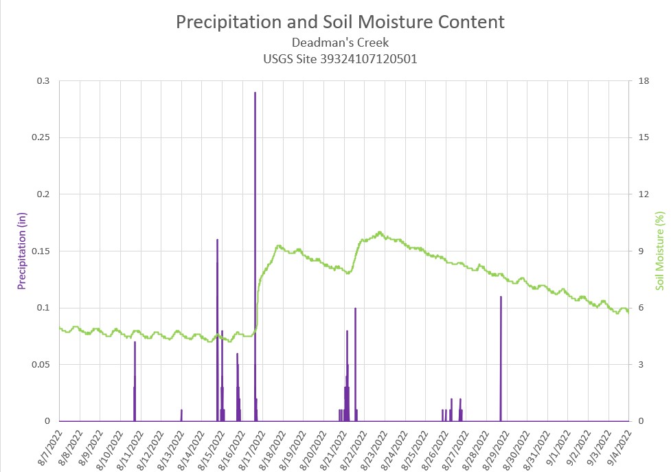


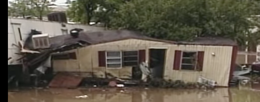
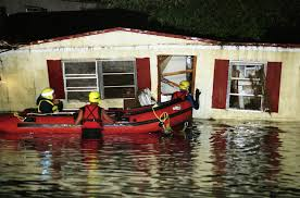


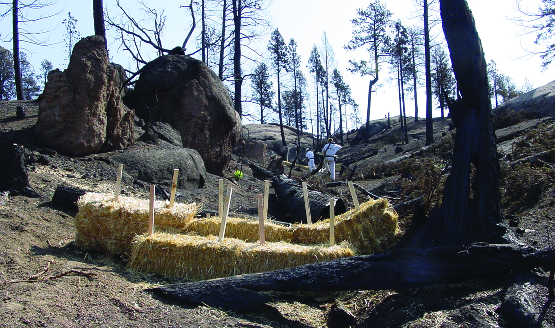
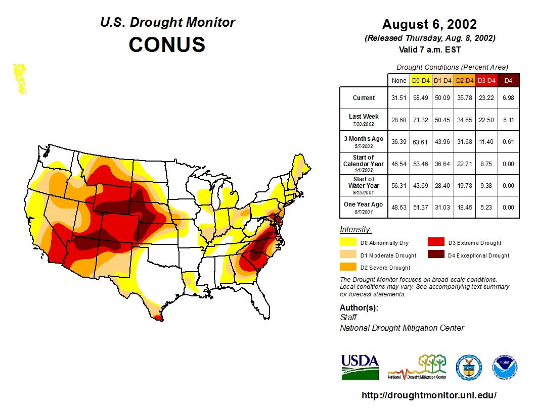
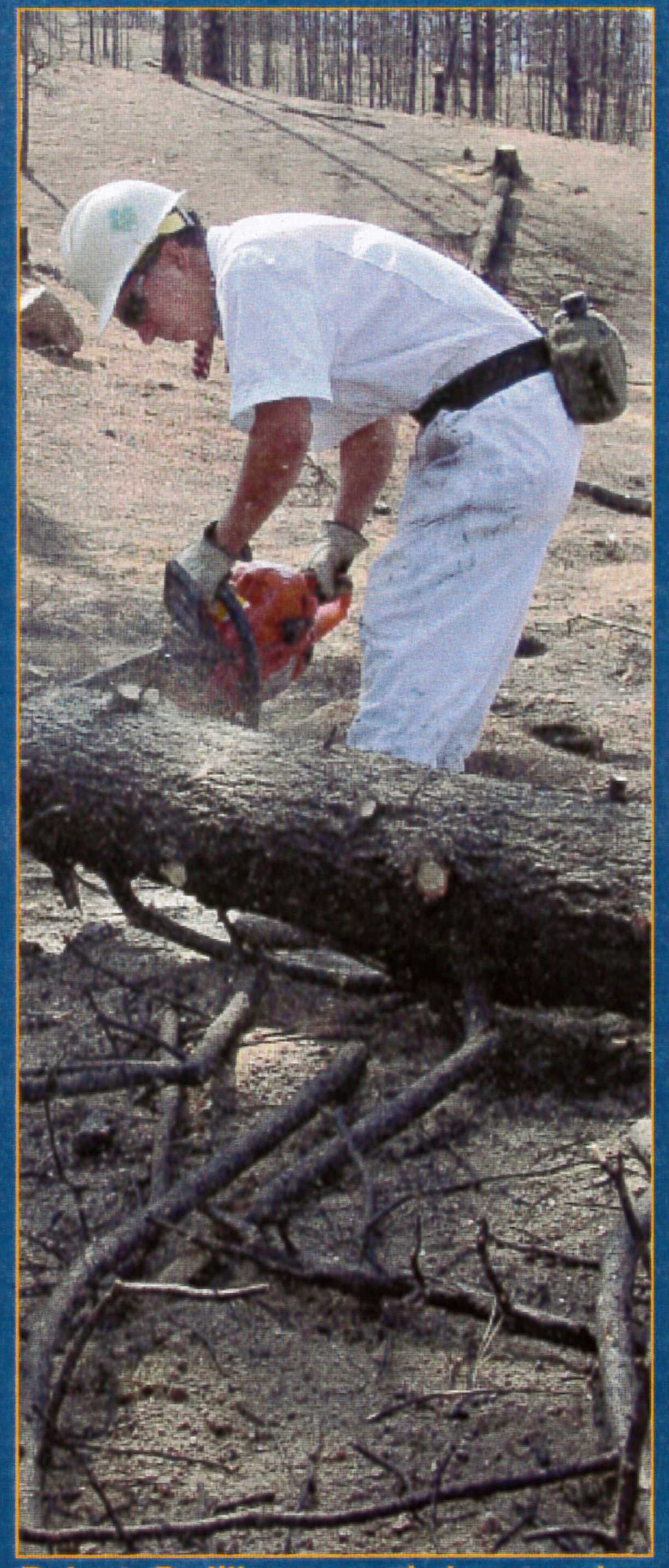
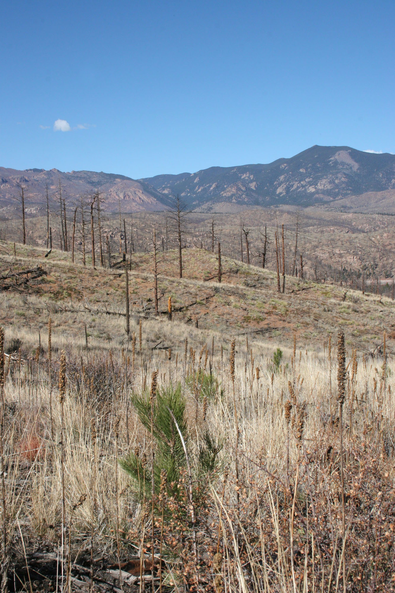
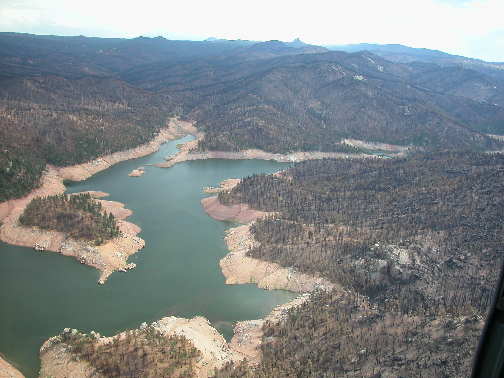
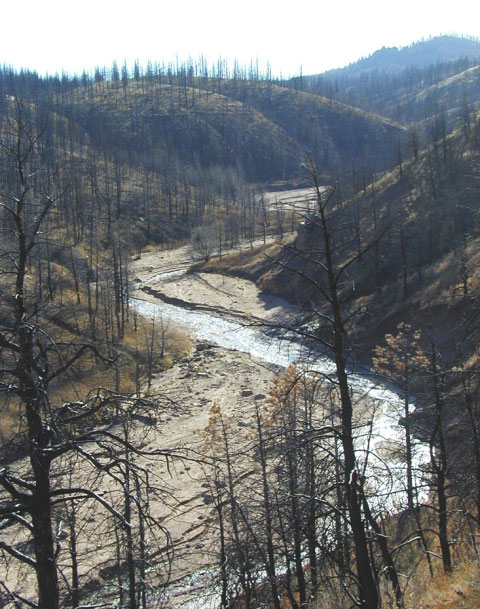
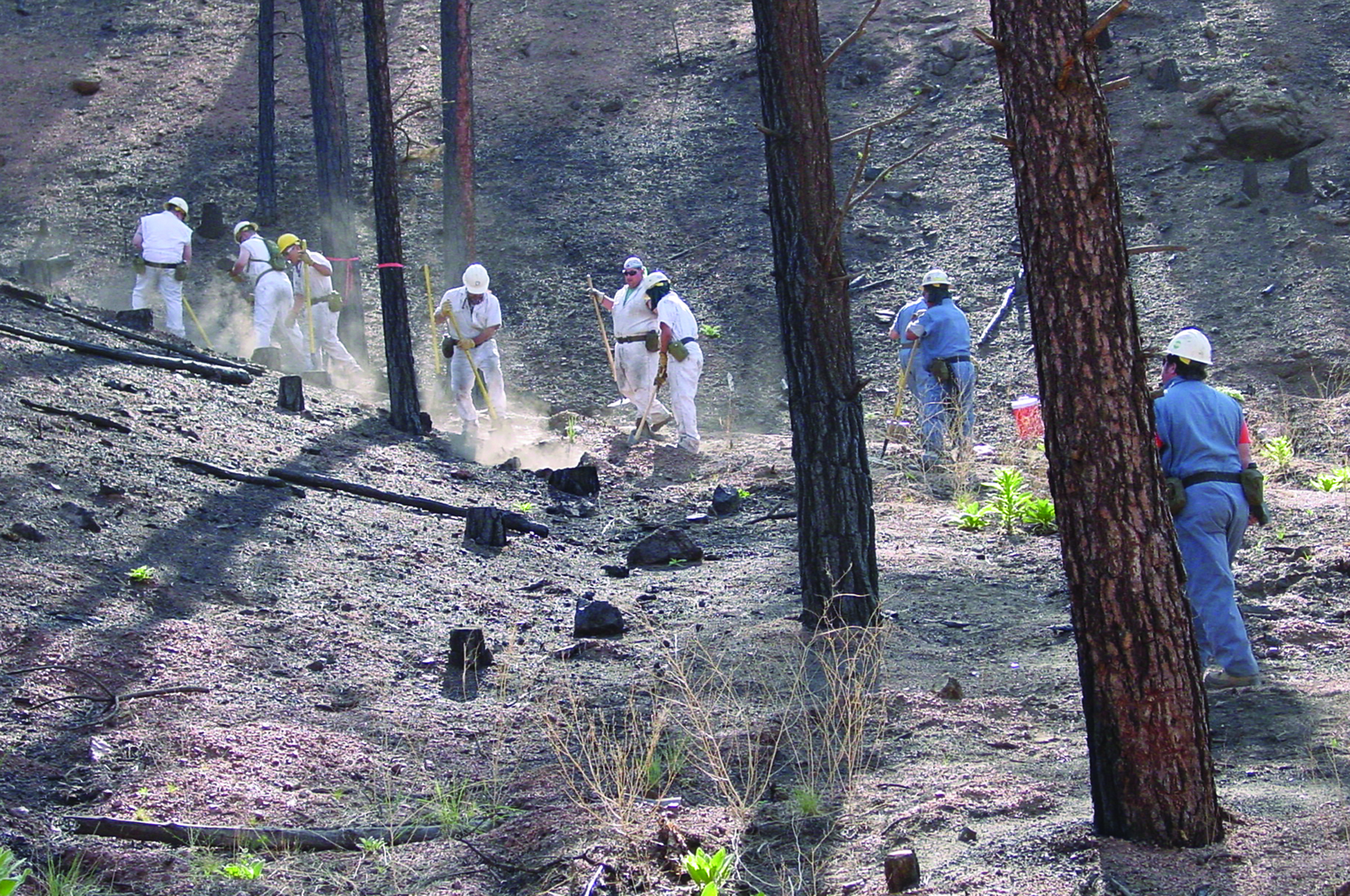
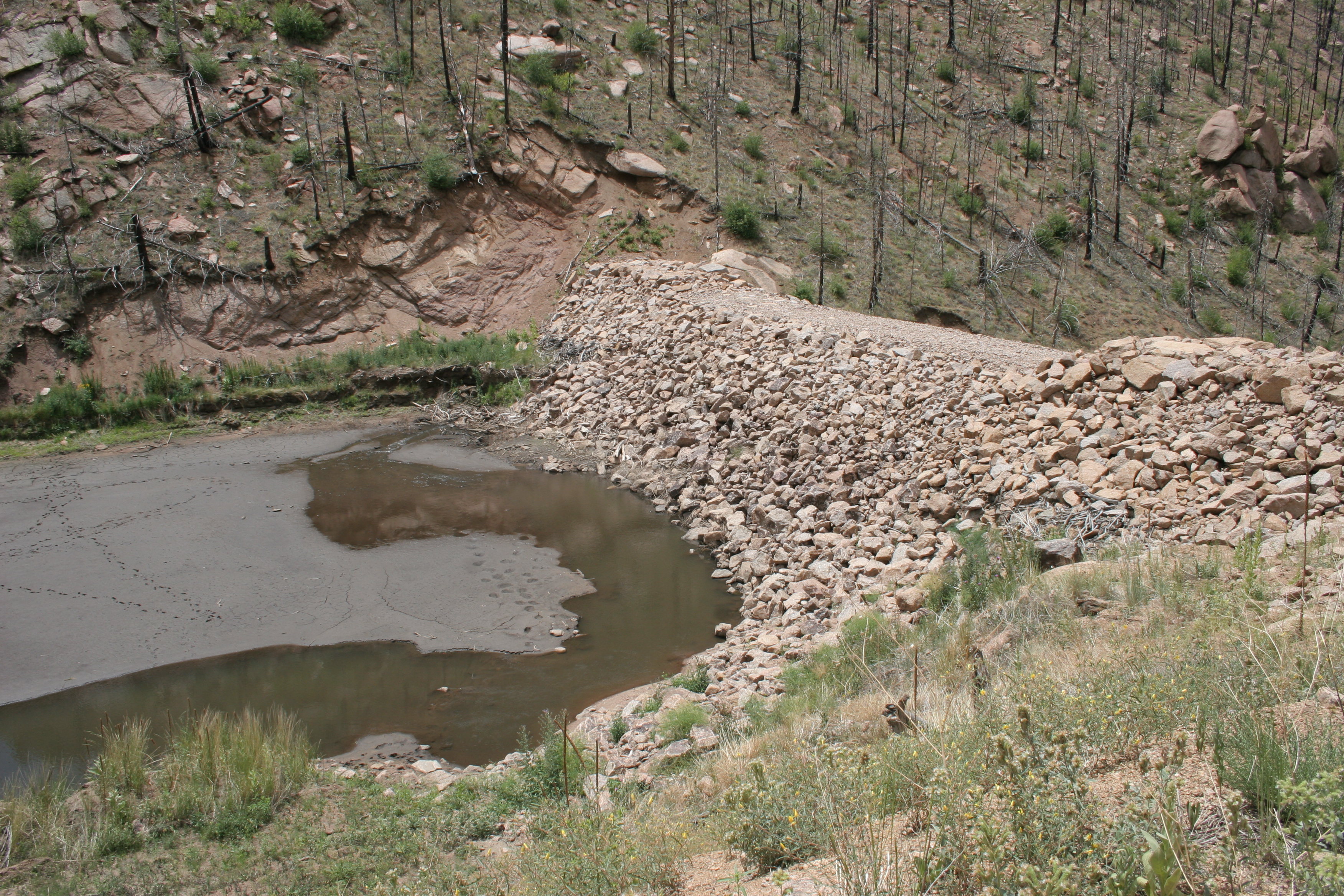
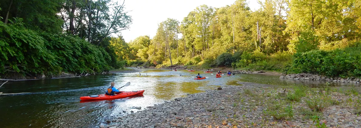
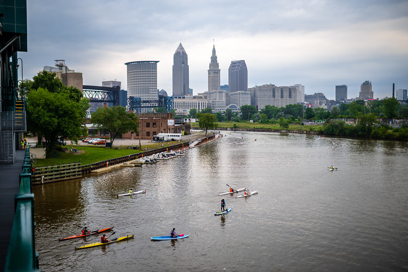
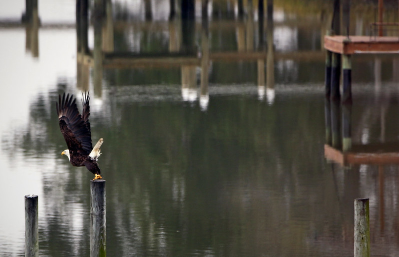


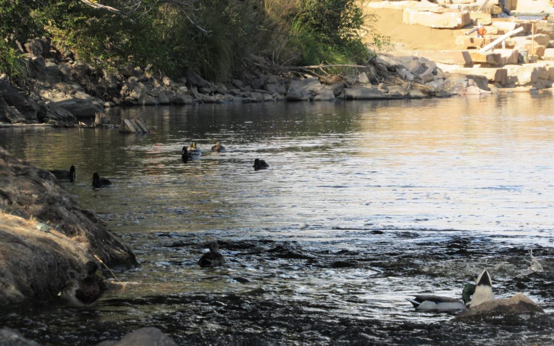

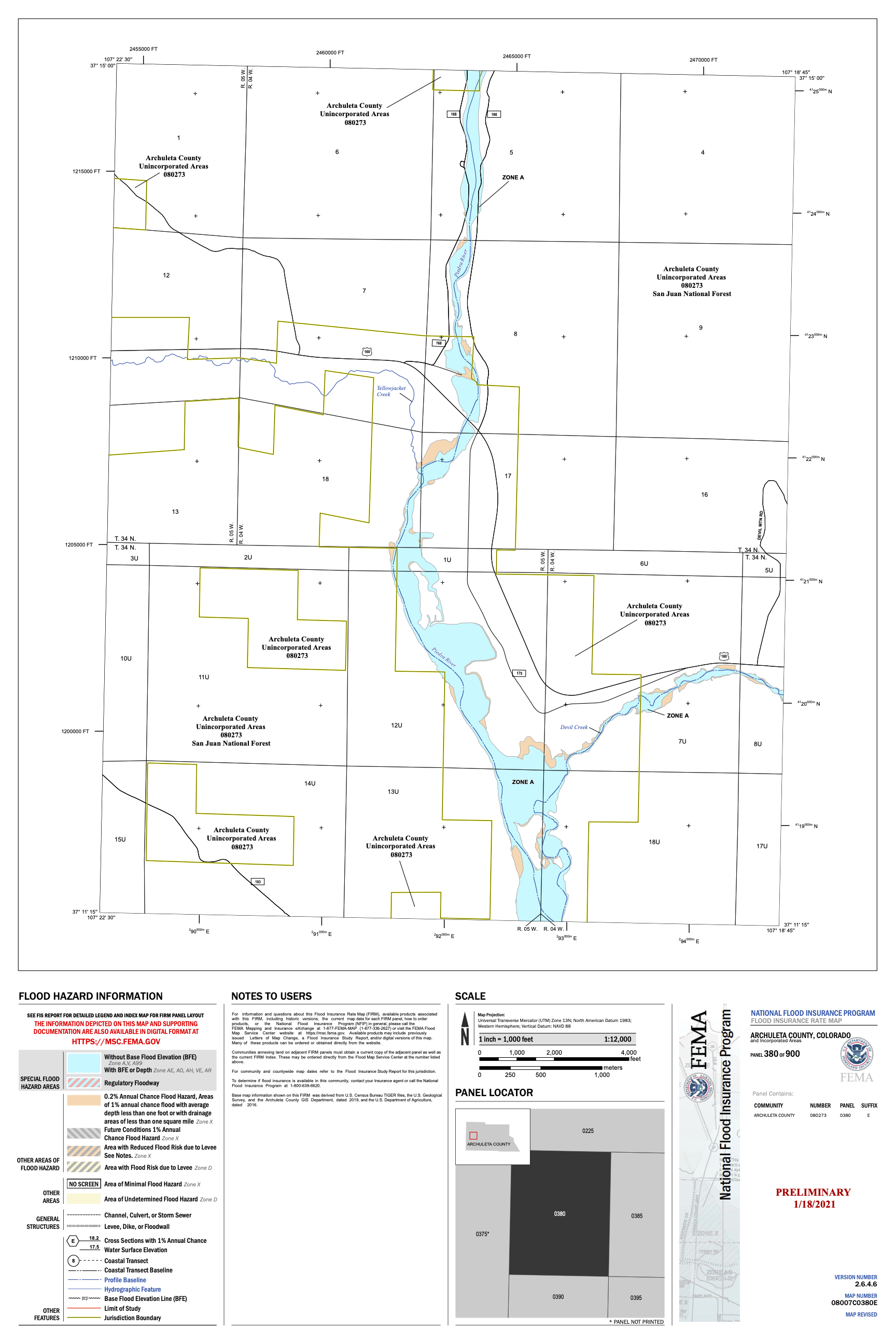
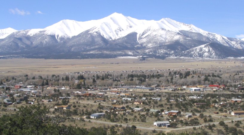

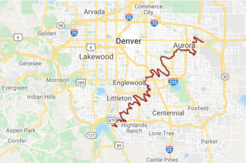

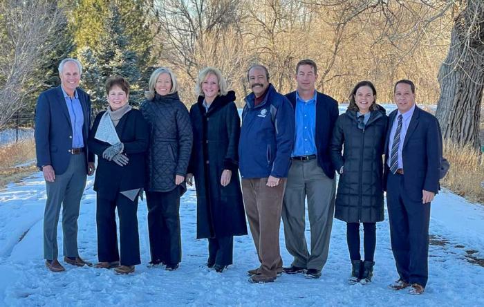
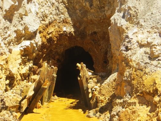

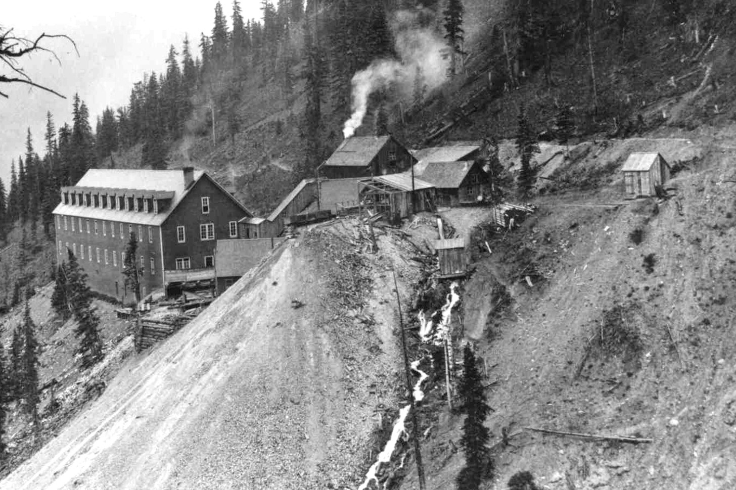
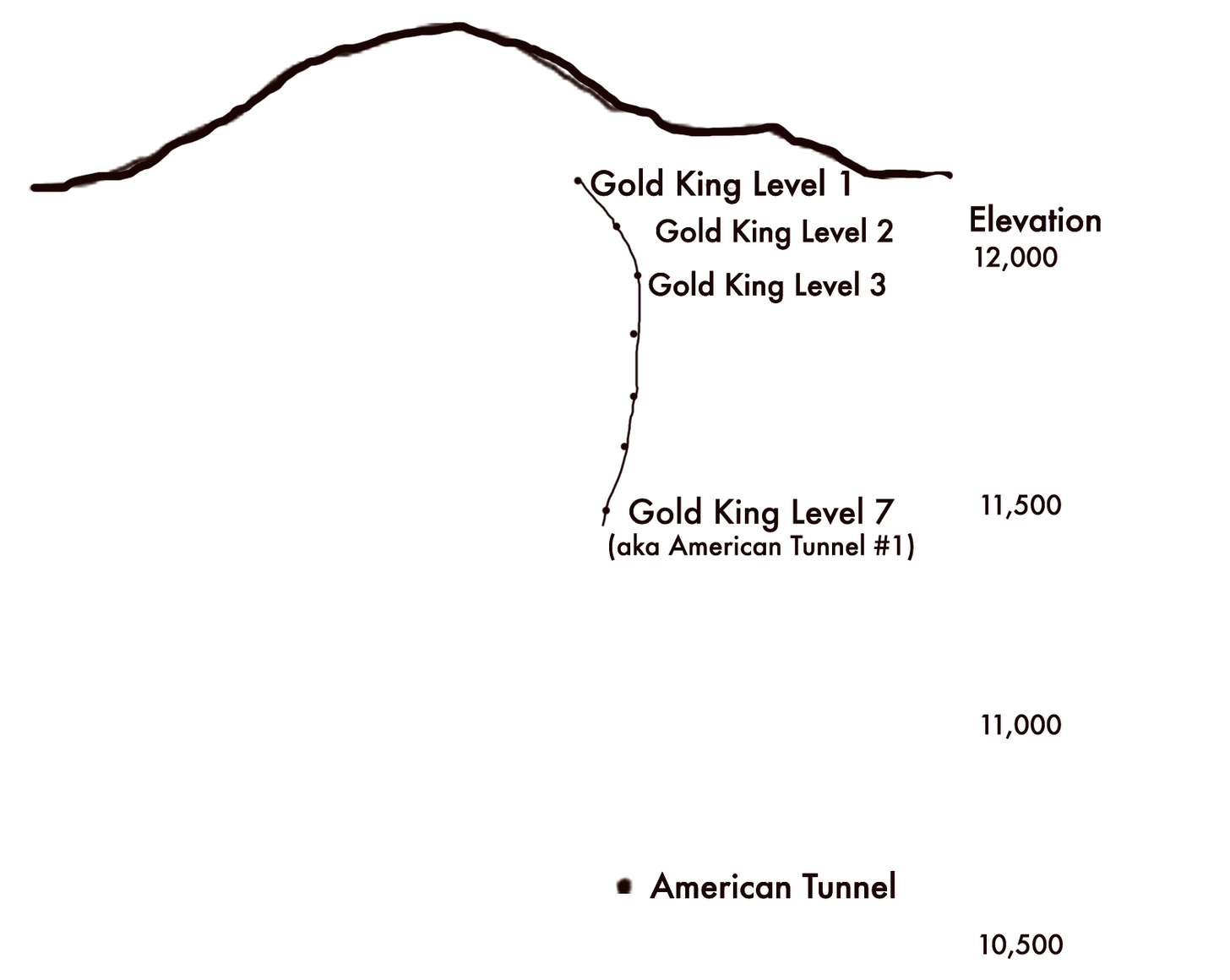
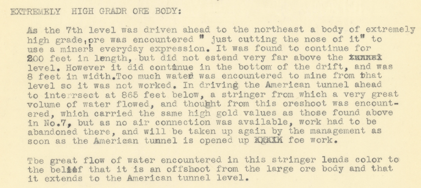

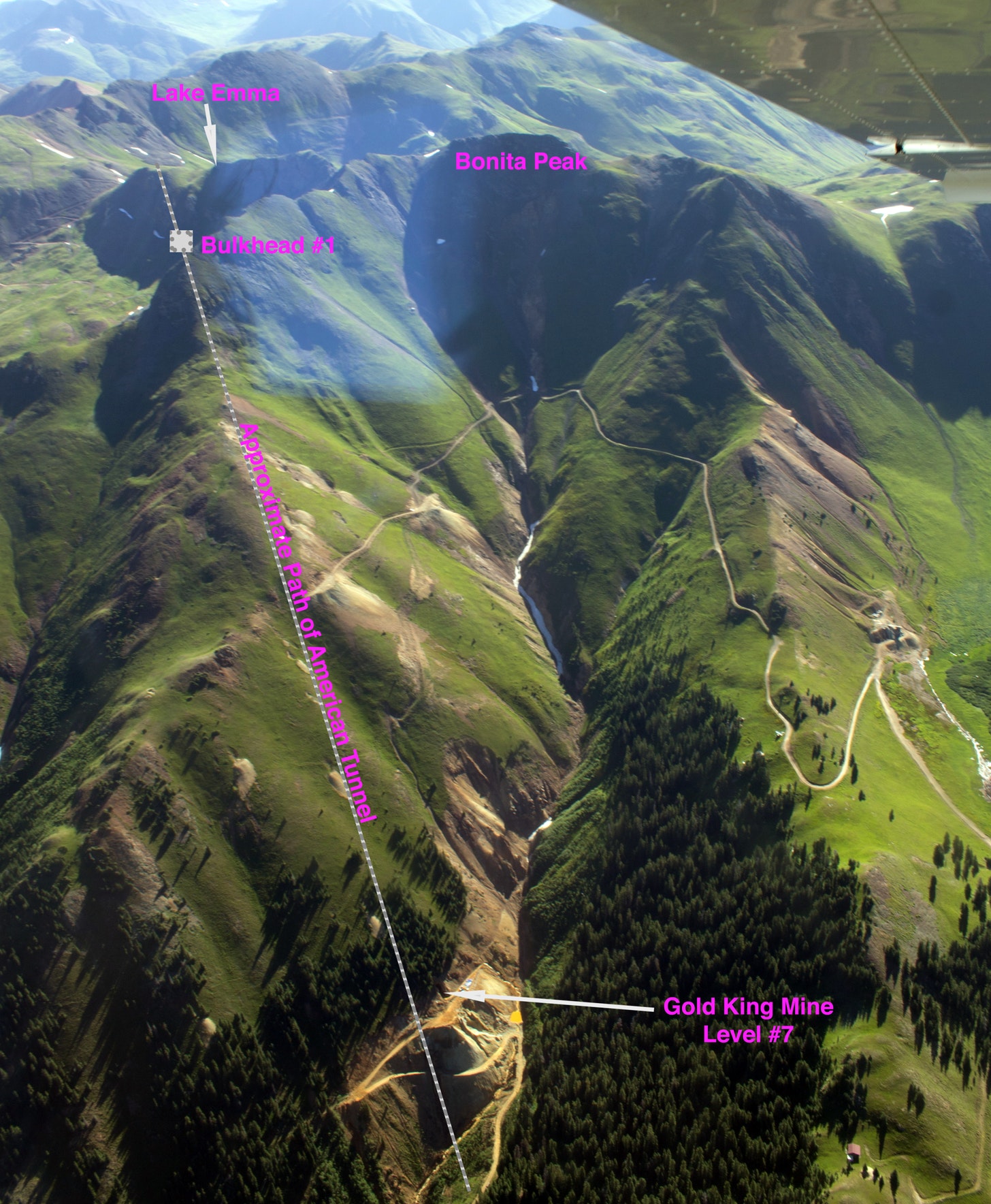


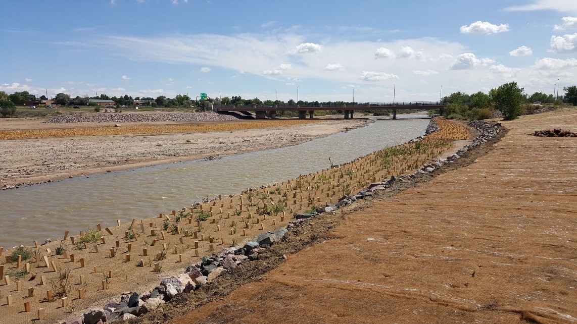


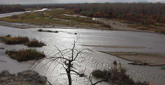


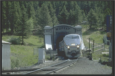


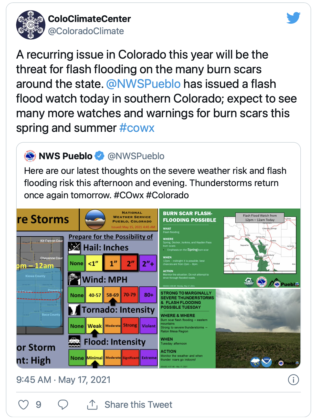
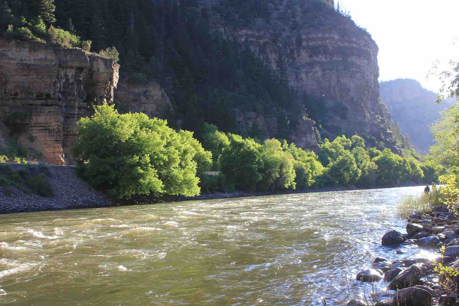
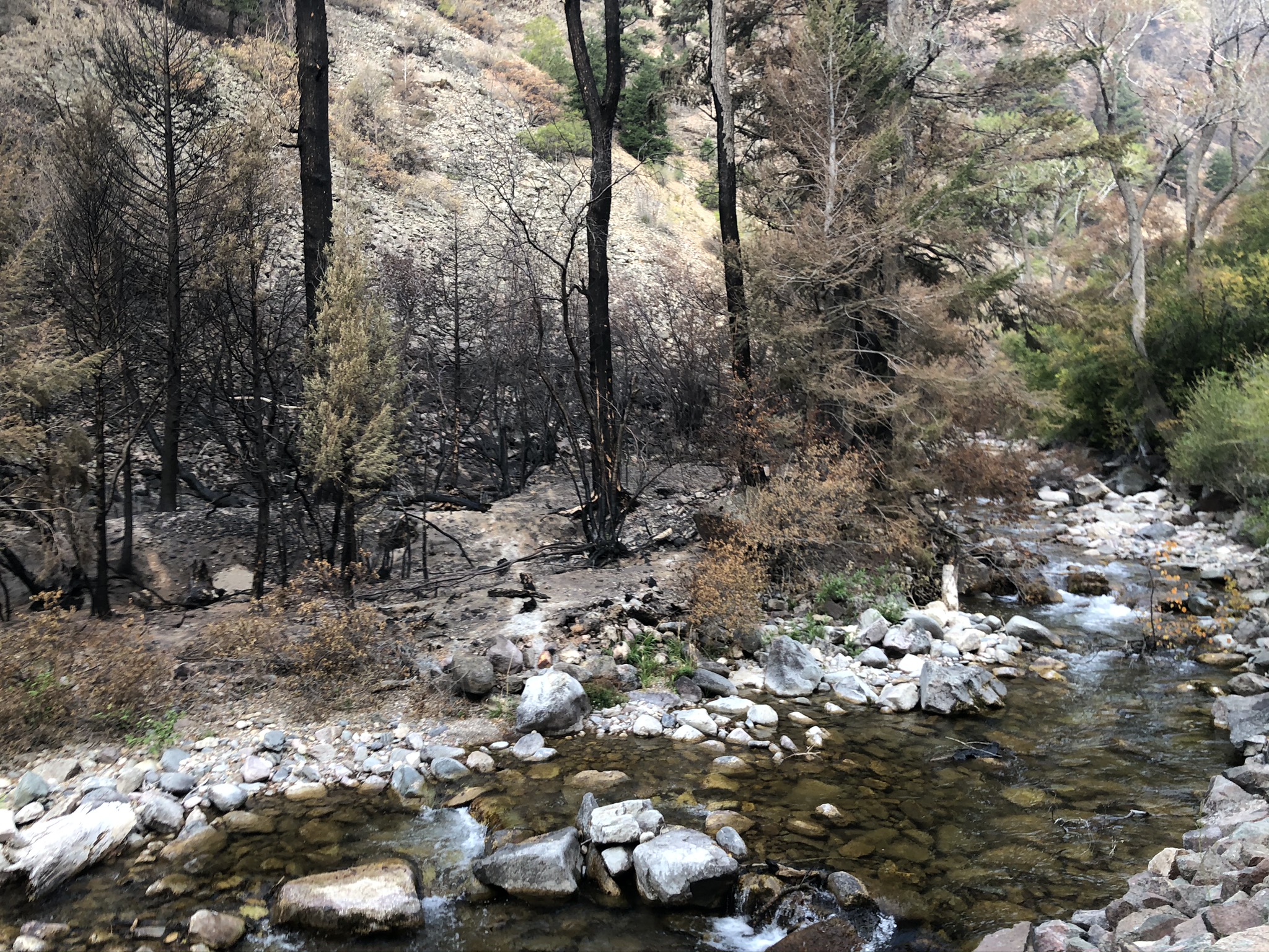
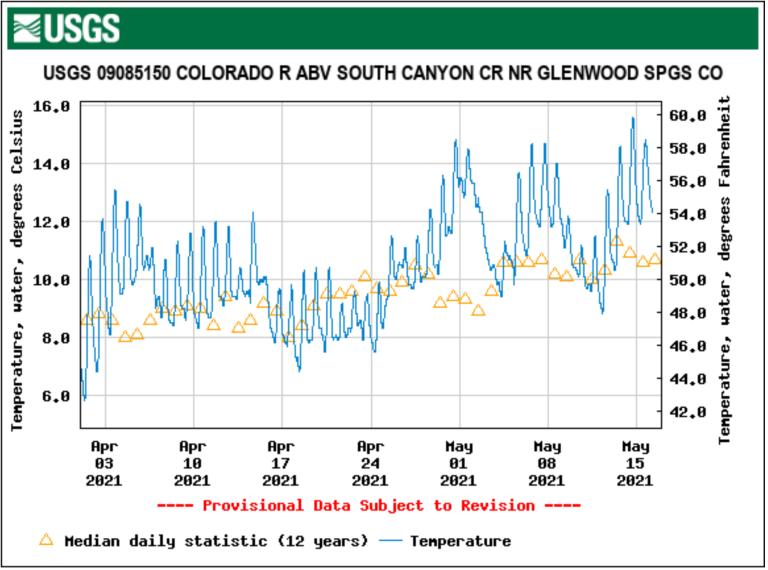
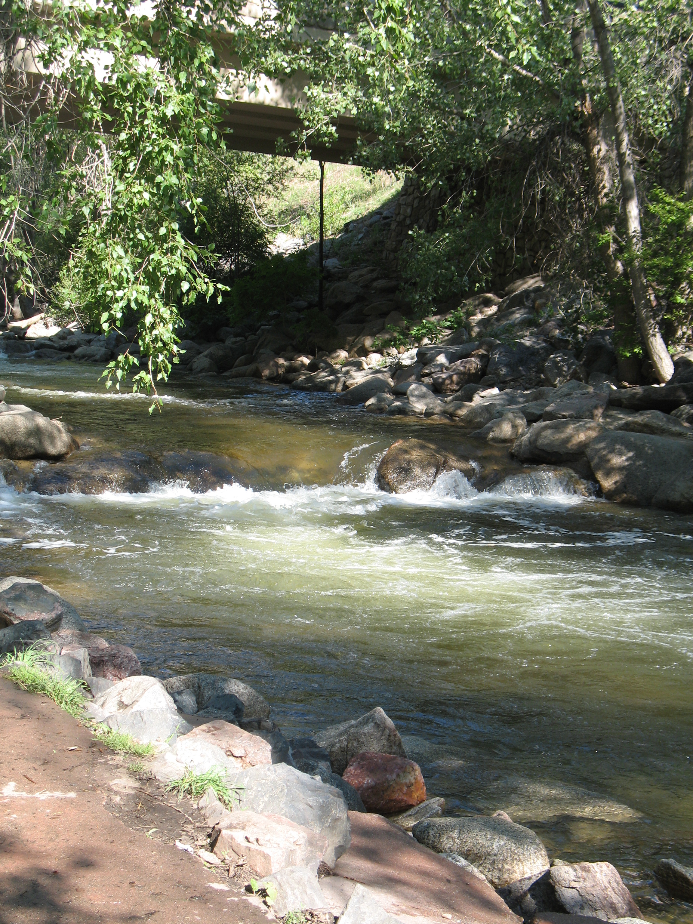
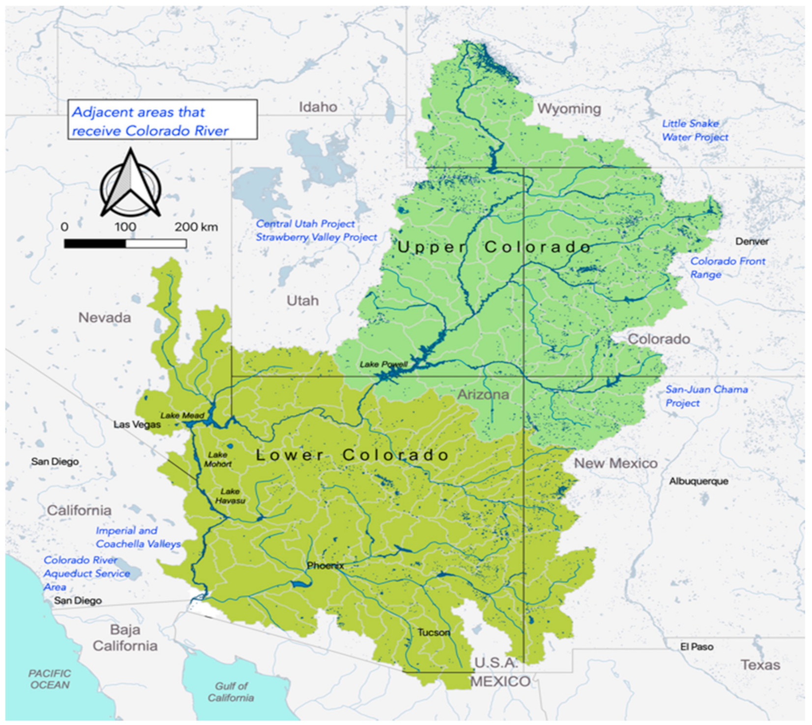

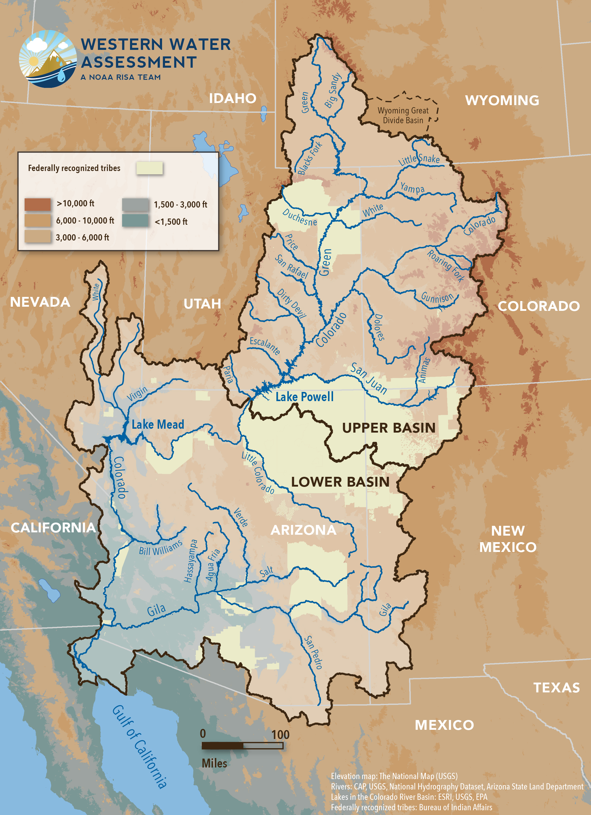


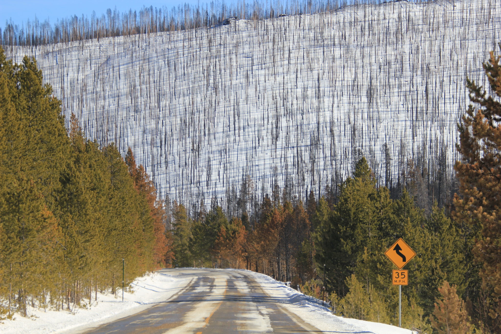

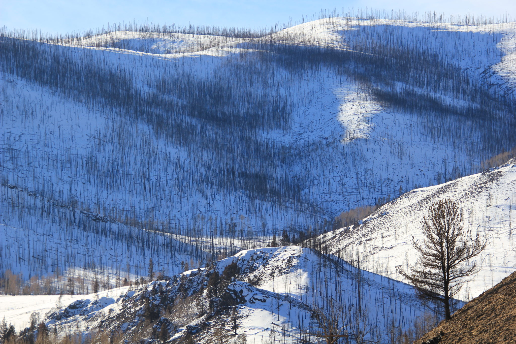


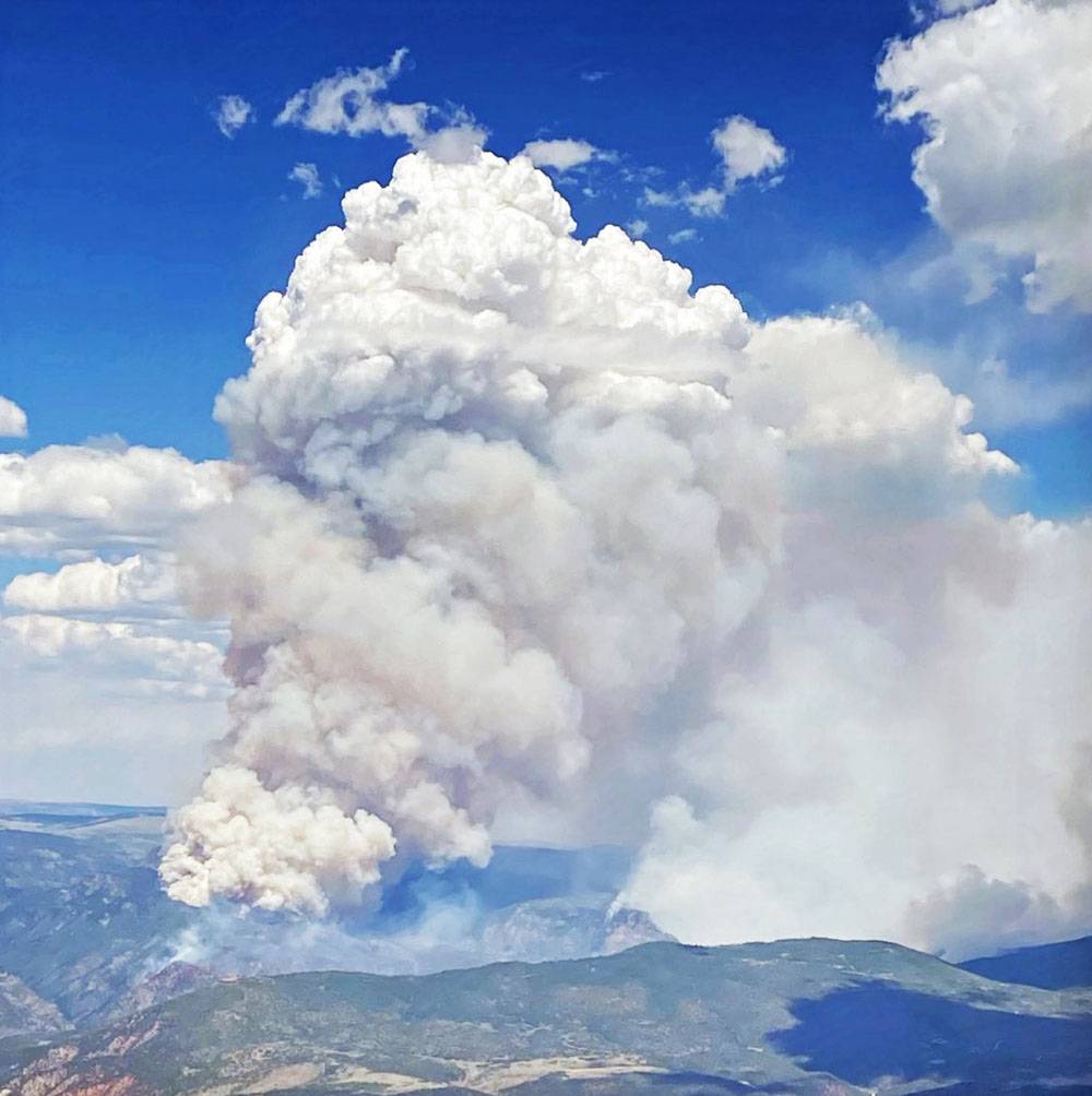


