The health of our waters is the principal measure of how we live on the land — Luna Leopold
Rare September 2013 flood was one of #Colorado’s worst natural disasters — The #FortCollins Coloradoan
Flood damage Big Thompson Canyon September 2013 — photo via Northern Water
FromThe Fort Collins Coloradoan (Miles Blumhardt):
Eight years ago this week, Colorado experienced one of its worst natural disasters when a week of rain flooded 20 counties, caused nearly $4 billion in damages, killed nine people and destroyed more than 2,000 homes.
Not only was the devastation staggering, but it marked only the second time in Colorado weather history that such a flood happened in September.
The National Weather Service ranked the 2013 flood its top weather story of the 2010-19 decade…
On Sept. 10, it started raining and didn’t stop for virtually a week, dropping copious amounts of precipitation from the Colorado-Wyoming border to Colorado Springs…
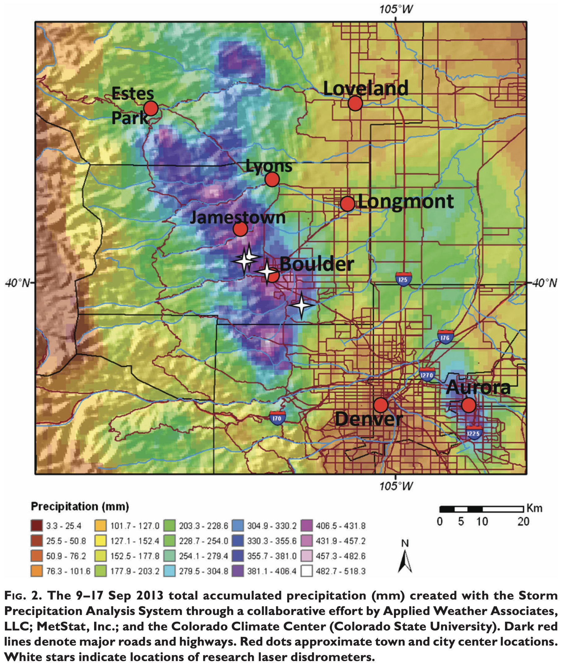
Fort Carson near Colorado Springs set a state record of 11.85 inches of rain in a 24-hour period, according to the National Weather Service. Boulder received 9.08 inches in one day and 18.16 inches in the week, which equates to more than the area’s average precipitation for a year.
Fort Collins reported 5.3 inches, Buckhorn Mountain west of the city 9.87 inches and Estes Park 9.31 inches for the week. For Buckhorn Mountain, 7.62 inches of that rain fell Sept. 11-12…
At one point, [Fort Collins] was cut off with all roads leading in and out impassable, including Interstate 25 where it crosses the Poudre River and the Big Thompson River near Loveland.
The flood is one of the reasons the I-25 bridge over the Poudre River is being raised 8 feet as part of the North I-25 Express Lanes project.
The devastation was staggering:
The flood covered 4,500 square miles, or the size of more than 10 Rocky Mountain National Parks
The damage estimate reached nearly $4 billion
More than 19,000 people were evacuated
26,000 homes were damaged
200 businesses were destroyed and 750 were damaged
200 miles of road were damaged or destroyed, including U.S. Highway 34 in the Big Thompson Canyon
50 major bridges damaged
[…]
Storm pattern over Colorado September 2013 — Graphic/NWS via USA Today
Schumacher said a blocking ridge of high pressure parked over the Pacific Northwest and western Canada prevented other weather patterns from moving into the area.
A low pressure sat stationary in the Four Coroners area drawing up large amounts of tropical moisture and swinging that moisture out east then back west, creating an upslope condition against the foothills and mountains.
It rained early that week but then on the evening of Sept. 11 a weak disturbance coincided with the showers and thunderstorms, resulting in a slow and almost stationary area of heavy rain along the Front Range that lasted through much of Sept. 12.
The rain intensity lightened up, but rain continued through Sept. 16 with many areas of the Front Range receiving 6 to 18 inches of rain over the week.
Schumacher said another anomaly of the storm was at how high of elevation it rained. He said conventional wisdom is that intense rain rarely happens above 7,500 feet because in upslope conditions the moisture is pushing up the mountainsides, running out of moisture as it moves up in elevation.
However, the 2013 storm produced up to 10 inches of rain at 10,000 feet and higher…
Schumacher said the only other September rain that comes close to 2013 was in May of 1938.
South Fork of the Republican River
He said heavy rain flooded the Republican River in eastern Colorado then. In 1938 and even in 1997 when Fort Collins was flooded, rainfall measurements were taken by measuring rain found in buckets, old tires or anything that collected rain, Schumacher said.
Some measurements in 1938 recorded more than 20 inches of rain, but the measurement never became official because the rain was not recorded in a gauge…
For more information about the 2013 flood, read the Bulletin of American Meteorlogical Society [report].