Some of the snowmelt flowing in the Blue River as it joins the Colorado River near Kremmling, Colo., will reach the Lower Basin states. Dec. 3, 2019. Credit: Mitch Tobin, the Water Desk
Click the link to read the article on the Summit Daily website (Eliza Noe). Here’s an excerpt:
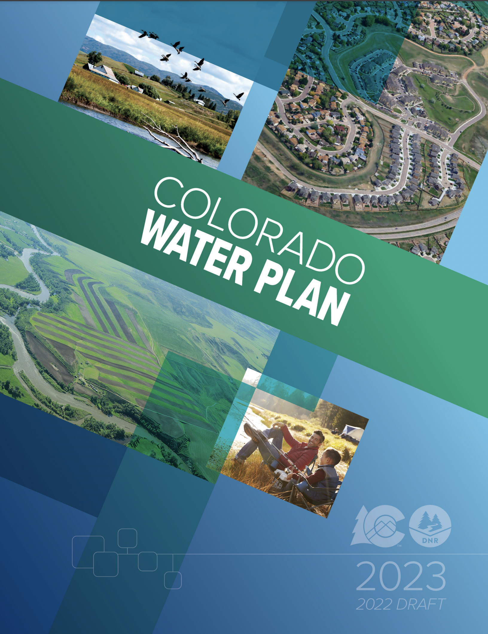
The plan focuses on four “interconnected action areas,” including resiliency planning, thriving watersheds, robust agriculture and community. It describes 50 “partner actions,” or project ideas that could be supported by Water Plan grants, as well as 50 “agency actions,” to support local projects, conservation and wise-water development. Overall, however, basin roundtables and stakeholders identified more than 1,800 potential future projects statewide, and 321 are in the Colorado Basin with 36 being in Summit County. In total, over $20 billion would be spent on the projects by 2050. Russ Sands, senior program manager of water supply planning for the Colorado Water Conservation Board, said that projects in the database are designated as near-term, midterm or long-term when it comes to getting them done. They’re also not all infrastructure projects. Some may work toward water conservation and others may be educational projects or environmental…
According to the plan, the Colorado Basin — which includes Summit County and the Blue River — faces issues such as competing resources for agriculture, tourism, protection of endangered species and potential for Colorado River Compact administration. The basin encompasses about 6% of the state’s population, and between 2015 and 2050, population is expected to increase 48-88%. Flows are also projected to be variable over the next several decades. Decreased peak flows across the basin create risks for wetland plants and fish habitats. Instream flows and recreational in-channel diversions may not be met if summer flows decrease due to climate change. Each year, water providers in the South Platte and Arkansas Basins export approximately 480,000 acre-feet each year from the Colorado Basin for eastern slope agricultural, municipal and industrial uses. Across the basin, as much as 70% of the river’s water flows out of Colorado…
The pie chart shows how much water each sector uses in Colorado, as well as how much water originating here leaves the state. CREDIT: COURTESY COLORADO WATER PLAN
“(June 30) opens up the 90-day public comment period,” Rebecca Mitchell, director of the Colorado Water Conservation Board, said. “This updated new and improved Water Plan is designed to meet today’s water challenges and builds on the legacy that we have in Colorado of collaborative statewide water planning.
Raymond Langstaff, a rancher and president of the Bookcliff Conservation District, irrigates a parcel north of Rifle. The 2023 Water Plan update says agriculture could experience an even bigger water supply gap in the future. CREDIT: HEATHER SACKETT/ASPEN JOURNALISM
State officials are hoping dire climate predictions and water shortages will convince Coloradans to get involved in planning how to share a dwindling resource.
Colorado Water Conservation Board staff released the second iteration of the Colorado Water Plan on Thursday, which is now open for public comment. The first version of the plan was implemented in 2015.
Words from the late water expert and former Colorado Supreme Court Justice Greg Hobbs set the tone on page 1 of the document: The 21st century is no longer about developing a resource, it is now an era of limits and learning how to share a developed resource.
“I think we get to educate and engage and inspire and be an example and I think that’s the benefit,” said CWCB Executive Director Becky Mitchell. “I think when we are given the opportunity to lead, Coloradans do that.”
The updated plan lays out four interconnected areas for action: vibrant communities, robust agriculture, thriving watersheds and resilient planning. Although municipal and industry does not currently experience a gap, the plan predicts a 230,000 to 740,000 acre-foot shortfall for cities and industries by 2050. According to the plan, about 20% of agriculture diversion demand is currently not met statewide, and that gap could grow to a 3.5 million acre-foot shortfall by 2050 under the “hot growth” scenario that would see temperatures rise 4.2 degrees Fahrenheit.
Meeting these supply-demand gaps will require hundreds of water projects throughout Colorado’s eight river basins, and carries a price tag of $20 billion. These projects, many of which have benefits to more than one water-use sector, are laid out in each roundtable’s Basin Implementation Plan.
Boaters float the Yampa River. According to the updated state Water Plan, summer recreation flow needs may not be met in the future due to lower peak flows, fueled by climate change. CREDIT: HEATHER SACKETT/ASPEN JOURNALISM
Backdrop of climate change
The 239-page document is set against the backdrop of climate change, which plays a bigger role in this water plan than in the 2015 version. The first water plan did not include projections of future climate change in its analyses. Three of the five planning scenarios now include assumptions of hotter conditions in the years to come.
According to the plan, Colorado has had three of the top five driest years on record since 2000 and has experienced a 2 degree Fahrenheit increase in average temperature. The state may see an additional 2.5 to 5 degree warming by 2050. Most projections show a decline in spring snowpack and more frequent heat waves, drought and wildfire, all of which have implications for water.
Environmental and recreation water needs could see the worst impacts since those uses generally have the most junior water rights.
“Peak runoff may shift as much as one month earlier, which could lead to drier conditions in summer months and impact storage, irrigation and streamflow,” the plan reads. “Decreased peak flows across the basin create risks for riparian/wetland plants and fish habitat. Instream flows and recreational in-channel diversions may not be met if June-August flows decrease due to climate change.”
The pie chart shows how much water each sector uses in Colorado, as well as how much water originating here leaves the state. CREDIT: COURTESY COLORADO WATER PLAN
Old tensions and trends
The new plan addressed a tension from the first plan: Front Range water providers would like the ability to develop new transmountain diversions in the future, while Western Slope stakeholders say not to look to the Colorado River basin for more water for thirsty cities. Colorado’s Front Range currently takes about 500,000 acre-feet of water a year from the headwaters of the Colorado River basin across the Continental Divide.
The plan stopped short of a detailed analysis of transmountain diversions because of ongoing litigation and permitting processes, but promised that state staff would facilitate discussions about transmountain diversions before the next update to the plan.
“Our promise to West Slope folks was when we could get past those legal barriers, we would take an honest look at trying to have a better conversation,” said Russ Sands, senior program manager for the CWCB’s water supply planning section. “I think we owe it to our stakeholders to try and focus on analysis.”
The plan says Colorado will continue the slow but steady transformation of moving water from agriculture — by far the largest water user — to cities, with nearly 14,000 acres of irrigated land expected to be urbanized, one-third of that in the Grand Valley. Stakeholders estimate the loss of irrigated land to “buy-and-dry” to be even greater at 33,000 to 76,000 acres, which is three times higher than the 2015 Water Plan estimate.
But this could be eased by innovative and flexible agreements between water users that allow the temporary transfer of water from one use to another. Formerly known as Alternative Transfer Methods, state officials have rebranded them Collaborative Water Sharing Agreements, which allow water sharing, but prevent the permanent removal of water from the land.
The Crystal River wends its way downstream along the flanks of Mount Sopris to its confluence with the Roaring Fork River near Carbondale. State officials have released an update to the 2015 Water Plan, which includes hotter and drier future planning scenarios. CREDIT: HEATHER SACKETT/ASPEN JOURNALISM
Equity and engagement
State officials have also made an effort to be more inclusive this time around and in March 2021 convened a Water Equity Task Force to help shape a guiding set of principles around equity, diversity and inclusion to inform the water plan. Abby Burk, the western rivers regional program manager with Audubon Rockies, was an equity task force member.
“People are engaging and leaning into the space other than just the water right owners,” she said. “We are all supported by water every single day. How do we expand this decision-making to include more voices? How do we open our arms and encourage more people to come into this space?”
The 2015 Water Plan racked up more than 30,000 comments and state officials are hoping Coloradans become even more involved this time around. The plan lays out three levels of engagement citizens can take and encourages Coloradans to promote water conservation, join water-focused stakeholder groups and coordinate with local leaders to advance water policy.
And there is a small bright spot that shows the potential for change when citizens get engaged: The plan says that Coloradans have reduced their per-person water use from 172 to 164 gallons a day, a 5% reduction in demand since 2008, mainly due to conservation efforts.
Sands said the tough conditions can open people’s minds and make them more willing to come to the table to talk.
“I think we are actually going to see more collaboration than ever,” he said.
The update to the Colorado Water Plan is open for public comment until September 30 and CWCB staff will also hold four online listening sessions. The plan is scheduled to be finalized by the CWCB in January 2023.
Aspen Journalism covers water and rivers in collaboration with The Aspen Times.
Colorado River “Beginnings”. Photo: Brent Gardner-Smith/Aspen Journalism
Click the link to read the article on the Colorado Public Radio website (Michael Elizabeth Sakas). Here’s an excerpt:
The mid-August deadline is quickly approaching for the states — Colorado, Utah, Wyoming, New Mexico, California, Nevada and Arizona — to figure out how to cut water usage down by 2 to 4 million acre-feet. For context, the entire state of Arizona is allowed to use 2.8 million acre-feet of river water each year.
Becky Mitchell, the commissioner of the Colorado Water Conservation Board, represents Colorado at the planning table with other states in the basin. Right now, her work is focused on collaborating with the other states in the upper part of the river basin — Utah, Wyoming and New Mexico — to come up with a list of ways their states can cut down on how much water they use. In a conversation on CPR’s Colorado Matters, Mitchell said most of that responsibility should be on the states in the lower part of the river basin: Arizona, Nevada and California.
“They’re using more than mother nature provides,” Mitchell said.
Mitchell said the states in the upper part of the river basin had been forced to use less water because of ongoing drought worsened by climate change. The states in the lower basin use water stored in Lake Powell and Lake Mead, the two largest reservoirs in the U.S., which she said has allowed those states to increase their water usage in the last few years. Mitchell said water stored in Lake Powell and Lake Mead allows the lower basin states to use more water than the river can provide, which has significantly dropped after decades of ongoing drought and the impacts of climate change.
Crop residue November 4, 2021. Photo credit: Joel Schneekloth
Click the link to access the paper on the Nature Sustainability website (Chloe MacLaren, et al.). Here’s the abstract:
Ecological intensification (EI) could help return agriculture into a ‘safe operating space’ for humanity. Using a novel application of meta-analysis to data from 30 long-term experiments from Europe and Africa (comprising 25,565 yield records), we investigated how field-scale EI practices interact with each other, and with N fertilizer and tillage, in their effects on long-term crop yields. Here we confirmed that EI practices (specifically, increasing crop diversity and adding fertility crops and organic matter) have generally positive effects on the yield of staple crops. However, we show that EI practices have a largely substitutive interaction with N fertilizer, so that EI practices substantially increase yield at low N fertilizer doses but have minimal or no effect on yield at high N fertilizer doses. EI practices had comparable effects across different tillage intensities, and reducing tillage did not strongly affect yields.
Some parts of the Rio Grande already experience a dry river most of the year. Photo by WildEarth Guardians.
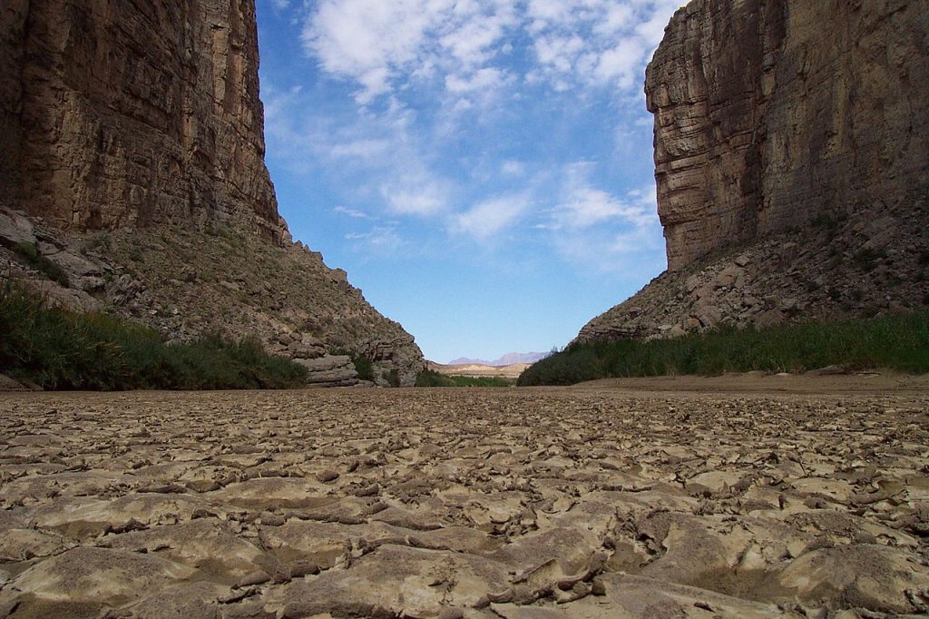
Click the link to read the article on the Texas Observer website (Dylan Baddour). Here’s an excerpt:
Near Santa Elena Canyon, a river gage measured 0 cubic feet per second for the first time on record on April 28, and it stayed that way for most of the next month. It’s a grim warning sign for the lower reaches of the Rio Grande, which provide water to millions of acres of crops and to many people in Texas and Mexico. The river has dried up in other spots off and on for decades now, battered by drought and overuse, but never in these places. No one alive has seen the river as it looks today.
“The scope of this is significantly more widespread than I have ever seen,” said Raymond Skiles, a retired park ranger who spent 31 years at Big Bend National Park and grew up in the region.
Heavy rains fell in West Texas and North Mexico over the first weekend in June, sending a raging pulse of water down the canyons of Big Bend and wetting the riverbed again. It was sweet relief from the ongoing drought, but nothing near enough to bring the once-great river of Texas back to life.
What seems like the death throes of this river began slowly. Upstream, between El Paso and Presidio, the so-called “forgotten” stretch has run dry intermittently for the last 40 years. But water from the Rio Conchos, which meets the Rio Grande at Presidio, always brought the river back to life before.
Skiles said he only saw the river dry up once below the Conchos in Big Bend National Park. It was 2003 and it happened along a particularly remote area, accessible only via a 15-mile round-trip hike. The phenomenon lasted only several weeks and never affected more visited stretches of river upstream, so few visitors noticed.
My latest article about the conservation work we completed in the Bears Ears area is now available via the link below. The piece is featured in the Spring/Summer 2022 edition of the Grand Canyon Trust’s publication, “Advocate Magazine”. Ancestral Lands Conservation Corps, Zuni #642. Photo: Lyle Balenquah Please consider supporting the Grand Canyon Trust in […]
The following is a short piece that I wrote for the radio program, “Earth Notes”, produced by KNAU and the Sustainable Communities Program at Northern Arizona University (Flagstaff, AZ). Hear the story HERE I wrote this for a couple reasons, one being that I have strong interest in turquoise and jewelry made from/with turquoise. But […]
In this blog post, we’re going to discuss meteorological and hydrological drought metrics. Droughts are an important but difficult hazard to characterize. Whereas hurricanes or tornadoes occur suddenly and persist for a short and clearly defined interval, a drought is usually thought of as a “creeping disaster”, in which it is often difficult to pinpoint […]
In honor of author Ben Goldfarb’s visit to Buffalo Peaks Ranch to talk about his book Eager, we have created a Buffalo Peaks Ranch Beaver Believer Tee! You can order a Beaver Believer Tee through our fundraising store at Bonfire—there are a lot of different sizes, colors and styles. Front of the Beaver Believer Tee […]
Editor’s note: This story was originally posted on TAP in 2017, 15 years after the Hayman Fire, then the largest in Colorado’s history, burned 137,760 acres in the summer of 2002. But following the summer and fall of 2020, the Hayman Fire fell to fourth on the list of Colorado’s biggest fires.
Colorado’s biggest wildfires are: the Cameron Peak fire, which started Aug. 13, 2020, and burned 208,913 acres; the East Troublesome fire, which started Aug. 14, 2020, and burned 193,812 acres; and the Pine Gulch Fire, which started July 31, 2020, and burned 139,007 acres.
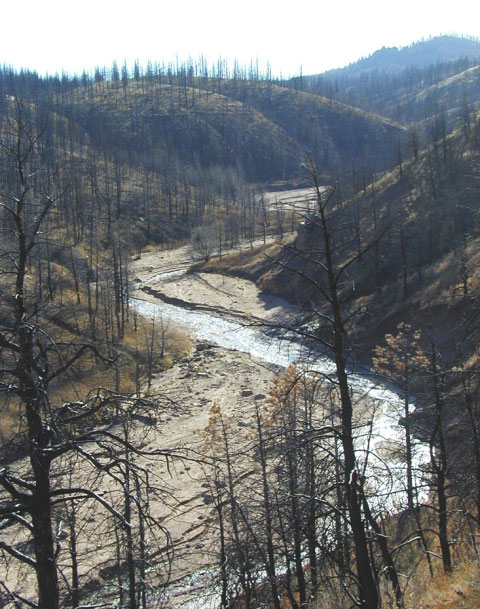
The Hayman Fire is the state’s largest recorded wildfire. Smoke from the massive blaze could be seen and smelled across the state. Photo credit to Nathan Bobbin, Flickr Creative Commons.‘
The ominous plume of smoke rising in the skies southwest of Denver. The ash falling on cars like large dried-up snowflakes. Many who lived in Colorado in the summer of 2002 will never forget the Hayman Fire, which burned 137,760 acres before it was over. Hayman still holds the dubious title as Colorado’s largest recorded wildfire.
This June marks the 15th anniversary of the destructive blaze, and Denver Water continues to deal with the aftermath. The fire seared through sizable portions of Denver Water’s watershed, reaching Cheesman Reservoir on its second day, where it destroyed 7,500 of the 8,500 forested acres Denver Water owns at the reservoir.
Front-row seat
Bill Newberry, one of Denver Water’s caretakers at Cheesman, got a front-row seat to the fire’s destruction. Newberry, who retired in 2014, stood near the reservoir’s shoreline as the fire blew through the area. He said the firestorm roared like a hurricane as it approached, and there was considerable heat and smoke, though he didn’t have to go into the water to escape the blaze.
Thankfully, the fire spared all of Denver Water’s caretakers, homes and buildings at Cheesman other than three small storage sheds. But what it left in its wake was a blackened landscape with only a few trees lining the reservoir, creating a danger of erosion and sedimentation problems from subsequent rains.
Traps and racks
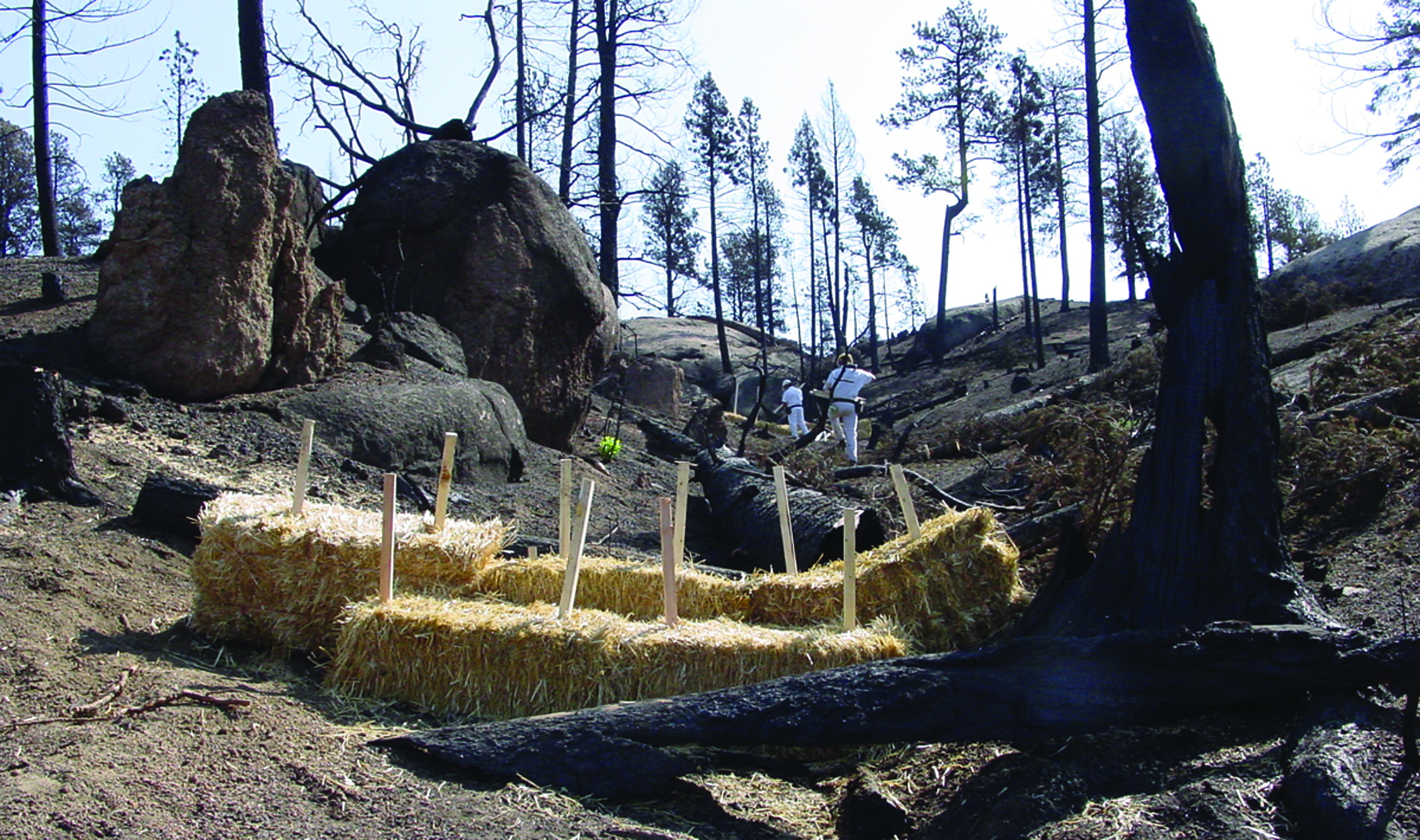
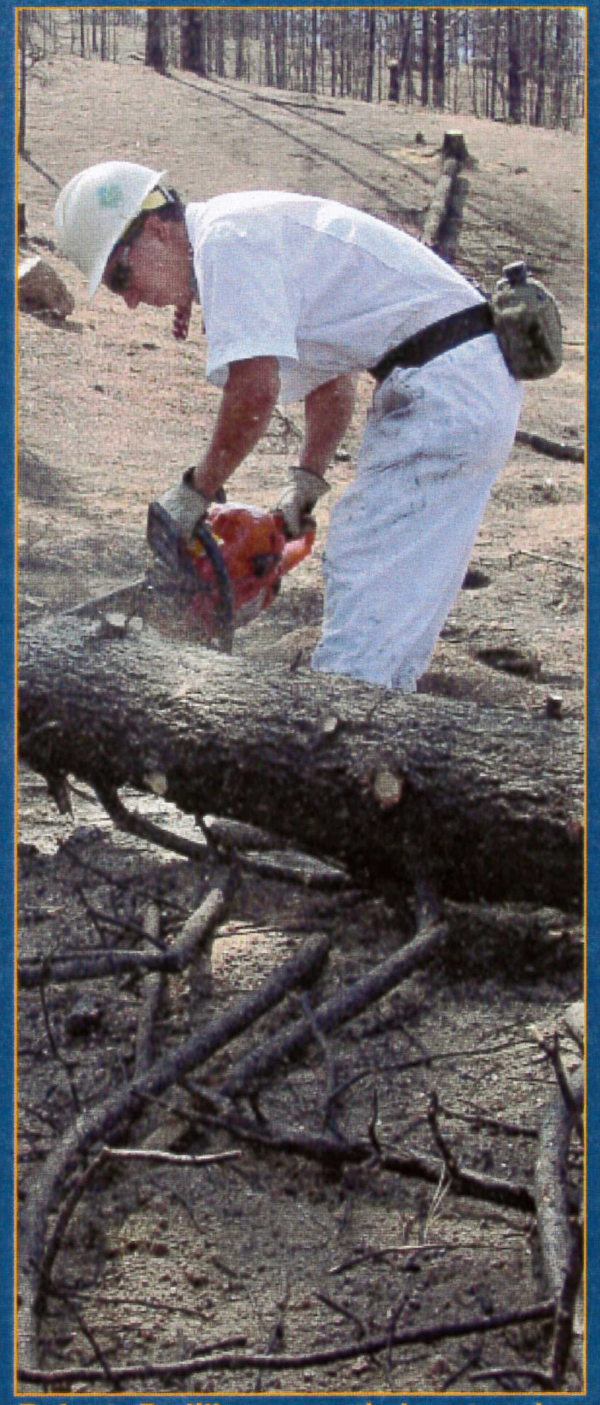
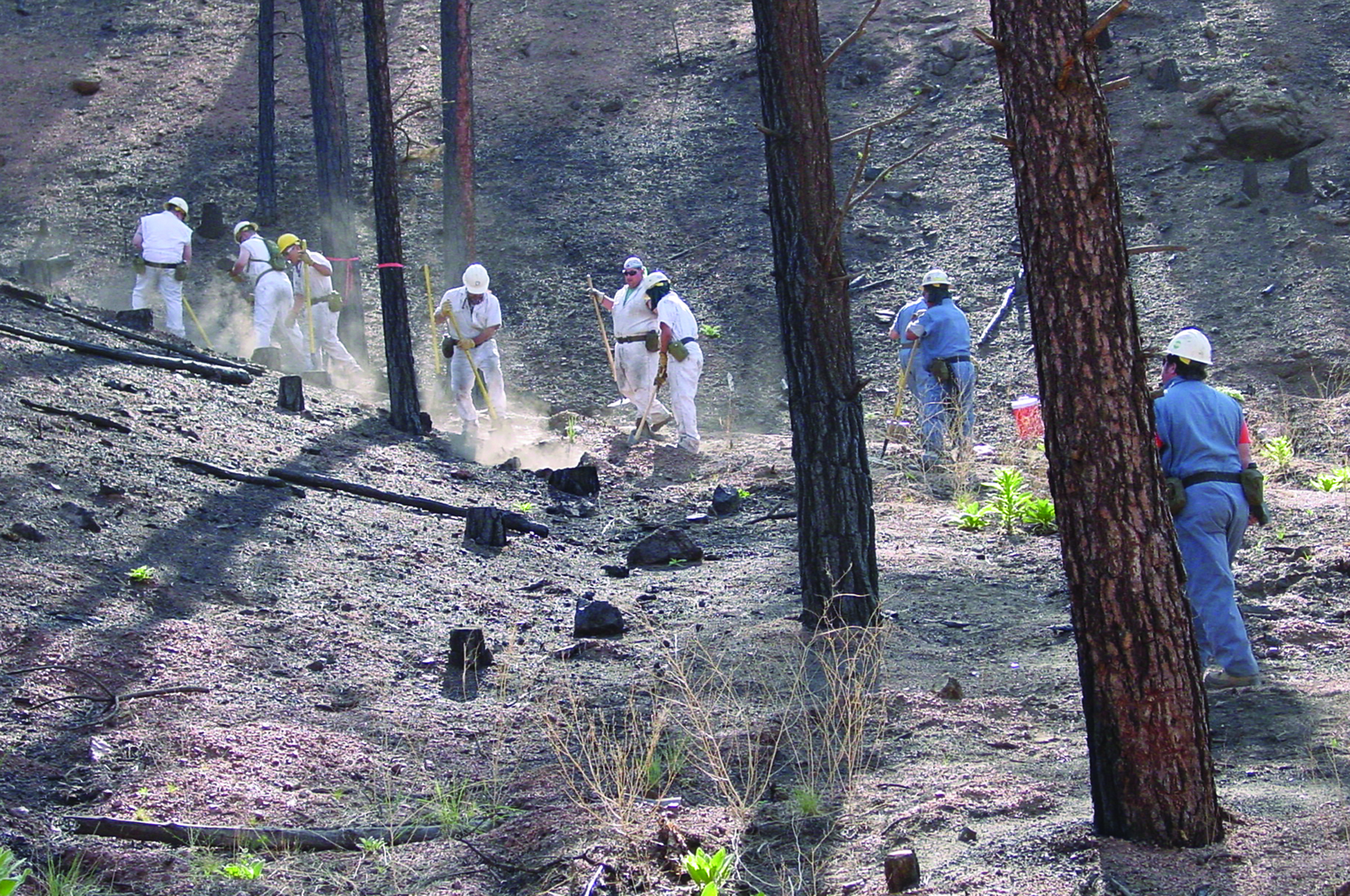
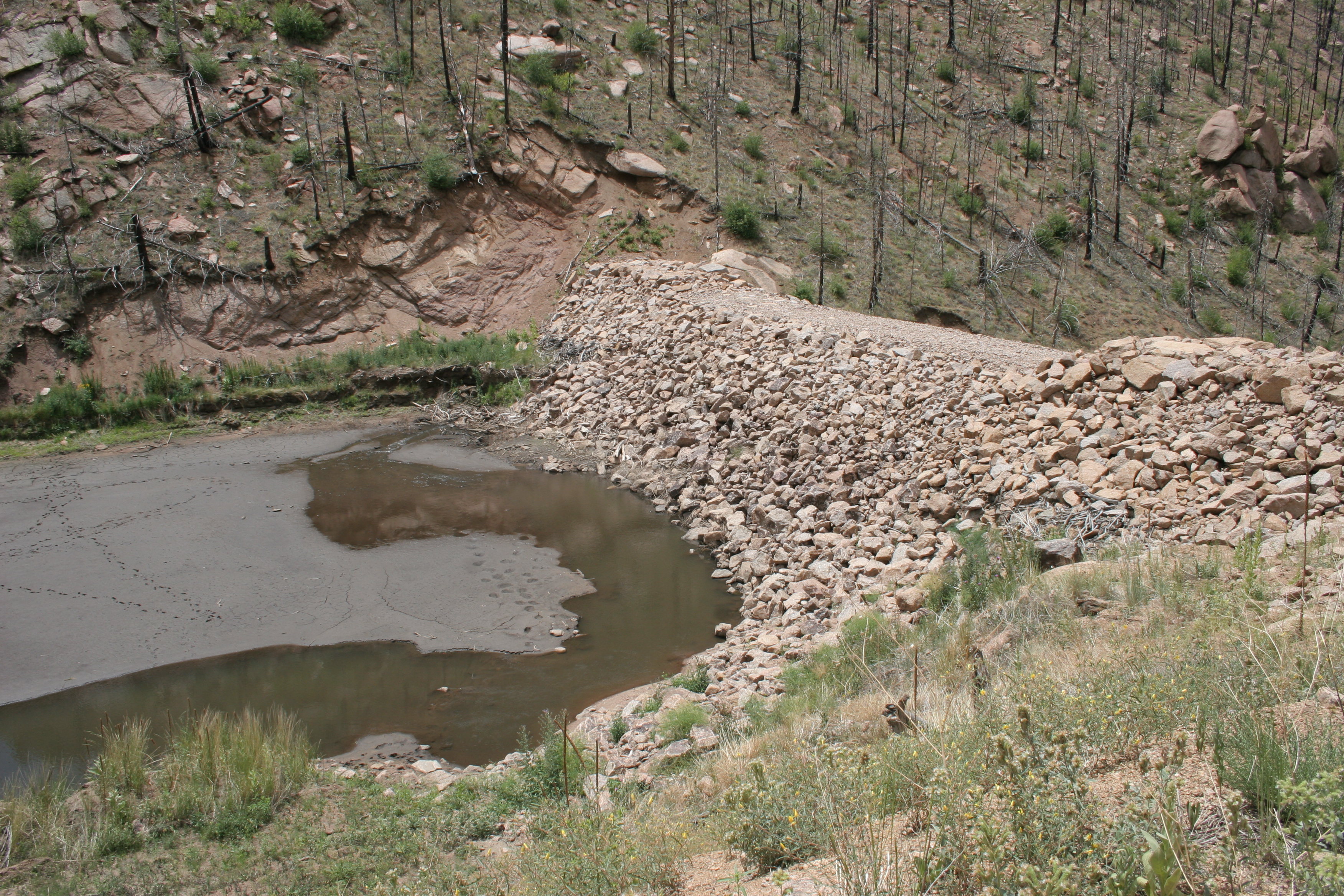
Sediment traps made of straw bales and trash racks were fashioned from downed trees following the fire. The traps and racks were positioned across drainages to catch ash and debris after heavy rains to prevent it from entering the reservoir and causing operational challenges. Photo credit: Denver Water
Immediately following the fire, Denver Water sent employees to help erect sediment traps made of straw bales and trash racks fashioned from downed trees. The traps and racks were positioned across drainages to catch ash and debris after heavy rains. Denver Water then built more permanent rock sediment traps to capture ash, sand and other debris from Turkey and Goose creeks, preventing that material from entering the reservoir and causing operational challenges.
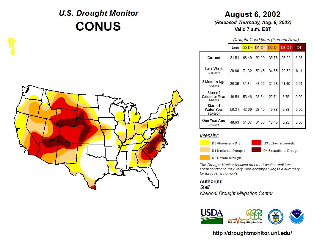
US Drought Monitor August 6, 2002
The crews building the traps were used to spending their days laying new pipe in Denver’s streets, and many had never even used a chainsaw. But given the 2002 drought that had parched the city and led to severe watering restrictions, Denver Water had suspended new pipe installation. Each day, 40 to 45 workers were bused from Denver to Cheesman to help build the sediment traps.
Bobby Padilla saws timber to build a sediment trap to slow runoff.
“I was on a pipeline crew in Denver, and they moved us up there after the fire hit,” said Bobby Padilla, now a senior work planner at Denver Water. He worked at Cheesman for three years after the fire, helping with the restoration efforts. “I’ll always remember the devastation. The burnt trees looked like telephone poles with nothing on them, and everything was burnt and dark. When it rained, there were rivers everywhere — there was nothing to slow down the water.”
Fifteen years after his unusual work assignment, Padilla is still in awe at the damage of the fire. “I can’t believe how fire damages and ruins land. You could tell it was intense,” he said.
Financial flames
When Hayman tore through the watershed, Denver Water was still dealing with fire fallout from the 1996 Buffalo Creek fire, which burned 11,900 acres near Cheesman. In the aftermath of both fires, Denver Water has spent more than $27 million on water quality treatment, sediment and debris removal, reclamation techniques and infrastructure projects.
The combination of the two fires, followed by significant rainstorms, resulted in more than 1 million cubic yards of sediment accumulating in Strontia Springs Reservoir. Prior to the wildfires, the reservoir had approximately 250,000 cubic yards of sediment, which had been accumulating since 1983, when the dam was completed. Increased sediment creates operational challenges, causes water quality issues and clogs treatment plants.
Sprouts of recovery
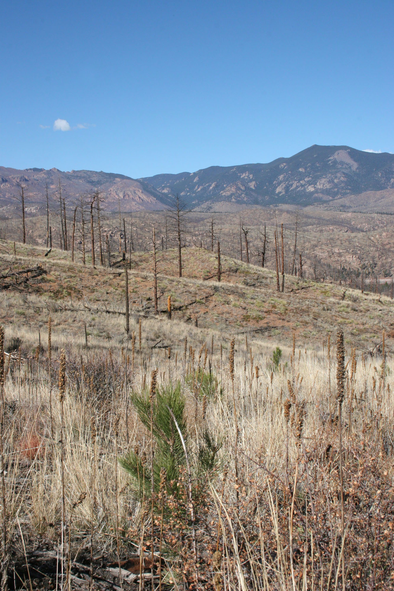
A ponderosa pine seedling peeks out of the Hayman-Fire scarred landscape near Cheesman Reservoir. After the fire, Denver Water spent more than 10 years working with volunteers and Colorado State Forest Service crews to plant about 25,000 trees per year on the 7,500 acres of Denver Water property destroyed by Hayman. Photo credit: Denver Water
After the fire, Denver Water spent more than 10 years working with volunteers and Colorado State Forest Service crews to plant about 25,000 trees per year on the 7,500 acres of Denver Water property destroyed by Hayman.
Following the tree-planting effort, the From Forests to Faucets partnership began in 2010 between Denver Water and the U.S. Forest Service – Rocky Mountain Region. More than 48,000 acres of National Forest System lands have been treated so far, accomplishing important fuels reduction, restoration and prevention activities.
But in many areas, the fire burned so hot it changed the chemistry of the soil in the months following the fire. Natural regeneration has been difficult, which is why Denver Water continues to work to reduce the risk of catastrophic wildfires.
After signing the renewal for the From Forests to Faucets partnership in February 2017, Denver Water CEO/Manager Jim Lochhead reiterated the need to stay vigilant. “We have a responsibility to our customers to provide safe, reliable water,” he said. “We also have an obligation to be a good steward of our natural resources. By protecting our watersheds, we’re also preserving our water.”
More photos of the Hayman Fire aftermath:
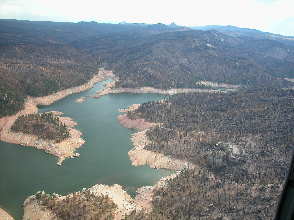
The devastation following the Hayman Fire, coupled with the crippling effects of a severe drought, stretched as far as the eye could see in this photo of Cheesman Reservoir taken in August 2002. The fire destroyed 7,500 of the 8,500 forested acres Denver Water owns at Cheesman Reservoir. Photo credit: Denver Water
Subsequent rains following the Hayman Fire in 2002 led to erosion problems and silt buildup in the creeks surrounding the reservoir. Photo credit: Denver Water
Immediately following the Hayman Fire, Denver Water sent employees to help erect sediment traps made of straw bales and trash racks fashioned from downed trees. The crews building the traps were used to spending their days laying new pipe in Denver’s streets, but given the 2002 drought parched the city and led to severe watering restrictions, Denver Water suspended new pipe installation. Photo credit: Denver Water
Following the Hayman Fire, Denver Water built large sediment traps to capture ash, sand and other debris from Turkey and Goose creeks, preventing that material from entering the reservoir. Photo credit: Denver Water
Click the link to read the article on the Big Pivots website (Allen Best):
Colorado’s largest electrical utility has halved its coal generation since 2005 and will achieve effectively zero by 2030. Surely this investment ranks as among the biggest, most important of the last century
A cliché seems like a terrible way to begin a story that strives for deeper analysis of this milestone in Colorado history, but I’m not clever enough to come up with my own simile or metaphor, so here goes:
Colorado’s reinvention of its energy system is like trying to rebuild an airplane in mid-air. Plans by Xcel Energy, by far the state’s largest utility, to revamp its electrical generation constitute the most compelling exhibit.
Colorado has been flying a plane using technology and infrastructure from the 1970-1990s. The rebuilding has been underway for awhile now, particularly since 2016, after prices of wind, in particular, had plummeted, and utilities satisfied themselves that they could integrate renewables without endangering reliability.
Now comes the giant stride. This coupled with new transmission could yield investment of up to $10 billion.
I’d suggest that Colorado has had few singular rivals in the last 100 years in terms of investment in public and quasi-public infrastructure. The splurge of roadbuilding unleashed by the National Interstate and Defense Highways Act of 1956 certainly surpasses this. I’d single out the Colorado-Big Thompson water diversion project of the ‘40s and ‘50s. Arguably construction of DIA, too. Buy me a beer, and we can chew through this at length.
But by whatever yardstick you choose, this is – and you knew I had to say this – a Big Pivot. This represents Colorado’s most muscular turn yet from centralized power generation from fossil fuel sources to more dispersed renewables.
Click the image to go to Xcel’s project page and the interactive map.
The landscape of eastern Colorado can be expected to look substantially different by the end of 2025. The plans — approved conceptually in a series of meetings during recent weeks by the Colorado Public Utilities Commission —will yield thousands and thousands of new wind turbines during the next few years scattered across eastern Colorado, likely massive amounts of solar, and game-changing amounts of storage. I can’t cite precise numbers, because they are yet to be worked out.
More clear is the transmission needed for this farm-to-market delivery of renewable energy: up to 650 miles of high-strung wires looping around eastern Colorado in a project called Power Pathway. Also possible is a 90-mile extension from a substation north of Lamar to the Springfield area.
Driving this hurried, gold rush-type of development in Colorado’s wind-rich regions is the state’s determination to dramatically reduce carbon dioxide emissions from electrical generation during this decade. It aims to do this even as it displaces use of fossil fuels in transportation and for space and water heating in buildings.
A hard deadline is imposed by the expiration of federal tax credits for wind and solar at the end of 2025.
An Xcel representative, Amanda King, had testified to the importance of completing the first two Power Pathway transmission segments sooner rather than later. The PUC commissioners cited that testimony in their June 2 decision approving the transmission lines:
“The company asserts that by having these segments in-service by the end of 2025, wind and solar developers will be able to interconnect resources prior to the expiration of the production tax credit and step-down of the investment tax credit, which would represent cost savings of approximately $300 million per (gigawatt) of interconnected wind capacity and $100 million per (gigawatt) of interconnected solar capacity, in net present value, to customers,” the decision said.
“It’s a pretty amazing amount of infrastructure that needs to go into the ground in a really short time,” says one individual, a stakeholder in the PUC process, speaking on condition of confidentiality.
Because of that exigency, a written decision is likely in July, no later than August. Appeals by Xcel or other stakeholders could delay the actual green light, but not for long.
For some, this represents a triumph of arguments going back almost two decades.
“It helps unleash the innovation we need to build the 21st century electrical system,” said Leslie Glustrom, who wears various hats but was speaking as a representative of the Colorado Renewable Energy Society the day I talked with her.
She uses the metaphor of inheritance vs. income. In this case, fossil fuels are the inheritance. In the future we must live off the income of renewables.
“If you were lucky enough to have a big inheritance you could buy three houses and five condos,” she said. Living off income poses a major challenge, she says, especially if you haven’t acquired the skills you need.
“We can do it,” she adds, “especially if we are better at matching our demands to the times when we have an abundance of wind and solar.”
Risk is inherent in this process of transition. But risk cuts both ways, as pointed out by Gwen Farnsworth, senior policy advisor for Western Resource Advocates. The PUC deliberations are focused on how to evaluate those risks of relying upon fossil fuel generation in terms of system reliability and climate change. The commission, she says, is “pushing Xcel so that its future resources are cleaner, more flexible and more reliable.”
With this triumph also comes anxiety. The three commissioners used the word “uncertainty” maybe a dozen times when they deliberated during a long afternoon on June 10.
Eric Blank. Photo via Big Pivots
“We are making decisions about billions of dollars of investments under conditions that may have unprecedented uncertainty,” said Eric Blank, the chair, while mentioning climate change, inflationary pressures, rising labor costs, and supply chain disruptions.
Renewables won’t be the steal they were in 2018. Demand has grown. This is the gold rush. California alone wants to add 8,000 megawatts of renewable generation.
Closely related is the growing concern about “resource adequacy” mentioned by Commissioner Megan Gilman and also Commissioner John Gavan. Can Xcel keep the air conditioners on during a really, really hot day—or, as in February 2021, on a very cold day?
After, I talked with Jeffrey Ackermann, the chair of the PUC for four years prior to Blank, to get his big-picture assessment of what this represents.
“I think everyone – regulators and utilities, but stakeholders, too – are eager to move forward while also realizing that you can’t get it mostly right. It has to be 100% right.”
Ackermann was referring to the greater complexity of the electrical grid being assembled with its more diverse resources and greater interplay between utilities and consumers. The stakes have also elevated.
Jeffrey Ackermann. Photo via Big Pivots
Overlay that onto the burgeoning Western markets that are still taking shape, which provokes new questions about resource adequacy and reserve margins. What if the interconnected utilities from Montana to New Mexico get struck by a heat wave at the same time?
In the PUC handling of this complex case, Ackermann commends his successor, Blank.
“I like how this chairman has sequenced the conversation,” he said. “It affirms the complexity of this and also the uncertainty. At the same time it doesn’t shy away from realizing that some tough decisions need to be made now if you want to achieve 2030 goals and beyond. It’s a tough balance.”
Ron Lehr, who chaired the PUC beginning in 1983, concedes the complexity, acknowledges the uncertainty – although pointing out that in 1983, interest rates stood at 18%. (I can confirm; I was suffocating that year, paying 21% interest on my loan for a purchase of a trailer in Granby).
Colorado’s planning process, says Lehr, deserves credit. For outsiders, it’s maddeningly complex and anything but transparent. Even those deeply engaged in the process sometimes get frustrated with the filing system at the PUC. Joe “Schmo,” public citizen? Fuggedaboutit.
Despite these shortcomings, Lehr argues the process itself has been very effective and has improved over time. It creates a forum for diverse voices to exchange ideas.
That process yields some crackpot ideas, he said, “but you weed through them. Then you can diversify your thinking and create a lower-risk template that can attract investment from the private sector.”
Colorado’s process, he added, has drawn national attention for yielding lots of bids for electrical generation — and lower prices.
“The more inclusive and integrated our planning and the more far-sighted the planning, the better we can handle the uncertainty,” he told me.
The story about moving on from coal is the easy story here, but Lehr thinks a side story – about the impacts of Winter Storm Uri on natural gas prices in Colorado — will move the needle past natural gas, too.
“Gas is a bankrupt long-term strategy. You don’t have it when you need it.”
Back to the metaphor of rebuilding the airplane in mid-flight. It was given to me by Mike Kruger, the chief executive of the Colorado Solar and Storage Association, and in a far more colorful way than I’ve articulated here.
We wouldn’t be remodeling this plane in flight if it wasn’t necessary, he says. Yes, uncertainties exist, and likely new uncertainties will become apparent. But the status quo of centralized fossil fuel generation isn’t working.
“We have to try something.”
Despite its cumbersome aspect, he believes Colorado’s legal structure and the stakeholders – Xcel but also the business, consumer, environmental, government, and other groups – have enough flexibility to respond rapidly if necessary.
“If in two and a half years we find we missed the mark on something, I would be surprised if the industry and the environmental and labor groups and Xcel would not be able to figure how to correct it quickly.”
Segments of wind turbine towers at the former Vestas (now CS Wind) factory in Pueblo with the smokestacks of Comanche Generating Station in the background, unit 3 on the left. Photo/Allen Best
That brings up Colorado’s newest coal plant, not quite a dozen years old, and also its largest, at 750 megawatts: Comanche 3.
(Some refuse to call it by that name in the belief that it besmirches tribal people. I couldn’t help note that almost invariably in the PUC discussions it was referred to as unit 3 or Pueblo unit 3.” Maybe Leslie Glustrom’s rants on this are being heard).
When the plant was formally approved in 2005, Colorado’s first major wind farm, Colorado Green, located near Lamar, had just begun producing electricity. It was the future, not coal, but most utilities had not yet gotten that memo. Tri-State was about to start spending $100 million on a humongous coal plant downstream along the Arkansas River in Kansas—a decision from which it has not fully recovered. And, of course, Comanche 3 cost upwards of $1 billion in today’s dollars. Xcel still had humongous debt, a central issue in how soon it is retired.
Coal’s rapid fall from favor and competitiveness is told in these numbers. The fuel produced 66% of Xcel’s electricity for Colorado retail and wholesale customers in 2005. Last year It had fallen by more than half, to 32%. It should be close to zero by 2030. (Xcel may still buy some power from the market that will come from coal plants).
As Noah Long of the Natural Resources Defense Council pointed out in a May 25 posting, this electric resource plan being approved could put Xcel on track to achieve approximately 90% carbon emissions’ reductions as compared to 2005 when Comanche closes, no later than New Year’s Eve of 2030.
Actually, the plant will likely close before then, perhaps long before.
Operations of Comanche will be determined, in part, by a new filter, the social cost of carbon, as specified by new Colorado laws in the last several years.
Another element of the plan being approved by the PUC will create a performance-incentive mechanism (PIM, in the acronym-heavy soup of PUC discussions) to give Xcel financial incentives to steer the plant with decarbonization goals in mind.
The PUC commissioners are going beyond the settlement agreement submitted to them in May by Xcel and the various stakeholder groups. At the suggestion of Blank, the commissioners plan to adopt an additional review governing operations and management that is to be tripped if another major investment is needed to continue operations of the plant.
At issue is how much money will be poured into propping up what one person close to these proceedings described as a “dog.” The analogy is to a car. At what point do you just walk away from it?
“Five years down the road we may have another turbine-bearing outage, and it just isn’t worth it,” said Commissioner Gavan, alluding to the cause of the most recent outage that has had “Pueblo unit 3” off-line for most of 2022 (it’s back in operation now). It was also off-line for most of 2020.
It seemingly has been cursed with problems since it began operations in the summer of 2010. The latest evidence was the deaths of two men in a slide of coal outside the plant on June 5. Their bodies were found under about 60 feet of coal.
A sharper definition of the closing should come into view during a “Just Transition” proceeding that begins in 2024. That proceeding will consider another round of new generation, presumably renewables, likely with a preference for those that can be added to property tax rolls in Pueblo County, to compensate for the loss of property tax there as the coal plants get retired.
The Pawnee Power Plant near Brush is to be converted to natural gas, but with retirement of some components of the coal-burning operation. Photo/Allen Best
In all this, the PUC has much balancing to do. Xcel is ultimately responsible for reliability of electricity, the PUC in protecting the interests of ratepayers. At least in theory – and I believe in practice – both have an interest in reducing greenhouse gas emissions, while Xcel has the additional motivation of delivering profits to investors.
This gets into a complex area of cost-recovery. As Glustrom points out, “these are not insignificant numbers.” The Colorado Renewable Energy Society documented undepreciated assets of the Hayden coal units of somewhere around $70 million, the Pawnee plant at Brush of $170 million, Comanche 3 even more.
Glustrom has long argued that state regulators allow Xcel and its investors unreasonably large returns on their investments. The authorized rate of return is 9.3%. If the utility’s decisions are risk free, then the return on equity should be below 5%, she says. Most everybody else is inclined to be more generous to Xcel than Glustrom.
What almost certainly will come into play is a concept called securitization. It’s fundamentally a way for an investor-owned utility to shuffle its debt into lower-interest long-term bonds. This will be part of the process going forward and, once again, could alter the retirement date of Comanche 3.
This area of cost recovery, almost certainly will be controversial – and might trigger an appeal by Xcel.
Three of the many additional elements of this deserve mention.
Pre-construction development
One is the idea advanced by Blank to give Xcel some leeway to begin planning and incurring expenses for gas-fired generation, but also wind, solar, and storage – with the expectation that the company will be able to recoup costs short of actual commissioning construction of the assets. It’s called “pre-construction development assets.”
This provision reflects the concern about the uncertainties and fluidities that Blank talked about in the June 10 meeting. This gives the company some rope to move forward but only so far.
Yampa River. Photo credit: Yampa River Integrated Water Management Plan website
Status of water
Another new element never seen before in Colorado – and perhaps no other state, either – is a provision that Xcel must report the status of its water rights associated with its retiring coal plants. Think particularly of Hayden, although Xcel has an interest in the coal plants at Craig, too. And then there is Comanche 3.
At first glance, this seems like a strange requirement. After all, Colorado state government already has a Division of Water Resources. Why does the PUC need to poke its nose into water?
That was essentially Xcel’s argument. The PUC commissioners, though, hesitated not at all in embracing this requirement
The idea had been advanced by Western Resource Advocates. WRA’s Ellen Howard Kutzer explains the expansive view here: Water is an essential component of the coal-fired steam plants built by the monopoly to create a public good, the production of electricity. As the coal plants go, the PUC should have some purview over the disposition of those assets. And Xcel has the staff that can provide the essential information in a way that is understandable to PUC staff.
True, the state water agency gets the same information. But the water world gets weirdly wonky at times. So, Xcel’s water staff can translate it for non-water-wonks. It won’t be a major imposition.
Five coal-burning units at Craig and Hayden now require water, but by 2030 those uses of Yampa River water will crease. Future uses remain unclear. 2020 photo/Allen Best
But why does this information matter?
Xcel likely has not decided, and certainly has not disclosed, what it will do at Hayden. It has talked about molten salt but has not dismissed the possibility for green hydrogen or other technologies that may – or may not – be ready for prime time. They can involve water.
The way Western Resource Advocates sees the water, it should be considered as part of the just transition process for Yampa Valley communities. The water that is kept there will most benefit the local communities.
The fear here is of water export, particularly to the Front Range. I dove deeply into this in late 2019 and early 2020 on behalf of Aspen Journalism. Geography matters entirely here. Exporting the water would require pumping it over two mountain ranges. That’s a big lift. That said, money has surfaced recently to reanimate the even bigger stretch of exporting water from Flaming Gorge Reservoir to the Front Range, so who knows.
Just how much water is involved in water for the coal plants? I forget the precise volumes, but they are not as much as you might think, but neither were they insignificant. Importantly, they have relatively high seniority.
WRA’s position, Howard Kutzer said, is that it’s not right to leave the utility to do with the water entirely what it pleases.
“They used these public resources to create a public good, so ultimately — not now, but in the future — the PUC should be able to say whether transferring those water rights is in the public interest.”
Level playing field for storage
Finally, the PUC affirmed their support for the treatment of storage proposed by Colorado Solar and Storage.
“Storage will be a critical path to getting the grid of the future that we want,” said Gilman at the June 10 meeting of the commissioners in endorsing the recommendation of the trade group.
The critical issues here are of the value assigned to storage and the role of private operators in providing that storage as opposed to company-owned storage. The limitations of storage are well known. Lithium-ion batteries currently can store reserves for about four hours. Because of that, Xcel Energy wanted to assign a lower value, but others wanted a higher value. This outcome favors higher value and hence greater incentive for private developers to propose projects.
Fred and Kay Lynn Hefley arranged to have a wind turbine erected on their farm near Walsh, in southeastern Colorado, to record the wind speeds and durations. 2021 photo/Allen Best
Other elements of this plan being approved could deserve mention. An entire story could be written through the lens of Pueblo County (and maybe I will—later).
Or through the lens of Akron, or Cope or Walsh, places on the eastern plains near which these new transmission lines will be draped, along with wind turbines. I hear diverse voices. Some resent the coming wind turbines, an intrusion into rural life to benefit city residents. Others – more commonly those who will directly benefit from lease payments – welcome the development of wind and solar resources.
This won’t solve all the problems of eastern Colorado, where mechanization has left farmers arguably more prosperous but it’s the main street of towns ever more anemic. Many, like Yuma County, had larger populations 100 years ago than they do today. Several times in recent years, I’ve had young people from eastern Colorado say to me, “I just wish Kit Carson had two or three restaurants,” or “It would be nice if Lamar was just a bit bigger.”
This won’t make that happen, but it will at least slow some of the erosion.
What’s next in this transition? So many things are up in the air. Rules are being drawn up governing the minimized use of natural gas in buildings (and boy, is that stuff tedious).
Then there will be the question of demand-side management and energy efficiency. Xcel is expected to submit its plans for that and for beneficial electrification of buildings on July 1. Expect a lot of push and pull here, as there has been over Comanche 3. The environmental community believes Xcel has vastly under-estimated what it can do in terms of reducing demand and shaping demand to better correspond with this vast fleet of renewables soon to take shape on Colorado’s High Plains.
There’s good cause for high-five’s, but there will be little time to dawdle.
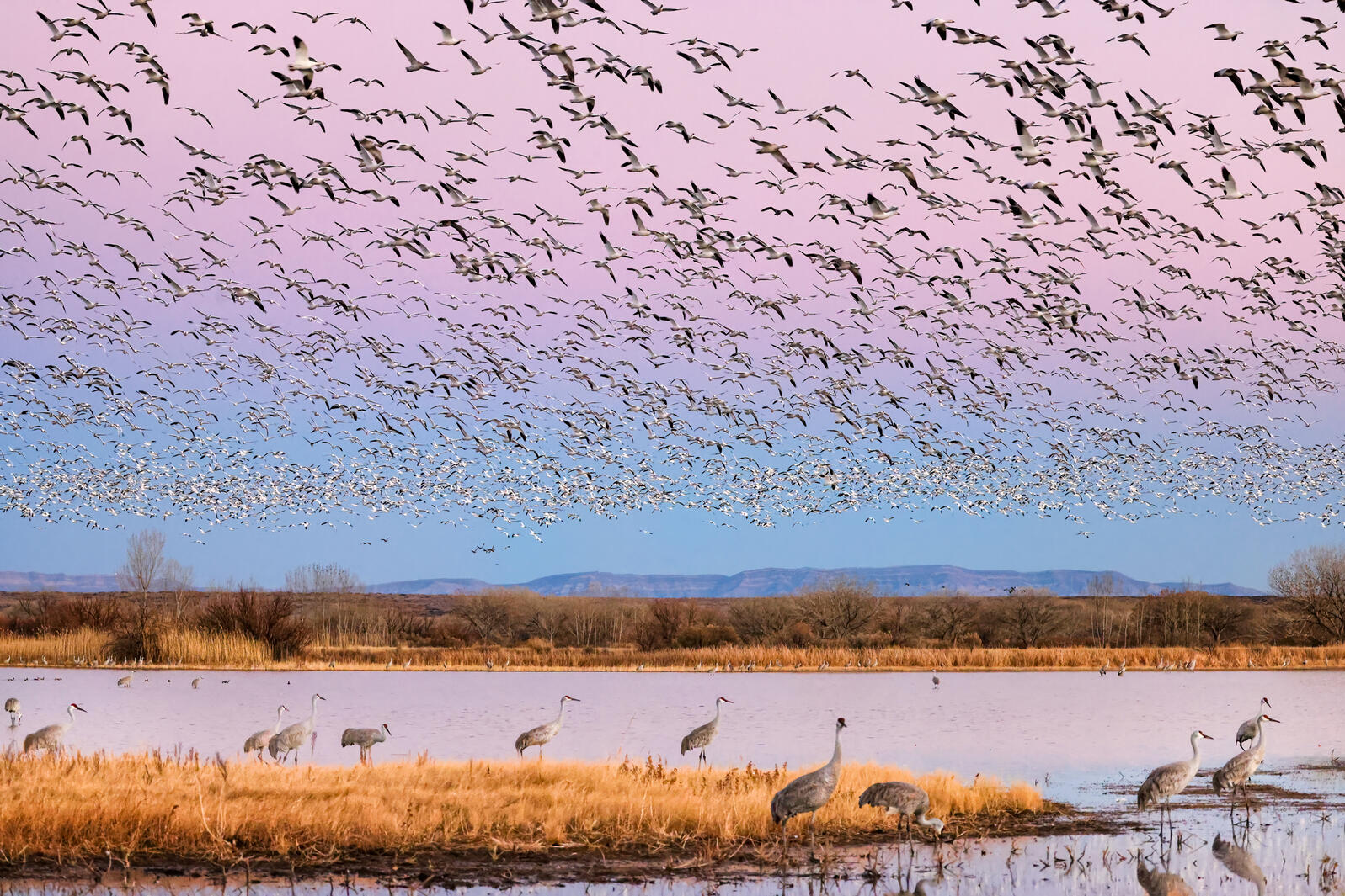
Sandhill Cranes and Snow Geese. Photo: Marti Phillips/Audubon Photography Awards
Click the link to read the article on the Audubon website (Karyn Stockdale):
News headlines in mid-June captured what Audubon’s Western Water team knows well: the Colorado River Basin and Great Salt Lake are in trouble—both facing historically unprecedented risks. Both may be headed towards ecological disasters, years in the making, the result of a pernicious combination of climate change aridifying the region and water management that does not adequately prioritize the environment. In the Colorado River Basin and at Great Salt Lake, warming temperatures and declining river flows threaten people and nature. And, we know there’s significant quality wildlife and bird habitat still worthy of attention and investments.
Birds tell us that water-dependent habitats across the arid West are essential oases and they are in decline. The water issues created by a century of law and infrastructure development are magnified by today’s climate crisis. For over 100 years, we’ve operated under a legal framework in the West where water has been “developed” without consideration for the Indigenous communities that have been on the land since time immemorial, and at the expense of the environment, sometimes draining the last drops of water that supported habitats. Across the West, water stress is evident—and people and birds will feel its effects. Audubon is working on some solutions (make sure you keep up with our ongoing posts), but for now, let me paint a picture of how dire the situation is.
With Great Salt Lake reaching its lowest ever recorded water levels, ongoing drought and increasing development pressures diverting the water flowing down rivers to the lake, a drying Great Salt Lake threatens the health of Salt Lake City residents, the future of key Utah industries, and the survival of millions of migratory shorebirds, waterfowl, and other wildlife. We are currently in uncharted territory as we test thresholds of water levels and this could have cascading effects that would ripple throughout the ecosystem. Although Auduboners tend to focus on the birds and ecology (where else in the West does one find FIVE globally Important Bird Areas at one location?), Great Salt Lake generates enormous impact for Utah and the region with $1.56 billion annually in economic contributions through mineral, aquaculture, and ski industries, and other recreation activities. The potential economic cost of the drying Great Salt Lake could reach $25.4 billion to $32.6 billion over 20 years, according to a 2019 report from the Great Salt Lake Advisory Council. Much like the Salton Sea in California – another giant salt lake—which is already experiencing severe air quality issues from the exposed dry lakebed, the public health and quality of life for communities around Great Salt Lake are at risk from increased dust from larger areas of exposed lakebed. Increased dust on snow also has the potential to compound the timing of snowmelt and thus water availability.
This photo from December 2021 shows one of the intake towers at Hoover Dam. Federal officials said basin states must conserve 2 to 4 million acre-feet to protect reservoir levels in 2023. CREDIT: HEATHER SACKETT/ASPEN JOURNALISM
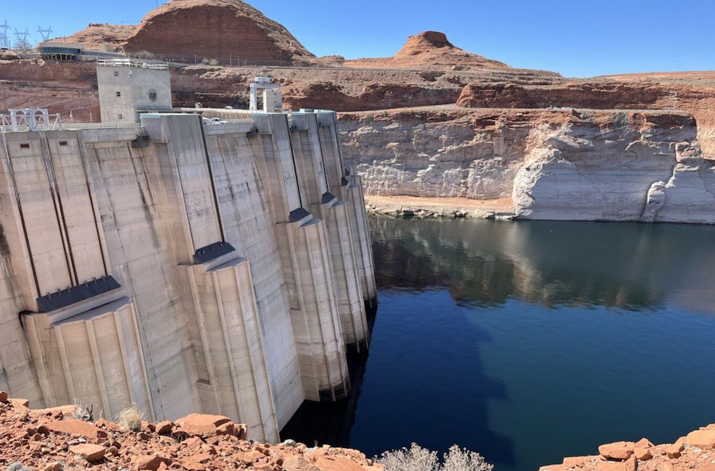
Glen Canyon Dam creates water storage on the Colorado River in Lake Powell, which is just 27% full in June 2022. Bureau data on the reservoir’s water-storage volume showed a loss of 443,000 acre-feet. Credit: U.S. Bureau of Reclamation
Even more stunning is the realization that the Colorado River’s major reservoirs—water supply for some 40 million people—are on life support. The federal U.S. Bureau of Reclamation in March took the unprecedented step of claiming a human health and safety emergency to justify reducing the water it releases from one of those reservoirs. At a U.S. Senate hearing in mid-June, Reclamation Commissioner Touton stated that net Colorado River water uses must be reduced in the next year by 2-4 million acre-feet, a staggering volume that amounts to about 30 percent of average consumptive use.
Brad Udall: Here’s the latest version of my 4-Panel plot thru Water Year (Oct-Sep) of 2021 of the Colorado River big reservoirs, natural flows, precipitation, and temperature. Data (PRISM) goes back or 1906 (or 1935 for reservoirs.) This updates previous work with @GreatLakesPeck.
Our water supplies across the dry West are in severe crisis because of historic over-development, compounded today by climate change. Warming temperatures are creating “hot droughts” that deplete flows in rivers, the flows that people and nature depend on. Today there is no longer enough water to supply all of the demands. Colorado River flows in the first two decades of the 21st century are 20 percent lower than flows in the last century. In years when we see “average” snowpack levels in the mountains, river flows are low: last year in the Colorado River’s headwater mountains, a 91 percent snowpack yielded only a 55 percent flow. That discrepancy demonstrates an impact of climate change between the mountain tops and the valley bottoms. Snowmelt isn’t reaching the rivers in the same way; warmer temperatures drive evaporation, turning the soils into thirsty sponges.
At the recent Colorado River-focused Getches-Wilkinson Center’s Colorado Law Conference aptly named “Hard Conversations About Really Complicated Issues,” Reclamation’s Jim Prairie shared the numbers behind the problem. The volume of water flowing into the Colorado River’s largest reservoirs—Lakes Powell and Mead—has declined, while uses have not. Over the past 20 years, this imbalance has resulted in a 40 million acre-foot decline in Colorado River reservoir storage – a volume that exceeds by a factor of three the Colorado River’s annual average flow. With so little water remaining in the reservoirs, the risks – including infrastructure failure, inability to deliver water to major population centers, and even the risk of no water flowing in the Grand Canyon – are untenable. Moreover, while Reclamation’s call for additional water conservation in the coming year should prevent things from getting worse in 2023, it is not projected to address recovery of the reservoirs, and is not expected to solve the problem beyond 2023 unless those enormous volumes of water can be conserved year after year.
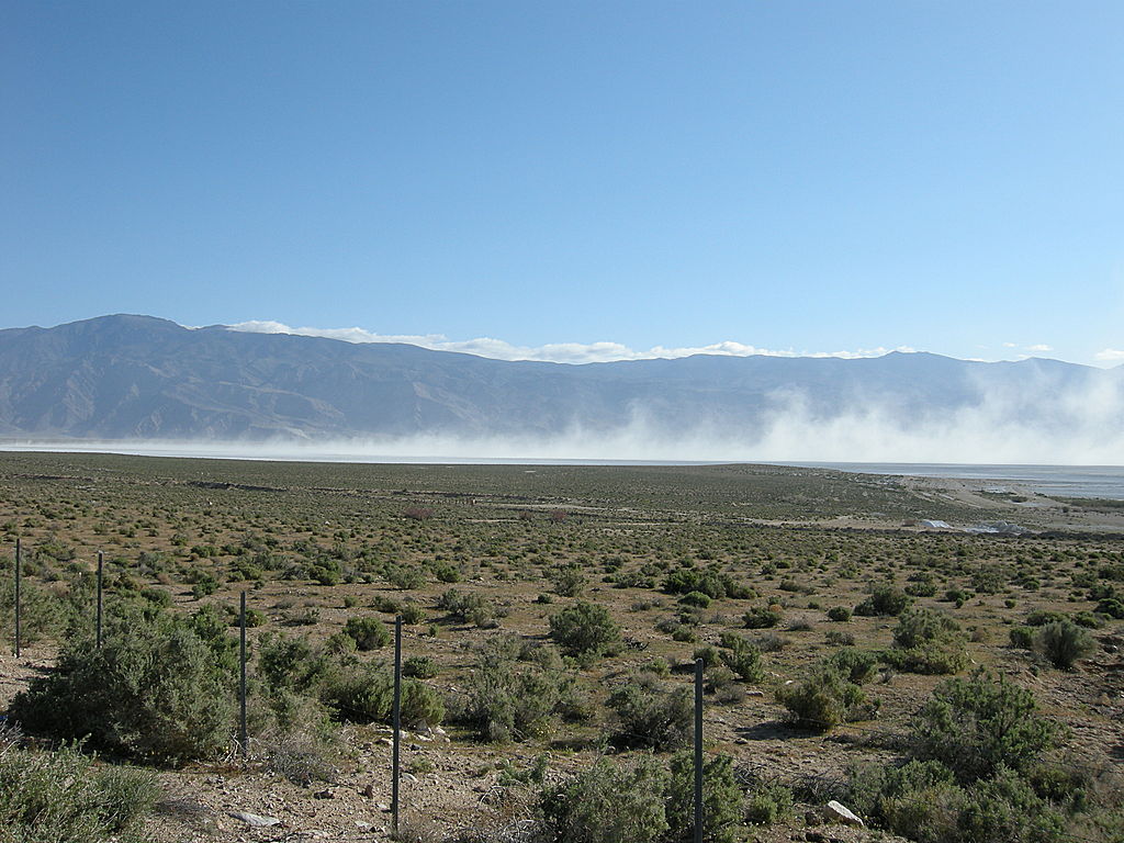
Blowing Alkali Dust at Owens Lake, California. Photo credit: Eeekster (Richard Ellis) via Wikimedia
Stakes are high, and mitigation will be costly. We learned that lesson at Owens Lake in California, where the costs to remediate the lake’s historic drying after Los Angeles diverted 100 percent of its water continue to grow. In order to address extreme dust pollution and loss of migratory bird habitat, the Los Angeles Department of Water and Power invested hundreds of millions of dollars to “rebuild” the ecosystem with pumping and piping of water, infrastructure and many dust control methods – resulting in annual maintenance costs estimated at $17 million. And the costs of restoring a small portion of flows and habitat in the once-vast Colorado River Delta underscore how much more expensive it is to try and fix rivers and lakes once they have been decimated.
This should be a wake-up call to everyone. This water crisis isn’t just impacting those of us who live in the West; it affects people who live in the East too. Not only did the Colorado River form beloved places like the Grand Canyon, it supports an enormous part of our American economy, and has outsized importance to wildlife and birds, with around 70 percent of all species in the region depending on the riparian corridor at some point in their life-cycle. On top of that, Great Salt Lake is essential to the world’s populations of Wilson’s Phalaropes, Eared Grebe, and American Avocet.
So what are some key takeaways that keep me up at night?
1) Today’s hydrologic cycle is vastly different than 50 years ago. Climate change is water change and climate continues to influence the hydrology in the West. And we have dry soils compounding the problem.
2) Solutions exist, but we need them to scale up. Quickly. Public funding—including the massive investments of last year’s Bipartisan Infrastructure Law—will help immensely. We must move swiftly to implement multi-benefit projects that protect our water resources. Ideas to improve the resilience of the West to declining water supplies abound. But will we respond fast enough? And don’t get me started about needed global climate change solutions to reduce carbon emissions…
3) In addition to scaling up solutions, representatives of Tribal and conservation interests need to be included in negotiations to define solutions. To leave out these voices would continue the systematic exclusion of Tribes and nature. Declining water supplies have amplified the problems created through inequitable access to water.
4) The immediacy of the situation. Although the environmental catastrophe looms large and needs immediate steps to reverse the trends—especially because nature impacts people—the risk of a catastrophic collapse of major Colorado River infrastructure is here. Soon. Federal leaders want the Colorado River Basin States to define plans in less than 60 days, noting that if the states cannot come to agreement on how to reduce water uses, the federal government will take unilateral action. Watch for Reclamation’s mid-August water forecast and announcements.
The buzz is around shared sacrifice. Politically, all sectors need to shoulder some of the burden of reducing water use. In all likelihood, despite having senior water rights, agricultural producers who rely on irrigation with Colorado River water will be required to take compensated cuts in their water use. As was pointed out at the Colorado River conference, we cannot conserve the 2-4 million acre-feet of water needed by evacuating the cities that rely on Colorado River water. Water conservation in the agricultural sector has implications for rural economies and the environment. It’s a terrible situation, and important that we are doing what we can to support rural economies and to increase investments in freshwater-dependent ecosystems.
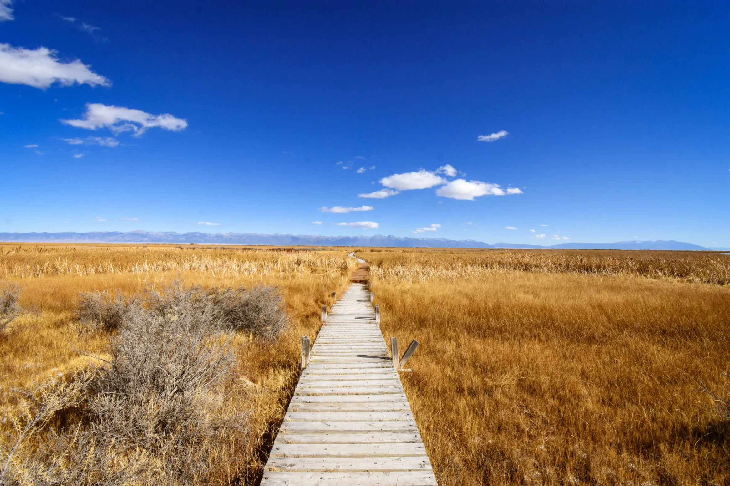
San Luis Valley wetlands. Photo credit: Ryan Michelle Scavo via The Alamosa Citizen
Water management systems in the West are breaking. As decision-makers revise the rules that shape water management systems, we need to urge them to incorporate today’s 21st century values, including equitable treatment of vulnerable communities that lack access to water, and emphasis on supporting water needs in the natural world around us. With even less water, the hard conversations on water conservation efforts should include both using less water while also ensuring water supply to all households in the Colorado River region, as well as minimum water flows to protect hydrologic connections and quality habitats as crucial steps to preserving our future in this landscape. We can’t let the water crisis allow bad projects to get approvals—they would create both short-term and long-term issues for the landscape. We’ve already lost too many wetlands and riparian habitats across the West—and birds are suffering in response. And birds tell us, we have to act on climate change and reduce carbon emissions. Because as bad as this seems, it can still get worse.
We are at a fundamental inflection point for the Colorado River and for Great Salt Lake. While this is a dire update, we need to stay focused to protect our future in the West. These immense water challenges underscore how essential Audubon’s work is to save and allocate water to these critical habitats and ecosystems. There is more to come this summer, and hopefully, we can find some breathing room to create the medium and long-term plans we need to protect water in the West.
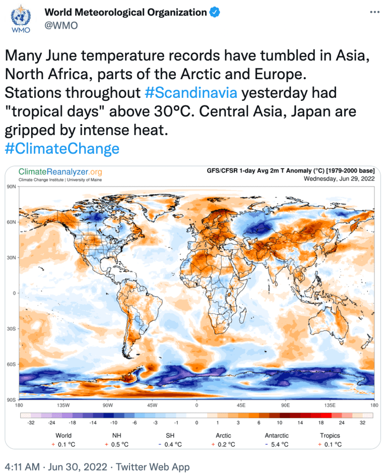
Summer (June–August) temperatures for the contiguous United States compared to the 20th-century average from 1895–2021. NOAA Climate.gov image, based on data from NCEI Climate at a Glance.
Click the link to read the article on The Washington Post website (Anna Phillips, Brady Dennis, Jason Samenow, John Muyskens and Naema Ahmed). Here’s an excerpt:
Summer temperatures in Reno have risen 10.9 degrees Fahrenheit, on average, since 1970, making it the fastest warming city in the nation during the hottest months, according to an analysis by the nonprofit research group Climate Central. For two consecutive summers, smoke from blazes burning in California has choked the region, sending residents to the emergency room, closing schools and threatening the tourism industry. It is among the sharpest examples of how climate change is fundamentally altering the summer months — turning what for many Americans is a time of joy into stretches of extreme heat, dangerously polluted air, anxiety, and lost traditions.
Wildfire smoke over Fort Collins. Photo credit: Yale Climate Connections
Though the summer season of 2022 is young, parts of the nation already have experienced punishingly high temperatures, extreme drought, wildfires, severe storms, flooding or some combination. Projections from federal agencies suggest more abnormally hot weather, an expansion of drought and well above average wildfire and hurricane activity in the months ahead.
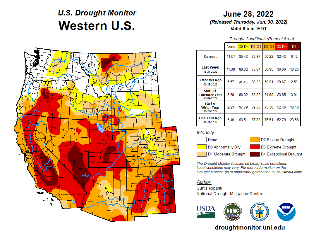
West Drought Monitor map June 28, 2022.
Scientists say the recent spate of severe summers is a clear change from previous generations. The average summer temperature in the past five years has been 1.7 degrees (0.94 Celsius) warmer than it was from 1971 through 2000, according to a Washington Post analysis of data from the National Oceanic and Atmospheric Administration. But some parts of the country have been much harder hit, with the West showing a 2.7 degrees (1.5 Celsius) increase.
Coyote Gulch’s new bicycle arrives home November 2, 2019.
Coyote Gulch’s Leaf charging at the City of Thornton’s Infrastructure Maintenance Center August 31, 2019. Charging infrastructure partially paid for with a grant from the Colorado Energy Office.
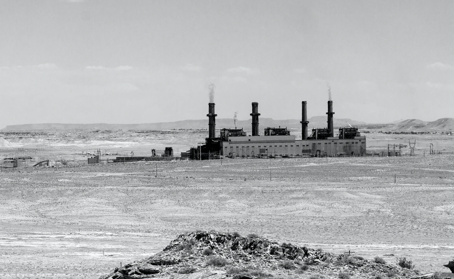
The San Juan Generating Station in mid-June of this year. The two middle units (#2 and #3) were shut down in 2017 to help the plant comply with air pollution limits. Unit #1 shut down today and #4 will shut down on Sept. 30 of this year. Jonathan P. Thompson photo.
By now I suspect most of you are aware of the bad news of the day when it comes to the federal government’s power to limit carbon dioxide emissions from power plants. That power has been taken away by the conservative majority of the Supreme Court, which is on a rampage lately.
The case, West Virginia v. EPA, concerned the Obama administration’s Clean Power Plan, which limited carbon dioxide emissions from power plants in a manner that aimed at phasing out coal-fired power plants altogether — albeit not immediately and, some might say, not quickly enough. The Court ruled, 6-3, that only Congress can limit carbon dioxide emissions to a level that forces a nationwide transition away from coal, which is to say: Given that most of Congress is owned by corporations and so will do nothing, this ruling essentially gives corporations free rein to spew climate changing pollutants into the atmosphere. “The Court appoints itself — instead of Congress or the expert agency — the decisionmaker on climate policy,” noted Justice Elena Kagan in her dissent. “I cannot think of many things more frightening.”
Yeah, same here. I haven’t delved too deeply into the decision and all of its intricacies yet. But, from what I can tell, we aren’t doomed entirely by this decision, alone. That’s because it leaves a lot of tools intact that can be used to limit other pollutants, aside from carbon dioxide, from coal power plant stacks. And because in most places coal is being phased out anyway, thanks to economics, to years of tenacious environmentalists’ efforts, to state-level regulations, and, in some cases, thanks to corporate shareholders actually pushing companies to clean up their act.
This is where we get to today’s good news. Today (June 30) Public Service Company of New Mexico shut down one of two remaining units on the coal-burning San Juan Generating Station in northwestern New Mexico. In three months, PNM will abandon the entire plant and, if all goes according to plan, it will be demolished, the accompanying mine will shut down and be reclaimed, and a major solar array will be constructed nearby to utilize the capacity on the high-voltage transmission lines that spoke out across the West from the Shiprock Substation.
The smokestacks will cease emitting thousands of pounds of sulfur dioxide, mercury, arsenic, nitrogen oxides, and other harmful pollutants along with millions of tons of climate-warming carbon dioxide each year. The plant will stop gulping up more than 5 billion gallons of San Juan River water annually, leaving that water for other uses or to stay in the river for the fishes’ sake. And it will no longer dump millions of tons of toxic coal combustion waste in the mine and in settling ponds nearby. (The Four Corners Power Plant, a dozen miles away, will continue to burn coal and emit pollution).
And, to help offset the economic pain from losing one of the region’s biggest employers and tax payers, PNM will pay the affected communities tens of millions of dollars to develop their economies and help and retrain workers.
Yes, there is a hitch or two standing in the way of cleaner air and a diversified economy.
For starters, an obscure company called Enchant Energy has teamed up with the City of Farmington in a long-shot bid to take over ownership of the plant and keep it running as is until it can scrape up $1.4 billion or more to install carbon capture equipment on the plant. It’s a long-shot for a number of reasons, most of which are outlined in a story I wrote for the Energy News Network. But to sum up the obstacles:
Enchant has not lined up investors or financing for the project, in part because the only thing making the project remotely economically feasible are federal tax credits for capturing carbon;
Enchant has not secured water rights, transmission capacity, a coal contract, or any of the permits it would need to continue running the plant, let alone construct carbon capture and sequestration infrastructure;
PNM doesn’t want to buy electricity from the plant, and even if it did, New Mexico’s Energy Transition Act wouldn’t allow it to due to emissions limits;
New Mexico’s environment department is about to implement a rule that would prohibit the plant from running without carbon capture starting Jan. 1 of next year;
While Enchant might be able to sell power from the plant in the near-term, since many utilities are facing generation crunches this summer and next summer, it’s unlikely that many utilities are going to be willing to purchase dirty coal power in the future;
The idea of installing carbon capture on aging coal plants in order to keep them running is insane. If you’re really concerned about preserving jobs and tax revenues, why not invest that $1.4 billion (probably more like $1.7 billion, at least) directly into the affected communities? Why spend so much damned money just to keep polluting? And yes, even if the carbon capture equipment were ever installed, the plant would continue to spew out other pollutants at the current rate. Carbon capture may have a place on cement plants, for example, or even natural gas plants. Not on coal plants.
Most environmentalists I’ve spoken to are optimistic about Enchant, which is to say they are pretty confident that their attempt to keep the plant running after PNM leaves is not going to fly.
I hope they’re right. However, I can imagine a scenario in which Enchant and city leaders leverage the region’s deep ties to and reliance upon fossil fuels, along with the Biden administration’s apparent zeal for carbon capture, to lure federal subsidies to the project, maybe get some exemptions from state or federal agencies, and so forth, if only to keep dragging this scheme out for years. Maybe they’ll even switch gears and team up with the governor to create some sort of blue hydrogen production plant.
But I’m not going to let those unlikely scenarios get me down. I’m going to celebrate. I’ll wait a few days for the air to clear, then I’ll go up to a favorite high spot of mine atop the McElmo Dome and look out onto the landscape. And so long as there’s no wildfire smoke blowing through, I should be able to see it more clearly than I ever have before. And it should only get better.
Banner image: Wil Srubar holds a sample cube of concrete that contains biogenic limestone produced by calcifying macro- and microalgae. (Credit: Glenn Asakawa/CU Boulder)
Global cement production accounts for 7% of annual greenhouse gas emissions in large part through the burning of quarried limestone. Now, a CU Boulder-led research team has figured out a way to make cement production carbon neutral—and even carbon negative—by pulling carbon dioxide out of the air with the help of microalgae.
The CU Boulder engineers and their colleagues at the Algal Resources Collection at the University of North Carolina Wilmington (UNCW) and the National Renewable Energy Laboratory (NREL) have been rewarded for their innovative work with a $3.2 million grant from the U.S. Department of Energy’s (DOE) Advanced Research Projects Agency–Energy (ARPA-E). The research team was recently selected by the HESTIA program (Harnessing Emissions into Structures Taking Inputs from the Atmosphere) to develop and scale up the manufacture of biogenic limestone-based portland cement and help build a zero-carbon future.
“This is a really exciting moment for our team,” said Wil Srubar, lead principal investigator on the project and associate professor in Civil, Environmental and Architectural Engineering and CU Boulder’s Materials Science and Engineering Program. “For the industry, now is the time to solve this very wicked problem. We believe that we have one of the best solutions, if not the best solution, for the cement and concrete industry to address its carbon problem.”
Concrete is one of the most ubiquitous materials on the planet, a staple of construction around the world. It starts as a mixture of water and portland cement, which forms a paste to which materials such as sand, gravel or crushed stone are added. The paste binds the aggregates together, and the mixture hardens into concrete.
To make portland cement, the most common type of cement, limestone is extracted from large quarries and burned at high temperatures, releasing large amounts of carbon dioxide. The research team found that replacing quarried limestone with biologically grown limestone, a natural process that some species of calcareous microalgae complete through photosynthesis (just like growing coral reefs), creates a net carbon neutral way to make portland cement. In short, the carbon dioxide released into the atmosphere equals what the microalgae already captured.
Ground limestone is also often used as a filler material in portland cement, typically replacing 15% of the mixture. By using biogenic limestone instead of quarried limestone as the filler, portland cement could become not only net neutral but also carbon negative by pulling carbon dioxide out of the atmosphere and storing it permanently in concrete.
If all cement-based construction around the world was replaced with biogenic limestone cement, each year, a whopping 2 gigatons of carbon dioxide would no longer be pumped into the atmosphere and more than 250 million additional tons of carbon dioxide would be pulled out of the atmosphere and stored in these materials.
This could theoretically happen overnight, as biogenic limestone can “plug and play” with modern cement production processes, said Srubar.
“We see a world in which using concrete as we know it is a mechanism to heal the planet,” said Srubar. “We have the tools and the technology to do this today.”
A scanning electron micrograph of a single coccolithophore cell, Emiliania huxleyi. (Credit: Wikimedia Commons / Alison R. Taylor, University of North Carolina Wilmington Microscopy Facility)
Limestone in real time
Srubar, who leads the Living Materials Laboratory at CU Boulder, received a National Science Foundation CAREER award in 2020 to explore how to grow limestone particles using microalgae to produce concrete with positive environmental benefits. The idea came to him while snorkeling on his honeymoon in Thailand in 2017.
He saw firsthand in coral reefs how nature grows its own durable, long-lasting structures from calcium carbonate, a main component of limestone. “If nature can grow limestone, why can’t we?” he thought.
“There was a lot of clarity in what I had to pursue at that moment. And everything I’ve done since then has really been building up to this,” said Srubar. He and his team began to cultivate coccolithophores, cloudy white microalgae that sequester and store carbon dioxide in mineral form through photosynthesis. The only difference between limestone and what these organisms create in real time is a few million years.
With only sunlight, seawater and dissolved carbon dioxide, these tiny organisms produce the largest amounts of new calcium carbonate on the planet and at a faster pace than coral reefs. Coccolithophore blooms in the world’s oceans are so big, they can be seen from space.
“On the surface, they create these very intricate, beautiful calcium carbonate shells. It’s basically an armor of limestone that surrounds the cells,” said Srubar.
The coccolithophore has been part of the Black Sea ecology for millennia, and in the summer these calcite-shedding phytoplankton can color much of the Black Sea cyan. (Credit: NASA Goddard Space Flight Center, Flickr)
Commercializing coccolithophores
These microalgae are hardy little creatures, living in both warm and cold, salt and fresh waters around the world, making them great candidates for cultivation almost anywhere—in cities, on land, or at sea. According to the team’s estimates, only 1 to 2 million acres of open ponds would be required to produce all of the cement that the U.S. needs—0.5% of all land area in the U.S. and only 1% of the land used to grow corn.
And limestone isn’t the only product microalgae can create: microalgae’s lipids, proteins, sugars and carbohydrates can be used to produce biofuels, food and cosmetics, meaning these microalgae could also be a source of other, more expensive co-products—helping to offset the costs of limestone production.
To create these co-products from algal biomass and to scale up limestone production as quickly as possible, the Algal Resources Collection at UNCW is assisting with strain selection and growth optimization of the microalgae. NREL is providing state-of-the art molecular and analytical tools for conducting biochemical conversion of algal biomass to biofuels and bio-based products.
There are companies interested in buying these materials, and the limestone is already available in limited quantities.
Minus Materials, Inc., a CU startup founded in 2021 and the team’s commercialization partner, is propelling the team’s research into the commercial space with financial support from investors and corporate partnerships, according to Srubar, a co-founder and acting CEO. Minus Materials previously won the university-wide Lab Venture Challenge pitch competition and secured $125,000 in seed funding for the enterprise.
The current pace of global construction is staggering, on track to build a new New York City every month for the next 40 years. To Srubar, this global growth is not just an opportunity to convert buildings into carbon sinks but to clean up the construction industry. He hopes that replacing quarried limestone with a homegrown version can also improve air quality, reduce environmental damage and increase equitable access to building materials around the world.
“We make more concrete than any other material on the planet, and that means it touches everybody’s life,” said Srubar. “It’s really important for us to remember that this material must be affordable and easy to produce, and the benefits must be shared on a global scale.”
Students working in the Living Materials Laboratory, which utilizes calcifying microalgae to produce limestone and create a carbon neutral cement, as well as cement products which can slowly pull carbon dioxide out of the atmosphere and store it. (Credit: Glenn Asakawa/CU Boulder)
Students working in the Living Materials Laboratory, which utilizes calcifying microalgae to produce limestone and create a carbon neutral cement, as well as cement products which can slowly pull carbon dioxide out of the atmosphere and store it. (Credit: Glenn Asakawa/CU Boulder)
Click the link to read the briefing on the Alamosa Citizen website (Chris Lopez). Here’s an excerpt:
Those June rains
June 2022 was a good month for precipitation, measuring 1.27 inches and finishing above the .043 inches that is normal for the month of June in Alamosa, according to the National Weather Service Pueblo station.
For the past two years, 2021 and 2022, the month of June has measured above the historical norm, reversing a June pattern in 2020 and 2019 that fell below the norms.
When the winter months don’t yield the snowpack and spring runoffs needed to feed the Upper Rio Grande Basin, then it becomes essential that the summer rains show up to deliver some relief. So far, so good in 2022.
July 2021 was also good, bringing 1.14 inches of rain. Here’s to at least 1.04 inches of rain in July 2022 which would be considered a normal July year.
Denver. A pilot program between CSU’s Salazar Center for North American Conservation and Denver Parks and Recreation will make up to $150,000 available to one to two research teams to identify and fund actionable research that support the city’s climate management needs and decision-making. Photo credit: Colorado State University
Are you a researcher focused on urban equity and climate resilience? The Salazar Center for North American Conservation, along with Denver Parks and Recreation (DPR), is currently seeking proposals from CSU faculty and research staff to support and advance DPR’s efforts in equitable climate resilience. The goal of this pilot program is to identify and fund actionable research that supports the city’s climate management needs and decision-making.
The Salazar Center’s mission is to accelerate the pace and scale of equitable, innovative, and durable solutions for nature and all people by connecting diverse leaders, communities, and resources across the North American continent. With Denver as a leader in climate action, this partnership will lead to durable natural climate solutions through a health-equity lens to improve the well-being of Denver’s landscapes and people. This program aims to bridge the gap between innovative CSU researchers and the city of Denver to advance solutions for meaningful work in urban conservation.
Core themes
The Center invites proposals that address one of four core research themes, developed in collaboration with DPR:
Climate impacts on landscapes
Native pollinators and climate change
Urban tree canopy and climate change
Soil carbon sequestration
In alignment with the Center and DPR’s programmatic priorities, proposals should also address how the research will support solutions that deliver equitable benefits across Denver’s communities. More information and guiding questions for each theme are available in the complete RFP.
Funding and Eligibility
The RFP opens to applications June 30, and proposals are due by August 5; 2022 proposals are to be submitted via the Center’s online application form. This program will make up to $150,000 available and award one to two research teams.
Any researcher affiliated with CSU may apply as a principal investigator, whether they are pre- or post-tenure, affiliates, or staff with any of the relevant centers, institutes, departments, extension offices, or other campus entities. While non-affiliates may not serve as PI, non-PI members of the research team may come from partner entities external to CSU. Teams that are interdisciplinary and cross-sector in nature, and proposals that include a spatial component and/or utilize GIS data, are encouraged.
Research funds will be awarded through a competitive process guided by a selection committee comprising staff from the Salazar Center and DPR, as well as CSU experts.
CWC ICCE Everest team member Red Thunder Spoonhunter, with a Northern Arapaho flag, and Adina Scott, engineer with the all-Black Full Circle climbing team, on Everest. (CWC ICCE Everest team)
Click the link to read the article on the WyoFile website (Katie Klingsporn):
Full Circle’s accomplishment was widely celebrated. What was lost in much of the coverage, however, was this detail: Five college students from central Wyoming trekked to base camp to help Full Circle test climate sensor technology.
The Wyoming group, affiliated with the Central Wyoming College’s Interdisciplinary Climate Change Expedition program, included two Eastern Shoshone students, two Northern Arapaho students and one bike shop mechanic who’s the first in his family to go to college.
Members of the CWC ICCE Everest team hike toward the Himalayas. (CWC ICCE Everest team)
On the expedition, they met Full Circle’s climbers, tested emerging technology that may provide clearer data on high-altitude climate change and visited communities dealing with impacts of a changing climate. It was eye-opening, said Ryan Towne, the bike mechanic.
“The communities who are least responsible for climate change do not deserve to bear the brunt of its consequences,” he said. “Whatever we can do, as a school, as a community, to spread awareness for these cultures and their struggles is, you know, all that I can hope for.”
The young adults also had an adventure of a lifetime touring the vibrant city of Kathmandu, sharing meals with Nepali hosts, hiking into the thin Himalayan air and bonding as friends. They played a role in a historic achievement that felt singular in its own merit.
“I can say that I, a Native American female, have reached Everest base camp conducting climate change research,” student Jada Antelope wrote about the trip. “For this, I am beyond proud…”
An Everest expedition arises
Central Wyoming College’s ICCE program launched in 2014. The undergraduate research program weaves together science and outdoor education skills, and its students have undertaken expeditions to Tanzania (in partnership with the National Outdoor Leadership School), the Great Divide Mountain Bike Route and the Wind River Range.
The Everest project started as a nebulous concept and narrowed into focus only a couple months before it took place, said Jacki Klancher, director of instruction and research at CWC’s Alpine Science Institute, who wrangled the expedition. It spawned in part out of Klancher’s relationships with Full Circle members Phil Henderson and James “KG” Kagambi — all three have worked for Lander-based NOLS.
In conversations with the climbers ahead of their Everest attempt, Klancher said, the concept of a CWC student team came up. “They embraced us,” she said. “And the idea was we work with them to get their electrical engineer help testing some tech that we wanted to test.”
The concept of beta testing climate sensors, meanwhile, has roots in a NASA National Space Grant Consortium meeting in Jackson Hole in October, where young and promising STEM scientists gathered, Klancher said. That’s where she put out the message that she was seeking a portable climate sensor, something she has been wanting for some time for Alpine Science Institute programs.
“I was like, ‘y’all, all I want is a portable location-enabled temperature and [relative-humidity] sensor. Can anybody help?’” she said. That led to conversations with scientists from universities like Penn State, as well as the company MeteoTracker, who showed interest in developing prototypes.
As those conversations evolved and with a green light from Full Circle, Klancher next set out to secure funding and assemble a team. Several funders, such as Wyoming NASA Space Grant Consortium and Wyoming EPSCoR, backed the project. In selecting students, she first turned to program veterans like Towne and Aidan Darissa Hereford, who had ridden in the bike trek, and Red Thunder Spoonhunter, who was on the Tanzania expedition.
When Klancher first proposed the expedition, Hereford said, she was reluctant. Hereford was unsure about traveling abroad during a pandemic for one, she said.
“It seemed pretty scary,” she said. “So I was just debating on it for … about a week. [Then] I thought ‘why not? Just go for it. This is a once-in-a-lifetime chance.’”
Antelope, who along with Spoonhunter is Northern Arapaho, and Antoine Day, who like Hereford is Eastern Shoshone, rounded out the team.
Once the team solidified, Klancher and the students scrambled to apply for funding, train for high altitude trekking, expedite passport applications and secure requisite vaccinations with barely any time to spare.
On April 25, they left Fremont County on the first leg of an enormous journey. In the end, base camp occupied two days of their experience-rich three-week adventure.
Travel weary and trekking
After a ride on a triple-decker plane and a long layover in Dubai, the students landed in the teeming city of Kathmandu on April 28, jet-lagged from the 12-hour time difference. They spent a couple days touring temples and negotiating the incessant city traffic before riding a helicopter to the precarious Lukla airport. From Lukla, a carless city roved instead by yaks and trekkers, they set out on foot. They hiked for 10 days, stopping at tea houses, learning Nepali words from their guides and experiencing the countryside one step at a time.
“It was really surreal,” Hereford said. “And it was really nice to see, like, the villages and see how they live and how things are just really different over there.”
Jada Antelope perches on a boulder at Everest base camp with the Northern Arapaho flag. (CWC ICCE Everest team)
Each day was vibrant, Klancher said. “It was spectacular — tea houses and people and culture and the landscape. It felt like we did a month’s worth of living in those 10 days.”
The expedition wasn’t without trials. The team had to manage a gamut of illnesses — including acute mountain sickness, which felled Hereford — and contend with foul weather.
Members healthy enough to keep hiking reached base camp on May 9. It was a different world at 17,600 feet, Day said. “Base camp is tent city, tents everywhere,” he said, with constant helicopter traffic overhead.
There, they met the Full Circle team and hiked to the ice fields. They partnered with Adina Scott, a Full Circle researcher and engineer, to work with the sensor prototypes, and Towne carried one on the trek down.
After two nights at base camp, the students started the journey home. Full Circle reached the summit of Everest on May 12.
It was a wild ride. But reminders of home helped bridge the familiar with the foreign, Hereford said. “What I really loved the most was waking up every day and smelling … over here in our community, you know, we burn sweetgrass … and so it smelled like that every morning, but they called that juniper.” One thing that helped her through her altitude sickness, she said, was eating a Nepali version of fry bread.
Crunching data, telling the tale
The team returned on May 19. In early June, members were still processing the adventure, and hadn’t yet determined the quality of the data the prototypes collected or the technology’s potential.
“We were successful in doing what we wanted to do, which was to partner with Full Circle to beta test these prototype units and go, ‘Can these things even do what MeteoTracker says?’” Klancher said.
Not knowing the answer to that immediately illustrates the long and sometimes painstaking process of science, she said
Aidan Hereford and Antoine Day on the trek. (CWC ICCE Everest team)
“So, you know, like people asked, ‘What did you learn?’ It’s like, well, we didn’t solve climate change for all time and save the Nepalese and 1.6 billion people from surface water crises,” Klancher said. Instead, they tested an idea, and will offer feedback in an attempt to improve the devices and ultimately the science, Klancher and Day said.
It’s “baby steps,” Klancher said, that one day could lead to, for instance, Sherpas carrying the units to gauge high-altitude climate conditions.
“Did we meet my objectives of diversity, equity, inclusion in STEM? We did,” she said. “Did we educate students and help provide them with professional preparation…? Yes. Did we contribute to climate and water science data and tech? Yes. Did we work on a ton of partnerships…? Yes.
“And did we have a blast? Yes,” Klancher said. The team was a delight, she said. “These guys just figured it out and laughed so much. …I did not have to do a lot of interpersonal group management … It was kind of the magic group.”
The students will present on their expedition in September in Riverton, and Day will curate a photography exhibit of images he took later in the fall.
Due to current drought conditions and decreasing water supply levels, the Pagosa Area Water and Sanitation District (PAWSD) began implementation of Level 1 water-use restrictions last week. Below is an abridged summary of the levels of water-use restrictions. A full and detailed explanation of forthcoming water use restrictions will be mailed to all PAWSD customers. It is expected that all affected customers will become familiar with the requirements and employ the demand reduction mandates so as to preserve the current water supply.
Copies of the PAWSD Drought Management Plan are available at http://www.pawsd.org or at the PAWSD office located at 100 Lyn Ave.
The Pagosa Area Water and Sanitation District (PAWSD) is currently providing water for Chama, N.M., with that community facing a water shortage and lack of running water. District Manager Justin Ramsey explained in an interview with The SUN that PAWSD is currently working with the New Mexico Department of Homeland Security and Emergency Management (DHSEM) to provide water for Chama.
According to Ramsey, DHSEM has a contract with PAWSD for up to 150,000 gallons of water a day for five days, which they are currently drawing from to help provide water for Chama, which is facing extensive water line breakages and extreme water shortages from a lack of running water.
“I know it’s gonna seem odd ‘cause we just went into drought restrictions, but this is an emergency,” Ramsey said of PAWSD’s involvement. “They have no water … to water their grass and their vegetables, … so we opted to be good neighbors.”
Ramsey also commented, “We’re trying to get ‘em to take it from … the fill station at [the PAWSD Vista office] and the fill station at Trails so that it’s coming from our San Juan plant. … Once it passes that diversion at San Juan, it’s gone, we don’t have it anyway, so that’s where we’re trying to grab it from. It’s water that would flow by us anyway.”
Rivers and drought
Stream flow for the San Juan River on June 29 at approximately 9 a.m. was 402 cubic feet per second (cfs), according to the U.S. Geological Service (USGS) National Water Dashboard. This is down from a recent peak of 911 cfs at 6:30 a.m. on June 27 and up from last week’s reading of 220 cfs at 9 a.m. on June 22.
Colorado Drought Monitor map June 28, 2022.
The National Oceanic and Atmospheric Administration (NOAA) National Integrated Drought In- formation System (NIDIS) reports that 100 percent of the county is experiencing drought. The NIDIS indicates May 2022 was the 19th driest May in 128 years, with 1.03 fewer inches of precipitation than normal, and with 2022 to date being the sixth driest year in the last 128 years, with 5.22 inches of precipitation less than normal. The NIDIS places the entire county in a severe drought, which the website notes may cause farm- ers to reduce planting, producers to sell cattle and the wildfire season to be extended, among other impacts. The NIDIS also notes that a severe drought is associated with low surface water levels and reduced river flows. The NIDIS also places a portion of the county in an extreme drought…
The forecast for the area indicates that in the next two weeks, the majority of Archuleta County will be experiencing extreme wet conditions, while the four-week forecast shows the county will be experiencing a mix of extreme wet and exceptionally wet conditions.
Gunnison Waves and other river users have asked local leaders to add a waveshaper to the whitewater park — a device that is prized by surfers for its ability to create a consistent wave when flows vary along the river.
Gunnison County, along with the Upper Gunnison River Water Conservancy District, are collecting feedback from local surfers and other river users on proposed improvements at the Gunnison Whitewater Park. Conceptual plans include moving and replacing the second wave or “Drop #2,” and adding an adjustable waveshaper. Although a waveshaper is widely supported by the river community, county staff are still exploring its feasibility due to staffing issues and added costs.
McLaughlin Whitewater, the design and engineering firm the county works with to assess conditions at the park, has been monitoring Drop #2 yearly since wave three was rebuilt in 2015 due to scouring underneath. According to project manager Ben Nielsen, although the current condition of Drop #2 does not pose a safety risk to surfers, it is worsening and following the same trajectory as wave three.
Jason Lakey, one of the original founders of Gunnison Waves, said the drop first shifted in 2019 after a big snow year. Users began to notice a decrease in the waves performance in 2020, where waves were harder to catch and stay in, he said.
Blue Mesa Reservoir is the largest storage facility in Colorado in the Upper Colorado River system. Prolonged drought and downriver demand is shrinking the reservoir. Credit: Tom Wood, Water Desk
Click the link to read the article on the KUNC website (Luke Runyon and Alex Hager). Here’s an excerpt:
Colorado’s water shortages are not relegated to the distant future. Water supplies cannot meet current demands in many communities, and are only likely to worsen as climate change heats up and dries out the state’s cities and farms. That message is front and center in the Colorado Water Conservation Board’s first draft of a comprehensive update to the Colorado Water Plan, originally passed in 2015. Its initial creation was spurred by then-governor John Hickenlooper.
The plan anticipates a supply-demand gap of 240,000 to 740,000 acre-feet for cities and industries by 2050…For agricultural users, shortages are already a way of life. The plan projects that an existing shortfall of 2.6 million acre-feet for farmers and ranchers could increase to 3.5 million acre-feet by the middle of this century.
The plan is candid about the harsh effects of climate change, and the likelihood that Colorado’s water future will be shaped by warming and drying patterns. This includes acknowledgements of “aridification” – the idea that the West is not just experiencing the normal ebb and flow of drought, but instead becoming permanently drier. Climate scientists broadly agree that rising temperatures are driving a batch of changes that result in a shrinking water supply for much of the Southwest.
Today, the Colorado Water Conservation Board (CWCB) released the draft update of the Colorado Water Plan for a 90-day public comment period. The plan, originally developed in 2015 under the direction of Governor John Hickenlooper, is meant to address growing water scarcity in Colorado and ensure the state has a sustainable water future that meets the needs of a wide range of water uses by all Coloradans. In response to the release of the updated plan, Water for Colorado has issued the following statement.
“We appreciate all of the hard work by CWBC staff and board members and Department of Natural Resources to prepare a draft update to the Colorado Water Plan. We have already begun our thorough and detailed review and we look forward to providing comments. Our coalition was founded seven years ago to help influence the development of the 2015 Water Plan through providing technical review and driving civic engagement. We will submit comments and engage in a robust conversation with stakeholders on how we can best protect Colorado’s watersheds and rivers for all Coloradans and for future generations. We look to this Water Plan update to improve water security throughout the state by equitably addressing many of our watershed and water conservation needs.
This revision of the Colorado Water Plan will certainly play an important role in advancing our water goals throughout the state. But it alone will not be sufficient to meet the growing water challenges we face. This was further emphasized by recent statements by federal officials about the need for substantial water reductions by all states and in all water sectors to avoid critically low levels in the Colorado River basin’s largest reservoirs. Worsening hydrology and increased demands placed on dwindling water resources guarantee that additional, urgent actions will need to be taken to ensure a secure water future for Colorado. Governor Polis has called 2022 the “year of water” for Colorado, and we look forward to working with Governor Polis and his administration, other elected officials, Basin Roundtables, and communities on the critically important issues facing our state in 2022 and beyond. We must meet this pivotal moment in a way that positions Colorado as a leader in collaborative water management — our state’s future depends on it.”
The coalition has spokespeople available for comment now and in the coming 90 days, during which both partner organizations and the public have a vital opportunity to ensure that their voices are heard, that their interests are considered, and that Colorado’s water plan is truly that — a plan for the entire state.
Pathfinder Dam part of the North Platte Project (originally the Sweetwater Project) is an irrigation project in the U.S. states of Wyoming and Nebraska. The Interstate Canal is part of the project. By Josh Hallett – originally posted to Flickr as Pathfinder Dam – Wyoming, CC BY-SA 2.0, https://commons.wikimedia.org/w/index.php?curid=4171115
From email from Governor Gordon:
Governor Mark Gordon has mobilized the Wyoming National Guard and multiple state agencies to provide assistance to the residents of Lingle and Goshen County in response to flooding that is occurring as a result of a breach in the Interstate Canal north of Lingle.
“I want to thank our state agencies for their quick response to this concerning situation and I praise them for their hard work and dedication to help minimize the impact on our citizens and communities there. Thanks to the quick and competent response from our state agencies, including the Wyoming Office of Homeland Security and the State Engineer’s Office, we were able to rapidly respond to the situation.
At my request, Secretary of State Buchanan is on the ground to personally survey the scope of the damage and to ascertain what resources are needed to help the citizens of Goshen County. Secretary Buchanan has reported the local folks are working together to sandbag the canal. As I have said many times before, I am proud of our Wyoming people who do what they do best—helping neighbors.
My office has been in contact with Governor Ricketts of Nebraska, as the majority of the water in the canal flows to our neighbors in Nebraska. We will continue to communicate with Nebraska officials as we work to resolve the issue.” Gov. Gordon said.
After Goshen County Commissioners issued an emergency declaration, the Governor activated the Wyoming National Guard to place 1,000-pound sandbags in the breach. The Laramie County Fire Authority assisted the State by transporting the sandbags to the site of the canal breach.
Staff from the Wyoming Office of Homeland Security, the State Engineer’s Office and county officials immediately traveled to the site to assess the situation. The Wyoming Public Service Commission is working with utilities. Water was promptly diverted from the canal at the Whalen Diversion Dam and parts of Lingle were evacuated. Early estimates determined that water levels would begin receding around 2 p.m. this afternoon. However, water is expected to continue flowing for the next twelve hours, as the canal was full prior to diversion.
There comes a phase in almost any large-scale, controversial project on public or private land when the questions arise and the lawsuits begin. The proposed Uinta Basin Railway (UBR) is no different.
Everything about the venture is large-scale, from its nationwide scope to potential global impacts. Although the UBR, at 88 miles, is considered a “short line,” it would create a new link in the oil supply chain connecting the vast, fracked-oil fields in northeast Utah’s Uinta Basin to the national rail network, passing through Glenwood Canyon on its way to the refineries on the Gulf Coast. The UBR, approved by the Federal Surface Transportation Board (FSTB) in late 2021, would provide enough transportation capacity to increase oil production in the Uinta Basin from between 80,000 and 90,000 barrels per day (B/D) currently to 350,000 B/D — essentially quadrupling output.
The increase in CO2 from expanding Uinta Basin production would come at a time when scientists around the world are sounding an alarm. In 2022, the Intergovernmental Panel on Climate Change stated that global greenhouse gas emissions must peak by 2025, drop by half by 2030 with net-zero CO2 emissions by 2050 to avoid catastrophic and possibly irreversible climate changes.
Combined CO2 emissions from the estimated fracked-oil operations in the Uinta Basin as result of the UBR and end-product combustion range from about 20 to 55 megatons per year, which, at the high end, is equal to about 1% of the U.S. or 17.5% of the United Kingdom CO2 output in 2020.
The Uinta Basin is shown on this map, along with existing rail terminals in Carbon County, Utah, where limited amounts of the basin’s waxy crude is loaded into train cars. A proposal to create a direct rail link to the basin would provide shippers with enough transportation capacity to quadruple output.
Salt Lake City refineries at capacity
The type of oil found in the Uinta Basin is tricky to transport and difficult to refine. Called “waxy crude” because of its high paraffin content, it solidifies at about 100 degrees Fahrenheit. The Utah Department of Environmental Quality states that it must be “heated in the field and transported in insulated trucks.”
As explained by Adam Sayres, president of Axia Energy II, which operates in the Uinta Basin, Uinta crude is like Chapstick. He gave a detailed presentation to the Board of Trustees of Utah’s School & Institutional Trust Lands Administration (SITLA) in May 2018, stating that the crude is liquid underground at about 225 degrees, but once it hits the surface, it has to be kept in heated tanks at 180 degrees. Then, it’s loaded onto insulated trucks that head for Salt Lake City refineries, about 150 miles away.
According to Matt Sands, host of the Mineral Rights Podcast, in 2019, those refineries had a total production capacity for 189,000 B/D but only about 88,000 B/D for Uinta Basin waxy crude. Salt Lake City was declared a nonattainment area by the Environmental Protection Agency for air-quality standards twice in one decade — in 2009 for fine particulate matter and in 2015 for ozone — which proved problematic for those wanting to increase Uinta Basin waxy-crude production. “Production has had to mirror the refining capacity,” Sayres told the SITLA board.
Bryce Bird, director of the Utah Division of Air Quality, told Aspen Journalism that ozone levels have not improved and emissions from all refining operations are capped due to air-quality concerns. “Without getting permit changes or offsetting emissions, the refineries cannot increase production,” he said.
Wendy Park, an attorney for the Center for Biological Diversity, a conservation group opposed to the UBR, said Uinta Basin oil producers are locked into the Salt Lake City refinery market, which gives the refineries a distinct advantage. “The Salt Lake City refineries can ask for a discount because there isn’t much competition for this waxy crude oil, [since companies] can’t get it to other customers,” she said. “The increase in markets for Uinta Basin crude would allow oil producers to charge higher prices, which would spur increased drilling.”
The only way to increase production in the Uinta Basin is to refine the waxy crude somewhere else. Proponents of the UBR say the best way to do that is to link the Uinta Basin by rail to the national rail network, near Price, Utah, and take that crude to Gulf Coast refineries that can handle it.
Glenwood Springs Mayor Jonathan Godes near the Union Pacific rail yard just west of downtown. Godes is opposed to oil trains from the Uinta Basin coming through Glenwood Springs.
Oil trains would go through Colorado
The UBR promises to add from three to 10 oil trains daily to the national railway running through Colorado. The trains would share the tracks with Amtrak and freight haulers, winding through Glenwood Canyon and up through the Moffat Tunnel before descending to Denver and then east and south. The waxy crude would be shipped in heated unit cars — approximately 110 cars per train with the capacity to carry about 642 barrels in each car.
Communities along the Colorado route, including the city of Glenwood Springs, have written to U.S. Sens. Michael Bennet and John HIckenlooper against the UBR, citing concerns about air quality, wildlife, water and public safety. Glenwood Springs Mayor Jonathan Godes told Aspen Journalism that an accident or spill in Glenwood Canyon would be disastrous all the way to the Sea of Cortez. “To say it’s a far-fetched possibility, I think, is to ignore reality,” he said. “If that waxy crude that’s heated in order to stay viscous spills into our watershed and into the Colorado River, it would be a massive cleanup where they would have to remove tons of soil and debris.”
Eagle County officials, who are party to a lawsuit challenging the FSTB’s December approval of the UBR, have also voiced concerns that the long-dormant Tennessee Pass rail line would be revived as an alternate route for the oil trains should the national rail network through Colorado — particularly the Moffat Tunnel — become crowded.
Texas-based Rio Grande Pacific Corp (RGPC), which plans to build and operate the UBR, also owns Colorado, Midland & Pacific Railway (CMP), which, in late 2020, attempted to lease a portion of the Tennessee Pass line from UP for possible commuter/passenger service and freight options, and applied for fast-track approval from the FSTB. RGPC made a point of stating that it “has no plan to operate oil trains over Tennessee Pass.” RGPC even went so far as to amend its plan a week before the FSTB made its decision, requesting restriction from hauling crude oil, coal and hazardous materials in the proposed lease.
But Eagle County Commissioner Matt Scherr is not convinced. “There is no way they can commit to that,” he told Aspen Journalism. “They are not allowed to officially make a promise that [they] will not do some sort of activity on a line that has a general practice of moving freight.”
The FSTB denied the application — and, by extension, RGPC’s proposed amendment — on March 25, 2021, for a variety of reasons, including public opposition and RGPC’s apparent rush to get it done. But the decision left the door open for CMP to reapply with a more comprehensive impact review and a full application process. “So, the proposal could come back,” said Park.
Click the link to go to the Colorado Water Plan website:
The Colorado Water Plan provides a framework for helping Colorado meet its water challenges through collaborative action around water development and water conservation. The plan includes a range of collaborative partner actions that stakeholders can advance through grant funding & local projects, as well as specific actions the Colorado Water Conservation Board and other agency partners will commit to in order to advance the plan. The plan guides future decision-making and supports local actions to address water challenges with a collaborative, balanced, and solutions-oriented approach that builds resilience.
The Colorado Water Plan uses state-of-the-art data and tools to analyze the state’s water issues, including adapting to aridification and climate change, embracing innovative ideas and new technology that align with Colorado’s evolving water goals. The Plan includes four main focus areas that work together for a stronger state: Vibrant Communities, Robust Agriculture, Thriving Watersheds, and Resilient Planning.
Colorado Water Plan grants support a range of multi-beneficial projects for water storage, water conservation, the water-land use nexus, agricultural efficiency, water education and awareness, watershed health, and outdoor recreation. The Colorado Water Plan’s focus areas will address overlapping themes to address identified risks and challenges: funding, supply, equity, climate change, land use planning, storage, efficiency, education, and forest health.
The South Adams County Water and Sanitation district is one of several water providers around the state now treating to remove PFAS from its drinking water supplies. Nov. 23, 2021. Credit: Jerd Smith
The EPA issued new or updated health advisories for four PFAS chemicals: PFOA, PFOS, GenX, and PFBS.
Health advisories are not enforceable.
The science behind the health advisories will inform federal drinking water standards that will be published later this year.
The U.S. Environmental Protection Agency’s new warnings about the danger of certain PFAS chemicals to human health are a stepping stone toward the agency’s development of national drinking water standards later this year. The warnings also test the limits of laboratory observation.
On June 15, the agency substantially lowered existing health advisories for two of the so-called “forever” chemicals, PFOA and PFOS. The agency also posted first-ever advisories for two additional chemicals, GenX and PFBS.
The new interim advisory levels for PFOA and PFOS are almost inconceivably small. So small, in fact, that laboratory methods cannot detect the chemicals in drinking water at these levels: 0.004 parts per trillion for PFOA and 0.02 parts per trillion for PFOS. The previous advisory level, set in 2016, was 70 parts per trillion combined — more than 10,000 times higher than the new level for PFOA.
“It’s unclear what to do,” said Alan Roberson, executive director of the Association of State Drinking Water Administrators, a group that represents state regulators. Roberson said a health advisory set below the detection level has never happened before.
For members of the general public who are attuned to drinking water contaminants, the EPA announcement is raising concerns, according to John Lovie, president of the Whidbey Island Water Systems Association. Located in Washington state, the association counts about 100 water systems as members, which range in size from several thousand customers to just three or four. The town of Coupeville, one of the largest in the association, is dealing with PFAS chemicals in its water.
Lovie said that people on the island have already started to ask water systems what they are planning to do about the health advisories.
“The short answer is: not very much at the moment,” Lovie said.
Not very much because of the nature of the tool that the EPA is using. Unlike federal drinking water standards, health advisories are not enforceable. Water utilities are not punished if they exceed the limits. The advisories instead are meant as guidance for utilities, notifying them of chemical concentrations at which health damage can occur.
The EPA’s 2016 revision of the PFOA and PFOS health advisories helped to lift the class of nonstick, water-repelling chemicals into the national spotlight. Found in cookware, clothes, carpets, firefighting foams, and burger wrappers, PFAS chemicals number in the thousands. They have been linked to a cluster of undesirable health problems: high cholesterol, kidney cancer, low birth weight, and hampered immune systems.
In developing the new advisory levels, the EPA considered recent scientific findings that suggest health damage occurs at minuscule concentrations. The revised health advisories for PFOA and PFOS are due in large part because the chemicals inhibit vaccine response in children. The advisories are based on a lifetime of tap water consumption.
Two other PFAS chemicals received their first health advisories. The advisory level for GenX (10 parts per trillion) was based on liver damage. The advisory level for PFBS (2,000 parts per trillion), on thyroid effects.
Lovie is concerned that drinking water is being “singled out” in the regulatory world because measuring PFAS in water is easier compared to measuring exposure from other sources of PFAS, like clothing, food packaging, or dental floss.
“It’s thrown a lot of pressure on water systems to do something,” Lovie said. “It seems a bit of a mess.”
Health advisories are the EPA’s first step. The official name for an enforceable federal drinking water standard is a maximum contaminant level, or MCL. The EPA intends to publish draft MCLs for PFOA and PFOS by the end of 2022 and finalize the rules next year.
The lack of federal rules has not stopped states from acting. According to the Association of State Drinking Water Administrators, 11 states have instituted their own health advisories, MCLs, or notification levels. These rules are a mixed bag of mandates and guidance, covering nine PFAS chemicals.
Roberson said that many states are waiting for the federal MCL before taking any additional action.
New Hampshire set its own standards in 2019. Jim Martin, a spokesperson for the New Hampshire Department of Environmental Services, said the state will be engaging with the EPA as the MCL process unfolds.
That process has a second layer. At the same time as the MCL, the EPA will publish a maximum contaminant level goal, or MCLG. This is the level below which no health problems are expected for people who drink tap water over a lifetime.
Because the MCL incorporates economic factors like the cost of compliance, it will undoubtedly be higher than the MCLG. According to an EPA spokesperson, the MCLG will be based on the same science that the agency consulted when developing the health advisories.
For Lovie, the likely divergence between a regulatory standard in parts per trillion and a health advisory in parts per quadrillion means that the EPA and utilities will confront a public communications challenge. They will need to explain why the federal standard is higher than the level which provides the most health protection.
“Hopefully they’re going to come up with some further information on how to rationalize an MCL that’s going to be probably 1,000 times higher at least than the lifetime health advisories that they put out there,” Lovie said. “That’s a hard circle to square.”
PFAS contamination in the U.S. via ewg.org. [Click the map to go to the website.]
In this photo we have Claude Birdseye (right) – expedition leader and Chief Topographic Engineer of the USGS, and Roland Burchard (left) – expedition topographer. Photo credit: USGS
Click the link to read the article on the NREL website (Harrison Dreves. Photos by Dennis Schroeder. Video by Josh Bauer):
Low-Impact Development of Solar Installations Could Be Win-Win-Win for Food, Water, and Renewable Energy
On a humid, overcast day in central Minnesota, a dozen researchers crouch in the grass between rows of photovoltaic (PV) solar panels. Only their bright yellow hard hats are clearly visible above the tall, nearly overgrown prairie grasses—which are growing exactly as expected.
Bent over white, square frames, some of the researchers catalog the number and type of native plants growing on a square foot of land. Others press double-forked meters into the ground, measuring the soil moisture below the solar panels and in open ground. Nearby, beekeepers check on the health of local hives.
Their research is part of an ongoing study to quantify the benefits of a new approach to solar installations: low-impact solar development.
To better understand the benefits of—and barriers to—low-impact solar development, the Innovative Site Preparation and Impact Reductions on the Environment (InSPIRE) project brings together researchers from the U.S. Department of Energy’s (DOE’s) National Renewable Energy Laboratory (NREL), Argonne National Laboratory, universities, local governments, environmental and clean energy groups, and industry partners. The project is funded by DOE’s Solar Energy Technologies Office.
Credit: NREL
Bees Benefit—and That’s Just the Beginning
Traditionally, large solar installations are deployed on land that is first leveled, removing much of the topsoil and vegetation. After the mounting racks and solar panels are installed, the ground is covered in gravel or turf grass. With low-impact solar development, the ground may also be leveled in some places, but the topsoil is preserved. After the panels are installed, native and other beneficial vegetation—often friendly to bees and other pollinators—is planted.
A greener way to go green—NREL Analyst Jordan Macknick and Jake Janski of Minnesota Native Landscapes survey the Aurora Solar Project’s low-impact installation (left). Compare that to a traditional solar installation at Ft. Carson Army Base in Colorado Springs, Colorado (right). Photo credit: NREL
The deep roots of native vegetation retain more water than turf grass and gravel during heavy storms and periods of drought. They also help retain topsoil and improve soil health over time, even in “brownfield” areas with polluted soils.
Perhaps most importantly, native and flowering vegetation provides a habitat for native species, especially pollinators and other beneficial insects that can improve yields at nearby farms.
Native solitary bee. Photo: The Xerces Society / Rich Hatfield
“One surprising thing is how rapidly and significantly pollinator-friendly solar has taken off in the states,” said Jordan Macknick, NREL’s lead energy-water-land analyst and principal investigator for the InSPIRE project. “Every state we work with wants more information on pollinator-friendly solar.”
At several InSPIRE sites, local beekeepers and university and national laboratory researchers are tracking their bees’ visits to the pollinator-friendly vegetation under the solar panels. The goal is to determine how vegetation at solar sites can benefit insect populations and to understand the extent to which pollinator-friendly solar installations can boost crop yields at surrounding farms.
The low-impact approach also benefits solar developers. For example, skipping the removal of topsoil reduces site preparation expenses. As prices continue to fall for solar panels and other hardware, nonhardware costs (including site preparation) will soon account for 20% of total utility-scale solar costs. Native vegetation, if selected appropriately, also requires less ongoing maintenance than traditional gravel or turf grass approaches, as there is less of a need for mowing or spraying.
Photo credit: NREL
Flourishing vegetation can even boost energy production from solar panels. Warmer temperatures can reduce the efficiency with which PV cells convert sunlight into electricity. The ground shading and increased evaporation provided by a healthy layer of undergrowth can actually cool solar panels, increasing their energy output.
So, why isn’t low-impact solar development more widely adopted?
“In a risk-averse industry, this is perceived as a risky practice because there haven’t been any studies and there isn’t any data to say that this works or that there can be benefits to the solar project,” said Macknick. “That’s why we are doing the first systematic and robust research on low-impact solar development—to see what works and to quantify costs and benefits.”
Low-Impact Solar Saves More Than Soil
At the Minnesota test site, Macknick and his colleagues have planted nine different seed mixes and are studying their impact on temperatures, soil moisture levels, energy production, and maintenance over several years. At sites in six other states, representing the country’s diverse climates, similar research is underway.
To ensure research stays abreast of current industry practices, an InSPIRE stakeholder group called ASTRO (Agriculture and Solar Together: Research Opportunities) brings together researchers, solar developers, and government agencies to share the latest data and best practices. Ultimately, InSPIRE’s research should yield actionable suggestions for the solar industry, answering questions such as “What seed mixes do we plant to minimize maintenance costs in certain climates?” or “How frequently do we mow?”
Photo credit: NREL
At InSPIRE’s Massachusetts, Arizona, and Oregon sites, the team is testing a particular low-impact approach that adds food to the mix: agrivoltaics. Growing agricultural crops under the shade of solar panels uses water much more efficiently while shielding plants from the worst of the midday heat.
Agrivoltaics probably won’t be feasible for large-scale, single-crop farms that rely on heavy machinery. But preliminary results already suggest it can significantly boost the yields of certain plants in hotter-than-average years. At the Arizona site, cherry tomato yields are doubled and require less water when grown in the shade of solar panels.
The solar energy generation also offers farmers a steady, additional source of income—a valuable assurance in a potentially volatile agriculture industry.
For states and municipalities with limited farmland, agrivoltaics offers another benefit. Gerry Palano, an energy program coordinator for the Massachusetts Department of Agriculture, has been working with cities and farmers to ensure new solar projects strike a balance between meeting the state’s renewable energy goals and maintaining local agriculture.
Agrivoltaics could help offset the impacts of extreme weather by reducing water use, increasing food yields, and limiting the negative effects of heat on solar panels.
Low-impact solar development does require additional up-front planning and expenditures, but—according to the data gathered by InSPIRE researchers so far—offers surprisingly robust benefits over time.
Perhaps most importantly, low-impact solar development can make solar projects more responsive to the priorities and concerns of local communities.
NREL researcher Jordan Macknick and Michael Lehan discuss solar panel orientation and spacing. The project is seeking to improve the environmental compatibility and mutual benefits of solar development with agriculture and native landscapes. Photo by Dennis Schroeder, NREL
Click the link to read “Inside Clean Energy: Yes, There Are Benefits of Growing Broccoli Beneath Solar Panels” on the Inside Climate News website (Dan Gearino). Here’s an excerpt:
Despite being “yucky” according to some picky eaters, broccoli is well-suited to grow alongside solar panels, according to a new study.
The research from Chonnam National University in South Korea is part of the growing field of “agrivoltaics,” in which agronomists and energy experts look for opportunities for solar power and agriculture to exist on the same land in an effort to meet the world’s needs for both energy and food.
The findings, published in the journal Agronomy, show that shade provided by solar panels helps to make broccoli a deeper shade of green, which makes the vegetable more appealing for grocery stores and consumers without a significant loss of the crop’s size or nutritional value.
But the greatest financial benefits for farmers come from producing energy. Income from solar was about 10 times the income from broccoli, which indicates that farmers already growing the vegetable are missing out on an opportunity by not having solar panels in the same fields, according to the study. The authors include Kang Mo-Ku, a horticulture professor.
The paper is “a great case study,” said Jordan Macknick, a lead analyst at the National Renewable Energy Laboratory in Colorado, whose work deals with agrivoltaics.
His main caveat is that the results only apply to one crop being grown in one region. He said the paper provides evidence that should encourage additional research in other places and with other crops.
He would know. His team at NREL has several projects involving solar alongside carrots, chard, kale, peppers and tomatoes, among others.
Blue Mesa Reservoir is the largest storage facility in Colorado in the Upper Colorado River system. Prolonged drought and downriver demand is shrinking the reservoir. Credit: Tom Wood, Water Desk
As back-to-back drought years continue to reduce snowpack and spring runoff, Colorado’s reservoirs are seeing little to any recovery in storage levels, members of the state’s Water Availability Task Force said Tuesday.
“It’s going to be a challenge for this year and the forseeable future until we get a banner snowpack year,” said Karl Wetlaufer, assistant snow survey supervisor for the Natural Resources Conservation Service (NRCS) and a task force member.
Statewide reservoir storage is at 85% of average, a number that hasn’t improved much in the past three years, Wetlaufer said.
Colorado derives the majority of its drinking and farm water supplies from mountain snows that are collected in reservoirs, and as a result, reservoir levels are closely watched.
Across the state’s eight major river basins, those to the north remain the wettest, with the South Platte Basin, which includes metro Denver and the Northern Front Range, seeing storage levels at roughly 94% of normal.
The Colorado River Basin headwater region has storage levels of 98%.
But to the southwest, in the hard-hit San Juan Dolores Basin, which includes Durango, reservoir storage levels are the lowest in the state, registering just 67% of normal
Colorado Drought Monitor map June 28, 2022.
At the same time, a new report from the U.S. Drought Monitor shows that the majority of Colorado remains in moderate to severe drought, with the southern portion of the state still mired in extreme drought.
Looking ahead to September, the forecast shows near normal precipitation for the state, but much higher temperatures as well.
At the same time, the drought continues to sap Colorado’s rivers. Statewide stream flows are expected to hit just 69% of average. And in the picture in the dry southwest corner of the state is grim, with the San Juan Basin expected to see stream flows of just 26% of normal, while the Rio Grande Basin streams are expected to hit 33% of average, according to the NRCS.
Task force member Becky Bolinger, assistant state climatologist at Colorado State University’s Climate Center, said the drought will likely continue into the fall and early winter. Though summer rains will help improve soil moisture levels, it won’t be enough to compensate for the damage already done this year.
According to Bolinger, it is likely that La Niña conditions will continue into the fall and beginning of winter. But if the fall is warm and dry, that could worsen drought conditions and Colorado could start another snowpack season at a deficit.
Still, Colorado’s ability to store water is a bright spot in the broader Colorado River Basin, where Lake Mead and Lake Powell are hovering around just 25% full.
The seven Colorado River Basin states, which include Colorado, New Mexico, Utah and Wyoming, in the Upper Basin, and Arizona, California and Nevada, in the Lower basin, are under an emergency order to come up with a plan to slash water use by 2 million to 4 million acre-feet by August or face mandatory cuts imposed by the federal government.
“We are not getting enough years like 2019 (which had above average mountain snowpacks) to boost reservoirs again,” Bolinger said. “The more likely scenarios are for less water.
“Despite sounding all gloom and doom, if everybody knows what they have to work with, they will adjust. When you know what you’re working with, then you can make good decisions,” she said.
Jerd Smith is editor of Fresh Water News. She can be reached at 720-398-6474, via email at jerd@wateredco.org or @jerd_smith.
Taos Mesa Solar Array June 3, 2022. Photo credit: Allen Best/Big Pivots
Click the link to read the article on the Big Pivots website (Allen Best:
New Mexico Gov. Michelle Lujan Grisham was among those who helped snip the ribbon at the Taos Mesa Solar Array on June 3.
Altogether the cooperative now has 41 megawatts of solar capacity within its service territory in addition to 15 megawatts of battery storage.
This is sufficient to meet the daytime needs of the 7,500 homes within the service territory of Kit Carson in northern New Mexico.
Kit Carson set out to develop its solar capacity in 2002, long before solar was competitive. In 2016, though, directors as well as Luis Reyes Jr., the long-time chief executive, were clear about the future. They negotiated an exit fee of $37 million from wholesale provider Tri-State Generation and Transmission and realigned with a new wholesale provider, Guzman Energy.
Kit Carson is scheduled to make its final payment to Tri-State on June 30.
What is Kit Carson’s carbon mix? Reyes says he doesn’t know, and Guzman does not disclose that information.
Widespread moderate drought and abnormal dryness continued to form and expand across a large swath of the eastern U.S. this week, with a few areas of severe drought forming or expanding as well. Spotty rain and storms occurred across the East, but in areas that missed out on heavy rainfall, high temperatures, browning lawns, and curling corn signaled that rapid drying was taking place in many areas. An early start to the North American Monsoon, particularly in New Mexico and southern Colorado, led to widespread improvement of extreme and exceptional drought in those states. Extreme drought formed or expanded in parts of the central Great Plains this week, where warm, dry weather continued. Moderate short-term drought also began to expand in parts of New England this week. Short-term moderate and severe drought expanded in coverage in Alaska and Puerto Rico, and drought conditions continued to expand in parts of Hawaii. Finally, despite some improvements to conditions in parts of the West, severe, extreme, and some exceptional drought remains widespread there…
Extreme drought developed in far northeast Nebraska, and in adjacent portions of South Dakota and Iowa, near the Sioux City area. Here, on the short- and long-term precipitation deficits have combined with high evaporation rates to create significant soil moisture and groundwater shortages, which have recently been reported. Severe and extreme drought also expanded across northeast and central Colorado, southeast Wyoming, and parts of southwest Nebraska, where dry weather continued. North Platte, Nebraska may tie its second driest June on record, with 0.43 inches of rain having accumulated so far as of the morning of June 29. In southern Colorado, an early and active North American Monsoon has delivered heavy enough rainfall to cut into short- and long-term deficits, leading to widespread improvement of drought conditions in the southwestern part of the state. After recent heavy rains, drought conditions have continued to improve in northwest Wyoming. Heavy rain in central and south-central Kansas alleviated precipitation deficits and increased soil moisture and streamflow, such that drought conditions retreated to the west…
Colorado Drought Monitor one week change map June 28, 2022.
Improvements to drought conditions in the West continued this week, though much of the region remains entrenched in drought or abnormal dryness. After recent heavy precipitation, and cool temperatures during April-June, drought conditions continued to improve in Montana and adjacent northeast Idaho this week. Due to heavy precipitation associated with the early and active start to the North American Monsoon, most of New Mexico, and parts of southeast Arizona, saw improvements to ongoing drought conditions. Despite these improvements, drought, still ranging from severe to exceptional in many areas, continued in the West, leading to cricket and grasshopper swarms…
Mainly dry conditions prevailed in the South this week, particularly from central Oklahoma and northeast Texas through Arkansas. Elsewhere, conditions were mostly dry, though some areas of heavier precipitation fell locally. Precipitation deficits improved enough in parts of western Oklahoma and the Texas Panhandle for some limited improvements to long-term drought conditions. Elsewhere, conditions mostly stayed the same or degraded, and abnormal dryness and moderate short-term drought quickly became entrenched in parts of east Texas, northern Louisiana, northern Arkansas, northern Mississippi, and Tennessee. Severe and extreme short- and long-term drought continued to plague southern Louisiana and a large portion of Texas this week. In drought areas in Texas, soil moisture deficits and low streamflow remained a major impact this week. There, extreme heat made drought-related problems worse. White-tailed deer are expected to have lower antler quality this fall in Texas due to the conditions. Additionally, crop stress continued and stock tanks lowered…
Looking Ahead
Through the evening of Monday, July 4, the National Weather Service Weather Prediction Center is forecasting dry weather across roughly the western two-thirds of Texas, much of Oklahoma, and most of the Intermountain West. Some precipitation is forecast across parts of Colorado and the Lower Missouri River Valley. Along the Gulf Coast, widespread precipitation is forecast to occur, with the heaviest amounts centered over parts of the Texas coast, where a tropical disturbance will approach. Heavy rainfall is also possible in coastal portions of Georgia and South Carolina. Elsewhere, pockets of moderate to heavy precipitation may fall across parts of the Southeast, mainly in the southern Appalachians or closer to the coasts.
For the period from Wednesday, July 6 to Saturday, July 9, the National Weather Service Climate Prediction Center forecast favors above-normal precipitation across much of the Upper Midwest, northern Great Plains, and Ohio River Valley. To a lesser extent, above-normal precipitation is also favored in remaining areas of the U.S., except for northern New England, where equal chances for above- or below-normal precipitation exist. Below-normal precipitation is favored in much of Texas and Oklahoma, and across most of the West, with the highest probabilities for below-normal precipitation occurring across northeast Nevada, northern Utah, southern Idaho, and western Wyoming. The forecast slightly favors above-normal precipitation in Washington, and above-normal precipitation is favored in western and central Alaska, while below-normal precipitation is favored in the Alaska Panhandle. A large area of high probabilities for warmer than normal temperatures exists across the central U.S., especially from the Great Plains to the Missouri and Mississippi River valleys. Above-normal temperatures are also favored in parts of the West and Southeast. Within the contiguous U.S., the only locations where below-normal temperatures are favored for this period are central and northern California to western Oregon and Washington, and New England. In Alaska, cooler than normal temperatures are favored in the west, and above-normal temperatures are favored in the east.
US Drought Monitor one week change map ending June 28, 2022.
Bryan Shuman, University of Wyoming professor of paleohydrology, paleoclimatology and paleoecology, coaxes audience members to behave like molecules while explaining atmospheric CO2 concentration levels June 25 at the Lander Community and Convention Center. (Dustin Bleizeffer/WyoFile)
Click the link to read the article on the Wyofile website (Dustin Bleizeffer:
Frustrated by state and federal inaction on climate change, community organizers have begun taking action in several Wyoming towns by showing the cost savings of energy efficiency measures and nudging municipal leaders toward small-scale renewable energy.
It’s a start, but not enough, Lander resident Ariel Greene said. The conversation about how climate change is already transforming Wyoming landscapes and threatening communities must become more inclusive and prominent, he told attendees of the inaugural Wyoming Climate Summit.
Signs posted at the inaugural Wyoming Climate Summit June 25 at the Lander Community and Convention Center. (Dustin Bleizeffer/WyoFile)
“The good news is that we have a fair idea about how to do this and much of the technology is available to do it,” said Greene, co-organizer of the summit. “It’s just that we’re not prioritizing the need to act now, collectively, and at speed and scale. We need many more people working on this problem.”
About 200 people attended the Saturday event, organized by the Lander Climate Action Network. The summit featured discussions on initiating and sustaining local climate action, as well as strengthening ties between climate science and community sustainability through traditional Native American ecological knowledge.
“[Traditional ecological knowledge] helps engage communities and science partnerships,” said Margaret Redsteer, an enrolled member of the Crow Tribe and assistant professor in the School of Interdisciplinary Arts & Sciences at the University of Washington. “When people see that their own observations are being acknowledged and that their own observations aren’t just something of a fluke that they happen to see, it is really, really a powerful thing.”
Turning frustration into action
The same frustration with inaction spurred the Greater Yellowstone Coalition and regional scientists to study the current and projected impacts of climate change in and around Yellowstone National Park.
Bryan Shuman, director of the University of Wyoming-National Park Service Research Center in Grand Teton Park co-authored the Greater Yellowstone Climate Assessment. The study, published in 2021, confirms critical changes already underway in six watersheds due to declining snowpack and warming temperatures. Using such information to encourage conversations at the local level is as important as the science itself, according to Shuman.
“This is exactly why we did the Greater Yellowstone Climate Assessment — to facilitate discussions like this,” Shuman told Wyoming Climate Summit attendees.
The hydrological and ecological changes that are already occurring in the region will only intensify, Shuman said. To what degree, however, depends on local policies and actions that must be part of a global response.
“We’re not totally doomed here,” Shuman said, adding that the far range of global temperature modeling can be avoided. “We’re going to face change, that’s unquestionable. But we have a lot of choices before us as to how to approach [climate change]. I think the biggest uncertainty about the future isn’t the physics of the climate system — it is what are our choices going to mean.”
Hope and local knowledge
Cody Pitz, a coordinator for the Jackson chapter of the Sunrise Movement, said a lot of young people he talks with about climate change are frustrated to the point of giving up. However, messages he heard at the Wyoming Climate Summit gave him more hope.
Wyoming Climate Summit attendees watch a demonstration of automation capabilities during the event’s electric vehicle car show June 25 in Lander. (Dustin Bleizeffer/WyoFile)
“It’s clear to me, based on politics and society, that we will not reach the levels [limiting global temperature rise] that a lot of us would like to, to have a more livable planet,” Pitz said. “But it’s clear to me that doing something is better than nothing, and I think that’s really motivating.”
The climate conversation must include and prioritize Indigenous people — a realization that is gaining traction among those advocating for climate action, Redsteer said. Indigenous people all over the world have adapted to changing ecosystems, and their responses are rooted in community and living sustainably with what each landscape offers.
“There’s nobody more resilient than a tribal community,” Redsteer said. “One of the things about Indigenous and local knowledge is it really is focused on living within the natural world and all of our relations to the ecosystems in the land and animals — all of the beings around us.”
From email from the Division of Water Resources Division 5 (James Heath):
Professional Engineer I (Glenwood Springs) – State of Colorado, Division of Water Resources is now accepting applications for our full time Professional Engineer I (Glenwood Springs). This position exists to provide management to the Division 5 operations group responsible for Water Court activities.
The Water Court related duties include to assist the public through the Water Court process; prepare expert witness reports; consult with the Water Court regarding Water Court applications; negotiate or provide expert engineering support / testimony to litigate any conditions necessary to protect existing water rights; and be the work lead for administrative staff.
This position will also assist the Augmentation Plan group by providing engineering expertise and analysis necessary for the adjudication and administration of plans for augmentation; support water rights administration by developing methodologies to collect and analyze water diversion and delivery data to verify augmentation plan operators are operating in compliance with all applicable court decrees, statutes, rules and regulations; and provide assistance to the public in understanding Colorado water law.
Applicant must possess a current, valid license as a Professional Engineer from the Colorado State Board of Licensure for Architects, Professional Engineers and Professional Land Surveyors. Must be willing and able to possess and maintain a State of Colorado Driver’s License.
Click here to apply online. State of Colorado is an Equal Opportunity Employer. Application deadline is 11:59 pm on 7/11/2022.
Colorado River “Beginnings”. Photo: Brent Gardner-Smith/Aspen Journalism
Too close for comfort! Members of Ferdinand Hayden’s Survey stand precariously close to @YellowstoneNPS Old Faithful Geyser erupting, circa 1878. Photo credit: William Henry Jackson
Click the link to read the article on the AZCentral.com website (Brandon Loomis). Here’s an excerpt:
The Colorado River’s precipitous decline pushed Arizona lawmakers to deliver Gov. Doug Ducey’s $1 billion water augmentation fund — and then some — late Friday, their final night in session.
Before the votes, the growing urgency for addressing the state’s oncoming water shortage and the long timeline for approving and building new water projects nearly sank the legislation. Just over a week after the federal government warned that the seven states that use the Colorado must make major new cutbacks by next year, Democrats held out until they got an additional $200 million commitment for water conservation, which they argued could help Arizonans much faster than the costlier seawater desalination plan that the governor has touted. Some of the water importation schemes that had been discussed would require multiple billions of dollars and interstate or international partnerships, making this three-year investment effectively a fund for down payments for big-ticket pipes or treatment plants. The water conservation measures, such as grants to help cities reduce turf grass, could be cheaper…
One after another, a bipartisan stream of legislators picked up a microphone in a two-day blitz for the package to say that spending to plug the emerging holes in Arizona’s water supply was critical to the state’s future. They eventually passed it as Senate Bill 1740 with just one dissenter in each chamber.
A helicopter drops water on the fire as firefighters continued to battle the blaze that burned into the evening hours in Waldo Canyon on the U.S. Air Force Academy June 27, 2012. The fires, which have burned more than 15,000 acres, began spreading to the southwestern corner of the Academy in the early morning, causing base officials to evacuate residents. (U.S. Air Force Photo by: Master Sgt. Jeremy Lock) (Released)
The Waldo Canyon fire started in the mountains west of Colorado Springs ten years ago on June 23. Smoke was actually first reported on June 22, 2012 but it wasn’t located until the next day. Just days later it roared into the city, killing two people and destroying hundreds of homes in the Mountain Shadows neighborhood. It also burned the Flying W Ranch.
Tony Cheng leads the Colorado Forest Restoration Institute and the Southern Rockies Fire Science Exchange Network at Colorado State University-Fort Collins. He visited the area with KRCC’s Shanna Lewis and reflected on the significance of the Waldo Canyon fire for Colorado.
Here’s an excerpt from their conversation, which has been edited for clarity.
Shanna Lewis: How does the Waldo Canyon fire fit into the historical context of wildfires in Colorado?
Tony Cheng: Wildfires in Colorado have always been around. So it shouldn’t be surprising that we had an event like Waldo. What was unique about Waldo was how it got into the suburban communities of Colorado Springs and transformed from a wildland fire into an urban conflagration. We really had never seen that in Colorado, nothing that really was of the magnitude of destruction.
Now, we’ve seen similar kinds of transitions from wildland fire into urban fire in places like California, but when it happened here, I think it was a real wake up call, especially at that time.
The other thing (is) that Waldo Canyon came on the heels of other fires, such as the Hayman fire in 2002, that burned almost 138,000 acres. There was definitely some loss of homes and structures, but not of the magnitude of Waldo. Subsequent to that, we’ve seen more and more of these fires that transitioned from a wildland fire into an urban conflagration.
Twin supercomputers Dogwood (pictured here) and Cactus are the newest additions to NOAA’s weather and climate operational supercomputing system. Located in Manassas, Virginia, and Phoenix, Arizona, respectively, each supercomputer operates at a speed of 12.1 petaflops — three times faster than NOAA’s former system. (General Dynamics Information Technology (GDIT))
Click the link to read the release on the NOAA website (Susan Buchanan):
Today, NOAA inaugurated the nation’s newest weather and climate supercomputers with an operational run of the National Blend of Models. The new supercomputers, first announced in Febuary 2020 with a contract award to General Dynamics Information Technology (GDIT), provide a significant upgrade to computing capacity, storage space and interconnect speed of the nation’s Weather and Climate Operational Supercomputing System.
“Accurate weather and climate predictions are critical to informing public safety, supporting local economies, and addressing the threat of climate change,” said U.S. Secretary of Commerce Gina M. Raimondo. “Through strategic and sustained investments, the U.S. is reclaiming a global top spot in high-performance computing to provide more accurate and timely climate forecasts to the public.”
“More computing power will enable NOAA to provide the public with more detailed weather forecasts further in advance,” said NOAA Administrator, Rick Spinrad, Ph.D. “Today’s supercomputer implementation is the culmination of years of hard work by incredible teams across NOAA — everyone should be proud of this accomplishment.”
“This is a big day for NOAA and the state of weather forecasting,” said Ken Graham, director of NOAA’s National Weather Service. “Researchers are developing new ensemble-based forecast models at record speed, and now we have the computing power needed to implement many of these substantial advancements to improve weather and climate prediction.”
Enhanced computing and storage capacity will allow NOAA to deploy higher-resolution models to better capture small-scale features like severe thunderstorms, more realistic model physics to better capture the formation of clouds and precipitation, and a larger number of individual model simulations to better quantify model certainty. The end result is even better forecasts and warnings to support public safety and the national economy.
The new supercomputers will enable an upgrade to the U.S. Global Forecast System (GFS) this fall and the launch of a new hurricane forecast model called the Hurricane Analysis and Forecast System (HAFS), slated to be in operation for the 2023 hurricane season pending tests and evaluation.
In addition, the new supercomputers will enable NOAA’s Environmental Modeling Center — a division of the National Weather Service’s National Centers for Environmental Prediction — to implement other new applications created by model developers across the U.S. under the Unified Forecast System link over the next five years.
The twin Hewlett Packard Enterprise (HPE) Cray supercomputers, called Dogwood and Cactus, are named after the flora native to their geographic locations of Manassas, Virginia, and Phoenix, Arizona, respectively. They replace NOAA’s previous Cray and IBM supercomputers in Reston, Virginia, and Orlando, Florida. The computers serve as a primary and a backup for seamless transfer of operations from one system to another.
Each supercomputer operates at a speed of 12.1 petaflops, three times faster than NOAA’s former system. Coupled with NOAA’s research and development supercomputers in West Virginia, Tennessee, Mississippi and Colorado, which have a combined capacity of 18 petaflops, the supercomputing capacity supporting NOAA’s new operational prediction and research is now 42 petaflops.
According to GDIT, Dogwood and Cactus are currently ranked as the 49th and 50th fastest computers in the world by TOP500.
Under the initial 8-year contract with a 2-year optional renewal, GDIT designed and serves as owner/operator of the computers with the responsibility to maintain them and provide all supplies and services, including labor, facilities and computing components.
The first phase of the contract covers products and services for the first five years, after which NOAA will work with the contractor to plan the next upgrade phase,” said David Michaud, director of the National Weather Service’s Office of Central Processing. “This new total managed service approach ensured that we could acquire the best system in the marketplace that can be adjusted as our needs grow in the future.”
In response to continued forecast precipitation and sufficient flows in the critical habitat reach, the Bureau of Reclamation has scheduled a decrease in the release from Navajo Dam from 500 cubic feet per second (cfs) to 400 cfs for Wednesday, June 29th, at 4:00 AM.
Releases are made for the authorized purposes of the Navajo Unit, and to attempt to maintain a target base flow through the endangered fish critical habitat reach of the San Juan River (Farmington to Lake Powell). The San Juan River Basin Recovery Implementation Program recommends a target base flow of between 500 cfs and 1,000 cfs through the critical habitat area. The target base flow is calculated as the weekly average of gaged flows throughout the critical habitat area from Farmington to Lake Powell.
Federal officials’ call for massive cuts along the Colorado River has water managers in the American West scrambling to find common ground before the federal government comes down with its own proverbial hammer. It’s a blow Southern Nevada is well positioned to absorb, thanks to a two-decade head start on conservation and significant investments in infrastructure to ensure water continues to flow in the Las Vegas Valley even in the worst of conditions.
“We’re far and away the best positioned,” said John Entsminger, general manager of the Southern Nevada Water Authority.
For more than 20 years the authority has pushed for conservation efforts to reduce the valley’s water consumption. And those efforts have paid off. Nevada consumed 242,000 acre-feet of water in 2021, roughly about 80 percent of the 300,000 acre-feet of Colorado River water its entitled to annually under a series of agreements that stretch back 100 years. That’s more than 80,000 acre-feet, or about 27 million gallons, less than the Las Vegas Valley consumed in 2002 when there were 800,000 fewer residents.
Still, Lake Mead’s levels have continued to decline over the past two decades as a persistent drought has strained the Colorado River…
The U.S. Bureau of Reclamation said last week that climate-change-fueled shortages along the Colorado River basin will require additional cuts of 2 million to 4 million acre-feet next year to preserve critical levels at Lake Mead and Lake Powell.
Entsminger doesn’t foresee outright limitations on development or growth amid those cuts. But the reductions along the river that supplies about 90 percent of Southern Nevada’s water could move up the need for future conservation efforts and will put a larger magnifying glass on what kinds of companies and businesses Southern Nevada can target for economic development.
Glen Canyon Dam created an opportunity. At the time of its construction, this opportunity was sometimes viewed in terms of water storage, power generation and flood control. Recreation on newly-formed Lake Powell, while clearly envisioned as a planned benefit, was perceived by some as a byproduct of the other reasons the dam was built, rather than as a primary purpose. That perception must change to align with current realities.
Lake Powell, which was once a remote but breathtaking recreational outpost with little supporting infrastructure, had by 2019 become a $420 million economic engine each year, and that’s just from direct revenue generated, not even counting any multiplier effect in the region. Annual visitation, which in 1967 was under 500,000, had increased eight-fold by the end of the second decade of the 21st century. By 2019, recreation on Lake Powell was producing more revenue than the power generated through the dam, a trend that will likely continue as other new energy options present themselves, but only if—and this is the crucial part—Lake Powell and its supporting infrastructure continue to exist and be maintained.
Water supply issues are evolving as well. Water rights have been well-established, and the seven states in the Upper and Lower Basin, along with Mexico, work closely with the Bureau of Reclamation to manage water supply based on a series of laws and protocols first established a century ago. But the legal framework they operate under no longer works as intended, especially as long-term drought has gripped the region, especially in the 21st century. As water supply from the Colorado River has become less reliable, water managers in those states will become more creative with conservation practices while working to develop new supplies through recycled water, desalination opportunities, and engineered solutions.
As the need to focus on water and power from the Colorado River system continues to diminish, the importance of recreational opportunities only increases. Lake Powell is a unique resource not just in the country, but in the entire world: a desert oasis providing unlikely access to some of the most beautiful canyons on the planet, while providing a haven for anglers, campers, hikers and anybody with a camera. It’s an international treasure.
As times have changed, so must the focus of those who manage the lake. Priorities change. The purpose of the dam and the lake it created have evolved. While there are loud and persistent voices who see draining the lake as the only reasonable path forward, we offer an alternative vision. Now is the time to Fill Lake Powell.
If yes, then you’re familiar with Denver Water’s decadelong campaign, launched a few years after the 2002 drought, that urged customers to reduce the amount of water they used in their everyday lives.
Denver Water’s decadelong Use Only What You Need campaign found humor in conservation. Photo credit: Denver Water.
The occasionally cheeky campaign showcased images like a park bench with only room for one person, water from a broken sprinkler head cascading onto a giant billboard and suggestions for using less water — like showering with a friend.
And it worked. By the time the campaign — created by Denver’s Sukle Advertising & Design — ended in 2015, water use by Denver Water’s customers had dropped 22% compared to usage before the drought.
The “Use Only What You Need” campaign has been recognized repeatedly over the years for its effectiveness and memorability, and on May 17 the Out of Home Advertising Association of America inducted it into the OBIE Hall of Fame, a group dominated by advertising campaigns backed by national and international brand names.
“Denver Water’s signature orange box asking customers to ‘Use Only What You Need’ became advertising legend in the Denver metro area,” said Jim Lochhead, Denver Water CEO/Manager.
“In a light-hearted and at times outrageous way, the campaign led the charge for our conservation programing where we had a critical call to action: Reduce water use by 22%. Eight years after achieving that goal, Use Only What You Need has remained a one-of-a-kind catchphrase that has continued to help Coloradans embrace a culture of conservation, which is so vital in the arid West where water is such a precious resource.”
Tip for using less water? Showering with a friend was part of a conservation campaign that reduced water use among Denver Water customers by 22% compared to usage before 2002. Photo credit: Denver Water.
Out-of-home advertising is visual advertising outside of the home, such as billboards, indoor and outdoor signs, ads on bus shelters or benches, in airports or train stations, and in a stadium or movie theater.
Previous OBIE Hall of Fame winners include the insurance company Geico (2021), entertainment giants The Walt Disney Co. (2007) and Universal Studios (2019), brewer MillerCoors (2018) and technology company Apple Inc. (2005).
Competition for the 2022 Hall of Fame award put Denver Water up against international heavyweights — and household names — Google, Netflix, Procter & Gamble Co., Pepsi and Samsung.
In the 30-year history of the OBIE Hall of Fame awards, Denver Water’s award is only the second time a regional brand has won the judges’ nod. The first was the San Diego Zoo in 1995.
“This is one of the highest creative honors in our industry, and we are immensely proud to be recognized by OAAA and our peers,” said Mike Sukle, owner of Sukle Advertising & Design.
“Creating and managing the campaign for a decade shaped how we approach every campaign we create. It cemented our philosophy that work must be both smart and creative to generate exceptional results. And while mass media including out of home was critical, the campaign spread almost as much through word-of-mouth. Our audience became our media. That’s an important lesson for all brands. And if you can make people like you, they may also listen to you,” he said.
The campaign encouraged customers to take a hard look at how much water they — and their lawns — truly needed. Photo credit: Denver Water.
Anna Bager, president and CEO of the association, called Denver Water’s campaign “truly brilliant and entertaining.”
“Denver Water has achieved legendary out-of-home status with a sustained level of creative excellence over many years. Their commitment to the ‘Use Only What You Need’ headline came to life in a seemingly endless number of creative solutions,” she said.
And while Denver Water’s message that water is precious and should be used wisely hasn’t changed, the utility’s campaign around water has evolved into a simple main message: Water is everything.
Denver Water’s latest campaign focuses on what water brings to our lives under the tagline “Life Is Better With Water.” Image credit: Denver Water.
Using the tagline “Life Is Better With Water,” the utility’s current campaign with Denver advertising agency Pure Brand celebrates the importance of water as a precious resource in our everyday lives and one that plays a vital role in Colorado’s unique lifestyle.
“It’s about elevating the value of water in our daily lives. Together, we all can help create a ripple effect that ensures our Colorado lifestyle continues for generations to come,” said Kathie Dudas, manager of brand and marketing at Denver Water.
Low river flows in the San Juan river have triggered drought stage 1 for the Pagosa Area Water and Sanitation District (PAWSD), according to a June 21 press release from District Manager Justin Ramsey. Ramsey’s press release contin- ues that entering the drought stage requires a vote of the PAWSD Board of Directors, which is scheduled to come during a 4 p.m. special meeting on Wednesday, [June 22, 2022].
In an interview with The SUN, Ramsey explained that drought stage determinations are based on lake levels at Hatcher Lake, river flow in the San Juan River and the state drought stage, with the variables to weighted to give Hatcher the highest priority, followed by the river flows, followed by the state drought stage. Ramsey commented that, while Hatcher is “still in good shape,” the median river flow for June 21 is 929 cubic feet per second (cfs) and the flow for that day in 2022 was 250 cfs…
Rivers and drought
Stream flow for the San Juan River on June 22 at approximately 9 a.m. was 220 cfs, according to the U.S. Geological Service (USGS) National Water Dashboard. This is down from a recent peak of 662 cfs at 7:15 p.m. on June 19 and up from last week’s reading of 137 cfs at 9 a.m. on June 15.
According to Ramsey, the rise in river levels is linked to the recent storms in the area.
Colorado Drought Monitor map June 21, 2022.
The National Oceanic and Atmospheric Administration (NOAA) National Integrated Drought Information System (NIDIS) reports hat 100 percent of the county is experiencing drought. It notes May 2022 was the 19th driest May in 128 years, with 1.03 fewer inches of precipitation than normal, and with 2022 to date being the sixth driest year in the last 128 years, with 5.22 inches of precipitation less than normal. The NIDIS also places the entire county in an extreme drought, which may cause pasture conditions to worsen and large fires to develop. The NIDIS also notes that an extreme drought can cause extremely low reservoir levels, mandatory water use restrictions and increases in water temperatures.
Xerces’ conservation efforts span across many different types of landscapes, and the organization has long been interested in expanding upon work being done in urban settings. To support those goals, my position was created: Pollinator Conservation Specialist for Urban and Small Farms in Historically Underserved Communities. Through this work, we strive to bridge the gap between pollinator habitat efforts in urban and agricultural areas.
Like many others on Xerces’ pollinator team, I also work closely with the Natural Resource Conservation Service (NRCS) as a partner biologist. Based in Michigan, I will work with the greater Detroit and Flint metro areas to provide education and technical assistance on their conservation programs, including through monitoring, establishing, or expanding habitat for pollinator insects, beneficial predatory invertebrates, and soil invertebrates.
As a new member of the Detroit community, my top priority in beginning this work is to listen and learn from the people who have been on the ground working on urban ag and community food systems. It is so important to understand the existing urban ag and conservation efforts here, to work towards developing genuine connections and building trust, and have conversations on how the pollinator and biodiversity conservation work of Xerces and NRCS can support existing efforts.
In my short time here, I am quickly learning how many wonderful local organizations and urban farms have already adopted pollinator habitat into their work, and many more are excited to develop new habitats. However, much of the community here has been marginalized and historically excluded from conservation efforts. So, having open conversations on what habitats can look like in their spaces, how we may work together to incorporate pollinator habitat needs into other urban conservation efforts (such as storm water management or soil pollution remediation), and how we can work together to achieve their long-term goals will be important for integrating our work in a collaborative way.
Community gains from urban agriculture initiatives
The Detroit area is a unique model in the development of urban agriculture. Understanding the history of the city will not only better inform us on the land use, but also the impact that the changing landscape has had on the people living here. When the automotive industry established in the city, Detroit saw a large increase in population. However, after the industry moved out of the city, many of the more affluent community members left with them. Detroit became less financially stable and social tension was high amongst the community. As a result, an increasing number of properties across the area became vacant (homes, schools, businesses) and often left communities isolated.
This also created or expanded food deserts, further limiting access to nutritious foods. Community members have since been working with the city and legislature to revitalize many vacant lots as community gardens and small urban farm sites. These sites grow crops to feed the local community, but there are other driving factors of urban agriculture:
Community development and job growth
Food sovereignty, production, and nutrition
Beautification and reduction of blight
Sustainability
Education and skills training
Biodiversity conservation through corridors and islands of habitat
Combating heat islands
Perennial pollinator habitat seen at Tricycle Urban Ag Farm (Photo: Nancy Lee Adamson, Xerces Society).
These urban farm sites act as excellent learning opportunities and demonstrations of the importance of biodiversity. Our society’s agricultural demand has developed to rely on European honey bees, but small urban agriculture areas offer a great opportunity to learn about other beneficial insects that are often overlooked. These beneficial insects include native solitary bees, who are often smaller than honey bees and are particularly efficient pollinators of our native plants. Predatory and parasitoid wasps are often underappreciated and are valuable in the garden as they can act as great natural biological control of other invertebrates that you may consider “pests”. Urban areas are also important for invertebrate diversity because they have been shown to help foster corridors and islands of habitat for wildlife.
Native solitary bee. Photo: The Xerces Society / Rich Hatfield
Exciting things are also happening on a national level with the start of a new US Department of Agriculture (USDA) Office of Urban Agriculture and Innovative Production. With this new office, diverse committees are being formed across the country to assist urban farmers through a variety of programs, technical support, and funding for their operations, including conservation practices. The Biden administration is also reinvesting in the People’s Garden Initiative (PGI), which recognizes the value of collaborative, community driven, local food production (e.g. urban farms, community gardens, school gardens).
A community garden in Omaha, NE (Photo: Jennifer Hopwood, Xerces Society).
Xerces is working closely with the Office of Urban Ag and the People’s Garden to support the creation of demonstration habitats with PGI urban farm partners across the U.S. At the same time, NRCS Chief Terry Cosby has committed to step up work on supporting historically marginalized communities and urban agriculture. Xerces will work closely with NRCS to support pollinator conservation in other urban ag settings, such as New York City, Philadelphia, and Minneapolis.
There are many exciting possibilities to work in support of both pollinators and urban agriculture. I look forward to working with these communities more, learning from and supporting their efforts, and sharing my passion for pollinators.
Stefanie Steele
Pollinator Conservation Specialist for Urban and Small Farms in Underserved Communities and NRCS Partner Biologist
Stefanie is the Pollinator Conservation Specialist for Urban and Small Farms in Underserved Communities and a NRCS Partner Biologist in the Upper Midwest – Detroit, Michigan area. Through this work, she provides technical assistance, planning, and education on incorporating pollinator and other beneficial invertebrate habitat in small urban agricultural areas and community gardens in historically excluded communities. Her work supports projects including the Xerces Habitat Kit Program, People’s Garden Initiative, and NRCS Conservation Programs through the USDA Farm Bill.
Colorado River Basin states will succeed in complying with an emergency federal order that came just last week to slash water use by millions of acre-feet, experts said, but it will take time plus major deals with farm interests and tribal communities, and will likely require that the basin, whose flows and operational structure were divided by the 1922 Colorado River Compact, be united and managed as one entity.
“The world has shifted under our feet this week,” said Doug Kenney, former director of the Western Water Policy Program at the University of Colorado Boulder. “We are all being asked to innovate at a pace and scale that I don’t think we were thinking of. Sometimes a big threat from the federal government is what you need.”
The states have 60 days to come up with a water reduction plan.
Kenney’s comments came June 17 at the Getches-Wilkinson Law Conference on Natural Resources at the University of Colorado Boulder.
Kenney was referring to a June 14 emergency request from the U.S. Bureau of Reclamation Commissioner Camille Touton, telling the seven states that comprise the Colorado River Basin that they will need to find 2 million to 4 million acre-feet of water use reductions in the next 18 months to stave off a potential collapse in the Colorado River system.
Colorado, New Mexico, Utah and Wyoming, in comparison, use roughly 3.5 million acre-feet (maf) annually.
Lake Powell, which can store roughly 26 maf of water when full, and its sister reservoir, Lake Mead, with 29.4 maf of storage, are two of the largest reservoirs in the United States.
A 20-year megadrought, considered to be the worst in 1,200 years, including two back-to-back intense drought periods during 2020 and 2021, has left each of the reservoirs well below their former levels, with Lake Mead just 24% full, and Lake Powell down to about 27% of capacity.
Touton’s order came just six weeks after the federal government and the states approved two other major agreements, one to hold 500,000 acre-feet of water in Lake Powell that would normally have been released to Lake Mead for Arizona, California and Nevada, and another releasing 500,000 acre-feet from Flaming Gorge Reservoir on the Utah-Wyoming state line to further boost levels in Lake Powell.
Under the terms of the 1922 Colorado River Compact, the Upper Basin is made up of Colorado, New Mexico, Utah and Wyoming, while the Lower Basin comprises Arizona, California and Nevada and Mexico.
Map credit: AGU
Each basin was given the rights to 7.5 million acre-feet of water, with an additional 1.5 million acre-feet of water for Mexico. But the river has generated much less than that for decades, and since the megadrought began in the early 2000s, the river’s flows have declined and stored water supplies in Powell and Mead have shrunk as well.
How the new reduction orders will affect supplies in Colorado and other Upper Basin states, who have never used their full entitlements to the river’s flows, isn’t clear yet.
To find ways to cut 2 million to 4 million acre-feet of water will require intense negotiations, and maybe even legal action, according to Bill Hasencamp, who manages Colorado River supplies for the Los Angeles-based Metropolitan Water District of Southern California, which serves 19 million people in Los Angeles, San Diego and elsewhere.
Under the terms of the 1922 compact and subsequent agreements, California was entitled to use 4.4 million acre-feet of Colorado River Water, but because supplies were abundant and the river generated millions of acre-feet of extra water every year, California routinely used more than its share. That changed in 2003, when the federal government ordered it to cut back.
With last week’s announcement, Hasencamp said, “It feels like I am going through 2003 again. The lessons are still applicable today. Having a federal threat is a pretty good motivator.”
Despite the enormity of the challenge, Hasencamp said he was optimistic that the states would reach a deal, just as they did 20 years ago.
“It’s going to be painful,” Hasencamp said. “Some people will lose their jobs. These are such tough decisions that there could be fallout…but we have some pretty smart people in the basin. Let them be creative.”
Twenty years ago, California was able to reduce its use by arranging intermittent land fallowing deals with major agricultural irrigators, such as the Imperial Irrigation District. It also made deals with Arizona and Utah to stabilize its water supplies.
Now, Hasencamp said, California is down to using just 4.2 million acre-feet of Colorado River water annually, below its formal allocation.
From the 2018 Tribal Water Study, this graphic shows the location of the 29 federally-recognized tribes in the Colorado River Basin. Map credit: USBR
Tribal concerns will have to be addressed to reach a deal, said Lorelei Cloud, a council member with the Southern Ute Tribe in southwestern Colorado.
Even now, she said, “Tribes are not compensated for their water that is in Lake Powell and Lake Mead. Everybody is depending on tribes not to use their water. But the federal government needs to fulfill its trust responsibilities to the tribes.”
James Eklund, a water attorney and former director of the Colorado Water Conservation Board, said that the federal government and the states will have to relax or eliminate the divisions between the upper and lower basins, because they sharply limit flexibility in managing the drought-strapped river system.
“We are in a crisis and we have an opportunity to reexamine [the 1922 compact]. Even five years ago, I would have said that is too much. That’s going too far.
“But a whole-basin approach is much more appropriate than continuing this fiction of an artificially bifurcated basin,” Eklund said.
Colorado officials have said repeatedly that they have always had to live with cutbacks as a result of lower flows that naturally occur in the system when you’re up high in the headwaters and don’t have substantial water storage to fall back on.
They also point to the two emergency releases from Flaming Gorge in 2021 and 2022, and releases from Colorado’s federally owned Blue Mesa Reservoir, as evidence of their having already given plenty of water to help stabilize the system.
And though Lower Basin states have already begun implementing cutbacks involving hundreds of thousands of acre-feet of water, this new ask is much larger and must be answered quickly, experts said.
Because farm interests control roughly 80% of the river’s water supplies, farmers are going to be asked to fallow land and to put a price on how much that will cost other water users and federal government.
Peter Nichols is a Colorado water attorney who helped craft a large-scale farm fallowing program in the Lower Arkansas Valley that was modeled after work that California’s Metropolitan District did in the early 2000s. Rather than buying farm land and drying it up, what’s known as the Super Ditch project allows farmers to lease their water when it is convenient and in times of drought.
The Super Ditch took years in water court and three trips to the Colorado legislature to finally implement, but it serves as an example of what can be done through the seven-state basin to achieve the federally mandated cutbacks, Nichols said.
“Irrigators are going to be willing to do this,” Nichols said. “But they’re going to be interested in three things: price, price and price.”
“They are also interested in flexibility,” Nichols said. “They don’t want to be tied in forever. If the price of onions goes through the roof, they will want out. They will want to be able to grow onions.”
Still the framework is out there and is workable, he said.
“[California’s] Metropolitan proved you can do this. But you can’t do it quickly. Reclamation has drawn a couple of lines in the sand and it has changed what we have to do and the amount of time we have to do it in,” he said.
Jerd Smith is editor of Fresh Water News. She can be reached at 720-398-6474, via email at jerd@wateredco.org or @jerd_smith.
Climate Shift Index For High Temperature on June 26, 2022. Graphic credit: Climate Central
Click the link to read the article on The Washington Post website (John Muyskens, Kasha Patel and Naema Ahmed). Here’s an excerpt:
Last week, 96 percent of people in the contiguous United States experienced nighttime temperatures more likely to occur due to human-caused warming. The findings come from a Washington Post analysis of data provided by the nonprofit Climate Central, which released the world’s first tool to show how climate change is affecting daily temperatures in real time. Overnight temperatures, as opposed to daytime temperatures, were boosted the most by climate change. While more and more people are increasingly exposed to warmer nighttime temperatures, which are potentially more dangerous to the body, last week’s number stands out.
Screenshot from The Washington Post website.
More than 3,000 new daily high temperatures were reached in the Lower 48 states that week – with nearly twice as many unprecedented warm temperatures reached at night than during daytime.
“Climate change is impacting us every day somewhere. That’s a big part of the world that we’re living in right now,” said Andrew Pershing, director of climate science at Climate Central. “Our goal is really to be able to talk about everyday conditions.”