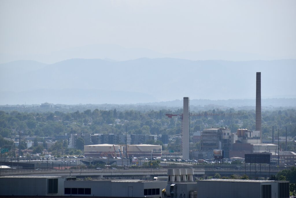
Wildfires in the American West are getting larger, more frequent and more severe. Although efforts are underway to create fire-adapted communities, it’s important to realize that we cannot simply design our way out of wildfire – some communities will need to begin planning a retreat.
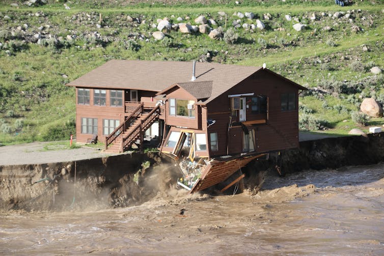
Paradise, California, is an example. For decades, this community has worked to reduce dry grasses, brush and forest overgrowth in the surrounding wildlands that could burn. It built firebreaks to prevent fires from spreading, and promoted defensible space around homes.
But in 2018, these efforts were not enough. The Camp Fire started from wind-damaged power lines, swept up the ravine and destroyed over 18,800 structures. Eighty-five people died.
Across the America West, thousands of communities like Paradise are at risk. Many, if not most, are in the wildland-urban interface, a zone between undeveloped land and urban areas where both wildfires and unchecked growth are common. From 1990 to 2010, new housing in the wildland-urban interface in the continental U.S. grew by 41%.
Whether in the form of large, master-planned communities or incremental, house-by-house construction, developers have been placing new homes in danger zones.
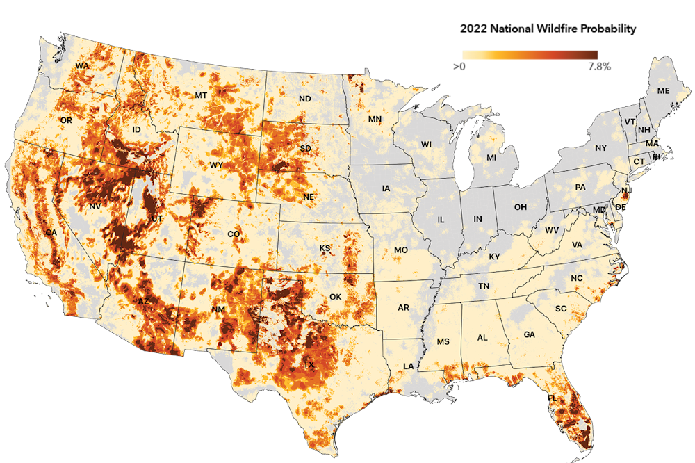
First Street Foundation created a national wildfire model that assesses fire risk at the local level to help communities understand and prepare. The map reflects the probability wildfire will occur in an area in 2022. First Street Foundation Wildfire Model
It has been nearly four years since the Camp Fire, but the population of Paradise is now less than 30% of what it once was. This makes Paradise one of the first documented cases of voluntary retreat in the face of wildfire risk. And while the notion of wildfire retreat is controversial, politically fraught and not yet endorsed by the general public, as experts in urban planning and environmental design, we believe the necessity for retreat will become increasingly unavoidable.
But retreat isn’t only about wholesale moving. Here are four forms of retreat being used to keep people out of harm’s way.
Limiting future development
On one end of the wildfire retreat spectrum are development-limiting policies that create stricter standards for new construction. These might be employed in moderate-risk areas or communities disinclined to change.
An example is San Diego’s steep hillside guidelines that restrict construction in areas with significant grade change, as wildfires burn faster uphill. In the guidelines, steep hillsides have a gradient of at least 25% and a vertical elevation of at least 50 feet. In most cases, new buildings cannot encroach into this zone and must be located at least 30 feet from the hillside.
While development-limiting policies like this prevent new construction in some of the most hazardous conditions, they often cannot eliminate fire risk.
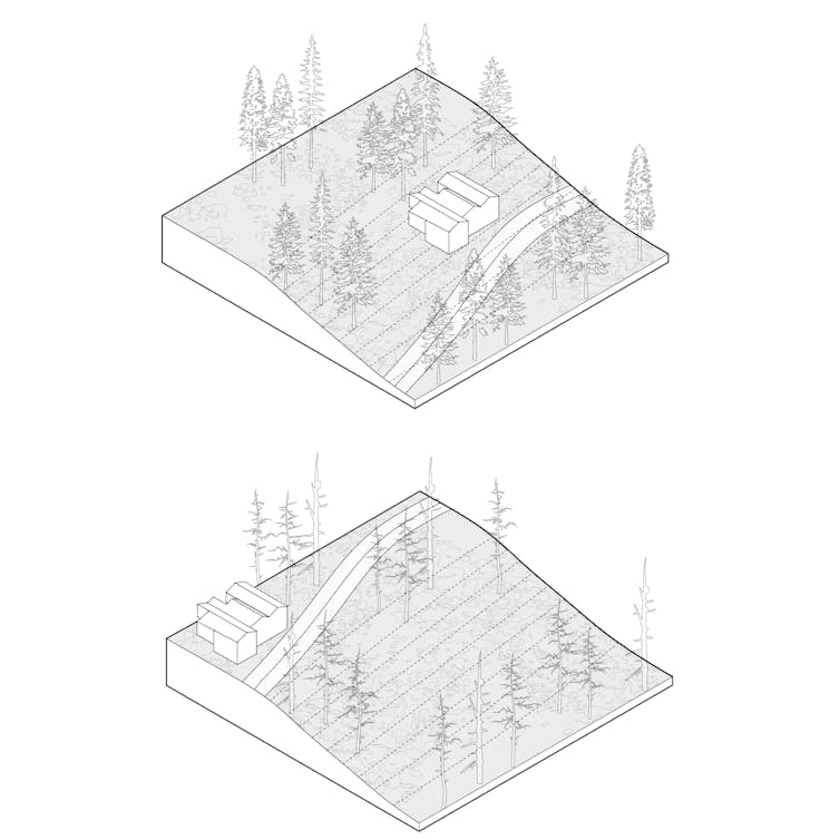
Development-limiting policies can include stricter construction standards. The illustration shows the difference between a home on a steep hillside that is hard to defend from fire and one farther from the slope. Emily Schlickman
Halting new construction
Further along the spectrum are construction-halting measures, which prevent new construction to manage growth in high-risk parts of the wildland-urban interface.
These first two levels of action could both be implemented using basic urban planning tools, starting with county and city general plans and zoning, and subdivision ordinances. For example, Los Angeles County recently updated its general plan to limit new sprawl in wildfire hazard zones. Urban growth boundaries could also be adopted locally, as many suburban communities north of San Francisco have done, or could be mandated by states, as Oregon did in 1973.
Halting construction and managing growth in high-risk parts of the wildland-urban interface is another retreat tool. Emily Schlickman
To assist the process, states and the federal government could designate fire-risk areas, similar to Federal Emergency Management Agency flood maps. California already designates zones with three levels of fire risk: moderate, high and very high.
Incentives for local governments to adopt these frameworks could be provided through planning and technical assistance grants or preference for infrastructure funding. At the same time, states or federal agencies could refuse funding for local authorities that enable development in severe-risk areas.
In some cases, state officials might turn to the courts to stop county-approved projects to prevent loss of life and property and reduce the costs that taxpayers might pay to maintain and protect at-risk properties
Threehigh-profileprojects in California’s wildland-urban interface have been stopped in the courts because their environmental impact reports fail to adequately address the increased wildfire risk that the projects create. (Full disclosure: For a short time in 2018, one of us, Emily Schlickman, worked as a design consultant on one of these – an experience that inspired this article.)
Incentives to encourage people to relocate
In severe risk areas, the technique of “incentivized relocating” could be tested to help people move out of wildfire’s way through programs such as voluntary buyouts. Similar programs have been used after floods.
Local governments would work with FEMA to offer eligible homeowners the pre-disaster value of their home in exchange for not rebuilding. To date, this type of federally backed buyout program has yet to be implemented for wildfire areas, but some vulnerable communities have developed their own.
The city of Paradise created a buyout program funded with nonprofit grant money and donations. However, only 300 acres of patchworked parcels have been acquired, suggesting that stronger incentives and more funding may be required.
Removing government-backed fire insurance plans or instituting variable fire insurance rates based on risk could also encourage people to avoid high-risk areas.
Another potential tool is a “transferable development rights” framework. Under such a framework, developers wishing to build more intensively in lower-risk town centers could purchase development rights from landowners in rural areas where fire-prone land is to be preserved or returned to unbuilt status. The rural landowners are thus compensated for the lost use of their property. These frameworks have been used for growth management purposes in Montgomery County, Maryland, and in Massachusetts and Colorado.
Incentivized relocating can be used in severe risk areas by subsidizing the movement of some people out of wildfire’s way. The illustrations show what before and after might look like. Emily Schlickman
Moving entire communities, wholesale
Vulnerable communities may want to relocate but don’t want to leave neighbors and friends. “Wholesale moving” involves managing the entire resettlement of a vulnerable community.
This technique, though, has drawbacks – from the complicated logistics and support needed to move an entire community to the time frame needed to develop a resettlement plan to potentially overloading existing communities with those displaced.
In extreme risk areas, wholesale moving could be an approach – managing the resettlement of an entire vulnerable community to a safer area. Emily Schlickman
Even with ideal landscape management, wildfire risks to communities will continue to increase, and retreat from the wildland-urban interface will become increasingly necessary. The primary question is whether that retreat will be planned, safe and equitable, or delayed, forced and catastrophic.
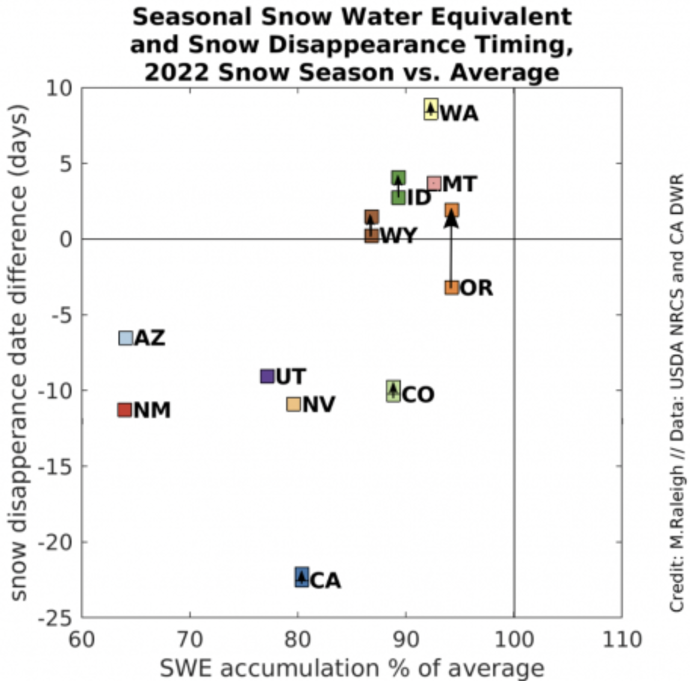
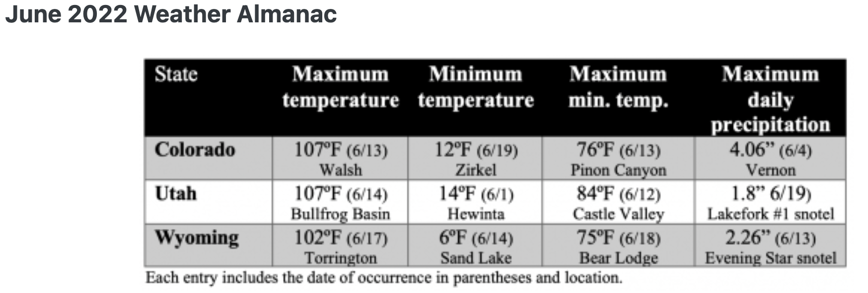
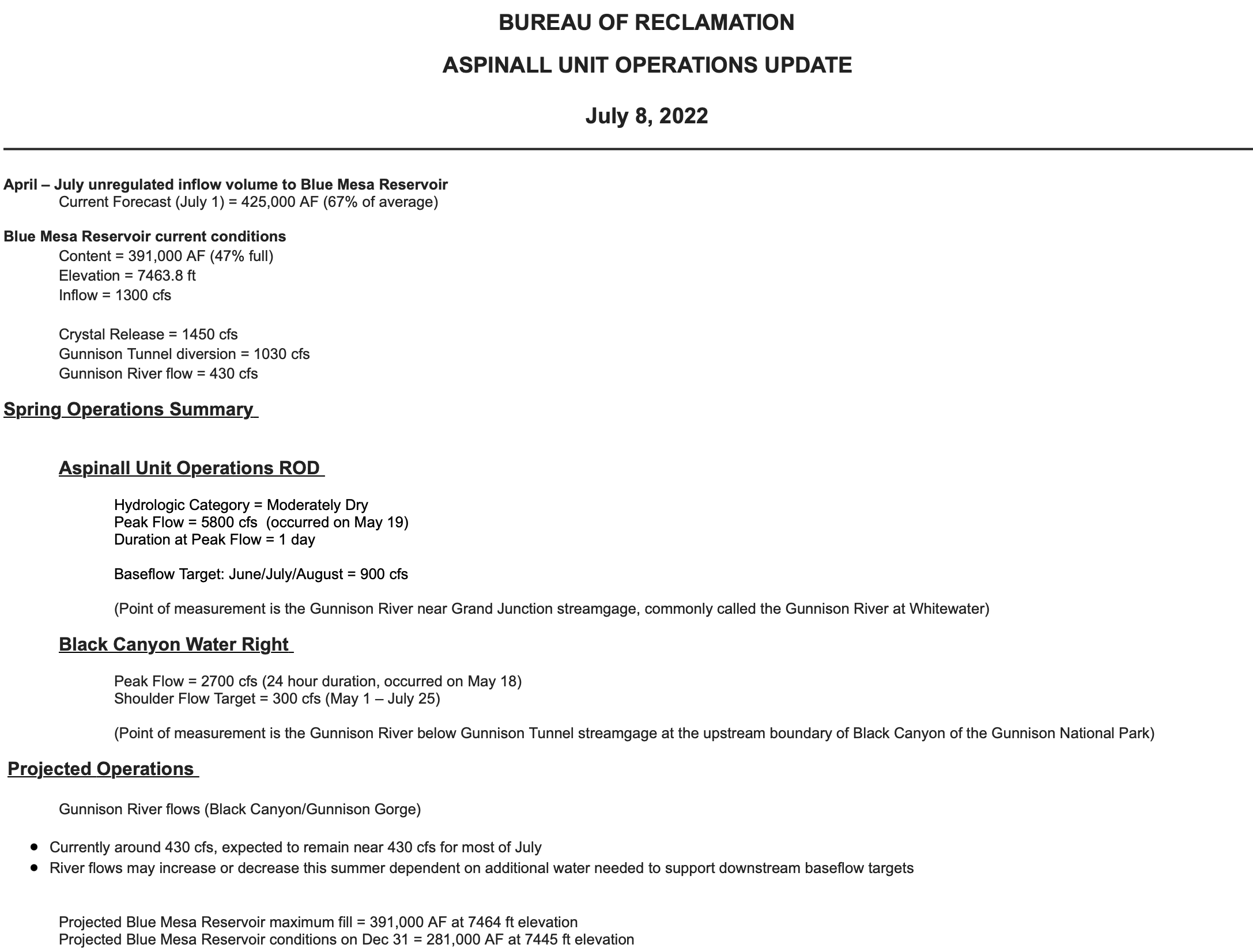
My family has been raising cattle in the Southwest for almost 50 years, and last year we experienced a first – producers in our valley did not receive any supplemental irrigation water from the reservoir. Agricultural producers in the river valleys and winding canyons of the Southwest are feeling the impacts of climate change. Temperatures are rising, snowpack is decreasing, runoff is occurring earlier in the year, and it’s becoming drier. As climate change continues to impact the Southwest, understanding how these environmental changes impact us will help farmers and ranchers like myself adjust our land management practices to remain resilient to drought and climate change.
Ecosystems Adapt & So Can We!
Areas that receive low amounts of rainfall are especially susceptible to changes in the environment. The plants and animals that live in dry areas are specialized to this unique landscape, and as the world around them changes, they must adapt or face extinction. Fortunately, healthy ecosystems respond to change, and so can we. The key to responding is diversity. Biodiversity is what gives species the genetic advantage they need to adapt to changing environments. The environment is changing, and just as genetic diversity allows for change, farmers and ranchers can proactively use innovative, versatile strategies to respond and help their enterprises survive.
Healthy Livestock Make Happy, Profitable Ranchers
Ensuring livestock remain healthy is the top priority for those who raise animals. Managed grazing that supports healthy soils and robust forage is a must. Lack of water affects the nutritional content and digestibility of forage. This leads to animals – and ranchers – becoming stressed. Adjusting stocking rates and pasture rotation are a few strategies recommended by the USDA Southwest Climate Hub that can help support the health of your pastures, which in turn supports the health of your animals.
Increased temperatures aren’t just uncomfortable; livestock consume more water when it is hot, making stock water especially important when water is scarce. Warmer temperatures also directly impact the health of our livestock, which in turn reduces profits. Providing access to pastures with trees or shade structures where livestock can get out of the sun is just as important as providing access to water.
It’s No Surprise That Plants Need Water
Photo courtesy of Sensa Wolcott
When water is limited, our fields produce less hay, forage and produce, making it challenging to grow what we need to be successful. Changing temperature will affect which crops thrive in particular areas. The Colorado State University Extension office provides many helpful strategies for how we can tackle these challenges. Prepare to make adjustments to the specific plants that you cultivate. Try planting crop varieties that require less water to thrive and research how specific crops use water. Rotate crops in a way that better promotes growth and productivity during drought and incorporate strategies that slow down water and increase infiltration, such as installing contour swales in fields.
Changes in temperature and precipitation patterns will impact the harvest timing of hay and produce and increase the likelihood of weeds popping up. Be prepared for changes in when you typically harvest and focus on increasing biodiversity by planting a mixture of different types of plants in a hayfield or pasture. Variety provides resilience as well as defense against invasive species, which are less likely to move into healthy, drought-resilient pastures and hayfields.
Healthy Watersheds Support Us All
Wetland. Photo courtesy of Sensa Wolcott
Water is critical to life in Colorado because it supports the biodiversity and health of the entire watershed, including the animals and plants so important to farmers and ranchers. Improving irrigation efficiency and upgrading diversion structures can help us adapt to rising temperatures that cause snow to melt and runoff earlier in the year. Early runoff means there is less water later in the season, when animals, plants, and irrigators all need water. Practicing irrigation strategies that encourage keeping rivers wet and implementing practices that increase groundwater storage support healthy waterways and support the needs of farmers and ranchers.
Riparian area management techniques like those mentioned in this article from Agri-Food Canada can benefit producers and the ecosystem. Try fencing livestock out of parts of the riparian corridor to support healthy riparian ecosystems. Livestock can cause erosion and water quality concerns – but well-planned access points that provide livestock with access to crucial drinking water can support both a healthy herd and a thriving waterway.
Farmers and ranchers want to see water in the river – the longer the better – which also supports the health and well-being of the aquatic ecosystem. Protecting our riparian areas is imperative; when our riparian corridors are healthy and thriving, so are we.
We Have a Choice
The future of agriculture is tied tightly to the future of our waters. Healthy ecosystems that have a variety of plants and animals are vital. Choosing innovative management strategies enables us to be good stewards of the natural world while also improving our farms and ranches so that we all can remain resilient in the face of drought and a changing climate.
Sensa Wolcottt.
Sensa Wolcott works as the Watershed Coordinator for the Mancos Conservation District. She is pursuing her Masters in Biology through Miami University’s Project Dragonfly, where her work focuses on community-based conservation and connecting people with the land through dialogue and collaboration. Sensa and her family live on their family owned and operated cattle ranch and enjoys hiking, camping, mountain biking, and photography.
Mancos and the Mesa Verde area from the La Plata Mountains.
Click the link to read the article on the NOAA website:
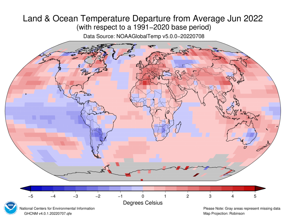
Globally, June 2022 was the sixth-warmest June in the 143-year NOAA record. The year-to-date (January-June) global surface temperature was also the sixth warmest on record. According to NCEI’s Global Annual Temperature Outlook, there is a greater than 99% chance that 2022 will rank among the 10-warmest years on record but only an 11% chance that it will rank among the top five.
This monthly summary, developed by scientists at NOAA’s National Centers for Environmental Information, is part of the suite of climate services NOAA provides to government, business, academia and the public to support informed decision-making.
Monthly Global Temperature
The June global surface temperature was 1.57°F (0.87°C) above the 20th-century average of 59.9°F (15.5°C). This ranks as the sixth-warmest June in the 143-year record. June 2022 marked the 46th consecutive June and the 450th consecutive month with temperatures, at least nominally, above the 20th-century average. The ten-warmest Junes on record have all occurred since 2010.
The Northern Hemisphere land-only surface temperature for June was 2.81°F (1.56°C) above average, making it the second warmest on record after June 2021. Europe had its second-warmest June on record, largely due to an unusually early heatwave heat wave coming from North Africa. Spain and France recorded temperatures not typically seen until July or August, breaking many temperature records for the month. Asia also had its second-warmest June on record.
Temperatures were above average throughout most of North America, Europe, and Asia and across parts of northern Africa, the Arabian Peninsula, and western and northern Oceania. Parts of China, the Middle East, and northern Africa experienced record-warm temperatures for June. Sea surface temperatures were above average across much of the northern, western, and southwestern Pacific, as well as parts of the Atlantic and eastern Indian oceans.
Temperatures were near- to cooler-than-average across parts of western and southern South America and in small areas of eastern Australia, western Russia, and southern Africa. Consistent with La Niña, sea surface temperatures were below average over much of the south-central, central, and eastern tropical Pacific. There were no areas with record-cold June temperatures in 2022.
Sea Ice
Globally,June 2022 saw the second-lowest June sea ice extent on record. Only June 2019 had a smaller sea ice extent.
June 2022 Arctic (left) and Antarctic (right) sea ice extent. Courtesy of NSIDC and NOAA.
Arctic sea ice extent in June averaged 4.19 million square miles, which is 347,000 square miles — roughly the size of Sweden, Norway, and Denmark combined — below the 1981-2010 average and the 10th-smallest June extent in the 44-year record. According to an analysis by theNational Snow and Ice Data Center(NSIDC), regional sea ice extent was below average in the Barents, Chukchi, East Siberian, and Kara seas and Hudson Bay, while conditions in Baffin Bay were near normal. The 10-smallest June Arctic sea ice extents have occurred since 2010.
Antarctic sea ice extent for June was a record low at 4.68 million square miles, or about 471,000 square miles below average. Following a below-average Antarctic sea ice extent in May, sea ice growth in June was slower than average.
Global Tropical Cyclones
June 2022 produced five named storms across the globe, which is near-normal activity for June. Only one of those, Hurricane Blas, reached tropical cyclone strength (74 mph) in June, but two storms that formed in June later reached cyclone strength in July. The global cyclone activity for January through June remains near normal by most metrics.
Although it was only a tropical storm for about 30 hours, Tropical Storm Alex was the Atlantic’s first named storm of the season. The East Pacific had two named storms in June, which is near-average activity. The West Pacific, which has below-average year-to-date activity, only had one named storm this month.
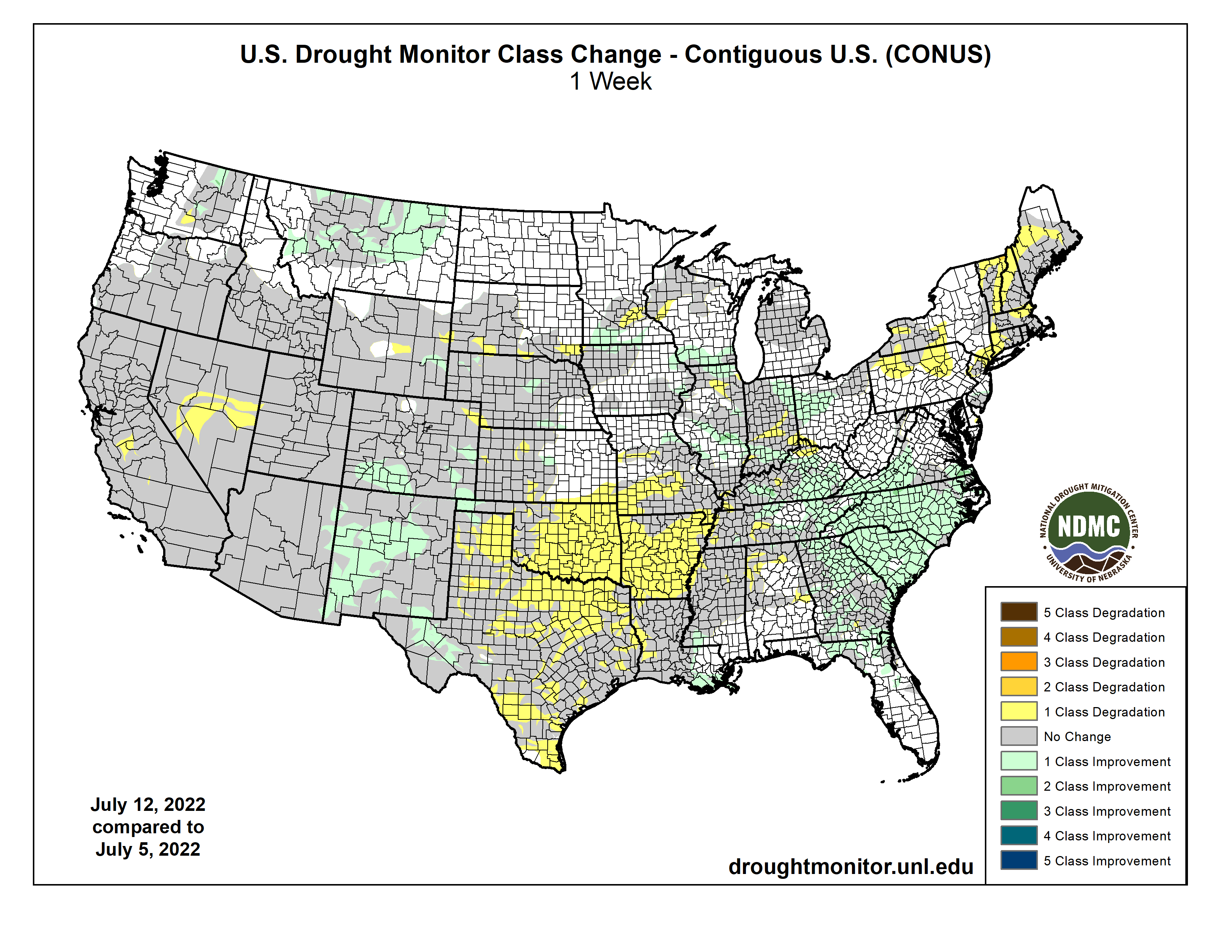
An active weather pattern over much of the Midwest and Southeast brought with it ample rain over many areas, with some places recording more than 5 inches for the week. Dry conditions were noted in the Northeast, West, and southern Plains where flash drought conditions were impacting vast portions of Texas, Oklahoma, Arkansas and into the lower Mississippi River valley. Monsoonal moisture continued to be spotty over much of Arizona and New Mexico, reaching into portions of west Texas as well as southern Colorado and Utah. Temperatures were near normal to slightly above over most of the U.S., with cooler-than-normal temperatures over portions of the West, Northeast, and Mid-Atlantic and above-normal temperatures over most of Texas, Oklahoma, Arkansas, and southern Missouri…
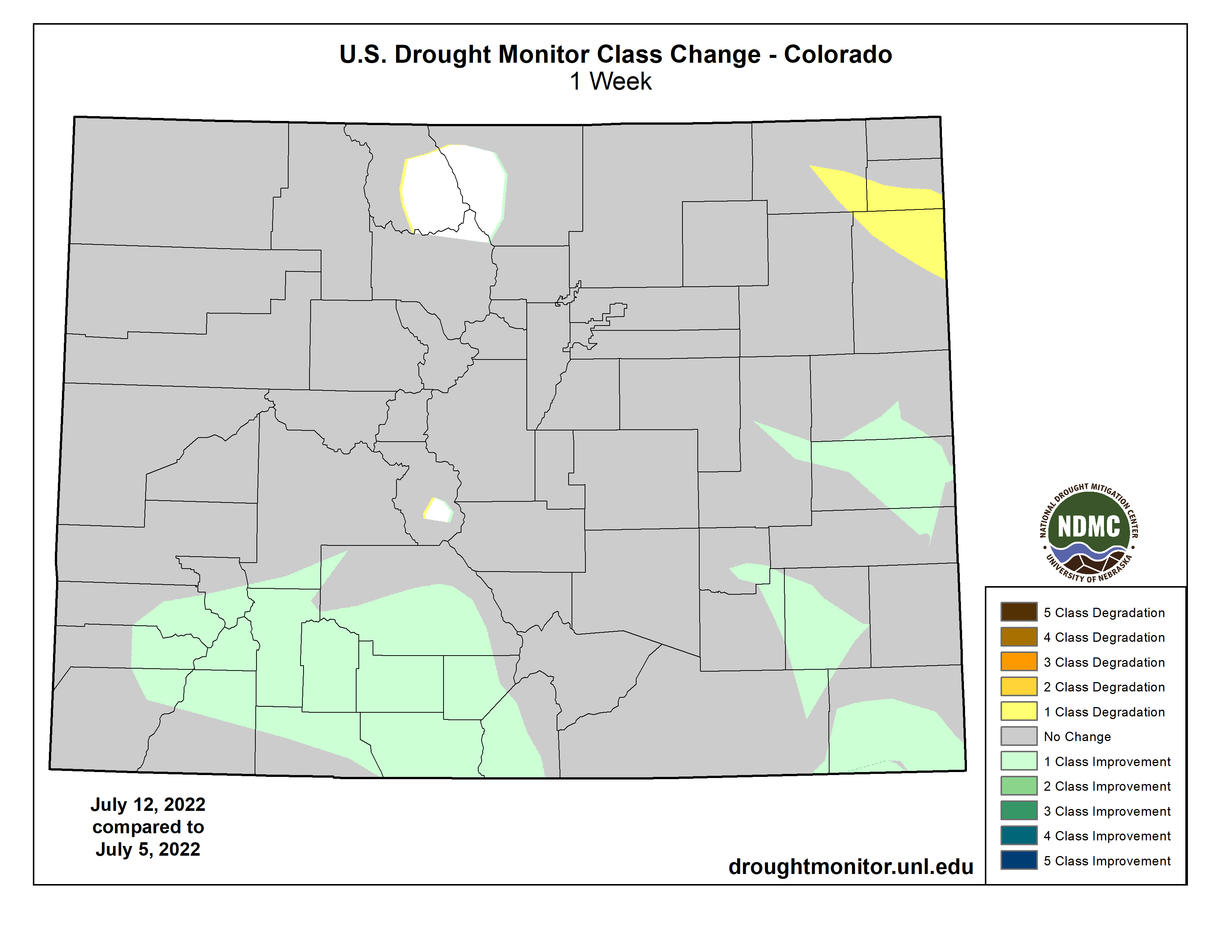
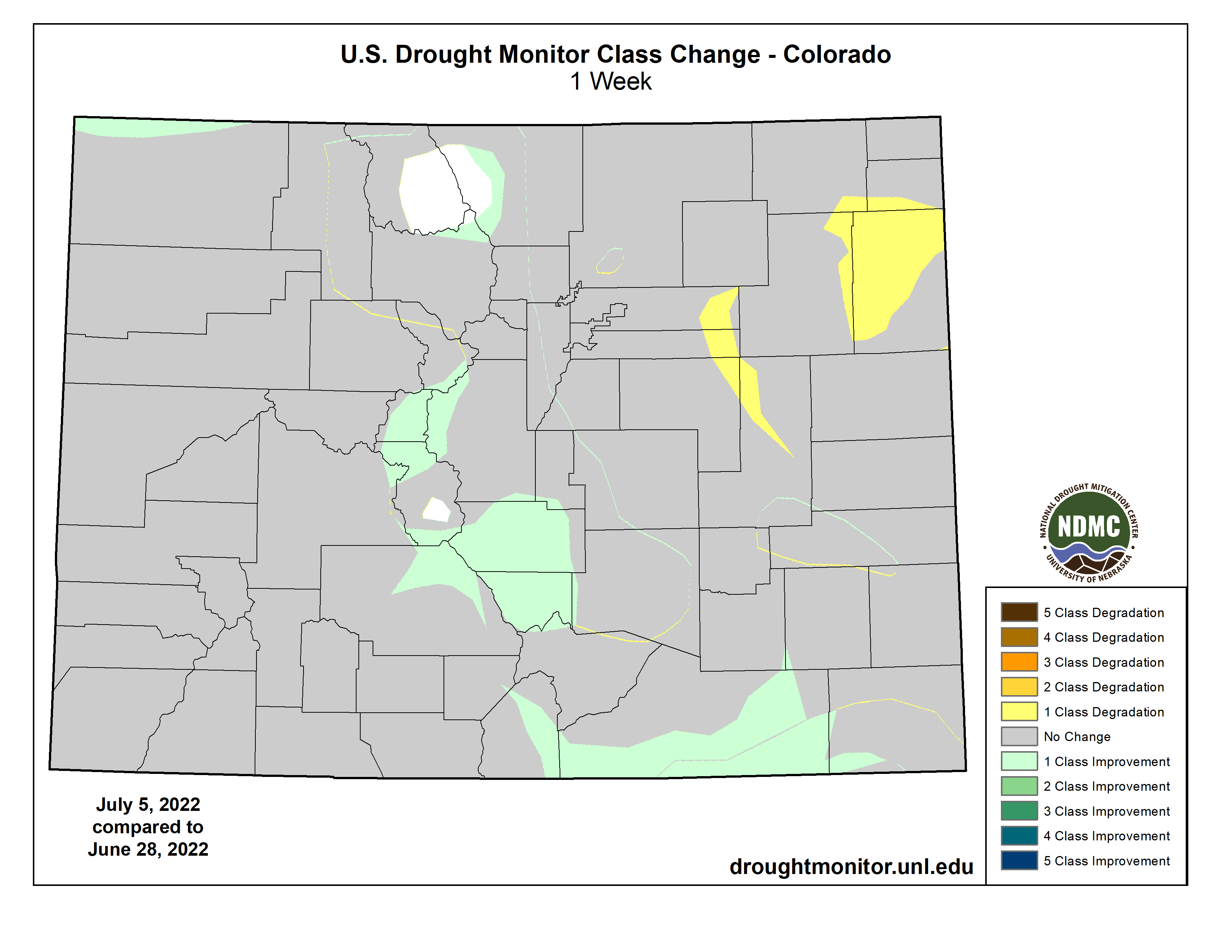
Most of the region had warmer-than-normal temperatures for the week, with most areas 1-3 degrees above normal. Heavy rains through western North Dakota, central and eastern South Dakota, northwest and central Nebraska, and northeastern Kansas helped with some dryness in the areas. The scattered nature of the rains left many dry, though, as summer thunderstorms were hit or miss in the region. Some improvements were made in Nebraska and central Kansas as well as on the plains of Colorado and Wyoming this week where the short-term wetness helped to alleviate concerns. Degradation took place over central Wyoming, southern South Dakota and western Kansas where longer-term dryness has been in place and most of these areas have missed out on earlier precipitation events. Exceptional drought was removed in southeast Colorado and extreme drought was reduced this week. Southeast Kansas is an area where abnormally dry and moderate drought expanded this week, as they are on the northern fringe of a flash drought that has been developing over the last 4-5 weeks…
Colorado Drought Monitor one week change map ending July 12, 2022.
Cooler-than-normal temperatures prevailed from the Pacific Northwest into much of California and western Nevada, where temperatures were 1-3 degrees below normal. Much of the rest of the region was normal to slightly above normal for the week. Above-normal rains fell in portions of Oregon and Washington as well as in Montana. Monsoonal moisture continues in New Mexico and Arizona, but it is widely scattered in nature compared to earlier in June. The rains did allow for some improvement in areas of New Mexico, where extreme and severe drought were reduced, and western Arizona, where severe drought was reduced. Severe drought was improved in southwest Colorado and much of the drought area of Montana had a full-category improvement. Moderate drought and abnormally dry conditions were adjusted in Washington to show a mix of improvements and some expansion of moderate drought. Extreme and exceptional drought was expanded over central Nevada and exceptional drought was expanded to include more of the San Joaquin Valley in California…
The region was mainly dry outside of some monsoonal moisture that made it into portions of West Texas and the panhandle. Portions of southwest Mississippi into southern Louisiana also benefited from above-normal precipitation this week. Some of the warmest temperatures in the country were observed in the region this week with many places having multiple days of triple-digit heat. Temperatures were 5-10 degrees above normal over much of the region as flash drought has developed. With the rapidly developing situation, without relief from the heat or precipitation, drought will continue to intensify rapidly. There were many changes to the drought intensity of the region this week, with only areas of west Texas and the panhandles of Texas and Oklahoma showing any improvements. Almost all of eastern Oklahoma, northern Texas, and Arkansas had a full-category degradation this week. Further degradation took place over central and southern Texas as well as portions of northern and western Louisiana. Coleman County, Texas had its driest January-to-June period on record going back to 1895. Other counties that had the driest first six months of the year were Bosque, Hamilton, Coryell, Wilson, Karnes, and Bee counties in Texas and Calcasieu Parish in Louisiana. There has been an uptick in the number of cattle sales taking place as water and feed demands are being impacted by the drought…
Looking Ahead
Over the next 5-7 days, it is anticipated that the monsoonal moisture will continue to bring rains throughout the Four Corners region. Active weather over the Midwest, Gulf Coast and Southeast will again bring widespread precipitation. Precipitation in the central Plains and northern Rocky Mountains will be minimal and dry conditions will continue to dominate the West as well as much of the southern Plains. Temperatures during this period will be well above normal over the western half of the U.S. with temperatures 6-9 degrees above normal while cooler-than-normal temperatures will be common over the eastern half with departures of 1-3 degrees below normal.
The 6-10 day outlooks show that the vast majority of the country has above-normal chances of recording temperatures that will be warmer than normal. The greatest probability of above-normal temperatures will be over the central to southern Plains. Alaska has above-normal chances of having cooler-than-normal temperatures during this time. The best chance of above-normal precipitation is over the Southwest and Southeast while much of the rest of the country will likely have below-normal precipitation, with the greatest chances in the Pacific Northwest and southern Plains.
US Drought Monitor one week change map ending July 12, 2022.
They’re seeking opportunity, fairness, and a voice in decision making after a century of exclusion
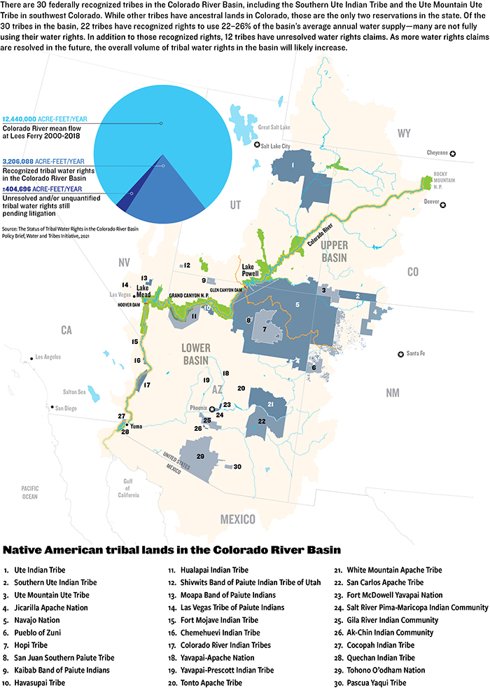
Mid-morning in early September 2020, leaders from eight tribal nations met with Arizona state legislators, water engineers and policy experts via Zoom. One by one, each recounted their tribe’s history and efforts to secure water for their citizens. Half of the tribes in Arizona have unresolved claims to water. Of the 30 federally recognized sovereign tribal nations in the U.S. segment of Colorado River Basin, the vast majority, 22, are in Arizona.
Meeting that day was the Arizona Governor’s Water Augmentation, Innovation and Conservation Council, a committee of state legislators and water policy experts convened to plan for Arizona’s share of diminishing resources in the Colorado River Basin.
Not quite a year later, in August 2021, federal officials issued the first-ever shortage declaration on the river, resulting in substantial cuts to Arizona’s share of Colorado River water. The state has been working with some of the tribes with resolved, adjudicated water rights to help make up for low water levels.
On that September morning in 2020, two things had become clear: First, tribes like the Navajo Nation, Pascua Yaqui Tribe, and Yavapai-Apache Nation have found a couple of conditions in Arizona’s policy toward negotiating Indian water settlements unacceptable, thus their water rights remain unsettled. And second, tribal nations had been collaborative partners to surrounding communities and were, and continue to be, positioned to play an increasingly pivotal role throughout the basin as more tribal water rights are settled and basin-wide water supplies continue to decline.
Tribes have played a pivotal role in leasing water to support other water users and states as they cope with water shortage, for example. But with so many tribes who still have unsettled water rights and Colorado River flows declining, big questions remain for the 40 million people spread throughout the basin in seven U.S. States and Mexico—many of those questions center around the tribes.
Ticking Clock
Everyone in the basin can hear the clock, ominously dripping time like a leaky faucet. Drip: There is less water than ever before with the basin ensnared in a 22-year megadrought, the worst in the past 1,200 years, according to a recent study published in the journal Nature Climate Change. Drop: Without swift action to conserve water under the growing pressure of demand, the basin may be hurtling toward a water crisis. Drip: The basin’s existing water shortage management framework is set to expire in 2026 so negotiations to craft the next framework are underway; will tribal nations be included in those negotiations? Drop: How will water shortages affect the tribal nations in the Colorado River Basin and what role will those tribes play as all water users cope with shortage?
Generally, the Colorado River Basin’s tribes have some of the senior-most water rights on the river, based on federally “reserved” water rights with priority dates aligned with the dates reservations were established, some as early as 1865.
But even today, 12 of the basin’s tribes (most in Arizona) have unresolved water rights claims, and eight of those 12 have unquantified rights—meaning the amount of water they have a right to is not yet determined. Simply securing those water rights remains a time-consuming and arduous endeavor, in costly settlement negotiations amidst a scrum of other water users staking claims.
The water held by the basin tribes who have legally quantified water rights amounts to no small sum: 22 tribal nations retain 3.2 million acre-feet of water, or an estimated 22% to 26% of all annual water supplies in the basin, according to a 2021 brief from the Water and Tribes Initiative. This amount will likely increase over the years once more tribal water claims are resolved.
Even for tribes with settled or adjudicated water rights, some can’t access the full extent of that water because of lack of infrastructure or funding, or both. In total, just under half, or 1.5 million-acre-feet, of settled or adjudicated tribal rights have not yet been put to use by the tribes.
When adding together that unused water and unquantified water, and considering that tribes plan to fully develop and use their water, other water users in the basin wonder how it will look to integrate expanded tribal water use with existing water uses as water supplies continue to dwindle.
Lack of Representation
In one blinding instant, a flashbulb floods the adobe-walled room, illuminating a row of stoic men: seven state water commissioners standing behind then-Secretary of Commerce Herbert Hoover who sat at a desk. In front of them lies the 1922 Colorado River Compact, the formative agreement to carve up flows of the Colorado River. Within the Palace of the Governors in Santa Fe, N.M., these men divided the river into an upper and lower basin, apportioning the rights to consume 15 million acre-feet of water—their estimation of average annual river flow at the time—between the seven U.S. basin states: Colorado, New Mexico, Utah and Wyoming of the upper basin, and Arizona, California and Nevada of the lower basin, with the opportunity for lower basin states to develop an additional 1 million acre-feet from tributaries below Lee Ferry, Ariz.
The compact ushered in a new era of water management for the Colorado River Basin. But now, 100 years later, when facilitator of the Water and Tribes Initiative, Daryl Vigil, peers at this photograph of Hoover and the state water commissioners, he sees an “all monochromatic photo of older white gentlemen” who made no plan for apportioning any share of water to Native American tribes.
Herbert Hoover presides over the signing of the Colorado River Compact in November 1922. Members of the Colorado River Commission stood together at the signing of the Colorado River Compact on November 24, 1922. The signing took place at the Palace of the Governors in Santa Fe, New Mexico, with Secretary of Commerce Herbert Hoover presiding (seated). (Courtesy U.S. Department of Interior, Bureau of Reclamation)
Since the beginning of U.S. tribal water law, sovereign tribal nations in the basin have been excluded from cornerstone water management decisions despite having senior title to water. Native American water rights were first officially recognized in 1908, over a decade before the Colorado River Compact was signed, with the U.S. Supreme Court’s Winters v. United States decision. The court found that when the federal government “reserved” territories known as reservations, it too had “reserved” sufficient water to fulfill the purposes of the reservations—these water rights are considered established at the date when the reservation was created, making them senior to all uses that came later. But having the right to reserved water didn’t mean that the tribes had access to actual “wet” water or the legal representation to quantify their water rights.
When the 1922 compact was signed, tribes were surviving a multitude of disastrous living conditions and forced assimilation produced by federal Indian policy, established after U.S. violent colonial expansion. Indigenous peoples weren’t recognized as U.S. citizens until 1924, tribal governance wasn’t federally recognized until 1934, and Native Americans couldn’t vote in every state until the 1960s. “We were surviving here on government rations in 1922 when the Law of the River was created,” says Vigil.
A 1928 survey entitled “The Problem of Indian Administration” found that 26 Western Native American reservations and their economic bases were crumbling under management of the U.S. Department of the Interior (DOI), asserting that colonialism largely destroyed their ability to hunt, gather and fish.
The report recommended educating tribes to effectively use their land and water rights, saying that administrators “should be given the duty of seeing that the Indians secure their rightful share of water.” This recommendation was not enough. Assigning concrete legal title to tribal water succumbed to federal delay—a defining feature of water rights disputes for all tribal nations.
Tribes gained some ground when, in 1963, tribal water policy and Colorado River policy intersected in the U.S. Supreme Court’s Arizona v. California decision. Lengthy litigation led up to the decision, with Arizona filing suit in the U.S. Supreme Court to determine how much Colorado River water it could use. To answer that question, the U.S. found it had to assess what reserved water rights were needed for some of the tribes in the lower basin. A special master for the case determined the future needs of each reservation by assessing the amount of practicably irrigable acres and reserving water to irrigate that land rather than considering the reservations’ populations. In his proposed decree, which was upheld by the Supreme Court, the special master entered a quantified water right for five reservations on the mainstem of the Colorado River, granting 905,496 acre-feet of water for 135,636 irrigable acres.
After the case established the standard of quantifying the tribal reserved water right as looking at the amount of water required to irrigate the irrigable acreage on the tribal land, the push to quantify more tribal water rights ensued. But Supreme Court rulings “grew more negative,” according to a presentation from DOI. In 1989, DOI adopted the policy to resolve Indian water disputes through settlement rather than litigation, creating the Secretary’s Indian Water Rights Office. To reach agreement, Indigenous nations must negotiate their rights within a massive tangle of other users staking claims to water within the state where their reservation is located, which can take decades. Once all parties concur, Congress must approve the agreement by passing legislation to fund any tribal water infrastructure projects.
As federal tribal water policy evolved, so too did Colorado River policy. After the 1922 compact, a series of layered agreements—including Arizona v. California and other court decisions, congressional acts, legal settlements, treaties and compacts—known collectively as the “Law of the River” have come to govern the way water is managed and divided throughout the basin.
The latest layers of the Law of the River have been implemented since 2000, in response to years of drought. In 2007, the U.S. Secretary of the Interior adopted the Interim Guidelines for Lower Basin Shortages and Coordinated Operations for Lake Powell and Lake Mead. The Interim Guidelines outline a method to balance the amount of water available between the upper and lower basins. In 2019, upper and lower basin Drought Contingency Plans (DCPs) were developed as additional frameworks to address water shortages and water-saving rules.
The upper basin continues to “equalize” the contents of Lake Powell and Lake Mead per the 2007 guidelines, and continues to pursue water augmentation activities such as cloud seeding. It is also exploring the possibility of developing a demand management program in which water saved or not used in the upper basin could be stored in Powell as a 500,000 acre-foot drought pool, though the Colorado Water Conservation Board put a “hard pause” on Colorado’s demand management investigation in March 2022. For the lower basin, the DCP, a Binational Water Scarcity Contingency Plan with Mexico, and the 2007 guidelines lay out cuts in water deliveries from the Colorado River, triggered by projections of Lake Mead storage elevations. The interim guidelines already outlined cuts but the DCP added additional delivery reductions for the lower basin states and Mexico to absorb. The greatest cuts to lower basin water use will come from Arizona and California but the entire lower basin, including Mexico, will share in scarcity.
When these guidelines and plans were crafted, all but the Lower Basin DCP received little to no tribal input. These plans will expire in 2026, and negotiations for the next phase of shortage-sharing agreements are just beginning.
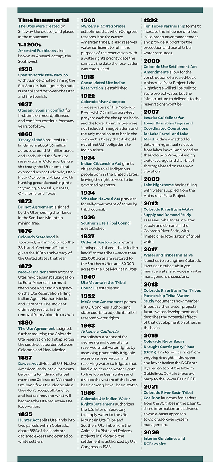
Native American Timeline. Credit: Water Education Colorado
Vigil, who is also water administrator for the Jicarilla Apache Nation from New Mexico, joined the Water and Tribes Initiative in 2017 to facilitate tribal discussions, protect water rights, and unify tribal interests within the Colorado River Basin. Their tribal leader forums helped spur a coalition of the tribes in the basin to call for inclusion in water framework negotiations.
When new guidelines are developed to govern river management beyond 2026, how will they affect existing tribal water rights or unresolved water claims? “Those are questions that are not yet clear to the Ute Mountain Ute Tribe and probably other tribes,” says Leland Begay, water attorney for the Ute Mountain Ute Tribe, which has adjudicated water rights in Colorado but has not yet resolved its water rights in New Mexico and Utah.
Settled Water Rights for the Colorado Ute Tribes
During the hot summers of his childhood, Lyndreth Wall of the Ute Mountain Ute Tribe would take refuge on Ute Mountain in southwestern Colorado, herding livestock at his grandparents’ sheep camp. They spoke only Ute to him, which he picked up fast, at least conversationally. In those days, the 1970s, the water on Ute Mountain was delicious. “The tribe took care of the water there,” Wall says. But his home tap water in Towaoc tasted like metal. It was “disgusting,” he says, and could make you sick. In White Mesa, their western tribal community in Utah, the water was worse—contaminated by radioactive waste.
For young Wall, his neighbors, family and livestock, the journey to procure drinkable water would be a 30- to 120-mile round trip excursion from Towaoc to Cortez or Mancos, even Durango, Colo. Wall remembers his parents packing buckets in their family pickup—the Wall’s buckets mixed with those of neighbors. This supply would last a few days before they would need more.
Today, more Ute Mountain Ute tribal members have water for drinking and irrigation thanks to the 1986 Colorado Ute Indian Water Rights Final Settlement Agreement, followed two years later by a federal settlement act, and by amendments in 2000, all of which they share with the Southern Ute Indian Tribe. The settlement places the Colorado Ute tribes among the four tribes in the upper Colorado River Basin that have completed water rights settlements, which also means that the State of Colorado is no longer negotiating any tribal settlement agreements.
For the Ute Mountain Ute Tribe, the settlement meant access to Dolores Project water, an entitlement to Animas-La Plata Project water, and rights to over 27,000 acre-feet of water from rivers that flow near or through their reservation. Most years, the Ute Mountain Ute Tribe can access their 25,100 acre-foot water storage allocation from the Dolores Project’s McPhee Reservoir in southwestern Colorado. Water from McPhee began to flow to the Ute Mountain Ute Tribe in 1994 delivering clean drinking water to the tribe for the first time in their history and supporting the development of a hotel, travel center and casino, which provide vital tribal employment and income. The tribe’s new irrigation water from the Dolores Project, up to 23,300 acre-feet per year, supported the development of the highly productive 7,700-acre Ute Mountain Ute Farm and Ranch Enterprise and Bow and Arrow corn mill.
For the Southern Ute Indian Tribe, the settlement wasn’t quite as momentous. “We have seven sources of water, seven rivers, that run to the tribe, so the tribe had been accessing those waters pre-settlement,” says Kathy Rall, head of the water resources division for the Southern Ute Indian Tribe. Before the settlement, the tribe didn’t have quantified rights to that water, Rall says. “Those rights were hammered out and solidified through the settlement,” she says. The Southern Ute Indian Tribe also received an allocation of Animas-La Plata Project water—but the infrastructure was never built for either tribe to access that water.
“Ever since [the Animas-La Plata Project] was constructed, we’ve never used a drop of it, yet we have a certain percentage, not only to us, but also our sister tribe, the Southern Ute,” says Wall, who is now a tribal councilman for the Ute Mountain Ute Tribe. The project allocated more than 60,000 acre-feet per year of municipal and industrial water to the Ute Mountain Ute Tribe and the Southern Ute Indian Tribe, but a series of obstacles has made this water inaccessible.
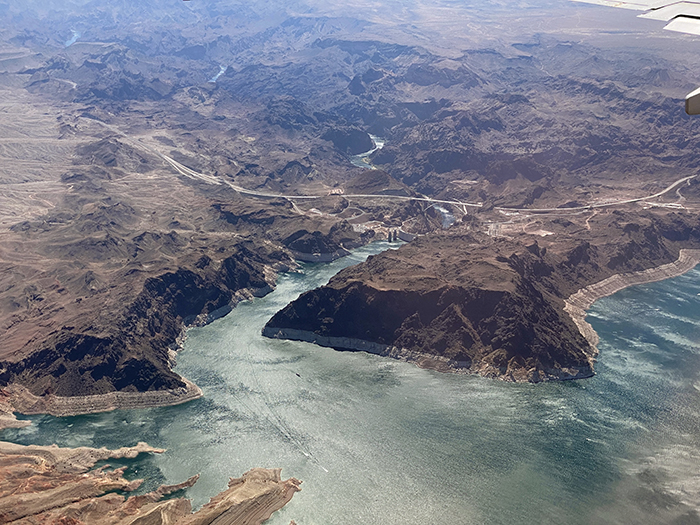
Lake Nighthorse and Durango March 2016 photo via Greg Hobbs.
The settlement authorized the construction of Lake Nighthorse, just south of Durango, to store Animas-La Plata water for tribal water uses. The project was envisioned to bring water for irrigation, municipal and industrial uses to the tribes and non-tribal water users. But environmental and fiscal concerns resulted in the project being downsized.
A lawsuit halted the construction of Lake Nighthorse’s Ridges Basin Dam in 1992. Groups including the Environmental Defense Fund, Sierra Club, and the Taxpayers for the Animas River argued the dam’s cost was an undue burden for taxpayers and that its construction would threaten the Colorado pikeminnow fish population, which was federally listed as endangered at the time. Christine Arbogast, lobbyist for the Ute Mountain Ute Tribe, Southern Ute Indian Tribe, and neighboring water districts and municipalities, remembers a meeting where an environmental advocate said that with the amount of funding required to build the reservoir project, they could supply the tribe with bottled water for life. “That was the kind of mentality on the side of the environmental community,” says Arbogast.
As project proponents tried to advance Lake Nighthorse, part of the permitting requirement was to propose alternatives to the project. To address the endangered fish issues, the U.S. Fish and Wildlife Service approved an alternative that would allow for reservoir construction but with certain requirements, including a new San Juan River Basin Recovery Implementation Program. The recovery program would go on to manage the river to recover the endangered Colorado pikeminnow and the razorback sucker while allowing water development to continue.
To carry out the Animas-La Plata Project, a 2000 settlement amendment restricted the water in Lake Nighthorse to municipal and industrial use, excluding irrigation. Now referred to as “Animas-La Plata Lite” there was no longer any plan to construct the irrigation canals that would have connected Lake Nighthorse to the tribes and even neighboring water districts and municipalities that were counting on these water supplies throughout the negotiations. The tribes scrapped their plans to expand farmlands as a result. “It was heartbreaking to every single one of them, including the tribes, when we had to make the decision to shelve the irrigation component in order to get this settlement,” Arbogast says.
Some positive outcomes resulted from the settlement, including quantified and adjudicated water rights for the Southern Ute Indian Tribe, access to Dolores Project water for the Ute Mountain Ute Tribe, and funding for both tribes, Rall says. But ongoing lack of access to water stored in Lake Nighthorse and the inability to use that water, if accessed, for irrigation, was “disastrous” she says.
When the project was downsized to the “lite” version “we just kind of said, ‘OK, we’re going to get what we get,’” Rall says. “The tribe went, ‘If we don’t settle now, who knows what we’ll end up with.’”
The settlement means that the tribes’ water allocations are protected, which “does offer the tribes a measure of security in their water rights,” says Amy Ostdiek, head of the Colorado Water Conservation Board’s Interstate and Federal Section. “But there are still critical needs in terms of infrastructure and access to clean drinking water.”
As the settlement stipulates, the moment the tribes begin to use water from Lake Nighthorse, they will each inherit an annual bill of around $800,000 in operations and maintenance costs for the dam and pumping facilities that the federal government is currently footing. At the moment, there is still no infrastructure to deliver the water to the tribes, and the tribes are not prepared to take on those costs, so they haven’t used any of their water. This may change due to the $2.5 billion earmarked in the 2021 Infrastructure Investment and Jobs Act for completion of authorized Indian water rights settlements. Both Colorado Ute tribes are pursuing that funding, with full support from the State of Colorado, according to the Colorado Water Conservation Board (CWCB), but whether they will receive it remains to be seen. Information sessions on the bill between tribal nations and DOI are ongoing.
“We’re trying to find alternatives and ways that we can utilize our water in [Lake] Nighthorse. We want it and it seems like we’re having a water war,” says Wall. “What’s rightfully ours is ours by God. We need to continue to save it for the future of our tribe.”
Water or Land, Not Both
Settling and quantifying tribal water rights claims isn’t just beneficial to tribal nations. The state in which a reservation is located and other water users there benefit from the certainty of knowing how much water is allocated to the tribes so they can make plans to live within and stretch their own share or to work together to send water where it’s most needed.
But Arizona is home, at least partially, to 11 of the 12 tribal nations in the basin who still have unresolved claims to Colorado River water—resulting in uncertainty for the state and the tribes. Many tribal leaders are frustrated by the state’s unprecedented condition for tribes to secure their water rights: In exchange, tribal nations must surrender their right to freely enter fee lands into trust, an essential administrative program of the Bureau of Indian Affairs that lets tribes recover their ancestral homelands. Instead, tribes would need congressional approval to have the Interior Secretary take lands into trust.
“We just believe that the congressional process is a more equitable forum for the discussion of those lands into trust,” says Tom Buschatzke, director of the Arizona Department of Water Resources. He cites the importance of hearing from local communities that could be impacted when the tribes bring additional ancestral homelands into trust and ensuring “politically elected leaders get to make the decision.”
That stipulation is a nonstarter for many tribes, and puts them in a precarious position, weighing their right to re-acquire their ancestral homelands against securing water for their people.
“That’s something we will never agree to,” Yavapai-Apache Nation Chairman Jon Huey told the Governor’s Water Augmentation Innovation and Conservation Council during that September 2020 meeting. The Yavapai-Apache Nation plans to bring land into trust, re-acquiring its homeland to build housing for the growing tribal population.
Already, leaders from the Navajo Nation, Tonto Apache Tribe, Yavapai-Apache Nation, and Pascua Yaqui Tribe in southern Arizona have worked for decades with the state and other water districts to reach a settlement. For example, the Navajo Nation has been in recurring negotiations since 1993.
Tribes also object to a condition proposed by Arizona officials that they waive their right to object to future off-reservation groundwater pumping.
Despite hearing from leaders like Huey, the state has not changed its position. Buschatzke says these conditions are just part of the “give and take” nature of settlements. “Some things you give more of, some things you give less of,” he says. “And the whole package has to fit together for both sides at the end of the day in a way that they can live with it and in a way that they believe, hopefully, that they’re better off with the package than they are without the package.”
DOI remains dedicated to facilitating settlement discussions and is aware of the tribal concerns toward Arizona’s anti-fee-to-trust policy. “We are working from the federal perspective closely with tribal partners and with non-federal entities like the State of Arizona to bring these issues to conclusion and resolution,” says Tanya Trujillo, assistant secretary for water and science at DOI, who has been part of these tribal settlement discussions.
Working Together in Shortage
Water levels in Lake Mead have dropped to historic lows over the past year, triggering a shortage declaration on the Colorado River. Some of the frameworks that govern how the river is managed are set to expire in 2026. As states and stakeholders negotiate the next management framework, tribal nations want to make sure they have a seat at the table. Photo by Jeffrey Hayes / Flickr
Despite some of the barriers to settlement, Buschatzke concedes that settlements provide certainty for tribes and other water users, as well as a way to work collaboratively. And now more than ever, the need to collaborate with tribes has hit harder than in the past.
September 21, 1923, 9:00 a.m. — Colorado River at Lees Ferry. From right bank on line with Klohr’s house and gage house. Old “Dugway” or inclined gage shows to left of gage house. Gage height 11.05′, discharge 27,000 cfs. Lens 16, time =1/25, camera supported. Photo by G.C. Stevens of the USGS. Source: 1921-1937 Surface Water Records File, Colorado R. @ Lees Ferry, Laguna Niguel Federal Records Center, Accession No. 57-78-0006, Box 2 of 2 , Location No. MB053635.
The upper basin states are subject to fluctuations in hydrology, which determine the amount of Colorado River water available for their use. While the 1922 compact allocated the consumptive use of 7.5 million acre-feet of water per year to each the upper and lower basins, the upper basin regularly uses less Colorado River water than agreed to—about 4 million acre-feet per year since 1990. That’s, in part, because the upper basin hasn’t fully developed reservoirs to store extra water in times of plenty and to use its full allocation. Per the compact, upper basin states cannot deplete the river at Lee Ferry, the dividing point between the upper and lower basins, below a certain amount. That non-depletion requirement means the upper basin will likely shoulder the burden of declining flows into the future, and may have to continue to use less water.
Lower basin states rely on supplies stored in Lake Mead, the basin’s largest reservoir, which reached a historic low of just 35% of capacity in August 2021. As Mead’s water level has receded, the lower basin has begun to take cuts to the amount of water it’s drawing from the reservoir, as outlined in the 2019 Drought Contingency Plans. The first big cuts are coming from Arizona—this year it will take 18% less Colorado River water, coming almost entirely from the Central Arizona Project (CAP), slashing its CAP water use by about 30%. The CAP pipes Colorado River water to Phoenix and Tucson, and to irrigators and tribal nations in central and southern Arizona. Agricultural water users will be the first to feel these water reductions, with CAP agricultural water deliveries, mostly in Pinal County, reduced by 65%.
If Lake Mead levels continue to fall, deliveries to lower basin states will continue to be reduced, eventually affecting all lower basin states and Mexico. In February 2022 the U.S. Bureau of Reclamation projected that the reservoir level could likely drop by another 30 feet or so over the next two years, reaching new shortage tiers and triggering more cuts to lower basin states.
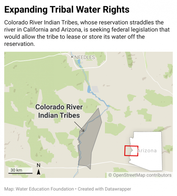
Tribes play a critical role in all of this: As Colorado River water supply diminishes, and as more tribes settle their water rights, those tribal water rights could comprise a larger percentage of available senior Colorado River water resources. Take the Colorado River Indian Tribes, consisting of four tribes, the Mohave, Chemehuevi, Hopi and Navajo, with a reservation along the Colorado River at the border between Arizona and California. These tribes hold rights to more than 700,000 acre-feet of mainstem Colorado River water, with more than 660,000 acre-feet of that water in Arizona. These are the most senior water rights in the lower basin, making them the most secure in times of shortage.
Starting in 2016, the Colorado River Indian Tribes entered a short-term pilot project with Reclamation, in which they were compensated for fallowing more than 1,500 acres of farmland so that water could be left in Lake Mead. Those pilot project numbers were upped in 2018. The following year, in 2019, the tribes worked with the State of Arizona on a much larger agreement, as part of the Drought Contingency Plan, committing to fallow farmland and forego water deliveries to the tune of 150,000 acre-feet over three years to help maintain levels in Lake Mead. In exchange for this contribution of water, the tribes are paid $38 million. Now, the tribes are looking to be able to lease their water—something that wasn’t authorized in the Arizona v. California opinion that established their water rights. A bill introduced to the U.S. Senate in December 2021 could allow the tribes to lease part of their water allocation to individuals, businesses, municipalities, governments and others for off-reservation uses to provide additional drought relief and protect natural habitats in Arizona.
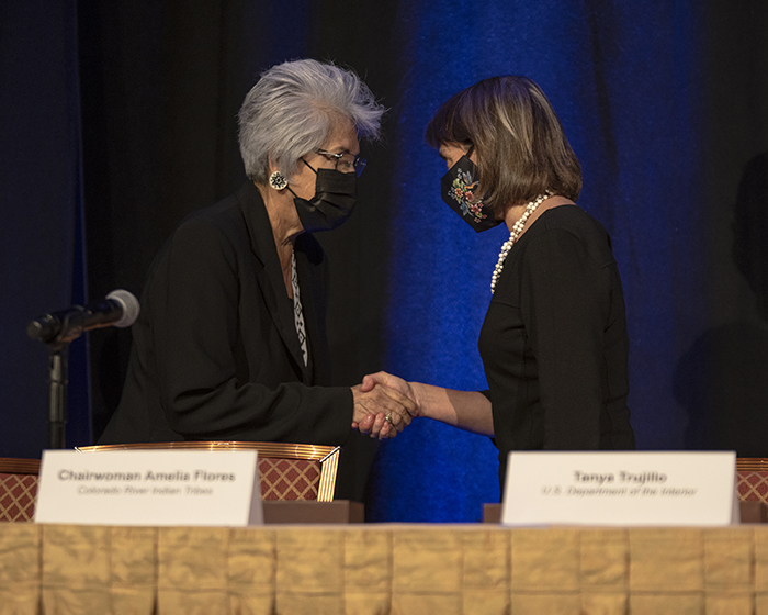
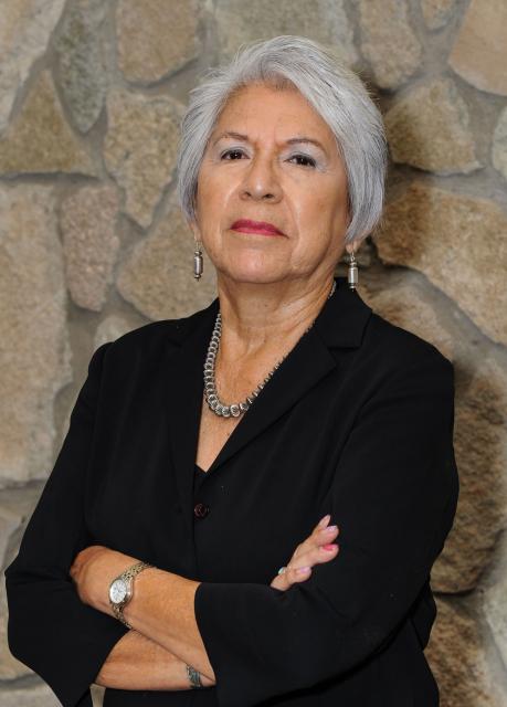
Colorado River Indian Tribes Chairwoman Amelia Flores greets Tanya Trujillo, the Interior Department’s assistant secretary for water and science, at the Colorado River Water Users Association December 2021 conference. Photo courtesy U.S. Bureau of Reclamation / Flickr
A January 2022 agreement on the Colorado River in New Mexico does just that. The Jicarilla Apache Nation, New Mexico Interstate Stream Commission and The Nature Conservancy announced a new deal to lease up to 20,000 acre-feet of water per year from the Jicarilla Apache Nation to the stream commission to support threatened, endangered and vulnerable fish and to increase water security for New Mexico. The tribal nation subcontracts some of its other water to users outside the reservation, providing a valuable source of income.
The Colorado Ute tribes and the State of Colorado are wondering whether a similar agreement or lease deal could put their unused Animas-La Plata Project water to work, says Peter Ortego, general counsel for the Ute Mountain Ute Tribe. (Ortego also serves on the Water Education Colorado Board of Trustees.) “The tribes have been eager to see solutions to these problems and the state has been helpful in working with us to find a consumptive use for that water,” says Ortego.
Talks are preliminary and confidential, and the tribes’ settlement legislation is somewhat narrow, Ortego says, specifying that the tribes water can be leased but must be used for municipal or industrial needs within Colorado. Because Lake Nighthorse is in the southwest corner of the state, so close to the border with New Mexico, that doesn’t leave room for a lot of Colorado users to step in and lease water. However, some nearby communities are running short on water and could benefit from the supplies stored in Lake Nighthorse, if an agreement is reached. “I think we’re starting to understand now that if we can all work together to utilize that water, it will be best for the entire region,” Ortego says. “The ultimate goal is to basically keep water in Colorado to help Colorado meet its other obligations.”
More of this water sharing and leasing work could be coming. “We are very open to more discussions with tribes about what additional opportunities may exist,” says Trujillo, who has met with tribes on their ability to contribute water and receive compensation. “I think there is a lot of interest from several different angles to try to do more of that.”
Tribes Unifying in Negotiations
When he became water administrator for the Jicarilla Apache Nation, Vigil began to see how excluded tribal nations were from river management decisions.
From the 2018 Tribal Water Study, this graphic shows the location of the 29 federally-recognized tribes in the Colorado River Basin. Map credit: USBR
No tribes were invited to provide input to the 2007 Interim Guidelines, which dictate reservoir operations in the event of water shortages. The guidelines were negotiated by representatives from each basin state, federal agencies, and with Mexico through the International Boundary and Water Commission—tribal water use was the responsibility of the state that the tribe resided in, so the tribes were treated as stakeholders within the states, not as sovereigns themselves. In 2012, when Reclamation completed the basin-wide Colorado River Basin Water Supply and Demand Study, tribes called attention to the fact that there was no meaningful inquiry into tribal water. It was only after pressure on Reclamation that the agency funded the Colorado River Basin Ten Tribes Partnership Tribal Water Study, which, in 2018 assessed water supplies for a coalition of 10 tribal nations in the upper and lower basins that had previously come together in 1992 to push for more tribal voices in basin water management. The study was not comprehensive of all basin tribes but gave a stronger sense of tribal water supplies. In developing the 2019 DCP, which outlined water-saving plans between the seven U.S. basin states and Mexico, Reclamation consulted with only a few lower basin tribes.
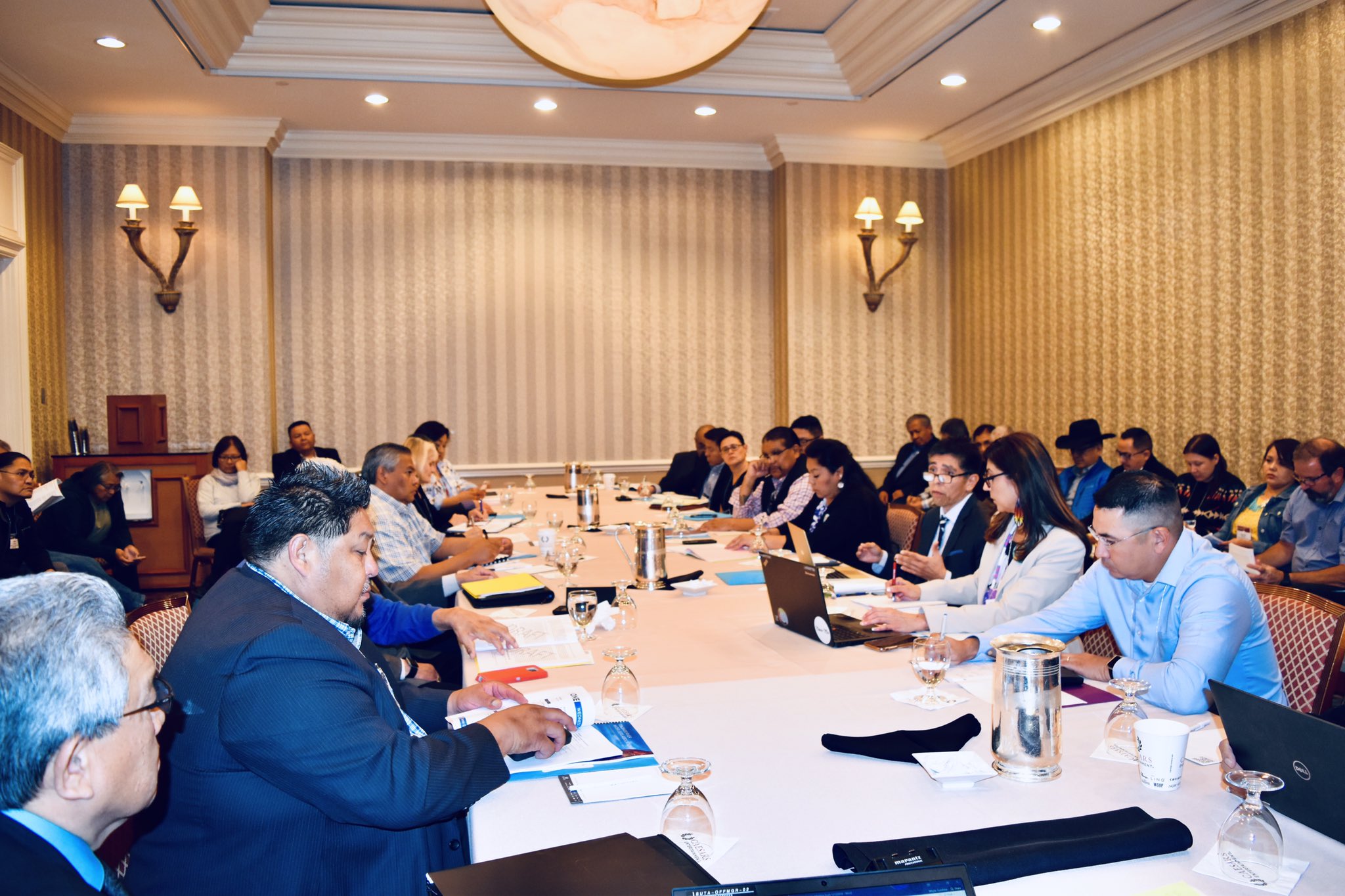
At this Ten Tribes Partnership Meeting in 2018, Southern Ute Indian Tribe councilwoman Lorelei Cloud approved publication of the Tribal Water Study. Photo courtesy of the Southern Ute Indian Tribe
This neglect from state and federal agencies prompted the creation of the Water and Tribes Initiative in 2017. Aiming to support tribes and give them a stronger voice in water management discussions in the region, various leaders formed the initiative, including tribal representatives, policy experts, researchers, conservation groups, state and federal officials and others, co-convened by Vigil and Matt McKinney, co-chair of the University of Montana’s Natural Resources Conflict Resolution Program. “Why wouldn’t you include 30 [tribal] sovereigns who own 25% of the volume of the Colorado River?” says Vigil. “Why wouldn’t you include 30 tribal sovereigns who have been here for millennia?”
As water managers begin to plan, negotiate and draft the next river management framework that will be implemented as the Interim Guidelines and DCP expire in 2026, many tribes are actively trying to gain a seat at the negotiating table. Twenty of the basin tribes have formed an ad hoc group for all 30 of the tribes in the basin called the Colorado River Basin Tribal Coalition. As the most substantive negotiations in developing the next river management framework are likely to unfold over the next two years, the coalition is calling to work together with federal agencies and states as soon as possible. While the next set of guidelines will not affect the status of settled tribal water entitlements, many tribes are concerned that they could affect unresolved water claims, which could still take decades to settle, and their ability to plan for their future.
Rebecca Mitchell, director of the CWCB, has been meeting with the Ute Mountain Ute and Southern Ute Indian Tribes to develop a sovereign-to-sovereign framework, a process for tribes and the State of Colorado to engage on equal ground throughout water management negotiations.
“The scope of the interim guidelines will be limited to operations of the major reservoirs, so it is important to recognize that we cannot resolve all of the issues in the basin throughout that negotiation process,” Mitchell wrote in a statement via email. “Still, it will be imperative to include tribal nations in the process.”
That relationship between the Colorado Ute tribes and state has been great, says Rall with the Southern Ute Indian Tribe. “[Mitchell] is trying to lead the way for other states to do the same, hoping that other states will enter into sovereign-to-sovereign agreements with their tribes to have a seat at the table.”
For Leland Begay with the Ute Mountain Ute Tribe, early involvement in Reclamation’s next framework for managing water shortage is going to be critical for tribes to determine their future—to participate in decisions they were excluded from in years past. “In the past, there’s been a lot of shortcomings on behalf of the Bureau of Reclamation in engaging with tribes at an early stage,” says Begay. “This is an opportunity for Reclamation to meaningfully engage with tribes on how the interim guidelines impact tribes and their water rights and their land.”
It’s difficult not to view the Colorado River Compact in a global colonial context. When the compact was signed in 1922, European colonial powers were still carving up African territories, exploiting resources like copper or rubber. The U.S. empire carved up the Colorado River, splitting it among seven states, dispossessing tribes from their natural relationship with the river, with no plan to deliver them water. While the historical Law of the River can’t be removed from this context, its next era could be one where federal, state and local agencies work collaboratively with tribal nations.
Vigil has a gentle, impassioned cadence when he speaks. The river, he says, has given him a calling, a voice. Tribal nations in the basin are in a much better position today to advocate for their water interests, but it took years—a whole century really—to reach this point. It’s left him wondering: Where are we headed if we don’t start to build a collaborative framework that includes tribes?
While he talked, Vigil would occasionally chuckle or laugh in disbelief, especially about the history of tribal water rights. “I think [the laughter] is a, you know, it’s a Native thing. It’s like a way to deal with the absurdity and like the massive amount of grief that comes with having to acknowledge this and where we’re at. Like every single time.”
Kalen Goodluck is a Diné, Mandan, Hidatsa and Tsimshian journalist and photographer based in Albuquerque, N.M. His work has appeared in High Country News, The New York Times, Popular Science, National Geographic – Travel, NBC News and more.
North American Indian regional losses 1850 thru 1890.
Click the link to read the article on the Colorado Public Radio website (Michael Elizabeth Sakas). Here’s an excerpt:
Colorado’s water leaders have released an updated blueprint detailing how the state will manage and conserve water supplies as climate change and population growth strain the system in unprecedented ways…
In the years since, continued warming, poor snowpack and low river flows have devastated available water supplies for farmers and ranchers. The reservoirs on the Colorado River, which starts in the mountains of Colorado and supplies more than 40 million people in the West with water, have hit critically low levels in the last year. The emergency has prompted the federal government to step in and demand the use of less Colorado River water…
The new analysis in the draft version of the new Colorado Water Plan, which was written by a team overseen by the Colorado Water Conservation Board, finds that cities, towns and industries in Colorado could be short 230,000 to 740,000 acre-feet of water annually by the year 2050 — enough water, depending on different drought and climate scenarios, to supply between 500,000 and 1.5 million homes. As the state faces warmer temperatures and less water, analysis in the draft plan finds that statewide water use in towns, cities and industries will climb between 35 percent and 77 percent by 2050…
The plan calls on leaders of Colorado’s nine river basins — known as roundtables — to identify local needs and projects that the Colorado Water Conservation Board can fund. Right now, about 1,800 such projects have been identified, a running list in various stages of readiness that comes with a hefty price tag: about $20 billion in funding to be fully completed. Some of the proposed projects include building new reservoirs and expanding old ones, watershed improvements, environmental restoration projects and infrastructure improvements.
The pie chart shows how much water each sector uses in Colorado, as well as how much water originating here leaves the state. CREDIT: COURTESY COLORADO WATER PLAN
Navajo Reservoir, New Mexico, back in the day.. View looking north toward marina. The Navajo Dam can be seen on the left of the image. By Timthefinn at English Wikipedia – Transferred from en.wikipedia to Commons., Public Domain, https://commons.wikimedia.org/w/index.php?curid=4040102
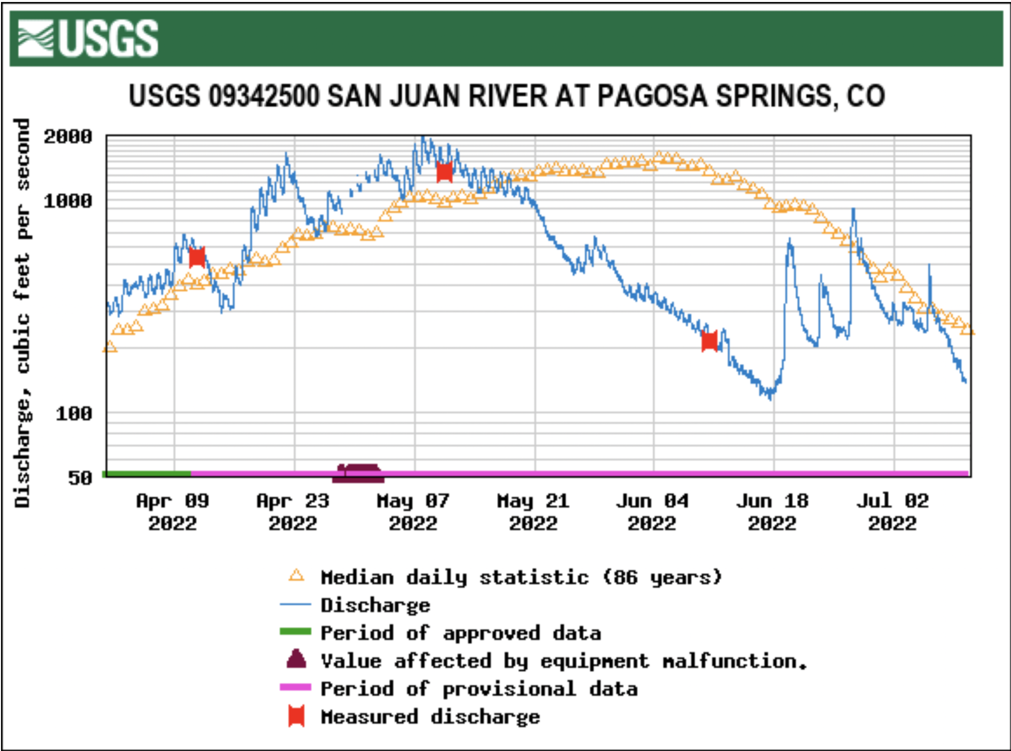
From email from Reclamation (Susan Novak Behery):
In response to low flows in the critical habitat reach and increased irrigation, the Bureau of Reclamation has scheduled an increase in the release from Navajo Dam from 500 cubic feet per second (cfs) to 700 cfs for today, Wednesday, July 13th at 12:00 PM, and additional increase from 700 cfs to 800 cfs at 2:00 PM.
Releases are made for the authorized purposes of the Navajo Unit, and to attempt to maintain a target base flow through the endangered fish critical habitat reach of the San Juan River (Farmington to Lake Powell). The San Juan River Basin Recovery Implementation Program recommends a target base flow of between 500 cfs and 1,000 cfs through the critical habitat area. The target base flow is calculated as the weekly average of gaged flows throughout the critical habitat area from Farmington to Lake Powell.
Click the link to read the article on the NOAA website:
Exacerbated by a record-dry June, Alaskan wildfires grow at near-record pace
Key Points:
Credit: NOAA
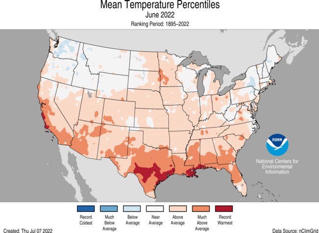
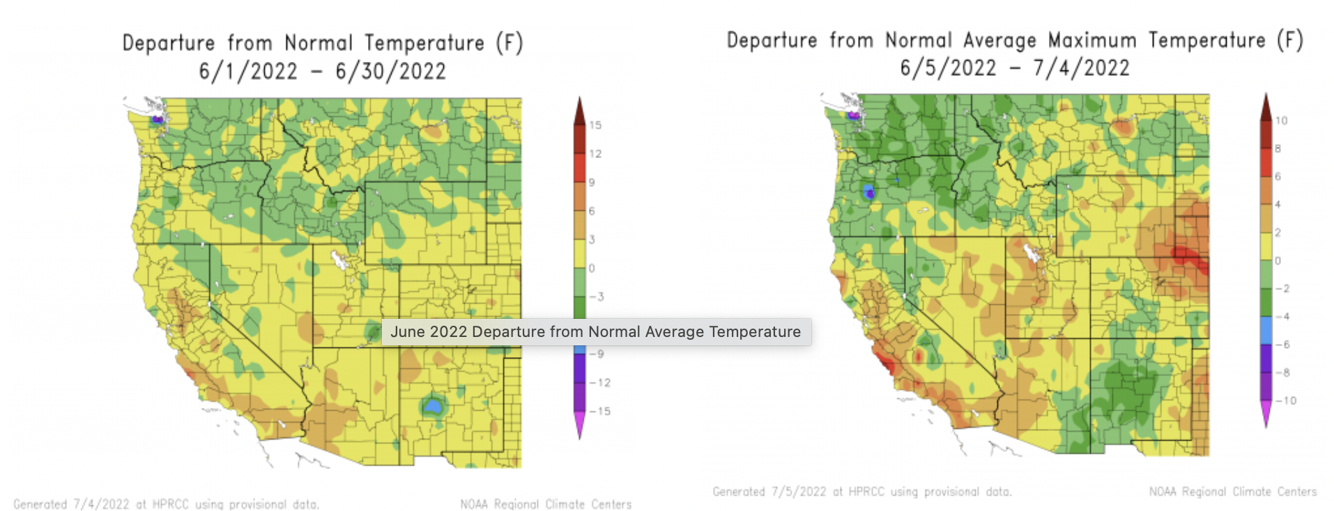
The average temperature of the contiguous U.S. in June was 70.7°F, which is 2.2°F above average, ranking 15th warmest in the 128-year record. Temperatures across much of the southern half of the Lower 48 as well as from the northern Plains to the Ohio Valley were above average.
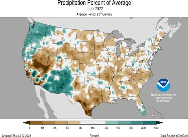
June precipitation for the contiguous U.S. was 2.33 inches, 0.60 inch below average, tying with 1930 for 12th driest in the historical record. Precipitation was above average across portions of the Northwest and Southwest. Precipitation was below average in the Great Basin, from the central Rockies to the Great Lakes, across the Deep South and from the mid-Mississippi Valley to the Southeast.
Integrated across the state, precipitation across Alaska ranked driest on record for June and was 0.04 inch less than the previous record set in 1934.
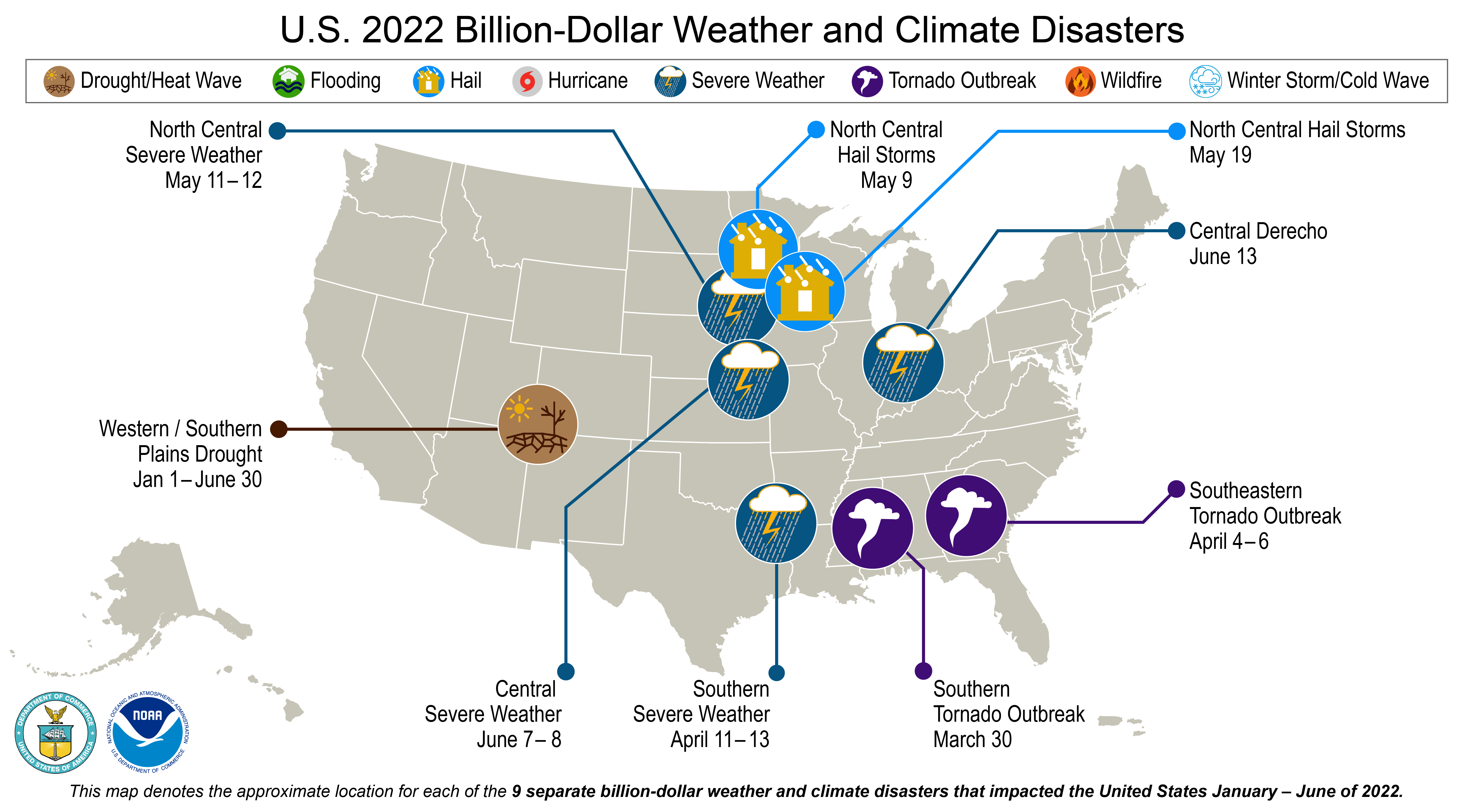
There were nine billion-dollar weather and climate disasters identified during January-June, the fifth-highest disaster count in the 43-year record for this year-to-date period. These disasters consisted of eight severe storm events and one drought event.
The wildfire season continues as large fires burn across portions of the South and Southwest and have grown rapidly across Alaska. Across all 50 states, more than 3.9 million acres have burned from January 1 through June 30 — nearly 2.3 times the average for this time of year.
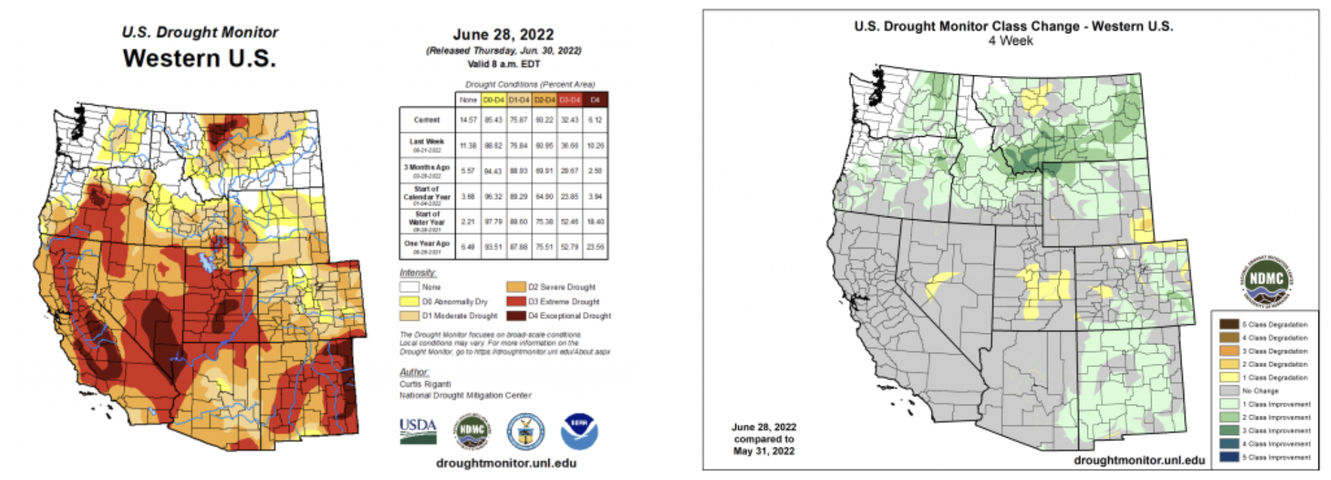
According to the June 28 U.S. Drought Monitor report, 47.7 percent of the contiguous U.S. was in drought. Due to monsoon rains, parts of the Southwest saw a reduction in extreme to exceptional drought, but drought conditions erupted and/or expanded across parts of the mid-Mississippi Valley and Southeast.Puerto Rico has been in drought for a record 81 consecutive weeks.
Other Highlights:
Temperature
Credit: NOAA
Above-average warmth, associated with a ridge of high pressure, dominated much of the contiguous U.S. during June. Several Southern Tier states had a top-10 warmest June on record including Texas, ranking fifth warmest on record for the month. This is the third consecutive month of extreme heat across Texas, which resulted in a ranking of warmest on record for the April-June period.
Averaged over the first half of the year, the contiguous U.S. temperature was 48.7°F, 1.2°F above the 20th-century average, ranking in the warmest third of the January-June record. Temperatures were above average from California to the Plains and from the central Gulf Coast to New England. Florida and California ranked seventh warmest and South Carolina ranked eighth warmest for this period. Temperatures were below average in parts of the Northwest and the Upper Midwest.
The Alaska statewide June temperature was 52.2°F, 3.0°F above the long-term average. This ranked as the ninth-warmest June in the 98-year period of record for the state. Temperatures were above average across much of the southern half of the state with record warm temperatures across Kodiak Island. Temperatures were near average across much of the North Slope and Northeast Interior divisions. Sitka had its warmest June on record while Anchorage and Kodiak were second warmest. For the first time on record, Anchorage reported daily high temperatures of at least 60°F every day during June.
Credit: NOAA
The year-to-date temperature for Alaska was 24.4°F, 3.0°F above the long-term average, ranking in the warmest third of the record for the state. Above-average temperatures were observed across most of the state and were near average across much of the North Slope and Northeast Interior divisions.
Precipitation
Credit: NOAA
The Pacific Northwest received above average precipitation in June associated with multiple atmospheric river events during the first half of the month and the Southwest received an abundance of precipitation associated with the return of the monsoon season during the second half of June. New Mexico ranked fifth wettest on record. Washington and Oregon ranked seventh and eighth wettest on record, respectively. A dominant ridge of high pressure across the central and eastern U.S. resulted in below-average precipitation totals for the month. North Carolina ranked second driest on record for June and Nebraska seventh driest.
The January-June precipitation total for the contiguous U.S. was 13.84 inches, 1.47 inches below average, ranking in the driest third of the record. Precipitation was above average across portions of the Pacific Northwest, northern Plains, Great Lakes and in pockets from the mid-Mississippi Valley to the Northeast. Precipitation was below average across much of the West and Deep South, as well as portions of the central Plains and Southeast during the January-June period. California ranked driest on record while Nevada and Utah ranked second and third driest for this six-month period, respectively. Texas ranked sixth driest.
Alaska precipitation was near average across the North Slope and portions of the Panhandle, but was generally dry to record dry across much of the state in June. Talkeetna had its lowest June precipitation total since at least 1932. Over the most recent three-month period (April-June), Alaska was also record dry as precipitation averaged across the state was 0.68 inch lower than what was received during the same period in 1954 — shattering that record.
Despite the record-dry conditions of the last three months across Alaska, precipitation averaged across the state for the January-June period ranked in the wettest third of the record and was generally above average across much of southeastern Alaska and near or below average for much of the rest of the state.
Other Notable Events
As of July 1, the largest fire on record in New Mexico, the Hermits Peak Fire, had consumed nearly 342,000 acres and was 93 percent contained. The Black Fire, New Mexico’s second-largest wildfire on record, burned through 325,000 acres and was 70 percent contained as of July 2.
1 million acres burned in Alaska by June 18 — the earliest such occurrence in a year than anytime in the last 32 years. By July 1, 1.85 million acres had been consumed — the second-highest June total on record and the seventh-highest acreage burned for any calendar month on record for Alaska.
The East Fork wildfire in the Yukon River delta region of Alaska is the largest tundra fire on record (since the 1940s) in the Yukon delta at 166,000 acres. Smoke from the ongoing fires created visibility and health concerns across much of mainland Alaska during June.
The elevation of Lake Mead, the nation’s largest reservoir, neared the dead pool, the elevation that prevents the water from flowing downstream from the dam, in late June. On June 30, the lake elevation was 1,043.02 feet above sea level — the lowest elevation since the 1930s when the lake was first filled.
Drought
According to the June 28 U.S. Drought Monitor report, 47.7 percent of the contiguous U.S. was in drought, down about 1.5 percentage points from the end of May, but up 2.4 percent in the last week of June. Drought intensified and/or expanded across the Deep South, Southeast and New England and erupted across portions of the mid-Mississippi and Ohio Valleys. Monsoon rains helped to lessen the drought intensity across parts of the Southwest. Several atmospheric river events aided drought reduction and/or elimination in portions of the Pacific Northwest and the northern Rockies. Drought expanded across Alaska and Puerto Rico and contracted across the Big Island of Hawaii during June.
Billion-Dollar Weather and Climate Disasters
Credit: NOAA
The nine individual billion-dollar events of 2022 include: three general severe weather events, two tornado outbreaks, two hail storms, a derecho event and a broad-area drought event. For this year-to-date period, the 2022 disaster count ranks fifth-highest behind 2017, 2020, 2011 and 2021.
Despite the above-average number of disasters during the first half of 2022, only a small number of fatalities has been reported associated with these events.
With an estimated cost of $2.2 billion, the costliest event to-date was the Southern Severe Weather event that occurred April 11-13.
Since these billion-dollar disaster records began in 1980, the U.S. has sustained 332 separate weather and climate disasters where overall damages/costs reached or exceeded $1 billion (based on the CPI adjustment to 2022) per event. The total cost of these 332 events exceeds $2.275 trillion.
Monthly Outlook
According to the June 30 One-Month Outlook from the Climate Prediction Center, above-normal temperatures are likely across the central and southern Plains and leaning above-normal from the Rockies to the East Coast as well as across southeastern Alaska. Below-normal temperatures are favored along the Pacific Northwest coast. Parts of the Southwest and from the Gulf Coast to the mid-Atlantic coast as well as the western half of Alaska have the greatest chance of above-normal precipitation whereas below-normal precipitation is favored across portions of the Great Basin and the central and southern Plains. Drought is likely to persist over much of the West with some improvement expected across the Southwest and along the west-central Gulf Coast. Drought development is likely from the Lower Mississippi Valley to the Midwest. Outside of the contiguous U.S., drought is likely to persist or develop across portions of Alaska, Hawaii and Puerto Rico, although recent heavy rains may mitigate drought on the eastern portion of Puerto Rico.
According to the One-Month Outlook issued on July 1 from the National Interagency Fire Center, parts of Alaska and Hawaii, eastern Washington to central California, portions of the southern Plains and the east-central Florida coast to the Carolina coast have above normal significant wildland fire potential during July.
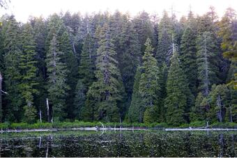
Dense stands of Douglas-fir surround South Twin Lake in the Klamath bioregion of northwestern California. Sources/Usage: Public Domain.
Click the link to read the article on the USGS website (Clarke Knight):
A team of federal scientists, academics, and Tribal members recently collaborated on a study that demonstrated the strong influence of Indigenous stewardship on forest conditions in northern California for at least a millennium. Indigenous burning practices coupled with lightning-induced fires kept forest carbon low, at approximately half of what it is today, and kept forests more open and less dense. Forest management and intentional ignitions also resulted in low forest fuel levels that allowed local Indigenous people to produce food and basketry materials, clear trails, reduce pests, and support ceremonial practices for generations.
These stable forest conditions appear to have enhanced the resiliency and health of the fire-prone forests of northern California. However, colonization and twentieth century fire suppression policies have transformed California forests. Forests today are denser and more prone to catastrophic large wildfire than in the past. As restoration ecologists attempt to improve the health of California forests, a key question becomes – restoration to what?
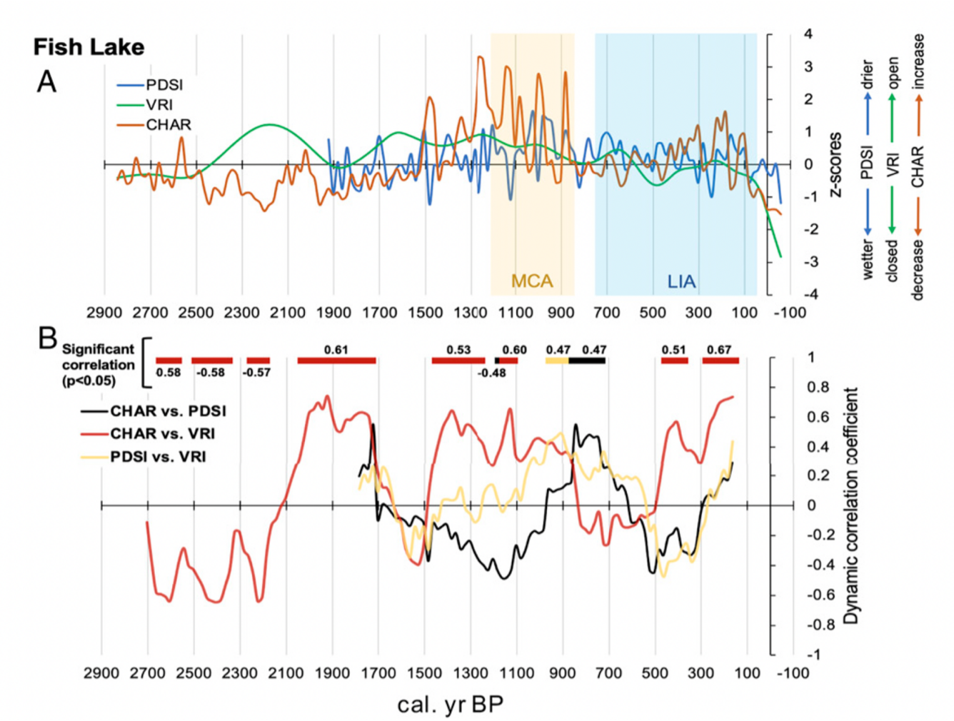
The research team merged multiple lines of evidence from the Klamath Mountains in northern California to help answer this question. They integrated Karuk and Yurok oral histories, Indigenous Traditional Ecological Knowledge (ITEK), a pollen-based vegetation abundance reconstruction, fire scars from tree stumps, a paleofire (past fires that occurred before instrumental record keeping) reconstruction based on sedimentary charcoal, and historic forest inventory data. The evidence was consistent with human management actions on the forest, particularly Indigenous ignitions that kept forest fuels low. Data also show that the current landscape – a dense Douglas fir–dominant forest – is unlike any seen in the preceding 3,000 years.
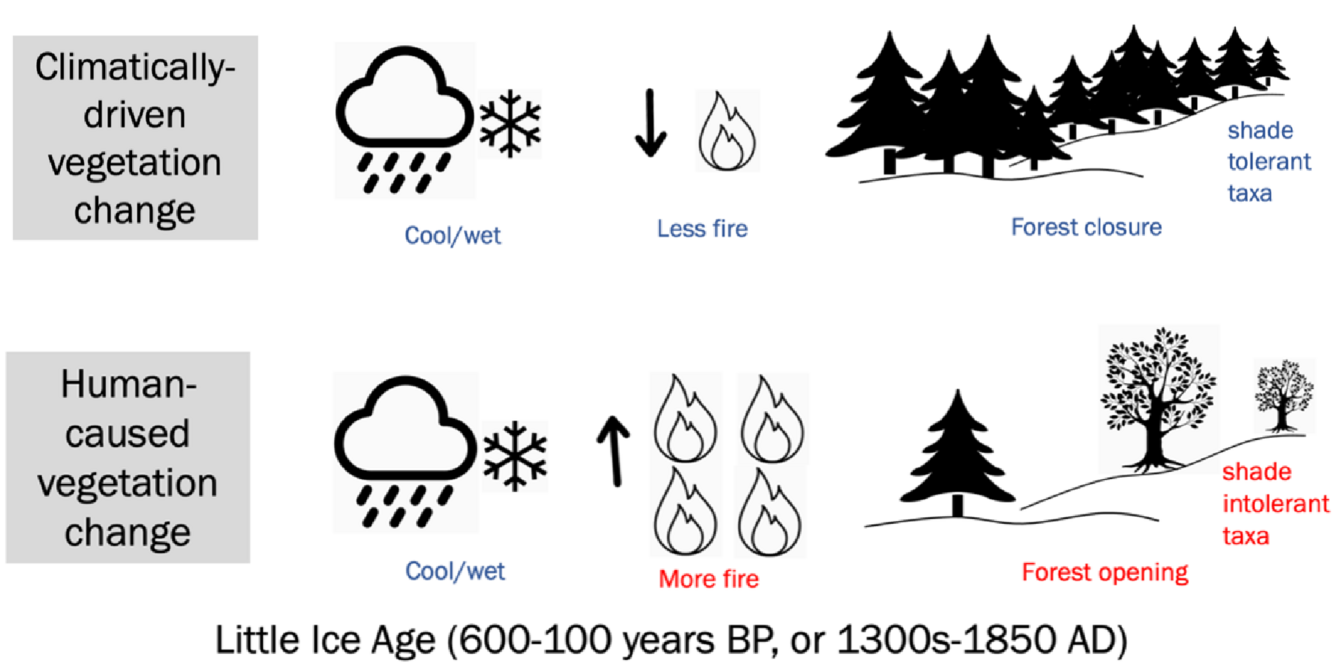
Figure 1. Idealized vegetation response to climate vs. human activity. Top panel shows climatically-driven vegetation change without the influence of people. Bottom panel shows human-caused vegetation change where increases in fire use create more open forest conditions despite cooler/wetter conditions, such as during the Little Ice Age. Credit: Clarke Knight, USGS.
Climate is often presumed to be the most important control on vegetation dynamics during the pre-colonial period, not people. Periods of wetter and colder conditions often lead to less fire on a landscape, the promotion of more shade-tolerant taxa, and more forest closure (Figure 1, top panel). The authors tested the expected effects of climate on northern California forest conditions and found that climate alone could not account for the trends in their data. For example, during the Little Ice Age – a period of cooler and wetter conditions between 1300-1850AD (600-100 years before present) – the authors found a signal of increased fire and vegetation openness (Figure 1, bottom panel), which they corroborated statistically (Figure 2), indicating human involvement in controlling and shaping the forest environment.
A) Trends in charcoal accumulation (CHAR, a measure of paleofire), Palmer Drought Severity Index (PDSI, a measure of climatic conditions), and vegetation response index (VRI, a measure of forest openness) were plotted through time at Fish Lake, one of two study sites. The Little Ice Age (LIA, blue panel) and Medieval Climate Anomaly (MCA, yellow panel) indicate two time periods of known climatic changes. For example, during the MCA when climate was relatively warmer and drier, CHAR (orange line) increased, in part because forest fuels were drier and easier to burn. B) Trends in correlations between CHAR, PDSI, and VRI over time. There is a significant positive correlation between CHAR and VRI (red line) during the climatically cooler period of the Little Ice Age (600-100 years before present) as predicted by the author’s conceptual model that accounts for human-caused vegetation change through burning practices. Other correlations were found at various times throughout the record. For example, there was a significant positive correlation between CHAR and PDSI around 800 years before present. Modified from Figure 4 in (Knight et al. 2022). Sources/Usage: Public Domain.
This research quantifies what stable, historic forests in California looked like and shows that frequent fire, in part ignited by people, limited forest fuels and shaped the forest for millennia. This finding is important because California is planning to use forest ecosystems to store carbon as part of climate mitigation efforts. The results of this study suggest a large-scale intervention could be required to achieve the historical conditions that supported forest resiliency and reflected Indigenous influence.
Brad Udall: Here’s the latest version of my 4-Panel plot thru Water Year (Oct-Sep) of 2021 of the Colorado River big reservoirs, natural flows, precipitation, and temperature. Data (PRISM) goes back or 1906 (or 1935 for reservoirs.) This updates previous work with @GreatLakesPeck.
From email from the Getches-Wilkinson Center:
This year marked the 42nd Annual Conference on Natural Resources at Colorado Law. Over its rich history, the conference has addressed many different natural resource issues. In more recent years, the Center’s summer conference has explored the major issues in water law and policy in the West.
There is no debate – demands for water across the Colorado River Basin exceed the shrinking supply. Chronic drought, record heat, increasing winds and aridity, as well as rampant wildfires are diminishing the Basin’s overall health and resilience.The historically low levels in Lake Mead and Lake Powell have invited unprecedented federal action and raise the specter of a looming energy crisis. To ensure a sustainable future, these harsh realities will require inclusive collaborations and innovative actions. The return of the GWC Summer Conference brought together a broad array of expertise and diverse perspectives from across the region to candidly discuss these complex challenges. Throughout this conference we examined potential options to advance sustainable water management, expand basin-wide conservation in every sector, and strengthen watershed resilience.
Conference Sessions:
Thursday, June 16: Where We Currently Stand in the Colorado River Basin
The Science: What Does the Climate Science Suggest for the Short- and Long-Term?
The Status, Scope and Timeline of Ongoing Negotiations for the 2026 Guidelines.
Institutional Uncertainty: 100 Years Later, What We Still Don’t Know About the Compact.
The Good (13 MAF/year), the Bad (11 MAF/year), and the Ugly (9 MAF/year). How does the Law of the River work (or not) along this continuum?
Friday, June 17: Building Pathways to a Sustainable Future for All
Crafting a Rural-Tribal-Urban Social Compact in a Warming World.
Water Resiliency Across the System.
Next Generation Voices.
42nd Annual Colorado Law Conference on Natural Resources
Thursday, June 16 and Friday, June 17, 2022
Wolf Law Building, Wittemyer Courtroom
Crystal River rancher Bill Fales stands at the headgate for the Helms Ditch, with Mount Sopris in the background. As part of an agreement with the Colorado Water Trust, Fales could be paid to reduce his diversions from the ditch when the river is low. CREDIT: HEATHER SACKETT/ASPEN JOURNALISM
A Crystal River Valley rancher and a nonprofit organization are teaming up for the second time to try to leave more water in a parched stream.
Cold Mountain Ranch owners Bill Fales and Marj Perry have inked a six-year deal with the Colorado Water Trust to voluntarily retime their irrigation practices to leave water in the Crystal River during the late summer and early fall, when the river often needs it the most. In addition to a $5,000 signing bonus, the ranchers will be paid $250 a day up to 20 days, for each cubic foot per second they don’t divert, for a maximum payment of $30,000.
The water would come from reducing diversions from the Helms Ditch and could result in up to an additional 6 cfs in the river. The agreement would become active in the months of August and September any time streamflows dip below 40 cfs and once becoming active, will extend through October. The agreement will lift if streamflows rise above 55 cfs.
The goal of the program is to use voluntary, market-based approaches to encourage agricultural water users — who often own the biggest and most senior water rights — to put water back into Colorado’s rivers during critical times.
The program has the hallmarks of demand management, a much-discussed concept over the past few years at the state level: it’s temporary, voluntary and compensated. Other pilot programs that focus on agricultural water conservation usually involve full or split-season fallowing of fields, but with this agreement Fales still intends to get his usual two cuttings of hay.
“The idea is to find something that is a flexible way for water rights owners to use their water in years where it makes sense for something different than strictly agricultural practices,” said Alyson Meyer-Gould, director of policy with the Colorado Water Trust. “It’s another way to use their water portfolio.”
Today, Colorado Governor Jared Polis urged the Colorado Department of Public Health and Environment (CDPHE) and other state agencies to take additional steps to improve air quality for Coloradans.
In a letter to key leaders within his administration at the agency level, the Governor wrote: “Clean air is critical to the Colorado way of life. We value protecting our environment, ensuring environmental justice, and promoting better health for all Coloradans. This past legislative session we made substantial progress toward improving our air, including:
Wildfire smoke and ozone have been a daily blur for long range views along the Front Range this summer [2021]. Photo credit: Chase Woodruff/Colorado Newsline
A significant investment over three years to increase resources available to our Air Pollution Control Division (APCD) to right size and modernize the Division. Recent expansion in core responsibilities specifically related to the EPA Ozone non-attainment did not come with adequate resources. These investments now empower the Division to expand monitoring and emissions work, accelerate the transition to cleaner technologies across various industries, and to more thoroughly engage with communities across the state, particularly those most affected by air pollution.
West Grand School District electric school bus. Photo credit: The Mountain Town News/Allen Best
Hundreds of millions of dollars of state money to clean up our transportation system, including resources to position Colorado as a national leader in the electrification of our school bus fleet; substantial resources to decarbonize the industrial and aviation sectors above and beyond current and future greenhouse gas emissions rules; saving people money on transit with free and reduced-cost fares, and significant investments to reduce pollution from the buildings sector.
New plating at the Glenwood Springs water intake on Grizzly Creek was installed by the city to protect the system’s valve controls and screen before next spring’s [2021] snowmelt scours the Grizzly Creek burn zone and potentially clogs the creek with debris. (Provided by the City of Glenwood Springs)
Expanded capabilities across the State to mitigate, prepare for, and respond to disasters such as wildfires, mudslides and flooding and other devastating impacts of climate change.”
The Governor acknowledged that CDPHE and the Air Quality Control Commission have an ambitious agenda over the next 12 months to establish new plans, and standards to improve air quality, reduce greenhouse gas pollution, and reduce paperwork for Colorado businesses.
The Governor also urged CDPHE and the Colorado Oil and Gas Conservation Commission (COGCC) to take steps to improve air permit modeling, the permitting process, and oil and gas emissions reporting, evaluate cumulative impacts, reduce emissions from heavy duty off-road engines, improve collaboration between COGCC and APCD, and provide greater access to air quality information for the public.
Four federal Indian law experts digest the Supreme Court’s ‘shocking‘ decision to grant state governments the power to prosecute crimes in Indian Country.
As part of its recent precedent-breaking spree, the U.S. Supreme Court turned federal Indian law on its head this week on Wednesday, June 29. In the case of Oklahoma v. Castro-Huerta, a majority of five conservative justices sided with the state of Oklahoma, finding that state governments have the legal jurisdiction to prosecute non-Native citizens for crimes committed against Native citizens on sovereign tribal lands. The opinion, authored by Trump-appointed Justice Brett Kavanaugh, breaks with centuries of established federal Indian law. Until this decision, state law enforcement agencies could intervene in Indian Country crimes only by an act of Congress.
The Castro-Huerta case revisited questions of jurisdiction and sovereignty that were central to the landmark July 2020 case McGirt v. Oklahoma. That case concluded that Congress had never disestablished the reservations of the Cherokee, Choctaw, Seminole, Chickasaw and Muscogee Creek nations in Oklahoma — roughly half of the state’s present land base — and that individuals charged with crimes on tribal lands could be prosecuted by either federal or tribal officials. This latest case now narrows the court’s previous ruling on tribal sovereignty in McGirt, and inserts state jurisdiction, as well. As the author of the dissenting opinion, Justice Neil Gorsuch denounced the majority decision reached by his conservative colleagues. “This declaration comes as if by oracle, without any sense of the history recounted above and unattached to any colorable legal authority,” Gorsuch wrote. “Truly, a more ahistorical and mistaken statement of Indian law would be hard to fathom.”
High Country News spoke with four federal Indian law experts in an effort to unpack precisely what this new ruling means for the citizens and nations of Indian Country, and to better understand what the court’s willingness to eschew established precedent will mean for the health of Indigenous sovereignty in the months and years to come.
This conversation has been edited for clarity and length.
High Country News: On Wednesday [July, 2022], the U.S. Supreme Court ruled 5-4 in Oklahoma v. Castro-Huerta that the state of Oklahoma, and presumably all states, have jurisdiction to charge non-Natives committing crimes against Native citizens. How significant of a departure is this from existing precedent, where a state’s right to prosecute in Indian Country required an act of Congress?
Stacy Leeds (Cherokee Nation; foundation professor of law and leadership at the Sandra Day O’Connor College of Law, Arizona State University). Photo credit: High Country News
Stacy Leeds (Cherokee Nation; foundation professor of law and leadership at the Sandra Day O’Connor College of Law, Arizona State University): The ruling represents a shocking disregard for centuries of prior precedent and a profound disconnect from historical context. The most basic tenet for federal Indian law is that the power over Indian Affairs is consolidated with the federal government to the exclusion of the states.
The sweeping language in this case upends the very foundations of the field. The court casually states without citation to any legal authority.
Elizabeth Reese (Yunpoví; assistant professor of law, Stanford Law School): This decision is a sweeping change in Indian law. It flips precedent and existing presumptions on their head. Yesterday, the preemption was that states have no power over crimes in Indian Country. The narrow exception, from McBratney, that states have jurisdiction over non-Indian on non-Indian crime was always a bit of a puzzle, given how contrary its reasoning was to the rest of Indian law decisions. It was treated like an outlier, a case with fragile foundations that scholars would occasionally ask me to make sense of because it was so inconsistent with the rest of federal Indian law doctrine. The holding in this case is ostensibly limited to just non-Indian on Indian crimes, but its reasoning supports a new era where state authority over tribal lands is the default assumption. I barely recognize the federal Indian law or the American history described in the majority opinion — it’s just that off base.
Matthew Fletcher (Grand Traverse Band of Ottawa and Chippewa Indians; foundation professor of law and director of the Indigenous Law and Policy Center, Michigan State University). Photo credit: High Country News
Matthew Fletcher (Grand Traverse Band of Ottawa and Chippewa Indians; foundation professor of law and director of the Indigenous Law and Policy Center, Michigan State University): Castro-Huerta is a dramatic departure and cannot be reconciled with McGirt v. Oklahoma. The court seems to believe that the (1832) Worcester v. Georgia rule that state law has no force in Indian Country — one of the foundations of federal Indian law — is dead. It doesn’t point to any case that says that, so it cannot even point to a year when that general rule went away, but there it is. The majority is going back to what I call “Canary Textualism,” where the Supreme Court takes the lead on national Indian affairs policy instead of Congress or the tribes.
Bethany Berger (Wallace Stevens professor of law, UConn School of Law). Photo credit: High Country News
Bethany Berger (Wallace Stevens professor of law, UConn School of Law): It’s big. It rejects the established law taught to every federal prosecutor working in Indian Country, every law student studying federal Indian law, and agreed to by every state court considering the question.
HCN: I recognize there will be a litany of responses to this question that will be determined by the relationship between states and the bordering tribal nations, but what do you perceive as being the immediate effects of this decision for tribal citizens throughout Indian Country?
Leeds: Read in its most restrictive light, this case is only about state concurrent jurisdiction over non-Indians who commit crimes inside Indian Country. It may lead to more law enforcement confusion in the field because starting Oct. 1, when the expanded Violence Against Women Act kicks in, all three sovereigns will be recognized as having jurisdiction over some situations. Two of those situations, the federal and tribal jurisdiction are expressly provided for by Congress in various statutes. Only one of those situations springs anew by judicial fiat.
Read in its most expansive light, this case seems to support many types of state intrusion into Indian Country with the erasure of Indigenous nations and their rights to be governed by their own laws to the exclusion of state law. Tribal sovereignty is the right to make local laws and be ruled (only) by those local laws. Now it seems as if the court would support states’ rights to pass laws that tribes oppose and the barrier to state power would not be tribal sovereignty and express treaty rights, but instead, whether a case-by-case federal preemption analysis would keep the state at bay.
Reese: You are correct to flag that a lot will depend on what different states decide to do and their relationships with tribes. Immediately, however, this means that non-Indian crime on Indian crime — including the domestic violence cases that led to all the VAWA activism and reform over the last few decades — are now going to fall to the state and federal government. Increased state police presence could happen on tribal lands immediately, and tribal laws or federal law which previously may have shielded non-Indians from certain state law decisions are no longer a shield.
Fletcher: I don’t know that states and counties are going to swoop into Indian Country to subvert federal and tribal criminal justice prerogatives right away, but they could. Suddenly, without any preparation or cooperation, states and counties are a third sovereign in Indian Country. Who knows what could happen? Justice Gorsuch’s dissent provides an easy suggestion for Congress to fix the decision. Some state legislatures could choose — at tribal request — to stand down from exercising jurisdiction. And — though very unlikely given the history of conflict between sovereigns, states and counties — (it) could actually enhance Indian Country criminal jurisdiction.
Berger: It will mean that tribal citizens will face less protection and more abuse by police. We have years of studies of criminal justice on reservations where Congress gave states full criminal jurisdiction, and state jurisdiction just undermines support for tribal and federal systems without increasing effective responses to crime. Tribal victims are less likely to trust or report crimes to state police, and witnesses are less likely to work with them. But states don’t do the effective community policing that makes tribal citizens safer. The Castro-Huerta case is an example of this. For two years, the Oklahoma Department of Human Services had received reports of possible neglect of the victim in this case, a little girl with severe disabilities who could not feed herself and needed five bottles of specialized feeding a day. Her mother had several other children, and her stepfather, Mr. Castro-Huerta, was an immigrant who worked multiple jobs. It was only when Mr. Castro-Huerta and her mother — who had just given birth — brought the child to the emergency room that the state took her into custody. Oklahoma also never notified the girl’s tribe, the Eastern Band of Cherokee Indians in North Carolina, to seek their help in finding a better placement for the child. The state’s response — to arrest the stepfather and sentence him to 35 (years) — is sadly typical in cases involving state criminal jurisdiction in cases involving Indians, focusing just on punishment and not on effective prevention.
HCN: I have a two-parter to end on: First, do you anticipate that the politicization of the court and its ruling today will embolden more states and private entities to challenge the sovereign rights of tribal nations?
Leeds: Yes, this provides the road map for the extension of state power.
Reese: Unfortunately, yes. Tribal sovereignty is even more vulnerable when the court is willing to disregard precedent and history. I fear that this case demonstrates how Oklahoma’s campaign to claw back power was more persuasive to the court than its precedents — that, in the words of Justice Gorsuch in McGirt, that “rule of the strong, not the rule of law” is what we can expect from this five-justice majority.
Fletcher: Justice Kavanaugh’s majority opinion is his first major writing in an Indian law case and it’s not good for Indian Country. He’s firmly in the Scalia-Rehnquist camp of skepticism toward Indian tribes, skepticism toward congressional policy decisions in Indian affairs, and extreme deference to states’ preferences. He claims to be a textualist, but he is happy to deviate from the text to fulfill those political commitments. The jury is still out on Justice Coney Barrett, another justice who has stated a commitment to textualism (and even wrote about textualism in her work as a law scholar). Her opinion in the Ysleta del Sur Pueblo bingo case was a good omen. When she is confronted with relatively clear text, she doesn’t so easily give up on her commitment to textualism just because a state government complains. Her vote in Castro-Huerta is disconcerting, however. We don’t have a separate writing from her in that case so we can’t be sure, but it appears she approved of the assertion of judicial power that has wreaked havoc in Indian affairs since the 19th century.
This court is quite likely the most radically activist court in American history. The court’s overruling of Roe is the tip of the iceberg. The court struck down the separation of church and state as well. In the next term, it’ll strike down affirmative action in higher education as well. This is a self-proclaimed textualist court that gratuitously deviates from its methodological commitments to advance certain political commitments — deference to states, deference to the police, deference to mainstream religion, and extreme skepticism of racial, gender and sexual minorities.
Berger: States and private entities have never stopped challenging the sovereign rights of tribal nations. This case just shows that — after a handful of cases where tribal sovereignty and precedent seemed to get some respect — the Supreme Court remains a very dangerous place for tribal rights.
HCN: And the second part: Given this is our bench for the foreseeable future, how much faith can those invested in the long-term political and legal strength of tribal nations truly put in this court? Particularly, I am thinking about Brackeen v. Haaland, the state-backed Indian Child Welfare Act challenge, among others. Put simply, can tribal citizens (and electeds and attorneys, etc.) trust SCOTUS after this decision?
Reese: Very little and no. I join the growing chorus of legal experts who are criticizing the faith we’ve put in the Supreme Court — particularly since Brown v. Board of Education — to be a guardian of law and the moral arc of the universe’s bend toward justice. We’ve given them a lot of power by putting so much faith in them. Far too much, I think. It’s time to stop waiting for the court to fix things or hoping that the best legal argument will prevail. It’s time to start talking about institutional reform to the Supreme Court, and to the Constitution broadly.
Fletcher: I would not trust this Court much at all, but that’s been true for the entire history of the United States. What makes this Court worse, however, is the extremity of its radicalism and lack of discipline. Nothing is sacred to this Court.
Berger: Given how much easier it is for the Justices to sympathize with states and non-Indians than with tribes and tribal citizens, trusting SCOTUS was never a safe move. For a few years starting in 2016, the Court seemed to be actually paying attention to precedent and the realities of life in tribal communities, and this breaks from that. It’s a bad sign for Brackeen, but that case always played into a lot of justices’ biases. But the choices facing tribes and their citizens are still the same: Try to stay out of the court, and try to make the best case possible if you have to go.
Nick Martin is an associate editor for HCN’s Indigenous Affairs desk and a member of the Sappony Tribe of North Carolina. We welcome reader letters. Email him at nick.martin@hcn.org or submit a letter to the editor. See our letters to the editor policy.
Natural gas flares near a community in Colorado. Colorado health officials and some legislators agree that better monitoring is necessary. Photo credit the Environmental Defense Fund.
Federal, state action needed to implement policies
Colorado leaders say the U.S. Supreme Court’s ruling last week to limit the Environmental Protection Agency’s ability to regulate carbon dioxide emissions from power plants further demonstrates the urgency to enact federal and statewide policies that curb greenhouse gas emissions. The ruling means the EPA needs authorization from Congress to regulate the carbon emissions from power plants. The decision raises questions about how much the federal government can do to fight climate change and the extent that federal agencies can impose regulations. Though the ruling will not affect Colorado’s ability to address climate change on a state level, environmental policy experts say it illuminates the need to find ways to make policy to address the climate crisis facing the state. With the EPA having more limitations to its powers, the court’s decision underscores the importance for states to recognize the threat that climate change poses through policymaking…
Colorado Sens. John Hickenlooper and Michael Bennet expressed a sense of urgency for Congress to take steps to address climate change…
“The bipartisan Clean Air Act has a 50-year track record of effectively protecting public health, curbing air pollution, and safeguarding our environment,” Bennet wrote in a news release. “This decision ignores the clear authority the Act gives EPA to keep our communities healthy and safe. With climate change bearing down on the American West, now is the time to strengthen protections for cleaning up air and water and for cutting climate pollution, not weaken them.”
[…]
[Alex] DeGolia said Colorado has made good efforts to address climate change through policy, such as the passage of House Bill 1261 in the state Legislature in 2019. The bill established statewide goals for reducing emissions over the next 30 years by 90% compared with 2005 levels. However, he said a big thing Colorado can do would be for the Air Quality Control Commission to evaluate the progress the state is making in reaching those targets as a result of the new policies being implemented. Doing that, he said, will help evaluate any gaps between the targets and the projections and eventually establish new regulations to help ensure the targets are met.
“States like Colorado have broad authority to regulate greenhouse gas emissions,” he said. “We just need to double down on our work at the state level and elsewhere, in order to make sure that we are reducing emissions as fast as we can.
A powerful sprinkler capable of pumping more than 2,500 gallons of water per minute irrigates a farm field in the San Luis Valley June 6, 2019. Credit: Jerd Smith via Water Education Colorado
Click the link to read the article on the Colorado Public Radio website (Michael Elizabeth Sakas). Here’s an excerpt:
Farmers and ranchers across the San Luis Valley face a deadline: Their underground water source is drying up from a combination of overuse and a decades-long drought driven by climate change. To restore a balance of supply and demand, farmers and ranchers across the valley need to drastically cut how much water they pump out of the ground, according to the Colorado Division of Water Resources. If they don’t, the state has threatened to step in and shut off hundreds of wells, which local water managers say would devastate the valley’s agriculture-driven economy…
Sarah Parmar, the director of conservation with Colorado Open Lands, a nonprofit that works to protect land from development, looks down at the brittle ground and recounts her first visit to this farm last summer.
“The farmer had a mix of peas and oats that he was growing, and they were up to his waist,” Parmar said. “It’s definitely a very productive farm.”
No food grows here now. The farmer has stopped watering these 1,800 acres. Instead, he’s working with Parmar on a deal to leave that water alone to save the area’s shrinking groundwater supply and keep other farms in operation. The farmer plans to sign a contract with Parmar to permanently end the use of his water rights to grow food here, and that rule would apply to any future owner of the property. Parmar calls the agreement a groundwater conservation easement — and said it could be the first of its kind in the country…
Once the agreement is signed, the farmer plans to sell the land to the Rio Grande Water Conservation District, which will work to revegetate the acres with native plants.
The Keene Ranch community southwest of Castle Rock used 2018 grant funds to assess and reduce wildfire risk to residents’ homes and properties. These before-and-after photos show how dense Gambel oak was cleared to improve defensible space around a home. Photos courtesy of Keene Ranch HOA
This morning in Evergreen, Governor Jared Polis was joined by local and state leaders, legislators, first responders, and local forest mitigation groups today to give an update on the significant progress state, federal, and local entities have made on forest health and wildfire mitigation initiatives since the disastrous fire year of 2020. Over the last 2 years, the Polis administration has committed around $145 million in state funds and leveraged millions in federal funds for forest health and wildfire mitigation work to protect Colorado’s communities, critical infrastructure, and watersheds from future wildfires. Lesley Dahlkemper, Jefferson County Commissioner and State Rep. Lisa Cutter joined today’s event.
“Colorado now has a nearly year-round fire season and our administration in partnership with the legislature are stepping up to better support first responders and communities. More work needs to be done to help protect our homes, our forests and our air so we are continuing our efforts and committing ourselves to significantly expand our wildfire prevention work,” said Governor Jared Polis.
The Colorado Department of Natural Resources is moving $13.3 million for on the ground forest mitigation work and landscape scale projects this year and $44 million dollars to protect and restore watersheds threatened by catastrophic wildfire. The Colorado State Forest Service also saw significant boosts to its grant programs to communities for fuels mitigation work, new funds for a state nursery to support post-fire reforestation, and investments to enhance state wildfire risk awareness campaigns.
The Polis-Primavera administration understands that there are more needs than funds or teams available and has been working hard to get resources and support to where it’s needed most and make an impact on the ground for communities and Colorado’s critical infrastructure.
“We are extremely excited to get funds and these conservation corps and DOC SWIFT crews out to communities who are in immediate need of forest health and wildfire mitigation projects. In many areas of Colorado there are projects waiting for funding or may not have the people power to get off the ground. This Grant is here to kick start these needed projects and place hand crews where they are needed to protect life, property and critical infrastructure. We appreciate the support of the Governor, legislators, our federal partners and local and regional entities who are working hand in hand together on our forest health and wildfire prevention priorities,” said Dan Gibbs, Executive Director, Colorado Department of Natural Resources.
Governor Polis and Director Gibbs discussed the importance of the Colorado Department of Natural Resources’ Colorado Strategic Wildfire Action Program (COSWAP) which has funded over $13 million in wildfire mitigation projects focusing on workforce development and landscape resilience. Within that, COSWAP’s Workforce Development Grant has invested over $6 million to support on the ground wildfire mitigation work by conservation corps or Department of Corrections (DOC) State Wildland Inmate Fire Teams (SWIFT), and wildfire mitigation workforce training. The Landscape Resilience Investment program focuses on larger investments in cross-boundary wildfire mitigation projects with a shared stewardship approach. $7 million has been awarded to 8 landscape projects across 8 counties.
The Colorado Strategic Wildfire Action Program (COSWAP) within the Department of Natural Resources was launched by the Polis administration through the bipartisan SB21-258 to invest $25 million in targeted wildfire risk mitigation, prioritize and fund key mitigation projects. COSWAP is designed to quickly move $17.5 million state stimulus dollars to start on-the-ground work on fuels reduction projects and increase Colorado’s capacity to conduct critical forest restoration and wildfire mitigation work that will increase community resilience and protect life, property and infrastructure.
COSWAP has allocated funding through two grant programs. Workforce Development Grant:
1. 41 Projects, 17 Counties, 3,664 Acres
2. 3 wildfire mitigation workforce training grants supporting over 150 people in receiving S130/S190, S212 and a prescribed fire training exchange.
Landscape Resilience Investment: 8 projects spread throughout COSWAP’s strategic focus areas have been selected for funding. Projects range from $500,000-$1,000,000 and will be matched by $4 million in local, federal, or other state funding.
1. Larimer County: Pole Hill / Waltonia, $1,000,000
2. Boulder County: Phase 1: St. Vrain Forest Health Partnership Project, $1,000,000
3. Jefferson County: Jefferson County Wildfire Safe, $1,000,000
4. RMRI Upper Arkansas – Chaffee County: Upper Arkansas Thrives – Landscape Level Resilience in Chaffee County, $500,000
5. RMRI Southwest Colorado – Mancos Conservation District: RMRI SW Colorado – Northwest Mancos Priority Zone, $1,000,000
6. RMRI Upper Arkansas – Lake County: Lake County CWPP Fuels Reduction Project, $500,000
7. RMRI Upper South Platte – Jefferson Conservation District: Upper South Platte Landscape Resilience, $1,000,000
8. Colorado State Forest Service – Teller County: Teller County Forest Health and Resilience Project (TCFHR), $1,000,000
“The partnership between Colorado conservation corps and the Polis-Primavera administration represents the best of Colorado: channeling resources into an efficient, proven solution that will protect the lives of millions of residents. The COSWAP program helps hundreds of young Coloradans find their purpose through service while addressing the existential crisis of climate change,” said Scott Segerstrom, Executive Director of the Colorado Youth Corps Association following today’s event.
“The Conifer/ Evergreen area has some of the highest wildfire risk in the state and requires funding sources that support mitigation work at multiple scales. Financial support that focuses on community protection is critical to ensuring safe and effective fire response. Implementation of projects in this area is not easily achieved and requires an immense amount of cross boundary collaboration with many partners and landowners,” said Benjamin Yellin, Wildfire Captain, Elk Creek Fire Protection District. “The flexibility of COSWAP in Jefferson County and the Upper South Platte Watershed will fund multiple landscape scale projects, support needed defensible space for residents, while facilitating critical planning processes that will align regional efforts and policy for the future.”
Captain Yellen, Matt McCombs with the Colorado State Forest Service and Garret Stevens with the Jefferson Conservation District spoke at today’s event
In addition to making forest mitigation a priority, Colorado also has invested significantly in watershed protection- a key component of forest restoration. Approximately 80 percent of Colorado’s population relies on forested watersheds to deliver water supplies. Senate Bill 21-240 appropriated $30 million to the Colorado Water Conservation Board for watershed restoration and flood mitigation grants and a statewide watershed analysis. The majority of this funding has gone towards post-fire restoration from the East Troublesome, Cameron Peak, Grizzly Creek, and Calwood Fires.
This year, Governor Polis in partnership with the Colorado state legislature also invested $20 million of American Rescue Plan Act funds to conduct wildfire mitigation work to protect watersheds, provide additional funds for DNR’s COSWAP program, and provide technical assistance and local-capacity to secure federal funding for projects that promote watershed and forest resilience. This spring, the US Department of Agriculture also announced significant federal investments in forest management in Colorado. The USFS 10-Year Wildfire Crisis Strategy directs $18.1 million in Bipartisan Infrastructure Law investments to Colorado National Forests in 2022, and $170.4 million over 2022-2024. Several Colorado projects also secured $6 million through the Collaborative Forest Landscape Restoration Program (CFLRP) this year.
👀 Sneak a peek at the deepest & sharpest infrared image of the early universe ever taken — all in a day’s work for the Webb telescope. (Literally, capturing it took less than a day!) This is Webb’s first image released as we begin to #UnfoldTheUniverse: https://t.co/tlougFWg8Bpic.twitter.com/Y7ebmQwT7j
Deepest-ever view of the cosmos from @NASAWebb. The spiked objects are local stars in our own Galaxy. ignore them. Everything else is an entire galaxy. Many distort into arcs, revealing spacetime curvature from the gravity of a galaxy cluster in the image's center. pic.twitter.com/s1XaOLegae
South of Hesperus August 2019 Sleeping Ute Mountain in the distance. Photo credit: Allen Best/The Mountain Town News
Click the link to read the article on The Denver Post website (Bruce Finley). Here’s an excerpt:
“A lot of reckoning” as Colorado low water flows imperil farming and ranching
The Utes are surviving, for now, by relying on a unique asset: a mill built in 2014 where tribal crews de-husk, grind and package all the corn they can harvest: “Native American Grown whole grain Non-GMO.” Sales nationwide to whiskey distilleries, health-oriented grocery stores and others help make ends meet — even as less water is available. Dry times led reservoir operators to cut the Utes’ water to 10% of their allotment last year and 25% this year. Only 13 of the tribe’s 110 center pivot irrigation sprinklers can run…
Mcphee Reservoir
The agricultural economy of far southwestern Colorado once encompassed more than 75,000 irrigated acres, including 7,700 acres on the Ute Mountain Ute reservation. It relies on the huge McPhee Reservoir completed in 1986, one of the largest and last that the federal government built to enable settlement in the arid Southwest. The reservoir is less than half full. Snowpack in the high San Juan Mountains has been shrinking — recent federal research has found these mountains will be dry before 2080 — and the cumulative impacts are such that runoff toward the reservoir disappears more quickly into parched terrain. The snow melts earlier, complicating planting, and unusually high winds and heavy dust accelerate water depletion.
Towaoc-Highline Canal via Ten Tribes Partnership/USBR Tribal Water Study
By tribal leaders’ own reckoning and multiple historical assessments, the Utes have been dealt repeated bad hands, forced in the 19th Century onto some of North America’s harshest land – high desert southwest of Cortez — with limited access to water.
For thousands of years, Utes migrated in sync with nature’s seasons across valleys and deserts that became Colorado, Utah and New Mexico. A tribal website video celebrates Utes’ role as stewards of the mountains. European settlers displaced them and disrupted nomadic lifestyles. A 1908 U.S. Supreme Court ruling said water on reservations had to fulfill the purpose of the reservations, which included agriculture. Yet, access to sufficient water remains difficult. Ute Mountain Utes lacked domestic drinking water in Towaoc, the tribal capital, until the late 1980s. Tribal members had been hauling snow down from Sleeping Ute Mountain on their backs and melting it.
In an effort to keep water levels in Lake Mead from declining at a drastic rate, the City of Phoenix announced that it will leave an additional 14,000 acre-feet of Colorado River water in the lake this year.
Mayor Kate Gallego and members of the Phoenix City Council approved the move on July 1 as part of the 500+ Plan, an organized effort among various entities to stop the lake’s decline by conserving 500,000 acre-feet a year.
GET THE MORNING HEADLINES DELIVERED TO YOUR INBOX
“In this time of extreme drought, it is not easy to convince governments to leave water behind,” Gallego said in a press release. “However, I believe we are all acutely focused on what it will take to help Arizona communities thrive for the long term. In Phoenix, that means we make reasonable sacrifices now, to ensure we can continue to welcome people who want to live here, as well as the businesses that want to set up shop here.”
The City of Phoenix made its first contribution to the 500+ Plan in January, and with the July 1 action, it will have contributed a total of 30,000 acre-feet.
By leaving water in Lake Mead, the City of Phoenix will receive about $7.8 million in funding from the Central Arizona Water Conservation District, the press release stated. The funds will be placed in the city’s Water Revenue Fund to help purchase water from other sources and fund conservation programs.
The Gila River Indian Community, the City of Tucson, the City of Phoenix and other communities across the region, and the state, have agreed to be part of the solution by making their own contributions.
The 500+ plan aims to add 500,000 acre-feet of additional water to Lake Mead both this year and in 2023 by supporting and funding actions to conserve water across the Lower Colorado River Basin, according to the Gila River Indian Community.
An acre-foot is the amount of water necessary to flood one acre of land to a depth of one foot, the City of Phoenix stated. That equals about 326,000 gallons, or enough water for three single-family homes in the Phoenix metro area.
Gallego thanked Gila River Indian Community Gov. Stephen Roe Lewis for his leadership in bringing stakeholders together.
In December 2021, Lewis signed two agreements with the United States Bureau of Reclamation stating that the Gila River Indian Community would conserve over 129,000 acre-feet of its Colorado River water entitlement in 2022 to keep Lake Mead from falling to critically low levels.
“It is also true that cities and Indian communities cannot solve this issue on our own,” Gallego said in a written statement. “We need to see proportional action across sectors – particularly agriculture, which uses 70% of available Colorado River water.”
Water users in Phoenix consume 30% less water per capita than they did 30 years ago, according to the City of Phoenix, even as the city has experienced massive population growth over the same period.
“We need that conservation trend to continue,” Gallego said. “But as the drought stretches on, we are constantly looking for ways to be even better stewards of our most precious resource.”
SUPPORT NEWS YOU TRUST.
Arizona Mirror is part of States Newsroom, a network of news bureaus supported by grants and a coalition of donors as a 501c(3) public charity. Arizona Mirror maintains editorial independence. Contact Editor Jim Small for questions: info@azmirror.com. Follow Arizona Mirror on Facebook and Twitter.
Remains from a batch plant used in construction of Glen Canyon Dam emerged from the receding waters of Lake Powell in February. Photos/Allen Best
Click the link to read the article on the St. George News website (David Dudley). Here’s an excerpt:
Just below the dam, railroad tracks run along the canyon wall — the ghostly remains of a concrete batch plant that was created to construct the dam in the early 1960s.
“This is the first time they’ve been above water in 60 years,” said Gus Levy, U.S. Bureau of Reclamation’s deputy field division manager at Glen Canyon Dam.
They may not be visible for much longer. Beginning in May, the Bureau of Reclamation began the process of releasing 500,000 acre-feet of water from the Flaming Gorge. That water will flow from northern Utah down into Lake Powell, where it will collect and, officials hope, enable the Glen Canyon Dam to continue providing water and electricity for millions of people…
Gene Shawcroft is the general manager for Central Utah Water Conservancy District, the state’s largest water district. Shawcroft, who is also the Colorado River commissioner of Utah, earned degrees in engineering from Brigham Young University. He originally grew up on a farm in southern Colorado, where he enjoyed working and playing in the water.
“There are two elevations that we’re concerned about right now,” Shawcroft told St. George News, referring to Lake Powell’s water level. “The first is 3,525 feet; the second is 3,490 feet.” The latter is the point at which the turbines at Glen Canyon Dam, which supplies millions with power, would be turned off, an unprecedented situation…To prevent that, Shawcroft said that various Upper Colorado River Basin states, which include Colorado, Wyoming, Utah and New Mexico, are working together. While some water from smaller basins has been released, Shawcroft said that the 500,000 acre-feet of water flowing from Flaming Gorge is meant to replenish Lake Powell…
Jack Schmidt is a professor as well as the Janet Quinney Lawson chair in Colorado River Studies at Utah State University. He’s researched the Colorado River and the Grand Canyon for over 30 years. Schmidt’s appraisal of the situation may feel grim to some, but it may also offer hope.
“We are the problem,” he told St. George News. “But we can also be the solution.”
One way people contribute to the problem is overuse of water in the face of the Colorado River’s dwindling water flows. The weather plays a crucial role, too.
The pie chart shows how much water each sector uses in Colorado, as well as how much water originating here leaves the state. CREDIT: COURTESY COLORADO WATER PLAN
Click the link to read the article on the KRDO website (Mallory Anderson). Here’s an excerpt:
A draft of the 2023 Colorado Water Plan has been released and outlines what the state needs to do in order to conserve resources as rivers, lakes, and reservoirs dry up…
A new analysis by the Colorado Water Conservation Board (CWCB) says up to 740,000 additional acre-feet of water could be needed by 2050 to meet community and industrial demands. For agriculture, an even bigger number. An estimated 2.6 to 3.5 million acre-feet of water is needed.
“I think we’re presenting a very honest view of where things are at,” said Russ Sands, Section Chief for Water Supply Planning with the Colorado Water Conservation Board. “It’s going to be tough. We can’t change things like mega-fires. We can’t stop the drought. But, we can do a lot of things to work together to mitigate the worst impacts of what is headed our way.”
[…]
A major way the Colorado Water Plan hopes to mitigate impacts is through local projects the CWCB is ready to give grants to…The Water Plan estimates that $20 billion is needed to address the water crisis…Despite the high price, the CWCB is staying positive when looking towards the future of water in our state…Public comment is now open for the Water Plan draft and closes on September 30, 2022.
A turbine whirls on a farm east of Burlington, Colo. Colorado’s eastern plains already have many wind farms—but it may look like a pin cushion during the next several years. Photo/Allen Best
The plan contains no silver bullet for the challenges facing cities, farms, forests, recreation and conservation areas in the state. It does lay out the challenges and points toward potential solutions to a future far shorter on water than what the recent past has experienced.
As noted in a quotation from former Colorado Justice Gregory Hobbs in a preamble to the document, “The 21st Century is the era of limits made applicable to water decision making. Due to natural western water scarcity, we are no longer developing a resource. Instead, we are learning how to share a developed resource.”
The plan picks up Hobbs’ “sharing” advice with a call for greater collaboration between the water basins and water decision makers in the state and beyond.
Headwinds in the use of Colorado water include multiple factors:
The population is growing. It’s nearly 6 million now and will be 8.5 million by 2050.
Nineteen other states plus Mexico also depend upon water that originates in Colorado.
It’s getting hotter. Average temperatures are up 2 degrees Fahrenheit in the past 30 years.
Rainfall is coming less often. It’s been below average since 2000.
Yet some progress in meeting challenges has been made, the report said.
Conservation efforts have reduced per capita water consumption by 5% since 2000.
Cities have worked collaboratively to lease 25,000 acre feet of agricultural water since then, instead of buying-and-drying.
About 400,000 acre feet of storage has been created since the turn of the century, too.
The Biden administration is set to approve another key permit for a new railroad in Utah that is expected to drastically increase the amount of crude oil hauled through Colorado by rail, dismissing objections from environmental groups and Colorado communities along the impacted route.
Officials with the U.S. Forest Service on Tuesday rejected a challenge to its decision to allow part of the proposed 88-mile Uinta Basin Railway to cross a protected roadless area in the Ashley National Forest. Securing the right-of-way is a critical step for the project, which is backed by a public-private partnership between seven Utah county governments, Drexel Hamilton Infrastructure Partners and the Rio Grande Pacific railroad company.
Utah’s oil and gas industry has eagerly supported the proposed rail line, which is projected to significantly increase oil production in the Uinta Basin by connecting the region to the national rail network, allowing crude oil to be transported over the Rocky Mountains to refineries along the Gulf Coast. An environmental impact statement prepared by federal regulators estimated that the increased production from the Uinta Basin alone could increase total annual U.S. greenhouse gas emissions by nearly 1%, at a time when scientists are urging drastic global emissions cuts to avoid the worst impacts of climate change.
GET THE MORNING HEADLINES DELIVERED TO YOUR INBOX
“President Biden should be doing everything in his power to respond to the climate emergency, but he’s about to light one of the nation’s biggest carbon bombs,” Deeda Seed, a senior campaigner with the Center for Biological Diversity, said in a statement. “This is pouring another 5 billion gallons of oil on the fire every year and bulldozing a national forest in the process. It’s a horrifying step in the wrong direction.”
Much of the additional crude oil produced as a result of the Uinta Basin Railway would be hauled through Colorado on a route that passes through Glenwood Canyon along the Colorado River, then through the Moffat Tunnel and central Denver. Up to 10 two-mile-long trains would travel the route daily, and because the Uinta Basin produces a type of oil known as “waxy” crude, the tank cars used to transport it need to be heated, creating additional safety and environmental risks.
Dozens of cities, counties and water districts along the route have voiced opposition to the project, including Glenwood Springs, where city officials worry about potential impacts to the Colorado River Basin, and Eagle County, which has joined environmental groups in suing the U.S. Surface Transportation Board in a federal appeals court over its 4-1 vote to approve the project as a whole in December.
This is pouring another 5 billion gallons of oil on the fire every year and bulldozing a national forest in the process. It’s a horrifying step in the wrong direction.
– Deeda Seed, a senior campaigner with the Center for Biological Diversity
At least 21 oil train derailments have occurred in the U.S. and Canada since 2013, according to a 2021 report from the nonprofit Sightline Institute. Such incidents frequently result in fires and spills, including the 2016 derailment of an oil train in Oregon’s Columbia River Gorge, in which an estimated 42,000 gallons of crude oil were spilled.
The partnership behind the railway project says it’s “committed to minimizing and mitigating environmental impacts where possible,” and will comply with “all federal, state, and local environmental regulations.”
In a notice sent on Tuesday, Forest Service officials rejected the Center for Biological Diversity’s challenge to the Ashley National Forest right-of-way permit, writing that despite some “concerns” about the environmental impact statement prepared by the Surface Transportation Board, the agency believes the analysis “supports permit issuance.”
“There is nothing in the proposal that would suggest that the Forest Service must reject the proposal or deny the application,” wrote Deb Oakeson, deputy regional forester for the USFS Intermountain Region. “Analysis in the (environmental impact statement) has led to certain protective measures and mitigations that would be stipulated conditions of any potential special use permit.”
Backers say the $1.5 billion Uinta Basin Railway would be the largest new railroad project in the United States in nearly 50 years. Construction could begin as early as next year.
Opponents, however, still hope to prevail in several legal challenges, including Eagle County’s suit against the Surface Transportation Board and a separate complaint alleging misuse of state funds in connection with the project’s financing. Eagle County and other petitioners in the federal lawsuit are scheduled to file opening briefs in the case by Aug. 4.
In a letter sent earlier this year, more than 50 Colorado city and county governments urged Democratic Sens. Michael Bennet and John Hickenlooper to speak out in opposition to the project. Both senators have said that they share Colorado communities’ “concerns” about the proposal.
Meanwhile, more than 100 environmental groups from Colorado, Utah and other Western states have voiced their opposition, objecting to the railway’s potential to do “tremendous harm to the environment.”
“This area is already facing water and air quality issues,” Jonny Vasic, executive director of Utah Physicians for a Healthy Environment, said in a statement Wednesday. “The railway will quadruple production of oil in the Uinta Basin, resulting in dire consequences for air quality, public lands, water, public safety and the climate.”
SUPPORT NEWS YOU TRUST.
Colorado Newsline is part of States Newsroom, a network of news bureaus supported by grants and a coalition of donors as a 501c(3) public charity. Colorado Newsline maintains editorial independence. Contact Editor Quentin Young for questions: info@coloradonewsline.com. Follow Colorado Newsline on Facebook and Twitter.
Blue Mesa Reservoir is the largest storage facility in Colorado in the Upper Colorado River system. Prolonged drought and downriver demand is shrinking the reservoir. Credit: Tom Wood, Water Desk
Click the link to read the article on The Montrose Press website (Katharhynn Heidelberg). Here’s an excerpt:
Bureau of Reclamation Commissioner Camille Touton in June 14 remarks to the U.S. Senate said the ongoing drought has put the Colorado River Basin at “the tipping point.” According to published reports, she also called on the basin states to reduce water use by 2 million to 4 million acre feet over the next 18 months and told the states to come up with a plan to do so in the next 60 days…
State Rep. Marc Catlin, a Colorado River District board member, is alarmed by the timeline — 60 days from Touton’s request is in mid-August.
“Historically, we haven’t been able to decide the shape of the table in 60 days,” Catlin said of talks between the basin states. “I really think what we’re looking at is more of what the water plan will be in water year 2023.”
[…]
BuRec is attempting, under drought response actions announced May 3, to boost storage in Powell by about 1 million af by next April. Flaming Gorge Reservoir will release 500,000 af, as called for by the drought contingency plan. Additionally, BuRec is reducing Glen Canyon Dam’s annual release volume from 7.48 million af to 7 million af.
Grand Junction City Council approved Wednesday a 25-year lease of Vincent Reservoir No. 2, a currently unused reservoir on Grand Mesa which the city owns, to Snowcap Coal Co. According to a staff, Snowcap plans to rehabilitate the 40-acre reservoir and dam while using the reservoir to augment any stream depletions in Rapid Creek caused by the Roadside Portals Mine, an abandoned mine-owned by Snowcap. The mine causes limited impacts to Rapid Creek, according to the lease, which by Colorado law are required to be augmented by Snowcap.
“Snowcap has identified the reservoir as a source for the storage of augmentation water to remedy the Stream Depletions,” the lease states. “Snowcap has investigated the Reservoir and Dam and has determined that rehabilitation of the Dam would benefit its efforts to comply with the Consent Order and its legal obligations under Colorado law.”
The augmentations will help keep the water rights for Rapid Creek and the Colorado River whole, according to Snowcap legal counsel John Justus. Snowcap has never operated the Roadside Portals mine and does not have any plans to re-start operations at the mine, Justus said.
The confluence of the Colorado and Little Colorado rivers in the Grand Canyon, shown here in a September 2020 aerial photo from Ecoflight, represents an area where the humpback chub has rebounded in the last decade. That progress is now threatened by declining water levels in Lake Powell, which could lead to non-native smallmouth bass becoming established in the canyon. CREDIT: JANE PARGITER/ECOFLIGHT
Colorado has no plans to make additional cuts to water use next year to meet the Bureau of Reclamation’s demand to conserve millions of acre-feet of water, a step needed to preserve power production in Lake Powell and Lake Mead. Instead, Colorado officials insist that other states should do the cutting.
“I think that at this point, we stand ready to hear what the Lower Basin has in mind,” said Amy Ostdiek, a section chief with the Colorado Water Conservation Board.
Ostdiek told The Gazette the Upper Basin states — Colorado, New Mexico, Wyoming and Utah — dramatically reduced their water use in 2021 because of drought conditions. Specifically, they cut 1 million acre-feet in use in 2021 compared with 2020, bringing it down to 3.5 million acre-feet. But, at the same time, total water use in the Lower Basin has not been cut enough to preserve levels in the lakes, said Ostdiek, who is chief of the Interstate, Federal, and Water Information Section. She said water users in Colorado cut their consumption to meet the obligations of the 1922 river compact that governs use between the seven states and Mexico, who all share the river.
“The most impactful thing we can do is live within the means of the river,” she said.
Map of the Colorado River drainage basin, created using USGS data. By Shannon1 Creative Commons Attribution-Share Alike 4.0
I moved to Wyoming a few years ago for its outdoor recreation, but I also liked the state’s history of championing equal rights for women. As early as 1869, it codified women’s voting rights, 50 years before the 19th Amendment did the same thing. Western women in the 19th century quickly proved their mettle, helping to build communities in rugged and isolated landscapes.
But now, sadly, Wyoming has agreed to subjugate women. In March, Wyoming’s governor signed a “trigger bill” that would ban abortions in the state five days after the Supreme Court overturned Roe v Wade, which it did June 24.
Around the West, other states including Idaho, Utah, North Dakota, South Dakota and Oklahoma also passed bills restricting women’s reproductive health soon after the Supreme Court acted. Texas had a tough law that banned virtually all abortions since 2021, although their new law, set to take effect in the next month, introduces even harsher measures — a near-total ban, even after incest and rape.
Fortunately, some Western states recognize the needs of women, and are already being sought out by women seeking abortions who are blocked at home. Colorado passed an act in March giving anyone pregnant the “fundamental right to continue the pregnancy… or to have an abortion.”
Three coastal states, California, Washington and Oregon, said they would be havens for women seeking abortions. In addition, Oregon allotted $15 million to help cover abortion costs even for non-residents.
Corporations are also becoming allies. Apple, Citi, and Yelp adjusted their corporate policies in Texas to include travel for abortions as part of health insurance packages. Lyft and Uber have promised to pay legal fees if their drivers are charged with the crime of “assisting” abortion patients.
Ironically, when Covid-19 was rampant, I often heard Westerners express a common sentiment about getting vaccinated, or not: “It’s my body and my choice.” I almost laughed, as that’s the cry of women who want the choice of becoming a mother, or not.
Before the Supreme Court decision was announced, I began talking to people about their views on access to abortion, and as you would expect, reactions were mixed, though no one I spoke to for this opinion agreed to be quoted by name due to privacy concerns. At a block party, a 22-year-old Jackson man, who self-identified as Hispanic, said he thought of abortion as “one of the worst sins.” Then he surprised me by adding, “But a woman should be able to make that decision.”
At a pizza joint, a fourth-generation Jackson resident I’ve gotten to know, said, “I don’t think the government should have a say about your individual body… The government should be building roads. We don’t believe in big government.”
An Indigenous man in his late 20s said, “Humans should be able to make choices for their own human bodies. Otherwise, we’re going back to slavery.”
Still, I get the sense that many well-intentioned men, trying to be supportive of the women around them, are opting to step back and let women fight this battle. This reticence has started to feel like men are saying, “Not my body, not my problem.” Perhaps our state legislators recognize this reluctance to get involved, thus freeing them to vote against women’s rights.
Sometimes an abortion is unwanted but necessary for a woman’s health. Sometimes an abortion is wanted but will now be illegal. I think whatever a woman decides must be her decision, not a ruling from the out-of-touch Supreme Court or from a male-dominated state legislature.
Five years ago, a friend was forced to travel to a Wyoming clinic to get an abortion after a doctor in Idaho told her that abortion was “wrong.” She was angry, and later when she told her father, he said he was proud of her for “sticking up for herself.”
“It was the best money I’ve ever spent,” my friend told me later. “I wouldn’t be half the person I hope to be without making that decision.”
Men retain control over their bodies, but in too many parts of this country, women no longer can. Deciding whether to bear a child is perhaps the biggest decision in any woman’s life. Controlling and criminalizing a woman’s choice is a tragic mistake.
Rebecca (Bex) Johnson is a contributor to Writers on the Range, http://writersontherange.org, an independent nonprofit dedicated to spurring lively conversation about the West. She works and writes in Jackson, Wyoming.
This view is from the top of John Martin Dam facing west over the body of the reservoir. The content of the reservoir in this picture was approximately 45,000 acre-feet (March 2014). By Jaywm – Own work, CC BY-SA 4.0, https://commons.wikimedia.org/w/index.php?curid=37682336
Here’s the release from the Colorado Division of Water Resources:
The Arkansas River Compact Administration (ARCA) passed a resolution on July 1, 2022 establishing a 20,000-acre feet multi-purpose storage account in John Martin Reservoir. This new account is intended to benefit water users in Colorado and Kansas and promote commonly held interests not directly related to the Kansas-Colorado Arkansas River Compact such as water quality improvements.
This is a pilot project to determine how a multi-purpose storage account could operate, document benefits, and determine if there are any adverse impacts from such an account. The account will be operated in accordance with an operating plan agreed to by the states and will terminate on March 31, 2028, unless extended by ARCA. This account is in addition to other accounts that are present in John Martin Reservoir.
The need for a multi-purpose storage account was recognized by municipalities, well augmentation and surface irrigation improvement replacement groups, water conservancy districts, and other water users within the Arkansas River Basin in Colorado. The concept of a multi-purpose account was brought to ARCA in 2013. The Lower Arkansas Valley Water Conservancy District with funding support from the Colorado Water Conservation Board helped further develop this account for the states to consider. Kansas and Colorado worked through issues and negotiated for much of the past decade to agree upon establishing this account in John Martin Reservoir as a pilot project through March 2028.
ARCA administers provisions of the Compact, including operations of the John Martin Reservoir. Colorado has three representatives who serve on ARCA: Rebecca Mitchell, director of the Colorado Water Conservation Board; Lane Malone, Holly, Colorado; and Scott Brazil, Vineland, Colorado. Kansas has three representatives who serve on ARCA: Earl Lewis, chief engineer of the Kansas Department of Agriculture’s Division of Water Resources; Randy Hayzlett, Lakin, Kansas; and Troy Dumler, Garden City, Kansas. Jim Rizzuto, Swink, Colorado, serves as the federal chair.
July 6, 2022 – CO, UT, WY
The region experienced a wide range of precipitation conditions during June. An atmospheric river and rapid snowmelt in northwest Wyoming produced record floods in Montana, early onset of the North American Monsoon caused much-above average precipitation in southern Colorado and Utah and much of Utah and Wyoming saw less than 1” of rainfall. Snow entirely melted out during June; melt was nearly ten days early in Colorado and Utah. Regional drought coverage decreased to 81% during June. Drought was completely removed in northern Wyoming and improvements to drought conditions occurred in southern Colorado, southern and eastern Utah and the Upper Snake River Basin. There is a 50-60% probability that mild La Niña conditions will persist through winter.
June precipitation was dominated by an early surge of monsoonal moisture in the southern portion of the region and an atmospheric river-type event in northwestern Wyoming. Southern Colorado and southeastern Utah received 200-800% of normal June precipitation due to the formation of the North American Monsoon. Monsoonal precipitation also produced above average precipitation in the Uinta Mountains of Utah. A strong atmospheric river event produced 2-5” of rain in northwestern Wyoming during early June; the combination of heavy rainfall and snowmelt caused extreme flooding in Yellowstone National Park and southwestern Montana. June precipitation was less than 50% of average in most of Utah and Wyoming with large areas of both states receiving less than 1” of rain.
Regional temperatures were slightly above normal during June for most of Colorado, Utah and Wyoming. June temperatures were slightly below normal in northwestern Wyoming. Daily maximum temperatures were up to 8 degrees above normal in northeastern Colorado during June.
Snowpack completely melted out at all snotel sites in Colorado, Utah and Wyoming. Averaged across all snotel sites, snow melted out 10 days earlier than average in Colorado and 9 days early in Utah. In Wyoming, snow melted out 2 days later than average.
Record-high flows were observed on the Clarks Fork of the Yellowstone, Gardner, Lamar and Yellowstone Rivers after an atmospheric river combined with rapid snowmelt. Record-low flows were observed on the Escalante, Sevier and Weber Rivers in Utah and the Purgatoire River in southeastern Colorado. Regional streamflow volume forecasts for July 1st were not published at the time of this briefing. Check back early next week for July streamflow forecast information.
Drought continues in the Intermountain West, but the coverage of drought decreased from 92% on June 1st to 81% on July 1st. Moisture from the early June atmospheric river in Wyoming caused the complete removal of drought conditions in northern and central Wyoming and the removal of D3 drought conditions from the Upper Snake River Basin. Above average precipitation from monsoonal moisture led to the removal of D4 drought in southern Utah and D3 drought in southern Colorado and central to eastern Utah. In northeastern Colorado, D3 drought was removed from Washington County, but emerged to the north in Weld, Logan and Sedgwick Counties. Drought continues to impact Utah most severely with 82% of the state in extreme (D3) drought conditions.
La Niña conditions continue in the eastern Pacific Ocean with sea surface temperatures 0.5 to 1.5 degrees Celsius below normal. La Niña influenced weather patterns during the first half of June with above normal precipitation and cooler temperatures in Wyoming and drier, warmer conditions to the south. There is a 55-65% probability of La Niña conditions continuing through mid-winter 2023. The average of sea surface temperature models project that ocean temperatures remain at least 0.5 degrees Celsius below normal through late-winter 2023.
The NOAA precipitation outlook for July suggests there is an increased probability of above average precipitation for southwestern Colorado and southeastern Utah and an increased probability for below average precipitation in northwestern Utah. The seasonal precipitation outlook for July – August predicts an increased probability of above average precipitation for southern Utah, suggesting that a stronger than average monsoon continues, and below average precipitation for much of Colorado and Wyoming. There is up to a 70% probability of above average temperatures for the entire region; Utah and western Colorado are most likely to see high temperatures.
Significant June weather event. Major flooding in Yellowstone National Park (YNP). From June 12-13, a warm atmospheric river-type storm dumped 2-4” of rain in northwestern Wyoming. Snowpack was much-above average in YNP during June and heavy rainfall combined with an estimated 5.5” of snowmelt to produce record-high flows on the Gardner, Lamar, Yellowstone and Clarks Fork of the Yellowstone Rivers. The Yellowstone River (Corwin Springs, MT) peaked at 49,400 cfs on June 14th, shattering the previous record of 32,200 cfs in 1996. Extensive damage was caused by flooding on the Gardner and Yellowstone Rivers in southwestern Montana and along Rock Creek in Red Lodge, MT. The Gardner River peaked at 2,980 cfs, 40% higher than the previous maximum flow, destroying several sections of the road from the North Entrance of Yellowstone to Mammoth Hot Springs. Yellowstone National Park was completely closed for 9 days and the North and Northeast Entrances are expected to remain closed until at least fall 2022…
Map of the Sacramento River drainage basin. The historically connected Goose Lake drainage basin is shown in orange. Made using USGS National Map and NASA SRTM data. By Shannon1 – Own work, CC BY-SA 4.0, https://commons.wikimedia.org/w/index.php?curid=79326436
The order, which took effect Thursday, puts a hold on about 5,800 water rights across the Sacramento and San Joaquin rivers’ watersheds, reflecting the severity of California’s extreme drought. Together with a similar order in June, the State Water Resources Control Board has now curtailed 9,842 water rights this year in the Sacramento and San Joaquin watersheds, more than half of the nearly 16,700 existing rights…The number of water rights that fall under this year’s orders is slightly less than the 10,200 curtailed in 2021. But the latest cuts have come earlier in the summer, affecting many farmers at the peak of their growing season, when they typically irrigate more.
Mammatus clouds, associated with strong convection, grace a sunset over Fort Collins, Colorado, home of the NOAA Cooperative Institute for Research in the Atmosphere at Colorado State University. Photo credit: Steve Miller/CIRA
Earlier this year, council decided to create 1041 regulations specifically for new major water or sewer systems and new highways or interchanges. They placed a moratorium on review of those kinds of projects until Dec. 31, but that moratorium applies only to projects that would cross through city parks or natural areas…
The proposed review process is a tiered system where the intensity of the review would depend on the impacts of the project. The draft regulations contain a long list of impact categories that staff would use to decide a route of review for the project. To name a few impact categories: local infrastructure or services such as roads, housing or stormwater management; recreational opportunities; visual quality; air quality, surface water or groundwater; wildlife; riparian areas or wetlands; and noise, dust or odors. The draft regulations also include impact categories specific to water or highway projects, such as impacts to natural resources or the productivity of agricultural lands for water projects and impacts to local traffic for highway projects. If staff find that a project isn’t likely to create any significant adverse impacts, the city could issue a “finding of no significant impacts” (FONSI) and waive the permit requirement. Projects going through the FONSI route could still be subject to other types of city review, and staff’s decision could be appealed to the Planning and Zoning Commission. The commission’s decision could then be appealed to City Council.
The other two review types would be “full permit” and “administrative permit.” The full permit process would be reserved for projects that would probably create multiple types of significant impacts or require eminent domain. The administrative permit process would be reserved for projects that would probably create significant impacts in just one category and not require eminent domain. The main difference between a full permit and an administrative permit is who makes the decision. For a full permit, staff would review the application and City Council would make the final, unappealable decision on the permit. For an administrative permit, the city’s director of community, development and neighborhood services (currently Paul Sizemore) would decide whether to issue the permit. That decision could be appealed to the Planning and Zoning Commission, whose decision could be appealed to council.
The Pagosa Area Water and Sanitation District (PAWSD) is continuing to provide water to Chama, N.M., with that community continuing to deal with a water shortage. PAWSD Manager Justin Ramsey reported Wednesday the district will continue to provide water through July 10. Ramsey elaborated on PAWSD’s involvement in providing water for Chama in a June 30 press release.
The release states, “Due to a pipeline break and operator issues the community of Chama New Mexico is suffering a severe water issue. The state of New Mexico has declared a state of emergency due to this predicament. The Chama community has asked for our help to provide some relief to this dire situation. The Pagosa Area Water and Sanitation District (PAWSD) has agreed to provide Chama with temporary emergency water.
“This may appear imprudent on PAWSD’s part due to our own drought concerns. However, PAWSD has developed a plan allowing 6,000 gallon tanker trucks to use uptown fill stations with water coming from our San Juan Water Treatment Plant to transport up to 150,000 gallons per day to Chama. Using these fill stations and water from the San Juan Water Treatment Plant has the lowest impact on our water reserves.
Rivers and drought
Stream flow for the San Juan River on July 6 at approximately 9 a.m. was 328 cubic feet per second (cfs), according to the U.S. Geological Service (USGS) National Water Dashboard. This is down from a nighttime peak of 499 cfs at 3 a.m. on July6. Over the night, due to heavy rains, the flow rose from 239 cfs at 7 p.m. on July 5 to the peak early in the morning of July 6. Flows are down from last week’s reading of 402 cfs at 9 a.m. on June 29.
Colorado Drought Monitor map July 5, 2022.
The National Oceanic and Atmospheric Administration (NOAA) National Integrated Drought Information System (NIDIS) reports that 100 percent of the county is experiencing drought…
The NIDIS also provides an evaporative demand (EDDI) forecast, an experimental tool for predicting drought conditions through measuring atmospheric evaporative demand or the “thirst of the atmosphere.” The forecast for the area indicates that in the next two weeks, the majority of Archuleta County will be experiencing extreme wet conditions, while the four-week forecast shows the county will be experiencing a mix of extreme wet and severe wet conditions.
AS you come into Saguache, about a half-mile out and to the west, you’ll find the start of the Hazard ranch and owners of the number one water right on Saguache Creek.
The Hazards have been ranching in Saguache forever, back to the 1870s, as everyone in the town and the county will tell you, which is why it comes as somewhat of a shock to the ranching and farming community that the Hazard family has sold the ranch to the Rio Grande Water Conservation District.
The transaction very likely could save the rest of what’s remaining of ranching and farming in Subdistrict 5 of the Rio Grande Water Conservation District. Without the purchase of the Hazard ranch, neighboring farm and ranch operations were facing ongoing curtailment of wells from the state Division of Water Resources because the subdistrict was unable to offset the injury depletions to Saguache Creek.
Saguache Creek. Photo credit: The Alamosa Citizen
n this particular instance,” said George Whitten, vice president of Subdistrict No. 5 Board of Managers, “had we not been able to secure that water and we weren’t able to actually establish an annual replacement that satisfies the state, then there would have been about 8,000 acres of meadow land that would have been lost.”
So now you understand the importance of the acquisition and how the Hazard family, a symbol of historical and cultural pioneering in Saguache, came to save the day.
“What Perry (Hazard) told me is that as a family they decided the thing to do was sell it to the subdistrict and that way a lot of people around here could benefit from that water rather than selling it to a developer or something like that,” Whitten said.
The sale was for $2.8 million. But really it’s the symbolism and meaning of the sale by one of the Valley’s oldest ranching families, a generational family that saw the end of the line and gave life to the other farms and ranches still trying to make it.
Nightmarish well curtailment
It’s been a rollercoaster 15 months for Subdistrict 5, with irrigators losing critical production time the last two irrigation seasons – 2021 and 2022 – after the state first shut down 230 or so wells in the subdistrict on April 1, 2021.
The subdistrict, like the others in the Rio Grande Water Conservation District, is required to file an Annual Replacement Plan with the state Division of Water Resources that shows precisely how farm operators are returning water to the Upper Rio Grande Basin tied to the amount of well pumping that occurs.
The state rejected the 2021 Subdistrict 5 Annual Replacement Plan because it didn’t have a source of water to remedy its depletions on Saguache Creek. When that happened the farmers and ranchers in the subdistrict had their worst fears come true.
The state initially had wells shut down from April 1 to June 22, 2021, before a challenge by the Rio Grande Water Conservation District was successful and wells were turned on again. By that time, though, operators like North Star Farm, a hay provider for large dairy operations in California that runs 28 circles in Subdistrict 5, lost critical time in their growing season.
he subdistrict also still did not have a remedy to its depletions on Saguache Creek when the 2021 appeal went through and had to figure that out in time to file its 2022 Annual Replacement Plan.
The state has a period of May 1 to April 30 of the following year as the annual replacement plan year for Valley irrigators.
The transaction on the Hazard ranch wasn’t finalized until May, and so at the start of May the state curtailed water wells in Subdistrict 5 for the second year in a row until it reviewed and approved the 2022 Annual Replacement Plan and the sale of the ranch.
“We get credit for the water that that property is not going to consume for the rest of the year, and we use that water and leave it in the stream to remedy the injury caused by the wells,” said Chris Ivers, program manager for Subdistrict 5.
The subdistrict has been letting the ranch dry up the past 40 days or so since it’s owned the property, Ivers said.
“The location of this water right and this property, it helps us tremendously because that stretch of the stream historically has always been wet,” Ivers said. “So we can have this water in place for dry years, and then in wetter years the stream goes farther so we can have sources of remedy down lower on the stream that can come to play in those years.”
Saguache Creek
The expectation is that the sale of the Hazard ranch will go a long way toward keeping that stretch of the Upper Rio Grande Basin and the confined aquifer sustainable, and help other cattle ranchers and hay farmers stay in business.
The sale also means there will be fewer cattle being raised in the Valley. It’s what the Hazard family did and had done for decades, but now it’s given up its farm and the water rights and others will carry on.
“It’s an incredibly fortunate thing for us to be able to require that water right. You couldn’t pick a better one,” Whitten said.
“We will need this water going into the future. It’s part of the long term plan,” said Ivers.
The Colorado River from Navajo Bridge below Lee’s Ferry and Glen Canyon Dam. The proposed Marble Canyon Dam would have been just downstream from here. Jonathan P. Thompson photo.
Click the link to read the article on the Associated Press website (Brittany Petersen). Here’s an excerpt:
For National Park Service fisheries biologist Jeff Arnold, it was a moment he’d been dreading. Bare-legged in sandals, he was pulling in a net in a shallow backwater of the lower Colorado River last week, when he spotted three young fish that didn’t belong there. “Give me a call when you get this!” he messaged a colleague, snapping photos.
Minutes later, the park service confirmed their worst fear: smallmouth bass had in fact been found and were likely reproducing in the Colorado River below Glen Canyon Dam.
The confluence of the Colorado and Little Colorado rivers in the Grand Canyon, shown here in a September 2020 aerial photo from Ecoflight, represents an area where the humpback chub has rebounded in the last decade. That progress is now threatened by declining water levels in Lake Powell, which could lead to non-native smallmouth bass becoming established in the canyon. CREDIT: JANE PARGITER/ECOFLIGHT
They may be a beloved sport fish, but smallmouth bass feast on humpback chub, an ancient, threatened fish that’s native to the river, and that biologists like Arnold have been working hard to recover. The predators wreaked havoc in the upper river, but were held at bay in Lake Powell where Glen Canyon Dam has served as a barrier for years — until now. The reservoir’s recent sharp decline is enabling these introduced fish to get past the dam and closer to where the biggest groups of chub remain, farther downstream in the Grand Canyon.
Western Water Q&A: CRIT chair Amelia Flores says allowing tribe to lease or store water off reservation could aid broader Colorado River drought response and fund irrigation repairs
Amelia Flores, chairwoman of the Colorado River Indian Tribes. (Source: CRIT)
As water interests in the Colorado River Basin prepare to negotiate a new set of operating guidelines for the drought-stressed river, Amelia Flores wants her Colorado River Indian Tribes (CRIT) to be involved in the discussion. And she wants CRIT seated at the negotiating table with something invaluable to offer on a river facing steep cuts in use: its surplus water.
Wheat fields along the Colorado River at the Colorado River Indian Tribes Reservation. Wheat, alfalfa and melons are among the most important crops here. By Maunus at English Wikipedia, CC BY-SA 3.0, https://commons.wikimedia.org/w/index.php?curid=47854613
CRIT, whose reservation lands in California and Arizona are bisected by the Colorado River, has some of the most senior water rights on the river. But a federal law enacted in the late 1700s, decades before any southwestern state was established, prevents most tribes from sending any of its water off its reservation. The restrictions mean CRIT, which holds the rights to nearly a quarter of the entire state of Arizona’s yearly allotment of river water, is missing out on financial gain and the chance to help its river partners.
Flores, as CRIT’s tribal chair and the first woman to hold that post, is leading her tribe’s effort to persuade Congress to allow the tribe to lease or store its water off reservation lands like tribes in Arizona and other Colorado River Basin states with congressionally approved deals already can. If Congress grants the request by CRIT, Flores said, the tribe would offer water to aid struggling Arizona farmers and cities as well as wildlife restoration sites throughout the Lower Basin. The bill is pending in a U.S. Senate committee.
CRIT is comprised of members from four distinct ethnic groups, the Mohave, Chemehuevi, Hopi and Navajo tribes, and has set its sights on having a voice in renegotiation of operating guidelines for the Colorado River, which must be renewed by 2026. Flores contends the tribe has proven itself as a valuable partner by recently leaving water in Lake Mead to alleviate shortages. She hopes CRIT will finally have a voice in determining the river’s future, unlike previous negotiations that were crafted without tribal input.
In an interview with Western Water, Flores explains CRIT’s cultural ties to the Colorado River, the proposed legislation and the need for tribes to play larger roles in the upcoming renegotiations.
WESTERN WATER: You refer to the tribes as Aha Makhav, or people of the river. Can you talk briefly about the tribe’s historical relationship with and its cultural ties to the Colorado River?
AMELIA FLORES: Our creator Mataviily created first the stars and the planets and then after he created the animals, he created the people. To go along with that, he created the river and laid aside the lands for us to live off of. This is in our clan songs. The clan songs followed the river from Avii Kwa’ame north of Laughlin, and the Newberry Mountain Range. That is our sacred mountain to the Mohave people. And not only to the Mohave, but to the other tribes along the river. I can’t leave out the mountains. The mountains are very sacred to the Mohave people and they all have names. As stewards of the land and of the river, our identity is in the land and the water. We are the river.
WW: In December of 2020, you were elected by a wide margin to become the first female chair of the Colorado River Indian Tribes. What inspired you to run for the position and, as you said after the election, break the glass ceiling?
FLORES: It goes back to me serving the tribal membership for 29 years as the library archivist. And during that time I was mentored by the Mohave elders, and these were male elders, about the history and the culture of our tribe. The knowledge they passed on was inspiring and I think that is part of me wanting to serve on the tribal council level. And so, it was just moving on to the next level (to become CRIT chair). Also, the passion that I have to serve and help my people is another part that inspired me to continue working for my people.
With the trust and the support of the people, I was elected. It was their support and their vote that broke the glass ceiling, not me. I can provide a woman’s voice to the decisions and to the government.
WW: Under your leadership CRIT is pursuing federal legislation that would allow it to lease or store some of its Colorado River water off the reservation. How would the bill benefit the tribe and how does it fit into broader efforts to share water across the entire Lower Colorado River Basin?
FLORES: The CRIT Resiliency Act didn’t happen overnight. Our past tribal councils had been looking at how we could get more benefit out of, and authority over, our water. Over at least the last 20 years other tribes in Arizona started getting their settlements. With their settlements, they’re able to lease their water that they use from the Colorado River.
Agriculture is the main economic venture on CRIT’s reservation, where a range of crops like alfalfa, cotton and sorghum thrive in the rich soil along the banks of the Colorado River. (Source: CRIT)
WW: Looking ahead, what sort of role might CRIT and other tribal groups play in the discussions about the next set of river operating guidelines, which must be finalized by the year 2026? What are some of CRIT’s main priorities heading into these renegotiations?
FLORES: I can only speak for CRIT, not for the other tribes. But we all should play equal roles to the states in these discussions. Each tribe is vital and for so long we’ve been left out of the discussions, we’ve been left out of when plans are developed. With the drought and given the conditions [on the river], we are now being invited to the table, which has been a wake-up call for the Bureau of Reclamation and the United States. We’re all sovereign, we all have our own water rights. But ultimately the United States has its obligations to protect our resources and that’s not only water but other resources, like land for the individual tribes.
I think we need to remain vigilant. We need to hold the Bureau of Indian Affairs and the federal government to their policies. And I believe through negotiation and being at the table, we have a better chance of holding them accountable. We don’t ever want to go back to 10 years, even five years ago when we weren’t consulted.
WW: What is your greatest concern with the Colorado River, especially given the drought?
FLORES: My concern is that there’s a risk the Colorado River could stop flowing if the megadrought continues. Although we would be the last to be cut, it would greatly impact our tribal government and our services to the people. It would impact our environment and the habitat preservation we have going on at the Ahakhav Preserve. I’m hanging on to hope that we have a change in our climate, but there’s a possibility that no water could be flowing along the banks of the river.
WW: CRIT in recent years has participated in the 2019 Drought Contingency Plan and done things like fallow farmland in order to help avoid shortages elsewhere in the Lower Colorado River Basin. Do you think the federal government and the other river users will recognize and credit CRIT’s cooperation and actions during the renegotiation process?
FLORES: Oh yes. With the 200,000 acre-feet of water that we’ve already left in Lake Mead, I don’t think they could overlook us anymore and what we have contributed. And we are now in a relationship with the Arizona Department of Water Resources and also CAP. So in developing those relationships over the years they see us as a vital part of saving the river.
Glen Canyon Dam creates water storage on the Colorado River in Lake Powell, which is just 27% full in June 2022. Bureau data on the reservoir’s water-storage volume showed a loss of 443,000 acre-feet. Credit: U.S. Bureau of Reclamation
After inputting the new data on July 1, 2022 storage values at the current elevation dropped 6%
The Bureau of Reclamation last week revised its data on the amount of water stored in Lake Powell, with a new, lower tally taking into account a 4% drop in the reservoir’s total available capacity between 1986 and 2018 due to sedimentation.
Bureau data on the reservoir’s water-storage volume showed a loss of 443,000 acre-feet between June 30 and July 1 — a 6% drop in storage from 6.87 million acre-feet (which is 28.28% of live storage based on 1986 data) to 6.43 million (26.46% of full).
The cause was a recalculation of water stored based on a Bureau of Reclamation and U.S.Geological Survey study released in March — the first such analysis in more than 30 years — about Lake Powell’s loss of storage capacity due to the amount of sediment that the Colorado River and other tributaries deposit into the reservoir. The study was based on data about sediment in the lake collected in 2017 and 2018.
“After inputting the new data on July 1, 2022, storage values at the current elevation were updated, resulting in a decrease of 443,000 acre-feet,“ bureau officials wrote in an email.
The Bureau of Reclamation has performed two prior sediment surveys: pre-impoundment (before the construction of the dam — up to 1963) and in 1986.
Storage capacity figures prior to the release of the report in March had been based on 1986 data, Casey Root, a hydrologist for the U.S. Geological Survey’s Utah Water Science Center, said in an email.
The new data will be included in the upcoming July 24-Month Study, scheduled to be released in mid-July, which forecasts the reservoir’s volume and surface elevation, and in any subsequent operational projections.
Slackwater delta
“Like most reservoirs, Lake Powell loses storage capacity as a result of sedimentation from its source rivers,” said Root, who worked on the most recent USGS and Bureau of Reclamation study.
The paper explained that Lake Powell has continuously trapped sediment — including silt, sand and mud — from the Colorado and San Juan rivers since the Glen Canyon Dam impounded the rivers in 1963. The meeting of the free-flowing rivers carrying sediment with the slack water of the reservoir creates a delta, where the sediment falls to the lake’s bottom.
Root explained that the delta regions are located at the furthest extents of Lake Powell and that these areas typically contain the most sediment.
“Sediment isn’t deposited uniformly across the reservoir but rather far from the dam,” he said. “Over time, these deposits can laterally build toward the dam.”
Since it began filling in 1963, the reservoir has lost on average about 33,270 acre-feet in storage capacity each year, according to the study.
“Lake Powell is unique in that it is a long, narrow, steep-walled canyon, so the deltas have historically been about 150 miles away from Glen Canyon Dam,” Root said. “Simply being far away from the deltas can help buffer the dam and its operations against sedimentation.”
Due to this sedimentation, Lake Powell’s storage capacity at full pool decreased by 6.79% from 1963 to 2018, or a 1.83 million acre-foot loss.
Between 1986 and 2018, it dropped by 4%, which represents a loss of 1.05 million acre-feet in 32 years.
This animation shows the sedimentation process in Lake Powell.
Sedimentation and the limits on useful life
While sedimentation is shrinking Lake Powell’s storage capacity, the 2022 study shows that storage loss has remained stable since 1963.
From 1963 to 1986, Lake Powell had lost on average 33,390 acre-feet in storage capacity each year; from 1986 through 2018, 33,180 acre-feet per year was lost, according to the report.
“As a first-order approximation, the average annual storage loss in Lake Powell indicates the remaining volume at full pool will be filled in approximately 750 years. However, the reservoir fills laterally, from the deltas toward Glen Canyon Dam, and would likely cease to be useful sooner,” the study pointed out.
Several other variables — including sedimentation rates and climate sensitivity among others — need to be taken into consideration to better evaluate the remaining useful life of the reservoir.
Researchers are currently working on the July 24-Month Study, which should offer further insights on the reservoir’s future operations when it gets published later this month. Lake Powell dropped to its lowest level since filling prior to this spring’s runoff, which has been increasing reservoir levels since late April. At its lowest point, Lake Powell’s surface elevation at the Glen Canyon Dam dropped to 3,522.24 feet above sea level on April 22, just 32 feet above the minimum level required to generate hydropower. Water volume at the reservoir on that day was listed as being at 23.68% of full pool.
The Silver City Hotshots conduct firing operations along Highway 518 west of Holman, New Mexico, on May 9, 2022, during the Hermits Peak Fire. The fire became New Mexico’s largest wildfire in state history in May 2022, scorching more than 315,000 acres. (Inciweb)
Click the link to read the article on the USDA website:
Today, the Departments of Agriculture, the Interior and Homeland Security through the Federal Emergency Management Agency (FEMA) are announcing the selection of members to the Wildland Fire Mitigation and Management Commission.
Established by President Biden’s Bipartisan Infrastructure Law, and announced in December 2021, the Wildland Fire Mitigation and Management Commission will play a key role in recommending ways that federal agencies can better prevent, mitigate, suppress and manage wildland fires. It will also recommend policies and strategies on how to restore the lands affected by wildfire.
The call for nominations for the non-federal members was issued in March. More than 500 applications were received, and 36 non-federal members — 18 primary and 18 alternates — have been selected to serve on the commission. Along with 11 federal members, the commission will be co-chaired by Departments of Agriculture, the Interior and FEMA leadership. Commission members represent federal agencies, Tribes, state and local municipalities, and private entities, as directed by the Bipartisan Infrastructure Law.
he commission will prepare a report with policy recommendations and submit them to Congress within a year of its first in-person meeting in August. A virtual introductory call is scheduled for this month. The Departments of Agriculture, the Interior and FEMA will provide support and resources to assist the commission with coordination and facilitation of their duties.
The commission’s work will build on existing interagency federal efforts such as the Wildland Fire Leadership Council and the White House Wildfire Resilience Interagency Working Group and will continue to pursue a whole-of-government approach to wildfire risk reduction and resilience. It’s creating comes at an important time as shifting development patterns, land and fire management decisions, and climate change have turned fire “seasons” into fire “years” in which increasingly destructive fires are exceeding available federal firefighting resources.
In addition to establishing the commission, the Bipartisan Infrastructure Law provides historic funding for a suite of programs aimed at reducing wildfire risks, detecting wildfires, instituting firefighter workforce reforms and building more resilient infrastructure.
This year, the Departments of Agriculture and the Interior have allocated an initial $234 million in Bipartisan Infrastructure Law investments for wildfire resilience efforts and established a new joint mental wellness program to equip federal wildland firefighters with post-traumatic stress disorder care and address environmental hazards to minimize on-the-job exposure.
These investments support the USDA Forest Service’s “Confronting the Wildfire Crisis” (PDF, 32 MB) strategy, which aims to treat 20 million acres of national forests and grasslands and 30 million acres of state, local, Tribal and private lands over the next 10 years to reduce wildfire risk where it matters most. They also support efforts to implement the Department of the Interior’s “Five-Year Monitoring, Maintenance, and Treatment Plan,” which aligns with the USDA 10-year strategy and provides a roadmap for addressing wildfire risk on Department of the Interior and Tribal lands.
The Bipartisan Infrastructure Law also supports landmark pay increases for federal wildland firefighters, announced on June 21, which aim to bring federal firefighter pay in alignment with their state and local counterparts, while aiding in recruitment and retention of a more permanent and stable wildland firefighting force across the federal government.
For more information visit the commission website or email wildlandfirecommission@usda.gov.
Releases from the Aspinall Unit will be increased from 1350 cfs to 1450 cfs on Friday, July 8th. Releases are being increased to maintain flows above the baseflow target on the lower Gunnison River. The forecasted April-July runoff volume for Blue Mesa Reservoir is 67% of average.
Flows in the lower Gunnison River are currently above the baseflow target of 900 cfs. River flows are expected to drop below the baseflow target without this additional increase in release from the Aspinall Unit.
Pursuant to the Aspinall Unit Operations Record of Decision (ROD), the baseflow target in the lower Gunnison River, as measured at the Whitewater gage, is 900 cfs for June, July and August.
Currently, Gunnison Tunnel diversions are 1030 cfs and flows in the Gunnison River through the Black Canyon are around 335 cfs. After this release change Gunnison Tunnel diversions will still be around 1030 cfs and flows in the Gunnison River through the Black Canyon will be near 435 cfs. Current flow information is obtained from provisional data that may undergo revision subsequent to review.
Short-term drought continued to rapidly expand across the Ohio, Tennessee, and Middle Mississippi Valleys along with parts of the Corn Belt. Thunderstorms brought locally heavy rainfall and drought relief to parts of the central to northern Great Plains. However, 7-day temperatures averaged above-normal throughout the Great Plains. A tropical disturbance in the western Gulf of Mexico and a trough of low pressure resulted in heavy rainfall and improving drought conditions to southeast Texas and southwest Louisiana. Convective rainfall was highly variable this past week across the Southeast with isolated amounts exceeding 3 inches while other areas remained mostly dry with worsening drought conditions. New England experienced a week of mostly dry weather and expanding drought coverage. Following the unusually heavy Monsoon rainfall during late June, heavy amounts were more localized this past week across New Mexico. Seasonal dryness prevailed throughout California, while much of the Pacific Northwest became drier after a wet spring. Drier-than-normal conditions persisted for much of Alaska into the beginning of July. A tropical wave of low pressure tracked northwest from the central Atlantic and brought heavy rainfall to eastern Puerto Rico…
Locally heavy rainfall (more than 1 inch) this past week resulted in 1-category improvements to parts of Kansas, Nebraska, and South Dakota. Based on increasing short-term precipitation deficits and consistent with worsening soil moisture indicators, severe drought (D2) expanded across north-central Nebraska and extreme drought (D3) was added to more of northeastern Nebraska. Recent precipitation and reassessment of longer term SPI values supported a slight reduction of severe drought (D2) in southwestern Wyoming. Following a drier-than-normal June with above-normal temperatures (+3-4 degrees F), degradations were made to northeastern High Plains of Colorado. Recent monsoonal rainfall and the “convergence of evidence” of multiple indicators led to improvements for southern Colorado…
Colorado Drought Monitor one week change map ending July 5, 2022.
The North American Monsoon remained robust into the beginning of July, resulting in near to above normal precipitation across Arizona and New Mexico. Following the widespread 1-category improvement made the previous week throughout New Mexico, improvements were limited to areas of the heaviest rainfall. Additional improvements may be necessary in subsequent weeks depending on the Monsoon rainfall. Beneficial rainfall (more than 1 inch) continued to result in drought elimination across eastern Montana. Parts of north-central Montana have remained drier since the spring and extreme drought (D3) was expanded which was supported by soil moisture data. Drought coverage and intensity remained steady for the remainder of the West…
The rapid onset of drought continues to affect parts of the Tennessee and Lower Mississippi Valley with a continued increase in coverage of short-term moderate drought (D1). Western Tennessee and northern Mississippi were especially dry the past two weeks with many areas receiving less than 0.25 inches of rainfall. This dryness was combined with above-normal temperatures. Therefore, severe drought (D2) was added to parts of northern Mississippi and western Tennessee. 30-day SPEI, EDDI, and soil moisture indicators were used as guidelines in these degradations. Likewise, D0-D1 was also expanded across northeast Texas, southeast Oklahoma, and Arkansas. The number of Arkansas counties, designated with burn bans, continues to increase. In the 6 week period since May 25, Jonesboro, Arkansas has recorded 1.17″ of precipitation, or about 25% of normal. This is the driest such period since 1952. SPI values, starting at 120 days through the past 24 months, along with CPC’s leaky bucket soil moisture (lowest percentile) supported an expansion of D4 across the Texas Panhandle.
Closer to the Gulf Coast, heavy rainfall (more than 1.5 inches) resulted in widespread 1-category improvements to southern Louisiana and southeastern Texas. In areas that received more than 5 inches of rainfall such as southwest Louisiana, a 2-category improvement was justified. A small 2-category improvement was also made to northeastern Texas that received 3 to 6 inches of rainfall. Recent, heavy rainfall also led to a trimming of the extension of moderate drought (D1) across central Mississippi…
Looking Ahead
A major heat wave is forecast to affect much of the south-central U.S. through at least July 7 or 8 with the anomalous heat becoming centered across the Southern Great Plains and West by mid-July. A swath of heavy rainfall (1 to 3 inches, locally more) is forecast from the Middle Mississippi and Ohio Valleys southeastward to the Mid-Atlantic States from July 7 to 11. Mostly dry weather is expected for the Northeast, Gulf Coast States, Lower Mississippi Valley, and Southern Great Plains. Monsoonal rainfall is forecast to be lighter compared to late June.
The Climate Prediction Center’s 6-10 day outlook (valid July 12-16, 2022) favors above-normal temperatures throughout the West, Great Plains, and Gulf Coast States. Below-normal temperatures are more likely for the Great Lakes and Midwest. Below-normal precipitation is favored for the northern Great Plains and Middle to Upper Mississippi Valley. Probabilities for above-normal precipitation are elevated across eastern Alaska, the Great Basin, Southwest, Southern Great Plains, and along the East Coast.
Just for grins here are early July drought monitor maps for the past few years.
Today [July 6, 2022], Governor Jared Polis traveled across the Eastern Plains to hear directly from farmers, ranchers, and local leaders working to boost Colorado’s agriculture economy and to protect Colorado’s water.
This morning, Governor Polis, administration officials and community members visited Julesburg Gauge on the South Platte River to discuss water issues.
“It was great to be in Sedgwick, Phillips, Yuma, Kit Carson, Cheyenne, Kiowa, Lincoln, and Elbert counties hearing directly from producers and discussing how our administration is working together even more to protect Colorado’s water, grow Colorado’s thriving agriculture industry, and support our hardworking farmers and ranchers,” said Governor Polis.
Gov. Polis was then joined by the Commissioner of Agriculture Kate Greenberg, and toured Vision Angus, a local family owned ranch and farm in Phillips county that has been passed down for four generations. Vision Angus is a second year recipient of the Agricultural Workforce Development Program which aims to keep developing the next generation farmers and ensure our agriculture industries continued growth.
Governor Polis then headed to the South Republican State Wildlife Area and was joined by board members and other officials to discuss groundwater conservation in Yuma county. The Republican River Basin is supported by SB22-028, which was signed by Gov. Polis creates groundwater compact compliance and sustainability fund water conservation efforts in order to protect our water supply and retain irrigation systems in the river basins across Colorado. The Polis-Primavera administration is fighting to ease the effects of climate change induced drought seen across the state.
Governor Polis then visited the Eads Fire Department in Elbert county and met with first responders to discuss the Polis Administration’s continued support for first responders, including legislation that Governor Polis signed into law this year to provide additional resources and support for volunteer firefighters.
Governor Polis then traveled to Kit Carson county to visit the Old Town Museum. The museum is a historic site that has been restored to display the history of the Colorado Plains and local agriculture.
Governor Polis later traveled to Cheyenne county to sit down with local leaders and county commissioners from Cheyenne and Kiowa counties to discuss soil health and drought resilience efforts. Cheyenne Conservation District will receive support from SB22-195, a bipartisan law signed by Governor Polis which allocates additional annual funding for conservation districts across the state.
Governor Polis then visited two recipients of the Colorado Proud grant, Grant Grains and the Cleantec Mushroom Facility in Lincoln and Elbert counties, and where he discussed the administration’s support for producers and discussed tax relief for farmers including a bipartisan bill the Governor signed into law in the form of SB21-293.
(Gov. Polis in Phillips County touring Vision Angus family farm). Photo credit: Governor Polis’ office
Click the link to read the article on the Sacramento Bee website (Dale Kasler). Here’s an excerpt:
In March the U.S. Environmental Protection Agency invited the backers of Sites Reservoir — a mammoth water storage project in the Sacramento Valley that’s being personally led by Durst — to apply for a $2.2 billion construction loan. The loan is far from a done deal, but the invitation means the EPA is seriously interested in backing the project, bringing Sites tantalizingly close to reality after years of planning.
“I was ecstatic. We finally convinced people this was a worthy project,” said Durst, chairman of the Sites Project Authority.
But the reservoir, planned for a spot straddling the Glenn-Colusa county line, 10 miles west of the Sacramento River, won’t dig California out of its current mega-drought. Even if all goes according to plan — a pretty big if — Sites wouldn’t finish construction until 2030. The status of Sites says a lot about how things stand in the third year of California’s terrible drought. There are no quick fixes, no immediate remedies. The only way out of this, for the time being, is conservation, forcing farmers and homeowners alike to make do with less water.
“What people have got to realize is,” Durst said, surveying one of his unplanted rice fields recently, “there’s no easy solutions left.”
[…]
A simple, non-controversial water project in rural south Sacramento County, designed to “bank” billions of gallons of water below ground as a reserve for drought periods, won’t be ready until late 2024. A more ambitious project, a multibillion-dollar recycling plant capable of putting a significant dent in the Los Angeles area’s water woes, is moving through the planning process but won’t produce drinkable water for another 10 years. The fact is, California is responding to the drought at something other than lightning speed. Its urban residents aren’t heeding Gov. Gavin Newsom’s call to cut their water usage by 15%. Since he made his plea last July, water savings total just 3%. And its public officials are struggling to get water-infrastructure projects over the finish line.
A small yard in Sterling Ranch, a Douglas County community that is the first in the state to undertake a rainwater harvesting project. June 27, 2022. Credit: Jerd Smith, Fresh Water News
Sterling Ranch, a conservation-oriented, fast-growing Douglas County community, is launching the first commercial effort to harvest rainwater in Colorado.
If the commercial pilot project succeeds, it could be used statewide to reduce water use in new developments, creating a supply of water that legally hasn’t existed before.
Andrea Cole is general manager of Dominion Water and Sanitation District, which serves Sterling Ranch. She said the project should prove that rain that runs off paved surfaces in developed areas can be used without harming natural water supplies that existed prior to development.
“When you change the landscape to a hardscape you produce more runoff,” Cole said. “The point is to capture the water off of a developed site without taking the water that would naturally be there.”
Sterling Ranch has been monitoring rainfall and infiltration of water into soils to ensure that the proposed collection system is gathering only the additional runoff from hard surfaces, and not the historic amount that the prairies collected pre-development.
Sterling Ranch must also convince its bigger neighbors, including Denver Water and Highlands Ranch, that Sterling’s rainwater collection is, in fact, a result of higher runoff from paved surfaces, not from the naturally occurring rain that falls in Douglas County.
“We’ve already heard from Denver and Centennial (the water district that serves Highlands Ranch) that we will have to prove we are not harming their water rights,” Cole said.
Swithin Dick, Centennial’s water rights administrator, said his agency was taking a wait-and-see approach to the rainwater pilot.
“If their application explains a project and plan that does not have the potential to injure Centennial’s water rights, and is consistent with existing law, it is not likely Centennial will oppose it,” Dick said via email.
Denver Water spokesman Todd Hartman said the agency had not yet taken a formal position on the project.
While collecting rainwater for drinking and irrigation is common elsewhere, it has been illegal in Colorado until recently because every drop of water that falls to the ground is owed to the rivers and streams, under the state’s 150-year-old allocation doctrine known as Prior Appropriation.
In 2016, Colorado legislators passed a law allowing individual homeowners to collect rainwater in two barrels per property with a combined storage capacity of up to 110 gallons, and also authorized a pilot program to see if a larger-scale, commercial effort could be done without harming downstream water users.
Harold and Diane Smethills began developing Sterling Ranch in 2004 and it now has 1,324 homes and will eventually have 12,050. The homes are among the most water-efficient that can be built and utilize small lots, hyper-efficient faucets and showers, and separate meters for indoor and outdoor water use.
Most Douglas County communities rely heavily on wells that tap water from deep, non-renewable aquifers, but heavy pumping over the years has lowered the aquifers’ levels. Water was already in short supply when Smethills first proposed Sterling Ranch, and he had to convince Douglas County planners that he could build the new development using much less water than the .75 acre-feet per single-family home the county required at the time. He also had to prove that he could do it using renewable surface water supplies in the South Platte River Basin.
He was eventually able to convince county planners that he could serve the community using .40 acre-feet of water per home, a number that now is closer to .20 acre-feet. An acre-foot equals 326,000 gallons, or enough to cover an acre of land with 12 inches of water.
Smethills and his team have been awarded two state grants worth roughly $111,500. The latest grant, awarded in March, will be used to help complete the feasibility studies and begin design work.
Cole said the project should generate 400 acre-feet of water annually that can be captured and used to irrigate the community’s small parks, allowing the community to use its existing supplies elsewhere.
But hurdles remain. Sterling Ranch may have to seek new legislation in the face of new stormwater rules that require separate storage facilities for stormwater and rainwater, Cole said, because the new rules would significantly increase the capital costs of the collection and distribution systen.
And as with almost all new water projects seeking a legal right to collect water, the project will have to go through an extensive review in a special water court, where anyone who has a water right in the region can submit concerns and challenge the process.
Sterling Ranch will apply to water court later this year, Cole said, and because of what she believes will be significant opposition, she expects it to take up to three years to complete the legal process and win the right to legally collect rainwater.
“Will there be opposition? Yes,” said Smethills, “Everybody else is watching to see how we do and if we can get it through water court. We’re at the bleeding edge. But this isn’t amateur night. We’ve spent millions of dollars to capture this data.”
Jerd Smith is editor of Fresh Water News. She can be reached at 720-398-6474, via email at jerd@wateredco.org or @jerd_smith.
Heavy rain combined with melting snow can be a destructive combination.
In mid-June 2022, storms dumped up to 5 inches of rain over three days in the mountains in and around Yellowstone National Park, rapidly melting snowpack. As the rain and meltwater poured into creeks and then rivers, it became a flood that damaged roads, cabins and utilities and forced more than 10,000 people to evacuate.
The Yellowstone River shattered its previous record and reached its highest water levels recorded since monitoring began almost 100 years ago.
Although floods are a natural occurrence, human-caused climate change is making severe flooding events like this more common. I study how climate change affects hydrology and flooding. In mountainous regions, three effects of climate change in particular are creating higher flood risks: more intense precipitation, shifting snow and rain patterns and the effects of wildfires on the landscape.
This occurs because warmer air can hold more moisture. The amount of water vapor that the atmosphere can contain increases by about 7% for every 1.8 degrees Fahrenheit (1 degree Celsius) of increase in atmospheric temperature.
Extreme rain storms triggered flooding and mudslides in Western Europe in 2021, killing more than 200 people. Thomas Lohnes/Getty Images
The latest assessment report published by the Intergovernmental Panel on Climate Change shows how this pattern will continue in the future as global temperatures continue to rise.
More rain, less snow
In colder areas, especially mountainous or high-latitude regions, climate change affects flooding in additional ways.
When rain falls on snow, as happened in the recent flooding in Yellowstone, the combination of rain and snowmelt can lead to especially high runoff and flooding.
In some cases, rain-on-snow events occur while the ground is still partially frozen. Soil that is frozen or already saturated can’t absorb additional water, so even more of the rain and snowmelt run off, contributing directly to flooding. This combination of rain, snowmelt and frozen soils was a primary driver of the Midwest flooding in March 2019 that caused over US$12 billion in damage.
While rain-on-snow events are not a new phenomenon, climate change can shift when and where they occur. Under warmer conditions, rain-on-snow events become more common at high elevations, where they were previously rare. Because of the increases in rainfall intensity and warmer conditions that lead to rapid snowmelt, there is also the possibility of larger rain-on-snow events than these areas have experienced in the past.
The 2022 Yellowstone flood inundated communities and swiftly eroded the land beneath this cabin that housed park employees. Gina Riquier via National Park Service
In lower-elevation regions, rain-on-snow events may actually become less likely than they have been in the past because of the decrease in snow cover. These areas could still see worsening flood risk, though, because of the increase in heavy downpours.
Compounding effects of wildfire and flooding
Changes in flooding are not happening in isolation. Climate change is also exacerbating wildfires, creating another risk during rainstorms: mudslides.
With the uptick in wildfires due to climate change, more and more areas are exposed to these risks. This combination of wildfires followed by extreme rain will also become more frequent in a future with more warming.
Global warming is creating complex changes in our environment, and there is a clear picture that it increases flood risk. As the Yellowstone area and other flood-damaged mountain communities rebuild, they will have to find ways to adapt for a riskier future.
The Little Colorado River is best known for its milky blue waters that flow into the mainstem Colorado River in the Grand Canyon. These waters carry so much life-giving significance. For millennia, they have provided physical and spiritual sustenance for Indigenous peoples and supported plants, wildlife, communities, and more.
Grand Falls Little Colorado River, Spring of 2010.
But the Little Colorado River is not always blue. Sometimes it runs as thick and brown as chocolate milk. With a little knowledge of the river’s annual peaks and lows and an eye on the weather gauge, you can predict whether it will be brown or that remarkable turquoise blue.
So why and when is the Little Colorado River so blue?
Confluence of the Little Colorado River and the Colorado River. Climate change is affecting western streams by diminishing snowpack and accelerating evaporation. The Colorado River’s flows and reservoirs are being impacted by climate change, and environmental groups are concerned about the status of the native fish in the river. Photo credit: DMY at Hebrew Wikipedia [Public domain]
The source of its milky blue waters
The Little Colorado River gets its blue color from dissolved calcium carbonate in the water. This mineral is found in chalk, antacids, eggshells, dark green vegetables, rocks, and more. In the Little Colorado River, calcium carbonate forms a type of limestone called travertine that creates white, pillowy deposits along the riverbed. Most of the turquoise-blue water in the Little Colorado River comes from springs 10 to 13 miles upstream of the confluence. Thanks to these groundwater-fed springs, the last 13 miles of the Little Colorado River flow year-round at an average rate of 220 cubic feet per second (cfs) until joining the mighty Colorado River, which has an average flow between 8,000 and 25,000 cfs!
The Little Colorado River’s year-round flows are important for the region’s largest population of humpback chub. The warm, cloudy waters make excellent habitat for this threatened fish species.
Little Colorado River. Photo credit: Sinjin Eberle via American Rivers
Other colors of the Little Colorado River
When the Little Colorado River begins its journey from its headwaters in the White Mountains, its waters are not yet blue. The clear mountain stream flows north into the desert lands below, picking up sediment, minerals, and debris along the way. But less than 20 miles from its source, the Little Colorado River dries up. And for the next 300 miles, the river relies on precipitation to send water downstream. Modern-day water use is a major culprit of this dry stretch of the Little Colorado River. Year-round flows return near Blue Spring, 13 miles upstream of the confluence.
During two high runoff periods each year — in the spring from snowmelt and in the late summer from monsoon rains — the Little Colorado River runs red. During these periods, from February to April and July to September, the Little Colorado River may spike to 18,000 cfs. At this runoff level, the water can be so thick and muddy that placing your hand just an inch below the surface of the water makes it invisible to the naked eye.
The cultural significance of the Little Colorado River’s blue waters
The Little Colorado River’s blue waters have been of deep cultural significance to Native peoples since time immemorial. At least 10 tribes have traditional connections to what Zuni people refer to as “the umbilical cord” of the world. For Hopi people, the Little Colorado River is the home of their emergence story, and its waters, springs, and salt remain important to this day. Adjacent Diné (Navajo) communities, whose land may be affected by proposed dam development, are considering a sacred site designation for the area to prevent development threats like the former Escalade tram proposal.
But to truly understand the importance of the Little Colorado River, I suggest you go directly to the source. Visit the Lifeways of the Little Colorado River collection to hear 11 Native voices share their personal and cultural ties to this life-sustaining river.
Low flows during drought on the Crystal River. Photo credit: Colorado Water Trust
Here’s the release from the Colorado Water Trust and the Cold Mountain Ranch (Alyson Meyer Gould and Bill Fales):
Cold Mountain Ranch and Colorado Water Trust finalized an agreement intended to increase streamflow in the Crystal River in drier years. The six-year agreement will compensate the Cold Mountain Ranch owners, Bill Fales and Marj Perry, for retiming their irrigation practices to leave their irrigation water in the Crystal River when the river needs it most.
The Crystal River, in 2012, was listed as the eighth most endangered river in the country by American Rivers. It is still a struggling river today. Owing to diversions off the river and the impacts of climate change decreasing snowpack, it runs very low or dry in most years. This impacts the fish and wildlife that depend on it. Colorado Water Trust and Cold Mountain Ranch are trying to help. This innovative agreement would provide the ranch the opportunity to add flows to their local river when it needs it most and hopefully contribute to a healthier aquatic and riparian habitat for those that depend on it. Together, we aim to show that agriculture and conservation can go hand in hand.
Cold Mountain Ranch relies on the Crystal River to irrigate pastures and hay fields that support its cow-calf operation. Under the agreement, Colorado Water Trust will monitor flows in the river and if flows fall to 40 cubic feet per second (cfs) in August or September, the ranch may voluntarily decide to shift its irrigation schedule to allow Colorado Water Trust to lease the water for environmental benefit. Colorado Water Trust will monitor and measure the changed practice and pay the ranch a $5,000 bonus for signing the agreement at the outset of the five-year contract and then $250 per cfs per day to encourage that shift. Once streamflows reach 55 cfs, payments would cease. The agreement can restore up to 6 cfs in the Crystal River.
In 2018, Colorado Water Trust and Cold Mountain Ranch signed a similar three-year pilot agreement that ended in 2020. Unfortunately, within this initial three-year period, Colorado Water Trust and Cold Mountain Ranch were unable to run the project. In 2018, the Crystal River’s flows were too low to implement the agreement – there was not enough water available to result in significant benefits instream. In 2019, the river was high enough to avoid triggering the agreement during the timeframe of the agreement. Although it flirted with the low flow trigger in the late fall, the timing was out of range for the agreement. And in 2020, because of dry and hot conditions and impacts to their irrigated crops, Colorado Water Trust’s partners at Cold Mountain Ranch needed to use as much water as possible to maximize their late season production and keep their ranching operation sustainable.
Colorado Water Trust and Cold Mountain Ranch’s initial three-year pilot agreement was the first crack at a highly customized, market-based solution that works for agriculture and rivers on the Crystal River, and offered lessons for the renewal and re-tooling of that initial agreement. In this new six-year contract, the partners tried to account for drier years and changing climatic conditions, as well as the economic needs of the Ranch. The changes include a $5,000 bonus to support agricultural operations, additional payment and flexibility for coordination, and extending potential coordination into October.
One of the most important goals of Colorado Water Trust’s work on the Crystal River was to design a solution that allows water rights owners to maintain healthy agricultural operations – and Colorado Water Trust continues to accomplish that goal.
Our past agreement also shows other ranchers on the Crystal River that when we say our solutions are voluntary and are NOT designed to harm their operations, we mean it. The vision for this project is that other ranchers on the Crystal River will see that Cold Mountain Ranch is fully empowered to make their own decisions in the best interest of their business, and will feel comfortable to sign on to the project as well. The Crystal River needs more water than just that of Cold Mountain Ranch’s and we hope others will get involved to maintain a healthy river.
ABOUT COLORADO WATER TRUST: Colorado Water Trust is a statewide, nonprofit organization that restores water to Colorado’s rivers in need. Colorado Water Trust accomplishes its mission with voluntary, market-based projects.
One of the City of Northglenn’s water diversions on Berthoud Pass that was vandalized the week of June 19. | City of Northglenn / Courtesy Photo Unknown-1
Click the link to read the article on the Sky-Hi News website (Tracy Ross). Here’s an excerpt:
The Grand County Sheriff’s Office reported last Friday that several water diversion gates on Berthoud Pass that deliver water to the city of Northglenn were intentionally damaged or destroyed, creating “monumental losses” for that city. Northglenn officials first contacted the sheriff’s office on June 22. They reported a theft of water and criminal mischief of the diversion gates on the Berthoud Pass Ditch in Current Creek Basin. Northglenn collects water from the ditch and diverts it into Clear Creek, said Andy Miller, president of the board of directors of the Upper Colorado River Watershed Group. On June 22, Northglenn staff reported “a sudden and significant decrease in water output routed for Northglenn” on the two days previous to their call. When Northglenn staff responded to the ditch, they found that several water diversion gates were intentionally damaged or destroyed…
Some are questioning whether the vandalism was sabotage by a water conservation group. Kirk Klancke, president of the Colorado River Headwaters chapter of Trout Unlimited, said a similar act happened at the same spot several years ago. In 2019, vandals caused an estimated $1 million worth of damage to the City of Northglenn’s collection system and disrupted both Northglenn and Golden water supplies…
Northglenn’s water right on Berthoud Pass is 600 acre feet of water per year, available between May 15 and October 15. Northglenn’s average annual water use is 6,000 acre feet, “so this is about one-tenth of our annual water supply,” said Moon. “It doesn’t seem like a lot, but on a good year, Berthoud Pass water is incredibly important to us. And now that we’re watching climate change change our weather patterns, and summer weather getting drier and drier, getting that water early in the season and being able to use it is one of the ways we can keep our residents from having water restrictions when we see our neighbors not the doing the same.”
Colorado transmountain diversions via the State Engineer’s office
The Yampa Valley has seen above average rainfall for the second straight month, with June seeing just shy of 3 inches of precipitation compared to the 1.6-inch average. While this year is trending better than the past handful, Van De Carr said talk of a closure [of the river] could swiftly surface…
The Yampa River below Stagecoach closed to fishing in early June because of low flows, which dropped to just 10 cfs flowing out on June 14. On Sunday afternoon, about 51 cfs was flowing into the reservoir and about 41 cfs out, according to data from the U.S Geological Survey…
Speaking before the Senate Committee on Energy and Natural Resources on June 14, Bureau of Reclamation Commissioner Camille Calimlim Touton warned that water users along the Colorado River must slash their usage by as much as one-fourth by the end of next year to “help preserve and protect power pool” at Glen Canyon and Hoover dams — both of which produce hydropower for millions across the region. Touton said Reclamation has seen similar patterns across every major basin in the West — hydrologic variability, hotter temperatures, dry soil — leading to earlier snowmelt and low runoff. Coupled with the lowest reservoir levels on record, “there is so much to this that is unprecedented,” she said.
“But unprecedented is now the reality,” Touton said…
“It is in our authority to act unilaterally to protect the system, and we will protect the system,” she said.
When looking to reduce usage by 4 million acre-feet, John McClow, general counsel for the Upper Gunnison River Water Conservancy District, said the answer is obvious. The Upper Basin states, situated at the headwaters of the Colorado River, have continued to take involuntary shortages each year, dependent on ebb and flow of rain and snowmelt.
“We haven’t got anything to give,” he said. “They’ve had perfect control of their supply ever since Hoover Dam was built. Their system is a lot easier to operate, you just turn on the tap … We don’t have those resources in the Upper Basin.”
[…]
UCRC Executive Director Chuck Cullom said he believes both the Upper and Lower basins need to contribute to a solution.
“I think the Upper Basin has taken significant efforts and suffered significant pain,” Cullom said. “There is more that can be done. Most of the work going forward should come from the area where there’s significant water use. And that’s, again, downstream.”
Cullom said although he is optimistic water users, tribes and the federal government can negotiate a plan within the 60-day window, emergency releases in 2021 and Touton’s call for more water reflects that the existing rules have been exhausted.
“Now that we’ve depleted the storage, the only choice is to adapt,” he said.