The health of our waters is the principal measure of how we live on the land — Luna Leopold
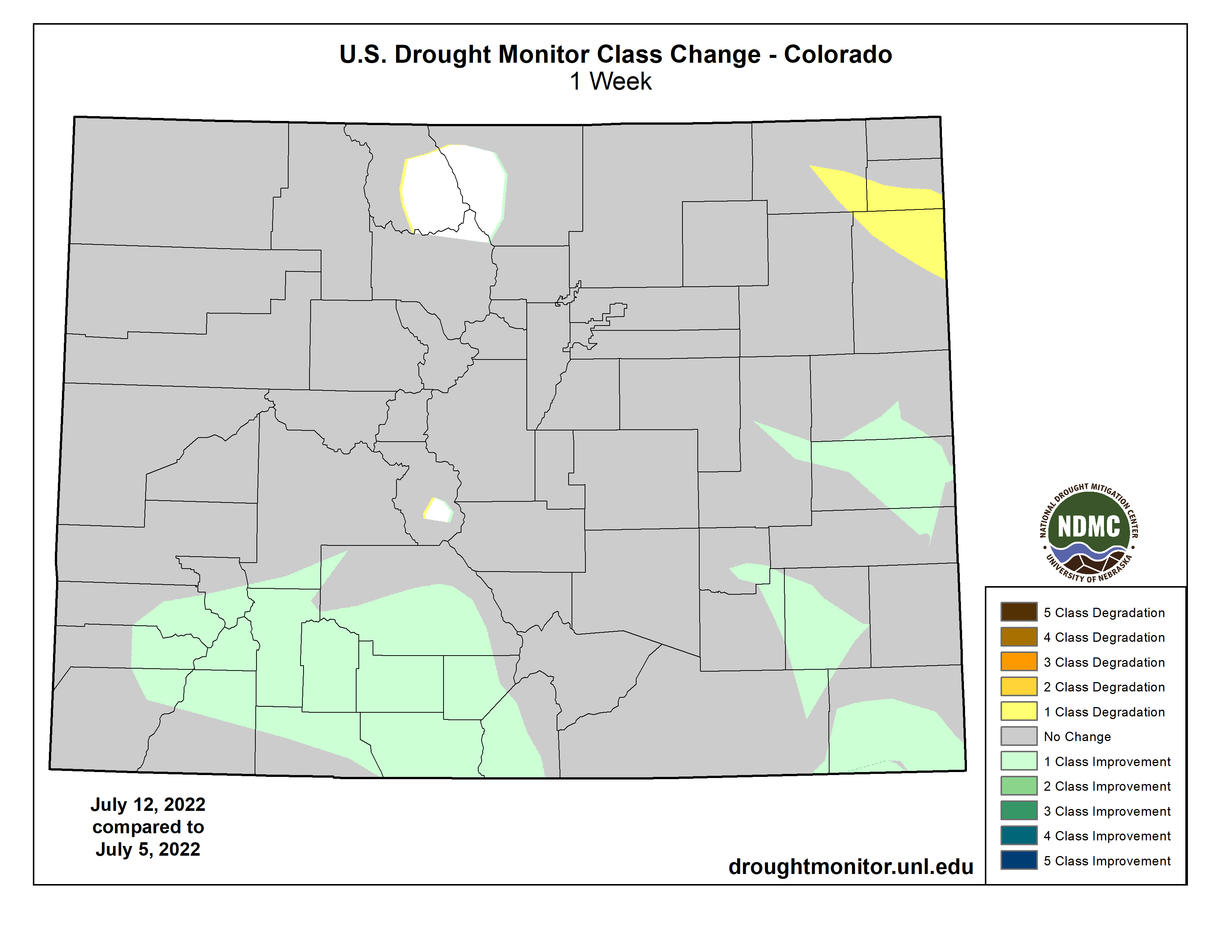
#Drought news (July 14, 2022): Exceptional drought was removed in southeast #Colorado and extreme drought was reduced this week…Severe drought was improved in southwest Colorado
Click on a thumbnail graphic below to view a gallery of drought data from the US Drought Monitor website.
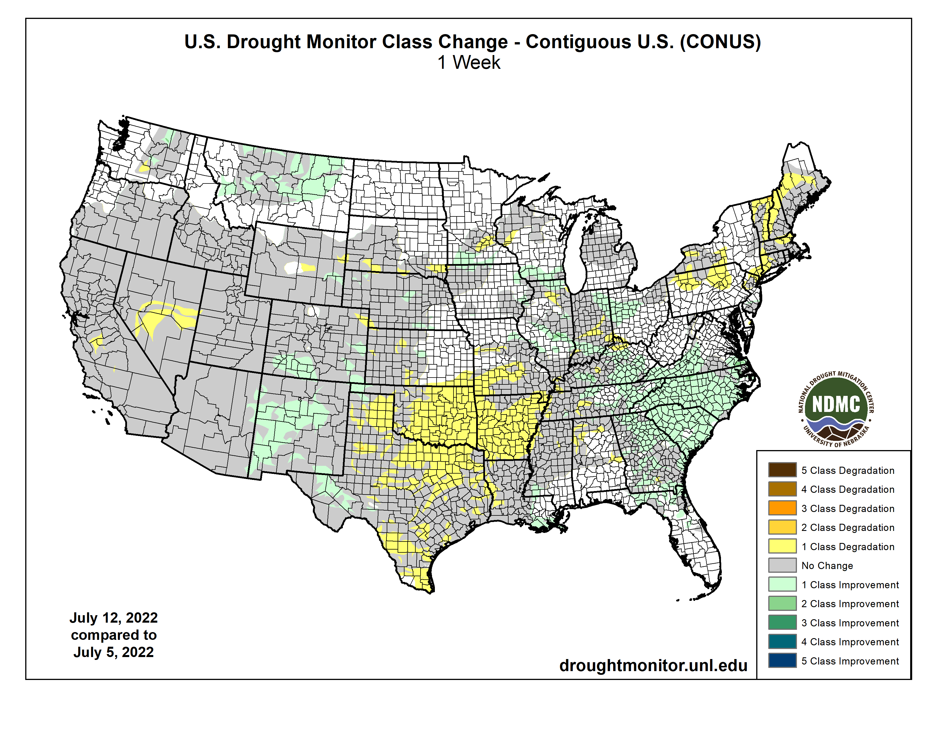
An active weather pattern over much of the Midwest and Southeast brought with it ample rain over many areas, with some places recording more than 5 inches for the week. Dry conditions were noted in the Northeast, West, and southern Plains where flash drought conditions were impacting vast portions of Texas, Oklahoma, Arkansas and into the lower Mississippi River valley. Monsoonal moisture continued to be spotty over much of Arizona and New Mexico, reaching into portions of west Texas as well as southern Colorado and Utah. Temperatures were near normal to slightly above over most of the U.S., with cooler-than-normal temperatures over portions of the West, Northeast, and Mid-Atlantic and above-normal temperatures over most of Texas, Oklahoma, Arkansas, and southern Missouri…
Most of the region had warmer-than-normal temperatures for the week, with most areas 1-3 degrees above normal. Heavy rains through western North Dakota, central and eastern South Dakota, northwest and central Nebraska, and northeastern Kansas helped with some dryness in the areas. The scattered nature of the rains left many dry, though, as summer thunderstorms were hit or miss in the region. Some improvements were made in Nebraska and central Kansas as well as on the plains of Colorado and Wyoming this week where the short-term wetness helped to alleviate concerns. Degradation took place over central Wyoming, southern South Dakota and western Kansas where longer-term dryness has been in place and most of these areas have missed out on earlier precipitation events. Exceptional drought was removed in southeast Colorado and extreme drought was reduced this week. Southeast Kansas is an area where abnormally dry and moderate drought expanded this week, as they are on the northern fringe of a flash drought that has been developing over the last 4-5 weeks…
Colorado Drought Monitor one week change map ending July 12, 2022.
Cooler-than-normal temperatures prevailed from the Pacific Northwest into much of California and western Nevada, where temperatures were 1-3 degrees below normal. Much of the rest of the region was normal to slightly above normal for the week. Above-normal rains fell in portions of Oregon and Washington as well as in Montana. Monsoonal moisture continues in New Mexico and Arizona, but it is widely scattered in nature compared to earlier in June. The rains did allow for some improvement in areas of New Mexico, where extreme and severe drought were reduced, and western Arizona, where severe drought was reduced. Severe drought was improved in southwest Colorado and much of the drought area of Montana had a full-category improvement. Moderate drought and abnormally dry conditions were adjusted in Washington to show a mix of improvements and some expansion of moderate drought. Extreme and exceptional drought was expanded over central Nevada and exceptional drought was expanded to include more of the San Joaquin Valley in California…
The region was mainly dry outside of some monsoonal moisture that made it into portions of West Texas and the panhandle. Portions of southwest Mississippi into southern Louisiana also benefited from above-normal precipitation this week. Some of the warmest temperatures in the country were observed in the region this week with many places having multiple days of triple-digit heat. Temperatures were 5-10 degrees above normal over much of the region as flash drought has developed. With the rapidly developing situation, without relief from the heat or precipitation, drought will continue to intensify rapidly. There were many changes to the drought intensity of the region this week, with only areas of west Texas and the panhandles of Texas and Oklahoma showing any improvements. Almost all of eastern Oklahoma, northern Texas, and Arkansas had a full-category degradation this week. Further degradation took place over central and southern Texas as well as portions of northern and western Louisiana. Coleman County, Texas had its driest January-to-June period on record going back to 1895. Other counties that had the driest first six months of the year were Bosque, Hamilton, Coryell, Wilson, Karnes, and Bee counties in Texas and Calcasieu Parish in Louisiana. There has been an uptick in the number of cattle sales taking place as water and feed demands are being impacted by the drought…
Looking Ahead
Over the next 5-7 days, it is anticipated that the monsoonal moisture will continue to bring rains throughout the Four Corners region. Active weather over the Midwest, Gulf Coast and Southeast will again bring widespread precipitation. Precipitation in the central Plains and northern Rocky Mountains will be minimal and dry conditions will continue to dominate the West as well as much of the southern Plains. Temperatures during this period will be well above normal over the western half of the U.S. with temperatures 6-9 degrees above normal while cooler-than-normal temperatures will be common over the eastern half with departures of 1-3 degrees below normal.
The 6-10 day outlooks show that the vast majority of the country has above-normal chances of recording temperatures that will be warmer than normal. The greatest probability of above-normal temperatures will be over the central to southern Plains. Alaska has above-normal chances of having cooler-than-normal temperatures during this time. The best chance of above-normal precipitation is over the Southwest and Southeast while much of the rest of the country will likely have below-normal precipitation, with the greatest chances in the Pacific Northwest and southern Plains.
US Drought Monitor one week change map ending July 12, 2022.