
Click the link to read the article on the Aspen Journalism website (Paul Anderson):
August 8, 2025
“The house of America is founded upon our land, and if we keep that whole, then the storm can rage, but the house will stand forever.” — President Lyndon B. Johnson
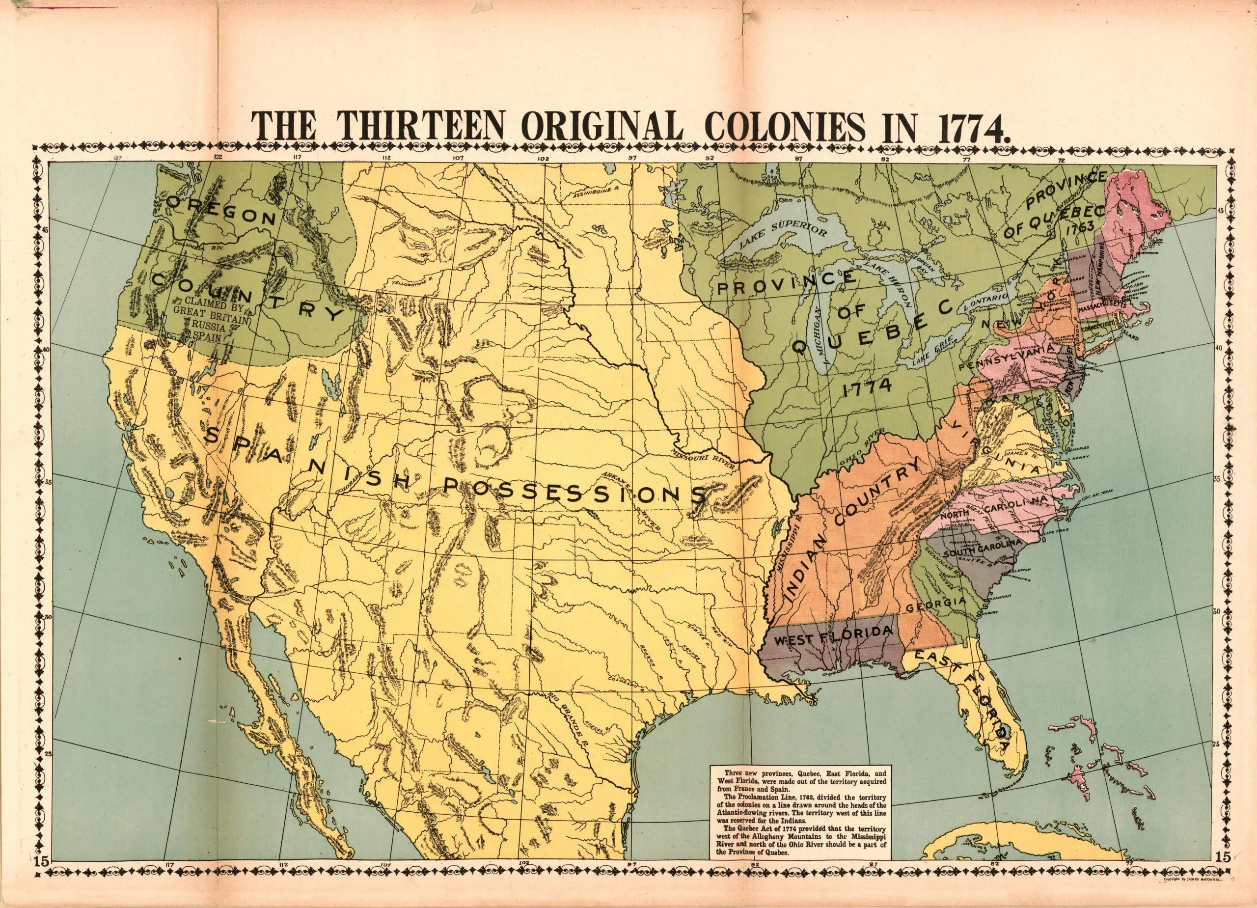
Editor’s note: This story is part one of a three-part series examining the notion of public lands, both in the United States and in our region. Part one looks at the earliest expressions of the commons in territories that would become the United States. Parts two and three, which will run Sunday and Monday, look at the history and legacy of what is now the White River National Forest.
In April, U.S. Sen. John Hickenlooper, D-Colo., held a public gathering in Eagle to discuss the future of public lands under the Trump Administration. Will Roush, director of Carbondale-based Wilderness Workshop, stated a chief concern: Not only should public lands be protected — they must be maintained.
“Part of this work to make sure that we protect our public lands is just to keep our public land,” Roush said, as quoted in The Aspen Times on April 16. “If we can have a conversation about protecting public lands, then we’re not having a conversation about selling public lands.”
Roush’s reference was to the proposed sale of public lands that had been floated by Republican lawmakers as part of the budget reconciliation process. Hickenlooper said that any such large sales of public land would happen “over my dead body.” Since then, the sale of public lands advanced by Sen. Mike Lee, R-Utah, was removed from the Republicans’ “Big Beautiful Bill” due to pushback from bipartisan public lands advocates.
“Some things just shouldn’t be for sale,” Hickenlooper said, “and selling our public lands, which is one of the greatest assets we have as a country, is unthinkable. Selling broad tracks of BLM land or national forest, that’s unconscionable. So, yeah, I’ll do everything humanly possible to block that. And I’ve talked to enough Republican senators that I can’t imagine that’s ever going to happen — famous last words.”

Exploiting veterans for cheap land
The idea of selling off lands held in public trust throughout the United States is grounds for national reflection on the significance of these very lands. Collectively referred to as the commons, these public lands are defined, according to an artificial intelligence search, as “the cultural and natural resources accessible to all members of a society, including natural materials such as air, water and a habitable Earth.”
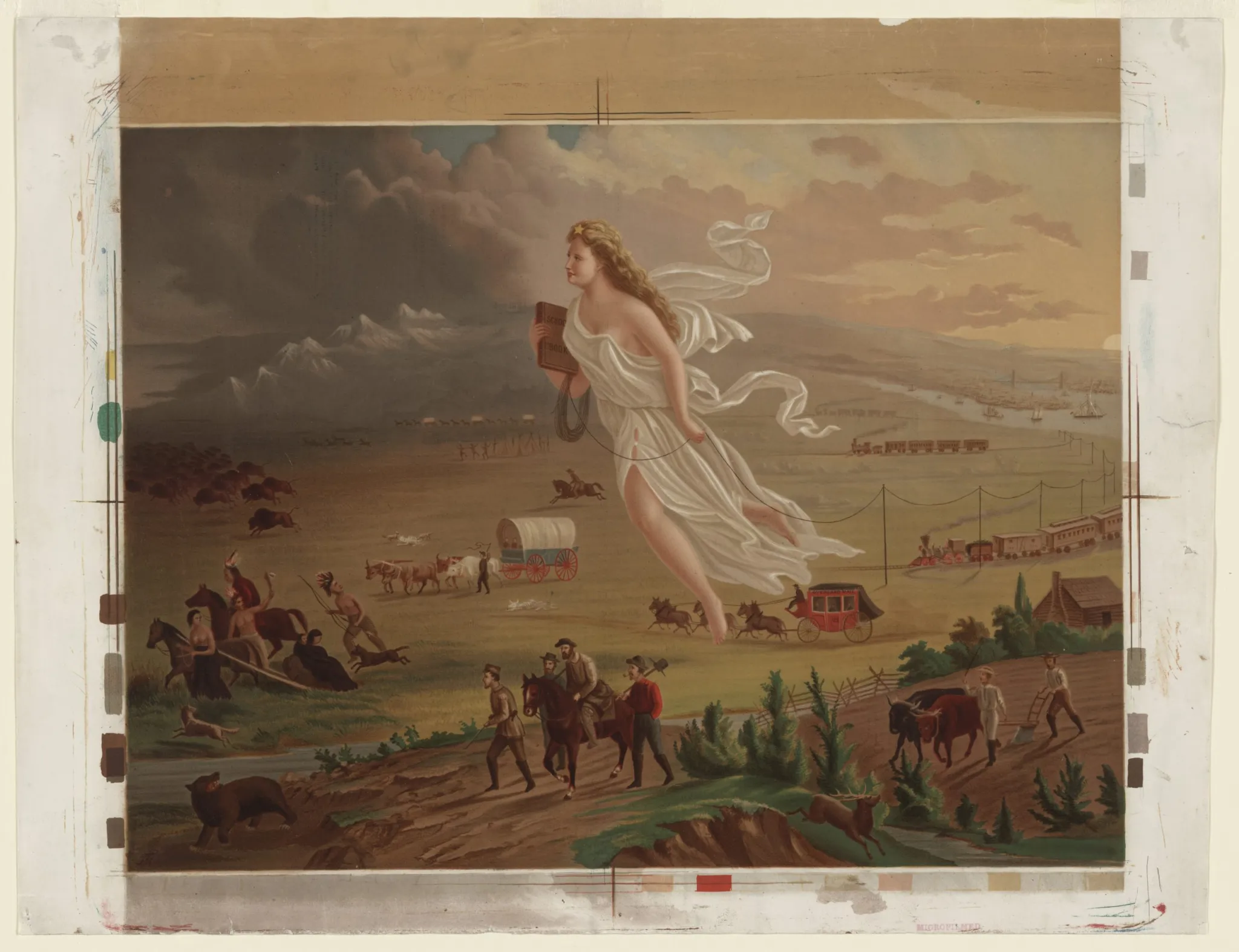
Historically, the privatization of land across the continental United States has been, in large part, a protracted scandal of greed, corruption, exploitation and opportunism. The foundation of what President Lyndon B. Johnson called the “house of America” is established upon countless examples of feckless manipulation, starting in the aftermath of the Revolutionary War that opened the doors to America’s nascent continental empire.
Unable to pay Revolutionary War soldiers with cash in the fight against British domination, the necessarily frugal Continental Congress of this fledgling nation issued scrip, a cash substitute that could be redeemed with land grants on the expanding Western frontier. This complied with Thomas Jefferson’s vision of a landed citizenry — so-called philosopher farmers — who would furnish America with an independent, homespun, land-based community of engaged citizens able to guide the nation toward an enlightened future by “possessing a chosen country with room enough for our descendants to the thousandth and thousandth generation.”
But the plan went awry when cash-strapped veterans of the War of Independence traded their hard-earned scrip for pennies on the dollar to unscrupulous speculators who then cashed in the ill-gotten scrip to acquire millions of acres of Western land. These acts of greedy acquisition squandered the Jeffersonian promise of opening the country to those who had heroically served, often at great sacrifice. Land exploitation was condoned by those who would capitalize on the plight of veterans and the speculation of rising property values as the frontier moved west.
To retiring Gen. George Washington, this represented an irreparable moral failure to make good on a “debt of honor,” which he warned of in his Letter to the Governors at the successful culmination of the Revolutionary War in 1783: “In what part of the continent shall we find any man or body of men who would not blush to stand up and propose measures purposely calculated to rob the soldier of his stipend? And were it possible that such a flagrant instance of injustice could ever happen, would it not excite the general indignation and tend to bring down upon the authors of such measures the aggravated vengeance of Heaven?”
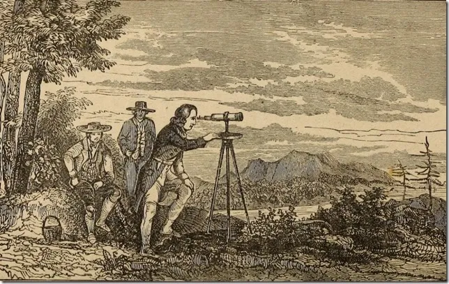
It may be hard to imagine a time in American history when land was so egregiously exploited — or that frontier land could be owned before it was even accurately measured. In “The Measuring of America,” Andro Linklater described the evolution of the earliest measuring instruments necessary for assessing land values: “Measuring out the wilderness made it possible for someone to buy and own it. This was a revolutionary concept. For centuries, the land had been lived in by the Delaware and passed through by the Miami and occupied by the Iroquois, but no one had ever owned it. No one had ever even thought of owning it. The idea of one person owning land did not yet exist on the west bank of the Ohio.”
Puritan colonist John Winthrop of the Massachusetts Bay Company reported in the 1600s, “As for the natives of New England, they enclose no land.” His reference to the enclosure echoed back to England in the 1100s when the public commons had been enclosed by the ruling aristocracy, banishing the people from their native landscapes. In America, where religious freedom had been a primary inspiration for colonial settlement in the new land, the acquisition of property soon predominated as a means for prosperity and personal gain.
Whereas Spanish and French New World settlements were owned strictly by the kings, the British colonies allowed individual ownership, which became a compelling reason for a dramatic swell in migration across the Atlantic. The resultant land hunger made a stark contrast to Native American concepts of the land as sacred common ground.
“What is this you call property?” asked a Massasoit chief in the 1620s of Plymouth colonists whom he had befriended. “It cannot be the earth, for the land is our mother, nourishing all her children, beasts, birds, fish and all men. The woods, the streams, everything on it belongs to everybody and is for the use of all of us. How can one man say it belongs only to him?”
Commoditizing the land
As land ownership evolved, the word “property” had to be redefined to include land. That is why the Virginia Constitution of 1776 — which was a prelude to the U.S. Constitution — stated “life, liberty and property” to be fundamental rights. The right to “the pursuit of happiness” came in a later iteration. It was land that defined a legitimate human pursuit.
Jefferson, America’s third president, assumed, according to Linklater, “the possession of land was the Newtonian principle that made democracy work. It guaranteed the independence of the individual and gave each one an interest in building a law-abiding community. All that was needed was education to teach them how best to use their freedom.”
James Madison, co-author of the Federalist Papers and the fourth president of the United States, differed with Jefferson’s land ethic. Madison regarded land ownership as restrictive and limiting to the need for a “commons” — the joint ownership and stewardship of the land. “Whenever there are uncultivated lands and unemployed poor,” wrote Madison, “it is clear that the laws of property violate natural right.” In an echo of the Native American view, Madison concluded, “The earth is given as a common stock for man to labor and live on.”
As the land became a transactional commodity, it was no longer valued solely for its production potential, but was valued for the raw land itself and what it might bring in speculative appreciation. “More than in any other economy of the time,” wrote Linklater, “American land was the prime producer of wealth … mostly from the increase in its value.”
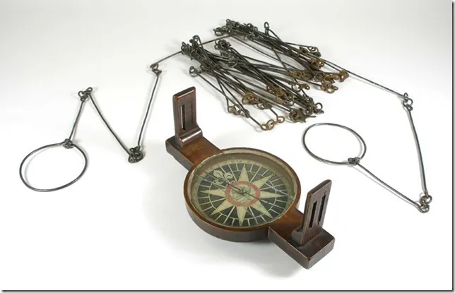
Once a means of measuring the land was accomplished with a chain-link device called Gunter’s Chain, named for its inventor, land could be more accurately quantified, with metes and bounds better determined. This facilitated ownership assurances that could be defended by law. Gunter’s Chain preceded, by more than a century, the more widely used theodolite, a precise optical type of transit.
In the hands of savvy capitalists, measuring the land became a fever utilized by land corporations such as the Ohio Company, which used devalued currency that it had acquired to effect the most advantageous land purchases. “In the 1780s,” wrote Linklater, “most [state currencies] could be bought on the street for twenty cents on the dollar. When the states began to put their own public lands on sale, the holders of such notes could use them to pay for land at the currency’s full value.”
Speculation rewarded those who held the land as it escalated in price commensurate with demand from, as Linklater describes, “land-hungry, timber-yearning, field-dreaming squatters in Kentucky and Virginia” who sought land-owning opportunities. These opportunists saw the frontier as something more tangible than a romantic vision. “The adventure of taming the frontier was certainly there,” wrote Linklater, “but what drew people from eastern states and from around the world was the desire of this soil magically transformed from wilderness to property by the act of measurement and mapping. … The ease with which it made land available to anyone who went west in search of it had an almost incalculable influence on the development of the American psyche and the American economy.”
In his seminal 1782 essay, “What Is an American?,” French immigrant farmer Jean de Crevecoeur issued a paean to the land and what it meant to America then. “I wish I could be acquainted with the feelings and thoughts which must agitate the heart and present themselves to the mind of an enlightened Englishman when he first lands on this continent. He must greatly rejoice that he lived at a time to see this fair country discovered and settled. He must necessarily feel a share of national pride when he views the chain of settlements which embellishes these extended shores.”
Equality and independence, wrote Crevecoeur, were the values the land gave to its new legal owners. “We are a people of cultivators, scattered over an immense territory, communicating with each other by means of good roads and navigable rivers, united by the silken bands of mild government, all respecting the laws without dreading their power, because they are equitable. … We are all animated with the spirit of an industry which is unfettered and unrestrained because each person works for himself.”
The American landscape became an asylum for the landless poor of Europe who had no opportunity to own land where they were born because of feudal controls that held the land for the aristocracy. “Can a wretch who wanders about, who works and starves, whose life is a continual scene of sore affliction or pinching penury — can that man call any other kingdom his country?” asked Crevecoeur. “A country that had no bread for him, whose fields procured him no harvest, who met with nothing but the frowns of the rich, the severity of the laws, with jails and punishments, who owned not a single foot of the extensive surface of this planet?”
Is it any wonder that land hunger was pervasive and drove hard men and women onto the rapidly expanding frontier of a continent that felt ripe for the plucking? America’s first president was exuberant in his depiction of just this manner of thought when he wrote his Letter to the Governors in 1783, as the Revolutionary War came to an end.
“The citizens of America,” Washington wrote, “placed in a most enviable condition, as the sole lords and proprietors of a vast tract of continent, comprehending all the various soils and climates of the world and abounding with all the necessaries and conveniences of life, are now, by the late satisfactory pacification, acknowledged to be possessed of absolute freedom and independency, are to be considered as the actors on a most conspicuous theatre which seems to be peculiarly designated by Providence for the display of human greatness and felicity.”
Manifest Destiny
Such effulgent prose prompted John O’Sullivan to declare, a century later, “Manifest Destiny” as the divine right of America to possess an entire continent as its just reward without moral scrutiny or remorse, but simply as a preordained right through the grace of God and the happenstance of history.
“Our Manifest Destiny is to overspread and to possess the whole of the continent which Providence has given us for the development of the great experiment of liberty and federated self-government entrusted to us,” O’Sullivan, a noted editor and diplomat, wrote in an 1845 essay about annexing vast areas of Western U.S. lands, including Texas.
This utilitarian affirmation of a right to possess paved the way to exploit all that the land could provide in a sometimes misbegotten destiny that would include the Dust Bowl of the 1930s. Manifest Destiny became a national entitlement of unlimited scope that remains an imperialistic rationale today.
Although individual and corporate land acquisitions of the 1700s ceded control of millions of acres from the public trust to private holdings, they were small potatoes compared with national acquisitions such as the Louisiana Purchase in 1803 as governments entered into the land market with astronomical acreages that amalgamated landscapes as mere abstractions.
“The sale of an empire,” wrote Linklater of Jefferson’s enormous real estate deal with the French, “was not an issue; it was simply a land deal.” The now-seemingly paltry sum of $15 million was deemed high at the time and raised eyebrows for profligacy. Yet, the French holdings of the purchase were acquired for 5 cents per acre — one of the most astounding real estate deals in history.

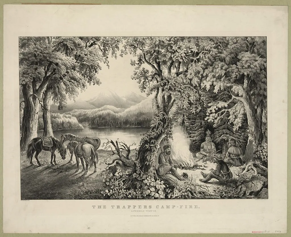
In Steven Ambrose’s “Undaunted Courage” account of Meriwether Lewis and William Clark’s Corps of Discovery, the extent of the newly acquired Western lands and a constant sense of the unknown in their vast scale affected every member of the team and its captains. After reaching the Pacific coast at the mouth of the Columbia River, Lewis and Clark called for a vote that would decide a conundrum as to where the Corps would winter over. That vote was the first time in an official U.S. government capacity that a woman, a Native American and a Black African cast ballots with equal weight to their white counterparts. Sacajawea filled two roles, as both a woman and a Native American; and Clark’s slave, York, was the Black man. The captains granted them a say because their shared travails during the 18 months it took to reach the coast across the wilderness of the Louisiana Purchase had bonded them as equals.
And yet, what of the natives who had no vote and no say at other crossroads? They became collateral damage in the rapaciously acquisitive westward march across their former homelands. “Almost every Indian war from Fallen Timbers in 1794 to the final massacre at Wounded Knee in 1890 had its origin in the hunger for land,” wrote Linklater. Defeated, coerced and compromised, the natives often had no choice but to sign land-granting treaties that exploited their plight under rule by opportunistic whites. “The United States was making an offer that could not be refused,” wrote Linklater.
The treatment of the Cherokee was among the most brutal when settlement pressures divided their nation and later expelled its Eastern half, even though the tribe had settled to legitimately tend the land with white man’s ways, as had been stipulated. Removed by force to Oklahoma in the winter of 1838 by edict of President Andrew Jackson, the Trail of Tears claimed the lives of 4,000 of the dispossessed 16,000 from disease, starvation and bitter cold on this notorious death march.
His calloused treatment of the Cherokees in shameless pursuit of land reflected a deeper set of character flaws regarding Jackson’s presidency (1829-37), flaws that appear to crop up now and again in America’s top political figures, as a newspaper editorial of the day made clear:
“The language of Jackson has been that of a heartless despot, solely occupied with the preservation of his own authority. Ambition is his crime, and it will be his punishment too: intrigue is his native element, and intrigue will confound his tricks, and will deprive him of his power; he governs by means of corruption, and his immoral practices will redound to his shame and confusion. His conduct in the political arena has been that of a shameless and lawless gamester. He succeeded at the time, but the hour of retribution approaches, and he will be obliged to disgorge his winnings, to throw aside his false dice, and to end his days in some retirement, where he may curse his madness at his leisure; for repentance is a virtue with which his heart is likely to remain forever unacquainted.”
This treaty-breaking policy became a pattern that repeated itself again and again as Linklater describes: “Incursion by small groups of settlers, growing tension, Indian violence, American retaliation and the intervention of the U.S. Army.”
Such would be the fate of the Northern Utes in 1881, when this same progression fomented what was known as the Meeker Massacre and the expulsion of the Utes to two reservations after Colorado Gov. Frederick Pitkin’s decree that “The Utes must go!” Pitkin proclaimed that the “Ute problem” would be resolved either by moving them to reservations or eliminating them by extermination. Thus, 12 million acres of land, including Aspen and the Roaring Fork Valley, were opened to white settlement.
Love of the land
As egregious as this historical progression sounds, all of us in western Colorado now call Ute lands our home. And so it has gone for generations of Americans whose acquisition of these once Native American lands has been a blessing overlaying a curse to those who were ruthlessly dispossessed. Many an author has described with rapture a sense of discovery, enchantment and enrichment from contact with these fought-over lands from which whole peoples were vanquished.
“When I strike the open plains, something happens,” wrote author Willa Cather (1873-1947), whose writings exude a deep appreciation for the Western landscapes of America. “I’m home. I breathe differently. That love of great spaces, of rolling open country like the sea, it’s the grand passion of my life.”
In 1850, long before Cather found her identity with the land, an Oregon Trail pioneer from Indiana, Margaret Frink, wrote a florid description of a junction of Midwestern wagon routes upon crossing Cottonwood Creek in Nebraska. Her praises as a witness to history are quoted in Rinker Buck’s “The Oregon Trail”:
“In the afternoon we came to the junction of the emigrant road from St. Joseph with our road. … Both roads were thickly crowded with emigrants. It was a grand spectacle to view the vast migration slowly winding its way westward over the broad plain. The country was so level we could see the long trains of white-topped wagons for many miles. It seemed to me that I had never seen so many human beings in all my life.”
Buck, who traveled the 2,150-mile Oregon Trail in four months by mule-drawn wagon in 2011, also quoted journalist George Law Curry, who crossed the trail in 1846 and was among 400,000 who had done so in the 15 years before the Civil War. Curry’s reflection was published in a St. Louis newspaper:
“Life on the plains far surpasses my expectation; there is a freedom and a nobleness about it that tend to bring forth the full manhood. A man upon the horizon-bound prairie feels his own strength and estimates his own weaknesses. He is alive to everything around him. For him there is a joy in the ‘lone elm’ grandeur on the mounds, beauty in the grassy and flower-besprinkled couch on which he rests, and a glory forever round him that stretches his spirit to its fullest tension.”
There were other reasons for the migration that made the West attractive, such as the growth of industrializing cities and the impending conflict over the spread of slavery, both repellant to those sensitive, bucolic souls seeking a peaceful little spread far from the madding crowd. The 1862 Homestead Act was the inducement where 160 acres could be claimed, worked and owned outright after living on it and improving it for five years. A small filing fee was required, as well as enough savings to get through until the land proved up.
“The idea behind the Homestead Act,” wrote Ian Frazer in “Great Plains,” “was that a nation of small, independent farmers would make the best foundation for democracy. It was an idea as old as the United States where politicians from the North wanted to fill the West with farmers to stop the spread of slavery.”
There was a political motive for offering free land, and an economic motive for those who sought it. Yet, the gift of land was not always fruitful for those who acquired it because of what all real estate brokers know about location, location, location. Bottomland near railroads was hard to get, so most homesteads were located on less-than-optimal plots. The homestead promise often failed to match up to the reality on the ground on what was a minimal portion of land, which rarely was enough to subsist on in pursuit of the evasive and intangible American dream.
Frazer wrote that the invention of barbed wire was necessary for any farm settlements to be possible and that the rates of success were marginalized by climate and aridity. Promotions by the U.S. Geological Survey and the serving railroads attempted to whitewash this harsh reality with “the meteorological theory that ‘rain follows the plow’ … that cultivation of the soil, human activity, steam from railroad engines — all the developments that accompany settlement — produced increased rainfall.” A so-called “rainline” was declared as an enticement by the Santa Fe Railroad to advance frontier settlements by 18 miles per year across the naturally arid West.
Cultivation was also thought to enhance dryland agriculture, but it proved yet another frontier fallacy as the sod was broken by the steel plow, resulting in destructive erosion. “Many thousands of homesteaders ended up owning farms on the Great Plains,” wrote Frazer. “But an even larger number went broke, lost their crops to grasshoppers, saw their fields dry up and blow away, went into debt, went crazy with loneliness, sold out, left, and never came back.”
Still, a deep-seated affection and affinity existed for the land as a romantic sense of place that was captured in verse by Katherine Lee Bates when she wrote “America the Beautiful” in 1895, five years after the closing of the American frontier. Her inspiration was a vision of Colorado’s Pikes Peak, for which the song was originally named:
O beautiful for spacious skies,
For amber waves of grain,
For purple mountain majesties
Above the fruited plain!
America! America!
God shed his grace on thee
And crown thy good with brotherhood
From sea to shining sea!Settlers in the Roaring Fork Valley, specifically Missouri Heights, raised similar paeans to the blessings of the land they acquired in the late 1800s and early 1900s as described by settler David Kapp in Anita McCune Witt’s “They Came From Missouri: The History of Missouri Heights, Colorado”:
I’ve got a hundred-sixty acres in the valley
I’ve got a hundred-sixty acres of the best
Got an old stove there
That’ll cook three square
And a bunk where I can lay me down to rest.
I’ve got a hundred-sixty acres full of sunshine
I’ve got a hundred-sixty million stars above
Got an old paint hoss
I’m the guy who’s boss
On a hundred-sixty acres that I love.Witt wrote: “They came by ship, by foot, by horse, and mule and oxen, by covered wagon and railroad box car, from all over the world, ultimately to settle on the high mesa above the Roaring Fork Valley.”

The land forged the America character
The frontier experience was best described by Frederick Jackson Turner in his famous 1893 essay, “The Significance of the Frontier in American History.” In that vaunted text, Turner credits the varied landscapes of the American frontier with deeply influencing the American character.
“The existence of an area of free land, its continuous recession, and the advance of American settlement westward explain American development,” wrote Turner. “Behind institutions, behind constitutional forms and modifications lie the vital forces that call these organs into life and shape them to meet changing conditions. … The changes involved in crossing a continent, in winning a wilderness, and in developing at each area of this progress out of the primitive economic and political conditions of the frontier into the complexity of city life.”
Turner’s thesis underscores the critical importance of the land — the commons — as a formative influence to national characteristics of individualism, risk-taking, innovation and the constant refreshing of democratic institutions on the ever-advancing frontier as manifest in new communities far beyond the reach of established institutions. Against that demanding, sometimes fatal, character-building crucible, the American spirit was forged.
“American social development has been continually beginning over again on the frontier,” wrote Turner. “This perennial rebirth, this fluidity of American life, this expansion westward with its new opportunities, its continuous touch with the simplicity of primitive society, furnish the forces dominating the American character. The true point of view in the history of this nation is not the Atlantic Coast, it is the Great West.”
Turner described a de facto evolution across the landscape: First came the pioneer, who provisioned himself from the land with the rudiments of shelter, food and clothing, but never ownership. As the pioneers moved to new ground, they were replaced by emigrants who sought a longer tenure with land ownership, farming and establishing more permanence with their dwellings through the social institutions that platted towns and birthed cities. Finally came the developers, mercantile agents and entrepreneurs who converted the land to commercial purposes and ushered in urbanity.
The frontier landscapes also played a role in social diversity, as Turner posited: “In the crucible of the frontier the immigrants were Americanized, liberated and fused into a mixed race.” The frontier also influenced politics: “The legislation which most developed the powers of the national government, and played the largest part in its activity, was conditioned on the frontier.” The frontier also set a tone for a particular American personality: “The American intellect owes its striking characteristics to the frontier,” wrote Turner, “that coarseness and strength combined with acuteness and inquisitiveness, that practical, inventive turn of mind, quick to find expedients, that masterful grasp of material things, lacking in the artistic but powerful to effect great ends, that restless, nervous energy, that dominant individualism, working for good or for evil, and withal that buoyancy and exuberance which comes with freedom — these are the traits of the frontier.”

Author Wallace Stegner recognized that the frontier had mostly been a wilderness bereft of human influence, which attributed the frontier with the power to “shape our history as a people.” Wilderness, the most protected landscape of U.S. public lands, was changed by those who pushed against it while they, too, were changed by coming in contact with it.
“While we were demonstrating ourselves the most efficient and ruthless environment-busters in history,” wrote Stegner, “and slashing and burning and cutting our way through a wilderness continent, the wilderness was working on us. It remains in us as surely as Indian names remain on the land.” Americans, he added, were “in subdued ways, subdued by what we conquered,” making us a nation of “civilized man who has renewed himself in the wild.”
Our wild lands — the untamed commons — continue to provide “spiritual refreshment,” wrote Stegner, “where the fun houses, the bulldozers, and the pavement of our civilization are shut out.” Stegner quoted author Sherwood Anderson, who suggested that men working in the outdoors “got a sense of bigness outside themselves that has now in some way been lost. Mystery whispered in the grass, played in the branches of trees overhead, was caught up and blown across the American line in clouds of dust at evening on the prairies.” Available here was a “deep, semi-religious influence” where men lost their “shrillness” and “learned the trick of quiet.”
Within his inspiring essay on wilderness, written in 1960 as a letter of comment to a federal lands manager, Stegner offered a manifesto for the conservation of a landscape that exists thanks to enlightened visionaries who recognized its lasting value for future generations, a landscape that can never be re-created:
“Something will have gone out of us as a people if we ever let the remaining wilderness be destroyed; if we permit the last virgin forests to be turned into comic books and plastic cigarette cases; if we drive the few remaining members of the wild species into zoos or to extinction; if we pollute the last clear air and dirty the last clean streams and push our paved roads through the last of the silence, so that never again will Americans be free in their own country from the noise, the exhausts, the stinks of human and automotive waste. And so that never again can we have the chance to see ourselves single, separate, vertical and individual in the world, part of the environment of trees and rocks and soil, brother to the other animals, part of the natural world and competent to belong in it.
“Without any remaining wilderness we are committed wholly, without chance for even momentary reflection and rest, to a headlong drive into our technological termite-life, the Brave New World of a completely man-controlled environment. We need wilderness preserved — as much of it as is still left, and as many kinds — because it was the challenge against which our character as a people was formed. The reminder and the reassurance that it is still there is good for our spiritual health even if we never once in 10 years set foot in it. It is good for us when we are young, because of the incomparable sanity it can bring briefly, as vacation and rest, into our insane lives. It is important to us when we are old simply because it is there — important, that is, simply as an idea.”
Wilderness historian Roderick Nash detailed the evolution of wilderness ideology in his 1965 book “Wilderness and the American Mind,” quoting Aldo Leopold, America’s first conservation biologist: “Recreational development is a job not of building roads into lovely country,” Leopold observed in 1938, “but of building receptivity into the still unlovely human mind,” which lacked, in Leopold’s view, the wherewithal to “embrace, love, respect and admire the land.”
As a soundbite for conservation, Nash coined this rhetorical question: “Doesn’t the present owe the future a chance to know the past?”
Still, the utilitarian counterpoint has played a strong hand in land management and was made clear when vast acreages in Alaska were earmarked for wilderness during some of the most passionate conservation years in American history in the 1970s as the nation awoke to emergent wilderness values. “I believe,” said Robert Dilger of the Washington State Construction Trades Council, “that it is unwise to lock up for the future 146 million acres of land that has hardly been surveyed, let alone thoroughly analyzed for its resources.”
Dilger’s views echoed the “Wise Use” mindset that swept through many Western states in the 1980s and ‘90s, an idea that originated with Gifford Pinchot (1865-1946), the first chief of the U.S. Forest Service under President Theodore Roosevelt. “Pinchot’s devotion to the forest,” states a Facebook site honoring Pinchot, “went far beyond beauty and spiritual admiration. He saw protecting the national parks as a ‘social good’ and recognized that national forests had value not only because of their beauty but also because of the resources they provided to citizens.”
The outcome of innumerable debates, contentions and often-conflicting policies over public lands has resulted in a cumulative de facto division of enormous reaches of the commons across the continent. In a little over a century, the parceling of the great American landscape represents an intractable set of manipulations to control and own the commons by those who have often sought none other than personal gain.
Linklater wrote: “Since 1785 the landmass of the United States has grown to 2.3 billion acres, and of that total, 1.8 billion acres spread across 32 states have been at one time in the public domain. More than 1 billion acres have been transferred to individual ownership. In economic terms alone, it has represented the greatest orderly transfer of public resources to the private sector in history.”
Given the current trends in Washington, D.C., the proposed dispersal of public lands to which Hickenlooper speaks may surge again in historic proportions in acts that may make a strange mockery of a traditional and well-known Woody Guthrie song that has a crucial meaning to most Americans.
“This Land is Your Land”
This land is your land, this land is my land
From California to the New York Island
From the Redwood forest to the Gulf Stream waters
This land was made for you and me.As I went walking that ribbon of highway
I saw above me that endless skyway
I saw below me that golden valley
This land was made for you and me.I roamed and I rambled and I followed my footsteps
To the sparkling sands of her diamond deserts
While all around me a voice was sounding
This land was made for you and me.When the sun came shining, and I was strolling
And the wheat fields waving and the dust clouds rolling
A voice was chanting as the fog was lifting,
This land was made for you and me.This land is your land, this land is my land
From California to the New York Island
From the Redwood Forest to the Gulf Stream waters
This land was made for you and me.***
This story, and Aspen Journalism’s ongoing coverage of challenges facing local public lands, is supported by a grant from the Fund for Investigative Journalism.


