Click here for all the links and graphics. Nice aggregation of data in one place.


Click here for all the links and graphics. Nice aggregation of data in one place.
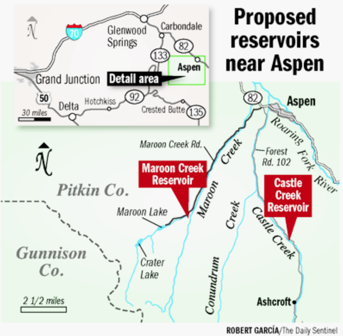
Editor’s note: The following is the fourth and final part in a series exploring the city of Aspen’s historic intent in filing for and maintaining conditional water rights for storage reservoirs on Castle and Maroon creeks.
By Brent Gardner-Smith, Aspen Journalism
ASPEN – The city of Aspen has said for decades that legislation approving the Fryingpan-Arkansas Project gives a certain status to the potential Castle Creek and Maroon Creek reservoirs.
However, it’s hard to discern just what that status is, and federal and regional water officials are dismissive of the city’s claims.
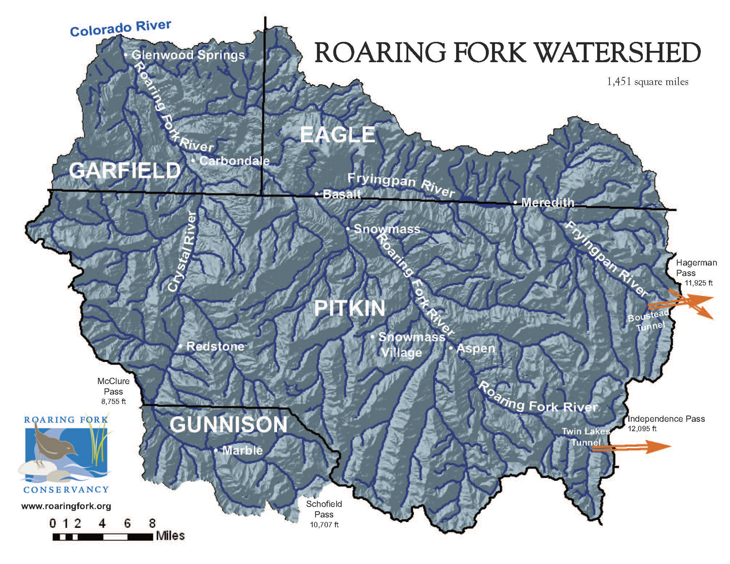
Built in the 1960s and early 1970s, the Fry-Ark Project is one of the larger transmountain diversion systems in Colorado. It diverts water from the headwaters of the Roaring Fork River, including Hunter, Midway, and No Name creeks, along with large amounts of water from the many tributaries in the headwaters of the Fryingpan River.
In all, the project includes 16 diversion structures that direct an average of 57,000 acre-feet of water a year to the Boustead Tunnel, which runs under the Continental Divide. The gathered water then flows to Turquoise Reservoir near Leadville and into the Arkansas River basin, serving both Front Range cities and agriculture on the eastern plains.
A key component of the Fry-Ark Project is Ruedi Reservoir above Basalt, which was built in the early 1960s as “compensatory storage” for Western Slope water users. Water collected in Ruedi does not flow to the East Slope.
Plans to divert water from the Fryingpan River date back to the 1930s, but the Fry-Ark Project as largely configured today was the result of intensive planning efforts and discussions that took place throughout the 1950s and early 1960s.
Aspenites in the 1950s were well aware of the looming Fry-Ark Project, especially as the Twin Lakes-Independence Pass project, built in the 1930s, was already diverting large amounts of water off the top of the Roaring Fork River.
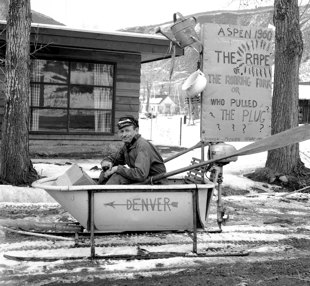
For example, in the 1954 Winterskol parade, local musician, letter-to-the-editor writer and junkyard operator Freddie Fisher created a witty float about the looming “rape of the Roaring Fork” that featured himself sitting in a bathtub-boat on skis while pondering the question, “Who pulled the plug?”

In the legislation
As the city is often quick to point out, the federal Fry-Ark legislation does in fact state that a feasibility report on a reservoir on a “tributary of the Roaring Fork River” should be prepared by the Department of the Interior; and if such a reservoir made economic sense, then the feasibility report should be submitted to Congress for review.
“The secretary [of Interior] shall investigate and prepare a report on the feasibility of a replacement reservoir at or near the Ashcroft site on Castle Creek, a tributary of the Roaring Fork River above its confluence with the Fryingpan River with a capacity of approximately 5,000 acre-feet,” the authorizing legislation states, “but construction thereof shall not be commenced unless said report, which shall be submitted to the president and the Congress, demonstrates the feasibility of said reservoir and is approved by Congress.”
The city maintains that the language, “at or near the Ashcroft site on Castle Creek,” still pertains to the potential Castle Creek Reservoir two miles below Ashcroft.
The operating principles for the Fry-Ark Project, which were hashed out by both entities on both sides of the Continental Divide, also address Ashcroft Reservoir.
“The Ruedi Reservoir shall be constructed and maintained on the Fryingpan River above the town of Basalt with an active capacity of not less than 100,00 acre-feet,” the principles state. “In addition thereto and in order to offset adverse streamflow conditions on the Roaring Fork River above the town of Aspen which might occur as a result of the project enlargement of the Twin Lakes Reservoir, the Ashcroft Reservoir on Castle Creek, or some reservoir in lieu thereof, shall be constructed on the Roaring Fork drainage above Aspen to a capacity of approximately 5,000 acre-feet: Providing, however, That the Ashcroft Reservoir shall be constructed only if the Secretary of the Interior after appropriate study shall determine that its benefits exceed the costs … ”
It also further defines Ashcroft Reservoir by stating that “‘Ashcroft Reservoir’ means not only the reservoir contemplated for construction on Castle Creek, a tributary of the Roaring Fork River, but also, unless the context requires otherwise, any other reservoir that may be constructed in the Roaring Fork Basin above the town of Aspen in lieu of that reservoir.”
To better understand the city’s claim, it’s instructive to view the potential Castle Creek Reservoir as “son-of” Ashcroft Reservoir, which in turn is “son-of” Aspen Reservoir.
For much of the long planning stage of the Fry-Ark Project, it included an “Aspen Reservoir,” which would have stored 28,000 acre-feet of water behind a tall dam at the bottom of the North Star-Stillwater section of the Roaring Fork River, just east of Aspen.
However, opposition to the Aspen Reservoir, primarily from James H. Smith Jr., owner of the North Star Ranch in Aspen, eventually caused Ruedi Reservoir above Basalt to be built instead of Aspen Reservoir.
One of the reasons Aspen Reservoir was attractive to water planners at the time was that it could be used to fill in low flows in the Roaring Fork River below the Salvation Ditch, a large irrigation ditch that diverts water at Stillwater Drive, near the entrance to Mountain Valley.
The combination of the Salvation Ditch, the Independence Pass diversions from the 1930s, and the coming Fry-Ark diversions meant the Fork through Aspen would be often dropped to exceedingly low levels, which is often the case today. And so it was felt that a compensatory reservoir east of Aspen, above the Salvation Ditch, would help keep more water, and fish, in the river.
But opposition by Smith, who was well connected in Washington, D.C., having served as assistant secretary of the Navy for aviation, helped kill the idea of Aspen Reservoir.
In the wake of the decision to abandon Aspen Reservoir, local, state, and federal water officials agreed to include a mention of another potential reservoir, Ashcroft Reservoir, or an alternate nearby reservoir, in the authorizing legislation for the Fry-Ark Project, as something of a consolation prize for Aspen.
Ashcroft Reservoir was once envisioned to be formed by a 140-foot-tall dam near the Elk Mountain Lodge property that would back up 9,056.7 acre-feet of water behind it.
The water right tied to Ashcroft Reservoir was eventually cancelled for lack of adequate due diligence in the 1970s, but today the city of Aspen still considers Castle Creek Reservoir, which is designed to hold 9,062 acre feet, to be the legitimate offspring, at least in the context of the Fry-Ark Project, of Ashcroft Reservoir.
But officials at the Bureau of Reclamation, the Colorado River Water Conservation District, and the Southeastern Water Conservancy District all say that the language in the Fry-Ark approvals has no direct bearing today on either of the two potential reservoirs that Aspen says it still intends to build someday when necessary.

An ‘unmet obligation’
Officials at the city of Aspen, speaking on background, have characterized the tie to Fry-Ark Project as an “unmet obligation” to the city. The obligation, as the city sees it, is to at least prepare a feasibility study of a reservoir on a tributary of the Roaring Fork River.
That “obligation” has been referenced a number of different ways over the years by the city, including most recently on Oct. 10, 2016, when Aspen City Council unanimously approved a resolution declaring their intent to file a diligence application this year for the conditional water rights it holds tied to potential reservoirs on Castle and Maroon creeks.
“Whereas, when these water rights were appropriated, this reservoir storage was an important component of Aspen’s long term water supply plan, particularly since the Fryingpan-Arkansas project was proceeding without the originally planned compensatory storage reservoir on the upper Roaring Fork River,” the council’s 2016 resolution stated.
The city filed two diligence applications on Oct. 31, one for Castle Creek Reservoir and one for Maroon Creek Reservoir. As of Wednesday afternoon, three environmental groups and three private landowners had filed statements of opposition in the cases, and Pitkin County, the U.S. Forest Service, and Trout Unlimited are expected to file statements by the end of the week.
American Rivers, Wilderness Workshop, and Western Resource Advocates have filed statements in both cases. In the Maroon Creek case, Roaring Fork Land and Cattle Co., which is controlled by billionaires Tom and Margot Pritzker, filed a statement. And in the Castle Creek case, Double R Creek Ltd and Asp Properties LLC filed statements. Double R Creek is controlled by Robert Y.C. Ho of Hong Kong and Asp Properties is controlled by Charles Somers, the CEO of SBM, a building services company located in McClellan, Calif.
Here’s how the city described the Fry-Ark relationship to the Division 5 Water Court in 2010, during the most recent diligence review of the water rights for the potential Castle Creek and Maroon Creek reservoirs:
“The Frying Pan-Arkansas Project, authorized by legislation dated August 16, 1962, authorized construction, operation and maintenance of a replacement reservoir on Castle Creek to furnish water required for protection of western Colorado water users,” states a proposed decree from the city’s water attorneys. “This reservoir was contemplated to have a capacity of 5,000 acre-feet, but this reservoir was never built.”
But not everyone agrees that the Fry-Ark legislation “authorized construction, operation and maintenance” of a reservoir on Castle Creek.
The city in 2010 also told the state there was a direct link between the Fry-Ark Project and its potential Castle Creek and Maroon Creek reservoirs.
“In 1965, taking precautions to ensure that its water rights were protected in the event the Frying Pan-Arkansas Project reservoir was in fact never built on Castle Creek, the city of Aspen filed applications seeking its own conditional water rights for storage on Castle Creek and Maroon Creek, i.e., the Castle Creek Reservoir and Maroon Creek Reservoir water rights for which diligence is sought herein,” the city’s 2010 diligence filing stated.
And in a 1990 water management plan, the city stated that “the authorizing act and operating principles of the Fryingpan-Arkansas Project require the Bureau of Reclamation to prepare a feasibility study on a reservoir of up to 5,000 acre feet, in order to offset adverse streamflow conditions in the Roaring Fork River above Aspen.”
But while a feasibility study may be called for in the Fry-Ark legislation, it is difficult to find anyone outside of the city of Aspen who thinks the call is still relevant.

Ancient history?
Sterling Rech, a public affairs manager with the Bureau of Reclamation, recently said, in response to questions about the city’s claim, that the Fry-Ark legislation “requested an investigation but explicitly did not authorize Ashcroft Reservoir unless the report demonstrated feasibility and subsequently, Congress approved it. There is no record of that approval in Reclamation law.”
Rech was asked to double-check with senior Reclamation officials on the point, and after doing so, stood by his statement that the Fry-Ark Project “did not authorize” a reservoir in the Castle Creek valley.
Given that officials at Reclamation would be the ones within the Interior Department to prepare a feasibility study on Castle Creek Reservoir, this would seem to be relevant to the city’s position.
Jim Pokrandt, director of community affairs for the Colorado River District, said the mention of the Ashcroft Reservoir in the Fry-Ark legislation, or a nearby reservoir in lieu of it, “is ancient history versus current events.”
The River District played a key role in developing the operating principles that still guide the Fry-Ark Project. And it’s the entity that originally filed for the conditional water rights on Ashcroft Reservoir in 1959.
“Being mentioned and studied in the context of the Fry-Ark does not bestow anything special at this point in time,” Pokrandt said of the city’s claim.
Chris Woodka, the issues manager for the Southeastern Water Conservancy District, had a similar take. Southeastern was created explicitly to manage the water diverted by the Fry-Ark Project and was instrumental in shaping its authorizing documents.
But Woodka also dismissed any link between the potential Castle Creek Reservoir and the Fry-Ark Project.
“It really doesn’t have a direct connection anymore to the Fryingpan-Arkansas Project,” Woodka said.
However, city officials still beg to differ.

Feds still obligated?
Officials at the city say, on background, that it is clear that a reservoir on a tributary of the Roaring Fork — somewhere above Aspen — was included in the Fry-Ark authorizing legislation, and it was done so by none other than legendary West Slope Congressman Wayne Aspinall, who served in the U.S. House of Representatives from 1949-1973.
And the city says that the obligation still remains for the Department of the Interior to conduct a feasibility study on such a reservoir.
City officials also point to a 2007 letter in regard to potential federal approval of new reservoirs in the Arkansas River basin to hold water diverted from the Fry-Ark project.
In that letter, the city and Pitkin County told the federal government that if it was going to study new reservoirs on the East Slope, it should also study reservoirs on the Western Slope, and by implication, the Ashcroft Reservoir or its successor, Castle Creek Reservoir.
“It is important that the Western Slope’s present and future water supply and storage requirements (for both consumptive and non-consumptive uses) be placed on a par with those of the Eastern Slope and included in all discussions on H.R. 1833,” the city and Pitkin County wrote in a letter to Congressman John Salazar in 2007 regarding pending legislation for the PSOP project, or Preferred Storage Options Plan. “Any feasibility study resulting from H.R. 1833 must address Western Colorado’s present and future regional water needs, not just investigate ways to mitigate impacts from an increase in trans-mountain diversions.”
According to city officials, the city felt it had leverage to ask for such a study because of the language regarding Ashcroft Reservoir in the Fry-Ark legislation. And that a study of Western Slope storage would have had to look at reservoirs such as Castle Creek Reservoir.
Be that as it may, the city’s claim of a lingering obligation in the Fry-Ark project is still out there, but with no clear resolution of how much standing it gives, or might someday give, the Castle and Maroon creek reservoirs.
One reason it is uncertain is that the city has never directly asked the Department of the Interior to produce a feasibility study on the Ashcroft Reservoir, or a successor, based on the obligation claimed by the city in the Fry-Ark legislation.
As such, the “unmet obligation,” if it exists, is still outstanding. And city officials say they’ll see what value it has at some point in the future.
Editor’s note: Aspen Journalism, the Aspen Daily News, and Coyote Gulch are collaborating on the coverage of water and rivers. The Daily News published this story on Thursday, Dec. 29, 2016.

By Brent Gardner-Smith, Aspen Journalism
Editor’s note: The following is the third part in a series exploring the city of Aspen’s historic intent in filing for and maintaining conditional water rights for storage reservoirs on Castle and Maroon creeks.
ASPEN – The city of Aspen has never conducted and then made public a detailed and comprehensive feasibility study of either the potential Maroon Creek Reservoir or the Castle Creek Reservoir.
But in 1971, the Bureau of Reclamation drilled three out of five planned test holes at the Castle Creek dam site, two miles below Ashcroft. What they found in the first few test borings — 142 feet of loose rock and sand — prompted officials at Reclamation to abandon the last two planned bores.
The findings caused the federal agency to write a letter to Aspen’s city manager, telling him that to keep drilling would not be a “wise investment.”
The 1971 drill tests by Reclamation appear to be the high-water mark of investigation into the physical feasibility of either reservoir.
The city filed maps with the state in December 1965 for the two potential reservoirs, but it did very little work on the projects between 1965 and 1970, disregarding suggestions from its consulting engineer, Dale Rea, to conduct feasibility studies on the reservoirs.
But on May 11, 1970, according to city council minutes, the members of the council met with the head of the Colorado River Water Conservation District to discuss the Castle Creek Reservoir.
The minutes note that Rollie Fischer, the “secretary engineer” of the River District, was in Aspen “to discuss with council their cooperation on the reservoir for Castle Creek or the Ashcroft area.”
“Mr. Fischer gave the background and responsibilities of the Water Conservation District and discussed those items that the city and board co-operate on, i.e., proposed dam on Castle Creek,” the Aspen City Council minutes state. “The status of which the Bureau of Reclamation is presently doing preliminary studies as [to] the proposed location of the dam.”
It’s not yet clear just how serious officials at the Colorado River District and the U.S. Bureau of Reclamation were about constructing the Castle Creek Reservoir in cooperation with the city of Aspen, but in the fall of 1970, the Bureau decided to drill some test bores into the ground that would serve as the foundation of the proposed dam. Fischer went up to take a look at the work on Oct. 5, 1970.
“The Bureau of Reclamation has been taking cores at Aspen’s proposed Castle Creek Reservoir site,” Fischer wrote in a quarterly report to the River District Board on Oct. 10. “I visited the site of the coring work with a Bureau of Reclamation geologist. The first cores indicate that valley alluvium is approximately 142 feet deep and the dam site is in a fault zone.”
Word of Reclamation’s findings apparently soon reached Aspen officials.

“Aspen’s proposed dam”
On Oct. 28, 1970, Rea sent a letter to J.W. Robins, a project manager at Reclamation’s office in Grand Junction.
“On several occasions I have had discussions with Mr. Leon A. Wurl, city manager, Aspen, Colorado, concerning any progress you have made with respect to Aspen’s proposed dam on Castle Creek,” Rea wrote to Robins. “We understand you did test drill our proposed dam site but have no further information. If you have made any progress at all in this matter, I would appreciate hearing from you, along with a copy to Mr. Wurl.”
On Nov 4, Rea heard back.
“This letter is in response to your inquiry of Oct. 28, 1970, regarding the status of our work at the Castle Creek dam site,” Robins wrote. “The dam axis we are considering is located about 1,400 feet upstream from the one originally contemplated. The purpose of this change is to place the dam embankment so as to reduce seepage loss through the alluvial fan on the right embankment.
“Our drill crew is presently working on a program of five test holes; to date two holes have been completed. The first hole was located adjacent to the creek channel and found 142 feet of pervious sand and gravel over bedrock of aplite, an igneous intrusive rock. The second hole was drilled on the alluvial fan on the east side of the creek and found 115 feet of overburden over aplite.
“Work is now beginning on a test hole on the right (east) abutment. Other items of work which we have completed at the site include plane table surveys of topography of the damsite and the digging of five test pits to explore for earth materials for dam embankment.
“The rather deep deposit of pervious sand and gravel at this site will present a special design problem to minimize seepage loss,” Robins wrote. “If we can provide further information, please let us know.”
The November 1970 letter was cc’d to Wurl at the city of Aspen.
The “rather deep deposits of pervious sand and gravel” at the Castle Creek dam site were, at a minimum, going to make the Castle Creek Reservoir more expensive.
The following spring, on May 8, 1971, Wurl wrote a letter to Rea.
“It was suggested by the Bureau of Reclamation that perhaps we obtain a cost estimate from a private concern to determine the estimated amount of seepage that would be lost in the bottom of the dam,” Wurl wrote.

A deeper report
And on May 11, 1971 Wurl got a more formal report from Robins at Reclamation about the agency’s drill tests. The report was copied to Fischer at the River District, and it referenced a recent meeting where Wurl had asked Reclamation officials about the Castle Creek drilling tests.
“As explained at this meeting the Bureau drilled three deep holes at the Castle Creek site during the fall and early winter of last year,” Robins wrote.
“The first hole was located adjacent to the present channel of Castle Creek to determine the depth to bedrock and the character of the overburden. The hole found 142 feet of pervious sand and gravel over bedrock. The bedrock was also quite broken and believed to represent a possibly dangerous fault zone.
“The second hole was drilled on the alluvial fan near the base of the right abutment and found 125 feet of sand, gravel, and cobbles over bedrock,” Robins wrote. “Percolations tests showed this material to be unacceptably pervious.
“Although the exact quantity of water that would be lost through this material if a dam were to be constructed at this site without a cutoff trench would be impossible to estimate without detailed tests, the results of the percolation tests we performed indicate the seepage losses would be excessive to acceptable standards for Reclamation design as the resulting piping may dangerously weaken the foundation of the dam.”
This could not have been good news for Aspen city officials, especially the part about how “the seepage losses would be excessive to acceptable standards for Reclamation.”
“The third hole was located at about dam crest elevation on the right abutment,” Robins continued in his letter to the city. “Igneous rock was found but the rock was badly broken to a depth of 142 feet where drilling was stopped. Percolation tests in this hole also showed the rock to be very pervious and an expensive grouting program would be necessary to properly seal this foundation material.
“The fourth hole, planned on the left abutment, was not drilled because of the unsatisfactory geological conditions encountered at the other three holes.
“The results of this drilling indicate that an excessive amount of seepage loss could be expected through the sand and gravel in the canyon bottom unless a cutoff trench or some type of special treatment was performed. The great depth (as much as 142 feet) and the distance of about 900 feet across the bottom area would make such treatment unjustifiably expensive.
“Because of the poor conditions found at the three exploratory holes drilled by the Bureau, we do not believe this additional work would be a wise investment for the district or the city of Aspen,” Robins concluded.
In 1971, Reclamation was still in the business of funding and building large reservoirs in Colorado, but Robins had just dismissed the idea of building one on the city’s proposed site on Castle Creek.

‘Costly mitigation’
In 2012, Aspen Journalism posed a number of questions in writing to city officials about the two reservoirs, including one about the Bureau’s 1971 report.
“Any construction at these sites would require extensive permitting as well as consideration of environmental values and community priorities at the time,” city officials replied at the time. “Construction is very expensive. The Castle Creek site, in particular, will likely require costly mitigation of soil conditions, such as grouting and lining.”
But it’s not clear how expensive such a “grouting and lining” effort would be.
In its Oct. 31 application for finding of reasonable diligence in Division 5 Water Court, the city made a reference to the “significant cost of permitting, design and construction” for the reservoirs, but it has yet to make public a detailed and updated estimate of those costs.
When asked recently if it had produced a recent estimate, David Hornbacher, the city’s director of utilities and environmental initiatives, said the city had “nothing to share at this time.”
A public record search has not provided any evidence of Aspen’s response to the Bureau’s advice that additional work on the Castle Creek dam site would be an unwise investment.

Rights decreed, despite drill tests
But on Nov. 5, 1971, the slowly turning wheels of justice produced an official water court decree for Aspen’s conditional water rights for both reservoirs. The decree came as part of Civil Action W-5884 and gave Maroon Creek Reservoir a priority number of 806 and Castle Creek Reservoir a priority number of 805.
The priority numbers represent the water right’s place in the state’s prior appropriation system, which is predicated on the idea of “first in time, first in right.”
The 1971 date marks the adjudication for the conditional water rights, while the appropriation date, when the “first step” was taken on the water rights, is July 19, 1965, the date on which the Aspen City Council gave direction to Rea to survey the dams and prepare maps to file with the state.
In April 1971, city officials were apparently still discussing the Castle Creek Reservoir with officials at the Bureau of Reclamation and the Colorado River District.
Wurl sent a letter to Rea on April 15, 1971, inviting him to a meeting in Aspen.
“On April 27 at 11:00 there will be a meeting here with the Bureau of Reclamation and the Colorado River Conservation District people relating to the proposed dam site on Castle Creek,” Wurl wrote. “I thought perhaps you would like to attend this meeting.”
About a year later, on May 31, 1972, the city filed its first finding for reasonable diligence with the water court to extend the conditional water rights for the two reservoirs.
The diligence report was prepared by the law firm of Delaney and Balcomb in Glenwood Springs, a leading local water law firm.
In its effort to convince the court it was making progress on building the two dams, the city said it conducted “Geologic core drilling on Castle Creek dam site in November of 1970.”
It did not, however, tell the court of the results of that core drilling, which the city had learned about a year-and-half earlier, November 1970.
Editor’s note: Aspen Journalism, the Aspen Daily News, and Coyote Gulch are collaborating on the coverage of rivers and water. The Daily News published a version of this story on Wednesday, Dec. 28, 2016. This version includes the correct year – 1971 – of a letter referenced in the last section.


Click here to go to the US Drought Monitor website. Here’s an excerpt:
Summary
Numerous storms brought changeable weather to many parts of the country, including significant precipitation in parts of the West, Northeast, and mid-South. Late in the drought-monitoring period, a particularly powerful winter storm produced heavy precipitation from California into the Southwest—and later resulted in a holiday blizzard across the north-central U.S. Meanwhile, the interior Southeast continued to experience varying degrees of drought relief, although streaks of significant rain notably bypassed core drought areas in northern and central Alabama and northern Georgia. In addition, Florida’s peninsula received little rain, exacerbating the effects of short-term dryness…
The Plains
Mild weather returned in the wake of the mid-December Arctic outbreak. A few showers across the central and southern Plains were insufficient to prevent further deterioration in the drought depiction—especially across central and eastern Oklahoma and neighboring areas. In addition, dryness (D0) expanded into much of eastern Kansas, where negligible precipitation has fallen in the last 2 months. From November 1 – December 27, precipitation in Wichita, Kansas, totaled just 0.92 inch (37% of normal).
Farther north, a major winter storm struck the northern Plains on December 25-26. Blizzard conditions engulfed the Dakotas and environs, disrupting holiday travel. From a drought perspective, however, the storm brought highly beneficial moisture to lingering areas of dryness (D0) and moderate to severe drought (D1 and D2) across the northern Plains, resulting in some improvements in the drought depiction…
The West
A pair of storms delivered widespread precipitation (rain and snow) to much of the western U.S., starting around December 22. Some of the most impressive precipitation fell across southern California and the Desert Southwest, where recent improvements have to be viewed through the lens of a multi-year drought that features lingering low reservoir levels; tree mortality; groundwater shortages; and other long-term indicators. Nearly all of the remaining Western drought areas carry the “L” designation, indicative of long-term impacts.
Despite heavy autumn and/or early-winter precipitation nearly region-wide, this season’s accumulated snowpack remains below average in many California and Southwestern basins, owing to several “warm” storms that have produced more rain than snow. For example, California’s Department of Water Resources noted that the average water content of the Sierra Nevada snowpack stood at 6 inches, about 70% of the late-December average but less than one-quarter of the typical April 1 seasonal peak. Still, Western precipitation has been heavy enough in nearly all areas to warrant some improvement in recent weeks, and further improvement could be dictated if strong storms continue to occur and if USDA’s Natural Resources Conservation Service issues an optimistic Western water-supply outlook in early January…
Looking Ahead
On December 29-30, a significant snow storm will unfold across the Northeast, with wind and snow extending southward through the Appalachians. The heaviest snow should fall in the Adirondacks and much of New England. Late in the week, heavy rain can be expected in parts of the Southeast, with freezing rain possible in the Mid-Atlantic States. Five-day precipitation totals could reach 1 to 3 inches or more in New England and parts of the Southeast. Meanwhile, disorganized Western storminess could result in local totals in excess of an inch, especially in the Pacific Northwest. Generally dry weather will prevail during the next 5 days across the northern and central Plains and the western Corn Belt.
The NWS 6- to 10-day outlook for January 3 – 7, 2017, calls for the likelihood of above-normal temperatures across the Alaskan mainland and along the Atlantic Seaboard, while colder-than-normal conditions can be expected across the remainder of the country. Meanwhile, odds will be tilted toward wetter-than-normal weather across most of the U.S., but below-normal precipitation should occur in much of Texas, northern California, and the Northwest.
Here’s a guest opinion (Eric Kuhn, Jim Light, Rick Lofaro, Louis Meyer) running in the Glenwood Springs Post-Independent:
In the Roaring Fork Valley, water is everyone’s business. Winter and summer, it fuels our economy and our fun.
The Roaring Fork, Crystal and Fryingpan rivers feed the Colorado River. Today, the Colorado River system supplies drinking water, irrigation, snowmaking, recreation and economic activity to 38 million Americans. It irrigates 4 million acres of rich farm and ranchlands and provides power to seven states. These rivers are everyone’s business.
And that system is in trouble. For 16 years, the Colorado River basin has seen dramatic drought. That, and overallocation of the river’s water, means that, since 2003, the demand for Colorado River water has consistently exceeded available supply. The few exceptional years, such as 2011, have saved the system – so far. Storage in lakes Powell and Mead has dropped to levels that threaten hydroelectric-power production and dramatic cuts in water deliveries to Arizona and Nevada by the end of 2017.
Simply put, if water in the West were a small business, we would be heading for bankruptcy.
And, yes, these challenges impact life here in the valley. Interstate agreements dictate Colorado can keep only a third of the water originating in our headwaters. Additionally, water rights owned by Denver Water and other Front Range water providers allow 30 diversions to send water from the Roaring Fork and other rivers through the Continental Divide to satisfy the Front Range thirst. Fill a glass of water in Denver and roughly half of the water started as snow on the Western Slope. In Colorado Springs it’s closer to 80 percent.
Our water future is challenged, a challenge we must address as a community, as a state and with our downstream neighbors. We must be water smart, and we have to do more with less.
That means being at the table where water decisions are being made. We need a Roaring Fork voice – and business is key to our voice. Why? Because when business talks, politicians and policymakers listen. Our Colorado River system supports a $26 billion recreation economy, with $3.8 million in local revenues from fishing on the Fryingpan alone. Elected officials and water managers from Aspen to Aurora to Anaheim need to know that.
That is why we sponsored the Business of Water summit here in the Roaring Fork Valley, gathering more than 50 business, nonprofit and community leaders to advance engagement on sustainable water practices and policies, and healthy rivers. We believe any plan to get the Colorado River out of the red must rely first on conservation, efficiencies and the full participation of the business community.
These facts are not lost on Gov. John Hickenlooper and the Colorado Water Conservation Board, who crafted our first state water plan highlighting the community and economic importance of our rivers and the need to invest in them. The Colorado Water Plan outlines projected shortfalls in water supply in the state by 2050 and how to address them, including a conservation goal of saving 130 billion gallons of water a year from municipal and industrial efficiencies (the equivalent of just 1 percent per year).
We can do this. Alpine Bank, with 36 West Slope locations, cut water use by 18 percent, while saving money. Denver Water customers use the same amount of water today as they did in 1973.
Finally, implementation of the Water Plan and safeguarding our water future will require money. Current state funding for critical water and stream restoration programs is limited by declining severance tax revenues. New funding mechanisms must be found.
Our Business of Water summit was the first step, and we will keep going — working with chambers of commerce and business leaders to host sessions on water education and engagement, linking businesses to share water-saving innovations and technologies, educating those who travel here on what a precious resource water is in the West.
If you own or operate a business and would like join us, please contact: louism@sgm-inc.com.
Eric Kuhn is general manager of the Colorado River District; Jim Light is chairman of Chaffin Light Management; Rick Lofaro is executive director of the Roaring Fork Conservancy; and Louis Meyer is co-founder of SGM.


Here’s the release from Reclamation (Emily Quinn):
The 50th Annual Colorado High School Bridge Building Contest will take place in the Bureau of Reclamation’s Technical Services Center laboratory facilities in Denver, Colorado on February 18, 2017. Winners from this event will have a chance to compete in the National Bridge Building Competition.
High school students from across Colorado will be putting their physics and engineering skills to the test to try and construct the most efficient bridge. Students can participate individually, or on teams that consist of their classmates. The winners will receive cool prizes like scholarships, treasury bonds, and technology gadgets.
The event is co-sponsored by Reclamation, Professional Engineers of Colorado and the American Council of Engineering Companies of Colorado. Reclamation’s Technical Service Center’s Concrete, Geotechnical and Structural lab will host this event for Reclamation. Students and teachers alike find value in this event, because it provides practical reinforcement of physics and engineering principles and allows the participants an opportunity to meet career engineers. Participants also get to tour Reclamation’s laboratory facilities.
The winners who move on to compete in the National Bridge Building Competition may also have the chance to participate in the International Bridge Building Competition. To participate in this event students must construct model bridges using the specifications provided by the National Society of Professional Engineers. Students can either bring their bridges to the lab in person, or they can mail them.
Each bridge will be tested at the event by applying increasing weight loads until the bridge breaks. The winning bridge will have the highest efficiency number (the maximum weight the bridge is able to hold, divided by the bridge’s weight). In the past, bridges have held up to 20,000 times their weight, and up to 2,500 pounds!
To register, students must visit: http://www.eventbrite.com/e/50th-annual-colorado-high-school-bridge-building-contest-registration-29831365417 by February 10, 2017. To find out more about this event, visit http://nspe-co.org/events_bridge_building.php
From The Mountain Mail (Joe Stone):
In the 2 years since a change of in-stream flow (ISF) policies threatened the viability of O’Haver Lake, discussions between officials with the Upper Arkansas Water Conservancy District and the Colorado Water Conservation Board have failed to yield a long-term solution.
At the recent Upper Ark board meeting, attorney Kendall Burgemeister said he has been “trying to work with the CWCB on the Grays Creek-O’Haver ISF issue” and expressed frustration with the lack of progress.
The conservancy district stores water in O’Haver Lake by diverting that water from nearby Grays Creek. Diverting water requires an exchange – a release of water from another source in exchange for diverting water from the creek.
By law, the CWCB holds all ISF water rights in Colorado, and as previously reported in The Mountain Mail (Dec. 16, 2014; Feb. 19, 2015), the agency began placing calls on its ISF rights a little more than 2 years ago.
The CWCB’s ISF right for Grays Creek is 4 cubic feet per second, but Upper Ark staff have documented average flows of 1.5-1.9 cfs. Given the disparity, the CWCB’s ISF call on Grays Creek prevents the Upper Ark district from exchanging water upstream to O’Haver Lake.
Terry Scanga, general manager of the Upper Ark district, previously said the old policy allowed exchanges as long as there were no calling water rights between O’Haver Lake and the point of release for the exchange water.
Since this practice did not injure any water rights, Scanga said he believes the old policy was correct, based on Colorado Revised Statute 37-92-102 (3), which established ISFs as a beneficial use of water in 1973.
The statute states that any ISF appropriation is subordinate to pre-existing “uses or exchanges of water … whether or not previously confirmed by court order or decree.”
Since O’Haver Lake has been used to store water since 1949, Scanga said, the CWCB’s ISF water right, established in 1977, should be subordinate to the conservancy district’s ability to exchange water into the lake.
But at the December board meeting, Burgemeister reported that CWCB staff have so far failed to formally acknowledge the pre-existing use of O’Haver for storing irrigation water due to a lack of data.
During discussion of Burgemeister’s report, Ben Lara, recreation program manager with the U.S. Forest Service Salida Ranger District, commented that the environmental impact statement currently being drafted will “spell out the effects of draining the reservoir,” which is on USFS land.
He also indicated that feedback for the environmental impact statement from Colorado Parks and Wildlife officials acknowledges the importance of the O’Haver Lake fishery.
Greg Policky, Colorado Parks and Wildlife aquatic biologist, did not attend the meeting but later confirmed the importance of the O’Haver fishery, stating, “We feel a cooperative agreement can be reached that reasonably protects the natural environment of Grays Creek while maintaining the recreational fishery in O’Haver Lake.”
Policky’s statement echoed Scanga’s recommendation that the Upper Ark board call for a meeting of all relevant agencies – CWCB, CPW, USFS and Upper Ark district – to attempt to negotiate a long-term agreement acceptable to all parties.
Board members approved Scanga’s recommendation but acknowledged that the district could be compelled to drain the reservoir if the situation is not resolved.

From The Denver Post (Josie Klemier):
The unique trail is one of a few projects planned at the mouth of Clear Creek Canyon
Jefferson County Open Space will be hosting a community meeting in January looking at a handful of projects planned for the mouth of Clear Creek Canyon.
Among them are development of the Welch Ditch Trail, a unique project reviving a trail atop an irrigation ditch first built in the 1870s to divert water from Clear Creek to around 4,000 acres of farmland in Jefferson County.
In a presentation created for the meeting, Jefferson County Open Space calls it “one of the most remarkable engineering achievements in Jefferson County.” The Golden Historic Preservation Board listed it as one of the most endangered sites in the area in 2003 and 2006.
Parts of the ditch are wooden flumes handbuilt in the 1930s and are elevated above the creek, particularly where it begins near Tunnel One in Clear Creek Canyon, offering a unique overhead view, said Nancy York, a planning supervisor for Jefferson County Open Space.
“It is an absolutely magical experience,” York said.
The ditch, in Jeffco Open Space’s Clear Creek Canyon Park, used to be open to hikers but much of it was closed in 2013 due to hazardous conditions.
York said it is an exciting project for its history — Open Space hopes to work with local historians to install educational signs along the way — but it is also an opportunity for a hiker-only trail alongside the Peaks to Plains Trail being built through the canyon.
York said Open Space is exploring the possibility of a suspension bridge connecting the ditch to the Peaks to Plains trail via a suspension bridge near the popular Twilight Zone and canal Zone climbing areas.
The community meeting, scheduled for 6-8 p.m. Jan. 18 at the Golden Community Center, 1470 10th St., Golden, will also provide updates on the ongoing work on the Peaks to Plains Trail, which received grants from Great Outdoors Colorado and the Colorado Department of Transportation, according to a Jeffco Open Space release.
From The Crested Butte News (Crystal Kotowski):
For the first time ever, the Water Quality Control Commission (WQCC) came to Gunnison on Monday, November 14 and was greeted by substantial local turnout.
A local group led by the Upper Gunnison River Water Conservancy District (UGRWCD) is working to address stream temperature standards—a conversation that began statewide in 2007, and locally in 2016. The comments submitted to the WQCC unanimously requested more time to compile data to determine whether standards should be revised.
The WQCC may hear proposals that address unresolved temperature issues at the June rulemaking, such as shoulder seasons (the transition from summer and winter) or elevation transitions, which other parties in the state feel is precedent-setting.
“Temperature is wildly difficult to regulate because as you can imagine it changes every day, by the hour, day and night, by the season, with groundwater inputs, water diversions, and dischargers—it’s infinitely complicated,” said Ashley Bembenek, technical specialist for the UGRWCD and the Northwest Council of Governments.
“Temperature standards are an attempt to maintain healthy stream systems as we deal with the ongoing effects of climate change– warming temperatures and decreasing streamflows,” said UGRWCD’s general manager Frank Kugel.
Temperature can have far-reaching implications. “Stream temperatures can impact the growth rate of fish and can change their geographic distribution. If it gets to an extreme, it can cause fish kills. At the same time, we are not just concerned about fisheries. Temperature can affect the dissolution of toxins and can impact certain metals,” said the High Country Conservation Advocates’ (HCCA) water director Julie Nania.
The Gunnison Basin has existing temperature standards, as temperature is part of the Clean Water Act, but stakeholders are looking to revise the statewide standards to better meet local conditions.
The UGRWCD’s local partners include the town of Crested Butte, Gunnison County, HCCA, the city of Gunnison, Mt. Crested Butte Water and Sanitation District, Trout Unlimited, Colorado Parks and Wildlife, the National Park Service, and the Coal Creek Watershed Coalition.
Together, these organizations comprise the Upper Gunnison Water Quality Monitoring Committee. The committee is working to assure that local interests are represented as temperature standards are revised in the Upper Gunnison River Basin. Their primary objective is to use local temperature data to revise standards, if needed, to assure that aquatic life is protected, while balancing the needs and concerns of municipal dischargers.
“[The committee] jointly submit[s] this request that the Regulation 35 Hearing, in June 2017, focus solely on site-specific standards or temporary modifications for temperature. Simply put, the broad issue of revisions to surface water temperature standards in the Upper Gunnison Basin is not ripe for resolution so we respectfully request that the broader discussion be postponed to a later date… Our request for additional time, until the next triennial review in 2022, will enable us to develop meaningful recommendations based on relevant local data,” the committee’s comment letter read.
The UGRWCD has committed to providing funding for the data collection. “We are the coordinating agency for a planning-grant request [needs assessment phase] we have submitted to the Colorado Water Conservation Board; this and other aspects of stream health needs are part of that grant request. The UGRWCD has also committed $150,000 toward the watershed planning process for 2017 as the required match for that request, but we will invest that money in the planning process, whether the grant comes through or not,” said UGRWCD board member George Sibley.
Stream health is a significant part of the watershed needs assessments and planning process that is the UGRWCD’s current major focus. Temperature data collection will be addressed as part of a larger effort looking at a range of consumptive and non-consumptive use needs. The UGRWCD is working closely in the needs assessment phase with irrigators and local municipalities, as well as HCCA’s Julie Nania, Trout Unlimited’s Jesse Kruthaupt, the Lake Fork Conservancy’s Camille Richard and the Rocky Mountain Biological Laboratory. The UGRWCD is the coordinating entity for the planning effort, but they hold the expertise, Sibley explained.
In the meantime, the committee partners will work together to collect supplemental data and create local recommendations for site-specific standards.
Triennial rulemaking hearing
The Gunnison meetings signify the start of the rulemaking process, and a large component of the process is determining how the Clean Water Act should be implemented in the region, said Nania.
Formal decisions about the standards will be made at a rulemaking hearing in June 2017. Prior to that an “issues formulation hearing” will be held in order for stakeholders to voice their concerns; for the Water Quality Control Commission to identify issues that are ripe for decisions; and to direct staff at the Water Quality Control Division on work priorities related to the upcoming rulemaking hearing.
The issues formulation hearing is the second step in a three-step process for triennial review of water quality classifications and standards in Colorado.
The first step is an issues scoping hearing, which provides an opportunity for early identification of potential issues that may need to be addressed in the next major rulemaking hearing.
The third step is the rulemaking hearing, where any revisions to the water quality classifications and standards are formally adopted.
The WQCC is the rulemaking body for the state of Colorado as it pertains to water quality. Commission members are appointed by the governor and serve for a term of three years. The Water Quality Control Division is staff to the WQCC and will develop a targeted list by January of site-specific temperature standards. The sites must have sufficient historical data, and the division must engage with local stakeholders. The process to revise temperature standards will continue with the rulemaking hearing on June 12, 2017 in Durango.

From the Associated Press (Dan Elliott):
After a dry autumn, snowfall is rebounding to normal levels at Western ski areas and in the mountains that feed the vital Colorado River.
Snow totals were encouraging across most of the region Wednesday, especially in Oregon, eastern Nevada and Utah, where it stood as high as 176 percent of average.
“I don’t want to wave ‘mission accomplished’ banners here, but it looks pretty good,” said Klaus Wolter, a climate scientist with the Cooperative Institute for Research in Environmental Sciences in Boulder, Colorado. “Certainly the near term looks good.”
A warm, dry fall forced some Western ski areas to delay opening and prompted the cancellation of some men’s World Cup ski races at the Beaver Creek resort in Colorado.
It also caused some worries about how much snowmelt would be available next spring for the Colorado River, which supplies water to about 40 million people and 6,300 square miles of farmland in seven states.
But a series of heavy snowstorms since late November improved snow conditions dramatically across the West. Beaver Creek has now recorded a total of more than 8 feet of snowfall for the season, said Rachel Woods, a spokeswoman for Vail Resorts, which owns Beaver Creek and 11 other resorts in seven states and Australia.
Beaver Creek reported a snow depth of 33 inches Wednesday. Snow compacts under the weight of skiers and other factors, so the cumulative snow total is almost always higher than the depth at any given time…
Snow depth remained below average in isolated areas, including the Sierra Nevada range in drought-stricken California and some southern New Mexico mountains.
But above-average snow has fallen across the region known as the Upper Colorado River Basin, which produces about 90 percent of the water in the Colorado River. The Upper Basin covers a large swath of Colorado, Utah and Wyoming and smaller sections of Arizona and New Mexico.
As of last week, the last time statistics were compiled, the snowpack was 119 percent of normal in the Upper Basin, said Marlon Duke, a spokesman for the U.S. Bureau of Reclamation, which manages multiple reservoirs on the river.
“I would expect that number would be a little higher right now because we got hammered Friday, Saturday and Sunday with a whole lot of snow,” he said.
With their normally deep winter snows, the Colorado mountains are the heart of the Upper Basin. Colorado’s snowpack ranged from 105 to 125 percent of normal Wednesday.
____________
Follow Dan Elliott at http://twitter.com/DanElliottAP. His work can be found at http://bigstory.ap.org/content/dan-elliott.
From The Mountain Mail (Brian McCabe):
Colorado’s snowpack is off to a good start, with the state recording snowpack at 115 percent above median and the Arkansas River Basin at 113 percent.
The U.S. Department of Agriculture’s Natural Resources Conservation Service released its snowpack report Wednesday, and every river basin in Colorado is above 100 percent of its median.
“At the upper end of the valley, around Twin Lakes, we are doing really well,” said Terry Scanga, general manager of the Upper Arkansas Water Conservancy District. “The Western Slope is also doing well. There is good moisture in this snow, which is always good at this time of the year.”
[…]
When asked about the outlook for the rest of the season, Scanga said it was “still too early to tell.”
“Normally when you have snowpack like this early, it portends very well,” he said. “A good base now helps later in the year.”
Scanga said Custer County isn’t doing as well as counties along the Arkansas, but it tends to get its water later in the year.
“Last year was a good year,” he said. “When we get good snow like this early, and it’s gold, that helps pack down and gives us a good solid base for when we get most of our moisture in March.”
Click on a thumbnail below to view a gallery of snowpack data from the NRCS.


From The Grand Junction Daily Sentinel (Gary Harmon):
“Big river issues” are likely to dominate Colorado’s water discussions in the coming years, said a Grand Junction water lawyer who is leaving his full-time practice.
“We need to be paying attention to the whole river and making sure the whole river operates properly,” said Mark Hermundstad of Williams Turner & Holmes P.C., who is retiring from the firm at the end of the year. As of Jan. 1, he will work part-time as in-house general counsel for the Ute Water Conservancy District.
Hermundstad is a veteran of battles representing Western Slope water interests with Front Range entities angling to divert more water to the east.
Those issues are far from resolved and remain important, Hermundstad said.
The overarching issue, however, is now that of maintaining the river so that Colorado and the upper Colorado River basin states meet their obligations under the 1922 compact that governs the river, as well as make certain that Lake Powell has enough water to allow for power generation, which provides needed electricity and funding for various projects.
After 16 years of drought, “Things are getting really critical,” as Lake Powell has fallen to 50 percent of capacity and Lake Mead downstream has slipped to 37 percent of full, Hermundstad said.
“It’s going to take multiple years of significant snowfall to make a difference” in the levels of those reservoirs, Hermundstad said…
What is known as “demand management,” or managing the river upstream for less consumptive use, is becoming the key approach to meeting those demands, he said.
The Colorado water plan, the first version of which was unveiled in 2015, marks a recent step in greater cooperation in Colorado on water issues, though it’s far from a cure-all, Hermundstad said.
The plan doesn’t have the force of law, though, so whether it will work “remains to be seen,” Hermundstad said.
Divisions within Colorado have improved over recent years with the development of the cooperative agreement with Denver Water on management of the river, as well as the resolution of the Orchard Mesa check case.
One part of the Orchard Mesa check case set up a weekly conference call among all the major water players, including those on the Eastern Slope, “which has worked really well over the years,” Hermundstad said. “We’re able to talk to each other and stave off problems rather than go to litigation.”

Here’s the release from the Southeastern Colorado Water Conservancy District (Chris Woodka):
The Southeastern Colorado Water Conservancy District has signed an Excess Capacity Master Storage Contract with the Bureau of Reclamation, culminating an effort that began in 1998.
“This is a great opportunity for the communities of the Arkansas Valley, which allows us to assist and provide them with a more secure water supply for the future,” said Bill Long, president of the Southeastern District board. “It’s been a very long process, much longer than we anticipated, but well worth it.”
The master contract allows participants to store water in Pueblo Reservoir when space is available. Pueblo Reservoir was built by Reclamation to store Fryingpan-Arkansas Project water and for flood control. But it rarely fills with Project water. Excess capacity contracts allow water from other sources, including Fry-Ark return flows, to be stored in Pueblo Reservoir.
The initial contract will allow 6,525 acre-feet of water to be stored in 2017, which will become the minimum number for future years. The contract allows storage of up to 29,938 acre-feet annually for the next 40 years.
For 2017, 16 communities signed subcontracts with the Southeastern District to participate in the master contract. Another 21 communities plan to join once the Arkansas Valley Conduit is built, and do not have an immediate need to join the contract.
Participants in 2017 include: Canon City, Florence, Fountain, La Junta, Lower Arkansas Valley Water Conservancy District, Olney Springs, Rocky Ford, Penrose, Poncha Springs, Pueblo West, St. Charles Mesa Water District, Salida, Security, Stratmoor Hills, Upper Arkansas Valley Water Conservancy District, Widefield.
“It’s a big step for the District,” said Jim Broderick, executive director of the Southeastern District. “The ability to use excess-capacity storage on a long-term basis has been a goal of the District for almost 20 years. This will add certainty to the process.”
Reclamation first issued excess capacity contracts in 1986. Last year, more than 29 excess-capacity contracts were issued more than 60,000 feet – one quarter of the available space in Pueblo Reservoir. For many years, Pueblo Water, Colorado Springs Utilities and Aurora Water were the major entities that used the contracts on an annual basis.
Pueblo became the first community to get a long-term contract in 2000. Aurora first used its long-term contract in 2008. In 2011, Colorado Springs, Fountain, Security and Pueblo West obtained a long-term contract as part of Southern Delivery System.
The next step for the Southeastern District is the Arkansas Valley Conduit. Reclamation anticipates completing the feasibility study later this year, which will allow construction to begin.
“The master contract is absolutely essential to the conduit,” Long said. “It will give us long-term reliability for a clean water supply.”

Here’s a guest column from American Rivers and Trout Unlimited about filing for objector status in the Aspen Maroon Creek and Castle Creek dam diligence case, via The Glenwood Springs Post Independent:
American Rivers and Trout Unlimited have joined the chorus of opposition against the city’s application to extend its conditional water rights to build dams on Castle and Maroon creeks.
The two lobbyist organizations announced Wednesday they entered a statement of opposition in Colorado Water Court, where the city made its filing Oct. 31.
The city secured its conditional water rights to build reservoirs on Maroon and Castle creeks in 1965. It is required to renew those rights every six years.
Castle and Maroon creeks supply Aspen’s drinking water. The city has maintained it must preserve the rights to build the dams in order to be prepared for population growth and climate-induced droughts depleting the water supply. The City Council approved the extension application Oct. 5. The proposed dams would be 150 feet tall on Maroon Creek and 175 feet tall on Castle Creek.
The statement from American Rivers and Trout Unlimited emphasized that the conditional water rights the city wants to renew hinge on damming the two streams.
“Conditional is the crucial word here,” the statement said. “According to the Colorado Standards for Due Diligence and Colorado Water Law, the City of Aspen can only possess these rights on the condition they develop the dams. That is what the water right was granted for in 1965. If the city does not renew these rights they simply vanish. No one else can claim these water rights.”
Filing an opposition allows American Rivers and Trout Unlimited to participate in water court proceedings regarding the city’s application. Pitkin County and Carbondale-based conservation group Wilderness Workshop also have filed statements of opposition, which are due no later than Saturday.
“We hope that Aspen will take this opportunity to work with stakeholders on better solutions for its water future,” said Dave Nickum, the executive director of Colorado Trout Unlimited, in a statement. “Building dams on free-flowing streams in one of Colorado’s most iconic wilderness areas is the last approach we should be taking to meet water needs in the 21st century. It is time to look forward toward new strategies, instead of relying on flawed ideas from the past.”
Matt Rice, director of the Colorado River Basin Program for American Rivers, said: “Aspen does not need these dams for municipal water supply, climate resiliency or for stream protection — now or at any time in the foreseeable future. Why not come up with a solution that does not involve dams? If the city were to determine sometime in the future that new storage is needed, reservoirs that flood wilderness on Castle and Maroon creeks would be the last place in the valley they would consider. We believe the best time to get bad projects off the books is as early as possible and this diligence filing is that opportunity for the city to do so.”
The city has countered that it is simply preserving its rights in the event of a worst-case scenario that severely impacts Aspen’s water supply.
“The science confirms that Aspen’s climate is already changing and will continue to do so,” Ashley Perl, the city’s climate-action manager, said in a city-issued statement released Dec. 20 in advance of the county commissioners’ decision to file opposition. “Aspen now sees 23 days less of winter than in the years before 1980. This trend is projected to continue and Aspen’s current water storage — our snowpack — will diminish.”

Here’s the 10 most important climate stories of 2016 from Climate Central (Brian Kahn). Click through for all the links. Here’s an excerpt:
This year is likely to remembered as a turning point for climate change. It’s the year the impacts of rising carbon pollution became impossible to ignore. The world is overheating and vast swaths of the planet have suffered the consequences. At the same time, it’s also a year where world leaders crafted and agreed on a number of plans to try to turn the tide of carbon pollution and move toward a clean energy future. It’s clear 2016 was a year where planetary peril and human hope stood out in stark contrast. Here are the 10 most important climate milestones of the year.
10. The world struck an airline carbon pollution deal
The friendly skies got slightly friendlier. Air travel counts for about 7 percent of carbon emissions globally. That number will need to come down in the coming decades, and the International Civil Aviation Organization, the world’s governing body for airlines, put a plan in place to start that transition. The plan, which was signed off on by 191 countries, is focused on letting airlines buy credits that will help fund renewable energy projects to offset airplane emissions. It isn’t a perfect solution since it doesn’t directly reduce carbon pollution from air travel, but it’s a first step for an industry that will have to find novel, carbon-free ways to produce the fuel needed to fly you home for Christmas vacation.
9. An extremely potent greenhouse gas is also on its way out
Hydrofluorocarbons are the chemicals in your air conditioner that help keep you cool in the summer (and the food in your refrigerator cool year round). Ironically, they’re also a greenhouse gas that’s thousands of times more potent than carbon dioxide when it comes to trapping heat in the atmosphere. Reducing them is critical to keep the planet from heating up much more and in October, international negotiators struck a deal to do phase them out. Countries still have to ratify the agreement — and it could face a major roadblock in the U.S. Senate — in order for it to take effect, but if approved, it will provide strong targets and a timetable to find replacement chemicals to keep you cool in a warming world.
8. July was the hottest month ever recorded. Then August tied it
The Arctic had a crazy heat wave this winter, but the planet as a whole really roasted through July and August. The summer is usually the warmest time of the year by dint of the fact that there’s more land in the northern hemisphere. But this summer was something else. July was the hottest month ever recorded, and it was followed by an August — usually a bit cooler than July — that was just as scorching. Those epically hot months helped set this year up for record heat (but more on that in a bit).
7. Arctic sea ice got weird. Really weird
The Arctic was probably the weirdest place on the planet this year. It had a record-low peak for sea ice in the winter and dwindled to its second-lowest extent on record. The Northwest Passage also opened in August, allowing a luxury cruise ship to pass through. Those milestones themselves are a disconcerting harbinger of a warming world, but November brought an even more bizarre event. Normally it’s a time when night blankets the region and temperatures generally plummet to allow the rapid growth of ice. But a veritable heat wave ratcheted temperatures 27°F above normal, hitting pause on ice growth and even causing ice loss for a few days. December has seen a similar warm spell that scientists have found would be virtually impossible if it wasn’t for climate change. The Arctic is the most rapidly warming region on the planet and 2016 served as a reminder that the region is being dramatically reshaped by that warming.
6. Divestment and clean energy investments each hit a record
Climate change is a huge, pressing economic issue as countries will have to rejigger their economies to run on renewables and not fossil fuels. Investors are attacking that switch at both ends, and 2016 stands out for the record pace at which they’re doing it. On the fossil fuel side, investors representing $5.2 trillion in assets have agreed to divest from fossil fuels. That includes massive financial firms, pension funds, cities and regional governments, and a host of wealthy individuals. Not bad for a movement that only got its start in 2011. On the flip side, a report showed that investors poured $288 billion into new renewable projects in 2015, also a record. That’s helping install 500,000 solar panels a day around the world and ensuring that 70 percent of all money invested into energy generation is going to renewables.
5. The Great Barrier Reef was decimated by warm waters
Coral has had a rough go of it around the world for the past three years. El Niño coupled with climate change has caused a massive coral bleaching event around the globe. Nowhere have the impacts been more stark than the Great Barrier Reef in Australia. Up to 93 percent of the reef was rocked by coral bleaching as record-warm waters essentially boiled coral to death. A third of the reef — including some of the most protected areas — are now dead. Researchers found that climate change made the record heat up to 175 times more likely, offering a glimpse into the dystopian future reefs face. A 1.5°C rise in the global average temperature would essentially mean game over for corals around the world.
4. The world breached the 1.5°C climate threshold
So about 1.5°C. It’s a threshold that’s crucial for low-lying island states to continue their existence (to say nothing of Miami or other coastal cities). Passing it would mean essentially issuing a death sentence for these places, corals and Arctic sea ice and other places around the world. The globe got its first glimpse of 1.5°C in February and March this year. Climate change, riding on the back of a super El Niño, helped crank the global average temperature to 1.63°C above normal in February and 1.54°C above normal in March compared to pre-industrial times. While the abnormal heat has since subsided a bit, it’s likely that 1.5°C will be breached again and again in the coming years and could become normal by 2025-30.
3. Carbon dioxide hit 400 ppm. Permanently
Scientists measure carbon dioxide in parts per million and in 2016, and it hit a not-so-nice round number at the Earth’s marquee carbon observatory: 400 ppm. Despite the seasonal ebb and flow, there wasn’t a single week where carbon dioxide levels dipped below 400 ppm. It’s the first time on record that’s happened. Because carbon pollution continues to rise, the world isn’t going to see carbon dioxide dip below 400 ppm again in our lifetimes (and likely a lot longer than that). Carbon dioxide also breached the 400 ppm threshold in Antarctica, the first time that’s happened in human history (and likely a lot longer). And in a report that was published this year, the World Meteorological Organization revealed that carbon dioxide passed the 400 ppm milestone globally in 2015. So yeah, 400 ppm was kind of a thing this year.
2. The Paris Agreement got real
The world got together to deliver the Paris Agreement in 2015, but the rubber really hit the road in 2016. Nearly 120 countries have ratified the agreement, putting it into force on Nov. 4. That includes big carbon pollution emitters like China, the U.S. and the European Union, and tiny ones like Mongolia, the Cook Islands and Sierra Leone. While there’s concern that President-elect Trump could pull the U.S. out of the agreement, signatories have stressed that they’ll go forward to meet their pledges regardless. With the rubber on the road, the next step is to get the wheels spinning.
1. It was the hottest year on record. Again
In case it wasn’t clear, the clearest sign of climate change is heat. And this year had lots of it. Hot Arctic, hot summer, hot water, and so it’s only fitting that the biggest climate milestone of the year (in a year that itself is a milestone) is record heat. Of course, that was the biggest story in 2014. And 2015 for that matter. This year marks the third year in a row of record-setting heat, an unprecedented run. It’s a reminder that we’ve entered a new era, where our actions have changed the world we call home. We also have the ability to decide what comes next.

From The Colorado Springs Gazette (Rachel Riley):
As 2017 begins, Colorado Springs Utilities will kick off the first of three major water main replacement and rehabilitation projects to improve service to its customers…
All work is weather-dependent. Businesses in construction zones will remain open as crews complete improvements, but area drivers should expect delays and take other routes if possible, Utilities officials advised.
The improvement projects could result in water service outages. Affected customers will be informed 48 hours in advance, according to Utilities officials.