The health of our waters is the principal measure of how we live on the land — Luna Leopold
#Drought news (August 19, 2021): D1 (Moderate Drought) developed in some areas of northeast #Colorado
Click on a thumbnail graphic to view a gallery of drought data from the US Drought Monitor.
US Drought Monitor map August 17, 2021.
High Plains Drought Monitor map August 17, 2021.
West Drought Monitor map August 17, 2021.
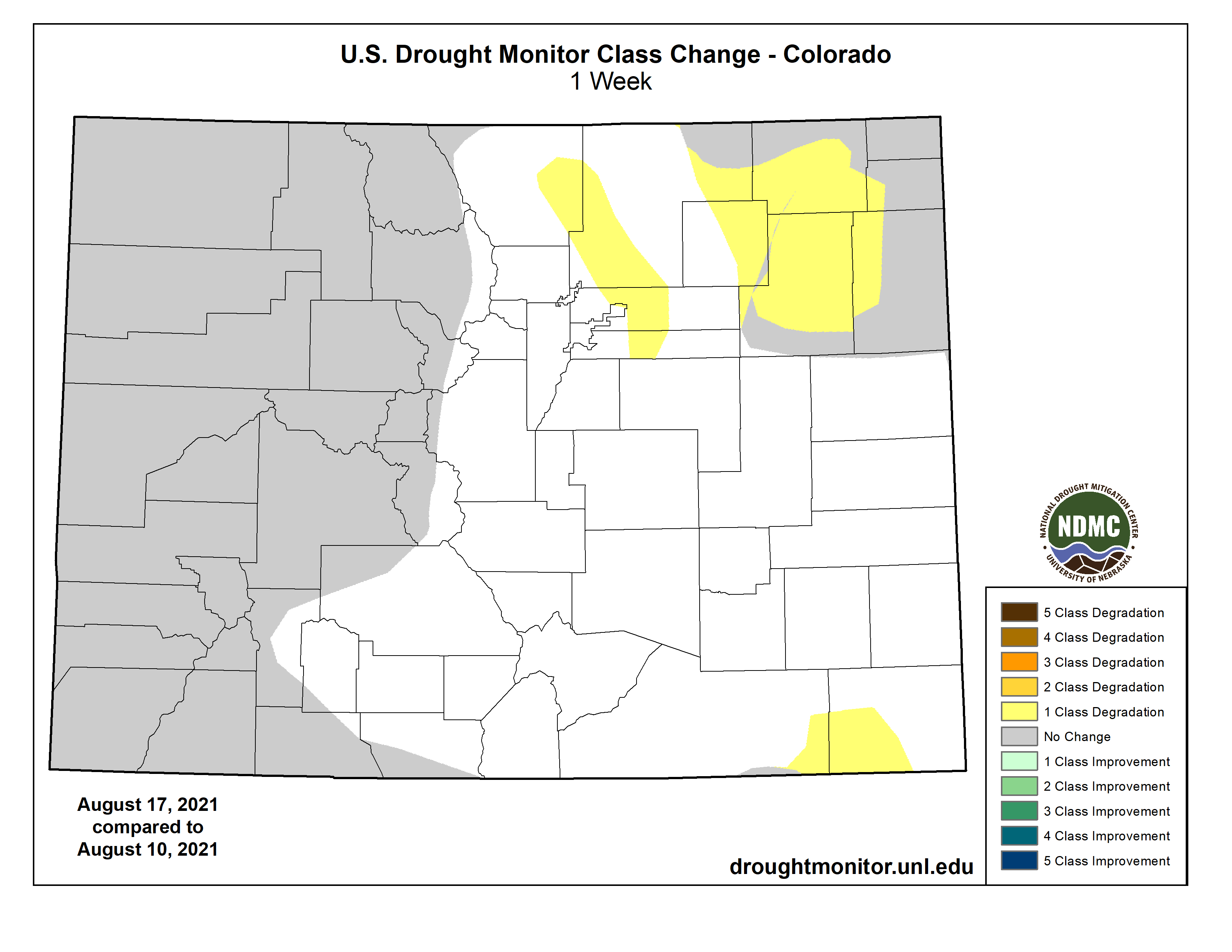
Colorado Drought Monitor map August 17, 2021.
Click here to go to the US Drought Monitor website. Here’s an excerpt:
This Week’s Drought Summary
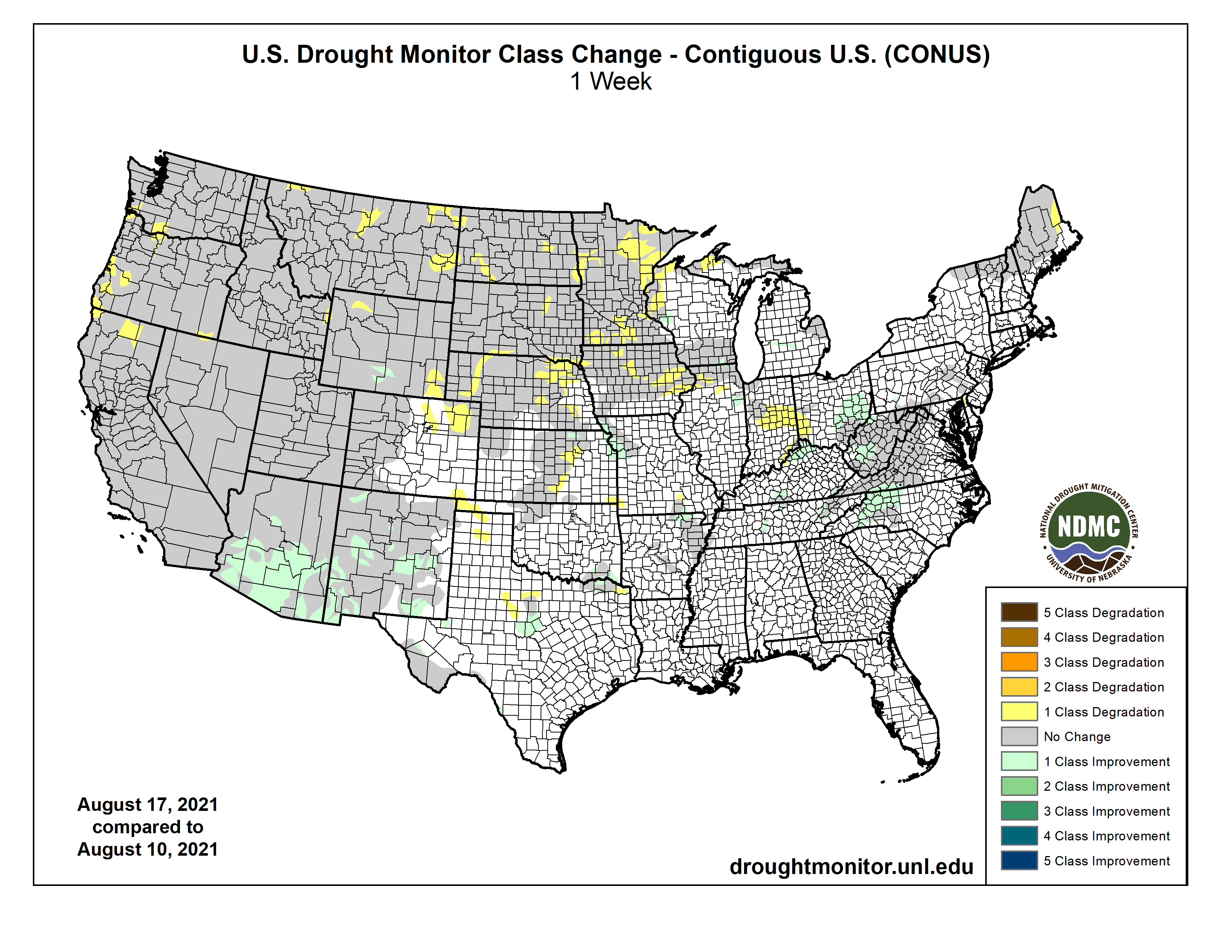
Monsoonal moisture, and associated heavy rainfall, returned to Arizona and New Mexico after a brief hiatus last week, leading to widespread improvements in drought conditions, as well as some flash flooding. In most of Arizona and New Mexico, long-term drought remains, but recent conditions have been wet enough for a green-up in vegetation. Meanwhile, warm and dry weather continued from the West Coast to the northern Great Plains. Tropical Storm Fred, and its remnants, progressed across the Southeast U.S., dropping heavy rain along the storm’s track, and to its east as well. Much of the rain in the drier areas of North Carolina, Virginia, and West Virginia fell after 8 a.m. EDT on Tuesday, so the effects from this heavy rain on dryness will be incorporated into next week’s analysis. However, some limited improvements to conditions did occur with rainfall before the Tuesday morning cutoff. Water shortages and wildfires continued to plague drought-stricken regions of the western and northwestern U.S., while very poor soil moisture conditions and severe agricultural impacts were felt in the northern Great Plains. In Minnesota, hydroelectric power generation along the Mississippi River halted near St. Cloud. River levels in the state lowered towards 1988 drought levels, creating a danger for boats to scrape along the bottoms of rivers. Rainfall from tropical cyclones in Puerto Rico led to improvement in moderate drought in southeast sections of the island. Maui and Hawaii also saw localized improvements of drought conditions from recent rainfall…
Aside from a few pockets of heavier rain in parts of Kansas and in eastern and central Colorado, most of the region was dry this week. Warm temperatures held sway in Colorado, Wyoming, South Dakota, and North Dakota, where temperatures generally ranged from 3 to 6 degrees above normal. Moderate drought developed in northeast Colorado in areas which did not receive significant rainfall this week. Severe and extreme drought grew in coverage along the Missouri River in northeast Nebraska and adjacent South Dakota. Drought coverage also increased in northeast South Dakota and across parts of North Dakota. In North Dakota, some farmers have harvested corn to use as livestock feed as drought continues to adversely affect agriculture. A few parts of south-central Wyoming saw localized improvement in drought conditions due to recent rainfall, while others in the southeast and northwest corners of the state experienced worsening conditions…
Colorado Drought Monitor one week change map ending August 17, 2021.
Amid water shortages and restrictions in the Colorado River Basin and widespread wildfires and extreme fire behavior in northern California and the Northwest, widespread severe, extreme, and exceptional drought continued across much of the region. Conditions worsened in northern California, western Oregon (and adjacent southwest Washington), southeast Oregon (and adjacent Nevada), and in northern and eastern portions of Montana, where soil moisture continued to degrade as hot and dry weather continued. In stark contrast, widespread improvements in drought conditions occurred in Arizona and New Mexico this week, as heavy monsoonal rains made their return after a one-week hiatus. Two-inch rainfall totals were commonplace, particularly in the southern halves of both states, and localized higher amounts also occurred. Most of the remaining drought in these states, while still extreme or exceptional in some locales, is confined to long-term impacts, as conditions are wet in many places on the short-term. While heavy monsoonal rain occurred in Arizona and New Mexico, moderate to heavy amounts were mostly confined to these two states. In central and southern Arizona and New Mexico, temperatures were cooler than normal, in some areas by 3 to 9 degrees. Otherwise, the rest of the region was warmer than normal, in particular northern California, Oregon, and Washington, where temperatures from 9 to 12 degrees above normal were widespread…
Rain amounts from 2 to 6 inches occurred in far southwest Texas, in association with heavy monsoonal rainfall this week. Elsewhere, scattered moderate-to-heavy rainfall amounts occurred, with a few pockets, notably south Texas and northwest Oklahoma, staying mostly dry. Long-term drought continued in a small area around Big Bend National Park in southern Texas, while a few areas of shorter-term drought were occurring along the Red River and in northwest Oklahoma. Cooler than normal weather was common in southern parts of Texas this week, in particular where heavy monsoonal rains fell, where temperatures were 3 to 9 degrees below normal for the week…
Looking Ahead
As of Aug. 18, the National Weather Service (NWS) Weather Prediction Center is forecasting several areas of significant precipitation from Aug. 18-23. As a storm system advances eastward out of the West, moderate to heavy rain is possible from central and eastern Utah northeast into the northern Great Plains and western Minnesota. Significant precipitation is also possible in western Wyoming and in parts of Montana. Any rainfall in these areas would be welcome, as much of the region forecast to receive rain is in drought. Additionally, moderate to heavy rain may occur in Tennessee and northern sections of Alabama and Mississippi. Finally, heavier rain may also fall in the Mid-Atlantic and in the Northeast. In the Northeast, the eventual track of Tropical Cyclone Henri may play a large role in rainfall amounts. To monitor the track and possible local impacts of Henri, please refer to the NWS National Hurricane Center’s latest forecasts, or those from your local NWS office. For the period from Aug. 24-28, the NWS Climate Prediction Center forecast leans towards warmer than normal temperatures in most of the contiguous United States, with the exception of the northern Great Plains and the Upper Midwest. Forecast probabilities strongly lean towards below normal precipitation in much of the West and northern Great Plains, while the Northeast, Southeast, and portions of the South are skewed towards likely wetter conditions.
US Drought Monitor one week change map ending August 17, 2021.