The health of our waters is the principal measure of how we live on the land — Luna Leopold
#Drought news (September 2, 2021): ~90% of the #West region (including #Colorado and #WY) is categorized as ‘in drought’ on the map with 54% in Extreme Drought (D3) or Exceptional Drought (D4)
Click on a thumbnail graphic to view a gallery of drought data from the US Drought Monitor.
US Drought Monitor map August 31, 2021.
High Plains Drought Monitor map August 31, 2021.
West Drought Monitor map August 31, 2021.
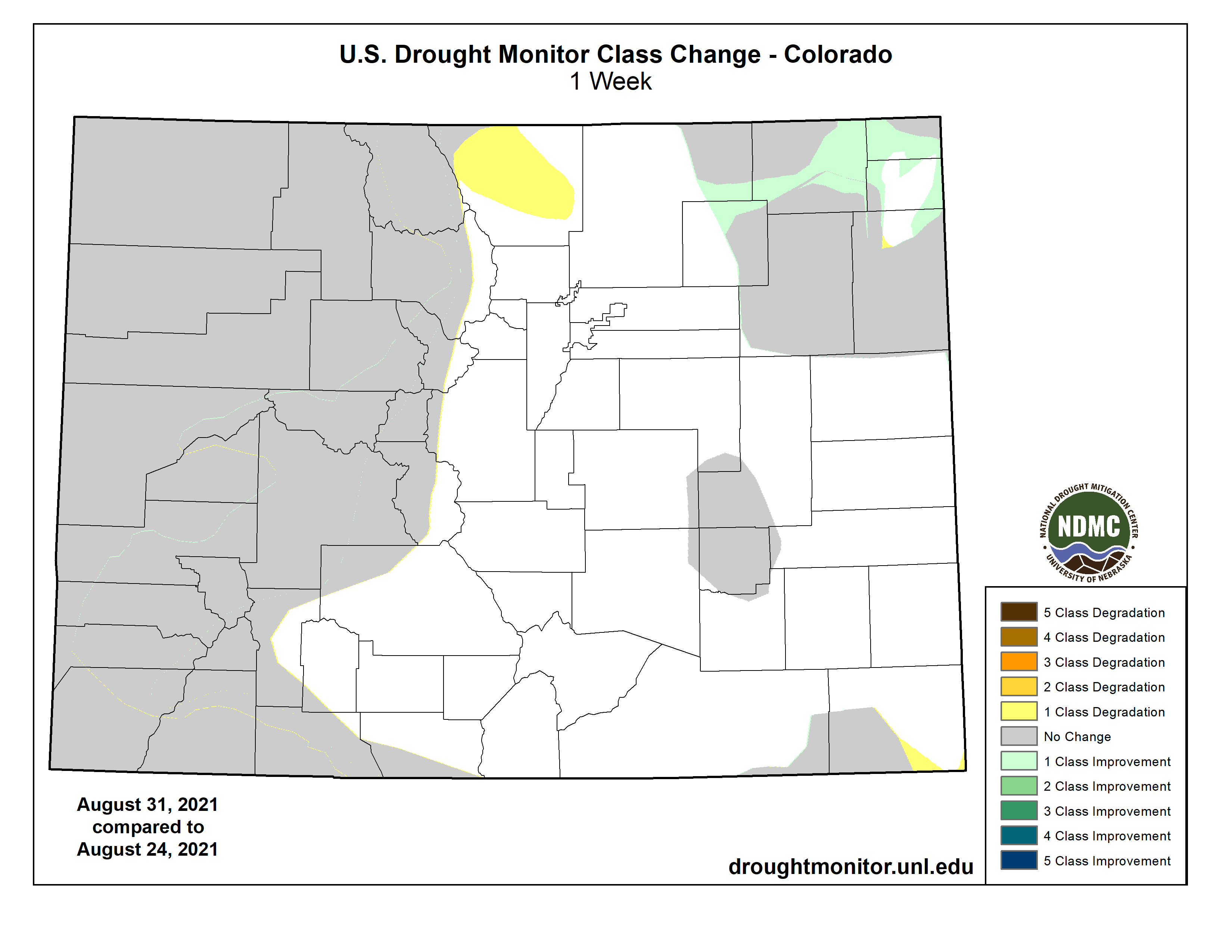
Colorado Drought Monitor map August 31, 2021.
Click here to go to the US Drought Monitor website. Here’s an excerpt:
This Week’s Drought Summary
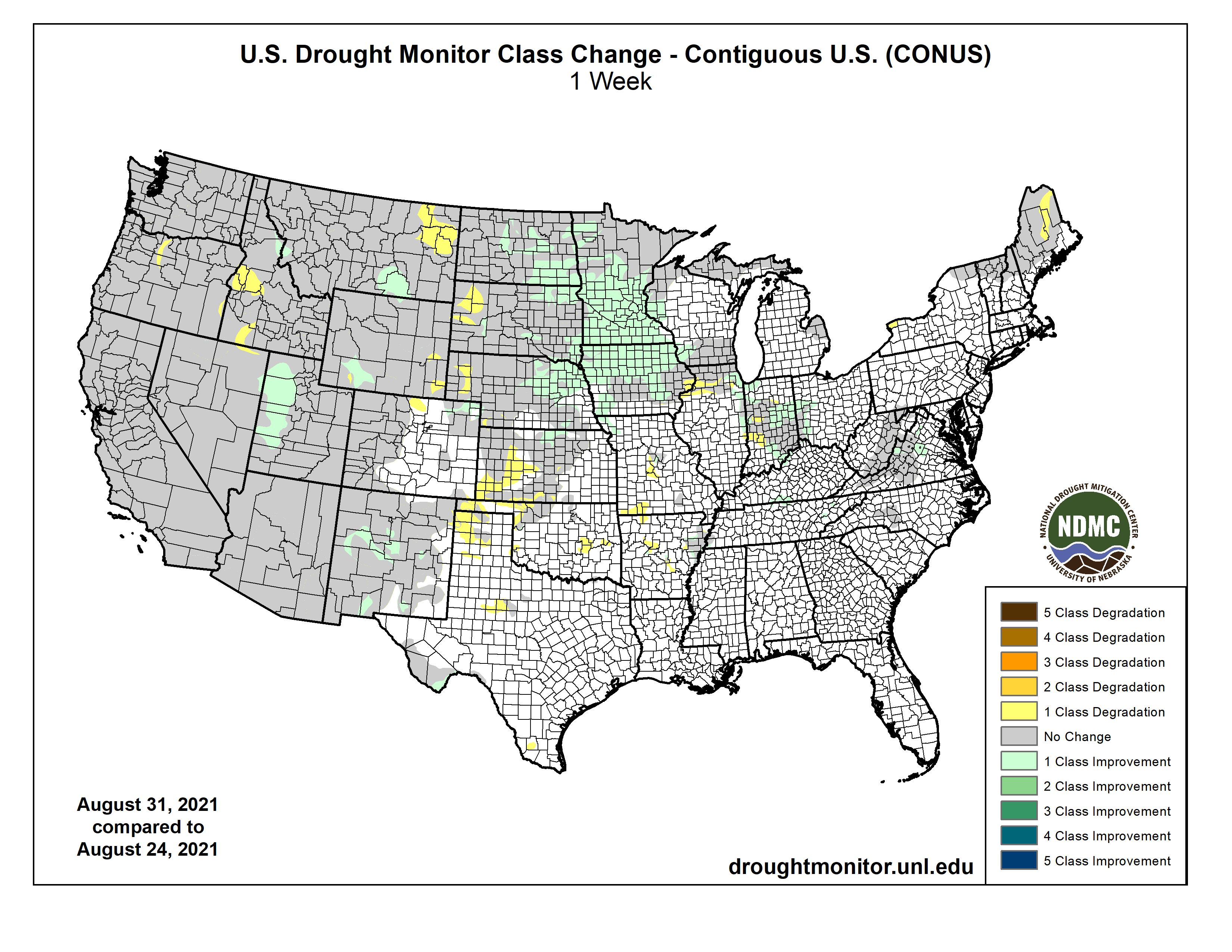
This U.S. Drought Monitor (USDM) week saw widespread improvements across areas of the Midwest and eastern portions of the Central and Northern Plains states in response to beneficial rainfall. Rainfall accumulation in these areas ranged from 2 to 12+ inches leading to one-category improvements across areas of the Dakotas, Nebraska, Kansas, Iowa, Minnesota, and Wisconsin. In the South, Hurricane Ida made landfall along the Gulf Coast of Louisiana on Sunday as a Category 4 hurricane with maximum sustained winds of 150 mph. The hurricane caused extensive infrastructure damage including widespread power outages in Louisiana and Mississippi, impacting more than 1 million homes and businesses as well as stranding residents amongst the floodwaters. In the West, dry conditions persisted across most of the region with approximately 90% of the region currently categorized as “in drought”. In California, two major wildfires (Dixie and Caldor fires) continued to intensify and expand due to the dry and windy conditions. In El Dorado County, California, the Caldor Fire continued to rapidly spread this week leading to the evacuation of residents in communities on the southern end of the Lake Tahoe Basin—including the City of South Lake Tahoe. In addition to impacting fire conditions, the on-going drought in California continues to strain the state’s water resources. This is reflected in the reservoir levels of California’s two largest reservoirs, Lake Shasta and Lake Oroville, which are currently at 43% and 34% of historical averages, respectively. In the Southwest, Lake Powell is currently 31% full and Lake Mead is 35% full. The total Lower Colorado system is at 40% full, according to the U.S. Bureau of Reclamation, compared to 50% full at the same time last year…
On this week’s map, areas of the region—including eastern portions of the Dakotas, Nebraska, and Kansas—saw widespread improvements in drought-stricken areas experiencing Exceptional Drought (D4), Extreme Drought (D3), Severe Drought (D2), and Moderate Drought (D1). The improvements were made in response to heavy rainfall during the past week (ranging from 2 to 5 inches) and minor improvements to soil moisture levels in some areas. Conversely, western portions of the Dakotas have continued to experience rainfall and soil moisture deficits which have severely impacted crops as well as pasture and rangeland conditions. According to the latest (August 29) USDA North Dakota Crop Progress and Condition report, pasture and range conditions across the state were rated 61% very poor and 24% poor, while stock water supplies were rated 58% very short and 31% short. According to the most recent (August 29) USDA South Dakota Crop Progress and Condition report, pasture and range conditions across the state were rated 48% very poor and 36% poor, while corn condition was rated 16% very poor and 29% poor. In terms of NOAA NCEI’s climatological rankings, North Dakota observed its 11th driest (-3.11-inch anomaly) May-July period as well as its 3rd driest (-7.40-inch anomaly) August-July period on record. Similarly, South Dakota had its driest (-3.17-inch anomaly) May-July on record as well as its 7th driest (-5.45-inch anomaly) August-July period on record…
Colorado Drought Monitor one week change map ending August 31, 2021.
Currently, ~90% of the West region (including Colorado and Wyoming) is categorized as “in drought” on the map with 54% in Extreme Drought (D3) or Exceptional Drought (D4). On this week’s map, some improvements were made in New Mexico and Utah in response to the cumulative impact of this summer’s active monsoon and its associated short-term improvements to vegetative health, soil moisture, and streamflow activity. Elsewhere, degradations were made on the map in the eastern plains of Montana, southeastern Wyoming, southern Idaho, and central Oregon. In Northern California, dry and windy conditions led to further expansion and intensification of the Dixie and Caldor fires during the past week. According to CalFire, the Dixie Fire is now the second largest wildfire in California history, while Caldor Fire is now the 15th largest. According to the National Interagency Coordination Center’s Incident Management Situation Report (Sept 1), the Dixie Fire had burned 819,956 acres (49% contained) and the Caldor Fire totals 199,632 acres (18% contained). During the past week, the Caldor Fire spread rapidly eastward up the Highway 50 corridor and into the Lake Tahoe Basin, leading to evacuation of the largest town in the basin—South Lake Tahoe. Looking at reservoir conditions across the region, statewide reservoir storage levels (August 1) were below normal across all the western states with the exception of Montana and Washington. In California, the state’s two largest reservoirs, Lake Shasta and Lake Oroville, were at 43% and 34% of historical averages on August 31, respectively. In the Colorado River Basin, Lake Mead is currently 35% full and Lake Powell is at 31% full (August 31). On a positive note, this summer’s monsoonal rains have led to some modest reservoir inflows in the Salt and Verde River system reservoirs in Arizona where the total reservoir system was at 71% full (85% full one year ago) as of August 31. For the week, rainfall activity (accumulations generally <2 inches) across the region was restricted to isolated areas of Arizona and New Mexico as well as central and eastern Montana. Average temperatures during the past week were slightly above normal (1 to 8 deg F degrees) across the southern half of the region, while cooler-than-normal temperatures were observed in northern portions ranging from 1 to 8 deg F below normal. According to NOAA NCEI, Arizona experienced its 2nd wettest July on record as well as its 3rd wettest May-July period on record...
On Sunday, Hurricane Ida made landfall along the Louisiana coast as a Category 4 hurricane with maximum sustained wind of 150 mph. Hurricane Ida was the second most intense hurricane to impact the state of Louisiana, causing major widespread damage to infrastructure across the southeastern part of the state. Rainfall accumulations in the direct path of Ida ranged from 2 to 15+ inches with the heaviest accumulations observed along the coastal areas of southeastern Louisiana and Mississippi. On this week’s map, drought-related conditions deteriorated in north-central as well as in the Oklahoma Panhandle where short-term dryness (past 30-day period) and reports of poor crop conditions led to the introduction of an area of Moderate Drought (D1). In the Texas Panhandle, precipitation deficits during the past 30- to-90-day period led to expansion of areas of Abnormally Dry (D0), while conditions improved to the south in the Big Bend region where precipitation has been above normal during the past month. According to NOAA NCEI, the May-July 2021 period was the 4th wettest on record in the South Climate Region and the 3rd and 5th wettest May-July period statewide for Texas and Louisiana, respectively…
Looking Ahead
The NWS WPC 7-Day Quantitative Precipitation Forecast (QPF) calls for moderate-to-heavy liquid accumulations ranging from 2 to 4+ inches across areas of the Northern and Central Plains as well as along the western portion of the Midwest. In the Northeast, heavy rainfall accumulations (2 to 7 inches) are expected in an area extending from Pennsylvania to Maine, with the highest rainfall totals expected in eastern Pennsylvania and coastal areas of New England. In the Southeast and the South, light rainfall accumulations (generally <1 inch) are expected with the exception of central Gulf Coast of Florida where moderate-to-heavy accumulations (2 to 5 inches) are forecasted. In the West, monsoonal showers are expected across isolated areas of the Four Corners states with the heaviest accumulations expected in southern New Mexico, while the remainder of the West is forecasted to experience dry conditions. The CPC 6-10-day Outlooks calls for a moderate-to-high probability of above-normal temperatures across the western half of the conterminous United States as well as along coastal areas of the Eastern Seaboard. Elsewhere, there is a moderate probability of below-normal temperatures across the Midwest, Mid-Atlantic, and northern portions of the South. In terms of precipitation, there is a low-to-moderate probability of above-normal precipitation across portions of California, Nevada, Arizona, and Utah as well as across areas of the Upper Midwest and the Northeast. In contrast, below-normal precipitation is expected across the Pacific Northwest, and areas east of the Continental Divide extending across the Plains states to the Southeastern U.S.
US Drought Monitor one week change map ending August 31, 2021.