The health of our waters is the principal measure of how we live on the land — Luna Leopold
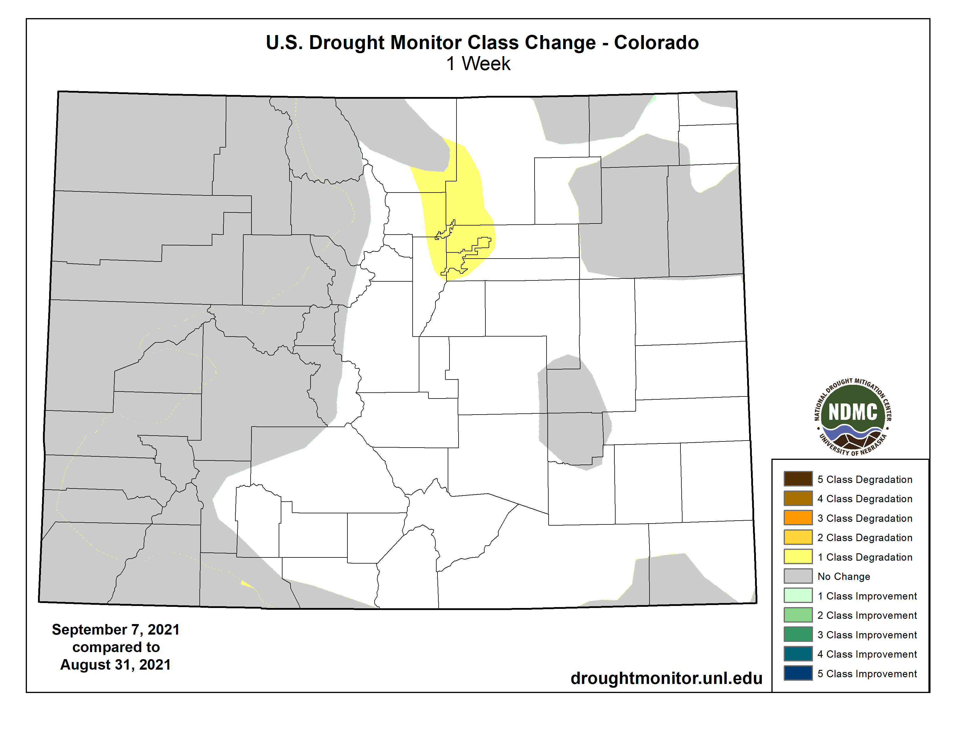
#Drought news: One class degradation in areas of Larimer, Weld, Boulder, Broomfield, Adams, Arapahoe, Jefferson, and #Denver counties
Click on a thumbnail graphic to view a gallery of drought data from the US Drought Monitor.
US Drought Monitor map September 7, 2021.
High Plains Drought Monitor map September 7, 2021.
West Drought Monitor map September 7, 2021.
Colorado Drought Monitor map September 7, 2021.
Click here to go to the US Drought Monitor website. Here’s an excerpt:
This Week’s Drought Summary
This U.S. Drought Monitor (USDM) week saw continued improvement in conditions across drought-stricken areas of the Central and Northern Plains states as well as in Iowa and Minnesota where light-to-moderate rainfall accumulations were observed. Despite recent precipitation in the Northern Plains, hay shortages and the associated costs of purchasing and transporting supplemental feed are forcing some ranchers to sell livestock. In response to the emerging situation, the U.S. Department of Agriculture (USDA) announced expansion of emergency assistance through the ELAP program to help cover feed transportation costs for drought-impacted ranchers. In the Northeast, the remnants of Hurricane Ida brought intense, heavy rains (5 to 10+ inches) and devastating flooding to areas of Pennsylvania, New Jersey, New York, and Connecticut. In the Southeast, short-term dryness (past 30- to 60-day period) and declining soil moisture and streamflow levels led to degradation on the map in portions of the Carolinas. In the South, short-term precipitation shortfalls and declining soil moisture levels led to some degradation of conditions in areas of Arkansas and Oklahoma that have largely missed out on recent rainfall events. Out West, dry conditions prevailed across most of the region this week. However, some beneficial rainfall was observed across isolated areas of the Southwest in association with the remnants of Hurricane Nora…
On this week’s map, areas of the region—including eastern portions of North Dakota, South Dakota, Nebraska, and Kansas—saw isolated improvements in response to continued rainfall activity. The heaviest rainfall in the region was observed in eastern Kansas where accumulations ranged from 2 to 7 inches, while areas further to the north in Nebraska and the Dakotas received 1-to-4-inch accumulations in isolated areas. For the last 30-day period, the percentage of normal precipitation has ranged from 100 to 300% of normal across a widespread area of the Central and Northern Plains. However, isolated pockets of dryness have persisted—particularly in western portions of the region that have not benefited from the recent rainfall events. According to the USDA for the week ending September 5, the percentage of topsoil in North Dakota rated short to very short was 63%, while neighboring South Dakota was rated 66% short to very short…
Colorado Drought Monitor one week change map ending September 7, 2021.
For the week, most of the region continued to experience dry conditions, although some residual moisture from Hurricane Nora worked its way into the Southwest leading to some isolated shower activity. On this week’s map, improvements were made in isolated areas of Arizona, New Mexico, and Utah where recent monsoonal rainfall has continued to improve drought conditions on a shorter-term basis. For the monsoon season (to date), some impressive rainfall totals have been observed in areas of southern and central Arizona and New Mexico as well as in areas of Utah. In Arizona, Tucson is currently having its 3rd wettest monsoon season on record with 12.41 inches (as of September 7), Flagstaff 10.35 inches (4th wettest), Payson 13.06 inches (2nd wettest), and Las Cruces, New Mexico 5.06 inches (3rd wettest). Elsewhere in the region, much of California, western Great Basin, Pacific Northwest, and the Northern Rockies have experienced drier-than-normal conditions during the past 90-day period. In Washington, drought and associated precipitation deficits dating back to the springtime, combined with extreme summer heat, have severely impacted the state’s wheat crop which is reportedly had its lowest output since 1973. According to the USDA, the percentage of topsoil rated short to very is as follows: Washington 100%, Oregon 89%, Idaho 75%, Montana 93%, Wyoming 70%, and California 85%. According to the Natural Resources Conservation Service (Sept 1), reservoir storage levels were below normal across all the western states except for Washington state (data not yet available for Montana)…
After the passing of Hurricane Ida, the region experienced some drying out this week as compared to the previous week’s deluge. For the past 30-day period, above-normal precipitation levels (130 to 300% of normal) have been observed across southeastern Louisiana, Mississippi, and much of Tennessee. Conversely, precipitation has been below normal across much of Arkansas, Texas, and Oklahoma during the past month, leading to expansion of areas of Abnormally Dry (D0). This includes around Tulsa, Oklahoma, which observed only 0.85 inches (normal 3.64 inches) for the month of August and no precipitation to date for September. Elsewhere, some minor improvements were made in an area of Moderate Drought (D1) in the Trans-Pecos region in the vicinity of Big Bend National Park where the Chisos Basin observing station reported 10.42 inches of rain (340% of normal) for the month of August. Likewise, the Pine Springs Guadalupe National Park observing station in the Trans-Pecos logged 8.98 inches (560% of normal) during August 2021. For the week, average temperatures were above normal (3 to 9 deg F) across Texas, Oklahoma, and western portions of Louisiana and Arkansas while areas to the east were 1 to 6 deg F below normal…
Looking Ahead
The NWS WPC 7-Day Quantitative Precipitation Forecast (QPF) calls for moderate-to-heavy rainfall accumulations ranging from 2 to 5+ inches along the Gulf Coast of Texas, Louisiana, Florida Panhandle, and areas of southern Georgia. Across the Mid-Atlantic and the Northeast, light rainfall accumulations (generally < 1 inch) are expected; except for coastal areas of Massachusetts and Maine where accumulations of approximately 2 inches are predicted. In the Midwest, light precipitation accumulations (generally < 1 inch) are forecasted across the eastern half of the region, while areas in the western extent will be drier over the coming week. From the Plains to the West Coast, mainly dry conditions will prevail with the exception of areas of isolated, light precipitation possible across the Central and Southern Rockies and the northern Great Basin, while slightly greater accumulations (generally around 1 inch) are expected in the Northern Rockies. The CPC 6-10-day Outlooks are for a moderate-to-high probability of above-normal temperatures across the northern half of the conterminous United States as well as along the Eastern Seaboard extending into New England. Across much of the Pacific Northwest, North Dakota, and the Upper Midwest, normal temperatures are expected. In terms of precipitation, there is a low-to-moderate probability of above-normal precipitation across New England, the Midwest, the South, and the eastern half of Texas. Below-normal precipitation is expected across most of the Western U.S.
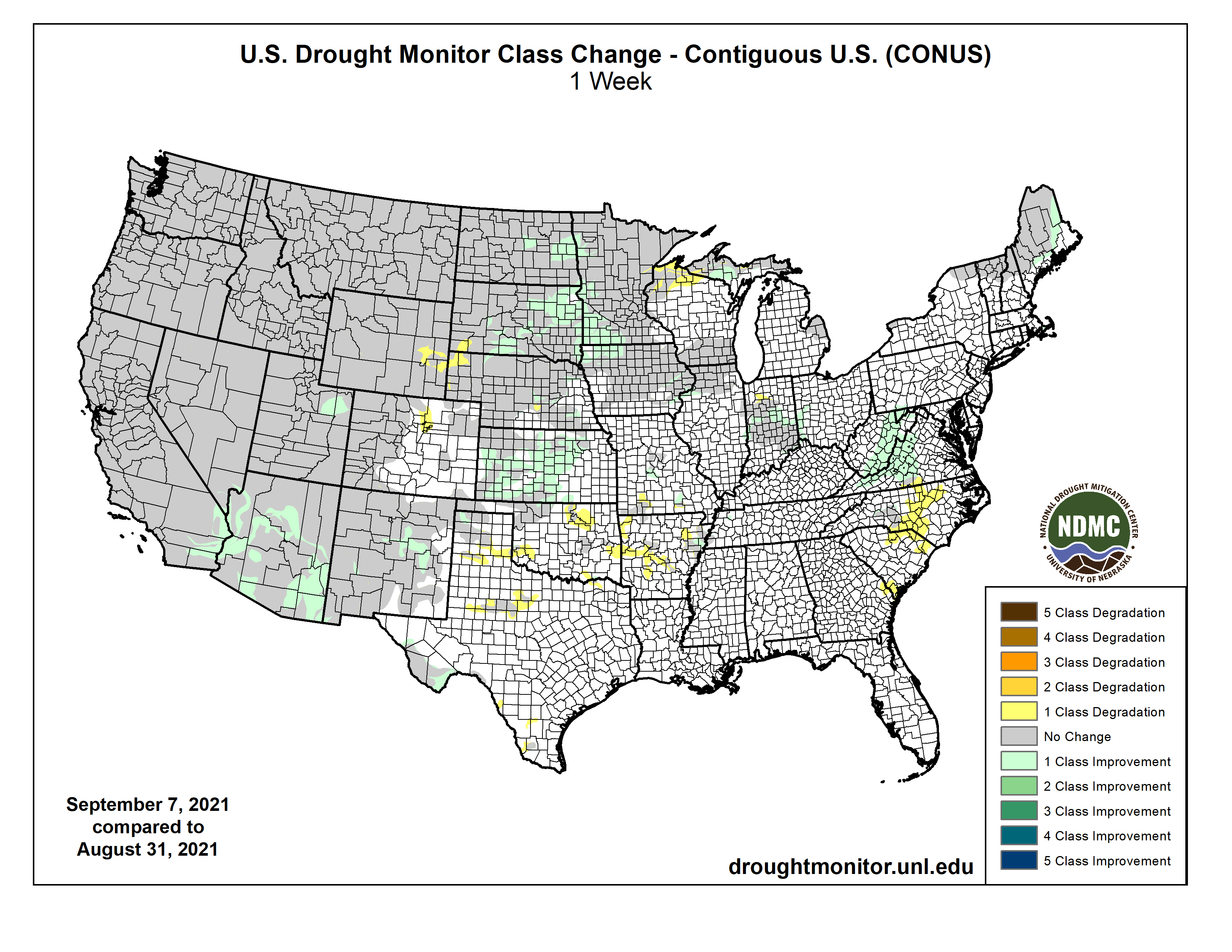
US Drought Monitor one week change map ending September 7, 2021.
Just for grins, here’s a gallery of early September US Drought Monitor maps for the past several years.