I’m writing to quickly share a book that may be of interest to the Coyote Gulch blog audience: Tributary Voices: Literary and Rhetorical Explorations of the Colorado River https://www.unpress.nevada.edu/books/?isbn=9781647790424. It came out at the end of April and enlarges the conversation about the river’s sustainability to include historically overlooked perspectives. A timely read in light of the Compact’s 100th anniversary this year.
From the University of Nevada Press website:
The Colorado River is in crisis. Persistent drought, climate change, and demands from urbanization threaten this life-source that provides water to more than forty million people in the U.S. and Mexico. Coupled with these challenges are our nation’s deeply rooted beliefs about the region as a frontier, garden, and wilderness that have created competing agendas about the river as something to both exploit and preserve. Citizens and experts look to law, public policy, and science to solve worsening water problems, but today’s circumstances demand additional perspectives to foster a more sustainable relationship with the river.
Through literary, rhetorical, and historical analysis, Tributary Voices considers a more comprehensive approach to river management. The book examines nature writing, women’s narratives, critiques of dam development, the Latina/o communities’ appeals for river restoration, American Indian authors’ and tribal nations’ claims of water sovereignty, and teachings about environmental stewardship and provident living. This innovative study models an interdisciplinary approach to water governance and reinvigorates our imagination in achieving a more sustainable water ethic.
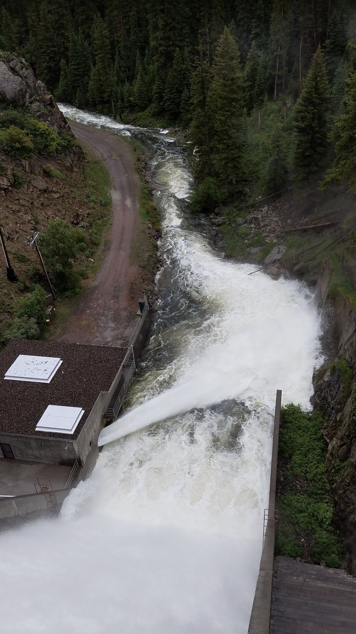
Near the end of July, flows into Stagecoach Reservoir from the Yampa River dropped below 40 cubic feet per second for a few days. That threshold is important because it helps, in part, determine how much water flows out of the reservoir and continues downstream to Steamboat Springs. If the flow coming in is more than 40 cfs, then at least 40 cfs is usually discharged at the bottom of Stagecoach Dam. If the inflow drops below 40 cfs, the outflow generally would as well, leaving less water for critical fish habitat below the dam and in the river in general.
The long-term deal is one of the first in the state and was made possible by a 2020 state law allowing such agreements. Before, groups like the Water Trust and Upper Yampa district needed to rehash out a contract each year…
But this year has been different. While the snowpack wasn’t impressive, spring precipitation slowed melting, and there was still snow in the basin until June 23, according to the Natural Resources Conservation service. Monsoon rains have further buoyed the river, with Steamboat measuring more than 10 inches of rain from May to July. While not necessarily a good roll, this year doesn’t seem like a bad one.
“I think it is on the low side of average,” said Emily Lowell, the district engineer for the Upper Yampa Water Conservancy District. “Runoff was pretty average, and I think monsoonal rains this summer have made it sustain that average.”
But even in a close-to-average year, releases from the reservoir are still needed, though not to the same extent. Since the first releases at the end of July, inflows and outflows have both stayed above 40 cfs and more of the trust’s water hasn’t been needed.
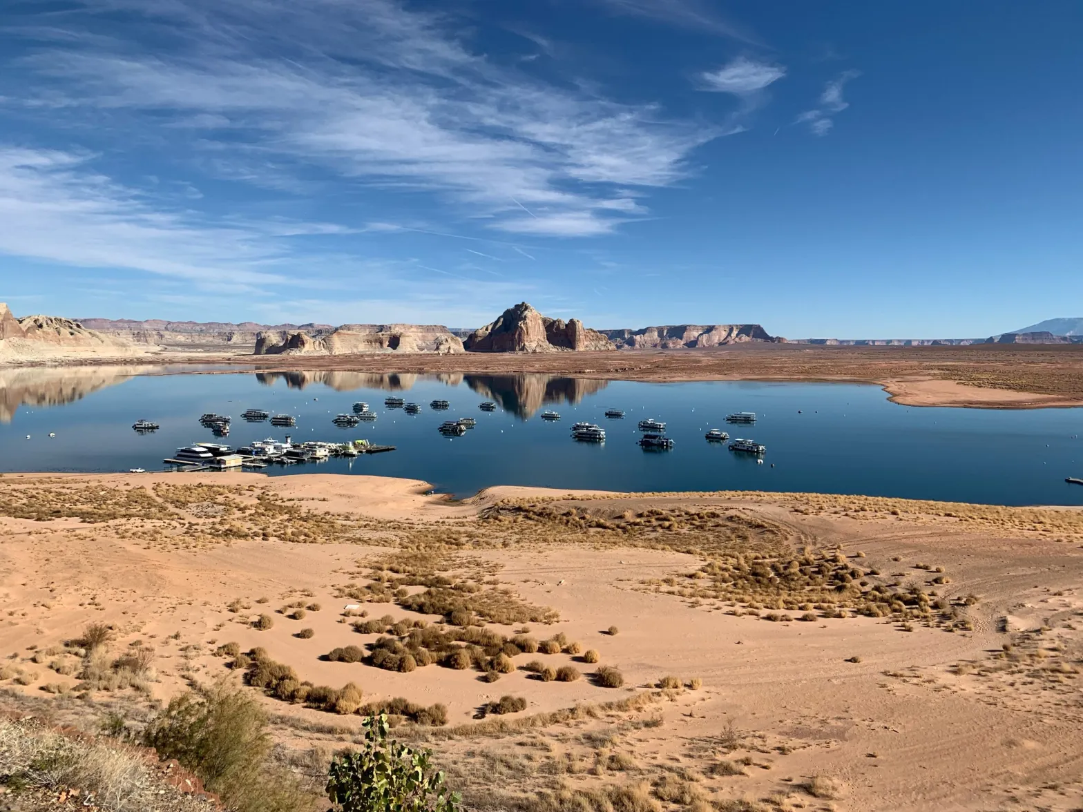
Houseboats on Lake Powell on Dec. 13, 2021, near Wahweap Marina, where the quarter-mile-long boat ramp is unusable due to low water levels. The Bureau of Reclamation Commissioner has said 2 to 4 million more acre-feet of conservation is needed to protect the system, leaving water managers wondering what authority the feds have over upper basin water projects. CREDIT: HEATHER SACKETT/ASPEN JOURNALISM
As the deadline approaches for the seven Colorado River basin states to come up with a plan to conserve water, some Colorado water managers are asking what authority the federal government has in the upper basin and which water projects could be at risk of federal action.
U.S. Bureau of Reclamation Commissioner Camille Touton sent water managers scrambling when she announced in June that they had a 60-day window to find another 2 to 4 million acre-feet of water to conserve or the federal government would step in to protect the system. With many reservoirs, transbasin diversion systems and irrigation projects in Colorado tied in one way or another to the Bureau of Reclamation, some are asking if the water in these buckets could be commandeered by the feds to make up the shortfall.
“I think that there’s probably a good argument that the Secretary (of the Interior) has some authority under those projects,” said Eric Kuhn, Colorado River author and former Colorado River Water Conservation District general manager. “The projects on the Western Slope and in the upper basin states that are owned by the federal government and are ultimately under the authority of the Secretary of the Interior, those are the projects at risk.”
Mcphee Reservoir
Paonia Reservoir. Photo credit: The College of New Jersey
Rifle Gap Reservoir via the Applegate Group
Taylor Park Reservoir
Ridgway Dam via the USBR
Ruedi Reservoir. Photo credit Greg Hobbs
There are many dams and reservoirs across Colorado that are tied to the Bureau of Reclamation’s 20th century building frenzy to impound water and “reclaim” arid regions through irrigation. On the Western Slope, some of the well-known projects include the Fryingpan-Arkansas Project (Ruedi Reservoir), Dallas Creek Project (Ridgway Reservoir), the Dolores Project (McPhee Reservoir), Paonia Reservoir, the Grand Valley Project, the Silt Project (Rifle Gap Reservoir), the Uncompahgre Project (Taylor Park Reservoir) and more.
In general, the local entities like conservancy districts, irrigators and municipalities who use the water are responsible for repaying the Bureau for the cost of the project. But the infrastructure is owned by the Bureau of Reclamation. Some projects are operated by Reclamation and some are operated by a local entity. Many also have a hydropower component.
“I think each project operator is having to look at their contractual obligations with the Bureau and their attorneys are going back over those with a fine tooth comb to see if the arm of the Bureau can reach up through Lake Powell and into the upper basin states,” said Kathleen Curry, a rancher and Gunnison County representative on the Colorado River Water Conservation District. “All of the upper basin projects are going to need to look real hard at what authority the Bureau has.”
Last year Reclamation made emergency releases out of Blue Mesa, Flaming Gorge and Navajo reservoirs to prop up Lake Powell. In this instance their authority was not questioned since these reservoirs are, along with Lake Powell, the four initial reservoirs of the Colorado River Storage Project. They store what’s called “system water,” which is used specifically to help the upper basin meet its delivery obligations to the lower basin.
But water managers still don’t know exactly what, if anything, Reclamation is allowed to do with the water contained in other reservoirs with Reclamation ties.
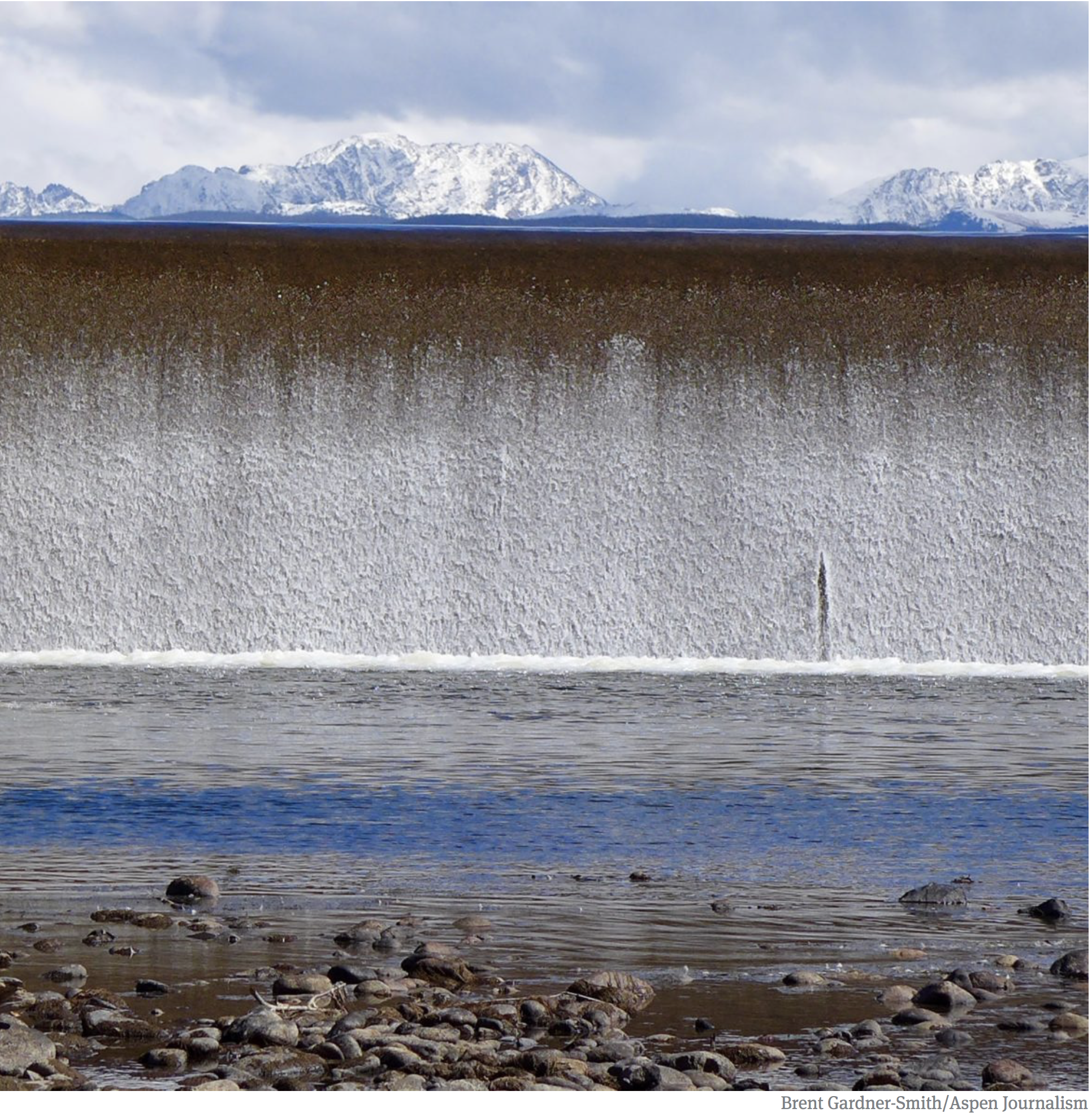
The crest of the dam across the Fryingpan River that forms Ruedi Reservoir, which can hold 102,373 acre-feet of water. Some Western Slope water managers are asking what authority the Bureau of Reclamation has over water projects with Reclamation ties in the upper basin. CREDIT: PHOTO: COURTESY OF BUREAU OF RECLAMATION
No answers from officials
At the River District’s third quarterly board meeting in July, board members repeatedly tried to pin down answers from federal and state officials without much luck.
Montrose County representative and state Rep. Marc Catlin asked state engineer Kevin Rein where he stood on whether the Bureau of Reclamation could make reservoirs with Reclamation ties release water downstream to Lake Powell to meet the 2 to 4 million acre-feet conservation goal.
“If the Bureau of Reclamation comes into the state of Colorado and says it wants to move water… down to Lake Powell, what’s the state engineer going to do?” Catlin asked. “Are those water rights under state law or federal law?”
Rein did not know the answer.
“I’m not sure what authority — this is not one of those rhetorical ‘I’m not sure,’ I really am not sure — what authority the Bureau of Reclamation would have to induce a federal project with state water rights to release them to get to Powell,” Rein said.
Later in the meeting, Katrina Grantz, the Bureau of Reclamation’s Upper Colorado Basin Assistant Regional Director, gave a presentation and took questions from board members. Curry asked if changes could be proposed to the operation of projects within the 15 counties represented by the River District with federal ties to get closer to the 2 to 4 million acre-feet. Grantz side-stepped the question.
“At this point we are not looking at specific locations,” she said. “I would turn it around and say: Are there areas where you locally think there might be areas to conserve?”
River District General Counsel Peter Fleming said the authority of the feds in the upper basin is untested. This is partly because the upper basin has dozens of small Reclamation projects as well as thousands of individual water users on private ditch systems that are not affiliated with the federal government. Colorado has generally been left alone to administer this complex system of water rights under the state doctrine of prior appropriation, which means older water rights get first use of the river.
The lower basin, in contrast, has only about 20 diversions — and only six or so big ones — from the Colorado River. And each entity that uses water from Lake Mead has to have a contract with Reclamation, meaning the federal government is directly involved with water deliveries.
“The reason I think these issues are untested is historically the secretary’s role in the upper basin has been different than the secretary’s role in the lower basin,” Fleming said. “It’s much more hands-off. The difference in river administration is huge.”
Fleming said that the River District does not have advice for its water users on the situation, other than to reiterate the upper basin stance that the responsibility to come up with the 2 to 4 million acre-feet lies overwhelmingly with the lower basin.
“At the end of the day I think there will be a big effort to try to resolve things through agreement and I believe the secretary will exercise her authority to the greatest extent she can without triggering litigation,” Fleming said.
Water managers may not have to wait long to get some clarity. The deadline for the states to come up with a conservation plan before the feds take action to protect the system is fast approaching. The upper basin states, through the Upper Colorado River Commission, have put forward a 5 Point Plan, which lays out actions they say are designed to protect the reservoirs.
Amee Andreason, public affairs specialist with the Bureau of Reclamation, said officials may answer the question of federal authority in the upper basin at a media event on Aug. 16 that coincides with the release of the August 24-month study, which lays out reservoir operations for the following water year.
If the feds end up curtailing uses in the lower basin, it could set a precedent that would strengthen the argument that they can do the same in the upper basin, Kuhn said.
“That’s one I think is the elephant in the room,” he said. “The fact that the River District board was asking about authorities tells you people are thinking about it.”
This story ran in the Aug. 4 edition of the Sky-Hi News.
The seven Colorado River states – Arizona, California, Colorado, New Mexico, Nevada, Utah and Wyoming – face a daunting mid-August deadline. The federal government has asked them to come up with a plan to reduce their combined water usage from the Colorado River by up to 4 million acre-feet in 2023.
That is a massive reduction for a river system that currently produces about 12.4 million acre-feet. The Bureau of Reclamation, which manages the Colorado River, warned that it will “act unilaterally to protect the system” if the states cannot come up with an adequate plan on their own.
The seven states have worked cooperatively over the past two decades to identify solutions to a shrinking river. But their response now, much like the global response to climate change, seems far from adequate to the enormous challenge.
In a recent letter to BuRec, the Upper Colorado River Commission, speaking for the four Upper Basin states, proposed a plan that adopts a business-as-usual, “drought-reduction” approach. They argue that their options are limited because “previous drought response actions are depleting upstream storage by 661,000 feet.”
The Commission complains that water users “already suffer chronic shortages under current conditions resulting in uncompensated priority administration, which includes cuts to numerous present perfected rights in each of our states.”
This leads the Commission to conclude that any future reductions must come largely from Mexico and the Lower Basin states of Arizona, California and Nevada, because they use most of the water.
But the Lower Basin states have already taken a significant hit to their “present perfected rights,” and if BuRec makes good on its promise to act unilaterally, they will face another big reduction. The cooperative relationship among the Basin states will not endure if the Upper Basin refuses to share the burden by reducing its consumption.
The Gross Reservoir Expansion Project involves raising the height of the existing dam by 131 feet. The dam will be built out and will have “steps” made of roller-compacted concrete to reach the new height. Image credit: Denver Water
A good place to start might lie with two Colorado projects to divert water from the Colorado River basin to the Front Range. Both began construction this summer. The Gross Reservoir Expansion Project will triple the size of one of Denver Water’s major storage units. Denver Water’s original justification for this project – to serve Denver’s growing urban population – seems odd given that water demand in their service area over the past two decades has shrunk, even as its population rose by nearly 300,000.
Outflow from the dam across the Colorado River that forms Windy Gap Reservoir. Taken during a field trip the reservoir in September, 2017.
Similar questions have been raised with the Northern Colorado Water Conservancy District’s Windy Gap Firming Project, which plans to store Colorado River water to support population growth in Front Range cities.
These two projects suggest that Colorado is prepared to exacerbate the current crisis when the opposite response is so desperately needed.
Abandoning these two projects would signal that Colorado is serious about giving the Colorado River a fighting chance at survival. It might also jump-start good-faith negotiations over how Mexico, the states, and tribes might work to achieve a long-term solution to this crisis.
The homestead laws of the 19th century attracted a resilient group of farmers to the West who cleverly designed water laws to secure their water rights against all future water users. “First in time, first in right” became the governing mantra of water allocation, because, except for Tribal Nations, the farmers were first.
That system worked well for many years. As communities grew, cities and water districts built reservoirs to store the spring runoff, ensuring that water was available throughout the irrigation season.
Climate change and mega-droughts have upended that system. Nowhere have the consequences been as dire as in the Colorado River Basin. America’s two largest reservoirs, Lake Powell and Lake Mead – key components of the Colorado River’s water storage system – have not filled for more than two decades. They now sit well below 30% of their capacity.
Hotter temperatures, less mountain snowpack, and dry soils that soak up runoff like a sponge have brought us to this seven-state crisis. All seven states must now share the pain of addressing this crisis.
The Upper Basin Commission’s anemic response to BuRec’s plea is not a serious plan. We can do better and we must.
Mark Squillace and Quinn Harper are contributors to Writers on the Range, writersontherange.org, an independent nonprofit dedicated to spurring lively conversation about the West. Mark Squillace is the Raphael J. Moses professor of natural resources law at the University of Colorado Law School. Quinn Harper is a graduate student pursuing a master’s degree in natural resource policy at the University of Colorado, Boulder.
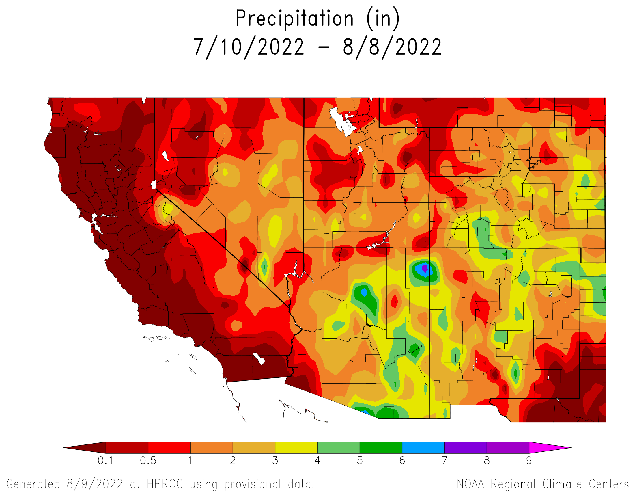
This week, according to the Community Collaborative Rain Hail and Snow Network (CoCoRaHS) website, Station CO-AU-33, located on Cactus Drive in Aspen Springs west of Pagosa Springs, experienced the third highest rain total in Colorado of 3.46 inches for the period between July 27 and Aug. 3. CoCoRaHS also indicates that, for the period between July 20 and Aug. 3, sites in Archuleta County received between 2.85 and 4.20 inches of rain. Higher precipitation totals were concentrated in and to the north and west of Pagosa Springs, with the highest total being reported near Hidden Valley Lake up Four- mile Road north of Pagosa Springs…
Rivers and drought
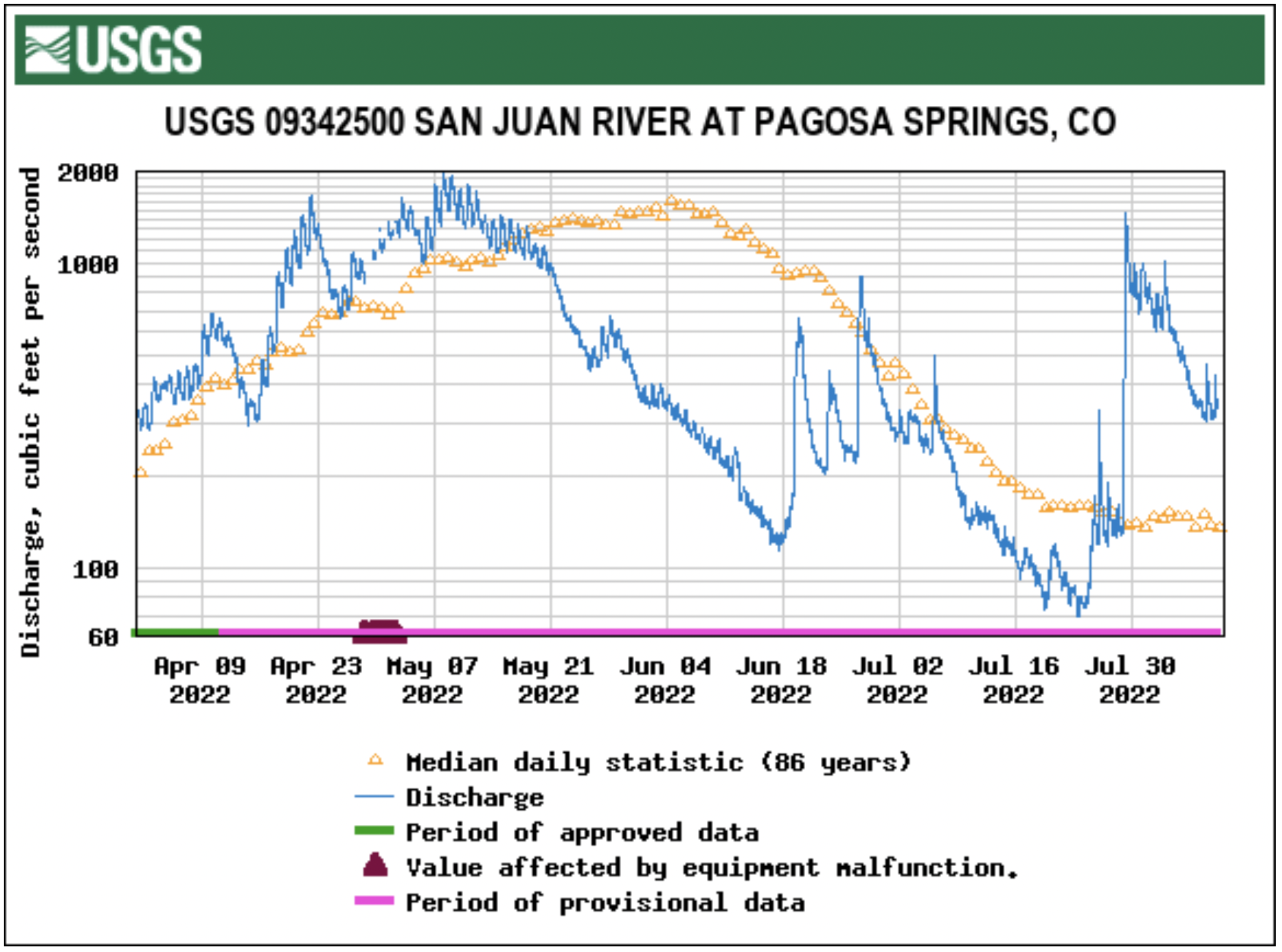
Stream flow for the San Juan River on Aug. 3 at approximately 12 p.m. was 611 cubic feet per second (cfs), according to the U.S. Geological Service (USGS) National Water Dashboard. This is down from a nighttime peak of 1,020 cfs at 8:30 a.m. on Aug. 2. These numbers are down from a recent peak flow of 1,470 cfs at 4:15 a.m. on July 29. However, flows are up from last week’s reading of 134 cfs at noon on July 27.
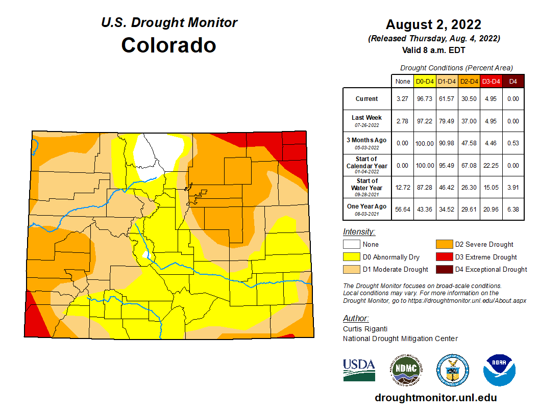
Colorado Drought map Monitor August 2, 2022.
The National Oceanic and Atmospheric Administration (NOAA) National Integrated Drought In- formation System (NIDIS) reports that 100 percent of the county is experiencing drought. The NIDIS places the entire county in a moderate drought…The NIDIS also places 46 percent of the county, primarily the southern and western portions, in a severe drought.