Carbondale rancher Bill Fales says that in 47 years of ranching in the Roaring Fork Valley, he’s never sees hay production as dismal as in 2020. “I used to think that one of the advantages of ranching here is we had a really stable climate,” he says. Photo credit: Laurine Lasalle/Aspen Journalism
In July, Cold Mountain Ranch and the Colorado Water Trust penned an agreement they hope will improve the Crystal River’s streamflow in dry years. The contract compensates the Ranch owners, Bill Fales and Marj Perry, for adjusting the timing of their water diversions when late summer flows dip.
The Crystal River has its headwaters in the Maroon Bells-Snowmass Wilderness, but as the river descends through the wide pastures above the Town of Carbondale, more than 30 agricultural diversions, representing around 300 cubic feet per second (cfs) of water rights, pull water from the Crystal and its tributaries to irrigate around 4,800 acres of land. In drought years, which are becoming more frequent, sections of the Crystal River run dry.
Created by Imgur user Fejetlenfej , a geographer and GIS analyst with a ‘lifelong passion for beautiful maps,’ it highlights the massive expanse of river basins across the country – in particular, those which feed the Mississippi River, in pink.
“A river is like a circulatory system,” says Alyson Meyer Gould, staff attorney & policy director for the water trust, “if you have a point where the circulatory system doesn’t work, it can have negative effects both upstream and downstream.”
A 2016 report on the Crystal River found there are specific stretches of the lower Crystal River that are most impaired, primarily after major ditches divert water from the river and before their return flows rejoin the Crystal downstream. This change to the river’s hydrology can impact water temperature, habitat quality and habitat availability, diminishing the ecosystem.
Cold Mountain Ranch is right next to one such beleaguered section of the Crystal River. The property has been in Marj Perry’s family since 1924. A cow-calf operation, the ranch irrigates several hundred acres for pasture and hay, utilizes grazing permits on nearby public lands and leases pasture nearby. In a typical year, Fales flood irrigates from early May through early October, moving water via ditches around his property in a three-week cycle. Fales gets two cuttings of hay, and spring and fall pasture with their water rights.
Under the new six-year agreement with the Colorado Water Trust, when river flows dip to 40 cfs or below, Cold Mountain Ranch will decide whether to enact the diversion coordination agreement. The ranch will be paid a $5,000 signing bonus for entering the updated agreement, an acknowledgment of the time and effort required to negotiate such a contract.
In addition to the bonus, for each cfs per day — up to 20 days total per year in up to five years — that they don’t divert during the contract period, they will be paid $250. The agreement will lift when flows hit 55 cfs. If the ranch is able to enact the agreement for their maximum decreed flow rate for the 100 potential days in the agreement, they could be paid $150,000 over five years.
Says Fales, “It’s the right thing to do. I’m not sure it’s a perfect thing to do, but I try not to let perfect be the enemy of the good. We’ll try it, we’ll see if it works and see what we learn from it.”
This is the second time that Cold Mountain Ranch and the Colorado Water Trust have entered such an agreement. The first ran from 2018 to 2020 but was never implemented. In 2018, flows in the Crystal were so low that “there was not enough water available to result in significant benefits instream,” according to the water trust. In 2019, flows were high enough that the threshold was never met. In 2020, heat and drought meant the ranch couldn’t afford to give up any water and still grow the hay and pasture they needed to feed their cows.
Helms Ditch irrigated acreage. Credit: Colorado Water Trust via Aspen Journalism
The water for this agreement will come from the Helms Ditch, which can divert up to around 6 cfs. In late summer this can be about 30% of the ranch’s available water. About half those rights were adjudicated in 1903 and the other half in 1936, making the diversion significantly more senior than the environmental instream flows on the river, which date to the 1970s. Cold Mountain Ranch uses water from three ditches, but the Helms Ditch is not shared with any neighbors, which makes it an easier candidate for an agreement with the water trust.
Crystal River rancher Bill Fales stands at the headgate for the Helms Ditch, with Mount Sopris in the background. As part of an agreement with the Colorado Water Trust, Fales could be paid to reduce his diversions from the ditch when the river is low. CREDIT: HEATHER SACKETT/ASPEN JOURNALISM
One barrier to in-stream water conservation is the fact that water voluntarily left in the river can simply be diverted by another user downstream. In this case, the agreement is designed to alleviate drought stress on a concise stretch of stream, an area that in the dry year of 2012 was completely dewatered. If the water stays in the river for as little as a mile or two, it can make a big difference. As Heather Tattersall Lewin, director of science and policy at the Roaring Fork Conservancy explains, “As little as 6 cfs can make a difference in temperature resiliency, the existence of a cool pool versus a shallow riffle, or the ability for a fish to move from pool to pool or not.”
This agreement with Cold Mountain Ranch is not the only one of its kind for the Colorado Water Trust. In 2012, when much of the state was in a severe drought, there were insufficient laws in place to protect water users who wanted to conserve. In 2013, the Colorado Legislature passed Senate Bill 13-19, allowing some water users to temporarily reduce their water use without jeopardizing their legal rights. Without that protection, a water user who conserved could legally be considered to be abandoning their valuable rights to water, a rule often referred to as “use it or lose it.”
Willow Creek via the USGS
Senate Bill 13-019 was first used by the Colorado Water Trust and a rancher on Willow Creek in 2016. Willow Creek is a tributary of the Colorado River southwest of Rocky Mountain National Park. The rancher had noticed Willow Creek sometimes ran dry during the late summer months and reached out to the water trust. That agreement has been used to restore flows in 2016, 2021 and 2022. According to the water trust, “The project restores a fairly small amount of water to the stream, but because there are no other diverters immediately downstream, that additional water helps to keep Willow Creek connected to the Colorado River.” This style of agreement has since been drawn up by the water trust for four other projects, including Cold Mountain Ranch.
Climate change is impacting both the supply and timing of flows in streams like the Crystal River. Average peak runoff is moving to earlier in the season, extending the amount of time in late summer when streams run low. Warmer temperatures make the soil thirstier, so more snowmelt gets absorbed by the land instead of turning into runoff, even when snowpacks are typical, increasing the frequency of low-flow years.
“The Colorado Water Trust sees diversion agreements as one of many tools in the toolbox to improve flows in Colorado Rivers in the face of climate change,” says Blake Mamich, water transactions coordinator for the water trust.
For some water users, dry years will make changing their diversions more challenging — many agricultural water users on the Crystal River and its tributaries already experience water shortages in dry years. But, continues Mamich, “these agreements may be advantageous to agricultural producers in sub-optimal production years, as a way to diversify income while supporting the health of the river.”
Agriculture represents the majority of water use in Colorado, so ranchers and farmers will need to be part of any major water conservation strategy. But it’s not as simple as just buying agricultural water rights. Farms and ranches around the state are a significant part of the state’s economy and lifestyle — permanently drying them up can have profound negative effects on local communities.
That’s why the water trust is trying these voluntary and temporary agreements, hoping to find a solution that benefits both the environment and agriculture. But, in the quest to improve flows around the state, the water trust uses many statutory tools to get more water in rivers, including purchasing and leasing water rights, creating agreements around the timing of reservoir releases, and more.
The Crystal River widens and becomes shallower just before it passes under the southern bridge into River Valley Ranch. A group of local organizations is working to restore both the stream and the banks. CREDIT: WILL GRANDBOIS / ASPEN JOURNALISM
For the Crystal River, water from Cold Mountain Ranch is just a start. The Crystal River Management Plan cites a need for 25 cfs during severe drought to meet goals for maintaining the ecosystem. The agreement between the water trust and the ranch will, at most, contribute 6 cfs for just 20 days of the year. To continue to build the river’s resilience in the face of climate change, Mamich says it will likely take a combination of various tools, from new infrastructure to additional diversion agreements with more water rights holders in the watershed.
Olivia Emmer is a freelance journalist based in Carbondale, Colorado. She can be reached at olivia@soprissun.com.
Climate experts say summer nights have gotten warmer. One study found the average minimum temperature in the United States has gotten warmer by 2.5 degrees over the last 50 years. For farmers, this means crops and livestock could suffer. This summer, warm nights hurt Kansas farmers and ranchers. Thousands of cattle were killed in June and the corn crop is doing poorly…
Since 1970, the average minimum temperature across the United States has gotten warmer by 2.5 degrees, according to a study by Climate Central. Dennis Todey, director of the USDA’s Midwest Climate Hub, said that in the Midwest low temperatures have changed more than high temperatures over the past century…This is largely driven by moisture in the atmosphere. Cloud cover is causing more and faster warming at night than during the day. In the Midwest, much of this moisture comes from the Gulf of Mexico and from “corn sweat” — evapo-transpiration of corn takes moisture out of the soil and puts it into the atmosphere…
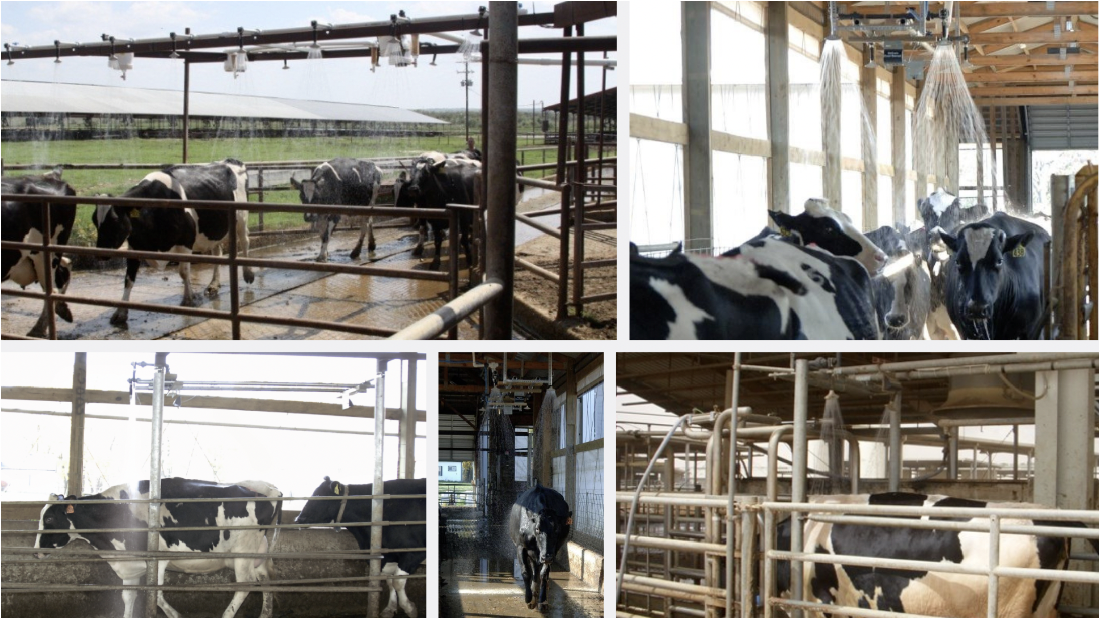
Dairy farmers are also using soaker systems to provide added cooling effects. Research on dairy cooling has shown that shade in combination with intermittent showering and forced air movement is a very effective method of cooling dairy cows, thereby reducing the production losses experienced during hot, humid weather conditions. Recent research at Kansas State University has shown that the application of water with low-pressure sprinklers cools cows more efficiently than fans alone. Photo credit: Avity Science
For dairy ranchers, heat abatement includes using sprinklers and fans to cool down the cows. Warm nights can change the schedule for that…
Map credit: The HIgh Plains Regional Climate Center
High overnight temperatures can also negatively impact crops such as corn, wheat, rice, and barley. Warmer overnight temps increase the crops’ respiration, leading to increased water use. Crops may also use carbon that’s usually used to develop grain cells, which can mean a lower yield. For corn, it’s particularly dangerous when warm nights occur during the pollination stage, said Mark Licht, an extension cropping specialist with Iowa State University. Cooling off at night during this stage helps produce higher yields, so the timing of those high overnight temperatures makes a difference…Chip Redmond said warmer temperatures hitting Kansas in July was especially bad timing. The conditions were dry and cloud cover led to warm nights during the silking stage.
A burnt sign on Larimer County Road 103 near Chambers Lake. The fire started in the area near Cameron Peak, which it is named after. The fire burned over 200,000 acres during its three-month run. Photo courtesy of Kate Stahla via the University of Northern Colorado
Two years after the Cameron Peak Fire started Aug. 13, 2020, its aftermath continues to plague residents in the burn scar and Larimer County, emotionally and financially. The 112-day fire had a perimeter encircling nearly 209,000 acres, making it the state’s largest recorded wildfire. It destroyed more than 460 structures…Since then, flash floods over scorched mountainsides laden with millions of dead trees and tons of sediment have killed six people, damaged more homes, washed away roads and culverts, and heavily impacted water supplies for the cities of Fort Collins, Loveland and Greeley. And that has left those living in the once-idyllic mountains west of Fort Collins frustrated and questioning the recovery response.
“Fire happens once and it’s done, but the floods keep going on,’’ said Tim Fecteau, whose property in the Upper Buckhorn Canyon and home he hand-built more than 40 years ago is sandwiched between scars left by the 2012 High Park and 2020 Cameron Peak fires…
From Tim and Betsy Fecteau’s mountain getaway perched above the single-lane dirt road Boogie Woogie Way, the view across Buckhorn Canyon to Crystal and Lookout mountains was for decades a mosaic of lush aspens and pines.
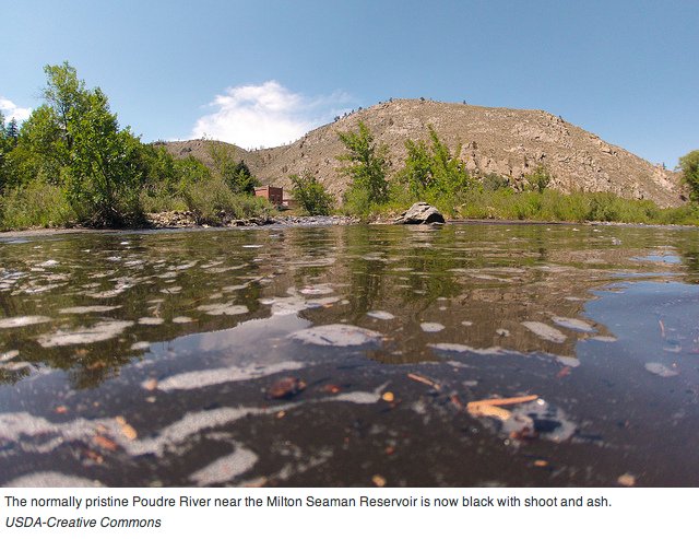
Ash and silt pollute the Cache la Poudre River after the High Park Fire September 2012. Photo credit: USDA
That ended in 2020, when the Cameron Peak Fire roared across the ridgeline, claiming all but a handful of homes and charring the mountainsides as far as the eye can see. Soon thereafter and continuing until recently, rains that would have been welcomed now cast a pall because of repeated flash floods. The National Weather Service has issued 31 flash flood warnings for the Cameron Peak burn scar so far this year. Last year, it issued 36 such warnings over the entire year. The 67 flash flood warnings issued since the fire far exceeds the 39 issued the two years after the High Park Fire, which burned more than 87,000 acres, and is more than were issued in the 15 years previous to the Cameron Peak Fire.