After Southwestern states failed to cut a deal, the Interior Department took it easy on them.
With drought pummeling the Southwest and the country’s most important reservoirs scraping bottom, the Department of the Interior announced that the seven states that rely on it must reduce the water they pull from the Colorado River next year.
The announced cuts are unprecedented. They are also a small fraction of what the federal government says is needed to keep the Colorado River system from collapsing.
Here’s what you need to know.
It was a messy process to get here. The Colorado River, which stretches from the Rocky Mountains to the Gulf of California in Mexico, provides water for 40 million residents of the Southwest; major cities, including Phoenix and Las Vegas; more than two dozen tribal nations; and some of the most productive, important agricultural fields in the world. The demand far exceeds the supply of a river that has been dwindling for years due to climate change-induced drought.
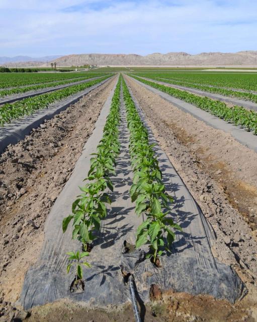
Farm fields in Arizona, where irrigation pumps are partly powered by Glen Canyon Dam. (Source: Water Education Foundation)
In June, the Bureau of Reclamation, the Interior Department agency that manages water infrastructure in the Western U.S., told the seven states involved — the “Upper Basin” states of Colorado, New Mexico, Utah and Wyoming, and the “Lower Basin” states of Arizona, California and Nevada — to cut back substantially on the water they collectively use. Otherwise, the agency warned, it would impose drastic cuts anyway.
However, the states failed to cut a deal. And on Tuesday, Interior Department officials declined to follow through on their threat, leaving a big question mark about how the federal government intends to address an increasingly dire situation.
Yes, there will be some cuts, but those cuts are meager. In a press release, the Interior Department described its response on Tuesday as an “urgent action” to protect the system. But the restrictions it announced were far less severe than what it had threatened in June.
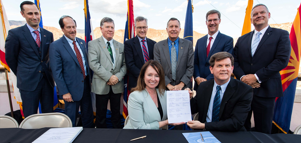
Signing ceremony for the Colorado River upper and lower basin Drought Contingency Plans. Back Row Left to Right: James Eklund (CO), John D’Antonio (NM), Pat Tyrell (WY), Eric Melis (UT), Tom Buschatzke (AZ), Peter Nelson (CA), John Entsminger (NV), Front Row: Brenda Burman (US), and from DOI – Assistant Secretary of Water and Science Tim Petty. Photo credit: Colorado River Water Users Association
Also, these cutbacks were already on the books. All seven states had already agreed to them in a 2019 drought plan, which laid out cuts for the Lower Basin if Lake Mead sank low enough to trigger a “Tier 2” shortage. That happened for the first time ever on Tuesday.
The reductions fall hardest on Arizona, which will lose 592,000 acre-feet in 2023 — 21% of its annual allotment (this figure includes an existing cutback from last year). Nevada will lose about 25,000 acre-feet, and Mexico will lose 104,000 acre-feet, or 7% of its annual portion. But California, another Lower Basin state, will not lose any of its water — for now. It will begin losing water at the next shortage level.
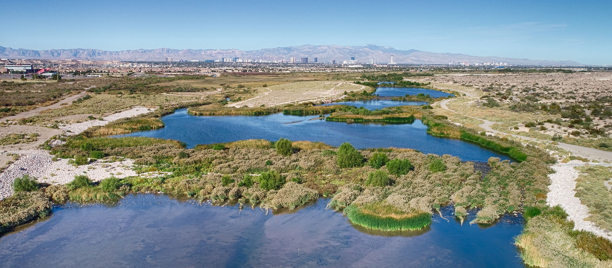
The Las Vegas Wash(Opens another site in new window) is the primary channel through which the Las Vegas Valley’s excess water returns to Lake Mead. Contributing approximately 2 percent of the water in Lake Mead, the water flowing through the Wash consists of urban runoff, shallow groundwater, storm water and releases from the valley’s four water reclamation facilities. Photo credit: Southern Nevada Water Authority
By contrast, in June the federal government requested a total of 2 million to 4 million acre-feet of cutbacks to ensure safe water levels in Lake Powell and Lake Mead. But with the federal government unwilling to act on its threat, it’s not clear how — or whether — the basin will be able to cut that water use.
Brad Udall: Here’s the latest version of my 4-Panel plot thru Water Year (Oct-Sep) of 2021 of the Colorado River big reservoirs, natural flows, precipitation, and temperature. Data (PRISM) goes back or 1906 (or 1935 for reservoirs.) This updates previous work with @GreatLakesPeck.
Things are bad and will get worse. There’s less water in the basin than ever. The past 20 years have been the Southwest’s driest in 1,200 years, according to an academic paper published earlier this year in Nature Climate Change. This “megadrought,” as scientists call it, has reduced rainfall, diminished snowpack and dried out riverbeds across the region.
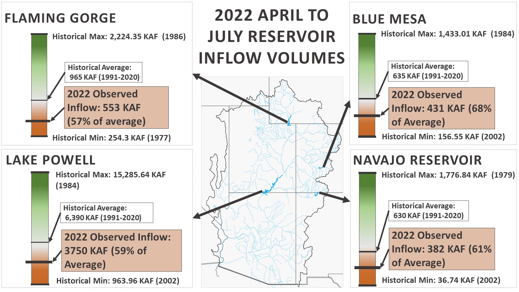
Tuesday’s announcement coincided with a regularly released 24-month study on water-level projections for Lake Powell and Lake Mead. Both reservoirs are languishing at just over a quarter full — an all-time low.
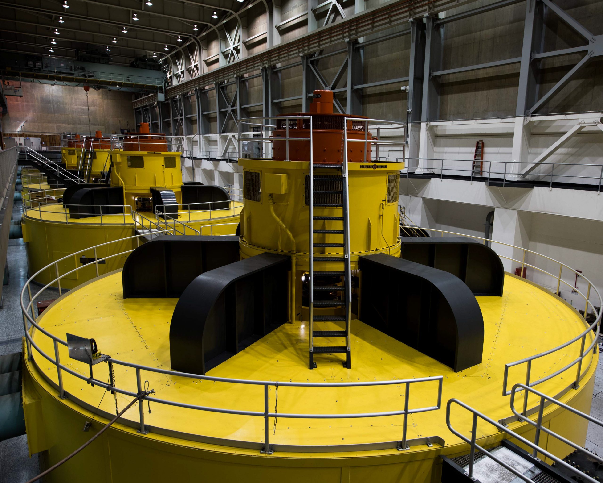
In a statement, the Interior Department described the conditions as “critically low.” The agency’s own study suggests things will get worse — and do so quickly. By January, Lake Powell is projected to sit just 32 feet above the “minimum power pool,” the level at which Glen Canyon Dam can no longer operate its giant turbines to produce electricity. This spring, the Bureau of Reclamation held back water in Lake Powell that was meant for Lake Mead, in order to prevent this calamity. This will likely happen again, as well as releases from reservoirs upstream of Lake Powell. But such short-term solutions cannot make up for the plain fact of not enough water to go around.
These turbines at Lake Powell’s Glen Canyon Dam are at risk of becoming inoperable should levels at Powell fall below what’s known as minimum power pool due to declining flows in the Colorado River. Photo courtesy U.S. Bureau of Reclamation.
Long-standing acrimony between states derailed the negotiations — and could prevent future fixes. There’s a long-standing tension between the Upper and Lower Basin states. The Lower Basin tends to use far more water than its northern partners, notably in the massively productive agricultural sectors of Arizona and Southern California. As a whole, more than 70% of the Colorado River’s water goes to agriculture. The Upper Basin historically has used less than its legal allotment, though several states have suggested they intend to change that.
Well before the federal government’s deadline, there were grim reports of conflict and negotiating stalemates among the states and other stakeholders. A Los Angeles Times dispatch described the process as “tense and acrimonious.”
Finger-pointing has ensued. In a terse letter released on Monday, John Entsminger, the general manager of the Southern Nevada Water Authority, criticized the negotiating process. “Despite the obvious urgency of the situation, the last sixty-two days produced exactly nothing in terms of meaningful collective action to help forestall the looming crisis. … Through our collective inaction, the federal government, the basin states and every water user on the Colorado River is complicit in allowing the situation to reach this point.”
On Tuesday, federal officials encouraged more talks. But will their outcome be any different?
From the 2018 Tribal Water Study, this graphic shows the location of the 29 federally-recognized tribes in the Colorado River Basin. Map credit: USBR
The laws and policies that govern the Colorado River have systematically excluded the basin’s 30 sovereign tribal nations. This exclusion has been a persistent fact dating back to the original Colorado River Compact of 1922.
Tribal governments in the Southwest hold the rights to between 22% and 26% of Colorado River water each year, according to a 2021 policy paper from the University of Colorado Boulder law school. Several tribes have ongoing water-right disputes, which, if resolved in their favor, would increase that figure.
Many tribes do not take their full annual allotment owing to insufficient infrastructure and funding, the paper noted.
The recent cuts come as the basin is renegotiating the laws that govern the river. The current set expires in 2026. The outcome of these negotiations — made more difficult by river’s dwindling flow — will determine who gets water and how much of it for years to come.
Colorado River Basin tribal governments have long sought to be recognized as equal partners in this process, but the negotiations over Tuesday’s cutbacks suggest that problems persist. In a letter to the Interior Department in late July, a coalition of 14 tribes said that they were “largely in the dark about what is being discussed” regarding the cutbacks.
“There has been no meaningful discussion with Basin Tribes,” the letter declared. “We should not have to remind you — but we will again — that as our trustee, you must protect our rights, our assets, and people.”
Nick Bowlin is a correspondent at High Country News. Email him at nickbowlin@hcn.org.
In response to continued forecast precipitation, the Bureau of Reclamation has scheduled a decrease in the release from Navajo Dam from 650 cubic feet per second (cfs) to 500 cfs for tomorrow, August 19th, at 4:00 AM.
Releases are made for the authorized purposes of the Navajo Unit, and to attempt to maintain a target base flow through the endangered fish critical habitat reach of the San Juan River (Farmington to Lake Powell). The San Juan River Basin Recovery Implementation Program recommends a target base flow of between 500 cfs and 1,000 cfs through the critical habitat area. The target base flow is calculated as the weekly average of gaged flows throughout the critical habitat area from Farmington to Lake Powell.