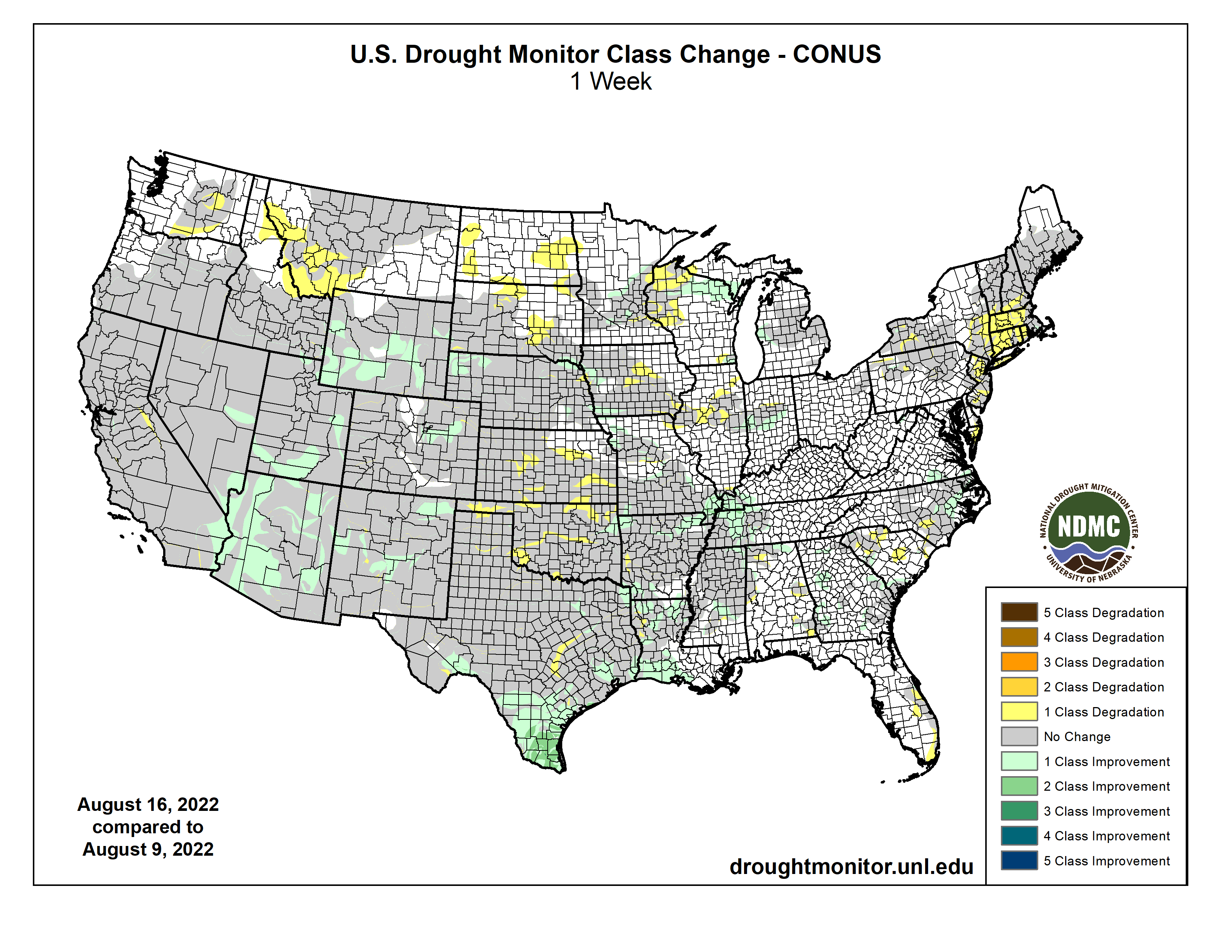
Precipitation again varied widely across the Lower 48 this week, which is not unusual during the summer. Across the interior West, monsoon rains were not as intense as last week, but remained heavier than normal. Several times the normal amount soaked most areas in the western half of the Four Corners Region, much of Nevada, southeastern California, reaching as far north as southeastern Oregon and Wyoming. Other areas receiving widespread heavy rains (and thus some improvement from recent dryness) included Deep South Texas and northwestern Nebraska. Parts of Deep South Texas recorded over 10 inches of rain, and 2 to 3 inches were common across northwestern Nebraska. Elsewhere, relatively narrow swaths of moderate to heavy rain dampened parts of the middle Mississippi Valley, Upper Midwest, and Great Lakes Region. Meanwhile, a broken pattern of moderate to heavy rain covered roughly the southeastern quarter of the contiguous 48 states. The higher amounts were in the 2 to 3 inch range though some small, highly-isolated areas recorded a bit more. In contrast, light precipitation at best fell on the Northeast, which teamed with abnormally high temperatures to induce significant and widespread intensification. Other areas observing light rain at best included part of the Upper Midwest, the north-central and south-central Plains. Conditions were seasonably dry along the West Coast…
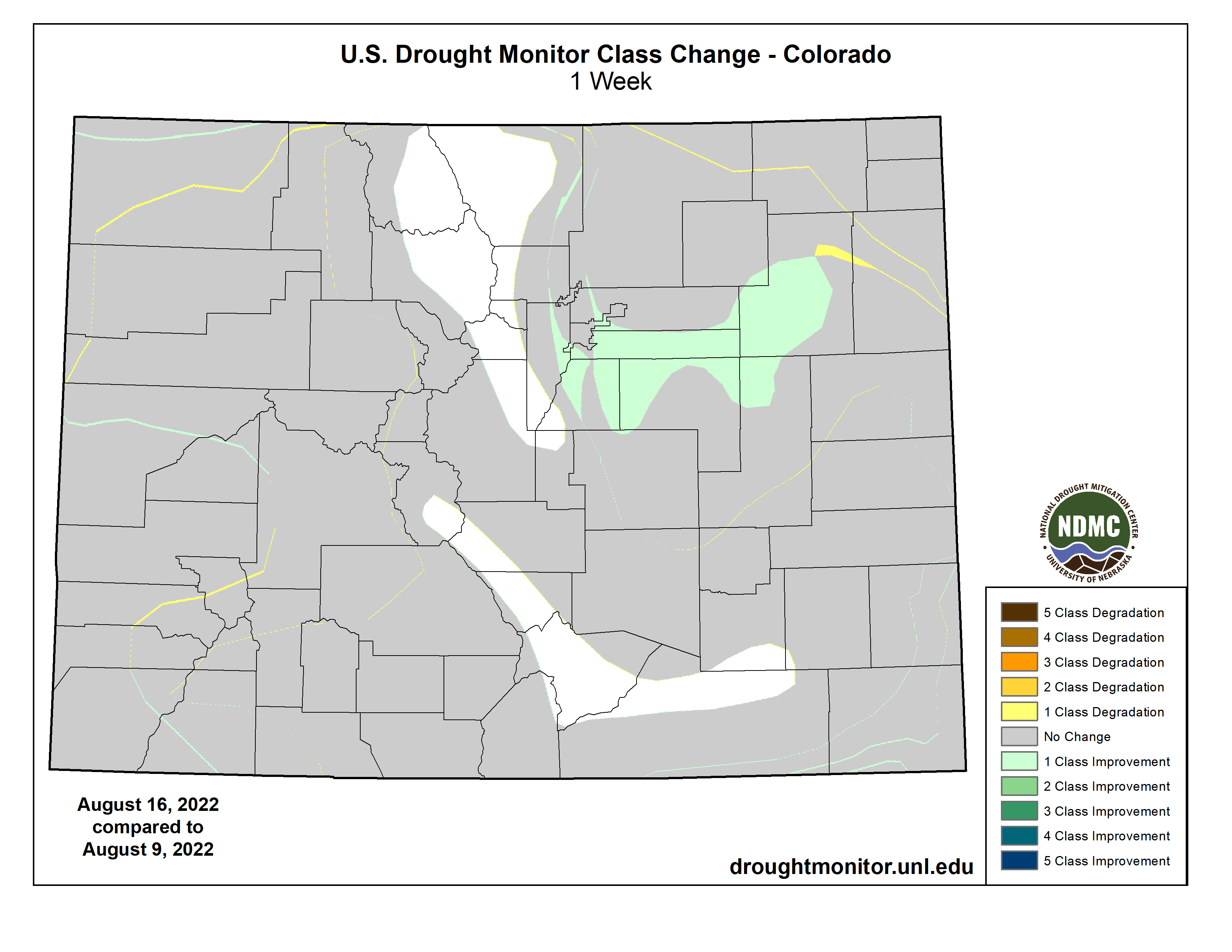
Light rainfall at best fell on Kansas and farther north across the Dakotas. In contrast, heavy precipitation augmented by intrusions of monsoonal moisture covered large areas from Colorado and Wyoming eastward into western Nebraska. Dryness and drought eased in these areas, with improvement most widespread across the southern half of Wyoming and in the Colorado High Plains. Precipitation in these areas generally exceeded an inch, with 2 to 4 inches falling on several areas from southeastern Wyoming into northwestern Nebraska. Outside of the band of heavy precipitation that brought some improvement to Nebraska and adjacent areas, little or no rain fell on central and southern Kansas, and across most of the Dakotas, with South Dakota recording less rainfall than areas to the north. As a result, dryness persisted or intensified in these areas. Most of the Dakotas and the eastern tier of the Region measured near or below half of normal for the last 3o days, with several patches across the central Dakotas and southeastern Kansas receiving 25 percent of normal or less. In sharp contrast, most areas from central Wyoming through eastern Colorado and western Nebraska reported 150 to locally over 300 percent of normal since mid-July…
Colorado Drought Monitor one week change map ending August 16, 2022.
Ample rains from the North American Monsoon continued through mid-August. Seven-day totals of 1 to 3 inches – with isolated higher amounts – fell across southwestern New Mexico and Arizona northward through much of the central and eastern Great Basin, and the western half of Utah. As a result, several large areas of improvement were noted this week, with the heaviest rains and most widespread improvement covering Arizona. After an extended period of serious drought, the heavy rains have prompted broadscale improvement in monsoon-affected areas. Two-category improvements over the past 4 weeks have occurred in areas recording the heaviest rainfall. Meanwhile, drought and dryness have been changing in the opposite direction across the northern tier. Most notably, abnormal dryness and moderate drought have been expanding across central and western Montana due to deficient precipitation and well above normal temperatures, while intensification has been slower and covers smaller areas in Idaho and Washington. Most of the Pacific Coast states have been dry and periodically hot as well, but this is their dry season, so totals are not far removed from normal…
Last week’s precipitation – though variable – followed the same general pattern as the precious week. Heavy rains drenched much of the eastern reaches of the Region while lesser amounts and localized deterioration were noted farther west. On significant exception was Deep South Texas, where heavy to intense rainfall brought significant improvement to areas of abnormal dryness and drought. Amounts exceeding 2 inches were widespread south of a line from Webb and LaSalle Counties eastward through San Patricio County, and amounts of 5 to locally over 10 inches drenched areas north of the Mexican border counties. This prompted nearly universal 1-category improvements on the Drought Monitor, with small areas of 2-category improvement where rainfall was heaviest. Extreme drought (D2) or worse are now confined to areas north and west of Duvall County. Elsewhere, increasing rainfall brought additional improvement to the Lower Mississippi Valley and Tennessee, but amounts were generally below-normal from central Texas northward through Oklahoma. Enough rain fell on central and northern Texas to keep areas of deterioration small, but little rain fell from the Red River (South) into northern Oklahoma, where larger areas of intensification were observed. Broad areas of exceptional drought (D4) still cover much of a large area from the southern Texas Panhandle southeastward toward the Gulf Coast. Over the last half-year, rainfall deficits of 8 inches to locally over a foot have affected areas of central Texas near and south of Dallas/Fr. Worth to the Gulf Coast…
Looking Ahead
The next five days could see heavy rainfall and improvement across a large part of northern Texas and southern Oklahoma eastward along the Arkansas/Louisiana border. Amounts of 2 to 3 inches are expected to be widespread here, with small areas south of the Texas Panhandle and in southeastern Oklahoma expecting over 4 inches of rain. Farther west, the robust monsoon looks to continue unabated. Between 2 and 4 inches are expected over southern sections of the Four Corners Region. But monsoon moisture is not expected to bring tropical moisture and heavy rainfall north of the central Rockies. Farther east, the rest of the southern tier of states are expected to get near or above an inch of rain, with bands of heavier rainfall expected in the Carolinas, southeastern Georgia and the central Gulf Coast. Much of the Upper Midwest and northern Ohio Valley should get several tenths to nearly 2 inches of rain, although the highest totals should be highly isolated. In stark contrast, little or no rain is expected over the contiguous states to the north and west of Kansas. In New England, where dryness has been intensifying rapidly, only a few tenths of an inch of rain are forecast in the areas of moderate to extreme drought along and near the I-95 corridor. Well above average temperatures will exacerbate dryness from the central Rockies northward and westward. Five-day average temperatures could exceed +9 deg. F above normal over the Great Basin and northern Intermountain West. Meanwhile, the southern tier of states – where heavy precipitation is expected – are forecast to average at least 3 deg. F below normal. Temperatures will be close to normal elsewhere, though they could sneak a few degrees above normal in part of New England.
For August 23-27, Odds favor a continuation of above normal temperatures from the Great Basin northward to Canada and westward to the Pacific Coast. In addition, enhanced chances for above-normal temperatures cover the Northeast, the eastern mid-Atlantic region, the immediate south Atlantic Coast, and Florida. Subnormal temperatures are favored from the southern half of the Rockies eastward through the central Plains, middle Mississippi Valley, lower Ohio Valley, and interior Southeast. At the same time, above-normal precipitation is at least slightly over a large area covering the desert Southwest, Intermountain West, Rockies, central and southern Plains, the lower half of the Mississippi Valley, the Ohio Valley, the lower Midwest, Appalachians, and most of the Eastern Seaboard from Georgia through southern Maine. The best chances for abnormally heavy rain extends from northeastern Texas and eastern Oklahoma northeastward through the Tennessee and adjacent Ohio Valleys.
US Drought Monitor one week change map ending August 16, 2022.
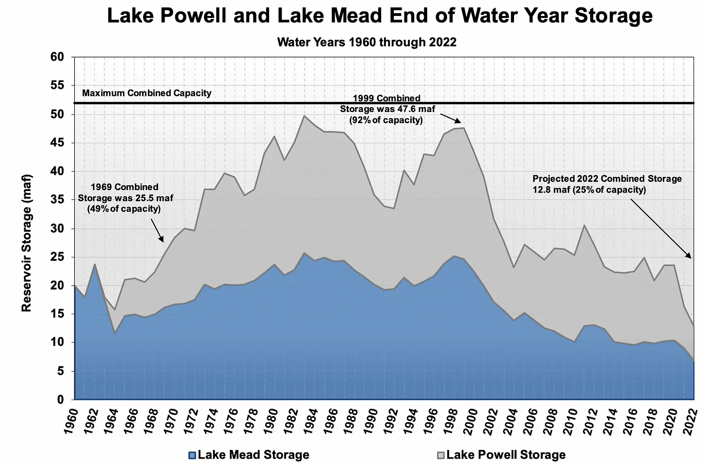
Lake Mead at Hoover Dam, January 2022. Jonathan P. Thompson photo.
Click the link to read to read the article on The Land Desk website (Jonathan Thompson):
THE NEWS: “Today [August 16, 2022] is a very important day for the Colorado River Basin. We are facing unprecedented challenges.” So said Tanya Trujillo, Assistant Secretary for Water and Science at the Interior Department, at an Aug. 16 press conference, setting the stage for the federal government to dive in and mandate drastic water use cuts to stem a crisis on the Colorado River. Instead, Interior Department officials merely dipped their toes into the diminishing waters, which is my weak, metaphorical way of saying that they stopped well short of making the draconian cuts, even though the states blew by a deadline to do it themselves.
Graphic credit: The Land Desk
THE CONTEXT: On Nov. 9, 1922, the seven Colorado River Basin states (without any input from the dozens of tribal nations in the Basin) signed onto the Colorado River Compact, which divvied up the river’s waters between the Lower Basin (Arizona, California, Nevada) and the Upper Basin (Colorado, Wyoming, Utah, New Mexico). At the time the signers believed an average of 16.4 million acre feet (maf) of water flowed through the river naturally each year, giving 15 maf for the states to divide up (the extra would go to Mexico).
The Upper Basin states would allow an average of 7.5 maf per year (75 maf every ten years) to flow to the Lower Basin, theoretically allowing the Upper Basin states collectively to withdraw the same amount. The Upper Basin divided their share up by percentages, with Colorado getting the most (51.75% or 3.9 maf), New Mexico getting the least (11%, or 840,000 acre feet), and the others falling in between. Down south California got 4.4 maf; Arizona 2.8 maf; and Nevada 300,000 acre feet.
From the 2018 Tribal Water Study, this graphic shows the location of the 29 federally-recognized tribes in the Colorado River Basin. Map credit: USBR
Although the 30 tribal nations in the Basin were not included in negotiations, the Compact does specify that the agreement does not affect the substantial tribal water rights recognized by the 1908 Winters v. United States Supreme Court decision. That means the tribes’ share of the water would come from the states’ portions.
Over time it became more and more clear that there wasn’t nearly as much water in the river as folks previously believed. Sure, during good years (the 1980s), there could be as much as 25 million acre feet flowing into Lake Powell. But the next year flows might plummet to 10 maf. At first this wasn’t a problem. The reservoirs, acting like big, murky savings accounts, were doing their job. During good years the river deposited water into the accounts and built up enough savings to get the states through several bad years, when the states could draw down their savings, allowing the Upper Basin States to pull out their allotted amount while still sending 7.5 maf downstream.
But there was a problem—two of them, really. First, the river started shrinking. In 1999 the Colorado River Basin entered the driest 23 year period on record, with the dry years getting dryer and outnumbering the wet years, which weren’t as wet as they once were. Yet the collective users of the water didn’t curb consumption during lean years. Instead, they actually used more water—far more than the skies and the river delivered, thereby depleting the savings accounts known as Lakes Powell and Mead.
Lake Powell now is only 27% full (and dropping), the Basin’s storage system is at 34% of capacity, and both Lake Powell and Lake Mead are in danger of losing hydropower production capacity—which leads to all sorts of other problems—in the next couple of years if conditions don’t improve or the users don’t make substantial cutbacks. Last year a Tier 1 shortage was declared, requiring Arizona to cut its Colorado River withdrawals by just over 500,000 acre feet, and water managers took additional measures to prop up Lake Powell. That wasn’t enough.
That’s why, on June 14, Bureau of Reclamation Commissioner Camille Calimlim Touton called on the Colorado River Basin states to come up with 2 to 4 million acre feet in additional cuts within 60 days—or else. The deadline came and went days ago, and the states reportedly are nowhere near the necessary targets. Utah hasn’t even withdrawn its proposal to suck additional water out of the system via the proposed Lake Powell pipeline.
“… the last sixty-two days produced exactly nothing in terms of meaningful collective action to forestall the looming crisis,” wrote the Southern Nevada Water Authority’s John Entsminger in a strongly worded letter to the Interior Department. “The magnitude of the problem is so large that every single water user in every single sector must contribute solutions to this problem regardless of the priority system.” Entsminger essentially begged the feds to step in and turn off some taps. (Read the whole letter by clicking the tweet below).
SNWA General Manager John Entsminger delivered this letter today to the Department of the Interior and Bureau of Reclamation. pic.twitter.com/1ZwW5rXcc3
— Southern Nevada Water Authority (@SNWA_H2O) August 15, 2022
But if that was the sort of decisive action that some observers expected and hoped for in [August 16, 2022’s] press conference, they went away disappointed. The Interior Department promised “urgent action” yesterday. But when reporters asked the officials whether or not they were actually mandating cuts, Touton said they were “starting the process” and emphasized the need for a “consensus solution,” but remained vague as to what any of that means.
That’s not to say the feds are doing nothing. They will implement Tier 2a restrictions on the Lower Basin states, meaning Arizona will have to cut withdrawals by an additional 80,000 acre feet (they are already down 512,000 af under Tier 1 cutbacks1) and Nevada by 25,000 acre feet. Of course, that’s not anywhere near the 2 million to 4 million that’s needed. Also, the Bureau of Reclamation will continue to limit releases from Glen Canyon Dam to 7 maf (rather than the previous 7.5 maf) and will probably release more water from upstream reservoirs to shore up Lake Powell’s water levels.
Meanwhile, they will continue to work with the states and tribes to come up with a solution. Time’s running out. “Without prompt, responsive actions,” Trujillo said, “the Colorado River will face a future of uncertainty and conflict.”
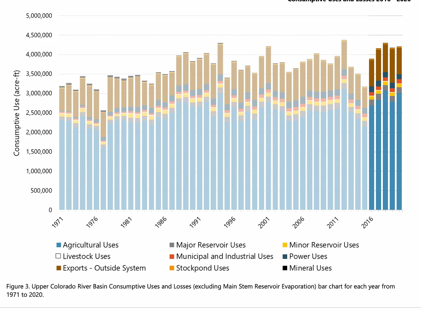
Note that this graph is only for the Upper Basin consumptive use and losses.
Among those who will be disappointed in the lack of drastic cuts on the Colorado will be … Powellheadz? Yeah, the Lake Powell fan club (the best description of Powellheadz I could come up with) teamed up with the Blue Ribbon Coalition, a motorized off-road advocacy group, to call on all seven Colorado Basin states to significantly reduce withdrawals beginning next year. The goal? Refill Lake Powell (and Mead) to improve recreation. Seriously.
I guess you could say this is the antithesis to the Drain Lake Powell/Fill Mead First movement. Last week the groups released their policy proposal entitled, “Fill Lake Powell: The path to 3,588.” That number refers to the minimum surface level of the reservoir at which most boat ramps are usable and recreation is prime. That would mean raising the surface of the reservoir about 55 feet from the current level. To get there, the report finds, would require cutting water consumption by about 4 million acre feet per year, beginning ASAP.
Hmmm… Well. Okay. So, the states can’t even seem to come up with 1 million acre feet to cut in order to keep the entire Colorado River system from collapse, but they’re going to come up with 4 million acre feet so that folks can put their motorboats in the lake? Good luck with that!
NOTE: Arizona’s the biggest loser during shortages thanks to the Colorado River Basin Project Act of 1968. Congress agreed to pay for the Central Arizona Project, which carries water from the Colorado River across the desert to Phoenix and Tucson. In exchange, Arizona agreed to subordinate its water rights to California’s in times of shortage.
One of the big problems with bringing water from somewhere else is a false sense of security. When we live long distances from our water, we may not understand the limits of that supply or ecosystem- so conservation is less likely. Big day for the #ColoradoRiverhttps://t.co/nXPEFSsUNt
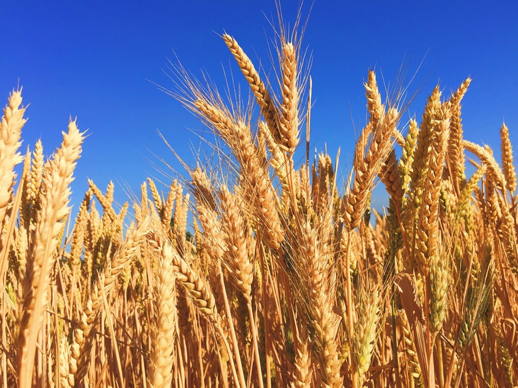
Dryland farming has never been easy. But in recent years, [Nate] Northrup has been battling a new challenge that would have baffled earlier generations: the wheat stem sawfly. It’s a pest that infests wheat stems at the base, flattening fields — usually just before the harvest. Northrup described a slow progression of sawflies infiltrating his wheat fields, starting in 2010.
“It used to be just a few swaths around the edges,“ he said. “And then, the next year following, it would just be entire fields, just laying on the ground.”
Adult wheat stem sawfly. Photo credit: Colorado State University
Last fall, Colorado farmers planted more than 2 million acres of winter wheat for the 2022 harvest. But persistent drought is hurting Colorado’s crop, and the sawfly infestation only worsens things.
Lodging cause by wheat stem sawfly. Photo credit: Colorado State University
The mature bugs emerge in the spring and lay their eggs in young wheat stems. As the wheat grows, so do the sawfly larvae, eating their way down to the bottom of the plant. Just as the wheat ripens and becomes ready for harvest, the larvae ripen and get ready to hibernate. It makes itself an overwintering chamber just above the root and, in the process, takes a final big bite at the base of the wheat stem, weakening it beyond repair. The first wind or sprinkling of rain topples the weakened stalks flat on the ground.
Dr. Erika Peirce is a postdoctoral researcher at Colorado State University who specializes in integrated pest management of the wheat stem sawfly, which, she is quick to point out, is not actually a fly.
“Contrary to the name. It’s actually a wasp,” she explained. She says sawfly may be a new pest, but the bug is not new to Colorado. “It was initially discovered in non-cultivated grasses – the grasses on the side of the road — in 1874 in Colorado. It only became a pest of winter wheat in Colorado in 2010.”
Peirce says the sawfly’s transformation from benign native insect to threatening pest happened because of a change in its lifecycle. Initially, adult sawfly timed their emergence to align with the growth of the non-cultivated grasses that were its native host. She explained that winter wheat develops earlier in the season than those native grasses.
“The sawfly, in order to use winter wheat, has to mature and emerge about 3 to 4 weeks earlier than they normally would for their native hosts,” she said.