A concerning increase in the Missouri River Basin as MT, WY, and NE are all over 70%. Parts of the Northeast have been going in the wrong direction too for some time. Lower 48 increased 2% as a whole. #drought
Agriculture is the main economic venture on CRIT’s reservation, where a range of crops like alfalfa, cotton and sorghum thrive in the rich soil along the banks of the Colorado River. (Source: CRIT)
Click the link to read the article on the KUNC website (Alex Hager). Here’s an excerpt:
A group of 14 tribes in the Colorado River basin is asking for a greater voice in ongoing negotiations about water conservation. In a letter to the Department of the Interior, those tribes write that they are not being adequately consulted as states ponder a plan to save an unprecedented amount of water amid this historic drought.
“We should not have to remind you — but we will again — that as our trustee, you must protect our rights, our assets, and people in addition to any action you take on behalf of the system,” the letter reads…
The tribes said a June pre-scoping notice about river negotiations was a good start — it mentioned a commitment to engage with tribes and consider their views— but the Interior Department has not kept its promise to keep tribes “appropriately informed.”
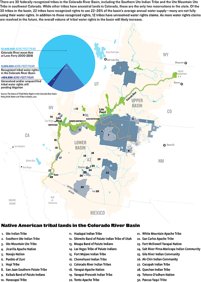
The Colorado River basin includes 30 federally-recognized tribes that depend on its water. Despite holding rights to about a quarter of the river’s flow, many tribes lack the funding and infrastructure to use their full allocations. They have historically been excluded from decision-making about how the river’s water is used, going back to foundational documents allocating the region’s water. They argue they are still being excluded during the unprecedented call for conservation…This is not the first time within the past year that tribes have come to the federal government with a call for greater inclusion. In November, twenty tribes within the basin sent a letter to the Interior Department broadly asking for greater inclusion in the long-term management of the Colorado River.
North American Indian regional losses 1850 thru 1890.
The downtown Denver skyline from Arvada. Photo credit: Allen Best/Big Pivots
Click the link to read the article on the Big Pivots website (Allen Best):
To be very clear, this is the biggest energy story of the year in Colorado, in my read.
State legislators in 2021 adopted several laws that will, in various ways, begin squeezing greenhouse gas emissions from buildings.
Now comes the implementation as the three commissioners from the Public Utilities Commission do their required public engagement in meetings held in various locations in Colorado. All available evidence suggests to me that this will come close to fist-swinging before it’s all done, at least of the wordy type. From what I hear, it already has.
I attended the second of the six meetings, the one at Montbello Community Center in Denver. It was a bilingual meeting structure designed for consumption by people who had mostly never heard of the PUC much less clean heat plans.
In Montrose a week later, people had heard of the clean heat plans – or least that an effort was underway to remove natural gas from buildings. According to a report in the Montrose Press, many were not in the least bit happy. “Public Utilities Commission gets an earful over Clean Heat Plans,” was the headline.
SB 21-264, which we’ll call the clean-heat law, requires Colorado’s four privately owned natural gas utilities – Xcel Energy, Black Hills Energy, Atmos and Colorado Natural Gas – to reduce greenhouse gases 4% by 2025 and then 22% by 2030. This is compared to emissions of 2015.
How can they do this? The law provides four ways for the utilities to do so in the heat-clean plans they must submit:
1) Demand-side management programs, especially including improved energy efficiency.
2) Beneficial electrification, meaning that gas use in buildings for space and hot water heating is replaced by electricity. One way of doing that is through addition of air-source heat pumps or, in original construction, ground-source heat pumps.
3) Improved efforts to reduce methane leaks from the natural gas infrastructure.
3) Recovered methane, such as from landfills, to supplement the methane extracted from wells;
4) Green hydrogen, which means made from renewable resources and after (but not natural gas);
5) Pyrolysis of tires, the recycling of tires to extract heat and energy, as is being considered at Fort Morgan.
The latter two are likely more difficult than the first three.
The PUC commissioners have until December to draw up the rules governing the review of these clean-heat plans.
I see four very, very big issues here:
First, this is a lot of work in a short time. “A heavy lift for utilities,” John Gavan, the PUC commissioner who presided at the Montrose meeting, said.
A Black Hills representative at the Montrose meeting said that the required reduction coming on top of demand growth means that instead of a 4% reduction it’s more like a 25% reduction. Nigh on to impossible, said Mike Harrigan, the Black Hills rep.
Second, the gas utilities are being required to radically change their business models and, in the case of three of them, to essentially make themselves less relevant. Xcel Energy will sell more electricity as it sells less gas. For Black Hills, which sells both gas and electricity, the trade-off is not as easy. It sells gas in Aspen, for example, but not electricity.
One of the attendees at Montrose summarized it in this way: “Let me get this straight,” said David Combs, speaking to the Black Hills Energy representatives. “The products you sell, you make money on, you’re trying to reduce and you’re giving people money to use less of it?”
There always has been a strange tradeoff between regulated utilities. They enjoy monopolies in their service territory in return for regulation. This was once reliable money. Utilities are now being required to be far more inventive.
Third, builders and real estate developers have been enjoying a subsidy as they build new subdivisions, the gas lines that are laid being subsidized by existing natural gas customers. At the end of the day, this may be the defining issue. High-spirited filings with the PUC began in December 2021.
Fourth, there are equity issues here as we squeeze out natural gas, replacing it with electricity. Who will pay for the aging natural gas systems? Like so many things, it’s likely to be those who can least afford to pay.
The meeting in the Denver neighborhood of Montbello was conducted in both Spanish and English. Photo/Allen Best
I mentioned the Montbello meeting. It was designed to reach out to an area that met the definition of a disproportionately impacted community. I can’t disagree, but I must say that I felt very marginalized. I struggle to hear well normally, and the choice of room configuration left me with my back to the speakers and trying — and almost entirely failing — to hear the English translation of what was being said in Spanish. My impression was that the meeting was designed with the intent of honoring the law, and it did achieve that. But one meeting alone will not achieve the real purpose with this particular group.
A meeting in Grand Junction was somewhat boisterous, I heard, which did not surprise me. The first filings of opposition to clean-heat plans in the PUC docket in this case were submitted by real-estate agents and others from the Grand Valley and Montrose. Weeks later they started arriving from places like Aurora.
Again, as Gavan identified in the Montrose meeting, the key issue here is the subsidy for gas lines to homebuilders. Nobody likes to lose their subsidy.
Sandy Head, executive of the Montrose County Economic Development Corp. told the Press that the cost of extending a gas line to a new house was previously $250 to $300 but will now cost $800.
This led to charges that it would become too expensive to live in a place like Delta County – which, with the exception of now pricey Paonia, remains one of Colorado’s least expensive places to live west of I-25.
Also balled up into this issue is the high cost of natural gas and the failure of Xcel Energy to adequately prepare itself for what happened in February 2021. Xcel ended up paying $600 million extra for high-priced natural gas. But there’s also the issue of Texans going without power – which some people, apparently, still think can be blamed on the dependency on wind turbines. (It was a part of the problem, but only a small part).
“We’re not going to shut off fossil fuel generation in the form of gas overnight,” Gavan replied, as per the Montrose Press account. “No, our plan is to add another gigawatt of combustion technology to back up renewables. It’s a balancing mix. As we transition, the resource mix will change. It will become very different, more intelligent.”
The All American Canal carries water from the Colorado River to farms in California’s Imperial Valley. The Imperial Irrigation District holds more rights to Colorado River water than any other user in the basin. Photo credit: Adam Dubrowa, FEMA/Wikipedia.
A plan is circulating among irrigation districts in southern Arizona and California to reduce Colorado River use by as much as 925,000 acre-feet.
Such a plan would require billions in funding.
These discussions foreshadow difficult negotiations in the coming years to balance water demand with a declining supply.
Knowing they are targets, farmers in southern Arizona and California who receive irrigation water from the Colorado River are discussing a plan that could go a long way toward meeting a federal conservation mandate in the drying basin.
With key reservoirs Mead and Powell at record lows and despite the continued decline of the Salton Sea, federal officials are demanding historic cuts in water use next year, on the order of 2 million to 4 million acre-feet, or roughly one-third of the river’s recent annual flow.
Irrigation districts in Arizona’s Yuma County and California’s Imperial and Riverside counties control more of the river’s water than any other entity in the basin. The Colorado River Indian Tribes, whose reservation abuts the river, also hold significant secure water rights.
A plan is now circulating among those districts to forgo 1 acre-foot of water per irrigated acre next year. In the Yuma area that amounts to a 20 percent cut, according to Tom Davis, manager of the Yuma County Water Users’ Association.
The emergency actions foreshadow difficult negotiations that will take place in the coming years as a river that irrigates 5 million acres and supplies 40 million people with a portion of their drinking water is decimated by a drying climate. Agriculture consumes about 80 percent of the basin’s water, making it a cornerstone for bringing demand in line with supply.
The discussions today could set the tone. As many as 925,000 acre-feet could be part of the current deal, about half or a quarter of the total cuts the federal government is seeking.
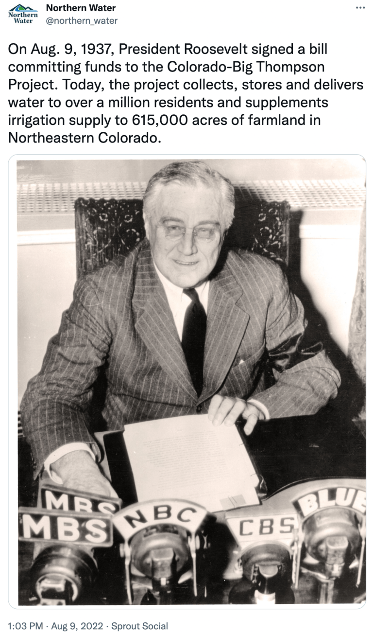
The forgone water would remain in Lake Mead, which is at its lowest level since 1937, when the big reservoir was being filled. Federal officials want to prevent a catastrophic outcome: the reservoir dropping so low that it can no longer generate hydropower or deliver water downstream.
Irrigation districts are willing to contribute — as long as they are paid.
“If agriculture steps up and makes it possible for the river to survive, they are taking a huge risk for their industry,” said Wade Noble, coordinator of the Yuma County Agriculture Water Coalition, which represents farmers in southwest Arizona. “And that risk and the cost analysis that goes into it is going to require some sort of compensation because they have a water right.”
The dollars at play could be significant. A range of values are being discussed, but a center point is $1,500 per acre-foot. If all 925,000 acres participated in the program, the total cost would be $1.4 billion a year.
It is unclear at this point how many irrigation districts are on board. Camille Touton, the commissioner of the Bureau of Reclamation, told the states to present a plan by mid-August. But observers in the basin do not consider that a firm deadline. Davis cited the accelerated timeline and delicate nature of the negotiations.
Noble outlined the agriculture conservation plan at the July 13 meeting of the Arizona Reconsultation Committee, a group that is advising the state government on Colorado River negotiations. He suggested a four-year program with a total cost between $4 billion and $8 billion.
“As we look at the risk to economies,” Noble added. “As we look at the risk to other industries. As we look at the risk to our urban areas, we don’t believe that you can say that is too much money.”
Noble did not return multiple phone messages seeking comment.
Robert Glennon, a water law and policy expert and professor emeritus at the University of Arizona said that though the dollar figures may seem high at first glance, they are miniscule compared with the risks involved.
“Why should that be a deal breaker?” Glennon asked about a nearly $2 billion annual price tag. “I mean, it’s only a one-year deal. But it’s wet water that saves everyone’s bacon while you’re trying to develop some long-term criteria.”
These irrigated areas are among the harshest climates in the United States, arid lowland regions of the Sonoran Desert that receive no more than 4 inches of rain in an average year.
The Colorado River is the ingredient that turned these drylands green. Applying more than 5 feet of water per acre of land each year allows farmers in Imperial Irrigation District, Wellton-Mohawk Irrigation District, Palo Verde Irrigation District, and a half dozen others to produce a staggering bounty of vegetables, grains, forage, and seed crops. Growing more than 100 crops, these counties are among the richest farming regions in the country, each generating more than $1 billion in sales in 2021.
The steady flow of the Colorado is the fuel that powers the ag machine. The threat that the spigot will be turned off has brought the irrigation districts to the table.
If dividing the river during a period of shortage were based purely on the law, then the irrigation districts would not have to worry. They hold some of the most legally ironclad rights to the river, those that are last in line for cuts.
Imperial Irrigation District, the largest of the bunch, has claim to 2.6 million acre-feet for irrigation, nearly as much water from the Colorado River as the entire state of Arizona. That water nurtures about 470,000 acres of alfalfa, Bermuda grass, Sudan grass, sugar beets, onions, lettuce, and other crops. Secured by a U.S. Supreme Court decree, Imperial’s water rights would be the last to be touched.
The political reality, however, is altogether different, according to Michael Pearce, an attorney with Gammage and Burnham who has more than three decades of experience in Arizona water law and policy.
“In a practical sense, you can’t see the cities of Phoenix and Los Angeles, and even Las Vegas and some of the cities on the Colorado River — Bullhead City, Lake Havasu City — have their water supply cut off so that you can grow alfalfa in Yuma and in the Imperial Valley,” Pearce told Circle of Blue. “This cannot be a practical solution.”
Aerial photo – Central Arizona Project. The Central Arizona Project is a massive infrastructural project that conveys water from the Colorado River to central and southern Arizona, and is central to many of the innovative partnerships and exchanges that the Gila River Indian Community has set up. Public Domain, https://commons.wikimedia.org/w/index.php?curid=326265
The Central Arizona Project, the 336-mile canal that supplies Phoenix and Tucson, has junior water rights to the Colorado River. But Arizona’s water leaders have publicly stated that they will not sign any agreement that allows the canal to run dry.
Leaders in the four upper basin states of Colorado, New Mexico, Utah, and Wyoming are also looking downstream for solutions. In a July 18 letter they argued that the burden of the conservation mandate should be placed on Arizona, California, and Mexico, which together use more than double the water than the upper basin. Besides the irrigation districts, urban suppliers in the basin are also putting forward conservation plans.
Another factor in the irrigation districts’ willingness to come to the table is that the mechanics of water delivery will eventually triumph over the law. Even the most secure legal rights are worthless if Mead sits at dead pool and no water can pass downstream.
How might the farmers be paid off? Glennon and Pearce noted a number of options. Congress could appropriate money. A wildfire and drought response bill that the House passed at the end of July authorizes $500 million to prevent Mead and Powell from declining to unacceptable levels. Or the White House could declare a federal disaster. Any outcome, they said, would likely require states to contribute funds.
Brad Udall: Here’s the latest version of my 4-Panel plot thru Water Year (Oct-Sep) of 2021 of the Colorado River big reservoirs, natural flows, precipitation, and temperature. Data (PRISM) goes back or 1906 (or 1935 for reservoirs.) This updates previous work with @GreatLakesPeck.
Those are potential short-term actions. In the long run, the current water rights arrangement is untenable, Glennon said. The drying basin has a structural deficit — more promises of water than physical water to distribute. The states, tribes, and federal government will have to not only rebalance water supply and demand, but also address the shrinking Salton Sea.
“That conversation has to take place,” Glennon said.
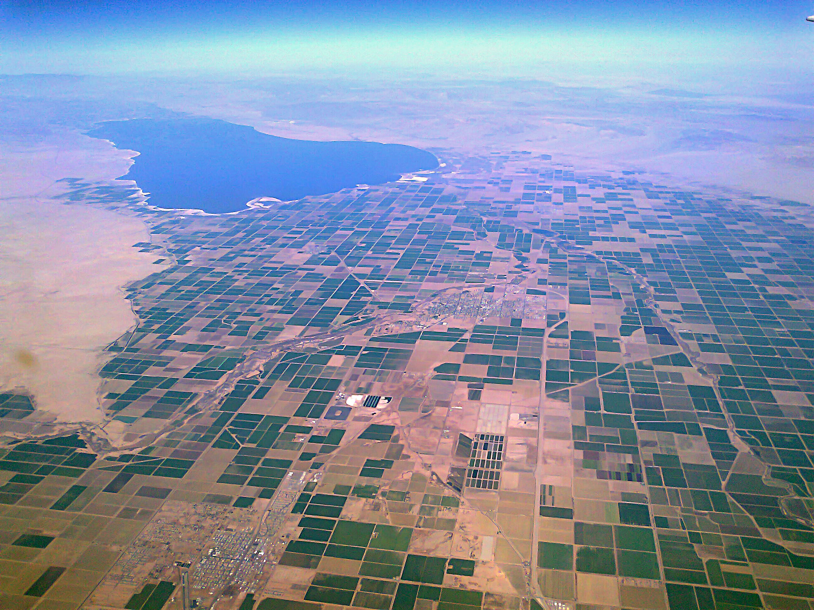
Located north of Imperial Irrigation District, the Salton Sea is an agricultural sump, a desert depression that receives most of its water from farm runoff. Less irrigation means less water flowing into the sea. A receding shoreline exposes more seabed salts and chemicals to winds. The area has some of the nation’s worst air quality.
Whether a system established more than a century ago that privileges desert agriculture is compatible with a hotter, drier, ecologically imperiled, urbanized 21st century is a question that will take years to resolve — but with little time to waste.
At its August 8, 2022 meeting, the Aurora City Council unanimously approved on first reading an ordinance sponsored by Mayor Mike Coffman that will restrict the use of turf in new developments and golf courses. This ordinance is forward-looking, impacting new development and redevelopment by prohibiting aesthetic cool-weather turf. Parks would be permitted to use turf in sports fields, informal play areas and social areas.
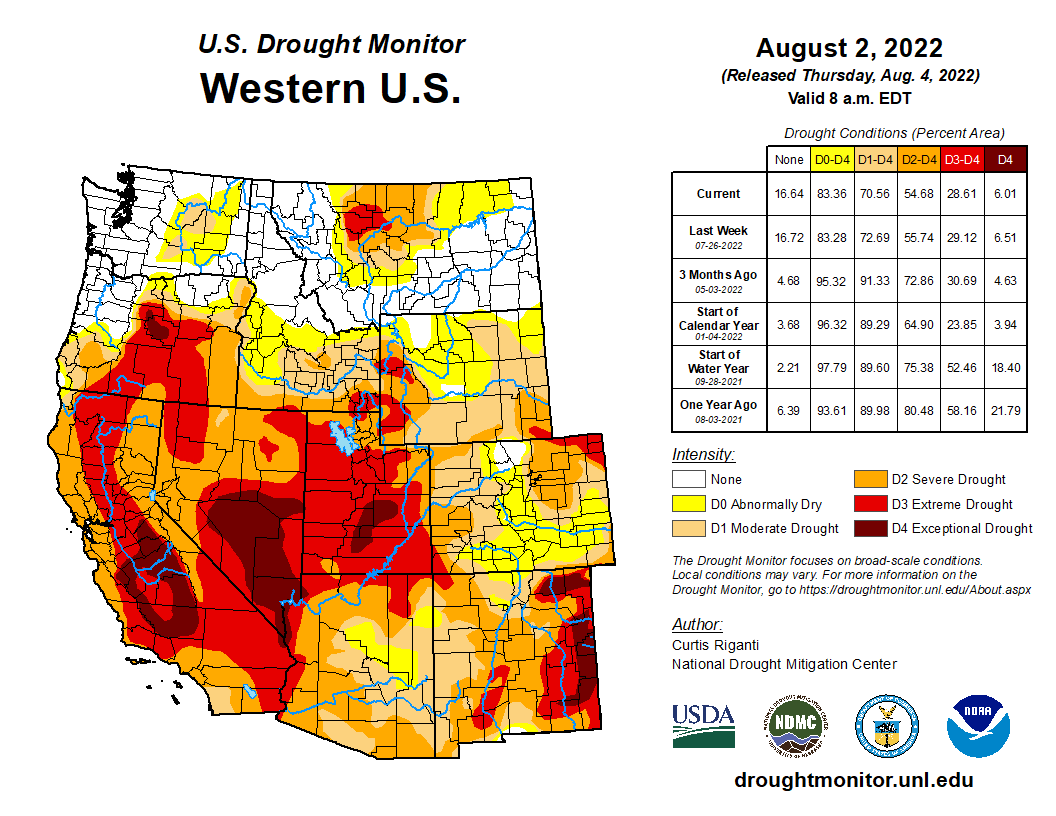
West Drought map Monitor August 2, 2022.
Mayor Coffman noted that continual drought in the arid west and the impacts of climate change weighed heavily in his decision to sponsor this ordinance. “Colorado is in a crisis,” he said. “We need to take action to ensure that Aurora can continue to grow responsibly.”
Credit: U.S. Women’s National Team
The ordinance will allow cool weather turf for new development only in active or programmed recreation areas, such as sport fields and organized social/cultural gatherings. It would prohibit turf in common areas, medians, curbside landscape (“tree lawns”) and in most residential front yards, while restricting it in backyards to allow for 45% coverage or 500 sq. ft., whichever is smaller. The ordinance permits turf in the front yard in alley-loaded developments that do not include substantial backyards. It also creates a path for transition zones to allow developments with site plans that are currently approved to better blend in appearance with the new areas that will be covered by the ordinance.
Broken Tee Golf Course via Golf Digest
Finally, the ordinance prohibits the use of cool-weather turf for development of new golf courses and it restricts ornamental water features, such as exterior decorative fountains, waterfalls, basins and ponds. Warm weather turfs that use less than 15 inches of supplemental irrigation, such as buffalo grass, will still be permitted.
Lindsay Rogers, Water Policy Analyst for Western Resource Advocates, a Boulder nonprofit conservation organization, provided support for the ordinance. “Aurora has long been a trailblazer and early adopter of water conservation and reuse programs and through this ordinance, Aurora is taking a critical step to ensuring water supply resiliency now and into the future,” she said during the City Council meeting.
Assuming passage on final reading on August 22, the ordinance will go into effect beginning Sept. 30, 2022. Development with complete site plans submitted prior to that date will not be impacted.
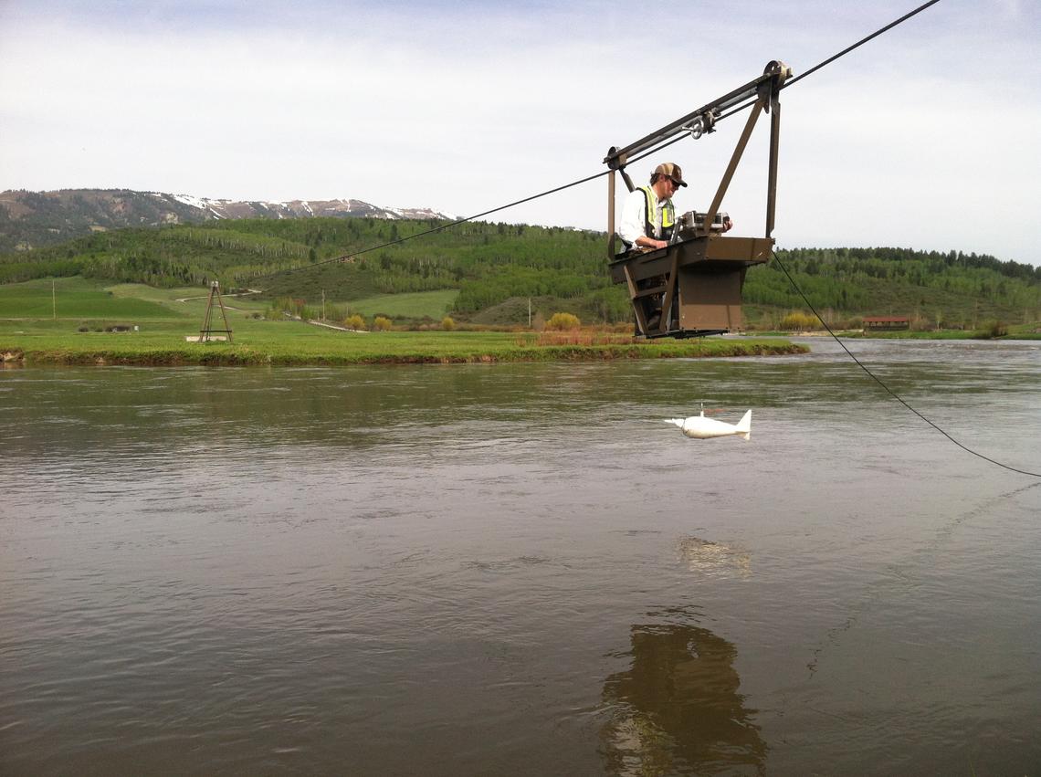
Water-quality sampling from Salt River cableway, Etna, Wyoming. Credit: Cheryl Eddy Miller, USGS
Click the link to read the article on the USGS website (Water Science School):
Checking the water quality of the Nation’s streams, rivers, and lakes is one of the main responsibilities of the U.S. Geological Survey (USGS). Physical water measurements and streamflow are almost always taken, but often water samples are needed for chemical analyses, and sampling must follow strict guidelines to collect scientifically-viable samples.
Water Quality Sampling Techniques
Checking the water quality of the Nation’s streams, rivers, and lakes is one of the main responsibilities of the U.S. Geological Survey (USGS). Physical water measurements and streamflow are almost always taken, but often water samples are needed for chemical analyses. Generally, it is imperative that water samples be representative of the whole stream, and so, sampling a stream means more than just dipping a coffee cup in at the stream bank and sending it to the laboratory. The USGS uses strict scientific methodology in taking samples of any water body.
USGS scientists collect water samples for chemical analysis from an excavated pond in the New Jersey Pinelands. Credit: Kelly Smalling, USGS
Sampling methodology depends on stream size
The USGS has to utilize different methods and equipment when taking a sample of water from a stream—it all depends on the size of the stream, how deep the water is, and how fast the water is moving. Also, I should add, on the ability of the water scientist to be able to access the water. As the left-side pictures below show, often a hydrologist can simply step out into a small stream and dip a bottle in at the appropriate place, but on larger rivers, it might be necessary to build a cableway and take water samples from high above the water surface. Sampling methodology also depends on the type of water sample needed.
Sampling a small stream
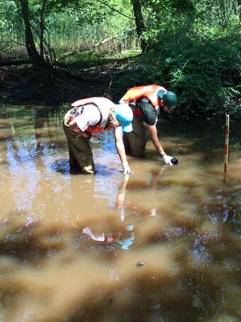
For a small stream where the water is well mixed, it is sometimes possible to take a single “grab sample”, where the hydrologist just dips a bottle in the stream at one location, still trying to move the bottle up and down to sample the entire vertical column of water. Note how the sampler always stands downstream from the sampling point—don’t want to stir up any sediment that could alter the chemical analysis of the water sample.
Quite often it is important to take a water sample that represents the stream as a whole. That entails taking small amounts of water from numerous horizontal sections across the stream, at regular intervals, as the middle picture shows. There is a bottle inside the white container at the end of the pole (bottom picture). The bottle has a small tube in it that allows only a small amount of flow into the bottle, and thus, the hydrologist can regulate how much water is sampled at various points in the stream. She can sample different horizontal sections separately by using a different bottle for each vertical section or use a single bottle for the whole stream.
Sediment sampling and surrogates. Sediment work using samplers, laser diffraction, and acoustics on the Kickapoo Creek near Bloomington, Illinois, on April 22, 2011. Credit: Tim Straub, USGS
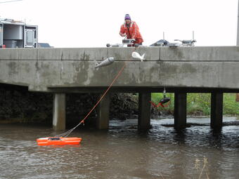
Sampling a larger river
It takes a lot more work to get a water sample from a larger river, as this picture shows. In larger rivers, there is more chance of variability in the water characteristics and quality across the river. There may be a tributary coming in from the left side above the sampling point or there may a wastewater treatment outflow pipe a mile upstream on the right bank.
It takes longer for all the water in large rivers to mix together. So, to understand the water properties of the whole river it is necessary to obtain individual samples at set increments across the river. Bridges make this task very convenient, although samples can be taken using a boat, if no bridge is available.
If the water is moving fast or if the depth is too deep, then a crane with an electric motor (or hand crank for especially hardy hydrologists) is used to obtain the water sample (above picture). The heavy metal “fish” which holds the sampling bottle is needed to keep the sampler from being pushed downstream, as it is important to representatively sample the vertical column of water at each sampling point across the river. The hydrologist has to move the sampler up and down at a steady rate until the bottle is filled, while at the same time being sure not to smash the nozzle into the mud on the stream bed!
Sometimes only a cableway will do
USGS hydrologists can’t always count on a nice, wide bridge being available for hydrologists to sample from, and sometimes it is too dangerous (due to high flows or floating debris) to use a boat for sampling. In these cases, a cable can be strung across the river, from which a hydrologist can move across and sample and measure the river as needed.