In response to the forecast for low flows on the San Juan River, the Bureau of Reclamation has scheduled an increase in the release from Navajo Dam from 350 cubic feet per second (cfs) to 450 cfs for August 12th at 4:00 AM.
Releases are made for the authorized purposes of the Navajo Unit, and to attempt to maintain a target base flow through the endangered fish critical habitat reach of the San Juan River (Farmington to Lake Powell). The San Juan River Basin Recovery Implementation Program recommends a target base flow of between 500 cfs and 1,000 cfs through the critical habitat area. The target base flow is calculated as the weekly average of gaged flows throughout the critical habitat area from Farmington to Lake Powell.
Precipitation varied widely across the Lower 48 this week. Across the interior West, heavy monsoon rains set records in some locales, with tropical moisture streaming much farther north and west than normal (through southern Montana, the Great Basin, and parts of the Sonoran Desert). Death Valley, CA set an all-time record for 24-hour rainfall, being doused with 1.46 inches during August 5 and 6. The average annual rainfall in Death Valley is less than 2.5 inches, and the 24-hour total makes August 2022 the wettest month in Death Valley since February 2010, and more than half of all calendar years bring less rain than that 24-hour total.
Farther east, many areas from the Mississippi River eastward through the Piedmont and Middle Atlantic States recorded moderate to heavy precipitation. Most areas from southern Missouri and northeastern Arkansas through central Illinois recorded over 1.5 inches of rain, as did parts of the Tennessee and southern Ohio Valleys, the Upper Midwest and western Great Lakes Region, the Central Gulf Coast, and northern Maine. In other areas from the Mississippi Valley eastward, heavy rain was less widespread. Still, numerous patches of land across the Upper Midwest, the middle Mississippi Valley, the Ohio Valley, and the Gulf Coast east of Texas received over 3.5 inches of rain, with isolated totals of 6 to locally 11 inches reported in a swath from the middle Mississippi and lower Ohio Valleys northward through the Upper Midwest and western Great Lakes Region. In contrast, many areas across these regions recorded only a few tenths of an inch of rain or less, with tight gradients between heavy rain and lesser amounts common. This variable rainfall pattern had a similar effect on areas of dryness and drought, with deterioration noted very close to improvement in many cases, and only a few broad swaths with a consistent pattern. Looking at the western half of the Lower 48, outside the areas affected by the monsoon, much drier conditions prevailed, though there were a few small areas recording moderate to heavy rainfall. Little or no rain fell on the central and southern Great Plains, much of the central Rockies, and the Far West. Temperatures averaged over 3 deg. F above normal in a large area across the central Rockies, most of the Plains, and the northeastern quarter of the country, exacerbating dryness in areas that missed the heavier rains…
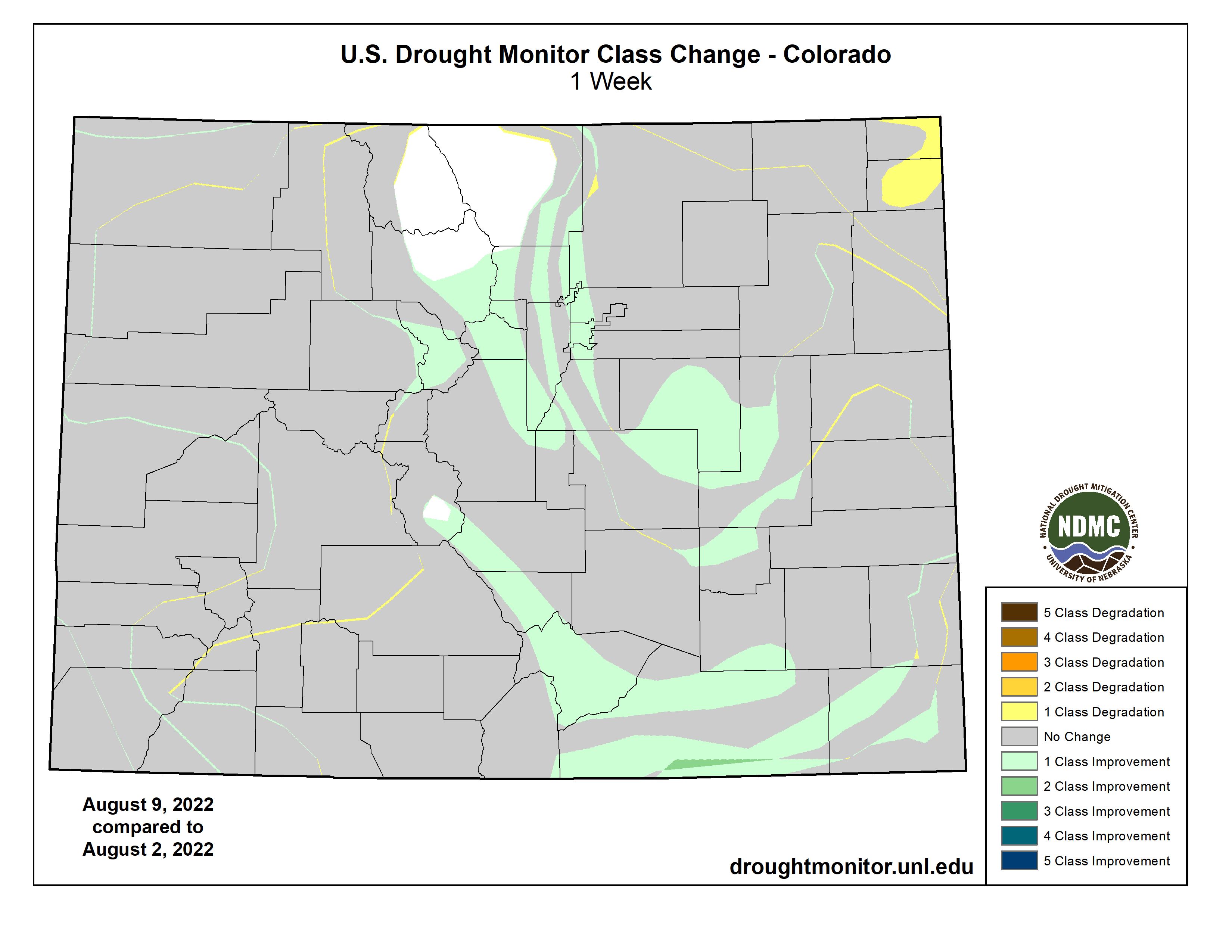
Most of the Great Plains recorded only a few tenths of an inch of rain at best last week, as did most of North Dakota. Rainfall was more abundant in central and southern Colorado, and in a swath across much of Wyoming and South Dakota. Totals of 0.5 to 2.0 inches were common in these areas, with isolated higher amounts of 2 to 5 inches soaking northwestern Wyoming, scattered areas in central and southern Colorado, and portions of central and eastern South Dakota. Fairly large areas of heavy rain were noted in south-central and parts of eastern South Dakota. Not surprisingly, parts of the wetter areas saw dryness ease somewhat while hot and dry conditions from eastern Wyoming and Nebraska southward promoted large areas of expansion and intensification there. In the last 60 days, much of this area received 35 to 65 percent of normal rainfall, but most locations recorded more. Periods of excessive heat have exacerbated the effects of the subnormal precipitation, and even some areas with near normal rainfall have seen conditions dry out due to the heat. Surface moisture shortages are now most acute in western Kansas and southwestern Nebraska, and a sizeable part of this area is in exceptional drought (D4), with the remainder in D3 along with northeastern Colorado, southeastern Kansas, northwestern Nebraska, and a newly-developed area in central South Dakota. Only the central and northern Dakotas, northeastern Kansas and adjacent areas, portions of the Colorado mountains, and part of central and northern Wyoming are largely devoid of drought, though abnormal dryness has been identified in some of those areas…
Colorado Drought Monitor one week change map ending August 9, 2022.
The North American Monsoon remained robust in early August. This is continuing to bring slow relief to a region long affected by entrenched drought. Tropical moisture from the monsoon circulation reached unusually far west this past week, into the southern Great Basin and southeastern California. As a result, exceptional amounts of rain fell on the southern half of Nevada and southeastern California, resulting in a very broad area of 1-category improvement. The record rains in Death Valley brought severe flash flooding that closed about 85 miles of road for several days, making many spots in the Valley unreachable. Farther east, rainfall was less remarkable, but still above normal, improving conditions across parts of New Mexico, southeastern Arizona, and parts of the southeastern quarter of Utah. Most locales in Arizona, New Mexico, the California deserts, southern Nevada, and a few other scattered areas have measured at least 200 percent of normal over the past 2 months. Portions of southeastern California, the Sonoran Desert, southwestern and northeastern Arizona, and a large area in northwestern New Mexico have been doused by 3 to 5 times normal rainfall. Farther north, central sections of Washington and Oregon also saw dryness and drought ease a little bit. The only area currently headed in the opposite direction is central and northern Montana. They are considerably wetter than normal for the past 60 days as a whole, but conditions have been changing rapidly since then. Rainfall has become scarce and temperatures have averaged well above normal. All this resulted in a significant expansion of D0 and D1 conditions into eastern and central Montana, although little change was noted in the areas already entrenched in severe to extreme drought…
The eastern and western portions of this Region are trending in very different directions. Abundant rains have been falling on much of Tennessee, Arkansas, western Mississippi, most of Louisiana, and adjacent areas, where many areas of dryness and drought are improving. Over most of Oklahoma and Texas, however, rainfall has been scare of late, and with periods of excessive heat also affecting these areas, dryness is intensifying. In the last 2 weeks, over 3 inches of rain fell on most of Tennessee, northern Arkansas, and southern Louisiana. A few areas received over 4.5 inches of rain, with totals topping out at nearly a foot at one spot in northeastern Arkansas. Farther west, the have nots from central Oklahoma southward through most of Texas saw only several tenths of an inch, at best. From south of the Red River Valley through most of Texas to the Deep South regions, few areas saw any measurable rainfall. Conditions are not as dry in the Texas Panhandle, where enough rain fell (generally 2 to locally 5 inches) to provide some tangible relief from the recent dryness. Moisture shortages date back at least 6 months over most of Texas south of the Panhandle and north of Deep South Texas, extending across the entire breadth of the state. During the last 90 days, less than half of normal rainfall has been observed in most of these areas, with a few scattered patches getting less than 25 percent of normal. This equates to 3-month rainfall deficits of 5.5 inches or higher across most of central and eastern Texas, with parts of northeastern and southeastern Texas accumulating rainfall deficits of 7 to 10 inches. And for the last half-year, much of central and southeastern Texas racked up deficits of 11 to 16 inches. Not surprisingly, drought intensified or at best persisted across the south half of Oklahoma and most of Texas, most of the state is in extreme (D3) drought, with large swaths of D4 covering a good portion of the state from the Red River to Deep South Texas…
Looking Ahead
Above-normal temperatures – with the potential for excessive heat – should cover the central Plains, northern half of the Rockies, the Intermountain West (except where the monsoon is active), and the Pacific Northwest during August 11-15, 2022. The largest departures from normal are expected in the central Plains, the northern Rockies, and part of the northern Intermountain West averaging 4 to 8 deg. F above normal. In the western U.S., the only area expected to be somewhat cooler than normal are in the southern Rockies, Southwest, and Great Basin, where the robust monsoon will continue, keeping temperatures down. It should also be somewhat cooler than normal from the Mississippi River to the Appalachians, possibly spilling over into parts of the Atlantic Coastal Plain.
Most of the Lower 48 should be drier than normal, with several tenths of an inch falling at best. But there are significant exceptions; A very robust Southwestern Monsoon should be in place through the period, bringing moderate to heavy rain to the Southwest, The eastern Great Basin, the western half of Colorado, and most of Wyoming. Portions of central Arizona, southwestern Utah, and northern Wyoming are forecast to receive 1.5 to 3.0 inches of rain, with locally higher amounts. The only other extensive areas where more than 0.5 inch is expected are south-central through southeastern Texas, the immediate South Atlantic Coast, and most of the Gulf Coast. But only east-central Texas should record over 1.5 inches of rain, except along parts of the immediate Gulf Coast. Little or no precipitation is anticipated along the western tier of the Lower 48, across a large part of the central Plains, and through much of the Upper Midwest north of the Ohio River. Little or no precipitation is also expected in southern New England. .
The Climate Prediction Center’s 6-10 day outlook (valid August 16-20, 2022) favors above-normal temperatures across a large part of the Lower 48 from the Great Basin and Southwest eastward through the lower Mississippi Valley, through almost all of the Appalachians and Eastern Seaboard. But wet weather is only weakly favored from the lower Mississippi River to the southern Atlantic States and across the Appalachians. Odds favor subnormal precipitation around the Great Lakes and across the northern tier of the Lower 48 from western North Dakota to the Pacific Coast.
Odds significantly favor below-normal temperatures across the Ohio Valley and central Appalachians, with somewhat lower odds from the Upper Southeast northward through the middle Mississippi Valley, Great Lakes Region, Northeast, and southwestern New England. Farther west, slightly enhanced chances for milder than normal temperatures extend across the central Plains and the central and southern Rockies. Meanwhile, there is a large tilt of the odds toward warmer than normal temperatures – with the potential for excessive heat – from central California, the northwestern Great Basin, and the northern Intermountain West to the Pacific Coast and the Canadian border. The chances for warmer than normal weather exceed 80 percent across interior sections of Washington and Oregon, and adjacent Idaho. Enhanced chances for warmth are less dramatic through the rest of California, the Great Basin, and the northern tiers of the Rockies and Plains. There are also slightly enhanced chances for warmer than normal weather extend across most of Texas, the lower Mississippi Valley, the immediate Gulf Coast, and Florida.
US Drought Monitor one week change map ending August 9, 2022.
Click the link to read the article on the Denver Water website (Cathy Proctor and Jay Adams):
Protecting people from hazards that can lurk in their drinking water is the day-in, day-out job for water industry engineers, utilities and regulators.
And at Denver Water, efforts to protect people from the health risks posed by lead from old, lead service lines getting into drinking water, has been part of the job for decades.
There is no lead in the water Denver Water delivers to customers, but the utility regularly tests for lead in the drinking water of homes that are known to have lead water service lines, the primary source of lead in drinking water.
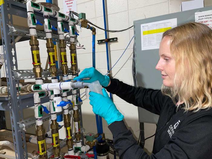
Rachel Himyak, water treatment lead, collects a sample of water that’s been run through old lead service lines as part of ongoing studies at Denver Water of pH adjustment. Photo credit: Denver Water.
In the first half of the 20th century, lead was a common, cheap and easy-to-work-with material to use when forming small pipelines that carry drinking water from utility pipelines in the street into customers’ homes. But these old lead service lines, which in Denver Water’s experience are more often found in homes built before 1951, pose a threat in the community, particularly to children, infants and pregnant women.
Denver Water has tested for lead in customers’ drinking water for decades under the Environmental Protection Agency’s Lead and Copper Rule. In 2012, the routine monitoring indicated the utility needed to investigate whether it could adjust the chemistry of the water it delivered to customers to better protect them from the risk of lead getting into drinking water.
Read this 2019 story to learn about Denver Water’s efforts over the years to combat lead in drinking water, which culminated in the 2020 launch of its groundbreaking Lead Reduction Program.
In short, the results of tests on customers’ drinking water launched Denver Water into years of study centered on one question: What more could it do to better protect at-risk customers?
The first step was more testing.
“For a utility of our size and the number of lead service lines we have, you can’t just test something by putting it into the distribution system that’s delivering water to 1.5 million people every day. That’s not acceptable to us,” said Ryan Walsh, manager of the water treatment engineering section at Denver Water.
“We had to test things at a pilot scale, by doing the pipe loop study, before we could move forward.”
Walsh’s team was in charge of testing various treatment options via the pipe loop study and later planned, designed and executed the treatment plant systems involved in increasing the pH level.
Denver Water crews dug up old lead service lines from customers’ homes for years of study that led to the utility’s Lead Reduction Program. Photo credit: Denver Water.
To build the pipe loop study, Denver Water used old lead service lines its crews removed from customers’ homes (replacing them with lead-free lines) as the crews found the old lines during their regular work on water mains across the utility’s service area.
Denver Water plumbers connected the decades-old pipes together on racks and its treatment engineers ran water through them for hours, days and years. They tested different treatment methods to find out which worked best to reduce the risk of lead from the old pipes getting into the water passing through them.
Watch this video to see Denver Water’s pipe loop study, which is still underway today.
“That testing was so critical because we used the water that had been treated by our treatment plants, Moffat and Marston, the water that was going into our system to customers. The pipe loop study allowed us to test the adjustments we might do to the water to keep people safe,” said Patty Brubaker, a water treatment plant manager.
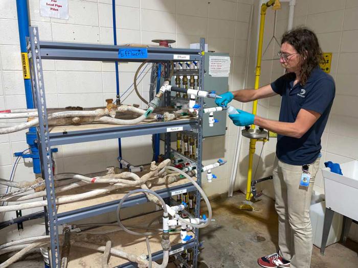
Aaron Benko, water treatment lead, pulls a sample of water from the rack of old customer-owned lead service lines that Denver Water crews dug up from customers’ homes and researchers continue to study. Photo credit: Denver Water.
“We tried different pH levels, we tried different phosphate levels, and we tried all of them on the actual lead pipes that had been taken from our system,” Brubaker said.
“There were so many people involved in putting this together. We had the crews who went out and pulled those lines, the plumbers that put them together on the racks, the people who made the adjustments and tested the water as it ran through the pipes.
All of us were studying the impacts to figure out which would be the best method to use to protect our customers from those old lead pipes.”
Decision time
In March 2018, based on Denver Water’s studies, state health officials told Denver Water it had two years — until March 2020 — to get ready to start using a food additive called orthophosphate to tamp down the potential for lead to get into customers’ drinking water.
The decision worried many people inside and outside of Denver Water.
The concern wasn’t whether orthophosphate would reduce the potential for lead to get into drinking water. They knew it would.
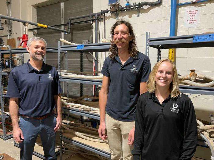
Denver Water treatment engineers and operators (from left) Ryan Walsh, Aaron Benko, and Rachel Himyak at the pipe loop rack, which continues to have water running through the old lead service lines for ongoing studies. Photo credit: Denver Water.
Denver Water’s years of tests on the old pipes had shown orthophosphate would work, and other water utilities use orthophosphate to reduce the risk of lead getting into their drinking water.
But Denver Water, environmental groups and other water and wastewater utilities downstream of Colorado’s capital city worried about the widespread, long term — and expensive — consequences of adding orthophosphate to such a large system, including the increased potential for environmental impacts in and downstream of the Denver metro area.
Nicole Poncelet-Johnson, director of Denver Water’s water quality and treatment section, had been hired at the utility few months before the state’s 2018 decision on orthophosphate. From previous jobs involving water and wastewater treatment plants, she’d seen what orthophosphate could do at the plants and in the environment.
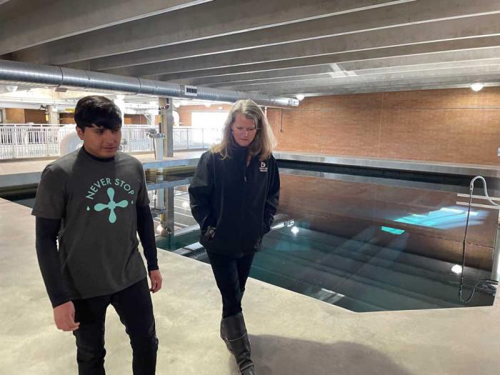
Hector Castaneda, a water treatment technician, and Nicole Poncelet-Johnson, director of Denver Water’s water quality and treatment section, at the Marston Treatment Plant filter beds, where water is filtered through tiny pieces of sand and anthracite coal as part of the treatment process. Photo credit: Denver Water.
“I’d seen the algae, which can grow faster when there are higher levels of phosphate in the water. I’d seen it coating the valves coming into the treatment plant so we couldn’t bring water in. I’ve seen how the taste and odor problems with the water were so bad that people bought and used bottled water instead of tap water,” Poncelet-Johnson said.
“And in Colorado’s dry, arid environment, with our long, sunny days and the UV light, adding orthophosphate to our system would have created a primordial soup. Plus, after the expense of adding it to the water at the drinking water treatment plant, it’s hard, expensively hard, to get phosphorous out of the water when it arrives at the downstream wastewater plants,” she said.
About half of Denver Water’s residential water use is outdoor water use used on lawns and gardens. Photo credit: Denver Water.
On top of the expensive work that would be required at wastewater treatment plants, there simply was no way to recapture all the orthophosphate that would be added to Denver’s drinking water due to the way water is used in the metro area, she said.
About half of Denver Water’s residential water use is outdoor water use, tied to the irrigation of lawns and gardens. That means some of the orthophosphate-treated drinking water was bound to run off of lawns, down the gutter and end up in the metro area’s urban creeks, streams and rivers.
Water used for irrigation of lawns and gardens often ends up in urban creeks and streams that flow throughout the Denver metro area. Photo credit: Denver Water.
The groups worried that under the right conditions, that additional phosphate could accelerate the growth of algae not only downstream of the city, but also in the metro area’s urban creeks, streams and reservoirs.
There had to be another way, they said.
Alternative path
“We went back to the data from the years of tests we’d run. We saw that if we raised the pH level of the water, instead of adding orthophosphate, we could protect people from the lead service lines,” Poncelet-Johnson said.
“And if we combined a higher pH with replacing those lead service lines with new, lead-free copper lines, then the lead levels would drop to the point where the tests couldn’t detect anything.”
In 2019, Denver Water formally proposed an alternative approach to state and federal regulators.
Denver Water’s proposal, at its core, called for raising the pH of the water delivered to customers from 7.8 to 8.8 on the pH scale, and keeping it there with relatively little variance as it flowed from the treatment plant to the customers’ homes and businesses.
Raising the pH of the water delivered to customers strengthens an existing protective coating inside lead service lines, which reduces the risk of lead getting into drinking water. Image credit: Denver Water.
The higher pH level would strengthen an existing protective coating inside the lead service lines, reducing the risk of lead getting into the drinking water as it passed through the lead pipes.
And that — combined with significantly accelerating the replacement of the old lead services lines — would 1) lower the risk faster than relying on orthophosphate alone, and 2) do so without the cost and environmental concerns posed by adding the phosphate.
This graphic (not to scale) portrays how a higher pH level creates a stronger protective coating (shown in white and brown on the left) inside a lead service line (shown in grey), separating the water (blue) from the lead pipe and reducing the risk of lead getting into the drinking water. Image credit: Denver Water.
“It was a better solution, a permanent solution to the problem of old lead service lines, which are the primary source of lead in drinking water,” Poncelet-Johnson said.
“Because instead of a Band-Aid approach, instead of just adding chemicals to the system and then dealing with the widespread economic and environmental consequences of that decision for decades, we went the other way and proposed permanently removing the problem by raising the pH of the water and replacing the lead service lines,” she said.
Listen to Nicole Poncelet-Johnson, director of Denver Water’s water quality and treatment section, discuss Denver Water’s Lead Reduction Program:
Denver Water’s alternative proposal focused on five areas:
Raising the pH of the water it delivers to 1.5 million people to 8.8, and keep it fairly constant, with very little variance, as the water flowed from treatment plant, through the distribution system, to customers’ homes and businesses.
Mapping the location of the customer-owned lead service lines in its service area and sharing that map with customers.
Replacing the estimated 64,000 to 84,000 customer-owned lead service lines in its service area with new lead-free copper lines at no direct cost to the customer.
Providing customers enrolled in the program with water pitchers and filters certified to remove lead to use until six months after their lead line was replaced.
Launching the largest public health communication effort Denver Water had ever done to educate its customers about the risks of lead, the importance of using filtered water until the old lead service lines could be replaced, and the process for replacing those lead pipes.
Watch this video to learn more about lead service lines.
Breaking new ground
The proposal broke new ground in the water industry in two main ways.
It attacked the legacy issue posed old lead service lines from all sides — by raising the pH level, replacing customers’ old lead service lines, providing water filters to customers enrolled in the program to use until six months after their line was replaced, and educating those customers about the program.
And Denver Water said it would tackle all those steps on a scale and at a speed never before seen in the water industry.
Communicating with customers enrolled in the Lead Reduction Program is one of five elements of the biggest public health initiative in Denver Water’s history. Image credit: Denver Water.
Other cities had aimed to replace a few thousand lead service lines.
But Denver Water proposed replacing up to 84,000 customer-owned lead service lines estimated to be in Denver Water’s service area, doing it at no direct cost to the customer, and doing it in 15 years.
And, the utility proposed sending water pitchers and filters to more than 100,000 households enrolled in the program to use for cooking, drinking and preparing infant formula until six months after their lead line was replaced.
More than 100,000 households enrolled in the Lead Reduction Program were supplied with water pitchers and filters certified to remove lead to use for cooking, drinking and preparing infant formula until six months after their lead line is replaced. Photo credit: Denver Water.
In December 2019, health officials at the EPA and the Colorado Department of Public Health and Environment agreed to Denver Water’s alternative proposal.
Weeks later, in January 2020, Denver Water launched its Lead Reduction Program — and immediately faced a crucial deadline.
The utility’s engineers, treatment plant operators and monitoring teams now had to implement the systems and processes that would raise the pH level of the water and maintain that level as the water flowed across more than 3,000 miles of pipe to 1.5 million people. And they had less than 90 days to do it.
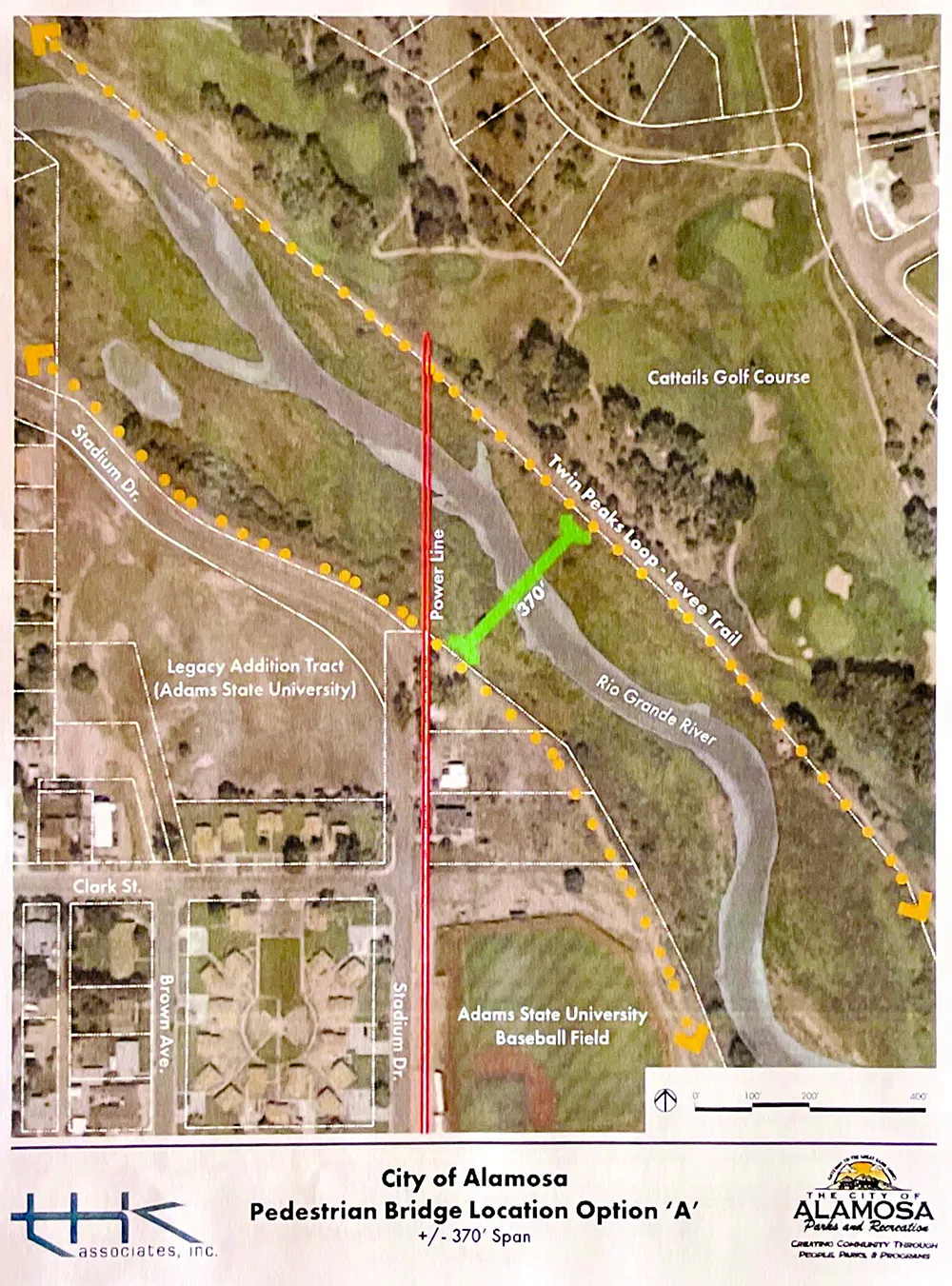
OU’RE walking along the Rio Grande trail at Cattails Golf Course and you see the campus of Adams State across the way but can’t get to the other side. Patience, dear trail user. A crossing is on the way.
The city of Alamosa is moving forward with plans for a pedestrian bridge crossing at Stadium Drive behind the Adams State ballfields that will connect the west levee to the east levee at Cattails Golf Course.
The city has applied for a grant through the U.S. Department of Transportation’s Rebuilding American Infrastructure with Sustainability and Equity grant program to help fund the $4.1 million project. Other funding coming into the project is $220,000 from local contributors to cover design and permitting; SLV GO! kicked in $100,000 from private donors; the city of Alamosa $50,000; SLV Health $25,000; and Alamosa County $40,000.
Green bar shows location of proposed pedestrian bridge. Read the report HERE.
This is a long-dreamt-of project, one that would no doubt change the way locals recreate. It would, with a seamless stitch, connect the most residential parts of Alamosa with the other side of the river, cutting down travel times and encouraging walking, running, and biking over driving.
Increased visits to Blanca Vista Park, the city’s Disc Golf Course and nearby trailheads are among the benefits, according to project consultant THK Associates. In addition, the pedestrian bridge would allow people to avoid the heavier traffic of the Highway 160 bridgeand the State Avenue bridge, giving a more direct route for runners like those from Adams State.
“The bridge will reduce vehicular traffic and result in reduced carbon emissions, potential traffic accidents, injuries, and deaths,” THK Associates said in its report. It added the State Avenue bridge was deemed a “High Conflict Area” and that runners, dog-walkers, and families with small kids could avoid potential danger with the new bridge.
Bridge on the river grand
THK presented three different bridge designs and locations, along with the costs. Of the three designs, the city chose to go with a more cost-effective, shorter bridge that will span just 370 feet at one of the river’s narrowest points. This particular design cuts down on the total overall cost, and also the impact to the river beneath it. The design proved to be the most direct line of access. To have this point of access, the city will have to purchase two properties on the west levee. As THK writes in its memo, “….the acquisition of additional land at this time is beneficial to allow for expanded parking, staging and access, and other possible benefits.”
Southwest River Engineers designed the bridge type and outlined where it would be and what it could look like. It’s a tied arch free span design that will have only two concrete supports placed on each side of the river bed. Each will impact 100 square feet of area once competed.
The earliest construction would begin is 2023, once funding is secured. An extensive design and permitting process is required before ground can be broken. A part of that permitting process is purchasing the two properties that border the west levee. After everything is moved along, permits are permitted and the Army Corps of Engineers is satisfied, construction could be completed by February 2024.
“With RAISE grant monies, the City will provide a safe corridor for pedestrians and cyclists separate from motorized traffic and improve economic competitiveness and resilience by supporting a growing outdoor recreation economy,” U.S. Sen. Michael Bennet wrote in a letter of support to U.S. Secretary of Transportation Pete Buttigieg.
Keith Baker and Vern Heersink from the San Luis Valley Transportation Planning Region wrote in their letter of support, “The City of Alamosa and Alamosa County for decades have been in need of and in pursuit of a pedestrian bridge to cross the Rio Grande near Adams State University’s campus…. Multimodal projects such as this have become increasingly important to communities within the region as they develop new initiatives to improve pedestrian and bicycle routes to recreational opportunities and commercial centers.”
“The Rio Grande Intermodal Transportation Project builds on years of community planning with diverse stakeholders to develop the infrastructure needed to connect the public to multi-use trails along the river corridor,” said Emma Ressor, executive director for the Rio Grande Headwaters Restoration Project in her letter of support. “This will increase sustainability and pedestrian accessibility, while creating space for the community to enjoy the Rio Grande and surrounding wildlife habitat.”
Widespread support for the project may help with grant selection. For small Alamosa, a bridge like this is apt to dissipate fear of traffic bridges, create an easier avenue to enjoy the nature and the sky, and ultimately increase the value of the town. The economic benefits from this are outstanding, yes, but the recreation opportunities are tenfold more.
Doing the math
Perhaps one of the most desired benefits of this project is the slashing of travel times.
Among the information studied by the city are two tables that show current travel times and estimated travel times after construction. The tables break down distance from Adams State, and travel times for driving, walking, and cycling to the North River Pavilion Trailhead, the Disc Golf Course, Blanca Vista Park, and the State Avenue Trailhead and Boatramp.
Say you start at Adams State University and want to catch up with some friends at the Disc Golf Course. You’re again limited to two ways to get there, but the obvious choice would be to take State Avenue. Let’s say you’re on your bike. The distance is 3.3 miles and if you’re enjoying a leisure ride, that would take you roughly 20 minutes.
With the new connecting bridge, the distance is cut by 2.5 miles and it would take you a mere 5 minutes to get there.
Now, of course, travel by car won’t change much if you want to park at the specific locations.
The flip side of this travel and distance also makes its case for anyone traveling from the east and north sides of town – the county side. Anyone can drive to these places and instead of taking the car downtown, they can take their own two feet. It encourages different means of travel for everyone.
It encourages taking the scenic route.
And for a community that relishes its outdoors, this bridge is a step toward making Alamosa’s wide open spaces and endless sky even more accessible and enjoyable.
Click on the link to read the article on the Guardian website (Oliver Milman). Here’s an excerpt:
Trees are advancing into the Arctic tundra and retreating from boreal forests further south, where stunting and die-offs are expected
Forests from the Arctic to the Amazon are transforming at a “shocking” rate due to the climate crisis, with trees advancing into previously barren tundra in the north while dying off from escalating heat farther south, scientists have found. Global heating, along with changes in soils, wind and available nutrients, is rapidly changing the composition of forests, making them far less resilient and prone to diseases, according to a series of studies that have analyzed the health of trees in north and South America. Many areas of forest are now becoming more susceptible to ferocious wildfires, causing the release of further greenhouse gases from these vast carbon stores that heat the planet even more. “It’s like humans have lit a match and we are now seeing the result of that,” said Roman Dial, a biologist at Alaska Pacific University.
Dial and his colleagues have discovered that a patch of white spruce trees in north-west Alaska have “hopped” north into an area of the Arctic tundra that hasn’t had such trees in millennia. The scientists’ new research paper, published in Nature, estimates the spruce are advancing north at a rate of around 4km a decade, aided by warming temperatures and changes to snow and wind patterns influenced by the shrinkage of sea ice in the region.
“It was shocking to see trees there. No one knew about them but they were young and growing fast,” said Dial, who first spotted the shadows of the trees on satellite imagery and then took a single-engine plane journey, followed by a five-day hike, to find and study the advancing forest.
“The trees basically hopped over the mountains into the tundra. Going by climate models, this wasn’t supposed to happen for a hundred years or more. And yet it’s happening now.”
[…]
Farther south, separate research has found a transformation is under way at the boundary between the boreal and temperate forests, with species of spruce and fir increasingly unable to cope with the hotter conditions. Scientists estimate that even small amounts of further heating, caused by human activity, could cause up to a 50% die-off of traditional boreal forest trees in certain places, with many other trees becoming stunted in their growth.
“Boreal species do very poorly even with modest warming. They grow more slowly and have greater mortality,” said Peter Reich, a researcher at the University of Minnesota who co-authored the research. “Intuitively, I thought they would do slightly worse with 1.5C of warming, but they do much worse, which is worrisome.”
[…]
The impact of the climate crisis is also being felt in the heart of the Amazon, a further study has underlined. Scientists have raised concerns that the huge rainforest ecosystem is in danger of tipping into a new, altered state, eventually becoming a savannah, and the new research found that a lack of phosphorus in the Amazon’s soils could have “major implications” for its resilience to global heating.
Fourteen years after Colorado adopted standards to restore Grand Lake, the state’s largest natural water body once known for its astonishing clarity and high water quality continues to deteriorate.
Frustrated and worried about the future, Grand Lake locals are asking the state to intervene to break through a log jam of federal and environmental red tape that has prevented finding a way to restore the lake’s clarity and water quality, despite a 90-year-old federal rule known as Senate Bill 80 requiring that the work be done.
At issue: Grand Lake serves as a key element of Northern Water’s delivery system, which provides water to more than 1 million people on the northern Front Range and thousands of acres of irrigated farmlands.
Owned by the U.S. Bureau of Reclamation and operated by Northern Water, what’s known as the Colorado-Big Thompson Project gathers water from streams and rivers in Rocky Mountain National Park and Grand County, and stores it in man-made Lake Granby and Shadow Mountain Reservoir. From there it is eventually moved into Grand Lake and delivered via the Adams Tunnel under the Continental Divide to Carter Lake and Horsetooth Reservoir, just west of Berthoud and Fort Collins respectively.
During that process, algae, certain toxins and sediment are carried into Grand Lake, clouding its formerly clear waters and causing algae blooms and weed growth, and harming recreation.
Map of the Colorado-Big Thompson Project via Northern Water
In a hearing before the Colorado Legislature’s Interim Water Resources and Agriculture Review Committee on Aug. 4, Mike Cassio, who represents the Three Lakes Watershed Association in Grand County, pleaded with state lawmakers to intervene and launch a study process that would help trigger federal action.
by Jerd Smith | Aug 10, 2022 | Climate and Drought, Colorado River, Environment, Infrastructure, Recreation, Restoration, Water Legislation, Water Quality |
Tourist haven Grand Lake asks state to intervene in federal water quality stalemate
A woman paddles on Shadow Mountain Reservoir, which is caught in federal stalemate over how to improve water quality to help improve its neighboring Grand Lake. Credit: Daily Camera
Fourteen years after Colorado adopted standards to restore Grand Lake, the state’s largest natural water body once known for its astonishing clarity and high water quality continues to deteriorate.
Frustrated and worried about the future, Grand Lake locals are asking the state to intervene to break through a log jam of federal and environmental red tape that has prevented finding a way to restore the lake’s clarity and water quality, despite a 90-year-old federal rule known as Senate Bill 80 requiring that the work be done.
At issue: Grand Lake serves as a key element of Northern Water’s delivery system, which provides water to more than 1 million people on the northern Front Range and thousands of acres of irrigated farmlands.
Owned by the U.S. Bureau of Reclamation and operated by Northern Water, what’s known as the Colorado-Big Thompson Project gathers water from streams and rivers in Rocky Mountain National Park and Grand County, and stores it in man-made Lake Granby and Shadow Mountain Reservoir. From there it is eventually moved into Grand Lake and delivered via the Adams Tunnel under the Continental Divide to Carter Lake and Horsetooth Reservoir, just west of Berthoud and Fort Collins respectively.
During that process, algae, certain toxins and sediment are carried into Grand Lake, clouding its formerly clear waters and causing algae blooms and weed growth, and harming recreation.
In a hearing before the Colorado Legislature’s Interim Water Resources and Agriculture Review Committee on Aug. 4, Mike Cassio, who represents the Three Lakes Watershed Association in Grand County, pleaded with state lawmakers to intervene and launch a study process that would help trigger federal action.
“We have the highest respect for all of our partners,” Cassio said, referring to ongoing remediation efforts involving Northern Water and the U.S. Bureau of Reclamation.
“But due to the design of the system, you have this beautiful natural lake and then you fill it up with reservoir water. Usually, in July when spring runoff is going on, Grand Lake is flowing from east to west. It is extremely clear. But as soon as Shadow Mountain’s water sits and starts to cook and grow weeds and algae, and the pumps come on, this massive plume of nitrates, inorganics, just basic muddy water flows into Grand Lake,” Cassio said.
In 2008, the Colorado Water Quality Control Commission moved to set a clarity standard, but it has since been replaced with a clarity goal and the aim of achieving “the highest level of clarity attainable.” Instead of working under a regulated water quality standard, Northern Water and others have implemented different management techniques, including changing pumping patterns, to find ways to improve water quality in all three water bodies.
In 2016, the U.S. Bureau of Reclamation took the first steps required under the National Environmental Policy Act of 1969 (NEPA) to do the scientific and engineering studies and public hearings that would be required to fix the system. But Reclamation stopped the process in 2020, saying that it could not definitively establish any structural alternatives that would work, nor could it find a way forward on funding what could be a project that would cost hundreds of millions of dollars, according to Jeff Rieker, general manager of Reclamation’s Colorado Eastern Plains office.
During last week’s hearing, lawmakers said they want more information and that Northern Water’s system is too critical to the northern Front Range to do anything without careful consideration.
“We are in a moment of time like none other,” said State Rep. Hugh McKean, a Republican who represents Loveland and other northern Front Range communities. He cited the warming climate and the effects of the massive East Troublesome fire in 2020, which engulfed lands around the three lakes and created additional water quality problems, which still impact the watershed today.
“Is this the moment to create a long-term plan, when right now our water situation is in flux? I’m resistant to say let’s stop everything and study this,” McKean said.
But Grand Lake Mayor Steve Kudron disagreed.
“This is exactly the right time,” Kudron said. “Tourism impacts my community more than almost any other community in the state. One million people visited [Fort Collins’] Horsetooth Reservoir last year. Are we getting to the time when recreation on the East Side of the [Continental Divide] is more important than the West Side?”
Grand Lake via Cornell University
Northern Water’s Esther Vincent told lawmakers at the hearing that management efforts have improved clarity somewhat. In 1941, before the Colorado Big Thompson Project began operating, clarity was measured at 9.2 meters, Vincent said.
“The [state’s] clarity goal is 3.8 meters,” she said. “We don’t hit it every year, but we’re doing a lot better. Over the past 17 years we’ve met the 3.8-meter goal 35% of the time and in the past five years we’ve hit the goal 60% of the time,” she said. “But East Troublesome complicates everything. We are still trying to wrap our heads around what this means for the system.”
Still, she said Northern was committed to finding a path forward and indeed is legally obligated to do so under the terms of its operating contract with Reclamation.
What that path may look like isn’t clear yet. Lawmakers did not recommend any action in the form of bills to authorize a study after Thursday’s hearing, according to interim committee staff.
But Grand Lake advocates say the state rightly should step in because it was the Colorado water users in Northern’s system that repaid the federal construction loans on the project.
“We have a lake unlike any lake in the country,” Kudron said. “The moment we start talking about closing the lake, it has a long rippling effect. There isn’t a Target [store] that will make up the tax dollars that would be lost. There are just 16,000 people in Grand County. If the natural resources that attract people to our county are interrupted, the county becomes interrupted. If we can’t rely on the water resource, we are in big trouble.”
Jerd Smith is editor of Fresh Water News. She can be reached at 720-398-6474, via email at jerd@wateredco.org or @jerd_smith.
The South Platte River Basin is shaded in yellow. Source: Tom Cech, One World One Water Center, Metropolitan State University of Denver.
Click the link to read the article on the CNN website (Stephanie Elam and Jason Kravarik). Here’s an excerpt:
Nebraska Gov. Pete Ricketts in April signed legislation that, within the terms of the compact, would allow Nebraska to build a canal in Colorado to siphon water off the South Platte River. In response, Colorado Gov. Jared Polis described the plan as a “costly and misguided political stunt.”
But it’s a conflict climatologists say could play out more often as drought expands in the West and Central US, draining water supplies and exacerbating strains between urban growth and agriculture.
“We go through droughts every 20 years or so, but nothing of this magnitude,” said Tom Cech, former co-director of the One World One Water Center at Metropolitan State University in Denver. “We are in for a wave of water rights battles through the West. This is the driest it has been in 1,200 years.”
[…]
“Without this compact and our ability to enforce our rights, we will see the dramatic impact upon our state,” Ricketts said in an April press conference, pointing to Colorado’s ever-growing population and its estimate of nearly $10 billion for 282 new projects along the South Platte. “Should all the long-term goals be affected, they would reduce the amount of water flows coming to the state of Nebraska by 90%.”
That rationale raised eyebrows in Colorado. “The fact is, many of those projects are not necessarily going to come to fruition,” Kevin Rein, Colorado’s state engineer and director of the Colorado Division of Water Resources, told CNN, noting that the state curtails usage based on water-rights seniority to ensure that Nebraska still gets the water it has the right to…
The South Platte River Compact allows Nebraska 500 cubic feet of water per second — with some conditions — in the fall and winter between October 15 and April 1. However, during the irrigation season in the spring and summer, from April 1 and October 15, Nebraska’s allotment drops to 120 cubic feet per second. Critically, though, the compact permits Nebraska to build a canal on Colorado land to divert water from the South Platte “for irrigation of lands in Nebraska” and “grants Nebraska and its citizens the right to acquire by purchase, prescription, or the exercise of eminent domain” any land necessary to build and maintain the canal.