

Click the link to read the article on the NOAA website (Theo Stein):
In the thrall of a 22-year megadrought, the record snowpack that built up in southwestern Colorado was a welcome break in a string of dry winters.
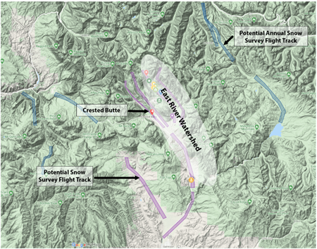
For a pair of NOAA scientists, part of a team conducting an intensive two-year study of how precipitation forms in the East River watershed near Crested Butte, the softening spring snows provided just a little extra challenge for a scheduled ski and snowshoe trek into the rugged mountain valley in late April.
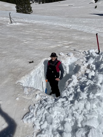
“Ski conditions were not great,” said Janet Intrieri, a research scientist with NOAA’s Physical Sciences Laboratory. “In the morning it was super crusty, in the afternoon it was super mashed-potato-y. But we got what we needed.”
When scientists from PSL and CIRES installed a comprehensive, state-of-the-art observing network in the East River watershed in the fall of 2021 to study how precipitation forms in the complex, high-altitude terrain, they couldn’t have imagined a year like this. As storm after storm plastered the mountains with snow this winter, the network of radars, instrumented towers, and meteorological sensors measured temperatures, precipitation amounts, soil moisture and snowpack properties. Complementing this array were two stations installed nearby by Global Monitoring Laboratory field engineers and researchers consisting of sophisticated radiometers, ceilometers, a total sky imager, a cloud optical depth sensor, and other meteorological instruments.
The mountains of data collected by the study, dubbed SPLASH, will be analyzed alongside data collected by an adjacent field campaign directed by the Department of Energy and Lawrence Berkeley Laboratory. The findings help improve several important NOAA models, including the Unified Forecast System, Rapid Refresh Forecast System, and National Water Model. The ultimate goal of this project will be more accurate weather and river flow forecasts in watersheds critical to the southwestern U.S. water supply.
“We’re simultaneously studying all of the aspects of the lower atmosphere and hydrometeorology that we can,” Intrieri said. “That’s kind of what the special sauce is.”
On the to-do-list that day for Intrieri and fellow PSL scientist Chris Cox was collecting bags of snow at regular intervals from the side of an eight-foot deep pit they dug. One of the layers was marked by a thin line of fine dust blown in from the red desert soils to the southwest. In spring, dust-on-snow events hasten the melt, the dynamics of which are important for water managers who rely on mountain snowpack to fill the reservoirs to understand. The snow was bagged for researchers at Purdue University to analyze.
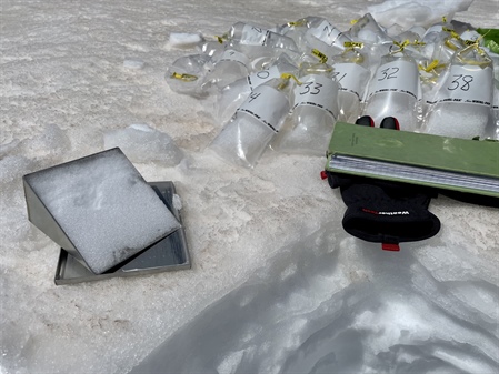
Cox said one of the main goals for this particular research station is to learn about how sunlight, temperature and the presence of dust particles influence whether snow turns to meltwater or evaporates directly into the atmosphere. Sometimes, there’s a big gap between how much water is in the snowpack and how much water ends up in reservoirs and streams.
“Improving our understanding of these physical processes will help us give water managers more accurate forecasts of how much runoff they can expect from Colorado’s snowpack each spring,” he said.
This winter’s abundance was a marked change from 2021-2022, which started off dry, peaked with a monstrous New Year’s storm known locally as the “Santa Slammer,” then quieted down through spring, resulting in an average year.
“Capturing the extremes is always great,” said Gijs deBoer, a CIRES scientist working at PSL. “That’s where a lot of action is when it comes to water supply issues.”

Since 2000, waves of drought have depleted the flow of the Colorado River, relied upon by six states and 40 million people from Denver to Los Angeles, by as much as 20 percent, causing water levels in Lake Mead and Lake Powell to fall to critically low levels. Climate change is projected to further reduce flows by another 10 to 50 percent in the next few decades.
The long-term drought has forced the six basin states to wrestle with the realization that there’s simply not enough water in the Colorado River system to satisfy all uses, which adds a sharp urgency to efforts to improve precipitation estimation and runoff forecasts.
For now, meltwaters are rushing off the surrounding West Elk mountains into the East River Valley, replenishing – for this year at least – soils and streams, and promising scientists a bounty of data to examine.
“It’s stunningly beautiful back there, and we picked a great weather window,” Intrieri said. “Great conditions, we got what we needed: thumbs up all around.”
For more information, contact Theo Stein, NOAA Communications, at theo.stein@noaa.gov.
