Click on a thumbnail graphic to view a gallery of drought data from the US Drought Monitor website.
Click the link to go to the US Drought Monitor website. Here’s an excerpt:
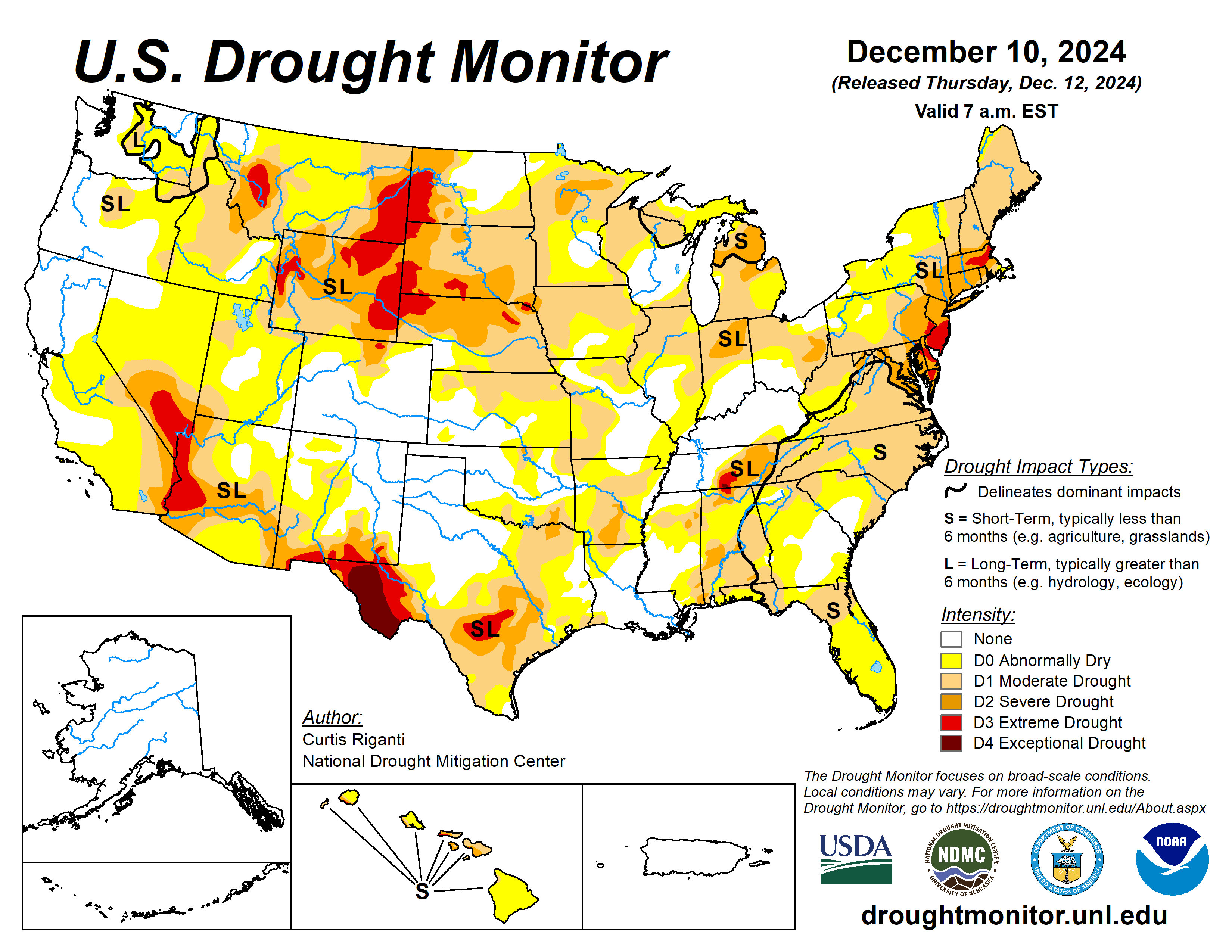
This Week’s Drought Summary
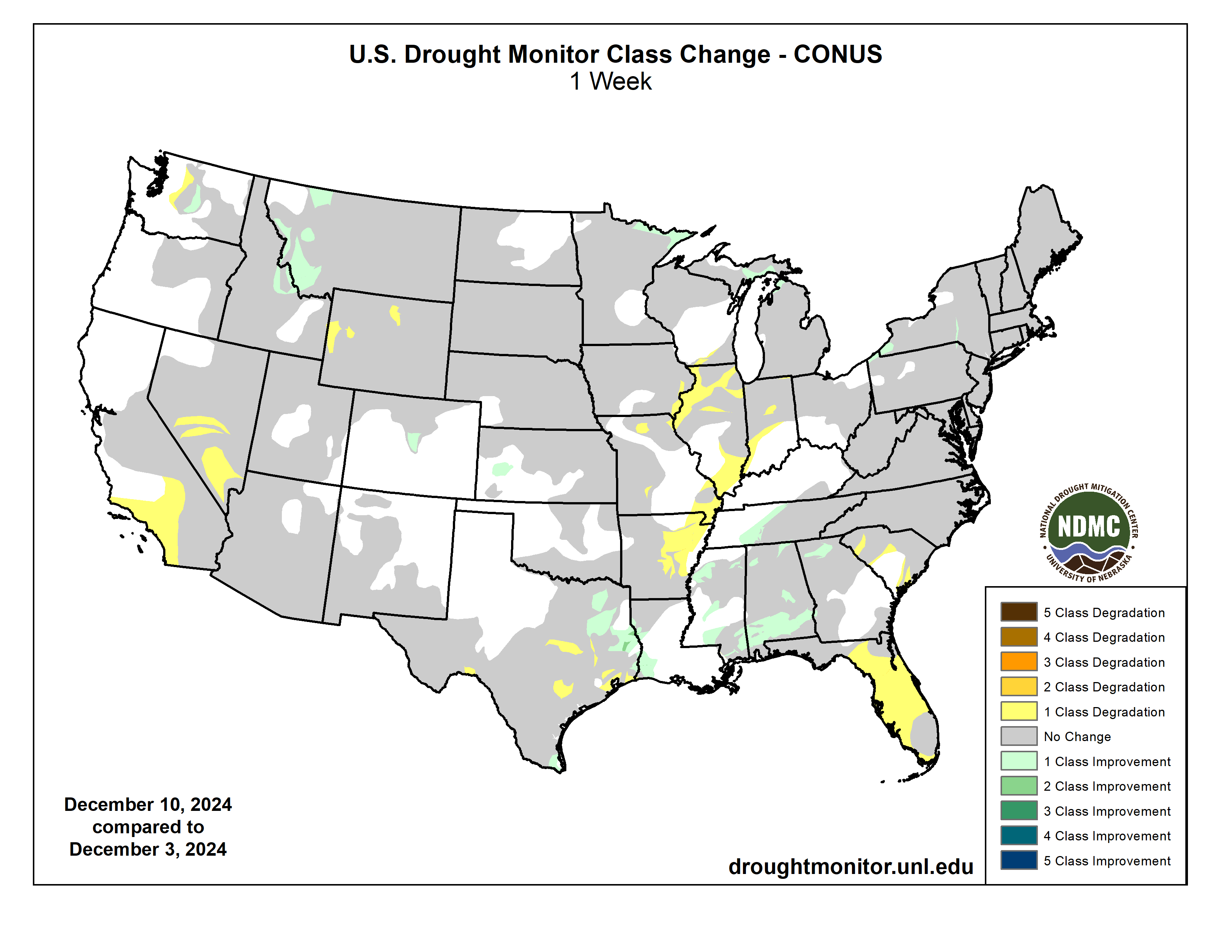
Rains, locally heavier, fell across roughly the east half of Texas this week, with heavier amounts (locally 4-7 inches) falling in parts of the central Gulf Coast region. Lighter precipitation amounts fell in parts of Mississippi, Alabama, Georgia and Tennessee, and in the Ohio River Valley. Snow, some of it lake effect, fell in parts of the Upper Great Lakes, and heavier lake effect snow fell downwind from Lakes Erie and Ontario. Most of the Great Plains and West was dry this week, except for high elevation areas of western Montana and northern Idaho and in western parts of Oregon and Washington. Degradations in drought conditions occurred in southern California and southern Nevada, parts of high elevation Wyoming, across portions of the Mississippi River Valley, in the Florida Peninsula and in parts of Texas. Generally drier weather in Hawaii led to widespread degradations as well, mostly on the windward sides of the islands. Improvements occurred in parts of east and deep south Texas, western Montana and central Washington, Mississippi, Alabama, Georgia and Tennessee, in the Upper Peninsula of Michigan and northeast Minnesota, and in Erie County, Pennsylvania and southwest and south-central New York…
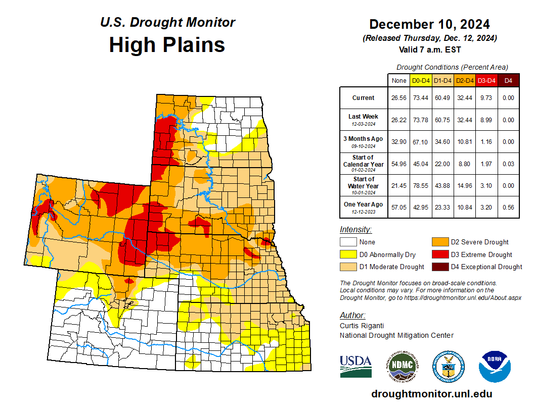
High Plains
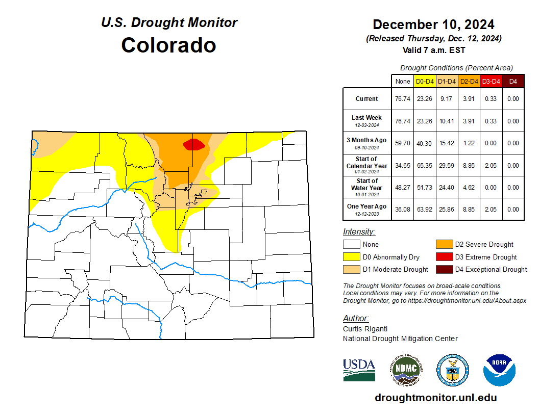
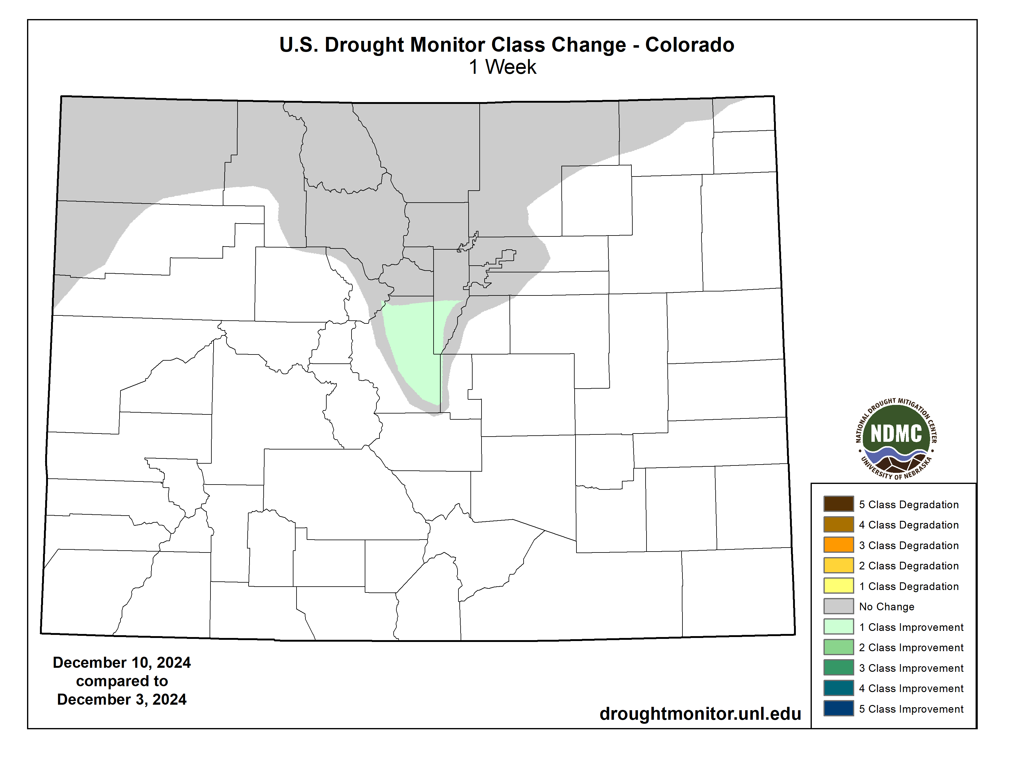
Except for parts of the Front Range of the Rocky Mountains in Colorado, weather across the High Plains region was mostly dry this week. Temperatures were primarily warmer than normal, ranging from 3-12 degrees above normal in most areas (with locally warmer readings). Drought and abnormal dryness coverage remained mostly unchanged. Moderate drought coverage was reduced southwest of the Denver area as precipitation deficits lessened there. Abnormal dryness was also removed from west-central Kansas after conditions were reassessed there following wetter-than-normal weather over the last couple of months. Well-below-normal early season snowpack and short- and long-term precipitation deficits led to expansion of extreme drought in parts of the Wyoming, Wind River and Bighorn mountain ranges in Wyoming. Water usage is currently restricted to essential use only, due to low well levels, in the communities of Auburn and Peru in southeast Nebraska, where moderate drought is ongoing…
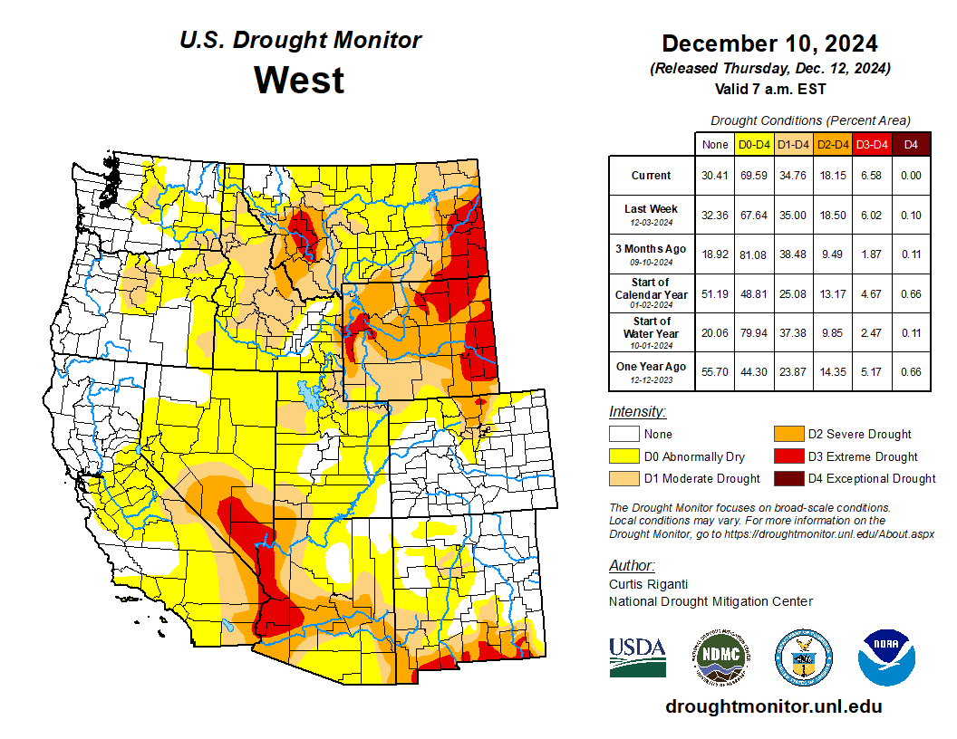
West
Primarily dry weather occurred in the West this week, except for western Washington, western Oregon, western Montana and northern Idaho. Most of the West finished this week either within 5 degrees of normal or 5-10 degrees warmer than normal. Central and eastern Montana saw widespread temperatures range from 10-15 degrees above normal. Widespread improvements to drought conditions occurred in western Montana and adjacent Idaho due to lessened short- and long-term precipitation deficits and increased soil moisture. In central Washington, small adjustments (both improvements and degradations) occurred in abnormal dryness and moderate drought areas where streamflow amounts and short- and long-term precipitation deficits changed. Short-term precipitation deficits continued to mount in southern and central Nevada and in southern California, leading to expansion of drought and abnormal dryness areas there…
South
Widespread rains fell across parts of the south this week, especially in eastern Texas, Louisiana, Mississippi and western Tennessee, while the rest of Texas, most of Arkansas, and Oklahoma remained mostly dry. Western Texas was mostly 3-9 degrees warmer than normal, while Mississippi was mostly near normal or 3-6 degrees below normal. In between these areas, temperature anomalies varied but were mostly within 3 degrees of normal. Due to lessened precipitation deficits and increased streamflow and soil moisture, drought areas were reduced in coverage in central Tennessee, parts of Mississippi, western Louisiana and parts of east Texas. Short-term precipitation and streamflow deficits continued to build in northeast Arkansas, leading to widespread expansion of abnormal dryness and moderate drought there. In parts of southeast and south-central Texas, conditions worsened where soil moisture and streamflow deficits grew amid growing precipitation deficits. In far southern Texas, heavy rains led to local improvements near the mouth of the Rio Grande. In Bexar County, Texas, certain types of fireworks were temporarily banned from sale or usage due to ongoing drought conditions, while lake and reservoir levels dropped to 20% capacity in the Corpus Christi area…
Looking Ahead
Through the evening of Monday, Dec. 16, the National Weather Service Weather Prediction Center is forecasting at least an inch of precipitation in the middle Mississippi River Valley, lower Ohio River Valley, western Tennessee, northwest Mississippi, eastern Texas, southeast Oklahoma, northern Louisiana and Arkansas. Precipitation of at least 1 inch is also forecast in parts of eastern New England and in a few areas downwind (east) of lakes Erie and Ontario. Heavy precipitation is also forecast in northern and northwest California and southwest Oregon, where locally up to or over 5 inches of precipitation is possible. At least 1.5 inches of precipitation is also forecast in many areas of western Washington and Oregon, while mostly lesser amounts are forecast in eastern Washington and Oregon and in parts of Idaho. The Southwest, western Great Plains, southeast Alabama, southern Georgia and the Florida Peninsula are forecast to remain mostly dry.

The National Weather Service Climate Prediction Center’s 6-10 day forecast, covering December 17-21, favors warmer-than-normal temperatures across almost the entire U.S., except for eastern Missouri, Illinois and parts of the Upper Midwest. Forecaster confidence is high for above-normal temperatures in the West, New England, southern Alaska and Hawaii. Precipitation amounts are likely to be below normal for this period across most of the central and northern Great Plains and the West, except for northwest Washington and Oregon, where above-normal precipitation is slightly favored. Above-normal precipitation is also favored in central and southern Texas, the Florida Peninsula, and the Atlantic Coast. Above-normal precipitation is also favored in southern Alaska, while drier-than-normal weather is favored in northern Alaska and in Hawaii.