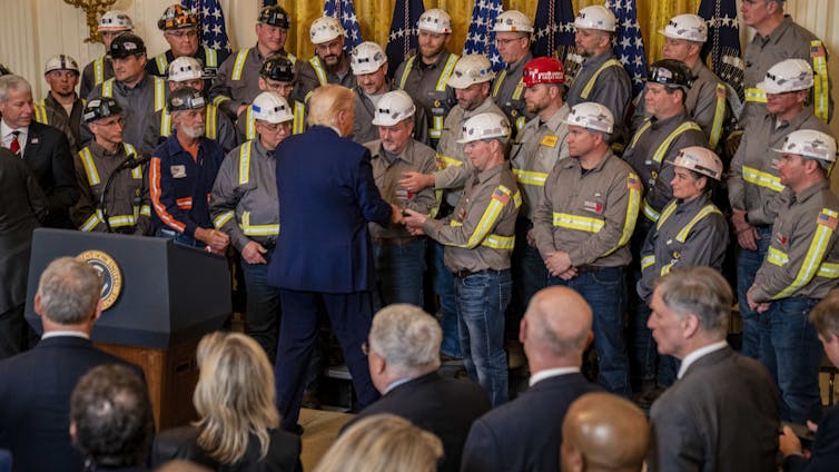
He also directed federal agencies to “identify coal resources on Federal lands” and ease the process for leasing and mining coal on those lands. In addition, he issued orders to exclude coal-related projects from environmental reviews, promote coal exports and potentially subsidize the production of coal as a national security resource.
But there remain limits to the president’s power to slow the declining use of coal in the U.S. And while efforts continue to overcome these limits and prop up coal, mining coal remains an ongoing danger to workers: In 2025, there have been five coal-mining deaths in West Virginia and at least two others elsewhere in the U.S.
Until 2015, coal-fired power plants generated more electricity than any other type of fuel in the U.S. But with the rapid expansion of a new type of hydraulic fracturing, natural gas became a cheap and stable source for power generation. The prices of solar and wind power also dropped steadily. These alternatives ultimately overcame coal in the U.S. power supply.
Before this change, coal mining defined the economy and culture of many U.S. towns – and some states and regions, such as Wyoming and Appalachia – for decades. And in many small towns, coal-related businesses, including power plants, were key employers.
Coal has both benefits and drawbacks. It provides a reliable fuel source for electricity that can be piled up on-site at power plants without needing a tank or underground facility for storage.
But it’s dirty: Thousands of coal miners developed a disease called black lung. The federal government pays for medical care for some sick miners and makes monthly payments to family members of miners who die prematurely. Burning coal also emits multiple air pollutants, prematurely killing half a million people in the United States from 1999 through 2020.
Coal is dangerous for workers, too. Some coal-mining companies have had abysmal safety records, leading to miner deaths, such as the recent drowning of a miner in a sudden flood in a West Virginia mine. Safety reforms have been implemented since the Big Branch Mine explosion in 2010, and coal miner deaths in the U.S. have since declined. But coal mining remains a hazardous job.
In both of his terms, Trump has championed the revival of coal. In 2017, for example, Trump’s Department of Energy asked the Federal Energy Regulatory Commission to pay coal and nuclear plants higher rates than the competitive market would pay, saying they were key to keeping the U.S. electricity grid running. The commission declined.
So many data centers, desperate for 24/7 electricity, are relying on old coal-fired power plants – buying electricity from plants that otherwise would be shutting down.
Despite the Trump adminstration’s efforts to rapidly expand data centers and coal to power them, coal is more expensive than most other fuels for power generation, with costs still rising.
The U.S. Department of the Interior’s recent effort to follow Trump’s orders and lease more coal on federal lands received only one bid – at a historically low price of less than a penny per ton. But in fact, even if the government gave its coal away for free, it would still make more economic sense for utilities to build power plants that use other fuels. This is due to the high cost of running old coal plants as compared to new natural gas and renewable infrastructure.
Natural gas is cheaper – and, in some places, so are renewable energy and battery storage. Government efforts to prevent the retirement of coal-fired power plants and boost the demand for coal may slow coal’s decline in the short term. In the long term, however, coal faces a very uncertain future as a part of the U.S. electricity mix.
In a collection of essays and research summaries, eleven members of the Colorado River Research Group (with eight guest contributors) touch on issues as diverse as plummeting reservoir storage, climate change trends, risk management, agricultural water conservation, equity, and governance, all against the backdrop of the need to fashion post-2026 reservoir operating rules.
Chapter 1. Colorado River Reservoir Storage – Where We Stand Jack Schmidt, Anne Castle, John Fleck, Eric Kuhn, Kathryn Sorensen, and Katherine Tara
Chapter 2. Think Natural Flows Will Rebound in the Colorado River Basin? Think Again. Jonathan Overpeck and Brad Udall
Chapter 3. The Erosion of the Colorado River “Safety Nets” is Alarming Doug Kenney
Chapter 4. Water Equity in the Colorado River Basin Bonnie Colby and Zoey Reed-Spitzer
Chapter 5. The Tale of Three Percentage-Based Apportionment Schemes Eric Kuhn
Chapter 6. A Humbly Proffered Proposal to Aid the Colorado River System: Conservation Easements & Land Purchases Kathryn Sorensen and Sarah Porter
Chapter 7. Facing the Future: Can Agriculture Thrive in the Upper Basin with Less Water? Kristiana Hansen, Daniel Mooney, Mahdi Asgari, and Christopher Bastian
Chapter 8. Towards a Basinwide Entity: Moving from Vision to Action Matthew McKinney, Jason Robison, John Berggren, and Doug Kenney
Contributors
Colorado River Research Group (CRRG) Members
Bonnie Colby, Professor, University of Arizona.
John Fleck, Writer in Residence, Utton Transboundary Resources Center, University of New Mexico.
Kristiana Hansen, Professor, Department of Agricultural and Applied Economics, University of Wyoming.
Doug Kenney, Director, Western Water Policy Program, Getches-Wilkinson Center, University of Colorado Law School; and Chair, Colorado River Research Group.
Eric Kuhn, Retired General Manager, Colorado River Water Conservation District.
Matthew McKinney, Co-director, Water & Tribes Initiative; Senior Fellow, Center for Natural Resources & Environmental Policy, University of Montana; Fulbright Specialist 2025-2027.
Jonathan Overpeck, Dean, School for Environment and Sustainability, University of Michigan.
Jason Robison, Professor of Law and Co-Director, Gina Guy Center for Land & Water Law, University of Wyoming.
Jack Schmidt, Director, Center for Colorado River Studies, Utah State University, and former Chief, Grand Canyon Monitoring and Research Center.
Kathryn Sorensen, Kyl Center for Water Policy, Arizona State University; and former Director, Phoenix Water Services.
Brad Udall, Senior Water and Climate Research Scientist/Scholar, Colorado Water Center, Colorado State University.
Guest Contributors
Mahdi Asgari, Postdoctoral Scholar, Department of Agricultural and Applied Economics, University of Wyoming.
Christopher Bastian, Professor, Department of Agricultural and Applied Economics, University of Wyoming.
John Berggren, Regional Policy Manager, Western Resource Advocates.
Anne Castle, Senior Fellow, Getches-Wilkinson Center, University of Colorado Law School; former US Commissioner, Upper Colorado River Commission; and former Assistant Secretary for Water and Science, US Department of the Interior.
Daniel Mooney, Associate Professor of Agricultural and Resource Economics, Colorado State University.
Sarah Porter, Director, Kyl Center for Water Policy, Arizona State University.
Zoey Reed-Spitzer, Research Assistant, North Carolina State University (formerly University of Arizona).
Katherine Tara, Staff Attorney, Utton Transboundary Resources Center, University of New Mexico.
Here’s the preface:
Welcome to the Colorado River Research Group’s (CRRG) inaugural Colorado River Insights report. This publication marks a new (and still evolving) direction for the CRRG, transitioning away from the group-authored policy briefs of the past to more personal “Individual Submissions” that allow members to be more focused, direct and sometimes prescriptive than in the past efforts authored jointly and requiring unanimous consent. While each of the Individual Submissions (i.e., Chapters) that follows is unique in structure and tone and detail, each member was given the same charge: to speak directly about issues on the river where they have been directing much of their current focus, and where feasible, to identify a path forward on those issues. Given this approach, each Individual Submission is truly individual—or, in several cases, the product of small groups—and thus should not be attributed to the entire body, although in practice there is usually very little internal conflict on any of the major themes featured throughout these pages. One byproduct of this approach is that it shines a light on some of the CRRG’s most glaring holes in terms of disciplines and substantive expertise, helping to steer us to new potential members (and guest contributors) and, perhaps, new approaches. Unless or until that happens, we readily acknowledge that our collective snapshot of current and emerging basin issues is far from comprehensive. But how could it be? That’s an impossible standard for a river as vast in size, importance and complexity as the Colorado.
We are hopeful that this new approach can be helpful in better funneling the knowledge emerging from the research community into the hands of decision-makers, journalists, NGOs, water users, and other concerned parties in a more hands-on position to implement the changes needed to restore the economic and environmental sustainability of the River. Clearly, we are in an era screaming for new ideas and new approaches; the status quo isn’t working. — Doug Kenney, CRRG Chair
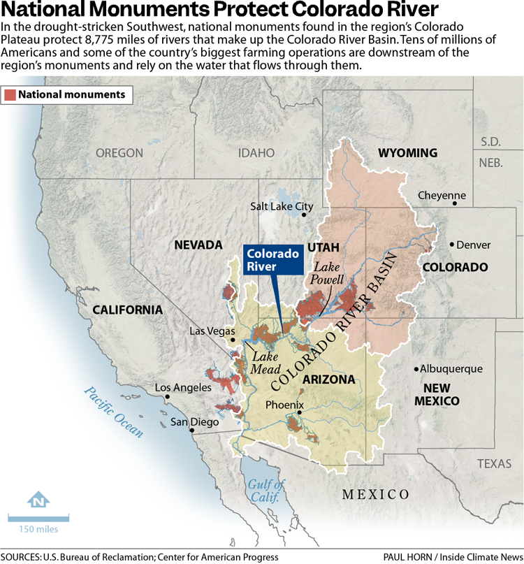
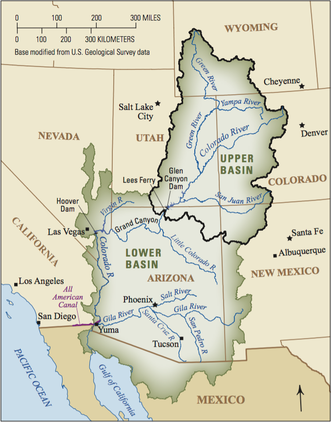
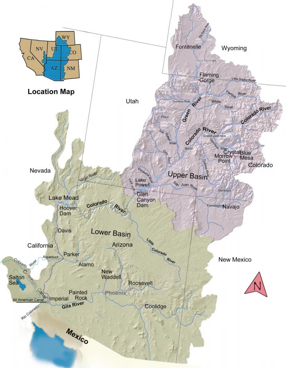
Map of the Colorado River drainage basin, created using USGS data. By Shannon1 Creative Commons Attribution-Share Alike 4.0
The 31 national monuments designated since the Clinton administration, which could be downsized as the Trump administration pushes to open more public lands to extractive industries, safeguard clean water for millions of Americans, according to a new analysis from the Center for American Progress.
Using geospatial data to quantify the miles of rivers and watersheds within the studied national monument boundaries, as well as the number of users who depend on that water, the report found that the water supplies for more than 13 million Americans are directly provided by watersheds within or downstream of these national monuments. About 83% of the water passing through these public lands has no other protection besides the monument designations, it found.
National monuments protect more than 21,000 miles of waterways across the U.S., nearly twice as much waterway mileage as the National Wild and Scenic Rivers System, the analysis also determined.
The report comes as the Trump administration weighs downsizing or revoking the designation of some national monuments.
In March, the Trump administration announced it would eliminate California’s Chuckwalla and Sáttítla Highlands national monuments before removing language from a White House fact sheet announcing that decision. The following month, The Washington Postreported that the administration was considering downsizing or eliminating six national monuments, and in June, the U.S. Department of Justice issued an opinion that the president has the power to rescind national monument designations, backtracking on a decades-old determination on the matter.
Stone and evening light, Bears Ears National Monument, Utah. Jonathan P. Thompson photo.
During Trump’s last term, Bears Ears and Grand Staircase-Escalante national monuments, established by the Obama and Clinton administrations, respectively, were shrunk to fractions of their original sizes, but they were restored by President Joe Biden after he took office.
If national monuments are downsized or eliminated, the areas surrounding a waterway will lose protections from extractive industries, including oil and gas drilling, mining and grazing. Contamination from those industries could seep into streams and, in turn, rivers. Those industries also use water, sometimes vast amounts in arid regions, further reducing the supply that flows to nearby communities. (In certain cases, some mining and grazing are already permitted on national monument lands, but the activities are limited in scale and more regulated than they are outside the monuments.)
“Landscapes and waterways go hand in hand,” said Drew McConville, a senior fellow for conservation policy at the Center for American Progress and a co-author of the report. “The clean water depends on what comes into them from natural lands … Just protecting the wet stuff itself doesn’t guarantee that you’re keeping [water] clean and durable.”
The portion of historically marginalized communities living within the watersheds of the national monuments is greater than the average for watersheds nationally, it found. Twenty-three of the monuments studied are also found in regions expected to face water shortages due to climate change in the coming decades, making the arid regions downstream even drier.
Grand Staircase-Escalante National Monument, for example, protects 2,517 miles of waterways, according to the analysis, and nearly 90% of the watersheds within the monument are expected to see declines in their water levels. The monument straddles the Upper and Lower Colorado River Basins, with the Paria and Escalante rivers flowing within its boundaries and Lake Powell, the nation’s second-largest reservoir, just to its south.
The monument is often thought of as a sparse, arid region, which it is, said Jackie Grant, the executive director of Grand Staircase Escalante Partners, a nonprofit focused on protecting the monument that has spent $11 million to protect the Escalante River watershed and all its tributaries. It remains vital to the Colorado River System, which millions of people in the Southwest rely on. Grand Staircase-Escalante helps slow water from the Paunsaugunt Plateau in Bryce Canyon National Park, much of which starts as snowpack in the park before melting and flowing downstream.
“People don’t think of water when they think of Grand Staircase-Escalante National Monument,” Grant said. “So when we can bring this view of water and how important it is to the protection of the monument, it helps us put another building block in our case for supporting the monument, because not only is it important for the animals, the native plants, the geology and the paleontology, water plays a huge role in the monument, and the monument protects the water itself.”
The Antiquities Act of 1906 was signed into law by Theodore Roosevelt, for “… the protection of objects of historic and scientific interest” through the designation of national monuments by the President and Congress. National monuments are one of the types of specially-designated areas that make up the BLM’s National Conservation Lands. Some of the earliest national monuments included Devils Tower, the Grand Canyon, and Death Valley. They were initially protected by the War Department, then later by the National Park Service. More recently, the BLM and other Federal agencies have retained stewardship responsibilities for national monuments on public lands. In fact, the BLM manages more acres of national monuments in the continental U. S. than any other agency. This includes the largest land-based national monument, the Grand Staircase-Escalante National Monument in Utah featured here. National monuments under the BLM’s stewardship have yielded numerous scientific discoveries, ranging from fossils of previously unknown dinosaurs to new theories about prehistoric cultures. They provide places to view some of America’s darkest night skies, most unique wildlife, and treasured archaeological resources. In total, twenty BLM-managed national monuments, covering over five million acres, are found throughout the western U. S. and offer endless opportunities for discovery. Photos and description by Bob Wick, BLM.
Stretching across 1.87 million acres of public land, Grand Staircase-Escalante National Monument is one of the country’s most expansive national monuments, protecting scores of wildlife as well as archeological resources in southern Utah. But a nine-billion-ton coal deposit is buried in the center of the monument along with deposits of minerals, including uranium and nickel. The Trump administration has long touted boosting the country’s coal production, and has established a pro-mining agenda this year.
“It’d be very easy to contaminate either one of those rivers if mining were to take place in the center section of the monument,” Grant said.
Margaret Walls, a senior fellow at Resources for the Future who has studied national monuments but was not part of this study, said national monuments are designated to protect cultural or historical landmarks, and it can be forgotten that they can also serve purposes like safeguarding water. Though she noted that even if monument protections are loosened, the areas remain federal lands, and their changes in status do not guarantee they will be developed.
“We don’t protect waterways the way we do land,” Walls said, “we’re going to get those water benefits by protecting the land.”
Created by Imgur user Fejetlenfej , a geographer and GIS analyst with a ‘lifelong passion for beautiful maps.’ It highlights the massive expanse of river basins across the country – in particular, those which feed the Mississippi River, in pink.
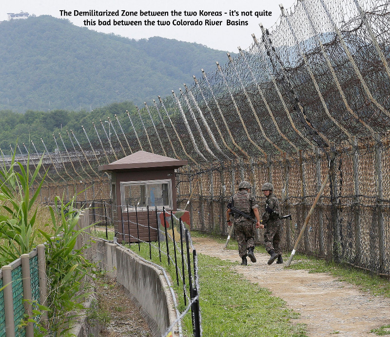
Negotiations among the Magnificent Seven representing the seven states of the Colorado River region begin to resemble the ongoing negotiations between the military and diplomatic representatives for North and South Korea, where negotiations for something beyond an armistice have been going on for more than sixty years. Here, as there, the negotiations have reached a stalemate, and both sides are now engaged in an information war. Between the two Koreas, this war takes the form of everything from huge arrays of speakers blasting pop music across the demilitarized zone to smuggled USB drives with movies and TV shows. Here, it is mostly just propaganda bombs tossed over our ‘DMZ,’ the Grand Canyons, about each side’s virtue and the other side’s obstinacy, depending on their regional media’s love of conflict and tendency to support the home team. The missed November deadline has been seamlessly replaced – as we all suspected it would be – by a February deadline. But otherwise – nothing new on that front. We can just hope it doesn’t go on for another fortysome years.
So I’m going to take advantage of the stalemate to ask the reader to think about a bigger picture that may be more interesting. It stems from a comment from my partner Maryo, from whom I learn too much to dismiss anything she says. ‘Why are you “romancing the river”?’ she asked the other day. ‘Romance is such a cheapened concept today – bodice-ripping stories of ridiculous antagonistic love. You’re undermining the value of your work, calling it a “romance.”’
‘Well,’ I said – figuring that if she feels that way, maybe my readers raise the same question – ‘maybe one of the things a writer ought to try to do is restore the value of words and the concepts they once represented that have become devalued through misuse.’ Spoken like a true Don Quixote, another old man who took arms, sort of, against abuse of the concept of ‘romance.’
I do think that one of the things that ‘civilization’ does in civilizing us is to simplify things for us, including words whose complexity and depth embrace concepts, ideas and feelings that can be inconvenient to an orderly civilized society. A ‘romance,’ from the medieval era on into the early 20th century, was a story of an adventure in pursuit of something mysterious, exciting, challenging, something beyond everyday life. That could be the pursuit of a love relationship that was life-changing (and maybe life-endangering) for its participants – Tristan and Isolde, Launcelot and Guinevere, Romeo and Juliet, Bonnie and Clyde.
But on a much larger scale, the romantic adventure can be establishing a relationship with anything outside of ourselves that intrigues or challenges us. The relationship can emerge with a place, a house, a horse, a car, a continent, a river, an idea, as well as another person, anything that intrigues us, wakes up our imagination – arational or prerational relationships that make the civilizing forces nervous. The relationship can run the quick dynamic spectrum from arational love to its flip side arational hate, through all the intermediary love-hate variations. It can also have a mythically selective or even creative attitude toward the gray-zone relationship between ‘truth’ and fact. Which leads those trying to develop an orderly civilization to dismiss anything (ad)venturing into the mythic as a lie. It just seems simpler that way.
The Powell survey on its second trip down the Colorado River, 1871. Photo credit: USGS
The first comprehensive study of the Colorado River region was uncivilized enough to state upfront its romantic origins: Frederick Dellenbaugh’s Romance of the Colorado River. Dellenbaugh’s book (available online for a pittance) delved as deeply as was possible at that time into both the First People prehistory in the region and the early history of the Euro-American invasion, from the Spanish trying to work their way up the river from its contentious confluence with the Gulf of California (‘Sea of Cortez’ to them) to the trappers imposing the first major Euro-American change on the river, stripping its tributaries of their beavers which increased the size and violence of the river’s annual spring-summer runoff of snowmelt. But the heart of the book is John Wesley Powell’s explorations to link the upper river and the lower river through its canyons.
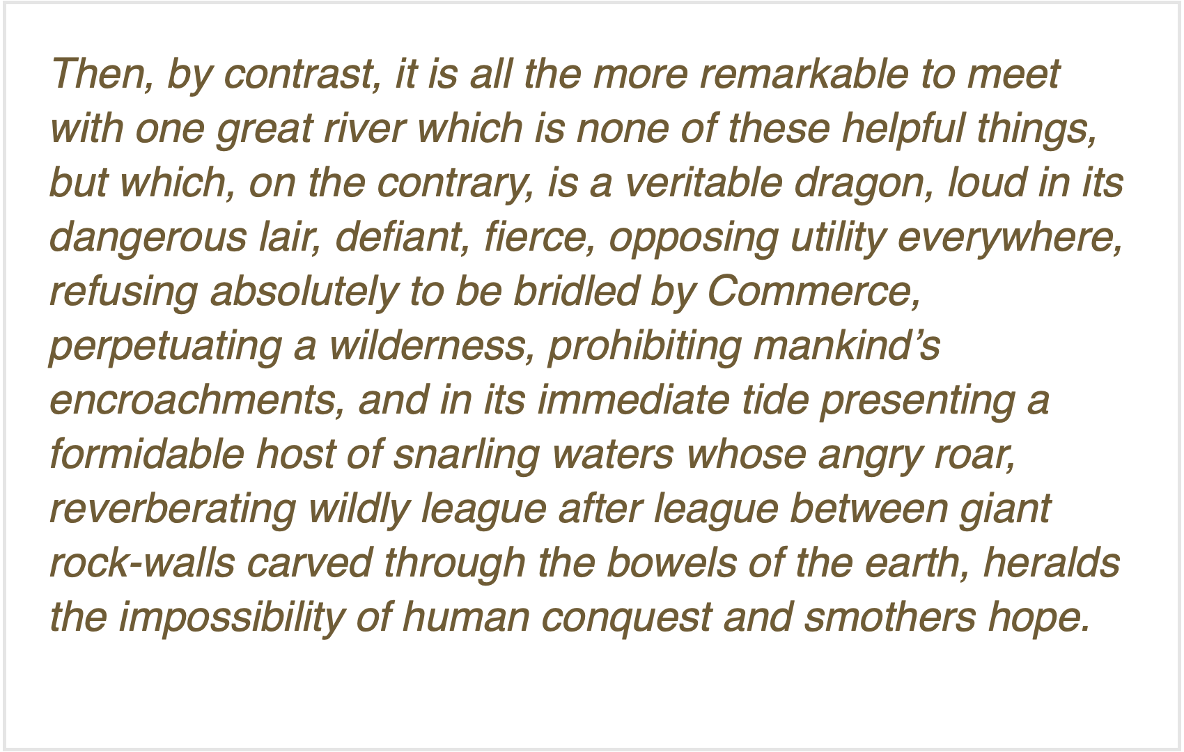
Dellenbaugh, as a seventeen-year-old, accompanied Powell on his second Colorado River expedition, a ‘baptism under water’ (often literally) that shaped his ‘romantic’ vision. In his ‘Introduction,’ after observing that most of the great rivers that humans encountered in exploration and settlement gradually became like foster parents to those who settled along them, carrying goods for them and generally watering and growing their settlements, he says of the Colorado:
Dellenbaugh’s Romance was published in 1903. That same year, another great southwestern writer, Mary Hunter Austin came out with her Land of Little Rain, a fascinating collection of her explorations in the deserts of the lower Colorado River region. In that book she offered what might be a cautionary note about ‘romancing the river,’ in an observation about a small Arizona tributary of the Colorado River, ‘the fabled Hassayampa… of whose waters, if any drink, they can no more see fact as naked fact, but all radiant with the color of romance.’
I will now indulge my tendency to take a ‘tectonic’ look at history – looking for large chunks colliding or grating together or subducting under each other. I see the history of our engagement with the Colorado River dividing into three ‘tectonic romances’: first, the Romance of Exploration, which is chronicled in a couple different ways by those two explorers, Dellenbaugh and Austin; their 1903 publications summarize that age and put a semi-colon at the end of the period, as it were.
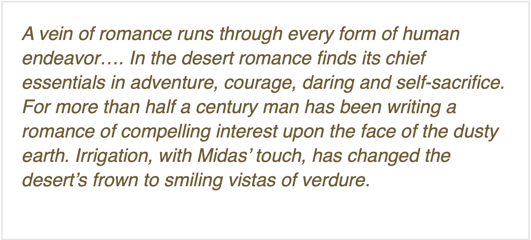
Second, the Romance of Reclamation: 1903 also marks the year the U.S. Reclamation Service came into being, an organization created almost specifically for settling the Colorado River deserts. Civilized people on both sides of the question would deny that there was any ‘romance’ to reclamation, but one early Bureau engineer would publicly disagree, writing in 1918 about ‘the romance of reclamation’:
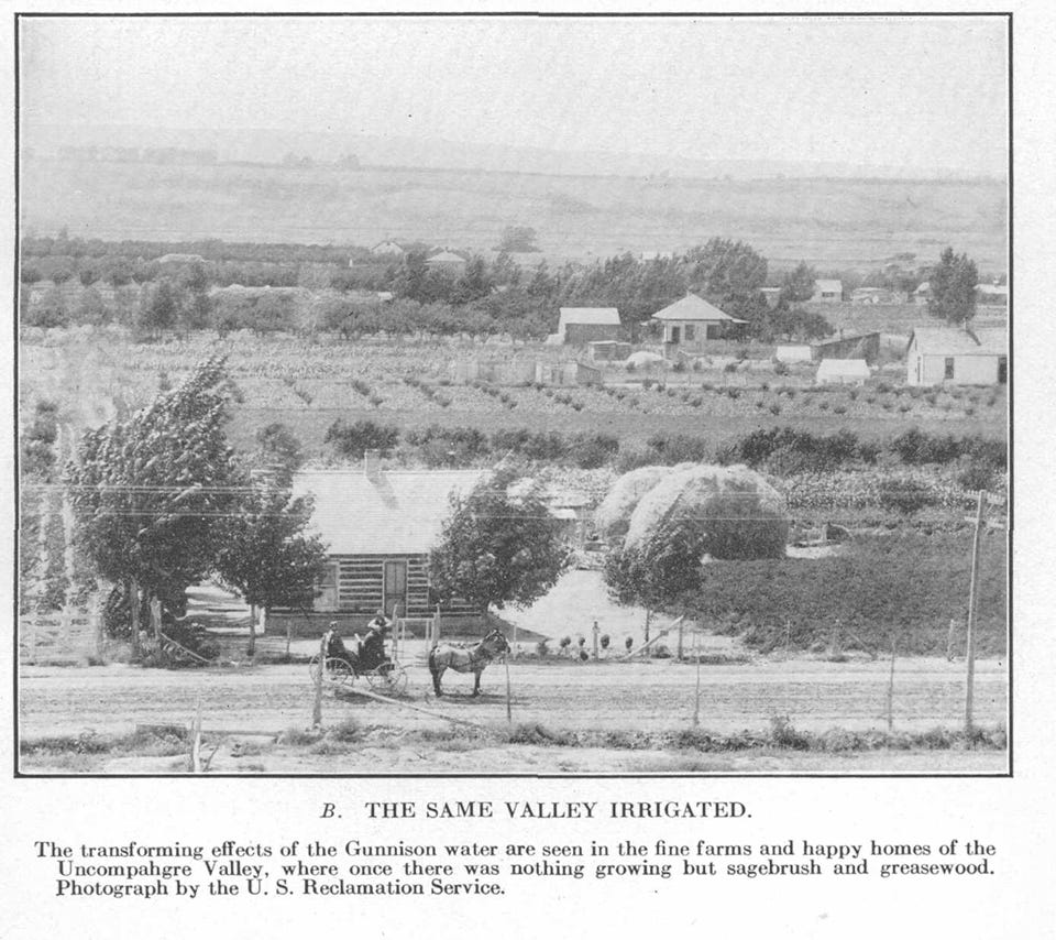
C.J. Blanchard of the U.S. Reclamation Service authored that steaming verdure. The Service at that time was under the U.S. Geological Survey, a scientific organization disciplined to the ‘look before you leap’ methods of science, discerning the reality of a situation and adapting to that; but the Reclamation Service, frustrated by the seasonal flood-to-trickle flows of the Colorado, thought that changing that reality (through storage and redistribution) was a more promising route than adapting to it, and so was on its way to becoming independent of the USGS when Blanchard wrote his ‘romance of irrigation’ for an educational journal called The Mentor(thanks, Dave Primus, for calling it to my attention).
Members of the Colorado River Commission, in Santa Fe in 1922, after signing the Colorado River Compact. From left, W. S. Norviel (Arizona), Delph E. Carpenter (Colorado), Herbert Hoover (Secretary of Commerce and Chairman of Commission), R. E. Caldwell (Utah), Clarence C. Stetson (Executive Secretary of Commission), Stephen B. Davis, Jr. (New Mexico), Frank C. Emerson (Wyoming), W. F. McClure (California), and James G. Scrugham (Nevada) CREDIT: COLORADO STATE UNIVERSITY WATER RESOURCES ARCHIVE via Aspen Journalism
The best-known document of the Romance of Reclamation was of course the Colorado River Compact – a document in which the romance of reclamation overrode any relationship to ‘naked fact’ about the river and its flows, a situation that is now biting our collective ass.Yet an Arizona water maven said recently that any Bureau of Reclamation solution to the seven-state impasse would have to cleave closely to the Compact…. The history of the Romance of Reclamation has been written in the gaggle of Congressional acts, court decisions, treaties, regulations and directives that make up the ‘Law of the River’ (recitations of which never seem to include the 1908 Winters Doctrine allocating assumed water to federal reservations, including to the First Peoples).
The end of the Romance of Reclamation would be in the 1960s, pick your date: publication of Rachel Carson’s Silent Spring in 1962, passage of the Wilderness Act in 1964, passage of the Environmental Policy Act in 1969 – a decade in which the general American perception of the West underwent a sea change, from seeing it as a workplace for producing the resources to feed the American people and industries, to seeing it as a great natural playground to which America’s predominantly urban population could go to recharge, with a resulting desire to protect it from the very industrial consumption that supported the American ‘lifestyle.’.
This was the dawn of the third romantic epoch in our relationship with the river (and the continent in general) – the Romance of Restoration and Revision, driven by a belief that we have sinned against capital-N Nature – with many naked facts as evidence – and can only expiate our sins by preserving what remains of the nonhuman environment, restoring what we can of the damage we’ve done, and revising our own systems for consuming nature (e.g., renewable energy).
Aesthetics are at the root of our romance with capital-N Nature, aesthetics best served by the (increasingly rare) opportunity to be alone with and ‘silent on a peak in Darien,’ as Keats put it. We have a large (and growing) number of excellent writer[s] who work to elaborate on that aesthetic – Ed Abbey first, Craig Childs, Heather Hansman, Kevin Fedarko, to name a few.
But the aesthetic yearning to ultimately ‘put it back the way it was’ does not extend to other equally naked facts, like the dependence of the outdoor recreation industries on the creation of big mountain-highway traffic jams pumping big quantities of carbon and nitrogen gases into the already overladen atmosphere, as we all load up our cars with expensive gear to go off to commune with Nature. Or the naked fact that maintaining civilization-as-we-know-it for 300 million people involves a lot of nonrewable extraction from Nature that it will be very difficult to move away from entirely – unless we figure out how to control our breeding.
Just as significant achievements were achieved under the Romance of Reclamation, so significant achievements have been achieved under the Romance of Restoration and Revision – the setting aside of millions of acres of still-sort-of-wild land, instream flow laws, increasingly responsible forest management, et cetera. But we are clearly still in the early transition – half a century later – to a more realistic romance with restoring and revising to a kinder gentler relationship with the nonhuman systems of nature. And right now, we are experiencing a major counter-attack from the societal forces whose aesthetics still imagine a ‘working landscape’ of derricks, mines and other industrial-scale harvests, all suffused with the ‘smell of money,’ societal forces that believe the best of times were before we woke up to the increasingly fragile finitude of our planet under the burden of us. Let’s all go back and make America great again!
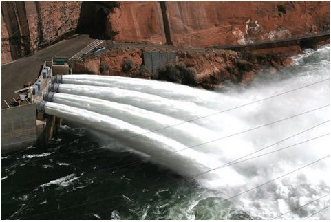
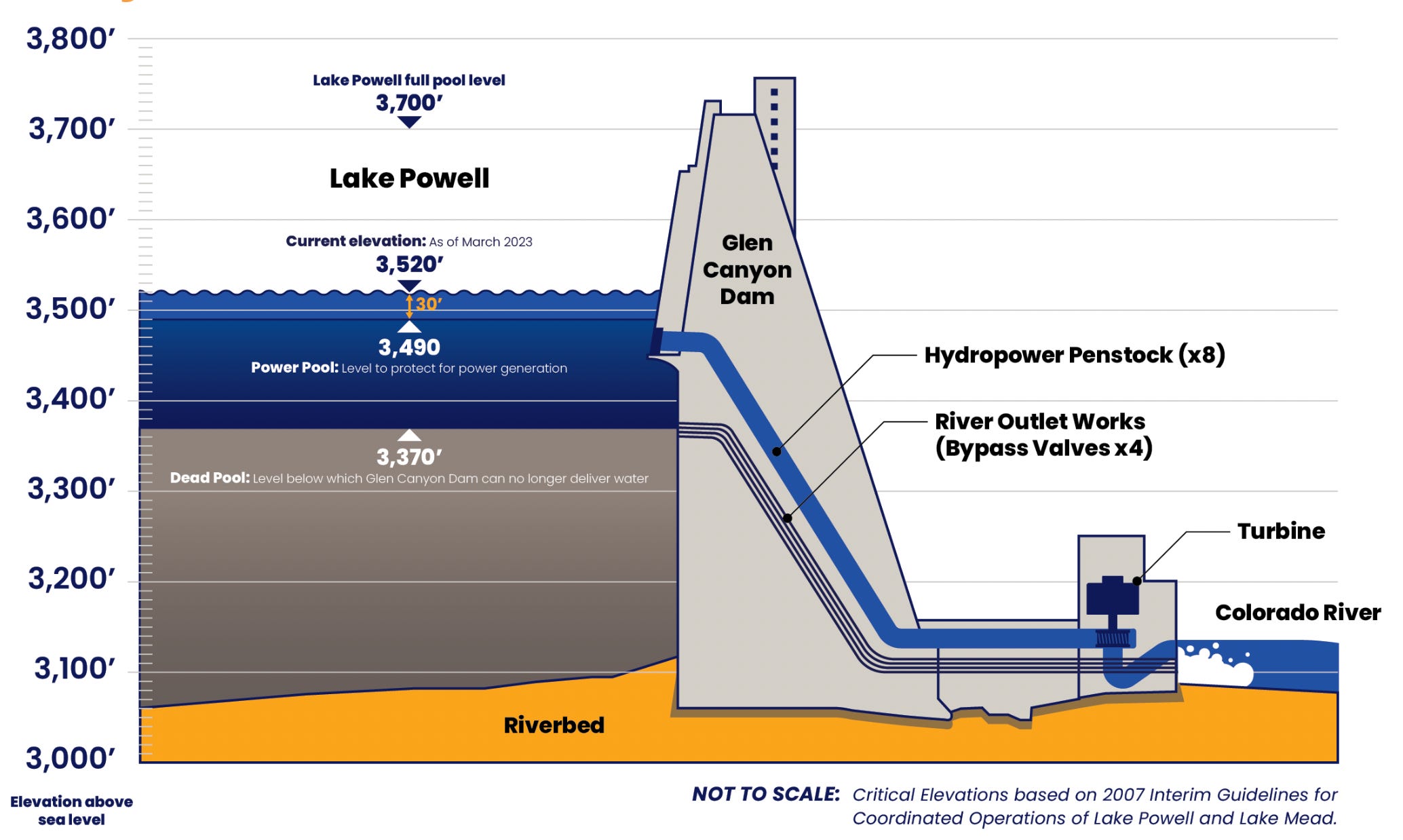
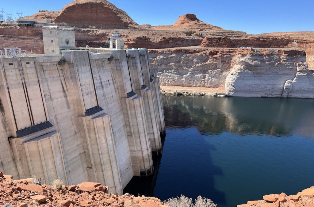
The back of Glen Canyon Dam circa 1964, not long after the reservoir had begun filling up. Here the water level is above dead pool, meaning water can be released via the river outlets, but it is below minimum power pool, so water cannot yet enter the penstocks to generate electricity. Bureau of Reclamation photo. Annotations: Jonathan P. Thompson
I cannot now imagine when and how this third epoch of our romance with the river will end. I think this aesthetic romance might peak with the ‘breaching’ of Glen Canyon Dam, an action that has taken on a somewhat mythic quality for today’s river romantics. I don’t think we will tear it down – let it stand as a monument to…something. But I suspect that even the Bureau of Reclamation is exploring some way of tunneling around it at river level, as we continue to flirt with the disaster of dead pool behind the dam. It will not be easy, due to the silt already piled up at the dam – but really, nothing is going to be easy anymore; that blessed civilization is now in the rear-view mirror.
I’m going to take advantage of the lull in the short-term news about the river’s management for maybe the next decade, to take a look at each of these three epochs of ‘romancing the river’ and their relationship to the ‘naked facts’ of the river – mostly see if there might be something there we’ve overlooked that might help us move forward in our ever-emerging relationship of this ‘First River of the Anthropocene.’ Onward and outward.
Map of the Colorado River drainage basin, created using USGS data. By Shannon1 Creative Commons Attribution-Share Alike 4.0
Click the link to read the article on the KUER website (David Condos). Here’s an excerpt:
December 3, 2025
Price Mayor Michael Kourianos drew an imaginary line in the air between two scrubby desert hills. His hand traced the path of a planned 100-foot dam for a new reservoir just north of the city in Carbon County. The project, which Kourianos described as vital to the area’s future, would provide irrigation to farmers and shore up the city’s water supply. It’s a big deal in a drought-prone area, and it could be built within five years, he said — if the federal funding that’s supposed to pay for it doesn’t disappear.
“I’m very much worried about that,” Kourianos said. “That could be at risk. That’s the unknown.”
To finish the project’s environmental impact study by next spring, he said the city and county had to scrape together about $215,000. That was after they were told there were no more federal funds to help with it due to the Trump administration’s recent cuts. The next step will be designing the reservoir, which he said is supposed to be paid for by the Natural Resources Conservation Service, part of the U.S. Department of Agriculture. The agency is set to pay 75% of construction costs, too. In all, the project will cost around $200 million. For a city of 8,216 people, that’s just not in the budget…
Price’s reservoir isn’t the only one threatened. In January, for example, the Biden administration awarded more than $70 million to 10 proposals in Utah and another $50 million to four on the Navajo Nation and Ute tribal land within the state’s watersheds. The projects range from improving wetland habitat for endangered fish to removing invasive plants, such as Russian olive trees, from riverbanks. It was part of a $388.3 million effort to improve drought resilience across the Colorado River Basin with money from the Inflation Reduction Act. Just a few days after the money was awarded, however, President Donald Trump took office and paused it. Several months later, recipients are still waiting…One of the impacted proposals is a collaboration between the Utah Division of Wildlife Resources and conservation organizations Trout Unlimited and The Nature Conservancy that would pay people to voluntarily leave water in the Price River rather than use it.
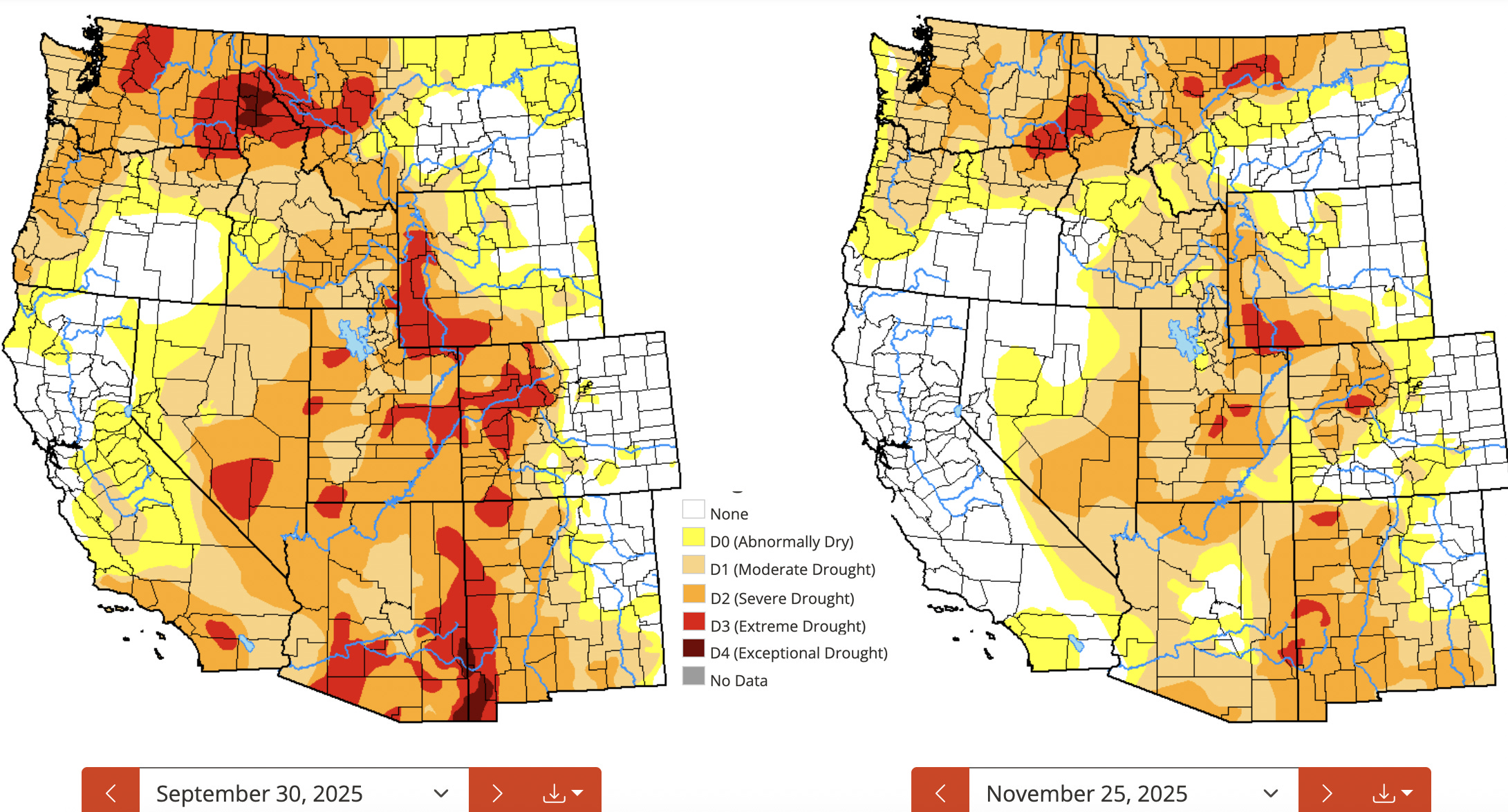
The drought situation has improved markedly in the Southwest since the end of the last water year, especially in the Four Corners area. Source: National Drought Monitor.
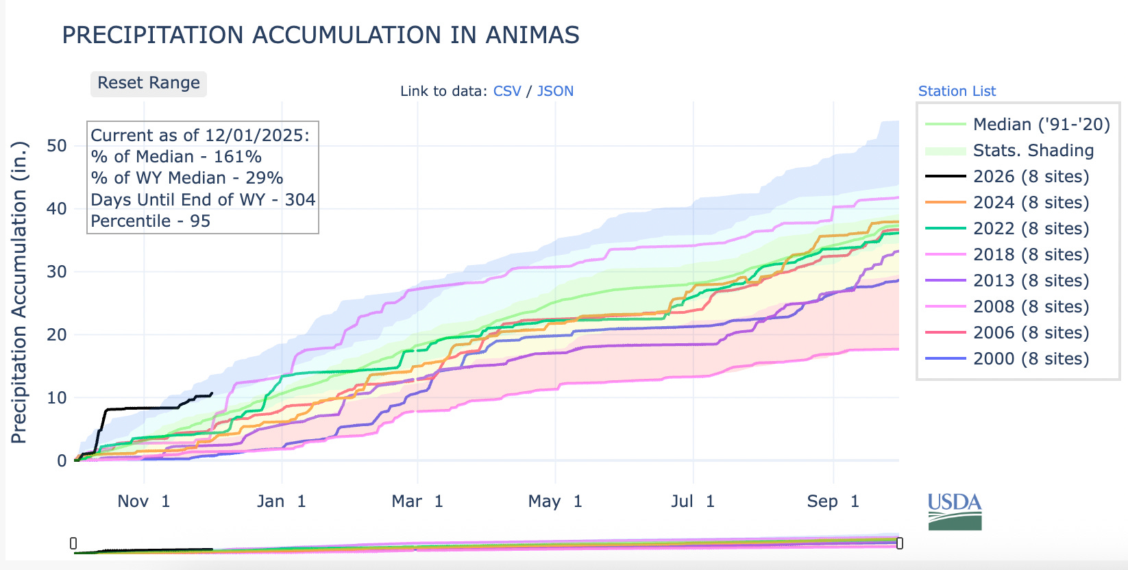
We are now two months into the water year — and a couple of days into meteorological winter — and so far both are pretty weird. On the one hand, much of the West is covered by one of the scantest snowpacks for early December in decades. On the other, it’s also been one of the wettest beginnings to the water year in recent memory.
Graph of 2026 water year snowpack levels for the Animas River watershed (which this year reflects that for most of western Colorado and the Upper Colorado River Basin), along with every year since 2000 that has started as sparsely or more so than this year. Note that the 2008 snowpack in the Animas was just as meagre in early December as it is this year. Then the snows came with a vengeance, leading to one of the biggest winters on record as well as a very healthy spring runoff that lasted well into July.
While snow levels are paltry, the weather gods have delivered plenty of precipitation to the region. While that has helped ease drought conditions, it is no substitute for a healthy snowpack.
Adding to the uncanniness has been the wave of generous storms that have dumped up to a foot of snow on Colorado ski areas and snarled traffic, leading to at least two multi-car pileups on I-70 and shutting down other arteries — yet still failing to bring snowpack levels to anywhere near “normal.”
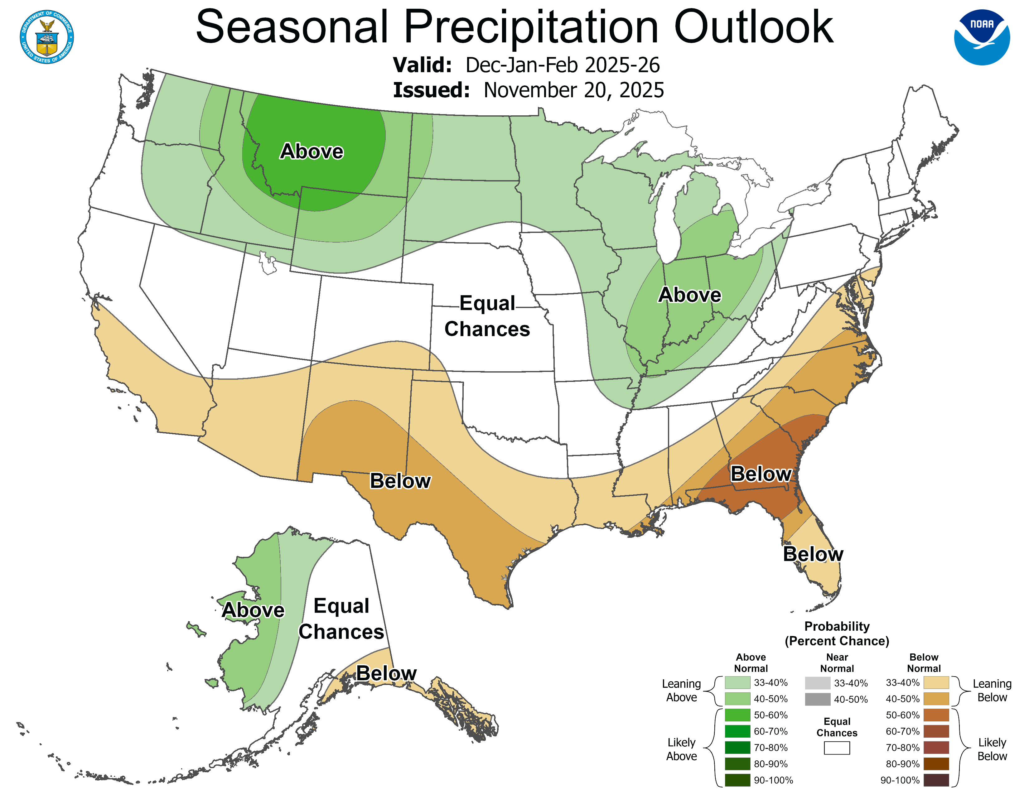
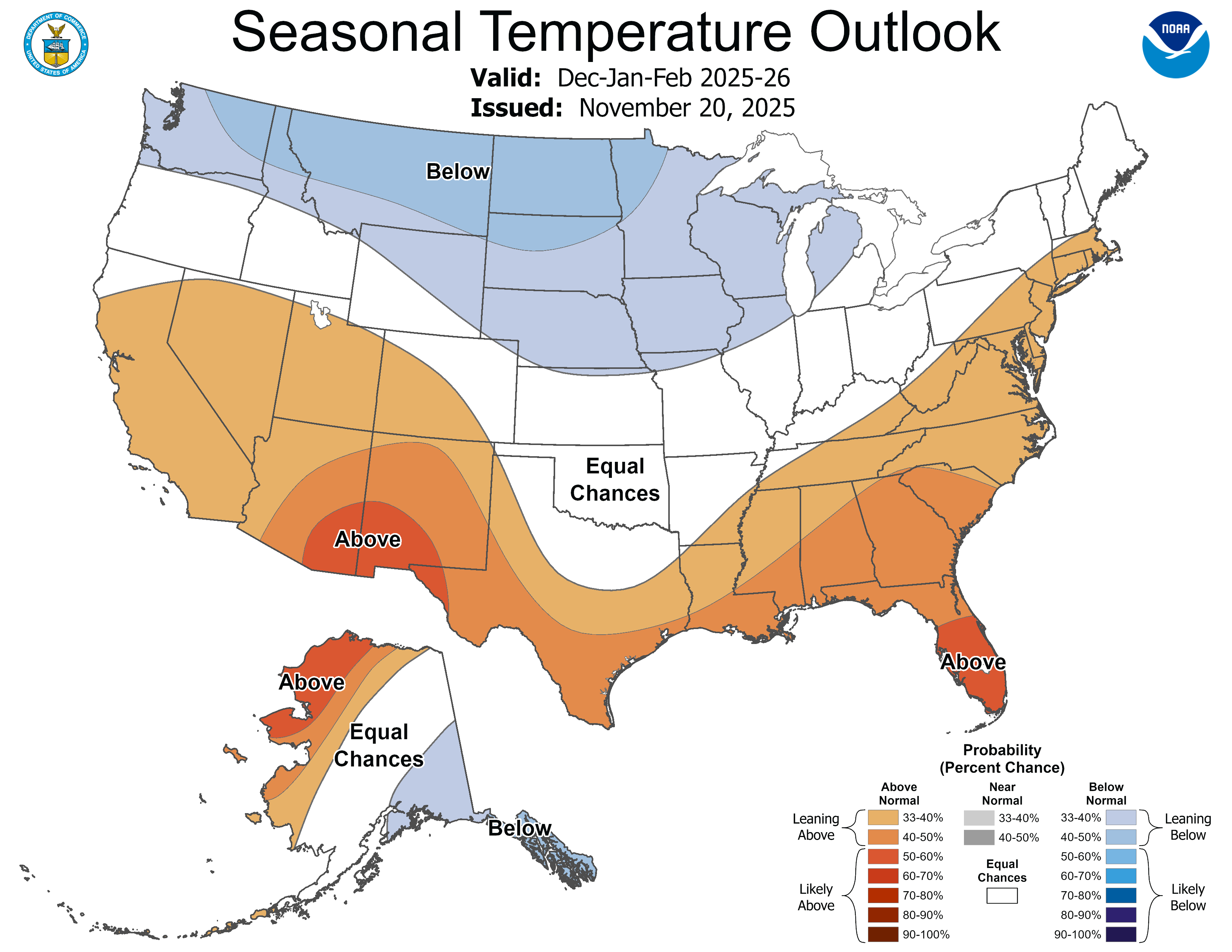
It’s a big ol’ mixed bag, in other words. The big October deluges eased the drought in much of the region, but the warm temperatures and snow drought don’t bode well for next spring’s runoff. Meagre early winter snowpacks can make and have made dramatic comebacks (e.g. water year 2008 in southwestern Colorado), and another storm is moving into the region as I write this, yet the National Weather Service’s is predicting an abnormally warm and dry winter for much of the Southwest.
🌵 Public Lands 🌲
The Grand County commissioners’ “Access and Capacity Enhancement Alternative” plan aimed at increasing visitation at Arches National Park was just the tip of an iceberg, it seems. Yesterday (Dec. 1), Commissioner Brian Martinez presented the plan to a group of state and federal officials at a closed State of Utah and National Park Service Workshop in Salt Lake City.
The meeting’s purpose, according to the official agenda, is:
This may sound fairly innocuous (and maybe it is). But given some of the players, it may also be the latest volley in Utah’s long-running effort to seize control of public lands. The meeting was run by the Interior Department’s associate deputy secretary, Karen Budd-Falen, and Redge Johnson, who leads Utah’s Public Lands Policy Coordinating Office.
Budd-Falen built her legal career on fighting federal agencies, including the Interior Department, and was part of the Sagebrush Rebellion and the Wise Use movements that endeavored to turn federal land over to states and counties and to weaken regulations on the extractive industries. Johnson, meanwhile, was a driving force behind the state’s effort to take control of 18.5 million acres of Bureau of Land Management land in the state.
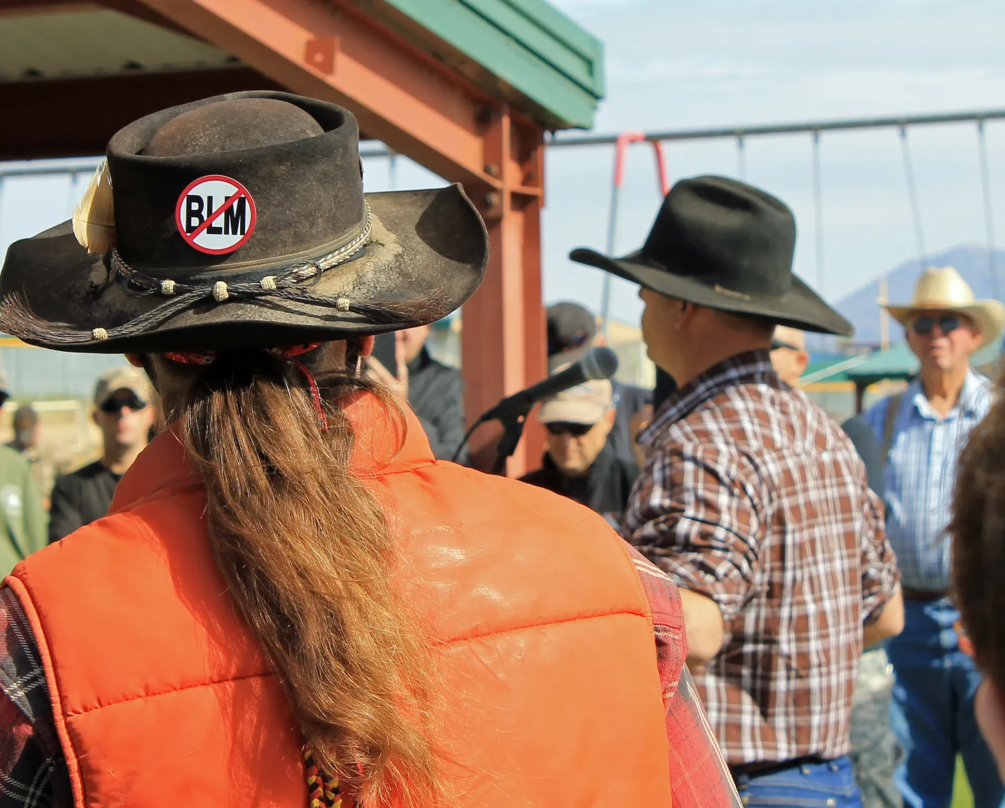
An anti-BLM sticker (referring, presumably, to the federal land agency, not the Black Lives Matter movement) at another Phil Lyman rally against “federal overreach” and motorized travel closures in southeastern Utah back in 2014. Photo credit: Jonathan P. Thompson/The Land Desk
It’s not clear what is meant when they say the meeting is aimed at achieving Trump’s agenda. As far as national parks go, the administration has been rather chaotic: Freezing hiring, laying off thousands of staff (only to rehire some of them), slashing budgets, and allowing visitors to run roughshod over the parks during the government shutdown.
It sure looks like they are trying to cause the parks to fail, which would give them an excuse to further privatize their functions. Private for-profit corporations already run the lodges, campgrounds, and other services inside many parks. That’s why, during the shutdown, concessionaire-run campgrounds within parks continued to operate, while all of the government-run functions, such as entrance-fee-collection, were shuttered. In this way a false contrast was created between the functional privately-run operations and the dysfunctional public ones; visitors during that time would be excused for preferring the former.
The timing of this meeting, purportedly to receive input from gateway communities, is kind of odd. I have to wonder whether the Interior Department consulted local elected officials before raising entry fees for foreign visitors to $100 at Zion and Bryce Canyon National Parks in Utah, along with Grand Canyon, Acadia, Everglades, Glacier, Grand Teton, Rocky Mountain, Sequoia & Kings Canyon, Yellowstone, and Yosemite National Parks.
The Southwest’s tourism industry is highly reliant on international visitors. Visitation from abroad is already down, thanks mostly to the Trump administration’s “America First” creed and its general hostility to the rest of the world. Singling out foreign travelers for these higher fees — even if only at the most popular parks — is likely to dampen visitation from abroad even more, which will ripple through Western economies.
Grand County’s bid to cram even more visitors into Arches National Park won’t be too effective if would be visitors don’t even make it to the United States …
🗺️ Messing with Maps 🧭
This is just another old map that caught my attention, in part because it’s a reminder of how extensive the railroad network was, even in the rugged parts of Colorado, back in the late 1800s and early 1900s. This one shows the Denver & Rio Grande rail lines in 1893.
Republicans are rallying around former New Mexico Rep. Steve Pearce, Trump’s nominee to oversee the land management agency
Conservation groups in Montana and across the West are raising concerns about Steve Pearce, a former New Mexico representative who is President Donald Trump’s newest nominee to lead the Bureau of Land Management.
In Montana and the two Dakotas, the BLM manages more than 8.3 million acres of federal land. Nationwide, the BLM oversees 245 million acres of federal land, along with 700 million acres of subsurface rights for extraction and energy development, putting the position directly in the crosshairs of energy developers and outdoor industry groups.
According to the Center for Western Priorities, Pearce amassed a “lengthy anti-public lands record,” sponsoring bills to shrink national monuments and increase extraction on national forest land.
Many conservation groups are specifically honing in on Pearce’s long record of advocating to sell off federal lands, including sponsoring legislation in Congress to authorize land sales or exchanges with local governments.
In a letter to then-House Speaker John Boehner in 2012, Pearce wrote that of the federal lands located in the West, “most of it we do not even need.”
“We cannot afford to hand the keys to 245 million acres of our public lands over to someone who has spent his career trying to auction them off to the highest bidder,” Aubrey Bertram, staff attorney and federal policy director at Wild Montana, said. “Steve Pearce’s record is crystal clear: he believes public lands should be privatized for billionaires’ benefit, not protected for the people’s.”
But Pearce’s nomination has been greeted with enthusiasm by mining and energy companies that operate on federal land, as well as by many Republican officials, including Montana Sen. Steve Daines.
“I knew Steve in the House days, and Steve is a great pick. And I particularly like the fact that it’s a Westerner,” Daines said in an interview. “I think it’s helpful when we have leaders in those important positions that come from the West, when they understand uniquely the challenges we face as it relates to federal land, state land, private land. And Steve Pearce has lived it and breathed it.”
Daines is a member of the newly formed Senate Stewardship Caucus, which is co-chaired by Montana Sen. Tim Sheehy.
The two Montanans also bucked their party earlier this year by joining Senate Democrats in a resolution that would have prevented the use of public land sales to reduce the deficit.
Representatives for Daines and Sheehy did not respond to questions about Pearce’s nomination.
Sheehy has not publicly stated whether he will support Pearce.
But Montana’s federal delegation has been supportive of increasing coal and energy extraction in the state.
In eastern Montana, Congress recently voted to overturn a Biden-era restriction on resource extraction on federal land, reopening nearly 1.7 million acres to future coal leasing.
All members of the state’s delegation supported the move calling it vital to the state’s economy and the nation’s energy security.
Pearce has roots in the oil and gas industry that stretch beyond his political work.
Starting in 2003, he represented New Mexico in Congress for seven terms.
He lost races for the U.S. Senate in 2008 and governor in 2018.
While conservation and public land advocates have pushed back against Pearce’s nomination, industry groups have applauded Trump’s pick.
The National Cattleman’s Beef Association said Pearce’s experience makes him “thoroughly qualified to lead the BLM and tackle the issues federal lands ranchers are facing.”
The Western Energy Alliance, comprising oil and gas companies across nine western states, also put out a statement of support for Pearce.
“As a westerner coming from a state that’s nearly 20 percent BLM land, he understands the bureau’s mission. As a former congressman and chair of the Congressional Western Caucus, his record shows he’s been a champion of multiple-uses of public lands. Steve has been a longtime friend who understands the value of energy development among other uses,” the Alliance said.
This story was originally produced by Daily Montanan, which is part of States Newsroom, a nonprofit news network which includes Utah News Dispatch, and is supported by grants and a coalition of donors as a 501c(3) public charity.
Click the link to read the article on the Big Pivots website (Allen Best):
December 2, 2025
Changing a name is simple enough, if somewhat expensive and time-consuming, at least in the case of businesses.
But what to make of the National Renewable Energy Laboratory’s new name? Is the change all bad for the laboratory and for its mission of the last 34 years?
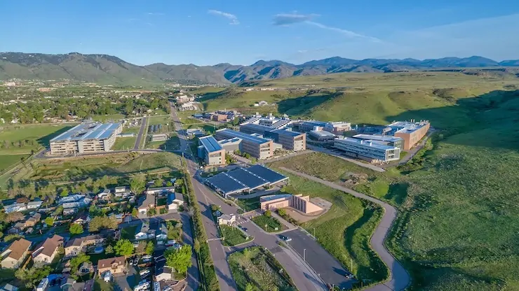
It became National Laboratory of the Rockies as of Monday. It had been known as NREL since 1991 and before that had been the Solar Energy Research Institute since its founding in 1977 during the presidency of Jimmy Carter.
The laboratory has become one of the nation’s — and perhaps the world’s — seminal institutions devoted to engineering an energy transition. As of October, it had 3,717 employees after a reduction of 114 during May.
“Clearly an effort is underway (by President Donald Trump)‚ to downplay renewable energy as a premier, viable energy source in the United States. So it is hard to separate the politics from this given the timing,” said David Renee, who worked at the laboratory from 1991 until his recent retirement.
Renee said that in part he was very disappointed to see the words “renewable energy” deleted from the name but does see the new name allowing the institution to broaden its mission to reflect needs of the ever-more-complex electrical grid.
“I can see some good, long-term benefits from this. It gives the laboratory flexibility to have a broader scope,” he said. “A lot of the work is not exclusively related to renewable energy but more related to grid reliability and expansion, of which renewables play an important part. So one could argue that the name change was overdue anyway in order to be consistent with other national laboratories, which are mostly named for their locations and not the technology.”
The United States has 17 national laboratories engaged in energy and other research, and most are named for their local geographies. New Mexico, for example, has the Sandia and Los Alamos labs, the former named for a mountain range and the latter a town. Renee arrived in Golden from the Pacific Northwest National Laboratory and retired after running the solar resource assessment program.
Ron Larson, one of the earliest employees of the solar institute who arrived in 1977, a time when solar was 100 times more expensive than it is now, also tends toward a charitable view of the name change.
A possible reason, and a valid one, he said, could be that other national labs wanted more to do on renewable energy topics and are qualified to do so. “Too, maybe some at NREL have wanted to expand into other sectors, including fossil fuels and nuclear.”
Peter Lilienthal, an NREL employee from 1990 to 2007, when he formed an energy-related business, was less charitable. He was incensed by a statement from Audrey Robertson, the assistant secretary of energy, in Monday’s announcement.
“The energy crisis we face today is unlike the crisis that gave rise to NREL,” Robertson said. “We are no longer picking and choosing energy sources. Our highest priority is to invest in the scientific capabilities that will restore American manufacturing, drive down costs, and help this country meet its soaring energy demand. The National Lab of the Rockies will play a vital role in those efforts.”
Lilienthal called that statement gaslighting. “That is just not true,” he said of Robertson’s assertion about no longer picking energy sources. He points to the promises of President Donald Trump on the campaign trail and elsewhere to restore fossil fuels and discourage renewable energy. This, he said, will slow the energy transition away from fossil fuels, he believes.
Jud Virden, the director of the renamed laboratory since October, said the new name “embraces a broader applied energy mission entrusted to us by the Department of Energy to deliver a more affordable and secure energy future for all.”
That statement clearly fits in with the narrative of Chris Wright, the Colorado-born director of the Department of Energy. A graduate of Cherry Creek High School, in south Denver, Wright was a rock climber and skier before going to the Massachusetts Institute of Technology to study engineering, first mechanical and then electrical. He also later studied at the University of California at Berkeley.
In April, Wright returned to Colorado to tour NREL. Afterward, he met with reporters, where he said that he had worked on solar energy during graduate school and then geothermal. Only later, needing a paycheck, did he begin work in the oil and gas industry. In Denver, he founded Liberty, an oil and gas field services company, in 2011.
In his remarks, Wright did not dismiss renewable energy, but he did — as he had done before — dismiss “climate alarmism.” He said the science does not support the perception of risk that has, in part, driven the work to make renewable energy affordable and integrated into the electrical grid.
Wright sees the need for more energy being paramount and climate change worries a hindrance to archiving that plentitude that will result in higher standards of living.
“The biggest barrier to energy development the last few decades is people, for political reasons, calling climate change a crisis,” he claimed.
He went on to cite 3 million people dying every year because they don’t have clean cooking fuels or the 4 or 5 million people dying because they don’t have sufficient food as well as the disconnect notices to American consumers for non-payment.
“If you call climate change a crisis and you don’t look at any data, you can pass laws to do anything.
Chris Wright has argued that energy scarcity poses a greater threat to quality of life than climate change. Here, he speaks to reporters in April 2025 while Martin Keller, then the director of NREL, looks on. Photo/Allen Best. Top image/National Laboratory of the Rockies.
In an essay published in The Economist in July, Wright said much the same thing.
Wright also talked about the need to deliver plentiful energy and lowering energy prices. He talked about the drive to integrate artificial intelligence data centers into the U.S. economy.
“Artificial Intelligence is critical. This is a phenomenal new technology. People are seeing the great consumer services it provides, the business efficiencies it provides, and we are very early on.”
And again, he talked about the need to expand electrical production as necessary to support artificial intelligence. Even without strong demand for data centers, he said, electricity prices have been rising.
“We’ve seen 20 to 25% rise in the price of electricity over the last four years. Americans are mad and angry and upset about that, which is why they’re all worried about AI — ‘No, we don’t want new demand on our grid that’s just going to make our prices more expensive.’ — We need to show them we can walk and chew gum at the same time. We’ve got to grow our electricity production capacity without raising the prices to consumers, and we’ve got to keep our grid stable, not just the complicated system stable, but the increasing cyber threats of people that want to do us harm on our grid.”
Chuck Kutscher took a broad view of the change. A mechanical engineer by training, he began working at NREL in the 1980s before retiring in 2018.
“NREL is widely viewed as the leading renewable energy laboratory in the world. In the U.S. and throughout the world, solar and wind dominate the new electricity generation being deployed because they are now the lowest in cost and are also the fastest to deploy, in addition to avoiding air pollution and greenhouse gas emissions. China is clearly the world leader in renewable energy development and deployment, but NREL has played a critical role in keeping the U.S. competitive,” he said in a statement.
“As a Department of Energy lab, NREL takes direction from DOE. The current administration made it clear in the last election that it would support fossil fuels. DOE does have a lab that focuses primarily on fossil fuels, the National Energy Technology Lab, so continuing to have a lab that performs R&D on renewables makes perfect sense, especially given the transition to renewable energy happening around the world. I’m sure the new lab director is working hard to preserve NREL’s tremendous expertise and important work in renewable energy while at the same time being responsive to DOE directives to strengthen the lab’s portfolio in areas such as AI and data centers.”
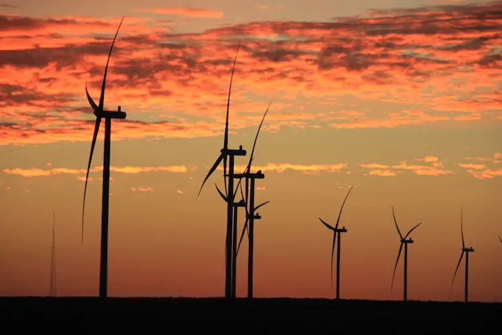
The Crossing Trails Wind Farm between Kit Carson and Seibert, about 150 miles east of Denver, has an installed capacity of 104 megawatts, which goes to Tri-State Generation and Transmission. Photo/Allen Best
The News:The Trump administration last week weighed in on the 53-year battle over what waterways are covered by the 1972 Clean Water Act — with a draft rule that would narrow the definition of “Waters of the United States,” or WOTUS. The rule would effectively remove federal CWA protections from hundreds of arroyos, rivers, and ephemeral streams in the Southwest, giving developers industries more latitude to alter or pollute those waterways. The public has until Jan. 5 to submit comments.
The Context: For years, the Environmental Protection Agency and Army Corps of Engineers—the agencies charged with enforcing the CWA—considered WOTUS to include everything from arroyos to prairie potholes to sloughs to mudflats, so long as the destruction or degradation thereof might ultimately affect traditionally navigable waters or interstate commerce (which could include recreation, sightseeing, or wildlife watching). It was a broad definition that gave the agencies latitude to “restore and maintain the chemical, physical, and biological integrity of the Nation’s waters,” as Congress mandated when creating the law in 1972.
Developers and property rights ideologues pushed back on this definition, saying it was too broad and therefore gave the feds too much power to curb pollution or restrict development. The issue ended up in the courts and, ultimately, to the U.S. Supreme Court.
The waters were muddied, so to speak, by the 2006 Supreme Court split decision on the Rapanos case. The late Justice Antonin Scalia wrote what would become the right-wing’s preferred definition of waters of the U.S. He argued that they should include only “relatively permanent, standing or continuously flowing bodies of water … described in ordinary parlance as streams[,] … oceans, rivers, [and] lakes.” Scalia’s definition emphatically excluded “ephemeral streams” and “dry arroyos in the middle of the desert.” Justice Anthony Kennedy disputed Scalia, saying instead the CWA should extend to any stream or body of water with a “significant nexus” to navigable waters, determined by a wetland’s or waterway’s status as an “integral part of the aquatic environment.”
Then, in 2023, in its ruling on the Sackett case, the SCOTUS majority deferred to Scalia’s Rapanos definition, writing: “… we conclude that the Rapanos plurality was correct: the CWA’s use of ‘waters’ encompasses ‘only those relatively permanent, standing or continuously flowing bodies of water forming geographical features that are described in ordinary parlance as streams oceans, rivers and lakes.’”
It’s up to the relevant agencies to translate these rulings into actual rules, often adding their own ideological twists. The W. Bush, Obama, and Trump I administrations issued their own post-Rapanos definitions of WOTUS, Biden weighed in post-Sackett, now Trump II is submitting its own set of industry-friendly, deregulatory definitions.
The EPA’s proposed definition of ‘‘waters of the United States’’ would include:
“Relatively permanent,” under the new rule, would mean
And then there’s this weird and vague, yet critical, term, “wet season,” which the rule defines as:
Sometimes you have to wonder whether the bureaucrats who come up with these things have ever even been to the Western U.S., particularly the arid Southwest.
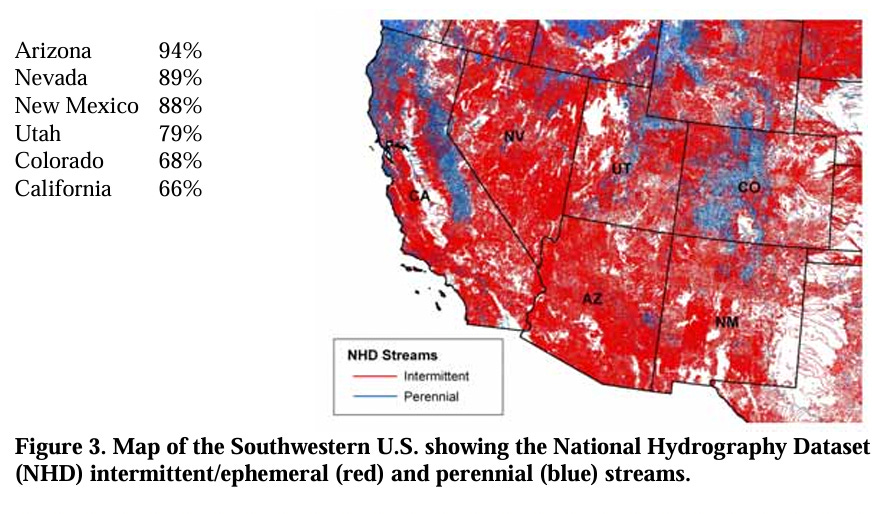
The “relatively permanent” requirement clearly excludes thousands of arroyos, ephemeral streams, washes, gullies, and even rios and rivers — from the Santa Cruz to the Rillito to the Santa Fe to the Puerco and the Dirty Devil — from CWA jurisdiction. Indeed, it leaves huge swaths of the Southwest without Clean Water Act protections, and at the mercy of respective states or counties. A 2008 EPA study estimates that ephemeral and intermittent streams make up 59% of all of the waterways in the U.S. (excluding Alaska) and over 81% in the arid and semi-arid Southwest (AZ, NM, UT, CO, CA).
Source: U.S. EPA.
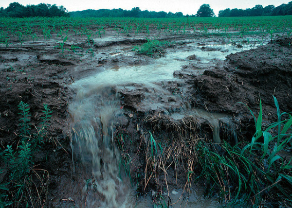
The ecological benefits of ephemeral streams are obvious to any Western wanderer who happens to venture down a seemingly dry and barren arroyo bed, where they may find cool air, the smell of water even on the hottest day, tiny tracks of animals seeking sanctuary from the sun, the lascivous bloom of a datura, and cottonwoods and even willows miles and miles away from any “relatively permanent” water source. And if that’s not enough, then consider that peer-reviewed research has found that these same ephemeral streams are major contributors to the water quantity and quality of the entire river drainage network of which they are a part.
Ephemeral streams are streams that do not always flow. They are above the groundwater reservoir and appear after precipitation in the area. Via Socratic.org
A 2024 study by Craig Brinkerhoff et al concludes: “This ephemeral influence directly implicates downstream water quality standards: Excluding ephemeral streams from coverage under the CWA would substantially narrow the extent of federal authority to regulate water quality in the United States.”
While the administration was looking to provide “clarity,” the “wet season” provision does exactly the opposite, especially when one tries to apply it to the desert Southwest. If southern Arizona has a wet season, wouldn’t it be the days and weeks of the late summer monsoon? Many arroyos do run continuously during a good monsoon season, even if it is only for two or three weeks. So would that put them back under CWA jurisdiction?
How these proposed changes would play out on the ground is a bit of a puzzle — especially given the “wet season” ambiguity. But what is clear is that developers of big housing projects in the desert outside Phoenix or Las Vegas or Tucson, for example, would be allowed to fill in or build roads through arroyos and washes without obtaining a federal CWA permit from the Army Corps of Engineers. That would leave it to the state and county to implement their own, similar, permitting systems if they chose to do so.
As one might expect, the energy industry, developers, ranchers, and farmers generally support the changes, since it will eliminate some of the red tape that tangles up and delays projects.
“For U.S. oil and natural gas operators, this is a game-changer,” wrote the head of a Texas petroleum industry group in the Odessa American. “Picture the Permian Basin or Bakken Formation: vast swaths dotted with intermittent draws and playas that previous rules treated like sacred rivers, triggering Section 404 permits under the U.S. Army Corps that could drag on for years and cost millions in mitigation. Now, with ephemeral features sidelined and groundwater off-limits, operators can overcome those hurdles for well pads, access roads, and seismic surveys.”
If you live in the West, you probably live near at least one of the ephemeral streams that would lose federal protections under these new definitions. You might want to go walk up it sometime soon before it goes away.
In the meantime, you have until Jan. 5 to send your comments, identified by Docket ID No. EPA–HQ– OW–2025–0322, by any of the following methods:
Federal eRulemaking Portal: https://www.regulations.gov/ (our preferred method). Follow the online instructions for submitting comments.
Email: OW-Docket@epa.gov. Include Docket ID No. EPA–HQ–OW– 2025–0322 in the subject line of the message.
Mail: U.S. Environmental Protection Agency, EPA Docket Center, Water Docket, Mail Code 28221T, 1200 Pennsylvania Avenue NW, Washington, DC 20460.
Read more about the Clean Water Act, WOTUS, and the value of ephemeral waterways here (but remember, you gotta become a paid subscriber to bust through the paywall!)
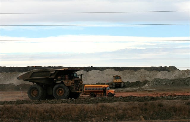
Scene from a huge coal mine in the Powder River Basin. Jonathan P. Thompson photo.
🌵 Public Lands 🌲
Congressional Republicans have apparently decided that the best way to turn over public lands to the extractive industries is to do away with the plans guiding management of those lands. Earlier this year, Congress revoked three Bureau of Land Management resource management plans in Montana, North Dakota, and Alaska. Now, they’ve done the same for the RMP for the BLM’s Buffalo Field Office in Wyoming, which covers a good portion of the coal-rich Powder River Basin.
These mark the first times ever that the Congressional Review Act, which is intended to give Congress the power to review and possibly revoke recently implemented administrative rules, has been used in this manner. That’s in part because RMPs have not been considered “rules” in the past, meaning they are not subject to congressional review.
Resource Management Plans provide a framework for managing large swaths of land and authorize the BLM to permit mining, drilling, grazing, and other activities. They endeavor to balance the agency’s multiple-use mandate with environmental protections, guiding resource extraction and development away from sensitive areas and toward more appropriate ones, for example. They can take years to develop, and incorporate science, legal considerations, court orders, tribal consultation, and input from local officials and the general public.
And then, with just a few hours of debate and no opportunity for public input, Congress can toss the whole thing into the can.
In this case, the main target was a provision of the Biden-era RMP that halted new coal leasing on that swath of public land. While the moratorium was celebrated by environmentalists and panned by fossil fuel lovers when it was implemented late last year, it was largely symbolic, since existing leases contain enough coal to meet demand at least until 2040. So revoking the ban similarly won’t lead to any new mining anytime soon, nor are resulting lease sales likely to fetch much industry interest or acceptable bids.
But in their haste to scrap the ban, Congress also may have taken away the BLM’s power to issue new leases altogether — not just for coal, but for oil and gas drilling, grazing, or any other use. And not just for the Buffalo Field Office, either. This is a bit wonky, but basically it goes like this:
By applying the CRA to RMPs, Congress is saying that RMPs are “rules.”
According to the CRA, rules must be submitted to Congress before they can take effect.
No RMP that has been implemented since 1996 has been submitted to Congress.
Therefore, no post-1996 RMP has legally taken effect, making it invalid.
The Federal Land Policy Management Act says the BLM can only issue permits, leases, rights of way, and other authorizations “in accordance with” a valid land use plan, or RMP.
Therefore all permits, leases, ROWs, and other authorizations issued under post-1996 RMPs — including over 5,000 oil and gas leases, and hundreds more coming up for auction in the near future — are invalid.
This summer, 31 law professors and public land experts called on Congress to refrain from using the CRA to revoke RMPs. “The resulting uncertainty could trigger an endless cycle of litigation,” they wrote, “effectively freezing the ability of the BLM and other agencies to manage public lands for years, if not decades to come.”
Just last week, a group of conservation organization legal analysts expanded on the potential for chaos, and called on the BLM to pause new leasing and address the “potential legal deficiencies” of oil and gas leases covering some 4 million acres that were issued under now potentially invalid RMPs. The agency should not issue drilling permits for those leases, the analysts wrote, and it should consider canceling the leases.
Somehow, I don’t think the BLM under the current administration is going to follow that suggestion. Given its track record, it seems more likely that the agency will see the sudden lack of valid RMPs as an open gate through which it can ferry its pro-extractive agenda. This one is almost sure to end up in court.
🦫 Wildlife Watch 🦅
The Trump administration is proposing new regulations that would dial back Endangered Species Act protections and weaken the landmark law to “strengthen American energy independence,” according to an Interior Department news release.
The new rules would:
Make it more difficult for the U.S. Fish & Wildlife Service to designate critical habitat in areas that are not currently occupied by an endangered species — likely because they were extirpated from the area — but that are essential for the conservation of that species. This would make recovering an endangered species that much more difficult.
Remove a rule that extends ESA protections to species that are listed as “threatened,” which is one step away from “endangered.” This would potentially remove protections for species such as the marbled murrelet, vernal pool fairy shrimp, western snowy plover, Gunnison sage grouse, northern sea otter, and many others.
Direct agencies to give economic impacts greater weight when deciding whether to extend ESA protections to a species. This could have potentially pushed the feds to, say, back off on listing the Tiehm’s buckwheat under the ESA, because doing so would potentially restrict or nix a proposed lithium mine in its only known habitat.
Make it more difficult for the U.S. Fish & Wildlife Service to designate critical habitat in areas that are not currently occupied by an endangered species — likely because they were extirpated from the area — but that are essential for the conservation of that species. This would make recovering an endangered species that much more difficult.
Remove a rule that extends ESA protections to species that are listed as “threatened,” which is one step away from “endangered.” This would potentially remove protections for species such as the marbled murrelet, vernal pool fairy shrimp, western snowy plover, Gunnison sage grouse, northern sea otter, and many others.
Direct agencies to give economic impacts greater weight when deciding whether to extend ESA protections to a species. This could have potentially pushed the feds to, say, back off on listing the Tiehm’s buckwheat under the ESA, because doing so would potentially restrict or nix a proposed lithium mine in its only known habitat.
“This plan hacks apart the Endangered Species Act and creates a blueprint for the extinction for some of America’s most beloved wildlife,” said Stephanie Kurose, deputy director of government affairs at the Center for Biological Diversity, in a written statement.
📸 Parting Shot 🎞️
Raven and the red, white, and blue. Digital Painting by Jonathan P. Thompson.
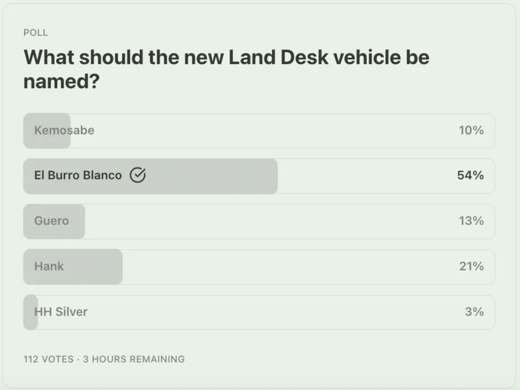
And, finally, the Land Desk readers have spoken, and they have chosen El Burro Blanco as the name for the new Land Desk dispatch-mobile, with Hank coming in a distant second.
I promised a while back to take a closer look at the U.S. Department of Agriculture’s plan to “Fortify the American Beef Industry.” I did, and my conclusion is that it’s a bunch of bunk. Okay, maybe not all of it: There are some parts about enforcing “Product of USA” labeling, and about supporting small processors by reducing overtime and holiday inspection fees and so forth that could be helpful to your friendly, local meat processor.
Curiously, however, the plan’s main emphasis is on grazing on both Forest Service and Bureau of Land Management public lands, even though this makes up only a tiny portion of the U.S. beef industry. It’s almost as if the plan was driven by an ideological agenda rather than a practical one. Oh, and look at that: The Public Lands Council is taking credit for essentially formulating the grazing section of the plan! (h/t to Western Watersheds Project)
The plan will “streamline and expand grazing on federal lands, elevate grazing as an administration priority, and provide direct relief and support to American ranchers.” The plan endeavors to return livestock to vacant grazing allotments and promises to ensure that the number of livestock grazing on public lands remains steady or increases. The plan also aims to diminish protections for wild predators — including endangered ones — and make it easier for ranchers to collect taxpayer subsidies when a wolf or bear is suspected of killing their cattle.
It’s difficult to imagine how public lands grazing can be made any easier. After all, the feds have charged a measly $1.35 per month for a cow-calf pair to graze on the public’s forage for years, which is the congressionally mandated minimum. And while the “Bureau of Livestock and Mining” might go back and forth on the “mining” part of the monicker, it has retained its livestock-friendly reputation through every administration, Republican or Democratic. The agency regularly bends over backwards to accommodate livestock operations, and it often has been unable or unwilling to remove livestock from cattle-trampled lands to allow them to recover — even in “protected” areas such as national monuments.
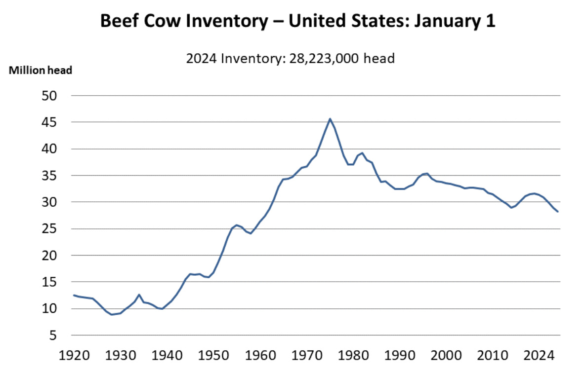
The administration is hoping to fill up the estimated 24 million acres of vacant grazing allotments and to bolster the number of cattle grazing on public lands, but it’s not clear how that would happen. It’s not like active allotments are bursting at the seams with too many cattle: In many cases, ranchers run far fewer cattle than authorized simply because they have fewer cattle to graze and because the industry is putting more cattle on feed. U.S. beef cattle inventories have declined by more than 30% since the 1970s (along with per capita consumption), but the number of beef cows in feedlots has ballooned.
Source: USDA National Agricultural Statistics Service.
Allotments may be vacant not because the BLM or Forest Service cancelled the lease, but because the forage is of marginal quality, due to drought or overgrazing or just not great grass growing conditions, or a conservation group bought out the lease from a willing seller.
Even if the plan did increase the number of cattle on public lands, it wouldn’t make a big difference to the industry as a whole, because public lands provide less than 2% of all of the forage consumed by the nation’s 27.9 million head of beef cattle.
Sending more cattle out into desert lands to eat what’s left of the native grasses and trample more sensitive places isn’t going to “fortify” the American beef industry. It will merely perpetuate the age-old and culturally embedded practice of giving grazing incredible leeway on public lands, while benefitting only a handful of chosen livestock operators.
I’m not an absolutist on the issue; I don’t believe that all public lands grazing should be outlawed. But it should be limited to appropriate places and at appropriate levels, and should be halted before it wrecks a particular landscape. Plus, ranchers should pay a reasonable amount for the thousands of pounds of taxpayers’ forage their cattle consume each month, along with a bit extra for the externalities, with which public lands grazing is rife. This sensible type of management simply is not occurring presently, as can be witnessed on just about any tract of active BLM “rangeland” in the Four Corners Country, where fragile desert streambeds are being sullied and valuable cryptobiotic crusts decimated by herds of thousand-pound beasts.
Jonathan P. Thompson photo.
***
If the administration was really interested in helping these ranchers, it would support a “just transition” away from public lands grazing, which is on the decline despite the government’s efforts to prop it up. That would include backing the Voluntary Grazing Permit Retirement Act, which was recently reintroduced in Congress by Rep. Adam Smith, a Washington Democrat.
The legislation would allow conservation groups to buy out federal grazing allotments from willing ranchers and livestock operators, after which the BLM or USFS would permanently retire the allotment.
While private entities can and do buy out leases currently, there is no guarantee that the leases will remain cattle-free, which is what would allow the administration to re-cow some of those vacant leases mentioned above. The proposed legislation would fix that, making the retirement permanent. The resulting certainty would encourage conservation groups to invest more in the buyouts, which would benefit the ranchers, who may be looking to get out of the business or out of a specific grazing allotment.
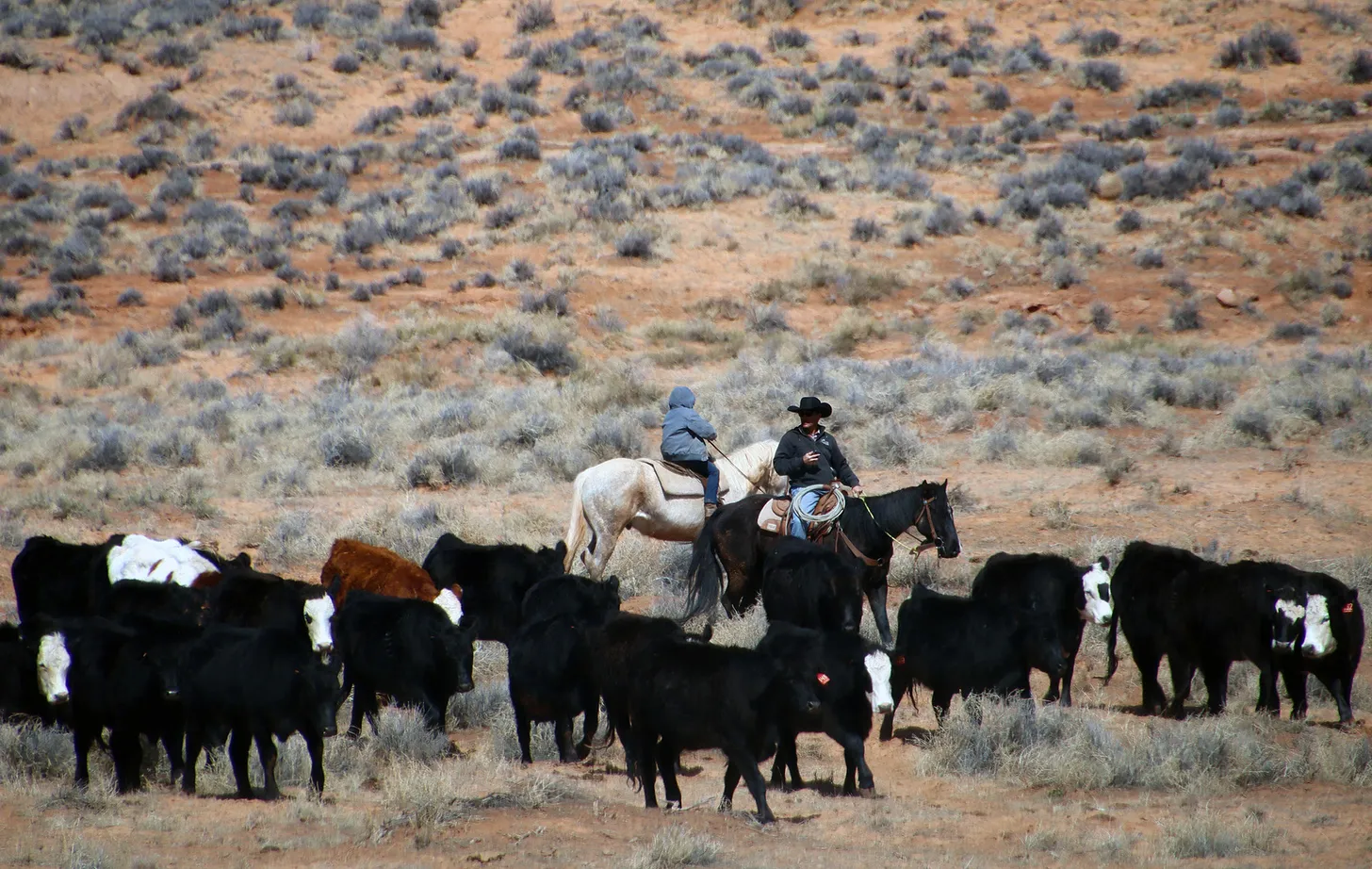
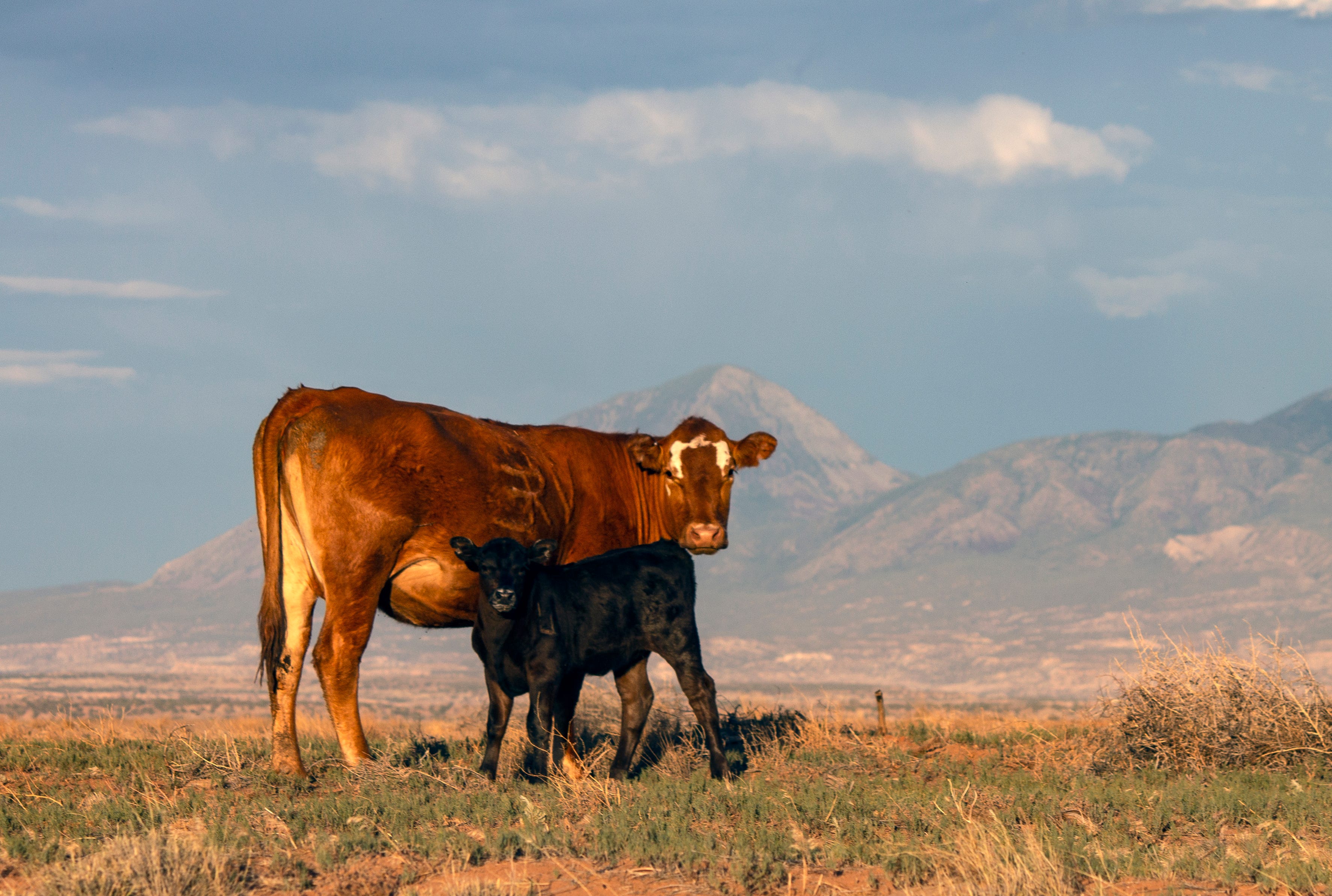
A cow in the desert. Jonathan P. Thompson photo
🤖 Data Center Watch 👾
Certain aspects of the film Eddington just keep jumping off the screen into real life. The movie, if you haven’t seen it, is about a small town in southern New Mexico where a gargantuan tech firm, SolidGoldMagiKarp, has chosen to site a data center during the height of the COVID epidemic. There’s also a conflict between a mask-denying sheriff and a slightly more high-falutin’, charismatic mayor (who supports the data center and its purported economic benefits). A lot of drama ensues — most of it not directly related to the data center — which leads into a bloody, over-the-top machine-gun battle, which, it turns out, does have ties to the data center (which ultimately gets built, because: big money).
So far data centers haven’t provoked warfare of the kind in the movie. But they are spurring a lot of conflict in the desert over their potential water and power use. There’s Project Blue in southern Arizona, which promises to add enough electricity from renewable sources to Tucson Electric Power’s grid to offset its projected enormous power use, but a lack of specifics invites skepticism. Project Jupiter, the gargantuan data center campus planned for Santa Teresa, New Mexico, says it will generate its own power, but hasn’t specified how — except that it’s not likely to use nuclear reactors because they couldn’t come online quickly enough.
Now there’s another proposal, this one for New Mexico’s Permian Basin. New Era Energy & Digital wants to build a hyperscale, AI-processing data center complex in Lea County. It, too, will build dedicated generation: A whopping 2,000 megawatts of capacity from gas, and 5,000 MW from nuclear, according to a Power magazine report. That’s an insanely huge amount of electricity. Palo Verde nuclear plant near Phoenix has a nameplate capacity of 3,937 MW and Diablo Canyon in California has 2,236 MW of capacity.
Take a moment to digest that: This proposed data center would gobble up more electricity than two of the West’s largest power plants combined could generate, which is enough to power some 2 million homes. These numbers are terrifying, but they also strain belief and reinforce the suspicion that the AI-data center boom is actually just a hype-inflated bubble that’s poised to burst before most of these facilities are ever built.
If New Era does advance its plan, it’s likely to encounter resistance (along with support) of the kind that could spark some cinematic conflict. A natural gas plant of that size could burn methane from oil wells that might otherwise have been flared off, but it will also emit carbon dioxide and other pollutants. And the nuclear reactors will produce radioactive waste, which likely would be stored onsite, something that even those accustomed to oilfield pollution might not be too enthusiastic about.
Meanwhile, the firm’s only disclosure about potential water use for cooling is that it chose the location in part for its “abundant water supply,” which is odd given the fact that the Ogallala aquifer on which the region depends is being depleted rapidly. The only kind of water that’s abundant in those parts is produced water, the briny, contaminated liquid waste that comes up from oil wells at a rate of at least four barrels of water to each barrel of oil.
⛏️ Mining Monitor ⛏️
Anfield Resources went ahead and broke ground on its Velvet-Wood uranium mine in the Lisbon Valley in southeastern Utah last week, and claims it will be producing ore by the middle of next year. That’s despite the fact the firm has yet to submit its plans for a water treatment plant to state regulators. Also, the state has not approved Anfield’s proposed reopening of its Shootaring mill near Ticaboo, Utah, which is where the ore would be processed. Anfield officials told the Moab Times-Independent that they are unlikely to send ore to the White Mesa Mill near Blanding.
***
Atomic Minerals says it has received Bureau of Land Management approval to drill more exploratory holes at its Harts Point Uranium Project just outside Bears Ears National Monument and adjacent to the Indian Creek climbing area and the Needles District of Canyonlands National Park. The new drill holes will be just over two miles from the Dugout Ranch and Canyonlands Research Center.
***
The Trump administration has added 10 new minerals to the U.S. Geological Survey’s critical minerals list, including copper, potash, and uranium. This doesn’t automatically mean a whole lot, but it will potentially give federal and state agencies and regulators yet another reason to fast-track mining proposals.
🗺️ Messing with Maps 🧭
One of the reasons I like looking at old maps and including them in these dispatches is that they provide a snapshot of how people, or at least the mapmakers, saw the region. Usually I put maps here that are at least a century old, simply because the changes they reveal are so dramatic.
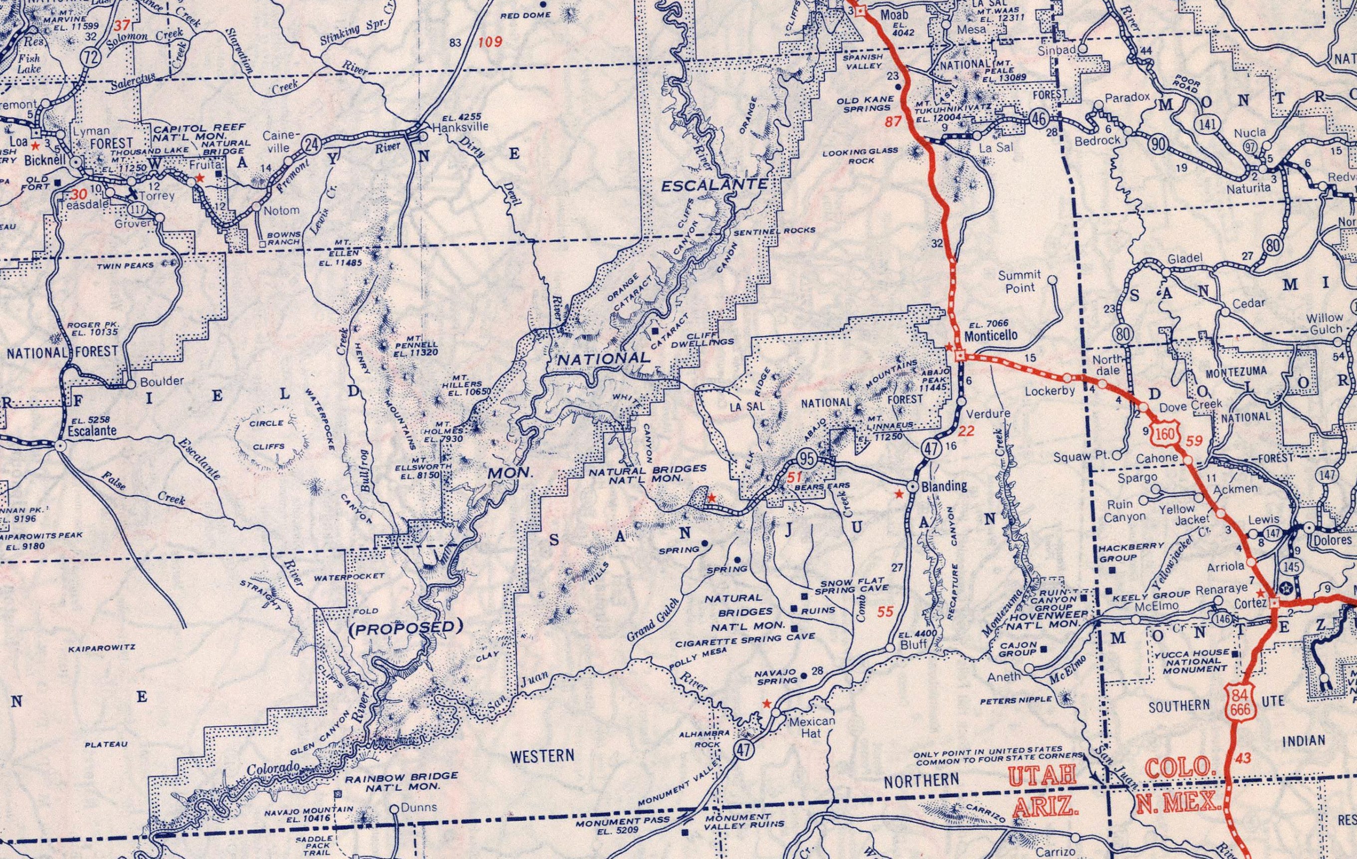
When someone posted this 1940 Rand McNally map of Utah on Facebook the other day, the most remarkable thing at first glance was that it included the proposed Escalante National Monument (which is why they posted it). But as I looked more closely, I realized that this map was made just as the West was about to go through a major transformation. Over the ensuing few decades the population of the region would explode as the post-war migration and uranium, coal mining, oil and gas, power plant building, and dam building booms swept across the West.
Roads were built, small communities virtually vanished, and the landscapes and cultures were altered — along with the maps. These outtakes from the old map gives a glimpse of what the place was. For best viewing, click on the image and it will take you to the website. Click again and it should show you a larger version.
On the top outtake, notice the proposed Escalante National Monument, which would have stretched from Moab down to what is now Page, Arizona. By this time the proposal had been whittled down from the original concept, which also would have included much of what is now Bears Ears and Grand Staircase-Escalante National Monuments and Canyonlands and Capitol Reef National Parks. Also note what is absent. The town of Page didn’t yet exist, because it was created to house workers building Glen Canyon Dam (construction began in 1956). Highway 95 followed a different route over Comb Ridge and ended at Natural Bridges NM. And the Moki Dugway road wouldn’t be built until the 1950s.
In western Colorado, especially, there were a lot of communities (probably very small, but big enough to include on a map) that no longer exist, including: Renaraye, McElmo, Ruin Canyon, Spargo, Ackmen, and Gladel. Ackmen basically relocated to Pleasant View after highway 666 (now 491) bypassed the older town; and Gladel is now Slick Rock. Egnar, meanwhile, does not appear on the map.
On the bottom map, note that I-15 didn’t yet exist, and the major artery through southwestern Utah, Hwy 91, bypassed the Virgin River Gorge south of St. George. I have to say, I really wish they hadn’t built an interstate through that lovely canyon. Also notable: Hildale, Utah/Colorado City, Arizona was simply Short Creek back then, and was on the Arizona side of the line (possibly where “Old Colorado City” is now?).
Because of the government shutdown, the Bureau of Reclamation cancels a high-volume water release from Glen Canyon Dam meant to rebuild Colorado River beaches.
Department of Energy research lab announces a funding opportunity to develop cheaper wastewater treatment for coal power plants.
Economic disaster declaration approved for an Illinois county where a harmful algal bloom in July resulted in a ‘do not drink’ water advisory.
The Bureau of Land Management is scheduled this week to publish a final environmental impact statement for a proposed groundwater pipeline in Utah.
Hydropower generation at federal dams in the western states was below average in fiscal year 2025.
And lastly, House Democrats from Illinois ask the EPA to release lead pipe replacement funds.
“Using federal funds as leverage against communities based on political considerations represents a dangerous abuse of power that undermines public trust and puts lives at risk. The longer we wait, the higher the long-term health, educational, and economic costs will climb, with costs being borne disproportionately by low-income and marginalized communities who have the least political power to demand faster action.” – Letter from seven Illinois representatives to Lee Zeldin, the EPA administrator, asking him to release federal funds for lead pipe replacements.
By the Numbers
River Mile 46.5: Estimated location, as of November 14, of the leading edge of the saltwater “wedge” in the Mississippi River in southern Louisiana. The wedge – salt water that pushed upriver due to weak water flow – has retreated 10 miles in the last three weeks.
88: Percent of average hydropower generation at federal dams overseen by the Western Area Power Administration in fiscal year 2025.
November 2012 High Flow Experiment via Protect the Flows
News Briefs
Glen Canyon Dam High-Flow Release Canceled Due to the government shutdown, the Bureau of Reclamation canceled a planned high-volume release of water from Glen Canyon Dam.
“This decision is based on the current lapse in appropriations, which has created uncertainty concerning necessary resources,” said Wayne Pullan, director of the Upper Colorado Basin Region, in a letter dated October 31.
High-flow releases are typically carried out when downstream sediment conditions are ripe for rebuilding Colorado River beaches. The last such release was in April 2023.
Pullan said that conditions in spring 2026 will probably be conducive to a high-flow release.
Illinois Harmful Algal Bloom The Small Business Administration approved an economic disaster declaration for Coles County, Illinois, for a harmful algal bloom in July that resulted in residents being told not to drink their tap water.
The disaster declaration allows small businesses that were hurt by the do-not-drink order to receive low-interest loans. Small businesses in six contiguous counties are also eligible.
Microcystin, a neurotoxin produced by the algae, was found in the treated water above safety limits in the town of Mattoon. The town issued two do-not-drink orders in a week. Businesses closed and residents bought bottled water.
Mattoon’s water comes from Lake Paradise, the source of the algae.
Studies and Reports
Keeping Coal Going The National Energy Technology Laboratory, a Department of Energy research arm, is offering $50 million in federal funding for projects to develop wastewater treatment systems for coal power plants.
It is the largest part of a $100 million funding announcement intended to improve the “efficiency, effectiveness, costs, emissions reductions, and environmental performance of coal and natural gas use.”
For wastewater treatment, the goal is to reduce discharges and generate useful, money-making byproducts.
Applications are due January 7, 2026.
On the Radar
Senate Hearings On November 19, the Senate Committee on Environment and Public Works will hold a hearing on PFAS cleanup and disposal.
Also that day, the Senate Energy and Natural Resources Committee will discuss BLM land use planning.
Utah Rivers map via Geology.com
Utah Groundwater Supply Pipeline The BLM is due to release an environmental impact statement on November 21 for the Pine Valley Water Supply Project, a scheme to pump groundwater in southwest Utah’s Beaver County and move it to neighboring Iron County for municipal supply and irrigation water.
Proposed by the Central Iron County Water Conservancy District, the project includes 15 wells to supply 15,000 acre-feet of groundwater per year, 70 miles of pipeline, and a 200-acre solar field.
Federal Water Tap is a weekly digest spotting trends in U.S. government water policy. To get more water news, follow Circle of Blue on Twitter and sign up for our newsletter.
Rebecca Mitchell, John Entsminger, Estevan Lopez, Gene Shawcroft, JB Hamby, Tom Buschatzke at the Getches-Wilkinson Center/Water and Tribes Initiative Conference June 6, 2024. Photo credit: Rebecca Mitchell
Click the link to read the article on the Deseret News website (Carter Williams). Here’s an excerpt:
November 12, 2025
Utah and the six other Colorado River states reached a tentative agreement to continue working together on a plan to share the river’s water, but failed to secure a consensus plan ahead of an important Tuesday deadline. Utah, Arizona, California, Colorado, Nevada, New Mexico and Wyoming, all of which rely on the river for water, agreed to continue to meet until they have a “framework solution” by mid-February 2026, said Gene Shawcroft, chairman of the Colorado River Authority of Utah.
“We were able to have enough of a framework put together that the federal government agrees with us that the framework can be continued to be refined in order for us to have a deal by the middle of February,” he told reporters in a negotiations update briefing on Wednesday…
The basin states have had agreements in place on how Colorado River water has been allocated for over a century, and the post-2026 plan seeks to be the largest operational update since a 2007 plan to address how water is stored and pulled from Lake Powell and Lake Mead, the nation’s two largest reservoirs. Its users agree that prolonged drought and low reservoir conditions remain persistent challenges facing the river, but there’s still division on how to handle the discrepancy between water needs and what’s available in the system within one of the fastest-growing regions of the country. Lower Basin states have called for mandatory reductions during dry years. In a public letter to Interior Secretary Doug Burgum on Tuesday, Arizona Gov. Katie Hobbs and other Arizona leaders called it “alarming” that Upper Basin states, including Utah, “have repeatedly refused to implement any volume of binding, verifiable water supply reductions.”
[…]
Upper Basin states don’t believe those types of cuts are necessary because they use less water than Lower Basin states, largely because of how water rights are allocated, favoring senior rights holders like California, Shawcroft said. These are the types of arguments still holding up a long-term deal.
“The major sticking point is there’s a whole lot less water in the system than we anticipated, or there’s historically been,” he said. “The question is, how do you divide a pie that’s significantly smaller than it has been, when everyone’s used to getting that big piece of the pie?”
The Colorado River Compact divided the basin into an upper and lower half, with each having the right to develop and use 7.5 million acre-feet of river water annually. (Source: U.S. Geological Survey via The Water Education Foundation)
There’s still no plan for how the seven states that use water from the Colorado River will allocate the scarce resource after 2026. Tuesday, November 11, marked a deadline set by the federal government for the states to share a framework for new operating guidelines—another deadline that’s come and gone with no agreement. The river’s supply has drastically decreased since the original Colorado River Compactwas signed in 1922, due to climate change and overallocation of water. In 2007, the states agreed to interim operating guidelines, but those expire in 2026. Because Lake Powell and Lake Mead, the basin’s two biggest reservoirs, are federal projects managed by federal agencies, those agencies will need to do an environmental review and public comment period, as required by law. The federal government needs input from the states in a timely fashion to complete the review and public comment process, in order to have new rules in place by October 2026. On Tuesday night, the seven states, along with the Department of Interior and Bureau of Reclamation, issued a statement on the negotiations…
“A supply-based proposal is the only way to move forward,” [Becky Mitchell] told attendees at the Colorado River District’s Across Divides conference on October 3. “We all have to be responding to supply.”
That means that the new guidelines should be based on actual streamflows, rather than demand from water users.
“We need to set aside building an operations plan that meets the needs as they are currently,” she said. “We need to let go of that dream and be able to figure out how to respond, and I think that’s been a bit of a struggle.”
Udall/Overpeck 4-panel Figure Colorado River temperature/precipitation/natural flows with trend. Lake Mead and Lake Powell storage. Updated through Water Year 2025. Note the tiny points on the annual data so that you can flyspeck the individual years. Credit: Brad Udall
Water managers from the seven states that share the Colorado River have blown a deadline given to them by the federal government to come up with a rough plan on how the drought-stricken river will be shared in the future.
The Upper Basin (Colorado, New Mexico, Utah and Wyoming) still cannot find agreement with the Lower Basin (California, Arizona and Nevada) about how the nation’s two largest reservoirs — Lake Powell and Lake Mead — will be operated and how cuts will be shared in dry years.
In June, Scott Cameron, the U.S. Bureau of Reclamation’s acting assistant secretary for water and science, said federal officials would need to know the broad outlines of a plan from the states by Nov. 11. Despite frequent meetings in recent months, negotiators were unable to hammer out a deal by Tuesday, leaving future management for the water supply for 40 million people in the Southwest cloaked in uncertainty.
Instead, the states, the Interior Department and the federal Bureau of Reclamation released a short joint statement Tuesday afternoon, noting that serious and ongoing challenges face the Colorado River.
“While more work needs to be done, collective progress has been made that warrants continued efforts to define and approve details for a finalized agreement,” the statement reads. “Through continued cooperation and coordinated action, there is a shared commitment to ensuring the long-term sustainability and resilience of the Colorado River system.”
Wahweap Marina at Lake Powell when water levels were at near-historic lows in 2021. The seven states and the federal government must figure out how to share the Colorado River after the current guidelines expire in 2026. CREDIT: HEATHER SACKETT/ASPEN JOURNALISM
Environmental groups disappointed
The failure to come up with a plan by the deadline has sparked criticism from the basin’s environmental groups.
“I’m really disappointed with how yesterday played out; the states did not have anything to meet the Nov. 11 deadline,” said John Berggren, a regional policy manager with Western Resource Advocates. “The fact that they didn’t have a basic framework for how to manage the system after 2026 is really unfortunate, and I think they missed a good chance to put forward something that we can all consider and examine as a basin.”
Representatives from the seven states have been in talks for two years about how to manage the river after the current guidelines expire. After a long standoff without much progress throughout 2024, state representatives in June offered a glimmer of hope for a way forward, floating a concept for sharing the river based on natural flows at Lee Ferry, the dividing line between the Upper and Lower basins, instead of water demand. But that hope evaporated like water off Lake Mead, with negotiators reportedly deadlocked again by the end of the summer.
A statement from environmental groups Great Basin Water Network and Living Rivers called the Nov. 11 deadline arbitrary and ineffectual, and said the inaction symbolizes the overall dysfunction on the river and in government. They chastised the states and federal government for the lack of transparency and lack of public participation surrounding negotiations.
“The states don’t deserve the kid-glove treatment any longer,” Kyle Roerink, executive director of the Great Basin Water Network, said in a prepared statement. “They have a behavioral problem as much as they do a hydrology problem. Any entity that wants to increase use is unfit to manage our most precious resource.”
A group of influential environmental organizations, including American Rivers, National Audubon Society, Environmental Defense Fund, The Nature Conservancy, Theodore Roosevelt Conservation Partnership, Trout Unlimited and Western Resource Advocates, released a joint statement Wednesday saying that they were deeply disappointed the states did not find consensus and that federal leadership will be essential.
The statement called for solutions that ground management decisions in the best available science, expand conservation programs, modernize infrastructure and ensure that Native American tribes — which have underutilized rights to a large share of the river’s water — play a meaningful role in shaping the river’s future.
“We understand the extraordinary complexity of this challenge and the difficult tradeoffs the states are working hard to navigate — but the river isn’t going to wait for process or for politics,” the statement said. “Drought, intensified by increasingly extreme conditions, is reshaping the basin, and the window to secure the river’s future and move beyond crisis-driven policymaking is closing fast.”
Udall/Overpeck 4-panel Figure Colorado River temperature/precipitation/natural flows with trend. Lake Mead and Lake Powell storage. Updated through Water Year 2025. Note the tiny points on the annual data so that you can flyspeck the individual years. Credit: Brad Udall
Since the turn of the century, the Colorado River basin has been locked in the grip of a megadrought. Climate change has robbed Western rivers of their flows, with the basin seeing a 20% decline from the 20th century average, according to scientists. Those factors, as well as unrelenting water demands, have pushed Lake Powell and Lake Mead to record-low levels in recent years and thrown river management into crisis mode.
The current negotiations between the seven states are aimed at replacing the 2007 Interim Guidelines, which lay out how the reservoirs will be operated and shortages shared, and which expire at the end of 2026. New guidelines would need to be in place by the beginning of the next water year, Oct. 1, 2026, leaving little time to complete the required National Environmental Policy Act (NEPA) review process.
The 2007 guidelines set annual Powell and Mead releases based on reservoir levels and do not go far enough to prevent them from being drawn down during consecutive dry years. In 2022, Lake Powell flirted with falling below a critical elevation to make hydropower, and may be headed there again next year if conditions don’t improve.
(Left to right) John McClow, Rebecca Mitchell, Gene Shawcroft, Tom Bucshatzke at the Colorado Water Congress 2022 Annual Summer Conference. Colorado representative Becky Mitchell, second from left, and Arizona representative Tom Buschatzke, farthest right, speak on a panel at Colorado Water Congress in 2022. The positions of the two states have emerged as one of the main sources of disagreement between the Upper Basin and Lower Basin. CREDIT: HEATHER SACKETT/ASPEN JOURNALISM
Sticking points
Over the past few months, the positions of two of the states — Colorado and Arizona — have emerged as one of the main sources of disagreement. Water from the Colorado River has fueled the exponential growth in recent decades of Arizona’s cities, which are the economic and political powerhouse of the state, along with some of the most productive farmland in the basin. But Arizona’s reliance on the junior water rights of the Central Arizona Project means it is first on the chopping block for cuts.
Arizona representatives have said that the deepest cuts should be shared basinwide, including by the Upper Basin. Gov. Katie Hobbs and other state lawmakers said in a Nov. 11 letter to Interior Secretary Doug Burgum that Arizona’s Colorado River allocation is important to the nation’s growth and independence and that Colorado River reliability is a matter of national security. The letter highlighted how the state plays a critical role in manufacturing semiconductors and information-technology products.
“With such high stakes for Arizona and the nation, we find it alarming that the Upper Basin states have repeatedly refused to implement any volume of binding, verifiable water supply reductions,” the letter reads. “This extreme negotiating posture — four of the seven basin states refusing to participate in any sharing of water shortages — has led to a fundamental impasse that is preventing the successful development of a seven-state consensus plan for the management of the Colorado River.”
This shows that Colorado’s Western Slope is the biggest supplier of water to the Colorado River. Source: David F. Gold et al, Exploring the Spatially Compounding Multi‐Sectoral Drought Vulnerabilities in Colorado’s West Slope River Basins, Earth’s Future (2024). DOI: 10.1029/2024EF004841
Water managers from Colorado — which is the de facto leader of the Upper Basin with a 51.75% share of the water allocated to the four Upper Basin states — have pushed back on the notion that their states should contribute to cutbacks in water use since their water users already suffer shortages in dry years and the four states have never used their entire allocation of the river, while the Lower Basin overuses its share. Colorado representative Becky Mitchell has repeatedly said that any cuts the state makes must be voluntary, not mandatory.
However, the Upper Basin states have been experimenting for years with conservation programs that pay water users to cut back, most recently in 2023 and 2024 with the federally funded System Conservation Pilot Program. In a proposal submitted in March 2024, the Upper Basin states offered up a potential conservation pool in Lake Powell of up to 200,000 acre-feet a year, and most water users accept that some type of future conservation program for the Upper Basin is inevitable.
What happens now?
Federal officials had previously set a second deadline of Feb. 14, 2026, for the states to present details of a plan. They have repeatedly said that if the seven states fail to come up with an agreement, Reclamation will exercise its authority to protect critical reservoir levels. That could include releases from upstream reservoirs to prop up Powell and Mead, including releasing water from Colorado’s Blue Mesa Reservoir on the Gunnison River.
Reclamation is moving forward with its NEPA process and said in early October that it plans to have a draft environmental impact statement by the end of the year. Representatives from the bureau were not available for comment Wednesday due to the government shutdown. Cameron has said that the alternatives analyzed in the EIS will be broad enough that they would capture any seven-state agreement, which they could then plug in as the preferred alternative — assuming the states come up with something.
“The basin states remain committed to collaboration grounded in the best available science and respect for all Colorado River water users,” Mitchell said in a prepared statement. “We are taking a meaningful step toward long-term sustainability and demonstrating a shared determination to find supply-driven solutions.”
Map of the Colorado River drainage basin, created using USGS data. By Shannon1 Creative Commons Attribution-Share Alike 4.0
Udall/Overpeck 4-panel Figure Colorado River temperature/precipitation/natural flows with trend. Lake Mead and Lake Powell storage. Updated through Water Year 2025. Note the tiny points on the annual data so that you can flyspeck the individual years. Credit: Brad Udall
Utah and six other states along the Colorado River blew past their deadline Tuesday to reach a new deal on managing the dwindling river, but negotiations aren’t over.
“We will continue to engage with our partners across the Basin to develop a framework that protects water users and the system as a whole,” Utah Gov. Spencer Cox said Tuesday afternoon on the social media site X.
The river contributes 27% of Utah’s water supply, and provides water to 40 million people across the U.S. and Mexico. Drought, overuse and hotter temperatures tied to climate change have all combined to shrink its flow.
The federal government had said it would step in and make its own plan if states failed to reach broad consensus by Tuesday, but the states agree they don’t want that to happen, Cox said.
“While the Basin States did not finalize an agreement today on post-2026 Colorado River operations, our commitment to a state-led path remains,” the governor said.
The U.S. Department of the Interior did not respond to questions from Utah News Dispatch Tuesday evening about the timeline and whether it would intervene. The current agreement runs through late 2026.
The federal agency and Utah’s negotiator Gene Shawcroft issued the same prepared statement, saying the talks yielded “collective progress.” They did not give any details on sticking points.
The seven states, the Department of the Interior and the U.S. Bureau of Reclamation, which manages water in the West, all “recognize the serious and ongoing challenges facing the Colorado River,” their statement says. “Prolonged drought and low reservoir conditions have placed extraordinary pressure on this critical water resource that supports 40 million people, tribal nations, agriculture, and industry.”
They said the states and federal agencies share a commitment to ensuring the river’s long-term sustainability.
“While more work needs to be done, collective progress has been made that warrants continued efforts to define and approve details for a finalized agreement,” the statement says.
The four Upper Basin states — Utah, Colorado, New Mexico and Wyoming — and the Lower Basin states of Nevada, Arizona and California presented competing plans to the federal government last year.
The Upper Basin states have sought to fend off mandatory cuts in dry years, saying they generally use much less than they’re allocated. The Lower Basin states have insisted that all seven absorb cuts in dry years.
In part to prepare for the possibility of mandatory cuts, Utah has been investing in measuring and monitoring water use in recent years.
In 2023, the Legislature set aside $1 million for a Colorado River measurement infrastructure project and $650,000 in ongoing yearly funding, according to the Utah Division of Water Rights.
Map of the Colorado River drainage basin, created using USGS data. By Shannon1 Creative Commons Attribution-Share Alike 4.0
The Trump administration has nominated Steve Pearce, a hard-right Republican and former congressman from New Mexico, to lead the Bureau of Land Management. Pearce’s political career was infused with hostility toward public lands and the BLM, so, as one would expect for these guys, Trump chose him to oversee those lands and head up the same agency.
Pearce has opposed new national monument designations, is a fan of drilling public lands, has tried to weaken or eliminate the Endangered Species Act, lied about wolves in an effort to defund the Mexican wolf recovery program, received a 4% score from the League of Conservation Voters. … the list goes on.
A hat button expresses a sentiment common in parts of the rural West — and among the folks the Trump administration picks to run the Bureau of Land Management. Jonathan P. Thompson photo.
You may remember that Trump’s first pick to helm the BLM didn’t work out so well. Soon after his inauguration, he nominated oil and gas lobbyist Kathleen Sgamma to fill the post and carry out his “energy dominance” agenda on public lands. But Sgamma pulled out after it was revealed that in the days following the Jan. 6, 2021, riots and invasion of the U.S. Capitol, Sgamma wrote that she was “disgusted by the violence” and “President Trump’s role in spreading misinformation that incited it.”
Meanwhile, Trump’s first-term pick, William Perry Pendley, was never confirmed due to his checkered past, and was found to unlawfully be serving as acting director.
If confirmed, Pearce would probably be involved in determining whether the Trump administration will revoke a ban on new oil and gas leasing within 10 miles of Chaco Culture National Historical Park’s boundary. The Biden administration implemented the ban on the urging of Pueblo leaders to keep drilling away from the park and Chacoan-era Great Houses that surround it, but to which the national park protections do not extend.
The Navajo Nation initially supported the leasing moratorium, as well, but under the Buu Nygren administration reversed itself after allotment owners within the buffer zone protested, saying the ban would indirectly hamper drilling on their allotments and cut into their royalty income.
Project 2025, the extreme right-wing’s playbook for the Trump administration, called for revoking the leasing moratorium, and doing so certainly fits with Trump’s “energy dominance” and “drill, baby, drill” agenda. Late last month the Interior Department informed tribal leaders it was moving forward with and sought their input on possibly re-opening the land to the oil and gas industry.
Meanwhile, the BLM is busy auctioning off oil and gas leases on public land in the Greater Chaco Region just outside the buffer zone around the park.
This week (yes, during the government shutdown), the agency leased about 3,100 acres of land to oil and gas companies in the San Juan Basin. This was regardless of multiple formal and informal protests opposing the lease sale, including ones from environmental groups, the Torreon/Star Lake Chapter of the Navajo Nation, and Sovereign Energy, a Pueblo women-led organization committed to advancing tribal energy sovereignty and protecting sacred landscapes.
“The BLM’s continued approval of lease sales in and around the Ojo Encino, Torreon/Star Lake, and Counselor Chapters not only perpetuates harm to frontline communities,” Sovereign Energy wrote, “but also demonstrates a systemic failure to uphold federal trust and treaty responsibilities. These lands are not vacant or disposable — they are the living homelands of Indigenous peoples with profound cultural and ceremonial importance.”
One parcel received no bids, while the bidders on five others will pay just $10 to $12 per acre for the exclusive right to drill them. A seventh parcel, in Rio Arriba County, received a high bid of $501 per acre.
The agency is planning a June auction to lease a 160-acre parcel and a 671-acre parcel in the Greater Chaco Region. The larger tract is a few miles northeast of Lybrook and the other one is about seven miles southeast of Lybrook in piñon-juniper-strewn hills.
***
The federal government shutdown may be depriving thousands of workers of paychecks, imperiling food stamps and other benefits, and leading to delayed and cancelled flights nationwide, but it isn’t stopping the Trump administration from implementing its “drill, baby, drill” agenda.
The BLM has issued 628 drilling permits for federal lands since the shutdown began, according to the Center for Western Priorities’ oil and gas tracker, including 530 in New Mexico, of which seven were issued by the Farmington Field Office for drilling in the San Juan Basin (the rest were for the much busier Permian Basin).
Rig counts remain relatively low, which indicates that oil and gas companies are snatching up as many drilling permits as they can while the getting is good, but may not use them anytime soon.
A Delta County hayfield (freshly cut in early November(!!!!), with the Garnet Mesa Solar Project in the background.
🔋 Notes from the Energy Transition 🔌
Parts of the agriculture-heavy Delta County in western Colorado could certainly be described as pastoral or idyllic, with the rows of vineyards and fruit orchards beautifully framing the West Elk and Ragged Mountains in the background. In summer (and even in November, this year), hay bales sit in freshly cut green fields and sparkling yellow and flame-orange cottonwoods rise up along stream and ditch banks.
So when I heard a couple years back that the Delta County commissioners had put the kibosh on a proposed utility-scale solar project, in part because it would defile prime agricultural land and views, I was somewhat sympathetic. It would, indeed, be atrocious to wipe out a viable orchard to make way for a sea of solar panels. That said, I was a bit flabbergasted, too, since Delta County is normally pro-private property rights to a fault (I doubt they’d deny an industrial-scale feedlot or chicken farm or, for that matter, a coal mine), and because the region needs new, clean energy sources to replace and displace natural gas and coal generation.
Eventually the county relented — in part because the proponents agreed to design the project to allow for sheep grazing — and approved the project. Now the Garnet Mesa solar project is complete. I went and checked it out last week, and it wasn’t until I actually saw it that I understood where, exactly, it is — and how my concerns about it wrecking idyllic farmland were misplaced.
Don’t get me wrong: Garnet Mesa has a distinct, spare sort of beauty to it. Its wide-open spaces afford lovely views of Grand Mesa and the other mountains in the distance, and there is an occasional irrigated hayfield here and there (along with patches of the aforementioned cottonwoods). But the ash-gray soil has very high levels of selenium, making growing things difficult, and the whole area has long been a sort of sacrifice zone and dumping place for dilapidated single-wides, old cars, and various other detritus.
It is the kind of place, in other words, that a developer might expect to be able to put up a solar project — even a really big one — without much resistance, especially on private land that hadn’t been in agriculture for years, if ever. But these days it seems that there’s a sort of knee-jerk opposition to almost any solar development, large or small, on relatively undisturbed public lands or long-abused private lands. And that’s really too bad.
Certainly developers, even of “clean energy,” should not be given carte blanche to build wherever they see fit. And they absolutely should look to brownfields, industrial rooftops, parking lots, and other already-developed areas to put their energy installations, first. But the fact is, we’re never going to be able to generate enough clean energy to displace coal and natural gas without some utility-scale installations on land that isn’t a rooftop or a parking lot.
Admittedly, the Garnet Mesa project is striking looking, and I have to agree with a friend’s description of it as “totally industrial.” But it’s also got its own aesthetic appeal to it, it doesn’t mar the long-distance vistas, and the fact that those panels are generating enough power to electrify some 18,000 homes without burning or emitting anything is super cool, if you ask me.
Garnet Mesa solar project. Photo credit: Jonathan P. Thompson
📖 Reading (and watching) Room 🧐
Krista Langlois has a nice and heartbreaking piece in High Country News reflecting on the ICE raids in Durango, the subsequent protests, and the violent response to the protesters.
Jerry Redfern continues his strong reporting for Capital & Main on oil and gas industry misdeeds in New Mexico’s San Juan Basin with a story about the Hodgson ranching family that is butting heads with Hilcorp Energy. The Hodgsons used to have a decent working relationship with the oil companies, but when Hilcorp moved in and acquired ConocoPhillips’ assets, things went downhill. Now, the Hodgsons — along with their neighbors Don and Jane Schreiber — are pushing back and trying to get Hilcorp to clean up their act. It isn’t an easy row to hoe by any means.
NM LAWS coalition is hosting a screening of Annie Ersinghaus’s new documentary, The Land of Sacrifice: The Burden of New Mexico’s Oil and Gas Extraction on Nov. 22, from 5 p.m. to 6:30 p.m. at the Totah Theater in Farmington. After the film, there will be a Q&A with a panel of local experts and advocates. Check out the trailer below.
I just finished watching The Lowdown, Sterlin Harjo’s new tv series, and I gotta say: It’s really damned good. I highly recommend it.
⛏️ Mining Monitor ⛏️
I recently joined Kate Groetzinger and Aaron Weiss of Center for Western Priorities to talk uranium mining and the so-called nuclear renaissance. You can listen to our discussion here or, if you don’t mind looking at my made-for-radio mug, you can watch it by clicking on the image below.
📸 Parting Shot 🎞️
A climber enjoys an unusually warm late-October day in Unaweep Canyon. Jonathan P. Thompson photo.
An image of the ruins of Chetro Ketl in Chaco Canyon (New Mexico, United States); shown is the complex’s great kiva. By National Park Service (United States) – Chaco Canyon National Historical Park: Photo Gallery, Public Domain, https://commons.wikimedia.org/w/index.php?curid=1536637
The Bureau of Land Management informed Navajo President Buu Nygren that it intends to revoke a ban on new mining claims and mineral leases on more than 300,000 acres surrounding Chaco Canyon.
Then-President Joe Biden withdrew the land from mining and mineral activity in 2023, a move meant to protect land and cultural resources in the region.
The ban on new activity upset many people who live near the canyon and who rely on mineral leases or mining claims for income. The issue has also divided tribal leaders in Arizona and New Mexico.
The Bureau of Land Management is moving to revoke a 2023 order that had prevented new mining claims and mineral leases for 20 years on more than 300,000 acres of public land surrounding Chaco Culture National Historical Park. In a letter to Navajo Nation President Buu Nygren, the BLM’s Farmington Field Office said it would initiate government-to-government consultation to fully revoke Public Land Order 7923, which was issued under former President Joe Biden. The order withdrew approximately 336,404 acres of public land in a 10-mile radius surrounding Chaco Culture National Historical Park in New Mexico from new mining claims and mineral leasing, while preserving valid existing rights. It has been controversial among many Navajo Nation members living near the area who rely heavily on gas and oil leasing of their property…That decision has also created tension between the Navajo Nation and Pueblo tribes that share deep cultural and ancestral connections to Chaco Canyon.
Craig station. Photo credit: Allen Best/Big Pivots
The funding represents Trump’s latest attempt at coal revitalization, but updating the nation’s aging facilities would cost billions, experts say.
By Anika Jane Beamer
November 3, 2025
This article originally appeared on Inside Climate News, a nonprofit, non-partisan news organization that covers climate, energy and the environment. Sign up for their newsletter here.
The U.S. Department of Energy has announced up to $100 million in federal funding for projects modernizing the nation’s remaining coal plants, nearly half of which were slated to close by 2030.
The investment, a fraction of what would be needed for a comprehensive upgrade, is unlikely to make coal power more affordable, energy experts and anti-coal advocates say.
On Friday, U.S. Secretary of Energy Chris Wright issued the Notice of Funding Opportunity, calling for applications to design, implement, or test refurbishments and retrofit systems that allow coal plants to “operate more efficiently, reliably, and affordably.”
The announcement outlined three key areas for development projects: advanced wastewater management systems, systems that enable plants to switch between coal and natural gas, and advanced “co-firing” systems that allow simultaneous combustion of both fuel types.
The funding comes just a month after the department announced $625 million to “expand and reinvigorate” America’s coal industry.
That investment already included $350 million to recommission closed coal power plants or modernize plants and $100 million for the three development areas outlined in Friday’s announcement. The DOE did not respond to questions about why additional funds were announced just a month later.
Trump’s investments in coal are a drop in the bucket of what would realistically be needed to revamp the plants, said Michelle Solomon, a manager in the electricity program at Energy Innovation, a nonpartisan energy and climate policy research firm based in San Francisco.
“Those types of retrofits for a single plant can cost hundreds of millions of dollars,” said Solomon. “To do that for every plant in the coal fleet, you’re looking at billions of dollars. And you’d be putting those billions of dollars into clunkers. Literally burning that money.”
In April, following Trump’s “Beautiful Clean Coal” executive order, the Department of Energy rolled out a series of actions intended to reinvigorate American coal production. The department reinstated the National Coal Council as a federal advisory committee, offered long-term financing for coal infrastructure, designated coal as a critical material and mineral and ended a moratorium prohibiting new coal mining leases on federal land.
“You’d be putting those billions of dollars into clunkers. Literally burning that money.”— Michelle Solomon, Energy Innovation
Last week’s funding announcement advances Trump’s commitment to restore U.S. energy dominance, the official press release read.
“For years, the Biden and Obama administrations relentlessly targeted America’s coal industry and workers, resulting in the closure of reliable power plants and higher electricity costs,” U.S. Secretary of Energy Chris Wright said in the report. “Thankfully, President Trump has ended the war on American coal and is restoring common sense energy policies that put Americans first.”
Yet Trump’s attempt to save coal from the brink is unlikely to succeed.
In 2001, coal made up half of the electricity generated by utility-scale facilities in the United States. Today, it accounts for less than a fifth of generated power; the decline reflects the changing energy landscape.
The decline of coal energy is due to rising coal prices and the proven cost-effectiveness of alternative energy sources, including solar, wind and natural gas, said Solomon.
Analysis by Energy Innovation found that coal prices increased 28 percent between 2021 and 2024, while inflation rose only 16 percent in that time.
At 99 percent of U.S. coal plants—209 out of 210—it would be cheaper to replace energy with new wind and solar than to keep them operating, a 2023 Energy Innovation analysis found.
The Sierra Club has led the charge to close power plants in the U.S. through their decades-long “Beyond Coal” campaign. The new coal funding is “just the latest Trump administration action that harms people and the planet,” Sierra Club climate policy director Patrick Drupp wrote in a statement to Inside Climate News.
“Their pro fossil fuel agenda is intent on keeping deadly and expensive coal plants alive while Americans foot the bill and suffer the public health damage,” Drupp added.
Trump’s emergency orders to keep operating multiple coal plants slated for retirement have cost ratepayers tens of millions of dollars in the last year alone.
A 90-day emergency order requiring continued operation of Consumers Energy’s J.H. Campbell coal plant in Michigan has generated an additional $80 million in costs since May. The company has said that it will seek payment from ratepayers across the Midwest, in accordance with the cost-collection process set by the U.S. Department of Energy.
Trump has repeatedly argued that coal is critical to improving the reliability of the American energy grid amid surging power demand. But the reliability of coal plants may be overstated.
Between 2013 and 2024, forced-outage rates (excluding planned outages for maintenance) for coal exceeded those for other major sources of electricity, including gas, nuclear and hydroelectric power, according to a report by the North American Electric Reliability Corporation.
Most coal plants in the U.S. were built before 1990. Keeping those plants running as they age requires more and more money, leading utilities to schedule retirement dates for nearly half of all plants.
Solomon uses the analogy of car ownership to explain the decline of coal energy in the U.S. “If you have a car that has 250,000 miles on it, very little is going to bring that car back to new,” she said. “You can only do so much when the infrastructure is that old.”
Correction: This story was updated Nov. 4, 2025, to reflect that inflation rose 16%, not 6%, between 2021 and 2024, according to Energy Innovation’s analysis.
The Lee-Curtis proposal would bring OHV traffic into the wildness and quiet of Cathedral Valley in Capitol Reef National Park. Photo courtesy Stephen Trimble
In her “Last Words” interview that was broadcast after her death, Jane Goodall talked about her calm in the face of “the dark times we are living in now.” She devoted her life to battling for conservation but attributed this serenity to the time she spent in the forest with the chimps. All those weeks and months and years of quiet observation.
Such quiet is a rare gift. I haven’t been in Goodall’s Tanzanian rain forest, but recently shared Utah’s Capitol Reef National Park with a 25-year-old cousin visiting from urban America. Once in the canyons he kept pausing to say, “it’s so peaceful, so still.” He was astonished and renewed by that quiet.
This canyon country stillness is under attack. The assaults come in waves powered by motorized vehicles, engines revving.
First, the Trump administration proposes abandoning the 2023 Bureau of Land Management travel plan for Labyrinth Canyon. This 300,000-acre Utah wildland along the Green River just north of Canyonlands National Park is a gem—a fretwork of slickrock canyons along the river. Labyrinth preserves quiet for rafters, hikers, and bighorn sheep. No death-defying rapids here on this lazy, looping stretch easily paddled by families in canoes.
In a model compromise, the current Labyrinth plan maintains access to more than 800 miles of off-highway-vehicle (OHV) routes, closing only 317 miles to vehicles. In the surrounding Moab region, more than 4,000 miles of routes remain open. OHVs have plenty of room to roam.
But moderation is never enough for Utah politicians determined to motorize every inch of our public lands. They are pushing to reopen 141 miles of closed OHV routes at Labyrinth and hoping for even more. You can comment here before October 24.
In another backtrack on conservation in Utah, the administration has solicited bids for coal leasing on 48,000 acres of BLM land, much of it on and near the boundaries of national parks. The big views from Capitol Reef, Zion, and Bryce Canyon don’t stop at the park boundaries. Visitors, many from other countries, would be horrified by such industrialization of these world-class destinations. Rural Utah depends on these tourists to survive economically.
These are lands that even the conservative second Bush administration deemed unsuitable for mines. As Cory MacNulty, with the National Parks Conservation Association, said of the proposed leasing, “It’s absurd.”
Now the OHV battalions are threatening to overwhelm Capitol Reef National Park.
Utah Republican Senators Mike Lee and John Curtis introduced a bill on October 5 to open virtually every road in Capitol Reef to off-roaders. They claim that disabled Americans need this fundamental change to park policy, though even the park’s back roads are currently accessible by moderately high-clearance cars and trucks. There’s absolutely no need to permit noisy and destructive OHVs.
The senators’ second bill would potentially open other national parks to OHV use. Lee tried to pass nearly identical bills in 2021 and encountered a buzzsaw of resistance from national park advocates.
As retired Capitol Reef superintendent Sue Fritzke said, “OHVs would denigrate the very resources those sites have been set aside to protect, with increased dust and noise and impacts on wildlife, endangered species, and visitors.”
At each mile farther into remote corners of the park, off-highway vehicles become more problematic. Even though a majority of riders obey the rules, some will go off-road. They just will. Their vehicles are designed for this exact purpose. In Capitol Reef’s considerable backcountry—as in all underfunded national parks and monuments— staffing does not allow for constant patrolling to apprehend and ticket wrongdoers.
Capitol Reef is a place to slow down, not speed up. To revel in quiet, not reach for earplugs. To share the healing land with tenderness and restraint.
Lee disrespects national park values with these twin bills, and Curtis, who likes to tout his nature sensitivity on hikes with constituents, should know better. Their misguided proposals should be left to wither in committee and die. Those of us who love the restorative peace of national parks will just keep fighting such regressive bills.
Stephen Trimble: Photo credit: Writers on the Range
In her last interview, Jane Goodall asked us to never give up: “Without hope, we fall into apathy and do nothing. If people don’t have hope, we’re doomed. Let’s fight to the very end.”
We will.
Stephen Trimble is a contributor to Writers on the Range, writersontherange.org, an independent nonprofit dedicated to spurring lively conversation about the West. He is a writer and photographer in Utah.
The Gifford Homestead in Capitol Reef National Park. Jonathan P. Thompson photo.
Colorado River “Beginnings”. Photo: Brent Gardner-Smith/Aspen Journalism
Click the link to read the article on The Aspen Times website (Ali Longwell). Here’s an excerpt:
October 8, 2025
The Shoshone water rights acquisition and negotiations on post-2026 Lake Powell and Mead operations dominate conversations at the Colorado River District’s annual water seminar
Western Slope elected officials, water managers, engineers, and conservationists met in Grand Junction on Friday, Oct. 3, all focused on one thing: the uncertain future of the Colorado River.
“Water users, as a lot, tend to crave certainty, and that certainty seems more and more elusive these days,” said Peter Fleming, general counsel for the Colorado River District, at this year’s annual seminar hosted by the River District.
While the seminar broached many of the challenges and opportunities facing those who rely on the Colorado River, most discussions came back to two looming decisions that will dictate how the future looks for the 40 million people, seven states, two counties, and 30 tribal nations that rely on the waterway. This includes the River District’s proposed $99 million acquisition of the Shoshone water rights and the interstate negotiations over the post-2026 operations of Lake Powell and Lake Mead. Both decisions will have ramifications for all Colorado River users — including agriculture, recreation, and municipal water — but are stalled by competing interests, be it political, geographic, or otherwise…The River District is currently working through a multi-year process to purchase the Shoshone water rights from Xcel Energy for $99 million. The rights — established in the early 1900s — are the oldest, non-consumptive water rights on the Colorado River…The Shoshone water right is currently tied to the hydroelectric power plant in Glenwood Canyon, which returns 100% of the water used to produce electricity to the river. However, he said that uncertainty surrounding the plant’s longevity, given its age and location — which he called an “area of great geohazard” — led the River District to seek acquisition of the rights. Under the proposed acquisition, Xcel would continue to operate the plant…The district intends to purchase the right and reach an instream flow agreement with the Colorado Water Conservation Board — the only entity that can hold an instream flow water right in Colorado. Doing so would maintain the status quo of the river, the River District claims. Defining what the status quo looks like, though, has led to disagreements between the West Slope entity and East Slope water providers…
Water allocation on the Colorado River dates back to the 1922 compact agreement, which divided the river between the upper and lower basins. Right now, it’s not the compact, but the 2007 operational guidelines for Lake Powell and Lake Mead that are being renegotiated. While the four Upper Basin states — Colorado, New Mexico, Utah, and Wyoming — rely predominantly on snowpack for water supply, the Lower Basin states — Arizona, Wyoming, and Nevada — rely on releases from Lake Powell and Lake Mead. The 2007 guidelines for the two reservoirs, which govern how they store and release water, are set to expire in 2026. The seven states have until Nov. 11 to try and reach a consensus on the reservoirs’ post-2026 operations; otherwise, the federal government will step in and impose its own plan.
Becky Mitchell, who has been negotiating on Colorado’s behalf, said on Friday that she is “hopeful” for this seven-state consensus “because the alternative is not great.” “I think we’ve kicked the can and we’re at the end of the road,” Mitchell said…Throughout the negotiations, the Lower Basin states have advocated for basin-wide water use reductions. The Upper Basin states, however, have pushed back on the idea, claiming they already face natural water shortages.
“In Western Colorado, it happens every year,” [Andy] Mueller said.
Army Corps, for fourth consecutive year, authorizes an underwater dam to keep salt water from moving up the Mississippi River in Louisiana.
A cold-water flow experiment at Glen Canyon Dam to disrupt non-native fish downstream will end within a week.
Senate passes a defense spending authorization bill with water-related provisions.
And lastly, EPA sits on a “forever chemical” toxicity assessment, ProPublica finds.
“Do not make American families pay the price for Trump’s war on affordable American energy.” – Sen. Martin Heinrich (D-NM) speaking on the Senate floor to rally votes to end President Trump’s national energy emergency. Heinrich and his Democratic colleagues faulted the White House for increasing electricity prices by cancelling wind and solar projects and fully supporting data center developments, which consume large quantities of electricity. Yet, the Democrats’ effort to repeal the emergency declaration failed.
River Mile 53.1: Approximate location of the front of the saltwater “wedge” that is pushing up the Mississippi River, in southern Louisiana, according to the Army Corps of Engineers. If the wedge moves far enough upriver it will endanger drinking water supplies for communities that draw from the river. Chloride concentrations are higher in the trailing sections of the wedge. The Corps estimates that the point at which they exceed EPA drinking water standards is 15 to 25 miles behind the wedge front.
News Briefs
Saltwater Barrier The Army Corps of Engineers, for the fourth consecutive year, has authorized the construction of an underwater dam across the bottom Mississippi River as a way of keeping salt water from the Gulf of Mexico from moving upriver and spoiling municipal water supplies.
A contractor is building the dam at river mile 64. As of October 10, the front of the saltwater wedge was estimated at river mile 53.1.
Salt water intrudes when river flows are too feeble to push it out. These low-flow conditions have happened in the late summer or early fall every year since 2022.
Because salt water is heavier than fresh, the intrusion happens along the bottom of the river, which is why the temporary earthen dam is placed across the river bed.
If salt water moves too far upstream, it will contaminate the water supply for communities whose intake pipes extend into the river. In 2023, the Army Corps barged 153 million gallons of fresh water to communities in southern Louisiana that were affected by the saltwater intrusion.
Senate Passes Defense Spending Bill The Senate passed a bill that authorizes defense spending for fiscal year 2026. The bill also has a number of water-related provisions.
It requires the Defense Department to conduct a pilot wastewater surveillance study at four or more military installations. The goal is to test wastewater for substances that would identify drug use among service members or the presence of infectious disease. (Wastewater surveillance grew in prominence as a testing tool during the Covid pandemic.)
It establishes a working group on “advanced nuclear” technologies that could power desalination facilities.
It requires a report on energy and water use for any data center built or expanded on military property.
It repeals a moratorium on the burning of PFAS substances, including firefighting foam.
The bill includes an amendment from Sen. Tim Kaine (D-VA) that requires NASA to pay for new drinking water wells for the Eastern Shore town of Chincoteague. The town’s existing wells were contaminated with PFAS when the land was owned by the Navy. That land has since been transferred to NASA.
Studies and Reports
EPA Sits on ‘Forever Chemical’ Report An EPA report on the toxicity of PFNA – one of the thousands of PFAS in circulation – was ready to be published in mid-April, ProPublica reports. But the agency has not yet released it.
PFNA is one of six PFAS that the Biden administration decided to regulate in drinking water. The Trump administration announced in May that it would attempt to reverse that decision for four of the chemicals – including PFNA.
On the Radar
Glen Canyon Dam Flow Experiment The Bureau of Reclamation began releasing cool water from the depths of Lake Powell in mid-August.
The cold water is meant to disrupt smallmouth bass spawning downstream of Glen Canyon Dam. Smallmouth bass are a non-native species that federal agencies and their partners are attempting to rein in to protect threatened native species like the humpback chub.
The cold-water flow experiment is set to end by October 20.
Because the cold-water flows bypass Glen Canyon Dam’s turbines, the dam has been producing less power. That means more power purchased on the market. According to the Western Area Power Administration, which markets federal hydropower, purchased power expenses are “significant.” WAPA opposed the cold-water release plan, arguing the end date should be October 1, which would reduce purchased power costs.
Sales of hydropower fund the operation and maintenance of Glen Canyon Dam.
Federal Water Tap is a weekly digest spotting trends in U.S. government water policy. To get more water news, follow Circle of Blue on Twitter and sign up for our newsletter.
“Whoever fights monsters should see to it that in the process he does not become a monster himself. And if you gaze long into an abyss, the abyss will gaze back into you.”
After 20 years of organizing in rural Colorado, I’ve learned that lasting results come from supporting rather than opposing, from building bridges not tearing them down, from identifying shared solutions, not only pointing at problems.
This is the Ditch Principle: Your ditch neighbor may disagree with you about everything except keeping the water running — so you start there. The neighbor who might pull you out of a snowbank doesn’t stop being your neighbor when you disagree about politics. Rural communities practice interdependence because isolation kills.
Friedrich Nietzsche’s warning about monsters isn’t just stale philosophy — it’s practical advice that seems freshly relevant. As authoritarianism rises in America, we face a choice: resist by becoming what we oppose, or demonstrate something better.
As a longtime climate activist, the current anti-science stance is infuriating and deeply disappointing. But wildfire preparedness is critical right now, and community-wide planning helps everyone regardless of how they understand climate science.
Instead of doom-scrolling at the edge of the abyss, we should respond by restoring what matters most in the spaces and relationships we maintain, leading forward from the ground up.
This is a necessity, not idealism. When fire ignites or search and rescue is called, people put down their projects and differences to pull together. We have to get along or nothing gets done. People who honor these expectations are accepted, our contrary politics notwithstanding.
The damage to both our planet and our institutions is real, extreme and unabated. Two-thirds of Americans recognize we’ve become too polarized and no longer believe partisan politics is capable of solving our problems, according to a recent New York Times poll. Here in western Colorado, the largest voting bloc isn’t Republican or Democratic — it’s unaffiliated voters who want problem-solvers, not partisans.
Anti-science is a hallmark of authoritarian regimes. The erasure of climate data and the dismissal of inconvenient facts to protect powerful interests is a current case in point. But rural communities include practical people. Farmers experience drought, higher temperatures, and climate weirding. Homeowners fear wildfire and feel the risk.
History shows proven strategies to oppose authoritarianism. And rural communities are naturally situated to lead these approaches and reclaim our democratic foundations.
Build alternatives, don’t just oppose. No one asks who voted for whom when the irrigation ditch needs cleaning. They show up with shovels. This is constructive organizing — demonstrating how things work when people focus on shared needs rather than manufactured divisions. Cooperation is a bulwark against authoritarianism.
Include everyone, abandon no one. We don’t start with politics when defending vulnerable community assets. Everyone depends on reliable water supply and safe evacuation routes, regardless of where they land on climate policy. We protect those needs notwithstanding the connections between climate, wildfire and drought. Navigating diverse perspectives, complicated relationships, and competing interests are not only challenges but tactics in resistance. Authoritarianism wins when we sacrifice groups one by one, including those we find disagreeable. Democracy wins when we expand the circle of concern.
Practice the democracy you want to see. It’s not only about fighting monsters, it’s about listening and working authentically even when it challenges us. Fair decisions, transparent communication, everyone gets heard — unlike cable politics, we don’t need leaders playing gotcha for narrow advantage. We change minds by creating shared experiences of things working better, solving problems that help everyone prosper.
The power of rural communities lies in quietly building resilience through relationships spanning decades. With steady focus on what we can control, these relationships outlast any political cycle. The infrastructure that serves everyone endures.
Authoritarianism requires division to survive and cannot withstand this approach. It needs us to see neighbors as threats, demands we choose ideology over community, that we abandon democratic norms in the name of winning.
When we refuse that bargain — when we bridge differences rather than divide, include rather than exclude, practice democracy and not just preach it — we make authoritarianism irrelevant.
The work to restore will outlive us. The best way not to become monsters is to stay neighbors. The ditch still needs clearing. A wildfire needs containing. When someone falls or is lost, it takes teamwork and a broad set of skills to get people out of rugged backcountry and back home to their families. So start there. Build from there.
E pluribus unum. In shared purpose we remember: The strongest defense against those who would divide us is simply refusing to be divided.
American beaver, he was happily sitting back and munching on something. and munching, and munching. By Steve from washington, dc, usa – American Beaver, CC BY-SA 2.0, https://commons.wikimedia.org/w/index.php?curid=3963858
State Department’s “America First” global health strategy does not directly mention water, sanitation, or hygiene.
EPA extends deadline for coal power plants to comply with water pollution standards.
USGS investigates how beavers change a watershed in northwest Oregon.
And lastly, a North Carolina senator urges Congress to fund FEMA’s disaster response.
“But for every community that is back on its feet, there are still several communities that are on their knees or flat on their back. In fact, there are some communities that we wonder whether or not they ever will come back.” – Sen. Thom Tillis (R-NC) speaking on the Senate floor on October 1 to mark the one-year anniversary of Hurricane Helene, which wreaked the western part of his state.
The state budget office for North Carolina estimated that the record-breaking storm caused at least $53.8 billion in direct and indirect damage. Tillis complained that Congress was not adequately funding recovery efforts through FEMA. The current government shutdown, he said, added an obstacle just when hurricane risk is peaking. “FEMA simply doesn’t have the funding needed to respond to a major disaster.”
By the Numbers
$1.4 Billion: FEMA’s account balance for major disasters, as of August 31.
News Briefs
Shutdown The federal government closed its operations on October 1, except for those necessary for public safety or funded outside the annual budgeting process.
Agencies have posted their shutdown plans. The Bureau of Reclamation notes that dam operators and water treatment plant operators are exempted from furloughs.
Coal Help During an event to promote the most polluting fossil fuel for generating electricity, Lee Zeldin, the EPA administrator, announced several measures to help the coal industry, which is having trouble competing with cheaper, cleaner power sources.
A final rule gives coal plants six more years to decide whether they will stop operating by the end of 2034. Once they decide, they are allowed to continue operating under less-strict pollution standards.
The agency justified the extensions by pointing to rising electricity demand due to AI. “A significant number of facilities need more time to understand how their operations fit within a changing landscape of local and regional demand,” the agency wrote. Zeldin has made AI promotion a pillar of his term as EPA administrator.
Studies and Reports
Extreme Heat Disasters A U.S. president has never declared an extreme heat disaster, the GAO reports.
But such a declaration is allowed under the Stafford Act, the federal statute that governs disaster response.
GAO, the watchdog arm of Congress, assessed FEMA’s role in assisting states and tribes with extreme heat.
The report found “limited assistance.” Less than 1 percent of FEMA’s climate resilience grants from 2020 to 2023 were directed to projects addressing extreme heat.
If a disaster declaration were requested and approved, FEMA could provide bottled water or set up cooling shelters.
Beavers in Oregon The U.S. Geological Survey published a multi-part study that examined how beavers influence water quality and hydrology in the Tualatin River basin of northwest Oregon. More than 600,000 people live in the basin.
The studies found that beaver dams trap sediment, can increase water temperatures in unshaded ponds, and in some cases dampen stream flows during small storms. The findings are important for water managers, whose treatment processes are affected by water quality changes.
On the Radar
Global Health Strategy Missing WASH The State Department published an “America First” global health strategy – but it does not directly mention water, sanitation, or hygiene.
A foundation for public health, the WASH trio is absent from the 40-page strategy, which emphasizes instead American safety and prosperity.
An overriding goal is to prevent disease outbreaks abroad from reaching U.S. soil. Yet the strategy also acknowledges that disease outbreaks can cause political instability in their country of origin. Good health, in this sense, makes for good politics.
“Given that instability can be a breeding ground for national security threats, targeted U.S. health foreign assistance has helped preempt those threats from emerging.”
Federal Water Tap is a weekly digest spotting trends in U.S. government water policy. To get more water news, follow Circle of Blue on Twitter and sign up for our newsletter.
The Colorado River District (CRD) hosted its annual Water Seminar on Friday [October 3, 2025], bringing together water leaders, politicians and city officials for a variety of discussions and activities. The seminar, titled “Across Divides”, was held at Colorado Mesa University, focusing on candid conversations and solution-focused dialogue to address water issues. The audience included agricultural producers, water providers, local and state government leaders, non-profit representatives, community members and CMU students.
“Over the course of today, we’ve leaned into the conference theme of ‘Across Divides.’ We’ve explored spaces where perspectives don’t always align, where there are divides in language, where there are divides in theory, where there are divides in practice,” said CRD Chief of Strategy Amy Moyer during her closing remarks…
The keynote address was given by CRD General Manager Andy Mueller, who discussed the challenges facing the Western Slope and Colorado River Basin as well as the work being done by the district and its local partners and the Shoshone water rights situation. He also discussed the impact of shrinking supplies and interstate pressures on Colorado…The “Lost in Translation: Interstate Divide” panel represented agriculture, drinking water, tribal nations and environmental interests from the Upper and Lower Basins, examining how the new supply-driven model proposal could shape the future of the Colorado River…
Moyer encouraged attendees to implement three actions in their lives to make sure the seminar leads to positive results.
“First, follow up with the contacts that you made with the people at your table, with the presenters here today…. Find somebody you haven’t had the chance to talk to,” she said. “The second thing is to apply one new idea that you learned from today, whether it’s in your personal life or your professional life…. Lastly, stay engaged with us at the Colorado River District. Look for the events and conversations that we hold throughout the year.”
Seven U.S. states and Mexico depend on the Colorado River, shown here in the Grand Canyon. But over the past century, the river’s flow has decreased by roughly 20 percent. (Bureau of Reclamation)
Click the link to read the article on the E&E News website (Jennifer Yachnin). Here’s an excerpt:
October 3, 2025
Scott Cameron will take over as acting head of the Bureau of Reclamation, shifting titles at the Interior Department while he maintains his role as the Trump administration’s lead official in negotiations over the future of the Colorado River. Interior Secretary Doug Burgum tapped Cameron for the role on Oct. 1, announcing the decision in a secretarial order that also updated other leadership roles recently confirmed by the Senate. The decision comes in the wake of President Donald Trump’s decision on Sept. 30 to withdraw his nomination of Ted Cooke, a former top official at the Central Arizona Project, to be Reclamation commissioner.
Colorado fly fishing, whitewater and other water-related recreational pursuits contribute significantly to Colorado’s $34.5 billion recreational economy. Photo courtesy of the Winter Park Convention and Visitors Bureau
Click the link to read the article on The Denver Post website (Judith Kohler). Here’s an excerpt:
October 5, 2025
While economists and politicians debate the merits and drawbacks of higher taxes on imports, industry representatives, state officials and business owners say the small and mid-sized companies that make up the bulk of Colorado’s outdoor business sector are struggling with the fallout. And the new tariffs come on top of duties that have been historically higher than for many other industries. Through the years, outdoor businesses have gone to China, Vietnam and other countries where materials and production facilities for technical gear and equipment are more available. All those factors make it difficult for outdoor businesses to move production to the U.S. At best, they say, it would take a few years to develop the factories and necessary expertise. Michael Mojica began moving some of the manufacturing for his business, Outdoor Element, from China to Vietnam in search of lower tariffs. But the shift wasn’t quite fast enough in the quickly changing trade arena. He received word from his logistics company that, even though the shipment was on the water, increase in tariffs on steel and aluminum announced Aug. 18 would pile another 50% onto the 28% rate he already was paying on those goods. Outdoor Element uses the metals for products that include multitool carabiners, stoves, knives and fire-starting equipment.
“I was planning to pay $4,200 for tariffs. I ended up paying $12,600. There went my profit,” Mojica said.
Outdoor Element, based in Englewood, had its best year in 2024. This year, Mojica is questioning whether he’ll be able to stay in business…
The effects of tariffs on outdoor businesses are no small thing for the national or state economy. The U.S. Bureau of Economic Analysis said the outdoor recreation economy accounted for 2.3% of the national gross domestic product in 2023. The total economic output was $1.2 trillion in terms of gross output. In Colorado, the outdoor industry accounted for 3.2% of the state’s GDP in 2023, according to the federal agency. A study conducted for the state found that the economic output associated with outdoor recreation by Colorado residents totaled $65.8 billion in 2023, contributing $36.5 billion to the state’s GDP. The Statewide Comprehensive Outdoor Recreation plan said the economic activity supported approximately 404,000 jobs in Colorado, which represented 12% of the entire labor force, and produced $22.2 billion in salaries and wages. Other economic contributions in 2023 included $11.2 billion in local, state and federal tax revenue, according to the study. Colorado’s outdoor industry is vulnerable to negative impacts from tariffs because the majority of the goods are produced in Cambodia, Vietnam and other countries with high levies on imports to the U.S., a Sept. 4 report by the Polis administration said. The industry is also mostly made up of small businesses.
“America’s Data Centers Could Go Dark,” the subject line of the email read.
If only, I mused. I’m less worried about data centers going dark than about everything else going dark because of data centers. But whatever. That’s not what the PR person (or AI bot?) who sent the email was trying to say. They were there to ask, rhetorically: “Can Microreactors Save the Day?”They then offered to connect me with James Walker, CEO of a firm called NANO Nuclear Energy, who would then try to sell me on his KRONOS MMR™, described as a “compact, carbon free” way to power data centers.
There is a lot of hysteria around data centers these days. Folks like me are worried about how much energy and water they use, and the effect that might have on the grid, the climate, scarce water supplies, and other utility customers. Others are panicking over the possibility that the U.S. might fall behind in the AI race — though I have no idea what winning the race would entail or look like.
And, in our capitalistic system, where there is fear, there are myriad solutions, most of which entail building or making or consuming more of something rather than just, well, you know, turning off the damned data centers. The Trump administration would solve the problem by subsidizing more coal-burning, while the petroleum industry is offering up its surplus natural gas. Tech firms are buying up all the power from new solar arrays and geothermal facilities, long before they’re even built.
Perhaps the most hype, and the loftiest promises of salvation, however, involve nuclear power and a new generation of reactors that are smaller, portable, require less up-front capital, and supposedly not weighed down with all of the baggage of the old-school conventional reactors, which not only cost a lot to build, but also tend to evoke visions of Chernobyl, Three Mile Island, or Fukushima.
Yet for all the buzz — which may be loudest in the Western U.S. — it’s far from certain that this so-called nuclear renaissance will ever come to fruition. The latest generation of reactors may go by slick, newfangled names, but they are still expensive, require dangerous and damaging mining to extract uranium for fuel, produce waste, are potentially dangerous — and are still largely unproven.
Experimental Breeder Reactor II on the Idaho National Laboratory. The reactor was shut down and decommissioned in 1994. Now Oklo is building a new reactor, using similar technology, nearby. Jonathan P. Thompson photo.
Several years ago I visited Experimental Breeder Reactor I, located west of Idaho Falls. It has been defunct since 1963 and is now a museum, and a sort of time capsule taking one back to heady times when atomic energy promised to help feed the exploding, electricity-hungry population of the post-war Western U.S. and its growing number of electric gadgets (remember electric can openers?).
The retro-futuristic facility is decked out with control panels and knobs and valves and other apparatus that possess the characteristic sleek chunkiness of mid-century high-tech design. A temperature gauge for the “rod farm” goes up to 500 degrees centigrade, and if you look closely you’ll see a red button labeled “SCRAM” that, if pushed, would have plunged the control rods into the reactor, thereby “poisoning” the reaction and shutting it down. If you have to push it, you’d best scram on out of there.
I couldn’t help but get caught up in the marvels of the technology. On a cold December day in 1951, scientists here had blasted a neutron into a uranium-235 atom and shattered it, releasing energy and yet more neutrons that split other uranium atoms, causing a frenetically energetic chain reaction identical to the one that led to the explosions that annihilated Hiroshima and Nagasaki several years earlier. Mass is destroyed, energy created. Only this time the energy was harnessed not to blow up cities, but to create steam that turned a turbine that generated electricity that illuminated a string of lightbulbs and then powered the entire facility — all without burning fossil fuels or building dams.
This particular reactor was known as a “breeder” because its fuel reproduces itself, in a way. During the reaction, loose neutrons are “captured” by uranium-238 atoms, turning them into plutonium-239, which is readily fissionable, meaning it can be used as fuel for future reactions.
A diagram of the atomic fission and breeding process at Experimental Breeder Reactor-I in Idaho. The reactor began generating electricity in 1951. Jonathan P. Thompson photo.
At first glance it seems like the answer to the world’s energy problems, and two years after EBR-I lit up, Dwight D. Eisenhower delivered his 1953 “Atoms for Peace” speech. Nuclear energy would help redeem the world from the terrible scourge of atomic weapons, the president said; it would be used to “serve the needs rather than the fears of the world — to make the deserts flourish, to warm the cold, to feed the hungry, to alleviate the misery of the world.”*
Now, with Arizona utilities teaming up to develop and build new reactors; with Wyoming’s, Idaho’s, and Utah’s governors collaborating on their nuclear-powered “Energy Superabundance” effort; and with Oklo looking to build a modern version of EBR-I not far from the original, it’s beginning to feel like 1953 all over again. Only now the nuclear reaction promises to serve the needs of cyberspace rather than the real world — to make AI do your homework, to cool the server banks, to feed the Instagram feeds, to send out those Tik-Toks at twice the speed.
Advertisement from 1954.
Seven decades later, Eisenhower’s hopes have yet to be fulfilled.
It turns out a lot of people aren’t comfortable with the idea nuclear reactions taking place down the road, regardless of how many safety backstops are in place to avoid a catastrophic meltdown a la Chernobyl. Nuke plants cost a lot of money and take forever to build. They need water for steam generation and for cooling, which can be a problem in water-constrained places and even in water-abundant areas: Diablo Canyon nuke plant sucks up about 2.5 billion gallons of ocean water to generate steam and to cool the reactors, before spitting it — 20 degrees warmer — back into the Pacific. This kills an estimated 5,000 adult fish each year, along with an additional 1.5 billion fish eggs and fry and messes up water temperature and the marine ecosystem. And while nukes are good at producing baseload power (meaning steady, 24/7 generation), they aren’t very flexible, meaning they can’t be ramped up or down to accommodate fluctuating demand or variable power sources like wind and solar.
And then there’s the waste. The nuclear reaction itself may seem almost miraculous in its power, simplicity, and even purity.
But the steps required to create the reaction, along with the aftermath, are hardly magical. To fuel a single reactor requires extracting hundreds of thousands of tons of ore from the earth, milling the ore to produce yellowcake (triuranium octoxide), converting the yellowcake to uranium hexafluoride gas, enriching it to concentrate the uranium-235, and fabricating the fuel pellets and rods.
Each step generates ample volumes of toxic waste products. Mining leaves behind lightly radioactive waste rock; milling produces mill tailings containing radium, thorium, radon, lead, arsenic, and other nasty stuff; and enrichment and fabrication both produce liquid and solid waste. It has been about 40 years since the Cold War uranium boom busted, and yet the abandoned mines and mills are still contaminating areas and still being cleaned up — if you can ever truly clean up this sort of pollution.
Yet the reaction, itself, generates the most dangerous form of leftovers, containing radioactive fission products such as iodine, strontium, and caesium and transuranic elements including plutonium. This “spent nuclear fuel,” or radioactive waste, is removed from the reactor during refueling and for now is typically stored on site. Efforts to create a national depository for these nasty leftovers have failed, usually because the sites aren’t deemed safe enough to contain the waste for a couple hundred thousand years, or because locals don’t want it in their back yard. If it were to fall into the wrong hands, it could be used in a “dirty bomb,” a conventional explosive that scatters radioactive material around an area.
Plus, breeder reactors, especially, produce plutonium, which can then be used in nuclear warheads (India used U.S.-supported breeder technology to acquire nuclear weapons). That’s one of the reasons folks soured on the technology and the U.S. ended its federal plutonium breeder reactor development program in the 1980s. The other reasons were high costs and sodium coolant leaks (and resulting fires). After the EBR-I shut down in 1963, because it was outdated, the Idaho National Laboratory built EBR-II nearby. It was shut down and decommissioned in 1994.
Nevertheless, Oklo — one of the rising new-nuke stars — is touting its use of similar technology as the EBR-II, i.e. liquid-metal-cooled, metal-fueled fast reactor, as a selling point for the reactor it is currently developing at the INL.
The envisioned new fleet of reactors go by many names: SMRs, or small modular reactors, and advanced, fast, micro, or nano-reactors. Most of them can be fabricated in a factory, then trucked to or assembled on-site. Some are small enough to fit in a truck. They can be used alone to power a microgrid or a data center, or clustered to create a utility-scale operation that feeds the grid.
Their main selling point is that they require less up-front capital than a conventional reactor, that you can build and install one of these things for a fraction of the cost and a fraction of the time (once the reactors are actually licensed, developed, and produced on a commercial scale, which is still not the case).
A decade ago, companies like NuScale were also promoting them as ways to power the grid in a time of increasing restraints on carbon. Now that the feds are not only declaring climate change a “hoax,” but also forbidding agencies from even uttering the term, that no longer carries as much weight. Instead, almost every new proposal now is marketed as a “solution” to the data center “problem.” Google, Switch, Amazon, Open AI, and Meta are all looking to power their facilities with nukes, if and when they are finally up and running.
The new technology is not monolithic. Some are cooled in different ways, or use different types of fuel, but they all work on the same principle as old-school conventional reactors. As such, they also require the same fuel-production process, also have potential safety issues, and also create hazardous waste.
In fact, a 2022 Stanford study found that small modular reactors could create more, and equally hazardous, waste than conventional reactors per unit of power generated. The authors wrote: “Results reveal that water-, molten salt–, and sodium-cooled SMR designs will increase the volume of nuclear waste in need of management and disposal by factors of 2 to 30 {compared to an 1,100 MW pressurized water reactor}.”
The cost thing isn’t all that clear cut, either. The smaller reactors may be cheaper to build, but because they don’t take advantage of economies of scale, they are more expensive per unit of electricity generated than conventional reactors, and still can be cost prohibitive.
In 2015, for example, Oregon-based NuScale proposed installing 12 of its 50-MW small modular reactors at the Idaho National Laboratories to provide 600 MW of capacity to the Utah Associated Municipal Power Systems, or UAMPS (which also includes a handful of non-Utah utilities). In 2018 — after receiving at least $288 million in federal subsidies — NuScale upped the planned capacity to 720 MW, saying it would lower operating costs.
But what started out as a $3 billion project in 2015 kept increasing, so that even after it was ramped down to 421 MW, the projected price tag had ballooned to $9.3 billion in 2023 (still about one-third of the cost of the new Vogtle plant in Georgia, but with a fraction of the generating capacity). UAMPS’s collective members, realizing there were plenty of more cost-effective ways to keep their grids running, canceled the project later that year.
It kind of makes you wonder: Is this new wave of nuclear reactors solving the data center energy demand problem? Or are data centers’ energy-gobbling habits solving the nuclear reactors’ cost and feasibility problems?
I suspect it’s a little bit of both, with the balance swinging toward the latter. In that case, nuclear reactors are not alone: The Trump administration is using data center demand as the prime justification for propping up the dying coal industry.
Before the Big Data Center Buildup, utilities really had no need for expensive, waste-producing reactors — they could more cheaply and safely build solar and wind installations with battery storage systems for backup. If needed, they could supplement it with geothermal or natural gas-fired peaker plants.
But if data centers end up demanding as much power as projected (like 22,000 additional megawatts in Nevada, alone), utilities will need to pull out all the stops and add generating capacity of all sorts as quickly as possible, or they’ll tell the data centers to generate their own power. Either scenario would likely make small nukes more attractive, even if they do cost too much, and even if it means that data centers end up being radioactive waste repositories, too.
Another plausible scenario is that the tech firms figure out ways to make their data centers more efficient; that it’s more cost-effective (and therefore profitable) to develop less energy- and water-intensive data processing hardware than to spend billions on an experimental reactor that may not be operating for years from now.
What a novel concept: To use less, rather than always hungering for more and more and more.
A view of the popular Pumphouse campground, boat put-in and the upper Colorado River. Photo credit: Brent Gardner-Smith/Aspen Journalism
Click the link to read the article on The Denver Post website (Elise Schmelzer). Here’s an excerpt:
September 28, 2025
The U.S. Department of the Interior plans to rescind the Biden-era Public Lands Rule, which directs the Bureau of Land Management to consider the conservation of public lands to be equally important as commercial uses like oil and gas extraction, mining, grazing and timber harvesting. When they announced the rollback, administration officials said the rule placed outsized priority on conservation and threatened to curtail grazing, energy development and other traditional land uses.
“The most effective caretakers of our federal lands are those whose livelihoods rely on its well-being,” Interior Secretary Doug Burgum said the proposal was unveiled. “Overturning this rule protects our American way of life and gives our communities a voice in the land that they depend on.”
Colorado conservation advocates said the rollback of the rule is shortsighted. The 2024 rule gives the BLM the tools to make sure the 8.3 million acres of Colorado land it manages — or nearly 13,000 square miles — remain healthy and productive for future generations, they said.
The rule provided balance so that the agency could “really embrace the most significant growing part of Western economies — the recreation economy,” said Michael Carroll, BLM campaign director for The Wilderness Society. “By not having balanced management on those landscapes, the pressure climate change is going to put on those landscapes is going to ultimately restrict the use of those lands, no matter what that use is.”
The proposed rollback is the latest in a series of moves by the Trump administration to open more public land to development and relax regulations around commercial uses on them. Months after a proposal to sell some of the West’s public lands failed due to an incredible onslaught of public opposition, federal lawmakers and the Trump administration are trying other methods to weaken protections for public lands, say conservation and recreation advocates…
Public comment on the administration’s proposed rule rescission is open until Nov. 10.
Pesticides sprayed on agricultural fields and on urban landscaping can run off into nearby streams and rivers. Here, pesticides are being sprayed on a soybean field in Iowa. (Credit: Eric Hawbaker, Blue Collar Ag, Riceville, IA)
EPA finalizes new water quality standards for a 38-mile urbanized section of the Delaware River.
EPA internal watchdog will begin assessments of wildfire and inland flood risk to Superfund sites.
USGS studies long-term trends for pesticide concentrations in groundwater, finding them declining.
GAO recommends that the Department of Energy hasten its reviews of historical PFAS use at its sites.
Defense Department delays PFAS cleanup at some of its contaminated sites.
And lastly, a federal judge allows a lawsuit against the EPA over the Flint water crisis to continue.
“The EPA failed to keep children and families safe during the water crisis. It is outrageous that a decade has passed without the EPA admitting its mistake and paying the citizens of Flint what they are owed. The EPA administrator should settle this lawsuit right now.” – Rep. Kristen McDonald Rivet (D-MI), in a statement about a lawsuit against the EPA for its role in the Flint water crisis. A federal district judge denied the EPA’s petition to dismiss the lawsuit, which was brought by city residents and alleges that the agency was negligent in its duties under the Safe Drinking Water Act.
By the Numbers
57: Department of Energy sites that are slated for an assessment of historical PFAS use. According to the Government Accountability Office, only 20 of the sites have completed an initial review. Twenty-one sites have a review in progress, and 16 have not started. More than 100 other DOE sites are not being reviewed.
News Briefs
PFAS Cleanup Delay The Defense Department is delaying PFAS cleanup at some of its contaminated sites, the New York Times reports. New timelines are in place for about 140 sites, the Times found when comparing a Trump administration update to a Biden-era plan.
Delaware River To protect two endangered fish species, the EPA strengthened water quality standards for a 38-mile urbanized section of the Delaware River.
The standards, which originated during the Biden administration and seek to increase dissolved oxygen levels, apply to parts of the river between Philadelphia and Wilmington, Delaware. Two species of endangered sturgeon live in these waters.
The standards will result in lower polluted discharges from industrial and municipal sewage and stormwater systems.
Studies and Reports
Pesticides in Groundwater A U.S. Geological Survey analysis found long-term declines in pesticide concentrations in groundwater in the nation’s major aquifer systems.
Across three decades of groundwater testing, the researchers found decreasing levels of most pesticides. That includes atrazine, one of the most broadly used chemicals. Twenty-one pesticides were analyzed.
Why the declines? Several factors are at play: less pesticide use, chemical degradation of pesticides in soils, and variable rainfall patterns and soil management, which can influence movement of pesticides after they are sprayed.
Some pesticides leave enduring legacies. DBCP, which was banned for agricultural use in the U.S. in 1979, was still the only pesticide in the study that exceeded human health standards in groundwater. (Though sampling for it took place only in California.)
The declines “can be viewed as encouraging results,” the authors write.
But they also urge caution: “many negative human-health effects have been linked to pesticide exposure, and these negative effects can occur when pesticide concentrations are below the human health benchmarks used in this study.”
The study results come from sampling 59 regional well networks and comparing pesticide concentrations to health standards. These networks represent agricultural and urban land uses, as well as areas in which groundwater is a drinking water source.
On the Radar
Superfund Environmental Risks The EPA’s internal watchdog will begin two investigations into environmental risks for Superfund sites.
One assessment will look at risks from inland flooding and whether remediation plans take into account potential flood disruptions. The other will do the same analysis but for wildfire risk.
Texas Desalination The Army Corps of Engineers issued permits for a proposed 100-million gallon per day desalination facility near Corpus Christi, Texas.
Federal Water Tap is a weekly digest spotting trends in U.S. government water policy. To get more water news, follow Circle of Blue on Twitter and sign up for our newsletter.
Colorado River headwaters-marker. Photo credit: Allen Best/Big Pivots
Click the link to read the article on the Big Pivots website (Allen Best):
September 28, 2025
Everyone knows about the Colorado River troubles. Even in the 1990s, the last time the river had enough water to reach the sea, problems were looming. Then came the 21st century with its mixture of severe drought, rising temperatures, and plunging reservoir levels.
You’ve likely read a few of the hundreds (and perhaps thousands) of stories that have been written about these diminishing flows and difficulty of the seven states and 30 tribes who share the river (along with Mexico) in reaching agreement about reduced uses. With a deadline of Nov. 11 looming to reach some basic agreement, the parties have not publicly retreated from their rigid talking points.
An ad hoc group of six Colorado River experts began assembling reports in 2025. They have been dubbed the Traveling Wilburys of the Colorado River Basin. Although several have previously served in various government roles, they report to no specific constituencies now. All save one are affiliated with academic institutions. They have freedom to speak the truth as they see it. They have no direct authority but they do have credibility.
In these white papers, they have consistently argued for the need to recalibrate expectations, to align demands with the water delivered by the shrinking Colorado River. They have not necessarily defined exactly how that is to be done. They argue for a shared burden.
Their position conflicts, to an extent, with the position of the four upper-basin states, who have never fully developed the 7.5 million acre-feet allocated to them in the Colorado River Compact of 1922 and insist that this allocation must be honored. Similarly, lower-basin interests have also continued to assert their rights to river entitlements.
Is this group of six having impact? That is hard to gauge, but observers and participants in Colorado River matters point to at least some small evidence that their thoughts and observations are showing up in take-away messages from meetings.
Big Pivots convened a conversation with several of the report authors on Sept. 18, a week after their latest report had been issued. In that report, (“Analysis of Colorado River Basin Suggests Need for Immediate Action,” Sept. 11, 2025) they took stock of the 24-month report from the Bureau of Reclamation that was issued in late August. That report delivered the numbers that collectively showed dramatically increased risk during the upcoming two years of the dams on the Colorado River becoming dysfunctional.
For reasons of expedience, the conversation was limited to three of the six individuals:
Eric Kuhn, who in 2018 retired from the Glenwood Springs-based Colorado River Water Conservation District after 22 years as general manager.
Eric Kuhn, who in 2018 retired from the Glenwood Springs-based Colorado River Water Conservation District after 22 years as general manager.
Anne Castle, a senior fellow at the Getches-Wilkinson Center for Natural Resources, Energy and the Environment at the University of Colorado Law School, who was the assistant secretary for water and science at the U.S. Department of Interior from 2009 to 2014 and the U.S. commissioner and chair of the Upper Colorado River Commission from 2022 to 2025. She had practiced water law for many years with Denver-based Holland & Hart.
John Fleck, the writer in residence at the Utton Transboundary Resources Center in Albuquerque since 2002 and before that directed the University of New Mexico’s Water Resource Program for five years. He was a journalist in his younger life.
Also contributing to the reports have been:
Jack Schmidt, director of the Center for Colorado River Studies at Utah State University, and former chief of the Grand Canyon Monitoring and Research Center of the U.S. Geological Survey;
Katherine Sorensen, of the Kyl Center for Water Policy at Arizona State University and former director of Phoenix Water Services; and
Katherine Tara, staff attorney for Utton Transboundary Resources Center at the University of New Mexico.
The conversation reported below has been tightened considerably and modified slightly to enhance clarity.
The three of you were among six authors of a report issued on September 11 that asked, “How close to the cliff’s edge we are in the Colorado River Basin?” How do you get six people in agreement to an answer for that question? What process do you use to produce these reports?
Eric Kuhn: When you focus on the data, coming to a similar conclusion about the future is actually quite easy. The (Bureau of Reclamation’s) 24-month study from August was out. It suggests that we’re closing in on the cliff. Jack Schmidt was very much involved in the numbers, the technical aspects. The message was easy. Getting agreement on the exact wording requires a little more patience.
John Fleck: Something that makes a process like this work with this group of people is that we all begin with a deeply shared understanding of how the system works and what those numbers mean. We don’t need to spend time learning about reservoir levels and the relationship between Powell and Mead. This is a group of people who already have a shared knowledge. [ed. emphasis mine]
In late May 2022, Lake Powell was declining after another year of low snow and high temperatures. By August, it was 26% full, the lowest it had been since waters had begun backing up behind Glen Canyon Dam in 1967. Photo/Allen Best
Anne Castle: I think we also share an overall goal of seeing a sustainable river system. We think that changes need to be made in an equitable way to match supply and demand, and that’s not happening. We all bring slightly different skills to the table and different experiences, which has improved the end product (the reports).
Fleck: One of the challenges in Colorado River governance is that you have many people who have a great deal of expertise who operate as employees of and advocates for a particular geography, for a particular community, especially those representing community or state water supplies.
Our group acts as citizens of the basin as a whole. Other people also see their role that way, especially folks in the federal government. But we have some freedoms that other people might not have in terms of being able to speak out publicly.
This is a third report since April by the same set of six authors. How did you come together?
Kuhn: Jack (Schmidt) is with the Center for Colorado River Studies. Jack and I co-authored white papers four and six among Jack’s series. That was now five years ago. Those papers are still very, very good. Because the supply-and-demand issue hasn’t been addressed, they’re still relevant. Jack and Anne go back a long way to when Jack was the head of the Grand Canyon research effort out of Flagstaff and Anne was assistant secretary of Interior. We’ve known each other for a long time. The new one is Katherine Tara, who just graduated a couple years ago from New Mexico law school and is now helping out John. So it was actually a pretty easy get together.
Fleck: We’ve all worked together in sort of twos and threes on books and papers.
Castle: John, Eric, Jack and I were having periodic meetings just to sort of talk through what was going on with the river and what the issues were. We were each doing our independent writing things. Jack and Eric and John had all worked with Katherine (Sorensen, of the Kyl Center for Water Policy at Arizona State University), and we wanted that lower basin expertise that Katherine has in spades.
We started to talk as a six-person group. In the spring, we decided the time was right for us to write something about the next set of guidelines. And that was the instigation for the report that we put out in April. See “Essential Pillars for the Post-2026 Colorado River Guidelines,” April 25, 2025.
All but one of the six of authors of these recent reports live in the upper basin states. I know you say that you do not have affiliations that tie you to a particular point of view. Still, does this tilt toward the upper basin dull some of your effectiveness?
Castle: I think, on the contrary, that the upper basin state principals would say that we tilt toward the lower basin because we haven’t adopted the positions that the upper basin principals have been taking.
Fleck: I have long been criticized here in New Mexico and by folks in the upper basin in general for always taking the side of the lower basin. I was born in California. One of my books was really lower basin focused. So I have a lot of connections and interest in the lower basin. It’s certainly the critique that we’ve received.
Kuhn: I agree. I think John and I wanted to take a basin perspective when we started writing our book (“Science Be Dammed: How Ignoring Inconvenient Science Drained the Colorado River”), but I acknowledge that after working for the Colorado River District for almost 38 years, that I do have an upper basin perspective on many things. In the recent papers, not much. My focus has been the entire basin.
Your reports have been very action oriented, and that is particularly true of this last one, where you call for drastic and immediate action. Are you seeing evidence that your work is having impact?
Castle: It’s getting attention. I don’t know if it’s resulting in action.
Fleck: One of our goals is to move conversations into the public arena that should be held in the public arena rather than in the sort of cloistered spaces in which a lot of Colorado River decision making is conducted. Katherine Tara, the newest member or youngest member of our group, talks about the need for a Colorado River C-SPAN, the need for broader public forums. And I think our work has contributed to forcing some issues and discussions into public.
I want to go back to something that Eric said at the outset. You said that you are of like mind, because you’ve all studied the data, and the data take you to the same conclusions. If that is the case with you having studied the data, what does that say about the broader basin discussion? If everybody has studied the data, should that not take everybody to the same conclusion?
Kuhn: The problem is that all the principals work for a governor or a board or constituents. The six of us all have focused on the data, and I think many, many of the journalists and many of the experts in the basin acknowledge the data. There’s still a culture among the major agencies and the states that supports a system that is unsustainable. We must reduce our uses to match the supply. But they all have constituencies and probably lawyers that tell them this is why it’s everybody else’s responsibility, not mine or not ours. We have yet to crack that culture that the basin must reduce water use — but not me.
Fleck: One of the things important about the book Eric and I wrote is in the title, ignoring inconvenient science, because we have a history in this basin of doing things for political expediency. Looking away from the most unpleasant scientific conclusions about the available water supply makes it easier for political actors to deal with their local and state constituencies. Because it’s hard to go to a community and say, “I’m sorry, there really is less water.” So, the political incentives are not aligned with responding to the science the way we think they should be, which is why we have to say these things that are really hard for a governor or governor’s representative to say.
Castle: Because we’re independent and do not answer to political constituencies, we have the ability and, frankly, the luxury of pointing to wherever the data takes us. The political incentives are almost diametrically opposed to doing the hard things that need to be done to balance what nature is supplying with what we’re using. One of the goals we’re pursuing is to educate a broader community about what the data shows and what conclusions that leads us to. That enables people to advocate to their own representatives for sensible solutions.
Do you have a bigger game plan in mind? Are you being reactive to events or do you have a strategy that goes beyond into like what we do in 2026, for example.
Fleck: Speaking for myself, I believe it is possible for us to continue to have communities that not only survive but thrive with less water if we find reasonable and equitable ways of sharing the burden of the impact of climate change across the entire West. My personal concern is that sort of parochial advocacy creates a winner- loser situation. Some community might win and not have to cut at all; another community could have disastrous cuts. That violates my basic notions of the moral framework that I have for thinking about what I want the future to look like.
Kuhn: My goal in this goes back to what John said about our book, which is paying more attention to the data and the science. We no longer have the luxury of ignoring the data and the science. Doing so will lead to an outcome that our constituents won’t like. We have to get over that hurdle. That has been my goal all along. More reliance on good data-based decision making.
The Rio Grande in New Mexico between Taos and Espanola. Photo/Allen Best
Are there lessons for the seven states in the Colorado River Basin from the recent Rio Grande settlement?
Kuhn: I think so. Going out on a limb, I think the lesson here is that even if there’s litigation in the Colorado River Basin, the negotiations are going to continue. The mediation is going to continue.
My view of this Rio Grande agreement from 30,000 feet and from a long way away was that the court-appointed special master pretty much forced them to reach an agreement. He kept pushing them to reach an agreement. They failed initially (and) at last succeeded.
So I think the lesson is, even if there’s litigation, there’s going to be continued discussions and negotiations. I question whether, without the litigation, New Mexico would have been willing to enter into the agreement that they have entered into. I think that the additional risk of the court case brought New Mexico to the table on several issues, but that’s just my view of it from a long way away.
Castle: A legal lesson learned from the Rio Grande experience is don’t ignore the objections of the feds.
Fleck: A related lesson I have taken is that we have a history of litigation in the Colorado River Basin that was very, very much conflict-based for more than a decade. But the Rio Grande experience shows that, while extremely unpleasant and extremely expensive, it was possible to manage this river. It’s my river, right? I’m in Albuquerque. On the Rio Grande, we’re able to manage this river during the time of litigation. It did force the parties into collaboration and compromise, however ugly and unpleasant the process may have been.
It makes me think litigation on the Colorado River would be a terrible idea. A collaborative solution is much preferred. But I also think that litigation might very well push us toward the collaborative solution anyway. My argument is let’s just do it now (without the expense and the heartache) because ultimately we will end up with the same thing. That is the lesson we might draw from the litigation on the Rio Grande.
A hay meadow along the Colorado River in Middle Park, near Kremmling. Photo/Allen Best
What is the most hopeful thing that you’ve heard or seen in the last year or two in the Colorado River Basin?
Fleck: I have been really impressed with the continued push toward permanent, relatively deep reductions in the Lower Colorado River Basin. They’re consistently coming in well below their 7.5 million acre-feet. They’ve been learning important lessons about how to approach that since the early 2000s when California was using more than 5 (million acre-feet) and had to cut back to 4.4. There’s a lot of built-up experience about how to go about reducing your water use.
And the communities are still thriving. Las Vegas’s water use reductions are stunning. You’re seeing significant reductions in the water flowing down the Central Arizona Project canal and really successful adaptations in the Imperial Valley. Over and over again we are seeing that when people have less water, they use less water, and communities can still thrive.
One thing that bothers me — which I wrote about in my book (“Water is for Fighting Over: And Other Myths about Water in the West”) over a decade ago — is this sort of limbic fear that we get, that a reduction in our water supply means the death of our community. We can, in fact, get by with less water
The significant reductions you’ve seen in the lower basin are clearly not enough. The reservoirs are still dropping. But it shows what is possible.
Castle: The action that I found most surprising and hopeful or constructive was the lower basin’s willingness to own the structural deficit. The lower basin stepped up and said, “we’re not negotiating this. This is what we’re going to do.” I think that was huge and I think it shows that there can be movement that kind of goes against the political expediency.
Kuhn: Another example is that California basically accepted a portion of the shortages. This happened a while ago. This happened back in 2018 or 2019. Under the 1968 law (that authorized the Central Arizona Project), Arizona was to absorb the shortages and not California. They basically realized that that agreement that was made in the ’60s was tying up the lower basin from being able to move forward. California compromised on that, at least for the moment. And I think that this willingness of California to go along with what else has happened in the lower basin shows progress. Where we haven’t made any progress is what I would call the crossing of the Lee Ferry divide. That’s going to take more effort.
Editor’s note: The Colorado River Compact distinguished between the upper basin and the lower basin, creating an artificial dividing line at “Lee Ferry,” a point just below Glen Canyon Dam. George Sibley, a water writer from Gunnison, along with others. have maintained that this artifice creates unnecessary problems. See: “Why not create the Colorado River Compact they wanted in 1922?”Sept. 1, 2025.
Fleck: We’ve just contradicted ourselves here, or at least I’ve contradicted myself. We talked about the political incentives that make it difficult to accept the reality of what the numbers are showing us, but we have just described a situation where, in fact, the political leadership, especially in Arizona, but also in California, and for a long time in Nevada, has been willing to accept this reality.
Partly, it’s just through a lot of long, hard learning, the realization by these communities that we took these steps to use less water. And we’re still okay, you know, we still have water in the fountain at the Bellagio (hotel in Las Vegas). We still have hundreds of thousands of acre-feet of irrigated ag land in the Imperial Valley. There’s less than there used to be, but there’s still a lot. There’s still a robust agricultural economy there. So, in fact, this runs counter to the notion that political incentives always lead you to ignoring convenient science, because there’s clearly evidence to the contrary.
Denver Water gains supplies from tributaries to the Colorado River in Grand County for diversion to metropolitan Denver. Photo/Allen Best
In your papers, you have consistently said that the water rights of the tribal nations must be honored. Can their claims on the river actually be resolved at this juncture? Or is there an irreconcilable conflict?
Castle: There are several reasons we’ve called attention to the Tribal rights. One is historically, Tribal rights and interests haven’t been front and center. The tribes have historically been left out of these kinds of high-level negotiations. But the fundamental reason, in my mind is the tribal water rights are part of the bargain that our federal government made with individual tribes in exchange for the relinquishment of some of their ancestral lands. They were promised a livable homeland. Part of a livable homeland is the amount of water necessary to fulfill the purposes of that land, and that’s a promise of the federal government.
Many tribes have quantified their water rights, so we know exactly how much that promise meant in terms of the amount of water that goes along with their reservation land. And it’s a different animal than all the other kinds of Western water rights. It’s important that we keep that in mind, that it is a different kind of promise. It’s a different kind of property right. And we can’t solve this supply and demand imbalance on the backs of the tribes.
Fleck: Anne talked about a promise made by the federal government. But that’s us. This is our promise. We are the people of this country, the people of the federal government, right? The federal government is a creature of us. This is our promise to those people. It’s not something that we as individuals in this particular state should get in a fight with the federal government over. We made this promise to those people and that’s important. I describe it as a legal and a moral obligation. Respecting the legal obligation is critical to making the books balance. It’s also this moral obligation.
Eric, I have a question for you. I know you have followed climate science very closely over the years. We’ve talked about it from time to time, the current state of the science. How would you describe that? I mean, there’s a lot of uncertainty. What we really don’t know, we can’t know until it happens. Nonetheless, if you were to summarize, what should that tell us about the Colorado River going forward?
Udall/Overpeck 4-panel Figure Colorado River temperature/precipitation/natural flows with trend. Lake Mead and Lake Powell storage. Updated through Water Year 2024. Credit: Brad Udall
Kuhn: There is a lot of uncertainty, but with time, we’re seeing a narrowing of that uncertainty. We’re in some would say the 25 years of a drought, others would say it started in the late 80s. We’re seeing a very distinct stepwise reduction in flows, natural flows at Lee Ferry, and we’re seeing temperatures increase. We have documented both.
I still think there’s going to be a lot of uncertainty when it comes to what happens in those rare, odd years where we have a real wet winter and you have atmospheric rivers that run into the San Juans or the central Rockies. We could end up with a big year, and that’s all a part of climate science.
But I think the message is pretty clear that it’s unlikely that river flows will return to what we thought there was historically, which was around 14 to 14.5 million acre-feet per year. That’s unlikely. And I know no one in the basin, including the current administration, based on comments from Mr. Cameron (Scott Cameron, acting assistant secretary for water and science, Department of the Interior), who thinks that it’s likely. We’re dealing with the river that we have today, and that means that the uncertainty around the climate science has narrowed, and we sort of understand the future of this river. As long as temperatures keep going up, we’re going to see aridification of the basin.
A final question, if you will abide it, and it’s kind of a big, sweeping question. It strikes me that it’s a really interesting journey that all three of you have been on during this shift in attitudes in the Colorado River Basin. I remember going to the Colorado River Water Users Association conference in Las Vegas maybe 15 years ago, and there were people from Los Angeles or wherever who were kind of dubious. This was drought. This wasn’t climate change. We don’t have to have fundamental change. That (attitude) has clearly dissipated. My question has to do with what has not changed. How have attitudes NOT changed?
Kuhn: People are still going to be very reluctant to give up what they believe was their entitlement. They’ll compromise; they’ll reach agreements. But Colorado, which is among the leaders when it comes to the public’s acknowledgement of the issues related with climate change, has yet to say we’re going to sacrifice any portion of our theoretical entitlement. But we all have to give up some of those theoretical claims. So the culture is still “protect our entitlement,” even though that entitlement was based on data and science that are no longer valid. Just the word entitlement is indicative of the problem.
Castle: A component of that problem is the failure to recognize that while I have a perfectly good legal argument about why I have this entitlement, there are other perfectly good legal arguments about why I don’t, and we haven’t made huge steps toward acknowledging that. There are lots of legal arguments and lots of good ones, but they can’t all carry the day. Like John says, there’s not enough water for all the lawyers to be right.
What remains of the Colorado River as it enters Mexico is diverted to the farm fields near Mexicali. Farther south, near San Luis Rio Colorado, this is what the riverbed looked like in February 2017. Photo/Allen Best
Music video by The Traveling Wilburys performing Handle With Care. (C) 2007 T. Wilbury Limited. Exclusively Licensed to Concord Music Group, Inc. http://vevo.ly/LGLafI
Seven U.S. states and Mexico depend on the Colorado River, shown here in the Grand Canyon. But over the past century, the river’s flow has decreased by roughly 20 percent. (Bureau of Reclamation)
Western Water in-depth: After a thwarted quest to better predict the effects of drought and climate change, federal water managers are taking a radically different approach
After four years of contentious negotiations, the seven states that rely on water from the Colorado River are racing against the clock to reach agreement on a new long-term operating strategy for the river’s dams and reservoirs. They face a Nov. 11 deadline from U.S. Interior Department officials to signal whether they think a deal among them is likely.
This is a high-stakes moment on the Colorado: Some 40 million people, 5.5 million acres of farmland and a $1.4 trillion economy depend on water from the river. But the double whammy of climate change and a now-quarter-century-long drought has strained relationships between the seven states that share the dwindling river.
Over the past two decades, scientists, engineers and water managers have invested tremendous effort in trying to deduce what the future might bring. They have used reconstructions of climate patterns stretching more than 1,200 years into the past to understand natural variability, and turned to global models to better grasp the potential impacts of climate change.
A key player in the effort has been the federal Bureau of Reclamation, which is primarily responsible for operating the massive dam-and-reservoir system on the Colorado River. Its in-house research and computer modeling team has played a crucial role in bringing new science about climate variability and change to Colorado River water managers.
Even with that, though, water managers have been repeatedly blindsided after conditions on the river proved even worse than predicted. Two earlier rounds of negotiations, dating back to 2005, yielded a pair of “interim” operating agreements to help the states weather the drought. But the river’s flow has continued to deteriorate so rapidly that water managers have found themselves stuck in a perpetual scramble to buy themselves time before the river enters an all-out crisis.
“The policies weren’t robust enough, and we were in this Band-Aid mode,” says Carly Jerla, who heads Reclamation’s long-term planning process and was previously a leader on the research and modeling team. Everyone, she says, realized that “we need something else.”
As a result, Reclamation has quietly abandoned the effort to rely on best guesses about the river’s future via traditional modeling methods. Now, it’s bringing a radically different style of thinking to the negotiating table: Decision Making Under Deep Uncertainty, or DMDU.
The approach focuses on testing out operating strategies, with the help of artificial intelligence, that perform well against a far wider range of possible hydrologic scenarios than has ever been considered before — some of which no one on the river may anticipate or even be able to imagine. DMDU gives water managers a way to see how well their ideas fare, and to better understand how, and why, they might fail.
Scrambling to Stay Ahead of the Curve
Reclamation’s research and modeling team is based in Boulder, Colo., and works out of a nondescript University of Colorado building tucked between a city bus depot and an Audi dealership a mile from campus. The Reclamation team shares an office with the university’s Center for Advanced Decision Support for Water and Environmental Systems (CADSWES), which developed the software system used to model the Colorado.
The downstream face of Glen Canyon Dam, which forms Lake Powell, America’s second-largest water reservoir. Water is released from the reservoir through a hydropower generation system at the base of the dam. Photo by Brian Richter
Reclamation’s collaboration with CADSWES began in the mid-1990s, and was initially led by Terry Fulp, who would go on to serve as the agency’s regional director for the Lower Colorado River Basin. CADSWES provided modeling know-how, but it also served as a pipeline of talented grad students that its director, Professor Edie Zagona, would send Fulp’s way. Many of the most promising candidates wound up working for Fulp’s team, which operated with relative autonomy within Reclamation’s larger hierarchy.
“We kind of flew under the radar,” says Fulp, who retired in 2020. “We had a little bit of a notion that we were special. But we also didn’t want to be too special.”
As the team took shape, trouble was brewing on the river. The 1922 Colorado River Compact, which initially allocated the river’s water between the states, was based on an assumption that average annual flows on the river were 16.4 million acre-feet per year. Over the past century, however, that number has decreased by approximately 20 percent.
A dramatic wakeup call came in 2002, two years after the drought first took hold. Inflows to Lake Powell, one of the two main reservoirs on the river, were only about 25 percent of average, and water managers had the unnerving realization that the world might be changing in ways they couldn’t predict.
“We were walking into a complete unknown,” says Pat Mulroy, who at the time was the head of the Las Vegas-based Southern Nevada Water Authority. “You have to assume that a 2002 runoff is not an anomaly, but that it’s going to happen again, and it’s going to happen with greater frequency.”
In 2005, governors’ representatives from the seven states began to negotiate an operating strategy they hoped would give them a way to ride out the deepening drought. But they were treading into delicate territory.
Legal Minefields and Flawed Crystal Balls
The Colorado River is governed by a complex series of rules laid out not just by the Colorado River Compact, but by an amalgamation of subsequent laws, treaties, agreements and court decisions that are collectively known as the “law of the river.” That has set up fundamental tensions over how the river’s water is divided not just between individual states, but also — because of the Compact’s legal structure — between the Upper Basin states of Colorado, Utah, Wyoming and New Mexico and the Lower Basin states of California, Arizona and Nevada, as well as the U.S. and Mexico, which has its own share of the river’s water.
The Colorado River Basin spans seven U.S. states and part of Mexico. Lake Powell, upstream from the Grand Canyon, and Lake Mead, near Las Vegas, are the two principal reservoirs in the Colorado River water-supply system. (Bureau of Reclamation)
Numerous legal minefields lurk within the law of the river, ambiguous provisions about which various states deeply disagree. Among the thorniest are: What is the Upper Basin’s precise obligation to provide water to the Lower Basin downstream? What are the relative responsibilities of the Upper and Lower basins in ensuring that Mexico receives its legal entitlement to water? How does water that the Lower Basin uses from local tributaries factor into its Compact entitlement?
The negotiating effort that began in 2005 was an attempt to find creative ways to survive the drought while staying within the boundaries of the Compact. By avoiding those legal minefields, the states could capitalize on areas of mutual flexibility to meet everyone’s needs — or at least get as close as possible.
To figure out how to make it work, the states’ representatives and their technical support staff began relying on Reclamation’s research and modeling team in Boulder to calculate the probabilities of success or failure for various options they were considering. In 2007, the negotiating effort yielded a set of “interim guidelines” for Colorado River operations that would remain in effect until 2026.
During that process, Fulp and his colleagues had started using tree-ring based reconstructions of past climate history, together with computer projections of the possible impacts of climate change, to get a clearer sense of the future. But as the effort went on, the team’s members realized they had a problem: The results from the global climate models weren’t squaring with what they saw playing out in real time.
“The climate change projections in the Colorado didn’t map up with what we’ve been experiencing the last 10, 15, 20 years,” says Alan Butler, a research and modeling group chief on Reclamation’s Boulder team. “There was a disconnect.”
That disconnect only seemed to be getting worse. One set of climate projections, for instance, suggested that future flows on the Colorado could range from less than five million acre-feet a year to more than 45 million — twice as much water as came down the river in 1983 in a massive flood that nearly tore apart Glen Canyon Dam.
“That’s just a massive range,” says Nolie Templeton, a senior policy analyst for Central Arizona Project, which supplies water to cities like Phoenix and Tucson, as well as tribes. “If you get a five-million-acre-foot river, you’re going to be planning and adapting significantly differently than if the dam gets blown out because it’s 45.”
Jim Prairie, the other research and modeling group chief on Reclamation’s Boulder team, recalls a warning he got from a respected climate modeler in 2009: Global climate models are research, not decision-making tools. They were never intended to provide the kind of probability-based projections that water managers so desperately needed.
The team began to back off from its pursuit of long-term probabilities and search for a better approach.
Learning to Navigate Uncertainty
Humans are practically hardwired to look to past experience to anticipate what the future might hold. Yet the world is changing in ways that our lived experience is ill-suited to help us comprehend. Decision Making Under Deep Uncertainty is a broad conceptual approach to addressing that problem.
Robert Lempert is a principal researcher at the RAND Corporation, the Santa Monica-based think tank that made its name devising Cold War nuclear deterrence strategy for the military. He’s also one of the intellectual pioneers of DMDU, a concept that’s being increasingly applied to long-term policy and planning challenges where future conditions are tough to predict. DMDU has been used in fields ranging from infrastructure, energy and transportation planning to public health and global security, and has helped cut airlines’ fuel costs and carbon emissions, formulate pandemic responses and analyze the effectiveness of the federal government’s terrorism risk insurance program.
It is particularly suited to situations where decision makers cannot reach consensus about future conditions or when traditional forecasting methods prove inadequate — exactly the problem that Reclamation’s team found itself facing with the climate models.
“What the climate models really give us,” Lempert says, “is overwhelming scientific evidence that the stable planning environment we built the system on has disintegrated.”
Rather than trying to make a best guess about what’s probable, DMDU is laser focused on what’s possible. A DMDU analysis typically starts by generating a wide range of possible future scenarios — or, in the case of a river, future flows. Policy makers can then test potential operating strategies to see which perform reasonably well, or are most robust, against that range. Based on those results, the operating strategies can then be refined to make them even stronger.
Carly Jerla heads Reclamation’s long-term planning process for the Colorado River. (Water Education Foundation)
The process can also be used to identify vulnerabilities in the system and flag them with “signposts.” If system conditions begin approaching those danger zones, the people who depend on them can take up the challenge of devising contingency plans, or damage-control efforts, to stave off a descent into a full-blown water-supply crisis. Navigating those hazardous areas requires difficult choices, but flagging them up front — even if decision makers defer action on them to only when they absolutely have to be dealt with — allows for crucial wiggle room: They can still take some action in the face of uncertainty, even as they punt the really difficult questions to the future.
Lempert and other RAND researchers led much of DMDU’s conceptual development, and they occasionally crossed paths — and exchanged business cards — with members of Reclamation’s Boulder team. Then in 2009, when the team’s members began work on the Colorado River Basin Water Supply and Demand Study, a comprehensive look at the river’s next 50 years, they realized they needed help.
“We found ourselves buried in data,” says Jerla, who has headed the team since 2010. “And we were like, ‘Anyone got those RAND guys’ numbers to come dig us out of this mess?’”
A Brave New World
Even after the seven states reached agreement on the 2007 interim guidelines, the rapidly changing realities of the river forced them into a near-constant series of ongoing negotiations. In 2012, the Reclamation team brought RAND representatives to the meetings to familiarize the states’ technical staff with DMDU.
University of Colorado professors Edie Zagona and Joseph Kasprzyk have played a crucial role in Reclamation’s effort to bring advanced modeling and decision-making techniques to the Colorado River. (Water Education Foundation)
That effort — at least initially — wasn’t exactly a smashing success. The states’ water managers were flummoxed by RAND researchers expounding on abstract concepts from the world of decision science. And, Jerla says with a laugh, “I don’t know that any of usreally even understood what was happening.”
The partnership between Reclamation and RAND wound down after the Water Supply and Demand Study concluded. But the Reclamation team continued working to incorporate DMDU techniques into its research and modeling.
At Reclamation’s behest, Zagona, University of Colorado professor Joseph Kasprzyk and others on the CADSWES team took the Colorado River model and married it with an AI tool called a “multi-objective evolutionary algorithm” developed at Penn State. The algorithm — somewhat ominously named Borg — is a sort of computational supercharger that can create many potential operating strategies, test them out in the river model, and sort through them to find the ones that perform best.
Glen Canyon Dam has four bypass tubes, also referred to as river outlet works (ROWs) that can draw water from Lake Powell around elevation 3,370 feet, bypassing the powerplant and sending the water downstream.
In 2016, the Reclamation team began exploratory work with the Borg-enhanced software to see what it could do. The following year, Kasprzyk, Zagona and a graduate student named Elliot Alexander — who would quickly be hired on with the Reclamation team — used the augmented modeling package to find an operating strategy for Lake Mead, the other main reservoir on the Colorado, that outperformed the one the states had painstakingly negotiated for the 2007 interim guidelines.
But the operation of Lake Mead is just one, albeit very important, variable in the complex Colorado River system. The potential beauty of Borg was that it can combine many policy variables to identify strategies that perform well across multiple objectives in a wide range of hydrologic scenarios.
There’s a catch, however: Multi-objective strategies, practically by definition, demand constant compromise. Keeping the water level in Lake Powell as high as possible, for example, improves the odds of being able to continue generating hydropower at Glen Canyon Dam. But it simultaneously limits water deliveries to the downstream states of California, Arizona and Nevada, among other tradeoffs.
Still, Borg offered a little more. The “evolutionary” part of the algorithm gave it the ability to essentially breed well-performing operating strategies with each other — and even artificially induce mutations — to create new approaches that might perform even better.
Yet Borg sometimes showed a naughty streak.
“It would find a lot of mathematical solutions that maybe were optimal for a certain metric,” says Butler. “But then you’d look at them and you’d think: ‘That’s just absurd.’”
Rebecca Smith is Reclamation’s Lower Colorado Basin research and modeling team lead. (Photo courtesy of Rebecca Smith)
In one test, the team set Borg loose on a mission to minimize the frequency of water shortages over a 30-year model run. The algorithm diligently avoided implementing water-delivery cuts for as many years as possible, until Lake Mead dropped so low that water could not be released from the reservoir, resulting in a sudden, six-million-acre-foot cut to California, Arizona and Nevada — an amount roughly equal to those three states’ entire annual Colorado River water use.
Ultimately, both Reclamation and the state and local water managers would end up using Borg not to generate specific strategies for consideration, but to test strategies of their own devising. But the exploratory work with Borg helped create a virtual anvil on which they could hammer out their own strategies and see how they compared with the bigger world of possibilities — even though some of those might be absurd.
“Borg created this dartboard where, if we’re throwing darts, at least we know where they land,” says Rebecca Smith, Reclamation’s Lower Colorado Basin research and modeling team lead. “Without having that, we’re just saying: ‘I guess this is good’ — but we don’t know how much better we could do.”
Translating Science into Action
Meanwhile, the clock was ticking on the Colorado River. After six grueling years of negotiations, the states reached agreement in 2019 on a Drought Contingency Plan that added to the interim guidelines. But the entire package of agreements was set to expire in just another six years. And so, in 2021, the state negotiating teams started meeting informally again to develop what, after a decade and a half of workarounds, they hoped would be a longer-term operating strategy.
Nathan Bonham of Reclamation’s research and modeling team has played a key part in helping the agency refine its analyses of robustness and vulnerability on the Colorado River. (Water Education Foundation)
While that was happening, the Reclamation team tasked Nathan Bonham, a newly arrived University of Colorado doctoral student who would also eventually be hired by Reclamation, with refining the methods used to assess system vulnerabilities and the robustness of potential operating strategies. That work led to a public web tool, designed in collaboration with CADSWES and consulting firm Virga Labs, that would put the DMDU-inspired upgraded software package into the hands of the negotiating teams as well as water agencies and anyone else, like tribes and environmental groups, with an interest in the river’s future.
The effort to develop the web tool reached a blistering pace over six months in 2023. Smith and H.B. Zeff, another Reclamation engineer at the time, would upload massive numbers of simulations to Microsoft’s cloud of high-performance Azure computers and remotely babysit the models as they ran, only to discover that the computers were rebooting themselves to install updates in the middle of the night.
Despite such glitches, the upgraded software package went online in November 2023, just as the negotiating effort to develop a post-2026 operating strategy was kicking into high gear. Now, water users had a way to test the strategies they were considering against 8,400 possible hydrologic scenarios.
One of the biggest challenges is presenting such complex data in a way that allows negotiators to compare the tradeoffs between various operating strategies.
“I can crunch the numbers all day long,” says Bonham, “but there’s a whole other element of how do you present it visually?”
In the web tool, each strategy under consideration can be displayed on an interactive parallel-axis chart. To a first-time user, the charts look like twisted skeins of yarn on a loom gone haywire. But with familiarity over time, they become a window into possibility.
A web tool allows users to see tradeoffs between the “performance objectives” of various operational strategies, such as keeping water levels higher in Lake Mead and Lake Powell, minimizing water shortages to the Lower Basin states and maintaining conditions that will prevent invasive small mouth bass from entering the Grand Canyon. (Bureau of Reclamation)
Users of the web tool can adjust the relative importance of various “performance objectives”: water levels at lakes Mead and Powell; water releases from the Upper Basin downstream to the Lower Basin; potential water cuts to Lower Basin states; favorable conditions for native fish in the Grand Canyon. Then, at least theoretically, they can find strategies that help them meet the goals they most care about without adversely affecting the objectives of other users, whose buy-in they need for a real-world agreement.
The web tool’s vulnerability analyses also help identify the danger zones — like low river flows below which problems start to occur at particular points in the system — that would necessitate more extensive damage-control efforts.
“That puts some numerical context around it,” Prairie says, “to track not just a feeling, but actually a level of flow that the analysis shows is a point where you start to see failure.”
DMDU’s ability to accurately flag those hazards could also potentially help water managers better respond when conditions start getting really bad.
“If we can understand where (an operating strategy) falls short, and have also seen what is more effective if things get worse,” says Smith, “then we are more prepared to adapt.”
Crunch Time for a Deal
The governors’ representatives are now racing to meet the Nov. 11 deadline to notify the Interior Department whether they’re likely to reach agreement on a post-2026 operating strategy. Reclamation’s Boulder team has been busy helping them with on-the-spot modeling work.
The Central Arizona Project canal cuts through Phoenix. Photo credit: Ted Wood/The Water Desk
For water managers, DMDU is proving to be a mixed blessing — or a double-edged sword. It is helping illuminate and more quantitively delineate the hazardous areas in the river’s future. But it’s also pushing hard questions to the fore.
“It’s a totally different way to think about risk,” says Central Arizona’s Project’s Templeton. “Just by exploring all these potentials, we’re understanding that there are critical thresholds in our future that should prompt some decision-making. That definitely has resonated within our agency.”
The catch, she says, is that DMDU doesn’t provide an unequivocal path through those decisions; it only illuminates the tradeoffs.
“The DMDU approach doesn’t say ‘yes’ or ‘no’ to any of those,” she says. “It’s always: ‘It depends.’”
The algorithm is not going to find a super-strategy for the future — at least not one that all seven states can agree to.
“I think many people like the idea of being able to have a magic strategy. But on the ground, it’s not that simple,” says Laura Lamdin, a senior engineer with the Metropolitan Water District, which supplies urban Southern California. “Having the ability to quickly test a bunch of ideas as you try and incorporate some out-of-the-box thinking is valuable to creating those more handcrafted strategies.”
In the end, DMDU’s real utility may not lie in delivering miracle fixes, but simply in helping water managers better understand the ramifications of their decisions.
The negotiators for the states may be able to reach agreement on a less-than-perfect plan that still gives them the flexibility to deal with tougher questions as they arise. In fact, it seems likely that any operating strategy the states can agree on will follow the incremental approach they’ve taken so far. If that turns out to be true, DMDU could help bring a better-informed style of incrementalism to the effort to work through the problems on the river.
In that mode of problem-solving, the danger zones are critical. In one sense, they are the perilous realms where water gets really tight. Yet they also mark the legal minefields that the states have so carefully steered clear of throughout the negotiations since 2005.
“One of the big problems is there’s a lot of the Compact questions that have been put off for many, many, many years,” says J.B. Hamby, the California governor’s representative in the negotiations. “We’ve continued to dance around them — and (now) here we are dealing with them, but with really bad hydrology, which then puts these core questions to the test.”
Paradoxically, as punishing as the entire two-decade-long negotiating process has been, it has spurred an era of innovation on the river, opening the door to more flexible reservoir operations and what has grown to be a massive water banking and transfer program.
Viewed more optimistically, then, DMDU’s ability to mark the danger zones in a post-2026 operating strategy might also reveal places where there could be new opportunities for the states to cut even more of the incremental deals they’ve managed to make between themselves so far.
Tough Choices Lie Ahead
Still, nearly everyone at the negotiating table acknowledges that a hard reality lies behind all of this. Annual water use throughout the Colorado River Basin currently exceeds inflows by at least 3.6 million acre-feet. The only way to make the numbers work over the long term — to truly make the Colorado River system robust against a future in which the only certainty is that there will be far less water — is to reduce the total amount of water used throughout the entire basin.
The white “bathtub ring” behind Hoover Dam shows the decline in Lake Mead levels since the beginning of the Millennium Drought. (Bureau of Reclamation)
Depending on how big they are, water cuts could have enormous economic impacts. In fact, the biggest point of contention in the negotiation of the post-2026 operating guidelines is which states would take cuts, and how big they’d be. In 2024, California, Arizona and Nevada committed to collectively reducing their use by 1.25 million acre-feet a year — 20 percent of what they used that year — and proposed splitting additional cuts with the Upper Basin and Mexico up to a total of 3.9 million acre-feet.
For their part, Colorado, Utah, Wyoming and New Mexico have, at least publicly, been adamant about not taking any cuts. They argue that, without any large upstream reservoirs backstopping their water supplies, they’ve already been disproportionately affected by drought and climate change — and, because they’ve grown slower than their downstream counterparts, they’re still entitled to water under the Compact that they haven’t yet put to use.
Breaking through that stalemate is the key challenge negotiators now face, and by most accounts their prospects for doing so are dim. But regardless of whether they can resolve that impasse by November, the really hard questions may be coming sooner rather than later.
The research and modeling team’s analyses suggest that when the Colorado River’s 10-year average annual flow dips into the 12- to 13-million acre-foot range, a lot of things start going wrong. As it happens, the river’s flows over the past five years have fallen squarely within that range. And in September, an independent group of Colorado River experts released an analysisshowing that, without immediate reductions in water use, the amount of “realistically accessible storage” in Lake Powell and Lake Mead could essentially be exhausted by early 2027.
The 21st century Colorado River is a world of inescapable tradeoffs, and DMDU is, at root, a search for the least-bad strategy to which everyone can agree. But, Smith says, that kind of compromise comes with a big question: “Are we prepared to deal with the realities of whatever gets chosen?”
“That’s the thing about DMDU,” she adds. “It shifts when you have to make the call — but you do still have to make a call.”
Welcome to the Landline, a monthly newsletter from High Country News about land, water, wildlife, climate and conservation in the Western United States.Sign up to get it in your inbox.
In the 1880s, giant cattle companies turned thousands of cattle out to graze on the “public domain” — i.e., the Western lands that had been stolen from Indigenous people and then opened up for white settlement. In remote southeastern Utah, this coincided with a wave of settlement by members of the Church of Jesus Christ of Latter-day Saints. The region’s once-abundant grasslands and lush mountain slopes were soon reduced to denuded wastelands etched with deep flash-flood-prone gullies. Cattlemen fought, sometimes violently, over water and range.
North American Indian regional losses 1850 thru 1890.
The local citizenry grew sick and tired of it, sometimes literally: At one point, sheep feces contaminated the water supply of the town of Monticello and led to a typhoid outbreak that killed 11 people. Yet there was little they could do, since there were few rules on the public domain and fewer folks with the power to enforce them.
That changed in 1891, when Congress passed the Forest Reserve Act, which authorized the president to place some unregulated tracts under “judicious control,” thereby mildly restraining extractive activities in the name of conservation. In 1905, the Forest Service was created as a branch of the U.S. Agriculture Department to oversee these reserves, and Gifford Pinchot was chosen to lead it. And a year later, the citizens of southeastern Utah successfully petitioned the Theodore Roosevelt administration to establish forest reserves in the La Sal and Abajo Mountains.
Manti-La Sal National Forest in the La Sal Mountains, Utah. The mountains have been managed by the U.S. Forest Service since 1906. Luna Anna Archey/High Country News
Since then, the Forest Service has gone through various metamorphoses, shifting from stewarding and conserving forests for the future to supplying the growing nation with lumber to managing forests for multiple uses and then to the ecosystem management era, which began in the 1990s. Throughout all these shifts, however, it has largely stayed true to Pinchot and his desire to conserve forests and their resources for future generations.
But now, the Trump administration is eager to begin a new era for the agency and its public lands, with a distinctively un-Pinchot-esque structure and a mission that maximizes resource production and extraction while dismantling the administrative state and its role as environmental protector. Over the last nine months, the administration has issued executive orders calling for expanded timber production and rescinding the 2001 Roadless Rule, declared “emergency” situations that enable it to bypass regulations on nearly 60% of the public’s forests, and proposed slashing the agency’s operations budget by 34%.
Forest Service lands declared as “emergency” situations this year, which includes nearly 60% of the nation’s forests. Credit: U.S. Forest Service
The most recent move, which is currently open to public comment, involves a proposal by Agriculture Secretary Brooke Rollins to radically overhaul the entire U.S. Department of Agriculture. Its stated purposes are to ensure that the agency’s “workforce aligns with financial resources and priorities,” and to consolidate functions and eliminate redundancy. This will include moving at least 2,600 of the department’s 4,600 Washington, D.C., employees to five hub locations, with only two in the West: Salt Lake City, Utah, and Fort Collins, Colorado. (The others will be in North Carolina, Missouri and Indiana.) The goal, according to Rollins’ memorandum, is to “bring the USDA closer to its customers.” The plan is reminiscent of Trump’s first-term relocation of the Bureau of Land Management’s headquarters to Grand Junction, Colorado, in 2019. That relocation resulted in a de facto agency housecleaning; many senior staffers chose to resign or move to other agencies, and only a handful of workers ended up in the Colorado office, which shared a building with oil and gas companies.
Though Rollins’ proposal is aimed at decentralizing the department, it would effectively re-centralize the Forest Service by eliminating its nine regional offices, six of which are located in the West. Each regional forester oversees dozens of national forests within their region, providing budget oversight, guiding place-specific implementation of national-level policies, and facilitating coordination among the various forests.
Rollins’ memo does not explain why the regional offices are being axed, or what will happen to the regional foresters’ positions and their functions, or how the change will affect the agency’s chain of command. When several U.S. senators asked Deputy Secretary Stephen Vaden for more specifics, he responded that “decisions pertaining to the agency’s structure and the location of specialized personnel will be made after” the public comment period ends on Sept. 30. Curiously, the administration’s forest management strategy, published in May, relies on regional offices to “work with the Washington Office to develop tailored strategies to meet their specific timber goals.” Now it’s unclear that either the regional or Washington offices will remain in existence long enough to carry this out.
The administration has been far more transparent about its desire to return the Forest Service to its timber plantation era, which ran from the 1950s through the ’80s. During that time, logging companies harvested 10 billion to 12 billion board-feet per year from federal forests, while for the last 25 years, the annual number has hovered below 3 billion board-feet. Now, Trump, via his Immediate Expansion of American Timber Production order, plans to crank up the annual cut to 4 billion board-feet by 2028. This will be accomplished — in classic Trumpian fashion — by declaring an “emergency” on national forest lands that will allow environmental protections and regulations, including the National Environmental Protection Act, Endangered Species Act and Clean Water Act, to be eased or bypassed.
Logging operations in Coconino National Forest, Arizona, in 1957. Credit: U.S. Forest Service
In April, Rollins issued a memorandum doing just that, declaring that the threat of wildfires, insects and disease, invasive species, overgrown forests, the growing number of homes in the wildland-urban interface and more than a century of rigorous fire suppression have contributed to what is now “a full-blown wildfire and forest health crisis.”
Emergency determinations aren’t limited to Trump and friends; in 2023, the Biden administration identified almost 67 million acres of national forest lands as being under a high or very high fire risk, thus qualifying as an “emergency situation” under the Infrastructure Investment and Jobs Act. Rollins, however, vastly expanded the “emergency situation” acreage to almost 113 million acres, or 59% of all Forest Service lands. This allows the agency to use streamlined environmental reviews and “expedited” tribal consultation time frames to “carry out authorized emergency actions,” ranging from commercial harvesting of damaged trees to removing “hazardous fuels” to reconstructing existing utility lines. Meanwhile, the administration has announced plans to consolidate all federal wildfire fighting duties under the Interior Department. This would completely zero out the Forest Service’s $2.4 billion wildland fire management budget, sowing even more confusion and chaos.
The administration also plans to slash staff and budgets in other parts of the agency, further compromising its ability to carry out its mission. The so-called “Department of Government Efficiency,” or DOGE, fired about 3,400 Forest Service employees, or more than 10% of the agency’s total workforce, earlier this year. And the administration has proposed cutting the agency’s operations budget, which includes salaries, by 34% in fiscal year 2026, which will most likely necessitate further reductions in force. It would also cut the national forest system and capital improvement and maintenance budgets by 21% and 48% respectively.
The goal, it seems, is to cripple the agency with both direct and indirect blows. The result, if the administration succeeds, will be a diminished Forest Service that would be unrecognizable to Gifford Pinchot.
Gifford Pinchot portrait via the Forest History Society
Last week, Jeff Brigger, an executive with NV Energy, Nevada’s largest utility — and a Berkshire Hathaway subsidiary — told a gathering in Las Vegas that tech firms are asking the utility to supply up to 22,000 megawatts of electricity to support planned data centers.
That is an insanely enormous amount of generation capacity. It’s about two-and-a-half times NV Energy’s current peak demand of 9,000 MW, according to a Las Vegas Review-Journal story. It’s enough to power about 11 million homes. And it’s equivalent to the generating capacity of five Palo Verde generating stations, the nation’s largest nuclear power plant.
Brigger noted, correctly, that these are “unprecedented times” before going on to say that the utility is “excited to serve this load.” I bet they are. Not only does it mean selling a hell of a lot more of their product, but it will also require investing in new infrastructure in a massive way, for which they can then recover the costs, with a profit, from all of their ratepayers. Warren Buffet’s about to get even richer — so long as power line-sparked wildfires don’t drain his utilities of all their cash.
To its credit, NV Energy has largely moved away from coal generation, shutting down its heavily polluting Reid Gardner plant near Moapa and replacing it with battery storage and solar. It is in the process of shutting down its North Valmy coal plant, too, but instead of tearing it down, the utility will convert it to run on natural gas, adding to its already substantial fleet of the fossil fuel-burning facilities. It’s likely that a portion of that requested 22,000 MW will come from new methane-fired plants.
But a great deal of the new capacity will also come from solar power. NV Energy is currently constructing the $4.2-billion Greenlink West transmission line between Las Vegas and Reno. And it is seeking Bureau of Land Management approval for its Greenlink North line that will run along Highway 50, also known as the Loneliest Road in America. These lines will open up hundreds of square miles of public land to utility-scale solar development, with most or all of the power going to data centers in the Reno and Las Vegas areas.
Proposed path of the Greenlink North transmission project. Credit: BLM
Look, I’d much rather see a solar or wind facility than a coal or natural gas plant. No matter how you figure it, the environmental and human health toll from burning fossil fuels is far greater than solar or wind power. A solar plant doesn’t spew sulfur dioxide and mercury and arsenic into the air (and bodies of those nearby); nor will it explode catastrophically, as a natural gas pipeline did this week in southern Wyoming, damaging a freight train and sending up flames visible from Colorado. Coal mining and natural gas extraction often occurs on public lands, damaging the ecosystem, fragmenting wildlife habitat, and polluting the water.
So it’s one thing when a new giant solar installation leads to a fossil fuel generator being retired. Yet the Big Data Center Buildup’s energy needs are so high that utilities end up deferring coal and gas plant retirements, building more gas plants, and carpeting public lands with solar. As the Center for Biological Diversity’s Patrick Donnelly put it in an email: “Turns out the destruction of the desert for renewable energy isn’t about displacing fossil fuels, it’s about feeding the big tech machine.”
Of course, at this point it’s anyone’s guess whether those solar and wind installations are ultimately built. While some are already under development in Nevada along the Greenlink West line, the Greenlink North line has yet to garner BLM approval. And since it is intended to carry primarily solar-generated electrons, it could face added scrutiny from the Trump administration. Meanwhile, Trump’s “Big Beautiful Bill” wiped out federal tax credits for solar and wind, making new developments less feasible.
It’s somewhat surprising that data centers continue to flock to the Las Vegas area given the water constraints. Nevada has butted up against the limits of its 300,000 acre-feet (down to 279,000 under current restrictions) Colorado River allotment for years. That has forced the Southern Nevada Water Authority to crack down on water consumption by banning new lawns, limiting pool sizes, and putting a moratorium on commercial and industrial evaporative cooling systems like those used by many data centers in arid regions.
As long as the moratorium stays in place — a Nevada lawmaker unsuccessfully tried to ban the ban this year — it will force new data centers in the Vegas-area to use less water-intensive, but more energy-intensive, cooling methods1. Still, the Las Vegas data centers that began operating prior to the 2023 ban use a lot of water: more than 716 million gallons, or about 2,200 acre-feet2, in 2024, according to Las Vegas Valley Water data obtained and reported by the Review-Journal.
It’s a bit overwhelming, especially since it all came on so fast. I looked back through the news and noticed that just five years ago talk about data centers’ energy and water use was confined to a few cryptocurrency miners setting up shop in rural Washington to take advantage of cheap hydropower. While the impact was big locally, it wasn’t yet throwing utilities’ long-term plans into disarray. But here we are.
In other data center news, the Doña Ana County commissioners voted 4-1 to approve tax incentives for Project Jupiter, a proposed $165 billion data center campus in Santa Teresa in the southeastern corner of New Mexico. Once again it’s a situation in which the community and region need the economic benefits and diversity the campus offered, but which is also short on water. As such, it sparked both opposition and support.
You may wonder why a place would try to lure, welcome, or even allow data centers into their communities, given their hefty resource consumption.
Sometimes they don’t: Tucson’s city council recently rejected a proposed data center after local residents raised concerns about water and power use and a lack of transparency. (The developers re-upped their proposal for a site outside the city, but opponents aren’t backing down).
The answer, as is often the case, is for the economic shot in the arm they offer. These sprawling facilities each create hundreds of construction jobs, which offer relatively high wages (even if they are short lived). Then they need employees to operate the centers (although not nearly as many). And they pay property taxes.
Right now, Las Vegas and Nevada as a whole seem to need a little help, given that they are one of the nation’s biggest victims of Trumponomics. Visitor volume to Las Vegas was down 11% in June and 12% in July compared to the same months in 2024, with hotel occupancy rates also taking a big hit. The state has lost 600 federal government jobs since Trump took office. And it has shed a whopping 7,300 construction jobs since January. Ouch.
On a similar note, Wyoming’s mining and logging sector shed about 1,000 jobs since January, a 6% drop. That’s surprising, given that this includes coal and uranium miners and oil and gas workers, who are supposed to be the main beneficiaries of Trump’s “energy dominance” agenda. Go figure.
🗺️ Messing with Maps 🧭
Here’s one more from the USGS’s Guidebook of the western United States: Part E – The Denver & Rio Grande Western route, published in 1922. This map shows a segment of the Wasatch Front in Utah. I’ve also included a Google Earth image of the same area now. It’s remarkable to me because back then Salt Lake City was a small city that stood on its own; now it’s surrounded by a sea of sprawl. Salt Lake was a bit bigger then (or rather, the lake level was higher than it was when the Google Earth image was made; when the map was made in 1909 it was 4,203 feet, now it’s about 13 feet lower). And Bingham Canyon still was a canyon, with little towns in it, rather than the gaping hole known as the Bingham Canyon copper mine.
For the most part, President Donald Trump has done everything we feared the candidate would do and then some: following Project 2025 to a T, gutting environmental and public health protections, shredding the First Amendment (to the point of even losing Tucker Carlson), threatening political opponents, and generally embracing authoritarianism.
But when it comes to public lands, there is actually one act we expected the administration to do shortly after the inauguration, but that it hasn’t yet attempted: Shrinking or eliminating national monuments, especially those designated during the Clinton, Obama, and Biden administrations. Even after Trump’s Justice Department opined (wrongly, I’d say) that the Antiquities Act authorizes a president to shrink or revoke national monuments, the administration didn’t actually do it.
I suspect this is because they realize how deeply unpopular that would be. Sure, Trump’s first-term shrinkage of Grand Staircase-Escalante and Bears Ears national monuments may have garnered some support from a handful of Utah right-wingers, but they’d be behind him regardless. Meanwhile, it pissed off a lot of Americans who value public lands but might otherwise support Trump’s policies.
That’s not to say the national monuments are safe. It’s just that the administration seems to be intent, for now, to outsource their destruction to their friends in Congress. The House Republicans’ proposed budget, for example, would zero out funding for GSENM’s new management plan — a de facto shrinkage.
And now, Rep. Paul Gosar, a MAGA Republican from Arizona, has introduced bills that would nullify Baaj Nwaavjo I’tah Kukveni – Ancestral Footprints of the Grand Canyon National Monument and the Ironwood Forest National Monument northwest of Tucson. The former blocks new mining claims in an area that has been targeted for uranium extraction. And the latter, established by Bill Clinton in 2000, covers a 189,713-acre swath of ecologically rich Sonoran Desert near the gaping wound known as the Asarco Silver Bell copper mine. The national monument designation blocked new mining claims.
Interestingly enough, neither of the national monuments are in Gosar’s district, which covers the heavily Republican western edge of the state, so he won’t suffer from voter blowback if the legislation succeeds.
⛏️ Mining Monitor ⛏️
Congressional Republicans, with some Democratic support, are again trying to pass legislation that would allow mining companies to dump their waste on public lands.
The Mining Regulatory Clarity Act of 2025, introduced by Rep. Mark Amodei, R-Nevada, made it through the House Natural Resources Committee this week on a 25-17 vote. It would tweak the 1872 Mining Law to ensure that mining companies can store tailings and other mining-related waste on public land mining claims that aren’t valid, meaning the claimant has not proven that the parcels contain valuable minerals. This was actually the norm for decades until 2022, when a federal judge ruled that the proposed Rosemont copper mine in Arizona could not store its tailings and waste rock on public land. That ruling was followed by a similar one in 2023, leading mining state politicians from both parties to try to restore the pre-Rosemont Decision rules.
The bill would supplement Trump’s executive order from March invoking the Defense Production Act to expedite mining on public lands, and his “emergency” order that fast-tracks mining and energy permitting on public lands.
***
Photo credit: Jonathan P. Thompson/The Land Desk
IsoEnergy, the company that owns the controversial Daneros Mine just outside Bears Ears National Monument and the Tony M Mine,plans to begin exploratory drilling at its Flatiron claims in Utah’s Henry Mountain uranium district. Last year, the Canada-based company staked a whopping 370 lode claims on federal land. Along with two Utah state leases, this adds up to about 8,800 acres south-southwest of Mt. Hillers.
🛢️ Hydrocarbon Hoedown
A peer-reviewed study out of UCLA recently found that pregnant women living near the Aliso Canyon natural gas storage facility in Los Angeles during the sustained blowout of 2015 experienced more adverse birth outcomes than expected. Specifically, the prevalence of low birthweight was 45% to 100% higher than those living outside the affected area. This should concern not only folks living near Aliso Canyon (which is still operational), but also anyone who lives near an oil and gas well or other facility.
Aliso Canyon is a depleted oil field in the hills of the Santa Susana Mountains in northern LA. Southern California Gas pipes in natural gas, pumps it into the oil field, and stores up to 84 billion cubic feet of the fuel there. In October 2015, one of the wells blew out and for the next 112 days spewed a total of about 109,000 metric tons of methane, a potent greenhouse gas and the main ingredient of natural gas.
That’s bad. But also mixed into the toxic soup that erupted from the field were other compounds such as mercaptans including tetrahydrothiophene and t-butyl mercaptan, sulfides, n-hexane, styrene, toluene, and benzene. All really nasty stuff that you don’t want in your air, and that is often emitted by oil and gas wells. The authors write:
“The emissions of BTEX and other HAP compounds are of particular concern as even at levels below health benchmarks they have been linked to health effects, including neurological, respiratory, and developmental effects.”
That appears to have been the case with the Aliso Canyon blowout, where “low birth weight and term low birth weight was higher than expected among women living in the affected area whose late pregnancy overlapped with the disaster.”
It’s simply more confirmation that fossil fuel development and consumption can take a big toll on the environment, the climate, and the people who live in or near the oil and gas patch or associated infrastructure. And that limits on methane emissions are important, even if you don’t care about climate change.
***
Long-time Land Desk readers might remember my story about the Horseshoe Gallup oil and gas field and sacrifice zone in northwestern New Mexico. I wrote about how the area had been ravaged by years of drilling and largely unfettered development, how the wells had been sold or handed off to increasingly irresponsible and slipshod companies as they were depleted, and how that had left dozens of abandoned facilities, oozing and seeping nasty stuff, but were not cleaned up because state and federal regulators still considered them to be “active.”
The field is still there, along with most of the abandoned wells. But Capital & Main’s Jerry Redfern reports that some of the worst sites, including the NE Hogback 53, are being cleaned up. Well, sort of. The extensive reclamation of the well and the tank battery was started, only to be halted in May at the end of the state’s fiscal year. It resumed in July, and is expected to cost about $650,000.
This highlights the need for stronger enforcement and, most importantly, adequate reclamation bond requirements. At prices like that, cleaning up just the Horseshoe Gallup could cost tens of millions of dollars, and the taxpayer will be left to shoulder most of the bill.
🥵 Aridification Watch 🐫
Clarification: In Tuesday’s dispatch on the Colorado River and Lake Powell, I wrote that another dry winter would put “… the elevation of Lake Powell at 3,500 feet by this time next year. And, due to the infrastructure’s limitations, Glen Canyon Dam would have to be operated as a ‘run of the river’ facility.” That probably needs a bit more explanation.
One smart reader pointed out that even after the surface level of Lake Powell drops below minimum power pool, or 3,490 feet in elevation, the dam can still release up to 15,000 cfs from its river outlets. Technically, managers would not be forced to go to run of the river until the surface level dropped below 3,370 feet, which is known as “dead pool.”
However, the Bureau of Reclamation is very wary of relying on the river outlets, because they weren’t designed for long-term use and could fail under those circumstances. So, BoR is intent on keeping the water levels above minimum power pool so that all releases can go through the penstocks and the hydroelectric turbines. “In effect,” the authors of the paper wrote, “at least for the short term, the engineering and safety issues associated with the ability to release water through Glen Canyon Dam mean that the amount of water actually available for release from Lake Powell is only that which exists above elevation 3500 feet.”
So, as long as this is the case, the BoR will need to go to run of the river as soon as the elevation drops to 3,500 feet. I hope that helps clear things up!
🗺️ Messing with Maps 🧭
Today’s map is less about the map than it is about the publication it comes from, the USGS’s Guidebook of the Western United States Part E. the Denver & Rio Grande Western Route, published in 1922. This thing is super cool, and super detailed (it’s 384 pages long). It’s got some great photos and maps, like this one (click on the image to see it in larger size on the website).
Besides having a cool, hand drawn style, this map struck me because it was made prior to the reservoirs on the Gunnison River. And it shows how the railroad tracks used to go into the Black Canyon at Cimarron and continue along the river all the way to Gunnison (most of that section is now under water). I suppose I should have known that was where the tracks went, but it never really occurred to me before. Credit: USGS
Related to that map were these two photos illustrating the miracle of irrigation.
Projects in Utah’s Uinta Basin could significantly increase hazardous oil shipments through Colorado
Colorado, along with 15 other states, is poised to sue the federal government for ignoring endangered species regulations in a wide range of infrastructure projects on public lands. One of those projects, a controversial proposal to expand an oil shipping facility in Utah, would significantly increase hazardous rail shipments through Colorado.
Phil Weiser, Colorado’s attorney general, and the attorneys general of the other states provided in a July 18 letter to Trump administration officials a 60-day notice of their intent to sue. The notice expired last week.
The letter cites violations of the Endangered Species Act it says have occurred in pursuit of an executive order, called “Declaring a National Energy Emergency,” which President Donald Trump signed on his first day in office in January.
“The ESA and implementing regulations do not allow agencies to routinely avoid and delay implementation of the ESA’s protections of endangered species and their critical habitats in the manner you have directed and which your agencies are carrying out,” the letter says.
The letter was addressed to Trump, Secretary of the Interior Doug Burgum, Commerce Secretary Howard Lutnick and the directors of the U.S. Fish and Wildlife Service, U.S. Army Corps of Engineers and the National Marine Fisheries Service.
The letter lists pipeline, cable and mining projects in states from Washington to Illinois — including the Wildcat Loadout Facility Right-of-Way Amendment on U.S. Bureau of Land Management land near Price, Utah — that it says pose risks to listed endangered species or critical habitat for fish and aquatic mammals from rainbow trout to salmon to sturgeon to whales.
“The notice of intent to sue to enforce the ESA could be a basis for joining the lawsuit challenging the White House energy emergency executive order,” Weiser spokesman Lawrence Pacheco wrote in an email this month. “The attorney general, however, has not made a decision on joining the EO lawsuit.”
Pacheco did not provide additional information on when the endangered species litigation will be filed or how it will be announced.
“We announce all lawsuits that we join or file ourselves,” Pacheco said. “I don’t have any idea on timing.”
Sued by environmental groups
The Wildcat Loadout expansion, as first reported by Newsline in 2023, has been plagued by air quality violations and other matters related to Native American antiquities. It would allow crude oil producers in the Uinta Basin to vastly expand drilling and transportation, including by rail through Colorado. Another proposed project in the basin, the bitterly opposed Uinta Basin Railway, would allow for even greater oil shipments. When the U.S. Supreme Court in late May cleared the way for the 88-mile rail link project, proponents said their next step was “completion of the Endangered Species Act (ESA) process.“
The BLM in early July invoked Trump’s emergency declaration to complete an accelerated environmental review of the permit for the Wildcat facility, which could increase oil capacity on the main rail line through Colorado by up to 80,000 barrels a day. Combined with the expansion of other nearby facilities, it will allow for the trucking and transfer to rail of up to 75% of the oil proposed for the Uinta Basin Railway project.
The railway project, estimated to cost at least $2.4 billion to build, would allow for up to 350,000 barrels of oil per day — more than doubling U.S. oil-by-rail transport — to move in heated oil tankers for 100 miles along the headwaters of the Colorado River, under the Continental Divide at Winter Park and through Denver on their way to refineries along the Gulf Coast. Backers of the project are seeking low-interest U.S. Department of Transportation private activity bonds.
Eagle County and five environmental groups sued to overturn U.S. Surface Transportation Board approval of the railway in 2022. They were initially successfully, but the U.S. Supreme Court overturned a favorable 2023 federal appellate court decision. Eagle County has long sought more direct state involvement in litigation opposing the project.
In a press release following the Supreme Court ruling, Keith Heaton, director of Utah’s Seven County Infrastructure Coalition, which has been using taxpayer dollars to pursue the railway project, said, “It represents a turning point for rural Utah — bringing safer, sustainable, more efficient transportation options, and opening new doors for investment and economic stability. We look forward to continuing our work with all stakeholders to deliver this transformative project.”
The coalition is not a sponsor of the Wildcat Loadout project.
Asked for project updates and comment on the pending endangered species litigation, Melissa Cano, director of communications for the Uinta Basin Railway and the Seven County Infrastructure Coalition, replied in an email: “At this time, the coalition does not have additional information or updates to provide beyond what has already been made publicly available. What I do wish to stress is that the Uinta Basin Railway Project is moving forward.”
In 2020, the Land and Water Conservation Fund provided a critical $8.5 million to help transfer ownership of Sweetwater Lake to the White River National Forest. Photo credit: Todd Winslow Pierce with permission
Click the link to read the article on the Summit Daily website (Ali Longwell). Here’s an excerpt:
September 16, 2025
The U.S. Department of the Interior is shifting priorities within a federal conservation and land access program in a way that some conservation groups say is antithetical to its purpose of preserving public lands. Interior Secretary Doug Burgrum issued a secretarial order on Sept. 4 that adds guardrails for how the Land and Water Conservation Fund is implemented within the department. Specifically, the order places a priority on land acquisitions by the U.S. Fish and Wildlife Service and National Park Service over those by the Bureau of Land Management. Opposing groups are concerned that it will essentially preclude Bureau of Land Management acquisitions.
“Basically, all of the BLM projects we’ve seen in the last several years would not qualify,” said Amy Lindholm is the director of federal affairs for the LWCF Coalition, an advocacy organization that connects group stakeholders, including nonprofits, ranchers, local governments and land trusts.
It also requires projects to receive approval from the governors and local municipalities, grants states the ability to use the funds to purchase “surplus” federal property and limits how nonprofits can participate in the program. The department said in a news release that the actions are meant to align with President Donald Trump’s “commitment to expanding outdoor recreation, reducing red tape and ensuring that America’s public lands serve the American people.” Some environmental, hunting and recreation groups have expressed concerns over the impact the order will have, claiming that it will unnecessarily narrow eligibility, politicize the process and open up the door for the disposal of public lands.
It’s not a surprise, but it’s a bit disappointing and maddening nonetheless: Trump and Interior Secretary Doug Burgum have officially moved to rescind the Biden-era Public Lands rule that aimed to put conservation on a par with other uses on federal land, such as energy development, grazing, mining, and recreation.
For a quick review, the main provisions of the rule are:
It directs the agency to prioritize landscape health in all decision making;
It creates a mechanism for outside entities (tribes, states, nonprofits) to lease public land for restoration projects, and allows firms to lease land for mitigation work to offset impacts from development elsewhere;
It clarifies the process for designating areas of critical environmental concern, or ACECs, where land managers can add extra regulations to protect cultural or natural resources.
And it directs the agency to incorporate Indigenous knowledge into decision-making, particularly when considering ACECs.
The rule was hailed by some conservationists as a “generation-defining shift” in public land management, and lambasted by Sagebrush Rebel-wannabes as a “misguided land grab meant to prevent oil and gas production … <and> … an attack on our ranchers and farmers that will end grazing on federal lands and will also prevent Coloradans from accessing their public lands.”
I would say it is neither of those things, and did and would do little if anything to block drilling or grazing, and certainly hasn’t stopped anyone from accessing public lands. After all, it’s been in effect for over a year, and I certainly haven’t heard of anyone taking any significant actions under it, and I bet Burgum hasn’t either. In the end, the rule is essentially a reminder to the BLM that their job is not just to bend over for corporate and extractive interests, but to actually care for the land that belongs to all Americans. It is simply reinforcing the multiple-use charge Congress set forth when it passed the Federal Lands Policy and Management Act back in 1976.
But Burgum’s and the Trump administration’s entire raison d’etre a la public land policy is to bend over for corporate and extractive interests, so I guess they’ve got to throw this rule out along with all of the other environmental protections.
📈 Data Dump 📊
By this time of year most hay farmers have had multiple cuttings, have scrambled to get the hay baled and bucked and under cover before the monsoon hits, and maybe sold a bunch. So I figured it was a good time to check in and see how hay exports are doing this year. The answer: Not so hot, at least compared to other years.
There are various reasons for this — exports from Colorado River Basin states, especially California, have been falling for the last couple of years, perhaps in part because some farmers are being paid to stop irrigating, which cuts into overall production. But Trump’s tariffs — and the retaliatory tariffs our trading partners hit back with — are certainly having an effect.
If you’ve wondered where your state’s hay is going and how much it’s worth, we’ve got the answer in this series of charts. I just included Colorado River states, and left out New Mexico, Colorado, and Wyoming because exports were negligible. Keep in mind that these figures are thousands of U.S. dollars, meaning that in 2022, for example, California exported just over $200 million worth of hay to China, alone. Also, this is for all types of hay, including alfalfa. But most exported hay goes to dairy cattle, and so is mostly alfalfa. And, finally, the scales are different for each state. California exports far more hay than anyone else.
On the tragic occasion of the tragic assassination of Charlie Kirk, the right-wing commentator, I point you to a piece I wrote last year after the attempt on then-candidate Donald Trump’s life. (Kirk was killed in Utah and lived in Arizona, making this a sort of Western story). The situation, the rhetoric, the players, and the reaction are so similar that to write about it again would be just to repeat myself. So here it is, removed from behind the paywall so even you free-riders can take a gander (but maybe you’ll consider upgrading to paid so you can see ALL the archives all the time!).
Water from the Colorado River flows into the Central Arizona Project on August 5, 2025. Ted Cooke spent much of his career at the agency, and some water leaders worried that he would bring bias from that job into a new federal role. Alex Hager/KUNC
Click the link to read the article on the KUNC.org website (Alex Hager):
September 18, 2025
This story is part of ongoing coverage of the Colorado River, produced by KUNC in Colorado and supported by the Walton Family Foundation. KUNC is solely responsible for its editorial coverage.
The Trump Administration’s nominee to run the Bureau of Reclamation is withdrawing from the process. Ted Cooke, a longtime water manager in Arizona, said he was asked to step back by the White House.
Cooke had been nominated to serve as commissioner of the federal agency that oversees the Colorado River. He faced pushback from some politicians and water officials who worried that he might bring bias into the position.
“I was a political casualty,” Cooke told KUNC on Wednesday.
The seven states that use the Colorado River are stuck in tense talks about how to share its water in the future. They are split into two camps: the Upper Basin states of Colorado, Utah, Wyoming and New Mexico, and the Lower Basin states of Arizona, California and Nevada.
Negotiations ahead of a 2026 deadline appear to be making little progress, and federal water officials can help push states towards agreement. If they can’t reach a deal in time, the federal government can step in and make those decisions itself. After Cooke’s nomination in June, some policymakers in the Upper Basin quietly expressed concern that he might favor the Lower Basin during that process.
Top water officials in the Upper Basin were tight-lipped in their opposition, but multiple sources with knowledge of the situation told KUNC that Cooke would face a difficult path to confirmation.
In a June meeting, Utah’s top Colorado River negotiator, Gene Shawcroft, briefly touched on the Trump Administration’s pick to run Reclamation.
“I hesitate to use the word disturbing, but it is a little disturbing,” Shawcroft said. “That is concerning to us for a variety of reasons, and I’ll probably leave it at that.”
Water levels sit low in Lake Powell near Bullfrog, Utah on September 15, 2025. Negotiations to manage the shrinking reservoir and the rest of the Colorado River system may be more difficult without federal leadership. Alex Hager/KUNC
Cooke spent more than two decades working for the Central Arizona Project, which brings Colorado River water to the Phoenix and Tucson areas. Any new plan for managing the Colorado River is likely to include cuts to demand, and Cooke’s former employer is generally among the first entities to lose water under any plan for cutbacks.
Water experts around the region said he was a qualified expert, and Cooke himself denied that he would bring a bias to his new position.
A panel of officials from the lower basin states at the Colorado River Water Users Association in Las Vegas, on Dec. 13, 2018. From left, Thomas Buschatzke, director of the Arizona Department of Water Resources; Ted Cooke, General Manager, Central Arizona Project; Peter Nelson, chairman, Colorado River Board of California; and John Entsminger, General Manager, Southern Nevada Water Authority.
“I don’t really appreciate being pre-judged by folks saying, ‘oh he’s just going to be a Lower Basin or an Arizona partisan,’” Cooke told KUNC in June, shortly after his nomination. “I call that projection. If this is what someone else would do in my shoes, then I feel sorry for them. But it’s not necessarily where I’d be coming from.”
Cooke said he was recently contacted by a White House staffer who asked him to withdraw from the nomination process for a certain reason, but Cooke declined to share that reason.
“I’ve since learned from other folks that I know, and I know lots of people, that that reason was pretty much a BS reason to basically get me out of the running,” Cooke said. “Because there were certain objections that had been raised from some of the states with which I would be dealing.”
Cooke’s withdrawal means that the top federal Colorado River agency will remain without a permanent leader. The seat has already been vacant for eight months. That may make seven-state negotiations more challenging. State water leaders have saidthat the threat of federal action can make it easier to find agreement.
While the top Reclamation role goes unfilled, other federal water officials appear to be filling the gap. Scott Cameron, a longtime federal official who currently serves as the Department of the Interior’s acting Assistant Secretary for Water and Science, told a room of water experts in June that he was intimately involved with those seven-state talks.
As for Cooke, he said he plans to stay in the Colorado River space.
“If this door is shut, there’s lots of other open doors,” he said. “It’s disappointing, don’t get me wrong, but I’m not going to sulk or be mad or develop a resentment about it. Whatever happened, happened.”
Ted Cooke and Tom Buschatzke: Photo credit: Arizona Department of Water Resources
Click the link to read the article on the EENews.net website (Jennifer Yachnin). Here’s an excerpt:
September 17, 2025
The White House plans to pull back its nomination of a former a veteran Arizona water official to lead the Bureau of Reclamation, leaving the agency without permanent leadership nine months into President Donald Trump’s second term. Ted Cooke, a former top official at the Central Arizona Project, told POLITICO’s E&E News on Wednesday that he has been informed his nomination will be rescinded.
“This is not the outcome I sought, and I’ll leave it at that,” said Cooke in a message.
[President] Trump tapped Cooke to lead the agency in June, and the selection drew praise from both environmental advocates and some state officials who pointed to Cooke’s knowledge of the Colorado River Basin. The Senate Energy and Natural Resources had not yet considered Cooke’s nomination. Interior and Reclamation have been involved in negotiations for a new long-term operating plan among the seven states that share the Colorado River…Although it is not unusual for Reclamation to be without permanent leadership until late in the first year of a new president term, the Colorado River negotiations put more pressure on the White House to fill the post.
Cooke spent more than two decades at the Central Arizona Project before stepping down as its general manager in early 2023, which distributes Colorado River water to Maricopa, Pinal and Pima counties.
A new report finds that Lakes Mead and Powell, the nation’s largest reservoirs, could store just 9 percent of their combined capacity by the end of next summer.
Consumption of Colorado River water is outpacing nature’s ability to replenish it, with the basin’s reservoirs on the verge of being depleted to the point of exhaustion without urgent federal action to cut use, according to a new analysis from leading experts of the river.
The analysis, published Thursday [September 11, 2025], found that if the river’s water continues to be used at the same rate and the Southwest sees another winter as dry as the last one, Lakes Mead and Powell—the nation’s two largest reservoirs—would collectively hold 9 percent of the water they can store by the end of next summer. After enduring decades of overconsumption of the river’s water, the lakes would have just under 4 million acre feet of water in storage for emergencies and drier years when demand can’t be met. Every year, roughly 13 million acre feet is taken from the river for drinking water and human development across the region, with conservative forecasts estimating roughly 9.3 million acre feet of inflow next year.
The report is stark in its assessment of the situation: Current Colorado River levels require “immediate and substantial reductions in consumptive use across the Basin” or Lake Powell by 2027 would have no storage left and “would have to be operated as a ‘run of river” facility” in which only the inflow from the river could be released downstream.
“The River recognizes no human laws or governance structures and follows only physical ones,” the report’s authors wrote. “There is a declining amount of water available in the Colorado River system, primarily caused by the effects of a warming climate—longer growing seasons, drier soils, and less efficient conversion of the winter snowpack into stream flow. Although American society has developed infrastructure to store the spring snowmelt and make that water available in other seasons to more completely utilize the variable runoff, the Colorado River watershed produces only a finite volume of water, regardless of how many dams exist.”
The lifeblood of the American Southwest, the Colorado River’s water flows from Wyoming to Mexico, enabling the region’s population and economies to develop. The damming of the river has diverted water to booming metropolises like Los Angeles and Phoenix while also supporting the U.S.’s most productive agricultural areas and powering some of the its largest hydroelectric dams. In total, the river supplies seven states, 30 tribes and 40 million people with water.
The compact that divvied up the river’s water a century ago overestimated how much actually flowed through it, and climate change has diminished the supply even further. The melting snowpack that runs off mountains in the spring to feed the river has declined, shrinking the river and its storage reservoirs during decades of drought. The seven states that take Colorado River water are divided into two factions engaged in tense conversations about its future and how cutbacks should be distributed. Current guidelines for managing the river in times of drought are set to expire at the end of next year, and new ones are legally required to take their place, but negotiations between states, tribes and other stakeholders over the sharing of the necessary cuts in water usage are at an impasse.
But if current conditions persist, further cutbacks on the river won’t be able to wait until those negotiations are finished, the report’s authors find, and they urged the Department of the Interior “to take immediate action.”
“Let’s hope that we are all wrong and that it snows like hell all winter and runoff is wonderful and we buy ourselves some time and additional buffer,” said Kathryn Sorensen, director of research for Arizona State University’s Kyl Center for Water Policy and one of the report’s co-authors. “But of course, it never makes sense to plan as if it’s going to snow, and we have to deal with what is a realistic but not worst-case scenario and take responsible actions.”
Adding to the issue is the status of the infrastructure that enables the river to be diverted and stored for use. For example, the researchers write, it was thought that anything above what’s known as “dead pool”—a water level below the reservoirs’ lowest outlets that can pass water through the dams—was “active storage.” But testing last year from the Bureau of Reclamation, the federal agency overseeing the river and its dams, found that those outlets can only be safely used at water levels higher than previously thought and cannot be used for long durations.
Margaret Garcia, an associate professor at ASU’s School of Sustainable Engineering and the Built Environment, who was not a part of the study, said the analyses makes clear the “reality of dead pool is within sight” for the basin’s reservoirs, even without considering the possibility of having an extremely dry year.
She likened the reservoirs to having a savings account with a bank. “When you have a savings account, you have some time to scramble and figure things out,” Garcia said. “But if you’ve already drawn down your savings account and then [you’re laid off] and you never filled it back up at least a little bit, you’re in for a really tough situation.”
And just like a savings account, Garcia said, a reservoir isn’t much good if it can’t generate hydropower or store water.
Sorensen said the secretary of the Interior, Doug Burgum, has broad authority to act to protect critical infrastructure in both of the river’s basins. The question is what those actions should be.
“The solutions are there,” she said. “The solutions are known. They’re just extraordinarily painful to implement. “
State negotiators have worked this year to determine how to manage the river after 2026, Sorensen said, but the buffer of water stored in reservoirs “that we’re relying on to kind of get us through the negotiations and these difficult times is potentially much smaller than maybe was commonly understood.”
Members of the House Committee on Natural Resources convene a hearing on public land funding at Jenny Lake Plaza in Grand Teton National Park on Sept. 5, 2025. Representatives pictured are Troy Downing, Doug LaMalfa, Harriet Hageman, Chairman Bruce Westerman and Teresa Leger Fernandez. (Angus M. Thuermer Jr./WyoFile)
Click the link to read the article on the WyoFile.com website (Angus M. Thuermer Jr.):
September 15, 2025
Four initiatives among federal agencies and in Congress would harm the Western landscape owned by all Americans, conservationists contend.
As Congress conducted a high-profile hearing in Grand Teton National Park 10 days ago to support parks funding, President Donald Trump’s administration and supporters were busy elsewhere eliminating public land protections across the West.
The Grand Teton hearing conducted by the House Committee on Natural Resources on Sept. 5 heard widespread support for resolving a backlog of maintenance at national parks, along with calls to restore DOGE staffing cuts.
But the committee meeting at the spectacular Jenny Lake Plaza came amidst a flurry of attacks against rules protecting wildlife, its habitat and preservation funds, conservationists said.
Those attacks include Agriculture Secretary Brooke Rollins’ move to rescind the Forest Service roadless rule that protects 59 million roadless acres considered vital to wildlife. Also, Interior Secretary Doug Burgum issued an order restricting use of the Land and Water Conservation Fund, which was created in 1964 to buy and preserve recreation lands.
Meantime, the U.S. House on Sept. 3 put on the chopping block a Bureau of Land Management plan in Montana that restricted coal leasing. If agreed to by the Senate, the bill would open the door to “legal and regulatory chaos” across the West, the Center for Western Priorities warned.
And on Thursday, the BLM opened comment on the plan to roll back its Public Lands Rule that gave conservation an equal footing with industrial uses of property owned by all Americans.
All that happened in 15 days — about one week on either side of the congressional Teton hearing. But while witnesses were supporting parks in the open air of the Teton Mountains, Trump allies were undercutting conservation with less visible methods, one public lands advocate said.
The rule changes, secretarial orders and legislation are complex and sometimes opaque, said Amy Lindholm, an Appalachian Mountain Club director and spokesperson for the Land and Water Conservation Fund Coalition.
“It’s not easy to understand what’s going on here,” she said, using Burgum’s order curtailing the LWCF as an example. “It flies under the radar [but] could be as serious as selling off pieces of federal public land.”
The MAGA messages
The administration and its supporters characterized the changes as necessary to help reduce the federal deficit, rectify allegedly unlawful policies and increase energy production, among other things.
“I am so baffled and mortified that for four years our government intentionally tried to impose energy poverty on the American people, all to please the vocal but minority climate lobby,” U.S. Rep Harriet Hageman said on the House floor when voting Sept. 3 for Joint House Resolution 104.
That bill states that the BLM’s Montana management plan restricting coal leasing in the Powder River Basin “shall have no force or effect.”
Designated roadless areas, like these timber stands on the Shoshone National Forest near South Pass, would be eliminated under rescission of the 2001 Roadless Rule that’s been announced by U.S. Department of Agriculture Secretary Brooke Rollins. (Mike Koshmrl/WyoFile/EcoFlight)
Hageman’s vote was one of three in the 211-208 tally that helped Republicans use the Congressional Review Act to move the bill through the House.
On another front, Agriculture Secretary Rollins’ roadless-rule rollback will allow loggers “to access our abundant timer [sic] resources,” U.S. Sen. Cynthia Lummis wrote to a constituent on Sept. 2. The roadless rule “has done nothing to advance our national interest or strengthen our communities,” Lummis wrote.
The rollback “will give state and local leaders, not distant federal agencies, the authority to manage forests responsibly, improve forest health, and implement real wildfire prevention strategies,” Lummis’ letter reads. “I will push back on any policies that endangers [sic] Wyoming families, communities or businesses.”
In ordering revisions to the Land and Water Conservation Fund, Interior Secretary Burgum wrote that changes will ensure funds “are managed efficiently and aligned with the goals of the Trump administration.” The account was used to buy and protect the 640-acre Kelly Parcel in Grand Teton National Park. While touting the revisions, Burgum said the Trump administration has “prioritized access to Federal lands and outdoor recreation.”
At the BLM, meanwhile, conservation should not be on equal footing with mining, drilling and grazing, according to a notice seeking public comment on the expurgation of the Public Lands Rule. Also known as the Conservation and Landscape Health Rule, the measure is “unnecessary and violates existing statutory requirements,” the notice reads.
Conservation doesn’t rise to a “principal or major use” of BLM land, the Western Energy Alliance said in a statement supporting rollback of the Public Lands Rule. Those principal uses are “mineral exploration and production, livestock grazing, rights‐of‐way, fish and wildlife development, recreation, and timber,” the statement said.
Greens see an assault
Conservationists and others are challenging those MAGA positions. Using the Congressional Review Act to undo the BLM’s Montana plan for the Powder River Basin coal — a move Hageman voted for — risks unleashing “legal and regulatory chaos across the West,” the Center for Western Priorities said.
“If courts interpret this action broadly, every management plan written since 1996 could be challenged in court — potentially invalidating oil and gas leases, grazing permits, and threatening public access to trails and campgrounds,” the Center’s Deputy Director Aaron Weiss said in a statement.
Without BLM resource management plans, operations would revert to “outdated frameworks … written before today’s recreation economy took off,” he said. “Outfitters, guides and businesses that depend on reliable access for rafting, off-roading, and other outdoor activities could face years of uncertainty, permit delays, and costly litigation.”
Road densities are especially high in Wyoming outside of wilderness areas and wilderness study areas, marked in blue in this map. Roads depicted are from the U.S. Geological Survey National Transportation Dataset. (Wyoming Wilderness Association)
On the roadless front, Lummis’ contention that roads can help prevent wildfires contradicts a 2007 study that found “current road systems increase risk of human-caused fire.” Authored by the Pacific Biodiversity Institute, the 40-page paper found that “[a]reas that are very close to roads have many times more wildfire occurrences than areas distant from roads.”
Roadless areas are critical to outfitter Meredith Taylor, who has worked successfully in them for decades, she told WyoFile. Industrializing them could endanger her family, community and business, she suggested.
“Unnecessary road development would ruin the value of these public lands for people and wildlife who appreciate them as they are,” Taylor said. The Jackson Hole Wildlife Foundation and others urged the public to comment before Sept. 19.
Conservation should be equal
Conservationists also decried the pending revocation of the BLM’s Public Lands Rule/Conservation and Landscape Health Rule. “The administration is saying that public lands should be managed primarily for the good of powerful drilling, mining and development interests,” Alison Flint, senior legal director at The Wilderness Society, said in a statement.
“They’re saying that public lands’ role in providing Americans the freedom to enjoy the outdoors, and conserve beloved places … is a second-class consideration,” Flint said. The rule “has solid grounding in a nearly 50-year-old directive from Congress,” she said.
Defenders of Wildlife said the existing rule “requires science-based decision-making and consideration of conservation.” The rule is “foolishly being yanked away in service of the ‘Drill, baby, drill’ agenda,” Vera Smith, national forests and public lands director at Defenders, said in a statement.
Addressing changes to the Land and Water Conservation Fund, which receives $900 million a year from oil and gas leasing, LWCF Coalition spokesperson Lindholm warned of dangers in Burgum’s order.
“There’s a provision encouraging states to use their state grant dollars [from the federal fund] to buy surplus federal land,” she said. “We don’t want states to use the funds to buy back federal land that’s already been protected, to pay for continued access to places they already have access to,” she said.
Given Burgum’s advocacy for developing federal land for housing, the changes create “a dangerous potential pathway for the selloff of federal lands,” she said.
The agency already has a process for the sale of property that works, Lindholm said. Burgum’s order will reexamine that process “with the intent of increasing the discretion of the secretary.”
Without Burgum’s stated selloff advocacy, “it’s not something we would have necessarily red-flagged,” she said.
Soul of Wyoming
Healthy landscapes and wildlife are the soul of northwestern Wyoming, state Rep. Liz Storer, a Democrat from Jackson, said. Her district covers Grand Teton and parts of Yellowstone national parks, the National Elk Refuge, parts of the Bridger-Teton National Forest and BLM property.
Those lands and the wildlife on them “define who we are,” she said at a Keep Parks Public rally in Jackson on Sept. 4.
Others at the forum chimed in. “These threats to public lands are very much alive,” Lauren Bogard, senior director of advocacy at the Center for Western Priorities, said after outlining DOGE cuts and threats to conservation.EcoTour Adventures founder and wildlife guide Taylor Phillips told the Teton congressional panel that scientists are scared. “In the next five to 10 years, the wildlife as we see it now will not exist unless drastic measures are taken,” Phillips testified of his talks with scientists.
EPA intends to retract a Biden-era regulation for four PFAS in drinking water.
Report on children’s health highlights MAHA concern with fluoride in drinking water.
GAO finds that the outcomes from Biden-era environmental justice focus are unknown.
Defense spending and harmful algal bloom bills move through Congress.
And lastly, Reclamation will do more analysis on an ag-to-urban Colorado River water transfer in Arizona.
“Following the completion of studies on fluoride, CDC and USDA will educate Americans on the appropriate levels of fluoride, clarify the role of EPA in drinking water standards for fluoride under the Safe Drinking Water Act, and increase awareness of the ability to obtain fluoride topically through toothpaste.” – Excerpt from the MAHA Commission strategy for improving children’s health.
By the Numbers
$1 Billion: Federal aid to livestock producers who were affected by wildfire and flooding in 2023 and 2024. The funds, announced by USDA, are intended to offset higher feed costs.
News Briefs
PFAS Regulation…And Others The EPA says it will attempt to retract its regulation of four PFAS in drinking water, a rule that was established during the Biden administration.
The agency will keep federal drinking water limits on two forever chemicals: PFOA and PFOS. But it wants to drop federal regulation of four others: PFHxS, PFNA, PFBS, and Gen X.
The EPA is also not defending the rule in court, asking judges to invalidate it, Bloomberg Law reports.
Utilities are challenging the rule on procedural grounds as well as objecting to its cost for small systems. Public health groups point out that federal law has “anti-backsliding” provisions to prevent existing drinking water limits from being weakened.
The agency signaled its intention to scrap limits on the four PFAS in the Unified Agenda, a semiannual listing of the federal government’s regulatory plans.
Other water-related regulatory actions mentioned in the agenda: perchlorate in drinking water, a definition of the “waters of the United States” that are subject to Clean Water Act permitting, and expanding the area in which oil and gas wastewater (a.k.a “produced water”) can be reused.
It instructs the department to provide clean drinking water from an alternative source to any household on a private well that is contaminated with PFAS due to military activities.
The bill also directs the military secretaries to assess water-supply risk at their bases. Each secretary will identify the three most at-risk bases under their command and develop a strategy to reduce water-supply risk.
The Senate, meanwhile, passed a bill that reauthorizes a federal program for harmful algal bloom research and monitoring.
Arizona Injection Well Management The EPA granted Arizona’s application to oversee permitting for wells that inject fluids and waste underground in the state.
Studies and Reports
Water and Children’s Health The Make America Healthy Again Commission released its strategy for improving children’s health.
The 20-page document refers to drinking water as a pathway for contaminants. But it provides vague direction on solutions. Federal agencies “will assess ongoing evaluations of water contaminants and update guidance and prioritizations of certain contaminants appropriately,” it states.
Several contaminants are called out. Fluoride, a favored enemy for the MAHA movement, is one. Others are pharmaceuticals and PFAS. Farm chemicals are indirectly cited, in a sentence that asks the USDA to research water quality and farm conservation practices. At the same time, EPA is directed to reduce permitting requirements to “strengthen regional meat infrastructure.”
The report is undermined by actions other federal agencies are taking – approving new chemicals for commercial use, cutting research and enforcement budgets, not defending PFAS regulations.
Evaluating Environmental Justice Push To help poor and disadvantaged communities overcome histories of pollution, racism, and poverty, the Biden administration ordered that they receive 40 percent of the benefits of certain federal spending. Donald Trump ended this Justice40 initiative in his first month in office.
What did the program achieve?
That’s hard to say, according to an audit by the Government Accountability Office.
Looking at three agencies that were key players in the program – EPA, Interior, and USDA – the audit concluded that, though they modified grant programs, provided assistance, and began to track outcomes, “overall results of agency actions are unknown.”
On the Radar
Arizona Water Transfer Following a court order for a more-thorough analysis, the Bureau of Reclamation will conduct an environmental impact assessment of an ag-to-urban transfer of Colorado River water that it already approved.
Queen Creek, a fast-growing Phoenix exurb, purchased water from GSC Farm, in La Paz County, on the opposite side of the state. The assessment will also consider the effects of moving the water to Queen Creek via the Central Arizona Project canal.
Cities and counties in western Arizona sued to block the water transfer.
Two virtual public meetings will be held on October 1 to gather comments. Log-in details are found here.
Senate Hearing On September 17, the Environmental and Public Works Committee will hold an oversight hearing on the Army Corps of Engineers.
House Hearings On September 16, an Oversight and Government Reform subcommittee will hold a hearing on weather modification. The subcommittee is led by Rep. Marjorie Taylor Greene, who incorrectly blamed Hurricane Helene on a “they” who control the weather. She introduced a bill in July to ban geoengineering, cloud seeding, aerosol injection, and other methods of altering the weather. Carbon emissions, however, are not explicitly mentioned.
Also on September 16, an Energy and Commerce subcommittee will hold a hearing on appliance efficiency standards, which Republicans and the president have criticized as limiting customer choice, even though they reduce water and energy consumption.
Federal Water Tap is a weekly digest spotting trends in U.S. government water policy. To get more water news, follow Circle of Blue on Twitter and sign up for our newsletter.
Please forgive me for being confused about the state of our nation, about the actions of our president, and about the reaction to it.
See, a decade ago, Western state politicians — particularly conservative Republicans and, if you will, Sagebrush Rebels — were up in arms, sometimes literally, about something they called “federal overreach.” In most cases, it referred to actions by the Bureau of Land Management and U.S. Forest Service that ranged from closing roads or prohibiting motorized vehicles in sensitive areas to attempting to round up cattle that had been grazing illegally on public land to arresting suspected pothunters to enforcing laws on federal land.
When a herd of assault-weapon toting self-proclaimed militia showed up at Cliven Bundy’s Bunkerville ranch in 2014, they were resisting federal overreach; when Phil Lyman led a flock of ATV riders down Recapture Canyon in Utah, he was protesting federal overreach; when Ammon and Ryan Bundy led the siege of the Malheur Wildlife Refuge in Oregon, they were protesting federal overreach.
In 2014, congressional Republicans even held a hearing on what they called “Threats, Intimidation, and Bullying by Federal Land Managing Agencies.” In this case, according to witnesses, “bullying” included enforcing the Endangered Species Act and failing to coordinate with the local sheriff.
Indeed, in 2011 Dennis Spruell, then-sheriff of Montezuma County, Colorado, threatened to arrest land management officials who dared to close roads across federal lands. He continued: “The sheriff is the ultimate law enforcement authority. I have an obligation to protect my county from enemies, both foreign and domestic. So if the federal government comes in and violates the law, it’s my responsibility to make sure it stops.”
A couple of years later, 28 Utah sheriffs wrote a letter to President Obama threatening violent revolt if he were to enact gun control. “No federal official will be permitted to descend upon our constituents and take from them what the Bill of Rights — in particular Amendment II — has given them,” they wrote. “We, like you, swore a solemn oath to protect and defend the Constitution of the United States, and we are prepared to trade our lives for the preservation of its traditional interpretation.”
All of which is a very wordy lead in to a question: Where the hell is the concern about federal overreach now?
The Trump administration is figuratively shredding the U.S. Constitution on an almost daily basis; masked federal ICE agents are terrorizing immigrants and citizens, alike; the administration is forcing utilities to keep operating coal plants; and not only has it sent the National Guard and even the Marines into Democratic-led cities unbidden in clear violation of states rights, but Trump himself declared “war” on an American city in a social media post. This makes a bit of BLM “overreach” look like child’s play.
If anything would warrant a response from the so-called militia, or the folks who oppose gun control because it would hamper their ability to resist tyranny, it would be this. Or so it seems. After all, sending the Marines to Los Angeles appears to have violated the Posse Comitatus Act, which makes it illegal “to employ any part of the Army of the United States, as a posse comitatus, or otherwise, for the purpose of executing the laws.” This Reconstruction-era law is often used by “constitutional” sheriffs and federal overreach crowd to bolster their positions.
So where’s Ryan Bundy and his pocket Constitution? Where are Richard Mack and the “constitutional sheriffs” and the folks that used to rail about posse comitatus? Where’s Phil Lyman, who repeatedly called the Obama administration and the BLM “despotic” for daring to increase protections on public lands and for sending in law enforcement officers to arrest folks who violated the Antiquities Act?
They are, it turns out, nowhere to be found. The reason is obvious: All of the “federal overreach” grievance was performative. An act based not on principle, but on false victimhood, on a sense of entitlement, on a selfish desire the liberty to do what they please, not for Liberty as a principle or creed. So long as ICE doesn’t come after them, their cattle, their guns, they don’t have any beef with federal overreach, no matter how egregious or harmful — especially if it’s done in the name of retribution and “owning the libs.”
But there is an exception, and a surprising one to me. Ammon Bundy, who led the armed takeover of the wildlife refuge in Oregon, told Mother Jones’ Stephanie Mencimer that he actually finds the military occupation of cities “very concerning.” I’ll admit I didn’t catch Mencimer’s story, which was published a month ago, until I was writing this piece, and was looking for possible Bundy reactions. Ammon told her he has been relatively subdued (he hasn’t occupied any federal facilities yet) in response to Trump because he’s got enough legal troubles as it is 1.
While I’m no supporter of Ammon Bundy, you got to hand it to him for his consistency. He rightly considers the ICE raids as an affront to the founding principles of the United States. And he points out — apparently referring to his one-time allies — “It has been my sad experience that most people will set principles, justice, and good aside to spite those whom they despise.” You got that one right. [ed. emphasis mine]
Sage Brush Rebellion folks, Recapture Canyon, Utah Photo credit: Jonathan P. Thompson
Like millions of people from around the globe, I watched the images of coup-pawns invading the U.S. Capitol on Jan. 6 with shock, rage, and sadness. But, like many others, I wasn’t surprised. After all, almost exactly five years earlier we had been transfixed and alarmed by another violent attack on an American institution, the occupation of the Malheur…
1 *Ammon Bundy was one of the few people to speak out against the Trump administration and FBI head Kash Patel for honoring the FBI agents who shot and killed LaVoy Finicum amid the Malheur occupation, and for fabricating the circumstances surrounding the incident.
Click the link to read the article on the Source NM website (Patrick Lohman):
September 9, 2025
Members of New Mexico’s congressional delegation are urging Republican leaders to prioritize the funding of tribal water settlements, even as President Donald Trump is proposing little to no funding to honor the nation’s longstanding treaty obligations.
In a letter to House and Senate leaders last week, New Mexico’s delegation — all Democrats — and their Republican colleagues in Montana called on House and Senate leadership to prioritize the passage of 10 water settlements, six of which are in New Mexico.
“Completion of these settlements will save taxpayers millions of dollars, provide water access and certainty to Tribal and non-Tribal water users across the West, avoid years of protracted and costly litigation, and support the United States’ trust responsibility to Tribes,” the members of Congress wrote in the Sept. 4 letter.
The letter notes that the settlements have “robust support” and have passed a Senate Committee and received a hearing in a House committee. But Congress has otherwise taken little action on them since members introduced the settlements in February, according to a congressional bill tracker.
New Mexico entered into five settlement agreements in 2022 with the Pueblos of Acoma, Laguna, Jemez and Zia, the Navajo Nation, Zuni Tribe and Ohkay Owingeh.
The New Mexico delegation subsequently introduced legislation to approve the deals, including approximately $3 billion to establish funds and build infrastructure. The settlements, which have required years and sometimes decades of costly negotiations, would settle tribal rights for the San José, Jemez, Chama and Zuni rivers.
Two other bills would correct technical errors in established Tribal water settlements and add an extension of both time and money to complete the long-delayed Navajo-Gallup water project. Federal funding granted the project a short reprieve, but it faces an upcoming deadline only Congress can delay.
The Navajo-Gallup project is the most expensive of the projects, with additional pending costs that Congress will need to approve.
However, President Donald Trump’s budget proposal does not include the roughly $175 million needed for the Navajo-Gallup project. U.S. Sen. Ben Ray Luján recently chastised a federal Interior Department official over the lack of funding, saying failure to pay for the pipeline would be the nation’s first-ever violation of a tribal water treaty.
The Interior Department’s budget request for the fiscal year beginning in October seeks Congressional approval of just $4 million for the Navajo-Gallup project, and it’s one of only two tribal water rights settlements to get any proposed funding, according to the budget request.
The letter calls on House and Senate leaders to extend the use of Customs User Fees, which the U.S. Customs and Border Patrol collects from international arrivals, to fund the settlements. Congress in 2010 funded four tribal settlements with the use of those fees, the letter notes, adding, “We urge you to consider prior precedent to offset the cost of these proposed settlements and appreciate your consideration.”
Native land loss 1776 to 1930. Credit: Alvin Chang/Ranjani Chakraborty
Select Douglas County water districts are poised to receive up to $2.75 million combined for projects dealing with sustainable drinking water or new pipelines. That’s on top of $20 million in American Rescue Plan Act funding already allocated for a wastewater project in northwest Douglas County. Back in May, U.S. Rep. Lauren Boebert of Colorado’s 4th Congressional District, had requested $9 million in federal funding for the Louviers Water & Sanitation District’s drinking water distribution replacement and Castle Rock Water’s Plum Creek to Reuter-Hess Reservoir pipeline projects. On July 22, the federal House Appropriations Committee advanced a bill that included $1.75 million specifically for Castle Rock’s project. The panel also advanced $1 million for the Louviers project, according to county officials…The funding still needs the full approval of Congress, which is expected later in the year…
Castle Rock Water officials said the $1.75 million is likely the most the project has ever received in outside funding. The money is needed for a new transmission water pipeline and pump station from Plum Creek in Castle Rock to the Reuter-Hess Reservoir in Parker, a roughly a seven-mile stretch. The $24.8 million project had earlier been “put on hold until additional funding could be secured,” according to Castle Rock Assistant Director Mark Henderson…A major water project aims to replace about 12,000 feet of aged galvanized steel pipe, including 86 service lines and 15 fire hydrants, in a small northwest Douglas County town. The project, called the Louvier’s Water & Sanitation District Water Distribution Replacement, will provide residents with “cleaner drinking water, increase system reliability, and enable better fire flow capacity,” Douglas County officials said in a news release…Meanwhile, near Louviers, a new million wastewater treatment facility near Chatfield Reservoir seeks to improve water quality in the area. The $20 million facility is funded with American Rescue Plan Act dollars. The project would benefit five nearby communities, according to Dominion Water & Wastewater officials, who oversee the project.
House passes a water and energy spending bill for fiscal year 2026 that boosts Army Corps construction budget.
White House uses an illegal maneuver to retract an additional $3.2 billion in foreign aid.
With Congress having returned from summer break, committees will hold hearings this week on water infrastructure, AI, energy efficiency, permitting reform, and the state of federal forests.
And lastly, NOAA expands a national flood mapping project..
“Energy strength is national strength – fueling jobs, innovation, and resilience in every community – and no longer will traditional energy sources be punished for being affordable and reliable.” – Rep. Tom Cole (R-OK) in a written statement after the House passed a fiscal year 2026 spending bill for water and energy agencies. Cole did not mention the failures of natural gas plants in the winter storm in 2021 that forced multi-day blackouts in Texas and led to a number of deaths. Nor that solar photovoltaic is the cheapest source of new electricity in the U.S.
By the Numbers
$3.2 Billion: Foreign aid spending retracted by Donald Trump using a “pocket rescission” that withholds spending late in the fiscal year. The retracted funds are from USAID’s development assistance program, which is meant for poverty reduction. But the administration opposes spending on things like climate adaptation abroad. The Government Accountability Office, an independent watchdog for Congress, calls the pocket rescission an illegal maneuver.
News Briefs
2026 Budget The 2026 fiscal year is just over three weeks away, and Congress is making typical slow progress on the budget bills.
The bill increases the Army Corps construction budget by nearly 40 percent, to $2.55 billion. That is for waterway navigation, flood protection, and ecosystem restoration. It also adds 10 percent to the operations and maintenance budget.
Energy efficiency and renewable energy programs, however, were cut 47 percent.
The bill does not include the EPA, which is handled in a separate piece of legislation.
Not making the September 30 deadline and needing to pass a continuing resolution to keep the government running is the way Congress now works. According to Pew Research, the last year that a budget was completed on time was 1997.
Studies and Reports
Flood Maps Real-time and predictive flood maps from NOAA are now available for 60 percent of the U.S. population.
The mapping service provides a model-based picture of areas currently underwater from river flooding. It also forecasts the area that will be flooded in the upcoming five days.
Regions that are not yet depicted in the maps include the intermountain West and the northern Plains.
Irrigation Organizations The USDA’s Economic Research Service published a report on the structure of irrigation organizations in the country. These are a mix of Bureau of Indian Affairs projects, mutual companies, unincorporated mutuals, and special-purpose government units.
On the Radar
California Water Meeting On September 9, the Bureau of Reclamation will hold its quarterly public meeting to provide updates on the coordinated operation of the two big canals in the state: the State Water Project and the Central Valley Project.
The meeting will run from 1:00 p.m. to 3:00 p.m. Pacific. Join via Microsoft Teams using this link. The meeting ID is 262 767 956 444 and the passcode is f74jJg
House Hearings On September 9, a House Natural Resources subcommittee will hold a hearing on the nation’s federal forests.
Also on September 9, a House Energy and Commerce subcommittee will discuss energy efficiency standards for buildings. Republicans have criticized efficiency standards for both water and energy as a waste of money.
And also on September 10, a Transportation and Infrastructure subcommittee will hold a hearing on implementation of previous iterations of the Water Resources Development Act.
Senate Hearing On September 10, a Senate Commerce subcommittee will discuss the Trump administration’s AI plan. The witness is Michael Kratsios, director of the White House Office of Science and Technology Policy.
Federal Water Tap is a weekly digest spotting trends in U.S. government water policy. To get more water news, follow Circle of Blue on Twitter and sign up for our newsletter.
Screenshot from Kestrel Kunz’s presentation at the CRWUA 2023 Annual Conference.
Funding for water in Colorado is seeing a surge, despite the state budget crisis, with cash from sports betting hitting a new high this year.
The gaming initiative brought in $37 million for the fiscal year that ended June 30, according to the Colorado Division of Gaming. That represents a nearly 21% increase from last year, when tax revenue came in at $30.4 million. But water projects statewide still are at risk as the legislature gears up for a special session next week to close a new $1 billion gap in Colorado’s budget.
Approved by voters in 2019, the sports betting tax is used to fund Colorado’s Water Plan.
Back then, early legislative forecasts for revenues that might flow from the program topped out at $29 million.
But the program has grown in popularity and lawmakers have, in recent years, expanded the amount of revenue from the gaming tax that can flow to water programs and also removed a tax break for free bets.
The Colorado Water Plan is run by the Colorado Water Conservation Board, the state’s lead water planning agency.
In addition to sports betting cash, the CWCB is financed using income derived from severance taxes, the state’s general fund, and other sources.
The agency sends millions of dollars across the state each year to help pay for water-saving programs for cities and farms, habitat restoration programs, storage projects, land use planning, irrigation system repairs and the purchase of environmental water supplies for water-short streams.
On Aug. 21, Gov. Jared Polis will convene a special session during which lawmakers will look for ways to fill a roughly $1 billion budget shortfall triggered by new federal tax cuts, which have an impact on Colorado’s tax collections as well.
The sports betting tax program, by law, can’t be tapped by lawmakers next week to fill budget holes. But how the CWCB and water programs financed through other unprotected funds will fare as budgets are trimmed isn’t clear.
Millions of dollars for water projects have already been committed this year, including $20 million in cash the CWCB set aside to help pay for the purchase of the historic Shoshone water rights on the Colorado River.
The CWCB did not respond to an interview request to discuss potential impacts on water projects due to the budget crisis. It said via email that it did not anticipate any impacts to its fiscal year 2026 budget. The fiscal year began July 1.
House Speaker Julie McCluskie, a Democrat from Dillon, said the financial outlook is bleak for all state agencies, including the CWCB.
“We are still too early in the process to determine exactly what water-related funding is at risk. However, this GOP-caused $1 billion hole in our budget will require some tough decisions, and nearly everything is on the table,” McCluskie said via email.
Lake Pleasant (pictured), located north of Phoenix, serves as the Central Arizona Project’s water storage reservoir, as well as being a popular recreational amenity. Water shortages are impacting Colorado River basin reservoirs such as Lake Mead in Nevada and Lake Powell, which stretches across northern Arizona and southern Utah. Environmental changes throughout the Southwest are presenting challenges to maintaining flows. Photo courtesy of Central Arizona Project
Arizona cities are joining together under one banner to advocate for Arizona in ongoing Colorado River talks…At a discussion on Wednesday, Phoenix Mayor Kate Gallego emphasized the need to get these negotiations right for the sake of Arizona’s future.
“For political reasons as well as drought, it [the river] is under threat, and we have to come together and tell the story of the really important work that we as the cities in the Central Arizona Project service territory are doing to protect our water,” Gallego said.
She is one of 23 Arizona mayors in the bipartisan coalition so far…The goal of the new Arizona coalition is to unite Colorado River water users and showcase the state’s ongoing water conservation efforts. Brenda Burman is the executive director of the CAP.
“I think when people have looked into our state from the outside, they haven’t seen us standing together. They’ve seen us making our own announcements, and that’s not how we feel, so we wanted to have a chance to be able to show it,” Burman said.
Burman said the coalition is only in its first phase and will expand to include other Arizona water users, like farms.
Extensive farmland receives irrigation water and 80 percent of the Arizona population receives municipal water through the Central Arizona Project, a massive distribution system in the state that Brad Udall’s father and uncle worked to establish. Accelerating evaporation in diversion systems such as this is a top concern resulting from climate change. Credit: Colorado State University
Hard times in the Colorado River region. A near-average snowpack dissipated into an inflow into Powell Reservoir of only 40 percent of average; dry soils in the headwaters and high deserts, and increased evaporation and plant transpiration in a warming world are taking big tolls. And the negotiators for the seven Basin states, trying to work out a river management plan to replace the failing current management strategies, with the 30 Indian nations and Mexico looking over their shoulders, are continuing to… negotiate. Trump’s Interior Department officials have given then until November to negotiate a draft plan for beyond 2026.
Projected Lake Powell end-of-month physical elevations from the latest 24-Month Study inflow scenarios.
Meanwhile the Bureau of Reclamation has issued its annual 24-month projection, and it has no good news. Its worst case scenario – the one everyone looks at – suggests that, barring a huge winter this year, Powell Reservoir might drop to the elevation at which it can no longer produce hydropower by late fall 2026 – at which point it cannot even make large deliveries downstream, because all the water would then have to go through four antique tubes never meant to carry that much water 24/7. This could undermine the best-laid plans of the negotiators, should they achieve a plan, with no ability to move sufficient water past Glen Canyon Dam until the reservoir filled back up to the power level. No plans have been announced for creating a Glen Canyon Dam bypass.
All the news dribbling out of the negotiations indicate that the negotiators persist in carrying forward the Colorado River Compact’s division of the river into Upper and Lower Basins. Do they not see that this is no longer necessary, or even desirable – nothing but a cause of conflict and contention?
When representatives from the seven Colorado River Basin states gathered in Washington in January 1922, six of the states knew what they wanted: they wanted a seven-way division of the consumptive use of the river’s waters that would transcend on the interstate level the appropriation doctrine all seven states adhered to intrastate.
They wanted this because southern California, the seventh state, was growing so fast, and already using so much of the river’s water, that the other six knew they would be losers in a seven-state horse race to appropriate the river’s water. The representatives all accepted the first-come first-served appropriation law as holy writ within their states, but saw its limits when looking at the whole river and the regional challenge of uneven development.
California sat down with the other six states because at that point, the other six states held a big card: California needed a interstate river to control floods and ‘rationalize’ the flow and distribution of the river’s water, rather than watching an uncontrolled flood of snowmelt ‘waste’ most of the water to the ocean. And California knew that Congress would provide for that big dam only if all seven states were sure they would have a share of the water, once the river was controlled. So California had to participate in setting long-term limits on itself in order to get what it needed in the short term.
But after several days of trying to work out that seven-way division, the compact negotiators gave up in frustration. Each negotiator had come with estimates of his state’s future water needs based on potentially arable land, mining-generated industry, possible urban development. Not really knowing what the future would bring did not dim their estimates at the turn of the 20th century, with the imperial impetus to ‘create our own reality’ just kicking into high gear. But by the time the seven negotiators had laid out their states’ envisioned water needs, the basin-wide total was half again even the Bureau of Reclamation’s rosiest estimates of Colorado River flows. And no one wanted to cut their estimates, go home to tell their governor and legislators he’d had to diminish the state’s envisioned future by a quarter or so.
Several of the frustrated negotiators thought they should abandon the whole idea of an interstate compact, but the federal representative and chairman, Herbert Hoover – himself an engineer eager to see the big dam built – persuaded them to stay with the idea for the rest of the year. They convened for some hearings around the west in the summer, and had a tour of the proposed big dam sites. But then Hoover and Colorado’s representative to the commission, Delph Carpenter, began circulating the idea of a two-basin division to break the impasse over the seven-way division, and Hoover was able to convene a November charrette to work until a compact was done.
Toward the end of an eleven-day marathon at a resort near Santa Fe, with 18 transcribed sessions and who knows how many informal barroom and hotel room caucuses, Chairman Hoover summarized their situation:
“We finally reached, in effect, this general conclusion as to the form of the compact, and that was that none of the figures and data in our possession, or within the possibility of possession at this time were sufficient upon which we could make an equitable division of the waters of the Colorado River [in perpetuity]…. [W]e make now, for lack of a better word, a temporary equitable division, reserving a certain portion of the flow of the river to the hands of those men who may come after us, possessed of a far greater fund of information; that they can make a further division of the river at such a time, and in the meantime we shall take such means at this moment to protect the rights of either basin as will assure the continued development of the river. (Text from the 12th of 18 transcribed November meetings, boldface added)“
That was the Colorado River Compact as seen in process by the commission chairman: ‘a temporary equitable division’ to be refined and finished when ‘a greater fund of information’ about both the river’s flows and the flow of the future was known. No one – with the probable exception of Delph Carpenter – was very happy with the Compact the commissioners took home to their states. Arizona refused to ratify it, and it took several years to get it through the other six state legislatures. But the U.S. Congress was actually somewhat eager to develop the river, making its desert lands available for development, and decided that six of the seven states on board was good enough. The Boulder Canyon Project Act was passed in 1928, and Hoover – then President – was able to launch construction of not just the huge Hoover Dam, but Parker Dam as the holding bay for the Metropolitan Water District’s 250-mile aqueduct, and the Imperial Dam and All-American Canal to carry water to the Imperial and Coachella Valleys – a major regional development that really set a course for the 20th century.
Enabling that, and what followed over the next four or five decades, did achieve the Compact goal to ‘secure the expeditious agricultural and industrial development of the Colorado River Basin,’ probably the major goal stated in its preamble (Article I) for most of those involved. But a century later we can say pretty definitely that its ‘temporary equitable division’ (still apparently regarded as permanent), has not achieved most of the other goals listed in the preamble. It did not ‘provide for the equitable division and apportionment of the use of the waters,’ either in the division between Basins explicit in Article III(a) nor in the relationship between the two Basins stated in Article III(d); it obviously did not ‘promote interstate comity’; and the two-basin division did not ‘remove causes of present and future controversies.’ If anything, the Compact created controversies with badly written sections like Article III(c) on the Mexican obligation, and Article III(d) on interbasin ‘obligations.’ (If you would like to review the Compact, you can find it here.)
More to the point – it is possible now to achieve what the 1922 commissioners originally wanted: an equitable seven-way division of the use of the river with a share for Mexico, which renders the two-basin ‘temporary division’ irrelevant and burdensome.
The seven-way division has been effected, not through interstate negotiation but through the ‘continued development of the river’; today, the seven states and Mexico all know, practically to the acre-foot, what has evolved as their share of the river as we have known it – the 14.6 million acre-foot average flow of the development period, the 1930s through the 1990s.
Allotments for the three Lower Basin states were set by the Boulder Canyon Project Act in 1929 as acre-foot portions of the Compact allotment of 7.5 maf, and confirmed by the Supreme Court in its 1963-4 Arizona v. California decision. Mexico received its share, 1.5 maf, in a 1944 treaty negotiated through the U.S. State Department. And the four Upper Basin states negotiated a compact for their share of the river in 1948 – by then known to be a variable quantity, usually less than the Compact’s allotment of 7.5 maf, so they divided their fluctuating share by percentages.
Native America in the Colorado River Basin. Credit: USBR
The ‘federal reserved rights’ of the Basin’s 30 Indian nations – barely given a ‘placeholder’ in the Compact – have been shoehorned in as state responsibilities through the 1952 ‘McCarran Amendment’ to a resource bill; this says that all federal reserved water rights, for all public lands as well as the Indian reservations, have to be adjudicated in the state water courts. The ‘equity’ of this is questionable; some states have only a few Indian nations; Arizona has 22 of them. Most of the Indian nations that have not already achieved some water rights are working on ‘settlements’ out of court, negotiating with those who have been using water for which the Indians had a prior claim (dating from the creation of their reservation) for water and money with which to develop the water they can get. The federal government puts up much of the money for the development of Indian water rights; there is still a long way to go in correcting this long-standing dereliction and shame, but there has been more activity in the past couple decades than in the previous century.
The point being – nearly everyone knows with some accuracy how much water they have had to use from the Colorado River – in the 20th century. Hardly anyone is happy with the resulting numbers, but we also all know that this is all the water there is – or was, in the 20th century. The river has been divided among the states and nations, de facto, if not yet de jure.
The structural deficit refers to the consumption by Lower Basin states of more water than enters Lake Mead each year. The deficit, which includes losses from evaporation, is estimated at 1.2 million acre-feet a year. (Image: Central Arizona Project circa 2019)
The alarming draw-down of the river’s major reservoirs in the early 21stcentury to date has been only partially caused by the ‘drought’ and permanent climate-related aridification. The bulk of the draw-down has been a ‘structural deficit’ stemming from the Lower Basin states’ blithe refusal to incorporate their ‘system losses’ – evaporation and transpiration, riparian losses, etc – and their portion of the Mexican share into their allotments, preferring to let the amenable Bureau release them as ‘surplus’ from Powell and Mead storage – a surplus that has not existed since the Central Arizona Project began to come on line after 1985, along with increased Upper Basin uses (still well below its ‘Compact allotment’). The Compact failed to include system loss provisions – probably around 12-14 percent of the water that flows from the headwaters snowpack.
The good news there is that, in the planning for river management beyond 2026, the Lower Basin states have agreed to absorb the ‘structural deficit’ and their share of the Mexican obligation into their river shares. The Upper Basin users have already absorbed their system losses by the time the Bureau moves Lower Basin water out of Powell.
It is not rocket science to lay out the seven-states-plus-Mexico division of the waters in a chart, a feat impossible in 1922, but largely accomplished de facto by the Compact’s century mark – a chart without any reference to the ‘temporary equitable division’ into two basins. If we were to eliminate the two-basin division form our future management plans, we would unload quite a lot of unnecessary baggage. We would be much closer to thinking of the Colorado again as one river, with one set of challenges for everyone, rather than this ‘Cold War’ between Upper and Lower.
The big challenge comes in trying to fit that division of the 14.6 maf river of 1930-2000 into the river we have today – ~12.5 maf, and dropping incrementally but steadily.
If we lived in a fair, just and moral universe, resolution of management guidelines for the future of the one river would just be a matter of applying basic high school math: if a state’s allotment (including a proportionate share of system losses) of a 14.6 maf river is X maf, what will be that state’s new allotment if the river’s volume drops to 12.5 maf? Or to 11.5 maf by 2050? Easy: you just convert the state’s allotment to a percentage of the 14.6 maf river, and multiply those percentages by 12.5 maf, or whatever the flow has dropped too. Do that for all users and, presto, there’s everyone’s new 21st-century allotment, learn how to live with it –
Wups. Uh-oh. One can already hear the ‘harrumphing’ firing up in the Imperial Valley: what about our senior water rights?! If you say we have to take the same cuts as everyone else, we’ll see you in court!
The Interior Department’s current acting assistant secretary for water and science, Scott Cameron, actually spoke to that eventuality or probability in a meeting of water mavens in Arizona: ‘Having senior water rights is a wonderful thing, but having senior water rights does not give you a free pass to ignore what’s happening in the greater community.’
What’s happening in the greater community is diminishing flows for everyone due to a warming, drying climate that is everyone’s and no one’s fault – a problem of a different order of magnitude from the issues the senior-junior appropriation doctrine developed to resolve. If Asst. Secretary Cameron’s perception (unusually perceptive from an official in the Trump administration) were to prevail as federal policy, it might facilitate a serious discussion in the arid West about how far and how high a body of law should be applied, that originated for working out squabbles between neighbors – with ‘first-come first-served’ the one-size-fits-all resolution. A resolution that is usually transcended locally in dry times with ‘gentlemen’s agreements’ to share the pain between neighbors who have also become friends.
Members of the Colorado River Commission, in Santa Fe in 1922, after signing the Colorado River Compact. From left, W. S. Norviel (Arizona), Delph E. Carpenter (Colorado), Herbert Hoover (Secretary of Commerce and Chairman of Commission), R. E. Caldwell (Utah), Clarence C. Stetson (Executive Secretary of Commission), Stephen B. Davis, Jr. (New Mexico), Frank C. Emerson (Wyoming), W. F. McClure (California), and James G. Scrugham (Nevada)
CREDIT: COLORADO STATE UNIVERSITY WATER RESOURCES ARCHIVE via Aspen Journalism
The westerners who convened for the 1922 compact commission wanted to suspend at the interstate level the appropriation doctrine they all adhered at home, for good reasons involving the uneven pace of regional development. We are now confronting a reduced volume of water for everyone, caused by a changing climate that is no one’s and everyone’s fault. Is this not a problem on a scale with the problem that convened a Compact commission a century ago to suspend – or more accurately, maybe, transcend – the appropriation doctrine at the interstate level?
Well – we keep getting news every day about the fairness, justice and morality of our small sector of the universe. Pray for rain; it’s more likely.
Map of the Colorado River drainage basin, created using USGS data. By Shannon1 Creative Commons Attribution-Share Alike 4.0