Hard times in the Colorado River region. A near-average snowpack dissipated into an inflow into Powell Reservoir of only 40 percent of average; dry soils in the headwaters and high deserts, and increased evaporation and plant transpiration in a warming world are taking big tolls. And the negotiators for the seven Basin states, trying to work out a river management plan to replace the failing current management strategies, with the 30 Indian nations and Mexico looking over their shoulders, are continuing to… negotiate. Trump’s Interior Department officials have given then until November to negotiate a draft plan for beyond 2026.
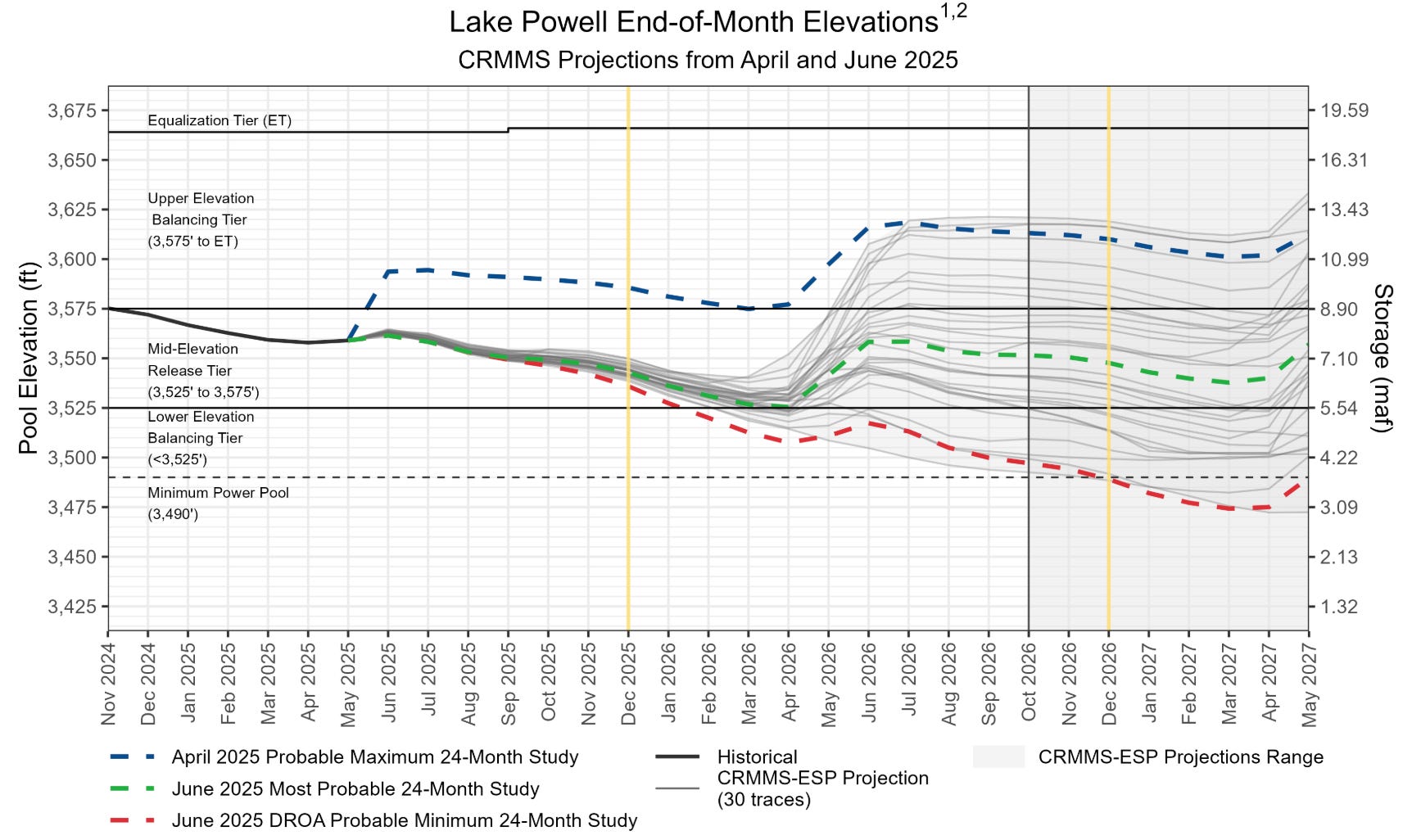
Projected Lake Powell end-of-month physical elevations from the latest 24-Month Study inflow scenarios.
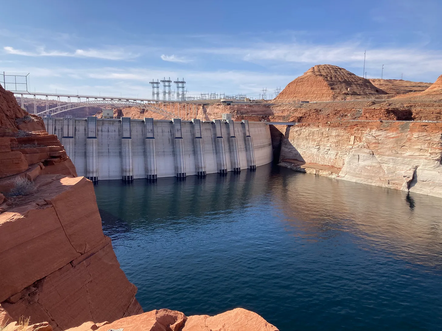
Meanwhile the Bureau of Reclamation has issued its annual 24-month projection, and it has no good news. Its worst case scenario – the one everyone looks at – suggests that, barring a huge winter this year, Powell Reservoir might drop to the elevation at which it can no longer produce hydropower by late fall 2026 – at which point it cannot even make large deliveries downstream, because all the water would then have to go through four antique tubes never meant to carry that much water 24/7. This could undermine the best-laid plans of the negotiators, should they achieve a plan, with no ability to move sufficient water past Glen Canyon Dam until the reservoir filled back up to the power level. No plans have been announced for creating a Glen Canyon Dam bypass.
All the news dribbling out of the negotiations indicate that the negotiators persist in carrying forward the Colorado River Compact’s division of the river into Upper and Lower Basins. Do they not see that this is no longer necessary, or even desirable – nothing but a cause of conflict and contention?
When representatives from the seven Colorado River Basin states gathered in Washington in January 1922, six of the states knew what they wanted: they wanted a seven-way division of the consumptive use of the river’s waters that would transcend on the interstate level the appropriation doctrine all seven states adhered to intrastate.
They wanted this because southern California, the seventh state, was growing so fast, and already using so much of the river’s water, that the other six knew they would be losers in a seven-state horse race to appropriate the river’s water. The representatives all accepted the first-come first-served appropriation law as holy writ within their states, but saw its limits when looking at the whole river and the regional challenge of uneven development.
California sat down with the other six states because at that point, the other six states held a big card: California needed a interstate river to control floods and ‘rationalize’ the flow and distribution of the river’s water, rather than watching an uncontrolled flood of snowmelt ‘waste’ most of the water to the ocean. And California knew that Congress would provide for that big dam only if all seven states were sure they would have a share of the water, once the river was controlled. So California had to participate in setting long-term limits on itself in order to get what it needed in the short term.
But after several days of trying to work out that seven-way division, the compact negotiators gave up in frustration. Each negotiator had come with estimates of his state’s future water needs based on potentially arable land, mining-generated industry, possible urban development. Not really knowing what the future would bring did not dim their estimates at the turn of the 20th century, with the imperial impetus to ‘create our own reality’ just kicking into high gear. But by the time the seven negotiators had laid out their states’ envisioned water needs, the basin-wide total was half again even the Bureau of Reclamation’s rosiest estimates of Colorado River flows. And no one wanted to cut their estimates, go home to tell their governor and legislators he’d had to diminish the state’s envisioned future by a quarter or so.
Several of the frustrated negotiators thought they should abandon the whole idea of an interstate compact, but the federal representative and chairman, Herbert Hoover – himself an engineer eager to see the big dam built – persuaded them to stay with the idea for the rest of the year. They convened for some hearings around the west in the summer, and had a tour of the proposed big dam sites. But then Hoover and Colorado’s representative to the commission, Delph Carpenter, began circulating the idea of a two-basin division to break the impasse over the seven-way division, and Hoover was able to convene a November charrette to work until a compact was done.
Toward the end of an eleven-day marathon at a resort near Santa Fe, with 18 transcribed sessions and who knows how many informal barroom and hotel room caucuses, Chairman Hoover summarized their situation:
“We finally reached, in effect, this general conclusion as to the form of the compact, and that was that none of the figures and data in our possession, or within the possibility of possession at this time were sufficient upon which we could make an equitable division of the waters of the Colorado River [in perpetuity]…. [W]e make now, for lack of a better word, a temporary equitable division, reserving a certain portion of the flow of the river to the hands of those men who may come after us, possessed of a far greater fund of information; that they can make a further division of the river at such a time, and in the meantime we shall take such means at this moment to protect the rights of either basin as will assure the continued development of the river. (Text from the 12th of 18 transcribed November meetings, boldface added)“
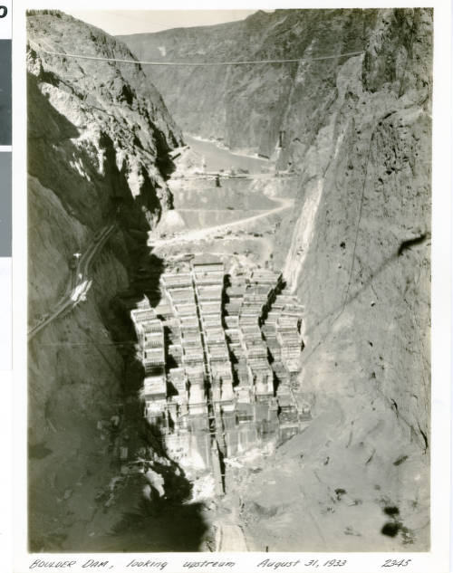
That was the Colorado River Compact as seen in process by the commission chairman: ‘a temporary equitable division’ to be refined and finished when ‘a greater fund of information’ about both the river’s flows and the flow of the future was known. No one – with the probable exception of Delph Carpenter – was very happy with the Compact the commissioners took home to their states. Arizona refused to ratify it, and it took several years to get it through the other six state legislatures. But the U.S. Congress was actually somewhat eager to develop the river, making its desert lands available for development, and decided that six of the seven states on board was good enough. The Boulder Canyon Project Act was passed in 1928, and Hoover – then President – was able to launch construction of not just the huge Hoover Dam, but Parker Dam as the holding bay for the Metropolitan Water District’s 250-mile aqueduct, and the Imperial Dam and All-American Canal to carry water to the Imperial and Coachella Valleys – a major regional development that really set a course for the 20th century.
Enabling that, and what followed over the next four or five decades, did achieve the Compact goal to ‘secure the expeditious agricultural and industrial development of the Colorado River Basin,’ probably the major goal stated in its preamble (Article I) for most of those involved. But a century later we can say pretty definitely that its ‘temporary equitable division’ (still apparently regarded as permanent), has not achieved most of the other goals listed in the preamble. It did not ‘provide for the equitable division and apportionment of the use of the waters,’ either in the division between Basins explicit in Article III(a) nor in the relationship between the two Basins stated in Article III(d); it obviously did not ‘promote interstate comity’; and the two-basin division did not ‘remove causes of present and future controversies.’ If anything, the Compact created controversies with badly written sections like Article III(c) on the Mexican obligation, and Article III(d) on interbasin ‘obligations.’ (If you would like to review the Compact, you can find it here.)
More to the point – it is possible now to achieve what the 1922 commissioners originally wanted: an equitable seven-way division of the use of the river with a share for Mexico, which renders the two-basin ‘temporary division’ irrelevant and burdensome.
The seven-way division has been effected, not through interstate negotiation but through the ‘continued development of the river’; today, the seven states and Mexico all know, practically to the acre-foot, what has evolved as their share of the river as we have known it – the 14.6 million acre-foot average flow of the development period, the 1930s through the 1990s.
Allotments for the three Lower Basin states were set by the Boulder Canyon Project Act in 1929 as acre-foot portions of the Compact allotment of 7.5 maf, and confirmed by the Supreme Court in its 1963-4 Arizona v. California decision. Mexico received its share, 1.5 maf, in a 1944 treaty negotiated through the U.S. State Department. And the four Upper Basin states negotiated a compact for their share of the river in 1948 – by then known to be a variable quantity, usually less than the Compact’s allotment of 7.5 maf, so they divided their fluctuating share by percentages.
Native America in the Colorado River Basin. Credit: USBR
The ‘federal reserved rights’ of the Basin’s 30 Indian nations – barely given a ‘placeholder’ in the Compact – have been shoehorned in as state responsibilities through the 1952 ‘McCarran Amendment’ to a resource bill; this says that all federal reserved water rights, for all public lands as well as the Indian reservations, have to be adjudicated in the state water courts. The ‘equity’ of this is questionable; some states have only a few Indian nations; Arizona has 22 of them. Most of the Indian nations that have not already achieved some water rights are working on ‘settlements’ out of court, negotiating with those who have been using water for which the Indians had a prior claim (dating from the creation of their reservation) for water and money with which to develop the water they can get. The federal government puts up much of the money for the development of Indian water rights; there is still a long way to go in correcting this long-standing dereliction and shame, but there has been more activity in the past couple decades than in the previous century.
The point being – nearly everyone knows with some accuracy how much water they have had to use from the Colorado River – in the 20th century. Hardly anyone is happy with the resulting numbers, but we also all know that this is all the water there is – or was, in the 20th century. The river has been divided among the states and nations, de facto, if not yet de jure.
The structural deficit refers to the consumption by Lower Basin states of more water than enters Lake Mead each year. The deficit, which includes losses from evaporation, is estimated at 1.2 million acre-feet a year. (Image: Central Arizona Project circa 2019)
The alarming draw-down of the river’s major reservoirs in the early 21stcentury to date has been only partially caused by the ‘drought’ and permanent climate-related aridification. The bulk of the draw-down has been a ‘structural deficit’ stemming from the Lower Basin states’ blithe refusal to incorporate their ‘system losses’ – evaporation and transpiration, riparian losses, etc – and their portion of the Mexican share into their allotments, preferring to let the amenable Bureau release them as ‘surplus’ from Powell and Mead storage – a surplus that has not existed since the Central Arizona Project began to come on line after 1985, along with increased Upper Basin uses (still well below its ‘Compact allotment’). The Compact failed to include system loss provisions – probably around 12-14 percent of the water that flows from the headwaters snowpack.
The good news there is that, in the planning for river management beyond 2026, the Lower Basin states have agreed to absorb the ‘structural deficit’ and their share of the Mexican obligation into their river shares. The Upper Basin users have already absorbed their system losses by the time the Bureau moves Lower Basin water out of Powell.
It is not rocket science to lay out the seven-states-plus-Mexico division of the waters in a chart, a feat impossible in 1922, but largely accomplished de facto by the Compact’s century mark – a chart without any reference to the ‘temporary equitable division’ into two basins. If we were to eliminate the two-basin division form our future management plans, we would unload quite a lot of unnecessary baggage. We would be much closer to thinking of the Colorado again as one river, with one set of challenges for everyone, rather than this ‘Cold War’ between Upper and Lower.
The big challenge comes in trying to fit that division of the 14.6 maf river of 1930-2000 into the river we have today – ~12.5 maf, and dropping incrementally but steadily.
If we lived in a fair, just and moral universe, resolution of management guidelines for the future of the one river would just be a matter of applying basic high school math: if a state’s allotment (including a proportionate share of system losses) of a 14.6 maf river is X maf, what will be that state’s new allotment if the river’s volume drops to 12.5 maf? Or to 11.5 maf by 2050? Easy: you just convert the state’s allotment to a percentage of the 14.6 maf river, and multiply those percentages by 12.5 maf, or whatever the flow has dropped too. Do that for all users and, presto, there’s everyone’s new 21st-century allotment, learn how to live with it –
Wups. Uh-oh. One can already hear the ‘harrumphing’ firing up in the Imperial Valley: what about our senior water rights?! If you say we have to take the same cuts as everyone else, we’ll see you in court!
The Interior Department’s current acting assistant secretary for water and science, Scott Cameron, actually spoke to that eventuality or probability in a meeting of water mavens in Arizona: ‘Having senior water rights is a wonderful thing, but having senior water rights does not give you a free pass to ignore what’s happening in the greater community.’
What’s happening in the greater community is diminishing flows for everyone due to a warming, drying climate that is everyone’s and no one’s fault – a problem of a different order of magnitude from the issues the senior-junior appropriation doctrine developed to resolve. If Asst. Secretary Cameron’s perception (unusually perceptive from an official in the Trump administration) were to prevail as federal policy, it might facilitate a serious discussion in the arid West about how far and how high a body of law should be applied, that originated for working out squabbles between neighbors – with ‘first-come first-served’ the one-size-fits-all resolution. A resolution that is usually transcended locally in dry times with ‘gentlemen’s agreements’ to share the pain between neighbors who have also become friends.
Members of the Colorado River Commission, in Santa Fe in 1922, after signing the Colorado River Compact. From left, W. S. Norviel (Arizona), Delph E. Carpenter (Colorado), Herbert Hoover (Secretary of Commerce and Chairman of Commission), R. E. Caldwell (Utah), Clarence C. Stetson (Executive Secretary of Commission), Stephen B. Davis, Jr. (New Mexico), Frank C. Emerson (Wyoming), W. F. McClure (California), and James G. Scrugham (Nevada)
CREDIT: COLORADO STATE UNIVERSITY WATER RESOURCES ARCHIVE via Aspen Journalism
The westerners who convened for the 1922 compact commission wanted to suspend at the interstate level the appropriation doctrine they all adhered at home, for good reasons involving the uneven pace of regional development. We are now confronting a reduced volume of water for everyone, caused by a changing climate that is no one’s and everyone’s fault. Is this not a problem on a scale with the problem that convened a Compact commission a century ago to suspend – or more accurately, maybe, transcend – the appropriation doctrine at the interstate level?
Well – we keep getting news every day about the fairness, justice and morality of our small sector of the universe. Pray for rain; it’s more likely.
Map of the Colorado River drainage basin, created using USGS data. By Shannon1 Creative Commons Attribution-Share Alike 4.0
Colorado River “Beginnings”. Photo: Brent Gardner-Smith/Aspen Journalism
Click the link to read the article on the AZCentral.com website (Kate Gallego, Chad Franke, Tom Kiernan and Manuel Heart). Here’s an excerpt:
August 25, 2025
Key Points
The Colorado River, a vital resource for millions, has reached a critical tipping point, thanks to drought and overuse.
The river needs urgent, collaborative action and flexible solutions for long-term water security.
Failure to reach agreements risks costly litigation and uncertain outcomes.
Reservoirs like Lakes Mead and Powell are again approaching record lows, and every water user is being affected…Against this backdrop, we urgently need unified action. We must proactively adjust our plans given the Colorado River’s changing water supply. We must confront the crisis with urgency and collaboration to build a workable water future for the broad network of Colorado River interests. To succeed, comprehensive, forward-looking solutions must replace the current crisis-to-crisis management approach…
Solutions must be rooted in flexibility, innovation and cooperation — and acknowledge both the urgency of today’s water supply shortages and the need for long-term water reliability and resilience. Doing so will require the immediate development of durable agreements — not just between Upper and Lower Basin states, but also among the states, U.S. and tribes, and between the U.S. and Mexico — that re-balance water demands with the river’s shrinking supply…Creating comprehensive, forward-looking solutions also requires immediate engagement with tribes, water users and other stakeholders. Their input is needed to tailor flexible strategies that meet the needs of different water users across various basin geographies, including the mountain headwaters, the Colorado Plateau and the desert Southwest…Without such tools and agreements, the Colorado River’s future will be decided by the courts following litigation that inevitably breeds a failure of dialogue, delays progress and leads to costly, drawn-out battles. At the end of that road lies a loss of local control as well as uncertain and harmful outcomes to water users throughout the basin.
Glen Canyon Dam May 2022. Photo credit: Allen Best/Big Pivots
Click the link to read the article on the Big Pivots website (Allen Best):
August 18, 2025
The words “urgency” and “immediate action” were used by Trump administration officials on Aug. 15 in releasing the U.S. Bureau of Reclamation 24-month study for the Colorado River Basin.
The study sees a high probability of water levels of Lake Powell falling to within 48 feet of the minimum power pool by January. That elevation, 3,490 feet above sea level, is the reservoir’s lowest level at which hydroelectricity can be produced. That has not happened since soon after Powell began filling after completion of Glen Canyon Dam in 1966.
“This underscores the importance of immediate action to secure the future of the Colorado River,” said David Palumbo, acting commissioner for the agency.
Scott Cameron, the acting assistant secretary for water and science in the Department of Interior, had similar words of warning to the seven states that share use of the river.
“As the basin prepares for the transition to post-2026 operating guidelines, the urgency for the seven Colorado River Basin states to reach a consensus agreement has never been clearer,” said Cameron. “We cannot afford to delay.”
The announcement cited “unprecedented drought” but made no mention of climate change. This seems to be a theme. [ed. emphasis mine]
Cameron, at the Getches-Wilkinson Center’s annual water seminar in Boulder during June, talked for 24 minutes without once mentioning climate change. He even answered a question about climate change without using the phrase. He did seem to acknowledge it, saying that in the “real world” there is less water than before, “and that is probably not going to change a whole bunch.”
Might the situation be even worse than what Bureau of Reclamation has projected will be most likely?
A bias of optimism
On Aug. 14, a day before the bureau’s release of the 24-month study, John Fleck and others posted an analysis on Fleck’s Inkstain that warned the study would likely be overly optimistic.
The problem, explained Fleck and his co-authors, is that the “assumptions underlying the study do not fully capture the climate-change driven aridification of the Colorado River Basin.”
The precipitation received from October through July in the Colorado River Basin fits in with a theme that is best understood when coupled with rising temperatures, which produces greater evaporation and transpiration. Image/Western Water Assessment
The bureau uses a 30-year average in predicting what lies ahead. However, using the hydrology of the Colorado River Basin since the 1990s no longer provides the same usefulness in predicting what lies ahead during the next 24 months. The climate is changing too fast.
In that paper, Milley and his co-authors argued that human-induced climate changes were altering the means and extremes of precipitation, evapotranspiration, and the rates of runoff in rivers. As such, they contended, using the old models to guide water management no longer worked as well.
In their posting at Inkstain, Fleck and his coauthors — Anne Castle, Erick Kuhn, Jack Schmidt, Kathryn Sorensen and Katherine Tara — noted that the Bureau of Reclamation’s 24-month study a year ago found that the “most probable” level for Powell would be 3,593 at the end of July 2025.
It was 38 feet lower than the projection. It had been another so-so or worse winter and then an early, warm spring.
This, they said, illustrated the bias toward optimism in the models used by the agency. That bias had been detailed in a 2022 study of past projections by a team led by Jian Wang of the Utah State Center for Colorado River Studies.
“Most probable” in the Bureau of Reclamation projections occupied a band of 80% likelihood. The bureau also issues maximum and minimum probable scenarios.
Fleck and his team contend that the bureau’s “minimum probable scenario has become the most valuable in providing a reliable indicator of the future” for Colorado River flows.
This past winter was mediocre, near average snowfall in some basins but among the worst in the San Juans. Spring was warm or more in many places, and rains in July were almost entirely absent.
The preliminary estimated inflow into Powell for April through July was 41% of the average from 1991 through 2020, according to the bureau’s most-probable study. During July, runoff slipped to 12% of that 30-year average.
Might fortunes soon be reversed? Not likely in months ahead, said Fleck and his team. They noted this summer’s weak monsoon for most of the upper basin coupled with the seasonal outlook by the National Oceanic and Atmospheric Administration. Together, they point to a warmer and drier than average fall.
“It’s a good bet that this trend will continue at least through winter,” they wrote.
As it stands, levels in Lake Mead, downstream from Powell, will necessitate cuts in the lower-basin as required by several agreements reached between 2007 and 2019. Arizona is to see an 18% cut and Nevada a 7% cut in their annual apportionments. Mexico is to get 5% less than its annual allotment. In acre-feet, that’s 412,000 for Arizona, 21,000 for Nevada, and 80,000 for Mexico.
A new agreement
The big story continues to be what agreements the seven basin states can achieve in recognition of the inadequacy of past agreements given reduced flows.
Drought as conventionally understood is part of the story, but only a part. A 2017 study by Jonathan Overpeck and Brad Udall, “The 21st Century Hot Drought and Implications for the Future,”concluded that between a third and a half of reduced flows in the Colorado from 2000 to 2014 could be attributed to the rising greenhouse gas emissions. They spoke about “megadrought,” a word now common in Colorado River discussions, as is “aridification.”
This year has brought more studies that strengthen the evidence. Included is a study published just last week in Nature, that identifies new ways that the warming climate has altered the hydrology of Colorado and other southwestern states. See: “Why rain and snow skip the Southwest.”
In 2018, an agreement among the states was reached regarding how to deal with drought. It was universally recognized as an interim agreement, with a final agreement to be reached in advance of a 2026 deadline. That deadline is now close at hand.
That impending deadline was alluded to in the comments of the federal officials.
“Health of the Colorado River system and the livelihoods that depend on it are relying on our ability to collaborate effectively and craft forward-thinking solutions that prioritize conservation, efficiency, and resilience,” said Cameron, Interior’s undersecretary, in the Aug. 15 announcement.
In June, Cameron had called on the Colorado River Basin states to submit details of a preliminary operations agreement by mid-November and share a final seven-state proposal by mid-February 2026. The plan would be to reach a final decision in the summer of 2026 with implementation beginning in October 2026.
Non-government organizations issued statements also calling for the states to figure out a way forward.
“This is not just a crisis. It’s also a call to action to use remaining time wisely to replace our current, reactive, emergency-based management framework with new, long-term solutions,” said John Berggren, the regional policy manager for Western Resource Advocates. “We can’t litigate our way out — we must collaborate forward.”
For many months, all reports suggested that the four-upper basin states — who speak with one voice in these negotiations — and the three lower-basin states remained far apart. A story on June 27 in the Las Vegas Review Journal described the meetings as “tense” and “deadlocked.”
Wyoming, Utah and New Mexico along with Colorado constitute the upper basin. Arizona, Nevada and California make up the lower basin.
Becky Mitchell, Colorado’s representative in the negotiations, told a forum in Silverthorne covered by Big Pivots in May that hydrologic risk must be shared between the upper basin and the lower-basin states.
The Blue River flowing through Silverthorne just below Dillon Dam in May 2025. Photo/Allen Best
This sore spot has long festered. The Colorado River Compact of 1922 specified that the upper basin states “will not cause the flow of the river at Lee Ferry to be depleted” below an aggregate of 75 million acre-feet for any 10 consecutive years. The location is between Glen Canyon and the Grand Canyon.
But what if the river fails to deliver that much water? Upper basin states have delivered that volume so far, but that’s mostly because Wyoming, in particular, has not developed what was expected 100 yeas ago.
Those who had originally gathered in Santa Fe in 1922 to negotiate the compact had understood drought, but only as a temporary thing. They had no extensive long-term perspective — and chose to ignore what evidence was at hand, according to a 2019 book by Fleck and Kuhn, “Science be Dammed: How Ignoring Inconvenient Science Drained the Colorado River.”
Colorado’s beef and that of other upper-basin states has been that the two big dams on the river provided certainty for the lower-basin states to get water. However, the headwaters states have no certainty. They must live with what Mother Nature provides. They have balked at cutting water use to provide certainty for downstream states. They want the risk shared.
Natural flow proposal
In June came the first public word of what may have been a breakthrough. It is called the “natural flow proposal.” As explained by Tom Buschatzke, the director of Arizona Water Resources, to the Arizona Republic in a story on June 18, the idea is to focus less on who gets what and more on what the river can realistically provide.
“We do have to recognize what the hydrologic risks are to us,” he said after presenting the idea to a committee,” and we have to kind of find an equitable way to share those risks.”
That idea being discussed would employ a rolling three-year average of the natural flow of the river. Natural would be defined as the volume if there were no diversions and impoundments.
Buschatzke — a frequent visitor at the Colorado River forum sponsored by the University of Colorado’s Getches-Wilkinson Center each June — pointed out that the goal would be to spread the pain equitably, not equally. The lower basin would need more water than the upper basin, which has still to develop all the water allocated it in the 1922 compact.
“It is not 50-50,” he told represents at the June 17 meeting. “I won’t try to speculate on what the number might be.”
California uses the most water of any state in the Colorado River Basin, partly for its cities along the Pacific Coast but a substantial amount for agriculture in the Imperial Valley. Photo December 2015/Allen Best
A few weeks later, John Entsminger, Nevada’s representative in interstate talks, similarly was vague about details. “It’s not something where I can tell you what the score is in the third inning: the baseball game is still being played,” he told the Las Vegas Review-Journal. Details remain sparse, he added.
“Everybody’s pretty much accepted that we’ve got to come up with a new formula for dividing the river,” Mark Squillace, an environmental law professor at the University of Colorado, Boulder, told the Las Vegas newspaper. “The devil’s in the details about getting the numbers right.”
According to the best information that Big Pivots was able to obtain, there is still no agreement about what the percentage should be, although it is not 50-50.
Mitchell, Colorado’s representative on the Upper Colorado River Commission (and its acting chair), told the Review-Journal that the 2007 guidelines that provide the management map of the river’s operations “are not ustainable, because the water is just not there. It’s not in storage, and it’s not in the river.”
For a late-June story in Politico’s E&E, Mitchell described the natural flows idea as a math problem. “The concept under discussion is that Powell would release a certain percentage of volume of the average of the last few years of natural flows, as measured at Lee Ferry,” she said.
E&E described a more complex challenge.
“The theory — the premise of sharing the river based on how much water would travel downstream without dams or diversions or other human interventions — is actually a complex mathematical problem, rife with potential pitfalls and technical issues.”
This idea of basing releases from Lake Powell likely would take several years to implement. As such, it would not immediately impact levels in the reservoir.
As for the minimum power pool at Powell, that’s the level at which hydroelectricity can no longer be generated. Some 16 municipal and cooperative electrical utilities in Colorado get power from the dam. Those amounts tend to be smaller, about 5% or less, although important if the utilities are stretching to achieve decarbonization goals.
The greatest value of Glen Canyon is that if the Western grid has a blackout, the grid can be restarted with hydropower from the dam.
And too, the role of Congress
As administrator of the two big dams in the basin and several smaller ones, the federal government must figure out how to manage them consistently with the agreements among the states. It is also the formal administrator among the lower-basin states.
At the conference in Boulder, Cameron clearly said the federal government wants the states to figure out the solution. However, he also said that if the states cannot come to agreement, the federal government, as the administrator of the infrastructure, has authority to set policy, too.
And finally, he mentioned that the whole package may need to go to Congress, as was the case with the Colorado River Compact. It was approved in 1929. (Arizona had refused to endorse the compact until much later).
Map of the Colorado River drainage basin, created using USGS data. By Shannon1 Creative Commons Attribution-Share Alike 4.0
Oak Flat, Arizona features groves of Emory oak trees, canyons, and springs. This is sacred land for the San Carlos Apache tribe. Resolution Copper (Rio Tinto subsidiary) lobbied politicians to deliver this National Forest land to the company with the intent to build a destructive copper mine. By SinaguaWiki – Own work, CC BY-SA 4.0, https://commons.wikimedia.org/w/index.php?curid=98967960
Click the link to read the article on the AZCentral website (Debra Utacia Krol). Here’s an excerpt:
August 20, 2025
Key Points
Hours after the 9th U.S. Circuit Court of Appeals blocked a land swap for a copper mine at Oak Flat, President Donald Trump called the mine’s critics “Anti-American.”
Tribal leaders reacted quickly, reminding the president that they are the first Americans and are trying to protect their sacred lands.
Trump reportedly met with mining executives at the White House and, in his Truth Social post, argued that the United States needed to protect its copper reserves.
Arizona tribal leaders struck back after President Donald Trump called opponents of a planned copper mine at Oak Flat “anti-American,” suggesting they were allied with other copper-producing countries like China. Trump posted comments on Truth Social on Aug. 19, hours after the 9th U.S. Circuit Court of Appeals temporarily halted a land exchange that would allow Resolution Copper to build the mine on a site east of Phoenix held sacred by the Apache people and other Indigenous communities. “Those that fought (the mine) are Anti-American, and representing other Copper competitive Countries,” Trump wrote, while claiming that the 9th Circuit Court is “a Radical Left Court.” He did not include any evidence to support his claims…Currently, 10 of the judges on the 9th Circuit’s panel are Trump appointees; another three are Republican-appointed justices, while the remaining 16 judges in the circuit court are Democratic appointees, according to the legal news outlet Daily Journal. The president also said the U.S. needs copper now…
In a Facebook post on Aug. 20, San Carlos Apache Tribe Chairman Terry Rambler hit back: “As first Americans, the San Carlos Apache Tribe agrees on the importance of protecting America’s interests,” he said, but “the President’s comments mirror misinformation that has been repeated by foreign mining interests that want to extract American copper.” Rambler also pointed out that a Chinese company, Chinalco, is the largest shareholder of Rio Tinto and BHP, the two British-Australian firms that jointly own Resolution Copper. “Of course their interest is in mining this copper and shipping it to China.” With just three smelters in the U.S., and one of those currently non-functional, mines have been shipping crushed ore to China for processing for years.
The San Carlos Apache Tribe and a coalition of environmental groups have fought for years against the Resolution Copper mine, which would become one of the country’s largest at the cost of a site revered by the tribe.
Just hours before the deal was set to go through, a federal appeals court temporarily blocked a land transfer in Arizona on Monday that would ultimately lead to the destruction of a site sacred to Western Apache people.
The 9th U.S. Circuit Court of Appeals’ temporary restraining order is the latest in a long-running saga in which the U.S. Forest Service has planned to transfer the land to a mining company, Resolution Copper, while the San Carlos Apache Tribe and a coalition of environmental groups have fought to protect the sacred site of Oak Flat, or Chí’chil Biłdagoteel in Apache.
The company has worked for two decades to gain access to the 2,200 acres of land in Tonto National Forest that contains both the sacred site and one of the world’s largest untapped copper deposits. The restraining order halts the land transfer until the court can rule on two consolidated cases, which have argued in lower courts that approval of the land transfer and mine violates the National Environmental Policy Act and failed to adequately consult with the tribe.
“The Apache people will never stop fighting for Chí’chil Biłdagoteel,” said San Carlos Apache Tribe Chairman Terry Rambler in a statement. “We thank the court for stopping this horrific land exchange and allowing us to argue the merits of our pending lawsuit in court.”
A spokesperson for Resolution Copper said in a written statement that the order is “merely a temporary pause so that the court of appeals can consider plaintiffs’ eleventh hour motions,” and that the company is “confident the court will ultimately affirm the district court’s well-reasoned orders explaining in detail why the congressionally directed land exchange satisfies all applicable legal requirements.”
U.S. District Judge Dominic W. Lanza on Friday denied the tribe and environmental groups’ challenges, which had cleared the way for the land transfer to go through. In his order, he acknowledged the mine would destroy the sacred area and use a massive amount of the region’s scarce groundwater. But he noted that the transfer was signed into law in 2014 by President Barack Obama—mandated by Congress in a rider attached to a defense bill—and that the Supreme Court declined to hear another case challenging the mine.
A spokesperson from the U.S. Department of Agriculture, which oversees the Forest Service, declined to comment on the latest court order, but said the bill authorizing the land transfer aligns with the Trump administration’s efforts “to strengthen domestic mineral and energy production, advancing the nation’s economic and strategic goals.”
In April, the Trump administration signaled it would approve the project. A years-long religious freedom case brought by Apache Stronghold, an Apache religious group, was denied by the Supreme Court in May. Then, the U.S. Forest Service postedthe final environmental impact statement and draft record of decision for the Resolution Copper project, setting the stage for Oak Flat to be transferred to the mining company by Aug. 19.
Since then, the proposed mine has become one of the most high-profile environmental battles in the U.S. The 9th Circuit’s order requires the tribe and environmental groups to file their opening brief by Sept. 9, with answering briefs from the Forest Service and Resolution Copper due by Sept. 29.
“We’re thankful that the court has paused this ill-conceived land exchange that would destroy Oak Flat and all that makes it special, including the old Emory oak trees, endangered hedgehog cactus, and its significant cultural and recreational values,” said Sandy Bahr, director of the Sierra Club’s Grand Canyon Chapter, in a statement. The Sierra Club is one of the plaintiffs. “There is still a lot to do to save this special place, but we remain committed to doing everything we can to ensure Oak Flat is here for future generations.”
Visitor volume to Las Vegas in June was down 11.3% from the previous year, according to local statistics. Visitation to Southwestern national parks is also lagging. Jonathan P. Thompson photo.
Last month I took a look at national park visitation numbers for the first half of the year to try to get a sense of how a drop in international travelers is affecting Western gateway communities. It wasn’t all that conclusive: Most parks were seeing numbers similar to in the past, though they were beginning to dip in June.
Now July figures are available for many parks, and they show that the June slump was no anomaly. Media reports indicate the tourism sectors across the West is starting to feel the pain.
The Moab Times-Independentreported that community resort taxes for April were down 11% from the previous year. And that was even before visitation had started dropping off at national parks. Moab’s figures for June and July aren’t available yet, but local business owners told the Times-Independent that they’ve seen fewer international tourists this year. A Colorado Sunstory by Jason Blevins records the same phenomenon on Colorado’s Western Slope, where visitation and tourist spending has dropped since last year.
The World Travel & Tourism Council predicted the U.S. will lose about $12.5 billion in international spending this year and is the only nation it tracks that is seeing a decline in tourism. Visitation from the U.K., Germany, South Korea, Canada, and other European countries is down significantly.
“This is a wake-up call for the U.S. government,” said Travel & Tourism Council President Julia Simpson in a written statement. ”While other nations are rolling out the welcome mat, the U.S. government is putting up the ‘closed’ sign.” That is to say, Trump administration policies and actions are generally hostile toward the rest of the world, which understandably is dampening the desire to travel to the U.S.
The good news is the crowds are ebbing slightly at some of the West’s most popular national parks. This, of course, isn’t so good for the economies of nearby communities that have come to rely almost entirely on tourism.
Some numbers:
Zion National Park had 529,798 visitors in July, a huge number, yes, but also the third lowest in the last decade (with only 2018 and COVID-affected 2020 lower).
Canyonlands had its second slimmest visitation in July since 2014.
Capitol Reef saw 111,183 visitors in July, which is higher than in 2022 (107,562), but lower than during any other year since 2014.
Lake Mead NRA saw 1.18 million visitors this June and July combined, the second lowest (after 2023) number for those two months since 1981. This jibes with tourism statistics for Las Vegas, where total visitor volume in June was down a whopping 11.3% from last year.
It’s a similar story at Bryce Canyon, Natural Bridges National Monument, Mesa Verde, Glen Canyon National Recreation Area, Joshua Tree, Great Sand Dunes, and the Grand Canyon (there is a huge fire burning there, after all, but the South Rim remains open).
The downward trend does not seem to have spread further north. Glacier, Yellowstone, and Grand Teton national parks are doing fine so far this year.
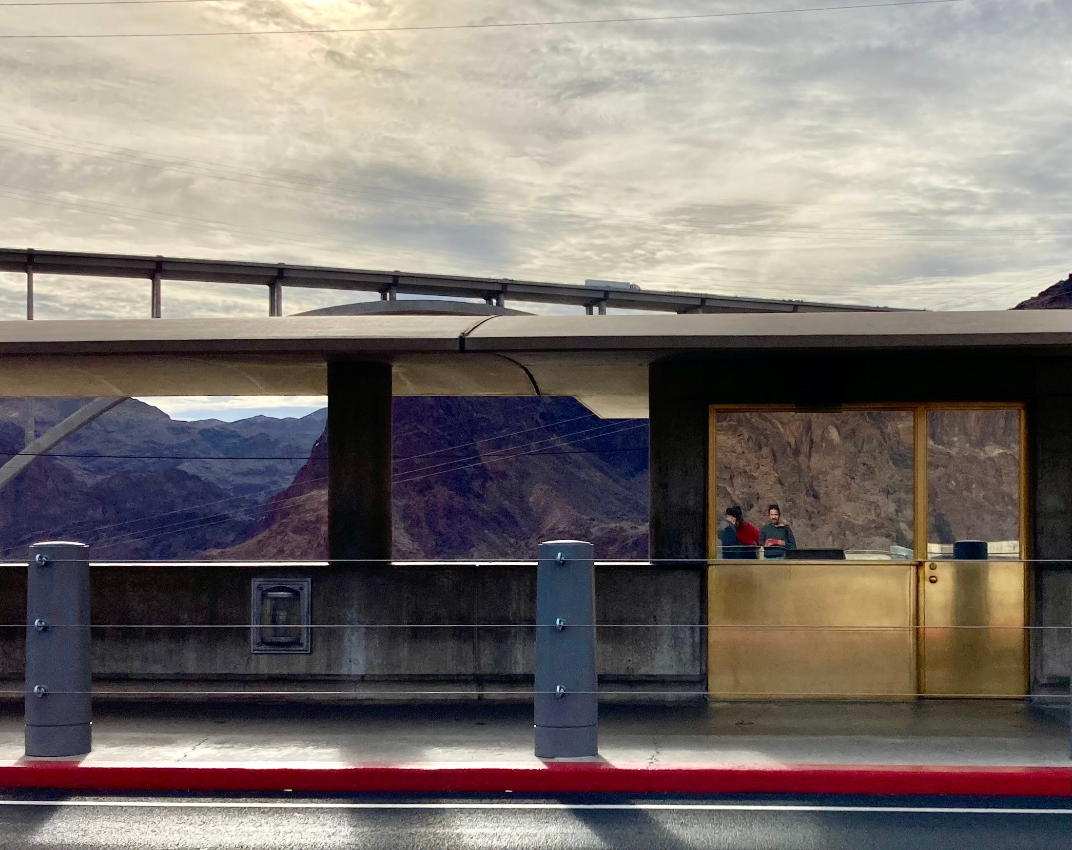
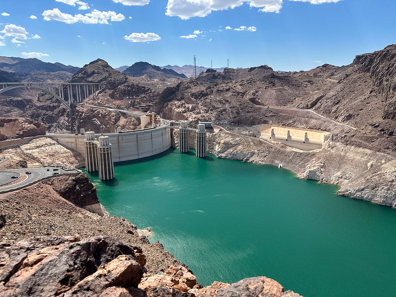
Hoover Dam, at Lake Mead National Recreation Area, where visitation is down significantly from past years. Jonathan P. Thompson photo.
🥵 Aridification Watch 🐫
The good news: As I write this, there is a flash flood watch for parts of the Phoenix area and on the North Rim of the Grand Canyon.
The bad news, climate-wise: Just about everything else.
This year’s dry and hot spell continues, manifested in trickling streams and smoky skies and heat-related death. The current “spell” is a continuation of the quarter-century-long megadrought that is the worst to hit the Southwest in 1,200 years. And a new study finds the aridification likely will continue well into the future.
Let’s start with the study.
University of Colorado researchers have found that the Colorado River Basin’s megadrought is linked to the Pacific decadal oscillation climate pattern, in which the ocean’s water temperatures fluctuate and move around in two-decade-long cycles. Or at least that’s what’s supposed to happen. But since the early 1990s, the oscillation has been stuck in its negative phase, causing a reduction in precipitation in the Southwest.
While the oscillation is natural, the researchers found that it can also be influenced by external forces, and since the middle of the last century, greenhouse gas and aerosol emissions have had an increasing impact and have been responsible for a good part of the megadrought. What this means, researchers say, is that if greenhouse gas emissions continue at current levels — which they almost undoubtedly will, given the societal reticence to give up fossil fuel burning — then the drought will continue for decades to come.
Meaning this year’s desiccation is, indeed, part of the new normal, which is damned frightening.
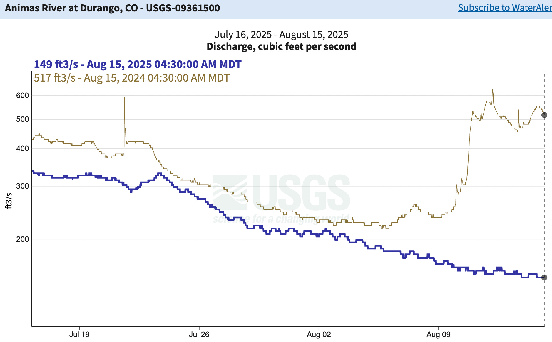
The ongoing aridification can be seen in very concrete ways in the streamflows — or lack thereof — in my home river, the Animas in southwestern Colorado (which I choose because its flow through Durango is largely unregulated, given there are no dams or large diversions upstream).
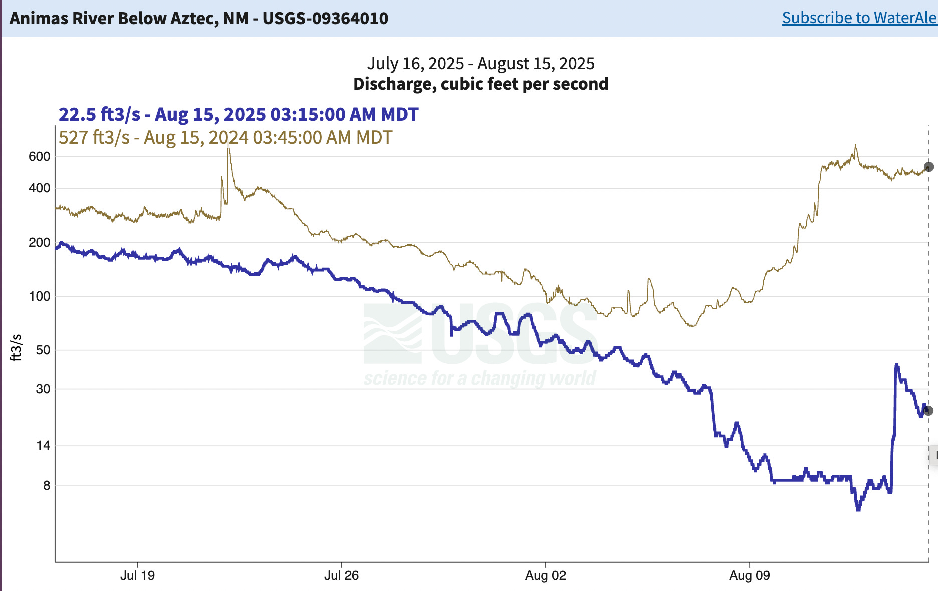
Today, the flow through Durango dropped below 150 cubic feet per second, putting some sections into the boat-bottom-dragging territory, and prompting rafting companies to consider shutting down operations early. But that’s bountiful compared to what’s happening downstream: The river below Aztec and through Farmington has come perilously close to drying out altogether. Check out the charts of the last month compared to last year:
The blue line is this year’s streamflow in cubic feet per second (149 cfs and falling) compared to last year (in the kahki/olive green color). Last year, flows didn’t even drop below 200 cfs before the monsoon came, pushing it back up into the 600s. This year it dropped below 200 cfs in early August, and with no significant rainfall in sight is likely to continue dropping.
Float downstream (if you can) a few dozen miles, and past more diversion points, and things look really grim. The Animas below Aztec dropped below 8 cfs for a moment before jumping back up on Aug. 14. While the increase looks like the result of a heavy downpour it was not (there was no rain in the area, and the gage at Cedar Hill, just 11 miles upstream, didn’t show the same spike. That leads me to believe it was the result of a big diversion, probably one of the upstream irrigation ditch withdrawals, being shut off. While it put some water back in the river, it’s still just a trickle.
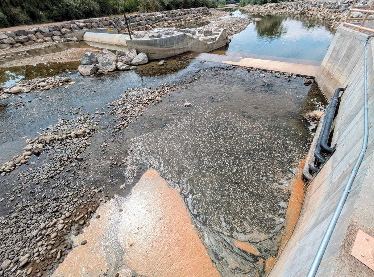
Here’s another visual, sent to my by David Fosdeck. It shows the new surf wave infrastructure on the Animas as it runs through Farmington. Surf is not up, needless to say.
Farmington’s new surf wave, sans surf. Source: David Fosdeck.
Lake Powell’s surface level has now dropped down to 3,552 feet above sea level, almost exactly what it was on this date in 2021.
And now for a quick update on the current fire situation:
The Lee Fire in Rio Blanco County, Colorado, has reached 134,000 acres, making it the fifth largest blaze on record in the state’s history. It is only 10% contained, meaning there’s a damned good chance it will jump up to the third largest before long.
The Stoner Mesa Fire in the southwest corner of the state has grown to 7,400 acres.
The Middle Mesa Fire east of Navajo Reservoir and just south of the Colorado-New Mexico line is now 92% contained.
The Dragon Bravo Fire on the Grand Canyon’s North Rim is up to 145,000 acres, but is 56% contained.
The other day, I was chatting with the venerable Sammy Roth of the Los Angeles Times for his Boiling Point podcast. We were talking about how fire season has changed in my lifetime, and I remarked that up until 2002, the Lime Creek Burn — which in 1879 charred forests south of Silverton — was the largest blaze in the state’s recorded history.
When I told Roth that the blaze was a mere 26,000 acres, he looked a little befuddled. That’s because in this age of megafires, a 26,000-acre wildfire is relatively small. In fact, the Lime Creek Burn no longer makes the state’s top 20 largest blazes — all of which have occurred since 2002. Even the 70,000-acre Missionary Ridge Fire, which seemed gargantuan when it blew through forests north of Durango in 2002, is now only number 7, er, 8 (because the Lee Fire slotted in above it).
Climate change: United Nations • Climate change refers to long-term shifts in temperatures and weather patterns. Human activities have been the main driver of climate change, primarily due to the burning of fossil fuels like coal, oil and gas.
The lack of a good monsoon so far has also meant the lack of cooling afternoon rains in the hottest parts of the Southwest. And that has exacerbated the danger posed by the heat. Phoenix has suffered through an unusually hot August so far, with daily average temperatures reaching 11 degrees higher than normal. If current trends continue, this could end up being the hottest August on record for the city.
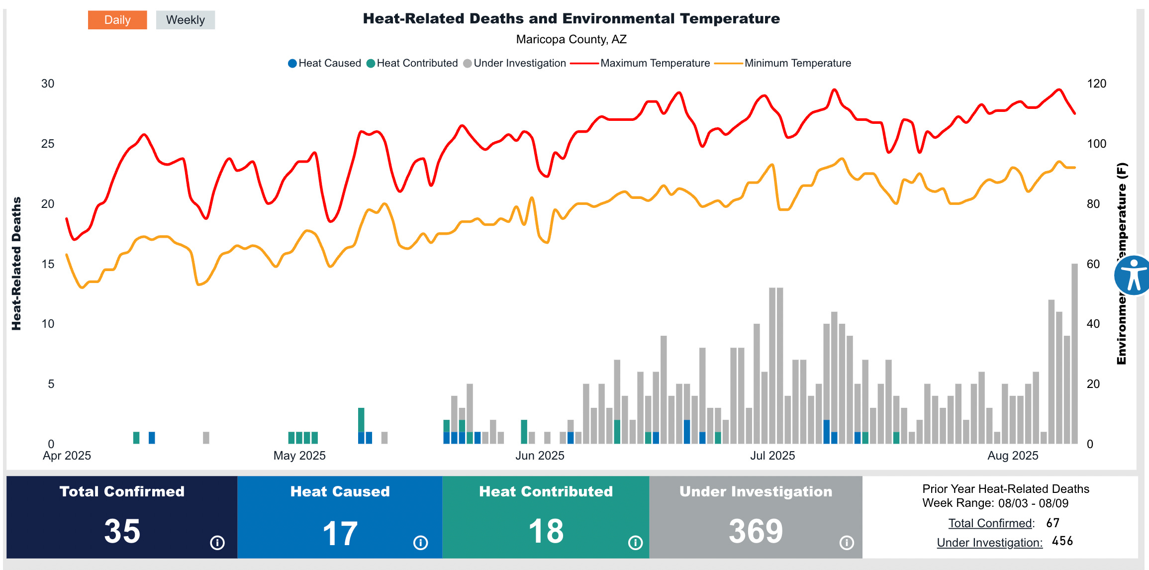
And it’s taking its toll on the people of Phoenix, as Maricopa County’s heat-related mortality report shows. So far this year the heat has killed or contributed to the deaths of 35 people, but another 369 cases remain under investigation (at the end of the year, most of these tend to end up in the heat-caused or heat-contributed category).
📸 Parting Shot 🎞️
Dragonfly in Natural Bridges National Monument. Jonathan P. Thompson photo.
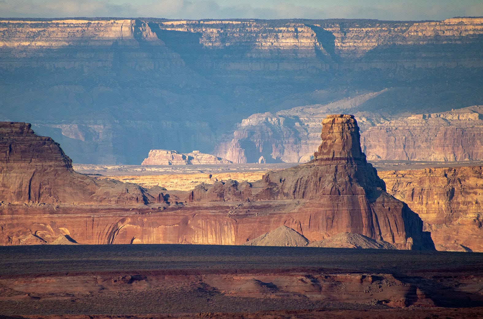
Late light on Glen Canyon rock formations. Jonathan P. Thompson photo.
August 1, 2025
When I was in college and my friends all went to study abroad, I attended a field study program run by The Sierra Institute, an outpost of the University of California, Santa Cruz. Over the course of an academic quarter, we learned about four California ecosystems by studying in them: the Mojave Desert, the Big Sur coast, the High Sierra and the Klamath Mountains. Along the way we hiked and camped and read and wrote and took turns with cooking, cleanup, fire tending and latrine duty.
“Nature, Philosophy and Religion” was the course title and our area of inquiry. We studied the thinkers and spiritual traditions that have been concerned with the splendor of nature, the sustenance humans get from it, and our mutual symbiosis. We considered our own obligations as individuals and as a species. Rather than a distant place and foreign language, we immersed ourselves in the ways that humans live with, steward and find holiness in the natural world.
These are not values I see reflected in today’s political discourse. Our government is working to cancel any programs aimed at sustainability. Elected and appointed officials are erasing climate data and defunding climate action. They are seeking to sell and develop public land and ignoring, at great risk, the ways humans depend on healthy natural systems. They have no interest in the ethics of their policies: who or what will be impacted, and how. Any deference to the land and its creatures — canceled!
Jennifer Sahn, editor-in-chief. Photo credit: High Country News
If everyone could do an extended field study program, could be exposed to natural wonder and experience close-knit community, perhaps the idea of having a responsibility toward the Earth, each other and future generations would be more widely understood and accepted. If you’ve haven’t learned why it’s important to respect and preserve natural systems, how would you understand that you have a choice, at this very moment, to be on the side of life — all life — and against the denigration and desecration of habitats and wild places, the last refugia where humans are required to show restraint. At High Country News, we side with life.
Sadly, after 40 years of running field programs in the backcountry, The Sierra Institute closed in 2015. A post on its Facebook page read, “It is something of a mystery as to why over the last decade the programs became more and more difficult to fill, but it is likely due to a broader cultural change than merely a miscalculation of how to advertise and promote.” The broader cultural change we so desperately need is one in which people believe in the value of nature because they have experienced it and want to continue experiencing it, and because they want those experiences to be available to future generations.
When I was a kid, I collected pinback buttons, political and otherwise. Most of you probably know what that is, but for the youngs out there, it’s basically an analog meme you pin to your clothing to let folks know which political candidate or other cause you might support.
I’m pretty sure I had a “John Anderson for President” button. My parents supported the Independent candidate in the 1980 election because he had been a vocal opponent of the Vietnam War. Jimmy Carter, while championing environmental preservation, had supercharged the fossil fuel industries in the West, which ravaged landscapes and economies, losing their support. I had a couple of buttons from the early Snowdown celebrations in Durango, and one from Wolverton Mountain Days, a funky event held at the Durango nordic center whose motto was: “Track, Telly, Twinkie,” or something along those lines. Maybe the little collection included a “Gilbert Slade for County Commissioner,” that I would have picked up at one of Slade’s Democratic Party goat roasts out on the Dryside.
But perhaps the most intriguing one was small, dark blue or black, with a bold white typeface declaring: “Fight Blight / Burn a Billboard Tonight.” I probably had to ask an adult what blight meant, though the second part I understood. It was, perhaps, my first encounter with the concept of monkey-wrenching, or sabotaging equipment or structures or billboards as a form of protest, usually with environmental motivations.
This would have been shortly after Edward Abbey’s The Monkey Wrench Gang was published (50 years ago this month), in which Doc Sarvis and Bonnie Abbzug did some billboard burning of their own before joining up with Seldom Seen and George Hayduke and moving on to bigger acts of sabotage. But the button’s text preceded the novel. The slogan was a favorite of David Brower, according to John McPhee’s “Encounters of the Archdruid,” which ran in the New Yorker in 1971.
Though I wouldn’t find out until much later, it turns out my father lived out the slogan during his younger days in Silverton, Colorado.
***
Up until the 1950s, Silverton was a full-on mining town, with a little bit of tourism on top. Following World War II, however, the last big mine, the Shenandoah-Dives, shut down. The local economy, sputtered and gasped, ushering in what Silvertonians would come to call the “Black Decade.”
Desperate, the townsfolk turned to tourism, capitalizing on a Hollywood-fueled, global fascination with the Wild West of American mythology. The Durango-to-Silverton stretch of railroad switched from hauling ore to carrying sightseers, and almost overnight Silverton morphed from mining town to a facsimile of a Hollywood version of a place that never existed. In order to lure motorists, some local businesses installed billboards along Highway 550 as it dropped into town from Molas Pass.
My parents arrived in Silverton in the 1960s. Mining had come back in force, with Standard Metals’ American Tunnel facilitating the re-opening of the fabled Sunnyside Mine. Yet the tourism industry and its cheesy theatrics persisted, much to the disgust of my parents and their peers, who were members of a sort of rural Western intelligentsia, drawn there by the mountains, the wildness, the culture, the history, and perhaps most of all, the authenticity of the community. They saw the tchotchke-peddling economy as the antithesis of the richer, more real mining culture.
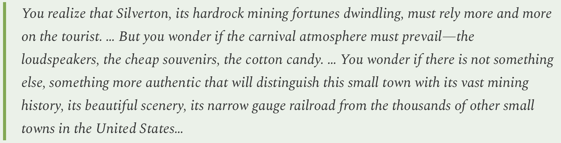
In July 1963, Terry Marshall summed up the sentiment in a Silverton Standard editorial on the surreal scene that unfolded every day at “train time.”
Ultimately, the town would pass statutes and rules that reined in the carnival atmosphere. Yet the billboards on 550 remained and fell into disrepair, and efforts to have the highway department take them down apparently went nowhere. One day in the late 1960s — the story goes 1 — my father was telling his cousin about his frustration with the situation, not just at how ugly the billboards were, but at the powerlessness to do anything about it. This relative (who will remain nameless), suggested in his sanguine way: “Let’s just burn it.”
And so, on one dark night, that’s exactly what they did, with my mother possibly driving the get-away car, nearly a decade before the fictional George Hayduke sabotaged the equipment building the road through Comb Ridge. My father and accomplices were never caught. Indeed, the billboard was so damned ugly that maybe nobody cared.
***
People who knew or knew of my father might find it incredible that he would go to this extreme. He was a diplomat and uniter, someone who could bring together disparate factions to benefit the community. He also had a strong moral compass and cared deeply about this land and its communities, and would do what he could to defend it — within reason — even if it may have skirted the law just a little bit.
I know this because when I was maybe 12 or 13, I went camping with my dad and his friend and the friend’s kid. It was way up near Raplee Ridge, in southeastern Utah, looking down into the San Juan River, on a dusty two-track. On the way to the campsite, we noticed some survey flags sticking up from the sparse and rocky earth.
This would have been the early 1980s, when the Carter-era quest for “energy independence” was still in full-force, and miners and drillers were ripping apart the Western landscape for whatever uranium, coal, oil and gas, or oil shale they could find. My young heart ached at the realization that the stakes marked a future extraction site, that soon the bulldozers and the drill rigs would show up and tear the earth apart and suck out whatever minerals dwelled down there.
On the way back, the adults stopped the car near the site, told us kids to stay put, got out, walked over to the stakes, methodically pulled them out of the ground, and threw them over the edge of the cliff. Then they got back in and we drove away, without saying anything else about it. It was a soothing site to witness, even from the remove of the old car.
The site was never developed or drilled or mined, though I’m guessing that had less to do with this little act of sabotage than with the fact that the energy booms all faded shortly thereafter. For them, however, it was a significant act of resistance, and perhaps of love for the Place. Maybe just as importantly, they were defying the powerlessness we feel in the face of the churning gears of progress and greed, apathy and cruelty.
***
The Monkey Wrench Gang is often considered monkey-wrenching’s literary debut. It’s not. Two years before Abbey published his book, there was Jim Harrison’s A Good Day to Die, which followed a trio on a Florida-to-Idaho road trip in a quest to blow up a dam.
Harrison’s protagonist is named Tim, a Hayduke-esque guy just back from a couple tours in Vietnam, scarred in more ways than one and with a hankering for booze and pills to ease the pain. The story’s narrator, a bit of a cad with relationship issues, is on a fishing trip and escapist odyssey in Florida’s Keys when he encounters Tim. During a drinking session, the narrator tells Tim offhandedly that there’s a dam in the Grand Canyon, or at least they are planning one, pushing Tim into a melancholic slump. “Jesus Christ,” he says, “it will fill up with water.”
Tim is immediately fixated by the idea, noting that he has never seen the Grand Canyon. The narrator “had seen Glen Canyon years ago before it was literally drowned and liked it better but any comparison was absurd with such splendors.” After a little more thought, he notes, casually: “We probably ought to blow up the goddamn thing.”
Tim takes the idea and runs with it, though it isn’t entirely clear what his motives are. Is he truly looking to defend the environment and free the Colorado River? Is he seeking to punish those who deigned dam up something as sacred as the Grand Canyon? Or is he merely lashing out at the general injustice of the world, hoping to be heard among all the cruel noise?
Whatever it is, the narrator gets caught up in it, too, maybe just to have a bit of purpose beyond baking in the sun and waiting for the fish to bite. When Tim suggests a trip West, the narrator hesitates and says only if they return quickly. But as the story progresses he becomes more invested in the act, even if it is only a means for pursuing the alluring Sylvia, Tim’s on-again-off-again girlfriend.
When they discover there is no dam in the Grand Canyon, the narrator refuses to abandon the mission, and suggests they instead decommission an earthen dam on a tributary of the Clearwater in Idaho, “where a wealthy rancher ruined a good steelhead stream … out of greed and contempt for the natural world.” Once the new target is picked, the narrator feels “strong and clean and very moral. Heroic, in fact.” 2
***
A Good Day to Die may have preceded and even inspired the Monkey Wrench Gang, but the latter was far more widely read and influential. Abbey’s classic was published 50 years ago this month, inspiring many acts of low- and high-level eco-sabotage in the decades that followed. And in 1985, Bill Haywood and Dave Foreman published a manual for Abbey’s acolytes called Ecodefense: A Field Guide to Monkeywrenching.
Monkeywrenchers pulled up survey stakes by the dozen, spiked trees to halt logging projects, cut commercial fishing drift nets, dumped sand and corn syrup into bulldozers’ gas tanks and crankcases, vandalized ski-lift supports, cut power to uranium mines, and plotted to topple transmission towers carrying electricity from nuclear plants. Some were caught. Others were not.
In the late 1990s, factions of the Animal Liberation Front and the Earth Liberation Front took it up a notch by torching a Bureau of Land Management wild horse captivity facility in Burns, Oregon. Then, in 1998, they burned down several structures at the Vail Ski Resort in an effort to block the ski area expansion and its deleterious effects on lynx habitat.
The ski area recovered and expanded, despite an estimated $24 million worth of damage. Direct environmental action, however, took a hit as federal law enforcement (and corporate interests) began throwing around the term “eco-terrorist,” the connotations of which became far more grim after 9/11 3. The FBI then declared monkeywrenching to be one of the nation’s leading domestic terror threats, surpassing even right-wing militia groups, despite the fact that the saboteurs only damage property and make a point of not harming humans or other living beings.
This put quite a damper on environmental direct action, since even pulling up a few survey stakes might get you labeled a terrorist and tossed in the clink — or even Guantanamo Bay — for years. Monkeywrenching, however, did not die. In 2016, for example, a crew of “Valve Turners” managed to shut down several major oil pipelines in an attempt to slow fossil fuel burning and bring attention to the climate crisis (Michelle Nijhuis wrote a terrific piece on this in 2018). Otherwise there have been very few high-profile direct-action eco-sabotage cases, at least from what I can gather.
***
Monkeywrenching is on my mind not because it’s MWG’s half-century birthday or even because the White House, Congress, and the courts have been occupied by authoritarians, oligarchs, and their enablers, who value profit over everything else, especially the environment. I’ve actually been pondering it for several months, since long before Trump was elected.
A couple of things sparked this line of thought. First, it seems as if there’s a bit of a literary revival of monkeywrenching. It’s one of the methods employed by climate activists in Stephen Markey’s excellent novel The Deluge. And it is the main theme of the film, How to Blow Up a Pipeline, which is a fictional rendering of Andreas Malm’s non-fiction treatise of the same name.
I began to write that these books and films are Monkey Wrench Gangs for the global warming age. But I don’t think that’s quite right. The tone of the newer book and film is far different — more urgent and somber — than MWG or a Good Day to Die. And the motives of the protagonists are also more serious and deep, if you will. Pipeline’s characters, for example, mostly were direct victims of the fossil fuel industry, making their sabotage a form of self-defense, while the Deluge’s eco-saboteurs see themselves as warriors fighting for the planet’s very survival.
It’s not surprising that eco-sabotage is experiencing a revival, even if it’s only fictional. The urgency of a warming climate is becoming acute, and yet the powers that be are diddling their thumbs. More and more people are frustrated and fed up with the lugubrious process of fighting climate change and environmental destruction in legal and legitimate ways. Even when the Democrats control the executive and legislative branches of the federal government, they rarely are able to take more than a half-step forward policy-wise, only to see their incremental progress obliterated by Trump, the MAGA-dominated Congress, and a runaway Supreme Court within weeks after taking power.
Now the Trump administration is even precluding public input for major mines, oil and gas drilling, and other developments on public lands, all in the name of a bogus “energy emergency.” They are literally blocking the public’s legal avenues for making a difference, leaving concerned citizens with little choice but to take more direct action.
What is surprising to me is that a new wave of eco-sabotage has not made it from the screen and page to real life. 4 Instead, climate activists are throwing soup, paint, and other stuff at prominent artworks, hoping to bring attention to their cause. They are gluing themselves to the road and disrupting bicycle races, from the World Championships in Scotland to the Tour de France, and Just Stop Oil even defaced Charles Darwin’s graves.
The activists and their supporters claim that these actions raise public awareness. That may be so, but awareness of what, exactly? How does disrupting a bike race, of all things, reduce fossil fuel combustion? How does defacing a painting — even if only “symbolically” — relate to environmental destruction? And what’s with targeting Darwin’s grave? While I appreciate the zeal, I can’t help but wonder: If you’re going to vandalize something and risk jail time, why not do something that makes a direct and immediate difference — even if only temporarily?
When the narrator in a Good Day to Die decides to get rid of the dam in Idaho, he is hit with a moment of moral clarity. I suspect it has to do with the directness of his planned action. He sees a problem, a fish-harming dam, and sets about to solve it in the most logical and direct way possible: blowing it up — preferably without harming anybody. He’s not looking to send a message, to make a symbolic gesture, or raise awareness. He’s just trying to fix something that’s wrong, not unlike burning an atrocious billboard or surreptitiously removing some survey stakes from a remote area or destroying a pipeline that defiles the land and carries planet-killing fossil fuels.
Don’t get me wrong. I’m not suggesting that anyone go out and do anything illegal. I’m just saying that when a person’s home — whether that’s a house, a community, a Place, or the entire planet — comes under attack, it shouldn’t be surprising that they would go to extreme lengths to defend it.
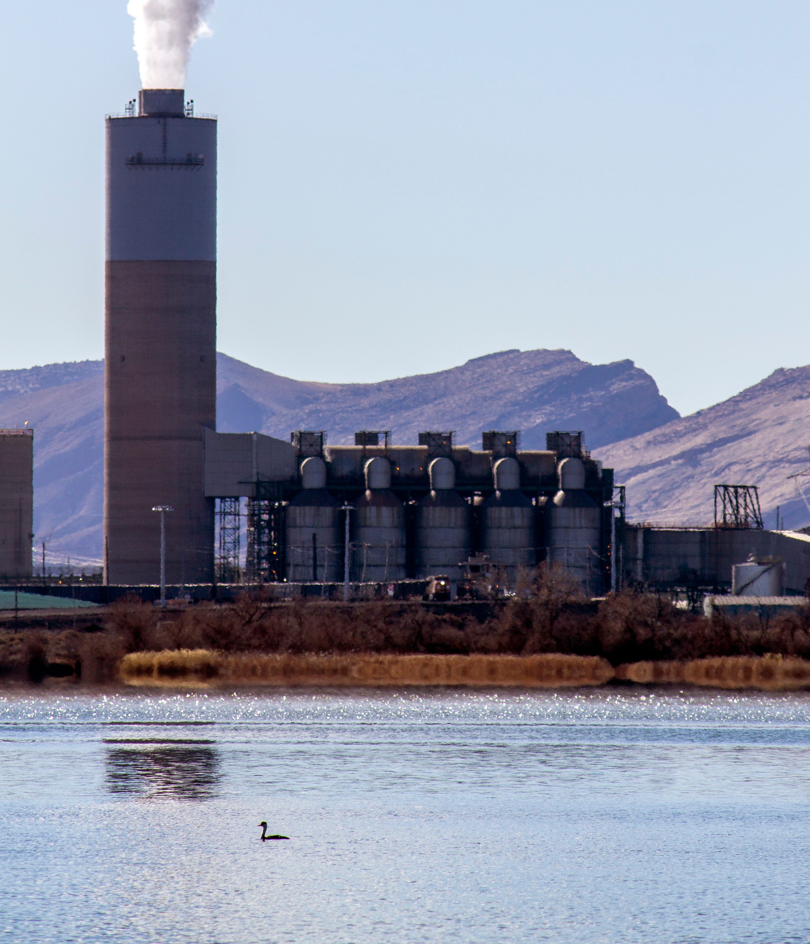
Four Corners Power Plant. Jonathan P. Thompson photo.
For the last several years, the coal industry in the Western U.S. has been suffering from what I call the Big Breakdown — as opposed to the Big Buildup of the 1960s and 1970s, when coal power plants and mines popped up all over the Colorado Plateau and beyond. Now, it appears that the proliferation of energy-intensive data centers is stalling the Breakdown, maybe even reversing it. Last week, Arizona Public Service announced it would keep the Four Corners coal plant in northwestern New Mexico running — and polluting — for another seven years beyond its scheduled 2031 retirement.
The coal-burning extension is part of the state’s largest utility’s plan to shift its climate goal from becoming zero carbon by 2050 to carbon neutral. While that sounds like a mere semantic switch, its on-the-ground effects will be significant. Along with the coal plant news, APS and the state’s other largest utilities are going in on a new natural gas pipeline from the Permian Basin so it can increase fossil fuel generation rather than pivoting entirely to solar, wind, battery energy storage, and other carbon-free sources.
APS officials say the shift is necessary to meet growing power demand. While population growth and increasingly hot temperatures play a role in the ever-larger load on the grid, the crop of new energy-intensive data centers sprouting in the Phoenix area is a principle driver. The utility is also likely reacting to the Trump administration’s fondness for fossil fuels and disdain for renewables.
The Four Corners plant and its accompanying Navajo Mine were constructed about 15 miles west of Farmington in the early 1960s by a consortium of utilities led by APS and Utah Construction & Mining Co, a subsidiary of Kennecott, a global mining firm. It was the flagship of a much larger fleet that would include the San Juan, Navajo, Mojave, Cholla, Coronado, and Escalante plants. Mojave was shuttered in 2005, with the other big plants closing down more recently (Coronado will be converted to natural gas). That leaves just Four Corners, which was supposed to be shuttered in 2031, or even sooner, if Public Service Company of New Mexico were able to get out of its 13% stake before then.
But over the last few years, utilities have been second-guessing plans to decommission the aging behemoths as data centers have sprouted across the region, significantly increasing demand on the power grid. Over the last week, both Salt River Project and APS have set new peak power demand records as both residents and data centers crank up the coolers to offset extreme heat. Demand is projected to grow significantly over the next decade, mostly due to new data centers. It’s the Big Buildup all over again, only this time it’s high-tech server farms sprouting all over the place, with power generating sources struggling to keep up.
1 *I didn’t hear this story until after my father died, so this is all second-hand and the details may be a bit off.
2 I won’t tell you what happens. If you read the book, you should be warned that reviewers of the time sneered at it for being too macho, too crude, having too much drug and alcohol use, “adolescent,” and so forth. Maybe that’s all true, but I liked it the first time I read it decades ago, and I still liked it when I read it again recently.
3 * The term was apparently coined in the 1980s by Ron Arnold, the founder of the anti-environment Wise Use Movement.
4** Right-wing nationalist attacks on the power grid are not, in my mind, a form of monkeywrenching. Their goal is to disrupt and harm society, including humans, not to stop environmental damage or even make a political protest.
The 24-Month Study projects future Colorado River system conditions using single-trace hydrologic scenarios simulated with the Colorado River Mid-term Modeling System (CRMMS) in 24-Month Study Mode. The Most Probable and Probable Minimum 24-Month Studies are released monthly, typically by the 15th day of the month. The Probable Maximum 24-Month Study is released alongside other 24-Month Studies in January, April, August, and October.
Initial Conditions: The 24-Month Study is initialized with previous end-of-month reservoir elevations.
Hydrology: In the Upper Basin, the first year of the Most Probable inflow trace is based on the 50th percentile of Colorado Basin River Forecast Center (CBRFC) forecasts and the second year is based on the 50th percentile of historical flows. To represent dry and wet future conditions, the Minimum Probable and Maximum Probable traces use the 10th and 90thforecast percentiles in the first year and the 25th and 75th percentiles of historical flows in the second year, respectively. The Lower Basin inflows are based only on historical intervening flows that align with the Upper Basin percentiles.
Water Demand: Upper Basin demands are estimated and incorporated in the unregulated inflow forecasts provided by the CBRFC; Lower Basin demands are developed in coordination with the Lower Basin States and Mexico.
Policy: 2007 Interim Guidelines, 2024 Supplement to the 2007 Interim Guidelines, Lower Basin Drought Contingency Plan, and Minute 323 are modeled reflecting Colorado River policies. For modeling purposes, simulated years beyond 2026 assume a continuation of the 2007 Interim Guidelines including the 2024 Supplement to the 2007 Interim Guidelines (no additional SEIS conservation is assumed to occur after 2026), the 2019 Colorado River Basin Drought Contingency Plans, and Minute 323 including the Binational Water Scarcity Contingency Plan. With the exception of certain provisions related to ICS recovery and Upper Basin demand management, operations under these agreements are in effect through 2026. Reclamation initiated the process to develop operations for post-2026 in June 2023, and the modeling assumptions described here are subject to change.
Reclamation will continue to carefully monitor hydrologic and operational conditions and assess the need for additional responsive actions and/or changes to operations. Reclamation will continue to consult with the Basin States, Basin Tribes, the Republic of Mexico and other partners on Colorado River operations to consider and determine whether additional measures should be taken to further enhance the preservation of these benefits, as well as recovery protocols, including those of future protective measures for both Lakes Powell and Mead.
For more detailed information about the approach to the 24-Month Study modeling, see the CRMMS 24-Month Study Modepage. All modeling assumptions and projections are subject to varying degrees of uncertainty. Please refer to this discussion of uncertainty for more information.
Projections
The latest 24-Month Study reports for each study can be found at the links below:
WASHINGTON — The Bureau of Reclamation released the August 2025 24-Month Study, reaffirming impacts of unprecedented drought in the Colorado River Basin and pressing the need for robust and forward-thinking guidelines for the future. The study provides an outlook on hydrologic conditions and projected operations for Colorado River reservoirs over the next two years and sets the 2026 operating conditions for Lake Powell and Lake Mead.
“This underscores the importance of immediate action to secure the future of the Colorado River,” said Reclamation’s Acting Commissioner David Palumbo. “We must develop new, sustainable operating guidelines that are robust enough to withstand ongoing drought and poor runoff conditions to ensure water security for more than 40 million people who rely on this vital resource.”
Lake Powell’s elevation on Jan. 1, 2026, is projected to be 3,538.47 feet—approximately 162 feet below full pool and 48 feet above minimum power pool. This places the reservoir in the Mid-Elevation Release Tier, with a planned release of 7.48 million acre-feet of water for water year 2026, October 1, 2025, through September 30, 2026. If hydrologic conditions worsen, the water year release volume may be reduced in accordance with the 2024 Record of Decision for the Supplement to the 2007 Interim Guidelines.
Lake Mead is projected to stay in a Level 1 Shortage Condition, with an expected elevation of 1,055.88 feet—20 feet below the Lower Basin shortage determination trigger. This condition necessitates significant water reductions as indicated by the 2007 Interim Guidelines and the Lower Basin Drought Contingency Plan in the United States and Minute 323 and the Binational Water Scarcity Contingency Plan in Mexico. This calls for Arizona to contribute 512,000 acre-feet, about 18% of its annual apportionment, Nevada to contribute 21,000 acre-feet or 7%of its annual apportionment, and Mexico to contribute 80,000 acre-feet or 5% of its annual allotment.
Current guidelines—including the 2007 Interim Guidelines, 2019 Drought Contingency Plans, and international agreements Minutes 323 and 330—are all set to expire at the end of 2026, leaving a critical void that must be filled with comprehensive strategies that address current and future challenges.
“As the basin prepares for the transition to post-2026 operating guidelines, the urgency for the seven Colorado River Basin states to reach a consensus agreement has never been clearer. We cannot afford to delay,” said Department of the Interior’s Acting Assistant Secretary for Water and Science Scott Cameron. “The health of the Colorado River system and the livelihoods that depend on it are relying on our ability to collaborate effectively and craft forward-thinking solutions that prioritize conservation, efficiency, and resilience.”
In June, Cameron called on the seven Colorado River Basin states to submit the details of a preliminary operations agreement by mid-November and share a final seven state agreement on that proposal by mid-February 2026, with the goal of reaching a final decision next summer to begin implementation in the 2027 operating year.
In the meantime, near-term operating guidelines approved last year provide additional strategies to reduce the risk of reaching critical elevations at Lake Powell and Lake Mead. These short-term tools, available through 2026, include conserving 3 million acre-feet or more of water in the Lower Basin and the potential to reduce release from Lake Powell. Under the Drought Contingency Plan, Upper Basin drought response operations could also include sending additional water to Lake Powell from upstream reservoirs.
“These short-term tools will only help us for so long,” Cameron emphasized. “The next set of guidelines need to be in place. We remain committed to this effort and will continue to invest in infrastructure improvements and system water reuse and conservation efforts as we move forward toward viable solutions.”
The Department and Reclamation continue meeting regularly with the basin states and Tribal Nations to collaborate on the Post-2026 Operating Guidelines as part of their continued commitment to ensuring water security and promoting long-term sustainability in the Colorado River Basin. For more information on the August 2025 24-Month Study, visit https://www.usbr.gov/lc/region/g4000/riverops/24ms-projections.html.
Udall/Overpeck 4-panel Figure Colorado River temperature/precipitation/natural flows with trend. Lake Mead and Lake Powell storage. Updated through Water Year 2024. Credit: Brad Udall
From email from Western Resource Advocates (John Berggren):
August 15, 2025
Western Resource Advocates released the following statement in response to the August 24-Month Study by the U.S. Bureau of Reclamation, which determines reservoir operations and Lower Basin shortages for the coming Water Year, and projects future conditions in the Colorado River system for the next two years.
“This study confirms what we’ve known for decades: the Colorado River is overallocated with demands outpacing supplies. We face continued shortages, emergency measures, and the limits of our current agreements, all which are set to expire in the next 12 months. It further sounds the alarm that the Colorado River is drying out and Western states need to act now to protect this vital waterway and its tributaries.”
– John Berggren, Ph.D.
The Colorado River provides drinking water for one in ten Americans and after years of persistent drought, declining snowpack, and rising temperatures, the river continues to face a historic and growing imbalance where demand overwhelms available supply. It is operating under extreme stress and at the edge of a critical management transition.
“This is not just a crisis. It’s also a call to action to use remaining time wisely to replace our current reactive, emergency-based management framework with new, long-term solutions. We can’t litigate our way out — we must collaborate forward. A negotiated agreement among all the Colorado River sovereigns and stakeholders will be more comprehensive, more adaptable, and more responsive to our communities throughout the Basin.”
Change is the only constant on the Colorado River. Its water carved the Grand Canyon, its flows fluctuate seasonally, its path is altered by a network of dams and pipelines, and its water is dwindling as climate change dries out the West. The River is a dynamic and living system with real limits, yet early agreements treated it like a simple water delivery pipeline.
“Going forward, it’s essential for all water stakeholders and decision makers to take an honest look at the Basin’s hydrology and accelerate coming together around a set of proactive solutions to keep the river healthy. Decisions made in the coming months will determine whether we can meet the needs of our communities and protect the river for future generations and for the fish, wildlife, and recreationists that depend on it. The time to lead is now.”
Thank you for fighting climate change in the West with us.
Trail building by the Civilian Conservation Corps on Notch Mountain, then a popular destination for its view of the Mount of the Holy Cross and the throngs of religious pilgrims who were drawn to the site in the early days of the Holy Cross National Forest, now part of the White River National Forest. CREDIT: U.S. FOREST SERVICE
Editor’s note: This story is the third of a three-part series examining the notion of public lands, both in the United States and in our region. Part one looked at the earliest expressions of the commons in territories that would become the United States. Parts two and three look at the history and legacy of what is now the White River National Forest.
The hunger for land was an insatiable draw to legions of the dispossessed who were on the march across America eager for land ownership. The Utes were simply in the way of an advance that could not or would not be stopped. The tragic story of these first inhabitants of the White River National Forest (WRNF) played out to a violent end amid a rush for land and resources in the Colorado Rockies that had 5,000 people per day pouring into the state by the 1870s.
Native inhabitants had been hunting and gathering here for more than 10,000 years. The Utes — the “People of the Shining Mountains,” according to the title of a book by Charles Marsh — ruled a vast and rugged empire of about 225,000 square miles that stretched from the Central Rockies west into Utah and Nevada, south into New Mexico and east onto the Great Plains where they hunted buffalo on horseback. The Utes were among the first Native Americans to acquire the horse from Spanish stock that, it was assumed, had been lost. Horses were key to Ute identity, and equestrian skills were a mark of manhood that provided rapid mobility and warrior status.
White River Ute warrior Gray Eagle and his young bride Honey Dew of the Mountains, on horseback on the western slope of the Wasatch Range in Utah, then roaming their vast territory west of the White River before the White River Agency was established. Circa 1871-1875. CREDIT: DENVER PUBLIC LIBRARY
Broken treaties and war
The advance of Europeans into Ute lands set up a tension that grew with every treaty violation and every trespass. As their domain was carved away, the U.S. government naively assumed the Utes could be transitioned from nomadic hunter-gatherers and cordoned off as sedentary farmers. Indian agents were hired to effect this transition, which, in the long run, proved futile and disastrous. There was no reasonable answer to “the Ute problem,” which was the terminology used by Frederick Pitkin, Colorado’s second governor from 1879-82, to refer to the cultural impasse.
The ensuing drama escalated at the White River Agency near today’s Meeker in 1879 when Indian agent Nathan Meeker, a naive and misguided minister, attempted to force the Utes’ compliance to “white man’s ways” by denying them their horses, rationing allotments and plowing over their racetrack to plant crops. Meeker and others believed that the Utes were in need of redemption for their spiritual welfare. The Utes, who found spiritual depth in the natural world around them, believed otherwise and clung to their sacred traditions.
The conflict boiled over in the late summer of 1879 when Meeker had a violent altercation with a Ute sub chief. The frightened Meeker sent for the U.S. Army, which advanced from Wyoming and was met by a strong Ute force. When the detachment of 190 troops crossed into Ute territory on Sept. 29, shots rang out, kicking off a grueling six-day battle of attrition that saw 17 U.S. soldiers killed and wounded 44, while the Utes saw 24 killed, in what became known as the Battle of Milk Creek. As the battle raged 17 miles away, Utes also attacked the White River Agency, killing Meeker, 10 men under his employ, and kidnapped women and children, including Meeker’s wife and daughter.
All captives were later released from a Ute camp on Grand Mesa. But the violent outbreak provided ample pretext for the whites to pursue a campaign of ethnic cleansing. In 1881, Pitkin issued an edict stating that the Utes would either be removed to reservations in Utah and southern Colorado or exterminated. Many were marched out of their homelands near the Uncompahgre River at gunpoint, while remaining bands roamed northwest Colorado until an 1887 military campaign known as the Colorow War.
With that Pitkin proclamation, 12 million acres of western Colorado opened for settlement. The White River Timberland Reserve was later created on these former Ute lands, placing them under federal administration. The Utes were compensated about $22 per capita in a settlement for all that they were forced to surrender. However, draws from those payments were taken from Ute hands to fund pensions paid to families of soldiers and agency staff killed during the violence surrounding the Meeker incidents. So ended the empire of the Utes.
Milk Creek Battlefield Park, 18 miles northeast of Meeker, Colorado. Battle of Milk Creek, Sept. 29 through Oct.5, 1879, between the Utes and the U.S. troops, which triggered the Meeker incident. The battle persisted with the Utes surrounding the wagon-circled troops until military reinforcements arrived. Most sources tally 17 whites killed and 44 wounded, along with 24 Utes killed and unknown numbers wounded, while 127 horses and 183 mules of the U.S. troopers died. By Jeffrey Beall – Own work, CC BY-SA 3.0, https://commons.wikimedia.org/w/index.php?curid=70937831
Exploitation, waste and destruction
“One of the most pressing problems facing Colorado in the 1880s and 1890s,” wrote Justine Irwin, author of the 1990 manuscript “White River National Forest: A Centennial History,” “was the prevalent exploitation of its natural resources by westward moving pioneers … [who] accepted the waste and destruction that followed as a small price to pay for their dream of prosperity.”
The prevailing attitude of the day regarded “wilderness” as a wasteland ripe for the biblical mandate in the Book of Genesis: “Increase, multiply, replenish the earth and subdue it.” These newcomers to western Colorado, wrote Irwin, viewed the land with “utilitarian spectacles,” through which “trees became lumber, prairies became farms, and canyons became the sites of hydroelectric dams.”
A dramatic example of the settlers’ creed was the extermination of the native elk herd as meat hunters ignored sustainable yields and fecklessly shot and killed all the native elk in the region, selling their harvest to railroad builders and mine workers. So-called “market hunting” flourished only as long as the herds lasted, and the 6,000 to 8,000 elk estimated to have been in the WRNF region in 1879 were soon extirpated. Hunters took only the hindquarters of the animals, leaving the rest as waste. The selling price for meat was 7 cents a pound for deer, 9 cents for elk, 10 cents for bighorn sheep and bear, and 50 cents for grouse.
Meanwhile, the General Land Office, a real estate branch of the Department of Interior, was busy selling off the commons at $1.25 per acre. The Homestead Act gave land away to qualifying settlers in 160-acre allotments for each adult member of a family. Large families could acquire considerable acreage of public lands. The Timber Culture Act of 1873, the General Mining Act of 1872 and the Railroad Act of 1862 gave away huge swaths of the public domain, all to encourage monetizing the commons and capitalizing on the riches of the continental empire of the United States.
“Ranchers, loggers and others invaded railroad lands taking what they wished and giving no thought to the long-range future of the region,” wrote Irwin, who describes a ruthless lawlessness that discouraged any interference in this land-based free-for-all. But there was change in the air as lawmakers recognized that there were limits to the nation’s natural resources. The giveaways continued, but national parks and designated forests were proposed and gradually established to preserve legacy Western landscapes for future generations in a first glimmer of conservation. The philosophy behind this growing movement was shared by Henry David Thoreau, George Catlin, John James Audubon, John Muir and an influential cadre of preservationists who began to win over advocates in Washington, D.C. The conservation ethic is summed up by author Rod Nash in his “Wilderness and the American Mind” (1967), in which he wrote, “Doesn’t the present owe the future a chance to know the past?”
Environmental concerns for preserving intact ecosystems to protect valuable and irreplaceable watersheds played a utilitarian role in conservation efforts on Western lands. Forestry management entered the lexicon of policymakers when, in 1875, Section 6 of the Colorado Constitution called for “Preservation of Forests: The General Assembly shall enact laws in order to prevent the destruction of, and to keep in good preservation, the forests upon the lands of the state.”
Citizen involvement through civic forestry associations amplified the call to protect national assets and save something for the future. In 1889, a timber reserve was called for on the Western Slope of Colorado to safeguard against wildfires, overgrazing and irresponsible timber harvests — all of which were decimating irreplaceable landscapes. A similar approach to nature aesthetics was winning hearts and minds for preserving the inspiring vistas that were beginning to sensitize America to the natural treasures of which it had taken possession.
In 1891, a groundswell of support led President Benjamin Harrison to enact the General Revision Act, a sweeping mandate to protect Western lands that led Harrison to issue a proclamation establishing the White River Plateau Timber Land Reserve, the first binding federal protection for a large expanse of central and northwest Colorado and the second of its scale and scope in the United States, after a forest reserve designated near Yellowstone National Park. Supporters called it a great victory, but detractors — of which there were many — impugned the initiative as a “taking” of what they considered the entitlement of free land.
The account of a boasting pioneer quoted in “White River National Forest: A Centennial History” and who had unconscionably plundered the public domain is a grim tale of misuse without supervision and reasonable limits of what was perceived as an infinite cornucopia: “In the summer of ’89, I killed about 700 deer and pulled the hides off, just for the hides. That fall, I got 43 bear near Lost Park. I shipped the hides to Chicago and they netted me clear $1.50 apiece. Everybody killed game for the hides and made money that way. I’ll tell you a fact: In ’89 I could ride up anywhere and there would be 40 to 50 bucks lying in one bunch. You could ride up to within a few feet of them. I killed 23 bucks in one day and jerked the hides off.”
Such carnage became repugnant to many and shameful to a growing number of nature lovers who advocated protective legislation such as the Forest Management Act of 1897 that granted the secretary of the interior power to regulate “occupancy and use” of federal lands. Implementation was another thing as new and often-inexperienced forest rangers came up against hardened libertarians who were armed and militant — namely, loggers and ranchers. Threats against rangers, who lacked policing power, were said to “make your eyes swell shut and your nose bleed,” according to “A Centennial History.”
“A ranger must be able to take care of himself and his horses under very trying conditions; build trails and cabins; ride all day and all night; pack, shoot and fight without losing his head. All this requires a very rigorous constitution,” read one early Forest Service job posting. A group of White River National Forest rangers are shown here at a 1921 meeting. CREDIT: U.S. FOREST SERVICE
Forest rangers bring law to the wilderness
According to Irwin’s manuscript, “the forest ranger had to become not only a conservationist, a lands manager, a grazing expert, a timber expert, a watershed manager, a wildlife protector and jack-of-all-trades, he also had to become an expert in public relations with a keen understanding of community and national politics.” Few could match up to these requirements without rigorous training and a deep commitment to the role.
In 1898, Charles W. Ramer of Fort Collins was appointed the first supervisor of the White River Plateau Timber Land Reserve, headquartered in Meeker. Jack Dunn, Harry Gibler and Solon Ackley were the first rangers hired to patrol the reserve, which was divided into nine districts. The rangers were assigned to observe that loggers and ranchers kept to their assigned boundaries, to ensure that game regulations were followed and to put out brush fires.
These early rangers faced tremendous personal risks from unruly forest users, as described in an account by ranger William Kreutzer, who faced repeated threats from his efforts to enforce regulations. One night in the early 1900s, wrote Irwin, “as he was returning to his camp from a day patrolling, three men sprang suddenly from the aspen thickets and attacked him. Almost instantly he was struck on the head with something that rendered him unconscious. When he recovered, many hours later, he was lying beside the road, his head ached, his nose was bruised.”
Early forest rangers faced personal risks from unruly forest users. One account by ranger William Kreutzer, shown here, described facing beatings and attempted shootings from his efforts to enforce regulations.
Another incident from Irwin’s manuscript revealed that Kreutzer boldly confiscated tools from a group of timber cutters felling trees inside the protected reserve. “One day he was riding a trail and a bullet whizzed by close to his head. He rolled from his saddle and sought shelter behind a large tree. Four more bullets struck near him. The boom that followed each shot told him they had come from a large rifle fired from a spot some distance away. He had only his six-shooter, but ascertaining as best he could the spot whence the shots came, he elevated the barrel of his gun and fired every cartridge. The shots of his assailant ceased. He decided that someone had just tried to scare him a bit.”
Trophy hunters flocked to hunt in the White River Reserve, the most prestigious of whom was President Theodore Roosevelt whose special train passed through Glenwood Springs in 1901. The Roosevelt party hunted the Danforth Hills near Meeker, killing 14 mountain lions. Although Roosevelt championed conservation of wild lands, he withdrew substantial acreage from the reserve on the advice of his chief forester, Gifford Pinchot, in order to appease complaints from forest users of “locking up the land.”
Meanwhile, posted notices advertised the following: “Men Wanted!! A ranger must be able to take care of himself and his horses under very trying conditions; build trails and cabins; ride all day and all night; pack, shoot and fight without losing his head. All this requires a very rigorous constitution. It means the hardest kind of physical work from beginning to end. It is not a job for those seeking health or light outdoor work. Invalids need not apply.”
Requirements were incredibly demanding, but men equal to the challenge answered the call and were hired only after completing a grueling exam that included saddling a horse, riding a required distance, packing a horse or mule with tools and camping gear, pacing the pack animal over a designated trail, taking bearings with survey tools and more. The annual salary for the few who were able to pass the test was $900 to $1,500, but starting at a lower figure.
The staunchest objectors to enforcement were cattlemen whose livelihood required substantial range. Among them was Roaring Fork Valley rancher Fred Light, who protested the charging of range fees for grazing his stock. Light’s story traces a reluctant yet gradual progression from vehement protests to acceptance of the principles of forest management.
Trophy hunters around the turn of the 20th century flocked to the newly created White River Reserve, the most prestigious of whom was President Theodore Roosevelt whose special train passed through Glenwood Springs in 1901. The Roosevelt party hunted the Danforth Hills near Meeker, killing 14 mountain lions. CREDIT: U.S. FOREST SERVICE
Light of the Roaring Fork
Fred Light (1856-1931) came to the Roaring Fork Valley in 1880. He prospected before locating a homestead on East Sopris Creek where he cut and sold hay in Aspen to feed the many teams required for mining and camp life. Eventually, Light proved up on his land, expanded his operation, and raised cattle and horses. In 1885, he was elected to the Colorado legislature and served two terms. He was a prominent, well-respected rancher who had political savvy — and clout.
“We want no forest reserves,” Light announced to cheers and applause at a meeting of the Stockmen’s Association in 1907. “If we must have reserves, we want no grazing tax; if we must have reserves and the tax, the cattlemen claim the privilege of saying who will be placed in charge of the reserves.”
Light gained notoriety when, that same year, he allowed his cattle to drift into the newly formed White River Forest Reserve where grazing was prohibited. Light, like many early ranchers, was resistant to government control over a resource that he and many ranchers took possession of as an entitlement by simply being there first and assuming a right of ownership.
Light was cited, which started a grazing-trespass case with the U.S. Department of Forestry and which eventually reached the Supreme Court. Light lost his case, but he had made a bold statement of rugged individualism that animated the spirit and the myth upon which much of the American West was settled. The decision against him, however, verified the government’s legitimacy in charging grazing fees and regulating uses on reserve land. Light accepted the decision and thereafter paid the appropriate fees. He also agreed to the rules and regulations, and he even came to endorse them as he witnessed how competing forest users were beginning to negatively impact the land.
Light’s story is compelling, but there was a far more sensational and dire event in his colorful life in the Roaring Fork Valley that describes a sad, personal anecdote. The Aspen-Democrat Times reported a dramatic event: An electrical storm, proclaimed “the worst in the history of this locality,” killed one person and wounded others in the Capitol Creek area.
According to the July 14, 1909, news story, “Early last evening an electrical storm set in which surpassed in severity any before experienced in this locality and brought disaster to the household of Hon. Fred Light of Capitol Creek, one of the most prominent and highly respected families of Pitkin County.” That evening, a bolt of lightning struck a potato cultivator outside the home, jumped to the gable on the home’s roof and ran down to the basement, where Light’s five children were packing meat. Light’s son Ray, 18, was killed with four others rendered unconscious.
Light’s conversion to the ways of the forest was a sign of progress, but, unfortunately, it did nothing to ameliorate an even more vitriolic conflict. A range war erupted in the early 1900s that pitted cattlemen and sheepherders against one another in a blood feud that resulted in thousands of sheep being slaughtered and a number of men being beaten and killed. The Western tradition of “first in time, first in right” gave cattlemen the wherewithal to declare the range existed for cattle only. Sheepherders were not forbidden by law or permit, but they took their lives in their hands if they violated the cattlemen’s self-imposed privilege.
Chapman Dam in the Fryingpan River basin, shown here in 1940, was a Great Depression-era Civilian Conservation Corps project. CREDIT: WWW.WATERARCHIVES.ORG
Range wars
While the Glenwood Post became amenable to regulations in the White River Reserve by acknowledging the advantages of range protection, increased pasturage and peaceable possession for cattlemen, the advent of sheepherders lit the fuse of a conflict that blew up repeatedly. Irwin describes the George Woolley Sheep Massacre in Routt County when, in 1911, several hundred sheep were “rimrocked” in a stampede that drove them off a cliff. In 1913, many sheep were killed by strychnine poisoning. Finally, a full-on range battle ensued in 1913 in the Battle of Yellowjacket Pass, between Craig and Meeker, when warring sheepherders and cattlemen fired upon one another, necessitating the calling out of the Colorado State Militia.
Changes in the cattle industry — such as growing domestic hay for winter feed and breeding more efficient strands of range cattle — increased weight gain and reduced the desperate need for vast grazing acreage. Forest rangers also played a part as peacemakers and mediators who headed off range feuds. They also took on rapidly expanding responsibilities to regulate timber cutting and supervise road-building, water diversions, irrigation, reforestation, erosion control, trail-building, sign-postage, wild game and fish management, and many other tasks. When elk were reintroduced to the forest in 1912 — Fryingpan Valley rancher Nelson Downey reportedly killed the last bull elk of the original herd in 1895 — rangers monitored the habitat and protected the imported elk from over-hunting.
As a more peaceful era settled on the reserve (renamed the White River Forest Reserve in 1902 by Roosevelt), a new use with rapidly growing popularity became evident as people came to the reserve, not to graze animals or cut timber, but to simply enjoy the sublime natural beauty that is in such profusion here. Enter recreation and a new identity for the public commons.
A U.S. Forest Service photo dated between 1910 and 1930 shows a man with a fishing pole near a tent at Snowmass Lake, with Snowmass Peak in the distance covered with snow. Recreation grew in popularity throughout the early 20th century, creating new priorities for the Forest Service. CREDIT: DENVER PUBLIC LIBRARY
For the love of nature
Pinchot, the chief forester, considered recreation to be only an “incidental use” until 1905, when hotels and sanitariums were introduced to the reserve for popular enjoyment and therapeutic healing. Gradually, roads and trails became part of the White River National Forest (Congress renamed it so in 1907) with the mandate to include all users. This brought commercial use into local cultural and economic equations and began a shift of management priorities.
An annual report on the forest in 1913 stated that natural resources would now be managed to reduce impacts from grazing and logging in order to “preserve the natural beauty of the location unmarred for the enjoyment of the public.” A potentially lucrative recreation economy spurred a tangential threat of privatizing public lands for commercial gain as stated in a letter to the U.S. Forest Service from the Denver Chamber of Commerce in 1913: “We deny that it is right or advisable for the federal government to retain title to and lease the public lands for any purpose whatsoever.”
The Forest Service was not alone in wariness of privatizing the commons for private development. In a major turnabout from only a decade before, Colorado stock growers shared the alarm: “We earnestly object to any action by Congress abolishing the national forests or transferring their control or administration from the national government, and we must respectfully urge our congressmen to oppose any measures materially changing the present method regulating grazing on the national forests.”
Even Light came to the forest’s defense as reflected in a report in the Glenwood Post in 1916: “Fred Light was even ready to kiss and forgive the forestry officials. … Mr. Light says he has learned to adapt himself to the forestry regulations and that the officials mean only good to the stockmen.”
Grazing and logging continued as fundamental to the forest economy, especially during World War I when resources were in great demand, and yet the clamor for private resorts and vacation cabins began exerting influence. Trappers Lake was a sought-after locale for a proposed lodge and several hundred cabins that threatened to commercialize a scenic focal point on this White River National Forest wilderness enclave. In 1919, Arthur Carhart, landscape architect for the U.S. Forest Service, made a survey of the area and later advocated for a new concept in public-lands management — wilderness — especially after a meeting with assistant forester Aldo Leopold, America’s first conservation biologist.
“How far shall the Forest Service carry or allow to be carried manmade improvement in scenic territories?” wrote Carhart. “The Forest Service is obliged to make the greatest return from the forests to the people of the nation that is possible.” Carhart acknowledged forest yields in economic terms, but then urged for a higher concept of land use. “There is a great wealth of recreational facilities and scenic values within the forests,” he opined. “There are portions of natural scenic beauty which are God-made and which of a right should be the property of all the people. There are a number of places with scenic values of such great worth that they are rightfully property of all people. They should be preserved for all time for the people of the nation and the world.”
With that statement, Carhart leaped beyond the utility of conversation via Pinchot into the notion of preservation along the aesthetic and spiritual lines of Muir and Leopold. Carhart concluded: “If Trappers Lake is in or anywhere near in the class of superlatives, it should not have any cabins or hotels intruding in the lake basin.” Trappers Lake was preserved, and Carhart’s memo became a strong endorsement of the Wilderness Act of 1964.
The mess tent at a Civilian Conservation Corps work project camp at Maroon Lake,1935. The CCC put the impoverished and the unemployed to work on federal lands to build roads, trails and facilities. CREDIT: ASPEN HISTORICAL SOCIETY
A Civilian Conservation Corps work project camp at Ashcroft, 1938. The workers at the camp were improving Castle Creek Road and building and repairing bridges. CREDIT: ASPEN HISTORICAL SOCIETY
The scenic WRNF and the CCC
There is a mountain in the distant West That, sun-defying, in its deep ravines Displays a cross of snow upon its side.
William Henry Jackson wrote that verse after photographing Mount of the Holy Cross (at 14,009 feet) during his wilderness sojourn in 1874 with the Ferdinand Hayden geologic survey team. Located in Eagle County, this dramatic peak became a religious icon in the 1920s when pilgrimages were made to nearby Notch Mountain for the spectacular view. Visitors came from around the world to see the sight, having either to hike there or to travel by horseback. President Herbert Hoover declared the peak a national monument in 1929. In 1950, that status was rescinded after the pilgrim era had tapered down to almost nothing.
Still, the religious influence of this remarkable mountain left an imprint in the American psyche that, for growing numbers, infused scenic lands with sacred status. A tide had turned when Western lands attained a divine countenance that glowed with ethereal majesty and touched the hearts, minds and imaginations of those who saw them. This love of the land became a national balm when, in 1929, the stock market crashed and America entered the Great Depression.
As many Americans suffered economic privation, the forests of the West became sanctuaries, places to escape the grit and grime of depressed cities and breathe fresh air. When Franklin D. Roosevelt was elected president in 1932, his socially progressive legislative agenda included the formation of a national service component called the Civilian Conservation Corps (CCC).
Federal dollars put the impoverished and the unemployed to work on federal lands to build roads, trails and facilities. CCC workers, each paid $30 per month, were mostly young men, from all walks and all corners of the nation, who spent weeks, months and sometimes years working in national forests, living in communal camps and recognizing the virtues of public lands.
During the 1930s, there were CCC camps in Woody Creek and at Norrie in the Upper Fryingpan. Gradually, forest access was opened to more users as land improvements mitigated erosion with the planting trees and shrubs, removing invasive or poisonous species, and making the forests prime recreation areas under the multiple-use mandate, which the Forest Service described as “inseparably interwoven into the social and economic future of forest communities.”
Maintaining the health of the range within the White River National Forest was a constant challenge made more practical by the Taylor Grazing Act of 1934, named for U.S. Rep. Edward Taylor, D-Colo., of Glenwood Springs. The act was designed specifically to prevent overgrazing and soil deterioration, and to provide for the orderly use and improvement of public lands, while also stabilizing the livestock industry dependent on the public range. Fundamentally, the act protected the health of the rangelands and the resources they provided.
Members of the 10th Mountain Division climb a slope during a winter training exercise where the troops skied from Leadville to Aspen. This image was likely captured near Mount Champion. After the war, many 10th Mountain veterans were among the legions of young skiers and mountaineers who established the Colorado ski industry that was soon to develop resorts on national forest land. CREDIT: 10TH MOUNTAIN DIVISION RESOURCE CENTER, DENVER PUBLIC LIBRARY
World War II and the 10th Mountain Division
America’s entering World War II with the Japanese attack on Pearl Harbor in 1941 raised demands for resources from the White River National Forest and reduced its workforce as all attention was focused on national defense. A different kind of attack, this one by the Engelmann spruce beetle, saw huge mortality rates throughout the forest, prompting foresters to implement the sustainable yield concept for renewable timber harvests, especially given the decimation from beetle-killed trees. This resulted in the passage, in 1944, of the Sustained Yield Forest Management Act, which found favor with the War Production Board and opened the forest to widespread logging. A deep cold snap in 1951 greatly reduced spruce beetle populations, restored forest health and obviated the need for insecticide applications that had been tested on Basalt Mountain.
The war brought a new user group to the forest when the 10th Mountain Division trained at Camp Hale, near Leadville. After the war, legions of young skiers and mountaineers were attracted to the state’s Rocky Mountains, where many established the Colorado ski industry that was soon to develop resorts on national forest land. Aspen became a focal point for Colorado’s identity with skiing, which brought Walter and Elizabeth Paepcke from Chicago to Aspen in 1945. Elizabeth Paepcke, who founded the Aspen Center for Environmental Studies (ACES), is described by Irwin as “an ardent conservationist trained by family friend, Gifford Pinchot,” and later by early wilderness advocate Enos Mills.
A Civilian Conservation Corps work project on Castle Creek Road,1937. Workers camped on public lands near Ashcroft improved Castle Creek Road and built and repaired bridges. CREDIT: ASPEN HISTORICAL SOCIETY
NEPA boosts environmental oversight
As recreation created mounting pressures for land development, the Forest Service recognized the need for greater environmental oversight, leading Congress in 1969 to pass the National Environmental Policy Act (NEPA). This groundbreaking legislation focused initially on the impacts of ski-area design and later became an overarching management tool for all public land uses.
Meanwhile, the White River National Forest became “the ski-area forest” as thousands of acres of public lands were permitted for ski runs and resort infrastructure. The town of Vail was incorporated in 1966, where by the end of the 1967-68 ski season, 1 million lift tickets were sold and revenues reached nearly $3 million. General forest visitation had also grown to 171,000 in 1947 from 96,000 in 1946. “For every two who pitched camp in our forests in 1948,” wrote a forester in 1950, “three or more did in 1949.” The recreation boom had begun.
By the mid-1950s, public demand for designated campgrounds created an ever-growing budget for facilities that could accommodate nature-seeking Americans. The role of the forests became focused on serving visitors in unprecedented numbers. The 1960 Multiple Use-Sustained Yield Act ushered in a new thrust for outdoor recreation as “multiple use” became the law of the land. Along with the explosion in tourism came ambitious water diversions as natural watersheds were impounded to fill dams and regulate flows for human benefit under the Bureau of Reclamation. Transmountain diversions and dams proliferated in the WRNF throughout the upper Fryingpan, Roaring Fork and Lincoln Gulch basins.
William Henry Jackson, who is credited with the image here, first photographed the cross of snow on the northeast face of the Mount of the Holy Cross in 1873, and the peak became one of the Rocky Mountains’ best known features. It was declared a national monument in 1929, but saw that status rescinded in 1950 as the number of religious pilgrims declined. The 14,009-foot peak has been protected by the Holy Cross WIlderness since 1980. CREDIT: DENVER PUBLIC LIBRARY
The wilderness idea
As human impacts threatened over-development of forest lands, a chorus of wilderness advocates called for a balance by establishing primitive and wilderness areas based on Carhart’s memo urging the preservation of Trappers Lake. The Wilderness Act of 1964 made possible the formation of the Maroon Bells-Snowmass Wilderness Area and many other mountain redoubts with roadless designations and pristine environments. Today, containing eight wilderness areas, the WRNF has 751,900 acres of statutory wilderness, the highest protected landscapes in the country, and 640,000 roadless acres.
The wilderness philosophy calls for preserving the nation’s legacy landscapes, where man is only a visitor. Although a mere 2% of the 48 contiguous states is protected with wilderness designation, these irreplaceable landscapes are sought after more and more frequently. They are fast becoming overcrowded, with many wilderness areas requiring permits merely to set foot in them. A deeper concept of nature has redefined recreation with access to quiet, peaceful settings where visitors may experience a spiritual balm and even a moral grounding for humanity. Lakota Sioux Luther Standing Bear said as much when he wrote at the turn of the 20th century: “The old Lakota was wise. He knew that a man’s heart away from nature becomes hard; he knew that lack of respect for growing, living things soon lead to a lack of respect for humans too.”
By the turn of the 21st century, the WRNF strained to manage for multiple uses of limited resources as competing users seek a balance among development, land conservation, wilderness preservation and environmental oversight. Management pressures are only growing, but under the current Trump administration’s Department of Government Efficiency (DOGE), many forest rangers and administrators have been dismissed, staffing is nearing a critical shortage, and the long-range management goals that have underpinned the health and resilience of the White River National Forest are under grave risks that are likely to impact the quality of our public lands.
A national forest mission statement describes what’s at stake: “The White River National Forest provides quality recreation experiences for visitors from around the world. Through strong environmental leadership we maintain a variety of ecosystems, producing benefits of local and national importance. Our success is due to active partnership with individuals, organizations and communities. Our strength is a diverse and highly skilled workforce.”
A current map of the White River National Forest, in green, which is Colorado’s largest, containing eight wilderness areas shaded dark green on this map.
The WRNF by the Numbers:
Total Acres of Land: 2.3 million
Wilderness Acres: 751,900
Roadless Acres: 640,000
Miles of System Trails: 2,500
Miles of System Road: 1,900
Miles of Streams: 4,000
Ski Resorts/Acres: 12 Resorts, 45,500 acres
Number of Campgrounds/ Picnic Areas: 85
Visitors per year: 9.2 million
This story, and Aspen Journalism’s ongoing coverage of challenges facing local public lands, is supported by a grant from the Fund for Investigative Journalism.
Jeff Hurd, the U.S. representative from western Colorado, met this week with first responders and residents from a region where multiple wildfires are raging. The Lee Fire had become the fifth-largest wildfire in state history and was threatening the town of Rifle, where officials had to evacuate a state prison in the fire’s potential path.
In a social media post about the visits, Hurd thanked local authorities and community members for their response to the fires tearing across his district, and he vowed to “be here for the long haul to help recover.”
But nowhere did he offer the most appropriate gesture: an apology.
Hurd, along with the other three Republican members of Colorado’s U.S. House delegation, has promoted drill-baby-drill policies as part of a Trumpist “energy dominance” agenda, even though those policies crank up the greenhouse gas emissions that guarantee more megafires in Colorado. The only posture truly available to Hurd when he meets constituents is contrition. The only plausible message is, “I was wrong.”
Rising global temperatures are increasing the risk and frequency of extreme weather across the globe. The Southwest is being transformed by aridification amid the worst drought in 1,200 years. There is no scientific doubt that the primary cause of climate change is the combustion of fossil fuels.
In Colorado, this means bigger, fiercer wildfires and a fire season that no longer respects warm-month limits. The most destructive wildfire in state history, the Marshall Fire in 2021 in Boulder County, occurred five days after Christmas. The state’s 20 biggest fires have all occurred since the turn of the century. The three biggest came in 2020, when one of them, East Troublesome, grew so ferocious it leapt over the Continental Divide. A 2021 study found that hotter, drier conditions in the American West are causing fires, such as East Troublesome, to reach high elevations that were previously too wet to burn.
“And they are burning at rates unprecedented in recent fire history,” the authors wrote. “While historical fire suppression and other forest management practices play a role in the West’s worsening fire problem, the high-elevation forests we studied have had little human intervention. The results provide a clear indication that climate change is enabling these normally wet forests to burn.”
Colorado is especially exposed. A huge part of the state is the site of one of the largest areas of the highest temperature spikes in the lower 48 states. It covers Hurd’s hometown of Grand Junction and much of his district. Either Hurd is oblivious to the science or he’s cynically chosen to side with oil and gas industry interests.
During the freshman Hurd’s campaign last year, he sometimes seemed to align with an “all of the above” energy policy, which at least purports to include renewables, but he also signaled a strong preference for fossil fuel extraction over wind, solar and other renewable energy sources. He even champions coal, the most damaging of fossil fuels, a position he’s reinforced as recently as April.
Hurd found himself in an awkward spot once he was in the House as MAGA extremism sought to demolish the all-of-the-above plank and demonize renewables. He and U.S. Rep. Gabe Evans of Fort Lupton were among 21 Republicans who urged colleagues not to eliminate energy tax credits, which support wind and solar jobs and development in Colorado. (The other two House members from Colorado, Lauren Boebert and Jeff Crank, left their names off the letter.) But they both voted to pass the recent Trump megabill, which eliminated the credits.
Hurd insists he believes climate change is real. But this just makes his approach all the more hypocritical. For example, he repeats the pro-carbon talking point that since fossil fuel in other countries is dirtier than America’s the U.S. should maximize production.
“If you genuinely care about reducing global greenhouse gas emissions, then you ought to support getting as much energy out of Colorado as possible. That includes not only the clean coal that we have, but also natural gas,” he told CPR in September.
But that’s like saying that since people are going to abuse fentanyl even though it’s deadly, America should manufacture a superior product to preempt China’s more dangerous supply. An immoral practice should be avoided because it’s immoral, not pursued with improvements.
If he has any doubt that prioritizing carbon-based energy is immoral, Hurd should take a closer look at the environmental catastrophe unfolding in his own district. He often cites the jobs at risk in the transition to renewable energy, but this short-sighted perspective ignores substantial state greening efforts to responsibly transition local economies, and it misses the larger risk that whole regions of a cooked Earth will be uninhabitable.
The megafires in Hurd’s district are exposing “energy dominance” as disastrously self-defeating.
An undated historic photo shows the U.S. Forest Service ranger near the Mount of the Holy Cross. Before the turn of the 20th century, public lands lacked formal protection. “Nowhere has the strength and vitality of America been better reflected in the last 100 years than in the evolution of the National Forest System,” a forest official wrote in 1990. CREDIT: U.S. FOREST SERVICE
Editor’s note: This story is part two of a three-part series examining the notion of public lands, both in the United States and in our region. Part one looks at the earliest expressions of the commons in territories that would become the United States. Parts two and three look at the history and legacy of what is now the White River National Forest.
The evolution of the White River National Forest (WRNF) in just over a century mirrors the settlement of the American West — from an unregulated, free-for-all wilderness to strategically managed industrial tourism and sustainable, extractive industries. As the WRNF formed, it refined its management purview over user groups as they expanded from traditional timber and ranching to the ski areas, recreation sites and wilderness terrain that define the forest today.
Beginning with its original designation as a forest reserve in 1891, forest management was besieged by militant factions that argued against any management at all. This was an era when user groups included homestead farmers, fiercely independent ranchers and opportunistic loggers. Shrill denunciations and blatant noncompliance often occurred with these original land claimants who argued that public lands should be designated for those who came first and that its uses should be for what was best for them alone. Only as the forest adapted to changing times and needs did the multiuse mandate create opportunities and protections for all.
A prime example was Fred Light, a traditional rancher in the Roaring Fork Valley from the 1880s who at first resented the overlay of federal control over lands where he and other ranchers had grazed their cattle with no oversight and no fees. Light later came to appreciate the forest as it protected his interests from other users who threatened to overrun grazing lands, usurp water from the range or, in other ways, impinge on grazing entitlements. Light’s shift in temperament and his eventual willingness to follow forest regulations reflected a growing, if reluctant, acceptance that management principles are essential for all forest users to ensure equal access to the public commons.
Light’s transformation spread to other users as complexities arose around the need for sustainability. As a result, the forest mission grew into the broader interpretation of what is the best and highest use for all. This egalitarian approach required a deep and pragmatic exploration of values and resources that led to accommodating conflicting interests.
In the early days of the WRNF, however, forestry officials were immersed in countless disputes and occasional violent conflicts. Rangers were harassed, beaten and fired upon as they performed their duties according to the evolving directives of forest administrators. Juggling over the ensuing decades the utilitarian and esoteric aspects of this remarkably diverse topography of mountains, valleys, meadows, forests and rock-and-ice alpine splendor has required scientifically based and diplomatically advanced regulations to avoid the impacts of overgrazing, timber clear-cutting, mining, overcrowded recreation and other issues yet to surface.
Through it all, the WRNF remains public land — 2.3 million acres (3,593.75 square miles) of the most visited national forest in the United States, stewarded by rangers trained with the necessary skills of backwoodsmen, diplomats, defenders, peacemakers, resource managers and ecologists.
The story of the WRNF is therefore a weave of time and place, and of a people for whom the forest is both an economic lifeblood and a battleground for conservation and preservation. For many, the forest is a place of sacred, cherished, iconic and legacy landscapes in which any and all visitors may experience and celebrate the power and splendor of pristine nature.
The White River Plateau Timber Land Reserve, the second federal forest reserve to be created, came into existence in 1891 and has evolved into the White River National Forest we know today as the most visited national forest in the country. Its management purview reflects two centuries of tension between exploitation and preservation for the greater good. CREDIT: U.S. FOREST SERVICE
Snowmass Mountain is shown in a historic U.S. Forest Service photo. The architecture of the White River National Forest was determined by vast and nearly incomprehensible geologic forces that shaped the mountain landscapes we see today. CREDIT: U.S. FOREST SERVICE
Public lands with no protection
In a foreword to Justine Irwin’s unpublished manuscript “White River National Forest: A Centennial History,” Thomas Hoots, the WRNF supervisor in 1990, led off with a crucial observation: “Before the turn of the century, the public lands were without a protector.” The national commons was being plundered and exploited by whoever got there first. Such was the opportunism that was rampant during the fever of westward expansion marked by Manifest Destiny and a willful disregard to impose limits on human agency.
This land hunger was described the following way by Gifford Pinchot, chief of the U.S. Forest Service from 1898 to 1910 and one of America’s original wise use conservationists: “There is no hunger like land hunger, and no object for which men are more ready to use unfair and desperate means than the acquisition of land.”
Pinchot led a growing advocacy for conservation of national resources against great odds as they lobbied for protection of federal lands from the unbridled influences of capitalistic greed.
Richard A. Ballinger, secretary of the interior from 1909-11, clearly defined a prevailing view: “You chaps who are in favor of this conservation program are all wrong. In my opinion, the proper course to take with regard to [the public domain] is to divide it up among the big corporations and the people who know how to make money out of it.”
Thanks to those with clearer vision for a public lands legacy for America, the world and for future generations, Ballinger’s idea did not come to fruition. And yet such has been the message from the transactional Trump administration as the monetization of public lands offers yet again the potential for financial gain.
Thirty-five years ago, Hoots described a different ethic: “The nation’s leadership recognized this dilemma and so began the long climb towards public land and resource management as we know it today. Nowhere has the strength and vitality of America been better reflected in the last 100 years than in the evolution of the National Forest System.”
Gifford Pinchot portrait via the Forest History Society
The WRNF is an integral part of that system. It is also a stellar example of a forest that has withstood numerous threats and, despite many compromises toward achieving the multiple-use mandate, has retained the conservation principles that has made it one of the most successful stories of land management in the United States. “The strength of our nation,” concluded Hoots on the centennial of the WRNF, “demands nothing less of the stewards of these public resources.”
Federal forest management dates to 1876 when Congress created the office of special agent in the U.S. Department of Agriculture to assess the quality and conditions of forests in the United States. In 1881, the department expanded the office into the Division of Forestry. A decade later, Congress passed the Forest Reserve Act of 1891, authorizing the president to designate public lands in the West into what were then called “forest reserves.”
Enter what would become the White River National Forest, the preliminary boundaries of which were drawn on federal maps under the direction of administrators in Washington, D.C. These long-distance planners for a realm of national treasures gazed over mountainous regions whose value they could only speculate, but which they reasoned were valuable in ways other than extractive, fast-buck profits measured only in capital gains for the few.
Responsibility for these reserves fell under the Department of the Interior until 1905 when President Theodore Roosevelt transferred their care to the Department of Agriculture’s new division: the U.S. Forest Service. Pinchot led this agency as its first chief, charged with caring for the newly renamed public commons.
The WRNF was created as the White River Plateau Timber Land Reserve on Oct. 16, 1891, by President Benjamin Harrison. This reserve was the second oldest in the newly conceived forest system, after a reserve established east of Yellowstone National Park, which two decades earlier became the country’s first national park. The WRNF would become the largest forest in Colorado when, in 1945, it absorbed the Holy Cross National Forest, created as a reserve in 1905. This newly defined national forest was a priority because it was being exploited with unsustainable resource extraction. It soon earned a place of immeasurable importance in the mosaic of public lands designated across the rugged western United States.
A geologic map of Colorado, produced by the survey team led by Ferdinand Hayden in 1873-74, helped draw prospectors to the mountains. CREDIT: DENVER PUBLIC LIBRARY
Nature laid the foundation
The architecture of the WRNF was determined by vast and nearly incomprehensible geologic forces that shaped the mountain landscapes we see today. Precambrian granite is the bedrock that was heaved up, twisted, broken, eroded and later covered with beds of sandstone and, later still, covered with an inland seaway that stretched from Mexico to Canada.
That seaway propagated plant and marine life-forms that speak to a far-different climate and ecology than today and that would eventually, under enormous pressure, form into huge coal deposits. This Cretaceous Seaway then gave rise to new landscapes as several major uplifts shed the accumulated water into major river systems and began building the mountain peaks rising from the bedrock floor. The uplifting, some from magma upwelling, brought metals and minerals to the surface where they were dissolved in super-heated groundwater and conveyed in solution into bedrock faults and fissures where they precipitated out at concentration. This formed the veins that gold and silver miners would later extract through labyrinthine tunnels and shafts.
Glaciation sculpted the finishing touches on the landscape by paring mountains into ragged escarpments and precipitous arêtes, and gouging deep U-shaped valleys where glacial runoff cut deeper still in the V-shaped drainages that we see today. Nature’s work is never complete, and so the mountains and valleys continue to be formed by erosion and an almost immeasurable continued uplifting from energies emanating from Earth’s depths.
Then biology stepped in and established an overlay of life, the flora and fauna that we see today inhabiting the niches where they are genetically suited to proliferate and thrive. These are the desert scrublands, grassy meadows, mixed forests and lichen-covered alpine terrain comprising a half-dozen life zones and multiple ecosystems that give the WRNF the diversity that characterizes a healthy and vibrant ecology.
The forest is home to one of the largest mule deer herds and one of the largest elk herds in the nation, as well as bighorn sheep, mountain goats, black bears, mountain lions, snowshoe hare, marmot, porcupine, badger, marten, ground squirrels and chipmunks, hundreds of bird types, and thousands of plant species in a veritable Garden of Eden of biodiversity.
But the human stories are what capture our imaginations, as noted in Irwin’s WRNF Centennial History; the people of the forest have differed greatly in their relationship to it: “Some have loved her, some have abused her, some have hated her, but all have made her what she is today.”
A map shows the route of the 1776 Dominguez-Escalante expedition, led by two Spanish priests trying to find a way from Santa Fe to California. They reached Utah Lake before turning back, becoming the first Europeans to explore a vast portion of what would later become Colorado and Utah. CREDIT: WIKIMEDIA COMMONS
The first Europeans
The first Europeans to visit the region of the WRNF and enter the traditional homelands of the native Utes were Spanish Franciscan friars Fray Silvestre Velez de Escalante and Fray Francisco Atanasio Dominguez. The two explorers and their party left Santa Fe on an ambitious exploratory mission to find an overland route to the Roman Catholic mission in Monterey, in what later became California. They ventured into the Western wilderness in July 1776, the same year the American colonies declared independence from British rule.
After traversing what is now northern New Mexico and southwest Colorado, the party traveled north, eventually passing through the Paonia area and Muddy Creek. They met the Colorado River near Divide and Mamm creeks along the Grand Hogback, a diagonal sawtooth range near Silt and New Castle. With Ute guides, they crossed the White and Green rivers, making it as far as what is now known as Utah Lake along the Wasatch Front, where they encountered a thriving indigenous community. With winter approaching, the party turned back toward Santa Fe and faced starvation as they struggled to cross the Colorado River at a location now flooded by Lake Powell, but all made it back alive.
The Louisiana Purchase of 1803 opened the door to more exploration, this from the east where a few adventuresome parties reached Colorado’s Front Range. The towering Rockies were considered too severe an obstacle to pass through, except for freelancing traders and trappers who knew no bounds and no limits in their pursuit of trade and beaver pelts.
A French trapper, Antoine Robidoux, was perhaps the first Anglo to trap in the White River in 1825, harvesting beaver pelts from Trappers Lake on the north side of the Flat Tops. The Yampa Valley, to the north, became widely visited by mountain men such as Jim Bridger, Kit Carson and Jedediah Smith.
John Fremont, an Army officer and explorer, took part in an 1845 journey that crossed Tennessee Pass from the Arkansas River basin and then followed the White River into Utah. Credit: Wikimedia Commons
The seizing of Texas from Mexico in 1836 by Sam Houston stretched the promising Western U.S. boundaries, inviting more visitation as manifest destiny became a divine entitlement for Western settlement and provided a God-given mandate to force out native peoples and exploit the land and its many resources.
In 1845, John Fremont, guided by Carson, crossed Tennessee Pass from the Arkansas Valley and along the White River to Utah. With the announcement that gold had been discovered in California, streams of fortune-seekers flowed west through Colorado, many of whom recognized the grazing potential of verdant mountain valleys well-watered by rolling streams and rivers. After striking out on California gold, some returned to what would, in 1876, become Colorado to farm and raise cattle. The discovery of gold along Cherry Creek, near today’s Denver, made Colorado a hot new prospect in 1859, popularizing this mostly unmapped territory.
The next year, 1860, Capt. Richard Sopris, for whom Mount Sopris is named, prospected the Roaring Fork Valley with a party of 14. In journals, it was mentioned that they stopped to take in the soothing waters of Yampa Hot Springs at today’s Glenwood Springs. The Homestead Act was passed by Congress in 1862, encouraging more western migration and providing a relief valve for growing national tensions during the Civil War.
Official U.S. survey teams were sent west to report on resources and tribal relations. Foremost among them was John Wesley Powell, a Civil War veteran who had lost his right arm in the Battle of Shiloh, but it didn’t impede him from exploring the Green, Yampa, White and Colorado rivers. By the early 1870s, cattlemen began grazing their herds in Brown’s Park and the Meeker area in what would become northern Colorado.
As permanent settlements became established, some officials in the federal government became aware that Western lands had no protective management. They garnered congressional funding for a particularly seasoned survey team under the leadership of Ferdinand Vandeveer Hayden, who would later win acclaim for surveying Yellowstone. Hayden’s 1873-74 visits to the Gunnison Country, the Roaring Fork Valley and the White River produced maps that would later draw hordes of mining prospectors into Ute lands in the late 1870s.
The Hayden Survey produced detailed drawings of multiple mountainscapes across Colorado, including these depictions of Pikes Peak, the Sawatch Range and Elk Range. CREDIT: DENVER PUBLIC LIBRARY
Hayden and his “Rover Boys,” including renowned photographer and artist William Henry Jackson and geographer Henry Gannett, for whom the highest peak in Wyoming is named, summited, triangulated, mapped and named most of the major peaks that we know and climb today. The scientific acumen that this team provided was monumental in their understanding of geology, flora and fauna. Hayden correctly referred to the Elk Mountains as an example of an “eruptive range” and a “geologic jumble” for the upheavals he recognized. Described as “tall, slender, with soft brown hair and blue eyes,” Hayden, a consummate geologist, was given a nickname by the Utes that translated to “crazy man who runs around picking up rocks.”
A letter from Rover Boy J.T. Gardner to his daughter in New York state characterized what must have been a crowning moment in history to witness a pure wilderness: “We are in full tide of successful career camping almost every night at 11,000 or 12,000 feet and climbing peaks 14,000 feet and over, their tops overlooking crested ridges and grand rock-walled amphitheaters where old glaciers were born, I cannot tell you how I am enjoying this wonderful region. … What a sweet sight. … The terrible grandeur around me here where life is represented by the grim bears crawling along the edges of perpetual snow fields or the mountain sheep scaling the shattered crags.”
In a later letter, Gardner described the party’s discovery of Mount of the Holy Cross where a horizontal ridge and vertical couloir form a snow-filled cross. “We are undoubtedly the first who have ever reached this peak. I do not feel in the least over-fatigued and am very well and strong.” Enduring an early-winter storm, Gardner wrote: “On this climb I wore four heavy shirts and a thick buckskin coat. The snow blew so that I had to wear spectacles to protect the eyes.”
Hayden spent 20 days nursing a sick member of the party at the base of Mount Sopris while his party explored the Crystal River Valley, with Jackson photographing it all. Unfortunately for history, Jackson’s load-bearing mule stumbled and fell into the Crystal River, breaking the glass plate negatives. All photographic documentation from that portion of the survey was lost.
Nonetheless, Hayden’s Atlas of Colorado was published by the U.S. Department of the Interior in 1877, featuring six finely drawn resource maps identifying forests, pastures, croplands, and regions of coal, gold and silver. These geologic maps became a spur for treasure-seekers eager to flood into Ute lands. And there lay the age-old conflict between European trespass on the Western Slope of Colorado still controlled by the Utes under treaties, later broken, that were doomed at keeping the peace.
This story, and Aspen Journalism’s ongoing coverage of challenges facing local public lands, is supported by a grant from the Fund for Investigative Journalism.
An aerial view of Oak Flat in Arizona. Credit: EcoFlight
Click the link to read the article on the AZCentral website (Debra Utacia Krol). Here’s an excerpt:
August 7, 2025
Key Points
The value of the copper beneath Oak Flat drew the attention of a judge hearing arguments to halt a land swap needed to build a huge mine.
The federal judge asked attorneys for Resolution Copper and the federal government what could stop the land exchange, which is required by law.
No timetable was given for a ruling in the case, but the land swap could occur as early as Aug. 19 if a court doesn’t block it.
U.S. District Court Judge Dominic W. Lanza heard arguments from the San Carlos Apache Tribe and a consortium of environmentalists on Aug. 6 as they seek to overturn a disputed land exchange between the U.S. Forest Service and Resolution Copper. Lanza likened the day’s “very complicated exercise” to pounding a square nail into a round hole. Much of the back-and-forth during the five-hour hearing centered around a 2022 appraisal of a 766-acre plot at Oak Flat, the Tonto National Forest campground at the heart of the struggle. Roger Flynn, who represented the environmentalists and inter tribal coalition, argued that the appraisal lacked one essential element: the value of the copper underneath the surface. Some estimates say that about 40 billion pounds of copper lie beneath Oak Flat, currently valued at $4.40 per pound…
Attorneys from the federal government and Resolution Copper, which has sought to obtain Oak Flat to mine for copper, squared off with lawyers from the Arizona Mining Reform Coalition and the San Carlos Apache Tribe, supported by the Inter Tribal Association of Arizona and several environmental organizations, including the Center for Biological Diversity and the Grand Canyon Chapter of the Sierra Club. Although there was no set date for Lanza to rule, he said he was cognizant of the need to rule soon as a 60-day review period nears an end. If no judge intervenes, the land exchange could be finalized as soon as Aug. 19.
These days, there’s a lot that divides the Colorado delegation along party lines. But one thing they’re all in agreement on is the need for the federal government to release about $140 million it’s holding onto for 15 water projects across the state.
“We ask you to move forward with obligating the remaining $140 million worth of Bucket 2 projects in Colorado – not just for the benefit of our state, but for the resilience of the entire Colorado River Basin,” urges the delegation letter [from Sen. John Hickenlooper, Hurd, Sen. Michael Bennet, and Reps. Jeff Crank, Joe Neguse, Gabe Evans, Brittany Pettersen, Lauren Boebert, Diana DeGette and Jeff Crow].
Among the awards was $40 million to purchase the Shoshone water rights from Xcel Energy and transfer them to the Colorado River District. The other projects deal with watershed restoration, restoring or improving habitats, improving wetlands and improving water health. As the letter points out, Congress allocated $4 billion in Biden’s signature climate, tax and health care law to deal with the ongoing drought in the Colorado River Basin. The Bucket 2 funding was awarded on January 17, but that was just the first step for money to be distributed to the projects. Typically, contracts or agreements have to be signed before the money is actually obligated and distributed. Still, even if that had been completed before the change of administrations, one of Trump’s first executive orders paused all funding appropriated through the IRA.
The state could eventually host the nation’s largest uranium production facility to use two different mining methods. Environmentalists worry that expedited permitting in the nuclear sector could threaten “safety, environmental quality and public trust.”
Uranium Energy Corp.’s Sweetwater uranium project has become the first mining proposal in Wyoming to be fast-tracked under President Donald Trump’s March executive order to increase U.S. mineral production.
The company announced Aug. 5 that it planned to expand its uranium mining operations in Wyoming’s Red Desert as a result of the expedited permitting process. The federal government expects to post a permitting timetable for the project by Aug. 15.
Through other executiveorders, the dismantling of environmental regulations and the spending bill congressional Republicans passed in July, the second Trump administration has made it easier for extractive industries to receive permits for mining on public lands. Trump has classified uranium as a “critical mineral” for the U.S., which imported 99 percent of its fuel for nuclear energy in 2023, according to data from the U.S. Energy Information Administration.
John Burrows, energy and climate policy director at the Wyoming Outdoor Council, saw the fast-tracking news as evidence of a pattern in the state’s nascent nuclear industry.
“Across the nuclear supply chain we’re seeing permits getting expedited and we’re having concerns around safety, environmental quality and public trust,” he said.
Last month, the U.S. Nuclear Regulatory Commission accelerated its review of an advanced nuclear reactor being built in Kemmerer, Wyoming, with an end-of-year completion goal. TerraPower, the company behind the new technology, was co-founded by billionaire Bill Gates.
Uranium Energy’s Sweetwater permits were fast-tracked by the Federal Permitting Improvement Steering Council. Trump’s March executive order required the executive director of the council to publish such projects on a special dashboard.
“I am excited to welcome the Sweetwater Complex to the FAST-41 transparency dashboard in support of President Trump’s goal of unlocking America’s mineral resources,” said Emily Domenech, the council’s executive director, in a statement accompanying Uranium Energy’s announcement. “The uranium that this project can produce would be game-changing for our nation as we work to reduce our reliance on Russia and China, strengthen our national and economic security, and reestablish a robust domestic supply chain of nuclear fuel.”
The Federal Permitting Improvement Steering Council was established in 2015 under President Barack Obama and made permanent by President Joe Biden’s Infrastructure Investment and Jobs Act in 2021.
Pictorial representation of the In situ uranium mining process. Graphic credit: (source: Heathgate Resources)
If approved, Uranium Energy expects to begin “in-situ” uranium mining within its permit boundaries. The process involves leaching uranium from underground rock and does less surface disturbance than conventional strip-mining methods. The company already operates conventional uranium mines in Wyoming but wants to expand its claim to include nearby areas it says are suitable for in-situ retrieval methods.
“This will provide the Company unrivaled flexibility to scale production across the Great Divide Basin,” Amir Adnani, Uranium Energy’s president and CEO, said in an email.
If Uranium Energy receives its permits, which could still take years, the company said its Sweetwater facility will become the largest in the United States capable of processing both conventionally and in-situ-mined uranium. Its current licensed production capacity at the Sweetwater facility is 4.1 million pounds of uranium annually, the company said.
Click the link to read the article on The Land Desk (Jonathan P. Thompson):
August 1, 2025
🥵 Aridification Watch 🐫
The monsoon is on its way, apparently, but seems to be delivering more lightning than rain to many areas that are grappling with wildfires. Meanwhile, the drought is intensifying and spreading in almost all parts of the West, especially in the deep Southwest.
Streamflows are dropping, too. The Animas River in Durango has fallen to about 200 cubic feet per second, and it’s only at about half that by the time it gets to Farmington, New Mexico’s, new surfing wave. The Rio Grande already dried up in Albuquerque a couple of weeks ago (but got a good boost from a thunderstorm early this morning). WyoFile reports that the Snake, Wind, and Bear Rivers are all at record low flows for this date, even though the snowpack was about average this winter.
And, of course, the wildfires continue to burn. The Dragon Bravo Fire on the Grand Canyon’s North Rim has burned through 112,000 acres so far, with only 9% containment. The Monroe Canyon Fire in southwestern Utah is at 55,642 acres with 7% containment, and is causing power outages in surrounding communities. The Turner Gulch Fire northeast of Gateway is still growing “due to continuous hot and dry conditions and erratic winds.” And the Elkhorn Fire north of Durango has settled down a bit at 317 acres, but officials worry forecasted hot and dry conditions could reawaken it.
Below are some satellite moisture index maps, with blue being moist and red indicating dryness. The top image shows Dove Creek and areas south of there. This was dryland farming country for many years (Pinto Bean Capital of the World), but irrigation from McPhee Reservoir on the Dolores River was later extended out to Dove Creek. Problem is, their water rights are junior to the farmers in the Montezuma Valley near Cortez, so when reservoir levels are low, they tend to get less irrigation water. Here you can see the difference between 2023 (on the left), when snow, river, and reservoir levels were high, and this year (right), when they are not. What stands out to me is that some fields are still being irrigated this year, despite the drought, as is indicated by the circles of bright blue. But there are more fallow fields now, and the areas around the fields are especially dry.
Here are two more images showing the Ute Mountain Ute Tribe’s farms south of Ute Mountain in 2023 compared to 2025. Again, some irrigation is still reaching the fields, but apparently far less, given the number of fields that are apparently fallow.
📈 Data Center Watch 📊
The Land Desk is adding another beat to its roster, the Data Center Watch, which is just to say that I’ll be covering data centers and their economic and environmental ramifications a bit more frequently from here on out. Why? Because they currently are proliferating throughout the West: There are 93 data centers in the Phoenix area, 54 in the greater Denver area, and eight in Albuquerque, with many more on their way. And every one of them uses outsized quantities of electricity and water, straining power grids, and throwing utilities’ resource planning into disarray.
Cheyenne, Wyoming, is already home to six data centers. That doesn’t count Meta’s $800 million center that is under construction there, or energy firm Tallgrass’s proposed facility that would pull 1,800 megawatts of electricity from new, dedicated natural gas plants and renewable power installations (presumably solar and wind). Down in Tucson, city officials are considering Amazon Web Services’ proposed Project Blue, a massive complex that is poised to consume up to 2,000 acre-feet of water per year and become Tucson Electric Power’s largest single customer.
In Alaska, a company is looking to build a large data center and a dedicated natural gas plant that would run off of oilfield methane. Numerous data centers can be found along the banks of the Columbia River, drawn there in part by the relatively cheap and abundant hydropower. In Montana, a proposed data center would use all of the powergenerated by NorthWestern Energy’s existing resources. And Pacific Gas & Electric expects new data centers in Silicon Valley to drive a 10 GW increase in electricity demand over the next decade, which is about one-third of today’s forecast peak demand for California’s grid.
The biggest concern with these sprawling warehouses packed with processors is their power consumption. Each one can draw as much electricity as a small city — the proposed Cheyenne server farm would use more power than all of the state’s households. As recently as half a decade ago, most utilities weren’t expecting the speed and magnitude of the big data center buildout. Now it’s hitting hard, and coinciding with increased demand from a growing number of electric vehicles and electrified homes, and utilities are scrambling to bring new power sources online to meet the projected demand growth. This includes geothermal, wind, and solar power — each with impacts of their own — but also new natural gas plants and even small nuclear reactors. Some utilities are cancelling plans to retire coal plants to keep enough generating capacity online.
In other words, the data center boom is likely to radically reshape the energy landscape of the West, and will spur more debates over the costs of this sort of economic development and the impacts our cyber-world has on the environment and humanity.
📈 Data Dump 📊
In some ways, I guess you could say that as alfalfa is to the Colorado River, data centers are to the Western power grid: they both suck up a lot of the resources. That doesn’t make them bad. Alfalfa mostly goes to dairy cows, which make cheese and ice cream and other really good things. Data centers power annoying AI art, sure, but they also make everything internet possible, including me sending this newsletter to you.
Anyway, it’s worth tracking both — alfalfa and data centers, I mean. So here’s a quick update on hay exports from the U.S. (which includes alfalfa and other hay), as well as a look at acreage planted in alfalfa (excl. other hay) over time. Exports seem to have peaked in 2022 and are now in decline. Nevertheless, sending alfalfa and other hay overseas is big business.
🤯 Annals of Inanity 🤡
You might think that our federal agencies under Trump would be content to wreck the environment and trample civil liberties in a quiet, not-so-noticeable way. But no, of course not: They’re so proud of their racism and fetishization of fossil fuels that they plaster social media with their proclamations thereof — they are trolling us, in other words.
Above are just two recent examples. In the first one, the Department of Energy fawns over a sparkling chunk of coal. In the other, the Department of Homeland Security posts an 1872 painting by John Gast titled “American Progress.”
Both are gross in their own way.
What the hell kind of sexualization of coal — i.e. “She is the moment” — are they going for in that first one? Friggin’ perverts, if you ask me.
As for the second, it glorifies the crimes the American military and white colonial settlers perpetrated against the Indigenous peoples in order to get more Lebensraum, one might say (it makes sense to use Hitler’s term given that he was inspired by the U.S.’s policies toward Native Americans). Not only is the use of the word “Heritage” in this way a dog whistle to white supremacists, but it’s also kind of weird to be talking about defending the “Homeland” against immigrants when, in the image, the immigrant invaders are the white settlers, and the folks trying to defend themselves and their homeland are the Indigenous people (and wildlife) fleeing from the settlers.
📸 Parting Shot 🎞️
I don’t want to leave y’all with that awful taste in your mouth, so here are a couple of nicer images of one of my favorite flowers out there.
The International Wastewater Treatment Plant is located along the US-Mexico border fence. Surfrider Foundation and Veriditas Rising
Click the link to read the article on the CNN website (Avery Schmitz, José Álvarez). Here’s an excerpt:
July 25, 2025
The governments of Mexico and the United States signed a memorandum of understanding on Thursday [July 24, 2025] to fund and expedite several wastewater treatment projects in the Tijuana River basin. Untreated wastewater continually affects residents living along the river, which flows across the border from Tijuana and through several of San Diego’s southern neighborhoods. Residents living along the river have long battled severe health issues which researchers say stem from the river’s contamination. One research team based at the University of California San Diego found that trace amounts of waterborne chemicals from tires, personal care products, and even illicit drugs present in the Tijuana River are being introduced into the air — exacerbating health concerns for tens of thousands of residents living on its banks…
In Thursday’s event celebrated in Mexico City, US Environmental Protection Agency Secretary Lee Zeldin and Mexico’s Secretary of the Environment and National Resources of Mexico Alicia Bárcena agreed to a series of actions to be taken by both governments by 2027 to address the deteriorating wastewater treatment crisis. The agreement stipulates that both Mexico and the US will re-commit to funding the construction and renovation of water treatment infrastructure on both sides of the border. The document also accelerates several projects to be completed over the next two years…Former Commissioner of the International Water and Boundary Commission (IBWC) Maria-Elena Giner called the agreement “excellent news” toward reaffirming commitments made by the US and Mexican officials in Minute 328, which outlines how Mexico and the US will share the costs of operating and maintaining water treatment infrastructure on the border.
We left the Colorado River a couple months ago to explore the Trumpsters’ effort to use the public lands in the river basin to ‘unleash American energy’ and return us to the glorious age of cheap petroleum – and why it’s not happening. At that time, the seven states in the river’s basin were in a stalemate over a management plan to replace the cobbled together ‘interim’ management guidelines that expire next year. The Trumpsters’ have not interceded noticeably in this situation, since it appears to require complex and sustained thought.
Unfortunately, the stalemate is still the basic situation. As a couple water mavens put it, we’re all still waiting for the black smoke coming out of the chimney to turn white. The Basin’s state representatives are meeting together regularly though, with input from the First People, and reports from the meetings suggest that the participants have all agreed to ‘work with the river we have, not the river we wish we (still) had’ (if we ever actually did have it) – the Colorado River Compact’s river. So a little review here today, to remind us where this puts us….
Members of the Colorado River Commission, in Santa Fe in 1922, after signing the Colorado River Compact. From left, W. S. Norviel (Arizona), Delph E. Carpenter (Colorado), Herbert Hoover (Secretary of Commerce and Chairman of Commission), R. E. Caldwell (Utah), Clarence C. Stetson (Executive Secretary of Commission), Stephen B. Davis, Jr. (New Mexico), Frank C. Emerson (Wyoming), W. F. McClure (California), and James G. Scrugham (Nevada)
CREDIT: COLORADO STATE UNIVERSITY WATER RESOURCES ARCHIVE via Aspen Journalism
The Colorado River Compact was created in 1922 for a river that had been, for a couple decades, running flows guesstimated to average 18 million acre-feet (maf) annually. The compact commissioners thought they were being conservative in only dividing 15 maf among themselves, and assumed that ‘those men who may come after us, possessed of a far greater fund of information’ would be dividing up even more water after resolving a share for Mexico and resolution of the Indian rights.
The river then played desert trickster and stopped running those big flows, shortly after Congress passed the Boulder Canyon Act to reconstruct the Colorado River through the subtropical deserts below the canyons. By the end of the 1930s drought that followed, the states’ water leaders knew the numbers in the Compact division might have been for a river that no longer existed, if it ever really had. But they persisted with the Compact, in the spirit of the unnamed quasi-mythical G.W. Bush administration official: ‘We are an empire now, and when we act, we create our own reality.’ The next half century was invested in creating our own imperial reality for the Colorado River – until we began to run into more ‘natural’ realities than we’d anticipated….
Udall/Overpeck 4-panel Figure Colorado River temperature/precipitation/natural flows with trend. Lake Mead and Lake Powell storage. Updated through Water Year 2024. Credit: Brad Udall
The unimperial reality today is a river whose annual flow since the turn of the century has dropped to an average around 12.5 million acre-feet (maf), two-thirds the size of the Compact’s river. That is ‘the river we have’ – and we are aware of the extent to which our superimposed imperial reality on the Colorado River region (and on the whole planet) has caused a lot of this unanticipated loss of water.
Exactly what it means when the basin-wide negotiators say they are working with that ‘river we have’ has not been revealed. One bad sign, however, viewing it from ‘outside the box,’ is their persistence in thinking of the river as divided into a four-state Upper Basin and a three-state Lower Basin, a construct destined by a competitive appropriation culture to devolve into chronic conflict – which it has.
Much of the conflict has revolved around the foggily written Article III(d) of the Compact, stating that the Upper Basin ‘will not cause the flow of the river at Lee Ferry to be depleted below an aggregate of 75,000,000 acre-feet for any period of ten consecutive years.’ This could be most rationally interpreted as a warning to the Upper Basin to just be careful to not develop to the point of using more than their 7.5 maf/year (which the four states have not even come close to doing) and cutting into the Lower Basin’s 7.5 maf in dry periods. Or it could be irrationally interpreted as a delivery obligation that the Upper Basin had to deliver regardless of the natural state of the river, even if an extended drought forced the upper states to short themselves in order to deliver the required 7.5 maf.
Looking upstream at the Boulder Dam (now called Hoover Dam) under construction. “Boulder Dam, looking upstream August 31, 1933 2345” is written at the bottom of the photo. Via UNLV
Given a history of tension among the states based on how fast California was growing, the obvious choice between those interpretations was to believe the worst. Their intent in convening the compact commission had been to prevent a ‘seven-state horse race’ to appropriate water for their futures; they wanted a seven-state division of the use of the river’s water that would override interstate appropriative competition. But they didn’t know enough about either the river or their own fantasy-infused futures to do that desired division. The two-basin division has come to be regarded as a stroke of genius, good for all time, when in fact it was just an expedient measure – one wouldn’t be wrong to call it a ‘desperate measure’ – to cobble together something that would persuade Congress that the states were enough on the same page so Congress could put up the money for a big control structure (Hoover Dam).
But in their haste in pasting together the two-basin compact, they appeared, through Article III(d), to make one basin ‘junior’ to the other, subject to a ‘compact call’ in an extended drought – or at least that is how everyone chose to interpret it. The 2007 ‘Interim Guidelines’ began to address that (perceived) inequity by imposing cuts on the Lower Basin states when Mead and Powell Reservoirs dropped to dangerous levels, but on not the Upper Basin (leaving their shortages up to the erratic river). But interstate ‘seniority’ played a big role in the size of cuts for each Lower Basin state, belying the notion that the Compact would protect states from interstate appropriative competition.
So what could today’s negotiators be doing instead? There is actually a constructive and useful way to divide a desert river into two ‘basins,’ based on the nature of the desert river. All rivers are surface water that is leaving – maybe reluctantly – the land it flows through; it is leaving the land because the land and its life were not able to put the water to use in support of life or to hold it as groundwater in an aquifer. Even much of the groundwater that doesn’t get used by the plants does not escape leaving the land with the river; isotopic analysis indicates that over the course of a year more than half of all the water in surface streams is groundwater trickling back in.
Ephemeral streams are streams that do not always flow. They are above the groundwater reservoir and appear after precipitation in the area. Via Socratic.org
This is not to say that a river is nothing but a drainage ditch – an earlier Army Corps of Engineers perspective that messed up a lot of rivers, trying to make the drainage more efficient by straightening channels. All rivers have a much more complex relationship with the land they are flowing through than just ‘drainage.’ Most rivers have their origins in highlands – mountains or other significant uplands – where steep slopes or fast snowmelts produce too much water to sink into whatever soil there might be; this generates surface flows that become small streams confluing to form larger streams and rivers. Through hyporheic exchange, surface streams either gain groundwater from the land they flow through when that land has a higher water table than the stream level (a gaining stream), or they lose water to the riparian areas along the river when the water table there is lower than the stream level (a losing stream – although, since the water it loses nurtures life in the riparian area, I think hydrologists should consider calling it a ‘giving stream’).
For rivers in humid regions, there is adequate precipitation throughout the river’s basin so the rivers will usually gain more from the land they pass through than they will lose (or ‘give’); they are gaining streams that grow from both surface and ground water until they discharge it all into the seas. But a desert river like the Colorado, on the other hand, is a dependable gaining stream only in its highland headwaters, where the Colorado River accumulates 85-90 percent of its entire water supply from the Southern Rockies, Wind River and Wasatch Mountains above ~8,000 feet elevation. This water-producing region is less than 15 percent of the whole basin. (That ‘division contour’ is more accurately an ‘ecotone,’ a blurry edge zone, in the 7,500-8,500 feet range.)
Below the ~8,000 foot elevation, the river’s tributaries flow first into the high orographic ‘cold deserts’ (steppes) of western Colorado, southwestern Wyoming and eastern Utah. Most of its tributaries have been ‘stepping down’ through the mountain region in a series of canyons alternating with floodplains, all of it the water’s work – and all of it the beautiful erosion and deposition that draws and holds us here. As they drop into the high desert, they get into a serious canyon-cutting project through the Colorado Plateau, up to a mile deep – a mystery story in itself that I’ve written about before. After more than five hundred miles of canyons winding through the Plateau, the river flows out into the subtropical Mojave and Sonora ‘hot deserts,’ and thence – only occasionally now – emptying what’s left into the Gulf of California.
Super Bloom along UT-128 during the last road trip with Mrs. Gulch May 2023.
But once they drop out of its headwaters highlands, desert streams and rivers like the Colorado and its tributaries become losing (giving) streams; they get little new precipitation below the ~8,000 foot contour. The occasional exception is the desert cloudburst that manages to penetrate the desert’s heat shield, dumping a huge rain that mostly runs off the desert land in a quick, destructive flood, filling dry arroyos and stream beds for a few dangerous hours. Or a rare winter snowfall that melts and sinks in, activating flora and small fauna that have lain inactive for long periods, instigating pilgrimages from hundreds of miles away just to see the desert in bloom.
The ‘natural’ Colorado River (the river before the 20th century CE) became a ‘big river’ for two or three months a year, in the May-July period when its mountain snowpack released the majority of the river’s water into its tributaries and ground storage. But once the snowpack was gone, the natural river became an increasingly modest flow, fed largely by groundwater, and as it wandered through the desert regions, it gave what water it had to riparian life (a process that intensified as humans began ‘broadening’ its riparian areas through irrigation systems), or into desert aquifers – and a lot of it just evaporated or transpired back into the atmosphere (losses that increased as humans spread more of it out in reservoirs and fields).
There were probably years (like our current water year) in which the last of the natural river’s water never made it through its lush delta to the sea in the autumn. It is not unusual for a desert stream to completely disappear in its desert; some 40 surface streams and rivers flow into the Great Basin, and most of them just disappear after spreading their limited beneficence en route.
The natural and logical ‘two-basin’ division for a desert river like the Colorado, then, would be into a ‘water production region’ and a ‘water consumption region.’ With the exception of mountain mining or resort towns, and the mountain flora and fauna, nearly all the users of Colorado River water live below that ~8,000 foot division. They are all in the same boat, trying to figure out how best to share a ‘losing river’ when its flows drop into the desert regions where they live.
Map of the Colorado River drainage basin, created using USGS data. By Shannon1 Creative Commons Attribution-Share Alike 4.0
The Colorado River Compact ignores this natural division of the river. The clumsy division into the four-state Upper Basin and three-state Lower Basin is done according to state boundaries, which have no geographic or hydrographic relevance to the Colorado River Basin. The state boundaries also include a lot of heavily developed land outside the natural river basin that can lay claim to Colorado River water as part of the state – and they have population and wealth concentrations that enable them to move that water out of the basin through tunnels. ‘We are an empire, and when we act’ et cetera et cetera.
The Compact division is especially problematic for the Upper Basin. A quarter to a third of the Upper Basin area is the river’s major water production area, scattered among the mountains of the four states above the ~8,000-foot contour, and the rest of the Compact’s Upper Basin is part of the river’s water consumption region. The Compact makes no such distinction, and all the water above the Upper-Lower division point near Lee’s Ferry is presumed to be the Upper Basin’s – minus the annual ‘delivery obligations’ of 7.5 maf for the Lower Basin and half of the 1.5 maf for Mexico. Given that the river’s annual flows vary between 5 and 20 maf, this makes the Upper Basin’s Compact allotment of 7.5 maf annually a fantasy.
Acknowledging the desert nature of the Colorado River suggests a rather radical, but common sense two-basin management strategy for the Colorado River, addressing two main challenges: first, to work out an equitable division among all users for the use of the water that flows into the ‘water consumption region’; and second, for all water consumption region users to collaborate on optimizing (not ‘maximizing’) the flow out of the ‘water production region’ and into the deserts.
And a third challenge (which should be first) would be to transcend (abandon) the Compact’s two-basin division, the artificiality of which just gets in the way of desert-river reality at best, and at worst fosters a competitive rather than collaborative attitude between the two basins.
And that’s enough for today. We will look more closely at those challenges next time – unless the negotiators have come up with a brilliant breakthrough to parse out. Don’t hold your breath….
Colorado River “Beginnings”. Photo: Brent Gardner-Smith/Aspen Journalism
A satellite view of Mesa, Arizona, showing a handful of the 91 energy- and water-intensive data centers in the greater Phoenix metro area. Source: Google Earth.
When I first read a recent headline in Matthew Yglesias’s Slow Boringnewsletter, I assumed it was a sort of joke to rope me into reading. “There’s plenty of water for data centers,” it said, reassuringly. “Probably the last worry you should have about either water or AI.”
Unfortunately, he wasn’t joking. But he opened his piece with a line that should have warned his readers to take everything else he said with a grain of salt:
Before I continue with my rant, I’d just like to encourage Yglesias to do a little more thinking about water scarcity before writing about it. Oh, and also, maybe consider spending a little bit of time in the water-starved West before committing punditry about it. (This is the same guy who tweeted that Sen. Mike Lee’s proposal to sell off public land was “pretty reasonable” and an “okay idea on the merits”).
Yglesias acknowledges that data centers use water, and that more data centers will lead to more water consumption. But it’s okay, he says, because “We’re not living on Arrakis, and rich countries are not, in general, abstemious in their water usage.”
No, we are not on Arrakis, but have you seen the lower reaches of the Colorado River or even the mid-reaches of the Rio Grande lately? It’s looking pretty Dune-like if you ask me.
Well, sure, Yglesias argues, but even in those places, people are doing frivolous things with water, like filling up their Super Soakers or using it to make ice cubes for their cocktails. Yes, he used those actual examples. Never mind that the potable water used each day by a single Microsoft data center in Goodyear, Arizona, could yield more than 35 million ice cubes or fill about 223,000 Super Soakers. That would be one big, drunken water fight.
Yglesias also notes that agriculture, especially growing alfalfa and other feed crops for cattle, is an even larger water consumer than Big Tech. True, for now. And he writes:
His logic appears to be: People are currently using a lot of water for all sorts of things — frivolous or otherwise. So, it should be fine to use a lot more water for data centers in perpetuity, since water is “sufficiently plentiful.” This is the sort of thinking that got the Colorado River Basin into its current mess, in which there actually may not be enough water to drink very soon if its collective users don’t change their ways. Adding a fleet of water-guzzling hyperscale data centers to places like Phoenix, Las Vegas, and Tucson, where water is anything but “sufficiently plentiful,” will only exacerbate the crisis.
Researchers have tried various methods to determine how much water a single ChatGPT query or AI-assisted Google search uses as compared to, say, streaming a Netflix video or writing a standard e-mail. So far the estimates diverge wildly. An early calculation came up with a whopping 500 ml for each AI query, but the estimates have since gone down. The difficulty is due in part to the fact that water use data isn’t always publicly available, and also because data centers’ water use can vary depending on location, as do their carbon footprints.
What is clear is this: Data centers use large quantities of both energy and water, no matter where they are. The massive server banks churning away in warehouse-like buildings on the fringes of Phoenix and Las Vegas, and even in rural Washington and Wyoming, each gobble as much electricity as a small city to process AI queries, cryptocurrency extraction, and other aspects of our increasingly cloud-based society. The harder they work, the hotter they get, and the more power and water they need to cool off to the optimum operating temperature of between 70° to 80° F.
Evaporative or adiabatic cooling, where air is cooled by blowing it through moistened pads (i.e. high-tech swamp coolers), works well in arid areas like Phoenix, Tucson, or Las Vegas. They use less energy than refrigerated cooling, but also use far more water.
Data centers can also indirectly consume water through their energy use, depending on the power source. Thermal coal, nuclear, or natural gas plants need water for cooling and steam-production (some of this water may be returned to the source after use, except with zero-discharge facilities); natural gas extraction uses water for hydraulic fracturing; and solar installations can require large amounts of water for dust-suppression and cleaning. This explains how Google’s data centers withdrew 8.65 billion gallons of water globally in 2023 1.
A 2023 study found that a single Chat GPT-3 request processed at an Arizona data center uses about 30 milliliters of water, compared to 12 ml per request in Wyoming. That doesn’t seem like much (it’s less than a shot-glass) until you consider that there are at least 1 billion ChatGPT queries worldwide per day and growing, using a total of some 8 million gallons of water daily, worldwide. And, training the AI at an Arizona data center would use about 9.6 million liters — or 2.5 million gallons — of additional water.
Another estimate finds the average data center uses between 1 million and 5 million gallons of water per day, onsite, which would be far more than the aforementioned Goodyear center (56 million gallons/year), but in line with a planned Google data center in Mesa, Arizona. When Google was first planning the facility back in 2019, the city of Mesa guaranteed delivery of nearly 1 million gallons of water per day. If they reach certain milestones they can use up to 4 million gallons daily, or about 4,480 acre-feet per year.
Now multiply those numbers by the more than 90 data centers of various sizes and water and energy intensity in the Phoenix area, alone, which would amount to somewhere between 14 million to 450 million gallons per day. No matter how you add it up, they collectively are sucking up a huge amount of water and power, and enough to strain even Yglesias’s purported “sufficiently plentiful” supplies (which do not exist in Arizona, by the way).
The average Phoenix-area household uses about 338 gallons of water per day, or almost 123,000 gallons per year. One of these big data centers, then, could guzzle as much water as some 10,000 homes. And yet housing developments in groundwater-dependent areas on Phoenix’s fringe must obtain 100-year assured water supply certification before they can begin building. The same is not the case for data centers.
According to Open ET maps, a 75-acre alfalfa field in Buckeye (western Phoenix metro area), uses about 156 acre-feet — or 50.8 million gallons — per year. That’s far less than the 28-acre Apple Data Center in Mesa consumes. Of course, there are the equivalent of about 3,470 alfalfa fields of that same size in Arizona (260,000 acres), meaning the total water consumption of hay and alfalfa is still greater than that of data centers. But it shows that while replacing an alfalfa field with houses would result in a net decrease in water consumption, replacing those same fields with data centers would substantially increase consumption.
And don’t forget that the 75-acre alfalfa field produces about 690 tons of alfalfa per year, which could feed quite a few dairy cows, which in turn would produce a bunch of milk for making cheese and ice cream. Just saying. Maybe it’s time to update the old saying: “I’d rather see a cow than a data center.”
Data centers aren’t going away. After all, they are the hearts and brains of the Internet Age. Many of us may wish that AI (not to mention cryptocurrency), which are more water- and energy-intensive than other applications, would just up and vanish. But that’s probably too much to ask for. Besides, AI, at least, does have real value.
So what can be done to keep the data center boom from devouring the West’s water and driving its power grid to the snapping point? Here’s where Yglesias had a good point: Policymakers and utilities should adjust water and power pricing for large industrial users, i.e. data centers, to discourage waste, incentivize efficiency and recycling, and push tech firms to develop their own clean energy sources to power their facilities.
It’s imperative that utilities force data centers to pay their fair share for infrastructure upgrades made necessary by added water or power demand, rather than shifting those costs to other ratepayers, as is usually the case. Arizona should make data centers prove out their water supply, just like they do with housing developments. Plus, states should stop trying to lure data centers with big tax breaks, which ultimately are paid for by the other taxpayers. And local governments and planners should subject proposed data centers to the highest level of scrutiny, and not give in to promises of jobs and economic development if it means sacrificing the community’s water supply or the reliability of the power grid.
Proper policy isn’t a cure all, by any means. But it could mitigate the impacts of the imminent data center boom. Meanwhile, Mr. Yglesias, I will reiterate that the West, at least, does not have plenty of water for data centers, and I will continue to worry about them guzzling up what little water remains.
📖 Reading Room 🧐
The Land Desk is reading all of y’all’s great responses to last week’s open thread about forms of resistance. Check it out and weigh in if you haven’t already.
Len Necefer has had some really strong pieces on his All At Once by Dr. Lennewsletter recently, including this one musing about the opportunities for the Navajo Nation to build a recreation economy on the San Juan River (great idea!). He writes about how strange it is that he, a Navajo Nation citizen, must get a permit from the BLM to raft the river, when it borders his homeland (and is at the heart of Diné Bikeyah). I also like that he sees boating/recreational opportunities along the entirety of the river, not just from Sand Island to Clay Hills Crossing. I’ve always thought it would be super cool to boat the reaches between Farmington and Bluff (actually, I’ve always wanted to boat from Durango to Farmington to Bluff).
Another Substack that’s been getting my attention is Time Zero, a podcast and Substack on “the nuclearized world.” The Wastelanding series is about the legacy of uranium mining and milling on the Colorado Plateau, the Navajo Nation, and on Pueblo lands. Very powerful stuff.
The Colorado Sun’s Shannon Mullane has a good story about the Southern Ute Tribe finally getting some of its Animas-La Plata water, which was the whole reason the last big Western water project, as it’s known, was finally built.
1 This is not the same as consumption, which is the amount of water withdrawn minus the amount returned to the source.
Udall/Overpeck 4-panel Figure Colorado River temperature/precipitation/natural flows with trend. Lake Mead and Lake Powell storage. Updated through Water Year 2024. Credit: Brad Udall
DENVER – Today, by repealing the 16-year-old “Endangerment Finding,” which determined that greenhouse gas (GHG) pollution poses a threat to public health and welfare, the Trump administration’s U.S. Environmental Protection Agency (EPA) paved the way for more extreme weather and natural disasters, hurting Colorado communities.
“This decision flies in the face of decades of data about the negative public health impact of greenhouse gasses including heat exposure and fire risk. Colorado is all too familiar with the impacts of climate change, seeing the three largest fires in our state’s history and the most destructive in the last five years. Despite the EPA’s denial of our reality, Colorado will continue to achieve our ambitious clean energy goals to save people more on energy bills, reduce emissions and improve our air-quality and health,” said Governor Jared Polis.
Oak Flat, Arizona features groves of Emory oak trees, canyons, and springs. This is sacred land for the San Carlos Apache tribe. Resolution Copper (Rio Tinto subsidiary) lobbied politicians to deliver this National Forest land to the company with the intent to build a destructive copper mine. By SinaguaWiki – Own work, CC BY-SA 4.0, https://commons.wikimedia.org/w/index.php?curid=98967960
Click the link to read the article on the AZCentral website (Debra Utacia Krol). Here’s an excerpt:
July 29, 2025
Key Points
A group of Apache women has asked a court to stop a land exchange that would lead to a huge copper mine at Oak Flat.
The suit is the latest attempt to block Resolution Copper from building the mine on land east of Phoenix considered sacred to the Apache and other tribes.
A judge will hear arguments in a separate lawsuit next week as the date nears for the land swap to take place.
A group of Apache women asked a federal judge in Washington, D.C., to halt a disputed land exchange at the center of a long battle over plans to build a huge copper mine at Oak Flat. It’s the fourth lawsuit that seeks to stop the U.S. Forest Service from signing over title to the site, held sacred by Apache peoples and culturally significant by other tribes, to Resolution Copper in exchange for other plots of environmentally sensitive land in Arizona. The four women, who all have spiritual and cultural connections to the 2,200-acre campground in Tonto National Forest about 60 miles east of Phoenix, filed their suit in the U.S. District Court for the District of Columbia July 24. Nelson Mullins, a law firm based in Washington, D.C., and South Carolina, outlined the case, which asks Judge Timothy J. Kelly, an appointee of President Donald Trump, to stop the exchange until the plaintiffs can have their day in court. The suit claims the exchange violates the Religious Freedom Restoration Act, the plaintiffs’ First Amendment-guaranteed religious rights protections and two environmental laws.
Visualizing Subsidence Through Block Cave Mining — Resolution Copper
The downtown Salt Lake City skyline is backdropped by fresh snow on the Wasatch Mountains on Monday, January 15, 2024. (Photo by Spenser Heaps for Utah News Dispatch)
The U.S. Department of Agriculture plans to slash its presence in the Washington, D.C., area by sending employees to five regional hubs, Secretary Brooke Rollins said Thursday.
The department wants to reduce its workforce in the District of Columbia, Maryland and Virginia from 4,600 to less than 2,000 and add workers to regional offices in Raleigh, North Carolina; Kansas City, Missouri; Indianapolis; Fort Collins, Colorado; and Salt Lake City.
The department will also maintain administrative support locations in Albuquerque, New Mexico, and Minneapolis and agency service centers in St. Louis; Lincoln, Nebraska; and Missoula, Montana, according to a memorandum signed by Rollins.
The effort, which the memo said is expected to take years, will move the USDA geographically closer to its constituents of farmers, ranchers and foresters, Rollins said in a press release.
“American agriculture feeds, clothes, and fuels this nation and the world, and it is long past time the Department better serve the great and patriotic farmers, ranchers, and producers we are mandated to support,” Rollins said.
“President Trump was elected to make real change in Washington, and we are doing just that by moving our key services outside the beltway and into great American cities across the country. We will do so through a transparent and common-sense process that preserves USDA’s critical health and public safety services the American public relies on.”
U.S. Sen. Todd Young, an Indiana Republican, called the announcement “very exciting news for Hoosiers.”
“Great to see these services move outside of DC and into places like Indiana that feed our nation,” he wrote on X.
Top Ag Democrat critical
U.S. Rep. Angie Craig, the top Democrat on the House Agriculture Committee, slammed the plan, saying it would diminish the department’s workforce and that Rollins should have consulted with Congress first before putting it in place.
The move by President Donald Trump’s first administration to move USDA’s Economic Research Service and National Institute of Food and Agriculture out of Washington, D.C., resulted in a “brain drain” in the agencies, as 75% of affected employees quit, Craig said.
“To expect different results for the rest of USDA is foolish and naive,” she said Thursday. “Sadly, farmers will pay the price through a reduction in the quality and quantity of service they already receive from the department.
She called on the committee’s chairman, Pennsylvania Republican Glenn “G.T.” Thompson, to hold a hearing on the issue.
“That the Administration did not consult with Congress on a planned reorganization of this magnitude is unacceptable,” Craig added. “I call on Chairman Thompson to hold a hearing on this issue as soon as possible to get answers. We need to hear from affected stakeholders and know what data and analysis USDA decisionmakers used to plan this reorganization.”
Pay rates
The USDA release also appealed to the plan’s cost efficiencies. By moving workers out of the expensive Washington, D.C. area, the department would avoid the extra pay workers in the region are entitled to, the department said.
Federal workers are eligible for increased pay based on the cost of living in the city in which they’re employed.
Washington has among the highest rates, boosting pay for workers in that region by 33%. Other than Fort Collins, whose workers also earn more than 30% more than their base pay, the other hub cities range from 17% in Salt Lake City to 22% in Raleigh, according to the release.
The plan includes vacating several D.C.-area office buildings that are overdue for large maintenance projects, the department said.
It will vacate the South Building in D.C., Braddock Place in Alexandria, Virginia, and Beltsville Agricultural Research Center in Maryland. The George Washington Carver Center in Beltsville will serve as an additional office location during the reorganization, but will also be sold or transferred once the reorganization is complete, the memo said.
Each of USDA’s mission areas will still have a presence in the nation’s capital, according to the release.
But the plan includes consolidating several functions into regional offices in an effort to “eliminate management layers and bureaucracy,” according to the memo.
Forest Service
The U.S. Forest Service, a key USDA agency, will phase out its nine regional offices primarily into a single location in Fort Collins. The agency will retain a small state office in Alaska and an Eastern office in Athens, Georgia, according to the memo.
The Agriculture Research Service will also consolidate from 12 offices to the five regional hubs.
And a series of support functions would be centralized, according to the memo.
Companies feared rules and lawsuits based on the Office of Research and Development’s assessments of the dangers of formaldehyde, ethylene oxide and other substances.
Soon after President Donald Trump took office in January, a wide array of petrochemical, mining and farm industry coalitions ramped up what has been a long campaign to limit use of the Environmental Protection Agency’s assessments of the health risks of chemicals.
That effort scored a significant victory Friday when EPA Administrator Lee Zeldin announced his decision to dismantle the agency’s Office of Research and Development (ORD).
The industry lobbyists didn’t ask for hundreds of ORD staff members to be laid off or reassigned. But the elimination of the agency’s scientific research arm goes a long way toward achieving the goal they sought.
In a January 27 letter to Zeldin organized by the American Chemistry Council, more than 80 industry groups—including leading oil, refining and mining associations—asked him to end regulators’ reliance on ORD assessments of the risks that chemicals pose for human health. The future of that research, conducted under EPA’s Integrated Risk Information System program, or IRIS, is now uncertain.
“EPA’s IRIS program within ORD has a troubling history of being out of step with the best available science and methods, lacking transparency, and being unresponsive to peer review and stakeholder recommendations,” said an American Chemistry Council spokesperson in an email when asked about the decision to eliminate ORD. “This results in IRIS assessments that jeopardize access to critical chemistries, undercut national priorities, and harm American competitiveness.”
The spokesperson said the organization supports EPA evaluating its resources to ensure tax dollars are being used efficiently and effectively.
H. Christopher Frey, an associate dean at North Carolina State University who served as EPA assistant administrator in charge of ORD during the Biden administration, defended the quality of the science done by the office, which he said is “the poster case study of what it means to do science that’s subject to intense scrutiny.”
“There’s industry with a tremendous vested interest in the policy decisions that might occur later on,” based on the assessments made by ORD. “What the industry does is try to engage in a proxy war over the policy by attacking the science.”
Among the IRIS assessments that stirred the most industry concern were those outlining the dangers of formaldehyde, ethylene oxide, arsenic and hexavalent chromium. Regulatory actions had begun or were looming on all during the Biden administration.
The Biden administration also launched a lawsuit against a LaPlace, Louisiana, plant that had been the only U.S. manufacturer of neoprene, Denka Performance Elastomer, based in part on the IRIS assessment of one of its air pollutants, chloroprene, as a likely human carcinogen. Denka, a spinoff of DuPont, announced it was ceasing production in May because of the cost of pollution controls.
Public health advocates charge that eliminating the IRIS program, or shifting its functions to other offices in the agency, will rob the EPA of the independent expertise to inform its mission of protection.
“They’ve been trying for years to shut down IRIS,” said Darya Minovi, a senior analyst with the Union of Concerned Scientists and lead author of a new study on Trump administration actions that the group says undermine science. “The reason why is because when IRIS conducts its independent scientific assessments using a great amount of rigor … you get stronger regulations, and that is not in the best interest of the big business polluters and those who have a financial stake in the EPA’s demise.”
The UCS report tallied more than 400 firings, funding cuts and other attacks on science in the first six months of the Trump administration, resulting in 54 percent fewer grants for research on topics including cancer, infectious disease and environmental health.
EPA’s press office did not respond to a query on whether the IRIS controversy helped inform Zeldin’s decision to eliminate ORD, which had been anticipated since staff were informed of the potential plan at a meeting in March. In the agency’s official announcement Friday afternoon, Zeldin said the elimination of the office was part of “organizational improvements” that would deliver $748.8 million in savings to taxpayers. The reduction in force, combined with previous departures and layoffs, have reduced the agency’s workforce by 23 percent, to 12,448, the EPA said.
With the cuts, the EPA’s workforce will be at its lowest level since fiscal year 1986.
“Under President Trump’s leadership, EPA has taken a close look at our operations to ensure the agency is better equipped than ever to deliver on our core mission of protecting human health and the environment while Powering the Great American Comeback,” Zeldin said in the prepared statement. “This reduction in force will ensure we can better fulfill that mission while being responsible stewards of your hard-earned tax dollars.”
The agency will be creating a new Office of Applied Science and Environmental Solutions; a report by E&E News said an internal memo indicated the new office would be much smaller than ORD, and would focus on coastal areas, drinking water safety and methodologies for assessing environmental contamination.
Zeldin’s announcement also said that scientific expertise and research efforts will be moved to “program offices”—for example, those concerned with air pollution, water pollution or waste—to tackle “statutory obligations and mission essential functions.” That phrase has a particular meaning: The chemical industry has long complained that Congress never passed a law creating IRIS. Congress did, however, pass many laws requiring that the agency carry out its actions based on the best available science, and the IRIS program, established during President Ronald Reagan’s administration, was how the agency has carried out the task of assessing the science on chemicals since 1985.
Justin Chen, president of the American Federation of Government Employees Council 238, the union representing 8,000 EPA workers nationwide, said the organizational structure of ORD put barriers between the agency’s researchers and the agency’s political decision-making, enforcement and regulatory teams—even though they all used ORD’s work.
“For them to function properly, they have to have a fair amount of distance away from political interference, in order to let the science guide and develop the kind of things that they do,” Chen said.
“They’re a particular bugbear for a lot of the industries which are heavy donors to the Trump administration and to the right wing,” Chen said. “They’re the ones, I believe, who do all the testing that actually factors into the calculation of risk.”
ORD also was responsible for regularly doing assessments that the Clean Air Act requires on pollutants like ozone and particulate matter, which result from the combustion of fossil fuels.
Frey said a tremendous amount of ORD work has gone into ozone, which is the result of complex interactions of precursor pollutants in the atmosphere. The open source computer modeling on ozone transport, developed by ORD researchers, helps inform decision-makers grappling with how to address smog around the country. The Biden administration finalized stricter standards for particulate matter in its final year based on ORD’s risk assessment, and the Trump administration is now undoing those rules.
In response to last week’s dispatch on a potential new Colorado River sharing deal, Save The World’s Rivers! tweeted this compelling — but, for some, potentially opaque — tweet:
I say “opaque” because at first glance it might seem strange that a 50/50 split of the river’s waters between the Upper Basin and the Lower Basin would lead to ecological disaster. But it could, if, during a period of extremely low flow years, the 50% sent downstream was so low that it reduced daily flows through the Grand Canyon to a level that could not support fish or the ecology.
I’ve written about the faulty math of the Colorado River Compact many times here. Yet the assumptions of the river’s flow and the math are hardly the only, or largest, problems with the document. Most egregious was the exclusion of tribal nations from the original negotiations and the compact, itself, even though they collectively are entitled to a significant portion of the river’s waters. Under the compact, the tribal nations’ water rights must come out of the respective states’ allotments — that reduces tribes to subdivisions of the states, which they are not. They are sovereign nations and their water rights are negotiated with the federal government.
The other very big problem is that the compact never once considers the river, or the ecology that depends upon it. Instead, it apportions all of the water in the river and then some to “beneficial use,” which does not include environmental or even recreational uses. The compact also states that “the use of its waters for purposes of navigation shall be subservient to the uses of such waters for domestic, agricultural, and power purposes.” If we consider river-running and Lake Powell boating to be navigation, then the compact also deprioritizes those uses, i.e. recreation.
Because all of the Lower Basin’s water must flow through the Grand Canyon, the Lower Basin’s water rights serve as sort of de facto instream water rights through the canyon. In other words, the more water the Imperial Irrigation District and other Lower Basin users demand for irrigating alfalfa, the more water there is for fish and other critters in the Grand Canyon (including river runners). So, if the states were to strike a deal that might allow the Upper Basin to send only a trickle to the Lower Basin, it would also result in a mere trickle flowing through the Grand Canyon.
The thing is, the fish and even the river runners don’t really care much about the annual volume of water in the river, they care more about the daily streamflow. And that is currently regulated by a separate set of rules aside from the Colorado River Compact that were implemented in the 1990s.
But first, let’s go back in time to the years before there was a Glen Canyon Dam. Back then, the Colorado River through Glen Canyon, Marble Gorge, and the Grand Canyon was truly wild. Seasonal streamflow fluctuations were extreme, swinging from as low as 3,000 cubic feet per second in late summer, fall, and winter, to 80,000 cfs or more during spring runoff and late summer monsoonal floods. The water was often laden with orange-red sediment, and in the summer its temperature might reach 80° F or higher, giving it a viscous, dirty-bathwater feel. It may not have been great for swimming in, but the native fish reveled in it.
The completion of Glen Canyon Dam in 1963 changed all of that. Annual flows were evened out to build up storage in Lake Powell while also meeting Colorado River Compact obligations. Seasonal fluctuations were also no more, and the silt-free, murky green water emanating from the dam was a near-constant 46° F. Daily fluctuations of streamflow, however, could be erratic and downright manic, depending on the power grid’s need for more juice.
Before there was a Glen Canyon Dam, the Colorado River ran wild and free, often topping out at Lees Ferry at or above 100,000 cubic feet per second, which is ginormous. After the dam was completed, managers withheld flows to fill up the reservoir. Then, in 1983, they withheld too much water, and a massive spring runoff threatened the dam itself, forcing managers to release nearly 100,000 cfs once again and providing a wild ride for Grand Canyon river runners. After the 1996 operations plan was implemented, occasional high-flow releases occurred to help move sediment through the Grand Canyon in an effort to benefit the riparian ecology and build new beaches. But they still pale in comparison with pre-dam high flows. Data source: USGS.
During the first few decades after the dam was completed, the hydropower plant operators had ample leeway to “follow the load” by modulating the flow of water through the turbines. This occasionally caused huge fluctuations in the flow of water through the Grand Canyon. On one July day in 1989, for example, about 3,471 cfs was running through the dam at 5 a.m., a meagre flow by the Colorado’s standards. By 3 p.m., it had jumped to 29,000 cfs—the maximum flow through the turbines—to generate juice to the burgeoning number of air-conditioners on the Southwest power grid. This must have wreaked havoc on river runners in the Grand Canyon, who might have tied up their boats during high flow, only to find them beached out several hours later (or vice versa, depending on how far downriver they were). It probably wasn’t so good for the fish, either.
In the early ‘80s, dam operators wanted to maximize the potential for following the load by also installing turbines in the river outlets so they could generate even more power by releasing more water, which likely would have exacerbated daily fluctuations. The proposal was shot down following intense opposition, and sparked an effort to develop a more river-friendly plan for managing the dam.
Congress passed the Grand Canyon Protection Act in 1992, and in 1996 Interior Secretary Bruce Babbitt signed off on the Glen Canyon Dam Operations plan, selecting the “Modified Low Fluctuating Flow” alternative — a compromise between environmental and power-generating interests — and creating an adaptive management working group. The annual releases would remain the same (8.2 million acre-feet), but it imposed minimum and maximum release rates and maximum fluctuation rates, along with adding in occasional high-flow events meant to simulate pre-dam seasonal fluctuations. This limited Glen Canyon Dam’s flexibility as a hydroelectric plant, but it was far better for the downstream river and its users.
A profile of the Colorado River with potential future dam and reservoir sites. From the 1916 USGS paper “Colorado River and its utilization,” by E.C. La Rue.
Yet in the ensuing three decades, power-generation has often taken precedent over downstream ecological health, and the Grand Canyon’s riparian environment remains imperiled. (As long as we’re talking about ironies: A portion of revenues from Glen Canyon Dam’s power sales fund endangered fish recovery efforts.)
Whether a new deal to share the Colorado River becomes an ecological disaster would seem to depend less on the annual volume released from Glen Canyon Dam than it does on the daily and seasonal operations of the dam. And I would add this to the above tweet: It would be the second ecological disaster for the Grand Canyon; the first was the construction of Glen Canyon Dam, itself.
The back of Glen Canyon Dam circa 1964, not long after the reservoir had begun filling up. Here the water level is above dead pool, meaning water can be released via the river outlets, but it is below minimum power pool, so water cannot yet enter the penstocks to generate electricity. Bureau of Reclamation photo.
As long as we’re talking streamflows … here’s a hydrograph of the Animas River in Durango for the last year (July 17, 2024-July 17, 2025) and for the same time period during the previous year. You can see that spring runoff this year was lower, and less drawn-out than in 2024, and that the current streamflow is about 25% lower than it was on this date last year. Hopefully the monsoon will arrive soon and boost flows, at least for a bit.
🤯 Trump Ticker 😱
While everyone is going bananas over the Trump/Jeff Epstein brouhaha, the Trump administration is putting its fossil fuel fetish on garish display. This includes:
Yesterday the Interior Department said it would subject proposed solar and wind developments on public lands to elevated scrutiny in an effort to end “preferential treatment for unreliable, subsidy-dependent wind and solar energy.” Meanwhile these guys have been eliminating environmental reviews for and public input on oil and gas and mining projects. So who’s getting preferential treatment now?
Meanwhile, the Environmental Protection Agency is trying to block the state of Colorado from pushing dirty coal plants to close as part of its effort to reduce air pollution and, well, comply with EPA air quality regulations. CPR’s Sam Brasch has the story, and reports that Colorado’s not about to take this one lying down.
And, the EPA continues to defy its name by extending the deadline for compliance with regulations for managing coal combustion waste, or CCW. Coal combustion waste is the solid stuff left over from coal burning, like ash, clinkers, and scrubber sludge, and it contains copious quantities of nasty stuff like mercury, arsenic, boron, cobalt, radium, and selenium. This is an enormous waste stream, and is piled up outside coal plants and in coal mines all over the West. Check out this map from Earthjustice to see where the coal waste depositories are near you!
And finally, U.S. Energy Secretary Chris Wright, in an Economist column, wrote that climate change is “not an existential crisis,” merely a pesky little “by-product of progress.” He said he was willing to take the “modest negative trade-off” of climate change—along, presumably, with the heat waves, wildfires, and devastating floods—”for this legacy of human advancement.” It’s almost as if they like pollution! It would be funny if it weren’t so tragic.
😀 Good News Corner 😎
Colorado has new wolf pups! Yes, Colorado Parks and Wildlife has confirmed three new wolf families have joined the Copper Creek Pack with new pups, though they have not released the number of pups in each family. This is good news, indeed.
“Like so many Coloradans, I’m thrilled to hear of new wolf families and puppy paws on the ground,” said Alli Henderson, southern Rockies director at the Center for Biological Diversity, in a written statement. “The howl of wolves rising once more in this iconic landscape signals real progress toward restoring balance in Colorado’s wild places.”
For more background and history on wolves, check out my essay from a little while back on wolves, wildness, and hope. But you’ll have to sign up as a paid subscriber to read it, since the archives are behind the paywall!
Millions of dollars in federal funding has been released to continue restoring lands and streams in the fire-scarred Upper Colorado River Basin watershed in and around Grand Lake and Rocky Mountain National Park.
The roughly $4 million was frozen in February and released in April, according to Northern Water, a major Colorado water provider and one of the agencies that coordinates with the federal government and agencies such as the U.S. Forest Service to conduct the work.
Esther Vincent, Northern Water’s director of environmental services, said the federal government gave no reason for the freeze and release of funds.
The amounts and timing of the freeze and release are being reported here for the first time.
U.S. Congressman Joe Neguse, who represents Grand County, did not respond to a request for comment regarding the funds.
The news comes as tens of millions of dollars in federal grants and budget allocations are being cut in Colorado and across the country as part of the Trump administration’s reorganization of federal agencies and associated budget cuts.
In June, Gov. Jared Polis’ office released an accounting of federal money that has flowed to state agencies. That analysis showed the agencies were able to retain $282 million in funding, but that $76 million had been lost, and another $56 million is at risk.
It’s unclear how much funding that flows through federal agencies to other Colorado entities and nonprofits such as those in the Upper Colorado River Basin, has been lost.
The U.S. Forest Service did not respond to a request for comment. The U.S. Bureau of Reclamation declined to comment on the funding actions.
In Grand County, $761,000 has been released from the U.S. Bureau of Reclamation to help move forward on a broad-based effort by the Kawuneeche Valley Restoration Collaborative, according to Northern Water. The valley has been damaged by drought, failing irrigation systems and overgrazing by wildlife and is a critical piece of the Colorado River’s upper watershed. The collaborative, established in 2020, is a major partnership of seven entities, including Northern Water, Grand County, the Nature Conservancy and Rocky Mountain National Park.
East Troublesome Fire. Photo credit: Northern Water
The $3.3 million in East Troublesome fire funding that has been released through the U.S. Forest Service will help restore the watershed around Grand Lake and land in Rocky Mountain National Park. The fire began in October 2020 and burned nearly 200,000 acres, making it the second largest fire in Colorado history.
The fire burned land that constitutes a sprawling water collection area for Northern Water, a major water provider that pipes Colorado River water from Grand County, under the Continental Divide and east to the Front Range, where it serves roughly 1 million residents of northern Colorado and hundreds of farms.
Steve Kudron, former mayor of Grand Lake who now serves as its town manager, said restoration work in both projects is critical to the economy and health of the historic tourist town, which lies at the western edge of Rocky Mountain National Park.
“The biggest concerns that we had were closing parts of the forest because there hasn’t been sufficient cleanup. Some mountainsides are unstable,” he said. “It’s the funding that makes it safe for the public to go into those areas. That’s why it was important to get the funding back.”
A houseboat docks on the mudflats near Wahweap Marina during the summer of 2021, when reservoir levels dropped perilously low. Jonathan P. Thompson photo
If Lake Powell is like a big thermometer gauging the hydrologic health of the Upper Colorado River Basin, then it’s running a high fever.
In one case, the fever analogy is a bit too literal: The National Park Service has detected high concentrations of cyanotoxins in the reservoir around the mouth of Antelope Canyon, and is warning folks to limit their exposure to the water. Warm water is one of the drivers of cyanotoxin growth.
The surface level peaked out on June 19 at 3,562 feet above sea level, with about 7.8 million acre-feet of storage (or about one-third of its capacity). That means the big, white “bathtub” ring on the sandstone cliffs has grown by about 27 feet in the past year, re-revealing some landforms and rendering some boat ramps unusable. Levels will continue to drop throughout the summer.
This is because more water is leaving the reservoir via downstream releases and evaporation than is flowing into it. Reservoir inflows during June were a mere 883,000 acre feet, or about 41% of the median inflows. That’s far lower than the last two years and is only marginally higher than in 2002, 2018, and 2021, some of the worst years on record. And with the water year three-fourths of the way done, only 4.2 million acre-feet has flowed from the Colorado River and its upstream tributaries into the reservoir, setting the stage for a water year total of just about 5.5 million acre-feet — or 2 million acre-feet less than the minimum release from Glen Canyon Dam.
The only good news is that temperatures at the reservoir mostly have been in the 80s or 90s for the past several weeks, which is about normal for this time of year. Oh, and another sorta-kinda silver lining: As the reservoir levels drop, the surface area decreases, reducing the rate of evaporation. Yay?
Inflow volumes at Lake Powell have been pretty skimpy this water year, with June of 2025 delivering just 41% of the median flows for that month. 1983 was the biggest water year on record since Glen Canyon Dam was completed in 1963, and 2002 was the lowest inflows.
Meanwhile, many of the Colorado River’s users continue under the illusion that the Colorado River Compact and the Law of the River will trump nature and the reality of diminishing flows.
Take the Imperial Valley in southern California. The Imperial Irrigation District is the single largest water user on the river, consuming some 2.3 million acre-feet during the 2024 calendar year to grow various food crops and a lot of alfalfa. That’s about seven times more Colorado River water than all of southern Nevada’s casinos, hotels, golf courses, and homes consume.
Bales of alfalfa in the Imperial Irrigation District of southern Calfornia, grown with Colorado River water. Photo by Brian Richter
But it’s also about 200,000 acre-feet less than the irrigation district consumed in 2013. That’s in part because some farmers are being paid to not irrigate or to irrigate less, often meaning they must fallow their fields, at least temporarily. And some of those farmers have chosen to lease their land — about 13,000 acres — to solar companies for utility-scale energy installations, allowing them to continue to make money off the land without further depleting the Colorado River.
Thanks to Dustin Mulvaney for tipping us off to this resolution on Bluesky.
That irks the Imperial Irrigation District’s board, which recently passed a resolution“opposing the continued expansion of utility-scale solar projects on active or historically farmed agricultural land” in the district. “Our identity and economy in the Imperial Valley are rooted in agriculture,” said IID Board Chairwoman Gina Dockstader, in a written statement. “Solar energy has a role in our region’s future, but it cannot come at the cost of our farmland, food supply, or the families who depend on agriculture. This resolution is about protecting our way of life.”
The resolution doesn’t carry any legal weight, but the IID has a lot of influence, and could easily push the county to ban or heavily restrict solar installations on farmland as dozens of other counties across the nation have done.
Granted, taking land out of agriculture and irrigation has consequences. It can become a weed-choked, dust-spawning expanse. In the Imperial Valley, irrigation runoff feeds the Salton Sea. And, of course, you lose food production and farmworker jobs.
Nevertheless, the resolution seems somewhat short-sighted. It is based on the assumption that the IID will be able to flex its senior water rights in perpetuity, and never have to give up significant amounts of irrigation. It robs farmers of their private property rights, their ability to diversify their income sources, and an opportunity to conserve increasingly scarce water.
And, if the solar installations aren’t built there, they are likely to end up on public land in desert tortoise and other wildlife habitat that could require the removal of hundreds or even thousands of Joshua trees. Worse, it might result in new natural gas or even coal plants to meet the burgeoning demand for power driven by the proliferation of energy- and water-intensive data centers.
And on that note, there’s Kanab, in south central Utah. I’ve driven through Kanab many a time, but usually I just roll on through, finding more of interest in Ordervilleor Fredonia or even Colorado City and Hildale. I mean, Orderville does have “Ho-Made Pies,” or so the sign declares, and was founded as a bastion of the United Order, the tenets of which were communalism, cooperation, and equal distribution of wealth.
Kanab, meanwhile, was notable to me only as the home of former Utah state representative Mike Noel, who was a Wise Use/Sagebrush Rebel leader of the early 2000s, and I wasn’t going to stop in for a cup of coffee — er, a soda — with the guy. So I failed to notice that the little community was not only growing, but sprawling into the surrounding red-rock desert in the form of upscale resorts and housing communities and even a brand new town. A friend sent me this video, which enthusiastically offers details:
There is, for example, Catori Canyon “a premium housing development & luxury gated community” that “redefines modern indoor-outdoor living.” Prices start at $450,000 — for a bare lot. It also predictably has a pickleball court, which is what I think they mean when they say it “isn’t just home — it’s a lifestyle.” I call that real estate propaganda.
And Ventana Resort, which is on state trust lands and is described by the Utah Trust Lands Administration as an “ambitious project that includes townhomes, affordable housing, nightly rentals, single-family homes, and even a hotel.” The Kane County Water Conservancy District, headed by the aforementioned Mike Noel, had hoped to build a golf course on the land, but pickleball — yes, the development has courts — and four swimming pools won out, apparently. The townhomes are expected to begin at $650,000, according to the Southern Utah News.
The new town? It was originally just a huge subdivision called Willow Preserve Estates, which received county approval (after the county had denied its proposed public infrastructure district). But apparently the developers weren’t content with the limits of the subdivision approval, so they petitioned the state to incorporate their own municipality called Willow, which would allow them to approve their own PID with higher housing density. Kane County commissioners are miffed. If the state approves the municipality, it will include 1,200 to 1,400 home sites along with commercial areas on a big parcel of land east of Kanab and just south of Hwy 89.
That’s a lot of homes; Kanab has about 2,000 households, and that doesn’t count Catori Canyon or Ventana Resorts, let alone Willow. And, if you’re like me, you’re wondering where these folks — along with the other developments with their swimming pools and lawns — are going to get their water.
It appears the answer is: wells. Kanab currently supplies its 5,000 residents with several groundwater wells and springs. Willow will likely get its water from Kane County Water Conservancy District’s Johnson Canyon system, which is also fed primarily by groundwater. Which is to say, they aren’t taking it directly out of the Colorado River system, but they are taking it indirectly from the system, since groundwater and surface water is all connected. Plus, aquifers all over the Colorado River Basin are being depleted by over-pumping. Pulling more out of them is not sustainable.
But that’s not all. Kanab is also about to be home to two new ultra-exclusive resorts in a similar vein as Amangiri, the posh place frequented by the Kardashians and located just outside the (past and possibly present) polygamist community of Big Water, Arizona.
Canyon Country, my friends, is rapidly being gentrified.
Kaia, by Outdoor Citizen, bills itself as a “new ultra-luxury RURAL EB-5 investment opportunity.” That is, if you’d like to migrate to America, just fork out a million or so bucks for one of the 40 planned residences in Johnson Canyon outside Kanab and, voila!, you have permanent U.S. residency. In Europe they call that a “golden passport.” The project’s developer is FirstPathway Partners, whose sole purpose is to facilitate these EB-5 visas.
Kaia, by Outdoor Citizen, bills itself as a “new ultra-luxury RURAL EB-5 investment opportunity.” That is, if you’d like to migrate to America, just fork out a million or so bucks for one of the 40 planned residences in Johnson Canyon outside Kanab and, voila!, you have permanent U.S. residency. In Europe they call that a “golden passport.” The project’s developer is FirstPathway Partners, whose sole purpose is to facilitate these EB-5 visas.
Kaia’s website says the development …
Yeah, the BLM land might be protected for now. But a warning to the rich folks that might want to invest: Utah politicians are leading the charge to turn that lovely “Greenbelt” of public land over to housing developers. So instead of those fetching red rocks, you might one day have a view of a subdivision out your giant front window. And if Sen. Mike Lee and his ilk can’t sell the public land straight out, the Trump administration might just fast-track a uranium or coal mine, AI-crunching data center, or oil and gas development in that greenbelt just a few hundred meters from your luxury home.
Late light on Glen Canyon rock formations. Jonathan P. Thompson photo.
The North Fork River valley. Photo credit: Colorado Farm & Food Alliance
Click the link to read the article on the KUNC website (Caroline Llanes). Here’s an excerpt:
July 1, 2025
At Thistle Whistle Farm in Hotchkiss, farmer Mark Waltermire grows a wide variety of crops on his 16 acres.
“A lot of greens, onions, shallots, cabbage, kohlrabi, carrots, beets, parsnips, burdock root, scorzonera and saltapie, and then heirloom tomatoes…” he lists when prompted.
Waltermire’s farm is in Colorado’s North Fork Valley, in the West Elk Range of the Rockies. The growing season is short, and the climate is semi-arid. As Waltermire notes, climate change is impacting how he operates…Waltermire is considering a solution [to the warmer atmosphere] that would create a dual use of his land. He wants to build five acres of solar panels on his land — about a megawatt of power — and continue growing his tomatoes, eggplants, potatoes, and leafy greens under them. The solar panels would provide shade, something that would benefit his many crops, as well as his goats, chickens, and ducks…It’s called agrivoltaics, combining agriculture with photovoltaic, or solar, panels…[Byron Kominek] explains that selling the energy from these solar panels can help farmers, even during bad years.
Click the link to read the article on the Big Pivots website (Allen Best):
July 3, 2025
Josh Shipley rides a Harley and drives a Jeep. He says ending federal tax credits for solar may upend his business.
Josh Shipley rides a Harley in his spare time and likes to take his family on off-road Jeep trips and has hunted across North America.
On Wednesday morning, Shipley had to fight tears as he talked about the impact on his business, Alternative Power Enterprises, and the families of the employees of the earthquake-inducing bill now being debated in Congress.
“Removing these tax credits at the end of the year is going to be extremely detrimental,” he said on a press call orchestrated by the staff of U.S. Sen. John Hickenlooper. “We actually don’t believe we’re going to be able to stay in business.”
The business is based in Ridgway, one of two smaller solar installation companies there. It has eight employees, and they have five spouses and seven children. They do work from Paonia to Silverton.
“It’s not just eight people that are going to be affected by this,” he said. The business, he explained, has been around for 30 years, and in recent years it has been able to start helping low-income families to get solar.
“I think in the last three years, 120 families in our area have benefited,” he said. “If I can’t survive, the other parts of this business are going away. I can’t be there to help those individuals.”
Shipley said he bought the business in 2020 with the assumption that federal tax credits would be phased out, but not until 2032.
The bill, he said, is a tragedy for U.S. energy policy.
“Republicans are always talking about independence and being — sorry, I’m getting a little emotional — getting and being dominant in our industries. This is how we become energy dominant. It’s not just wind. It’s not just solar. It’s not just natural gas plants. It’s not just nuclear power plants.
“It takes every single one of these technologies for us to create that — excuse me — and to keep these families — I’m sorry, excuse me — but it will take all of these forms of energy to create that dominance,” he said. This bill’s going to kill that. There are no if’s, and’s, or but’s about it. Small businesses will go out of business because of it. There will not be the workforce that is going to be required to create that energy dominance later, when they’ve realized what they’ve done.”
Hickenlooper, who had arrived late the night before from Washington D.C., touched on several provisions of what he called the “cruel, reckless bill” that the Senate had passed on Sunday morning.
“This was a vote that would strip 17 million Americans, including many, many children, of their health care, push more than 300 rural hospitals to close, gut investments in affordable clean energy,” he said “It would expand our national debt at a level that we have never imagined before, and all this just to accommodate these lavish tax cuts for wealthy Americans, most of whom aren’t asking for the tax cuts. It is a form of madness, fiscal madness, and I think it’s cruel.”
U.S. Sen. John Hickenlooper called the bill passed by his fellow senators “cruel.” Credit: Allen Best/Big Pivots
Later, he explained that the bill would gut the Inflation Reduction Act of 2022. “It was a major step towards addressing climate change, and now it’s been it’s like running into a brick wall,” he said.
“We’re going to lose over a million jobs in this country. I mean, these are careers, hundreds of billions of dollars of lost GDP, lost wages. We’re going to see the cost of electricity go up. We’re going to kill new renewable energy that prevents blackouts just when we’re in the process of trying to accommodate AI. We need more energy. We’ve got over 8,000 solar jobs just in Colorado.”
Speaking later, KC Becker described the bill as triggering an all-hands-on-deck moment for the solar industry in Colorado. In April, she became the executive director of the Colorado Solar and Storage Association.
“People are nervous from the smallest companies to the largest companies. It’s been a whirlwind,” she said. “The bill was expected to get better in the Senate. It actually got worse in the Senate because of the excise tax (on solar and wind production, now discarded).”
Right now, many solar providers are working hard, because they have inventories of panels. But the demand, if this bill gets passed as new constructed, will cause demand to drop off a cliff after Dec. 31.
The big question in Colorado — and part of the national dialogue — is whether any of Colorado’s representatives in Congress who are Republicans will buck the marching orders of President Donald Trump. Rep. Gabe Evans and Jeff Hurd, both freshman and both Republican, voted for the bill after saying nice things about renewable energy.
Fort Lupton-based Evans was barely elected last November from the Eighth District north of Denver, his first run at Congress. Grand Junction-based Hurd has a more comfortable position in the Third District, which covers much of the Western Slope plus much of southern Colorado.
Also speaking on the webcast press conference were the four Democrats who are members of Colorado’s delegation in the House of Representatives, Gov. Jared Polis, and various individuals from health care providers, most from more rural parts of Colorado.
The take-away message was that this bill will dramatically hurt poorer people who are unable to afford health care without governmental assistance. That, however, can also be true in urban areas.
U.S. Rep. Brittany Pettersen was momentarily reduced to fighting tears when she talked about the giant erosion of programs to help low-income people. “When I think about my mom who works a low-wage job, without access to medical care,” said Pettersen, who then choked up. For her, this was politics, but the bill was also deeply personal.
A serious mess, also known as the NE Hogback #53 well and associated infrastructure. Chuza, the most recent owner of the site in the Horseshoe Gallup oil field in northwestern New Mexico, went bankrupt. That left New Mexico and federal taxpayers holding the cleanup bill. The site has been partially reclaimed, but only partially. Jonathan P. Thompson photo.
A new report on New Mexico’s abandoned and orphaned oil and gas wells presents an alarming and expensive scenario for the state. It reveals that while the industry generates a lot of revenue for the state, cleaning up its mess is also poised to cost state and federal taxpayers hundreds of millions of dollars. No, this report was not put out by an environmental or progressive advocates, but by the state’s legislative finance committee.
New Mexico has been an oil and gas hotspot for more than a century, during which drillers have sunk at least 121,000 wells, mostly in the San Juan and Permian basins in the northwest and southeast portions of the state. Newly drilled wells typically kick out a large volume of oil and/or gas during the first months after drilling, generating a lot of cash for their operators and for state coffers, and helping to push production numbers for the state through the roof.
Decline curve generated by decline curve analysis software, utilized in petroleum economics to indicate the depletion of oil & gas in a petroleum reservoir. By Richard Banks – Sent to me personally, GFDL, https://commons.wikimedia.org/w/index.php?curid=33914059
But the wells are soon afflicted with what’s known as the decline curve, meaning that the longer they pump, the less they pump. You know, it’s kind of like aging in people. Eventually, aging will render all oil and gas wells into low-producing stripper wells (I’m not sure how this analogy extends to the human realm, but hey …) that kick out less than 10 barrels of oil per day. Thousands of New Mexico wells are extreme strippers, producing one barrel or less daily. Yet they continue to spew methane, hydrogen sulfide, and volatile organic compounds at the same as or an even higher rate than their younger, more vital counterparts.
This is problematic for a number of reasons. For one, the operators of stripper wells are likely to be smaller, less financially secure companies, and it’s easier and cheaper for them to keep the wells in a nearly inactive state — during which the wells continue to ooze pollutants into the air and groundwater — than to decommission, plug, and reclaim them. It may make economic sense to abandon these wells, or for the companies to cease to exist and “orphan” the wells, leaving them to the state or federal taxpayers to clean up, since reclamation bonds are woefully inadequate. And, finally, these wells generate almost nothing in production taxes, meaning that they aren’t contributing much to the state’s conservation fund, a portion of which is used to clean up abandoned and orphaned wells.
The near constant drone of drilling for over a century has resulted in a near-constant addition of low- to non-producing wells to New Mexico’s rosters. While responsible and financially solvent companies plug and reclaim their own wells, many smaller operators simply walk away.
New Mexico’s Oil Conservation Division is currently responsible for plugging close to 1,000 abandoned and orphaned wells, including 700 on state or private land, and for remediation and reclamation of an additional 500 well sites and 18 infrastructure sites (such as leaky tank batteries).
Detail of interactive map showing orphaned, inactive, and low-producing wells on state and private land in the San Juan Basin (this leaves out hundreds of additional such wells on federal lands).
At recent rates, plugging them will take close to a decade, not including remediation/reclamation. OCD is also responsible for remediation and reclamation of an additional 500 well sites and 18 infrastructure sties. In total, plugging, remediation, and reclamation of all currently orphaned wells and infrastructure on state and private land is estimated to cost a minimum of $208 million, and likely more. And that’s just for now.
The report goes on to say: “… in addition to wells the state already has legal authority to plug, thousands of inactive and low-producing wells are at risk of being orphaned, potentially increasing the state’s liability by many orders of magnitude.” There are about 1,400 inactive at high risk of being orphaned on state and private land, according to the OCD. And there are thousands more that are extremely low-producing wells — putting out less than one barrel of oil equivalent per day — for which the “expected cost of cleanup far exceeds predicted future revenues, increasing their risk of being orphaned.”
And the kicker: “Altogether, the state’s current and near-future liability for well plugging and site remediation is estimated to be between $700 million and $1.6 billion.”
More data from the report:
38,817 Number of stripper wells, meaning they produce less than 10 barrels of oil-equivalent daily, in New Mexico, making up about 64% of the state’s active wells. This number will continue to increase.
$100,000 Average cost to plug single oil and gas well.
450% Percent the average state-contracted cost to plug an oil and gas well in New Mexico has increased since 2019.
$250,000 Maximum amount of financial assurance an operator in New Mexico must post to cover the costs of plugging and reclaiming its wells. This cap applies whether the operator has five wells or 500 wells, meaning it actually provides almost no financial assurance whatsoever.
$46.4 million Amount spent by the New Mexico Oil Conservation Division to plug and reclaim 360 wells and associated infrastructure between 2019 and 2024.
9% Percent by which the cost of plugging a gas well exceeds that of an oil well. Most of the wells in the San Juan Basin are gas wells.
$208 million Estimated cost to New Mexico to plug, remediate, and reclaim all existing orphaned and abandoned wells and infrastructure on state and private land.
$5.6 million Amount in financial assurance associated with orphaned wells or their operators, meaning most of the costs will be shouldered by the taxpayers — either via the state reclamation fund or federal grants.
$66.7 million April 2025 balance of New Mexico’s oil and gas reclamation fund (which is funded by a portion of conservation tax revenues).
$6 million Tax revenue New Mexico’s 3,024 wells producing less than 1BOE/day would generate with the West Texas Intermediate oil price at $70/barrel (it’s currently lower than that). Plugging and reclaiming those same wells would cost an estimated $531 million to $885 million. “The vast majority of the wells—87%—are owned by private companies whose financial health is difficult for regulators to assess.”
$1.6 million Amount New Mexico paid in 2024 to plug six of Ridgeway Arizona’s wells under a 2023 settlement agreement with the company. Under the agreement, the state pays to plug 299 of the company’s wells, and the company reimburses the state $2 for each barrel of oil it sells, with a minimum payment of $30k per month. But at current rates, the total cost to plug the remaining wells could be $60 million or more, meaning it would take the company as long as 170 years to pay it off.
🌵 Public Lands 🌲
By now you’ve probably heard that Sen. Mike Lee pulled his public land sell-off provision from the budget reconciliation bill that the Senate just passed following intense backlash. And perhaps you’re planning on celebrating the salvation of America’s public lands on July 4.
There’s so much BS in Lee’s statement. How, for example, does selling public land to developers keep it from being ruined for the next generation? It doesn’t, it just locks up that land for every generation except those that can afford to buy a house in the new subdivision that would go there. Public land is not “locked away from the people who live there.” But it would be locked away if it was privatized. And while there is no property tax on public lands, there are federal payments in lieu of taxes, or PILT, which a county can use to fund schools and search and rescue operations. Plus, public lands generate billions in revenue for gateway communities through public land users’ sales and lodgers taxes and local spending.
Well, I hate to be Mr. Buzzkill, but while this victory may be sweet, it does little to offset the bitterness brought by continuing attacks on public lands, along with democracy, morality, decency, and, well, America, itself, this Independence Day week.
The “Big, Beautiful Bill” perpetuates and amplifies the massive transfer of wealth from low- and middle-income and working-class Americans to the richest 10%. It will slash Medicaid and other vital programs Americans have paid into and rely upon, while also dismantling tribal sovereignty. And yet, it will also drive up the deficit by trillions of dollars due to additional spending on the military industrial complex, which is reaching its tentacles further into immigration enforcement, wildlife blocking border walls, deportations, and $450-million-per-year concentration camps. With Trump threatening to revoke citizenship from U.S.-born citizens whom he considers threats (e.g. Zohran Mamdani and Elon Musk), those camps may end up housing his political opponents. I really hate to make this comparison, but that is some severe Nazi-esque nastiness.
The Senate’s bill gives more handouts to the oil and gas and coal industries, while revoking tax credits for wind and solar power, which could kill those industries when they are needed most.
And yes, some of you may cheer a weaker renewable-energy industry, since it will mean fewer utility-scale installations blanketing the desert. I get that. But it will also hurt rooftop solar and larger installations on big box stores, over parking lots, or in fallow agricultural land, brownfields or other appropriate sites. A western Colorado farmer’s plan to install solar panels to generate electricity and shade his crops, for example, is imperiled by the GOP’s plans.
This at a time when strain on the power grid is exponentially increasing due to the outsized demand of more and more AI-powering, hyperscale data centers. That power will come from somewhere, and if it’s not solar or wind or batteries, then it’s likely to be from pollution-intensive coal and natural gas (mined and drilled from public lands), fish-killing hydropower, or new nuclear reactors (that will require uranium mined from public lands).
And keep in mind, oil and gas leasing and mining claims represent a sort of quasi-privatization of public lands. Sure, the government retains title to the land, but the corporations get access to the minerals within, can rip the land apart to get to them, and can cut off public access with the necessary permits. With its accelerated 14-day “energy emergency” permitting process, the Trump administration is making it a heck of a lot easier for corporations to mine, drill, and otherwise develop public lands, sans public input. The latest beneficiaries include:
NorthWestern Energy, which was given the Bureau of Land Management green light to build a 74-mile natural gas pipeline between Helena and Three Forks, Montana.
Ormat got the BLM go-ahead to move forward on three separate geothermal projects in Nevada: • Exploration work at the Diamond Flat project near Fallon; • Upgrades at the McGinness Hills project in Lander County; • Exploration drilling at the Pinto Geothermal Project near Denio.
I’m not suggesting that these are horrible projects that shouldn’t have been approved. Geothermal holds a lot of potential as a relatively clean, round-the-clock baseline power source, and these are merely upgrades and exploration, not full on developments. Still, geothermal development and even exploration have impacts and can affect groundwater aquifers, springs, and wetlands. Land agencies should have as much time as it takes to adequately analyze potential effects, and tribal nations should be consulted and have time to do their own analysis. And if it’s happening on public lands, then the public deserves to know about it and have an opportunity to weigh in. None of that is possible under this 14-day permitting process.
So, yeah, happy Fourth of July, y’all and welcome to the Divided States of Project 2025. And on that note, the Land Desk will be taking the rest of the week off.
📸 Parting Shot 🎞️
Just getting into the ol’ July Fourth spirit with this picture of Raymond “Squeek” Hunt’s signs near his mutton meat slaughterhouse and shop in Waterflow, New Mexico. I mean, it does have an American flag in it, after all.
Lock and Dam No. 1 on the Cape Fear River in Bladen County, North Carolina. By Bud Davis, U.S. Army Corps of Engineers – U.S. Army Corps of Engineers Digital Visual LibraryImage pageImage description pageDigital Visual Library home page, Public Domain, https://commons.wikimedia.org/w/index.php?curid=2000782
Click the link to read the article on the Propublica website (Anna Clark):
July 2, 2025
EPA Administrator Lee Zeldin claims to prioritize combatting long-lasting chemicals called PFAS. Despite this, the agency has delayed enforcement of standards and terminated over $15 million in funding for “forever chemicals” research.
ProPublica is a nonprofit newsroom that investigates abuses of power. Sign up to receive our biggest stories as soon as they’re published.
One summer day in 2017, a front-page story in the StarNews of Wilmington, North Carolina, shook up the lives of hundreds of thousands of people. The drinking water system, it said, was polluted with a contaminant commonly known as GenX, part of the family of “forever” PFAS chemicals.
It came from a Chemours plant in Fayetteville, near the winding Cape Fear River. Few knew about the contaminated water until the article described the discoveries of scientists from the Environmental Protection Agency and a state university. Given that certain types of PFAS have been linked to cancer, there was widespread anxiety over its potential danger.
In the onslaught of legal action and activism that followed, the EPA during President Donald Trump’s first term took an assertive stance, vowing to combat the spread of PFAS nationwide.
In its big-picture PFAS action plan from 2019, the agency said it would attack this complex problem on multiple fronts. It would, for example, consider limiting the presence of two of the best-known compounds — PFOA and PFOS — in drinking water. And, it said, it would find out more about the potential harm of GenX, which was virtually unregulated.
By the time Trump was sworn in for his second term, many of the plan’s suggestions had been put in place. After his first administration said PFOA and PFOS in drinking water should be regulated, standards were finalized under President Joe Biden. Four other types of PFAS, including GenX, were also tagged with limits.
But now, the second Trump administration is pulling back. The EPA said in May that it will delay enforcement on the drinking water limits for PFOA and PFOS until 2031, and it will rescind and reconsider the limits on the other four. Among those who challenged the standards in court is Chemours, which has argued that the EPA, under Biden, “used flawed science and didn’t follow proper rulemaking procedures” for GenX.
These EPA decisions under Trump are part of a slew of delays and course changes to PFAS policies that had been supported in his first term. Even though his earlier EPA pursued a measure that would help hold polluters accountable for cleaning up PFAS, the EPA of his second term has not yet committed to it. The agency also slowed down a process for finding out how industries have used the chemicals, a step prompted by a law signed by Trump in 2019.
At the same time, the EPA is hampering its ability to research pollutants — the kind of research that made it possible for its own scientists to investigate GenX. As the Trump administration seeks severe reductions in the EPA’s budget, the agency has terminated grants for PFAS studies and paralyzed its scientists with spending restrictions.
Pointing to earlier announcements on its approach to the chemicals, the EPA told ProPublica that it’s “committed to addressing PFAS in drinking water and ensuring that regulations issued under the Safe Drinking Water Act follow the law, follow the science, and can be implemented by water systems to strengthen public health protections.”
“If anything,” the agency added, “the Trump administration’s historic PFAS plan in 2019 laid the groundwork for the first steps to comprehensively address this contamination across media and we will continue to do so this term.”
In public appearances, EPA Administrator Lee Zeldin has pushed back on the suggestion that his agency weakened the drinking water limits on GenX and similar compounds. Future regulations imposed by his agency, he said, could be more or less stringent.
“What we want to do is follow the science, period,” he has said.
That sentiment perplexes scientists and environmental advocates, who say there is already persuasive evidence on the dangers of these chemicals that linger in the environment. The EPA reviewed GenX, for example, during both the first Trump and Biden administrations. In both 2018 and 2021, the agency pointed to animal studies linking it to cancer, as well as problems with kidneys, immune systems and, especially, livers. (Chemours has argued that certain animal studies have limited relevance to humans.)
Scientists and advocates also said it’s unclear what it means for the EPA to follow the science while diminishing its own ability to conduct research.
“I don’t understand why we would want to hamstring the agency that is designed to make sure we have clean air and clean water,” said Jamie DeWitt, a toxicologist in Oregon who worked with other scientists on Cape Fear River research. “I don’t understand it.”
Delays, Confusion Over PFAS
Favored for their nonstick and liquid-resistant qualities, synthetic PFAS chemicals are widely used in products like raincoats, cookware and fast food wrappers. Manufacturers made the chemicals for decades without disclosing how certain types are toxic at extremely low levels, can accumulate in the body and will scarcely break down over time — hence the nickname “forever chemicals.”
The chemicals persist in soil and water too, making them complicated and costly to clean up, leading to a yearslong push to get such sites covered by the EPA’s Superfund program, which is designed to handle toxic swaths of land. During the first Trump administration, the EPA said it was taking steps toward designating the two legacy compounds, PFOA and PFOS, as “hazardous substances” under the Superfund program. Its liability provisions would help hold polluters responsible for the cost of cleaning up.
Moving forward with this designation process was a priority, according to the PFAS plan from Trump’s first term. Zeldin’s EPA describes that plan as “historic.” And, when he represented a Long Island district with PFAS problems in Congress, Zeldin voted for a bill that would have directed the EPA to take this step.
The designation became official under Biden. But business groups, including the U.S. Chamber of Commerce, and organizations representing the construction, recycling and chemical industries, sued. Project 2025, The Heritage Foundation’s playbook for the new administration, also questioned it.
Zeldin has said repeatedly that he wants to hold polluters accountable for PFAS, but his EPA requested three delays in the court case challenging the Superfund designation that helps make it possible.
The agency said in a recent motion it needed the latest pause because new leadership is still reviewing the issues and evaluating the designation in context of its “comprehensive strategy to address PFOA and PFOS.”
The EPA also delayed a rule requiring manufacturers and importers to report details about their PFAS use between 2011 and 2022. An annual bill that sets defense policy and spending, signed by Trump in his first term, had charged the EPA with developing such a process.
When Biden’s EPA finalized it, the agency said the rule would provide the largest-ever dataset of PFAS manufactured and used in the United States. It would help authorities understand their spread and determine what protections might be warranted.
Businesses were supposed to start reporting this month. But in a May 2 letter, a coalition of chemical companies petitioned the EPA to withdraw the deadline, reconsider the rule and issue a revised one with narrowed scope.
When the EPA delayed the rule less than two weeks later, it said it needed time to prepare for data collection and to consider changes to aspects of the rule.
In an email to ProPublica, the agency said it will address PFAS in many ways. Its approach, the agency said, is to give more time for compliance and to work with water systems to reduce PFAS exposure as quickly as feasible, “rather than issue violations and collect fees that don’t benefit public health.”
The court expects an update from the EPA in the Superfund designation case by Wednesday, and in the legal challenges to the drinking water standards by July 21. The EPA could continue defending the rules. It could ask the court for permission to reverse its position or to send the rules back to the agency for reconsideration. Or it could also ask for further pauses.
“It’s just a big unanswered question whether this administration and this EPA is going to be serious about enforcing anything,” said Robert Sussman, a former EPA official from the administrations of Presidents Bill Clinton and Barack Obama. As a lawyer, he now represents environmental groups that filed an amicus brief in PFAS cases.
Back in North Carolina, problems caused by the chemicals continue to play out.
A consent order between the state and Chemours required the manufacturer to drastically reduce the release of GenX and other PFAS into the environment. (The chemicals commonly called GenX refer to HFPO-DA and its ammonium salt, which are involved in the GenX processing aid technology owned by Chemours.)
Chemours told ProPublica that it invested more than $400 million to remediate and reduce PFAS emissions. It also noted that there are hundreds of PFAS users in North Carolina, “as evidenced by PFAS seen upstream and hundreds of miles away” from its Fayetteville plant “that cannot be traced back to the site.”
PFAS-riddled sea foam continues to wash up on the coastal beaches. Chemours and water utilities, meanwhile, are battling in court about who should cover the cost of upgrades to remove the chemicals from drinking water.
Community forums about PFAS draw triple-digit crowds, even when they’re held on a weeknight, said Emily Donovan, co-founder of the volunteer group Clean Cape Fear, which has intervened in federal litigation. In the fast-growing region, new residents are just learning about the chemicals, she said, and they’re angry.
“I feel like we’re walking backwards,” Donovan said. Pulling back from the drinking water standards, in particular, is “disrespectful to this community.”
“It’s one thing to say you’re going to focus on PFAS,” she added. “It’s another thing to never let it cross the finish line and become any meaningful regulation.”
A letter dated April 29, 2025, notifying Michigan State University about the termination of a grant for research into PFAS, one day after the EPA said in a press release that it was committed to combating PFAS contamination by, in part, “strengthening the science.” Credit: Obtained by ProPublica
Research Under Fire
The EPA of Trump’s first term didn’t just call for more regulation of PFAS, it also stressed the importance of better understanding the forever chemicals through research and testing.
In a 2020 update to its PFAS action plan, the EPA highlighted its support for North Carolina’s investigation of GenX in the Cape Fear River. And it described its efforts to develop the science on PFAS issues affecting rural economies with “first-of-its-kind funding for the agriculture sector.”
Zeldin, too, has boasted about advancing PFAS research in an April news release. “This is just a start of the work we will do on PFAS to ensure Americans have the cleanest air, land, and water,” he said.
At about the same time, though, the agency terminated a host of congressionally appropriated grants for PFAS research, including over $15 million for projects focused on food and farmlands in places like Utah, Texas and Illinois.
Scientists at Michigan State University, for example, were investigating how PFAS interacts with water, soil, crops, livestock and biosolids, which are used for fertilizer. They timed their latest study to this year’s growing season, hired staff and partnered with a farm. Then the EPA canceled two grants.
In virtually identical letters, the agency said that each grant “no longer effectuates the program goals or agency priorities. The objectives of the award are no longer consistent with EPA funding priorities.”
The contrast between the agency’s words and actions raises questions about the process behind its decisions, said Cheryl Murphy, head of Michigan State’s Center for PFAS Research and co-lead of one of the projects.
“If you halt it right now,” she said, “what we’re doing is we’re undermining our ability to translate the science that we’re developing into some policy and guidance to help people minimize their exposure to PFAS.”
At least some of the researchers are appealing the terminations.
About a month after PFAS grants to research teams in Maine and Virginia were terminated for not being aligned with agency priorities, the agency reinstated them. The EPA told ProPublica that “there will be more updates on research-related grants in the future.”
Even if the Michigan State grants are reinstated, there could be lasting consequences, said Hui Li, the soil scientist who led both projects. “We will miss the season for this year,” he said in an email, “and could lose the livestock on the farm for the research.”
Federal researchers are also in limbo. Uncertainty, lost capacity and spending restrictions have stunted the work at an EPA lab in Duluth, Minnesota, that investigates PFAS and other potential hazards, according to several sources connected to it. As one source who works at the lab put it, “We don’t know how much longer we will be operating as is.”
The EPA told ProPublica that it’s “continuing to invest in research and labs, including Duluth, to advance the mission of protecting human health and the environment.”
Meanwhile, the agency is asking Congress to eliminate more than half of its own budget. That includes massive staffing cuts, and it would slash nearly all the money for two major programs that help states fund water and wastewater infrastructure. One dates back to President Ronald Reagan’s administration. The other was spotlighted in a paper by Trump’s first-term EPA, which said communities could use these funds to protect public health from PFAS. It trumpeted examples from places like Michigan and New Jersey.
The EPA lost 727 employees in voluntary separations between Jan. 1 and late June, according to numbers the agency provided to ProPublica. It said it received more than 2,600 applications for the second round of deferred resignations and voluntary early retirements.
“These are really technical, difficult jobs,” said Melanie Benesh, vice president for government affairs at the nonprofit Environmental Working Group. “And the EPA, by encouraging so many employees to leave, is also losing a lot of institutional knowledge and a lot of technical expertise.”
The shake-up also worries DeWitt, who was one of the scientists who helped investigate the Cape Fear River contamination and who has served on an EPA science advisory board. Her voice shook as she reflected on the EPA’s workforce, “some of the finest scientists I know,” and what their loss means for public well-being.
“Taking away this talent from our federal sector,” she said, will have “profound effects on the agency’s ability to protect people in the United States from hazardous chemicals in air, in water, in soil and potentially in food.”
Four major Front Range water agencies have requested a state hearing to fully air their objections to a Western Slope plan to purchase historic, coveted Colorado River water rights.
The Colorado River Water Conservation District, which represents 15 Western Slope counties, is leading the effort to purchase the $99 million water rights tied to the century-old Shoshone Power Plant, owned by a subsidiary of Xcel Energy. The district wants to buy the rights to protect historical water resources for Western Slope communities long into the future.
Aurora Water, Denver Water, Colorado Springs Utilities and Northern Water also want to maintain the historical flows past Shoshone which provides stability for their water supplies. They just disagree over the numbers, namely how much water is included in the deal. If the number is too high, it could throw a wrench in their water systems.
The state’s water board, the Colorado Water Conservation Board, will decide during a special meeting Tuesday whether to grant the hearing requests.
“If, as the River District asserts, the status quo will be maintained, this acquisition can be a win-win for both the Front Range and the West Slope,” wrote Marshall Brown, general manager of Aurora Water in a letter on June 9. “However … we have significant concerns.”
The Colorado River District already has passed a few hurdles in its years long effort to purchase the powerful water rights for Shoshone, located just east of Glenwood Springs.
It has a purchase agreement with Xcel Energy. A diverse array of Western Slope cities, agricultural groups, the Colorado legislature and others have promised millions of dollars toward the asking price.
Democratic and Republican Congressional representatives from Colorado have spoken in support of the purchase. U.S. Rep. Jeff Hurd, a Republican from Grand Junction, asked Secretary of the Interior Doug Burgum to release the funds in a committee meeting this month.
120 days to decide
The district is moving on with its next step: working with the state to use the water rights to help protect the environment. This is where the concerns over historical flows come in.
The River District wants Shoshone’s rights to be used to keep water in the Colorado River near the power plant in Glenwood Canyon to benefit aquatic ecosystems when the power plant isn’t generating electricity.
The additional environmental use would secure the flow of water past the power plant, even if the plant goes out of commission — maintaining the status quo flows permanently. That water could otherwise be used further upstream.
The Colorado Water Conservation Board, faces a September deadline to decide whether to approve this new environmental use, called an instream flow right.
The four Front Range water managers were the only entities to submit notices within that 20-day window.
They want to recalculate how much water has been used at Shoshone in past decades before the matter goes to water court, where opposing parties will have another opportunity to voice their concerns and make sure their water supplies aren’t negatively impacted.
Collectively, the four agencies help deliver water to over 3 million people along the Front Range cities and northeastern plains.
In its letter, Aurora Water said the river district’s estimate could overstate historic use by up to 300,000 acre-feet. One acre-foot roughly equals the annual water use of two to three households. The utility did not respond in time for publication.
Northern Water is concerned about its ability to fill Green Mountain Reservoir in Summit County, which depends in part on downstream water rights, like Shoshone’s. The reservoir delivers water to the Western Slope, including to a 15-mile stretch of the Colorado River that provides vital habitat for endangered and threatened fish.
Colorado Springs Utilities’ letter said a too-high estimate could cut into the amount of water the provider can divert from the Blue River and the Homestake Water Project, which directs water from the Western Slope to the Eastern Slope.
Denver Water cited similar concerns, saying the proposal, as is, will change the “status quo” in ways that would harm the utility’s ability to provide water to over 1.5 million people during severe or prolonged drought.
Colorado Springs and Denver Water declined to comment further, referring to their written letters.
If the Colorado Water Conservation Board approves the hearing request, people will have until July 9 to ask to join the hearing process, said Rob Viehl, chief of the Stream and Lake Protection Section at the Colorado Water Conservation Board. The board will share updates with the public on its website and decide the date of the hearing during its meeting Tuesday.
Shoshone hydroelectric generation plant Glenwood Canyon via the Colorado River DistrictShoshone Falls hydroelectric generation station via USGenWebThe blown-out penstock in 2007 at the Shoshone plant. Photo credit: Brent Gardner-Smith/Aspen JournalismXcel truck at Shoshone plant. Photo credit: Brent Gardner-Smith/Aspen JournalismThe penstocks feeding the Shoshone hydropower plant on the Colorado River in Glenwood Canyon. Photo credit: Brent Gardner-Smith/Aspen JournalismThe Shoshone plant and boat ramp on the Colorado River. Photo credit: Brent Gardner-Smith/Aspen JournalismThe Shoshone hydro plant in Glenwood Canyon, captured here in June 2018, uses water diverted from the Colorado River to make power, and it controls a key water right on the Western Slope. Photo credit: Brent Gardner-Smith/Aspen JournalismShoshone Hydroelectric plant. Photo credit: The Colorado River DistrictThis historical photo shows the penstocks of the Shoshone power plant above the Colorado River. A coalition led by the Colorado River District is seeking to purchase the water rights associated with the plant. Credit: Library of Congress photoPhoto: 1950 “Public Service Dam” (Shoshone Dam) in Colorado River near Glenwood Springs Colorado.View of Shoshone Hydroelectric Plant construction in Glenwood Canyon (Garfield County) Colorado; shows the Colorado River, the dam, sheds, a footbridge, and the workmen’s camp. Creator: McClure, Louis Charles, 1867-1957. Credit: Denver Public Library Digital CollectionsThe twin turbines of Xcel Energy’s Shoshone hydroelectric power plant in Glenwood Canyon can generate 15 megawatts. The plant was down for about a year and a half, according to the Colorado Division of Water Resources. Credit: Heather Sackett/Aspen JournalismWater runs down a spillway at the Shoshone hydro plant in Glenwood Canyon. Rockfalls, fires and mudslides in recent years have caused frequent shutdowns of plant operations. Credit: Heather Sackett/Aspen JournalismThe Shoshone hydro plant in Glenwood Canyon. The River District has made a deal with Xcel Energy to buy the water rights associated with the plant to keep water flowing on the Western Slope. Credit: Heather Sackett/Aspen Journalism
[Colorado U.S.] Senator John Hickenlooper is looking into the proposal to create a U.S. Wildland Fire Service and what it could mean for wildfire response and resources
President Donald Trump’s 2026 budget proposal outlines plans to create a new U.S. Wildland Fire Service by combining the wildfire assets currently distributed between the U.S. Forest Service, the U.S. Fish and Wildlife Service, the Bureau of Land Management and the National Park Service. The budget request states that the “dispersed nature” of the federal wildfire program “creates significant coordination and cost inefficiencies that result in sub-optimal performance.” It would house the U.S. Wildland Fire Service in the Department of Interior. But in a letter to the Senate earlier this month, a nonprofit group representing thousands of U.S. Forest Service retirees, including seven previous chiefs of the agency, raised concern that consolidating federal firefighting operations would be “a costly mistake.”
“Wildfire management is more than extinguishing fires,” National Association of Forest Service Retirees Chair Steve Ellis wrote in the letter. “The critical linkage between fire suppression and forest management, including fuels reduction and prescribed fire, must be maintained. Severing forest management and forest managers from fire suppression will make firefighting less safe and put communities at greater risk.”
In addition to relocating firefighting operations, Trump’s budget request for the Forest Service asks Congress to zero out millions of dollars of funding, including for forestry research and grants that support state, tribal and private forestry efforts. It also proposes cuts of $392 million to the Forest Service management budget and $391 million to forest operations…Ellis, who worked for the federal government for 38 years in both the Forest Service and the Bureau of Land Management, said “the fire program is integrated into almost everything the Forest Service does.” From forest thinning to prescribed burns, prevention and suppression, Ellis said strategies have to be integrated into the broader forest management goals. By removing firefighting operations from the Forest Service, the proposal could divorce firefighting from land management, he added…
When asked about the U.S. Wildland Fire Service proposal, White House Assistant Press Secretary Taylor Rogers pointed to the Los Angeles wildfires that killed 30 people, forced 200,000 to evacuate and burned 57,000 acres earlier this year…But Ellis questioned whether a consolidated federal firefighting agency like the U.S. Wildland Fire Service would have done anything to prevent or lessen the impacts of the Los Angeles fires. In his experience, Ellis said the fire program in the United States is “pretty seamless” with different agencies not only working with each other but also collaborating with state and local partners to combat wildfires.
There it is again – the invocation for most of the 20th century. But – wait: aren’t we in the 21st century? Well, really – not yet in any way that matters. President Biden tried, through his big beautiful legislative acts (two of them), to nudge and cajole us into the early 21st century: beginning to commence to proceed to address the scientific reality of a climate that our created realities have been inadvertently changing for the worse, and the socioeconomic realities of an increasingly inequitable society that unbridled private capitalism has been advertently imposing on us all. But Biden’s acts no longer address our official realities.
The new official reality, which wants to take us back to the good old days of the mid-20th century, includes a full restitution of the fossil energies (including beautiful clean coal) that, a mere seven months ago, we were told we needed to stop using as soon as we possibly could for the sake of our continued existence on the planet. Trump may have missed a couple ‘first day’ promises – low grocery prices and peace in the Ukraine – but one first-day promise he did fulfill was issuing an executive order on January 20, 2025 for ‘Unleashing American Energy,’ colloquially known as ‘Drill, baby, drill.’
Therein, Trump explained that ‘in recent years, burdensome and ideologically motivated regulations have impeded the development of these (fossil) resources,’ inflicting ‘high energy costs upon our citizens … driving up the cost of transportation, heating, utilities, farming, and manufacturing, while weakening our national security.’ Trump proclaimed that this constituted a ‘National Energy Emergency’ caused by President Biden and other liberals obsessed by a ‘climate crisis’ that is now, almost magically, no longer an official part of American reality.
Biden-era policies, according to this MAGA narrative, kept energy development off of the public lands by ‘locking the lands up’ for conservation, preservation and recreation, making Biden’s administration responsible for our high gasoline and home-heating prices. And the Trump administration was going to reverse that by reopening the public lands for the O&G industry to drill new wells, increasing the supply of gas and oil to both bring down O&G costs and re-establish America’s global energy dominance – a dominance in O&G production that we already in fact have.
Trump’s Interior Secretary Doug Burgum followed this up February 3, 2025 with a seven-page order revoking all of President Biden’s energy-related executive orders dating back to 2021, and replacing them with orders specific to ‘drill, baby, drill.’
But there is a problem they are not acknowledging, however: is the O&G industry really going to get out there and ‘drill, baby, drill’?The truth, as usual with Trump, lies elsewhere….
Let’s take a look at how the leasing process goes, on our Bureau of Land Management lands (with similar rules on the National Forests):
First, someone from the public – usually someone from the O&G industry – expresses interest in a piece of land for oil or gas production. The BLM then has to prepare a lease sale for that land. Biden rules put in force last year (now rescinded) restricted this to lands with some probability of actual O&G resources in the land.
Once requested lands are mapped into lease units (maximum lease 2,560 acres in the lower 48 states, 5,760 acres in Alaska), the BLM holds quarterly auctions to lease the mapped units. The 2024 rules (now rescinded) raised the minimum bid from $2/acre to $10/acre, and also declined to sell the leases when there was no competitive bidding. The leases are for 10 years (renewable in some cases), with rental at $3/acre for the first two years, $5/acre for the next six years, and $15/acre for any year thereafter – obvious incentive to get a lease into production.
Before leaseholders can do anything on the land, they need to put up a bond to cover the cost of closing-off and site reclamation when they abandon the well (after 4 years with no action). The minimum bond was increased in 2024 from $10,000 to $150,000, making forfeiture painful (now rescinded).
When leaseholders are ready to ‘develop’ a lease, they apply for a drilling permit. If their drilling plan is approved by the BLM (more than 95 percent are), they pay a permitting fee (minimum $10,000) and can then ‘drill, baby, drill.’ Biden rules (now reduced again) charged a 16.67 percent royalty to the government on what they produce.
Oil wells can be operated as long as they are profitable, with lease extensions. When they are no longer producing enough to profitably cover lease rent plus operating expenses, the company owning the lease is responsible for closing down the well and restoring the land.
Did the ‘Biden-era’ government ‘shut down’ this leasing and permitting process, ‘locking out’ energy development, as the Trump administration and the O&G industry claim? Hardly; that’s just more Trumpty-Dumpty fake news. Anyone with a cultural memory that goes back further than 2025 will remember that environmental interests were constantly haranguing the Biden administration to stop the leasing on public lands, since it undermined the administration’s other efforts to address the climate crisis, which was then officially part of our reality, like it or not. It is also part of our reality, however, that our need for gasoline and natural gas has not diminished much, and Biden had to work for a balance no one liked. Anyone wanting to revisit the kind of pressure from both sides that Biden and his Interior Department encountered on such issues could look at this AP story about leases in Alaska’s far frozen north.
There’s a more important fact (remember ‘facts’?) to keep in mind about the leasing situation, however, and Trumpish complaints that the government is blocking our energy dominance on the planet: 25 million acres of public land are currently reserved in O&G leases, but at least a third of that, maybe more, is in leases that have not been developed. Let me say that again: the O&G industry already holds several thousand leases that it has not begun to bring into production.
Two questions rise: Why are they not developing these leases on which they are paying rent? And why are they agitating for even more leases?
The answer to the first question is the most obvious: they do not want to bring more wells into production because the price of a barrel of oil has been dropping below their industrial break-even price of around $65/barrel. Energy production is governed to some extent by a calculation called the ER:EI – ‘Energy Return on Energy Investment.’ In the good old days of 30-cents-a-gallon gasoline, oil was ‘gushing’ abundantly from wells. The ER:EI of oil then ranged from 20:1 upward, depending on how fast it flowed and how far it had to go to market – meaning 20 barrels were produced for every barrel-equivalent of energy invested.
The miracle of ‘fracking’ opened up vast new regions from which oil could be squeezed, but fracked oil does not gush; instead it has to be freed from rock formations with complex and expensive drilling and pumping procedures. The ER:EI of fracked petroleum and natural gas is 5:1 or often lower. The O&G frackers need barrel prices above $65 to even begin making a profit.
Recent rumors of war in the Mideast have pushed the price up to the $70-75/barrel range, but that is a fluctuating situation that will not be reflected at the gas pump. And that may be countered by the OPEC+ nations (all the Arabian nation-states plus Russia and a handful of other non-Arabian states), who just upped the ante. They still have oil they can access at an ER:EI significantly above that of the United States frackers – and they recently voted to increase their production June 1 by an additional 411,000 barrels a day, which pretty well insures that the global prices of a barrel will not go up to where United States frackers will want to start developing the thousands of leases they are paying rent on. Unless, perhaps, Trump decides to put a tariff on OPEC oil and gas, with all the political chaos that would create – including driving up the price of gasoline and heating gas here.
So therein lies the truth about who is responsible for persisting higher gas prices: it wasn’t the Biden administration shutting off opportunities; it was the O&G industries refusing to develop low-cost public-land opportunities they already owned – not wanting to produce oil and gas at a loss as a patriotic MAGA gesture. America has no more ‘cheap’ oil with the massive profitability of a high ER:EI.
But at any rate, if we do actually have a ‘national energy emergency,’ it is certainly not going to be resolved by putting a lot more public land up for leases to ‘unleash’ America’s fossil energy, with more than a third of the public land already leased but not developed due to low energy prices. A January lease offer – Biden’s last – in the Arctic National Wildlife Refuge had no bidders.
So why the big push for more public lands leasing?
Well, in Trumpland it may not be about lower prices for consumers at all, but about industrial control in the public lands. An O&G lease, so long as the rent is paid – pocket change for the industry – amounts to a priority use on public lands managed for multiple uses. So long as a lease remains undeveloped, it can’t be fenced; it is open for grazing cattle, hikers, bikers and other ‘multiple-users’ to wander over. But the O&G company has the priority use on the land, and if it decides to develop the lease, the surface land needed for the drilling and pumping operations becomes single-use land, with a road leading into it – no longer really ‘public’ or ‘multiple use’ for so long as the well operates.
As noted in the leasing and permitting process outlined above, the drilling company has to put up a bond assuring that it will properly shut down and plug the well and reclaim the area when the well runs out. The historic $10,000 bond was so low that companies found it cheaper to just forfeit the bond and leave it leaking methane into the atmosphere, polluting the underground water table, and surrounded by the refuse from the fracking operation. The Biden administration raised the bond for a permit to drill to $150,000, about twice the current average reclamation cost, and enough to make some miners/drillers to think twice about just abandoning the well. Now, of course, that Biden-era move toward good sense is being rescinded.
How many ‘orphaned wells’ are there (abandoned with little or no reclamation)? No one seems to know for sure. The EPA estimates there are as many as four million abandoned wells nationwide, most plugged to some degree with known owners and operators; but some 100-150 thousand of the abandoned wells are orphaned – no financially solvent owner-operator can be found, and many of those are not plugged, and are emitting methane into the atmosphere and oil and toxic fracking fluids into water tables. Those numbers are more guesstimates than estimates, and no one really knows how many of the orphaned wells are on public lands, but we taxpayers will end up paying to plug, clean up and maintain the orphans, as (chronically inadequate) budgets allow (2024 information).
There may be another rationale behind the O&G industries’ desire for more leasing and permitting, when they aren’t developing a third of what they already have. There is a huge overlap between the 90 percent of BLM land that is open for O&G leasing at the request of the industry, and the BLM land that is suitable for the development of the massive solar, wind and geothermal renewable energy resources that will be needed when American reality again encompasses the climate crisis. Leasing processes have been worked out for renewable energy development – somewhat more rigorous than those for the O&G industry – and many of the suitable sites find an O&G lease right in the middle of them, with its undeveloped use priority. The developers of the renewables have to buy surface-use waivers from the O&G leaseholders – unless the O&G leaseholders don’t want to give up the chance to develop their non-renewables.
Well – enough said on this. I hope this disabuses you of the Trumpty-Burgumty nonsense about a ‘national energy emergency’ that can be resolved through a wide-open assault on our public lands. That’s the good news; the bad news is the fact that gasoline at the pump is probably never going to go down much, so long as a barrel of oil has to bring more than $70 to the fossil-fuel producer.
An intelligent and forward-looking society would be working to gently and fairly phase out the truculent O&G industries, and phase in the renewable energy resources with a lot of job creation – which the Biden administration, now seemingly maligned by everyone, was actually trying to do with the two big beautiful infrastructure acts that the Trumpty-Burgumties are trying to rescind as thoroughly as possible, for no discernible reasons other than their own ‘creative reality,’ and of course, with Trump, vengeance on his enemies.
The Trumpty-Burgumty teams have come up with some other plans for the public lands, including selling off some of them – a lemon from which it might actually be possible to squeeze some lemonade, depending on how it shakes out. More about that in the future, when we see if it stays in the Big Piggy Bill….
Next post – back to the Colorado River where, believe it or not, things are pretty much still where they were a year ago – which is to say ‘a standstill’ – at least in terms of a new management plan for the post-2026 era. Stay tuned.
Oil and gas infrastructure is seen on the Roan Plateau in far western Colorado. (Courtesy of EcoFlight)
A two-track road cuts through Bureau of Land Management property west of Pinedale in April 2024. (Mike Koshmrl/WyoFile)
Click the link to read the article on the WyoFile website (Angus M. Thuermer Jr.):
June 25, 2025
In the face of a backlash, Utah Republican Sen. Mike Lee has revamped his public land sell-off measure to target only Bureau of Land Management holdings while also declaring, “we’re just getting started.”
A reconciliation budget proposal revised by Lee’s Senate Energy and Natural Resources Committee targets BLM land within five miles of undefined “population centers.” It puts checkerboard BLM holdings back on a priority list for his “mandatory disposal” measure and takes lands under permit for grazing off the auction block.
The revision would shift 15% of revenue to local governments and conservation. The bill would appropriate $5 million to carry out the mandatory sales, which are designed to be offered within 60 days of passage and regularly thereafter.
Lee has not said or mapped how much land must be sold, ostensibly for affordable housing.
“We haven’t put out maps because there are a whole bunch of criteria established by the legislation, and those criteria are very difficult to reduce to a map,” Lee told conservative radio host Charlie Kirk in a video posted on X.
But opposition to Lee’s measure comes from “all walks of life,” said Land Tawney, former president and CEO of Backcountry Hunters and Anglers. That includes “Democrats, Independents, Republicans, hunters, anglers, bird watchers, kayakers, ranchers [and] loggers,” he said Wednesday at a roundtable hosted by Democratic U.S. Sen. Martin Heinrich of New Mexico.
Heinrich excoriated Lee’s measure.
“Eighty-five percent of the money from these sales would go to pay for tax cuts,” Heinrich said. “That means that folks like Elon Musk, who already own[s] 4,400 acres of land in Texas [worth] some $3.4 billion, will make money off the public lands that should belong to the American people.
“That’s horseshit,” Heinrich said.
A spectrum of opposition
Lee’s plan to include U.S. Forest Service land in the “mandatory disposal” provision flunked a parliamentarian’s rules test that limits reconciliation budget measures to relevant budget matters. The revised provision must undergo the same scrutiny, Democrats say.
Heinrich poo-pooed the notion that Lee’s measure would result in affordable housing. “An out-of-town billionaire can show up, buy a 100-acre parcel and throw a trophy home on it,” he said.
Powell resident Mike Tracy criticized Lee’s linking of public land and affordable housing.
“If you put those two concepts in the same sentence,” he said of Lee’s proposal, “it makes them seem somehow related, maybe even somehow causal.
“It makes people not feel comfortable speaking out against it because who wants to be against affordable housing?” he said at the roundtable. “I don’t think it’s proper to say that they’re related.”
U.S. Sen. Catherine Cortez Masto, a Democrat from Nevada, had a message for Lee. “Don’t come into our states and dictate what should be done.
“It is clear they’re trying to sell this public land to pay for this reconciliation package, which gives tax cuts to billionaires,” she said. “That’s what this is about.”
“Right now, we are pissed,” said hunting advocate Tawney, who represented American Hunters and Anglers. “They want to defund, dismantle and then divest,” he said of President Donald Trump’s administration.
Native American tribes are upset, too, said Hilary Tompkins, former solicitor for the Department of the Interior.
“The Southern Ute Indian tribe in southwestern Colorado is concerned because they have off-reservation hunting and fishing rights on an area that includes BLM lands,” she said. “They have not heard from anyone who is advocating for this proposal about the impact on those off-reservation treaty rights.”
Wyoming Gov. Mark Gordon sees opportunities to resolve the state’s challenges with the checkerboard land ownership pattern along the Union Pacific Railroad line, said Jess Johnson, government affairs director with the Wyoming Wildlife Federation.
“I want to figure out how we do this in a Wyoming way,” she said of the checkerboard conundrum. “This budget reconciliation is not it.”
Not sensitive lands?
Wyoming’s U.S. Sens. John Barrasso and Cynthia Lummis, Republicans who continue to support Trump’s agenda, did not respond Wednesday to requests for comment about the backlash. “It is clear that our congressional delegation isn’t in it for Wyoming,” the state’s Democratic Party chair, Lucas Fralick, said in a statement.
Lee, however, explained some of his thinking.
“I’m working closely with the Trump administration to ensure that any federal land sales serve the American people — not foreign governments, not the Chinese Communist Party, and not massive corporations looking to pad their portfolios,” he said in a post. “This land must go to American families. Period.”
In the radio interview, he said opposition was ginned up.
American Enterprise Institute’s proposed Freedom City sites on BLM land near Grand Junction, Colorado.
“The left is working overtime to dupe conservatives about my federal land sale bill,” he said. “This is just basically surplus land that’s suitable for housing because it’s right next to where people live.”
He characterized critics as having an agenda. “What I’ve heard is that people on the left generally want people moving from rural areas into urban areas, more suburban areas and from single-family housing into multi-family housing, higher density housing units,” he said. “They believe that that’s good for them, perhaps for Mother Earth, or whatever their reasons might be.
“These are not sensitive lands,” Lee said of the targeted BLM parcels. “They are not lands that are out there, that are part of an environment that’s appropriate for hunting, for hiking, for fishing, etc.”
Wyoming’s Johnson challenged that notion at the roundtable. She said she arrowed her first mule deer on public land near town.
“I was on this amazing parcel of public land — tiny,” she said. “It’s little. It’s one to three miles from Lander. It’s BLM. It’s really nothing special to look at, except it is everything to me.”
An image of the ruins of Chetro Ketl in Chaco Canyon (New Mexico, United States); shown is the complex’s great kiva. By National Park Service (United States) – Chaco Canyon National Historical Park: Photo Gallery, Public Domain, https://commons.wikimedia.org/w/index.php?curid=1536637
Click the link to read the article on the AZCentral website (Arlyssa D. Becenti). Here’s an excerpt:
June 25, 2025
Key Points
The National Congress of American Indians passed a resolution seeking new protections for Chaco Canyon in New Mexico.
The group says the Trump administration wants to rescind an administrative order that created a 10-mile buffer around Chaco Canyon, barring oil and gas drilling for 20 years.
The resolution has renewed a rift between other tribes and the Navajo Nation, which says the 10-mile buffer could cost local residents royalties from gas and mineral extraction.
The oldest and largest organization representing tribal governments is urging action to protect Chaco Canyon from oil and gas leasing, amid what its leaders say are growing threats from the Trump administration’s energy policies. The National Congress of American Indians passed a resolution urging action to restart efforts to protect Chaco Canyon and the public lands surrounding it, and to pass the Chaco Cultural Heritage Area Protection Act, which would create a permanent 10-mile buffer zone around the site restricting oil, gas and mineral extraction. Trump has ordered federal agencies to prioritize energy and mineral extraction on public lands. Supporters of the buffer say that a shift in policy risks damage to Chaco Canyon, but residents with land allotments in the region argue that the buffer could deprive them of an income. With the resolution, the NCAI joins other tribes, elected officials and environmental organizations opposing a proposal to revoke Public Land Order 7923, which withdraws approximately 336,404 acres of federal land from new oil and gas leasing within a 10-mile area around Chaco Canyon for 20 years…
On June 6, New Mexico’s senators and congressional delegation sent a letter to Interior Secretary Doug Burgum expressing support for the 10-mile buffer zone around Chaco Canyon. Sens. Martin Heinrich and Ben Ray Luján, along with Reps. Melanie Stansbury, Teresa Leger Fernández, and Gabe Vasquez, all Democrats, signed the letter, which voiced concern over the Interior Department’s move to begin revoking the public lands order…The letter said Interior has yet to adequately consult tribal nations on Chaco Canyon protections. A May 9 letter from the Bureau of Land Management, an Interior agency, announced a general tribal consultation for May 28, 2025, which gave less than 30 days’ notice and was short of the department’s own consultation standards. The letter also claimed that many affected Pueblos were not directly notified, and that BLM’s informal virtual presentation lacked the detail and structure needed for meaningful dialogue or informed tribal input According to the bureau’s own estimates, the 10-mile withdrawal area protects approximately 4,730 documented archaeological sites while oil and gas operators forgo development of only a few dozen wells, stated the letter.
The Navajo Nation is embroiled in a lawsuit against Haaland and the Interior Department, filed in a New Mexico federal court three days before President Donald Trump took office. The suit argues that Interior’s plan to withdraw land from new oil and gas leasing violated the law and could cost land allottees millions of dollars in royalties.
Sen. Mike Lee, the Utah Republican and Trump sycophant, has slightly backed off on his proposal to sell-off public lands, but only slightly.
Lee posted the following on X/Twitter at 5:42 a.m. today:
Big sigh of relief? Nope. Sure, it’s great he’s removing Forest Service land from the pool of land eligible for “disposal.” This means the Hidden Valley/Falls Creek areanear Durango is out of danger, as are parcels near Flagstaff and Boise and Santa Fe that could have ended up on the auction block under the original provision. The 5-mile limit from population centers will also take some remote BLM parcels out of consideration — parcels that wouldn’t have been prioritized, anyway.
The change reduces the size of the pool of available land, and presumably also reduces the amount of land that would be sold to between 1.25 million and 1.9 million acres. That’s still a crap-ton of public lands that will be privatized, cluttered up with houses and roads and cul-de-sacs and power lines and so forth, and to which the public will lose access. If this goes forward, you can plan on houses popping up on some of your favorite hiking, trail-running, or biking areas.
And it still includes places like:
Animas Mountain and upper Horse Gulch near Durango;
swaths of BLM land near Naturita and Nucla, Colorado;
BLM land, including wilderness study areas, near Moab (wilderness study areas and areas of critical environmental concern are not exempted from the sell off);
parcels that abut Zion National Park’s boundaries (within five miles of Springdale and Rockville);
the lower slopes of Jumbo Mountain near Paonia;
parcels on Las Vegas’s fringe, along with tracts around Mesquite and Moapa that the Freedom Cities folks have their eyes on;
other Freedom City-proposed parcels near Fruita and Grand Junction;
the list goes on and on. (To get an idea just check out the Wilderness Society map, ignore the green areas, and look for “population centers” around the brass-colored areas to see what might be eligible).
Lee says he will protect ranchers, which may or may not mean his provision would again leave out land that is in active grazing allotments. He doesn’t explain what the hell he means by “FREEDOM ZONES,” except to imply that he wouldn’t let any foreigners buy the land(?). Lee once again doesn’t mention a damned thing about affordable housing, meaning he’s just fine with public lands being used for luxury developments or even multi-million dollar mansions.
Oh, and then there’s that little aside about the Byrd Rule. Yeah, that might get in Lee’s way. See, the Senate parliamentarian ruled that the public land sell off provision, along with several other sections relating to energy development on public lands, were subject to a 60-vote threshold. This means they would likely be dropped from the reconciliation bill altogether, since leaving it in could sink the entire “Big Beautiful” whatever. Still, the GOP has a thing about ignoring the parliamentarian and the usual rules, and Lee indicated he would push on with this concept in one form or another. So now is not the time to back down.
The public lands sell-off provision has generated a huge amount of outrage and public push back, which is clearly working (after all, why else would Lee make those changes?). But it’s not the only or even the worst thing the MAGA folks are inflicting on the American public’s lands.
For example, yesterday Agriculture Secretary Brooke announced that the U.S. Forest Service plans to repeal the Clinton-era Roadless Rule, which blocks roadbuilding and other development on about 58 million acres of Forest Service land. If the rollback survives inevitable legal challenges, it will open up a lot of forest to logging.
Glen Canyon Dam, January 2022. Jonathan P. Thompson photo.
🥵 Aridification Watch 🐫
To be a Colorado River watcher is to ride a slow-motion emotional roller coaster. We reached extreme highs during the late 1980s and into the 1990s, fell into a two-decade depression beginning in 2002 — with ebullient spikes in 2005, 2008, 2011, 2019 — and then the bountiful winter of 2023 came along and was followed up by a not-so-sad 2024.
It was enough to convince us we were recovering, and we could quit therapy, cut back on the meds, and stop worrying (all figuratively, of course). During this period of relative abundance, all of the studies about climate heating diminishing snowpacks and threatening the West’s lifeline seemed a bit abstract: Scary, sure, but we still had years and years before it manifested itself.
Yeah, no. It turns out that 2023 was just another manic and anomalous episode that falsely lulled us into complacency. And now that it has past, we’ve been sent spiraling back down into a deep aridification-sparked depression (somewhat figuratively speaking).
The snowpack-meagre 2025 winter delivered the first buzzkill to the Upper Colorado River Basin, followed by a warm and dry and dismal spring. Now, Lake Powell’s surface level is flatlining just as it should be shooting upward, an indicator that the river is back to its new normal. That is to say it is once again shrinking, and the gap between how much water has been allocated to the river’s users and what’s actually in there continues to grow. Which is to say, we’re still f&$#ed, and getting even more so with each passing year.
In fact, the U.S. Bureau of Reclamation’s latest projection has Lake Powell possibly dropping below the minimum power pool, or the level at which hydropower production shuts down, as soon as the end of 2026. Mind you, that’s their worst case scenario, but these forecasts often lean towards optimism. Most notable is how dramatically the forecast has changed since April, a difference that is visible in the graph below.
Get used to it: I’m probably going to be using that quote at the head of every post here for the near future at least; nothing so perfectly summarizes the history not just of the past several months, but of the past century, beginning – so I would argue – in the 1920s with the first crash of over-financialized hog-trough capitalism, resolved with the construction of Hoover Dam, and the birth of a growing government partnership with the private sector in financing and building what we came to accept as 20thcentury reality.
Since the 1990s and the creation of the internet and virtual reality, we have seen the process of imperial reality creation speed up – now to a literally unbelievable speed with leadership standing firmly athwart the line between the merely incredible and the absolutely ridiculous.
Science has been puffing and panting along behind the juggernaut of industrial civilization for that whole century, trying to point out the’real realities’ we have to ultimately confront and learn to live with, real realities whose consequences for what we have been doing are measurable, documentable – and increasingly alarming. So alarming that the Trumpty-Mumpty masters of the universe are telling us we can ignore, deny them. No, not can, but will deny and ignore them, because in their new reality such things as ‘climate crisis,’ ‘social inequity,’ ‘resource depletion’ (including potable water) either do not exist, or are deported, or are otherwise under control.
A Big Beautiful Joke: How many Republicans does it take to change a light bulb? Answer: None; Trump just says I’ve fixed it, and the Republicans sit in the dark and applaud….
Okay – moving on. I’ll begin with a couple of corrections to the last post, about the Trumpish assault on the public lands, specifically the lands managed by the Bureau of Land Management (BLM). First, the correct name of the law mandating the BLM Resource Management Plans that the MAGAs don’t like, is the Federal Land Policy and Management Act (FLPMA). And second, the Gunnison Sage Grouse is not a subspecies of Sage Grouse; it has been recognized as a distinct species. My apologies, and thanks to Arden Anderson, a retired BLM agent living in Gunnsion.
But now – well, I’m confused.
In my last post here, I got about halfway through some historical perspective on a bill proposed by my occasional congressional representative, Jeff Hurd, a lawyer from Grand Junction. (By ‘occasional representative,’ I mean I occasionally feel represented by Congressman Hurd, a definite improvement over the Repugnican Lauren Boebert whom he replaced.) But – now he’s got me almost as confused as Trump gets us all on tariffs.
Hurd’s bill to the House is for a ‘Productive Public Lands Act’ (‘PPL Act’). In Hurd’s own words: ‘This bill would force the Bureau of Land Management to reissue nine Biden-era Resource Management Plans (RMPs) which locked up access to viable lands throughout Colorado and the West. A reissue of these RMPs will put us on a path to energy dominance allowing for a more secure and prosperous United States.’ This is a direct legislative response supporting Trump’s trumped-up ‘national energy emergency,’ announced his first day in office with an executive order titled ‘Unleashing American Energy.’ One ‘First Day’ promise he did keep. We will look at more closely at the ‘national energy emergency’ in the next post (if it is still part of official reality).
Meanwhile, however, at about the time my post about Hurd’s PPL Act was appearing in your inbox, Hurd announced that he was introducing in the House, as a bipartisan legislation proposal, the bill that Colorado Democrat Senator [Michael Bennet] had just introduced in the Senate, for a ‘Gunnison Outdoor Resources Protection Act’ (‘GORP Act’).
The GORP Act, if passed, according to Senator [Bennet’s] website description, ‘will protect over 730,000 acres of public lands in Western Colorado, safeguarding the region’s local economy, world-class recreation, ranching heritage, wildlife habitat, and clean air and water.’ It’s a true mulitple-use bill, in the spirit of the FLPMA, that includes:
Enlargement of existing wilderness areas into undeveloped land around their edges;
‘Protection Areas’ designated to protect the natural and undeveloped character of public lands;
‘Recreation Management Areas’ to provide for sustainable management of both motorized and unmotorized recreation;
‘Special Management Areas’ set aside for ‘broadly conserving, protecting, and enhancing the natural, scenic, scientific, cultural, watershed, recreation and wildlife resources’;
A ‘Rocky Mountain Scientific Research and Education Area’ in the upper East River valley, above and below the Rocky Mountain Biological Lab in Gothic;
‘Wildlife Conservation Areas’ to conserve and restore wildlife and wildlife habitat (including the Gunnison Sage Grouse);
Existing mineral claims or oil and gas leases can be developed, but there will be no further withdrawals for minerals or oil and gas on the public lands covered by GORP, and the oil and gas rights under some of the land can only be developed with no surface disturbance (by horizontal drilling or tunneling).
If the GORP bill were to pass, it would require new Resource Management Plans that would, in Repugnican terminology, be ‘locking up’ a large quantity of public land for a diversity of uses valued in the local economy and culture – with no accommodation for the ‘national energy emergency.’ The GORP bill includes practically everything the ‘Productive Public Lands’ bill wants to undo in nine existing BLM Resource Management Plans.
It is not, in short, a bill anyone would expect from even a Republican, let alone a Repugnican – and certainly not from the congressman who put the ‘Productive Public Lands’ bill before the House. I’ve submitted a question to Congressman Hurd asking for his rationale, in submitting one bill that essentially contradicts another bill he had submitted. I’ve received no answer yet, but will pass it along when I do.
The simplest explanation – maybe just simplistic, fitting the Trumpty-Mumpty era – is that Rep, Hurd knows that the ‘Productive Public Lands’ bill will probably be passed by the Republican-majority House (the usual one or two vote ‘landslide’), while the GORP Act has practically no chance of passing. But proposing it will make him some friends among the conservationists and environmentalists that continue to be a growing part of his district, grasping at any straw in these times. Or maybe, I’ve heard it suggested locally, his work session with the Gunnison County Commissioners, between his presentation of the two bill, was a low voltage version of the biblical bolt that struck Saul/Paul on the road to Damascus. The commissioners did make a well-informed and passionate defense of the grassroots input on and support for the amended Gunnison Sage Grouse RMP that Rep. Hurd’s PPL Act would throw out.
And the amended Sage Grouse Resource Management Plan deserves a defense, in what’s left of our democratic system of governance. Rep. Hurd and other Repugnican supporters blame these RMPs on President Biden, but all President Biden did was what other presidents this century, excepting Trump, have done: they have stood back and let the 1970 National Environmental Policy Act, and the two 1976 Acts, the Federal Land Policy and Management Act and the National Forest Management Act, work as Congress intended, back in the way-too-short 1970s ‘enviro-populist’ era.
That legislation happened before the Supreme Court turned our elections over to the plutocrats who only want to get richer. From the mid-1960s through the 1970s, the people elected a series of Congresses that actually performed the will of the people, who saw the forests dying from acid rain, rivers too polluted to even swim in let alone drink from, air sometimes unbreathable, and who wanted to protect and restore what was still salvagable on the planet after a century of pedal-to-the-metal, balls-to-the-wall industrial capitalism. That, in at least my mind, is one of the times when America was great. And needs to be great again in that way, even greater as the challenges escalate – but that won’t happen during the Trumpty-Mumpty hog-trough administration.
The GORP bill is a synthesis of portions of the plans evolving since the turn of the century to keep the Gunnison Sage Grouse viable as a species, and also of a ‘Gunnison Public Lands Initiative’ that has been evolving since 2014. The ‘GPLI’ is a collaboration involving ranchers, motorized and non-motorized recreational users, whitewater and flatwater interests, and other stakeholders whose joint purpose is to strike a balance between conservation (in culture as well as nature), preservation, and tourism on the 2.5 million acres of public lands in Gunnison County – four-fifths of the County. Sage Grouse concerns spread the GORP bill into counties beyond Gunnison County where the bird is found in small populations.
The national public land agencies – mainly the BLM and Forest Service – accept the need for public participation in resource management planning, and respect the level of knowledge that most stakeholders bring to the table; but they also have top-down management priorities to work into the mix, and are a little reluctant about ‘citizen initiatives’ with a more local economic and ecological focus. Senator Bennett used the Gunnison Public Lands Initiative as a foundation document for his GORP bill, but the U.S. Forest Service mostly ignored it in the recent Grand Mesa, Uncompahgre and Gunnison National Forest planning process for the next decade.
They prefer citizen response to alternatives established (with citizen participation) through the NEPA environmental analysis procedure; various alternative management action plans are outlined and analyzed according to the exhaustive (and often exhausting to read) environmental analysis that had been assembled. There is always a ‘no action, continue current management’ alternative; there is usually a ‘heavy industrial’ alternative that the environmental and recreational users don’t like, a ‘heavy recreation and preservation’ alternative that the loggers and miners don’t like, and gradations between leading to a ‘preferred alternative’ that tries to balance the various multiple uses in a way that everyone can live with.
So that is where we stand now: Senator [Bennet] and Representative Hurd are presenting the grassroots, multiple-use ‘Gunnison Outdoor Resource Planning Act’ bill (GORP Act) in the two houses of Congress, with thirty West Slope participating organizations signed on, including eleven County Boards of Commissioners. And Representative Hurd is presenting in the House of Representatives the ‘Productive Public Lands Act bill (PPL Act). The GORP bill, if passed, would require Resource Management Plans of exactly the type that the PPL bill, if passed, would seek to rescind, in favor of a top-down, single-use bill to ‘Unleash American Energy.’
Next time, we will take a deeper look at the unleashing of American energy on our public lands. (And after that, I promise, it’s back to the river – the beautiful, the beautiful and also useful river.
This story was published in partnership with Public Domain.
Last year, as Utah prepared to file a federal lawsuit aiming to take control of millions of acres of federal public land within its borders, state officials sought help swaying public opinion in their favor. So they turned to a group of public relations professionals at Penna Powers, a media and branding firm based in Salt Lake City.
Backed with a commitment of more than two million in tax-payer funds, the firm sprang into action. One of the early orders of business was studying the opposition. In June 2024, an assistant attorney general sent an email to numerous state government colleagues and Penna Powers staffers that contained a video from the Theodore Roosevelt Conservation Partnership (TRCP) in which the well-known hunter and media personality Randy Newberg described the dangers of transferring federal land to state control. “It doesn’t matter how many promises are made,” warned Newberg, “the financial realities would force states to sell off our public lands.”
Noting that organizations like TRCP are good at connecting with “traditionally conservative” audiences, the Utah official told his colleagues that “our PR efforts will largely depend on how well we can anticipate and effectively respond to these expected criticisms.”
“That definitely helps us know what we need to counter the opposition,” added Redge Johnson, director of Utah’s Public Lands Policy and Coordinating Office, or PLPCO, which has played a central role in organizing the state’s campaign to seize federal land.
Throughout 2024, Penna Powers put together an elaborate PR and media campaign to do just that — counter the opposition and build support for Utah’s efforts. They churned out videos, newspaper ads, social media spots and more. They hired actors, ran focus groups and helped prominent Utah politicians write talking points. In at least one instance, Penna Powers relied on AI to help create voice-overs in videos. In another instance, PLPCO staffers warned Penna Powers not to use too much scenic imagery in the campaign for fear it might undermine their efforts. They called the campaign “Stand for Our Land,” and those who worked on it were required to sign non-disclosure agreements. “The Office of the Attorney General is taking this NDA extremely seriously,” wrote one government official.
Hundreds of records reviewed by Public Domain shed light on the key players involved in this campaign and the strategies they used to persuade the public in their favor. Among other themes, their campaign relentlessly portrays the federal government as an absentee landlord that mismanages land and cuts off access to the public domain. Utah, on the other hand, is painted as a benevolent force working to ensure public land access. The campaign — like the lawsuit it was meant to support — seeks one principal outcome: federal land disposal. Utah has identified some 18.5 million acres of federal land within the state’s boundaries that are currently administered by the Bureau of Land Management on behalf of all Americans — and it wants those lands for itself.
Penna Powers, meanwhile, landed a big pay day. The contract between the PR firm and PLPCO runs until 2029 for a total cost of some $2.6 million.
In response to queries, PLPCO in a written statement said that,“Utah believes in protecting access to public lands for all users of all ages and abilities, and we are committed to actively managing these lands for generations to come. Utah is home to five national parks, several national monuments, and many other natural wonders. The state has always welcomed, and will continue to welcome visitors from around the world to visit and enjoy all that this great state has to offer.” Penna Powers did not respond to requests for comment.
Meanwhile, critics of the Utah PR effort called it a “propaganda” campaign meant to mislead Utahns and the general public.
“Penna Powers worked hand-in-hand with the state of Utah to craft a misleading message about the state’s land grab lawsuit,” said Kate Groetzinger, communications manager at the Center for Western Priorities, a conservation group. “They made it seem like forcibly taking ownership of public lands would help recreationists and ranchers, when the real goal of this lawsuit was to increase extraction and privatize national public lands in Utah. This campaign is the very definition of propaganda — misleading political messaging paid for by taxpayers.”
UTAH’S EFFORT TO take control of federal lands kicked off in earnest in 2012, when Utah’s then-Governor Gary Herbert signed into law the Utah Transfer of Public Lands Act, demanding state control of the majority of federal public land in Utah. “This is only the first step in a long process,” Herbert said at the time, “but it is a step we must take.” In 2018, Senator Mike Lee, a leading proponent of the land transfer movement, shared similar sentiments during a speech to the conservative Sutherland Institute in Salt Lake City. The campaign for land transfer, he said, “will take years, and the fight will be brutal.” Indeed, just last week, Lee put forward a proposal in the GOP’s massive reconciliation bill that would force the sell off of millions of acres of federal land in the Western U.S.
Utah’s actions to seize control of federal land have only grown more aggressive as the years have progressed. In August last year, it filed a lawsuit directly with the Supreme Court seeking to strip federal ownership over some 18.5 million acres of BLM land within Utah. It claims these lands are “unappropriated,” a novel argument meant to create a legal distinction between national parks, forests and monuments, and large swaths of BLM land across the West. If successful, Utah’s lawsuit would deprive the vast majority of Americans of their ownership stake in such BLM lands. Tribal nations, meanwhile, have been staunch opponents of Utah’s lawsuit, which the Ute Indian Tribe described as an “existential threat” to the tribe and its reservation lands.
In January this year, the Supreme Court declined to hear Utah’s case. It remains unclear whether Utah will refile its lawsuit in lower court, but its efforts to seize federal land are a generational project.
Regardless, Utah, faces a major public opinion hurdle. A large majority of Western voters are opposed to the idea of state control over federal public lands, according to Colorado College’s annual polling. Even in Utah, some 57% of voters oppose public land transfers. That is where Penna Powers comes in. The firm worked to reshape public opinion in the state’s favor, with a focus on building support among Utah residents as well as key decision makers at the national level.
“The Stand for Our Land public education campaign is informing Utahns about the management of public lands, and how federal agencies are restricting access to public lands and ignoring local concerns,” wrote PLPCO in a statement. “The Bureau of Land Management closed over 2,000 miles of Utah roads on public lands in the past two years.”
A centerpiece of Penna Powers’ effort has been glossy videos that portray federal land agencies as an exclusionary force bent on keeping people off the public domain. In one video, Penna Powers and PLPCO hired a voice actor to portray a “disabled camper” in a wheelchair on a camping trip with her family. “Because of my disability I need to reach campsites in a motorized vehicle,” the actor said. “If I lose road access, I lose the ability to do something I love with my family. That’s why I think Utah should be managing Utah land.” The actor who was selected to voice the video does not appear to use a wheelchair or mobility aid in social media posts and other records reviewed by Public Domain. PLPCO appears to have had many of those involved in its video shoots also sign NDAs. A talent agent for the actor in question did not provide comment at the time of publication.
Redge Johnson, the executive director of PLPCO, was particularly keen on the “disabled camper” storyline, among others. He asked about a video that combined the “disabled camper” story with one about an off-highway vehicles business. “I really want that video in the folder, it tells a great story,” he wrote to Penna Powers staffer Allyse Christensen, who worked on the Stand for Our Land campaign.
Others, like disability community advocate Syren Nagakyrie, said Utah’s use of a “disabled camper” storyline to promote its political agenda is “disingenuous.”
WESTERN PUBLIC LANDS ARE HABITAT FOR ARIDLAND BIRDS
This map shows the cumulative range for 30 aridland bird species in North America, with the vast majority of that range falling within the boundaries of federal and state public lands. Source: Aridland bird data from Bird Conservation Regions, Bird Studies Canada and NABCI. Public lands map from GISGeography.com.
The Wyoming Office of State Lands and Investments was ultimately given $75,000 for the study, and it picked Jackson-based Y2 Consultants to complete the analysis. When the 357-page study was completed the following fall, state land managers and lawmakers were warned that they lacked staff and resources to take over control of 25 million acres of Bureau of Land Management, U.S. Forest Service and Bureau of Reclamation property that fell within state boundaries.
A two-track road cuts through Bureau of Land Management property west of Pinedale in April 2024. Such tracts of public land could be on the chopping block because of federal budget reconciliation text that seeks to sell between 2-3 million acres of the federal estate. (Mike Koshmrl/WyoFile)
“Ultimately, without significant changes to federal law, the greatest challenge would be that the state would be inheriting the same bureaucratic maze of overlapping, entwined, often conflicting federal mandates established in the labyrinth of laws and directives laid out by Congress,” the 2016 Y2 Consultants report stated. “The land management trials, conundrums, and conflicts encountered would largely be the same for the state that exist under present [federal] management.”
The first author listed on the report, a slot that typically denotes the lead, was Brenda Younkin, a natural resource specialist who co-founded Y2 Consultants with her husband, Zia Yasrobi.
On Wednesday, Politico’s E&E News publicized that Younkin had been appointed by the Trump administration and had started working in a senior advisor post at the Bureau of Land Management, where she’d report to its acting director, Jon Raby. Trump’s first pick to lead the BLM, Colorado oil and gas advocate Kathleen Sgamma, withdrew her bid after it was revealed that she’d written a memo expressing “disgust” for “President Trump’s role in spreading misinformation that incited” the Jan. 6, 2021 riot at the U.S. Capitol.
WyoFile was unable to reach Younkin for an interview Friday, but an auto-response from her Y2 Consultants email address confirmed a “leave of absence” because of a new gig with the U.S. Department of the Interior, the BLM’s government parent.
The Bureau of Land Management’s 245 million surface acres, depicted in yellow in this map, account for about 10% of the United States’ landmass. (Library of Congress)
According to her biography and past interviews, Younkin has worked in the public lands and ranching sphere her entire career.
In statements made to the Cowboy State Daily, U.S. Sens. Cynthia Lummis and John Barrasso both lauded Younkin’s appointment.
“The more Wyoming voices we can have in the room, the better off we will all be,” Barrasso told the outlet.
Younkin joins a handful of other Wyoming residents who’ve gone to work for the Trump administration’s Interior Department via political appointments, or who have been nominated for positions.
Wyoming Game and Fish Director Brian Nesvik speaks at a Game and Fish Commission meeting in Douglas in September 2024. (Mike Koshmrl/WyoFile)
Last, southwestern Wyoming big game hunting advocate Josh Coursey was appointed to a Fish and Wildlife Service post, pulling him away from the Muley Fanatic Foundation, which he co-founded. That group has since gone on record opposing a provision expected to be yoked into the so-called “One Big Beautiful Bill Act” that would mandate the sale of an estimated 2-3 million acres of federal land in 11 western states.
“Public lands need to stay in public hands and the Muley Fanatic Foundation opposes anything or anyone that threatens our lands that we hold dear for personal use,” President and CEO Joey Faigle told WyoFile in a written statement. “The public land sales being included in the reconciliation needs to stop now.”
If the public land sale mandates don’t stop, the amount of land that Younkin, the Jackson Hole consultant, will be tasked with overseeing at the Bureau of Land Management will shrink.
The disposal language in the Senate Committee on Energy and Natural Resources legislative text demands selling between 0.5% and 0.75% of the BLM and U.S. Forest Service’s 438 million surface acres within the next five years. Although just a fraction of the agencies’ overall holdings, it’d translate to doing away with public lands that collectively add up to an area no smaller than Yellowstone National Park.
In his brief slot on the panel, Udall was first a cheerleader for Colorado River problem solving but reminding listeners that climate change was the elephant in the room, as several speakers later in the conference acknowledged.
Following are his remarks, lightly edited:
Given the policy expertise on this panel, I’m going to constrain my remarks to what’s going on in the climate space. I want to make the following two points and end with a heartfelt plea.
Within this basin, we can and have worked together to deal with a really sticky, difficult issue like climate change, to inform decision-making given the right partners, including the federal government at the table. Point two is our current climate trajectory is beyond awful, and that makes our challenge even worse.
So let me get to point one. We can, in fact, work together on a really difficult issue. In late 2006 Terry Fulp (then regional director of the Lower Colorado Basin Region for the U.S. Bureau of Reclamation), pulled together six different sciences to consider how a changing climate would impact runoff, to inform the 2007 Interim Guidelines EIS. That effort became Appendix U.
Interestingly, it was the first time climate science was incorporated into a major EIS. It was not particularly controversial, and it was done during a Republican administration. It set the stage for future (Bureau of) Reclamation climate change efforts, efforts that have continued to this day.
But put an asterisk next to that.
The next year (2008), the Water Utility Climate Alliance was formed by eight major national water providers, and four of those were actually in our basin: the San Diego County Water Authority, Denver Water, Metropolitan Water District of Southern California, and Southern Nevada Water Authority.
Members have led the way in figuring out how to adapt to climate change, including hiring certain staff to deal with this. And a hat tip for this to both Jim (Lochhead, former CEO of Denver Water) and Bill Hasencamp (Colorado River resources manager for Metropolitan).
Let me mention Reclamation again, because in 2009 Mike Connor, as a congressional staffer, wrote the SECURE Water Act, which made Reclamation perform a series of continuing climate change studies that are important to this day.
The lesson here is that when faced with such a daunting and unknown challenge, we actually can come together to discover scientific truths, but we need both federal and basic leadership to make this happen. Unfortunately, right now, one leg of this is seriously threatened, hence my asterisk.
My second point is about our awful moment, our global climate change trajectory. Hold on to your seats, because I’m going to make you uncomfortable. The world is on track for 3 degrees Celsius warming by 2100. This far exceeds anything agreed to by the 2015 Paris Climate Accords. And frankly, terrifies scientists. Three Celsius is a projected average global warming, but over land, that’s 5 Celsius. Converted into Fahrenheit, it’s nine Fahrenheit. Imagine every day, 9 Fahrenheit warmer. Highs, 9 Fahrenheit warmer. Lows, 9 Fahrenheit warmer. That’s a world unlike anything we currently know, and it’s going to challenge us all on every front.
And what’s worse about this, and not particularly appreciated, is that to get to 3 Celsius, we need large global greenhouse emissions to continue through this century to 2100. So, it will continue to warm significantly beyond 2100. Nine Fahrenheit is not where we end up. It’s kind of where we start.
This 3 Celsius outcome has been has been obvious for at least five years, as climate policy progress has stalled and even gone backwards. You know, post-Paris in 2015 there were all kinds of great net-zero by 2050 pledges by government and industry, including the fossil fuel industry.
But since then, the fossil fuel industry is trying to have it both ways. They love to tout these goals while at the same time talking to the shareholders about how they’re going to expand production in ways that are completely incompatible with 2 Celsius. And there are about 25 large, mostly national oil companies that are living this lie. Each one thinks they’re going to be the last one standing, selling a product that’s fundamentally incompatible with a stable climate. [ed. emphasis mine]
If you think we’ve got plenty of time to solve this, like 75 years, normally, I’d agree with you. But think about what’s happened over the past 35 years. Emissions have gone up 60% and continue to rise. With these bad actors and with banks willing to finance this and governments willing to subsidize it, what we’re witnessing is a monumental failure of both capitalism and governance.
Now, if this weren’t all bad enough for you, we now have an anti-knowledge president and his vile enablers systematically attacking all forms of knowledge using illegal and unconstitutional tactics. Nowhere has this been more true than in this climate science space, where they’re going after anything and everything that has the word climate on it, every federal agency.
I’ll mention three here in our basin that are really critical: NOAA, the USGS and Reclamation. All of that climate work is in the sights of these vile enablers and the administration. Hence that nasty asterisk again. This administration aims to stop all work at preventing future greenhouse gas emissions as well as our ability to adapt to coming changes.
And 95% of what I can say on this panel about this is not suitable for this room, but let’s call it what it is: it’s insanity what they’re doing.
There are also recent, strong signs that climate warming is speeding up. So 2023 and 2024 were 1.5 Celsius above a pre-Industrial average. And there, those two years have a trend line that’s twice what we’re used to seeing, and it has climate scientists flummoxed about the reasons behind it.
So why talk about global climate issues in a conference about the Colorado River? Well, it should be obvious. There is no way this makes for a better world in which we live, a better world in which the Colorado River flows, and if you live in that world, tell me how to join in la-la land, because I’d love to be there.
I’m now convinced that we need to plan for the worst possible climate future, and that’s somewhere around 10 million acre-feet runoff. But what it also means is taking a hard look at every existing agreement in the river. It either breaks them or substantially modifies them.
Let me get to my plea. These facts should be a call to action to everybody. Not only are we in a really deep climate hole, we’re continuing to dig. Absolutely the last thing we need is the federal government undercutting our efforts to meet the water supply challenges in this basin. There’s a term called the pessimism aversion trap. I’m going to urge you not to fall on that. And it’s the tendency to look the other way when confronted with dark realities. We still control our destiny, even if the solutions seem daunting.
So I’m going to ask for two things. One, obviously, fight back against all these harmful cutbacks to all aspects of our national climate effort, including the abandonment of science and scientists. Our federal allies are critical partners in this fight, and lasting damage has been done.
Second, some of you think that your job description doesn’t include worrying about reducing greenhouse gas emissions or what might happen at 2100 or beyond. I disagree. I plead with you to get serious about figuring out how to reduce the emissions of your organization and even your own personal emissions. I agree that individual actions aren’t going to solve this, but they send a really strong signal to everyone around us.
Finally, I need to apologize to and beg forgiveness our next speaker who deserves to follow someone far nicer than I am.
Hidden Valley on National Forest land near Durango, Colorado. This is the type of parcel that could be on the auction block if Sen. Mike Lee gets his way. Photo credit: The Land Desk
It is not hyperbole to say we are living in dark times.
The U.S. President is about to hold a multi-million-dollar, taxpayer-funded, dictator-style military parade — for his frigging birthday. He activated the national guard and the marines to violently quell non-violent protests in Los Angeles. A U.S. senator was tackled, thrown to the ground, and handcuffed for deigning to ask a question of Homeland Security Secretary Kristi Noem during a press conference in which she admitted that federal troops were in Los Angeles not to stop rioting, but to “liberate the city from the socialists and the burdensome leadership that this governor and that this mayor have placed on this country.” Oh …
American democracy, morality, empathy, civil liberties, and the rule of law are all under attack, and the assailants are none other than the President, his administration, and a vast majority of congressional Republicans.
So when Sen. Mike Lee, the Jello-slurping Utah MAGA-ite, proposed selling off a mere one half of one percent of the nation’s public land, it might not seem worth squandering whatever remains of one’s outrage on. But we — as in the American people — stand to lose a lot from this latest push to take public lands out of the public’s hands.
Lee installed his amendment into the Energy and Natural Resources section of the so-called “Big, Beautiful Bill,” which proposes to rescind environmental protections on millions of acres in Alaska, slash royalty rates for oil and gas, and revive noncompetitive leasing, among other mining- and drilling-friendly provisions.
Lee’s provision would require the Interior Secretary to “select for disposal not less than .50% and not more than .75% of Bureau of Management land, and shall dispose of all right, title, and interest of the United States in and to those tracts” and the Agriculture Secretary shall select for disposal .50% to .75% of National Forest System.” Lands in national parks, monuments, or conservation areas, wilderness, wildlife refuges, and other protected areas would not be eligible for disposal.
While that’s a tiny fraction of the nation’s public lands, it adds up to between 2 million and 3.2 million acres, which on the upper end is about equivalent to Bears Ears and Grand Staircase-Escalante national monuments combined. The amendment would apply to every Western state except Montana, which was probably exempted in the hopes of winning Rep. Ryan Zinke’s support.
While the amendment is purportedly to free up more land for affordable housing, there is nothing in the text restricting the end use of the land after it’s sold or transferred. It only requires someone nominating a parcel to specify what they plan to use land for and the extent to which development of the tract would address local housing needs (including housing supply and affordability).
It would prioritize tracts for disposal that are:
nominated by states or local governments
adjacent to existing developed areas
have access to existing infrastructure
suitable for residential housing
would reduce checkerboard land patterns
inefficient to manage.
At first glance, this appears relatively harmless: It would merely consolidate private holdings on the urban fringe, and ease the management nightmares of checkerboard land-ownership. But this is where I urge you to think about your favorite public land-adjacent community and consider what might parcels might be prioritized for disposal.
I went through this exercise somewhat inadvertently recently as I rode my bike on a trail through a place known as Hidden Valley on National Forest land north of town. The valley floor is nearly perfectly level, having been carved by a glacier many millennia ago, and bounded on two sides by bone-white sandstone cliffs. Up until the fifth century A.D., Pueblo people inhabited and farmed the valley, and the area continues to hold cultural and archaeological significance. Grass — green during this time of year — covers much of the valley. Cattails, nourished by the waters of Falls Creek, jut from the northern end.
Durango folks come up here to walk and seek solace from the din of humanity. They walk and bike and in the winter even ski and snowshoe here and coexist — sometimes uneasily — with bears and mountain lions and deer and elk and even rattlesnakes.
That this tract of public land would be sold off for development is almost unthinkable. And yet, it fits all of the criteria: It is just a few miles from town, is sandwiched between existing residential areas, is easily accessible and quite buildable, and infrastructure is already in place. Durango is grappling with a severe housing affordability crisis and Hidden Valley could theoretically support hundreds of housing units, alleviating some pressure on the real estate market. Unthinkable to you and I, yes. But keep in mind that it would be the Trump administration calling the shots on this one.
There are hundreds of other Hidden Valley-like tracts of land across the West, pieces of public land near communities that provide all kinds of benefits to wildlife and humans and the ecosystem and solitude. And if Mike Lee has his way, 3 million acres of these special places would go on the auction block, ultimately to be covered with homes, affordable or otherwise, and other development.
Fascinating observation from Jim Lochhead this morning at the Getches-Wilkinson Center Colorado River Conference about the nature of the current negotiations and the role of the federal government. It came during a panel moderated by Anne Castle focused on what we learned from the expiring 2007 river management guidelines, which are the subject of intense renegotiation among the seven basin states.
From the perspective of the panel’s charge – what have we learned since the 2007 agreements – the way I phrased that, the the way the current process is going, should seem weird to us: “intense negotiation among the seven basin states.”
According to Lochhead, a Coloradan who was in the room for the ’07 negotiations, the current cloistered seven-state process is very different from what happened leading up to the ’07 agreement. In 2007, Lochhead explained, the states weren’t the decision maker, the federal government was the decision maker, playing a much more active role as facilitator compared to the current process, which has deferred to the states to come up with a deal.
This is not going well. At least I think it’s not going well. Who knows? Lochhead likened it to the selection of a pope, as we all await the puff of smoke. “The current process seems to me to be like the conclave.”
In my gossip network, I’ve heard good things about the current role being played by Scott Cameron, the Trump Administration’s point person on this stuff. We will hear from him tomorrow. I look forward to that.
Other stuff from the morning sessions
Weirdly, after driving all the way to Colorado for the meeting, I spent the morning in my hotel room on Zoom – a bit under the weather, not feeling up to the social battery drain of all those people, saving energy for tomorrow when I’m moderating the closing panel. But what I lost in social capital construction and maintenance, I made up for in being able to focus on the talks. Among them.
Brad Udall, our modern-day E.C. LaRue, was pretty frank about the climate change trajectory, arguing that we need to prepare for a 10 million acre foot river. For those not steeped in the numbers, that’s not very much water. The current climate trajectory, Brad said, is “beyond awful.”
Gov. Stephen Roe Lewis from the Gila River Indian Community argued that enduring solutions to the Colorado River’s problems will require federal financial help.
A couple of useful nuggets from my Bill Hasencamp of the Metropolitan Water District of Southern California. One: Bill talked about a really interesting analysis his team has done of the Intentionally Created Surplus Program, which concludes that there is a lot more water in the reservoirs right now, including in Lake Powell, than would otherwise be the case. They’ve briefed me on their analysis and shared the report with me, I just haven’t had the time to write about it yet, it’s super interesting.
Bill also talked about the weird state of the current state negotiations. One on one, people say they’re interested in compromise, in finding an agreement. In the negotiating room, they stick to hard line positions. This circles back nicely to Lochhead’s point that last time around, this was a federal process, not a state-run process.
Anne Castle made an incredibly important point about the challenges face by the state’s negotiators. They are sent into the room to advocate for their state’s water supplies. They need permission from their constituents to compromise, to be able and willing to give up some water in order in the interests of the good of the basin.
In May 2022, a couple paused at once had been the bottom of the boat put-in ramp in Antelope Canyon to lok down on the receding waters of Lake Powell. The reservoir at that point was 22% full. Photo/Allen Best
Almost 300 water wonks converged on Boulder Thursday [June 3, 2025] for two days of sobering conversations about the river’s future punctuated by frustration, pleas for creative solutions and references to everything from the musician Lizzo to the kids movie “Frozen.”
Udall/Overpeck 4-panel Figure Colorado River temperature/precipitation/natural flows with trend. Lake Mead and Lake Powell storage. Updated through Water Year 2024. Credit: Brad Udall
The Colorado River Basin is in dire straits: The water supply for 40 million people has been dwindling, and climatologists say the climate future is bleak. State officials have spent months mired in thorny negotiations over things like how to split painful water cuts in the driest conditions — with scant progress to report publicly. The lack of progress and insight into the talks had some conference-goers feeling frustrated. Concerned. Uncertain.
High-ranking federal officials joined the Boulder event to reassert the federal government’s frequent role in talks over the Colorado River’s future: The parent ready to stop the car if the kids can’t stop fighting.
In the event that the states can’t agree on how to manage the river’s reservoirs and water supply in a timely fashion, Department of Interior Secretary Doug Burgum is ready to wield his federal authority over reservoirs, water contracts and more in the basin.
“He’s not looking forward to that, but in the absence of a seven-state agreement, he will do it,” Scott Cameron, the Department of the Interior’s acting assistant secretary for water and science, said Friday at the 45th annual Conference on the Colorado River at the University of Colorado’s Getches-Wilkinson Center.
The basin’s task is to submit a joint management proposal to the federal government for analysis. For months, however, they’ve been stuck working on separate ideas for how to manage the river.
Upper Basin states — Colorado, New Mexico, Utah and Wyoming — are on one side, and Lower Basin states — Arizona, California and Nevada — on the other. The 30 tribal nations in the basin are advocating for their individual needs, as is Mexico.
Notably, the top state negotiators, except California’s, skipped the Boulder conference this year, unlike in the past.
The Interior Department will analyze a joint basin proposal as part of a larger process to select draft alternatives and then settle on a final plan.
The final plan could determine everything from how key reservoirs store and release water to who takes cuts in dry years and how environments, like the Grand Canyon, will be impacted for years to come. It will impact water supplies for cities, like Denver, Phoenix and Los Angeles, ecosystems, a multibillion-dollar agricultural industry, hydroelectric power and more.
“The time for action is now,” Cameron told the gathering in a speech. “We do not have a lot of time to waste, people.”
Mounting challenges and a bleak climate future
The Bureau of Reclamation plans to release a draft outlining management options by the end of 2025 with a final plan in place by early summer 2026, Cameron said.
But the negotiating challenges are significant. State officials face the political problem of bringing home a deal that includes water cuts. Policymakers distrust each other. Anxious water users are nixing ideas before they have time to grow into policy solutions.
L. to R. Chris Winter, Colby Pelligrino, Chuck Cullom June 4, 2025 during the “Turning Hindsight into Foresight: The Colorado River at a Crossroads” the annual Getches Wilikinson Center/Water & Tribes Initiative shindig in Boulder.
We have to let people develop their ideas, said Colby Pellegrino with the Southern Nevada Water Authority and part of the Nevada negotiating team.
“We’ve done a really crappy job of that. Everyone in this room,” she said. “We need to do more to support the compromise.”
The basin states are already running behind schedule: In March, Upper Basin officials said the basin states had until May to submit their joint management proposal for federal analysis. But May passed, and nothing happened.
It’s like watching the Catholic Church’s secluded conclave to select the next pope, Jim Lochhead, former CEO of Denver Water and state negotiator, said.
“The smoke is all black right now,” he said. “I’m not hearing of any major breakthroughs.”
That’s not for lack of effort: The states are meeting twice a month, and they’re at the negotiating table together.
“We know that we get the best solutions when the states work together,” Colorado’s top negotiator Becky Mitchell said in a prepared statement. (She wasn’t at the conference.) “I am focused on building a broad consensus to address the risks facing the Basin States.”
One of those risks is a changing climate: The basin, along with the rest of the planet, is facing a “beyond awful” climate future, said Brad Udall, senior research scientist at Colorado State University.
The world is on track to warm by 9 degrees Fahrenheit by 2100, and continue warming from there. It’s a future with even less water to share among the U.S., Mexico and 30 tribal nations — and an outcome that, frankly, terrifies scientists, Udall said.
“That’s a world unlike anything we currently know, and it’s going to challenge us all on every front,” Udall told the gathering.
Searching for a unicorn
While some conference-goers were frustrated, speakers took the opportunity to pull lessons from past interstate negotiations and share their ideas for how to break the deadlock.
Tribal leaders called for continued and increased tribal involvement in the Colorado River talks.
“Honestly, I think if our state representatives are going to sit silent, then we have 30 tribal nations that are ready to take over and make a decision and save our river,” said Lorelei Cloud, a member of the Southern Ute Indian Tribe bordered by Colorado and chair of the Colorado Water Conservation Board. “We’ve been doing it since time immemorial.”
Some suggested solutions, like bringing in an external facilitator. Former negotiator and federal official Mike Connor said the states need to seize every olive branch and set aside personal agendas or political legacies. (This is where speakers turned to the “Frozen” mantra: “Let it go.”)
Jennifer Pitt of the National Audubon Society said building personal connections has been the key to progress in the past. Many people pushed for states to find creative solutions, like desalting seawater — a very expensive solution with a relatively small benefit (the equivalent of Lizzo’s tiny, Valentino purse, one water expert said).
“People are trying to turn this thing upside down and sideways to find a unicorn,” Chuck Cullom, executive director of the Upper Colorado River Commission, said.
Concerns abounded. Lochhead said the basin had a once-in-a-generation influx of federal funding — and blew it. Reclamation’s staff has been cut, something that Cameron said he was working to address. With shrinking water supplies, the basin’s communities are feeling the impacts of dry conditions more immediately than in the past.
Western Slope water leader Andy Mueller pushed for more information and faster action to help Colorado communities have more time to adapt and come up with water conservation plans.
“I think failure of our negotiators would be to fail to recognize that our hydrology could be just as bad as Brad Udall is predicting, or worse,” Mueller said.
Solar panels San Luis Valley. Photo credit: Allen Best/Big Pivots
Click the link to read the article on the Big Pivots website (Allen Best):
June 3, 2025
Not much to like in this bill. But then, it’s only half-time. How hard will key Republicans in Senate push back?
Higher electricity rates? In Colorado as elsewhere, that’s the given if the U.S. Senate adopts the recent budget reconciliation bill passed by the House of Representatives that would end a whole host of federal tax credits.
Tax credits shorn by the bill include those now available to consumer who purchase electric vehicles and plug-in hybrids
How exactly will that impact Glenwood Springs-based Holy Cross Energy? In the short term, the legislation adds uncertainty as the electric cooperative works to move from 80% emission-free energy in 2025 to its goal of 100% in the next five years. It serves the Aspen- and Vail-dominated resorts valleys.
Brighton-based United Power has a different problem posed by the sharp-elbowed bill if it remains intact after review by the U.S. Senate. An electrical cooperative also, United serves one of Colorado’s fastest growing areas for population growth, but the electrical demand from new homes is dwarfed by that from new industrial and commercial development.
By a one-vote margin, the House approved the sweeping tax and spending bill on May 22. In addition to other sweeping provisions, the bill largely guts incentives created by Congress in 2022 in the Inflation Reduction Act to advance clean energy and storage. The IRA is widely regarded as the most significant climate change legislation ever adopted in the United States.
Supporters of the controversial bill included two Republicans from swing districts in Colorado, Rep. Gabe Evans of Fort Lupton and Jeff Hurd of Grand Junction. Two Republicans and all 212 Democrats voted against the bill. Another two Republicans did not vote and one merely registered presence.
Evans and Hurd were among 21 House Republicans who signed a letter in March that calls for preserving energy tax credits as necessary to “increase domestic manufacturing, promote energy innovation and keep utility costs down.” Hurd, but not Evans, was among 26 who signed a May letter calling for preservation of tax credits necessary to accelerate deployment of next-generation nuclear power technologies.
After the vote, Evans posted a press release that said the bill “eliminates Green New Deal-style giveaways.”
Two days before the vote, President Donald Trump visited Capitol Hill to inform on-the-fence representatives that they could face primary opposition if they voted against what the president had called his “one big beautiful bill.” Big Pivots requested comment of both Evans and Hurd but without response.
he Senate, where Republicans hold a three-vote advantage, may act on the budget bill as early as July. However, the Washington Post on Monday noted that four Republicans senators in April sent a letter to Senate Majority Leader John Thune cautioning against “the full-scale repeal of current credits.”
“We just hit half-time. We’re still very much in the middle of this game,” said Harry Godfrey, who manages federal priorities for Advanced Energy United, a national industry association that monitors Colorado and 16 other states.
Differences would be negotiated by a conference committee before being returned to the two chambers for review.
“They really went after just about everything that they could in the realm of clean energy and electric vehicles,” said Will Toor, who directs the Colorado Energy Office.
“I would certainly hope that cooler and wiser heads will prevail in the Senate,” Toor added. “The benefits of the Inflation Reduction Act are widespread, not just for clean energy but for consumers and for jobs, especially in red states and districts. We’re hopeful that the Senate will reject this incredibly unwise bill that was adopted by the House of Representatives.”
Mike Johnson, speaker of the House, had described the bill as being “somewhere between a scalpel and a sledgehammer” approach to the IRA. Abigail Ross Hopper, head of the Solar Energy Industries Association, a trade group, called it a “sledgehammer masquerading as a scalpel.”
The IRA along with the earlier Bipartisan Infrastructure Law have produced a proliferation of announcements about expanding battery production and other business ventures along the Front Range.
For example, Louisville-based Solid Power is developing next-generation solid-state batteries and has agreements with EV manufacturers Ford and BMW. The company’s business model assumes continued rapid expansion of the market for EVs. See October 2024 story.
Wind turbines near Pawnee Buttes in northeastern Colorado. Photo/Allen Best
Employment at the Vestas factories in Brighton and Windsor may suffer if clean energy incentives get gutted. The manufacturer of blades and nacelles for wind turbines invested $40 million at its plants. In the last year it hired 700 people in anticipation of orders for 1,000 turbines during 2025. Orders for wind turbines would be impacted by loss of the manufacturing production tax credit, according to Advanced Energy United.
At Namaste Solar, chief executive Jason Sharpe said he is unsure whether to plan for expansion or constriction.
“As a business owner, how do you plan a business with this amount of uncertainty, trying to thread the needle between coping with political change and not creating panic among my employees? It’s challenging,” he said.
Namaste sees the bill having a target on residential solar because it would eliminate tax credits that homeowners can apply for directly.
The bill also has a provision that would disrupt the transfer of tax credits, harming existing renewable energy and storage projects and making funding more difficult for other, less proven technologies.
“If Xcel Energy, for example, builds a large solar project, they might not have enough tax obligation to fully utilize the tax credit. So, they could sell that, or transfer it, to other investors to monetize the tax credit.”
Advanced Energy United’s Godfrey says that a conventional big bank will be more risk adverse, but the transferrable tax credit enlarges the pool of potential investors. As such, this sweetener, as the Economist describes it, will also be lost for nuclear energy and carbon capture and storage, technologies currently absent in Colorado but which remain theoretically possible. The State Land Board has leased subterranean rights to several parcels for carbon capture.
As for Colorado’s solar sector Sharpe says Namaste will survive if the bill becomes law but with fewer employees. Now 20 years old, the company has 200 employees “We will have a smaller market but not a zero market,” he said.
U.S. Sen. Michael Bennet met last week with Sharpe as well as representatives of Vestas, electrical utilities, and others to hear how they saw the proposed shift in tax incentives impacting them.
“This casts a broad shadow on lots of the progress that the state has made in terms of power supply,” said Mark Gabriel, the CEO of United Power, in a later interview. The bill as written, if it becomes law, will impact “virtually all of our members and virtually all of Colorado.”
Project developers will find it more difficult to get financing, said Gabriel. Those projects that do go forward will cost more.
United serves 115,000 members across a 900-square mile service territory stretching from the oil-and-gas wells of the Wattenberg Field to the foothills west of Arvada. During the last four years demand in April, to cite just one month, has grown from 350 megawatts to 500 megawatts.
“I am a practical businessman. I don’t have dreadlocks. I don’t wear Birkenstocks. This is not a crusade,” said Gabriel.
Resource adequacy and reliability lie at the heart of Gabriel’s concerns. Colorado has plans to close all of its coal plants in the next six years. Coal has become expensive when compared to renewables. Most Colorado utilities plan major investments in natural gas plants, and United Power has one nearing completion about 40 miles northeast of Denver.
United also plans new renewable generation and battery storage in what Gabriel calls a hyper-localization strategy. Cheap renewables from other states and time zones could be part of the long-term strategy, but getting new transmission built remains a daunting, long-term challenge.
“Replacing base-load generation takes time,” said Gabriel. “The transmission is not coming over the hill to save us between now and 2030. What resources can we install in a relatively expeditious manner? They tend to be solar and storage and some gas.”
Perversely, the higher cost of electricity would also add to the cost of production of oil and gas in Colorado. Chevron, said Gabriel, has reported plans to drill 262 wells north of Denver in the Wattenberg Field, some of which is served by United.
“If you think about it, oil and gas is moving to electrify many of their fields. Certainly, the folks in the mid-stream arena are under certain requirements of the state,” Gabriel observed.
Xcel Energy CEO Robert Kenney was also at the meeting. He told Bennet that the existing tax credits will help Xcel reach its goals for emissions reduction while simultaneously reducing the cost of projects, all while keeping customers’ bills well below the national average.
In a filing with state regulators in October, Xcel said it needs 700 megawatts of new generating capacity, about two-thirds of it for a wave of new and large data centers.
Tri-State Generation and Transmission, Colorado’s second largest electrical wholesaler, said that the House version presents challenges to meeting its priorities of maintaining reliable and affordable energy for rural communities.
Residents of Castle Rock and other communities served by CORE Electrical Cooperative could also expect higher electricity prices. The utility, Colorado’s largest in terms of members, has entered into contracts for renewable and battery projects. Any reduction of the tax credits will result in increased costs to CORE’s members,” said the utility in a statement. “These tax credits are critical to keeping costs, and therefore rates, stable for our members.”
Holy Cross Energy has no large data centers on its horizon and serves only a few gas wells in the Western Colorado’s Piceance Basin. Growth in electrical demand from the Aspen and Vail-dominated resort valleys has been modest. It has a different challenge. It wants to erase all emissions from its electrical generation by 2030.
Bryan Hannegan, the chief executive, said six years ago that achieving 85% to 90% emissions-free energy would be the easier task. Holy Cross is close to complete. For 2025, the utility expects to surpass 80% emissions-free energy. That compares to 50% in 2022. Last October and again in April, it surpassed 90% emissions-free electricity.
Holy Cross did this while maintaining some of Colorado’s lower electrical rates.
Now, the utility has started work on that last 10% to 15%. After securing large amounts of wind and solar energy from Colorado’s eastern plains, Holy Cross now is focused on adding local resources with greater flexibility and in precise locations within its service territory or base-load generation that can be relied upon when the wind isn’t blowing and the sun isn’t shining. Geothermal is one of the options.
A program called Power+FLEX encourages Holy Cross members to install batteries that can benefit the homes and businesses where they are located but in a way that Holy Cross can draw upon them when needed to support the local power grid. Roughly 850 batteries have been installed as part of the program with a combined capacity for 4.25 megawatts.
The batteries are financed through a combination of upfront rebates, low-interest financing by the utility, the federal investment tax credit and the direct pay provisions in the current tax code. These provisions allow Holy Cross to subtract the value of the tax credit from the amount financed. Loss of the tax credit will make the batteries more expensive, dampening future demand.
Bryan Hannegan has been leading Holy Cross Energy in a quest to mostly end emissions in generation of electricity nad, possibly, become a model for larger utilities. Photo/Allen Best
On May 22, the same day the House passed its bill, Holy Cross issued a request for proposals for solar combined with battery storage and other technology that may allow it to produce 90% clean energy consistently in coming years.
“These resources are different from what they were in the past: much more flexibility, much more localized, even specific locations. That reflects the success of the energy transition so far. To go further, we will need different things than what we have had in the past,” said Hannegan.
How might the bids — which are due by the end of June — impact Holy Cross’s plans? The uncertainty about federal law will introduce a large amount of uncertainty, said Hannegan.
“These tax changes will be far reaching throughout the entire energy system, and without some clarity, it is hard to say what those impacts will be,” he said. “But if you increase the cost of something, people tend to reduce their consumption of it.”
In other words, if solar and energy storage become more expensive because tax credits go away, the costs to utilities will increase.
Wouldn’t it be fair for the renewable sector to stand on its own now? Prices for first wind and then solar have dropped with jaw-dropping speed during the last decades with energy storage now echoing their successes.
Namaste’s Sharpe says that time is approaching but has not yet arrived.
“I think we are getting close, and I do look forward to that day,” he said, while noting that the fossil fuel industries had what he called a 200-year head start in their subsidies.
Solar, he said, has become the lowest cost resource and the fastest dispatching. But it does have a vulnerability, as does wind: variability.
“The problem with high-penetration renewables is that variability,” said Sharpe. “That is the last hurdle.”
Colorado — and the world, actually — are on the “cusp of what we need to get over that hurdle,” said Sharpe, as we work on new storage technologies such as the Form Energy iron-air project in Pueblo. For that, innovation — which has started coming in great spurts, particularly by companies along the Front Range — must continue, and that innovation has been driven by the favorable tax credits.
“It’s wrong to abruptly end incentives at a time when we are on the cusp of innovation that will solve this problem,” he said.
Public lands in Bears Ears National Monument. The Trump administration has indicated it may attempt to shrink the monument’s boundaries once again, potentially removing this area near White Canyon from heightened protections. Jonathan P. Thompson photo.
Even before public lands lovers were still celebrating one small victory — i.e. killing a budget bill amendment that would have sold off a half-million acres of federal holdings in Nevada and Utah — the MAGA/Trump/GOP launched a multi-pronged assault on the places Americans hold dear.
The blows come from all three branches of the federal government and seem to be designed to unravel the nation’s framework of environmental protections that have been developed over the last 50 years and more. Meanwhile, the Trump administration’s proposed 2026 budget would gut the agencies that oversee public lands and the programs aimed at stewarding them. Here’s a breakdown of just some of the attacks:
Oak Flat, Arizona features groves of Emory oak trees, canyons, and springs. This is sacred land for the San Carlos Apache tribe. Resolution Copper (Rio Tinto subsidiary) lobbied politicians to deliver this National Forest land to the company with the intent to build a destructive copper mine. By SinaguaWiki – Own work, CC BY-SA 4.0, https://commons.wikimedia.org/w/index.php?curid=98967960
The Supreme Court rejected Apache Stronghold’s bid to block a land swap at Chi’chil Biłdagoteel, aka Oak Flat, in central Arizona, clearing the way for Resolution Copper’s massive mine on sacred ground.
SCOTUS also overturned a lower court’s decision to block federal approval of a proposed Utah railway that would ship Uinta Basin oil alongside the Colorado River and across multiple states to larger markets. More significantly, the ruling also limited the scope of federal environmental reviews to the direct impacts of a proposed project. This means the relevant federal agency need not consider effects of upstream oil and gas drilling facilitated by the railway, or those of processing and burning the oil downstream. The ruling will make it easier for corporations to build pipelines, highways, major oil and gas projects, and so forth.
Excerpt from the Supreme Court’s decision on SEVEN COUNTY INFRASTRUCTURE COALITION ET AL. v. EAGLE COUNTY, COLORADO, ET AL.
The U.S. Interior Department egregiously fast-tracked its approval of the Velvet-Wood Mine in Utah’s Lisbon Valley and promised to do the same for similar projects on federal lands to address a purported “energy emergency.”
Interior also expedited permitting for geothermal energy developments on federal lands, beginning with three projects in Nevada.
Interior Secretary Doug Burgum — whose original appointment was endorsed by none other than outdoor retailer REI (remorsefully, it turns out) — moved to roll back protections on 13 million acres of wilderness-quality lands on Alaska’s North Slope, reopening it to oil and gas drilling, mining, and other development.
Sen. Mike Lee, the Utah Republican who apparently still holds Jell-O socials in his office every Wednesday, said he plans to revive the public land sell-off provision in the budget bill. So much for dodging that bullet!
The Trump administration has granted FAST-41 status to Laramide Resources’ proposed La Jara Mesa and Crownpoint-Churchrock uranium mines in New Mexico. The designation is aimed at streamlining permitting for the contested projects in the Grants area. However, the FAST-41 program does not compress the environmental review or licensing process as radically as the BLM did for the Velvet-Wood mine. The Environmental Impact Statement likely won’t be completed until next November.
And then there’s the Trump administration’s proposed 2026 budget. A while back I gave a more general overview of the budget and the deep, deep cuts to almost everything except for defense, border security and Trump’s golf trips. Now we have more detail in the form of the Technical Supplement to the 2026 budget.
Just like the overview, it would would tear apart the nation’s social safety net, set back science, destroy America’s global standing, erode education, eviscerate the federal workforce, rob communities and low-income households of vital funding, gut dozens of federal agencies, generally weaken regulatory oversight, and even transfer some national park units to states. You can read my take on that one here.
Yet the budget still increases the federal deficit — even Elon Musk calls it an “abomination” (harsh words coming from the guy who brought us the vehicular abomination known as the cybertruck) — because it would hike spending to more than $1 trillion for the military industrial complex and the Department of Homeland Security. It would slash funding for nuclear energy research, but spend an additional $11 billion annually to build more nuclear weapons.
This time, I’ll focus on public lands (and related bureaus under the Interior Department and the USFS) because we only have so much space in these emails, and I only have enough self-medication to handle so much outrage and anxiety. Comparisons are between the 2024 actual expenditures and proposed spending for 2026. This is merely a sampling of some items that really stood out.
Cuts for the Bureau of Land Management:
1,157 full-time-equivalent staff positions (or about 20% of the entire full-time workforce)
– $216 million for personnel compensation
– $45 million for recreation management
– $17 million for energy and minerals
– $65 million for workforce and organizational support
– $30 million for aquatic resources management
– $114 million for wildlife habitat management
– $45 million for national monuments and national conservation areas
National Park Service
-$980 million (yes, you read that right: The agency that oversees America’s “Best Idea” is having its budget slashed by nearly a billion buckaroos …).
– 5,518 full-time-equivalent employees (… and the agency is losing over 40% of its full-time workforce).
U.S. Geological Survey
$563 million budget cut for the agency
– $281 million from ecosystems programs
– $46 million from natural hazards programs
– $74 million from water resources programs
– 2,067 full-time-equivalent employees (44% of the permanent workforce)
U.S. Fish and Wildlife Service
$149 million from the National Wildlife Refuge System
– $50 million from conservation and enforcement programs
– $16 million from habitat conservation
– $9 million from science support
– $33 million from state and tribal wildlife grants
– 1,785 full-time-equivalent employees (27% of the workforce
Bureau of Indian Affairs
$120 million from public safety and justice
– $625 million from gross outlays
– 282 full-time-equivalent employees
Bureau of Reclamation:
$253 million from water and energy management and development
– $51 million from fish and wildlife management and development
National Forest System
4,636 full-time-equivalent employees (or 33% of the workforce)
Other notes
The Bureau of Ocean Energy Management would have its renewable energy program zeroed out, along with $51 million in cuts for its environmental programs. The Bureau would slash about 10% of its workforce.
The Bureau of Safety and Environmental Enforcement (which regulates offshore oil and gas operations on the Outer Continental Shelf) would see its budget cut by $150 million.
The Office of Surface Mining Reclamation and Enforcement’s budget would be reduced by $15 million.
The strikes are coming so rapidly, and from so many different directions, that it has become difficult to keep track, let alone to fight back. That is by design, of course. Advocates can take to the courts to block some regulatory rollbacks, but they have little recourse against Supreme Court decisions. Citizens may be able to convince their congressional representatives to block public land sell-offs, but that draws attention away from lawmakers’ efforts to make it easier to drill and develop public lands.
The attacks will only intensify. The resistance must meet it with equal, opposing force.
📸 Parting Shot 🎞️
Sacred Datura in Utah. Jonathan P. Thompson photo.
Sacred Datura in Utah. Jonathan P. Thompson photo.
Getting federal approval for permits to build bridges, wind farms, highways and other major infrastructure projects has long been a complicated and time-consuming process. Despite growing calls from both parties for Congress and federal agencies to reform that process, there had been few significant revisions – until now. In one fell swoop, the U.S. Supreme Court has changed a big part of the game. Whether the effects are good or bad depends on the viewer’s perspective. Either way, there is a new interpretation in place for the law that is the centerpiece of the debate about permitting: the National Environmental Policy Act of 1969, known as NEPA…
Decades of litigation about the scope of indirect effects have widened the required evaluation. As I explain it to my students, that logical and legal progression is reminiscent of the popular children’s book If You Give a Mouse a Cookie, in which granting a request for a cookie triggers a seemingly endless series of further requests – for a glass of milk, a napkin and so on. For the highway example, the arguments went, even if the agency properly assessed the pollution from the cars, it also had to consider the new subdivisions, malls and jobs the new highway foreseeably could induce. The challenge for federal agencies was knowing how much of that potentially limitless series of indirect effects the courts would require them to evaluate.
The Uinta Basin is shown on this map, along with existing rail terminals in Carbon County, Utah, where limited amounts of the basin’s waxy crude is loaded into train cars. A proposal to create a direct rail link to the basin would provide shippers with enough transportation capacity to quadruple output.