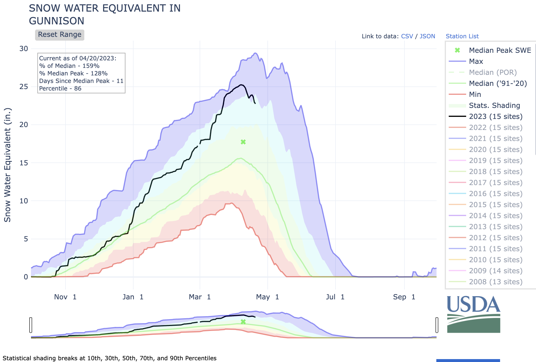
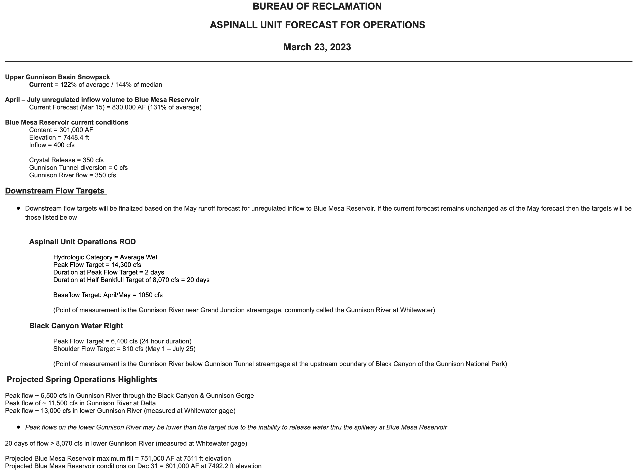
The June 1st forecast for the April – July unregulated inflow volume to Blue Mesa Reservoir is 845,000 acre-feet. This is 133% of the 30 year average. Snowpack in the Upper Gunnison Basin peaked at 138% of average. Blue Mesa Reservoir current content is 625,000 acre-feet which is 75% of full. Current elevation is 7496 ft. Maximum content at Blue Mesa Reservoir is 828,00 acre-feet at an elevation of 7519.4 ft.
High flows along tributaries downstream of the Aspinall Unit helped with meeting the Aspinall Unit ROD targets on the lower Gunnison River as measured at the Whitewater gage. Releases to meet ROD targets were lower than expected and with the increase in the runoff forecast there is now a need to increase releases from the Aspinall Unit.
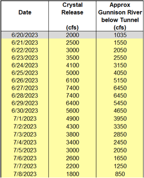
Therefore ramp up of releases from the Aspinall Unit will begin on Wednesday, June 21st, with the peak release being achieved by Tuesday, June 27th. The timing of the peak release will be coordinated with required spillway gate inspections at Morrow Point Dam. The full schedule of releases from Crystal Dam with estimated Gunnison River flows is shown in the table below.
RiversEdge West, a Grand Junction-based nonprofit, received $22,035 from the Colorado River District’s Community Funding Partnership and $34,433 from the Colorado Water Conservation Board to restore two river sites owned by the city of Montrose.
According to RiversEdge West Restoration Coordinator Montana Cohn, the two sites together total around 70 acres, and the project will allow the group to remove about 8 acres worth of invasive tamarisk and Russian olive plants and replace them with native species…One site is off Mayfly Drive, and the other is near Home Depot off Ogden Road. Cohn said restoration efforts at these sites have yielded positive results before, and the new project will expand on previous work. He explained invasive thorns and plants like Russian olive and tamarisk crowd out native vegetation, degrade soil quality and, since some are thorny, block access to the river for wildlife, livestock and recreationists…
The project will go down in phases, starting with volunteer efforts this summer. Then in the fall, paid crews from the Americorps program Western Colorado Conservation Corps will come in with herbicides and chainsaws and remove as many of the invasive plants as possible. Efforts, including volunteer replanting efforts of native plants, will continue into 2024.
There is no better time to invest in rural Colorado and in climate action. The best science is telling us that the window is still slamming shut for staving off significantly worse effects from climate change. Congress might be focused on the debt limit and spending cuts, but we should not be distracted by the drama.
Still, for those who insist on weighing the price of action or inaction today as a bottom line, take note: The future in which we do not act to avert this cascading catastrophe will be far more expensive than almost any future in which we did.
The good news is that there is more funding available than ever to help rural communities transition into 21st century economies that center conservation, climate action, and prosperity. The catch is that they need to participate to get these resources. And for many small communities, that in itself is a burden that may be too much to overcome.
Smart investment in frontline climate action needs to make it to the regions facing the most severe risk from climate change. It needs to reach the places that have borne and will bear the impacts from past and current fossil fuel activity. And it needs to be accessed by the communities that have the furthest to go to catch up in metrics of prosperity, including income, education, and access to housing, jobs, and services. But many of these places, needing such investments the most, do not have development staff or lobbyists in Denver or Washington, D.C.
In response to these constraints, my organization, the Colorado Farm & Food Alliance, is seeking to assist the North Fork Valley, where we are based, to find these federal and state partnerships that can bring those resources here. And we want to do it in a way that serves as a model for what rural climate leadership looks like.
Crops below solar panels. Credit: NREL
Recently we were the named recipient in a national prize to spur community solar projects. This award is for a collaborative, community-based project that we are helping lead that will pair solar energy and farming in a practice called agrivoltaics. As exciting as this pilot project is, for us and we hope for others watching, it will truly be a success if it is followed by meaningful investments that make more ideas like this possible — such as state policy changes to smooth the way for rural electric co-ops to facilitate and integrate more community solar projects.
For starters, here are three places where smart state and local policy should align to ensure that historic federal investments are making a difference for rural communities.
Expanding community-based rural renewables
Strengthening land and watershed health and resilience
Boosting and incentivizing farm-based ecosystem services
So, while it is the case that the debt-ceiling debate has shifted media and other attention to competing economic needs and proposals, it is worth recounting why investment now in climate action remains more critical than ever.
In our recent report, “Gunnison Basin-Ground Zero in a Climate Emergency,” we lay out clearly the high stakes of failure to act. It all adds up to more human suffering, declining environmental health, and severe economic hardship. Most importantly, though, and on point, is that this report lays out the path for action. It makes the case that western Colorado is particularly well suited to be a national leader in rural-based climate leadership. But to get there, we need government partners that prioritize those outcomes.
We are grateful for federal investments that can drive this type of thoughtful, innovative and scalable climate action, especially for frontline, transitioning, and disproportionately impacted communities. And certainly, Congress ought not “claw back” or otherwise diminish that funding. Climate action is an imperative and rural America should not be left behind.
So we are also eager to see that investment show up in our communities now. We are ready to make a difference before the window for effective climate action slams shut. There is no more time to delay and an incredible opportunity to act. Smart investment now will help rural Colorado, and help all of us to succeed.
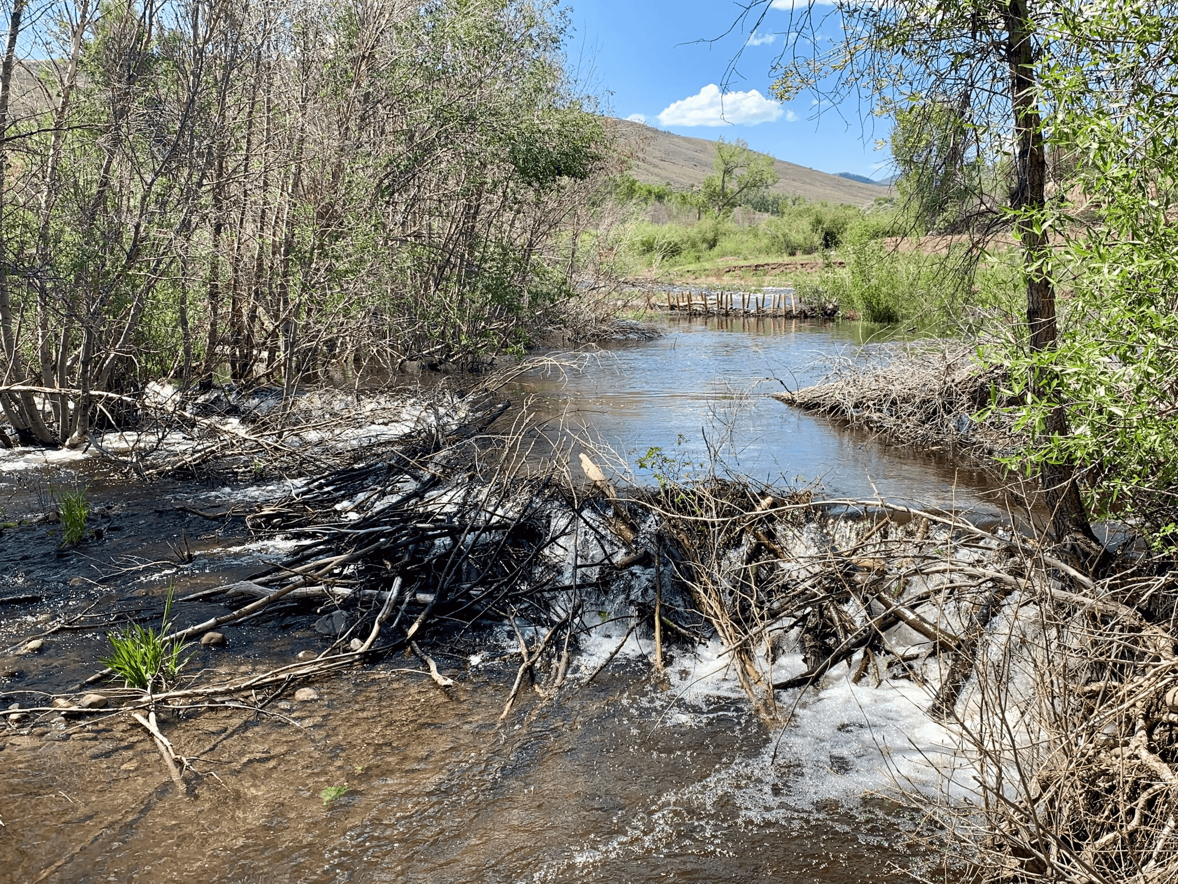
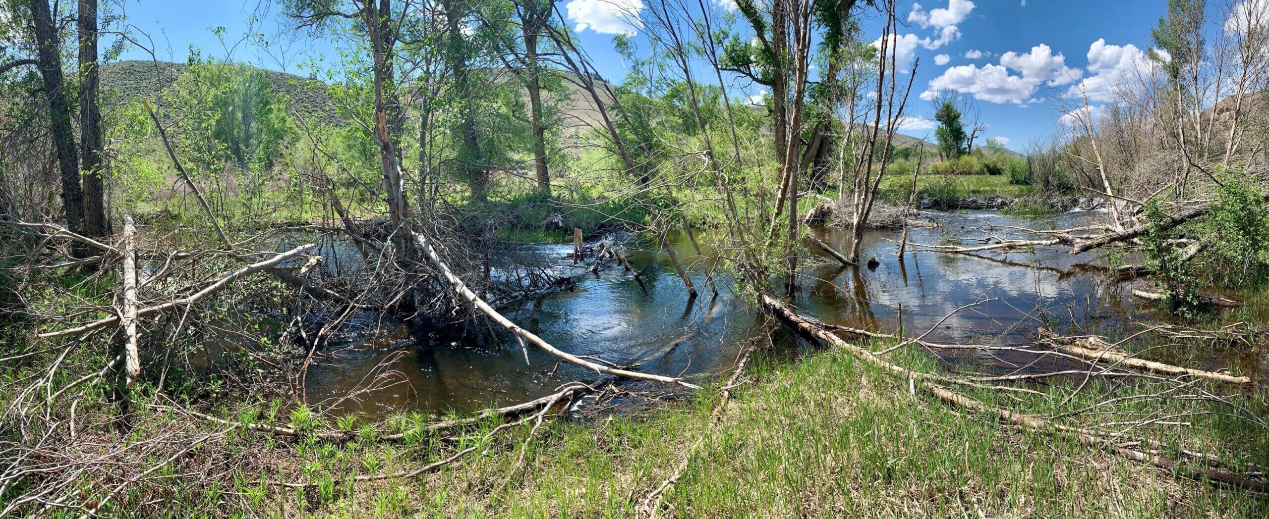
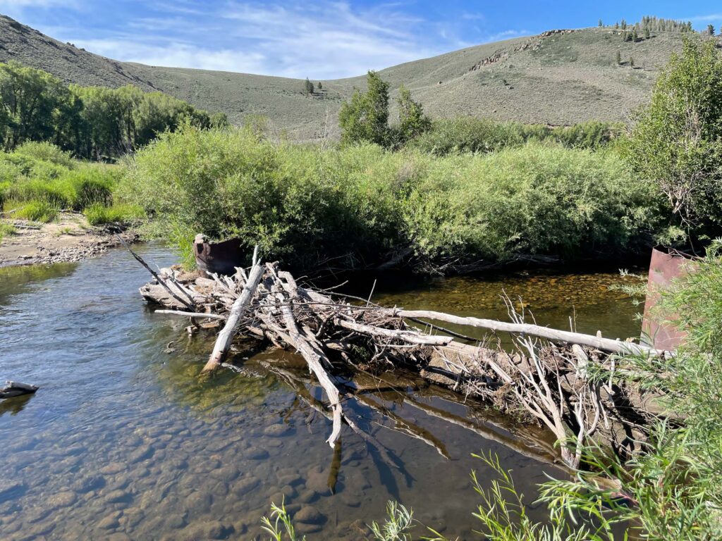
As western mountain snowpacks diminish and wildfires race across parched landscapes, appreciation has grown for the moist mountain meadows and wetlands that hold water up high, feeding streams throughout the summer and providing fire-resistant refuges for wildlife. Before beavers and their dams were largely eliminated by the fur trade, these natural water storage features and refuges were common across western states’ mountain landscapes.
Beavers added to a LTPBR structure installed on Beaver Creek, Gunnison County, CO
The removal of beavers and other land disturbances have led many creeks to cut deeper into their valleys and detach from their floodplains, dropping the water table and drying out the landscape. A growing field of stream restoration, known as low-tech process-based restoration (LTPBR), seeks to reverse these changes through methods that mimic beaver activity in hopes of enticing them to return.
Projects across the west have demonstrated the benefits of LTPBR on the landscape. Projects have improved water quality, provided important habitat, trapped sediment, increased riparian vegetation and forage, and bolstered resilience against drought, fire, and floods. These benefits are achieved by installing low-tech, hand-built structures, creating “speedbumbs” that enable water from snowmelt and storms to spread across the riparian area, slowing peak flows and recharging groundwater. The rewetted soil “sponge” supports healthy riparian vegetation and reduces wildfire risks.
LTPBR project on Beaver Creek, Gunnison County, CO
As LTPBR projects have proliferated across western states, both excitement about their benefits and questions about potential impacts have grown. A new report from American Rivers reviews the published science and case study information on LTPBR to better understand the full range of benefits these projects can provide, and provides scientific evidence to address potential concerns. The report finds ample evidence for LTPBR benefiting habitat and buffering the impacts of droughts, floods, and wildfires, but concludes that more research is needed to better understand the full suite of ecosystem service benefits. It also provides insights on how to address human and social factors related to LTPBR projects, such as mitigating beaver dam impacts to infrastructure.
Click the link to read the article on The Crested Butte News website (Katherine Nettles). Here’s an excerpt:
UGRWCD senior water resource specialist Beverly Richards reported that the Gunnison River at the Gunnison Whitewater Park was flowing at 3,210 cubic feet per second (CFS) last weekend, and is very close to peaking. Richards said there is currently only one small portion of Gunnison County to the west that is facing drought, and the three month outlook shows drought conditions not recurring with the exception of a few areas to the north. Richards reported that precipitation has generally been within the historic normal range in the past 30 days, while snow water equivalent (SWE) maps show 193% of normal for the entire Gunnison Basin and 153% of normal for the upper basin. SNOTEL sites where SWE is measured are melting out. “But that was for May 19,” she said, which reflects that in May there isn’t usually much snow left.
The entire Gunnison Basin water storage is at 75% of average; reservoir storage for the Upper Gunnison Basin is 61%; and projected unregulated inflow for Blue Mesa Reservoir is at 131% of average. Richards said Blue Mesa is projected to be 97% full with a max fill amount of 102,869 acre feet. There is no indication from the Bureau of Reclamation (BOR) as of yet about how much water might be called downstream.
“Reservoir storage across the Upper Colorado River is going up, but Lake Powell is expected to only be about 37% full,” said Richards, due to the volume that will come out. For perspective, she offered an estimate that Lake Powell could be filled in three years if the region had the same kind of snowy year as 2023, and if no one took water out. With the reality of outflows, however, she said it would take 6 to 8 years with winters like this one to refill Lake Powell.
The Grand River Diversion Dam, also known as the “Roller Dam”, was built in 1913 to divert water from the Colorado River to the Government Highline Canal, which farmers use to irrigate their lands in the Grand Valley. GVWUA is not participating the rebooted System Conservation Program after water managers couldn’t agree on how much farmers should be paid to cut back their water use. Photo credit: Bethany Blitz/Aspen Journalism
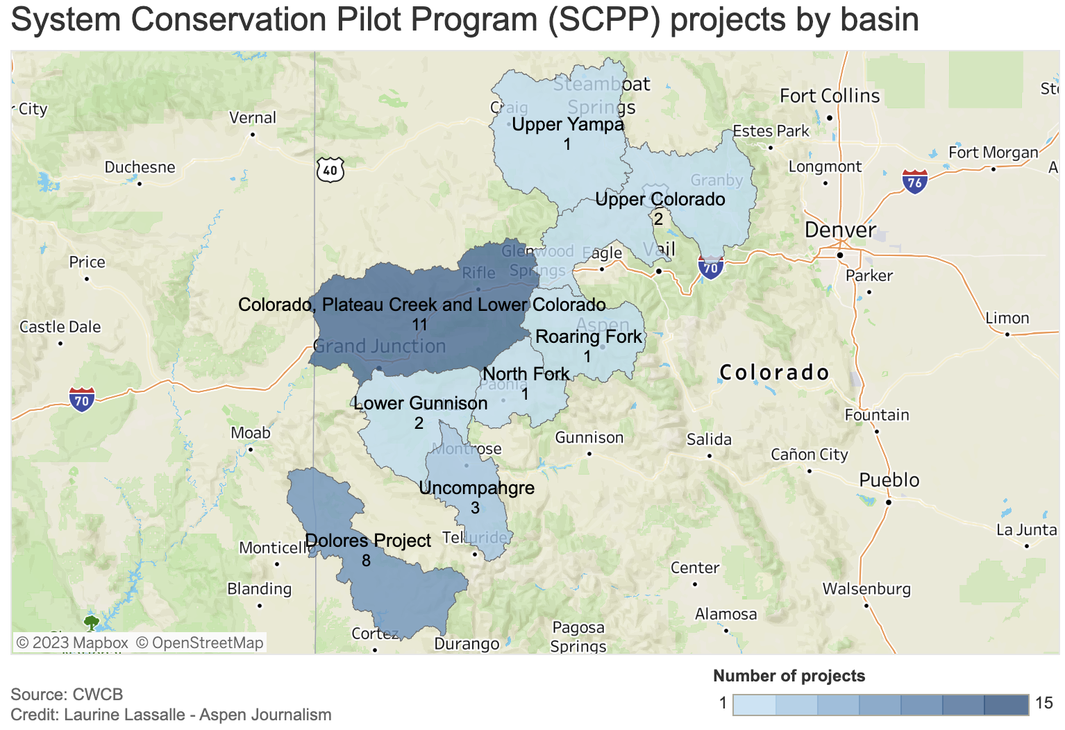
Three of western Colorado’s biggest irrigation districts are not participating on a large scale in a federally funded program to conserve water, and the amount of water saved by the program overall won’t be enough to rescue depleted reservoirs.
The rebooted System Conservation Program was one of the legs of the Upper Colorado River Commission’s 5-Point Plan, announced in July and aimed at protecting critical elevations in Lake Powell and Lake Mead, which have fallen to record-low levels in recent years because of overuse, drought and climate change. System conservation will take place in the four upper Colorado River basin states — Colorado, New Mexico, Wyoming and Utah — and will pay water users to cut back. It’s being funded by $125 million from the federal Inflation Reduction Act.
The total water estimated to be saved across the upper basin for this year of the restarted, temporary and voluntary System Conservation Program is nearly 39,000 acre-feet. By comparison, Lake Powell when full holds more than 23 million acre-feet; Ruedi Reservoir, on the Fryingpan River, can hold about 100,000 acre-feet. (An acre-foot is the amount of water needed to cover an acre of land to a depth of 1 foot and can supply one to two households a year.)
Becky Mitchell, Colorado commissioner to the UCRC, said in a UCRC meeting last month that although the upper basin will do its part in response to last summer’s calls from the federal government that the seven Colorado River basin states needed to conserve 2 million to 4 million acre-feet of water, the majority of that needs to come from cuts in the lower basin (California, Arizona and Nevada).
“(System conservation) will not resolve the crisis in the reservoirs,” she said.
Last month the UCRC approved moving forward with executing agreements with program participants, which are still being finalized.
Although a goal of the program was to get participation across all water sectors — agricultural, municipal and industrial — all of the projects proposed in Colorado involve Western Slope agriculture. None of the state’s Front Range water providers, which collectively take about 500,000 acre-feet per year of the Colorado River’s headwaters across the Continental Divide to thirsty cities and farms, are participating.
Paying water users to irrigate less has long been controversial on the Western Slope, with fears that these temporary and voluntary programs could lead to a permanent “buy and dry” situation that would negatively impact rural farming and ranching communities.
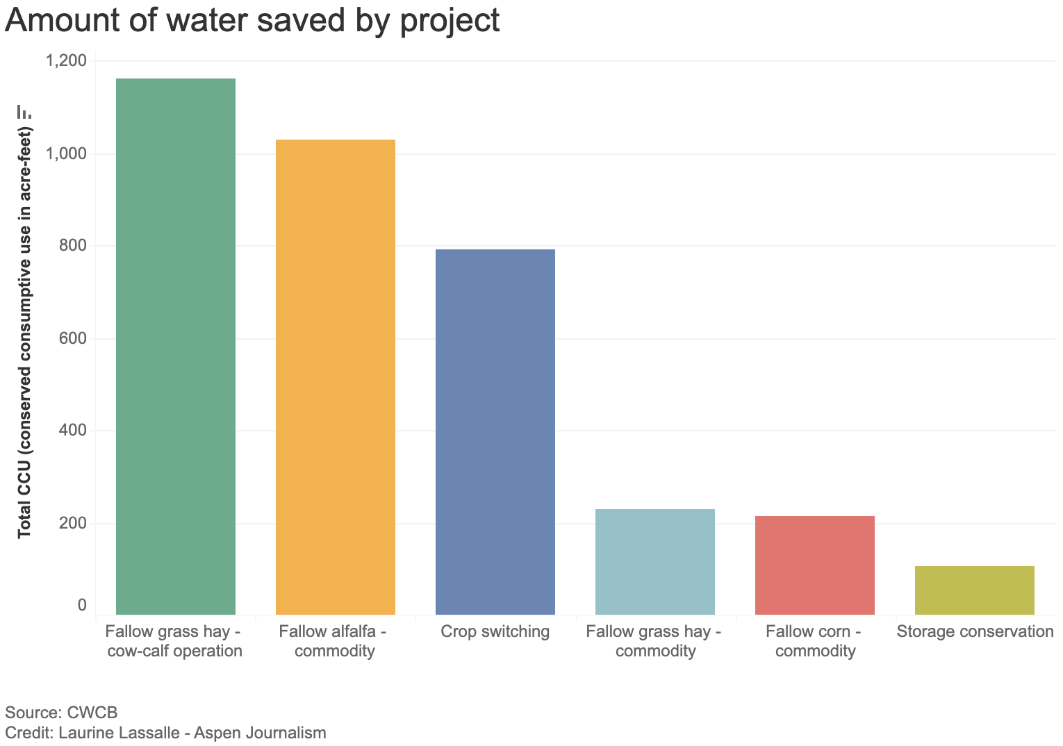
Of the four upper basin states, Colorado has the largest number of projects (29) but the least amount of saved water (3,532 acre-feet). This is an indication that most of Colorado’s participants are proposing small projects. UCRC Executive Director Chuck Cullom said if the program is undertaken again, officials may consider a minimum size requirement because doing very small projects may not be worth it.
“From a practical standpoint of the cost of monitoring and administering a verification program for that (small number of) acres may not pencil out relative to the amount of water conserved,” Cullom said.
Of the 29 Colorado projects, most involve reducing water use for forage crops, according to information provided by UCRC. Eight involve fallowing grass hay as part of a cow-calf operation, saving 1,163 acre-feet of water; seven plan to fallow alfalfa and save 1,029 acre-feet; and eight propose switching to less-thirsty crops, saving 791 acre-feet.
The UCRC received 88 proposals across the four states, 72 of which met the qualifying criteria. Utah has 20 projects that meet preliminary criteria; Wyoming has 22 and New Mexico has one. The UCRC’s opening offer was $150 per acre-foot of saved water, but the average compensation will probably end up being higher — $434 per acre-foot, according to information provided by UCRC.
Grand Valley Water Users Association not participating
Although some water users in the Grand Valley Water Users Association participated in the original system conservation pilot program, which ran from 2015 to 2018 and conserved 47,000 acre-feet of water at a cost of about $8.6 million, they won’t be taking part this time around.
The Government Highline Canal flows past Highline State Park in the Grand Valley. CREDIT: BETHANY BLITZ/ASPEN JOURNALISM
GVWUA, whose Highline Canal delivers water to roughly 24,000 acres of farmland on the north side of the valley between Grand Junction and Mack, withdrew its application from the process after manager Tina Bergonzini said she couldn’t come to an agreement on the price with the UCRC. GVWUA had rejected the concept of paying farmers based on an amount of unused water, instead proposing to pay farmers for each acre of land they took out of production.
Individual farmers would have had to apply to the program through the association, which proposed to cap total member participation at 1,000 acres and 3,000 acre-feet of water.
GVWUA was asking for between $686 and $1,306 per each acre fallowed, depending on whether farmers reduced water use during the entire irrigation season or just part of it.
Bergonzini said the price represents what it would cost to administer the program in a way that provides equity and protection; at any lower price, the funding from system conservation would not be enough to cover the extra staff and engineering costs. Cullom said his organization was unlikely to approve those costs, so GVWUA withdrew its application.
“They were not wanting to pay per acre what we had requested,” Bergonzini said. “They had a line drawn in the sand and so did I.”
The Grand Valley Irrigation Company, which serves about 40,000 acres of farmland between Palisade and Mack, has four projects proposed within its service area, covering a total of 120 acres and 285 acre-feet of water savings.
“It’s not a very big amount,” said GVIC Assistant Superintendent Charlie Guenther. “I did hear from a handful of ag people that they didn’t want to be part of this because it sounded very technical and it was government involvement. That’s something that came up.”
Unlike GVWUA, individual water users within GVIC did not have to apply to the program through the irrigation company, and the company’s board did not take a stance on whether or not to support system conservation, according to Guenther.
There is just one conservation project proposed in the boundaries of the Uncompahgre Valley Water Users Association, the largest irrigation district in Western Colorado, at more than 83,000 acres of farmland in Delta and Montrose counties. The project would enroll about 33 acres in the program and would result in about 46 acre-feet of water savings.
UVWUA manager Steve Pope said the system conservation program didn’t get much interest from his water users because of the timing. Bergonzini agreed.
“They didn’t want to do a last-minute thing,” Pope said. “By the time this thing was rolled out, these guys had already made their decisions and they were already committed for the next season.”
Cullom has acknowledged that there were shortcomings with the program’s rollout. The UCRC unveiled details of the program in December, with an original application deadline of Feb. 1, which was later pushed to March 1 for this summer’s irrigation season.
“We need to do much better when we think about how to do this in the future, if we do this in the future,” he said. “We need more clarity on the data requirements, what we expect from a proposal. We need to give people more time to engage in understanding what the opportunity is and we need to start sooner. Start in the fall for an irrigation season instead of January.”
Conservation district concerns
The Western Slope’s two largest conservation districts — the Colorado River Water Conservation District and Southwestern Water Conservation District — submitted letters to the UCRC stating their concerns with the program. Mitchell had promised the districts that they could participate in the review and approval process for applications, thereby securing a measure of local control. But in March, she walked back that commitment, saying the UCRC had sole authority in the approval process.
The UCRC has released few details so far on project proposal specifics, and publicly available applications have been heavily redacted. In addition to redacting the applicants’ personal identifying information, nearly everything else has been blacked out: the precise location of projects; which streams and ditches are involved; details of the water rights involved; and how much the applicants are asking to be paid for their water.
The districts say this makes it impossible to meaningfully review them to determine whether the projects would cause injury to other water users. Their letters to the UCRC say the lack of transparency raises questions about whether public funds are being used wisely.
“In short, SWCD is very disappointed and concerned about the process that has been undertaken by the UCRC and the state of Colorado,” reads the letter from Southwestern General manager Steve Wolff.
In response, Amy Ostdiek, CWCB section chief for interstate, federal and water information, said that the review process respected project proponents’ privacy and that striking a balance between transparency and privacy is an ongoing effort.
“The Colorado State Engineer’s Office has been directly involved as implementation agreements and verification plans are developed to ensure no injury results from SCPP participation,” Ostdiek said in an email.
She said additional information will be available when the UCRC finalizes agreements with project participants, which should happen late this month, according to Cullom.
The 39,000 acre-feet of water across the four upper-basin states will do little to boost Lake Powell. It’s the proverbial drop in the bucket. But the political value of 39,000 acre-feet may be far greater than any benefit to the nation’s second-largest reservoir. The effort shows that upper-basin water managers are willing to do their part to prevent the system from crashing, but that part is small compared with the cuts they say are needed in the lower basin.
“It’s unlikely any system conservation stood up in the upper basin is going to move the needle,” Cullom said. “But it’s important for the upper basin to participate and contribute within the resources and the tools we have available, and what we are demonstrating in this process is that we do have tools, we do have resources. They are narrow in scope and small in volume.”
Saying the state will fare best if it stands together when it comes to protecting Colorado River water rights, Western Slope legislators are hailing a bill that creates a drought task force.
“It’s to get Colorado to come to the table and start talking about what we can do, rather than somebody on the eastern side of the state, or the governor, talking,” Rep. Marc Catlin, R-Montrose, who was House sponsor of Senate Bill 295, with Rep. Julie McCluskie, D-Dillon, House speaker. “We’re trying to get people from the Western Slope, particularly since the Western Slope is going to have to deal with it.”
Senate Bill 295 passed 63-2, with Sens. Perry Will, R-Newcastle, and Dylan Robert, D-Eagle, carrying it in the Senate. The bill creates a Colorado River Drought Task Force, with subcommittees, to guide the development of water legislation. It is to include the Ute Mountain Ute and Southern Ute tribes, regional water conservation districts, local government, farmers, ranchers, environmental nonprofits and the Colorado Department of Natural Resources. Members are charged with developing steps and tools the legislature can use to address drought in the Colorado River Basin and commitments under the Colorado River Compact through conservation of the river and its tributaries, such as the Gunnison River and the Uncompahgre. If the bill creating the task force is signed into law, its members have a short window to act: between July and Dec. 15, they are to furnish their recommendations and a summary of their work to the legislative water resources and agricultural review committee…
The bill says recommendations need to be for programs that can be reasonably implemented in a way that does not harm economic or environmental concerns in any sub-basin or region in the state. The recommendations must also fall in line with the 2019 Colorado River Drought Contingency Plan. The recommendations must further ensure any program related to acquiring water rights is voluntary, temporary and compensated, while also looking at revenue sources for the acquisition of program water. [Perry] Will and [Marc] Catlin worry about entities that are purchasing farm land, as well as buying or leasing water, especially if they are not providing adequate compensation…
“The Uncompahgre (River), we’ve got the oldest, biggest water right on the Western Slope of Colorado. Certainly, there are people looking at us,” Catlin said. He said speculators need to understand that when they buy water, they are affecting the entire ag community, not just individual farmers — and that reality needs to be part of the conversation.
WAM bought this 57-acre parcel as part of a $6 million deal in January 2020, leading some to suspect the company was engaging in investment water speculation. WAM’s activity in the Grand Valley helped prompt state legislators to propose a bill aimed at curbing speculation.
CREDIT: BETHANY BLITZ/ASPEN JOURNALISM
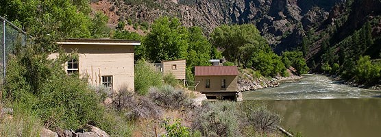
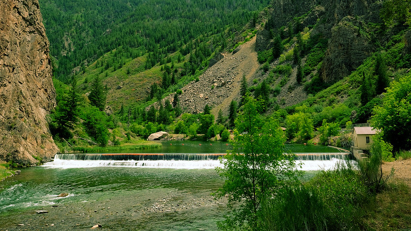
Black Canyon July 2020. Photo credit: Cari Bischoff
From email from Reclamation (Erik Knight):
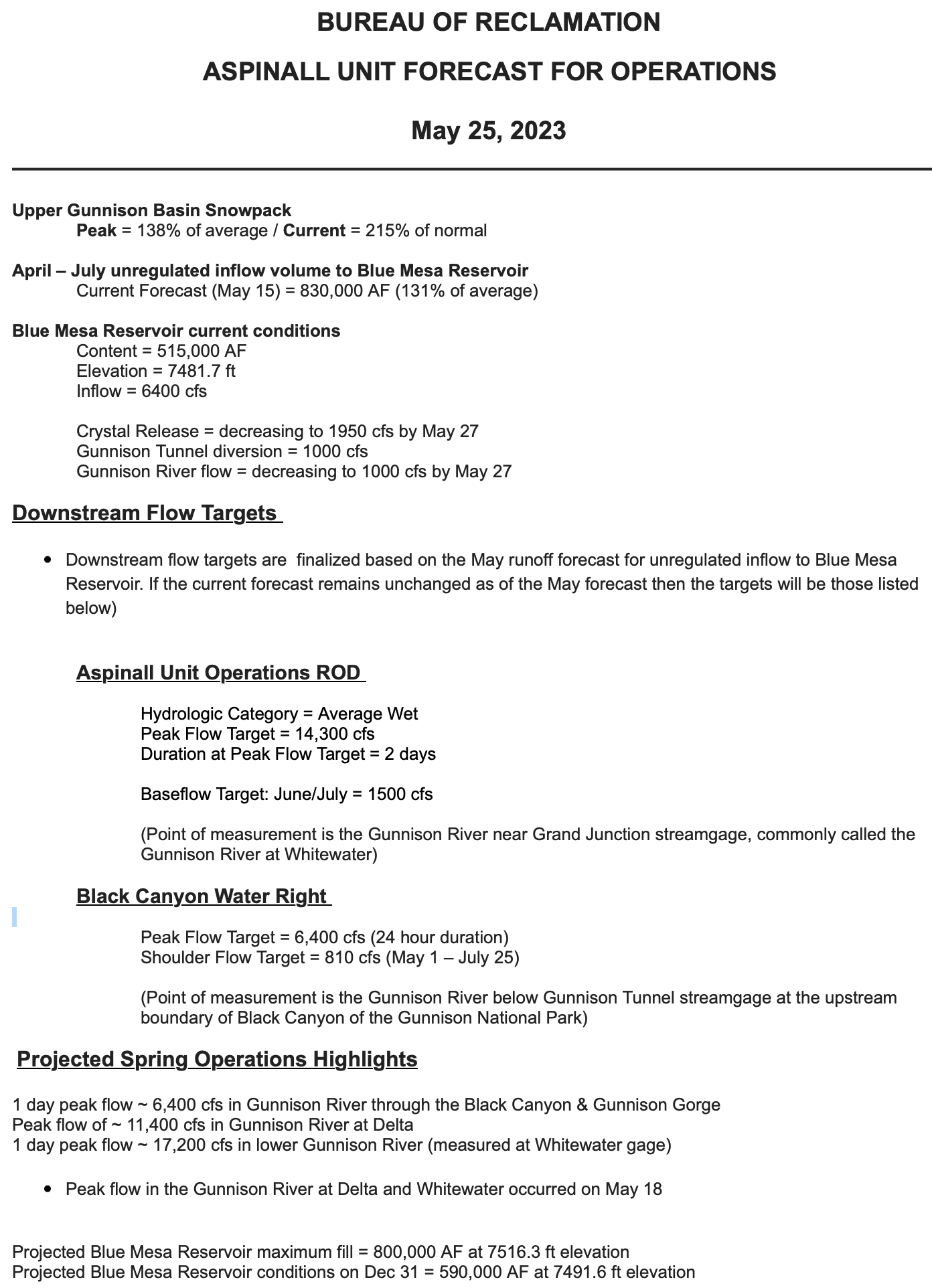
The May 15th forecast for the April – July unregulated inflow volume to Blue Mesa Reservoir is 830,000 acre-feet. This is 131% of the 30 year average. Blue Mesa Reservoir current content is 468,000 acre-feet which is 57% of full. Current elevation is 7475.3 ft. Maximum content at Blue Mesa Reservoir is 828,000 acre-feet at an elevation of 7519.4 ft.
Based on the May forecasts, the Black Canyon Water Right and Aspinall Unit ROD peak flow targets are listed below:
Black Canyon Water Right
The peak flow target is equal to 6,400 cfs for a duration of 24 hours.
The shoulder flow target is 810 cfs, for the period between May 1 and July 25.
Aspinall Unit Operations ROD
The year type is currently classified as Average Wet.
The peak flow target will be 14,300 cfs and the duration target at this flow will be 2 days.
The half bankfull target will be 8,070 cfs and the duration target at this flow will be 20 days.
The ramp up for the spring peak operation has been paused as flows on the Gunnison River at Whitewater are already above the spring peak target flow. Flows on the Gunnison River at Delta are close to the flow level that could impact the Delta Wastewater Treatment Plant. Currently Crystal Reservoir is spilling with a total release of 5,300 cfs. Flows in the Gunnison River through the Black Canyon are 4,600 cfs.
With the projected increase in flows on the North Fork of the Gunnison River, releases at Morrow Pt Dam (which is now controlling the spill at Crystal Dam), will be reduced by a total of 1,400 cfs by tomorrow, May 19th. This should bring flows in the Gunnison River through the Black Canyon down to around 3,200 cfs. This release rate will be maintained through the weekend and may possibly continue well into next week.
This adjustment to the release plan is based on the latest forecast for river flows in the Gunnison Basin. Adjustments in Aspinall Unit release rates may be made in either direction to achieve downstream target flows or if water gets too high at points along the Gunnison River through Delta.
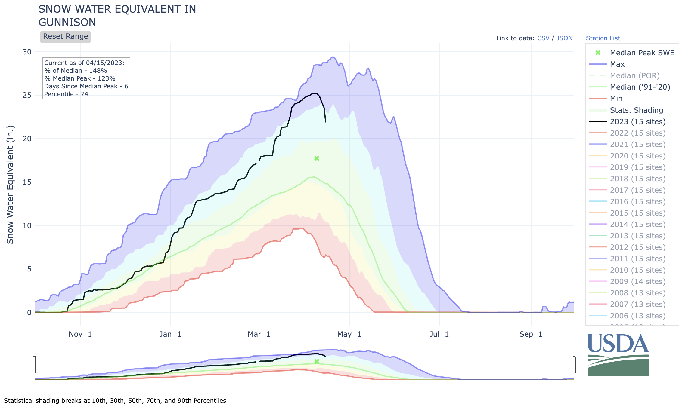
The May 1st forecast for the April – July unregulated inflow volume to Blue Mesa Reservoir is 830,000 acre-feet. This is 131% of the 30 year average. Snowpack in the Upper Gunnison Basin peaked at 138% of average. Blue Mesa Reservoir current content is 434,000 acre-feet which is 52% of full. Current elevation is 7470.4 ft. Maximum content at Blue Mesa Reservoir is 828,00 acre-feet at an elevation of 7519.4 ft.
Based on the May forecasts, the Black Canyon Water Right and Aspinall Unit ROD peak flow targets are listed below:
Black Canyon Water Right
The peak flow target is equal to 6,400 cfs for a duration of 24 hours.
The shoulder flow target is 810 cfs, for the period between May 1 and July 25.
Aspinall Unit Operations ROD
The year type is currently classified as Average Wet.
The peak flow target is currently 14,300 cfs and the duration target at this flow is currently 2 days.
The half bankfull target is currently 8,070 cfs and the duration target at this flow is currently 20 days.
Pursuant to the Aspinall Unit Operations ROD, releases from the Aspinall Unit will be made in an attempt to match the peak flow of the North Fork of the Gunnison River to maximize the potential of meeting the desired peak at the Whitewater gage, while simultaneously meeting the Black Canyon Water Right peak flow amount. The latest forecast for flows on the North Fork of the Gunnison River shows a high peak flow occurring near the middle of next week. Flows in the tributaries downstream of the North Fork confluence are also very high, which will help with meeting the flow targets on the lower Gunnison River at the Whitewater gage.
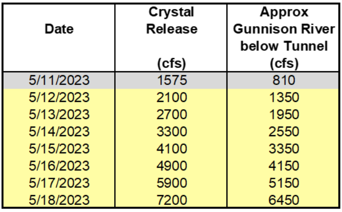
Therefore ramp up for the spring peak operation will begin on Friday, May 12th, with the intent of timing releases with this potential higher flow period on the North Fork of the Gunnison River. Releases from Crystal Dam will be ramped up according to the guidelines specified in the EIS, with 2 release changes per day, until Crystal begins to spill. The release schedule for Crystal Dam is:
The current projection for spring peak operations shows flows in the Gunnison River through the Black Canyon peaking at 6400 cfs in order to achieve the desired peak flow and duration at Whitewater. Actual flows will be dependent on the downstream contribution of the North Fork of the Gunnison River and other tributaries. Higher tributary flows will lead to lower releases from the Aspinall Unit and vice versa.
The May 1st forecast for the April – July unregulated inflow volume to Blue Mesa Reservoir is 830,000 acre-feet. This is 131% of the 30 year average. Snowpack in the Upper Gunnison Basin peaked at 138% of average. Blue Mesa Reservoir current content is 434,000 acre-feet which is 52% of full. Current elevation is 7470.4 ft. Maximum content at Blue Mesa Reservoir is 828,00 acre-feet at an elevation of 7519.4 ft.
Based on the May forecasts, the Black Canyon Water Right and Aspinall Unit ROD peak flow targets are listed below:
Black Canyon Water Right
The peak flow target is equal to 6,400 cfs for a duration of 24 hours.
The shoulder flow target is 810 cfs, for the period between May 1 and July 25.
Aspinall Unit Operations ROD
The year type is currently classified as Average Wet.
The peak flow target is currently 14,300 cfs and the duration target at this flow is currently 2 days.
The half bankfull target is currently 8,070 cfs and the duration target at this flow is currently 20 days.
Pursuant to the Aspinall Unit Operations ROD, releases from the Aspinall Unit will be made in an attempt to match the peak flow of the North Fork of the Gunnison River to maximize the potential of meeting the desired peak at the Whitewater gage, while simultaneously meeting the Black Canyon Water Right peak flow amount. The latest forecast for flows on the North Fork of the Gunnison River shows a high peak flow occurring near the middle of next week. Flows in the tributaries downstream of the North Fork confluence are also very high, which will help with meeting the flow targets on the lower Gunnison River at the Whitewater gage.
Therefore ramp up for the spring peak operation will begin on Friday, May 12th, with the intent of timing releases with this potential higher flow period on the North Fork of the Gunnison River. Releases from Crystal Dam will be ramped up according to the guidelines specified in the EIS, with 2 release changes per day, until Crystal begins to spill. The release schedule for Crystal Dam is:
Crystal Dam will be at full powerplant and bypass release on May 15th. Crystal Reservoir will begin spilling by May 16th and the peak release from Crystal Dam should be reached on May 18th. The flows in the Gunnison River after that date will be dependent on the timing of the spill and the level of tributary flow contribution. Estimates of those numbers will be determined in the upcoming days.
The current projection for spring peak operations shows flows in the Gunnison River through the Black Canyon peaking at 6400 cfs in order to achieve the desired peak flow and duration at Whitewater. Actual flows will be dependent on the downstream contribution of the North Fork of the Gunnison River and other tributaries. Higher tributary flows will lead to lower releases from the Aspinall Unit and vice versa.
The county Department of Public Works says in a news release that the threat of flooding in the county from rapid snowmelt primarily poses a flood threat on the Colorado and Gunnison rivers, but several creeks and washes also can be at significant risk of flooding.
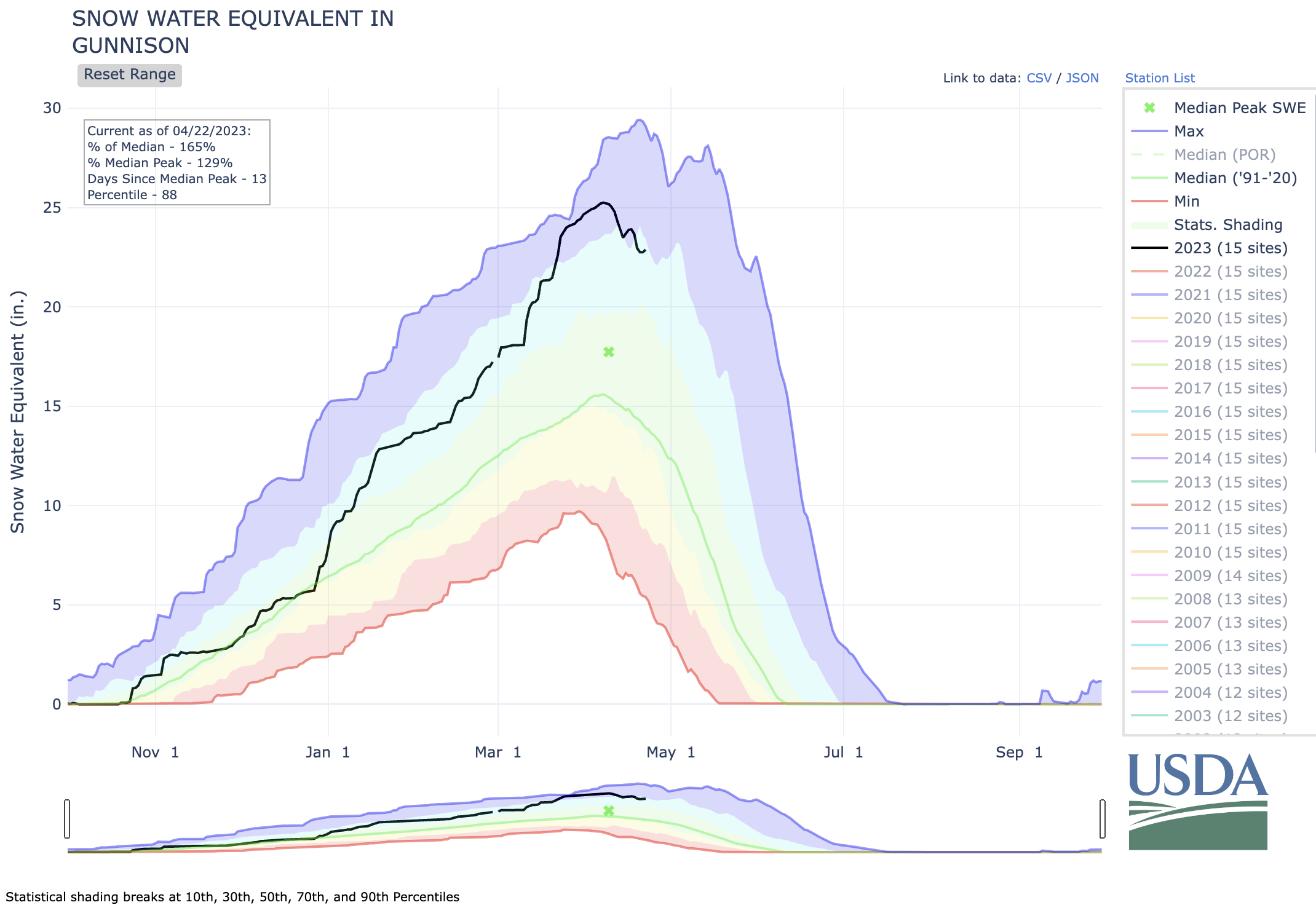
Colorado’s snowpack on Friday was at 133% of median for that date, according to the Natural Resources Conservation Service. Snowpack is at 143% of normal in the Yampa/White river basins, 123% in the upper Colorado River Basin in Colorado, 159% in the Gunnison River Basin and 184% in the combined San Juan/Dolores/San Miguel/Animas basins…Snowpack at three measurement sites on Grand Mesa ranges from 137% to 238% of normal. The Columbine Pass site on the Uncompahgre Plateau is holding four times the normal amount of snow for this time in April.
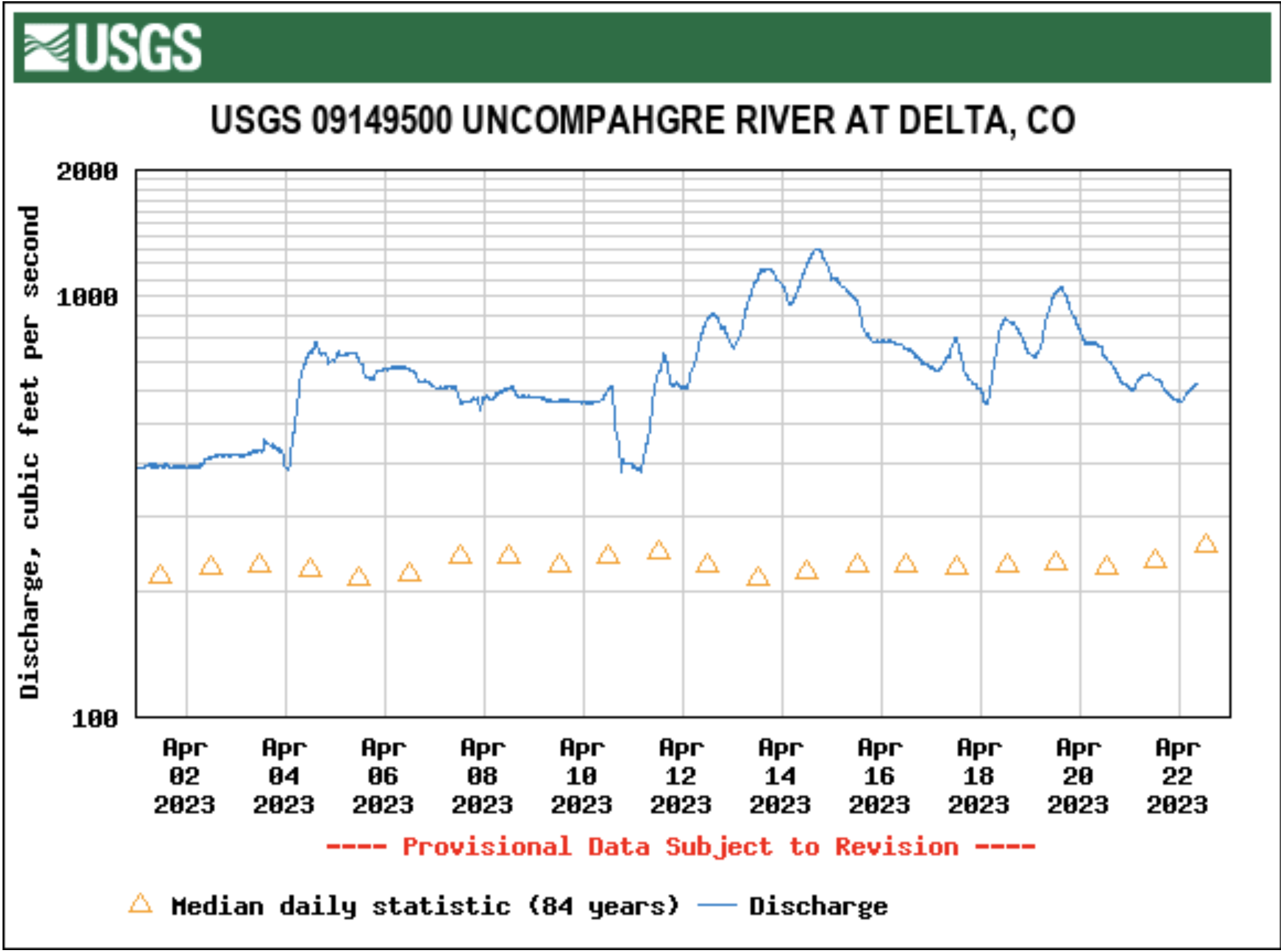
Flooding already has occurred in places such as Dolores, Montrose County and Hayden in Routt County. Delta County and the city of Delta have been making preparations for high waters on waterways including the Gunnison and Uncompahgre rivers, through measures ranging from checking and cleaning culverts and storm drains…Gudorf said anywhere from Palisade to Fruita along the Colorado River has potential for flooding in lower-lying areas…Among other areas she is concerned about are Plateau Creek, and the Dolores River in Gateway. She said drainages in the Redlands area also may be susceptible to high waters from snow melting at higher elevations…
Gudorf said that when temperatures started warming up quickly a while back she got nervous about rapidly increasing runoff, but the cooldown that followed gave her some hope for a slow but steady runoff season. But she said a lot of snowmelt needs to come off Grand Mesa. Another concerning factor is a recent windstorm that deposited dust on a lot of Colorado’s mountains, which can accelerate snowmelt as the dark dust absorbs heat from the sun.
Click the link to read the article on the Montrose Daily Press website (Katharhynn Heidelberg). Here’s an excerpt:
When Luz Marquez returned to her Heritage Estates home off Marine Road Wednesday morning, she was prepared for an ordinary day. What she found was water — lots of it, pooling in her backyard, flowing under a raised shed, and carving small trenches through her parking area to dump the gravel there into the street…
Montrose County had been anticipating flooding this year, based on high snowpack and the potential for a quick melt and runoff. The county was getting sand and sandbags ready for distribution, cleaning ditches and had a contractor lined up for the work. But the water came even sooner than expected.
“It came a little quicker than we thought,” Montrose County Road and Bridge Superintendent Brandon Wallace said, as he and other county staff worked at Heritage Estates. “We watched all night and it decided it really wanted to release. We were trying to get a game plan to clear out some of these drainage ditches cleaned out to alleviate some of this water.”
Montrose County was on alert for weeks, in light of intense snowpack, which just weeks ago stood at record highs in parts of the Gunnison River Basin…The water came roaring about a week sooner than was expected, upending the county’s plans to clear out drainage ditches when things are a bit drier. “The water just beat us to it. We really thought we had a little bit bigger window to get it cleaned when it was dry,” Hawkins said.
A way-above-average snowpack has already begun melting, meaning rivers on the Western Slope will likely be rushing this year — and some nearby adventure outfitters will be happy to see it. The increased flows will likely have both positive and negative impacts on the services, but owners and managers agreed: southwestern Colorado needs water, and nobody’s complaining about it…
As of March 21, the Daily Press reported SnoTel sites above nearby waterways and their reservoirs show big-time snowpack, with the gauge at Columbine Pass sitting at 262% of normal and more than 41 inches of snow water equivalent on the Uncompahgre Plateau. It’s already melting, as evidenced by the flooding seen earlier this week at the Heritage Estates neighborhood off Marine Road.
NREL researcher Jordan Macknick and Michael Lehan discuss solar panel orientation and spacing. The project is seeking to improve the environmental compatibility and mutual benefits of solar development with agriculture and native landscapes. Photo by Dennis Schroeder, NREL
Here’s the release from the Colorado Farm & Food Alliance:
PAONIA, CO. (April 20, 2023) – Today the Colorado Farm & Food Alliance was named by the National Community Solar Partnership (NCSP) as a recipient of a Community Power Accelerator Phase 1 prize to study and advance community-owned farm-based renewable projects in the North Fork Valley.
The Community Power Accelerator Prize is a U.S. Department of Energy led initiative to spur development of community-owned solar and renewable projects. The North Fork award is for a collaboration that involves the CO Farm & Food Alliance and other organizations, community leaders and businesses. In March this group submitted a proposal to help plan a small solar project that will benefit area farms and farm-related businesses and to use that project as a springboard for additional renewable energy to benefit rural communities. Phase 1 prize recipients can compete for additional awards.
“Our goal is to promote rural climate leadership and to show that the clean energy transition can support agriculture, boost local enterprise, and work toward greater energy equity,” said Pete Kolbenschlag, director of the Colorado Farm & Food Alliance. “We are extremely excited to move our project forward, and we see it as a model for rural climate action that puts land health, people and local community first.”
The North Fork team first coalesced around a small agrivoltaic project being scoped near Hotchkiss, and saw this as an opportunity to consider how the area might advance more community-owned renewables that integrate with agriculture and serve local residents.
“We see agrivoltaics as part of our effort to pursue sustainability, adding renewable energy to our efforts to improve the health of our land and soil and to better feed our local community,” said Mark Waltermire, owner of Thistle Whistle Farm in Hotchkiss, Colorado. “This project will give a handful of farms like this one, and a few food-related businesses that use our produce, a way of accessessing cleaner power, while benefiting our farm by giving us more gentle growing conditions under the panels to grow some of our crops. Our whole farm community benefits. And, we can set the stage for similar projects in areas around the valley that can help other producers,” he added.
Agrivoltaics is an emerging field of solar development that is paired with agriculture. In the U.S. Southwest, as we head into a warmer and drier future, interest in agrivoltaics, as a means to adapt farming to a changing climate while co-locating clean energy production, is high. Some studies show that growing certain crops under solar panels can provide shade benefits, help regulate soil-moisture, and can also help to cool the panels, which increases their efficiency.
Rogers Mesa
The projects being considered by the North Fork team will involve working agriculture, grid energy production, and scientific research conducted in partnership with the Colorado State University Western Colorado Research Center at Rogers Mesa, to gather more data on how renewable energy and agriculture can co-exist and can even benefit each other.
“Innovative solar projects involving agrivoltaics and community ownership models promise significant benefits for rural agricultural communities and there isn’t a better place than the Western Slope to demonstrate that potential and to provide a model that can be replicated,” said team-member Alex Jahp, who works at Paonia-based Solar Energy International. “Receiving the Community Power Accelerator Prize demonstrates that we aren’t alone in our thinking.”
The North Fork Valley is named after a major stem of the Gunnison River, which is the second largest tributary to the imperiled Colorado River system. The region is at the epicenter of the global climate emergency, as a critical headwaters area and due to its heating at a more rapid rate than many places in the nation. The North Fork Valley is home to both the state’s largest operating coal-mine and its highest concentration of organic farms. Many in the region still see both agriculture and energy as key parts of a diverse economic future, but also see the critical need to act to address climate change.
“With Delta County warming double the national and global average, the impacts of local warming are upon us. Building community resilience–through community-driven projects like the ones being considered here, at the nexus of agriculture, water, and energy–is critical if we are to survive and thrive” said Natasha Léger, Executive Director, Citizens for a Healthy Community. She added that “farms play a critical role in transitioning away from oil and gas as energy sources for running farm operations, and will be leadership models for new approaches to land use.”
Citizens for a Healthy Community has recently completed a Climate Action Plan for Delta County, hoping to help local governments act more boldly to address the climate crisis. In its recent report, Gunnison Basin: Ground Zero in the Climate Emergency, the Colorado Farm & Food Alliance also made a pitch for the potency of rural-based climate action – including the expansion of farm-based renewables. The North Fork Valley agrivoltaic team is not waiting to act.
“The Community Power Accelerator Prize is a key award that will allow us to take the great work already being done by local community groups and turn it into tangible results,” said Kolbenschlag on behalf of the Colorado Farm & Food Alliance which accepted the prize for the community collaboration. “We have an exceptional team and an exceptional project. We think this can be a model for rural climate action and community resilience. We thank the Department of Energy and Solar Partnership for this opportunity to prove it.”
On Monday, April 17, Gunnison County Emergency Services hosted a multi-jurisdictional meeting to discuss spring runoff and the possibility of flooding in the Gunnison Valley as temperatures rise. Although the upcoming weather forecast is favorable and no cause for alarm, local officials and law enforcement made sure plans are in place and sandbags are available in the case of rapid snowmelt. Snowpack for the Gunnison Basin sat at approximately 160% of normal on April 9 with more snow on the way. After an exceptionally wet winter, rapid warming has the potential to overfill streams and rivers — putting low-lying areas at risk as the snow finally starts to melt away.
Temperatures above freezing overnight at higher elevations for several days can lead to expedited snowmelt, National Weather Service (NWS) Hydrologist Erin Walter said during a weather briefing at the start of the meeting. But transitioning into the middle of the week, she said the basin will see the influence of a low pressure system carrying snow and cooler temperatures.
“This downward turn in temperatures is what we want to see for snowmelt,” Walter said. “If we saw a ridge of high pressure over us and all of these temperatures climbing for a prolonged period of time, that’s when we need to be on high alert.”
The graphs this week from the U.S. Department of Agriculture show that the Gunnison Basin is at 161% of its normal snow-water-equivalent (S.W.E.). Interestingly, the Upper Colorado Headwaters zone is at 132% of its normal S.W.E. These “normals” are based on just the previous thirty years, twenty of which have been drought years here in the western U.S. But there is some elation in seeing the moisture now residing in the soils within our valleys, though it is said to be too wet to plant onions just yet. Of course, the soils in the backyards of towns such as Crested Butte are still hidden from sight, beneath five feet of settled snow still on the level…
How much of this melting snowpack can we capture and store this year? As reported by Katharhynn Heidelberg in Tuesday’s Montrose Press, the U.S. Bureau of Reclamation states that Blue Mesa Reservoir’s actual live storage capacity is projected to be at just 71% by the end of the water year in September. That beats last year, anyway.
Industrial pollution is one of the consequences of operators ignoring their effect on the shared environment. By Frank J. (Frank John) Aleksandrowicz, 1921-, Photographer (NARA record: 8452210) – U.S. National Archives and Records Administration, Public Domain, https://commons.wikimedia.org/w/index.php?curid=17100801
Click the link to read the article on the Sibley’s Rivers website (George Sibley):
In my last post, I was questioning the process of allowing the privatization of the commons through individual appropriations – in our specific instance here, privatization of the ‘water commons,’ but also of the land, and all of its living systems and the raw resources that must feed, water, shelter not just us but all life on the planet.
Every living thing that requires food, water, air or virtually anything at all ‘appropriates it from the commons,’ and probably in the strictest sense we all ‘create a property’ in the apples we pick to eat, the water we dip out of the stream to drink, the oxygen in the air we suck into our lungs. But we have not always gone on to claim personal ownership of the tree that produced the apple, or the land the tree grows on, the stream that waters the tree. That is a relatively recent invention of modern cultures – the agricultural and the industrial societies that we created when there came to be too many of us to support ourselves as hunter-gatherers living off the scattered abundance of the commons.
A contemporary writer-thinker who has considered our conduct in the commons is Garret Hardin, a 20th century American ecologist whose main concern as a scientist was the threat of overpopulation: a species (us) in swarming mode, but clever enough to stay a step ahead of the usual ‘natural’ controls – famine, plague, social breakdown and the Hobbesian ‘war of each against all.’ Hardin is best known, however, for a short excerpt, often found in high school and college texts, from a 1968 essay, ‘The Tragedy of the Commons.’
In the popular excerpt from ‘Tragedy,’ Hardin posed a grazing commons, used by a number of herdsmen. Being rational, Enlightenment individuals with a ‘natural’ desire to maximize their own self-interest through their labors, each herdsman desires to add another animal to his herd on the commons, even though he is aware that it might have a negative impact on the commons. The rational individual calculates, however, that he would get all the profit from his extra animal, while the cost to the commons would be spread among all the grazers. But with every user of the commons adding extra animals through that rational logic, the commons is over-grazed and destroyed.
One leader of the Scottish Enlightenment was Adam Smith, the father of modern economic science. By Etching created by Cadell and Davies (1811), John Horsburgh (1828) or R.C. Bell (1872).
This is the dark side of Enlightenment economist Adam Smith’s theory that economic individuals are driven by rational self-interest to engage in useful pursuits that will benefit their society as well as themselves, by meeting some societal need – a thesis embraced by most economists since Smith’s time (The Wealth of Nations was published in 1776).
The challenge of course is how to prevent the Enlightenment’s pursuit of individual self-interest from leading inexorably to Hardin’s ‘tragedy of the commons.’ Hardin saw the only alternatives to ecological catastrophe being either a) administration of the commons by the state or b) privatization of the commons according to the conventional wisdom of Aristotle: ‘Men pay most attention to what is their own; they care less for what is common.’ The choice between state management of what’s left of the commons, and further privatization by individuals, remains an area of open public conflict in the American West, with at least two bills before the current Congress proposing more creation from the commons.
But other modern thinkers have thought it through further – with work grounded in research, evidence collection, and other methods of the Scientific Revolution that preceded the Enlightenment. They discovered that there were (still are) many commons that have been used consistently without the users marching inexorably into Hardin’s tragedy – in some cases, in use for hundreds of years. They studied grazing commons, timber commons, fishing commons, water commons, and less tangible ‘commons’ like the air we breathe.
Foremost among these scientists is the late Elinor Ostrom, an American political scientist whose work in the study of commons was acknowledged in 2009 with a Nobel Prize in Economics. Her study of commons globally led her to observations about why some commons endured, even when used by individuals trying to maximize their own profit from their use, while individuals with the same motive degraded other commons.
Commons that succeeded over time, she found, were consciously managed locally by the users themselves, according to a set of rules generated, monitored and enforced uniformly bythe users. She did not find individual self-interest incompatible with successful commons management; it was only necessary for the individuals operating on a fragile commons to be able to persuade themselves and each other that even their short-term interests required the development of rules for avoiding the over-use of their commons. And if they kept the rule-making process close to home, they would be be able to build in elements of flexibility and local control sufficient to maintain the commons without losing their own sovereignty to external forces.
It became evident, to Ostrom and to other students of the commons, that this kind of commons management had to be locally generated rather than top-down from some external authority, and among people who had similar goals in living off the commons; a community with multi-generational stability, and a ‘belief commons’ as well would be more likely to succeed in conserving its physical commons if it chose to. Equally evident was the fact that it could never be a simple one-size-fits-all process; each commons and each community would have unique features.
The ‘water commons’ – the sum of our precipitation, surface waters, and groundwater – is our interest here, and the last two years bear mute testimony to its lack of predictability, which makes management of the commons difficult, no matter what system is employed.
San Luis People’s Ditch March 17, 2018. Photo credit: Greg Hobbs
The acequia system of land settlement, practiced by both the indigenous Mexican cultures and the Spanish invaders, only permitted settlement by communities of people, rather than by individuals under the ‘enlightened’ Euro-American model. Acequia systems essentially have ‘commons management’ by its users built into it. Everyone works to build and maintain the irrigation system, and the watered land under the ditch is divided as equitably as possible among parciantes, with the land above the ditch being mostly an undivided commons for grazing, ‘energy production’ (wood-gathering) and timber. The system is run by its users, with both surpluses and shortages shared evenly.
The ‘enlightened’ western American water appropriation system, on the other hand, is fundamentally antithetical to even the existence, let alone the intelligent management of a water commons. The Colorado Constitution, for example, seems to establish a public ‘commons’ in first declaring the ‘water of the streams public property’ – but then immediately stating that this public property is only the water ‘not heretofore appropriated’ – and the rest of the public property is ‘dedicated to the use of the people of the state, subject to appropriation… (and) the right to divert the unappropriated waters of any natural stream to beneficial uses shall never be denied.’
Once the right to use the water has been appropriated, there is not only no encouragement to share the burden of bad years, it is actually operating outside the law to do so; the law enforces the right of the senior appropriators in a system to get all of their water, even if it dries up junior appropriators to do so. This institutes a ‘first come, first served’ system that is more competitive than cooperative.
Theoretically, the users are only appropriating the right to use the water, not the water itself, and only for so long as they actually puts the water to use. But somehow that ‘right to use’ has become a property that can be sold or bought just like any more tangible personal property. And a new owner of the ‘right to use’ can file for a change of use, then move the right to use the water and the water anywhere he or she wants along with the seniority of the right.
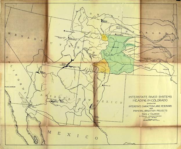
Delph Carpenter’s 1922 Colorado River Basin map with Lake Mead and Lake Powell shown. The two giant reservoirs have always been part of the governance of the river.
All western states in the arid region have basically the same appropriation system, with variations mostly in administration. Thus, throughout the Colorado River region, water that was appropriated and privatized for agricultural use in one place can (after a change of use) water suburban growth a couple hundred miles away in the same state – a situation facilitated by the fact that the state boundaries bear no relation to any geographic realities like watersheds. Up to five million acre-feet of water leave the Colorado River’s natural basin every year for agricultural and municipal uses outside the basin – 40 percent of the river’s water. This ‘flexibility’ of ownership, on top of its ‘first come, first served’ energy, makes the appropriation process a powerful engine for growth, but with not much of a sense of a water commons.
Which brings us more or less back to the present, where we are at something of an impasse over what passes for our water commons. The seven Colorado River Basin states are confronted with the need for a huge ‘reality adjustment’ in the way the river has been operated over the past century: essentially we must – beginning this year – abandon the magical thinking of the Early Anthropocene and cut the overall consumptive use of the river by at least two million acre-feet.
Six of the seven states have constructed a draft plan that would apportion cuts close to two million acre-feet to meet this emergency equitably among all the states – not ‘equally,’ but equitably, cleaning up some mistakes from the past, like the Lower River states ignoring a million and a half acre-feet of annual evaporation. But the seventh state, California, is holding out for strict administration of the appropriation law, which would mean they would get most of their usual allotment, 4.4 million acre-feet (minus 400,000 they are willing to put into the kitty), and Arizona, Nevada and the four Upper River states, all with water rights mostly junior to California’s, would bear the rest of the burden.
Arguments can be made both ways: the importance of the primacy of the rule of law, versus an emergency situation that the law as (mis)administered cannot resolve. I am personally of the latter persuasion (in case you hadn’t noticed), and believe the appropriation laws for water, as they have evolved, might be more part of the problem than part of the solution at this point.
There is a little-discussed fact about appropriation law and seniority rights as it is actually practiced in bad years down on the ground, at least here in the headwaters of the Upper River. That is the fact that agricultural users, at the local level, don’t like to place ‘calls’ on their neighbors in hard times – a ‘call’ being a demand by a senior user that upstream juniors let the water go by until his right is completely fulfilled.
Downstream senior users will place a call when an upstream junior is being blatant in his or her disregard for priority in a time of relatively normal flows, to bring the offender in line. But in a dry year, which is no one’s fault, farmers and ranchers who have drawn water from the same stream for years – sometimes for generations – tend to not insist on rigorous apportionment of water according to seniority, but instead sit down together and figure out how to move whatever water is available around so that everyone gets enough to avoid dead perennials and maybe get a partial crop on their best land.
The ranchers here call these ‘gentlemen’s agreements’: ad hoc measures in which humans respond to nature’s random assaults the way anthropologists show us we did for our first million or so formative years, fragile bands wandering the generally unaccommodating steppes of the Pleistocene ice ages: working it out together. Self-interest served rationally through cooperative action.
These informal agreements beyond the law seem to fit with Elinor Ostrom’s observed ‘rules’ for the long-term management of commons; ‘gentlemen’s agreements’ only seem to work at the local level where users know each other, have transcended the abstract fear that he-she-they want my water, and know that rational self-interest in living a reasonably peaceful and productive life requires some neighborly accommodation to each other’s needs, whether one loves the neighbors or not (although serious neighborhood feuds can preclude a gentlemen’s agreement).
Herbert Hoover presides over the signing of the Colorado River Compact in November 1922. Members of the Colorado River Commission stood together at the signing of the Colorado River Compact on November 24, 1922. The signing took place at the Palace of the Governors in Santa Fe, New Mexico, with Secretary of Commerce Herbert Hoover presiding (seated). (Courtesy U.S. Department of Interior, Bureau of Reclamation)
‘Gentlemen’s agreements’ have not, however, worked when ‘upscaled’ to the state or regional level. Consider the Colorado River Compact: the seven states gathered in 1922 for the expressed purpose of dividing the consumptive use of the river’s water seven ways beyond the appropriation laws. Each state would continue to observe appropriation laws intrastate, but not interstate; they wanted a gentlemen’s agreement that fast-growing California would not be allowed to appropriate most of the river before slower-growing states really got started, and California wanted the other states to support a big-dam project on the mainstem. But either despite their rational self-interest, or on account of it, they were unable to develop that equitable apportionment. The reason they couldn’t is obvious enough from looking at the Compact meeting transcripts: the Compact commissioners were arguing from fantasies about their future development, and they would neither accept each others’ fantasies nor downsize their own, and they would have needed half again more water than even the Bureau of Reclamation’s optimistic fantasies about the river’s actual flow.
But are we now at a sufficiently different place so that the river’s reality might prevail over magical thinking? We now know how much water there actually is in the river, and approximately how much less there will be as the temperatures continue to rise; we can see that the growth energy inspired by ‘first come, first served’ is the last thing we need in the Southwest today; we are aware what a general tangle the fantasies, omissions, ambiguous language and contradictions of the Compact and the subsequent ramshackle Law of the River have created – and we know we are only a couple really bad snow years from a ‘dead pool’ status where no one below Hoover Dam gets any water at all. We know we have to come up with some kind of consensual agreement now, not after another decade in court.
Can the seven states come to the table, leaving all our fantasies of the future behind, face these realities, and come to a gentlemen’s agreement that will get us at least through the next several years with the requisite major cuts in use? While we are trying to forge some new compact that does what the last one failed to do?
The Tomichi Water Conservation Program involves regional coordination between six water users on lower Tomichi Creek to reduce consumptive use on irrigated meadows as a watershed drought management tool. The project will use water supply as a trigger for water conservation measures during one year in the three-year period. During implementation, participating water users would cease irrigation during dry months. Water not diverted will improve environmental and recreational flows through the Tomichi State Wildlife Area and be available to water users below the project area. Photo credit: Business for Water.
If the ranchers on Tomichi Creek can do it up here in the headwaters….
‘The essence of dramatic tragedy is not unhappiness. It resides in the solemnity of the remorseless working of things.’
The climate emergency poses an existential threat to our businesses, farms, and communities but there is no shortage of things we can be doing to address it. These include climate action opportunities in agriculture, land-use, electricity and power, and shifts in policy and priorities to drive these solutions. This report provides useful information on the climate crisis and its impacts on the Gunnison River Basin. It also provides examples of available actions for individuals, businesses, and governments.
2023 GRANT FUNDS SUPPORT NUMEROUS PROJECTS THROUGHOUT UPPER GUNNISON BASIN
The Board of Directors of the Upper Gunnison River Water Conservancy District (UGRWCD) voted at the March 27th Board meeting to award $297,170 to organizations and individuals in the Upper Gunnison River Basin. These grant funds will be used for projects that will enhance water supply, improve stream and irrigation conditions, conserve water, provide water education benefits and restore wetlands. There was a diverse group of project applications from all over the Upper Gunnison River. Examples include a City of Gunnison native plant xeriscape project at 11th & Quartz Street intersection with educational signage, Coal Creek Dam Construction (Lake Irwin), and irrigation demonstration projects – one utilizing a combined plastic irrigation pipe, headwall, and turnout gate for improved irrigation water management and another utilizing an IntelliDitch HDPE Liner to prevent seepage loss.
All applicants were required to provide a 50 percent cost match and their projects had to be consistent with the District’s purpose, mission, and objectives.
UGRWCD General Manager Sonja Chavez noted during this year’s funding cycle, the District received requests for funding that totaled $370,613.
“It was a very competitive cycle and I strongly encourage those who were not funded to reach out to us to discuss their project and how they can make it stronger for the next cycle,” said Sonja.
Sonja also pointed out the District Grant Funding Program is a prime example of the District’s responsible allocation of tax revenues to directly benefit diverse water improvement projects in the basin. “I am delighted to report that during this cycle, our District grant funds were leveraged at a ratio of 1:3 with outside funding sources which just amplifies returns on District investment.
The UGRWCD Grant Program follows an annual cycle with applications due in February each year. General Manager Chavez urges potential applicants or individuals, even those just wondering about a water project, to reach out to the District now so that the District can help with infrastructure assessment or engineering that can assist in ensuring that the project can be funded. If you have a water project in mind, please call the District at (970) 641-6065 to schedule a consultation.
Bridge 40 Diversion. Photo credit: Upper Gunnison River Water Conservancy District
Chittendon Diversion Improvement. Photo credit: Upper Gunnison River Water Conservancy District
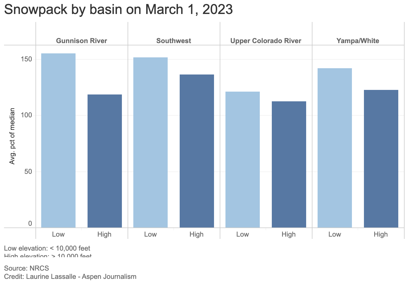
This SNOTEL site at about 8,774 feet at the top of McClure Pass was measuring 154% of median snowpack on March 1, 2023. Lower elevation SNOTEL sites across the West Slope are showing a higher percentage of median snowpack than those at a higher elevation (above 10,000 feet). CREDIT: HEATHER SACKETT/ASPEN JOURNALISM
Snowpack on the Western Slope is tracking above average for this time of year, which has some forecasters feeling optimistic about spring runoff. But there is also an interesting phenomenon that they don’t yet know what to make of.
The snow-water equivalent — a measure of how much water is contained in the snowpack — for the headwaters of the Colorado River stands at 116% of average. That number is measured by snow telemetry (SNOTEL) sites, which are remote sensing stations throughout the West’s mountainous watersheds that collect weather and snowpack data.
Most of the lower-elevation SNOTEL sites (10,000 feet and below) have a higher percentage of median snowpack than high-elevation sites (above 10,000 feet). For example, in the Colorado basin, low-elevation SNOTELs are at a combined 121% of average while high-elevation ones are at 112% of average.
This trend holds true across the Western Slope with the Gunnison, Southwest and Yampa/White/Green river basins at 155%, 152% and 142% of average, respectively, for low-elevation sites and 119%, 136% and 122% for high-elevation sites. In the Roaring Fork basin, snowpack is at 110% for the four high-elevation sites and 134% for the four low-elevation sites.
“I can pretty confidently say sites below 10,000 feet have that trend pretty clearly exhibited,” said Karl Wetlaufer, a hydrologist and assistant supervisor at the National Resources Conservation Service’s Colorado Snow Survey. “It’s certainly an interesting observation.”
Why this counterintuitive trend is occurring is unclear. This winter’s storm patterns may be favoring lower elevations. Or colder-than-average temperatures and overcast days in February may have allowed the snowpack at lower elevations to continue accumulating. The February temperatures for western Colorado were on average about 2 degrees below normal, according to the NRCS.
“We’ve been cloudier, colder, and that has probably helped prevent some melting at lower elevations that might typically take place,” said assistant state climatologist Becky Bolinger. “We will definitely want to look into why the lower elevations are performing so much better than the higher elevations.”
Snowpack above average
Snowpack overall on the Western Slope is above average, with some basins — the southwest, which includes the San Miguel, Dolores, Animas and San Juan rivers and the northwest, which includes the Yampa, White and Little Snake rivers — already surpassing the average seasonal peak. Snowpack typically peaks the first week or two in April.
What more snow at lower elevations means for the timing of this spring’s runoff is also unclear, but forecasters say runoff volume should be above average.
“Big picture, this year is looking very, very favorable for all of western Colorado, and it’s a really big turnaround from the last couple of years,” Wetlaufer said. “It’s kind of tough to parse out the impact of this lower-elevation snow being at a higher percent of median than higher-elevation snow, but, in a general sense, I would certainly say it’s quite encouraging for ample snowmelt runoff this season.”
This is partly because lower elevations encompass more surface area than higher ones; there is simply more land below 10,000 feet than above, and if it is covered in an above-average snowpack, that is a good thing for streams and soils.
“Having that lower-elevation snowpack is going to help keep soil-moisture levels high, which can help the efficiency of the higher-elevation snow when it does melt at a later date,” Wetlaufer said. “Substantial low-elevation snow is going to wet up the soil conditions and allow most of that snowmelt to actually transition to the stream channel.”
In recent dry years, thirsty soils have sucked up runoff before it made it to streams. For example, 2021 was historically bad, with an upper basin snowpack that peaked about 90% of average but translated to only 36% of average runoff into Lake Powell, according to the U.S. Bureau of Reclamation. It was the second-worst runoff on record after 2002.
Although water managers are feeling confident that this year will be better and give a boost to depleted reservoirs in Colorado, they caution that one good year is not enough to pull the entire system out of a crisis. Lake Powell, which is the storage bucket for the upper basin states of Colorado, Utah, New Mexico and Wyoming, is at about elevation 3,521 feet, or about 23% full, the lowest since filling.
“Is this going to solve the Lake Powell and Lake Mead crisis? Not even close,” Bolinger said. “But the forecasted inflows into Powell are above average right now. There’s a silver lining there.”
Aspen Journalism covers water and rivers in collaboration with The Aspen Times.
The Bureau of Land Management and a nonprofit entity have teamed up once again on an acquisition by the federal agency of land along the lower Gunnison River, this time involving a 26.32-acre parcel in Mesa County. The BLM’s Grand Junction Field Office partnered with the Western Rivers Conservancy on the acquisition of the Meridian Junction property, on the east side of the river just north of the Mesa/Delta county line. The acquisition furthers partnership efforts to conserve and protect resources for future generations, the agency said in a news release. The land is within the Dominguez-Escalante National Conservation Area, and was bought with money from the federal Land and Water Conservation Fund.
It is too early to draw definitive conclusions in terms of the Gunnison Basin’s water situation even given the consistent snowstorms we have experienced recently. But it is currently in a good spot. While the Gunnison Basin is recording snowpack that is significantly above average and is about even with where were last year at this time even after a 99-inch snowstorm barreled through the area in late 2021 and early 2022, it takes more than good December and January snow to ultimately fill the reservoirs.
“It’s too soon to say what our water year might look like,” cautioned Upper Gunnison River Water Conservation District (UGRWCD) general manager Sonja Chavez. “As we saw last year, we had a great snowpack through January and then it stopped snowing. We didn’t see any significant storm events the rest of the winter season. Then, wind and dust on the snowpack was a problem, and our snowpack disappeared before our eyes.”
According to UGRWCD water resource specialist Beverly Richards, last week the area in general was recording 140% above average snowpack and that has dropped a bit this week to 133%. The water content is at 129% of average, which is a good sign…
Billy Barr photo via Sotheby’s
“This winter is doing quite well especially after a very weak start,” he reported. “The snowpack is well above average, though the past week’s snow was much lighter in water than everything earlier. That means it is still settling and catching down to the average. But this is a good winter, if not anything overly special. Last year’s end of December storm was big, but that was pretty much the winter while this year has been steady, which is more like it tended to be in the past.”
Broad-tailed hummingbird visits flowers of the dwarf larkspur. Photo courtesy of David Inouye
Click the link to read the article on the Big Pivots website (Allen Best):
Changing climates have started disrupting schedules of almost everything everywhere. As temperatures rise, spring snow in the Rocky Mountains melts earlier. How has this changed the dance between birds and bees, flowers and the trees?
Plenty, according to a new study of research conducted in Colorado during the last half-century, and in far more complex ways than you might think.
Published by the Proceedings of the Royal Society B, a scientific journal of papers in life sciences, the study examined the voluminous evidence accumulated by 15 scientists since 1975 at the Rocky Mountain Biological Laboratory near Crested Butte. The scientists have studied plants, insects, and birds in the outdoor laboratory amid the forest and meadows at an elevation of about 9,500 feet.
Gothic mountain shrouded in clouds behind several cabins. Site of the Surface Atmosphere Integrated Field Laboratory. Gothic, Colorado, USA. By Charlie DeTar – Own workby uploader, CC BY-SA 3.0, https://commons.wikimedia.org/w/index.php?curid=4795644
RMBL, pronounced “rumble,” also has a continuous record of temperature and other weather data beginning in 1975. Average summer temperatures at the lab, which is headquartered at the old mining hamlet of Gothic, have increased 0.4 degrees C each decade. Those in autumn rose 0.2 degrees per decade.
Something similar is happening with snowmelt. The date of bare ground has arrived an average of 2.4 days earlier per decade. With this earlier snowmelt, first spring activity advanced significantly across all the species examined except migratory birds. This makes sense because bird migration is determined by cues along their travel from winter grounds farther to the south and not solely by conditions in their breeding grounds in the Gunnison River Basin.
The study found that this shifting climate has not had uniform effects on the plants, insects, and birds that have been studied since Gerald Ford was president. Some interactions, such as those between particular wildflowers and pollinators, may no longer occur. Hummingbirds may no longer arrive while glaciers lilies are in bloom, for example. And, taking cues from the shifting climate, new species may be entering into the mix in different ways.
Rebecca M. Prather, one of four lead authors of the study, compares what has been observed at RMBL to the dining schedule of two people who had habitually gotten together for lunch at a restaurant for a long time. Suppose one of the patrons had a disruption, causing the person to cancel their noon get-togethers. The second person might take up with others, and the one with the disruption might instead arrive in evening.
In the natural world, the warming climate is changing the timing of interactions — or causing missed dates.
Prather explains that a specific flower can rely on a specific pollinator. And if the flower starts flowering before the insect arrives—well, the flower may not be able to reproduce, because it needs that insect to help it accomplish that task.
The study also emphasized the importance of examining which cues are driving a species’ entire distribution of seasonal activity. For example, first date of flowering by a wildflower may not be a good predictor of its peak flowering.
The study yielded some surprises, said Prather, a post-doctoral researcher at Florida State University’s Department of Biological Science who first studied the effects of changing climate on prairie ecosystems in Oklahoma.
Before the data collection began in 2021, she says, researchers assumed the earlier snowmelt in spring and the accompanying warmer temperatures mattered almost entirely in determining how the birds, insects, and plants interact. They do matter, but the study instead found that other things were also at play. For example, precipitation and temperatures from up to 18 months before can alter interactions among actors in the natural world.
“While we didn’t test the mechanisms for why climate in both short and longer time frames matters, we do know that cues can accumulate over time and interact with an organism’s physiological demands,” Prather explains.
“Extended lag times may be more common at high altitudes or latitudes because there is a shorter growing season, or time for organisms to obtain and store energy. An example that we use in the paper is that alpine bistort pre-forms its leaves and inflorescences four years prior to blooming.”
The study was not focused on quantity, such as the number of bees or flowering lilies, but only the timing of their interactions – and, on the flip side, non-interactions.
Scarlet gilia, blue flax, and other wildflowers make for a happy midsummer setting at the Rocky Mountain Biological Laboratory near Crested Butte. Photo courtesy of David Inouye
David Inouye, another of the study’s authors, began spending his summers at Gothic in 1971 studying bumblebees, flies, and hummingbirds, as well as their interactions with the plants that can, in extremely warm years, such as was the case in 2022, flower in the high mountain meadows into October.
Now living in semi-retirement in Paonia after a teaching career at the University of Maryland, Inouye similarly stresses the greater complexity of interactions that the study found. “Individual species do not all respond in the same way,” he says.
For example, migrating hummingbirds might arrive after the flowers, blooming earlier than before, have disappeared. Bumblebees wintering underground might also have jostled timings relative to their vegetative hosts.
“This points to a more complicated picture than we assumed at first,” he says. “It makes it more complicated, but also more interesting. It also points to the need for detailed long-term studies, to tease apart these interactions.”
Why might somebody in Boulder or Durango care about this?
“A lot of people, no matter where they live, have an appreciation for nature and a curiosity about how nature works and curiosity about how things are changing due to climate change,” he says.
“Anybody who spends time outdoors and has done that for a decade or more has a personal understanding that nature is changing. And I think they will also have an appreciation for learning some of the details about how it is changing that we have gained from decades-long studies like ours and with a variety of species.”
Ian Billick, executive director of RMBL, said the study demonstrates how the laboratory is uniquely positioned to provide a systems-level understanding of how ecosystems around the world will respond to a changing climate.
In terms of climate, the lab’s 45 years of data is but a glimpse. Other records go back much further, especially when considering ice cores and coral reefs.
“But from an organismal perspective, this is the gold standard,” he explains. “There are very few organismal studies that go back 50 years.”
Billick also emphasizes the importance of the study at two levels. If not the first such study, it nonetheless provides a “powerful example of how we can start to integrate across individual studies to develop and better predict how species will respond to climate change.”
Second, he says, this study will help climate scientists broaden their understanding of what lies ahead. Today’s climate change models focus on atmospheric conditions. They must also include earth-system models. In other words, they must incorporate what is happening on the ground—and underground, too—and the interaction with the atmosphere.
“Organisms are a huge driver of carbon cycles, and there are strong feedback loops between organisms and carbon/climate,” Billick explains. “We’ve made a lot of progress on climate models abstracting away the organismal component, but bringing biology back into those models will be very important to reducing uncertainty.”
This paper, while not focused on climate models predicting the future, “is a step in harnessing that complexity in the service of more predictive earth-system models,” he says.
Years of consideration and conservation work all led to a golden moment for two pristine rivers in central Colorado.
During its meeting Jan. 18 in Colorado Springs, the Colorado Parks and Wildlife Commission welcomed the Gunnison and Taylor Rivers as the newest Gold Medal trout fisheries in the state. CPW’s Gold Medal Program showcases the most elite fisheries throughout the state.
The stretches nominated and approved include 20 miles of the Taylor River below Taylor Park Reservoir and 12.5 miles of the Gunnison River starting west of the town of Gunnison at Twin Bridges extending up to the town of Almont.
“I’m pretty excited to be able to announce these two waters into our Gold Medal Program,” said CPW Assistant Aquatic Section Manager Josh Nehring. “It’s an achievement that came about by a lot of work by a lot of people over a number of decades. It’s amazing to see the quality of fisheries that we have here.”
Fisheries in Colorado may be designated by CPW as “Gold Medal” if they meet two qualifying criteria. The standard is 60 pounds of fish per acre along with at least 12 quality trout of 14 inches or greater per acre.
With the addition of the Gunnison and Taylor Rivers, Colorado now boasts 19 Gold Medal sections on 13 rivers that total roughly 362 miles. The state also has three lakes that have earned Gold Medal designation.
While the Gunnison and Taylor are newly-designated Gold Medal streams, CPW aquatic biologists believe the rivers have produced Gold Medal quality trout fishing since the 1990s.
CPW Aquatic Biologist Dan Brauch said that while the rivers had met the biological criteria for designation for decades, it was important to ensure the streams provided long-lasting fish habitat for all life stages of trout.
“Significant work went into maintaining conditions on the Gunnison and Taylor Rivers to allow those fisheries to continue to persist,” Brauch said. “We have sampled the rivers quite a few times in the last 10 years, and we continued to see good numbers of quality-size trout and abundant trout.
“The Gunnison and Taylor Rivers really represent a successful conservation story with lots of partners that have made this fishery what it is today.”
CPW surveys streams regularly through the process of electrofishing. Fish are collected, weighed, measured and returned to the water. Data collected through these surveys provides invaluable data for CPW to assess the health of a fishery and to determine waters worthy of Gold Medal nomination.
“It does take quite a bit of work to get fisheries to this standpoint,” said Nehring, who grew up in neighboring Montrose and has enjoyed fishing the two rivers since he was a child. “Just the habitat that goes into it, the monitoring of the fisheries, making sure our regulations are appropriate and we aren’t getting too many fish harvested. There are a lot of things that go into making sure the system is healthy.”
Brauch and Nehring thanked a multitude of public and private partners that have come together throughout time to support the Gunnison and Taylor fisheries as work has been done to improve and protect trout habitat through the Gold Medal stretches.
While celebrating the conservation success story that has led to Gold Medal status for the rivers, CPW Area Wildlife Manager Brandon Diamond encouraged anglers to help protect these resources for generations to come.
“It’s extremely important right now for all water users and conservation-minded people, including anglers, to view these incredible resources through a stewardship lens,” Diamond said. “And I strongly encourage all of us to evaluate how we can contribute to the long-term conservation of these waters and how we fit in as stewards of the land and river resources.
“The Gold Medal designation is certainly something we are locally proud of. The Gunnison Valley has always been very supportive of wildlife conservation values, and we hope to continue that relationship moving forward.”
Photo credit: Colorado Parks & WildlifePhoto credit: Colorado Parks & WildlifePhoto credit: Colorado Parks & WildlifePhoto credit: Colorado Parks & WildlifePhoto credit: Colorado Parks & Wildlife
Blue Mesa Reservoir is the largest storage facility in Colorado in the Upper Colorado River system. Prolonged drought and downriver demand is shrinking the reservoir. Credit: Tom Wood, Water Desk
From email from Reclamation (Erik Knight):
The next Aspinall Operations meeting is scheduled for this Thursday, January 19th, start time 1:00pm
The meeting will be open to in-person attendance at the Western Colorado Area Office in Grand Junction.
445 West Gunnison Ave
Grand Junction, CO
The meeting will also be available to attend virtually via Microsoft Teams. Please click on this link to attend the meeting virtually.
This link should open in any smartphone, tablet, or computer browser, and does not require a Microsoft account.
The meeting agenda with handouts will be emailed out prior to the meeting.
For any questions please email or call at the number below.
Part of the memorial to Wayne Aspinall in Palisade. Aspinall, a Democrat, is a legend in the water sector, and is the namesake of the annual award given by the Colorado Water Congress. Photo: Brent Gardner-Smith/Aspen Journalism
From email from Reclamation (Erik Knight):
The next coordination meeting for the operation of the Aspinall Unit is scheduled for Thursday, January 19th, 2023 at 1:00 pm
As of now, the meeting is planned to be held in person as well as virtually.
The meeting is planned to be held at the Western Colorado Area Office in Grand Junction, CO. Even if the in-person meeting needs to be cancelled, the meeting will still be held via webinar.
Information for connecting to the meeting virtually will be emailed out prior to the meeting, along with the agenda and handouts.
Known for its breathtaking scenery, the Dominguez-Escalante National Conservation Area is a fine example of the spectacular canyon country of Colorado’s Uncompahgre Plateau. Red-rock canyons and sandstone bluffs hold geological and paleontological resources spanning 600 million years, as well as many cultural and historic sites. The Ute Tribes today consider these pinyon-juniper–covered lands an important connection to their ancestral past. The Escalante, Cottonwood, Little Dominguez and Big Dominguez Creeks cascade through sandstone canyon walls that drain the eastern Uncompahgre Plateau. Unaweep Canyon on the northern boundary of the NCA contains globally significant geological resources. Nearly 30 miles (48 km) of the Gunnison River flow through the Dominguez-Escalante NCA, supporting fish, wildlife and recreational resources. The Old Spanish National Historic Trail, a 19th Century land trade route, also passes through it. A variety of wildlife call the area home, including desert bighorn sheep, mule deer, golden eagle, turkey, elk, mountain lion, black bear, and the collared lizard. There are 115 miles (185 km) of streams and rivers in the NCA, and there is habitat suitable for 52 protected species of animals and plants. By Bob Wick; Bureau of Land Management – Dominguez-Escalante NCA, Public Domain, https://commons.wikimedia.org/w/index.php?curid=42092807
by Abrahm Lustgarten
ProPublica is a Pulitzer Prize-winning investigative newsroom. Sign up for The Big Story newsletter to receive stories like this one in your inbox.
On a crisp day this fall I drove southeast from Grand Junction, Colorado, into the Uncompahgre Valley, a rich basin of row crops and hayfields. A snow line hung like a bowl cut around the upper cliffs of the Grand Mesa, while in the valley some farmers were taking their last deliveries of water, sowing winter wheat and onions. I turned south at the farm town of Delta onto Route 348, a shoulder-less two-lane road lined with irrigation ditches and dent corn still hanging crisp on their browned stalks. The road crossed the Uncompahgre River, and it was thin, nearly dry.
The Uncompahgre Valley, stretching 34 miles from Delta through the town of Montrose, is, and always has been, an arid place. Most of the water comes from the Gunnison River, a major tributary of the Colorado, which courses out of the peaks of the Elk Range through the cavernous and sun-starved depths of the Black Canyon, one rocky and inaccessible valley to the east. In 1903, the federal government backed a plan hatched by Uncompahgre farmers to breach the ridge with an enormous tunnel and then in the 1960s to build one of Colorado’s largest reservoirs above the Black Canyon called Blue Mesa. Now that tunnel feeds a neural system of water: 782 miles worth of successively smaller canals and then dirt ditches, laterals and drains that turn 83,000 Western Colorado acres into farmland. Today, the farm association in this valley is one of the largest single users of Colorado River water outside of California.
I came to this place because the Colorado River system is in a state of collapse. It is a collapse hastened by climate change but also a crisis of management. In 1922, the seven states in the river basin signed a compact splitting the Colorado equally between its upper and lower halves; later, they promised additional water to Mexico, too. Near the middle, they put Lake Powell, a reserve for the northern states, and Lake Mead, a storage node for the south. Over time, as an overheating environment has collided with overuse, the lower half — primarily Arizona and California — has taken its water as if everything were normal, straining both the logic and the legal interpretations of the compact. They have also drawn extra releases from Lake Powell, effectively borrowing straight out of whatever meager reserves the Upper Basin has managed to save there.
This much has become a matter of great, vitriolic dispute. What is undeniable is that the river flows as a much-diminished version of its historical might. When the original compact gave each half the rights to 7.5 million acre-feet of water, the river is estimated to have flowed with as much as 18 million acre-feet each year. Over the 20th century, it averaged closer to 15. Over the past two decades, the flow has dropped to a little more than 12. In recent years, it has trickled at times with as little as 8.5. All the while the Lower Basin deliveries have remained roughly the same. And those reservoirs? They are fast becoming obsolete. Now the states must finally face the consequential question of which regions will make their sacrifice first. There are few places that reveal how difficult it will be to arrive at an answer than the Western Slope of Colorado.
In Montrose, I found the manager of the Uncompahgre Valley Water Users Association, Steve Pope, in his office atop the squeaky stairs of the same Foursquare that the group had built at the turn of the last century. Pope, bald, with a trimmed white beard, sat amid stacks of plat maps and paper diagrams of the canals, surrounded by LCD screens with spreadsheets marking volumes of water and their destinations. On the wall, a historic map showed the farms, wedged between the Uncompahgre River and where it joins the Gunnison in Delta, before descending to their confluence with the Colorado in Grand Junction. “I’m sorry for the mess,” he said, plowing loose papers aside.
Colorado Rivers. Credit: Geology.com
What Pope wanted to impress upon me most despite the enormousness of the infrastructure all around the valley was that in the Upper Basin of the Colorado River system, there are no mammoth dams that can simply be opened to meter out a steady release of water. Here, only natural precipitation and temperature dictate how much is available. Conservation isn’t a management decision, he said. It was forced upon them by the hydrological conditions of the moment. The average amount of water flowing in the system has dropped by nearly 20%. The snowpack melts and evaporates faster than it used to, and the rainfall is unpredictable. In fact, the Colorado River District, an influential water conservancy for the western part of the state, had described its negotiating position with the Lower Basin states by claiming Colorado has already conserved about 28% of its water by making do with the recent conditions brought by drought.
You get what you get, Pope tells me, and for 15 of the past 20 years, unlike the farmers in California and Arizona, the people in this valley have gotten less than what they are due. “We don’t have that luxury of just making a phone call and having water show up,” he said, not veiling his contempt for the Lower Basin states’ reliance on lakes Mead and Powell. “We’ve not been insulated from this climate change by having a big reservoir above our heads.”
He didn’t have to point further back than the previous winter. In 2021, the rain and snow fell heavily across the Rocky Mountains and the plateau of the Grand Mesa, almost as if it were normal times. Precipitation was 80% of average — not bad in the midst of an epochal drought. But little made it into the Colorado River. Instead, soils parched by the lack of rain and rising temperatures soaked up every ounce of moisture. By the time water reached the rivers around Montrose and then the gauges above Lake Powell, the flow was less than 30% of normal. The Upper Basin states used just 3.5 million acre-feet last year, less than half their legal right under the 1922 compact. The Lower Basin states took nearly their full amount, 7 million acre-feet.
Colorado River Basin Plumbing. Credit: Lester Doré/Mary Moran via Dustin Mulvaney and Twitter
All of this matters now not just because the river, an unwieldy network of human-controlled plumbing, is approaching a threshold where it could become inoperable, but because much of the recent legal basis for the system is about to dissolve. In 2026, the Interim Guidelines the states rely on, a Drought Contingency Plan and agreements with Mexico will all expire. At the very least, this will require new agreements. It also demands a new way of thinking that matches the reality of the heating climate and the scale of human need. But before that can happen, the states will need to restore something that has become even more scarce than the water: trust.
The northern states see California and Arizona reveling in profligate use, made possible by the anachronistic rules of the compact that effectively promise them water when others have none. It’s enabled by the mechanistic controls at the Hoover Dam, which releases the same steady flow no matter how little snow falls across the Rocky Mountains. California flood-irrigates alfalfa crops destined for cattle markets in the Middle East, while Arizona takes water it does not need and pumps it underground to build up its own reserves. In 2018, an Arizona water agency admitted it was gaming the timing of its orders to avoid rations from the river (though it characterized the moves as smart use of the rules). In 2021, in a sign of the growing wariness, at least one Colorado water official alleged California was repeating the scheme. California water officials say this is a misunderstanding. Yet to this day, because California holds the most senior legal rights on the river, the state has avoided having a single gallon of reductions imposed on it.
Updated Colorado River 4-Panel plot thru Water Year 2022 showing reservoirs, flows, temperatures and precipitation. All trends are in the wrong direction. Since original 2017 plot, conditions have deteriorated significantly. Brad Udall via Twitter: https://twitter.com/bradudall/status/1593316262041436160
By this spring, Lake Powell shrank to 24% of its capacity, its lowest levels since the reservoir filled in the 1960s. Cathedral-like sandstone canyons were resurrected, and sunlight reached the silt-clogged floors for the first time in generations. The Glen Canyon Dam itself towered more than 150 feet above the waterline. The water was just a few dozen feet above the last intake pipe that feeds the hydropower generators. If it dropped much lower, the system would no longer be able to produce the power it distributes across six states. After that, it would approach the point where no water at all could flow into the Grand Canyon and further downstream. All the savings that the Upper Basin states had banked there were as good as gone.
In Western Colorado, meanwhile, people have been suffering. South of the Uncompahgre Valley, the Ute Mountain Ute tribe subsists off agriculture, but over the past 12 months it has seen its water deliveries cut by 90%; the tribe laid off half of its farmworkers. McPhee Reservoir, near the town of Cortez, has teetered on failure, and other communities in Southwestern Colorado that also depend on it have been rationed to 10% of their normal water.
Across the Upper Basin, the small reservoirs that provide the region’s only buffer against bad years are also emptying out. Flaming Gorge, on the Wyoming-Utah border, is the largest, and it is 68% full. The second largest, Navajo Reservoir in New Mexico, is at 50% of its capacity. Blue Mesa Reservoir, on the Gunnison, is just 34% full. Each represents savings accounts that have been slowly pilfered to supplement Lake Powell as it declines, preserving the federal government’s ability to generate power there and obscuring the scope of the losses. Last summer, facing the latest emergency at the Glen Canyon Dam, the Department of Interior ordered huge releases from Flaming Gorge, Blue Mesa and other Upper Basin reservoirs. At Blue Mesa, the water levels dropped 8 feet in a matter of days, and boaters there were given a little more than a week to get their equipment off the water. Soon after, the reservoir’s marinas, which are vital to that part of Colorado’s summer economy, closed. They did not reopen in 2022.
South Canal. Photo credit: Delta-Montrose Electric Association via The Mountain Town News
As the Blue Mesa Reservoir was being emptied last fall, Steve Pope kept the Gunnison Tunnel open at its full capacity, diverting as much water as he possibly could. He says this was legal, well within his water rights and normal practice, and the state’s chief engineer agrees. Pope’s water is accounted for out of another reservoir higher in the system. But in the twin takings, it’s hard not to see the bare-knuckled competition between urgent needs. Over the past few years, as water has become scarcer and conservation more important, Uncompahgre Valley water diversions from the Gunnison River have remained steady and at times even increased. The growing season has gotten longer and the alternative sources, including the Uncompahgre River, less reliable. And Pope leans more than ever on the Gunnison to maintain his 3,500 shareholders’ supply. “Oh, we are taking it,” he told me, “and there’s still just not enough.”
On June 14, Camille Touton, the commissioner of the U.S. Bureau of Reclamation, the Department of Interior division that runs Western water infrastructure, testified before the Senate Committee on Energy and Natural Resources and delivered a stunning ultimatum: Western states had 60 days to figure out how to conserve as much as 4 million acre-feet of “additional” water from the Colorado River or the federal government would, acting unilaterally, do it for them. The West’s system of water rights, which guarantees the greatest amount of water to the settlers who arrived in the West and claimed it first, has been a sacrosanct pillar of law and states’ rights both — and so her statement came as a shock.
Would the department impose restrictions “without regard to river priority?” Mark Kelly,, the Democratic senator from Arizona, asked her.
“Yes,” Touton responded.
For Colorado, this was tantamount to a declaration of war. “The feds have no ability to restrict our state decree and privately owned ditches,” the general manager of the Colorado River District, Andy Mueller, told me. “They can’t go after that.” Mueller watches over much of the state.Pope faces different stakes. His system depends on the tunnel, a federal project, and his water rights are technically leased from the Bureau of Reclamation, too. Touton’s threat raised the possibility that she could shut the Uncompahgre Valley’s water off. Even if it was legal, the demands seemed fundamentally unfair to Pope. “The first steps need to come in the Lower Basin,” he insisted.
Each state retreated to its corners, where they remain. The 60-day deadline came and went, with no commitments toward any specific reductions in water use and no consequences. The Bureau of Reclamation has since set a new deadline: Jan. 31. Touton, who has publicly said little since her testimony to Congress, declined to be interviewed for this story. In October, California finally offered a plan to surrender roughly 9% of the water it used, albeit with expensive conditions. Some Colorado officials dismissed the gesture as a non-starter. Ever since, Colorado has become more defiant, enacting policies that seem aimed at defending the water the state already has — perhaps even its right to use more.
For one, Colorado has long had to contend with the inefficiencies that come with a “use it or lose it” culture. State water law threatens to confiscate water rights that don’t get utilized, so landowners have long maximized the water they put on their fields just to prove up their long-term standing in the system. This same reflexive instinct is now evident among policymakers and water managers across the state, as they seek to establish the baseline for where negotiated cuts might begin. Would cuts be imposed by the federal government based on Pope’s full allocation of water or on the lesser amount with which he’s been forced to make do? Would the proportion be adjusted down in a year with no snow? “We don’t have a starting point,” he told me. And so the higher the use now, the more affordable the conservation later.
Colorado and other Upper Basin states have also long hid behind the complexity of accurately accounting for their water among infinite tributaries and interconnected soils. [ed. emphasis mine] The state’s ranchers like to say their water is recycled five times over, because water poured over fields in one place invariably seeps underground down to the next. In the Uncompahgre Valley, it can take months for the land at its tail to dry out after ditches that flood the head of the valley are turned off. The measure of what’s been consumed and what has transpired from plants or been absorbed by soils is frustratingly elusive. That, too, leaves the final number open to argument and interpretation.
All the while, the Upper Basin states are all attempting to store more water within their boundaries. Colorado has at least 10 new dams and reservoirs either being built or planned. Across the Upper Basin, an additional 15 projects are being considered, including Utah’s audacious $2.4 billion plan to run a new pipeline from Lake Powell, which would allow it to transport something closer to its full legal right to Colorado River water to its growing southern cities. Some of these projects are aimed at securing existing water and making its timing more predictable. But they are also part of the Upper Colorado River Commission’s vision to expand the Upper Basin states’ Colorado River usage to 5.4 million acre-feet a year by 2060.
It is fair to say few people in the state are trying hard to send more of their water downstream. In our conversation, Mueller would not offer any specific conservation savings Colorado might make. The state’s chief engineer and director of its Division of Water Resources, Kevin Rein, who oversees water rights, made a similar sentiment clear to the Colorado River District board last July. “There’s nothing telling me that I should encourage people to conserve,” Rein said. “It’s a public resource. It’s a property right. It’s part of our economy.”
In November, Democratic Gov. Jared Polis proposed the creation of a new state task force that would help him capture every drop of water it can before it crosses the state line. It would direct money and staff to make Colorado’s water governance more sophisticated, defensive and influential.
I called Polis’ chief water confidante, Rebecca Mitchell, who is also the director of the Colorado Water Conservation Board and the state’s representative on the Upper Colorado River Commission. If the mood was set by the idea that California was taking too much from the river, Mitchell thought that it had shifted now to a more personal grievance — they are taking from us.
On a day in late May [2022] when wildfire smoke obscured the throat of an ancient volcano called Shiprock in the distance, I visited the Ute Mountain Ute farming and ranching operation in the southwestern corner of Colorado. Photo credit: Allen Best/Big Pivots
Last month, Mitchell flew to California for a tour of its large irrigation districts. She stood beside a wide canal brimming with more water than ever flows through the Uncompahgre River, and the executive of the farming company beside her explained that he uses whatever he wants because he holds the highest priority rights to the water. She thought about the Ute Mountain Ute communities and the ranchers of Cortez: “It was like: ‘Wouldn’t we love to be able to count on something? Wouldn’t we love to be feel so entitled that no matter what, we get what we get?’” she told me.
What if Touton followed through, curtailing Colorado’s water? I asked. Mitchell’s voice steadied, and then she essentially leveled a threat. “We would be very responsive. I’m not saying that in a positive way,” she said. “I think everybody that’s about to go through pain wants others to feel pain also.”
Here’s the terrible truth: There is no such thing as a return to normal on the Colorado River, or to anything that resembles the volumes of water its users are accustomed to taking from it. With each degree Celsius of warming to come, modelers estimate that the river’s flow will decrease further, by an additional 9%. At current rates of global warming, the basin is likely to sustain at least an additional 18% drop in its water supplies over the next several decades, if not far more. Pain, as Mitchell puts it, is inevitable.
The thing about 4 million acre-feet of cuts is that it’s merely the amount already gone, an adjustment that should have been made 20 years ago. Colorado’s argument makes sense on paper and perhaps through the lens of fairness. But the motivation behind the decades of delay was to protect against the very argument that is unfolding now — that the reductions should be split equally, and that they may one day be imposed against the Upper Basin’s will. It was to preserve the northern states’ inalienable birthright to growth, the promise made to them 100 years ago. At some point, though, circumstances change, and a century-old promise, unfulfilled, might no longer be worth much at all. Meanwhile, the politics of holding out are colliding with climate change in a terrifying crash, because while the parties fight, the supply continues to dwindle.
Average combined storage assuming drought conditions continue
Average end-of-year combined Lake Powell and Lake Mead storage is shown, assuming hydrologic conditions of the Millennium Drought continue. Results show combined reservoir contents using a range of Upper Basin consumptive use limits (colored ribbons) along with a range of Lower Basin maximum consumptive use reductions (line styles) triggered when the combined storage falls below 15 million acre-feet (MAF). The status quo lines use the 2016 Upper Colorado River Commission (UCRC) projections and existing elevation-based shortage triggers. All water use and shortage values are annual volumes (MAF/year).
Recently, Brad Udall, a leading and longtime analyst of the Colorado River and now a senior water and climate scientist at Colorado State University, teamed with colleagues to game out what they thought it would take to bring the river and the twin reservoirs of Mead and Powell into balance. Their findings, published in July in the journal Science, show that stability could be within reach but will require sacrifice.
If the Upper Basin states limited their claim to 4 million acre-feet, or 53% of their due under the original compact, and the Lower Basin states and Mexico increased their maximum emergency cuts by an additional 45%, the two big reservoirs will stay at roughly their current levels for the next several decades. If the basins could commit to massive reductions below even 2021 levels for the Upper Basin and to more than doubling the most ambitious conservation goals for the south, the reservoirs could once again begin to grow, providing the emergency buffer and the promise of economic stability for 40 million Americans that was originally intended. Still, by 2060, they would only be approximately 45% full.
Any of the scenarios involve cuts that would slice to the bone. Plus, there’s still the enormous challenge of how to incorporate Native tribes, which also hold huge water rights but continue to be largely left out of negotiations. What to do next? Israel provides one compelling example. After decades of fighting over the meager trickles of the Jordan River and the oversubscription of a pipeline from the Sea of Galilee, Israel went back to the drawing board on its irrigated crops. It made drip irrigation standard, built desalination plants to supply water for its industry and cities, and reused that water again and again; today, 86% of the country’s municipal wastewater is recycled, and Israel and its farmers have an adequate supply. That would cost a lot across the scale and reach of a region like the Western United States. But to save the infrastructure and culture that produces 80% of this country’s winter vegetables and is a hub of the nation’s food system for 333 million people? It might be worth it.
A different course was charted by Australia, which recoiled against a devastating millennium drought that ended 13 years ago. It jettisoned its coveted system of water rights, breaking free of history and prior appropriation similar to the system of first-come-first-served the American West relies on. That left it with a large pool of free water and political room to invent a new method of allocating it that better matched the needs in a modern, more populous and more urban Australia and better matched the reality of the environment.
In America, too, prior appropriation, as legally and culturally revered as it is, may have become more cumbersome and obstructive than it needs to be. Western water rights, according to Newsha Ajami, a leading expert at Lawrence Berkeley National Laboratory and the former director of the urban water policy program at Stanford University, were set up by people measuring with sticks and buckets, long before anyone had ever even considered climate change. Today, they largely serve powerful legacy interests and, because they must be used to be maintained, tend to dissuade conservation. “It’s kind of very archaic,” she said. “The water rights system would be the first thing I would just dismantle or revisit in a very different way.”
This is probably not going to happen, Ajami said. “It could be seen as political suicide.” But that doesn’t make it the wrong solution. In fact, what’s best for the Colorado, for the Western United States, for the whole country might be a combination of what Israel and Australia mapped out. Deploy the full extent of the technology that is available to eliminate waste and maximize efficiency. Prioritize which crops and uses are “beneficial” in a way that attaches the true value of the resource to the societal benefit produced from using it. Grow California and Arizona’s crops in the wintertime but not in the summer heat. And rewrite the system of water allocation as equitably as possible so that it ensures the modern population of the West has the resources it needs while the nation’s growers produce what they can.
What would that look like in Colorado? It might turn the system upside down. Lawsuits could fly. The biggest, wealthiest ranches with the oldest water rights stand to lose a lot. The Lower and Upper Basin states, though, could all divide the water in the river proportionately, each taking a percentage of what flowed. The users would, if not benefit, at least equally and predictably share the misery. Pope’s irrigation district and the smallholder farmers who depend on it would likely get something closer to what they need and, combined with new irrigation equipment subsidized by the government, could produce what they want. It wouldn’t be pretty. But something there would survive.
The alternative is worse. The water goes away or gets bought up or both. The land of Western Colorado dries up, and the economies around it shrivel. Montrose, with little left to offer, boards up its windows, consolidates its schools as people move away, and the few who remain have less. Until one day, there is nothing left at all.
‘Colorado River “Beginnings”. Photo: Brent Gardner-Smith/Aspen Journalism
The Upper Gunnison Basin Cloud Seeding Program started in the 2002/2003 winter season, following a feasibility study the year prior funded by Gunnison County in response to significant drought in 2002. After the program’s first year, the UGRWCD took over and in the time since it has grown to 15 generators, on both public and private land. The UGRWCD wants to add more generators in other qualified locations, starting with one on private land on Black Mesa. According to the UGRWCD, cloud seeding is one of the cheapest forms of augmentation water for the river basin at an estimated $0.53 per acre-foot annually. And it can provide critical water to support Gunnison River basin flows, Blue Mesa Reservoir and the local economy.
“Typically, what we plan for is that in the last five years or so the programs run at about $114,000 to $118,000 per year,” says Sonja Chavez, general manager for the UGRWCD.
The Colorado Water Conservation Board gives anywhere between $67,000 and $94,000 and the UGRWCD covers the remaining $20,000 to $45,000. Chavez says that program costs are increasing, however. “We are adding a new generation site, and we are going to be looking for new funding partners,” she says…
Cloud seeding cannot create a snowstorm, but it can increase the precipitation from a storm that already exists. Cole Osborne, project meteorologist for NAWC, explains how the process works using manual and remote-controlled generators and propane tanks to blast a mix of silver iodide and sodium iodide into the atmosphere.
“The solution attracts liquid particles in a cloud, and the water molecules develop into ice crystals…so you can speed up the process and make a cloud more efficient at producing precipitation,” he says…
The UGRWCD and NAWC believe a remote generator placed at Black Mesa between Crested Butte and Gunnison will do more than any other program enhancement, in terms of water augmentation in the Gunnison Range and to Blue Mesa Reservoir. The UGRWCD, with financial assistance from the Colorado Water Conservation Board, has decided to fund the initial set-up and infrastructure costs for the remote generator for approximately $67,600. Osborne says there’s a huge area they are trying to target to lead to increased spring runoff and rises in reservoir levels. According to a memo from the UGRWCD earlier this month to potential funding partners, “NAWC analysis indicates that the generator will have significant direct benefits to northern and southern tributaries to Blue Mesa Reservoir and to eastern tributaries due to positive downwind cloud seeding impacts. The remote generator would permit cloud seeding during almost all storm periods that impact the Upper Gunnison River watershed. Seeding could occur during periods with winds ranging from northerly to southerly.
Project 7 Water Authority scored another grant to help it add critical infrastructure. The Colorado River District’s Accelerator Grant program awarded Project 7 $46,600, to be used in developing a competitive federal funding application.
Project 7 provides drinking water for about 60,000 people in the Uncompahgre River Valley and is in the process of developing a backup treatment facility to deliver treated water from Ridgway Reservoir. Currently, Montrose, Delta and Ouray counties’ drinking water comes from a single treatment plant, using water from Blue Mesa Reservoir that is delivered via the Gunnison Tunnel.
The Colorado River District funding will help pay for a feasibility study and a grant application to the U.S. Bureau of Reclamation for funding to treat hard water with high levels of minerals in Ridgway Reservoir. This study and application will include the results of a pilot project that tested out different means of softening and filtration so that when the backup plant is built, the water it treats will be of the same quality as the current treatment plant. Once the study is accepted by BuRec, Project 7’s Regional Water Supply & Resiliency Program is eligible to apply for federal funding through the bureau’s Title XVI Water Reclamation and Reuse grant opportunity. Earlier this year, Project 7 secured $612,059 from BuRec’s Desalination and Water Purification Research Program, which paid for the pilot project (with a funding match from Project 7).
The push for a second treatment facility is on, because the current, single source puts the region’s drinking water supply at greater risks from wildfire, drought and infrastructure failure. Having a second treatment plant will provide another source of drinking water (from Ridgway Reservoir) and provide a backup option in the event of infrastructure failure at the current plant.
American beaver, he was happily sitting back and munching on something. and munching, and munching. By Steve from washington, dc, usa – American Beaver, CC BY-SA 2.0, https://commons.wikimedia.org/w/index.php?curid=3963858
Beavers could help protect water quality and ecosystem health from the effects of climate change, new research suggests. The conclusion comes from a new study in the journal Nature Communications focused on a beaver dam outside Crested Butte. In 2017, Christian Dewey, then a doctoral student focused on water and soil science at Stanford University, set out to research shifting steam flows along the East River, a winding tributary of the Colorado River. Dewey, now a post-doctoral researcher at Oregon State University, hoped the study could add context to a potential threat to western watersheds. As climate change drives more frequent droughts and drier weather long-term, scientists fear excess nutrients, like nitrogen, could build up in waterways, contaminating the water and the surrounding river ecosystems. Major downpours and seasonal snowmelts flush away the harmful chemicals in normal years. Low nitrogen levels benefit many organisms, but Dewey said too much can trigger harmful algal blooms that deprive fish and other creatures of essential oxygen. Accumulated nitrogen also puts human infants at a higher risk of “blue baby syndrome,” a potentially deadly condition defined by low blood-oxygen levels.
Dewey had no plans to study beavers until the industrious rodents took over his research site. During the dry summer of 2018, a dam appeared across the main channel of the river, slowing the flow into a small pond.
“We were really just in the perfect position to capture the changes the beaver damn caused. It was really being in the right place at the right time,” Dewey said.
The beavers maintained the dam for two months until the water swept away the mud and branches. By carefully tracking steam’s flow and chemical composition, Dewey found the structure flooded the surrounding soil, allowing microbes to convert excess nitrogen into a harmless gas. Rain and snowmelt have a similar effect but nothing close to the benefits of beavers. The research found the dam increased nitrogen removal by 44 percent compared to the river’s normal seasonal fluxations.
What we need now is your help; I invite you to join us for the West Slope Water Summit on Nov. 10 at the Montrose County Event Center. Even though we are a small community on the western slope, arming our community members with knowledge, encouraging conservation, and researching potential solutions is a role that we all play in the Colorado River system. In its fourth year, the West Slope Water Summit’s theme is “troubled waters” featuring an impressive number of prominent water and conservation experts.
The program begins with Andy Mueller, Executive Director of the Colorado River District, who will address adapting the 1922 Compact to today’s reality. Next, Don Day, Meteorologist Day Weather Inc., is presenting on the State of the Weather: the good, the bad, and the ugly.
Before the free lunch, our local Uncompahgre Valley Water Users Association Manager Steve Pope will provide an update to the Colorado River Basin Drought Response as part of a panel of water user board members.
Spots are still available — we recently moved from the conference room to the arena to accommodate a larger crowd. Register at westslopewatersummit.com
River Bottom Park Uncompahgre River. Photo credit: PhilipScheetzPhoto via the City of Montrose
Official opening of the Gunnison Tunnel by President Taft at the west portal
From email from Reclamation (Erik Knight):
Releases from the Aspinall Unit will be decreased from 950 cfs to 370 cfs on Monday, October 31st. Releases are being decreased in coordination with the shutdown of the Gunnison Tunnel on Monday, October 31st.
Flows in the lower Gunnison River are currently above the baseflow target of 790 cfs. River flows are expected to remain above the baseflow target for the foreseeable future.
Pursuant to the Aspinall Unit Operations Record of Decision (ROD), the baseflow target in the lower Gunnison River, as measured at the Whitewater gage, is 790 cfs for October and November.
Currently, Gunnison Tunnel diversions are 570 cfs and flows in the Gunnison River through the Black Canyon are around 340 cfs. After this release change Gunnison Tunnel diversions will be zero and flows in the Gunnison River through the Black Canyon will still be near 340 cfs. Current flow information is obtained from provisional data that may undergo revision subsequent to review.
The Grand Mesa, Uncompahgre and Gunnison (GMUG) National Forests’ Grand Valley Ranger District in partnership with Delta County, Mesa County and Colorado State Forest Service announce the Grand Mesa Watershed Resiliency Partnership—a large landscape scale effort to reduce the potential for catastrophic wildfire effects in critical watersheds on and adjacent to the Grand Mesa. A series of community meetings will be offered to provide the public detailed information on the effort, what types of projects are considered and an invitation to be involved in the planning.
The Grand Mesa Watershed Resiliency Partnership was created in the summer of 2022 to plan integrated fuels reduction projects on the western portion of the Grand Mesa National Forest. Significant funding to implement projects is anticipated in two years. Early informational sessions with neighboring agencies, local governments, fire chiefs, utility companies, water producers, and wildfire councils have been very supportive. Community members are invited to actively participate and help create fire-resilient landscapes.
“The size and intensity of large wildfires have greatly increased across the West over the past 20 years, often with catastrophic results to communities and watersheds. In response, Congress has provided funding to implement locally-designed projects to reduce the intensity and negative effects of large wildfires. We are starting to work with our local communities now, so we are prepared to receive funding in two years. We are fortunate and grateful to have this unique opportunity, and community support will be necessary for this to be a successful effort,” said Bill Edwards, District Ranger for the Grand Valley Ranger District.
Several open houses in local communities will be available for in-person and online attendance:
Nov. 2 – 6 p.m. – 8 p.m. Cedaredge Community Center, 140 SW Second St. Cedaredge, CO 81413.
Part of the memorial to Wayne Aspinall in Palisade. Aspinall, a Democrat, is a legend in the water sector, and is the namesake of the annual award given by the Colorado Water Congress. Photo: Brent Gardner-Smith/Aspen Journalism
From email from Reclamation (Erik Knight):
Releases from the Aspinall Unit will be decreased from 1050 cfs to 950 cfs on Thursday, October 20th. Releases are being decreased due to reduced demand at the Gunnison Tunnel.
Flows in the lower Gunnison River are currently above the baseflow target of 790 cfs. River flows are expected to remain above the baseflow target for the foreseeable future.
Pursuant to the Aspinall Unit Operations Record of Decision (ROD), the baseflow target in the lower Gunnison River, as measured at the Whitewater gage, is 790 cfs for October and November.
Currently, Gunnison Tunnel diversions are 700 cfs and flows in the Gunnison River through the Black Canyon are around 340 cfs. After this release change Gunnison Tunnel diversions will be around 600 cfs and flows in the Gunnison River through the Black Canyon will still be near 340 cfs. Current flow information is obtained from provisional data that may undergo revision subsequent to review.
United Lithium Corp. (CSE: ULTH; OTC: ULTHF; FWB: 0ULA) (“ULTH” or the “Company”) ispleased to announce that it has established a large land position in a historic lithium-beryllium producing area of Gunnison County of Colorado. The Company has completed staking of over 300 unpatented lode claims covering more than 9 square miles (nearly 25 square kilometers) near Ohio City, Colorado, surrounding the Black Wonder granite. The “Patriot Lithium Project” hosts numerous pegmatite bodies, several of which have been mined for Li-Be. United Lithium’s claim block covers or surround all past LCT (lithium, cesium, tantalum) pegmatite production in the Ohio City area.
A reconnaissance rock chip sampling program was carried out in conjunction with the staking program to identify new areas for detailed field work. Samples have been submitted to the laboratory and assays are awaited.
Michael Dehn, CEO of United Lithium stated, “We are planning an integrated exploration program to evaluate the Ohio City area land holdings. The program will include local area detailed geologic mapping and additional rock chip sampling. With anomalies well-defined, targets with be drilled in the coming year when permits and contracts are in place.”
A general outline of the United Lithium claims is presented below. The area staked covers the public lands administered by the U.S. Forest Service (USFS). There are private property holdings within the USFS lands and the claims are positioned and located to recognize the pre-existing, titled ownership rights.
Map 1 Patriot Lithium Project Lode Claims (red), Gunnison County, Colorado, USA. Credit United Lithium
Historic Lithium – Beryllium Pegmatite Mining in the Ohio City Area
The Patriot Lithium project is part of the Quartz Creek pegmatite field. It is located 17 miles due east of City of Gunnison, in Gunnison County. The Patriot Lithium Project comprises three blocks of claims that are located between Parlin and Ohio City, Colorado and illustrated on Map 1. The two northern “Ohio City” claim blocks are separated by privately owned lands and a highway right-of-way. A sequence of younger, Paleozoic rocks separate the Ohio City claims from the southern “Parlin” claimblock. More than 1,800 individual pegmatite bodies were mapped around the Black Wonder granite by the US Geological Survey. The mapped pegmatites demonstrate zonation where the pegmatites closest to the Black Wonder granite are less evolved while the more distalpegmatites are geochemically evolved and commonly enriched in lithophile elements like Li, Be, Sn, Cs, Rb, etc. The more evolved pegmatites hosted lithium and beryllium former mines and occurrences, including the well-known Brown Derby pegmatite mine, as well as the Bazooka, White Spar and Opportunity pegmatites.
Reconnaissance Rock Chip Geochemical Sampling
A geological crew worked in conjunction with the staking crew in the Ohio City – Parlin areas, highlighting areas for coverage, and more importantly, collecting 243 surface rock chip samples from many pegmatite outcrops for geochemical analysis. Lithium minerals were identified in a number of the outcrop samples, including abundant lepidolite, spodumene and tourmaline (elbaite), while beryl was the chief beryllium mineral. Other minerals reported in the pegmatites from this area, but not recognized in hand specimens, include monazite, columbite, tantalite, microlite, rynersonite, gahnite, zircon, allanite, amblygolite, pollucite and stibiotantalite.
The pegmatites of the Ohio City- Parlin area contributed to the economic development of the region and contributed significantly to the war efforts of the 1940s and 1950s. The Brown Derby pegmatite mines were of particular note for their Li and Be production as well as a locale for several collectible mineral species.
Map 2 Location of the major lithium-rich mines and occurrences in the Quartz Creek pegmatite district. : From Hanley et al 1950.
Photo 1 The Brown Derby pegmatite, main gallery in July 1980. From 2015 Conference Paper – Quartz Creek pegmatite field, Gunnison County, Colorado: geology and mineralogy by Mark Ivan Jacobson, Mines Museum of Earth Science, Colorado School of Mines
Map 3 The Bazooka Spodumene Prospect, Quartz Creek Pegmatite District: From Staatz et al, 1955
Large lepidolite crystals in pegmatite near the brown derby deposit unitied lithium.jpg
All claims still require final approvals from the Bureau of Land Management.
Mark Saxon (FAusMM), Technical Advisor to the Company, is a qualified person as defined by National Instrument 43-101 (Standards of Disclosure or Mineral Projects) and has prepared or reviewed the scientific and technical information in this press release.
References
Jacobson, M. A. 2015. Quartz Creek pegmatite field, Gunnison County, Colorado: geology and mineralogy, Conference Paper
Staatz, M. H. and A. F. Trites, Jr. 1955, Geology of the Quartz Creek pegmatite district, Gunnison County, Colorado: U.S. Geological Survey Professional Paper 265, 111 pp.
Hanley, J. B., E. W. Heinrich and L. R. Page. 1950. Pegmatite investigations in Colorado, Wyoming, and Utah, 1942-1944: U.S. Geological Survey Professional Paper 227, 125 pp.
The risk of water curtailments throughout the state is growing as the Upper and Lower basin states continue to negotiate a way to deal with extensive drought conditions along the Colorado River — a system under significant stress as the West dries up. On Sept. 27, the City of Gunnison’s water attorney, Jennifer DiLalla, provided council with an update on the standings of its water rights. She focused on the city’s preparedness to maintain water security as Colorado discusses how it will handle a potential “compact call,” which could reduce the water supply of more junior users throughout the state. The Colorado River Compact is a 1922 agreement allocating water use rights between basin states. While the Lower Basin states of Nevada, Arizona and California are already dealing with compact-related reductions to their water use to boost the levels of Lake Powell, the Upper Basin states of Colorado, Wyoming, Utah and New Mexico, have not yet been faced with a compact call. A call would result from the Upper Basin’s inability to meet its delivery obligations to the Lower Basin, requiring water cuts upstream to make up for the deficit. Water planners in Colorado evaluate their portfolios based on whether the water rights that make up their water supply are junior or senior to the compact…
According to DiLalla, the city is well positioned based on the pre-compact priorities of its “workhorse” water rights. The town ditch, which is one of the city’s primary water sources, is decreed for 64 cubic feet per second (cfs) out of the Gunnison River — which accounts for almost 42 million gallons per day — with an 1880 priority date. For the 10-year period between 2012 and 2022, the ditch was never out of priority. While it can only be utilized between May and September, the water can be stored and is critical for long-term planning, she said. The town pipeline, another significant diversion, has an 1883 appropriation and priority date with no seasonal limits — making it available for municipal use when the ditch isn’t running…Despite what DiLalla called a “strong and resilient” portfolio, she still recommended that city staff draft risk mitigation strategies to protect against severe and long-term drought, events that could ultimately trigger a compact call along the Colorado. Storage will be critical, she said.
East Portal Gunnison Tunnel gate and equipment houses provide for the workings of the tunnel.
Lisa Lynch/NPS
From email from Reclamation (Erik Knight):
Releases from the Aspinall Unit will be decreased from 1250 cfs to 1050 cfs on Monday, October 3rd. Releases are being decreased due to the heavy rainfall that occurred over the weekend which has reduced demand at the Gunnison Tunnel.
Flows in the lower Gunnison River are currently above the baseflow target of 790 cfs. River flows are expected to remain above the baseflow target for the foreseeable future.
Pursuant to the Aspinall Unit Operations Record of Decision (ROD), the baseflow target in the lower Gunnison River, as measured at the Whitewater gage, is 790 cfs for October.
Currently, Gunnison Tunnel diversions are 950 cfs and flows in the Gunnison River through the Black Canyon are around 350 cfs. After this release change Gunnison Tunnel diversions will be around 750 cfs and flows in the Gunnison River through the Black Canyon will still be near 350 cfs. Current flow information is obtained from provisional data that may undergo revision subsequent to review.
Black Canyon July 2020. Photo credit: Cari Bischoff
From email from Reclamation (Erik Knight):
Releases from the Aspinall Unit will be decreased from 1350 cfs to 1250 cfs on Saturday, September 24th. Releases are being decreased due to the cooler and wetter conditions that have decreased demand at the Gunnison Tunnel. The actual April-July runoff volume for Blue Mesa Reservoir came in at 68% of average.
Flows in the lower Gunnison River are currently above the baseflow target of 890 cfs. River flows are expected to remain above the baseflow target for the foreseeable future.
Pursuant to the Aspinall Unit Operations Record of Decision (ROD), the baseflow target in the lower Gunnison River, as measured at the Whitewater gage, is 890 cfs for September.
Currently, Gunnison Tunnel diversions are 1050 cfs and flows in the Gunnison River through the Black Canyon are around 340 cfs. After this release change Gunnison Tunnel diversions will be around 950 cfs and flows in the Gunnison River through the Black Canyon will still be near 340 cfs. Current flow information is obtained from provisional data that may undergo revision subsequent to review.
Click the link to read the article on the Montrose Press website (Katharhynn Heidelberg). Here’s an excerpt:
The Upper Colorado River Basin recorded its ninth-warmest water year on record through August — and five of those record warm water years have fallen within the last 12. Despite recent, good moisture in the Southwest — sufficient to lift some pockets into a drought-free status — the region should brace itself for another warmer, drier winter and lower snowpack next year, climatologist Peter Goble said during the Tuesday, Sept. 13, Southwest drought briefing…Montrose enjoyed some wetter weather earlier this summer. It also saw near-record temperature highs during the first week of this month, which climatologists said is in keeping with the last four or so years. The U.S. Drought Monitor on Wednesday showed most of Montrose County in moderate drought, with a pocket of severe drought.
Goble also discussed long-term temperature and precipitation in the Upper Colorado Basin, delivering the bad — although perhaps unsurprising — news that it’s experiencing yet another warm water year…When it comes to precipitation, the Upper Colorado Basin has seen three drier than normal years in a row…
Goble said although monsoons this year brought some shorter term relief, “arguably” helped with wildfire season and somewhat improved the soil moisture picture, groundwater in the basin is still well below normal. Root zone soil moistures are in better shape than groundwater, but are still on the low side, which is anticipated to negatively influence runoff next year as the drier soils drink down moisture from precip. Goble said 2022’s spring snowpack was low and runoff, even lower, with values peaking between 70 and 90% of normal…Runoff values stood in the 50 to 80% range…
The winter precipitation outlook is not good, Goble said. Data show an increased chance of it falling below normal, edging up to equal chances north of central Utah and central Colorado. The La Niña weather pattern of drier winters is expected to hold sway and overall, the odds of a warmer, drier fall and winter “are elevated,” he said.
Releases from the Aspinall Unit will be decreased from 1450 cfs to 1350 cfs on Thursday, September 15th. Releases are being decreased due to the cooler and wetter conditions that have caused the river to rise above the baseflow target on the lower Gunnison River. The actual April-July runoff volume for Blue Mesa Reservoir came in at 68% of average.
Flows in the lower Gunnison River are currently above the baseflow target of 890 cfs. River flows are expected to remain above the baseflow target for the foreseeable future.
Pursuant to the Aspinall Unit Operations Record of Decision (ROD), the baseflow target in the lower Gunnison River, as measured at the Whitewater gage, is 890 cfs for September.
Currently, Gunnison Tunnel diversions are 1050 cfs and flows in the Gunnison River through the Black Canyon are around 440 cfs. After this release change Gunnison Tunnel diversions will still be around 1050 cfs and flows in the Gunnison River through the Black Canyon will be near 340 cfs. Current flow information is obtained from provisional data that may undergo revision subsequent to review.
Two Gunnison River water districts in the headwaters of the Colorado River system are embarking on a $700,000 drought planning effort, aided by hundreds of thousands of dollars in new funding from the U.S. Bureau of Reclamation.
The Montrose-based Uncompahgre Valley Water Users Association, one of the largest suppliers of agricultural water in the Upper Colorado River Basin, will spend $400,000 to develop an action plan for dealing with the ongoing and future droughts, with $200,000 in federal funds, and matching funds from local sources.
The Gunnison-based Upper Gunnison River Water Conservancy District will spend $300,000 for a similar program, with $140,000 in federal funds, and another $166,000 from local partners, according to its application. The Upper Gunnison district is responsible for delivering agriculture water, but also serves the city of Gunnison and the town of Crested Butte as well as the ski area.
Reclamation granted this funding through its WaterSMART program. On Aug. 2 the agency awarded more than $865,000 in drought planning funds to water districts and agencies in five states, including California, Arizona, New Mexico and Oregon, as well as Colorado.
The seven-state Colorado River Basin is facing severe water shortages and is operating under a basin-wide set of state-level drought contingency plans. Those plans include water cutbacks for users in Arizona and Nevada, and possibly California in the Lower Basin, as well as emergency releases of water from reservoirs in the Upper Basin, including Flaming Gorge and Blue Mesa. The Upper Basin includes Colorado, New Mexico, Utah and Wyoming.
Compared to the multi-million dollar state and federal efforts, the local WaterSmart grants are fairly small, but officials say they provide critical help in important areas and create opportunities to win matching funds from other agencies.
“This really helps because there is so much that has to be done,” said Sonia Chavez, general manager of the Upper Gunnison district. “And anything we can get will help us leverage funding to get more done. A couple of hundred thousand dollars really helps.”
Steve Pope, manager of the Uncompahgre association, said the money will go toward developing contingency plans and designing improvements to the association’s aging federal infrastructure on which it relies.
“Our infrastructure is extremely old,” Pope said. “Even though this grant is for planning purposes it will have a big impact on our system in the sense that it will allow us to best manage our water without having to make big infrastructure changes.”
Pope is responsible for delivering 500,000 to 700,000 acre-feet of water, through more than 700 miles of canals, laterals and drains, to farmers and some small towns in the Gunnison Valley.
Both districts occupy key territory in the Upper Colorado River Basin, with the Gunnison district lying just above Blue Mesa Reservoir, and the Uncompahgre district lying below.
Blue Mesa Reservoir, Colorado’s largest water storage reservoir operated by the U.S. Bureau of Reclamation, has been hard hit by drought and by emergency releases of water to help stabilize Lake Powell.
Chavez said her small, largely rural district has never implemented a drought plan, in part because one has never been needed until now.
The new grant funds will allow it to better monitor and analyze its water supplies, develop ways to conserve water, and determine equitable ways for farmers and cities to use whatever water is available.
“If we get into a drought, how is my little community here going to get through that drought?” Chavez said, “and how could we better share the water we do have available?”
Jerd Smith is editor of Fresh Water News. She can be reached at 720-398-6474, via email at jerd@wateredco.org or @jerd_smith.
Black Canyon July 2020. Photo credit: Cari Bischoff
From email from Reclamation (Erik Knight):
Releases from the Aspinall Unit will be increased from 1350 cfs to 1400 cfs on Thursday, September 8th. Releases are being increased due to the hot and dry conditions that have caused the river to drop below the baseflow target on the lower Gunnison River. The actual April-July runoff volume for Blue Mesa Reservoir came in at 68% of average.
Flows in the lower Gunnison River are currently under the baseflow target of 890 cfs. River flows are expected to be under the baseflow target until the additional release from Crystal Dam arrives.
Pursuant to the Aspinall Unit Operations Record of Decision (ROD), the baseflow target in the lower Gunnison River, as measured at the Whitewater gage, is 890 cfs for September.
Currently, Gunnison Tunnel diversions are 1050 cfs and flows in the Gunnison River through the Black Canyon are around 345 cfs. After this release change Gunnison Tunnel diversions will still be around 1050 cfs and flows in the Gunnison River through the Black Canyon will be near 400 cfs. Current flow information is obtained from provisional data that may undergo revision subsequent to review.
On Aug. 16, the Bureau of Reclamation (BOR) issued a press release restating the urgency of the situation and laying out actions it will take in coming months to protect water levels in Lake Mead and Lake Powell.
“Every sector in every state has a responsibility to ensure that water is used with maximum efficiency. In order to avoid a catastrophic collapse of the Colorado River System and a future of uncertainty and conflict, water use in the Basin must be reduced,” Assistant Secretary for Water and Science Tanya Trujillo said. “The Interior Department is employing prompt and responsive actions and investments to ensure the entire Colorado River Basin can function and support all who rely on it. We are grateful for the hardworking public servants who have dedicated their lives to this work, and who are passionate about the long-term sustainability of Basin states, Tribes, and communities.”
“They said, ‘Well, we appreciate all of the efforts, and here’s what the August 24-month study shows, and here’s what we’re going to do for the next year, which is basically consistent with the 2007 guidelines with a modification,’” Upper Gunnison River Water Conservancy District General Counsel John McClow said.
That modification from the already existing agreement, McClow said, was to hold 480,000 acre feet of water back in Lake Powell to protect the critical elevation of 3,525 feet, but to treat it as if it went to Lake Mead for the purpose of water accounting.
“So, nothing new,” McClow said. “But they said they were still looking to the states to come up with an answer. Basically, I think it was unrealistic to expect the states to deliver a plan to cut the river use by 2 to 4 million acre feet in 60 days. It just wasn’t feasible.”
Brad Udall: Here’s the latest version of my 4-Panel plot thru Water Year (Oct-Sep) of 2021 of the Colorado River big reservoirs, natural flows, precipitation, and temperature. Data (PRISM) goes back or 1906 (or 1935 for reservoirs.) This updates previous work with @GreatLakesPeck. https://twitter.com/bradudall/status/1449828004230664195
The problem remains that aridification in the West has meant significantly less available water in the system over the past 20 years. That is compounded by what some have called a “structural imbalance” in how the water is used between the upper and lower basins. In 2021, for instance, the Lower Basin states consumed over 10 million acre-feet of water from the Colorado River, while the Upper Basin states combined consumed 3.5 million acre-feet.
The next coordination meeting for the operation of the Aspinall Unit is scheduled for Thursday, August 25th, 2022, at 1:00 pm.
The meeting will be held virtually via BOR WebEx. The WebEx link is included below along with the option to call in by phone.
The meeting agenda will include a review of hydrology and operations since the April meeting as well as discussion of the weather outlook and planned operations for the fall and winter.
Handouts of the presentations will be emailed out prior to the meeting.
Better than expected monsoonal rains this summer have not led Gunnison County out of the region’s persistent drought — but the moisture has gone a long way to lessen its severity. Beverly Richards, water resource specialist for the Upper Gunnison River Water Conservancy District, shared the message with the Gunnison County Commissioners on Tuesday. As of last week, over 96% of Gunnison County was listed in the National Integrated Drought Information System as falling in the category of “moderate drought,” one step above the least severe rating of “abnormally dry.” The 30-day outlook calls for continued improvement, as forecasts predict at least a 33% chance of above normal precipitation in the next month.
Richards said the wetter-than-forecasted summer has done little to improve the water storage outlook at Blue Mesa Reservoir, however. Current forecasts call for the lake to drop to 33% of capacity heading into winter, up only slightly from the 29% estimate in early summer. The water level in the reservoir peaked at 48% in July and sits at 44% of capacity.