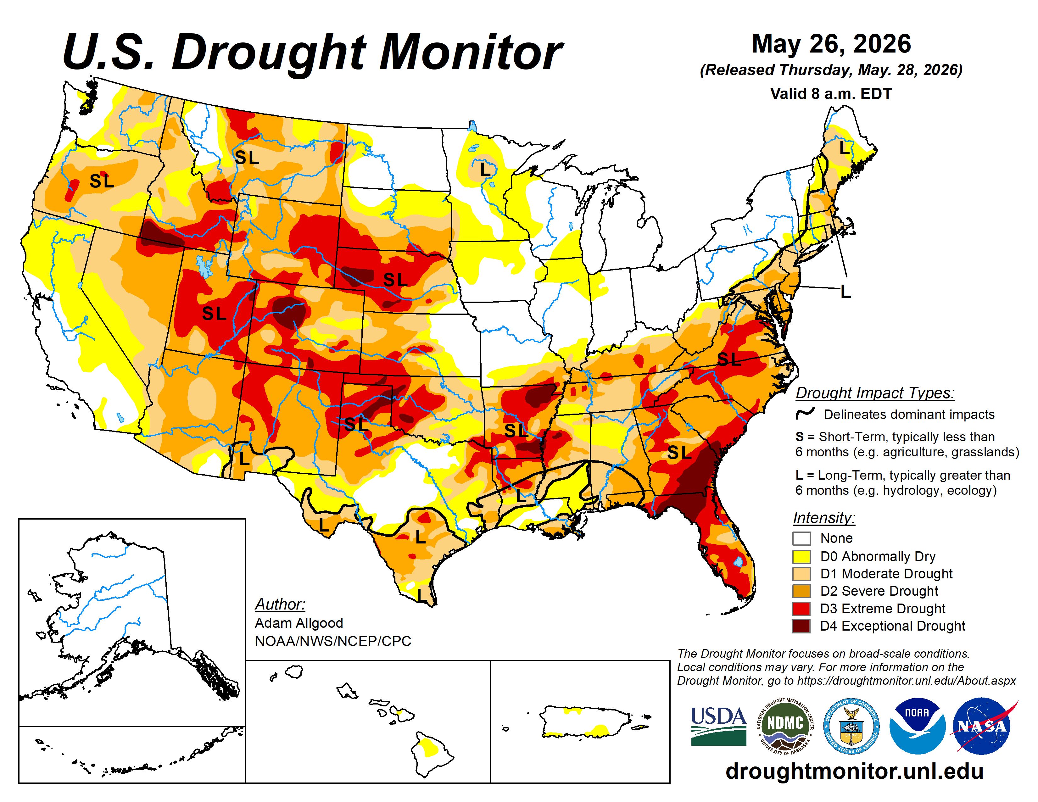
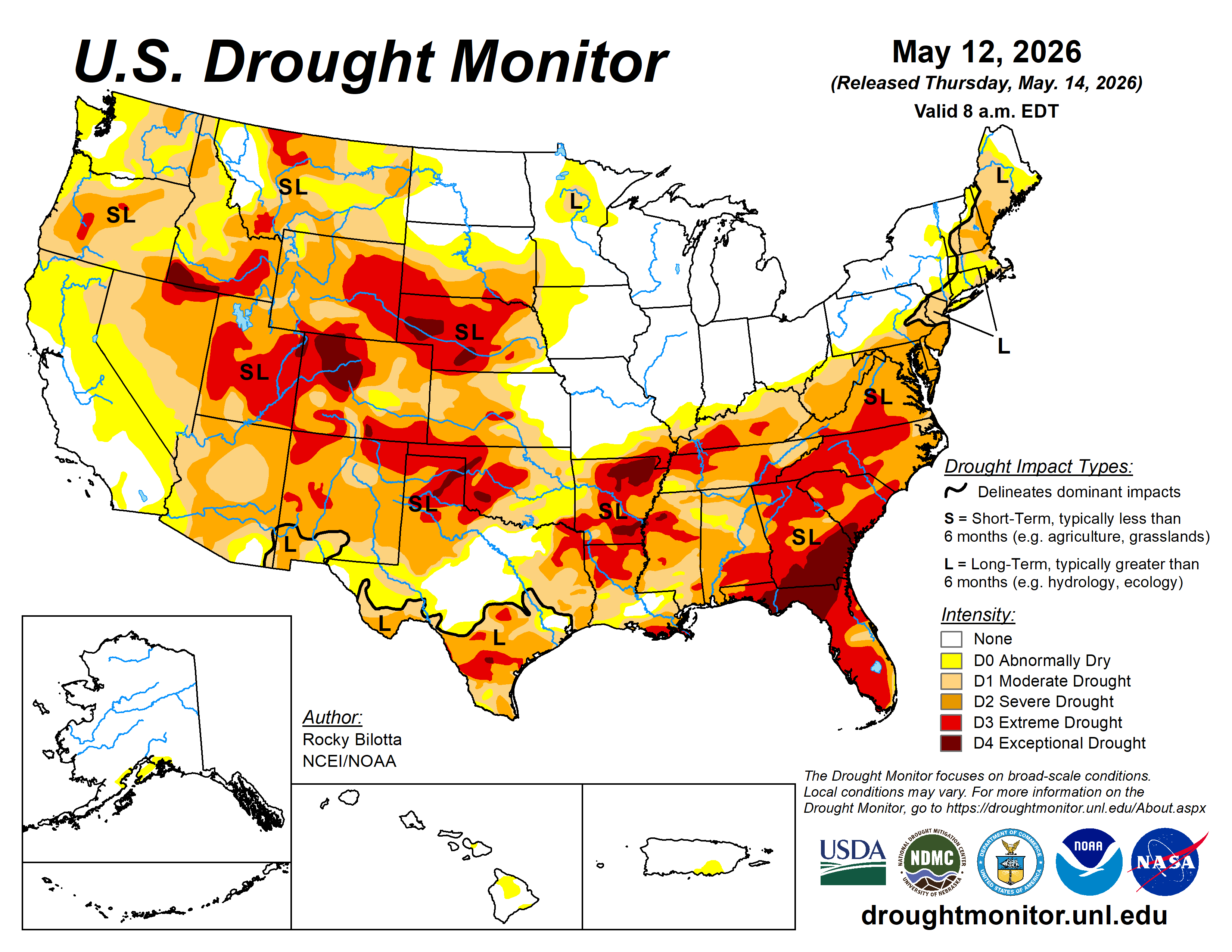
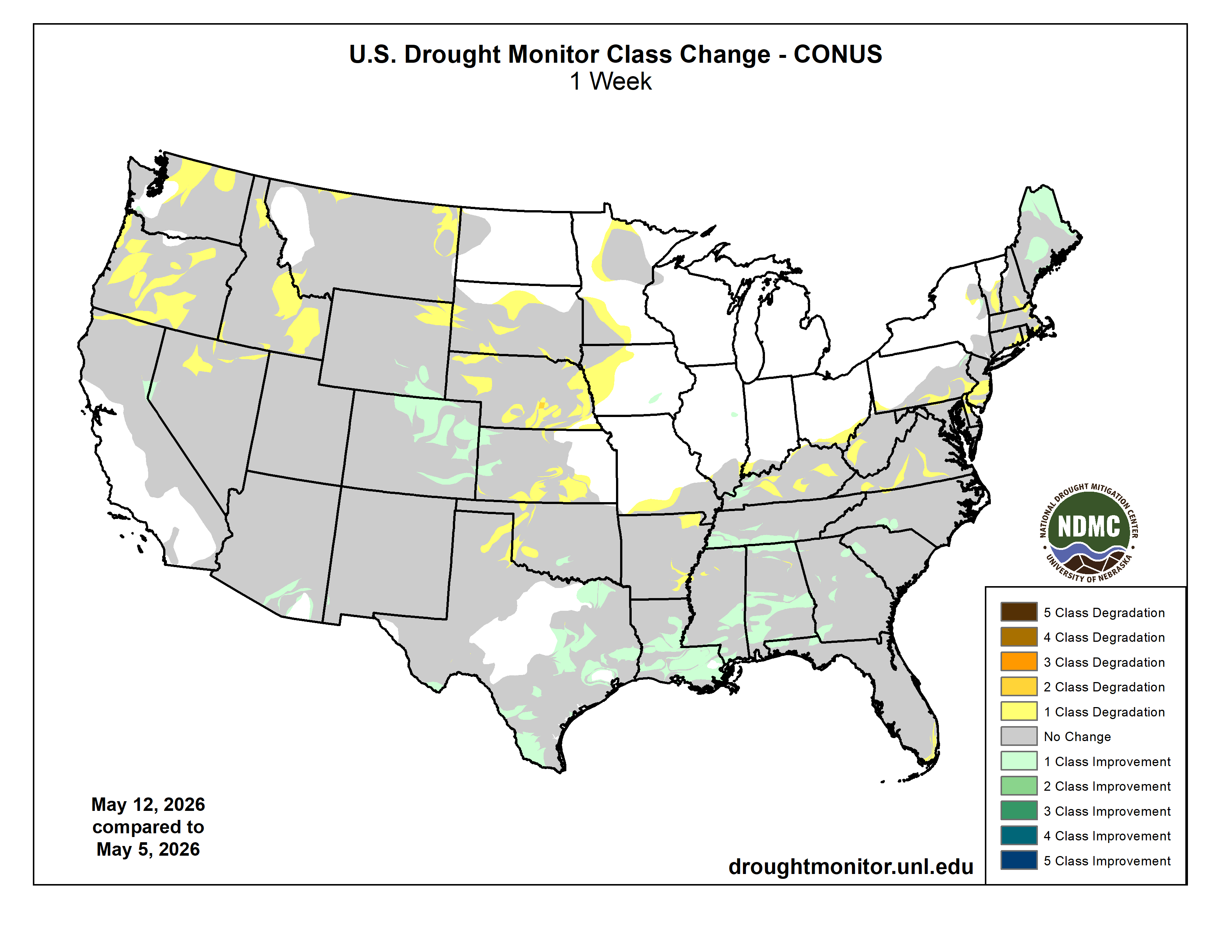
During the week, a highly variable weather pattern brought wide temperature swings to much of the contiguous United States. An unusually cold airmass that had settled over the Plains at the start of the week pushed eastward, bringing a rapid and stormy end to the early season heat wave across the Eastern Seaboard. In contrast, the West baked under much above normal temperatures. By mid-week, much above-normal temperatures had returned to the Plains, with daily maximum temperatures climbing into the upper 90s in some locations. As temperatures began to rebound across the East, cooler air overspread the Pacific states by the end of the week.
The strong temperature gradients that set up across the Nation, coupled with ample Gulf moisture streaming northward resulted in widespread heavy and persistent precipitation, with many locations exceeding two inches from eastern Texas and Oklahoma northeastward to the mid-Atlantic states, and isolated instances of 6 or more inches in some spots. Widespread rainfall, albeit with lighter accumulations, fell across the north-central Plains as daily temperatures warmed, but mostly dry weather prevailed across the upper Mississippi Valley and western Corn Belt. West of the Rockies, mostly dry weather prevailed for most of the week, but showers associated with a strong cold front overspread the Northwest at the very end of the period…
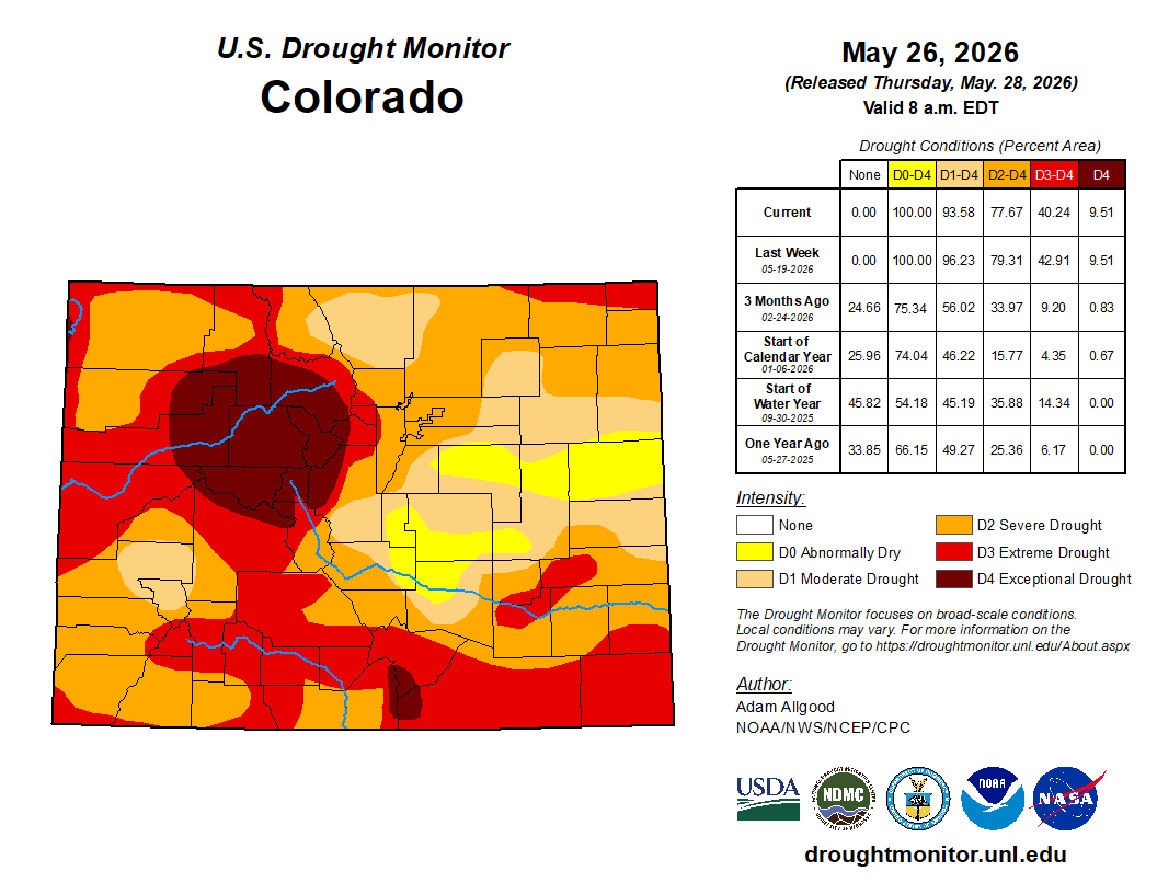
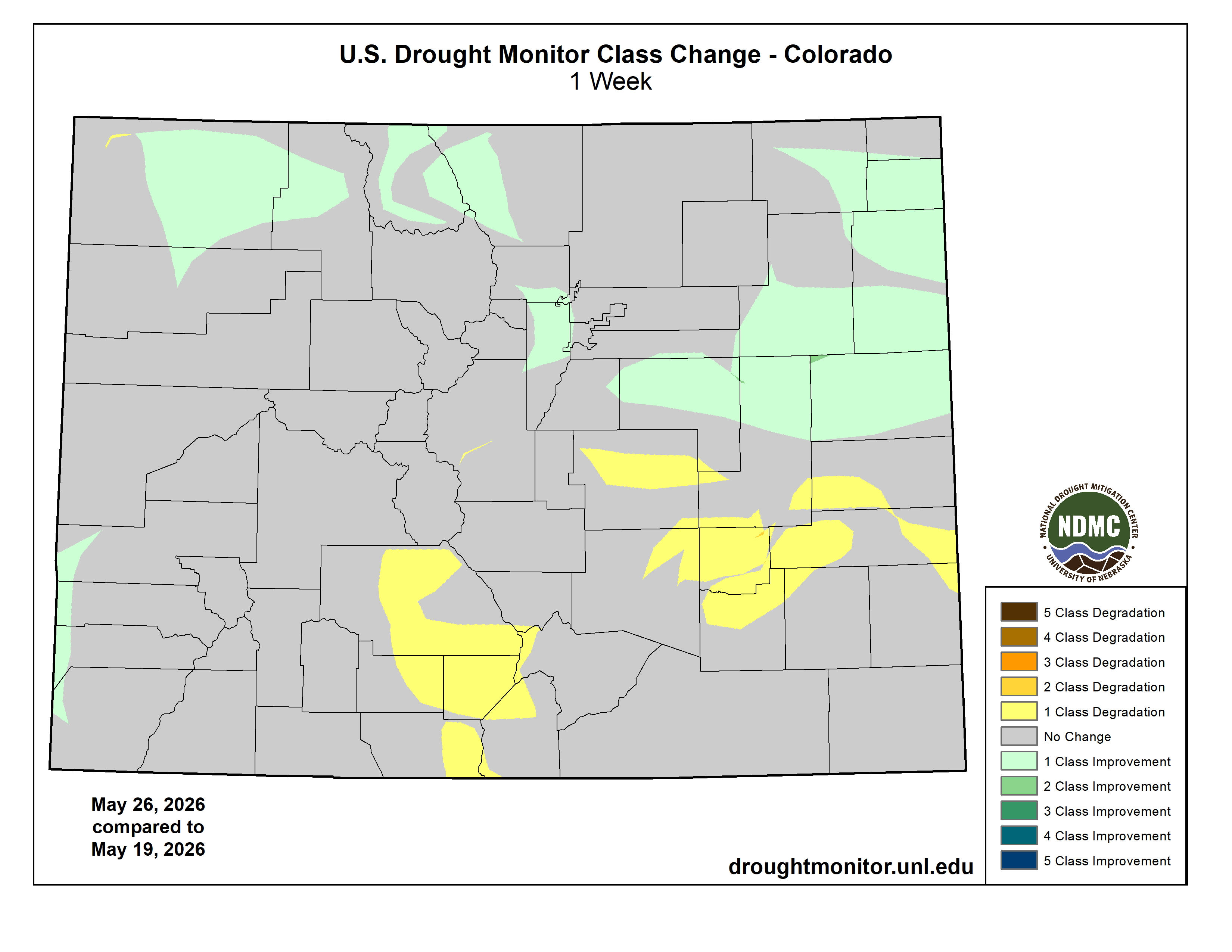
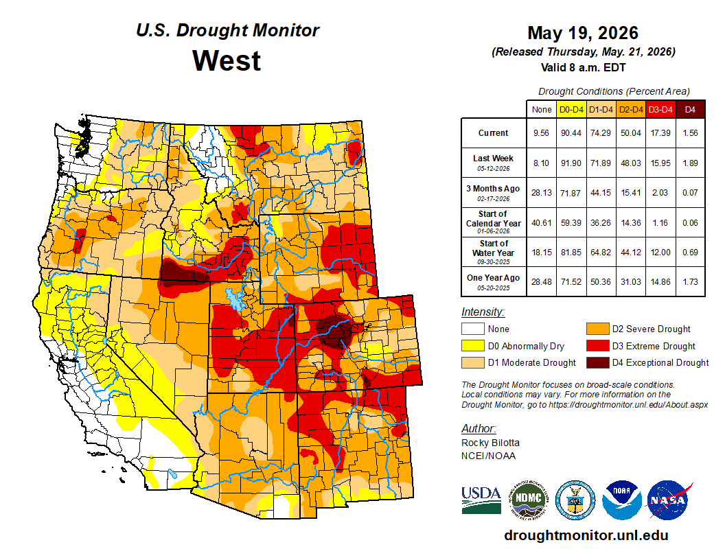
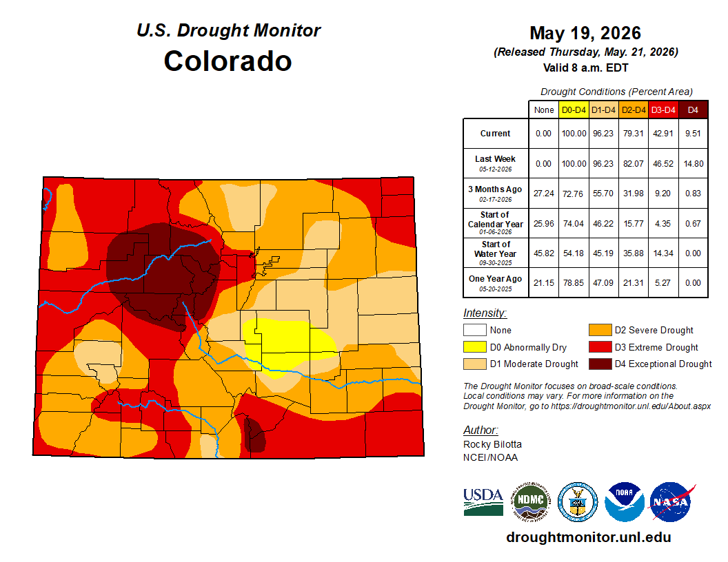
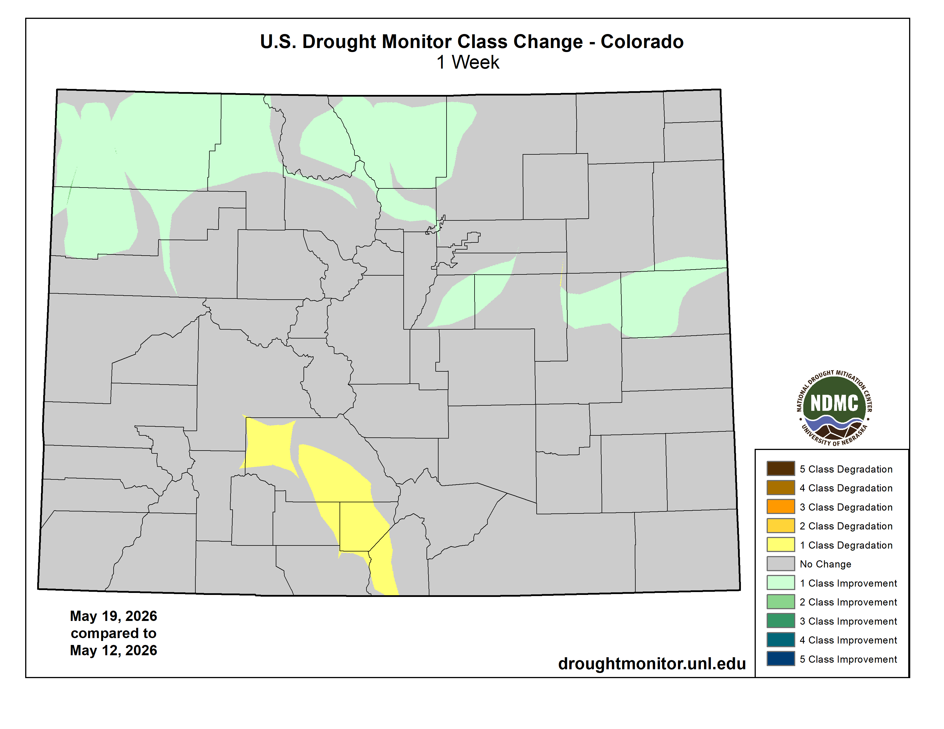
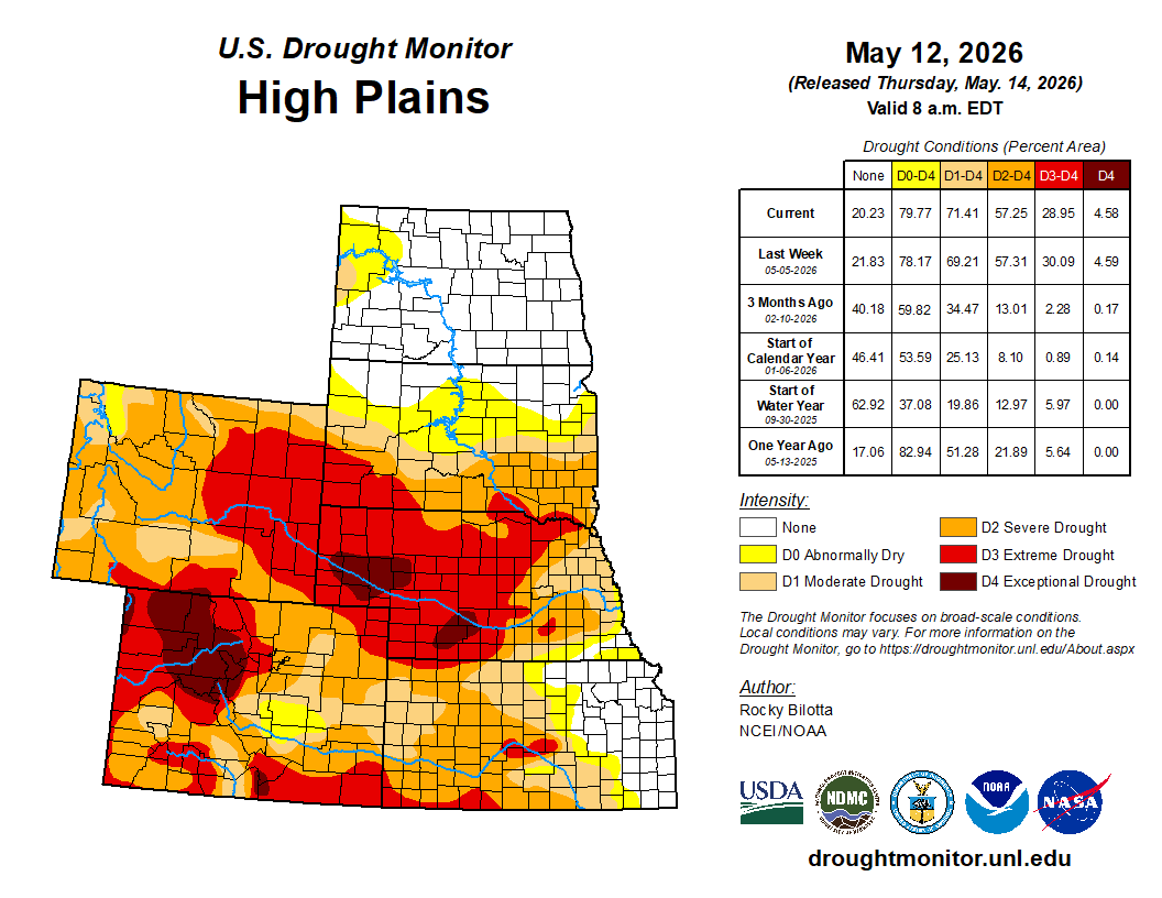
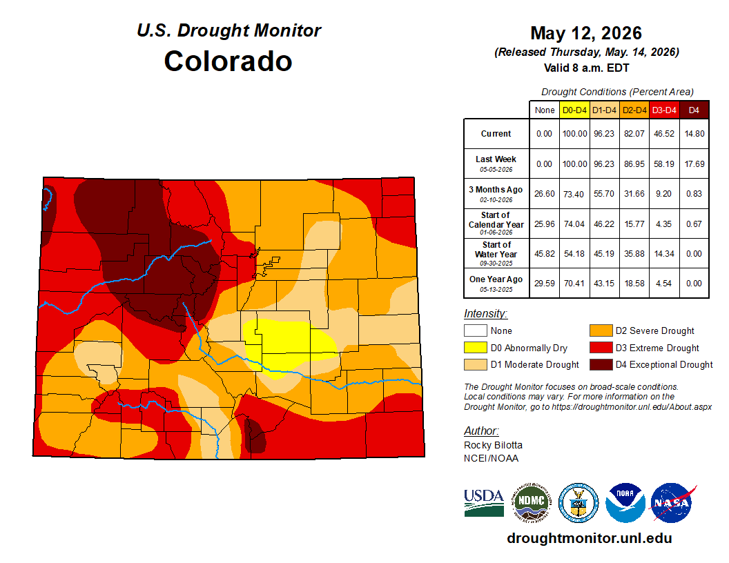
As below-normal temperatures transitioned back to a hot pattern across the High Plains, widespread precipitation moved through the region. Areas of convection brought up to 2 inches of rain to portions of eastern Nebraska and eastern Colorado, while amounts were generally an inch or less elsewhere. This precipitation was sufficient to bring some drought reduction across northern and northeastern Colorado, but drier conditions across southeastern Colorado and Kansas, coupled with hot temperatures, resulted in degradation. A sharp cutoff in precipitation was also noted across the far western Dakotas, where small areas of degradation were noted along the borders with Wyoming and Montana…
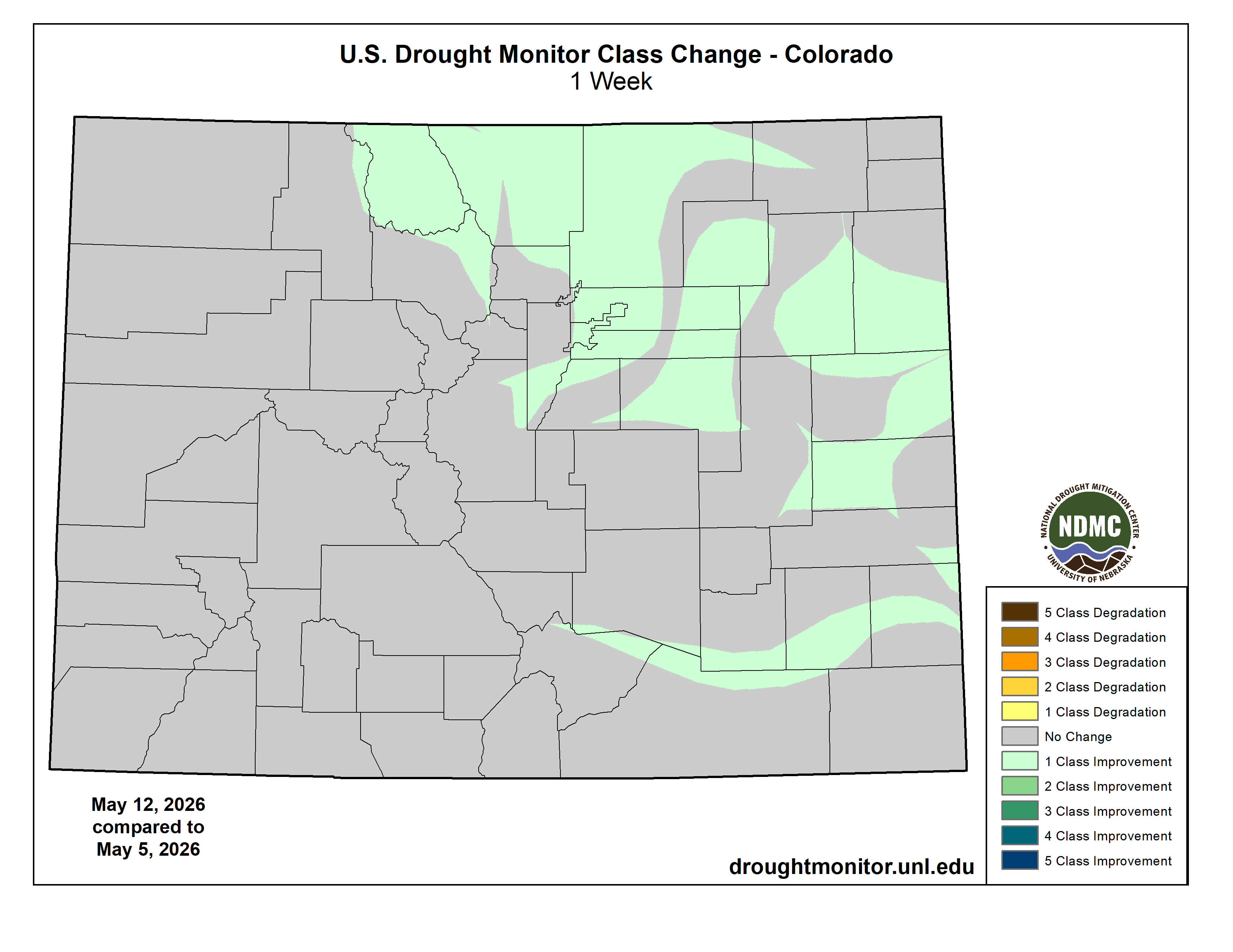
Colorado Drought Monitor one week change map ending May 26, 2026.
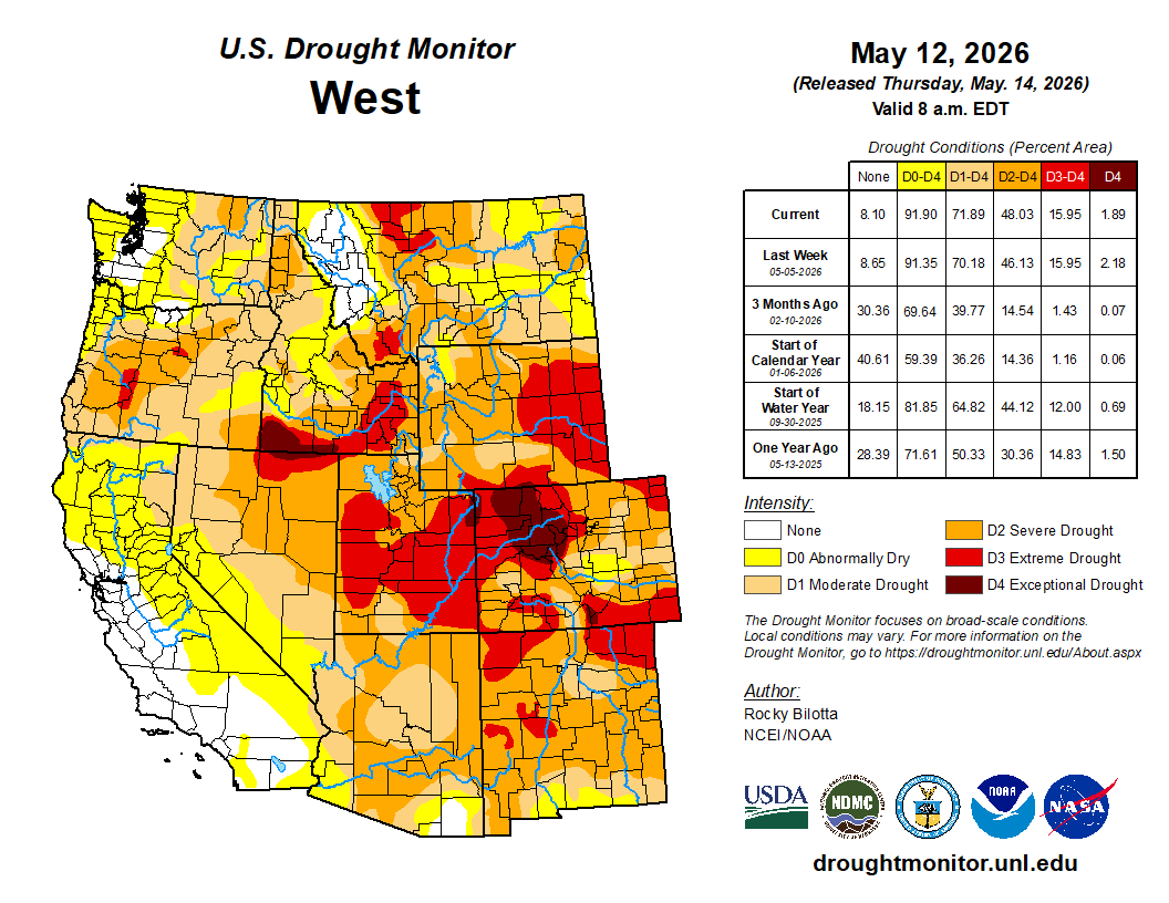
Mostly dry weather and above-normal temperatures dominated the Western Region during the week sparking some small-scale degradation across Montana, Idaho, and New Mexico, where the effects of the meager winter snow cover are beginning to be felt in falling streamflow values. Status quo was maintained west of the Rockies for the most part, as reservoir conditions remain good across California during a climatologically dry time of year. At the end of the week, a strong cold front brought abnormal moisture to the Northwest and northern Rockies. While not sufficient to substantively alter the drought depiction, a modest reduction in abnormal dryness was noted in far northwestern Washington…
Widespread heavy rainfall overspread the Southern Region, with amounts increasing from west to east. Accumulations of 2 to locally more than 5 inches fell across most of Tennessee, engendering widespread drought reduction. Rainfall was locally heavy but a bit spottier across Louisiana and Arkansas, which also saw widespread drought reduction but with less coverage. Across Texas, heavy rainfall across the eastern half of the state yielded drought improvements and also localized flooding. Across North Texas, localized convection brought relief to some areas, but hot conditions resulted in degradation where precipitation did not occur…
Looking Ahead
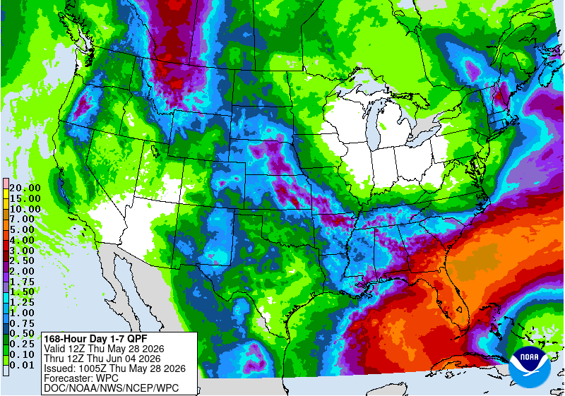
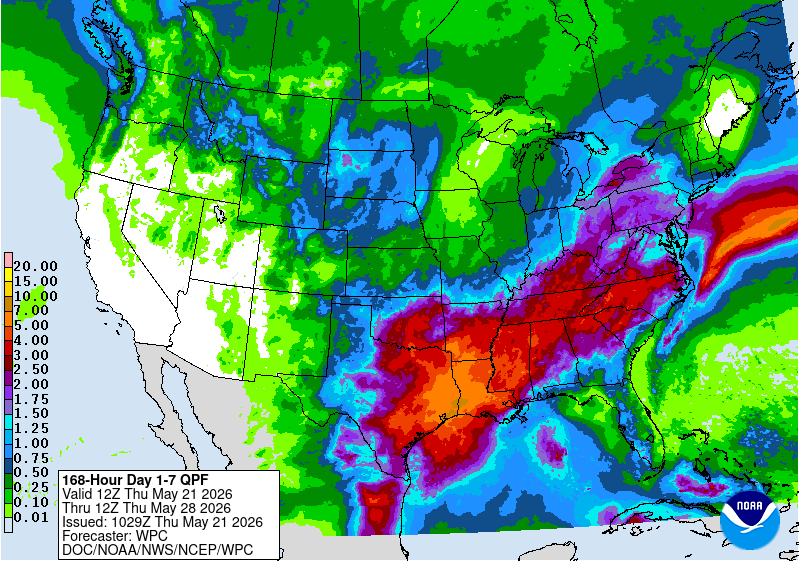
During the upcoming week, a late season storm system across the West is forecast to bring abnormal moisture to California, Oregon, and Washington, with precipitation spreading eastward to the northern Rockies by mid-week. The heaviest accumulations are forecast across the southern Cascades. Periods of convection are favored across the Plains states throughout the week, with the WPC 7-day quantitative precipitation outlook showing a potential for 1 inch or locally more across portions of Nebraska and Kansas, where Gulf moisture advection is most pronounced. Across the eastern third of the CONUS, unsettled weather is favored to continue across the Southeast, with the focus of heaviest precipitation shifting towards Florida and the south Atlantic coastal plain. A slow moving cold front is forecast to push east during the period, maintaining showery weather across the Deep South while cooler and drier conditions overspread the Corn Belt and Northeast.
During Week-2, the trough over the East is favored to rapidly de-amplify, with temperatures quickly moderating. Above-normal temperatures are favored across the West and northern tier of the CONUS on the latest CPC 8-14 day outlook, with mostly near-normal temperatures the most likely outcome across the South and Southeast regions. Unsettled weather and continued precipitation may play a role in keeping hot weather at bay across the southern tier. The CPC 8-14 day precipitation outlook favors above-normal precipitation across the Four Corners states eastward along the southern tier to the Atlantic coastline as far north as Virginia. Near normal precipitation is favored elsewhere, except for a small wet signal over the Pacific Northwest. Above-normal precipitation is favored for eastern Alaska, while above-normal temperatures and above-normal precipitation are both favored for Hawaii.
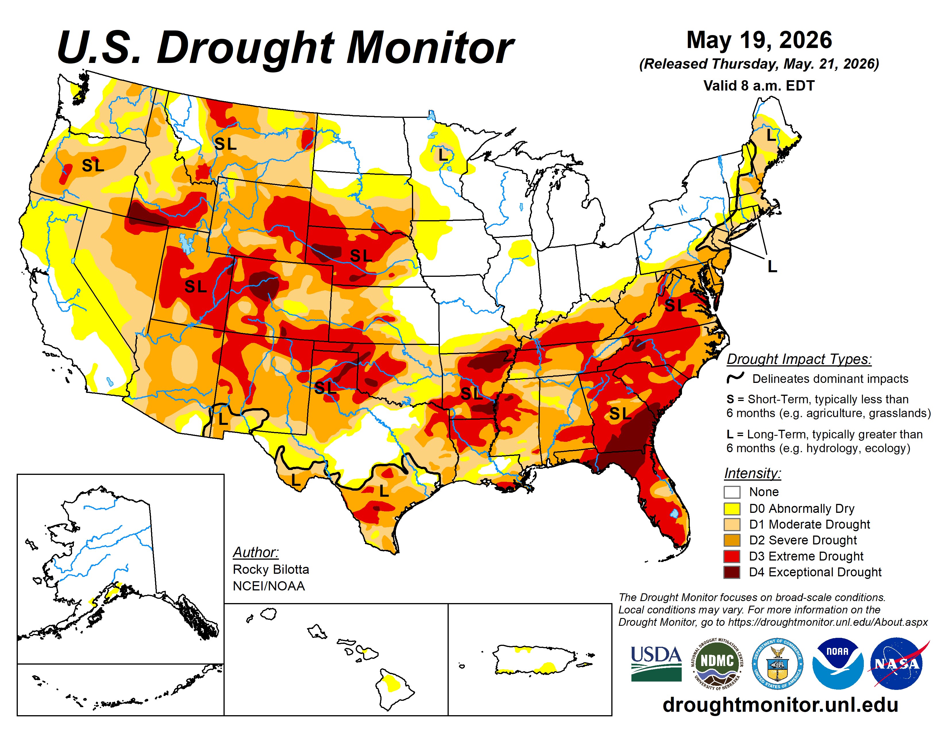
US Drought Monitor one week change map ending May 26, 2026.
Click the link to read the article on the Big Pivots website (Allen Best):
May 26, 2026
Dissonance exists between life-close-to-normal policies regarding urban water use and the growing crisis on the river
Casually surveying the urban landscapes in much of Colorado’s Front Range, you’d never know that the Colorado River — the source for roughly half the water of the cities — has deteriorated to its most pitiful shape of perhaps the last century.
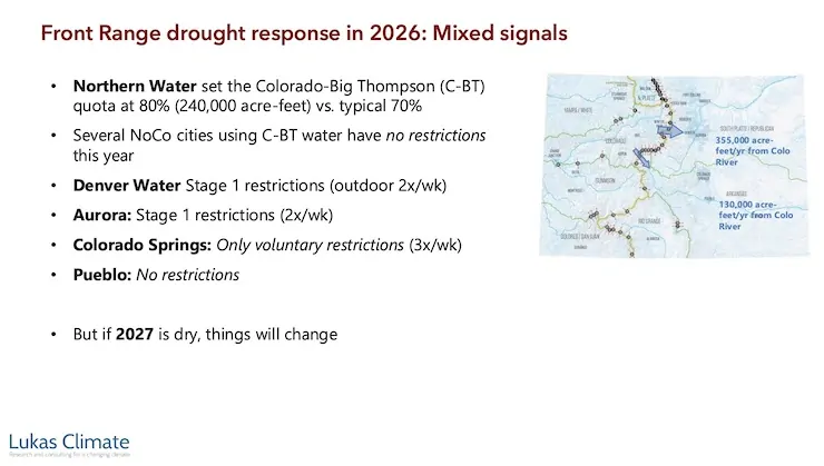
Oh, yes, some utilities — notably Denver Water and Aurora Water, which together serve 1.9 million residents — have imposed rigorous stage-one drought watering restrictions. Outdoor irrigation is allowed twice per week and never during the heat of day. Other water utilities that tap Colorado River water, however, have asked only for voluntary cutbacks, if any at all.
Jeff Lukas via the Western Water Assessment.
Jeff Lukas, a water consultant with several decades invested in climate change work, says this seeming aloofness of some cities will not persist indefinitely. That is certainly true if the record heat and abnormal dryness of the past winter continues into 2027. They may have no choice.
“I think Front Range cities will be asked, whether nicely or not, to reduce their Colorado River diversions,” said Lukas in a May 11 webinar. “The mechanism for that is unclear, but I think it’s going to happen.”
Water rights of the Front Range cities — and many of those on the Western Slope, too — are junior to the Colorado River Compact. It was negotiated in 1922, making diversions more recent than that junior.
Problems in the basin were becoming apparent in the 1990s. The warming climate in this century has provoked changes. By all accounts, they have not been enough.
Lukas, as a dendrochronologist at the Institute of Alpine and Arctic Research in Boulder 20 years ago, was teasing out evidence from tree rings to understand the climates of the Colorado River Basin during the last 1,200 years.
Later, as a scientist with the Western Water Assessment, Lukas co-authored (with Liz Peyton) a 2020 report called Colorado River Basin Climate and Hydrology: State of the Science. That 500-page report integrated more than 800peer-reviewed studies to help water managers understand physical processes, climate risks, and forecasting tools across the basin.
In 2024, with the state climatologist, Russ Schumacher, and several others, Lukas turned out the 100-page volume called “Climate Change in Colorado.”
Based in Lafayette, Lukas now works as a consultant. At Lukas Climate Research and Consulting, he specializes in the overlapping areas of climate hazards, water resources, and ecosystems.
Lukas, in a presentation he titled “Running dry on the Colorado River: The roots of the crisis & its implications for the Front Range,” explained the big picture and Colorado’s Front Range part in it.
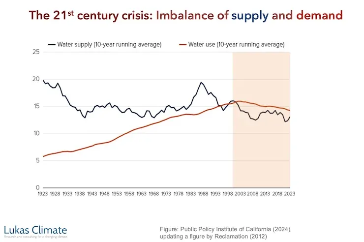
Defined by the Continental Divide, Colorado has an inverse relationship between its eastern and western slopes. About 90% of the state’s residents live to the east, nearly all at the foot of the Rocky Mountains, whereas 80% of the state’s precipitation originates on the west side, in the headwaters of the Colorado River and its tributaries.
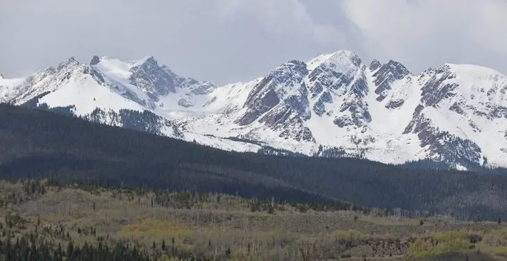
Snow from the Gore Range and other “islands” of precipitation in Colorado provide 50% to 60% of the water in the Colorado River. Photo credit: Allen Best/Big Pivots
Colorado itself provides 50% to 60% of the water in the entire Colorado River, depending upon the year. This year has been a terrible year everywhere in the basin, Colorado included.
Lukas explained that “islands of moisture” provide nearly all the water in this 244,000-square-mile basin. The high mountains constitute these islands. Some places deliver more than others. Buffalo Pass, near Steamboat, famously has had prodigious volumes of snow. This snow, when melted, can produce 50 inches of water.
It takes 20 inches or more of precipitation in these mountain islands to produce meaningful runoff. Even then, it doesn’t all end up in the Colorado River. In Colorado and the three upper-basin states, he said, 16% of the rain and snow that falls becomes water in the Colorado River. In the hotter lower basin, the figure is 3%.
“The atmosphere takes back most of what it giveth, even in the wetter upper basin,” he said.
Evaporation and transpiration are the pickpockets of this water. Heat produces evaporation, and we’ve had plenty of that this year.
Temperatures during November through April were the warmest on record in Colorado for that span of months. March heat was exceptional. This produced runoff in the rivers that in most cases may surpass that of May or June, the traditional times for peak runoff. Peak runoff has been trending earlier by several weeks during the last few decades, but this was a leap of about two months.
Runoff for April through July — a time that normally accounts for 70% to 80% of annual streamflows — this year will likely deliver no better than 20% to 40%. In its May report, the Bureau of Reclamation said April flows into Lake Powell were 40% of the average during the last 30 years and it expects flows in May to sink to 9% of that average.
Can it get any worse? Count on it, said Lukas.
“We should expect not every year to look like 2026 from here on out, but more years in the future will look like 2026. And somewhere down the pipe, not as far in the future as we would like, there will be a year worse than 2026 for the Colorado River.”
Members of the Colorado River Commission, in Santa Fe in 1922, after signing the Colorado River Compact. From left, W. S. Norviel (Arizona), Delph E. Carpenter (Colorado), Herbert Hoover (Secretary of Commerce and Chairman of Commission), R. E. Caldwell (Utah), Clarence C. Stetson (Executive Secretary of Commission), Stephen B. Davis, Jr. (New Mexico), Frank C. Emerson (Wyoming), W. F. McClure (California), and James G. Scrugham (Nevada) CREDIT: COLORADO STATE UNIVERSITY WATER RESOURCES ARCHIVE via Aspen Journalism
This is so very different from what was assumed by the delegates from the seven basin states who gathered in 1922 in Santa Fe to apportion the Colorado River.
The role of reservoirs
Taking the big, long-term view, Lukas pointed out that the overall story of the Colorado River is one of modifications needed to suit human uses. “It’s all about smoothing out the natural variability in the availability of water over space and over time.”
Reservoirs are the primary means by which humans have been able to “smooth out the natural variability.”
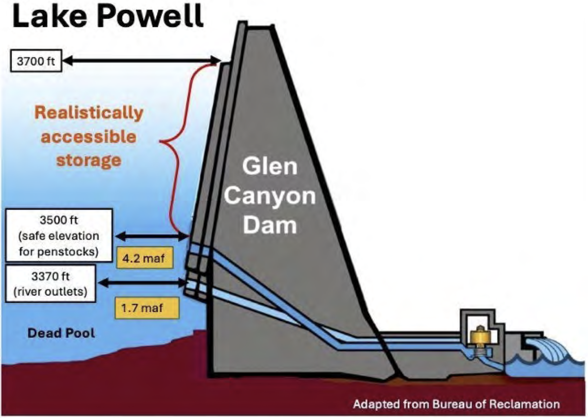
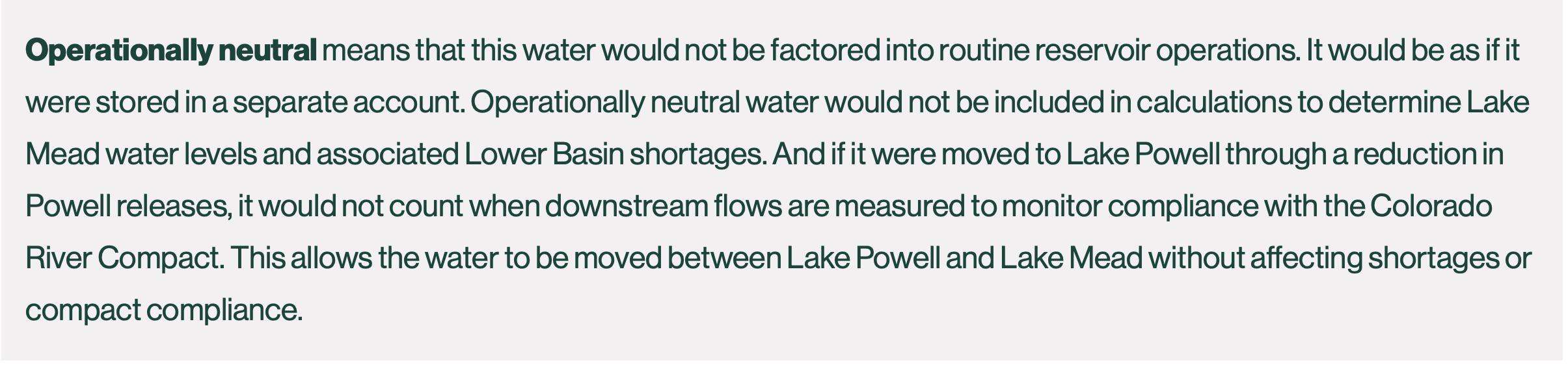
The Colorado River Basin has 60 million acre-feet of storage. That’s four times the annual flow. Five-sixths of the storage capacity is found in the desert in two vessels: lakes Mead and Powell. The headwaters have many reservoirs but they are relatively small. The total storage capacity is 2,000 times more than the volume of Dillon Reservoir.
Illustration from the report, “Antique Plumbing & Leadership Postponed” from the Utah Rivers Council, Glen Canyon Institute and the Great Basin Water Network. Courtesy of Utah Rivers Council
Since 2000, stored water in those two big buckets, Mead and Powell, has declined from 49 million acre-feet to 16 million acre-feet as of May. Of that, 9 million lies at elevations below the lowest outlets. These are called dead pools.
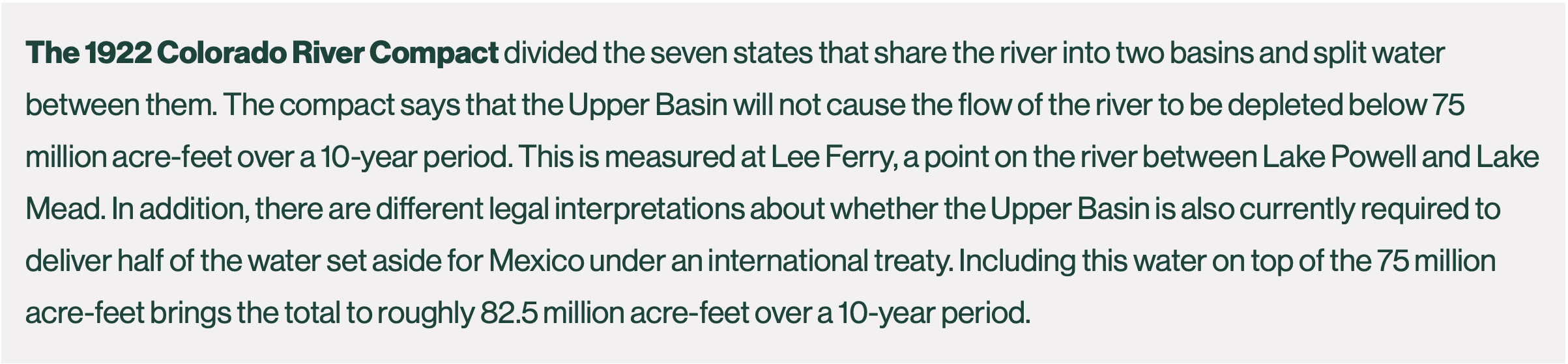
Those delegates in 1922 who crafted the Colorado River Compact, the legal document that provided the basis for nearly all these dams and aqueducts subsequently built, assumed annual flows of 17 million to 18 million acre-feet. They were overly optimistic. The 20th century average was 15.2 million acre-feet.
Now comes the 21st century, and the average at Lee Ferry has dipped to 12.2 million acre-feet. This has implications for the Front Range cities but also farms. If Colorado must reduce its diversions to accord with the compact, those rights dated before 1922 will be exempt from reductions. The giant transmountain diversions have come more recently, as have many of the diversions for towns and cities on the Western Slope.
Accumulating evidence fingers human-caused climate change with large amounts of responsibility for declined flows. Lukas said his rule of thumb is that the role of greenhouse gases overall are responsible for two-thirds of lower flows.
Colorado statewide annual temperature anomaly (°F) with respect to the 1901-2000 average. Graphic credit: Colorado Climate Center
As for the mechanics of this shift, rising heat is one important “knob,” said Lukas. As the atmosphere warms, it reduces “runoff efficiency” even more, sending water into the atmosphere instead of into streams and then rivers. Accumulating evidence fingers human-caused climate change with responsibility for most and possibly all of increased temperatures.
Precipitation has declined about 5% since 2000, with a larger reduction in spring, an important time of year to get moisture. Here, the link to the warming climate is less clear. “It seems increasingly likely that climate change is changing the dynamics of storm tracks and the persistence of, say, high-pressure systems over the interior West,” said Lukas. “That is, at least in part, responsible for why we’ve had less precipitation since 2000.”
The Colorado River, though, had problems even before the warming climate began throwing sharp elbows in water volumes. The reservoirs of the Colorado River Basin were 92% full in 1999, a wet decade overall. Even then, however, the Colorado River had ceased to reach the Pacific Ocean. There were too many straws inserted.
Less than 12% of the river’s flow goes to urbanized and industrial uses. Lukas pointed out that cities have become more efficient in their use of water. The rule of thumb for Denver and other Western cities is that one acre-feet of water meets the needs of a three households on an annual basis. That compares with two households a few decades ago.
Mining of fossil fuels and minerals uses a small amount. Evaporation from reservoirs and rivers and other “system losses” accounts for about 15%.
That takes us to agriculture. It uses 75% of the river’s water in the Colorado River for irrigation on 5 million acres. Some of that land lies outside the basin itself. That includes the South Platte and Arkansas River valleys of eastern Colorado.
Over half of that water — about 9 million acre-feet — gets used to grow feed for livestock, mainly alfalfa and pasture grass.
Might cities want to cut deals with farmers to “share” the water? This discussion has been underway for at least 15 to 20 years. Some pilot projects in Colorado and elsewhere have been launched to see what this might look like. A strong proponent has been James Eklund, a water attorney in Denver. Others question how this is done and, for that matter, whether we want to do it. But certainly, water for urban uses has higher monetary value than growing hay to feed cattle.
Why the restraint of cities?
As for the Front Range cities, the big question is whether they are planning for a river that produces even less than it does now.
In 2024, Andy Mueller, the general manager of the Colorado River Water Conservation District, suggested the need to start planning for a river that may deliver less than 10 million acre-feet in coming decades. Some thought then that the state engineer, Jason Ullman, needed to start sorting through this matter of junior vs. senior rights. Jim Lochhead, a former water attorney on the Western Slope and later CEO of Denver Water, pushed back, saying it was premature given the huge amount of work that would be required. See: “Heading for the Colorado River Cliff,” Big Pivots, Oct. 20, 2024.
At the Zoom session on May 11, I asked Lukas about the modest watering restrictions by Front Range water providers. He had previously described mixed signals from the water utilities. If 2027 is dry again, expect more uniformity around drought restrictions. “But it’s pretty weird right now,” he said.
With the attention to the Colorado River in the news media, it seemed like a perfect opportunity for the water utilities to mount more aggressive campaigns. Any idea why they had not, I wondered.
The utilities, he said, are reluctant to deliver regulations that produce discomfort around outdoor water-use restrictions. They don’t want to do this unless absolutely necessary.
Part of this is because of experiences during the covid epidemic. A lesson to public servants during that time made them more reluctant to push the public to do things they don’t want to do. “You only want to exercise that authority, that public legal authority, sparingly and only when it’s clear that is what is really necessary.”
Revenue was another consideration. Water infrastructure is expensive, and the money to pay for it comes from charges for water use. By imposing limits, you reduce revenue and hence must charge more for water. The conundrum is that reducing use doesn’t necessarily mean you pay less. In some cases, less water may require more infrastructure. This is a hard message to convey.
“What you’re seeing is a dissonance between the circumstances and what’s happening, at least this year,” he said.
Or at least right now. We have had rainy weather in May. Some meteorologists think we may end up with healthy rainfall this summer. If instead the summer is like the winter, very hot and dry, I expect the utilities might pick up their game.
This USGS map shows the number of PFAS detected in tap water samples from select sites across the nation. The findings are based on a USGS study of samples taken between 2016 and 2021 from private and public supplies at 716 locations. The map does not represent the only locations in the U.S. with PFAS. Sources/Usage: Public Domain. Visit Media to see details.
EPA aims to end federal regulation of four PFAS in drinking water and give utilities more time to comply with existing rules.
FEMA reopens applications for a climate-resilient infrastructure grant program that the agency had cancelled.
Bureau of Reclamation announces $52 million for three new Hoover Dam turbines that will generate hydropower at lower Lake Mead levels.
A House FY27 budget bill will cut the federal government’s primary water infrastructure funds by 24 percent.
NOAA forecasts fewer Atlantic hurricanes this season.
EPA water office leader commits to investigate groundwater pollution in Georgia from Meta data center construction.
The Trump administration recommends that the U.S. Supreme Court take up Nebraska’s claim that Colorado has violated a river-sharing compact.
And lastly, the Bureau of Reclamation’s acting commissioner informs a House subcommittee about the status of Colorado River negotiations.
“Several weeks ago, I met with the 14 senators from the Colorado River basin and on a bipartisan basis, several of them said, ‘Look, we have a real crisis on the Colorado and we need to get things done and if there are any environmental statutes that are slowing things down, tell us what they are and maybe we can legislate to clear out some of the unhelpful bureaucratic paperwork.’” – Scott Cameron, acting Bureau of Reclamation commissioner, speaking at a House Natural Resources subcommittee hearing. Cameron said his office has not yet followed up on the offer but “looked forward” to conferring with the senators about “waiving or streamlining certain environmental statutes on the Colorado.”
Udall/Overpeck 4-panel Figure Colorado River temperature/precipitation/natural flows with trend. Lake Mead and Lake Powell storage. Updated through Water Year 2025. Note the tiny points on the annual data so that you can flyspeck the individual years. Credit: Brad Udall
As for the status of Colorado River negotiations, Cameron said, “Frankly, the seven states are not in a position where they could agree today, right now, to a four-year deal, let alone a 20-year deal, because of the uncertainties we’re dealing with.”
By the Numbers
$1 Billion: Funding now available from FEMA’s Building Resilient Infrastructure and Communities program, a grant opportunity to reduce risk from climate and weather hazards. A federal judge ordered the agency to reinstate the program, which the Trump administration had cancelled. Applications are due July 23.
$52 Million: Funding announced by the Bureau of Reclamation for three new low-head turbines at Hoover Dam. Only five of the dam’s 17 turbines are designed to operate when Lake Mead drops below elevation 1,035 feet, a threshold that the shrinking reservoir is fast approaching and could breach in the next 12 months, if not sooner.
Not So PFAS The EPA is proposing to repeal federal regulation of four PFAS in drinking water, partially undoing a Biden-era rule that set first-ever limits on six of the “forever chemicals.”
Three of the chemicals – PFHxS, PFNA, and Gen X – were regulated individually. Together with PFBS, they were also regulated as a mixture.
The EPA will retain standards for PFOA and PFOS, the two most-studied of the chemicals. However, in a separate rule-making, the agency is proposing to give water utilities more time to comply, extending the deadline by two years, until 2031. The agency says the move will “ease the implementation burden” financially and administratively for water systems and might allow for cheaper treatment technologies to come to market.
Water utilities must apply for an extension. One of the considerations is whether an extension would pose an “unreasonable risk to health.” The EPA is proposing that PFOA and PFOS levels below 12 parts per trillion would not be unreasonable. (The federal standard for both is 4 ppt.)
The EPA wants public comment on whether interim utility actions during a compliance extension – point-of-use treatment, filtration pitchers, education, alternative water sources – can mitigate health risks above 12 ppt.
Water Infrastructure Funding Cuts A House spending bill cuts the two main federal sources of water infrastructure funding by about 24 percent in fiscal year 2027. The bill passed out of subcommittee last week.
The bill provides $1.2 billion for the Clean Water State Revolving Fund (27 percent cut) and $911 million for the Drinking Water State Revolving Fund (19 percent cut).
Following a recent trend, about half of the appropriation comes in the form of earmarks. This money will go directly to specific projects and will not enter the revolving fund. Water industry advocates argue that continuing to take earmarks out of the revolving fund appropriation threatens the viability of the program.
Studies and Reports
The South Platte River Basin is shaded in yellow. Source: Tom Cech, One World One Water Center, Metropolitan State University of Denver.
Great Plains Water Fight The federal government’s top lawyer recommended that the U.S. Supreme Court take up one of Nebraska’s claims that Colorado is violating the South Platte River Compact, which divides the river’s water between the two states.
Nebraska argues that Colorado is breaking three articles of the compact. The U.S. solicitor general says that the high court, through a special master, should pursue only one of them: that Colorado is allowing irrigators to take too much water.
“A claim that one State has deprived another of water to which it is entitled under an interstate compact is a quintessential case for this Court’s original jurisdiction,” the brief states.
Atlantic Hurricanes NOAA is forecasting a less active Atlantic hurricane season. The agency estimates that one to three major hurricanes (Category 3 or higher) will form.
The category ratings can be misleading. They measure wind speed, not precipitation. Tropical storms and minor hurricanes can still inflict serious flood damage.
Air Conditioning Estimates The U.S. Census Bureau published data estimating how many homes use air conditioning.
States with the lowest air conditioning use are in New England and the West.
On the Radar
EPA on Data Centers and Household Wells Under oath at a House subcommittee oversight hearing, Jessica Kramer, head of the EPA Office of Water, committed to investigate impacts to drinking water quality from data center construction.
“Whatever type of construction it is, it’s a priority to ensure that water quality standards established by EPA are being met. So we’ll be looking into that certainly,” Kramer said.
Kramer’s commitment at the House Energy and Commerce hearing was prompted by Rep. Alexandria Ocasio-Cortez (D-NY) who asked about water pollution from data center construction.
Ocasio-Cortez visited Morgan County, Georgia, a few weeks ago. She returned with jars of brown water from household wells near the construction site of a Meta data center. She displayed those at the hearing.
“This is what the drinking water now looks like, next to that data center,” Ocasio-Cortez said.
“As soon as I get back to the office, I will be looking into exactly what you just talked about,” Kramer replied.
Army Corps Deauthorized Projects The Army Corps published a list of water projects that it intends to deauthorize.
These are projects that were authorized years ago but either haven’t ever received funding or haven’t recently received funding.
Public comment on the proposal runs through August 19. Submit comments at http://www.regulations.gov using docket number COE-2026-0034.
Federal Water Tap is a weekly digest spotting trends in U.S. government water policy. To get more water news, follow Circle of Blue on Twitter and sign up for our newsletter.
View of Shoshone Hydroelectric Plant construction in Glenwood Canyon (Garfield County) Colorado; shows the Colorado River, the dam, sheds, a footbridge, and the workmen’s camp. Creator: McClure, Louis Charles, 1867-1957. Credit: Denver Public Library Digital Collections
Click the link to read the article on The Denver Post website (Elise Schmelzer). Here’s an excerpt:
May 22, 2026
For more than a year, the U.S. Bureau of Reclamation has withheld $40 million awarded to the Colorado River District for the purchase of the water rights attached to Xcel Energy’s aging Shoshone Power Plant in Glenwood Canyon. The release of the federal funding brings the total amount secured for the purchase to $97 million — just shy of the $99 million needed for the project. For years, the river district — a taxpayer-funded agency based in Glenwood Springs that works to protect Western Slope water — has worked to purchase the rights from the utility. Its leaders want to ensure that, even in dry years, the billions of gallons of water the rights command continue to flow west through the canyon and to the communities, wildlife habitats and farms downstream. The district and other Western Slope entities feared the certainty of the flows would be threatened if another purchaser — like a Front Range utility — were able to snag the rights first. The purchase is a “once-in-a-generation” investment in securing Western Slope water supplies, said Andy Mueller, the general manager of the Colorado River District, in a news release Friday. The federal dollars will add to the $20 million contributed by the Colorado Water Conservation Board and the $37 million raised by the district from Western Slope governments, organizations and irrigators.
“This award is a major breakthrough in our coalition’s effort to permanently secure historic flows on the Colorado River,” he said…
The federal funding brings the Shoshone water rights deal — originally inked in 2023 — one step closer to completion. Xcel Energy still needs approval for the sale from Colorado’s public utility regulators, and the river district m
The cover of a new book I’ve just published, Storm in My Head, a collection of poetry written over the 60 years I’ve been living in the headwaters of the Colorado River, since 1966 — George Sibley
This is the cover of a new book I’ve just published, Storm in My Head, a collection of poetry written over the 60 years I’ve been living in the headwaters of the Colorado River, since 1966. My 60-year celebration. Those of you who prefer your literature in sprints and strolls over the marathon essays I impose on you might enjoy this book. I’m in the process of getting it distributed, and it may eventually be in a bookstore near you or on Amazon; but for the time being, if you are interested, an email to me, george@gard-sibley.org, will initiate a response on how to get a little money to me (10 bucks plus shipping) to get an inscribed copy wending its way to you.
End of advertisement – back to the river….
Romancing the River – Elephants in the River
The Colorado River situation is moving toward replacing the existing ‘Interim Guidelines’ for managing the river system with a new set of interim guidelines for managing the river system. This new set is devised mostly by the Bureau of Reclamation, which is growing a little desperate to avoid the embarrassment of having its river system cause the flow of the river to stop – ‘dead pool’ – behind one or another of its big dams, in a river management system built for a considerably larger Colorado River – now as mythic a river as the biblical four that flowed out of the Garden of Eden.
All this makes me think I’ll briefly abandon my historical update of Frederick Dellenbaugh’s Romance of the Colorado River, and try to sort through what has been happening recently in the present, most of which we’ve been reading or hearing about in the media.
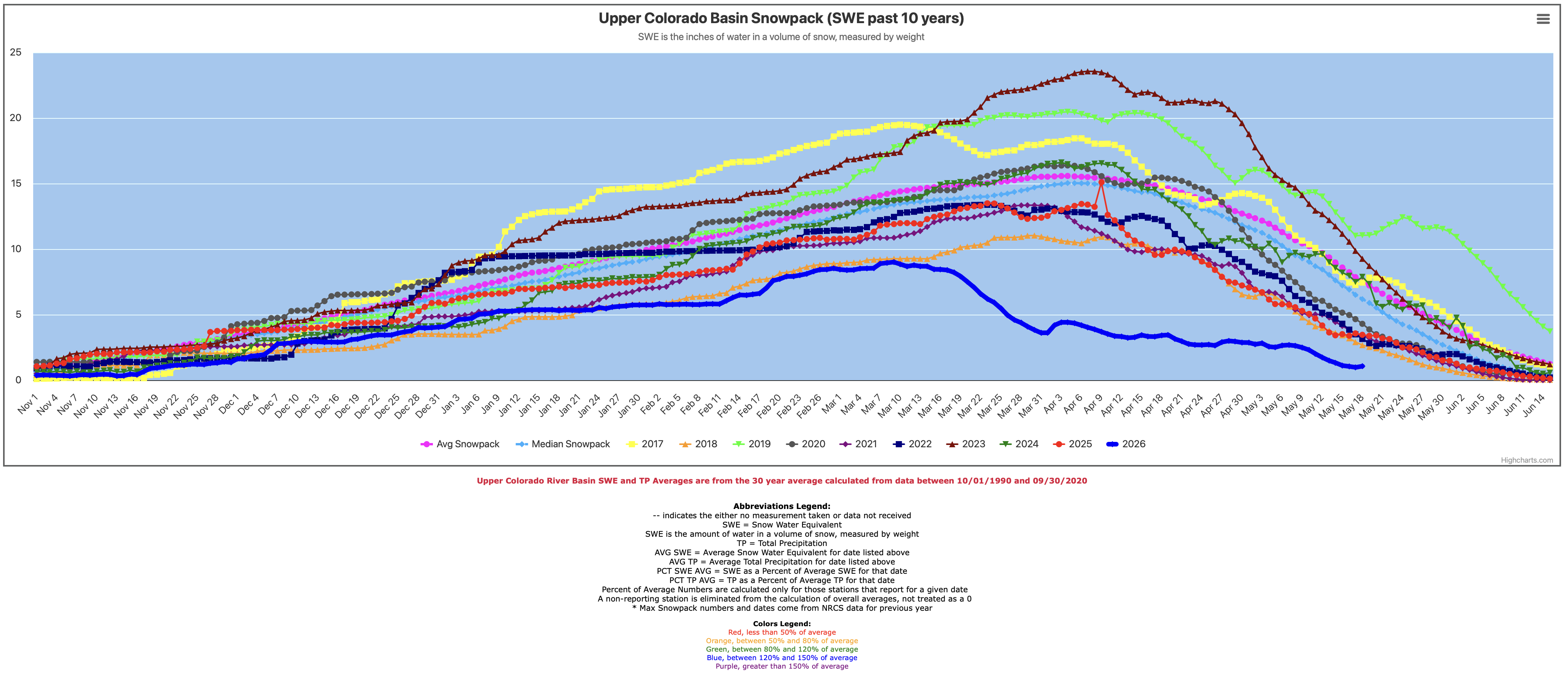
Reports on the river’s flow after the Weirdest Winter Ever (at least in recorded time) have just gotten worse and worse; now the anticipated inflow to Powell Reservoir is 13 percent of the thirty-year average, from tributary runoffs that peaked as much as two months earlier than the usual early June. The Bureau of Reclamation’s 24-month projection indicates that, if last year’s releases from Powell were replicated this year, they might have to stop generating power by late summer to protect the power turbines – which in effect declares the remaining quarter of the reservoir’s potential storage ‘dead pool,’ since the only other way past Glen Canyon Dam is through four outflow tubes of questionable viability that the Bureau would like to use as little as possible.
The Bureau will address this with two emergency measures: first, by bringing a large quantity of stored water down the Green River from Flaming Gorge Reservoir, and second, by cutting releases from Powell Reservoir by close to two million acre-feet (maf) – which in turn will leave Mead Reservoir lower and diminish its power generation. This is an emergency plan that can nowise be considered long-range planning.
The Lower Basin states in turn have bumped up their willingness to take more shortages for the next couple years by roughly doubling shortages they have already agreed to accept – if the feds will pay them something for not using water that is not there. Their earlier cuts were basically just enough to finally start taking out of their individual allotments the system losses (mostly evaporation) they have been dismissing, with Bureau cooperation, as being met through ‘surplus flows’ that effectively disappeared when the Central Arizona Project came online in the 1990s.
The four Upper Basin states have responded by suggested that it might be time to bring in a facilitator or mediator to conduct the seven-state negotiations on future management planning. This launched an episode of fussing between the Lower and Upper Basins as to who first had that idea, with the other basin objecting to it. But no one seems to be totally opposed to the idea at this point, and it might happen.
Udall/Overpeck 4-panel Figure Colorado River temperature/precipitation/natural flows with trend. Lake Mead and Lake Powell storage. Updated through Water Year 2025. Note the tiny points on the annual data so that you can flyspeck the individual years. Credit: Brad Udall
But basically it all seems to be in reaction to an ‘emergency’ water year, with no advance on more long-range planning – and there is no reason to believe that this year in just a one-shot emergency like the 1977 water year. It is just the most extreme year in an extreme period – the past quarter century – that is probably the shape of the future in the Colorado River region, and there are no more Flaming Gorge reservoirs to draw down for the next emergency year….
It’s probably important to remember a distinction: there is a river, the Colorado River, and we have overlaid on that river a management systemfor managing the river’s water for its human uses, a system whose parts either store water or distribute stored water to users. But we do not directly ‘manage’ the river itself, which runs according larger ‘operators’ – to global climate factors that we can inadvertently change but do not directly control, to what is happening to precipitation that falls in the river’s watersheds, and to how much what lives on the land (including us) interacts with the flow both on and below the land surface.
That last point – the water ‘on and below the land surface’ – strikes me as very important but largely ignored in the stalemated negotiations. You remember the metaphor of ‘the elephant in the room’: a big thing that everyone in the room is trying to ignore because to acknowledge it is to open a can of worms? (Sorry, mixing metaphors here.)
Well, we have ‘elephants in the river’ – or rather maybe in the ‘box’ containing the sacred Law of the River, through which we try to manage to the river. That’s the box that we’re all supposed to be ‘thinking outside of.’ Beginning to work ‘outside the box’ on anything will open a can of worms, but… are we going to have any choice, further down the road when it will be even harder if the elephants in the river continue to be ignored?
Trying to think in an integrated way of the water under the land as well as that on the land is one of our elephants in the river. We need to keep in mind the distribution of the freshwater all land-based life depends on (basically a solar-distilled three percent of the ocean’s water). In our times more than half of the freshwater on the planet is ‘banked’ in mountain glaciers and the ice sheets of the polar regions and Greenland – although this fraction is gradually diminishing under the changing climate. Of the remaining 35-40 percent, most of it is groundwater – water that soaks into the land, nurturing nearly all of the plant life that is the foundational food, fuel and housing supply for the animal kingdom (including us). This leaves only a small fraction of the water on the surface – lakes, wetlands, streams and rivers – and this is also a diminishing fraction, as the warming climate increases sublimation and evaporation from all waters exposed to the sun’s increasing power.
Typical water well
Yet that is also the fraction of freshwater over which nearly all the human squabbling is happening. For a long time, until the last century-plus, that was all the water that most of the animal kingdom could access, but now we have – and use, not wisely – pumps that make the groundwater accessible too.
We also know that most of that small fraction of surface water is pretty intimately connected to the groundwater. A river is not just a drain for water that failed to soak into the ground; as a river runs through its low-elevation course in a watershed, it constantly interacts with the groundwater, gaining water when the land is wet and the ground is full of water, and giving water to the land, as gravity permits, when the land is dry.
Healthy mountain meadows and wetlands are characteristic of healthy headwater systems and provide a variety of ecosystem services, or benefits that humans, wildlife, rivers and surrounding ecosystems rely on. The complex of wetlands and connected floodplains found in intact headwater systems can slow runoff and attenuate flood flows, creating better downstream conditions, trapping sediment to improve downstream water quality, and allowing groundwater recharge. These systems can also serve as a fire break and refuge during wildfire, can sequester carbon in the floodplain, and provide essential habitat for wildlife. Graphic by Restoration Design Group, courtesy of American Rivers
This knowledge ought to drive us toward thinking of groundwater and surface water as a single water source – not just our awareness that pumping the land dry will also diminish the river, but also our awareness that irrigating the chronically dry lands from the streams and rivers not only grows more plants and animal foods that the dry land could – but some of that irrigation water also sinks below the root zone to recharge the groundwater. The city of Gunnison, where I live, bought a ranch adjacent to the city because the city leaders knew enough about alluvial water to know that their groundwater supply (several relatively shallow wells) depended on keeping that ranch under irrigation from the river — water mostly cleaned by the ground it passes through.
But back to the Colorado River, the fraction of the water that does not soak into the land is a larger fraction than you would find in gentler lands primarily because most of the water falls on mountains in winter as snow, which melts in a relatively short time period as the weather warms, too fast for all of it to sink into land that is often too steep or too rocky for absorbing it anyway. But even in that ‘runoff period,’ scientists are learning that a lot of the water in the stream in the ‘spring flood’ season is groundwater flowing in from saturated lands.
Despite knowing all this, however, we persist in fighting over the fraction of freshwater that flows in the river’s watersheds through the year in the Colorado River region (natural basin plus out-of-basin extensions), and pay little in a basin-wide way to the use and abuse of groundwater. Only Colorado – to the best of my knowledge – has tried statewide to legally integrate the use of surface waters and groundwater: since 1969 all groundwater users had to acquire water rights, in the same priority system with surface water users. And – before there was easy access to computers and spreadsheets – all groundwater uses going back almost a century were also integrated into that priority system, a massive ‘can of worms’ to negotiate.
What’s been happening in Colorado for 35 years then is the beginning of the intelligent management of an integrated surface-and-groundwater supply – apparently far too intelligent for the Trumpish agri-industrialists of the two largest Colorado River water users, Southern California and Arizona. Arizona was forced to develop a groundwater management plan (1970) for the areas of Arizona that would be served by the federal Central Arizona Project, in order to get Congress to pass the project; but the rest of the state has been pumping groundwater at prodigious rates, with surface subsidence as evidence of collapsing emptied aquifers that are lost forever. Most of California’s groundwater overpumping is up in the Central Valley, not ‘served’ by the Colorado River, but as Colorado River flows inexorably diminish in a warming world, there will be growing temptations to pump in the Imperial and Coachella Valleys.
I have not found figures for the amount of unregulated groundwater ‘mining’ that goes on in the Colorado river region, but the number and volume of aquifers that have collapsed and been lost due to water-mining would probably go a long way toward filling Mead and Powell Reservoirs. And if you pause for a second and think about it, storing water underground is probably better than storing it in open reservoirs under a desert sun.
That is not the only elephant in the Colorado River – and most of them lead back, one way or another to the Colorado River Compact. The ‘temporary’ two-basin division that has clearly become toxic. Acknowledgement that the compact commission’s original goal of a seven-state division is not just possible now, but has been realized, to everyone’s discontent, making the two-basin division nothing but a battleground. Acceptance of the fact that the diminished river will continue to diminish so long as we continue to put greenhouse gases into the atmosphere faster than the planet can absorb them. Acknowledgment of the fact that as the planet warms, surface storage in big desert reservoirs is a bad idea that will get worse. Acceptance of the fact that the reconvening of a compact commission is overdue, to formalize the seven-state division and its appropriative consequences. And maybe the biggest worm-can of all: are some reasonable, even moral, limits on the appropriation doctrine possible?
We’ll look at some of these other elephants in future posts here – which I think is where the ‘romance of the Colorado River’ is today. I also think we will never have a workable resolution to our current river-system problems until we take on the elephants and bump our own consciousness of water in the arid regions up a notch from the naive ‘conquest of the desert.’
Map of the Colorado River drainage basin, created using USGS data. By Shannon1 Creative Commons Attribution-Share Alike 4.0
Click the link to access the report on the Frontiers in Environmental Science website (Laura M. Norman, Michael M. Pollock, Francina Dominguez, Michael A. Crimmins, David Lawrence5 and Michael Dettinger). Here’s the abstract:
Drylands across the globe are experiencing intensifying water scarcity, land degradation, and hydroclimatic extremes. This review integrates evidence from multidecadal field studies, hydrologic monitoring, geomorphic and ecological assessments, remote sensing, and land–atmosphere science to evaluate how restoration influences key components of the terrestrial water cycle. Low-tech natural infrastructure in dryland streams (NIDS)—including check dams, leaky weirs, one-rock dams, and gabions—has emerged as a promising but under-synthesized nature-based solution for restoring hydrologic function in these environments. We describe the mechanisms through which these interventions modify runoff detention, infiltration, sediment and alluvial storage, shallow-groundwater recharge, vegetation recovery, and surface-energy partitioning, and we summarize outcomes across diverse dryland settings. Findings consistently show increased water residence time, enhanced soil-moisture storage, expanded riparian vegetation, extended flow duration, and shifts toward greater latent-heat flux—producing localized cooling and strengthened ecohydrological feedbacks. Building on these localized effects, we articulate a hypothesis that links the spatial extent of restoration, the density of NIDS per unit drainage area, and the magnitude of the latent-to-sensible-heat contrast generated by wetter post-rainfall conditions. Specifically, we hypothesize that when NIDS are implemented at densities permitted by topography and across areas large enough to maintain elevated soil moisture after storm events, the resulting increases in latent heat flux, surface cooling, and boundary-layer moistening may enhance moisture convergence and boundary-layer development, potentially increasing the likelihood or stability of convective precipitation, analogous to how reductions in these processes have contributed to regional drought intensification. These land–atmosphere feedbacks remain untested at scale but represent an important research Frontier. By integrating hydrologic, geomorphic, ecological, and atmospheric perspectives, this review provides a comprehensive framework for considering how low-tech, landscape-scale interventions can strengthen watershed resilience and contribute to climate-relevant nature-based solutions.
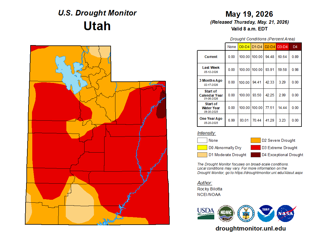
Enforcement actions will be left up to local water providers, who urge Utahns to cut back on outdoor irrigation.
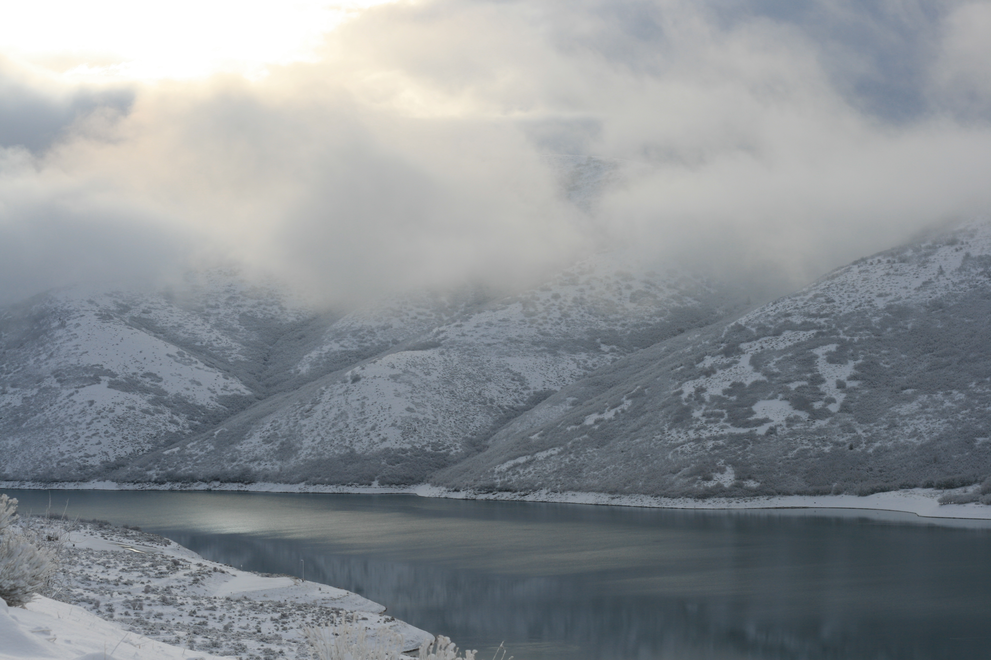
Following Utah’s winter of “no-pack,” Gov. Spencer Cox has declared a state of emergency over drought conditions. The governor and Utah water managers stood near the shores of Little Dell Reservoir in Salt Lake County to outline how dire conditions have become: the worst snowfall seen in generations. Record-breaking spring heat. Rural towns that will have practically no irrigation season this summer. Forestry managers bracing for a rough fire season. And the continued decline of the Great Salt Lake and Colorado River.
“We can’t bank on what Mother Nature might deliver next winter,” Cox said at a news conference Thursday [May 22, 2026]. “Precipitation isn’t promised, and conservation is a choice that we can all make, and must make at this time.”
Utah’s April 1 snowpack averaged 2.7 inches of snow water equivalent, the amount of water the snow releases when it melts. That’s the lowest since 1930, the governor said. The normal snow water equivalent is around 14 inches at the start of April. In 2023, which saw record snowfall, the state had an average of 28 inches in April. Snowmelt provides almost all of the water supplies across the state, and runoff is what helps the Great Salt Lake and reservoirs rise each spring. The governor’s emergency declaration does not contain any mandatory actions, though. It calls on Utahns to voluntarily take water-saving measures like fixing irrigation leaks, installing low-flow toilets and replacing unused grass with water-wise plants…The Utah Department of Agriculture and Food said the declaration opens up the Emergency Disaster Relief Loan program for farmers and ranchers across the state. The program offers seven-year loans of up to $100,000 at 0% interest for the first 2 years, and 2.75% interest thereafter. Those funds can only be used for declared disaster-related losses not covered by insurance, the department said.
Udall/Overpeck 4-panel Figure Colorado River temperature/precipitation/natural flows with trend. Lake Mead and Lake Powell storage. Updated through Water Year 2025. Note the tiny points on the annual data so that you can flyspeck the individual years. Credit: Brad Udall
Click the link to read the article on the KVNF website (Brody Wilson). Here’s an excerpt:
May 19, 2026
A special mid-year West Slope Water Summit brought together water managers and community leaders to address a dire water year. Projected inflows into Lake Powell are expected to be well below half of normal — and negotiations over the river’s future remain unresolved.
A special mid-year West Slope Water Summit convened this week in Montrose — called early because the situation couldn’t wait until November. Montrose County Commissioner Sue Hansen organized the gathering after attending the Colorado River District’s State of the River address. She told attendees it was time to step up the urgency.
“This year is the first year that I am not optimistic,” Hansen said. “This is unprecedented and perhaps sobering for all of us.”
[…]
“The Lower Basin has put out, maybe you guys have heard of this, bridge proposal a couple weeks ago that in my opinion is a joke,” she said.
Her frustration centers on the math. The proposal calls for reducing water use by 3 million acre-feet over two years. But Flinker says that’s nowhere near enough — the river needs cuts of at least that much every single year. At the heart of the standoff is a hard reality. There is currently much less water in the river than we have been using, and no one anticipates that changing any time soon.
As Flinker puts it, “Well, I can speak for myself and you probably have the same opinion. Who wants to reduce their water usage? Right? No one. And the Lower Basin has used over 10 million, close to 11 million, acre-feet out of this river every year, much above their allocation. They don’t want to use less – especially when it’s not a little less – it’s like half, right?”
Southeastern Colorado’s farmers and farming communities say they’ve won valuable protections against the historic worst practices of cities’ “buy and dry” of agricultural water, after final passage of revegetation requirements along the Lower Arkansas River that may spread to other basins of the state.
“For the first time in Colorado, this new law establishes that when irrigation water is permanently removed from farmland for other uses, the responsibility to properly revegetate and reclaim that land belongs to the entity removing the water,” said Jack Goble, general manager of the bill’s primary advocate, the Lower Arkansas Valley Water Conservancy District.
“It also strengthens the role of local counties by requiring the water court to incorporate their revegetation criteria and enforcement mechanisms into change-of-use decrees. At its core, this law sets clear expectations, creates accountability and helps protect the land, neighboring landowners and rural communities that are left behind when water leaves,” Goble said.
Southeastern Colorado advocates conceded some measures after the bill’s introduction.
The original bill limited a water use transfer to 50% of the purchased water until 50% of the affected farmland had been successfully revegetated against erosion and deterioration. The bill as passed removes the hard percentage, and gives city water agencies more flexibility when they buy, such as posting a bond or negotiating conditions during local permit applications.
The initial bill language had a hard requirement for a five-year water court oversight of revegetation after a rights transfer to guarantee reclamation. The bill as passed gives water courts the ability to create an oversight period, but only when there is “a substantial risk that reclamation could regress,” Goble said.
The final bill gives assurances to Arkansas Valley communities by requiring any reclamation agreements with cities to be written into change-of-use decrees, after the details have been negotiated by an intergovernmental agreement in a permit.
“Colorado agricultural lands are vital to our economy and way of life in Colorado, and protecting Colorado lands from the impacts of drought, erosion and invasive weeds is important to protecting our natural resources and our communities. The governor will review the final version of the bill,” spokesperson Ally Sullivan said.
Aurora Water officials, from one of the Front Range water agencies that has traveled far for decades to acquire river rights and agricultural water rights, said they support concepts in the legislation, but have reservations about how it might be executed.
“Aurora Water has actively worked in the Lower Arkansas Valley for decades, including opening an office in Rocky Ford in 1988 with full-time staff dedicated to supporting long-term revegetation and land stewardship efforts after water has been removed from agricultural production,” said Aurora Water spokesperson Shonnie Cline. “In many respects, House Bill 1340 was largely modeled after practices Aurora Water has implemented in the region, and we strongly support the overall intent of the legislation.”
Cline said Aurora Water backs responsible reclamation, and “at this time, we do not anticipate the bill significantly changing Aurora Water’s current operations in the region.”
Aurora Water is much less enthusiastic about potential future legislation applying the new southeastern Colorado protections to other river basins in the state.
“Aurora Water would have concerns with any future expansion of this type of legislation into other regions of the state as it could unintentionally harm existing dryland farming operations or create disincentives for farmers who are successfully operating under dryland agricultural practices on converted lands,” Cline said.
“Additionally, Aurora Water believes it is important for water courts to retain the authority to independently evaluate whether revegetation or dryland farming standards to be incorporated into a court decree are technically appropriate, scientifically supported and feasible under the specific facts of each case, regardless of where the standards originate.”
Controversy over what happens to former farm and pasture land when a distant city dries it up has hit other parts of Colorado beyond the Lower Arkansas River, including Thornton’s purchase of thousands of acres of water rights in Weld and Larimer counties. Thornton has tried to placate the counties with commitments to revegetate or promote responsible dryland farming when it starts taking water off the acreage and putting it into an under-construction pipeline.
Aurora and Colorado Springs have faced decades of criticism from southeastern Colorado counties for past purchases and dry-ups that left areas like Crowley County looking like Dust Bowl victims. More recent farm water purchase agreements in places like Bent County limit the number of years in a row a city could take farm water, and make other concessions to try to support local economies.
Colorado Springs Utilities said after the bill’s final passage, “We recognize that revegetation of formerly irrigated lands is a fundamental requirement for any water transfer.”
“We strive to forge mutually beneficial partnerships in the Arkansas River Basin, which is why our team spent over three years negotiating terms and conditions for our water projects in Bent County,” Colorado Springs officials said, in a statement.
Colorado Springs officials said they appreciated the negotiations over House Bill 1340 for “taking these concerns seriously so that we could reach a compromise on the introduced bill that upholds our local agreements. … We believe that reliance on science and collaboration with local governments allows projects to be tailored to unique community and regional needs.”
We are excited to welcome indigenous scholar, filmmaker and founder of NativesOutdoors Len Necefer (Diné) to accompany the screening of the film in co-sponsorship with the Getches-Wilkinson Center and the American Indian Law Program at the University of Colorado Boulder School of Law, as well as with our colleagues at the Center for the Humanities and The Arts in the College of Arts and Sciences at CU Boulder.
Advance registration is encouraged. You can register HERE
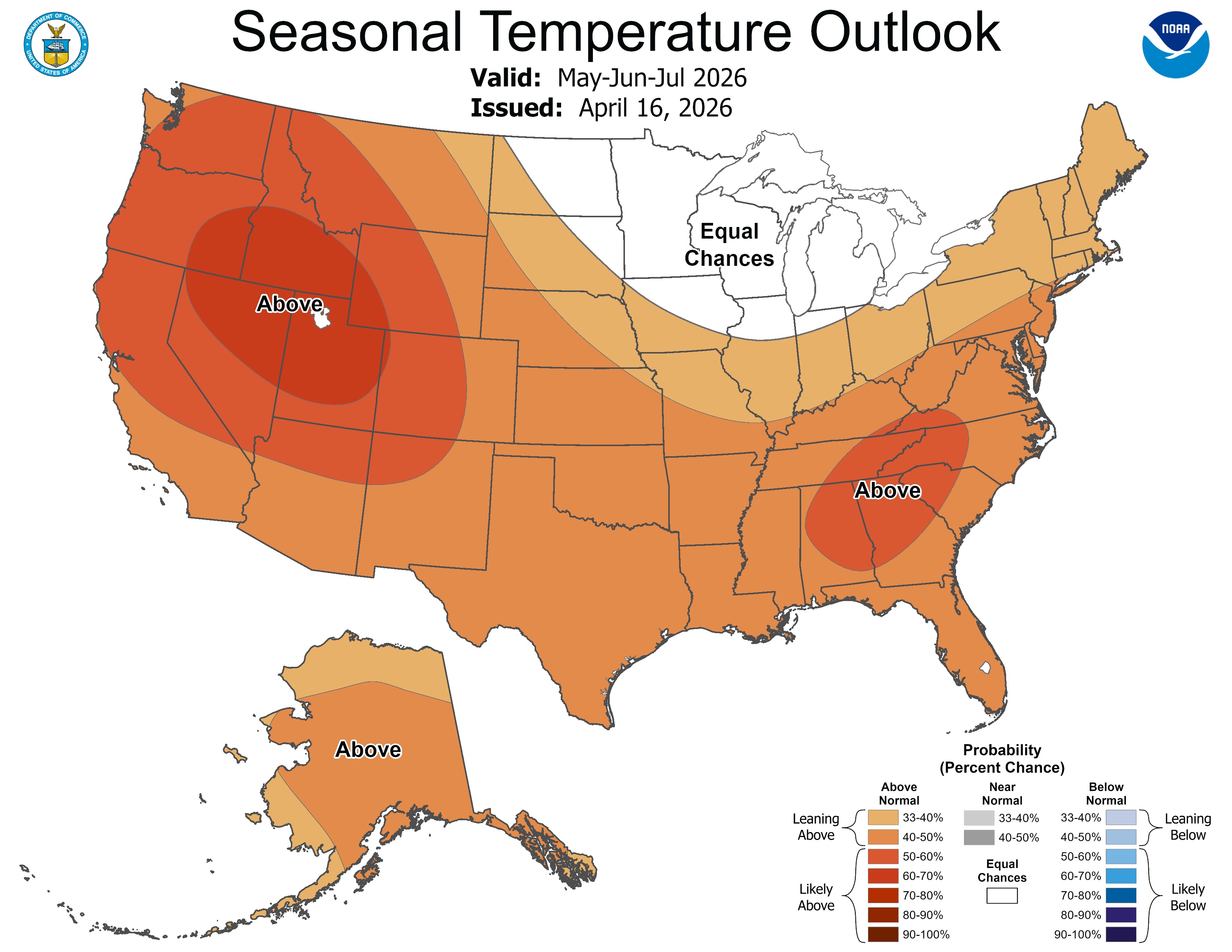
El Niño is likely to emerge soon (82% chance in May-July 2026) and continue through Northern Hemisphere winter 2026-27 (96% chance in December 2026 – February 2027). An #ElNino Watch remains in effect. #ENSOhttps://t.co/5zlzaZ0D9Zpic.twitter.com/iIomWfkCco
— NWS Climate Prediction Center (@NWSCPC) May 14, 2026
The early May winter storm that brought winter weather to Colorado and Wyoming dissipates, revealing the snowy landscape left in its wake. Taken on 6 May 2026, 17:21:00. GOES imagery: CSU/CIRA & NOAA
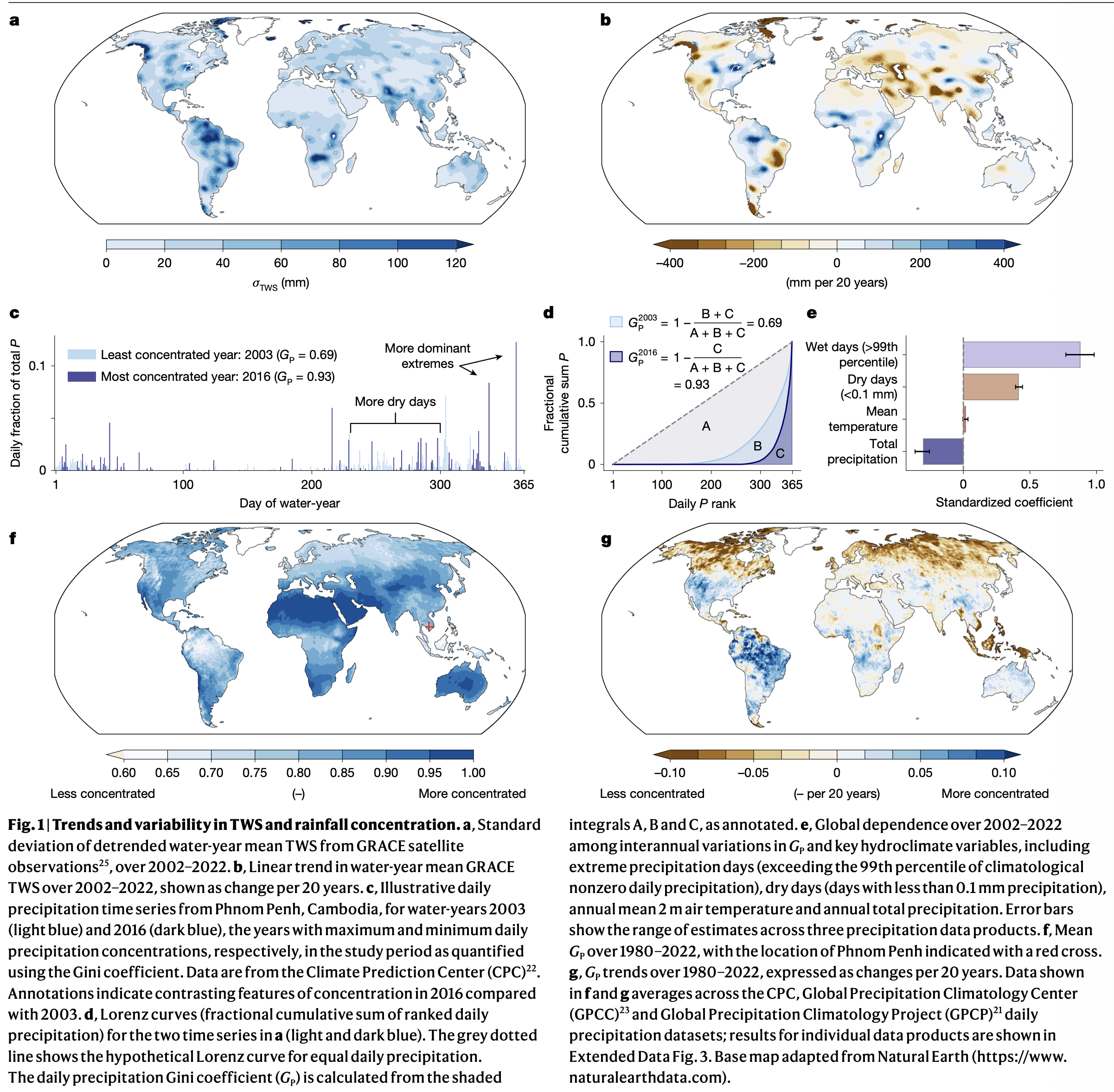
Snow and rain in the American West is concentrating at one of the highest rates in the world, researchers found, with implications for ecosystems, water management and this year’s El Niño.
Scientists have uncovered a new driver of aridification, potentially reshaping how drought across the globe is understood.
A new study published Wednesday in Nature by a pair of researchers from Dartmouth College and the Université du Québec à Montréal shows that changing precipitation concentrations exert an important influence over landscape moisture retention. When an area receives its annual moisture in a small number of large, wet storms, it can overwhelm the soils, creating pools of water on the land surface. These exposed pools are more prone to evaporation, meaning water that would otherwise reach streams, rivers and dams drifts back into the atmosphere.
When paired with long dry spells, these storms dry out landscapes, even though total precipitation hasn’t necessarily changed, the researchers found.
“If you’re asking the land to drink from a fire hose, whether that’s through highly concentrated precipitation falling from the sky or rapid snowmelt, you’re going to lose water,” said Justin Mankin, an associate professor of geography at Dartmouth and the study’s senior author. “It is just a feature of the world that as you concentrate rainfall, less of it goes into the land.”
Using several precipitation datasets, Mankin and his co-author, Corey Lesk, a professor of Earth and atmospheric sciences at the Université du Québec à Montréal, determined where on Earth annual moisture was concentrating, and where yearly rain and snow totals were spreading out across the calendar.
“There’s really maybe two hotspots that have the strongest consolidation trends since 1980,” Lesk said. “One is the Amazon and adjacent regions, too, it’s a huge hotspot.”
“But the other hotspot is pretty much right over Wyoming [and] Colorado,” he added.
River basins across the American West have been drying out under a “megadrought” that has gripped the region for the better part of the 21st century, forcing Western states to cut back their water use and renegotiate—with considerable acrimony—the dwindling resource. Mankin and Lesk’s new paper adds to a growing body of science laying out the perils changing moisture cycles pose to river basins, where users are accustomed to receiving a set amount of water at a predictable time.
“The methods represent a strong combination of direct observations and tests of the relationships using computer simulations,” said Bryan Shuman, a paleoclimatology professor at the University of Wyoming who was not involved with the study. “These are not patterns that can be dismissed as untrustworthy computer predictions. They show that this pattern has been happening and can be observed.”
Shuman, who has previously studied precipitation concentration, said the dynamics outlined in Mankin and Lesk’s paper paint a sobering picture for the West’s climate.
“The challenges raised here highlight how the future could involve both dangerous flooding but that that can come along with much worse droughts than in the past,” he said. “Simply put, we could receive the same amount of rain and still experience drought.”
As the American West staggers out from its worst winter on record, there is a chance the coming El Niño cycle, where warmer water in the Pacific Ocean can increase temperatures and precipitation in the West, brings concentrated levels of precipitation, along with the potential drying Mankin and Lesk describe in their research.
Since the early 20th century, the American West has blossomed on the vines of federal and state dams and canals meant to impound and transport water from where it flowed naturally to where it is useful for cities, farms and industries.
But this century-old infrastructure and the economies it enables could be “potentially maladapted to this rapidly changing climate,” Mankin said, in which the same amount of moisture packed into in a few heavy storms yields less water.
Moisture consolidation, which Mankin and Lesk believe is a logical result of a warming atmosphere, is “actually a new mode of volatility, a new way in which precipitation and the water cycle in a warmer climate is harder to predict and harder to manage,” Lesk added.
“It’s not just more of the same that the West has always dealt with.”
We’re excited to invite you to view a screening of The American Southwest, a film about the Colorado River and the historical and current implications it's management has on the indigenous peoples of Colorado. 🎥The screening will take place on June 11th from 4:00 – 7:00pm at CSU… pic.twitter.com/gFL8TSuQfX
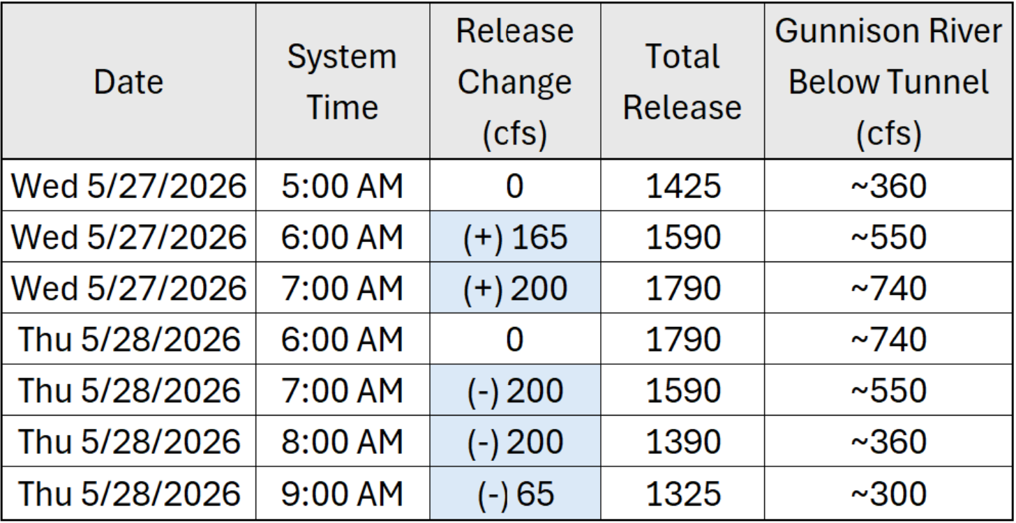
The Aspinall Unit spring peak operation has been scheduled for Wednesday, May 27th. The schedule for the ramped increase and decrease in releases is as follows:
The purpose of this release is to satisfy the Black Canyon Decree spring release. Due to the maintenance outage ending on May 20th and unseasonably early peak runoff of the North Fork, this spring peak release timing was chosen to coincide with equal or greater inflows to Blue Mesa Reservoir.
Contact Andrew Limbach (alimbach@usbr.gov or 970-248-0644) for more information regarding Aspinall operations or the Operation Group meeting.
Click the link to access the update on the NOAA website:
May 14, 2026
West Braces for Critical Water Shortages After Unprecedented Snow Drought
Key Points
Snowpack, the western U.S.’s largest non-man made reservoir, is already gone in many places. Significant hydrological drought impacts (low water supply) are already occurring and will continue through summer across much of the West. Compounding these impacts, the West continues to experience long-term drought. Drought conditions can be expected to deteriorate, and impacts to become more pronounced.
April and May snowfall in some areas did not offset seasonal snow deficits, but increased soil moisture and slowed high-elevation snowmelt, which may slow drought deterioration and temporarily mitigate early season wildfire risk. Snow did not fall in all states.
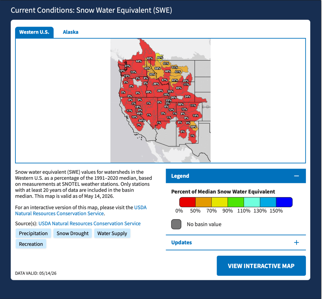
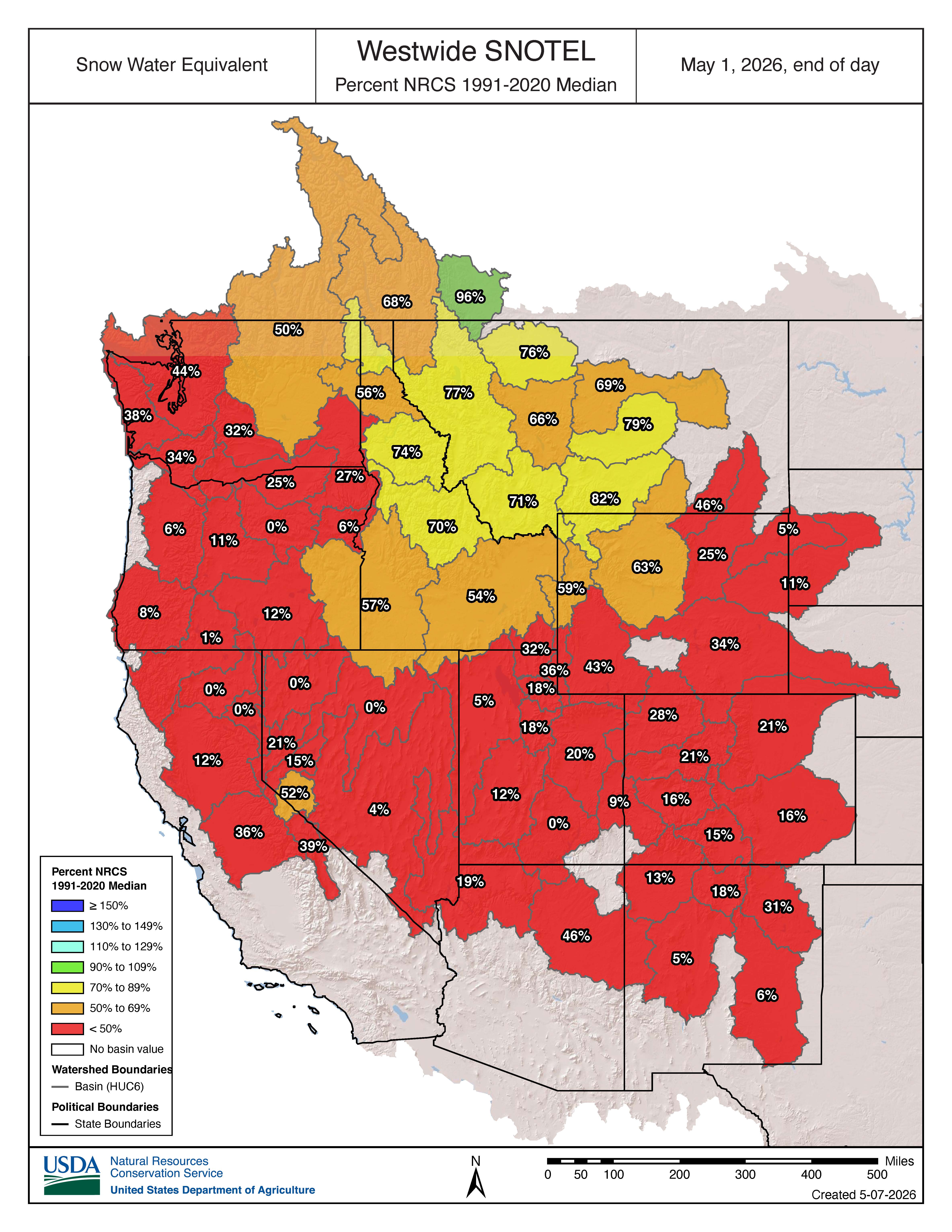
This year’s peak snowpack will be the new benchmark low for Wyoming, Utah, Colorado, and New Mexico; there are no comparable years. [ed. emphasis mine] In these states, snow water equivalent (SWE) around April 1, the usual peak date, was 32- 53% lower than the previous record low during the SNOTEL era. In Idaho, record warm temperatures pushed snow to only the high elevations, leaving the state with no historical comparison.
Earlier-than-normal meltout (snow no longer present) occurred across the Western U.S., with many SNOTEL locations setting a new earliest or second earliest meltout date on record. Water supply forecasts in many watersheds are still forecasted to approach historic lows or at historic lows.
In Oregon, 62 of 73 forecast points are approaching or at historic lows.
In Utah, peak flows occurred and concluded in many streams before the spring runoff season even started.
As the West enters summer, evaporative demand (thirst of the atmosphere) and water demands will increase. This will further strain and reduce water supplies. Current outlooks favor-warmer-than-normal normal temperatures. Any relief will depend on late spring storms, along with the level of activity and geographic extent of the monsoon season.
Snow Drought Conditions Summary
This update is based on data available as of Monday, May 11, 2026 at 12:00 a.m. PT. We acknowledge conditions are evolving.
Quantifying snow drought values is an ongoing research effort. Here, we define snow drought as snow water equivalent (SWE) at or below the 20th percentile, which is a baseline guided by partner expertise and research. Note that reporting of SWE by Snow Telemetry (SNOTEL) stations may be unavailable or delayed due to technical, weather or other issues, which may affect snow drought depiction in this update.
Current Conditions
The unprecedented heat wave and rapid snowmelt in March made recovery from the snow drought nearly impossible, despite the April and May snow for some. The April and May storms slowed snowmelt in the high elevations where little snowpack remains and brought rain to the lower elevations, increasing soil moisture. These conditions will likely slow further drought deterioration and mitigate immediate wildfire risk. However, not all states saw this precipitation. Outlooks continue to favor an early start to the wildfire season in some areas of the West.
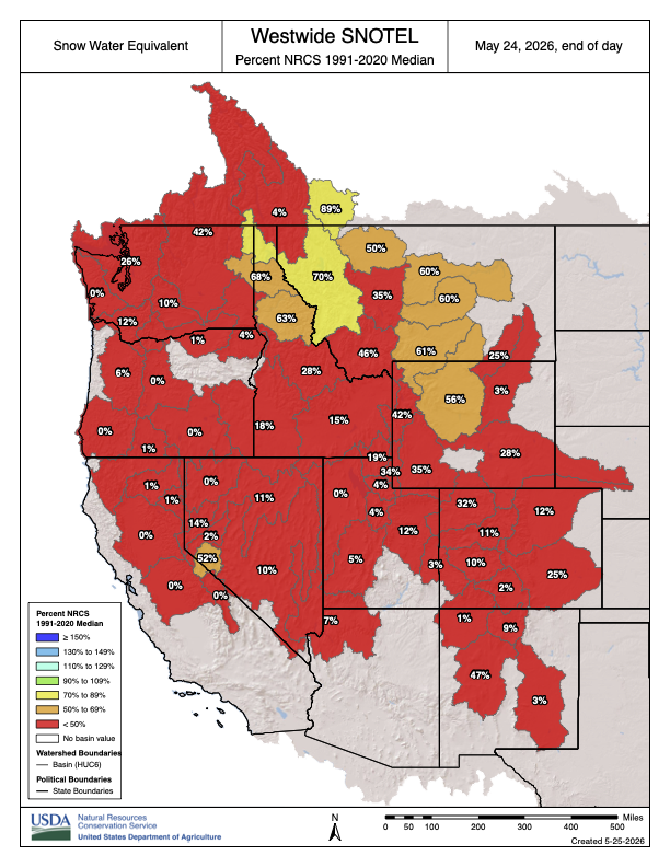
This water year continues to be the warmest on record (since 1895) in California, Nevada, Utah, Arizona, Colorado, Utah, New Mexico, Wyoming, and Montana; the second warmest in Oregon and Idaho; and the fourth warmest in Washington. The average temperature over the last 5 years was the warmest on record in Wyoming, Arizona, Colorado, Idaho, Montana, Nevada, Utah, and Washington. In California and Oregon, the last 5 years were the third warmest 5-year period on record. Many states are experiencing long-term drought, compounding the impacts from this year’s snow drought. Record low water supply are forecasted in many locations, reflecting the impacts of this year’s snow drought, long term drought, and record warmth.
This year’s western snow drought is considerably worse than significant snow droughts of the past for many states. Even for states where there is precedence, anticipating impacts or drawing comparisons to previous significant snow droughts is challenging given increasing demands on western water supply and multiyear droughts. In Washington, snowpack in 2026 was greater than its record low, 2015, and similar to that in 2001. However, Washington is in its fourth consecutive year of drought, and a drought emergency was declared in all previous years with similarly low snowpack. This year’s peak snowpack will be the lowest on record for Wyoming, Utah, Colorado, and New Mexico. This year will represent the new benchmark low. In these states, snowpack around April 1, the usual peak date, was 32- 53% lower than the previous record low in the SNOTEL record. Idaho also experienced a new record low snow season. In Idaho, warm temperatures melted snow at middle and lower elevations, and no previous years compare to this condition for the state.
Given that snow droughts often precede hydrological drought (when low water supply becomes evident in the water system), significant hydrological drought impacts are already and will continue to impact much of the West.
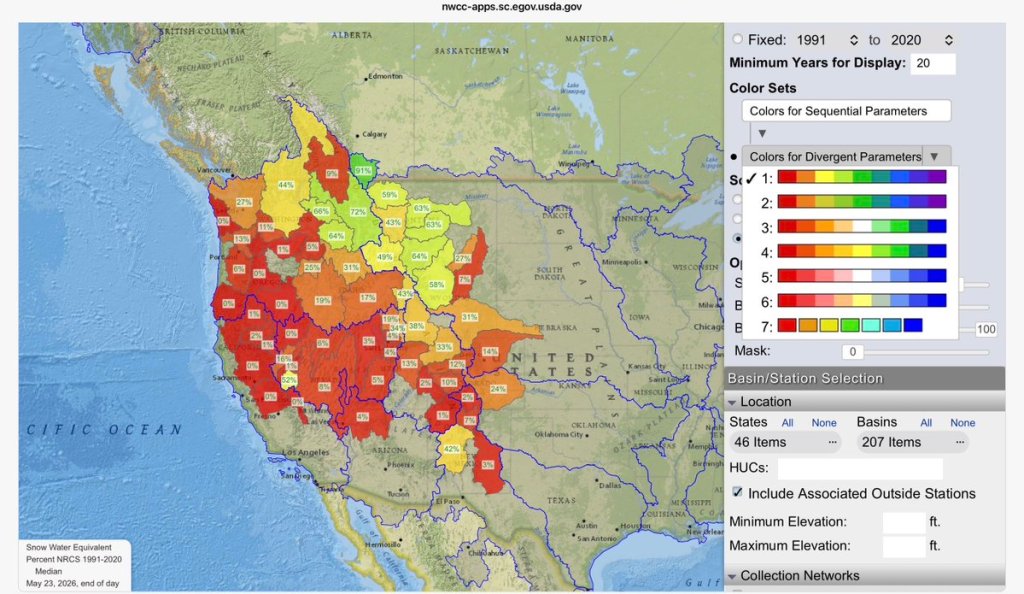
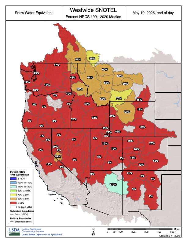
Snow Telemetry (SNOTEL) snow water equivalent (SWE) date of water year melt out for Water Year 2026, compared to the median melt out date. Only stations with at least 20 years of data are included. Blue indicates later than normal melt out, whereas yellow, orange, and red indicate earlier than normal melt out. This map is valid as of May 10, 2026. Source: USDA Natural Resources Conservation Service (NRCS).For an interactive version of this map, please visit NRCS.
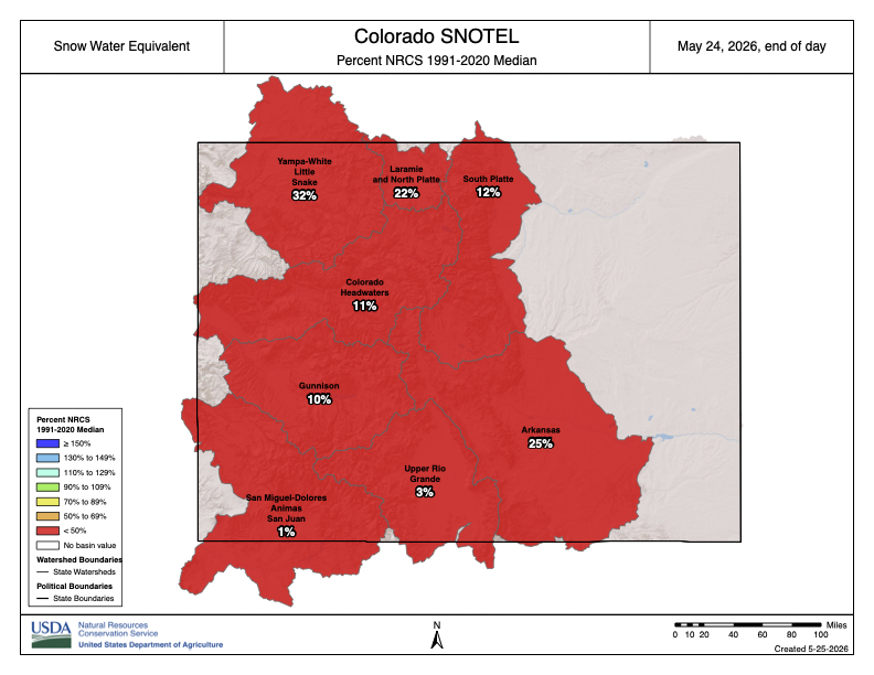
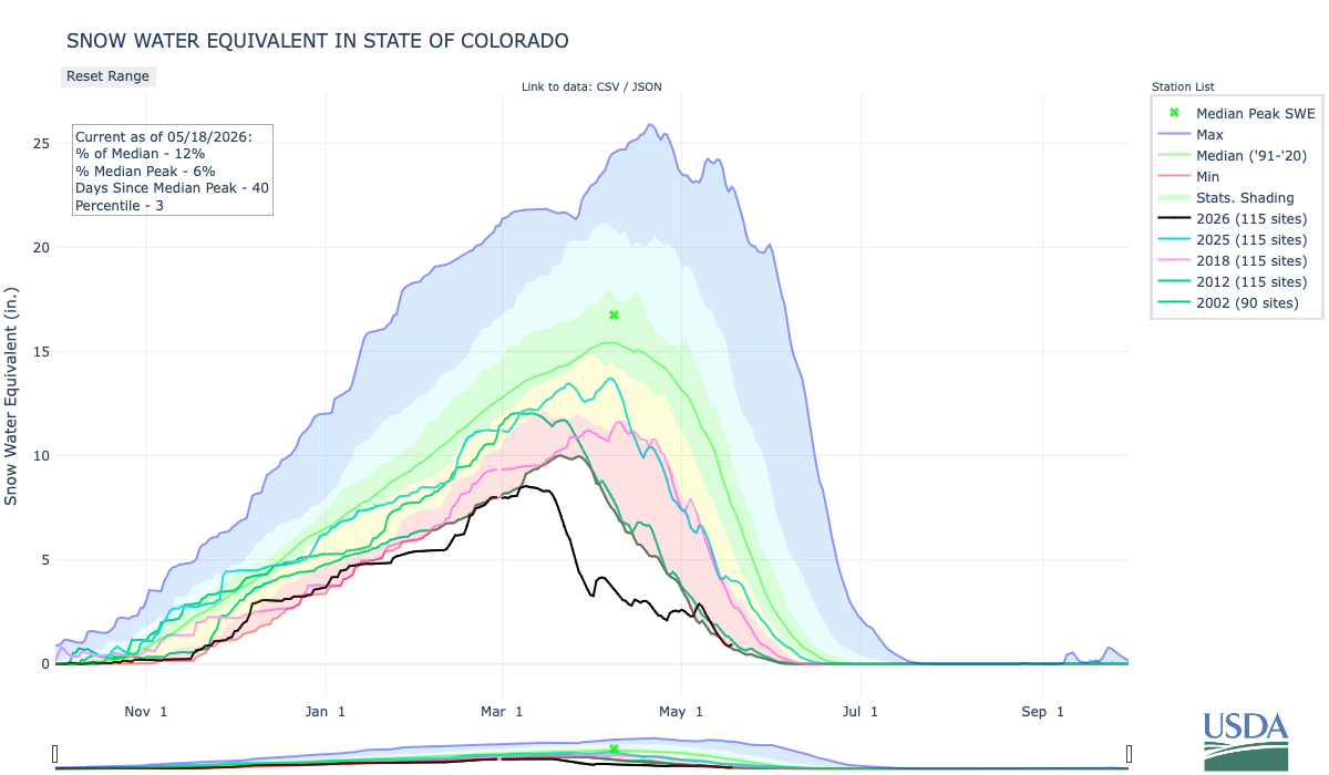
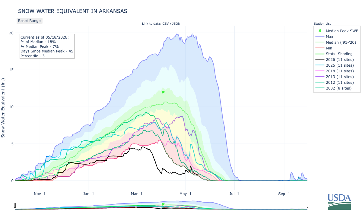
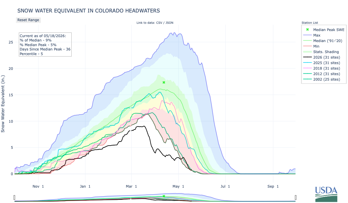
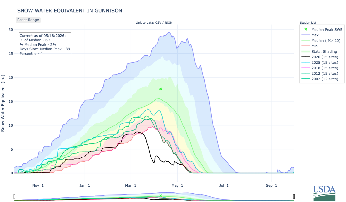
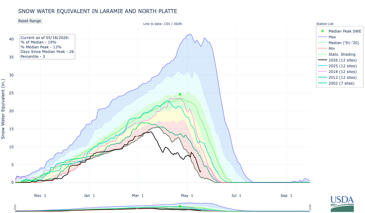
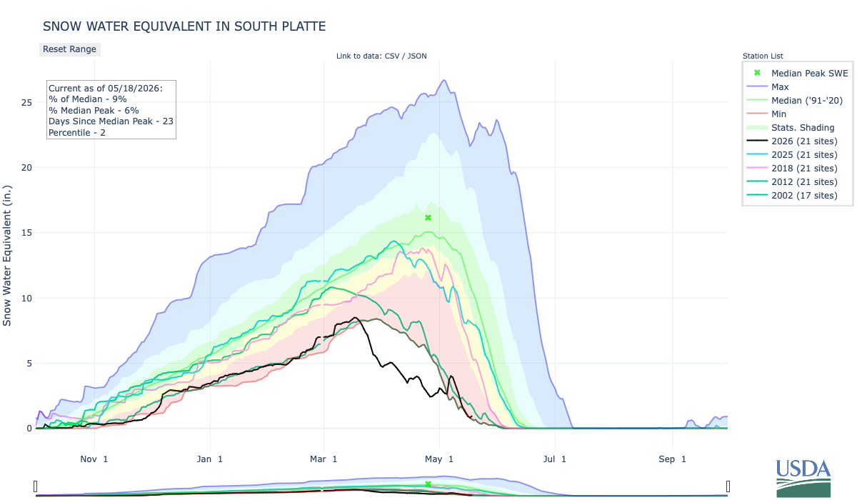
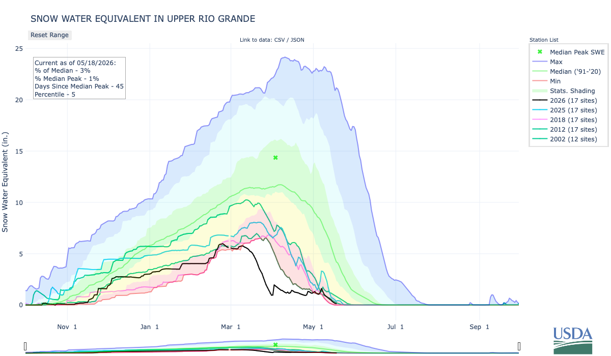
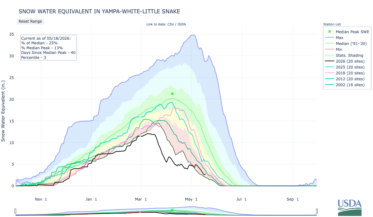
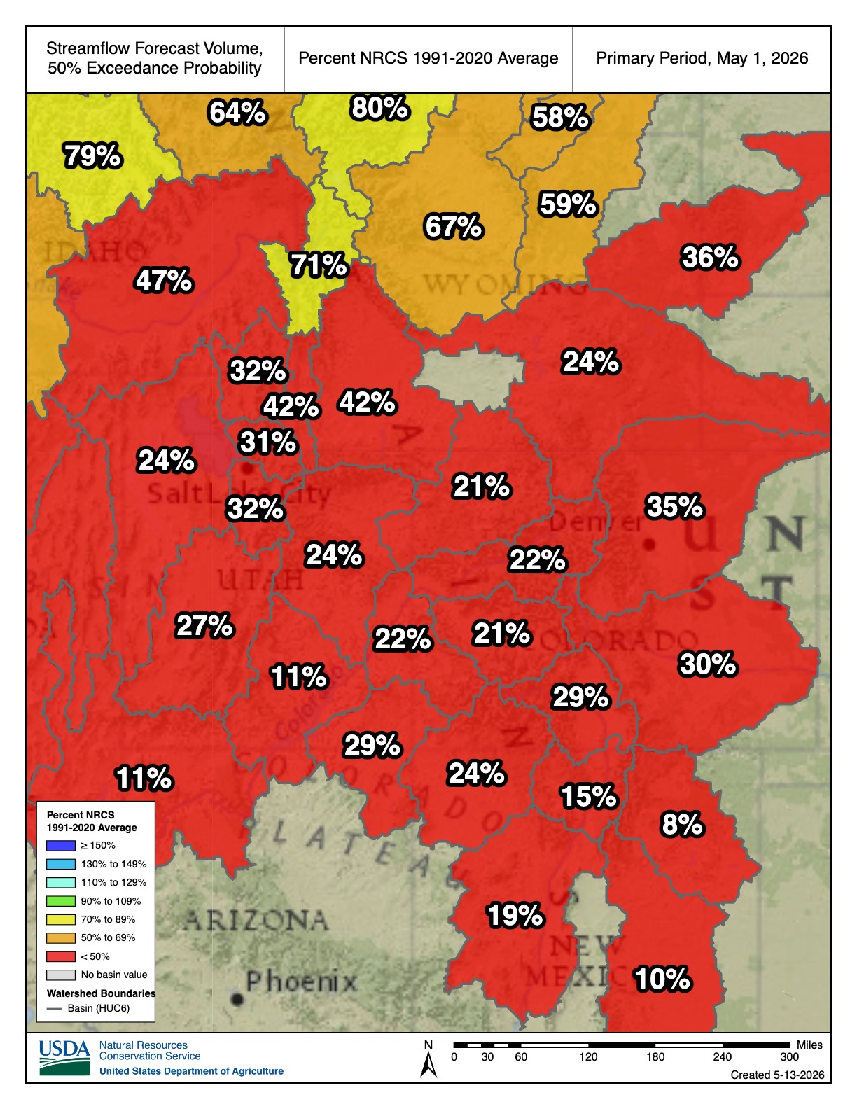
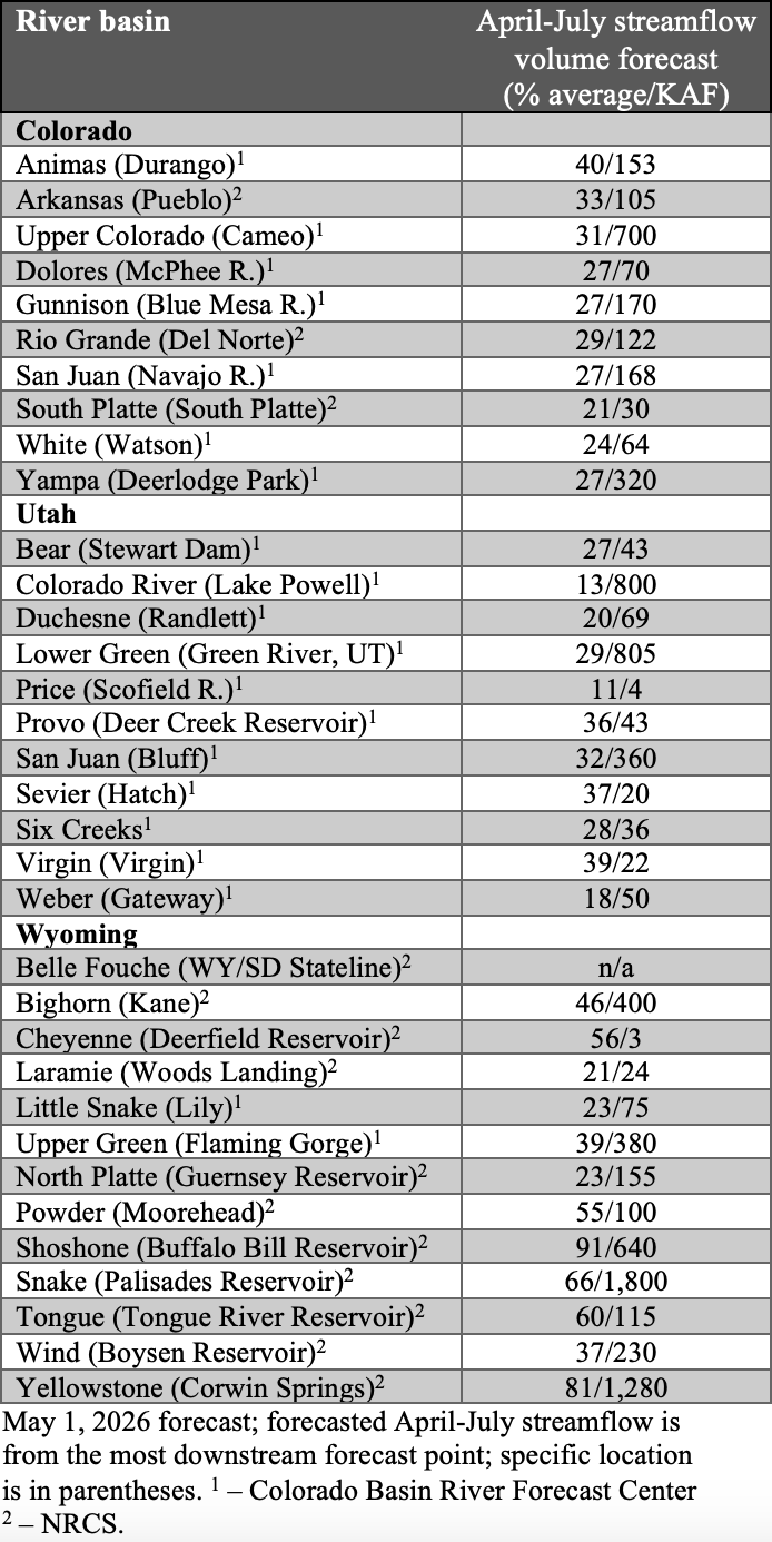
Central Rocky Mountains
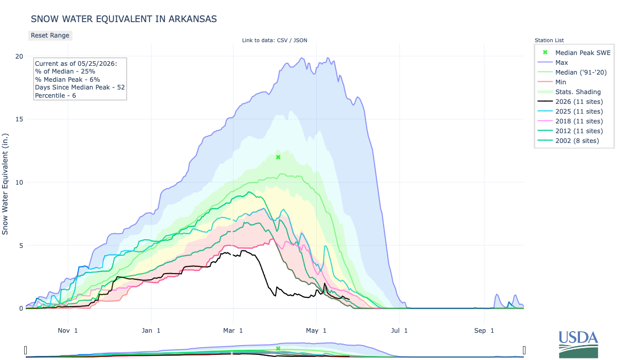
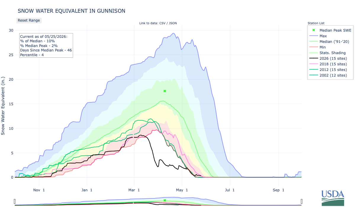
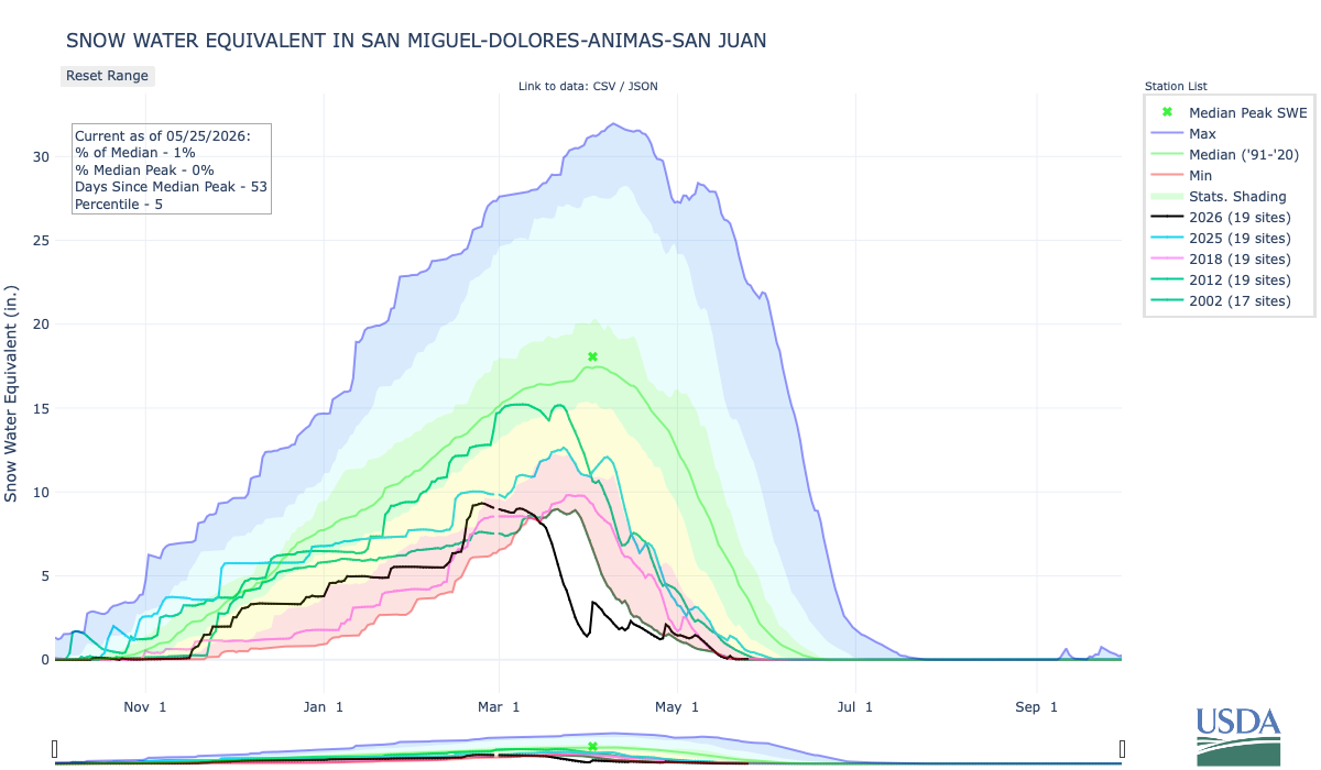
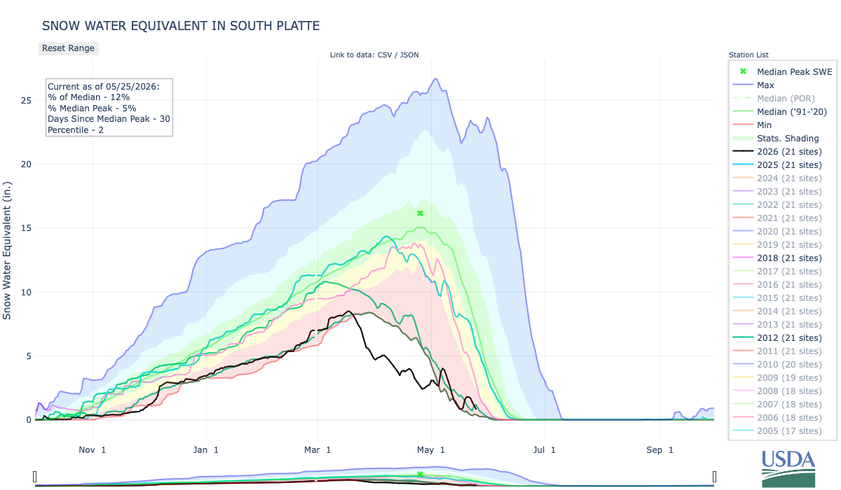
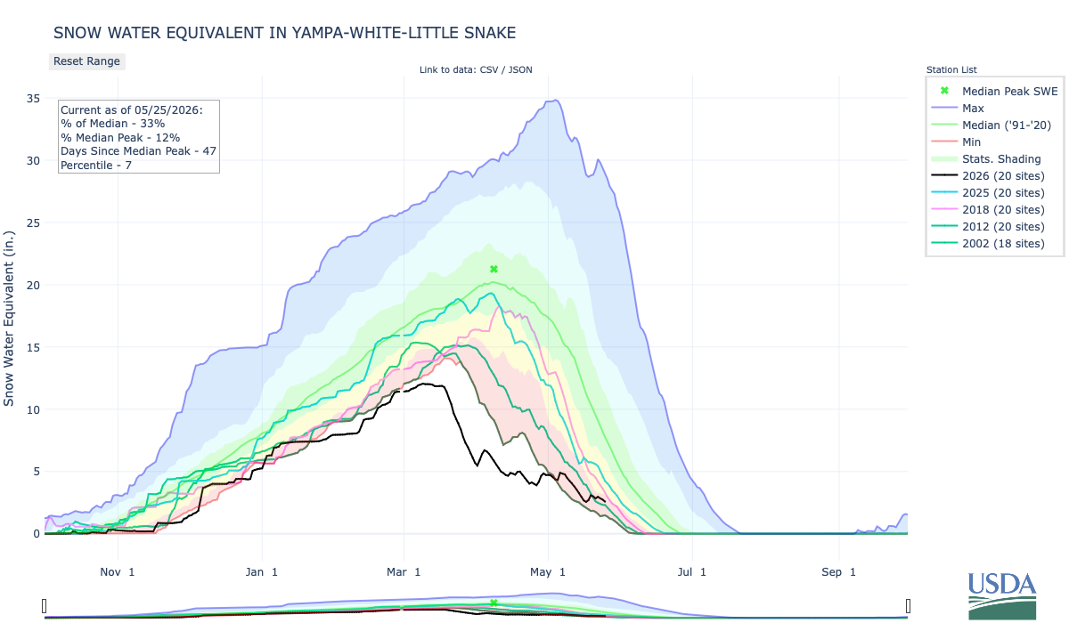
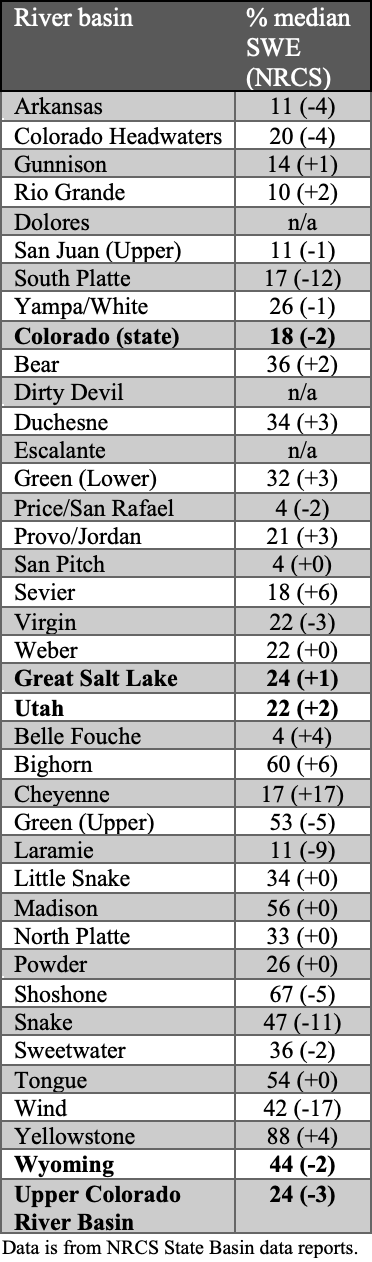
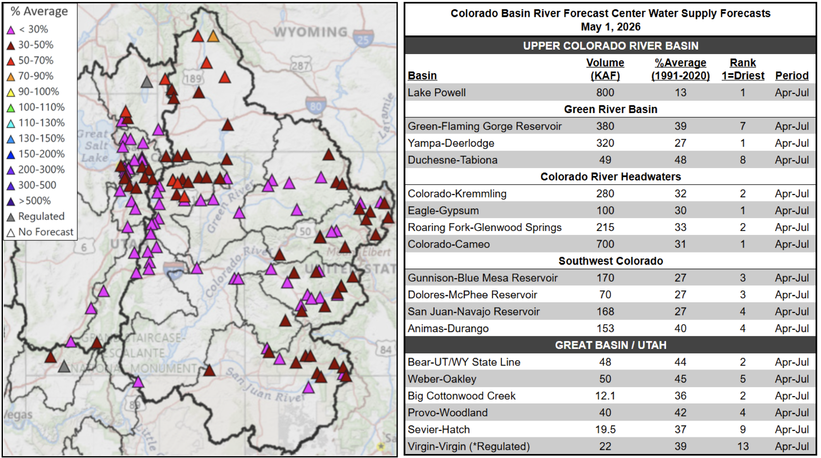
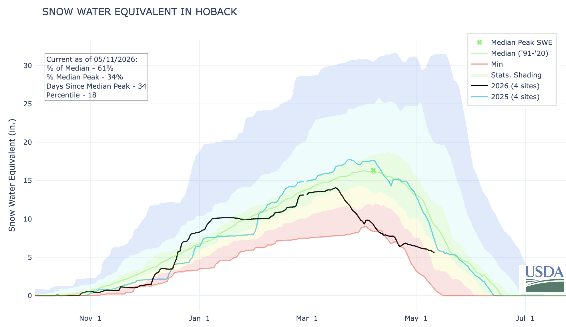
Much of the snow is gone at SNOTEL stations in Utah and Colorado, with snow remaining at only 12% and 37% of stations in the two states, respectively. At stations where snow has disappeared, the melt out occurred an average of 40 days early. Snow water equivalent (SWE) at most of the remaining stations is at 20% of median or less. Storms in April slowed high elevation snowmelt, but were far from sufficient for the region to recover from considerable seasonal SWE deficits. An early May snowstorm in Colorado brought beneficial moisture to parts of the state, but again, did not alleviate the SWE deficits and water supply concerns. Record low streamflow volumes are forecast for the Yampa River (28% of average) and the Colorado River at Lake Powell (13% of average). Temperatures in October-April in Utah and Colorado were the highest on record, but, in contrast to the northern Rocky Mountains, seasonal precipitation across the region was generally much below normal. Water year precipitation totals were below the 15th percentile for many SNOTEL stations in central Utah and central and northern Colorado.
Utah
On May 7, 2026, the Utah Drought Response Committee formally recommended Utah Governor Spencer Cox issue a drought emergency declaration for all 29 counties in the state. The recommendation cited record low snowpack, water supply concerns, and statewide drought. Formal drought declarations also were issued for parts or all of the state in 2021, 2022, and 2025. Drought has impacted southern Utah for 8 of the last 10 years. A formal drought emergency declaration allows the state to activate resources, support agriculture, and coordinate water restrictions.
Colorado
On March 16, 2026, acting on recommendations from the state’s Water Conditions Monitoring Committee, Governor Jared Polis activated Phase 2 of the state’s Drought Response Plan and the state’s Drought Task Force. The actions followed the warmest start to the water year in the Colorado Climate Center’s 131-year record, and statewide snow water equivalent among the lowest in more than four decades of records. The last time the Drought Task Force was activated was in 2020. During every year since 2020, portions of the South Platte River and Rio Grande River have required priority calls to curtail water use to ensure that senior water rights holders receive their legal share. The Drought Task Force identifies critical impact areas to coordinate state-level support and resources for affected Colorado communities.
Arizona
In 2025, Arizona operated under Tier 1 reductions in Colorado River Water Supply and is still operating under this structure. These reductions are a result of less available water in the Colorado River, impacting central Arizona agricultural users. These reductions represent a 512,000 acre-foot reduction in water, with most reductions being taken by the Central Arizona Project water users.
New Mexico
Several years of extreme drought and the earliest snowmelt on record are challenging water users of the Rio Grande River. The Middle Rio Grande Conservancy District began staggered irrigation operations in late March with natural flow of the Rio Grande. The Carlsbad Irrigation District began releases for irrigation on March 22 and has allocated only 2.5 acre-feet per acre to farmers.
For More Information, Contact:
Dan McEvoy Desert Research Institute, Western Regional Climate Center daniel.mcevoy@dri.edu
Jason Gerlich University of Colorado Boulder Cooperative Institute for Research in Environmental Sciences / NOAA’s National Integrated Drought Information System jason.gerlich@noaa.gov
Tony Bergantino Wyoming State Climate Office, University of Wyoming antonius@uwyo.edu
Amanda Sheffield University of Colorado Boulder Cooperative Institute for Research in Environmental Sciences / NOAA’s National Integrated Drought Information System amanda.sheffield@noaa.gov
On Friday, May 22, 2026, Congressman Jeff Hurd announced the release of a $40 million award to the Colorado River District for the purchase and permanent protection of the Shoshone Water Rights. The final approval of $40 million award brings the total amount of funding secured to $97 million of the $99 million needed for the purchase. The process now moves into the contracting phase during which the River District will work with the Bureau of Reclamation to finalize the terms of the award.
Colorado River District General Manager Andy Mueller offered the following remarks regarding the broad, bi-partisan support of this project from our federal, state and local representatives:
“This award is a major breakthrough in our coalition’s effort to permanently secure historic flows on the Colorado River. This funding would not have been possible without the leadership of Representative Jeff Hurd. His unwavering advocacy within the Administration helped secure this once-in-a-generation investment in a project that is vital to the prosperity of rural communities, farmers and ranchers on the Western Slope.
Senator Michael Bennet demonstrated valuable foresight appropriating Inflation Reduction Act funding to address the growing water challenges facing the Colorado River Basin. His leadership helped deliver this historic investment in long-term water security and protect our state’s namesake river for generations to come.
As founders of the Colorado River Caucuses in both the Senate and House, Senator Hickenlooper and Representative Neguse fought for these dollars by developing and strengthening coalitions across divides – both geographical and political. By advocating for the Shoshone Water Rights Project in Colorado and Washington, they helped deliver a durable and permanent solution for the entire Colorado River system.
Shoshone Hydroelectric Plant back in the days before I-70 via Aspen Journalism
During the week, the contiguous United States exhibited significant regional temperature anomalies driven by a highly amplified synoptic pattern. Early in the period, a pronounced unseasonable cold air mass influenced the Northern Plains, Upper Midwest, and Northeast, depressing temperatures 5°F to 15°F below normal across the Dakotas, Minnesota, New York, and Pennsylvania. Conversely, the Southwest and South Texas experienced anomalous warmth, with maximum temperatures exceeding 90°F and averaging up to 15°F above normal. By the latter half of the week, this warm air mass expanded eastward into the Ohio Valley and Mid-Atlantic, initiating an early-season heatwave with observed maximum temperatures climbing into the mid-80s to low 90s.
Precipitation regimes during this period were characterized by severe convective outbreaks and pronounced moisture disparities. In the early portion of the week, persistent onshore moisture transport resulted in heavy rainfall totals of 4 to 6 inches across the central Gulf Coast, specifically affecting Louisiana, Mississippi, and Alabama. Between May 17 and 18, a powerful frontal system traversing the central United States triggered widespread severe weather across the Great Plains and Midwest. This system produced damaging winds up to 80 mph, large hail, and multiple tornadoes across South Dakota, Nebraska, Iowa, Kansas, and Missouri, alongside localized flash flooding. In contrast, extreme moisture deficits persisted west of the Rocky Mountains, where weekly precipitation totals generally remained under 0.10 inches, further elevating wildfire risk across the southern High Plains…
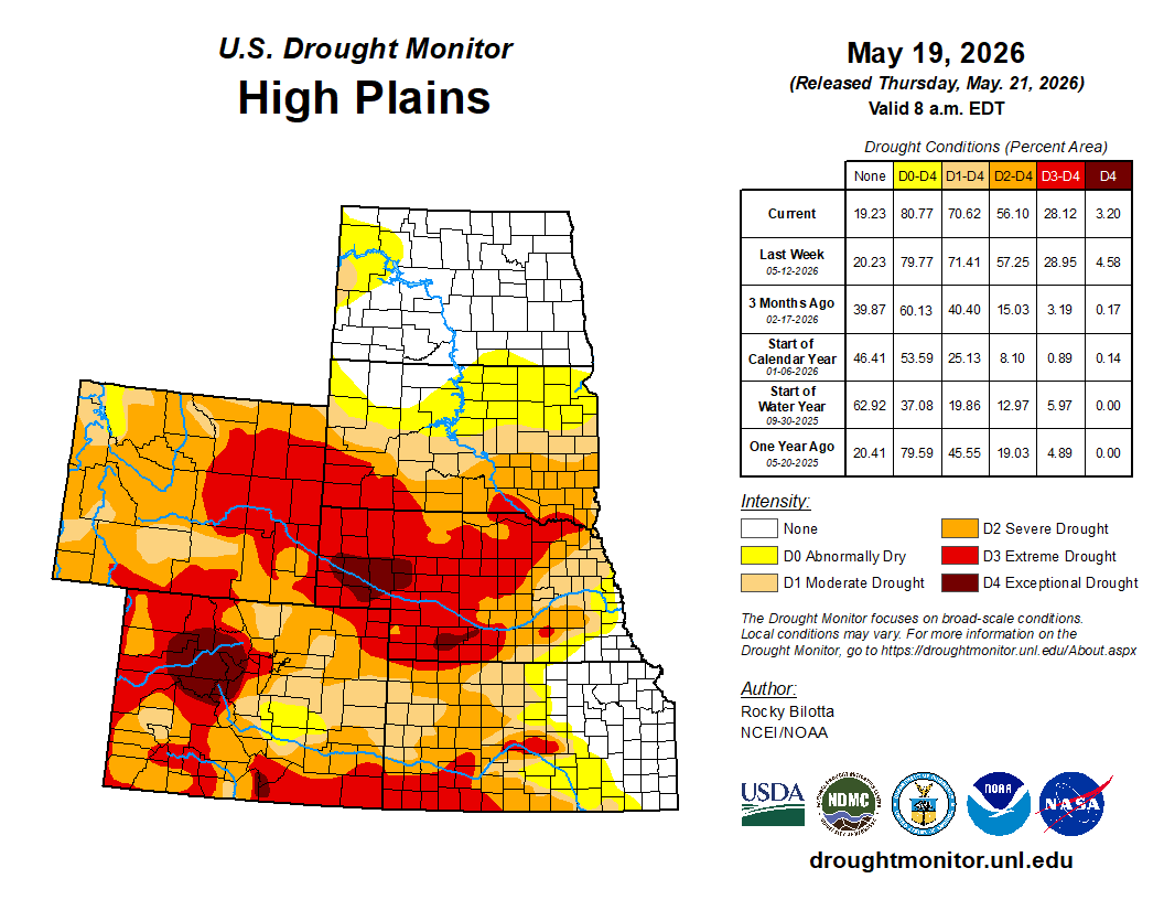
Temperatures were above normal across much of the region this week, with average readings ranging from the low 40s along the Canadian border and in the mountains to the mid-70s across southern Kansas. Highly anomalous early-season warmth gripped the southern half of the region. The core of this heat anomaly was centered over Kansas and Colorado, where weekly temperatures soared 6°F to 12°F above historical averages, with localized spots in southern Kansas peaking more than 12°F above normal. This unseasonable warmth extended moderately northward into Nebraska, yielding departures of 3°F to 6°F above average. Conversely, the northern High Plains remained under a more seasonal air mass; North Dakota, South Dakota, and northern Wyoming experienced below-normal conditions, fluctuating within 3°F to 6°F of historical baseline temperatures. Precipitation amounts varied across the region, with extreme dryness across the much of the region and a highly concentrated deluge along the southeastern boundary. Large portions of Wyoming, Colorado, and western parts of North Dakota, South Dakota, Nebraska, and Kansas, reported weekly totals below 0.50 inches, with extensive areas receiving less than 0.10 inches. This lack of moisture resulted in departures of 0.5 to 1.5 inches below average, causing conditions to deteriorate. Extreme (D3) drought expanded in southwestern Kansas and southern Colorado. Severe (D2) in parts of Colorado and northeast Wyoming, while moderate (D1) drought expanded in parts of South Dakota. In powerful contrast, intense convective activity generated a sharp corridor of heavy rainfall across eastern portions of Kansas and Nebraska. Totals in this localized zone rapidly climbed between 2.5 and 5.5 inches, with departures ranging between 1.5 to over 4.5 inches above normal, resulting in improvements to moderate (D1) to exceptional (D4) drought in Nebraska and moderate (D1) to extreme (D3) drought in Kansas. Heavy rainfall also brought improvements to severe (D2) to exceptional (D4) drought in northern Colorado and a reduction of exceptional (D4) drought in southern Wyoming this week…
Colorado Drought Monitor one week change map ending May 19, 2026.
Temperatures varied across the region this week, with average readings ranging from the mid-30s and 40s across the northern tier and high elevations to the low 80s in the desert Southwest. In terms of departures from normal, unseasonably cold conditions dominated the northern half of the region, with departures ranging between 3°F and 9°F below normal. In sharp contrast, the southern tier experienced unseasonable warmth. A building ridge over the Southwest drove temperatures in southern California, Arizona, and New Mexico 3°F to 9°F above normal, with eastern New Mexico seeing the greatest extremes. Precipitation across the Western region was characterized by an extreme contrast between a highly active storm track in the Pacific Northwest and aridity across the remainder of the region. Above-normal precipitation was confined to much of Washington, and parts of Oregon and Montana, where weekly rainfall totals ranged between 1.5 to 3.5 inches, with localized totals in the Cascade Range exceeding 4.5 inches. This activity generated substantial departures of 0.75 to over 3.0 inches above normal, justifying moderate (D1) to severe (D2) drought and abnormal dryness (D0) improvements in Washington and northern Idaho, and improvements to abnormal dryness (D0) to northwestern Oregon and western Montana. Conversely, dry conditions persisted across nearly the entire remaining geographic footprint. Widespread areas across California, Nevada, Arizona, New Mexico, and parts of Idaho, Montana, Utah recorded negligible rainfall totals of less than 0.10 inches. Due to the climatological onset of the dry season in parts of the West, this lack of rainfall translated into modest negative departures ranging from near-normal to 0.75 inches below seasonal averages. Nonetheless, deteriorating conditions led to the expansion of exceptional (D4) drought in southern Idaho, and extreme (D3) drought in parts of New Mexico, Arizona, Utah, Montana, and southern Idaho. In addition, severe (D2) drought was expanded in Oregon, Montana, and Arizona, while moderate (D1) drought expanded in parts of Idaho, Montana, Nevada, and Arizona…
Below-normal precipitation dominated the South this week. The vast majority of Texas, Oklahoma, Arkansas, Louisiana, Mississippi, and Tennessee received less than 0.10 to 0.50 inches of total rainfall, leaving nearly the entire geographic footprint under exceptionally dry conditions. This lack of rainfall translated into widespread departures ranging from 0.75 to 1.50 inches below normal. Below-normal rainfall totals resulted in the introduction of exceptional (D4) drought in the Oklahoma Panhandle and D4 expansion in parts of Arkansas and Mississippi. Extreme (D3) to severe (D2) drought were expanded in parts of Oklahoma, Arkansas, Mississippi, and Tennessee.
The major exception to this dry regime was concentrated in southern portions of the region, specifically southern Texas, where localized convective storms delivered 1.0 to 3.0 inches of rainfall, resulting in the improvement of extreme (D3) drought in southern portions of Texas, Louisiana, and Mississippi. Temperatures were above normal across much of the region, ranging from the upper 50s and low 60s in Tennessee to the upper 80s in parts of Texas. Looking at departures from normal, a highly anomalous zone of intense warmth gripped the western half of the region, where temperatures averaged 6°F to 15°F above historical norms. Conversely, the eastern tier of the region bucked the western warming trend entirely; Mississippi and Tennessee experienced unseasonably cool conditions, with temperatures suppressing to 3°F to 6°F below normal…
Looking Ahead
Over the next five days (May 19–23, 2026), the United States can expect a highly dynamic weather pattern characterized by contrasting temperature extremes and widespread storm activity. An early-season heatwave will make headlines across much of the eastern U.S. through midweek, with interior portions of the Mid-Atlantic and the Carolinas seeing highs climb into the lower to middle 90s—warm enough to potentially establish new daily records before a cold front brings cooler relief by Thursday. In stark contrast, the Intermountain West and Rockies will experience below-normal temperatures to start the week, alongside late-season accumulating snow in the higher elevations of Colorado and Wyoming. Meanwhile, a strong cold front tracking across the Plains and Midwest will spark widespread showers and severe thunderstorms. Multiple rounds of heavy rainfall will bring a risk of scattered flash flooding, focusing heavily on Texas, Oklahoma, and Arkansas on Tuesday before an expanded risk of heavy precipitation stretches from western Texas to the central Appalachians on Wednesday.
Further out, the Climate Prediction Center’s 6–10 day outlook (valid May 24–28, 2026) favors above-normal temperatures across most of the United States—stretching from the Rocky Mountains all the way to the East Coast, with the highest confidence for this unseasonable warmth concentrated in the Upper Midwest. Hawaii is also leaning toward warmer conditions. In contrast, temperatures are expected to be colder than average across the state of Alaska, and in a pocket of northwestern Washington state. Meanwhile, near-normal temperatures are forecast in parts of the South and along the West Coast. Probabilities for wetter-than-average conditions favor the vast majority of the country, including Hawaii and portions of Alaska. In the contiguous U.S., this wet weather pattern extends from the Southwest to the East Coast, with the greatest probability of above-normal precipitation expected to be in the south-central U.S., specifically across southern Texas. The West Coast, portions of the Pacific Northwest, the northern Rockies, northern parts of the Midwest, and northern Alaska are favored to receive near-normal precipitation during this time. No areas are favored to be drier than normal.
US Drought Monitor one week change map ending May 19, 2026.
A whistleblower and watchdog advocacy group used an EPA database of locations that may have handled PFAS materials or products to map the potential impact of PFAS throughout Colorado. They found about 21,000 Colorado locations in the EPA listings, which were uncovered through a freedom of information lawsuit. Locations are listed by industry category. (Source: Public Employees for Environmental Responsibility analysis of EPA database)
The U.S. Environmental Protection Agency (EPA) announced $44.3 million in new grant funding for “Small or Disadvantaged Communities” to address polyfluoroalkyl substances (PFAS) in Colorado water. That funding comes as the agency rolls back some regulations on those chemicals…The funding for Colorado water is part of a billion dollar investment across the country. The money can be allocated to testing, planning, and infrastructure projects. According to a press release from the EPA, “small, rural, and disadvantaged water systems often have fewer resources.“ The program is ”specifically designed to ensure these communities are not left behind.” […] New rules announced Monday would rescind some Biden-era regulations on PFAS chemicals and extend the deadline for water to meet federal standards by two additional years, to 2031.
A double rainbow arches over the Painted Wall in Black Canyon at Gunnison National Park. Photo Credit: Dave Showalter
From email from Reclamation (Andrew Limbach):
May 20, 2026
The Aspinall Unit spring peak operation has been tentatively scheduled for Wednesday, May 27th. A final notification of the release schedule will be sent out that will include time of day ramped releases.
Pursuant to the Black Canyon Decree section 31.5.2.1 for peak flows during a “dry” hydrologic year the Black Canyon will have a 24-hour peak flow of 730 cfs.
The purpose of this release is to satisfy the Black Canyon Decree spring release. Due to the maintenance outage ending on May 20th and unseasonably early peak runoff of the North Fork, this spring peak release timing was chosen to coincide with equal or greater inflows to Blue Mesa Reservoir.
Contact Andrew Limbach (alimbach@usbr.gov or 970-248-0644) for more information regarding Aspinall operations or the Operation Group meeting.
Click the link to read the article on the Summit Daily website (Robert Tann). Here’s an excerpt:
May 19, 2026
Lawmakers decided against introducing a “right to float” bill this legislative session, despite a push by river advocates
Last summer, a group of Colorado legislators hopped aboard several rafts with river guides and conservationists to float a mellow section of the Colorado River south of Kremmling. The trip was organized by a coalition of outdoor recreation advocates, who’d hoped to persuade lawmakers to once again wade into the issue of stream access and what rights the public has when recreating in rivers that run through private property. But over the course of Colorado’s 120-day legislative session, no such bill was introduced. A compromise between recreationists and landowner groups, which lawmakers had been seeking, never materialized…River rafters have been pushing for legislation that would provide immunity from trespassing for floaters who touch the privately-owned riverbeds and banks to help with navigation. They hoped the proposal could provide a tailored solution and avoid the longstanding fight over whether river beds should remain private property or be publicly owned…Landowner groups remained resistant to any legislative approach, which they say would only breed conflict. They would prefer to see river access issues continue to be resolved the way they’ve long been, with agreements made between landowners and river users…
Heading into this year’s legislative session, supporters of public river access advocates were again at odds over what kind of policy they should push for. Not long after organizing lawmakers’ river trip last summer, the stream access coalition, made up of several outfitting and conservation groups, split into two camps. One was focused on the right to wade in rivers, primarily driven by anglers, while the other was concentrated on the right to float. It was the latter group, which dubbed itself the River Recreation Alliance, that ultimately pursued legislation this year…A right to wade bill would have meant taking on private property ownership of river beds. A study published last year by the free-market think tank Common Sense Institute warned that the state, should lawmakers go that route, would be at risk of violating the takings clause of the Colorado Constitution, which prohibits the government from taking or damaging private property without compensation. Johnson believes legislation focused instead on floating would minimize those risks, since it would not strip land from property owners. Her coalition’s proposal also would have allowed rafters to touch the bed and banks of rivers only for safety reasons, such as scouting, portage and to avoid obstacles, according to a one-page memo Johnson shared. Walking, wading, anchoring or wade fishing would not be protected under the proposal, which also would have provided liability for landowners when accidents or injuries occurred in the river.
A warming climate is increasing the risk to water infrastructure.
The U.S. recorded a record number of billion-dollar weather disasters in the last three years.
Weather hazards, combined with aging infrastructure and rising costs, are raising the cost of supplying water.
When the Eaton Fire blitzed central Los Angeles County in January 2025, the foothills community of Altadena sat in its path.
Burning more than 14,000 acres in and around the southern edge of Angeles National Forest, the fire concentrated its structural damage in an area of Altadena served by Las Flores Water Company, a small drinking water provider.
By the time the flames were extinguished, the water company sustained substantial losses that its customers will cover with expensive surcharges. The Eaton Fire destroyed the private utility’s two reservoirs and about three-quarters of its customers’ homes. More than a year later, effective April 1, the utility instituted a $3,000 surcharge per household, to be paid on the water bill in $50 increments over 60 months. Residents with savings can make a single $2,600 payment upfront.
Failure to pay means either a dramatic household or business disruption. Water service will be cut off. For Las Flores, the funds are intended to be a lifeline, keeping the utility from bankruptcy as it repairs its reservoirs while maintaining day-to-day operations until more residents return and revenue rebounds.
For residents whose lives have already been upended, the surcharge also represents an unwelcome expense.
“Such an action is not taken lightly, and we recognize that the imposition of this flat fixed fee may have economic consequences for some of you,” John Bednarski, the board president, wrote in a September 2025 letter to customers.
These consequences of a climate-related emergency in the Los Angeles foothills are emblematic of the terrible toll being exacted nationwide not just on land and property, but also on essential duties of government, like supplying water. Las Flores is just one calamity among many in recent years. The number of weather disasters causing more than $1 billion in damages in the United States is climbing. According to Climate Central, the last three years have had the highest number of billion-dollar disasters. The vicious storms, floods, freezes, and droughts have destroyed homes and killed hundreds of people. They are also endangering water supply and reliability as well as municipal and residential financial well-being.
Hurricane Helene in western North Carolina, in 2024, wrecked dozens of water and wastewater systems and prompted $861 million in state and federal funds to rebuild them. The Hermit’s Peak-Calf Canyon Fire outside Las Vegas, New Mexico, in 2022, so damaged a watershed with ash and debris that the city’s water treatment plant could not function. It is being replaced thanks to a congressional appropriation. Persistent drought today threatens southern Texas, where Corpus Christi nears a water catastrophe due to depleted reservoirs.
A warming planet is magnifying these and other physical risks to water infrastructure while also increasing the cost of recovery. This environmental upheaval is set against a backdrop of increasing economic pressures for water utilities and challenging financial conditions for their customers.
Aging pipes and treatment plants need to be replaced. By one estimate the national need for drinking water, wastewater, and stormwater over the next 20 years is $3.4 trillion, or $168 billion annually in capital spending. New federal regulations for lead and PFAS are an expensive outlay. Additional costs since the pandemic came first in the form of supply chain snarls and rapid inflation, then moved higher with the Trump administration’s tariffs. Rising interest rates and more costly energy and treatment chemicals – all these factors add up. The result is that utilities have raised customer water rates, which have outpaced overall inflation for years. Water and sewer bills rose 24 percent over the last five years in 50 large cities, according to Bluefield Research.
Utility leaders have taken notice of the headwinds. Among the top challenges identified in this year’s State of the Water Industry survey from the American Water Works Association were aging infrastructure, securing financing, rising cost of treatment, and extreme weather.
“Climate variability is one of the most significant and challenging risks to water supplies and water sector infrastructure,” the report notes.
Management failures in the face of environmental pressures have financial consequences. Earlier this month, S&P Global Ratings downgraded the credit rating for Corpus Christi’s municipal utility from AA- to A. The lower rating will increase borrowing costs for the city just when it needs money to navigate a water-supply crisis. To justify the downgrade, the ratings agency cited the city’s drought risk, water restrictions, and high capital needs to acquire additional water supplies. Corpus Christi is planning at least $1 billion in water infrastructure and supply investments, which include groundwater pumping, brackish groundwater treatment, recycled water, and potentially seawater desalination. The city’s two main reservoirs are 8 percent of capacity combined as of May 15.
State and federal dollars often fill the breach after a weather disaster. But the need is far greater than the available funds. North Carolina awarded $861 million in state and federal grants to 217 drinking water and wastewater projects after Hurricane Helene. But more than $600 million in applications were not able to be fulfilled, according to Gov. Josh Stein.
“We need substantially more federal support,” Stein said on May 14 while visiting Canton, a town in western North Carolina that was flooded during Helene. With $24.5 million in state and federal funds, Canton is rebuilding its water and sewer infrastructure.
Canton is one of the lucky ones. The increasing number of weather disasters for water utilities comes at a time of federal disengagement and funding uncertainty, note Rebecca Anderson and Shannon M. McNeeley of the Pacific Institute.
The Trump administration cancelled a multibillion-dollar FEMA grant program for climate-resilient infrastructure before being ordered by a U.S. district judge to reinstate it this spring. The Infrastructure Investment and Jobs Act, the Biden-era law that provided an extra $43 billion for water infrastructure, expires this year with no replacement in sight. A federal pandemic-era program to assist low-income households with their water bills has also expired. Water utilities are urging Congress to resume the program so that they can upgrade their systems without worrying that the cost will burden their poorest customers. House Democrats introduced the Water Access and Affordability Act in April to reauthorize the program.
“Without sufficient federal disaster mitigation and recovery funding, states and communities shoulder a disproportionate share of response, recovery, and preparedness costs,” Anderson and McNeeley write. “This burden is often especially heavy for small and rural water systems with limited revenue.”
Floods, droughts, wildfires, and hurricanes have always wrought destruction and water-supply desperation. Superstorm Sandy, in 2012, knocked out wastewater plants in eight states, leading to the release of some 11 billion gallons of raw and partially treated sewage. In New York City alone, the damage to wastewater facilities totaled more than $100 million.
But with the rising number of disasters and the increasing intensity of storms and droughts, more financial demands are challenging not just individual water utilities but assumptions about who is at risk.
No utility, even those on apparently solid financial footing, should be complacent, said Greg Pierce, a California water system expert at the UCLA Luskin Center for Innovation. Just look at Las Flores Water Company and its neighbors in Altadena.
Before the Eaton Fire, “none of these systems were on anyone’s list of small or underperforming systems, even within Los Angeles County,” he said.
The first Colorado Streamflow Tracker update of the season showed very low April flow. The White River at Meeker flow was in the 1st percentile(!). Nearby, the North Platte River recorded its LOWEST April volume in the ~77 year @NRCS_CO naturalized flow archive. #cowxpic.twitter.com/bGDCditqvP
— Colorado Flood Threat Bulletin (@COFloodUpdates) May 19, 2026
Lake Powell is formed by Glen Canyon Dam. In a concept pitched by a conservation organization, a flexible pool of water could be moved between Upper Basin reservoirs to wherever it’s needed most. CREDIT: HEATHER SACKETT/ASPEN JOURNALISM
An environmental organization is floating a concept that could help the Colorado River system during extremely dry years like this one and keep the nation’s two largest reservoirs above critical thresholds.
Boulder-based Western Resource Advocates has released a concept paper that explores the idea of a flexible pool of water that can be moved wherever it’s needed most among the basin’s biggest reservoirs.
Water users in the Lower Basin states — California, Arizona and Nevada — currently have about 3.2 million acre-feet stored in Lake Mead through voluntary conservation and efficiency measures. Water users bank water in this pool, known as the Intentionally Created Surplus, and can take this water back out again to use under certain circumstances.
The paper’s authors — John Berggren, a regional policy manager with Western Resource Advocates, and Kevin Wheeler, principal and engineer with Water Balance Consulting — used the ICS pool as an example to explore how the idea would work. They say that if the ICS pool could be moved from Lake Mead to Lake Powell, the U.S. Bureau of Reclamation could have a buffer to more easily protect Glen Canyon Dam infrastructure, minimize the need for large releases from upstream reservoirs and reduce the risk of litigation among the seven basin states that share the Colorado River.
“If you took a million or two million acre-feet out of Mead in the form of a conservation pool and moved it to Powell, then you could protect Powell without having to do all the DROA and the 6e releases,” Berggren said. “This is a perfect year where we would like to have the flexibility to move this water wherever it’s needed most, in this case in Powell.”
Berggren is referring to the actions that the federal government is taking this year: releasing up to 1 million acre-feet from Flaming Gorge Reservoir to prop up Powell, as well as reducing releases down to just 6 million acre-feet from Powell instead of the originally expected 7.48 million acre-feet. Projections from Reclamation show the reservoir falling below 3,500 feet by this summer if these actions aren’t taken, jeopardizing the ability to make hydropower at Glen Canyon Dam.
This is a pivotal moment for the Colorado River Basin’s 40 million water users, with a historically bad snowpack and streamflows pushing reservoir levels to new lows and management into crisis mode. The seven states that share the river have not been able to reach an agreement for how reservoirs will be operated and shortages will be shared after the current framework expires this year. The feds are poised to step in with their own management rules, but the actions they are allowed to legally take may not go far enough to keep the system from crashing.
Graphic credit: Aspen Journalism
An invisible pool
Berggren’s paper lays out a surplus pool that would be flexible and “operationally neutral,” and would be separate from the rest of the stored water in both reservoirs. That means it wouldn’t count toward calculations of how much water is in Lake Powell or Lake Mead for the purpose of determining how water shortages would be shared.
There isn’t a way to physically move water upstream, but according to WRA, water could be transferred between reservoirs through adjustments to dam releases and careful accounting. A pool could be “moved” from Mead to Powell by holding back water in Powell. It could be moved back to Mead by increasing releases from Powell.
The concept paper does not advocate for taking such actions this year, presenting them as a potential strategy to be used under a new river management framework that is being hashed out between the states that share the river and the federal government.
“There are a lot of concerns about operational neutrality, but we’re trying to show that it’s actually not that scary and can provide benefit with less risk than the current options,” Berggren said.
Reservoir levels in Mead currently determine how deep cuts to the Lower Basin states are; as Mead is drawn down, it triggers deeper cuts. Some water experts have said the ICS pool allows Lower Basin water users to game the system. By leaving their water in the ICS pool, it keeps reservoir levels artificially high and lets water users avoid taking deeper cuts. If the ICS pool had remained separate from the rest of Lake Mead, shortage triggers and mandatory conservation would have happened earlier.
Making this pool “operationally neutral,” or invisible to reservoir operations, fixes this issue.
In a proposal submitted to the federal government May 1, the Lower Basin states expressed support for this concept, but they did not lay out a plan to implement it.
“The goal is to achieve operational neutrality of ICS,” the submittal reads. “The Lower Division States will continue to determine when and how to convert ICS to operational neutrality at higher elevations in Lake Mead.”
They also said the long-term goal is to create an operationally neutral common pool of new water savings to be strategically deployed at low elevations to help delay and offset additional reductions to the Lower Basin.
Some experts say there are concerns and unanswered questions about these types of pools. The dividing line where water delivery is measured from the Upper Basin (Colorado, New Mexico, Utah and Wyoming) to the Lower Basin is Lee Ferry, just downstream of Lake Powell. Water measured at this location determines whether the Upper Basin remains in compliance with the 1922 Colorado River Compact. Moving water between reservoirs would have to deal with this issue.
“You would just have to agree on the rules of when is it considered a delivery at Lee Ferry and when isn’t it a delivery at Lee Ferry,” said Colorado River expert and author Eric Kuhn.
Another problem is that removing the ICS pool from reservoir accounting would leave a 3.2-million-acre-foot hole in Lake Mead that would need to be filled.
“It’s hard to get there because there isn’t a way to make ICS operationally neutral unless you impose the shortages that would occur if the ICS weren’t there,” said Kathryn Sorensen, director of research and professor of practice at the Kyl Center for Water Policy at Arizona State University. “I don’t know how else you can do it. You have to pay the piper.”
The infamous bathtub ring around Lake Mead can be seen in this photo of the intakes at Hoover Dam in December 2021. A conservation organization says flexible pools could be used to “move” water from Lake Mead to Lake Powell, where water levels could be critically low this year. CREDIT: HEATHER SACKETT/ASPEN JOURNALISM
Lower Basin proposal
Last week, the Lower Basin states submitted a proposal to Reclamation to operate the reservoirs through 2028 that includes more conservation. This short-term deal could provide a temporary fix while states continue to hammer out a long-term strategy to share the river.
The Lower Basin states are proposing to cut another 700,000 acre-feet of water per year through 2028, on top of the 1.5 million acre-feet they had already promised. California and Arizona will each take another 300,000 acre-feet of cuts and Nevada will take a cut of 100,000 acre-feet. The proposal does not include any mandatory conservation from the Upper Basin.
“It was a monumental undertaking in a very short time frame to come up with all of this,” said JB Hamby, California’s lead negotiator. “We need a bridge to the future, and we welcome and look forward to an opportunity for a full seven-state deal where all states are part of the solution.”
The Lower Basin proposal also says that this year’s release from Flaming Gorge to prop up Powell should be as close to the maximum amount of Reclamation’s rangeof 1 million acre-feet as possible. The proposal also calls for increasing releases from Lake Powell if hydrology and projected reservoir levels improve.
“The intent under improved hydrology is to share the benefits of improved hydrology between both basins,” the proposal reads.
Colorado’s negotiator, Becky Mitchell, said in a prepared statement that the Lower Basin’s proposal for water-use reductions is a good first step but they still call for too much water to be released out of Lake Powell and other Upper Basin reservoirs.
“The Lower Division States’ proposal would also drain the Upstream Initial Units with limited opportunities for recovery,” Mitchell’s statement reads. “Lake Powell should properly be viewed as a savings account for the Lower Basin: The Lower Basin’s own resiliency depends upon it. The entire Basin should support sustainable, supply-driven operations at Lake Powell that rebuild storage.”
Upper Basin officials have proposed a mediator to help move the needle on talks about future management to try to get to a seven-state deal.
Berggren said that although the concept of a flexible, floating pool doesn’t solve the basic supply-and-demand problem on the Colorado River, it’s still an important tool for future management.
“There are a bunch of other things needed, including Lower Basin users and Upper Basin users using less water overall,” Berggren said. “This is just one component. But it helps provide some benefit in dry years like this one.”
In backcountry first aid, the rapid assessment of someone injured was for years summed up by the ABCs: check the patient’s airway, breathing and circulation. A new priority has since been added: stop life-threatening bleeding as quickly as possible.
That approach is relevant for those of us working to protect public lands as we confront the equivalent of a massive hemorrhage. It is Congress’ unconstrained use of the Congressional Review Act (CRA) to destroy management plans that were thoughtfully considered and years in the making.
With only simple majority votes required in each chamber of Congress, bypassing committee review and without the Senate’s 60-vote filibuster, management plans that involved extensive public participation are being thrown out.
The CRA has already been used to undo six resource management plans and one mining prohibition. What replaces these plans is unclear and has plunged public land managers, local communities and even industry into uncertainty that will linger for years.
Last month, Congress used the CRA to remove protections against mining for roughly 225,000 acres at the headwaters of the Boundary Waters Canoe Area Wilderness. This was a major blow to the watershed of America’s most visited wilderness and a grim moment for conservationists. Now, the focus has shifted to Utah.
Senator Mike Lee and Rep. Celeste Maloy, both Utah Republicans, have introduced joint resolutions to undo the management plan for the 1.9-million-acre Grand Staircase-Escalante National Monument. When you think of Southern Utah, Grand Staircase-Escalante is at its heart; its vast landscape of canyons and mesas knits together Bryce Canyon and Capitol Reef national parks and the Glen Canyon National Recreation Area.
If this CRA resolution passes, it could devastate the monument, turning it into a place where out-of-control off-road vehicle use, landscape-level clearcutting, and other extractive activities would all be possible.
The good news is that this fight is one that we, together, can win. When we do, it will set a precedent to protect all national monuments, national parks and beloved public lands that might be next in line.
In the House of Representatives, the ever-changing margins are razor thin—just ask Republican Speaker Mike Johnson, who struggles with vote counts daily. In the Senate, Mike Lee has proved notorious for wasting valuable time with legislation that has little chance of passing.
We know these elected officials have been hearing from their constituents who are unhappy about their previous votes using the CRA. In both chambers, a growing list of Republicans find they need to bolster their public lands and environmental credentialsbefore the mid-terms.
Lee and Maloy’s doomed efforts last year to sell off public lands proved highly unpopular nationwide and in Utah. Knowing that, members of Congress might want to think twice before tying themselves to the duo’s latest attempts to weaken protection for Grand Staircase-Escalante.
At the Southern Utah Wilderness Alliance, we’re no stranger to an uphill battle. Ever since SUWA was founded in 1983, we’ve sparred with Utah’s anti-public-lands politicians, who show a level of disdain for our national heritage that seems bizarre in its tenacity. A deep-rooted belief that a federal public lands system simply should not exist seems to drive these politicians—defying logic, economic data and poll after poll.
That’s why we are not shy about asking people outside of Utah to join us in speaking up for protecting public lands in Utah. Public lands belong to all Americans, and every day, we urge people across the country to tell their elected officials to speak up for public lands, Indigenous sacred sites and intact ecosystems in Utah—because our politicians won’t.
Scott Braden
This is the moment to urge members of Congress to vote “no” on the Grand Staircase-Escalante CRA resolution. A vote could be coming anytime in the next few weeks. Time is of the essence.
To make the case, everyone who cares about the magnificent red-rock canyons of Grand Staircase-Escalante and Southern Utah needs to act now. The more our voices are raised and registered, the stronger our message urging Congress to listen to the people who want protection and stewardship, not short-term exploitation of our public land.
Scott Braden is a contributor to Writers on the Range, writersontherange.org, an independent nonprofit dedicated to spurring lively conversation about the West. He is the executive director of the Southern Utah Wilderness Alliance (SUWA).
The Antiquities Act of 1906 was signed into law by Theodore Roosevelt, for “… the protection of objects of historic and scientific interest” through the designation of national monuments by the President and Congress. National monuments are one of the types of specially-designated areas that make up the BLM’s National Conservation Lands. Some of the earliest national monuments included Devils Tower, the Grand Canyon, and Death Valley. They were initially protected by the War Department, then later by the National Park Service. More recently, the BLM and other Federal agencies have retained stewardship responsibilities for national monuments on public lands. In fact, the BLM manages more acres of national monuments in the continental U. S. than any other agency. This includes the largest land-based national monument, the Grand Staircase-Escalante National Monument in Utah featured here. National monuments under the BLM’s stewardship have yielded numerous scientific discoveries, ranging from fossils of previously unknown dinosaurs to new theories about prehistoric cultures. They provide places to view some of America’s darkest night skies, most unique wildlife, and treasured archaeological resources. In total, twenty BLM-managed national monuments, covering over five million acres, are found throughout the western U. S. and offer endless opportunities for discovery. Photos and description by Bob Wick, BLM.
As the keynote speaker at the Arkansas River Basin Water Forum in Salida, Upper Colorado River Commissioner Rebecca Mitchell spoke about the Colorado River crisis and water-use negotiations among the seven Colorado River Basin states. Photo credit: Joe Stone/Heart of the Rockies Radio
As the keynote speaker at the Arkansas River Basin Water Forum in Salida, Upper Colorado River Commissioner Rebecca Mitchell spoke about the Colorado River crisis and water-use negotiations among the seven Colorado River Basin states.
Following a warm winter with the lowest snowfall on record, Colorado faces a dire water-resource challenge. Mitchell acknowledged these unprecedented conditions and repeatedly avowed hydrologic reality in the Colorado River Basin as the basis for administering water use.
The 1922 Colorado River Compact governs water allocations in the Colorado Basin and delineates Upper Basin states – Wyoming, Utah, Colorado and New Mexico – and Lower Basin States – Nevada, Arizona and California.
Negotiated during one of the Basin’s wettest known climate patterns, the Compact allocates 7.5 million acre-feet of Colorado River water to the Upper Basin states. The Lower Basin allocation is 7.5 million acre-feet from the Upper Basin plus a million acre-feet from Lower Basin tributaries.
“Let’s look at the numbers,” Mitchell said. “Even in the most recent years … with reservoirs near the brinks of collapse,” Lower Basin water use was almost 11 million acre-feet in 2021, 2.5 million acre-feet more than the Lower Basin’s allocation. That overuse is based on “a very flawed legal opinion,” not science.
By contrast, the Upper Basin states cut usage by almost a million acre-feet from the previous year, using less than 4 million acre-feet, or 3.5 million acre-feet less than their allocation.
Mitchell also compared annual water flows into Lake Powell with the amount of water that the U.S. Bureau of Reclamation released from Lake Powell. “Sixteen out of 20 years, more water left Lake Powell than came in. That mass balance equation simply doesn’t work.”
Those excessive water releases “were not tied to what was happening with hydrology,” she said. “They were tied purely to the reservoir elevations” established by the 2007 Interim Guidelines “and releases that were desired by the Lower Basin.”
Other numbers Mitchell cited include reservoir levels for recent years in which the Lower Basin states used more than their water allocations under the Compact.
In 2000, “you can see Powell is about 86% full. And you look at where we are in 2025, and we’re predicted to be in an even worse situation at the end of this year. … This didn’t work. You see a steady decline.”
The Interim Guidelines “incentivized pulling down Meade so more water would come from Lake Powell. That put us in the situation that we are in today,” Mitchell said. “These guidelines didn’t respond to real world hydrology. They incentivized use – unsustainable use … and they prioritized one basin over the other” – i.e., the Lower Basin over the Upper Basin.
As a result, “two countries are struggling. Forty million people are struggling. Thirty tribes haven’t been at the table before this, (and they) deserve to be. This wasn’t the way to get security for the Western United States.”
The solution, she emphasized, is having flexibility to adapt to changing conditions across the entire Colorado Basin by planning for variable operations. Colorado’s Prior Appropriation (Priority) System, embedded in the Colorado Constitution, requires that flexibility.
Colorado’s Priority System has produced a system of year-round real-time administration of water use based on legal priority.
“You all know the Priority System,” Mitchell said. “There is a priority system in the Lower Basin” that “has been used … yeah, zero times. …
“I think the truth is important, and facts are important. Science is important. … (The Lower Basin’s) overuse essentially put us in the situation that we are in today. … We’re in this together. But we have to pivot to that.
“And we have to engage the tribal nations and Mexico. We can’t do this the way that we have done it before. … One user is not more important than the other users, one side of the Basin is not more important than the other side of the Basin.”
Upper Basin states, led by Colorado, have proposed multiple collaborative, science-based approaches to resolving the Colorado River crisis, but “the Lower Basin is coming up with yet another one of their own plans that involve our resources. …
“They’re irresponsible. They’re not doing enough.” Their rhetoric “puts all of us at risk. And I think we have the responsibility to do better. … One of the things that we’ve always done is really look at what we can do based on the resources that we have – the systems that we already work under.”
Mitchell insisted that the Upper Basin states had put on the table “a generous rule curve of releases from Powell” as well as upstream reservoirs like Blue Mesa and Flaming Gorge.
“Now that we know a year like this is possible, we need to factor that in and be prepared for that. … We have to figure out how do we save in the good years so we can get through the years like this year? …
“I was just in Grand Junction. I had grown men come to me crying. They know this year is going to suck. Literally. And if we don’t acknowledge that as part of our path forward, then we’re really not acknowledging who we are, and we’re also not acknowledging what needs to be done.”
Udall/Overpeck 4-panel Figure Colorado River temperature/precipitation/natural flows with trend. Lake Mead and Lake Powell storage. Updated through Water Year 2025. Note the tiny points on the annual data so that you can flyspeck the individual years. Credit: Brad Udall
Here’s the release from the St. Vrain and Left Hand Water Conservancy District (Sean Cronin):
April 20, 2026
Agreement affirms no new on-river dam while preserving valuable water rights for communitybenefit
The St. Vrain and Left Hand Water Conservancy District has reached an agreement with Save the World’s Rivers that reaffirms a new path forward for its Coffintop Reservoir water rights—one that does not include construction of a large on-river dam.
The District was created in 1971, in part, to build Coffintop Reservoir on South St. Vrain Creek west of Longmont and upstream of Lyons, through a planned partnership with the U.S. Bureau of Reclamation. While the reservoir itself was never built, two water storage rights associated with the Coffintop Reservoir project remain legally valid today.
As a governmental entity, the District holds the Coffintop Reservoir water rights not for its own benefit but for the community’s. In 2024, as required under Colorado water law, the District filed a routine six-year diligence application in water court to maintain those rights. The filing prompted an environmental group, Save the World’s Rivers, to submit a statement of opposition, opening discussions between the two organizations about the future use of the Coffintop water rights.
“The Water Court process is complex, and at the onset we were uncertain what Save the World’s Rivers hoped to achieve through it,” said Sean Cronin, the District’s Executive Director.
“We are always watching proponents of dams,” said Gary Wockner, Executive Director of Save the World’s Rivers. “At the appropriate time, we seek to identify ways proponents can achieve their mission while not creating a new dam. We were generally aware of the good work being done by the District, but concerned about their plan to build Coffintop Reservoir and dam.”
Through dialogue, the District and Save the World’s Rivers found common ground. Cronin noted, “I met with Gary several times, and I gained respect for his organization’s objectives, and I appreciated his willingness to come to the table and talk through complicated issues.” Save the World’s Rivers learned that the District had been working for more than 10 years with the City of Longmont, Town of Lyons, Boulder County Parks and Open Space, local environmental organizations, and food producers to develop a strategy to best utilize the Coffintop Reservoir water rights – without building the actual reservoir.
The District and Save the World’s Rivers reached an agreement through the court process, under which the District agreed to forgo using the Coffintop Reservoir water rights for any new on-river reservoir, including Coffintop Reservoir, and for the expansion of any existing on-river reservoir. Instead, the District will return to water court with plans to use the water rights at alternative locations and in ways that align with community needs, and environmental and water management goals.
“It became clear through discussions that the District shared values around avoiding a new on-river dam while still meeting its mission,” said Wockner. “That made an agreement possible,” Wockner said.
District leaders emphasized that the water rights are held for public benefit and that the original Coffintop Reservoir concept no longer reflects the highest and best use of the resource.
“This is something we and our communities have contemplated for decades,” said Christopher Smith, President of the District’s Board of Directors. “The Coffintop project, as envisioned more than 50 years ago, no longer fits today’s needs or values.”
For more than a decade, the District has worked with community partners to explore alternatives that could use the Coffintop water rights, while also supporting increased stream flows during low-flow periods. The District’s development and implementation of these alternatives is moving forward with engagement from important partners, including the Town of Lyons and City of Longmont.
Town of Lyons Mayor Hollie Rogan welcomed the agreement. “St. Vrain Creek is the lifeblood of our town, and a large dam upstream was never embraced by our community,” she said. “We’re pleased the District will not pursue Coffintop Reservoir and look forward to continued collaboration.”
Longmont Director of Water and Waste Service Chris Huffer noted the long history between the City and the District. “The challenges around water have only grown more complex over the last 50 years,” he said. “The District has a solid water plan, and the City is an eager partner in realizing the greatest potential of these water rights.”
The South Platte River Basin is shaded in yellow. Source: Tom Cech, One World One Water Center, Metropolitan State University of Denver.
The region generally experienced drier conditions east of the Continental Divide, and wetter conditions west of the Divide in April. Temperatures were near to above average for most of the region. As of May 1, statewide percent median SWE was 18% in Colorado, 22% in Utah, and 44% in Wyoming. Regional streamflow volume forecasts are below to much below average, with 13% of average inflow forecasted for Lake Powell. Drought conditions cover 99% of the region as of April 28. ENSO forecasts predict an 88% chance of El Niño conditions developing during May-July and continuing through the end of 2026.
Regional precipitation was variable in April, ranging from below average conditions in eastern Colorado and much of Wyoming to above average conditions in western Colorado, much of Utah, and south-central Wyoming. Much below average April precipitation occurred in eastern Colorado, northwestern Utah, and eastern and western Wyoming, with large pockets of less than 25% of average conditions in southeastern Colorado and southeastern Wyoming into northeastern Colorado. Record-dry conditions occurred in southeastern and northeastern Colorado, and southeastern Wyoming. Record-wet conditions occurred in Carbon County, Utah.
Regional temperatures were near to above average in April. Much of Colorado, Utah, and southern and western Wyoming experienced 2-4°F above average temperatures, with pockets of 4-6°F above average temperatures along the northern and southern Front Range of Colorado, and in eastern Colorado. A few pockets of 2 to 4°F below average temperatures occurred in northwestern and southeastern Wyoming, and one pocket in southwestern Utah, and one area of 4 to 6°F below average temperatures occurred in Platte County, Wyoming.
Below to much below normal snow-water equivalent (SWE) continues throughout the region as of May 1. All river basins in Colorado, Utah, and eastern Wyoming observed 50% or less of normal SWE. The only river basins with above 50% of normal SWE were in western Wyoming, including the Yellowstone (88%), Shoshone (67%), Big Horn (60%), Madison (56%), Tongue (54%), and Upper Green (53%) River Basins. The Dolores River Basin in Colorado and the Dirty Devil and Escalante River Basins in Utah have melted out as of May 1. As of May 1, statewide percent median SWE was 18% in Colorado, 22% in Utah, and 44% in Wyoming. Peak SWE was observed on March 12 for Colorado (51% of median peak), March 9 for Utah (52% of median peak), and March 17 for Wyoming (69% of median peak)
Seasonal streamflow volume forecasts for all river basins in the region are below to much below average. In Colorado, seasonal streamflow volume forecasts suggest 20-40% of average runoff for all major river basins. In Utah, seasonal streamflow volume forecasts suggest 10-40% of average runoff for all major river basins. In Wyoming, streamflow forecasts were more variable, with a near average forecast for the Shoshone River Basin (91%), below average forecasts for the Yellowstone (81%), Snake (66%), Tongue (60%), Cheyenne (56%), and Powder (55%) River Basins, and forecasts below 50% of average in the remaining major river basins. Much below average inflow is forecasted for many regional reservoirs, including Flaming Gorge (39%), Boysen (37%), Deer Creek (36%), Navajo (27%), McPhee (27%), Blue Mesa (27%), Guernsey (23%), and Lake Powell (13%).
Regional drought coverage increased during April and covered 99% of the region by April 28 (drought covered 93% of the region on March 31). Drought conditions deteriorated in Colorado, where moderate (D1) drought now covers the entire state, severe (D2) drought coverage increased by 25%, and extreme (D3) drought coverage increased by 10%. In Utah, D1 drought still covers the entire state, and D2 drought coverage increased by 10%. In Wyoming, D1 drought coverage increased by 6%, D2 drought coverage increased by 17%, and D3 drought coverage increased by 5%. Exceptional (D4) drought coverage decreased by 4% in the West Slope of Colorado.
As of mid-April, the equatorial Pacific Ocean was in an ENSO-neutral state but is rapidly transitioning toward El Niño. ENSO forecasts predict an 88% chance of El Niño conditions developing during May-July and continuing through the end of 2026. NOAA monthly forecasts for May suggest an increased probability for below average precipitation in Wyoming and above average temperatures for the entire region, particularly in northern Utah and western Wyoming. NOAA seasonal forecasts for May-July suggest an increased probability for below average precipitation in Wyoming, northern Utah, and northern Colorado, and above average precipitation in southern Colorado. Above average temperatures are forecasted throughout the region, particularly in Utah and southwestern Wyoming.
Significant weather event: Hammer Fire. The Hammer Fire started on April 22 in El Paso County near the community of Hanover, Colorado, southeast of Colorado Springs. There were extreme fire conditions on April 22, with strong winds and very low humidity, causing the fire to grow quickly. Mandatory evacuations were issued for nearby residents, and schools were closed in Hanover School District 28. The fire started in the afternoon and rapidly grew from 200 acres to over 4,000 acres within hours due to the strong wind gusts that day. The wildfire was contained on April 24 and burned approximately 4,958 acres, making it the second-largest wildfire in Colorado in 2026, only behind the 24 Fire that burned 7,404 acres from March 18-April 2 southwest of Colorado Springs.
Reclamation announced on April 17 that it would release between 600-thousand and one million acre feet of water from Flaming Gorge Reservoir on the Wyoming-Utah state line over the course of the next year. In addition, Reclamation will reduce the amount of water it sends from Lake Powell through Glen Canyon Dam, decreasing flows downstream through the Grand Canyon and into Lake Mead. Through September 2026, the agency will reduce its annual release volume from about 7.5 million acre feet of water to just 6 million acre feet.
Upper Colorado River Basin Snow Water Equivalet and Total Percent Averages are from the 30 year average calculated from data between 10/01/1990 and 09/30/2020. Graphic credit: Water-Date.com
The drought contingency actions come in response to a water year that has been incredibly dire for the Western United States and the Colorado River Basin. Snowpack has been at record lows for much of the winter, which is bad news for a region that relies on snowmelt for much of its water use. The forecast for runoff into Lake Powell from the entire Upper Basin is forecast to be just 23% of normal. The agency estimates that these combined actions will boost Lake Powell’s elevation by 54 feet over the course of the year, bringing it to 3,500 feet in April 2027. Currently, Lake Powell’s elevation is about 3,528 feet. 3,490 feet is the elevation at which hydropower can no longer be produced at Glen Canyon Dam. Any lower, and water will not be able to enter the hydroelectric turbines. Instead, the water has to go through what’s called “river outlet works,” which are tunnels that bypass the turbines to get the water downstream to the Colorado River. Seth Arens, a hydrologist at the Western Water Assessment, said Glen Canyon Dam was not designed to have the river outlet works as the primary way to get water out of the reservoir.
The back of Glen Canyon Dam circa 1964, not long after the reservoir had begun filling up. Here the water level is above dead pool, meaning water can be released via the river outlets, but it is below minimum power pool, so water cannot yet enter the penstocks to generate electricity. Bureau of Reclamation photo. Annotations: Jonathan P. Thompson
Colorado’s two largest fires on record, the Cameron Peak and East Troublesome fires, burned hundreds of thousands of acres across some of the state’s most visited landscapes in 2020.
More than five years later, the scars remain stark: blackened hillsides, closed trails and bare slopes where forests once stood. According to our recent research, which has not yet been peer reviewed, the fires caused significant and lasting declines in visitation at the burned sites.
But these landscapes are changing fast. Wildfires are affecting our public lands at an accelerating scale and increasing intensity. Yet how fire affects recreation has remained poorly understood.
Our first challenge was gathering data about visits to these outdoor areas.
A handful of monitored public lands track visitor counts, but those counts can tell us only so much about how fires affect recreation. Wildfires often cross boundaries, for example from a national park into a national forest, and span dispersed remote areas where no one is monitoring visitation.
Alternatively, every time someone logs a hike on AllTrails, posts a nature photo to Flickr, reports a bird sighting on eBird or simply carries a phone into the backcountry, they leave a precise digital trace of where and when they spent time outdoors. We trained a visitation model on the on-site counts that do exist at monitored sites, using millions of these digital traces, alongside other recreation drivers such as weather, land cover and site characteristics, as predictors.
Across Colorado and California, this approach let us track visitation in burned areas across hundreds of wildfires and prescribed burns for years before and after each fire, even in the remote, unmonitored landscapes where most fires burn. But changes in visitation can have many causes, including weather, broader recreation trends, even pandemic effects. So we statistically paired each burned site with a very similar unburned site elsewhere on public lands. This let us measure not just what happened after each fire, but also what we could expect would have happened without it. The gap between those two is how fire actually affected recreation.
We found that it’s not simply fire itself that drives people away, but a confluence of the type and severity of a fire, the ecosystem that burned and the social values connected to the fire-impacted landscape.
Wildfires that empty trails – and ones that don’t
In Colorado, the average wildfire reduced visitation to burned sites by 8% in the year of the fire. Those declines never recovered to prefire levels for the five-year postfire period we tracked.
As fires grew larger and burned more intensely, recreational losses sharpened. Visitation dropped 15% to 20% at sites burned at higher severity. These declines lasted years. Take the Cameron Peak Fire, for example. The Arapaho and Roosevelt national forests typically see about 8 million visits a year. Our model estimates that the area burned in the Cameron Peak Fire drew nearly 500,000 visits annually before the fire. Applying our 15% to 20% average declines estimated for moderate- to high-severity wildfires, that translates to roughly 70,000 to 100,000 fewer trips annually, losses our analysis finds persist for years.
But these postfire recreational losses were largely concentrated in forested landscapes. Wildfires that occurred in grasslands, such as the southeastern Colorado Cherry Canyon Fire in 2020, by contrast, seemed to barely register with visitors. Visitation at these grassland-dominated burn sites showed essentially no change. This pattern reveals something important. People’s recreational responses to fire are not just about the physical damage and accessibility impacts. They reflect the particular relationships people hold with different landscapes. Grasses recover within a season or two, and the wide-open vistas that draw people to those landscapes remain intact, even after a fire.
Forests are different. The towering canopies, shaded trails and old-growth character that people value may take decades or centuries to return, if they return at all in a changing climate.
In California, our analysis reveals how these human-nature relationships also vary across regions, with much sharper and more persistent losses than in Colorado. Californian wildfires reduced visitation by 18% in the first year on average, and high-severity forest fires produced losses of 33% that showed no recovery five years after the fire. California’s fires tend to be significantly larger, more severe and more concentrated in forested landscapes.
However, small fires in California actually increased visitation by 8%. This suggests that after years of megafires, a small burn may barely register. Californians have grown accustomed to a fire-shaped landscape, and a modest fire scar may not be enough to keep them off the trails.
Prescribed fire tells a different story
As wildfire intensifies, land managers are responding by expanding prescribed fire programs. They are intentionally setting lower-intensity fires to clear out the dead trees, dry brush and accumulated debris built up from over a century of fire suppression that can feed catastrophic wildfires.
Current prescribed fire planning tends to focus on reducing fire suppression costs and protecting properties, as well as managing ecosystems by reducing fuel loads and improving wildlife habitat. But managers are scaling up these programs without knowing how prescribed fire affects the recreationists who visit these landscapes, a gap our analysis sets out to fill.
In Colorado, we found that on average prescribed fire actually increased visitation by about 8% in the year of the fire. This increase may reflect improved trail conditions, enhanced wildlife habitat that attracts birders and hunters, or positive public perceptions of proactive management.
In California, prescribed fire on average decreased visitation by about 3%. Crucially, in stark contrast to wildfire, impacts were short-lived, with visitation returning to prefire levels within three years in both states.
Beyond their direct effects on recreation, prescribed burns also reduce the likelihood of future extreme fires – the very fires that drive the largest and longest-lasting recreation declines.
Why this matters beyond fire
Some of the Colorado communities that are most dependent economically on recreation experienced the steepest visitation declines in the period we studied. These are towns such as Grand Lake, Durango and Gunnison, where shops, hotels, restaurants and seasonal workers rely on a steady flow of visitors, and where sales tax from those visitors funds the infrastructure and daily life of the community. Persistent declines in visitation threaten the long-term viability of these places.
The implications run beyond fire. Calls to consider less tangible benefits of nature, such as recreation, into climate impact assessments, extreme events research and conservation planning have grown recently. Turning those calls into action requires evidence that can help land managers make decisions. Our work provides some of that evidence for fire and a framework that can be used for other disturbances, such as floods and droughts. Without accounting for these less tangible values of nature, increasingly extreme climate impacts will keep eroding the experiences, livelihoods and connections that sustain the well-being of millions of Americans.
“There’s not economic adjustments that the birds can make. A payout doesn’t help the birds that use those habitats.”––Jennifer Pitt, Colorado River program director for Audubon. Photo credit: Morgan Sjogren — https://wildwords.substack.com
A coalition of organizations, tribes, utilities and governments from across the Colorado River basin is asking the federal government for at least $2 billion to address the near-term impacts of the escalating drought and water supply crisis in the West.
“Water Year 2026 is unfolding as one of the most challenging hydrologic years in more than a century of recordkeeping, with exceptionally low snowpack and river runoff and continued stress on an already depleted reservoir system,” wrote the coalition. “Difficult decisions around water supplies will be needed to address the severe shortages and operational risks that threaten the basin and the stability of the entire system.”
The letter was signed by 70 groups that represent water users and interests in all seven states that comprise the Colorado River basin: Wyoming, Colorado, Utah, New Mexico, Arizona, California and Nevada. The river flows from its headwaters in Grand County down 1,450 miles to the Gulf of California in Mexico, providing water to nearly 40 million people across the seven states, two counties and the 30 tribal nations that fall within the basin. The newly-formed coalition asks Congress to find funding for additional resources to “sustain and scale” the U.S. Bureau of Reclamation’s existing drought mitigation investments needed to stabilize the system “in a manner that ensures the Basin will do more than simply endure from crisis to crisis.” It requests that the $2 billion be invested in tools that bolster conservation, efficiency and smart, targeted augmentation to develop new water supply sources.
The city of Aspen will enter a stage 3 water shortage for the first time since the city adopted a formal drought mitigation plan in 2020. The new restrictions will limit residential watering schedules even further. The Aspen City Council voted to declare a stage 3 water shortage during a meeting on Tuesday night, nearly eight months after it entered stage 2 water restrictions. The city’s drought response committee recommended the new restrictions because, since a stage 2 water shortage was declared, “conditions within Aspen, the Maroon and Castle Creek drainages, and the Roaring Fork Valley have degraded significantly,” according to a memo sent to the city council ahead of Tuesday’s [May 12, 2026] meeting. Irrigation will be restricted to two days per week. Water users with even home addresses can irrigate on Tuesdays and Fridays, while those with odd home addresses can irrigate on Wednesdays and Saturdays. No outdoor water use will be allowed between 8 a.m. and 6 p.m. New turf from seed or sod can be watered for up to 21 consecutive days after it is planted. Other new plants are allowed to be watered on the day they are planted. Residential swimming pools and hot tubs, and other existing water features cannot be filled or refilled using city water.
Anna Vargas, of Manassa, Colorado, is a sixth-generation resident of the San Luis Valley who is deeply embedded in local water management initiatives. She hasn’t drunk her own tap water in years out of fear of contamination. Credit: Jacob Spetzler/Inside Climate News
In the San Luis Valley, the ongoing megadrought and a record-low snowpack are draining groundwater and increasing its concentrations of toxic metals. There are few protections for residents drinking from private wells.
Julie Zahringer hears a common refrain at her environmental laboratory in Alamosa, Colorado: A customer has been drinking well water on family land where they’ve lived for years, but recently noticed it has changed. They want to know why.
“All of a sudden it looks different, tastes different, there’s odor, there’s color,” said Zahringer.
Zahringer’s SDC Laboratory is one of the few testing water in the San Luis Valley, an 8,000-square-mile, high-altitude desert in south-central Colorado. She has tested thousands of wells during more than 30 years in the field.
Residents of the valley, which has large Hispanic populations and a high poverty rate, have been concerned about naturally occurring heavy metals in their water for decades, she said. But in the past five years, the rate of change has accelerated.
“Every year it just seems like this is the climax of it, and the next year, it gets worse,” said Zahringer. “This year, we’re looking at probably the worst as far as water quality.”
San Luis Valley Groundwater
The San Luis Valley relies on surface water from the Rio Grande and a massive aquifer system, one of the largest in North America, to drive its agricultural economy. But the aquifer is severely overallocated, losing an estimated 1.2 million acre-feet of water between 1976, when tracking began, and 2013—equivalent to more than five times what the city of Denver consumes each year. This year, the aquifer could hit another record low, as Colorado’s snowpack, which recharges the state’s aquifers, is at the lowest level since record-keeping began in 1941.
San Luis, CO – MAY 5, 2026: The sun sets over agriculture fields in San Luis, Colorado on Tuesday, May 5, 2026. The primary agriculture in the valley are potatoes and livestock. The Rio Grande recharges the aquifer which is the source of water for the entire San Luis Valley, including agriculture, which is the industry which economically sustains the area. The amount of water necessary for large scale agriculture is also the primary reason for the aquifer’s depletion. (Photo by Jacob Spetzler/Special to Inside Climate News)
Manassa, CO – MAY 5, 2026: A water control gate controls flow in an irrigation ditch in Manassa, Colorado on Tuesday, May 5, 2026. (Photo by Jacob Spetzler/Special to Inside Climate News)
Researchers are finding that as groundwater levels drop, the remaining water can contain higher concentrations of carcinogenic heavy metals.
The valley’s well water users, many of them in historically underserved communities, are increasingly concerned about what’s in their drinking water. But with little governmental oversight of private wells or resources to help track and manage quality, they have few options to make it safe.
Shifting Chemistry
Anna Vargas, a sixth-generation resident of the San Luis Valley, remembers making snowmen often as a child, and her mother talking about the daily rains during the summer monsoon season. Now, monsoon season barely exists here, Vargas said.
“As the years have gone by, there’s less rain, less snowfall. I’ve lived in the valley long enough to see the changes in weather patterns,” says Vargas, project manager with the SLV Ecosystem Council. “We depend a lot on snowpack, and we have hardly any this year. It’s concerning for all of us in the Rio Grande basin…The heavy metals will just become more concentrated.”
Map of the San Luis Valley
Heavy metals like arsenic, tungsten, uranium, manganese and selenium occur naturally in rocks and soils and come up with groundwater that is pumped to the surface. With drought, Zahringer said, they can become a problem.
“We’re not seeing a dilution of any of the contaminants…so anything that’s in the geologic makeup is just really concentrating,” said Zahringer, whose tests have documented contaminant levels rising in the wells during dry periods.
Alamosa, CO – MAY 5, 2026: Julie Zahringer, owner and laboratory director of the Sangre de Cristo (SDC) Laboratory, poses for a portrait in her office in Alamosa, Colorado on Tuesday, May 5, 2026. The SDC Laboratory is the only source of water testing in the San Luis Valley. The company tests water for both private well owners and municipalities as well as water used in agriculture. (Photo by Jacob Spetzler/Special to Inside Climate News)
In addition, as aquifer levels drop during droughts—and due to overpumping—its geochemistry shifts, says Kathy James, Ph.D., associate professor with the Colorado School of Public Health. Users reaching deeper into the ground to access the remaining water can draw small amounts of water connected to geothermal sources or underground reservoirs of hot water, which can have high arsenic concentrations, into the drinking supply. Even in small amounts, this can increase arsenic concentrations to dangerous levels. James notes that these relationships are complex and non-linear, however, and additional research is needed.
Zahringer’s estimates mirror these results: Of all the well waters her lab tests in southern Colorado, about 25 percent exceed the U.S. Environmental Protection Agency’s maximum contaminant level for arsenic in drinking water.
Zahringer said that some customers come to her lab on referrals from their primary care physicians trying to determine the root cause of elevated levels of heavy metals in their bloodstream. Her own well water is high in arsenic, but her filtration system thoroughly treats it before it enters her house.
“I’m in a unique situation where I’m educated and vigilant, and I have the resources to test and make sure it’s OK,” said Zahringer. “A lot of my neighbors, I know they’re just drinking it right out of the ground.”
Half of the U.S. population relies on groundwater for drinking, irrigation, industry and livestock. Much of it is pumped through public water systems, which must limit contaminants to comply with the federal Safe Drinking Water Act, in addition to state requirements that may be more stringent. But private wells, which are the main source of drinking water for 15 percent of Americans and about a third of San Luis Valley residents, are not regulated or monitored. In effect, about 51 million Americans are responsible for monitoring the safety of their own drinking water.
In the San Luis Valley, residents are asking more questions about how their water is impacting their health, crops and cattle, Vargas said, making it easy for her to recruit some of the more than 800 private well owners involved in James’s study.
“We filled it up so fast that that just shows how much the community members wanted their wells tested,” says Vargas.
After a few months of recruiting, the study group was nearly at capacity.
Later, neighbors would stop her at the grocery store to tell her about their results: manganese, arsenic, uranium or other contaminants were often above the EPA thresholds.
Today, many residents in Vargas’s community have turned to bottled water. “They just don’t know if they can drink the water,” she said.
“As those contaminants are increasing, we are going to start to see these rural areas really can’t afford these treatment plants and mitigation for it,” said Zahringer. “We’re dealing with a lot of really small communities that are really struggling to pay for their water testing, let alone to build these new plants.”
San Luis Valley is one of the poorest rural areas of Colorado, with an estimated 21.4 percent poverty rate. Even if well users can access a water test, consistent filtration remains an economic burden.
San Luis, CO – MAY 5, 2026: Water from a natural spring pours out of a pipe in the town of San Luis in the San Luis Valley, Colorado on Tuesday, May 5, 2026. (Photo by Jacob Spetzler/Special to Inside Climate News)
San Luis, CO – MAY 5, 2026: The town of San Luis in the San Luis Valley, Colorado on Tuesday, May 5, 2026. (Photo by Jacob Spetzler/Special to Inside Climate News)
Household reverse osmosis systems can remove up to 99 percent of contaminants, including arsenic. But they are expensive—often costing thousands of dollars to install and hundreds more annually to maintain—and can waste up to 80 percent of the water that passes through them. And because the San Luis Valley has moderately to extremely hard water, compounds and metals accumulate much faster on filtration systems, requiring replacement more than twice as frequently as in areas with soft water.
“I come from a rural and impoverished community, and my community members can’t always be changing out these filters for this reverse osmosis filtration system,” Vargas said.
Researchers at Arizona State University are planning to field test a new type of filter that removes a range of heavy metals from hard water systems without losing water in hopes of providing more accessible water quality mitigation for residents. Alireza Farsad, a postdoctoral research scholar at ASU who founded AmorPH2O, the company developing the filter, expects it to be commercially available next year.
Meanwhile, Vargas and James have presented the water quality study results to local county commissioners and talked with state lawmakers about the increasing concentrations of heavy metals.
But, for now, the issue has seen little action beyond testing.
San Luis, CO – MAY 5, 2026: Shirley Romero Otero, a local activist and teacher poses for a portrait in town of San Luis, Colorado on Tuesday, May 5, 2026. As an educator and activist Romero Otero has spent decades organizing for land and water rights in the San Luis Valley. (Photo by Jacob Spetzler/Special to Inside Climate News)
For Shirley Romero Otero, a local educator and activist who helped implement James’s study, water quality in the San Luis Valley is an issue of environmental justice. She says the valley, home to the state’s largest native Hispanic population, is often left out of policymaking conversations.
“Those folks in Denver that make those decisions for testing and resources need to pay attention…We are part of Colorado. We should have equality when it comes to testing and finding out what the hell is really going on,” says Otero, who lives in San Luis, the state’s oldest continuously occupied town, which has fewer than 600 residents.
“Regardless of socioeconomic status, political affiliation or racial geographic areas, water is the most precious resource that we have. It is the lifeblood of every community. You don’t have water, you die. It’s that simple.”
San Luis , CO – MAY 5, 2026: An acequia flows into San Luis, Colorado on Tuesday, May 5, 2026. Acequias are traditional community-managed irrigation ditches that channel water from rivers and streams to farms and towns. (Photo by Jacob Spetzler/Special to Inside Climate News)
Udall/Overpeck 4-panel Figure Colorado River temperature/precipitation/natural flows with trend. Lake Mead and Lake Powell storage. Updated through Water Year 2025. Note the tiny points on the annual data so that you can flyspeck the individual years. Credit: Brad Udall
Click the link to read the article on the AZCentral website (Brandon Loomis). Here’s an excerpt:
May 14, 2026
Key Points
The U.S. Bureau of Reclamation is now seeking a 10-year water-sharing plan for the Colorado River states, adjusting cutbacks every two years.
A worst-case scenario being modeled could slash water shares for Arizona, California and Nevada by 40%.
The Lower Basin states have proposed their own conservation plan, which could cover the first two years of the new federal framework.
Unable to get Colorado River states to hash out a new 20-year deal to share in worsening water shortages, the U.S. Bureau of Reclamation has told them it’s now aiming for a 10-year plan with prescribed cutbacks to be reassessed every two years. Federal officials informed the seven states of their new preference late last week, and Arizona’s lead negotiator made it public on Wednesday, May 13, during a meeting of a committee representing the cities, tribes and other water users who meet to develop a unified state position.
The shift to what could effectively become five two-year plans carries both opportunities and risks for Arizona. On the one hand, state Water Resources Director Tom Buschatzke said, it means a proposal that the Lower Basin states — Arizona, California and Nevada — recently submitted to boost their conservation through 2028 could cover the first two-year term if federal officials agree. That would keep water moving through the Central Arizona Project Canal, an economic lifeline that is at risk under some other scenarios. On the other hand, a move to bite-size plans “has us in a room negotiating for the next 10 years,” Buschatzke said at a meeting of the Arizona Reconsultation Committee. “That’s not something that creates the certainty that we’ve heard some people desire.”
[…]
New rules are necessary because the shortage-sharing guidelines that covered the last 20 years expire this fall — and because the river keeps shrinking along with a paltry snowpack in the Rocky Mountains. A deepening shortage has increased the stakes, keeping a consensus deal out of reach…In pitching their new 10-year “framework,” federal officials also informed the states that they intend to at least model the potential effects of a 3 million acre-foot annual reduction to what the three Lower Basin states could pull from Lake Mead. That worst-case scenario would slash 40% from what the century-old Colorado River Compact promised those Lower Basin states, and it could dry up the CAP Canal. It’s nearly twice the reduction that those states offered in their recent proposal…A 10-year program with a broad menu of potential guidelines that update every two years allows flexibility to adapt to both the changing hydrology and the potential for a political breakthrough on a consensus deal, [Alex] Smith said.
Map of the Colorado River drainage basin, created using USGS data. By Shannon1 Creative Commons Attribution-Share Alike 4.0
This week was defined by a significant precipitation divide, highlighted by a major deluge across parts of the South and Gulf Coast. Persistent storm systems funneled heavy moisture into Louisiana, Mississippi, and Alabama, where total rainfall reached 4 to 6 inches—and in some coastal pockets even higher—representing departures of 3 to 5 inches above seasonal norms. While an active frontal corridor brought a secondary band of moderate rain (1 to 3 inches) from Texas through the Ohio Valley and into the Northeast, the Western U.S. remained exceptionally dry, with most areas west of the Rockies receiving less than 0.1 inch of rain. This lack of moisture, paired with blustery winds, triggered extreme fire danger across the Upper Mississippi Valley, though the period concluded with a pattern shift as a significant Pacific low-pressure system finally moved onshore to deliver moisture to the Northwest.
Temperature patterns showed an equally sharp geographical split, with unseasonable warmth gripping the West and parts of the South while a late-spring chill lingered over the North. In the Southwest and South Texas, summer-like heat took a firm hold as Rio Grande Village, Texas, hit a national high of 105°F and Death Valley consistently reached the triple digits; overall, the Western U.S. averaged 5 to 15°F above normal. Conversely, a significant cool-down settled over the Northern Plains and Upper Midwest, where the Dakotas and Minnesota experienced temperatures 5 to 15°F below seasonal averages. This thermal contrast was further sharpened by winter-like conditions in high-elevation regions of the West, where stations in Utah recorded lows as cold as 10°F, even as record-challenging warmth began to expand across the Pacific Northwest and the Southern Border states…
Anomalous warmth dominated most of the High Plains this week, while precipitation was defined by a significant east-west gradient. The eastern portions of the region, remained under a persistent late-spring chill with average temperatures falling 4°F to 10°F below seasonal norms. This area was also exceptionally dry, receiving less than 0.05 inches of rain, which resulted in precipitation deficits of 0.6 to 1.2 inches. Persistent dryness resulted in the expansion of exceptional (D4) drought in Nebraska, while and moderate (D1) to extreme (D3) drought were expanded in northeastern Wyoming, South Dakota, Nebraska, and Kansas. In contrast, the western High Plains across Wyoming, much of Colorado, and western portions of South Dakota and Nebraska, experienced unseasonable warmth, with departures ranging from 2°F to 6°F above normal. This warmth was accompanied by an active moisture corridor through the southern High Plains; while northern and eastern reaches were dry, portions of Colorado and adjacent areas of Wyoming and Kansas recorded 0.7 to 1.6 inches of precipitation, ranging from 0.3 to 0.9 inches above normal. This above-normal precipitation resulted in the removal of exceptional (D4) and reduction of extreme (D3) drought in Wyoming, and improvements to severe (D2) to exceptional (D4) drought in Colorado and severe (D2) to extreme (D3) drought in western Kansas…
Colorado Drought Monitor one week change map ending May 12, 2026.
The West was characterized by unseasonable warmth and widespread dryness across the Pacific Coast and Great Basin, contrasted by cooler, more active conditions in the Rocky Mountains this week. The eastern portion of the region—specifically eastern portions of Montana, Utah, and New Mexico—remained notably cooler, with departures ranging 3°F to 6°F below normal. However, most of the region, particularly in parts of Oregon, California, and Nevada, experienced significant temperature departures of 6°F to over 12°F above normal, with actual average readings in the Desert Southwest reaching the 80s and 90s. This heat was paired with minimal moisture, as coastal and interior basin states recorded less than 0.1 inches of rain, resulting in precipitation deficits of 0.6 to 1.5 inches below seasonal averages. Exceptional (D4) drought was expanded in southern Idaho, while extreme (D3) drought was introduced in Oregon and expanded in Montana, Idaho, and Nevada this week. Severe (D2) and moderate (D1) drought were expanded in Oregon, Idaho, and Montana. Severe (D2) drought was also introduced in northern Washington and expanded in northern Nevada. Conditions deteriorated over parts of southwest Washington and northwest Oregon resulting in the expansion of abnormal dryness (D0) in these areas. Conversely, localized moisture resulted in the moderate (D1) to severe (D2) drought and abnormal dryness (D0) improvements in southern Arizona, while improvements to moderate (D1) drought occurred in parts of western Nevada…
The Southern region experienced a stark contrast in both precipitation and temperature during the week, defined by torrential Gulf Coast rains and a significant late-spring chill across the interior. Precipitation was most intense across the central Gulf Coast, particularly in Louisiana and southern Mississippi, where weekly totals reached 7 to over 9 inches. These amounts represent exceptional departures of 6 to 7.5 inches above normal. Moderate (D1) to Exceptional (D4) drought was reduced in southern and eastern portions of Texas, and in parts of Louisiana, Mississippi, and southern Tennessee. Abnormal dryness (D0) was improved in parts of Texas and southern Louisiana. Conversely, drier conditions prevailed in West Texas, Oklahoma, and much of the Tennessee Valley, where precipitation was generally 1.5 to 3 inches below average. Exceptional (D4) was introduced in southwest Oklahoma and from the Texas Panhandle into northwest Oklahoma, and expanded in parts of Arkansas and northern Mississippi. Extreme (D3) expanded in northern portions of Texas and western Oklahoma. Heat persisted in southern Texas, where average temperatures reached the 80s and 90s, representing departures of up to 5°F above normal. However, a powerful cold anomaly gripped the northern, eastern, and central portions of the region. In these areas, temperatures were broadly 5 to 10°F below normal for the week…
Looking Ahead
Over the next five days (May 12–16, 2026), weather patterns across the United States will feature a stark contrast between record-challenging heat in the West and unsettled, cooler conditions in the East. A building atmospheric ridge will maintain well-above-normal temperatures across the western U.S., with several high-temperature records likely to be tied or broken as this warmth spreads into the central Plains by mid-week. Conversely, the eastern half of the country can expect near to below-normal temperatures as a series of frontal systems bring frequent rounds of showers and thunderstorms from the Midwest to the Atlantic Coast. Meanwhile, an incoming Pacific low-pressure system is forecast to deliver light to moderate precipitation to the Pacific Northwest and northern Rockies, while gusty winds may accompany the passage of these weather systems across the Rockies and Great Plains.
Further out, the Climate Prediction Center’s 6–10 day outlook (valid May 17–21, 2026) favors above-normal temperatures across Hawaii and most of the contiguous U.S., with the most intense heat probability concentrated in the Southeast. Areas along the northern border and southern parts of Alaska are favored to be cooler-than-average during this period. Probabilities for above-normal precipitation are increased across Hawaii and the vast majority of the lower 48 states and Alaska. In contrast, below-normal precipitation is favored across the West Coast, particularly over northern California, and in parts of the East Coast, from the Mid-Atlantic to the Carolinas.
US Drought Monitor one week change map ending May 12, 2026.
In this special episode, SNWA General Manager John Entsminger joins City Cast Las Vegas Podcast host Jesse Merrick to discuss how the aging Law of the River is colliding with a modern climate. 🎧: https://t.co/uTIfvvnCKbpic.twitter.com/n6Jio3BBFD
— Southern Nevada Water Authority (@SNWA_H2O) May 13, 2026
At its quarterly board meeting in April, the Colorado River District Board of Directors approved $415,876 in Community Funding Partnership grants to support six irrigation companies and districts as part of the newly launched Irrigation Company Financial Sustainability Pilot Grant Opportunity. The pilot program is designed to help irrigation providers assess the condition and financial needs of their systems, prioritize capital improvements, and develop long-term financial plans that support ongoing maintenance and modernization with greater independence and less reliance on uncertain outside funding.
The six approved projects include:
Grand Tunnel Ditch Company, Garfield County: $14,246
Grand Valley Irrigation Company, Mesa County: $137,530
“These projects are great examples of the Community Funding Partnership’s goals of strengthening Western Slope communities by investing in the water infrastructure they depend on,” said Melissa Wills, Community Funding Partnership Program Manager for the Colorado River District. “By helping irrigation providers plan for long-term maintenance, modernization, and financial sustainability, we are supporting West Slope agriculture and local economies, ultimately helping communities prepare for a hotter, drier future.”
Together, the projects support irrigation companies across Delta, Garfield, Mesa, Moffat, and Montrose counties, and a range of ditch sizes, organizational structures, and agricultural communities. Each project will support the development of a capital improvement plan and rate study to help local water providers better understand infrastructure needs, project costs and sustainable funding options. Collectively, the six projects align with the Community Funding Partnership’s goals to support productive agriculture, improve water infrastructure, increase conservation and efficiency, and strengthen communities that rely on local water systems.
The six pilot grants awarded will serve as models for the Irrigation Company Financial Sustainability Pilot Grant Opportunity to collect lessons learned and develop a potential future program that meets the organizational sustainability needs for irrigation companies across the Western Slope. This pilot grant is the first program on the Western Slope to provide dedicated funding for irrigation companies’ infrastructure and financial planning.
Since launching in 2021, the Community Funding Partnership has invested over 32 million dollars in water projects across Western Colorado that support productive agriculture, healthy rivers, watershed health, water quality, infrastructure, conservation and efficiency.
The Colorado River Water Conservation District spans 15 Western Slope counties. Voters across the district are considering a mill-levy increase that would raise the River District’s budget by $5 million, funding a variety of water-related projects. Colorado River District/Courtesy image
The weather has been odd this year on the southern side of the Yellowstone Plateau. And summer is setting up to be a little scary – low water, fire danger, and masses of tourists.
Hoback, Wyoming, is an unincorporated area of a few hundred people 14 miles south of the Jackson Town Square. It’s the poorest part of the wealthiest county, Teton, in the United States. The residents here stand a little apart – you see bumper stickers plastered with the message ‘Hoback Nation’. Some four million cars pass through our roundabout each year, mostly tourists, but also people driving to work from more affordable locales like Alpine and Pinedale. It’s also where the Hoback River joins the Snake just before it enters the Snake River Canyon, the site of whitewater trips offered by local outfitters.
The Hoback River runs 66 miles, starting in the slopes of the Wyoming Range around Bondurant, Wyoming. It still runs free – no dams (yet). For a western river it’s medium sized: base flows sit at 200 cubic feet per-second across the winter, with peak flows reaching perhaps 4,300 cfs around the first of June. The last 11 miles of the Hoback, from its confluence with Granite Creek, are protected, part of the National Wild and Scenic Rivers System. My home looks up the Hoback: deer walk across the river in the winter and fishermen and kayakers come down all summer.
Waterwise, conditions were better here than across most of the West until the March warm-up. Teton County was even a bit above normal in snow water equivalent, or SWE, the typical measure of snowpack. But the snowfall was unevenly spread: lots of snow in the mountains, but dry in the valleys. For the first time since the 90s there wasn’t continuous snow cover in the valley across the winter, and we had a brown Christmas. The valleys saw five rain events this winter that melted what snow we did get at 6,000 feet. On the other hand, the warm, wet air meant more snow on the peaks. Jackson Hole Mountain Resort had the best snow in the West.
Up until the late March heatwave, the Hoback watershed was faring better than most of the West, snowpack-wise. But after that? Not so great. Source: NRCS.
The heatwave of March was something to behold. On March 21 the temperature hit 71 degrees, 32 degrees above normal, taking a big bite out of the snowpack. The rivers grew five times from their base flows two months ahead of schedule. Daffodils appeared five weeks early.
On the good side, the winter has been easy on the wildlife. The antelope have been particularly hard hit by the winter of 2022-2023. That year the fawn mortality was nearly 100%, the result of three feet of crusty snow. Whether the antelope, deer, and elk will have enough browse this summer is an open question. Fingers are crossed for a good monsoon.
But even with a good monsoon this summer’s water situation is looking dicey. The local reservoirs, Jackson and Palisades, caught the early runoff, but Wyoming has rights to only 4% of the water in the Snake – senior water rights belong to Idaho farmers. The Bureau of Reclamation recently announced that Jackson Lake may be drained dry this summer to provide water to farmers across the Snake River Plain. We’ll learn more about Bureau of Reclamation plans at its meeting in Jackson in mid-May.
At least the ospreys were on time. The pair that inhabit the nest above our home appeared on April 1. They’ve been busy carrying sticks to replenish their nest. They spend the summer fighting with bald eagles, when they aren’t dismantling fish in the crooked dead conifer that juts out over the river.
This might sound idyllic, but there’s a wealth of political controversy in Teton County. You’d expect nothing less from a place that combines funhogs and billionaires, second homeowners and 4th generation ranchers, a county with 23,000 inhabitants hosting 3.3 million visitors a year. Teton County is a blue dot in a very red state. It creates a weird dynamic: the conservative Freedom Caucus politicians in Cheyenne are often hostile to us while also being dependent on our tourist-generated income (there is no state income tax). There’s also a jarring juxtaposition of the local and the international: the Jackson Hole Economic Policy Symposium, sponsored by the Federal Reserve Bank of Kansas City, meets here each August, and the likes of JD Vance and Kristi Noem come to town for fundraisers. Real estate office windows are plastered with ads printed in both English and Russian. And the average price of a home here is more than six million dollars.
The Trump administration today [May 12, 2026] fully rescinded the Conservation and Landscape Health Rule, a.k.a. the Public Lands Rule. The Biden-era rule was finalized in 2024 and endeavored to put conservation on a par with other uses of federal lands, such as grazing, mining, and drilling, primarily by making leases available for conservation or restoration projects. Now, before it ever even had a chance to be tested, it is being killed to better align the Bureau of Land Management’s regulations with the Trump administration’s agenda, which effectively is to return the agency to the days of the Bureau of Livestock and Mining.
This is yet another volley in the administration’s wholesale assault on public land management and environmental protections designed to benefit the extractive industries, while also sticking it to some of Trump’s many adversaries.
It’s unfortunate, sure, but the reaction from some environmental groups seems totally overblown and aimed more at triggering anger than truly considering the limited effects this will likely have on the ground. While I understand the need to rally the troops, so to speak, I’m not sure hyperbole and constant outrage is all that productive.
I’ve read, for example, that the administration is “stripping conservation” from public lands, and that this is simply a prelude to “dispose of these landscapes entirely.” It sounds a lot like the reactions from the extreme right when the rule was being developed: It would “eradicate grazing” and its framers were akin to tree-spiking eco-terrorists, that it would “lock up more land,” and then South Dakota Gov. Kristi Noem called it “dangerous.”
None of this is accurate.
For the most part, the Public Lands Rule was a sort of reinforcement of the 1976 Federal Land Policy Management Act’s multiple-use mandate, which directed the BLM to manage public lands “on the basis of multiple use and sustained yield” and “in a manner that will protect the quality of scientific, scenic, historical, ecological, environmental, air and atmospheric, water resource, and archeological values.”
The rule applied land health standards and codified a framework for establishing areas of critical environmental concern. Perhaps most significantly, it created a conservation lease system, which allowed entities to lease land to conduct restoration projects or conservation activities. While conservation tends to be considered a “non-use,” this flipped that to make conservation a “use” — one that could even generate revenues for the federal government. Whether this put conservation on a level-playing field with drilling, mining, and other extraction is unclear.
What is clear is that the rule could not be used to boot cows, drill rigs, mines, or any other existing use off public land. Conservation leases would only be available on land that wasn’t already leased or claimed. And it had absolutely nothing to do with public land conveyances, exchanges, transfers, or sales.
Since the rule didn’t stop extractive uses, abuses, or land transfers, revoking it won’t spark an uptick in grazing, drilling, or mining, nor will it lead to wholesale land selloffs.
What the Public Lands Rule did do was attempt to steer the agency — albeit gently — further away from its old identity as a sort of clearing house for extractive industries. It acknowledged the effects of climate change on public lands, and the landscape-health standards — if applied correctly — could have stopped the BLM from leasing out certain parcels for development. And, it seems to me, the conservation lease concept could have helped kickstart a land healing industry.
For example, a conservation group might have been able to lease out one of the vacated grazing allotments in Canyon of the Ancients National Monument, and conduct restoration work on that land, such as replanting native grasses or removing noxious invasive weeds. Or perhaps using federal funds from the Biden-era Infrastructure and Inflation Reduction Acts — which Trump and the GOP gutted — an entity could have taken over terminated leases in the mostly abandoned Horseshoe-Gallup oilfield, cleaned up the mess, and plugged and reclaimed the methane-oozing wells.
Tragically, the initiative was nipped in the bud before anyone could see how it might play out on the ground. Hopefully when this administration is over some semblance of democracy and reason will return to Washington and maybe not only revive this rule, but make it even stronger.
A friend and I went down to Farmington over the weekend to check out some of the newish mountain biking trails around there. We rode the Boneyard trail, which crosses through some interesting country and, as is almost always the case when on public lands in the San Juan Basin, it wound its way around pumpjacks and other gaspatch detritus. It’s sort of like a journey through the energy-economic transition, given that the trails are part of an effort to diversify the fossil fuel economy with outdoor recreation.
The riding is good, though you might want to avoid the trails on a hot day, and sandy areas can bog down bikes with skinnier tires (I rode a gravel bike, which wasn’t a great idea). And, of course, afterwards we went to Blake’s Lotaburger for lunch. The following images are from the trail and downtown Farmington.
Near Farmington, New Mexico. Photo credit: Jonathan P. Thompson
Near Farmington, New Mexico. Photo credit: Jonathan P. Thompson
Near Farmington, New Mexico. Photo credit: Jonathan P. Thompson
Farmington, New Mexico. Photo credit: Jonathan P. Thompson
Farmington, New Mexico. Photo credit: Jonathan P. Thompson
A new concept paper from experts at Western Resource Advocates and Water Balance Consulting shows that flexible water conservation pools can help get the Colorado River through dry years like this one.
The Colorado River’s two major reservoirs are approaching historic lows, threatening the infrastructure that delivers water and hydropower to communities across the West. The current tools to address the problem are limited.
The guidelines for managing the river expire this year. There are several management alternatives being considered that incorporate new flexible conservation pools.
A new concept paper shows how these pools can protect the Colorado River Basin and minimize conflict in critically dry years.
Imagine that you’re about to overdraw your checking account. Would you transfer money from your savings to avoid overdraft fees? Cut back on your spending?
Water managers on the Colorado River are faced with a similar problem, and few people are happy with the options available.
The Colorado River Basin just experienced its warmest winter on record. Snow water equivalent, or the amount of water in snowpack, is on track to be one of the lowest on record. An unprecedented March heat wave quickly melted much of what little snow was available to feed the river. And the West is projected to continue getting hotter and drier in the coming years.
The Colorado River Basin isn’t dealing with a temporary water shortage, it’s bankrupt.
The river’s two major reservoirs — Lake Powell and Lake Mead — were constructed with a much bigger river in mind. Today, these reservoirs are approaching historic lows, threatening the infrastructure that delivers water and power to communities across the West. The Bureau of Reclamation forecasted that Lake Powell could drop below 3,500 feet, or the level needed to protect hydropower production, this summer if no actions were taken.
We are about to overdraw the account, resulting in significant consequences for the West.
Figure 2. Diagram showing schematic of Glen Canyon Dam elevations at which Lake Powell’s waters can be released downstream, and the volumes of water defined by these elevations. Active storage between 3370 and 3500 ft is not realistically accessible for continuous downstream release without risk to engineering infrastructure at the dam and powerplant. Hydroelectricity cannot be produced below 3490 ft, and 3500 ft has been established as a minimum safe level for intake through the penstocks.
Under current management guidelines, Reclamation only has two options to put more water in Lake Powell, and both come with drawbacks. The first is to release water from upstream reservoirs into Lake Powell. This is a stopgap measure — like drawing on your savings account to cover an unexpected expense. There are limits to how much water can be moved and how often. Upstream reservoirs must be allowed to refill after the water is transferred to Lake Powell.
The second option is to reduce Lake Powell releases. However, holding too much water in Lake Powell could trigger litigation from the Lower Basin states as soon as this fall, claiming that the Upper Basin is violating the Colorado River Compact.
Reclamation announced in late April that it will be using both options simultaneously keep water levels in Lake Powell from dropping below 3,500 feet. The agency plans to release between 660,000 and 1 million acre-feet of water from an upstream reservoir while reducing Lake Powell releases by 1.48 million acre-feet. While Reclamation is trying to protect the river with limited tools, the Basin states are not thrilled with the plan. The Upper Basin was quick to point out that increased releases from upstream reservoirs will have significant impacts on local economies and is not an action that can be taken year after year. Meanwhile, the Lower Basin says withholding additional water in Lake Powell could lead to the Upper Basin violating the Colorado River Compact.
The plan also might not work. It is expected to keep Lake Powell just above 3,500 feet — dangerously close to the hydropower intakes. This could potentially draw air into the intakes, damaging equipment and resulting in a complete loss of hydropower production.
The river’s current management guidelines are clearly no match for climate change. We are drawing down our savings in the hope of just barely making ends meet. It might not be enough, and it’s not something we can afford to do every year.
A NEW WAY FORWARD
The river is undergoing dramatic changes. What if we had a new management tool that allowed us to change with it?
WRA worked with Kevin Wheeler at Water Balance Consulting to find out.
We found that flexible water conservation pools can help maintain critical reservoir elevations and minimize the need to release large volumes of water from upstream reservoirs, while also not exasperating compact compliance issues.
We looked at the Intentionally Created Surplus (ICS) program — an existing water conservation program in the Lower Basin — to explore how this might work.
Currently, the ICS program allows water users in the Lower Basin to save water and store it in Lake Mead through actions like increasing irrigation efficiency or fallowing farmland. There is a little over 3 million acre-feet of ICS water currently being stored in Lake Mead.
This water has the potential to provide enormous benefit to Lake Powell as well, but there are institutional barriers to moving it. The water level in Lake Mead is currently used to determine how much water is released to the Lower Basin. Under the current guidelines, moving ICS water out of the reservoir would lower Lake Mead and impact Lower Basin shortages.
The key to solving this problem is creating a conservation pool that is “operationally neutral,” allowing saved water to be moved between reservoirs without impacting Lower Basin shortages or affecting compact compliance. This would allow ICS water to be stored in Lake Mead or Lake Powell — wherever it is needed to protect infrastructure and river health.
There is no infrastructure on the Colorado River to physically move water upstream; however, water can be transferred between reservoirs through adjustments to dam releases and careful accounting. For example, reservoir releases from Lake Powell could be physically reduced by 1 million acre-feet to “move” 1 million acre-feet of ICS water upstream from Lake Mead to Lake Powell. Releases from Lake Powell could later be increased by 1 million acre-feet to physically transfer the water downstream back to Lake Mead.
Because this water is operationally neutral, it would not be considered when calculating Lake Mead water levels and so moving it would not affect Lower Basin shortages. It also would not affect the 10-year Lee Ferry average. On paper, it would be as though there was no reduction in Lake Powell releases to “move” water upstream. This avoids exasperating compact compliance issues. This is in contrast to the operations Reclamation is undertaking this year, which will result in actual decreased Lake Powell releases, affect the 10-year Lee Ferry average, and bring compact implications as a result.
Our analysis shows that if a flexible conservation pool had been available this year, it could have significantly reduced the need to pull additional water from upstream reservoirs — helping to address concerns raised by the Upper Basin states. It also would have minimized compact compliance implications — helping to address issues raised by the Lower Basin.
The guidelines for managing the river expire this year, and there are several new management alternatives on the tablethat incorporate flexible conservation pools. Our analysis shows how these pools could work to protect the river and our communities in critically hot and dry years like this one.
Drawing down our savings isn’t going to work in the long term. We need sustainable solutions to ensure the infrastructure that delivers water and power to the West can function in dry years.
At this time of year in Western Colorado, my friends and I watch rivers. We’re eagerly anticipating a bruising spring runoff and the start of kayak season. When it arrives, many of us become obsessive, meeting daily after work to paddle.
Not this year. In one of the driest springs in Colorado history, our watershed’s snowpack was 26% of normal on April 1. The impact on fire danger, drought, agriculture, economy, and ecology is going to be profound.
Colorado statewide annual temperature anomaly (°F) with respect to the 1901-2000 average. Graphic credit: Colorado Climate Center
But this is the new normal in a climate-changed world. Colorado has warmed 2.3° F since only 1980. The Upper Colorado River Basin suffered close to record-low precipitation in March—normally our snowiest month—and record heat. Snowpack peaked at the earliest date and lowest amount ever. This collapsed the ski industry, and many resorts closed in what is typically their most profitable month.
A kayaker runs the 6-foot drop of Slaughterhouse Falls on the Roaring Fork River near Aspen in June 2021. Recreation proponents gave six recommendations to the CWCB to better elevate recreation in the update to Colorado’s Water Plan. CREDIT: BRENT GARDNER-SMITH/ASPEN JOURNALISM
The kayak run my friends and I like best is called, ominously, “Slaughterhouse.” It flows through an alpine forest at 7,000 feet, near the town of Woody Creek. Kayakers must navigate tight channels and churning holes, steering around boulders the size of VW buses.
Though many of us have kayaked this stretch hundreds of times, we never paddle the same river twice, to echo Heraclitus, because flows are always minutely different, as is the turbidity of the water, the quality of sun, or clouds. At the same time, there is a Zen to the repetitiveness: a remembered left turn below a spruce tree to hit an eddy; a crucial line that splits two rocks; the plant smells we recall from last year and the previous 30.
This friend group of men in their forties and fifties—a photographer, a paramedic, a ski mountain manager, a caterer—has become attuned to the river. We continuously observe snowpack and storm cycles throughout winter, with an eye to runoff. We know that when it reaches 500 cubic feet per second (cfs) we can float Slaughterhouse for the first time. 800 to 1000 cfs is juicy, a joyous party, and that level often holds steady for many weeks. The water gets pushy around 1300 cfs, and some of us stop paddling when it gets too scary. No need to worry this spring: Slaughterhouse, which can peak above 7,000 cfs, topped out at about 250 cfs.
We know each other like we do the river. Banter focuses on making fun of our paddling. One meme of an upside-down kayak shared on a group chat read: “Roses are red, violets are blue, I lied about having a solid roll…where are you?” If you do happen to swim out of your boat, the group instantly switches from a bunch of jerks to a coordinated rescue team. Expect to hear “Are you doing OK?” for the rest of the day.
Later, expect to be made fun of at that location for the rest of your life. When we gather at the takeout, we drink beer and reflect on our glories and failures, loitering past dinnertime.
To be a good kayaker, you have to be willing to suffer the consequences of a mistake. Typically, that means being upside down in cold water, unable to breathe or see. Boaters call this underwater experience “the white room,” or “being Maytagged.” You accept the fact of an inevitable frigid swim, because, as old kayakers say, “We’re all between swims.” This season, the mistake we must endure is a societal one.
In a sense, kayakers are prepared for the hot, smoky summer ahead: We’ve learned to endure some inevitable pain. Harder to manage will be the loss. We’ll have to forgo the camaraderie, ritual and traditions that come from decades of recreation tied to seasons, place and environment. The truth is, as the planet warms, we’re in danger of losing a sense of who we are.
Auden Schendler
The philosopher Glenn Albrecht coined a term for this: solastalgia, the distress caused by environmental change, creating a “homesickness you feel while still at home.”
It is widely understood that climate change will forever alter our physical world. Indeed, it already has. It’s less obvious that it’s also coming for our friendships, our identity and the spirit and rhythm of our lives.
Auden Schendler is a contributor to Writers on the Range, writersontherange.org, an independent nonprofit dedicated to spurring lively conversation about the West. He lives in Basalt, Colorado, and is the author of Terrible Beauty: Reckoning with Climate Complicity and Rediscovering Our Soul.
Steve Held of Broadus, Montana, comes from a long line of ranchers going back to the late 1800s.
Held: “We do love the lifestyle. People who do it for a living have to love it, but it’s not because it’s easy or beautiful.”
He says ranching is tough. And the warming climate is making it even harder.
As temperatures rise, winter snowpack is shrinking – which reduces water supplies in the spring and summer.
Held recalls that when he was growing up …
Held: “We would get a snow around Christmas that would last until the end of March. The snow would melt off … come running down the creeks and the hills and fill up all of our ponds, and that’s what we relied on for water. It doesn’t happen anymore.”
And more intense storms, floods, and wildfires have put his cattle in danger and caused expensive damage to the ranch.
Held says it’s no mystery what’s happening. Scientists have been warning about climate change for decades, so he says it should not be a partisan issue.
Held: “And it’s absolutely shameful that politics have turned this into a kicking ball. And the people who are suffering are the people on the land.”
So Held wants people from all walks of life to come together, acknowledge the danger of climate change, and take action.
A person looks out over the Colorado River near Page, Arizona on November 2, 2022. The seven states that use its water are caught in a standoff about how to share the shrinking supply. They say they want to avoid a court battle, but some states are quietly preparing for that outcome. Alex Hager/KUNC
Click the link to read the article on the KUNC website (Scott Franz):
May 8, 2026
This story is part of ongoing coverage of the Colorado River, produced by KUNC in Colorado and supported by the Walton Family Foundation. KUNC is solely responsible for its editorial coverage.
A federal hydrologist appeared to be momentarily at a loss for words Thursday as he described how dire the latest forecast has gotten for how much water will flow through the Colorado River Basin this summer.
“Really no good news this winter,” Cody Moser with the Colorado Basin River Forecast Center said before taking a long pause on a webinar.
Moser went on to describe how just 800,000 acre-feet of water is projected to flow into Lake Powell, the upper basin’s largest reservoir, through July. That’s 13% of its average supply. It would also be the lowest summer inflow in the reservoir’s history. The projected flows into Powell have dramatically decreased over the last two months.
The worsening outlook is driven by record-low snowpack around the west and a March heat wave.
“We did see a cool down and a wetter April, but it pales in comparison to this five, six month stretch of just record warm and dry weather that we’ve seen,” he said.
Falling water levels at Lake Powell recently prompted the Interior Department to take emergency measures to prop it up. The goal is to stop it from getting so low that it can no longer produce hydroelectricity for several states in the west. Some forecasts have it reaching that level as soon as this summer.
The rescue plan involves taking a massive amount of water from the Flaming Gorge reservoir on the Wyoming-Utah border upstream and sending it down to Powell.
Meanwhile, there’s been some recent activity in the stalled negotiations involving how the water should be shared and conserved among the seven states depending on it.
The upper basin states have been at an impasse with the lower basin states over how much each basin should have to cut back its use.
Last week, Nevada, California and Arizona made a new short-term pitch for how to avert an ongoing crisis in water shortages.
The states said they would conserve as much as an additional one-million acre feet of water per year through 2028.
Colorado’s water negotiator gave the new pitch a tepid response Monday.
Becky Mitchell said in a statement that the proposal is a “good first step,” but it would be “unsustainable.”
“While the lower division states have made progress, more is needed to protect the Colorado River system now and into the future,” she said. “These differences highlight the urgent need to come back together with the help of a mediator.”
Map of the Colorado River drainage basin, created using USGS data. By Shannon1 Creative Commons Attribution-Share Alike 4.0
The western stretch of the Arkansas River, which flows from its headwaters in the Rocky Mountains across the plains of southeastern Colorado, is in trouble. That trouble is compounded by uncertainty about what, exactly, is polluting and drying the river, and how such problems can be fixed.
Overshadowed by the ongoing political brawl over the Colorado River, the Arkansas River Valley rarely appears in national news. But since Dec. 30, when President Donald Trump vetoed a bipartisan bill that would have secured favorable terms for funding to complete a $1.39 billion, 130-mile water pipeline, the region has become the stage for yet more drama about water in the Western U.S.
Arkansas Valley Conduit map via the Southeastern Colorado Water Conservancy District (Chris Woodka) June 2021.
The Arkansas Valley Conduit is part of a decades-long effort to replace the dwindling, contaminated water in this stretch of the Arkansas Valley with clean water from Colorado’s Western Slope and the Pueblo Reservoir. If completed, it will supply water to roughly 50,000 valley residents, many of whom can no longer count on municipal supplies for safe drinking water.
Pundits portrayed Trump’s veto as retaliation against Colorado politicians: Republican Rep. Lauren Boebert, who helped force the November vote for the release of the Epstein files, and Democratic Gov. Jared Polis, who has resisted pressure to pardon Tina Peters, a county clerk in western Colorado convicted of tampering with voting machines during the 2020 election. Sens. Michael Bennet and John Hickenlooper, both Democrats, condemned the administration for “putting personal and political grievances ahead of Americans.” The Salida-based Ark Valley Voice declared a “Reign of Retribution Punishing Deep Red Southeastern Colorado.” The New York Times, emphasizing the same irony, observed that “A Trump Veto Leaves Republicans in Colorado Parched and Bewildered.”
For those managing the project, the veto is a setback but not a showstopper. The first dozen miles of the conduit have already been completed, and enough capital is on hand for at least three more years of construction. “Some (coverage) has been saying it’s the end of the project, which is totally false,” said Chris Woodka, senior policy and issues manager of the Southeastern Colorado Water Conservancy District. “It’s still being built; the veto was not for any reason that had anything to do with the project, and we’re working in every way we can to make this affordable.”
For valley residents, the issue is personal. This rural region is more culturally aligned with western Kansas than with Front Range cities. Like people throughout the Great Plains, the local residents are grappling with eroding social services and the rising cost of living. The scarcity of safe water magnifies uncertainty. “If you don’t have clean water,” said Jack Goble, general manager of the Lower Arkansas Valley Water Conservancy District and a sixth-generation rancher, “you really don’t have anything.”
“HOW EASY IT IS,” wrote William Mills in his 1988 book The Arkansas, “to take a river for granted.”
The Arkansas Valley of Colorado is the ancestral homelands of the Plains Apache, Comanche, Kiowa, Cheyenne and Arapaho peoples. A geographical corridor across the Southern Plains, it was a route for incursions and ethnic cleansing by non-Native fur trappers, traders, military expeditions, hide hunters, railroad developers and settlers. Those settlers include my ancestors; I grew up in southwest Kansas, where generations of my family farmed and ranched along the dry Cimarron River. The Arkansas Valley, with its dwindling water and flatlands, feels like home.
Straight line diagram of the Lower Arkansas Valley ditches via Headwaters Magazine
By 1900, settlers had diverted the Arkansas into a maze of ditches. Irrigation and migrant labor supported sugar beet factories, vegetable cultivation and Rocky Ford’s famous melons. Such practices remade the riverbed, increased salinity, and reduced flow. As with the Colorado River, water rights were assigned partly on wishful thinking. Today, the Arkansas Valley is one of the region’s most over-appropriated basins, and the river’s annual flow has dramatically declined. A short distance past the Kansas line, the river is entirely dry.
The Arkansas is being drained in new ways. Climate change and a record-breaking snow drought are intensifying the scarcity. Over the last half-century, growing Front Range cities have purchased water rights from farmers in the valley. Exchange agreements allow cities to swap these rights for ones farther upstream, leaving the downstream flow diminished and dirtier. Between 1978 and 2022, nearly 44% of the irrigated farmland in the Lower Arkansas Valley Water Conservancy District was taken out of production.
Rocky Ford Melon Day 1893 via the Colorado Historical Society
Critics call it “buy-and-dry.” They say the removal of water has disastrous consequences for an agricultural region. “If you take all of that water out of an economy that completely depends on it,” Goble said, “it just breaks a community.” Faced with the prospect of litigation from local water districts, cities like Aurora claim to be developing more sustainable arrangements.
THE ARKANSAS’ WATER is changing, too. The river is diverted into dozens of canals and fields. What doesn’t evaporate or get absorbed returns as runoff or sinks through the alluvial gravels that connect to the riverbed. Each time a drop of water returns, it carries more dissolved minerals. As the river’s volume lessens, the concentration increases in what is left. By the time the river reaches the Kansas border, the water regularly contains 4,000 milligrams or more per liter — making it about eight times saltier than a typical sports drink and unsuitable for growing many crops.
Minerals are not the only problem. The river basin and alluvial gravels are also contaminated with radium and uranium. Last year, a study by the Colorado Geological Survey found that the levels of radioactivity in more than 60% of the private wells sampled in the valley exceeded federal standards.
The radionuclides are called “naturally occurring.” But natural uranium usually stays locked in rock. In the valley, irrigated agriculture sets it into motion. Uranium is mobilized by complex interactions between oxygen, sediments, water, microbes and nitrate. Nitrate is a common fertilizer. One study found that valley farmers had over-applied it for decades. This pulls out radionuclides, turns them loose, and flushes them into the river’s shallow aquifer. Levels rise as the river moves east through agricultural lands.
Contamination is not news in the valley. People have worked on cooperative solutions for decades. To meet safe water standards while the conduit is under construction, the towns of La Junta and Las Animas installed filtration systems. But cleaning the water creates hyper-contaminated wastewater, which is currently diluted and poured back into the river. “The only true solution,” said Bill Long, president of the Southeastern Colorado Water Conservancy District board, “is a new source.”
Aerial Photo of AVC Construction. Credit: Southeastern Colorado Water Conservancy District
THE CONDUIT WOULD PROVIDE safe water to a region too often disregarded. But the project also raises questions about what can truly be bypassed and what cannot, and about the fate of the river itself.
Lincoln Park/Cotter Mill superfund site via the Environmental Protection Agency
Near Cañon City, upstream from the conduit, the Lincoln Park/Cotter Superfund site contains a former uranium mill, millions of tons of radioactive waste, coal mineworks and tailing ponds. The site sits less than two miles from the Arkansas River. It is known to be contaminated with the same compounds — radionuclides, selenium, sulfates — that affect communities downstream.
Local residents have worked for decades to raise awareness and hold a revolving cast of agencies, regulators and owners accountable for the pollution. “It has taken us a lifetime,” said Jeri Fry, co-chair of Colorado Citizens Against Toxic Waste. “As the years have gone by, we have been the ones holding the memory.”
Without memory, they say, contamination is normalized as background, treated as an isolated issue, or denied. “We’ve been stonewalled on many of our legitimate concerns,” said Carol Dunn, vice-chairperson of the Lincoln Park/Cotter Community Advisory Group. She believes state regulators avoid testing for fear of uncovering inconvenient facts.
The most inconvenient would suggest connections between contamination in the valley and industrial pollution upstream, which affects not only Cañon City but the communities of Leadville, Pueblo and Fountain Creek. For Fry, all of the known and unknown pressures on the river point to the same fundamental problem. “We are not treating our water as though it is a sacred thing,” she said. “And it is. It’s got to be.”
Typical cold aisle configuration with server rack fronts facing each other and cold air distributed through the raised floor. By Robert.Harker – Own work, CC BY-SA 3.0, https://commons.wikimedia.org/w/index.php?curid=29153430
Saguache County adopted a resolution on Tuesday, May 5, 2026 that placed an emergency temporary moratorium on any data center projects within the county for six months.
Some language was changed in the draft resolution during the meeting, but the commissioners said the resolution was drafted following their April 21 meeting where San Luis Valley Rural Electric Cooperative CEO Eric Eriksen said that the power company had received three inquiries for “rural data center” projects in the Valley.
A representative with SLVREC said Eriksen was out of the office this week, so a voicemail was left with him on Tuesday morning.
Alamosa County Administrator Roni Wisdom sent the Citizena copy of SLVREC’s informational newsletter that breaks down what a “rural data center” is. In that letter given to the Alamosa County Commissioners, Eriksen said that over the past year, SLVREC “have been in discussion with three rural data center developers exploring opportunities.”
The Saguache County moratorium is necessary “for the immediate preservation and protection of the public health, safety, and welfare of the citizens of Saguache County.”
“Everybody in our county is upset about data centers,” said Saguache County Commissioner Liza Marron.
The primary purpose for enacting an emergency temporary moratorium on the acceptance, processing, or approval of data center projects is “to provide the County sufficient time” to develop and amend the Saguache County Land Use Code, Standards, other sections of the Land Use Code, and Saguache County 1041 Regulations.
Any changes to the land use code requires a review and recommendation by the County Planning Commission and a public hearing.
“The intent of the new Land Use Code and 1041 provisions prepared and implemented during the moratorium period is to establish an improved process and standards regarding requests for Data Center projects,” the resolution reads.
“County Land Use Department has informed the BOCC that it has received inquiries regarding data center projects and the current regulations in the Land Use Code,” the original draft read. This turned out not to be the case.
Saguache Land Use Administrator Amber Wilson said her office has not had any official inquiries for data centers. “No one has come to us,” she said.
The language in the paragraph of the moratorium had been changed on May 5 to reflect the information stemming from SLVREC.
The Saguache County commissioners can put the moratorium in place for the purposes of “prohibiting or regulating in any part of or all of the unincorporated territory of the county used or to be used for any business, residential, industrial or commercial purpose….”
Meanwhile in Alamosa County, Land Use and Building Director Richard Hubler told the Citizen, “we have not received any applications for data centers, although I’ve had a couple questions about them, including a call from someone related to this small scalecontainer based project”
Hubler said that Alamosa County doesn’t currently have anything specific codes to address data centers, but he said the county is currently “talking about updates that would likely end up with some new language about stand-alone data centers as a primary use, and something related to size.”
“Certainly the Hyperscale centers like the Front Range are seeing could have a huge impact on housing and energy needs,” Hubler said, “in addition to water. But the smaller ones like that container may be a good fit for existing capacity on the SLVREC system.”
He noted there are some small data centers that assist agriculture operations and also the local hospital system.
“We even have server rooms at the county buildings, but these are all ancillary to the principal use, not developed for commercial sale/rental applications, and are not as much part of the current ‘data center’ conversation which focuses heavily on AI.”
“Our high altitude cool sunshine air, your SLV Rural Electric Cooperative and Ciello broadband are perhaps the most ideal conditions in the nation for a rural data center,” Eriksen wrote. “That gives us a competitive advantage.”
Eriksen wrote mainly about the economic and technological benefits of a data center in rural areas.
“Not all data centers are the same,” he wrote. “Not every data center is a giant, power-hungry, watering-guzzling complex like the ones you see in national news.”
He compared the different types of data centers: Hyperscale data centers, regional data centers, and edge or rural data centers. Hyperscale data centers require 100 megawatts of power or more and thousands of square feet. Regional data centers are described as mid-sized facilities that require strong infrastructure, but are often operating on less than 100 megawatts.
The rural data centers, Eriksen said, “are the most relevant for us… Rural data centers are small, efficient facilities — often the size of a modular 20’ or 40’ metal container, a home or a small commercial building.”
He wrote that SLVREC’s largest “electric member” is about 1.5 megawatts.
These data centers, Eriksen wrote, require far less power than hyperscale data centers, operating at 50 kilowatts up to 50 megawatts. These centers are said to commonly use air-cooling or closed-loop refrigeration instead of consuming water.
In SLVREC’s position, the agriculture industry’s energy demand “has been declining.” The company sees the “underutilized capacity” as an opportunity “to serve five, 10, 20, 50 megawatts or more of rural data centers.”
According to SLVREC, there are seven long-haul fiber routes into and out of the Valley, “with terabytes of unused capacity that is ideal for data centers.”
Eriksen said that reducing the “digital distance” between the San Luis Valley “and the rest of the world is transformational. When data is processed closer to home, everything works better and faster. Rural data centers can help lower rates.”
Those three developers that SLVREC has been in communication with “haven’t pulled the trigger yet, but if one does, then you’ll know it’ll be beneficial for all of us,” wrote Eriksen.
From the Rockies to the Cascades to the Sierra Nevada, mountainsides across the West are sparsely covered by the snow that usually blankets the high country well into the summer.
That snowpack is like a savings account that the West draws on when the hot, dry months arrive. It moistens the landscape as it melts, lessening the risk of severe wildfire. The runoff feeds into river basins, and the swelling waterways provide power to hydroelectric dams, irrigation to farmers and drinking water to cities.
This year, Western states are heading into the summer with a desperately low balance — threatening wildfires, drinking water, crops, electricity and more.
“This has been an extremely poor year,” said Sharon Megdal, director of the Water Resources Research Center, a research unit at the University of Arizona. “This has gotten a lot of people concerned and alarmed.”
While a late-season storm brought heavy snow to parts of the Rockies this month, the region remains in a deep snowpack deficit.
As warmer weather arrives, states are preparing for a dangerous wildfire season across the drought-stricken West. Farmers and cities are bracing for potential cutbacks in their water allocations from rivers that have less to give. Fisheries managers are watching for low river flows that could threaten vital salmon runs. And worsening conditions could threaten the supply of hydropower that provides cheap, clean electricity to many Western states.
A hot, dry winter
Across nearly the entire West, states spent the winter waiting for snow that rarely arrived. Ski resorts lost millions of visitors as they struggled to stay open. Then in March, a record-breaking heat wave settled across the region, shrinking the already paltry snowpack.
“It’s unheard of,” Megdal said. “Things were already looking bad in January, but if you follow the projections, they had to keep revising the numbers downward because the snow just never came and we had this hugely hot period in March.”
Westwide SNOTEL basin-filled map May 10, 2026.
The federal National Water and Climate Center produces a real-time map showing the snow water equivalent in river basins across the country — a measurement of how much moisture is being held in those mountaintop savings accounts.
The majority of the West is bright red, indicating that snowpack is at less than 50% of the median level for this time of year. Yellow and orange cover most of the remaining areas, showing regions that are still well below the median.
The most recent U.S. Drought Monitor map shows most of the country in abnormally dry or drought conditions, aside from the Great Lakes region and some other parts of the Midwest.
West Fork Fire June 20, 2013 photo the Pike Hot Shots Wildfire Today
Wildfire
For many Western states, the most imminent threat from the dry winter is the prospect of a dangerous wildfire season.
Already, wildfires in Nebraska have burned hundreds of thousands of acres, shattering records and setting the stage for a record wildfire year.
The wildland fire outlook maps produced by the National Interagency Fire Center show above-normal fire risk spreading across much of the West by June and July.
“There’s a lot of red on the map,” said Matthew Dehr, wildland fire meteorologist with the Washington state Department of Natural Resources.
Dave Upthegrove, Washington’s public lands commissioner, said his agency is preparing for fire season as normal but with a heightened awareness that this summer could be demanding. He’s focused on educating residents about the risks, noting that 90% of wildfires in Washington are caused by humans.
“What we’re likely to see are wildfires moving more quickly through forests,” he said. “When we do have a large fire event, it’s likely to move faster, be more significant.”
He also noted that this year is Washington’s fourth consecutive year of drought conditions, making trees more susceptible to diseases and pests and compounding wildfire risk.
Dehr said spring rains could provide a bit of a buffer before the heat of July and August, but a recent stretch of sunny weeks has yet to provide relief.
Upthegrove noted that the challenging conditions across much of the West could make it more difficult for states to send wildfire crews to each other’s aid, if many states are battling big blazes simultaneously.
“As the climate crisis pushes a forest health crisis pushes a wildfire crisis, it’s going to stress the whole system, not just in our state,” he said.
Low water supplies
Many Western states also rely on snowpack to feed rivers that provide irrigation for farming and the water supply for cities. In particular, the Colorado River provides water for tens of millions of people across seven states, a region that has grown even as the river’s supply has dwindled in recent decades. Reservoirs that were full at the turn of the century are now nearing critically low levels.
“There hasn’t been enough flow in the river to meet all these expected demands, even in the good years,” said Megdal, the water researcher. “We’ve used up our savings and storage, so now what do we do?”
Water allocations for states, tribes and farmers in the region are governed by a complicated and fiercely contested system known as the Colorado River Compact. In recent years, cutbacks due to the low supply reduced the water allocation for central Arizona, including all of the water for agricultural users.
“It’s turning out to be very hard to get the states to agree on how to slice up a much smaller pie,” Megdal said. “There are scenarios that are not zero probability that are catastrophic to the region.”
If the states are unable to reach an agreement, allocation for the river’s diminished water will be determined by federal regulators under the “law of the river.” Cutbacks imposed by the feds could fall heavily on central Arizona, Megdal said, cutting the supply for Phoenix, Tucson and some tribal nations.
Such uncertainty in the Colorado River basin and elsewhere “leaves farmers making planting decisions now without knowing whether sufficient water will be available to carry crops through harvest,” the American Farm Bureau Federation wrote in an April report.
The lack of water could force farmers to remove trees or vineyards, the Farm Bureau noted, or reduce cattle herds if the parched landscape does not supply enough forage.
Meanwhile, rivers running at a slow trickle could reduce the hydroelectric power produced by dams across the West. Across 13 Western states, hydropower accounts for nearly a quarter of electrical generation.
The Glen Canyon Dam in Arizona, which forms Lake Powell, produces about 5 billion kilowatt-hours of electricity each year, enough to power nearly half a million homes. But the lake level may soon fall below a threshold from which the dam can no longer generate power.
“Hydropower is so incredibly important because it has been the lowest-cost power for many in the West,” Megdal said. “There are big implications for the energy grid and the cost of electricity.”
This story was originally produced by Stateline, which is part of States Newsroom, a nonprofit news network which includes Utah News Dispatch, and is supported by grants and a coalition of donors as a 501c(3) public charity.
Created by Imgur user Fejetlenfej , a geographer and GIS analyst with a ‘lifelong passion for beautiful maps.’ It highlights the massive expanse of river basins across the country – in particular, those which feed the Mississippi River, in pink.