
Click on a thumbnail graphic to view a gallery of drought data from the US Drought Monitor website.
Click the link to go to the US Drought Monitor website. Here’s an excerpt:
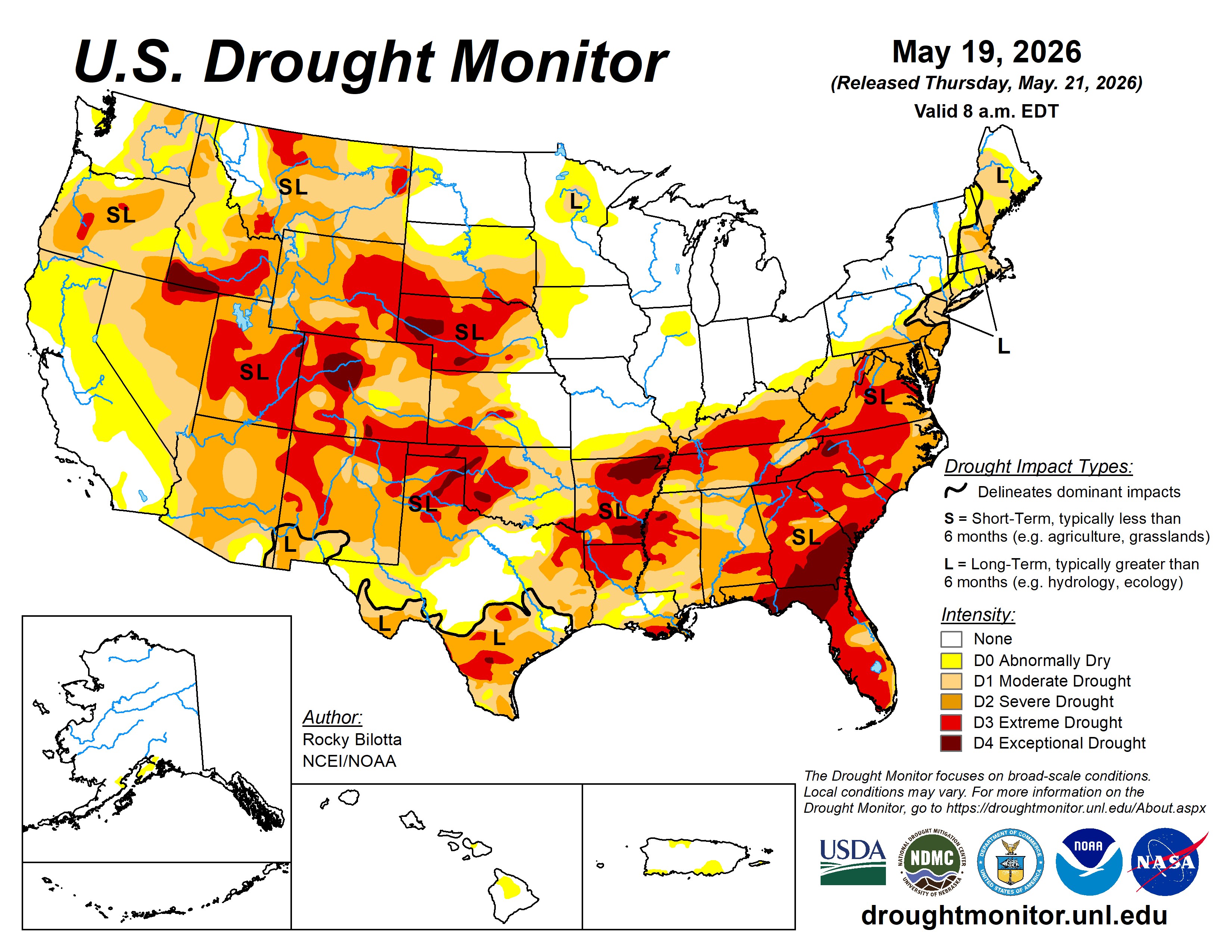
This Week’s Drought Summary
During the week, the contiguous United States exhibited significant regional temperature anomalies driven by a highly amplified synoptic pattern. Early in the period, a pronounced unseasonable cold air mass influenced the Northern Plains, Upper Midwest, and Northeast, depressing temperatures 5°F to 15°F below normal across the Dakotas, Minnesota, New York, and Pennsylvania. Conversely, the Southwest and South Texas experienced anomalous warmth, with maximum temperatures exceeding 90°F and averaging up to 15°F above normal. By the latter half of the week, this warm air mass expanded eastward into the Ohio Valley and Mid-Atlantic, initiating an early-season heatwave with observed maximum temperatures climbing into the mid-80s to low 90s.
Precipitation regimes during this period were characterized by severe convective outbreaks and pronounced moisture disparities. In the early portion of the week, persistent onshore moisture transport resulted in heavy rainfall totals of 4 to 6 inches across the central Gulf Coast, specifically affecting Louisiana, Mississippi, and Alabama. Between May 17 and 18, a powerful frontal system traversing the central United States triggered widespread severe weather across the Great Plains and Midwest. This system produced damaging winds up to 80 mph, large hail, and multiple tornadoes across South Dakota, Nebraska, Iowa, Kansas, and Missouri, alongside localized flash flooding. In contrast, extreme moisture deficits persisted west of the Rocky Mountains, where weekly precipitation totals generally remained under 0.10 inches, further elevating wildfire risk across the southern High Plains…
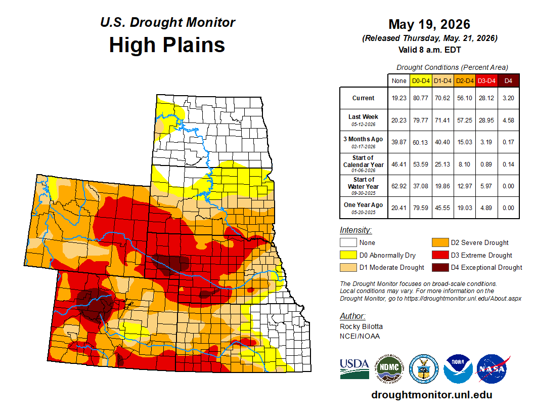
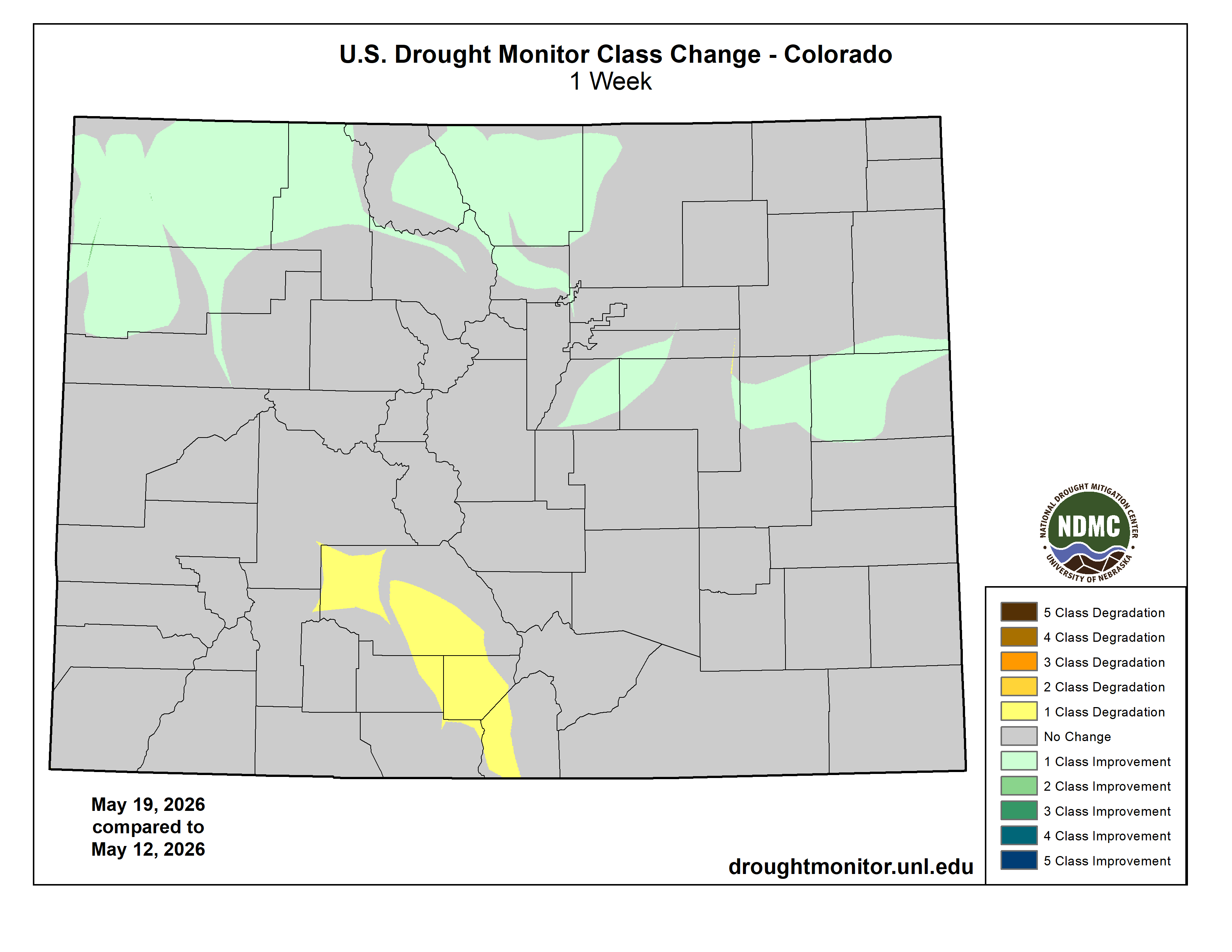
High Plains
Temperatures were above normal across much of the region this week, with average readings ranging from the low 40s along the Canadian border and in the mountains to the mid-70s across southern Kansas. Highly anomalous early-season warmth gripped the southern half of the region. The core of this heat anomaly was centered over Kansas and Colorado, where weekly temperatures soared 6°F to 12°F above historical averages, with localized spots in southern Kansas peaking more than 12°F above normal. This unseasonable warmth extended moderately northward into Nebraska, yielding departures of 3°F to 6°F above average. Conversely, the northern High Plains remained under a more seasonal air mass; North Dakota, South Dakota, and northern Wyoming experienced below-normal conditions, fluctuating within 3°F to 6°F of historical baseline temperatures. Precipitation amounts varied across the region, with extreme dryness across the much of the region and a highly concentrated deluge along the southeastern boundary. Large portions of Wyoming, Colorado, and western parts of North Dakota, South Dakota, Nebraska, and Kansas, reported weekly totals below 0.50 inches, with extensive areas receiving less than 0.10 inches. This lack of moisture resulted in departures of 0.5 to 1.5 inches below average, causing conditions to deteriorate. Extreme (D3) drought expanded in southwestern Kansas and southern Colorado. Severe (D2) in parts of Colorado and northeast Wyoming, while moderate (D1) drought expanded in parts of South Dakota. In powerful contrast, intense convective activity generated a sharp corridor of heavy rainfall across eastern portions of Kansas and Nebraska. Totals in this localized zone rapidly climbed between 2.5 and 5.5 inches, with departures ranging between 1.5 to over 4.5 inches above normal, resulting in improvements to moderate (D1) to exceptional (D4) drought in Nebraska and moderate (D1) to extreme (D3) drought in Kansas. Heavy rainfall also brought improvements to severe (D2) to exceptional (D4) drought in northern Colorado and a reduction of exceptional (D4) drought in southern Wyoming this week…
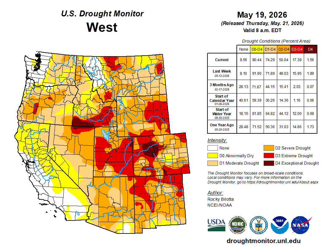
West
Temperatures varied across the region this week, with average readings ranging from the mid-30s and 40s across the northern tier and high elevations to the low 80s in the desert Southwest. In terms of departures from normal, unseasonably cold conditions dominated the northern half of the region, with departures ranging between 3°F and 9°F below normal. In sharp contrast, the southern tier experienced unseasonable warmth. A building ridge over the Southwest drove temperatures in southern California, Arizona, and New Mexico 3°F to 9°F above normal, with eastern New Mexico seeing the greatest extremes. Precipitation across the Western region was characterized by an extreme contrast between a highly active storm track in the Pacific Northwest and aridity across the remainder of the region. Above-normal precipitation was confined to much of Washington, and parts of Oregon and Montana, where weekly rainfall totals ranged between 1.5 to 3.5 inches, with localized totals in the Cascade Range exceeding 4.5 inches. This activity generated substantial departures of 0.75 to over 3.0 inches above normal, justifying moderate (D1) to severe (D2) drought and abnormal dryness (D0) improvements in Washington and northern Idaho, and improvements to abnormal dryness (D0) to northwestern Oregon and western Montana. Conversely, dry conditions persisted across nearly the entire remaining geographic footprint. Widespread areas across California, Nevada, Arizona, New Mexico, and parts of Idaho, Montana, Utah recorded negligible rainfall totals of less than 0.10 inches. Due to the climatological onset of the dry season in parts of the West, this lack of rainfall translated into modest negative departures ranging from near-normal to 0.75 inches below seasonal averages. Nonetheless, deteriorating conditions led to the expansion of exceptional (D4) drought in southern Idaho, and extreme (D3) drought in parts of New Mexico, Arizona, Utah, Montana, and southern Idaho. In addition, severe (D2) drought was expanded in Oregon, Montana, and Arizona, while moderate (D1) drought expanded in parts of Idaho, Montana, Nevada, and Arizona…
South
Below-normal precipitation dominated the South this week. The vast majority of Texas, Oklahoma, Arkansas, Louisiana, Mississippi, and Tennessee received less than 0.10 to 0.50 inches of total rainfall, leaving nearly the entire geographic footprint under exceptionally dry conditions. This lack of rainfall translated into widespread departures ranging from 0.75 to 1.50 inches below normal. Below-normal rainfall totals resulted in the introduction of exceptional (D4) drought in the Oklahoma Panhandle and D4 expansion in parts of Arkansas and Mississippi. Extreme (D3) to severe (D2) drought were expanded in parts of Oklahoma, Arkansas, Mississippi, and Tennessee.
The major exception to this dry regime was concentrated in southern portions of the region, specifically southern Texas, where localized convective storms delivered 1.0 to 3.0 inches of rainfall, resulting in the improvement of extreme (D3) drought in southern portions of Texas, Louisiana, and Mississippi. Temperatures were above normal across much of the region, ranging from the upper 50s and low 60s in Tennessee to the upper 80s in parts of Texas. Looking at departures from normal, a highly anomalous zone of intense warmth gripped the western half of the region, where temperatures averaged 6°F to 15°F above historical norms. Conversely, the eastern tier of the region bucked the western warming trend entirely; Mississippi and Tennessee experienced unseasonably cool conditions, with temperatures suppressing to 3°F to 6°F below normal…
Looking Ahead
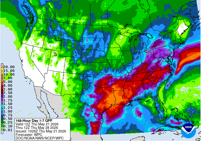
Over the next five days (May 19–23, 2026), the United States can expect a highly dynamic weather pattern characterized by contrasting temperature extremes and widespread storm activity. An early-season heatwave will make headlines across much of the eastern U.S. through midweek, with interior portions of the Mid-Atlantic and the Carolinas seeing highs climb into the lower to middle 90s—warm enough to potentially establish new daily records before a cold front brings cooler relief by Thursday. In stark contrast, the Intermountain West and Rockies will experience below-normal temperatures to start the week, alongside late-season accumulating snow in the higher elevations of Colorado and Wyoming. Meanwhile, a strong cold front tracking across the Plains and Midwest will spark widespread showers and severe thunderstorms. Multiple rounds of heavy rainfall will bring a risk of scattered flash flooding, focusing heavily on Texas, Oklahoma, and Arkansas on Tuesday before an expanded risk of heavy precipitation stretches from western Texas to the central Appalachians on Wednesday.
Further out, the Climate Prediction Center’s 6–10 day outlook (valid May 24–28, 2026) favors above-normal temperatures across most of the United States—stretching from the Rocky Mountains all the way to the East Coast, with the highest confidence for this unseasonable warmth concentrated in the Upper Midwest. Hawaii is also leaning toward warmer conditions. In contrast, temperatures are expected to be colder than average across the state of Alaska, and in a pocket of northwestern Washington state. Meanwhile, near-normal temperatures are forecast in parts of the South and along the West Coast. Probabilities for wetter-than-average conditions favor the vast majority of the country, including Hawaii and portions of Alaska. In the contiguous U.S., this wet weather pattern extends from the Southwest to the East Coast, with the greatest probability of above-normal precipitation expected to be in the south-central U.S., specifically across southern Texas. The West Coast, portions of the Pacific Northwest, the northern Rockies, northern parts of the Midwest, and northern Alaska are favored to receive near-normal precipitation during this time. No areas are favored to be drier than normal.
