Colorado water commissioners declined to upgrade water quality rules for the urban stretch of river, though conservation groups say they are finally being heard.
Public officials, conservation groups and citizen speakers pleaded with the Colorado Water Quality Control Commission [August 9, 2021] to reverse a 2020 decision and strengthen protections for the South Platte River in north Denver and Adams County, but the commissioners declined.
Opponents of the commission’s decision last year thought they had one last chance in a “town hall” feedback format to urge the commissioners to revisit the controversial vote, which rejected a staff recommendation to upgrade the South Platte to higher water quality protections. They pointed to the recent weeks of high heat and air pollution in metro Denver, as well as a new climate change report showing irrefutable and irreversible damage to the environment, as more reasons to protect the river with tougher regulations…
“We cannot wait five more years to upgrade or revisit what’s happening to the communities in north Denver,” said Ean Tafoya, Colorado director of the nonprofit GreenLatinos.
The commissioners, who are appointed by Gov. Jared Polis to oversee the Water Quality Control Division of the Colorado Department of Public Health and Environment, said they would not reverse their 2020 decision now. The coalition favoring more protections said after the town hall they would consider trying to force the commission to reconsider through a petition process, by taking legal action…
The Platte River plods through downtown Denver, a small workhorse with a big load. Photo/Allen Best
But some commissioners appeared to leave the door open to further discussions and to seek more community input on future river decisions…
Those who want to elevate the South Platte’s urban stretches used the commission’s town hall comment period to attack the 2020 decision. The staff of the water quality division last year had recommended that the South Platte River through north Denver and Adams County, long plagued by industrial releases and wastewater effluent, be upgraded to the next higher level of stream protections.
Metropolitan Wastewater Reclamation District Hite plant outfall via South Platte Coalition for Urban River Evaluation
The higher level would have forced existing polluters in that section, like Metro Wastewater, Suncor or Molson Coors, to avoid further degrading water quality with any new activity unless they could prove it was essential to their continuing business. As it stands now, those existing polluters have “protected use” status that permits them to degrade the water, even though water quality in those central urban streams has improved in recent decades.
The Colorado division of Parks and Wildlife, the Environmental Protection Agency, the Adams County Commissioners and others had supported the staff request for a river protection upgrade. The water commissioners rejected the idea last year, and then again in June.
Adams County Commissioner Steve O’Dorisio said he wanted to be frank with the water commissioners that not enough opponents were prepared for the discussion ahead of the 2020 decision.
“Back in 2020 we did not know how this specific decision would affect our river and our communities,” O’Dorisio said.
Jeff Neuman-Lee, describing himself as a citizen speaker for the town hall forum, pointed to Colorado’s air fouled by wildfire smoke and heat-generated ozone in recent weeks.
“We’ve been just degrading our Earth over and over and over again, and we can’t tolerate any more,” he said. “It’s depressing to see that we’re allowing water quality to go unheeded; to create stretches of our rivers and say we don’t care about them, we’re just going to let them go.”
[…]
Sunrise along the Clear Creek Trail August 12, 2021.
Some of Monday’s speakers said they were concerned that leaving the South Platte’s water quality protection where it is now will weaken the current permit renewal process underway for the Suncor refinery, which borders Sand Creek as it empties into the South Platte. The state health department is reviewing and answering public comments on Suncor’s permit application, and conservationists and neighborhood groups want Suncor’s water and air pollution caps cut way back.
“This idea of grandfathered legacy pollution,” Tafoya said, “just because they always have, doesn’t mean they should continue to.”
Officials in Lower Colorado River Basin states want to slow the decline of Lake Mead’s water levels over the next few years by paying Southern California farmers not to plant crops.
It’s not a plan that Bill Hasencamp, manager of Colorado River resources for the Metropolitan Water District of Southern California, considers a “drought buster,” but it will reduce lake level decline by up to 3 feet over the next three years, he said.
The Southern Nevada Water Authority, Metropolitan Water District of Southern California and Central Arizona Water Conservation District have all approved an agreement for the plan. The U.S. Bureau of Reclamation has not yet signed the agreement, but Hasencamp said additional water is already being saved in the Palo Verde Irrigation District in Southern California.
The program comes as the Lower Colorado River Basin braces for the first federally declared water shortage in Lake Mead, a determination that should come Monday when the Bureau of Reclamation releases water level projections.
Under existing river agreements, Nevada, Arizona and Mexico will take cuts to their allocations of water next year…
The farms of the Palo Verde Valley draw water from the Colorado River. Visual: Dicklyon / Wikimedia Commons
Building on existing program
The new agreement between the federal government and water agencies in California, Nevada and Arizona builds on a 2004 agreement between the Metropolitan Water District and Palo Verde Irrigation District.
The original agreement allows the water district to pay farmers in the Palo Verde Irrigation District to temporarily not plant crops on portions of land. Water saved by not irrigating that farmland is then made available for urban use in Southern California.
Because the Metropolitan Water District’s water reserves are so high, the existing program is now operating at the minimum level outlined in the agreement, Hasencamp said.
That presented an opportunity to use the remaining capacity of the program to benefit Lake Mead. Hasencamp said he approached the other agencies participating in the program in May.
The Metropolitan Water District will continue to get water from Palo Verde at the minimum level outlined in the original agreement, but the difference between that and the total water savings under the new agreement will be banked in Lake Mead to slow the decline of water levels.
The federal government will pay for half of the program cost under the new agreement, with the three water districts splitting the rest.
Officials estimate the program could keep up to 180,000 acre-feet — equal to 60 percent of Nevada’s annual river water allocation — in the lake…
Lower Basin cooperation
Part of the significance of the agreement is the Palo Verde Irrigation District’s willingness to contribute some of its water to Lake Mead, said Chuck Cullom, manager of Colorado River programs for the Central Arizona Project…
Palo Verde will not contribute any more water than the maximum amount that was outlined in the original 2004 agreement.
Those gamboling across the tundra of Colorado’s high mountains this summer have been posting photographs of prolific wildflower displays to social media sites.
But what all has been happening up there beyond the dazzle?
It’s been warming, of course, like all other places. Research published in June has found that warming temperatures are causing plants to stay green longer and flower earlier. But their reproductive cycles are not responding in the same way.
A research team at the University of Colorado Boulder synthesized 30 years of experimental warming data from 18 different tundra sites, both in Arctic and Alpine areas, across the globe. What they found confounded simplistic explanations.
“This research shows how difficult it is to make broad-scale predictions about what’s going to happen with global climate change, because even with 30 years of data at 18 sites, there’s still very complex responses that are happening,” said Courtney Collins, a postdoctoral researcher in the Institute of Arctic and Alpine Research at CU Boulder and the lead author of the study that was published in Nature Communications.
The research included studies on Niwot Ridge, located in the Front Range of Colorado northwest of Boulder.
“The tundra is warming much more rapidly than other parts of the world. In some places, it’s happening at twice the rate of warming (of the rest of the globe), and so these changes are occurring extremely fast and they’re happening as we speak,” said Collins in a story issued by the university.
Warming of Arctic areas of permafrost had long worried climate scientists. As the Washington Post noted in a story this week, they call it the “methane bomb.” They worry about melting of the vast permafrost in Siberia. Photo credit: Peggy Williams via Big Pivots
“What we do know with quite a lot of confidence is how much carbon is locked up in the permafrost. It is a big number, and as the Earth warms and the permafrost thaws, that ancient organic matter is available to microbes for microbial processes, and that releases CO2 and methane,” said Robert Max Holmes, a senior scientist at the Woodwell Climate Research Center.
Holmes was consulted by the Washington Post’s Steven Mufson after a new report was published in the Proceedings of the National Academy of Sciences about a surge of methane emissions from Siberia’s permafrost. This was a different source than expected. Thawing wetlands release microbial methane from the decay of soil and organic matter. Thawing limestone – or carbonate rock – releases hydrocarbons and gas hydrates from both below and within the permafrost.
This is from Big Pivots 43. For subscription information click here.
Surface temperatures during the heat wave in Siberia had soared to 10.8 degrees Fahrenheit above the norms of the 20th century.
Holmes, the scientist, called the finding intriguing. “It’s not good news if it’s right. Nobody wants to see more potentially nasty feedbacks, and this is potentially one.”
In Colorado, temperatures have been rising for decades. A study conducted since the 1980s at the Rocky Mountain Biological Laboratory near Crested Butte has attempted to predict the future of mountain meadows with rising temperatures. The bottom line: more sagebrush, fewer wildflowers.
Also at Gothic, site of the outdoor laboratory, David Inouye studied wildflower blooms for decades. In 2014, he reported results of his 39 years of study. More than two-thirds of alpine flowers had changed their blooming patterns, he found. The blooming season that had formerly run from late May through early September now lasts from late April to late September.
The spring peak, when masses of wildflowers burst into bloom, had moved up by five days per decade, he found.
After almost two years of a horrific pandemic that’s killed almost 620,000 Americans and deadly, faster-spreading variants emerging because selfish and ignorant people refuse to get vaccinated — those of us who have tried to do everything right have no more f**ks left to give.
Anti-vaxxers, COVID conspiracy theorists and right-wing politicians have made the pandemic far more hellacious than it ever needed to be. We have been lectured endlessly by pundits and attention seekers on social media that we musn’t ever make them feel bad about their awful choices — no matter how many public, violent scenes they cause over health rules, heavily armed protests they organize to intimidate us and how much the death toll soars.
Their feelings have been deemed more important than the health and well-being of our families, because somehow if we kowtow to the worst people in our society, a few will supposedly be nice enough to get vaccinated or wear masks.
Nope.
Knuckle-draggers do not deserve veto power over our safety. The only way we will make COVID an occasional nuisance instead of a mortal threat to everyone’s health is with vaccine mandates for everything from school to concerts to travel.
–
If you refuse to get vaccinated — and this goes double if you are someone with enough of a platform to influence others — you are to blame for the fourth wave. You are the reason why more children are being hospitalized, so spare me your family values bloviation. You are why good people who have done their part and gotten their shots are getting breakthrough cases.
I am tired of sugarcoating it. I am tired of the perennial hectoring to “both sides” the pandemic like we mindlessly do with political coverage.
GET THE MORNING HEADLINES DELIVERED TO YOUR INBOX
The 40% who can’t be bothered to get jabbed because they know more than doctors or they understand freedom better than the rest of us or just know that the magnetic 5G is gonna be injected in their veins are why people continue to needlessly die. And they are why life continues to be hell for the rest of us.
Yes, there is a political divide in vaccination rates — and Republicans are on the wrong side of it. Let’s stop denying the obvious or making excuses for a party whose pandemic response has been a mix of crass pandering to their base and sociopathic stupidity.
For almost a year and a half, most of us have stayed home as much as we could, helped our neighbors, homeschooled our children, faithfully worn masks and gotten our shots when it was our turn. Health care workers, in particular, have seen the most unfathomable human suffering, been forced to isolate from their families and have desperately pleaded with people to follow simple health rules and get vaccinated so that we can put COVID-19 behind us.
We were promised that by sacrificing, working hard and playing by the rules, we could put an end to mass death and finally get back to some of the things that bring us joy: having parties, going to festivals, traveling beyond our backyards and more.
But the dream of post-COVID normalcy is fading fast as Delta and other variants have ripped through our country, even infecting some of the vaccinated.
That’s also threatening our economic recovery, which is why you’re seeing corporate America step up with major companies like Walmart and Google finally issuing vaccine mandates.
Let’s be clear. Vaccine passports should have been mandatory from the jump. Counting on people to do the right thing has worked for most people during the pandemic — but there are millions who have proven they could care less about keeping others — or even themselves — alive.
But it seems to be in our DNA as Americans to cower in the face of an angry (white) minority, and so President Biden and many Democratic politicians were convinced that mandates wouldn’t work. Of course, even efforts by Michigan Gov. Gretchen Whitmer and other leaders to essentially bribe people into getting vaccinated with lottery-style raffles were deemed by Republicans as slightly less offensive than critical race theory.
Yes, there is a political divide in vaccination rates — and Republicans are on the wrong side of it. Let’s stop denying the obvious or making excuses for a party whose pandemic response has been a mix of crass pandering to their base and sociopathic stupidity.
–
Knuckle-draggers do not deserve veto power over our safety. The only way we will make COVID an occasional nuisance instead of a mortal threat to everyone’s health is with vaccine mandates for everything from school to concerts to travel.
How did we get to a point where the proudly ignorant wield this much power, anyway?
Well, in my more than 20-year career in journalism, there has been one constant: You are never, ever to make people who are loudly anti-intellectual, knowingly spew lies and publicly pat themselves on the back for it, feel dumb. That is the sin of elitism and there is nothing worse, you see. Even casting the argument in positive terms, like lauding the value of higher education, is considered looking down on nice folks who insist that the Earth is flat and their theories should command the same respect as those of Galileo.
We’re told there’s nothing worse than living in liberal bubbles (even though those in the media and on the left are obsessed with trying to understand red state America). But you know what? Living in a blue enclave is a pretty great way to survive a plague. Nobody yells at you for wearing a mask at the gas station. Schools actually care about our kids’ safety. Officials aren’t trying to score political points off of our misery.
And so when I have taken publications to task for knowingly printing lies about COVID-19, particularly from GOP leaders who know exactly what they’re doing, the reaction is always dreadfully boring. A seasoned journalist (read: white and male) takes it upon himself to lecture me that I know nothing of journalism (even though I’ve run two publications and they typically have run none), and people must be trusted to make up their own minds and sift between facts and B.S.
How’s that working out as we’re facing another fall and winter trapped in our homes as unvaccinated-propelled variants crash across the country?
After this much unneeded agony, I’m done coddling the craven and crazy. And I know I’m not alone.
SUPPORT NEWS YOU TRUST.
Colorado Newsline is part of States Newsroom, a network of news bureaus supported by grants and a coalition of donors as a 501c(3) public charity. Colorado Newsline maintains editorial independence. Contact Editor Quentin Young for questions: info@coloradonewsline.com. Follow Colorado Newsline on Facebook and Twitter.
Click here to read the discussion and for the figures:
CLIMATE PREDICTION CENTER/NCEP/NWS
and the International Research Institute for Climate and Society 12 August 2021
ENSO Alert System Status: La Niña Watch
Synopsis: ENSO-neutral is favored for the remainder of summer (~60% chance in the July- September season), with La Niña possibly emerging during the August-October season and lasting through the 2021-22 winter (~70% chance during November-January).
Recently, sea surface temperatures (SSTs) were near-to-below average in the central and east- central equatorial Pacific, with above-average SSTs in the far eastern Pacific. In the last week, most Niño indices were slightly negative (-0.2oC to -0.3oC) except for the Niño-1+2 index, which was +0.7oC. Subsurface temperatures cooled considerably in July, becoming quite negative (averaged from 180-100oW, reflecting the emergence of below-average subsurface temperatures east of the DateLine. Low- level wind anomalies were easterly over the east-central Pacific Ocean, while upper-level wind anomalies were westerly across the eastern Pacific. Tropical convection was suppressed over the western Pacific Ocean and enhanced over a small region near Indonesia. Given the surface conditions, the ocean-atmosphere system reflected ENSO-neutral.
Compared to last month, forecasts from the IRI/CPC plume are generally cooler in the Niño-3.4 SST region during the fall and winter 2021-22. Recent model runs from the NCEPCFSv2 and the North American Multi-Model Ensemble suggest the onset of a weak La Niña in the coming months, persisting through winter 2021-22. The forecaster consensus continues to favor these models, which is also supported by the noticeable decrease in the observed subsurface temperature anomalies this past month. In summary,ENSO-neutral is favored for the remainder of summer(~60% chance in the July-September season), with La Niña possibly emerging during the August-October season and lasting through the 2021-22 winter (~70% chance during November-January; click CPC/IRI consensus forecast for the chances in each 3-month period).
I keep hearing Klaus Wolter’s warning from 2011, “Beware a second year La Niña.”
Click on a thumbnail graphic to view a gallery of drought data from the US Drought Monitor.
US Drought Monitor map August 10, 2021.
High Plains Drought Monitor map August 10, 2021.
West Drought Monitor map August 10, 2021.
Colorado Drought Monitor map August 10, 2021.
Click here to go to the US Drought Monitor website. Here’s an excerpt:
This Week’s Drought Summary
Monsoonal moisture was squelched this week, in contrast to the heavy rainfall that had been pelting the southern Rockies and – to a lesser extent – much of the interior West. Totals between 1 and 2 inches were limited to a few patches in southeastern Arizona, central and south-central New Mexico, and scattered higher elevations in central Colorado and central Montana. West of the Plains, only part of northwestern Montana and northwestern Washington saw fairly widespread amounts of 1.5 to locally 3.0 inches. Farther east, significant rainfall evaded most areas of dryness and drought from the Plains to the Atlantic Seaboard, with a few dramatic exceptions. Most of interior Wisconsin recorded 2 to 5 inches of rainfall from north of Milwaukee into far southeastern Minnesota. Moderate to heavy rains were not as widespread elsewhere, with amounts exceeding an inch covering relatively small areas. The scattered areas of heavy rain included northeastern and part of southern North Dakota, northeastern South Dakota, a few areas from central Minnesota southward into central Iowa and southeastern Nebraska. Similarly, widely-scattered areas of 1 to locally 3 inches dotted the Midwest, lower Ohio Valley, central and southern Appalachians, and northern New England. But most of these regions recorded light precipitation, and other areas of dryness and drought across the contiguous states saw little or no precipitation. As a result, dry areas in the western Great Lakes region experienced significant improvement, but otherwise improvement was limited to relatively small, scattered areas where the heavy rains fell. Increased drought coverage and intensity was more common, as a large majority of these areas recorded light precipitation at best. Crops have been damaged by the lack of precipitation, with spring wheat and barley most significantly impacted. In primary producing states, 46 percent of the barley crop was in poor or very poor condition, compared to only 4 percent at this time last year. Similarly, about 60 percent of spring wheat in the primary producing states was in poor or very poor condition, compared to 7 percent at this time last year…
Similar to some other regions, small scattered areas of heavy rain induced localized improvement, but most areas received little rainfall at best, leading to increasing moisture deficits and thus expansion and intensification of dryness and drought. Some improvement was noted in southwestern North Dakota, but much broader areas of deterioration were observed across eastern North Dakota and many areas from South Dakota through Nebraska and Kansas. Drought intensities of D3 and D4 now cover large portions of the Dakotas. Limited precipitation fell on Colorado and Wyoming, but decreased impacts and localized moderate rains led to 1-category improvements in central Colorado and southwestern Wyoming…
Colorado Drought Monitor one week change map ending August 10, 2021.
Little or no precipitation fell on most of the region, and drought intensity remained unchanged from last week in most areas. Some improvement from recent monsoonal rains were introduced in southern Utah while conditions deteriorated in central Washington and a few isolated patches in northern Utah, western California, and northern Oregon. Crops in Washington have suffered because of the drought, with 93 percent of their spring wheat and 66 percent of barley in poor or very poor conditions. The dryness, exacerbated by periods of intense heat, has led to the rapid development and expansion of wildfires. The Dixie Fire in northern California has scorched hundreds of thousands of acres, making it the second-largest fire in the state’s history. Fires in the western half of the contiguous states (including Colorado and Wyoming) have burned, on average, 30 square miles of total area every day since early June – an area approaching half the size of Washington, DC…
Areas of dryness and drought remained restricted to a few relatively small areas, but coverage increased from last week, and surface moisture depletion was exacerbated by abnormally hot weather. New or expanded patches of D0 dotted Tennessee, Oklahoma, and Texas, with broader D0 coverage introduced in central and northeastern Arkansas. Dry conditions are relatively short-lived in this region, but the hot, dry weather is quickly depleting soil moisture, and the region could see more substantial expansion and intensification of dryness as August progresses. A small area of moderate drought was introduced within the D0 in the eastern Red River Valley where 60-day precipitation totals were under half of normal…
Looking Ahead
During the next 5 days (August 12 – 16, 2021) should see a resurgence of monsoonal moisture in the southern Rockies. Generally 1.5 to locally over 4.0 inches are forecast in the southeastern quarter of Arizona, the southern half of New Mexico, and part of northwestern Texas, with moderate rain expected in adjacent areas. Farther east, 1.0 to 3.0 inches of rain are expected from the North Carolina mountains into central Virginia, with isolated larger totals in the higher elevations. Moderate to heavy rains (1 to 2 inches) are anticipated in a swath from central Kansas into the southern Great Lakes Region, and across western Pennsylvania. Light to locally moderate rainfall (0.5 to 1.5 inches) should fall in northernmost New England, and in a broken pattern from northern Arkansas through the Middle Ohio Valley. Other areas in the central Plains and the lower Mississippi Valley can anticipate light to locally moderate rainfall. Little if any precipitation is forecast from the western Great Lakes Region across the northern half of the Rockies to the entire length of the West Coast, and over most of central and southern Texas. Temperatures will be near or above normal through most of the contiguous states, particularly from the central and northern Plains westward, where many locations could average 6 to 10 degrees F above normal. The only area expecting subnormal readings are the southern halves of Arizona and New Mexico, where unusually heavy precipitation will keep daytime highs 3 to 9 degrees F below normal.
The CPC 6-10 day extended range outlook (August 17 – 21, 2021) favors subnormal rainfall from the Northeast into the central Great Lakes Region, and southward into the Middle Atlantic Region. Dryness is also favored – though with lower confidence – in southern Texas, and from the Great Basin to the Oregon and lower Washington coasts. Enhanced chances for surplus rainfall cover a broad area across the Rockies, Plains, lower Ohio Valley, part of the lower Mississippi Valley, and the southeastern quarter of the country. Odds also favor above-normal precipitation in the areas of dryness and drought across Alaska. Meanwhile, warmer than normal weather is expected from the central and northern Plains eastward into the Middle Atlantic Region and Northeast to the Atlantic Coast. Chances for abnormal warmth top 70 percent from the northern half of the Great Lakes Region through New England, topping 80 percent in Maine and adjacent Vermont and New Hampshire. Increased chances of warmth also cover the Gulf Coast Region, southern Texas, and northern California. In contrast, mild conditions are favored in the Pacific Northwest, the Southwest, much of the Rockies, the southern High Plains, and across the Carolinas and much of Georgia.
US Drought Monitor one week change map ending August 10, 2021.
The news in the blockbuster IPCC Climate Change report has the head of the United Nations calling it “A code red for humanity,” with grim and wide ranging predictions. In Colorado, climate science has been talked about for decades with effects being felt in the colder altitudes and warmer cities.
It’s been tangible in recent summers with poor air quality caused by fires which experts say are being worsened by climate change…
In the mountains, there’s a very visible effect at times.
“Climate change is the biggest force that’s going to affect our business and it’s an existential threat,” said Auden Schendler, senior vice president of sustainability for Aspen Skiing Company. “We’ve lost a month of winter since 1980. This is just measured on the ground here.”
As averages rise so do extremes. More record heat and more problematic drought. A warmer atmosphere evaporates more moisture. Drier mountains mean more forest fire danger.
“Right now people can’t get to Aspen because Glenwood Canyon is closed because of fires which the climate scientists told us would happen and then floods and runoff which the scientists told us would follow,” said Schendler. “The thesis historically was that people will, in a climate change world, would want to escape, say Denver where it’s 100 degrees, to come to the mountains, but last night I woke up choking because of that dense smoke here.”
“The fixes to these problems are not impossible, we know how to solve climate we’ve got the technology we’ve got the policies on the shelf, we can deploy them it’s going to be way, way cheaper to do that than to continue to see the kinds of catastrophes we’re seeing.”
The ski industry itself profits from people travelling great distances, for the most part using fossil fuels.
“Skiers didn’t say, ‘Hey get me to the ski resort in the most damaging way possible,’” he said. “The answer is this isn’t your fault, because you drive an SUV, the answer is there’s a systems problem and we’re going to fix it systematically and we have the technology to do it.”
Former U.S. Sen. Ken Salazar of Colorado was unanimously confirmed by the U.S. Senate as the new ambassador to Mexico.
“Colorado is proud that one of our great statesmen will be representing the United States in Mexico,” Gov. Polis said in a press release Wednesday morning. “Ken Salazar was confirmed this morning by the United States Senate as Ambassador to Mexico. I congratulate my good friend Ambassador Salazar on his confirmation and look forward to working with him to expand our economic and cultural ties between Mexico and Colorado.”
GET THE MORNING HEADLINES DELIVERED TO YOUR INBOX
Salazar was the first Latino elected to statewide office in Colorado when he was elected as the Colorado attorney general in 1998. Salazar also served in the U.S. Senate, representing Colorado from 2005 until 2009, when he retired from the Senate after being nominated by former President Barack Obama to serve as the secretary of the Interior Department.
Salazar, a fifth-generation Coloradan, was born in Alamosa and raised on a family ranch. Salazar joined WilmerHale, a law firm with a branch in Denver, in 2013, according to the WilmerHale website.
On June 15, President Joe Biden announced Salazar and eight others as the ambassadors that he would submit to the Senate for confirmation. Both Colorado Sens. Michael Bennet and John Hickenlooper supported Salazar’s nomination.
“Ken Salazar is an exceptional leader who has served Colorado and our country at the highest levels. As ambassador to Mexico he will revitalize the relationship with a neighbor, ally, and one of our biggest trading partners,”Hickenlooper said in a press release on June 15.
“President Biden has made a terrific choice in nominating Ken Salazar as the next Ambassador to Mexico,” Bennet said in the same press release. “Ken is a tremendous public servant with a strong record of bipartisanship in the United States Senate. He has always led with integrity, and I have great confidence in his ability to represent the United States.”
An ambassador is the U.S. president’s representative to a country, and normally leads the embassy in the country he or she is the ambassador to, according to the National Museum of American Diplomacy website.
SUPPORT NEWS YOU TRUST.
Colorado Newsline is part of States Newsroom, a network of news bureaus supported by grants and a coalition of donors as a 501c(3) public charity. Colorado Newsline maintains editorial independence. Contact Editor Quentin Young for questions: info@coloradonewsline.com. Follow Colorado Newsline on Facebook and Twitter.
Utilities with goals of producing 100 percent renewable energy in Colorado must figure out how to reliably deliver electricity when relying upon resources, primarily wind and sunshine, that aren’t always reliable.
The answer may lie in water, and some of that water may come from Colorado’s Yampa River.
Colorado’s two largest electrical utilities, Xcel Energy and Tri-State Generation and Transmission, are talking about the potential for green hydrogen and other possible storage technologies associated with their existing coal-fired power plants, at Hayden and Craig, in the Yampa Valley. Both plants are scheduled to shut down, with Hayden slated to close by 2028 and Craig by 2030.
Duane Highley, the chief executive of Tri-State, told member cooperatives in a meeting Aug. 4 that Tri-State and the State of Colorado have partnered in a proposed Craig Energy Research Station.
Hydrogen has been described as the missing link in the transition away from fossil fuels. It can be produced in several ways. Green hydrogen, the subject of the proposal at Craig, is made from water using electrolysis. The oxygen separated from the H2O can be vented, leaving the hydrogen, a fluid that can be stored in tanks or, as is in a demonstration project in Utah, in salt caverns. The hydrogen can then be tapped later as a fuel source to produce electricity or, for that matter, put into pipelines for distribution to fueling stations.
How much water will be required to produce green hydrogen isn’t clear. But the Yampa Valley’s existing coal-fired plants have strong water portfolios that could be used to create green hydrogen or another storage technology called molten salt. The latter is the leading candidate at the Hayden plant, co-owned by Xcel Energy and its partners.
Craig Generating Station in 2021 is projected to use 7,394 acre-feet of water, according to a Tri-State filing with the Colorado Public Utilities Commission. By 2029, the last year of coal generation at Craig, Tri-State projects water use will decline to 4,270 acre-feet.
Xcel Energy also has water rights associated with its somewhat smaller two-unit Hayden Generating Station.
When Tri-State first announced last year its plans to close its coal units, some hoped the utility would allow the water to continue downstream, aiding fish and habitat in the Yampa Valley. The Yampa, arguably Colorado’s least trammeled river, since 2018 has been plagued by drought. In early August, water managers placed a call on the middle section of the Yampa River for only the third time ever.
Western Resource Advocates, which works in both energy and water, has supported the green hydrogen proposal. But there’s also hope that a water dividend will still be realized in this transition, resulting in more water available for the Yampa, which is a major tributary to the Colorado River.
“If we do it right, we have the chance to equitably share the impacts and solutions to climate change all across Colorado and the West, with benefits for communities, economies and the environment,” says Bart Miller, director of the Healthy Rivers Program for Western Resource Advocates.
Green hydrogen, similar to wind and solar in the past, has a cost hurdle that research at Craig, if it happens, will seek to dismantle. The federal government’s Energy Earthshots Initiative announced in June hopes to drive the costs down 80% by the end of the decade. That is the program in which Tri-State hopes to participate.
Tri-State’s Highley suggested at the meeting last Thursday that the Craig site should swim to the top of the proposals, because it is an existing industrial site, and the Craig and Hayden units also have high-voltage transmission lines. This is crucial. Those lines dispatch electricity to the Front Range and other markets but they can also be used to import electricity from the giant wind farms being erected on Colorado’s Eastern Plains as well as solar collectors on rooftops and in backyards.
In addition, Craig and Hayden have workforces that, at least in theory, could be transitioned to work in energy storage projects.
Western Resource Advocates, in a June 30 letter to the Department of Energy, made note of that consideration. “A green, zero-carbon hydrogen project at Craig Station is an opportunity to demonstrate how the clean energy transition can also be a just transition for fossil fuel-producing communities,” said the letter signed by Erin Overturf, the Clean Energy Program director.
Several state agencies will likely play a role, said Dominique Gomez, deputy director of the Colorado Energy Office, including the Office of Just Transition that was established in 2019 and the Office of Economic Development and International Trade.
Craig Station in northwest Colorado is a coal-fired power plant operated by Tri-State Generation & Transmission. Photo credit: Allen Best
At Craig, the vision is “to provide researchers access to the key resources necessary to perform their research, including water, transmission and site space,” Tri-State spokesman Mark Stutz said in an e-mail. “As the initial step, Tri-State and the state plan to engage a group of stakeholders to facilitate the development of the center.”
The Department of Energy has not indicated when it expects to announce the finalists or grant funding.
Hayden Station. Photo credit: Allen Best/The Mountain Town News
At Hayden, where the coal units are scheduled to close in 2028, Xcel Energy says it is in the early stages of studying potential for molten salt, the leading energy storage technology at this time, but also green hydrogen.
Water use will depend upon the size of the projects, said Xcel representative Michelle Aguayo in a statement. “It’s important to remember the amount of water used in power generation in Colorado is relatively small, representing 0.3% of water diversion in the state.”
Xcel already participates in a hydrogen pilot project in Minnesota, its home state for operations, and has proposed natural gas plants in North Dakota and Minnesota that are to be designed to use hydrogen technology when it becomes viable and cost-effective.
“As we’ve said before, we’re focused on identifying and exploring technologies that will allow us to bring our customers carbon-free energy by 2050, technologies that are not available or cost effective today,” she said.
Long-time Colorado journalist Allen Best publishes Big Pivots, an e-magazine that covers the energy and other transitions in Colorado. He can be reached at allen@bigpivots.com and allen.best@comcast.net
Photo: DNR Director Dan Gibbs, Gov. Polis, CWCB Director Rebecca Mitchell, Colorado River District General Manager Andy Mueller at Elkhead Reservoir. Photo credit: Colorado Water Conservation Board
From email from the Colorado Water Conservation Board:
The Colorado River District and the Colorado Water Conservation Board (CWCB) announced a partnership to release up to 677 acre-feet of water from Elkhead Reservoir to provide relief to farmers and ranchers in the Yampa Valley impacted by severe drought conditions.
Governor Polis announced this partnership during the Northwest Drought Tour – a two-day event that brought state officials and decision makers through Steamboat Springs and Craig to see first-hand impacts of drought on agriculture and other industries, and to find collaborative solutions and resources for the region.
The Yampa River Basin is one of many in Western Colorado suffering the effects of increasing temperatures, decreasing precipitation, and soil aridity, adding pressure to an already limited water supply.
“I am proud that the Colorado River District and the Colorado Water Conservation Board are doing their part by releasing 677 acre-feet of water from Elkhead Reservoir to local farmers and ranchers free of charge. Northwest Colorado continues to face exceptional drought conditions, with hot temperatures, dry soils, and reduced runoff, which impacts farmers and ranchers,” said Governor Polis. “Partnerships like this one showcase how collaboration and working together can help find local solutions. My administration will continue to work with local and federal entities to assist Coloradans as we navigate this systemic drought’s impact on our agricultural economy and local communities.”
The Colorado River District recently coordinated with the Division of Water Resources in an effort to postpone restrictions or a “call” on the Yampa River with releases from the District’s 2021 Yampa River Flow Pilot Project at Elkhead Reservoir. However, with water flows in the basin remaining low and water demands consistent, there is still the potential for future restrictions or “calls” in the Yampa River Basin.
In advance of this forecast, the River District initiated a financial partnership with the Colorado Water Conservation Board (CWCB) to provide supplemental water for agricultural producers in the Yampa River Basin.
“We are attempting to free up all available resources through innovative partnerships in the face of this ongoing drought,” said Colorado River District General Manager Andy Mueller. “This hotter, drier climate is hitting the small family farms and ranches along the Yampa River hard. We’re taking quick action to protect our constituents and the communities relying on these farmers and ranchers across the basin and the state.”
The agreement with CWCB will allow the River District to provide water to local agricultural stakeholders on a first-come, first-serve basis in Irrigation Year 2021, specifically for crop and/or livestock production. Through the CWCB, the state will provide the financial support necessary to pay for the stored water in Elkhead Reservoir for late season use by ranchers and farmers who depend on the Yampa River for irrigation and watering their livestock.
“As we continue to see compounded drought years that impact all Coloradans, including our agricultural producers, it is critical that we work together on collaborative solutions to meeting our future water needs,” said CWCB Director Rebecca Mitchell. “We are proud to support the Colorado River District in their efforts to provide additional water to the Yampa Valley farmers and ranchers in need.”
Available water through the Elkhead Reservoir release is limited, however, and therefore is available on a first-come, first-serve basis. Those interested in applying should contact the Colorado River District’s Director of Asset Management, Hunter Causey, at hcausey@crwcd.org.
Yampa River at the mouth of Cross Mountain Canyon July 24, 2021.
Conceptual framework, on the San Juan. Photo: Brent Gardner-Smith/Aspen Journalism
From email from Reclamation (Susan Novak Behery):
In response to decreasing flows in the critical habitat reach, the Bureau of Reclamation has scheduled an increase in the release from Navajo Dam from 700 cubic feet per second (cfs) to 800 cfs for THURSDAY, August 12th, starting at 4:00 AM. Releases are made for the authorized purposes of the Navajo Unit, and to attempt to maintain a target base flow through the endangered fish critical habitat reach of the San Juan River (Farmington to Lake Powell).
The San Juan River Basin Recovery Implementation Program recommends a target base flow of between 500 cfs and 1,000 cfs through the critical habitat area. The target base flow is calculated as the weekly average of gaged flows throughout the critical habitat area from Farmington to Lake Powell.
While recent monsoonal moisture has been a welcome relief for drought-stricken North Fork Valley, residents in Hotchkiss need to continue to conserve water. That message came late during a special water work session held by the town council last week.
“I would think that we’re going to keep our water restrictions at this point and time”, said Mayor Larry Wilkening. “I think the rains that have been coming through are great, but until we get snow pack and rain and maybe two years worth of good water then I think we need to have them.”
The water work session was scheduled to help the town council get a better grip on how Hotchkiss water works and to sort out how they should handle ongoing out-of-town water tap requests.
Mayor-Pro tem Mary Hockenbery requested the water work session last month in the absence of the mayor saying she’d like to have some kind of guidelines for issuing out-of-town water taps…
Fagan and Public Works Director Mike Owens provided the council with a detailed overview of the town’s water system including the town’s raw water supply and demand, water transmission, treatment, storage, distribution and future water challenges.
Fagan showed a map of the water system overview beginning with the raw water supply primarily coming from the Carl Smith Reservoir north of Hotchkiss and then flowing into the Leroux Creek in the Leroux Creek Watershed.
The raw water flows in Leroux Creek to the Highline Canal where the town diverts the water through a sand trap and then to a pipe that carries water to the pre sedimentation ponds above the water treatment plant, Fagan said.
After the water settles, it flows to the water treatment plant where a microfiltration system is used year round to screen out all particles larger than one micron. According to Fagan’s slide presentation, during the warmer months the water is pre-treated with a coagulant, flocculated and settled in clarifiers before running through microfiltration modules…
Fagan said while the town treats water for Rogers Mesa it does not supply the raw water. Paul Schmucker, water commissioner, discussed the town’s water rights and how they affect future usage and storage. There was also a lengthy discussion on the town’s bulk water system usage. Fagan explained that the bulk system is a fraction of the town’s water usage.
A longer walk from the dock to the water is in store for boaters at the Elk Creek marina, Blue Mesa Reservoir. Blue Mesa is being drawn down to feed critically low Lake Powell, as continued dry weather and rising demand deplete the Colorado River. (Courtesy photo/National Park Service) via the Montrose Daily Press
“The inescapable truth is that the Colorado River system is seeing declining flows and for the foreseeable future, is likely to continue on that trend. So we have to adjust expectations and water use accordingly,” [Andy Mueller] said…
Year after year of dry conditions hammered the river and, this year, dropped Powell so low that Blue Mesa Reservoir and others in the Upper Basin had to release water to keep Powell’s power turbines turning.
“It’s our water balance. Last year and this year have been terrible,” said Anne Castle, former assistant Secretary of the Interior for Water and Science during the Obama Administration, during an Aug. 5 webinar hosted by the Colorado River District. Castle is currently senior fellow at the Getches-Wilkinson Center for Natural Resources, Energy and the Environment at the University of Colorado law School…
Given climate science predictions, the poor water years have not been a surprise, she said — but Powell dropped 50 feet last year, equating to 4 million acre feet of water no longer available. The reservoir is projected to drop within six months to the dreaded 3,525 feet elevation, the baseline for power generation and meeting the river compact requirements…
On top of it, the compact prohibits the Upper Basin from depleting more than 75 million acre feet over 10 years (so that it can deliver an average of 7.5 million acre feet a year to the Lower Basin)— a “guarantee,” as far as the Lower Basin sees things, while the Upper Basin’s perception is Lower Basin states are vastly overusing their water.
Under that rolling 10-year average, the Upper Basin has delivered 92 million acre feet, which is well above its obligation, but that is projected to drop to 82 million over 10 years and, if poor hydrology continues, could plunge even further, which stands to put the Upper Basin below its obligations…
Lake Powell not only provides a “savings account” to meet the Upper Basin’s compact obligations, but generates hydropower that is used throughout the basin, [Steve] Wolff said.
That hydropower in turn generates revenue, which flows back to the Upper Basin for infrastructure, Endangered Species Act compliance programs and salinity control…
Changing the rules will have ripple effects on both users and the economy, she said. Although the Upper Basin sees overuse by the Lower, the Lower Basin says it has cut use; is doing what the compact allows, and that the Upper does not have a plan for demand management, [Castle] also said.
“Everyone’s got their grievances and their legal theories. … There’s not enough water for any of the lawyers to be right 100%,” Castle said.
The task is to equitably manage use — and that means reducing it, she said.
Powell is sitting at 32% full and Mead, at 35% full, Mueller said…
The Colorado River Compact accords to the Lower Basin an additional 1 million acre feet. The Upper Basin’s argument is that this is supposed to account for use from the Gila River, a tributary. The 1.5 million acre feet to Mexico under treaty is to be provided from surplus, unless there is a shortage on the river.
What constitutes a shortage is a point of contention between Upper and Lower Basin states, but Mueller said it’s the Upper Basin’s position that the Lower Basin is undercounting its consumptive use.
The Upper Basin uses 4 million to 4.5 million acre feet per year, well below its allocation, while the Lower Basin and Mexico (most years) use their full allotments.
The Lower Basin has use of 2 million to 2.5 million acre feet in tributaries and loses another 1 million to 1.3 million acre feet in federal reservoir evaporation or loss during transit.
Mueller said that evap is not accounted for in the Lower Basin’s consumptive use, which even without it is at 7.5 million acre feet. Evaporation from the Upper Basin’s reservoirs, including Blue Mesa, is counted as consumptive use, and the Upper Basin is still only using 4.5 million acre feet of its allocation, Mueller said…
Through reservoir evap, transit losses, system losses, Lower Basin tributary consumption (excluding Mexico deliveries), species conservation and purported inefficiencies having to do the groundwater storage in Arizona, more than 1.1 to 1.3 million acre feet a year is being lost. Taking the low end of those estimates, over 10 years, more than 11 million acre feet of water would be available in the system had the overuse been addressed, Mueller said…
Climate change and rising temperatures concern everyone in the Southwest, [Mueller] also said.
“It’s not a political statement from me. It’s a fact we’re seen that temperature increase,” Mueller said Aug. 5, referring to data between 1895 – 2018.
For every 1 degree rise in temperature, streamflow in the Colorado River system decreases 3 to 8%, he said, citing U.S. Geological Survey data.
“The bottom line is, we have seen and should expect to continue to see decreasing flows in a system that is already stressed,” Mueller said…
For the Upper Basin, such parched conditions in areas that don’t operate below large federal reservoirs mean a cut in consumptive use — or even near-cessation. Upper sub-basin ranchers and farmers on direct flow ditches don’t have water…
The Uncompahgre and Grand Valley systems do have some reservoir storage above them and can continue to produce…
Farmers and ranchers have been feeling the pinch for the past two decades. They cull herds because there is insufficient water for cattle and/or to grow their feed.
Brad Udall: Here’s the latest version of my 4-Panel plot thru Water Year (Oct-Sep) of 2019 of the #coriver big reservoirs, natural flows, precipitation, and temperature. Data goes back or 1906 (or 1935 for reservoirs.) This updates previous work with @GreatLakesPeck
The National Weather Service has officially issued a La Niña Watch and if that forecast holds true, it will have an impact on what this winter looks like in Colorado…
With the winter of 2021-2022 shaping up to be a La Niña year, Coloradans can expect weather in their state to be a bit drier than the norm, with stronger winds and less snow. This can amplify issues of drought that may intensify during the summer and fall – likely to be particularly problematic on the western side of the state in upcoming months. La Niña conditions were also present last year, with Colorado having below-median snow throughout the season on a statewide scale.
In contrast to Colorado being drier, La Niña seasons tend to mean more snow for the Pacific Northwest…
Here are the typical outcomes from both El Niño and La Niña for the US. Note each El Niño and La Niña can present differently, these are just the average impacts. Graphic credit: NWS Salt Lake City office
So there you have it – expect a cold winter in Colorado without too much snow.
Climatologists at Colorado State University began reviewing a new report from the United Nations on Monday detailing the speed and impact of human-caused global warming. They noticed some are universal around the world while others are more focused by region.
The Calwood Fire approaches Boulder, CO. Photo credit: Malachi Brooks via Water for Colorado
They plan to study the findings further to help understand the outlook for Colorado, but already see the same concerns underlined from past research.
“We certainly know from previous reports, previous summaries that have been specifically for Colorado and the west,” said Russ Schumacher, a climatologist at CSU. “This report narrows down the range of what the human influence on the climate system can be and what that may look like going forward.”
The head gate to Grand Lake’s hydro power plant is blocked by trees washed up during Saturday’s flash flooding. You can see the head gate on the right side of the picture. Photo credit: Town of Grand Lake
Fires and floods as well as heatwaves and drought overseas and across the U.S. demonstrated global warming is rapidly hitting every region of the world in an unprecedented way, according to the U.N. report. Carbon dioxide levels are higher than at any time in at least 2 million years.
Melting ice and rising sea levels are irreversible, even if emissions are limited. Scientists say we have made the world almost two degrees hotter than pre-industrial levels…
Denver smog. Photo credit: NOAA
Drought in western Colorado and the Colorado River Basin highlight the climate issues most unique to our region. Reducing greenhouse gases, which trap heat and make the earth warmer, is a first step to fighting climate change.
Methane contributes to climate change and ground-level ozone, leading to environmental, economic, and public health issues. (Photo Credit: Delfino Barboza via Unsplash) via Writers on the Range
New Mexico, the third-ranking U.S. oil producer, has moved to curtail methane pollution from the oil and gas industry, moving it closer to neighboring Colorado’s leadership. Methane is a dangerous greenhouse gas that contributes to climate change and also damages human health.
With the United States among the world’s top methane polluters and the Biden administration promising tighter nationwide rules, these two Western states set a bar for other states to follow.
For decades, the oil and gas industry has freely discharged the colorless pollutant from tens of thousands of wells as a cost-savings measure. Then, this March, New Mexico banned the wasteful venting and flaring of natural gas, which is comprised almost entirely of methane. New Mexico is only the third state, after Colorado and Alaska, to ban the practice.
This May, New Mexico also proposed a final rule to staunch the leaking of methane from across the state’s oil and gas supply chain, which includes part of the mammoth Permian Basin it shares with Texas. The leaking occurs at well pads, pipelines, compressors, storage facilities, and more.
It’s a system-wide problem that generates methane plumes large enough to detect from space.
The proposed rule on leaking, now up for public comment, improves on a December draft that offered broad loopholes. When it’s made final, it will require regular inspection and repair of leaky equipment, which today goes largely unmitigated as yet another industry cost-savings measure.
The United States is among the world’s top methane producers, and methane hotspots are prevalent in the oil-rich West. (Photo Credit: U.S. Environmental Protection Agency) via Writers on the Range
The state effort means New Mexico is catching up with Colorado. In 2014, Colorado became the first state to regulate methane and has twice strengthened its original rule. Colorado has also modernized its oil and gas regulatory agency’s mission so that it includes safeguarding public health. And it is reworking oil and gas bonding requirements so taxpayers don’t get burdened with plugging leaky “orphan wells” abandoned by producers.
Colorado’s rules were a model for the first national methane regulations, implemented under President Obama in 2016. Unfortunately, the Trump administration dismantled those rules.
Controlling methane is a climate imperative. Because the gas has 80 times the heat-trapping potential of carbon dioxide, it’s a potent driver of climate change. NASA says it has fueled a whopping 25 percent of the human-caused global warming that today increasingly jeopardizes Western water, agriculture, and recreation.
Research also shows that methane is entering the atmosphere from sources such as wetlands or thawing permafrost. In the latter, warming tied to methane begets more methane. It is the ominous type of feedback loop that global warming alarmists have warned us about for decades.
But the good news is that methane only survives in the atmosphere for about 10 years, unlike the centuries-long lifespan of carbon dioxide. Consequently, methane rules today could produce swift returns on climate as the world grapples with the harder problem of carbon dioxide.
But methane and associated pollutants also contribute to harmful ground-level ozone, which is linked to premature birth, respiratory sickness, and other illnesses. New Mexico Gov. Michelle Lujan Grisham made this part of her campaign for regulation, pointing out that poor air quality disproportionately harms poor communities.
That concern helped build support from Indigenous and other groups, outweighing fears that new regulations would detract from drilling royalties, which provide over a third of New Mexico’s revenue for education, health, and other services.
Part of the New Mexico governor’s strategy in winning support for methane control was focusing on fiscal accountability. Venting, flaring, and leaking — all monumentally wasteful practices — send an estimated $43 million in potential state revenue into New Mexico’s thin air every year.
At the national level, President Biden campaigned on restoring federal methane regulations rolled back under Trump. Biden issued executive orders on his first day in office that set a September goal for proposing a new strategy. Crafting new federal rules is expected to take years, but New Mexico and Colorado now offer strong examples. By applying rules to both new and existing oil and gas infrastructure, they exceed the original Obama regulations, which only addressed new permits.
Today, Western states, along with heavy oil producers Texas and North Dakota, offer only a patchwork of tax incentives and voluntary targets. Limited rules, however, often tilt in industry’s favor. Now, with fossil fuel production ramping back up and global temperatures rising, New Mexico and Colorado show that tougher regulations are the way to go.
Tim Lydon is a contributor to Writers on the Range, http://writersontherange.org, a nonprofit dedicated to spurring lively conversation about the West. He writes from Alaska.
The boat ramp at Ruedi Reservoir allows motor boats to access the water. The Bureau of Reclamation is projecting that the reservoir will fall to 55,000 acre-feet this winter. CREDIT: HEATHER SACKETT/ASPEN JOURNALISM
Bureau of Reclamation warns of potential impacts to Aspen hydro plant, water contract holders
Water levels at Ruedi Reservoir could fall so low this winter that the city of Aspen could have difficulty making hydro-electric power and those who own water in the reservoir could see shortages.
That’s according to projections by the Bureau of Reclamation, which operates the reservoir near the headwaters of the Fryingpan River. At the annual Ruedi operations meeting on Aug. 5, officials estimated the reservoir will fall to around 55,000 acre-feet this winter, what’s known as carry-over storage. According to Tim Miller, a hydrologist with the Bureau of Reclamation who manages operations at Ruedi, the lowest-ever carry-over storage for the reservoir was just over 47,000 acre-feet in 2002, one of the driest years on record. Last year’s carry-over was about 64,000 acre-feet.
At 55,000 acre-feet, the elevation of the water is about 7,709 feet. That’s about two feet lower than Aspen officials would like.
“We don’t like being below 7,711,” said Robert Covington, water resources/hydroelectric supervisor for the city.
That’s because the hydro plant needs a certain amount of water pressure to operate. The higher the water elevation, the more water pressure there is.
According to Covington, power providers Xcel Energy and Holy Cross Energy sometimes temporarily and quickly shut down the hydro-electric plant when there are problems with transmission lines or they need to do repairs.
“It’s very common for these types of plants to automatically shut down,” Covington said.
The problem is that restarting the plant requires a larger amount of water than the 40 cubic feet per second that is roughly the minimum amount required to operate the plant efficiently.
“It’s very difficult for us to get back online so we end up pushing more water through for a very short period of time,” he said.
If Aspen has to shut down the plant because flows are too low, the city could purchase more wind power to maintain its 100% renewable portfolio.
“When we go lower on hydro, we go with wind, which is generally the most cost-effective,” said Steve Hunter, utilities resource manager with the city.
Anglers dock at Ruedi Reservoir on Aug. 5. Bureau of Reclamation officials project that low carry-over storage combined with another low runoff year could lead to shortages for water contract holders. CREDIT: HEATHER SACKETT/ASPEN JOURNALISM
Shortages to contract holders
Another consequence of low carry-over storage means that Ruedi will start out even lower next spring when the snow begins to melt and the reservoir begins to fill again. That means if there is below-average runoff again, some contract holders who own water in Ruedi could have to take shortages, something that has never happened before, Miller said.
There are 32 entities that have “contract water” in Ruedi, which the bureau releases at their request. This is water that has been sold by the bureau to recover the costs of building and operating the reservoir. The contract pool is separated into two rounds and contract holders will take a previously agreed upon shortage amount depending on which round they are in.
“If we get another similar type of runoff this year, there will be shortages most likely to the contract pool,” Miller said.
The 15-Mile Reach is located near Grand Junction, Colorado
But there are still uncertainties in predicting how low the reservoir will go. The biggest of these is how much water will be released for the benefit of the endangered fish in the 15-mile reach of the Colorado River near Grand Junction.
There is a 10,412 acre-foot pool available for the fish, but in dry years entities that store water in Ruedi will sometimes coordinate to release more fish water in the late summer and fall. This would draw down the reservoir even further. It’s still not clear how much water will be released this fall for the four species of endangered fish.
“The release defines the carry-over,” Miller said.
Despite initial bureau forecasts in April that projected Ruedi could probably fill to its entire 102,373 acre-foot capacity, Ruedi ended up only about 80% full this year. July 11 was the peak fill date at 83,256 acre-feet and an elevation of 7,745 feet.
“It was probably a little over-optimistic,” Miller said of the April forecast. “But at the time our snowpack was average. It was a reasonable forecast given the conditions.”
As climate change worsens the drought in the Western U.S., Ruedi is not the only reservoir to face water levels so low that they threaten the ability to produce hydroelectric power. Last month, the bureau began emergency releases from Upper Basin reservoirs, including Blue Mesa on the Gunnison River, to prop up levels in Lake Powell and preserve the ability to produce hydropower at Glen Canyon Dam.
This story ran in the Aug. 10 edition of The Aspen Times.
Colorado River “Beginnings”. Photo: Brent Gardner-Smith/Aspen Journalism
Click here to read the paper. Here’s the introduction and summary:
Introduction
The first two decades of the 21st Century have been characterized by prolonged periods of drought in the Colorado River Basin, causing some to argue that the region’s hydrologic system has shifted into long-term aridification. One effect has been to highlight the disparity between the amounts of water allocated for use under various legal arrangements and the physical availability of water, even in a system with over sixty million acre-feet (maf) of storage. This prolonged and deepening shortage of water also highlights other disagreements in the legal framework governing uses of the system’s total water supply. Serious disagreements respecting key provisions of the Law of the River were largely avoided when the system contained enough water to satisfy all interests. That is no longer the case. The purpose of this working paper is to explore some of the uncertainties in the Law of the River most likely to cause conflicts in times of water shortage and to consider ways for their resolution. The paper concludes that some long-standing assumptions about aspects of the Law of the River must give way to the realities of growing water scarcity. The paper begins with a brief summary of the conclusions from each of the six areas of uncertainty.
Summary
1. Uncertainties Concerning Mainstream Water Use Entitlements in the Lower Basin Interpretation: Consumptive uses of water from the main Colorado River for the three mainstream states are not a fixed allocation but aspirational and adjustable according to water availability after accounting for water for Mexico and losses and need to be adjusted accordingly.
2. Uncertainties Respecting Uses of Water from Lower Basin Tributaries Interpretation: All beneficial consumptive uses of tributary water in the Lower Basin are included within the Articles III (a) and (b) apportionment and need to be fully identified and accounted for annually. The effect of these uses on water availability in the main Colorado must be taken into account. Uses exceeding 8.5 maf/year may constitute a violation of the Law of the River under certain circumstances such as if their existence causes a failure to meet treaty obligations with Mexico.
3. Uncertainties Respecting the Status of Article III (b) Water Interpretation: Authorization for the Lower Basin to increase its consumptive uses an additional one million acre-feet (maf) resulted in an agreement limiting the Lower Basin to total protected consumptive uses of 8.5 maf/year, including those in the tributaries. Uses exceeding 8.5 maf are contingent and need to be identified and managed, if necessary.
4. Uncertainties Respecting the Meaning of Article III (d) in an Era of Climate Change- Induced Water Shortages Interpretation: The Upper Basin’s obligation not to deplete flows at Lee Ferry below 75 maf over consecutive ten-year periods (75/10) must take into account climate-change-induced reductions in water availability unrelated to Upper Basin depletions and find more flexible ways to satisfy this obligation that reflect actual water availability.
5. Uncertainties Respecting the Sources of Water to Satisfy the Mexico Treaty Obligation Interpretation: The traditional view that the Upper Basin has an obligation to provide 750,000 acre-feet per year to meet the Treaty obligation to Mexico needs to be reconsidered when Lower Basin uses exceed 8.5 maf/year, when Mexico adjusts its delivery requirements to reflect shortages, and in view of the fact that, in some manner, the treaty water is a national obligation.
6. Uncertainties Respecting Uses of Tribal Water Rights, including Existing but Unquantified Rights Interpretation: Tribes with reservations in the basin have rights to more than 20% of the system’s water. The states and the United States should search out opportunities to enter into voluntary, compensated agreements with willing tribes to forego uses of portions of their water rights as needed to help maintain and increase system water.
John Fleck takes a look at the uncertainties in this post on Inkstain, “Sources of Controversy in the Law of the River – Larry MacDonnell.”:
As we lumber toward a renegotiation of the operating rules on the Colorado River, one of the challenges folks in basin management face is the differing understandings of the Law of the River. There’s stuff we all know, or think we know, or stuff Lower Basin folks think they know that Upper Basin people may disagree with, and stuff Upper Basin folks think they know that Lower Basin people may disagree with.
Larry MacDonnell, one of the Law of the River’s great legal minds, has written a terrific treatise to help us untangle this. It’s clearly written from an Upper Basin perspective (“Yay!” said the guy – me – who drinks Upper Basin water!), so Lower Basin folks may disagree with some of what Larry is saying. That’s OK, the important thing is to understand that the answers to these questions are not given – that there are genuine disagreements on this stuff, and the negotiations to come need to wrestle with these questions.
Extreme heat, ongoing drought and wildfires plague much of the western contiguous U.S. during July
The July 2021 contiguous U.S. temperature was 75.5°F, 1.9°F above the 20th-century average, tying with 1954 and 2003 for 13th warmest in the 127-year record. For the year-to-date, the national temperature was 53.0°F, 1.8°F above average, ranking 14th warmest on record.
The July precipitation total for the contiguous U.S. was 3.36 inches, 0.58 inch above average, and sixth-wettest in the 127-year period of record. The year-to-date precipitation total for the Lower 48 was 18.00 inches, 0.09 inch below average, ranking in the middle one-third of the historical record.
This monthly summary fromNOAA National Center for Environmental Information is part of the suite of climate services NOAA provides to government, business, academia, and the public to support informed decision-making.
July 2021
Temperature
Temperatures were above average to record warm across the West, much of the northern Plains and portions of the mid-Atlantic and Southeast. Washington, Oregon, California and Nevada each had their warmest July on record with five additional states across the West and northern Plains having a top-10 warm month.
Temperatures were below average across portions of the southern and central Plains, Midwest, Southeast and Northeast.
A ridge of high pressure across the western U.S and a trough across the eastern U.S. for most of July kept the temperatures well-above average across the West and more moderate across the central and eastern states. This pattern remained in place for the duration of the month. An eastward shift in the ridge mid-month allowed the southwestern monsoon to kick off.
The Alaska average July temperature was 53.7°F, 1.0°F above the long-term mean and ranked in the warmest third of the historical record for the state.
Areas that experienced above-average precipitation across western Alaska during July also had temperatures that were below average.
Above-average temperatures occurred across much of the eastern half of Alaska and across the Aleutians.
The Alaskan wildfire season, to-date, is well-below average.
Precipitation
Precipitation was above average across much of the Northeast, Southeast, and South; portions of the Midwest, Ohio Valley, and Great Lakes; and much of the Southwest. New York and Massachusetts had their wettest July on record with nine additional states across the Northeast, South and Southwest experiencing a top-10 wettest July.
The Southwest monsoon season began in earnest during the second half of July, bringing some rainfall to the drought-stricken region. Portions of Colorado, Nevada, New Mexico, Utah and Arizona saw some improvement in the drought intensity, but still remain entrenched in drought.
Much of the West, particularly the Northwest, remained entrenched in exceptional drought conditions, which was reflected in very high wildfire activity throughout the month.
Precipitation was below average across much of the Northwest, Northern Tier and portions of the central Plains, Midwest and central Appalachians. Minnesota ranked second driest while Washington ranked fourth driest.
Hurricane Elsa formed in the Atlantic Ocean in early July and made landfall in Cuba before reemerging in the Gulf of Mexico and making landfall as a tropical storm in Florida.
Elsa brought flooding, tornadoes and damage to portions of Georgia and the Carolinas as well as flooding in parts of the Northeast. At least 17 were injured and one fatality was reported.
Elsa was the earliest fifth-named storm on record.
Alaska received near-average precipitation during July, but regional amounts varied greatly. Precipitation was above average across much of western Alaska and below average across eastern Alaska.
Kotzebue had its wettest July and month on record while Nome and Bethel each had their wettest July since the 1920s.
According to the August 3 U.S. Drought Monitor, approximately 46 percent of the contiguous U.S. was in drought, down from about 47 percent at the end of June. Drought intensified and/or expanded across portions of the northern Plains, northern Rockies, Northwest and from the Great Basin to the Pacific Coast.
Drought also emerged across portions of Alaska and intensified across Maui in Hawaii. Drought severity lessened across the Northeast, Great Lakes and portions of the Southwest and central Rockies. Nearly 90 percent of the 11 states across the western U.S. are experiencing some level of drought.
Year-to-date (January-July 2021)
Temperature
January-July temperatures were above average across the West, northern and central Plains, Great Lakes, Northeast, mid-Atlantic and portions of the Southeast. California, Oregon and Nevada each had their fourth-warmest year-to-date period on record with 11 additional states across the West, northern Plains, Northeast and Southeast experiencing a top-10 warmest January-July.
Temperatures were below average across portions of the South.
The Alaska statewide average temperature for this year-to-date period was 27.1°F, 1.3°F above average and ranked in the middle one-third of the record. Temperatures were above average across much of Bristol Bay, Northwest Gulf and the Aleutian regions with near-average temperatures present across much of the rest of the state.
Precipitation
Precipitation was above average from the southern and central Plains to the Midwest and into portions of the Southeast. Mississippi ranked sixth wettest for the first seven months of the year.
Precipitation was below average from the West Coast to the western Great Lakes. Minnesota and North Dakota each ranked third driest while Montana ranked fourth driest on record.
Precipitation across Alaska ranked in the wettest third of the historical record.
Other Notable Events
Wildfire activity exploded across the drought-stricken portions of the West, especially the Northwest, during July. As of July 31, 37,650 fires have burned through 2,982,960 acres during the first seven months of 2021. This is nearly 1 million more acres than were consumed by this time last year and about 1 million fewer acres burned than the 2011-2020 year-to-date average.
With multiple large fires burning across the West, forecasts for worsening conditions and a potential shortage of resources, on July 14, the National Multi-Agency Coordination Group raised the national Preparedness Level (PL) to the highest category — level 5. This is the earliest PL5 issued in the past 10 years.
As of July 31, the largest fire across the U.S., the Bootleg Fire, located in Oregon, has consumed more than 413,000 acres and was 56 percent contained.
The second largest fire in the U.S., the Dixie Fire, located in northern California, burned more than 240,000 acres and was 24 percent contained.
Heavy smoke from these and many other fires across the western U.S. and Canada contributed to low air quality across the U.S. during July.
A blistering international report on the global effects of climate change says action is needed now to cut emissions and chart a new path for humanity.
The United Nations Intergovernmental Panel on Climate Change, which represents nearly 200 member nations, made clear the planet is warming at an even faster rate than scientists previously thought and those warming trends are causing chaos in every corner of the world.
Utah’s Salt City Lake International Airport, as an example, experienced the warmest July on record since records first started being kept in 1874, and the state, like the entire West, is in the grip of a protracted drought.
U.N. Secretary General António Guterres described the report released Monday as “a code red for humanity.”
One of the U.S.-based authors of the report, Kim Cobb, a professor of earth and atmospheric sciences at the Georgia Institute of Technology, said the report’s findings are dire.
“There’s really one key message that emerges from this report: We are out of time. And this report really provides compelling, scientific linkages between the headlines that we see today and what we know about the physics of the climate system and how it’s being impacted by rising greenhouse gases.”
Some key takeaways include:
Climate change is intensifying the water cycle. This brings more intense rainfall and associated flooding, as well as more intense drought in many regions.
Climate change is affecting rainfall patterns. In high latitudes, precipitation is likely to increase, while it is projected to decrease over large parts of the subtropics. Changes to monsoon precipitation are expected, which will vary by region.
For cities, some aspects of climate change may be amplified, including heat (since urban areas are usually warmer than their surroundings), flooding from heavy precipitation events and sea level rise in coastal cities.
Logan Mitchell, an atmospheric scientist with the University of Utah, echoed Cobb’s concerns.
“The thing that really strikes me is I thought that many of these climate impacts were going to hit us in a few decades in 2040 or 2050, but we are seeing them today with the wildfires, the smoke, these extreme heat events.”
Jessica Tierney, associate professor of geosciences at the University of Arizona and one of the authors of the report, noted the widespread impacts in the West.
“So we keep hearing more and more in the news about these extreme events, and the takeaway message from this new report is that these events are just going to occur more and more often as global temperatures rise. And they may get more and more intense. And so in the western U.S., for example, we need to think hard about issues like water conservation and water storage in order to sort of weather through these increasingly extreme events.”
Credit: Colorado Water
Tierney went on to add that snowpack in the western United States is almost certain to decline in the future.
“And that has implications for water availability, because a lot of the stream flow in the Western United States — for example, the Colorado River — depends on snow. So we have increased confidence that we’re going to see less flow through our river systems in the western U.S., which means that we’re going to be even more prone to drought. And in fact, if emissions continue, then there is a very good chance that we’re going to see a level of drought and aridity that we haven’t seen in at least a thousand years.”
FromThe Washington Post (Brady Dennis and Sarah Kaplan):
U.N. chief calls findings ‘a code red for humanity’ with worse climate impacts to come unless greenhouse gas pollution falls dramatically
More than three decades ago, a collection of scientists assembled by the United Nations first warned that humans were fueling a dangerous greenhouse effect and that if the world didn’t act collectively and deliberately to slow Earth’s warming, there could be “profound consequences” for people and nature alike.
The scientists were right.
On Monday, that same body — the Intergovernmental Panel on Climate Change — described how humans have altered the environment at an “unprecedented” pace and detailed how catastrophic impacts lie ahead unless the world rapidly and dramatically cuts greenhouse gas reductions.
The landmark report states that there is no remaining scientific doubt that humans are fueling climate change. That much is “unequivocal.” The only real uncertainty that remains, its authors say, is whether the world can muster the will to stave off a darker future than the one it already has carved in stone.
The sprawling assessment, compiled by 234 authors relying on more than 14,000 studies from around the globe, bluntly lays out for policymakers and the public the most up-to-date understanding of the physical science on climate change. Released amid a summer of deadly fires, floods and heat waves, it arrives less than three months before a critical summit this November in Scotland, where world leaders face mounting pressure to move more urgently to slow the Earth’s warming.
Photo credit: Kim Delker/University of New Mexico
U.N. Secretary General António Guterres called the findings “a code red for humanity” and said societies must find ways to embrace the transformational changes necessary to limit warming as much as possible. “We owe this to the entire human family,” he said in a statement. “There is no time for delay and no room for excuses.”
From left, President François Hollande of France; Laurent Fabius, the French foreign minister; and United Nations Secretary General Ban Ki-moon during the climate change conference [December 2015] in Le Bourget, near Paris. (Credit Francois Mori/Associated Press)
But so far, the collective effort to slow climate change has proved gravely insufficient. Instead of the sort of emission cuts that scientists say must happen, global greenhouse gas pollution is still growing. Countries have failed to meet the targets they set under the 2015 Paris climate accord, and even the bolder pledges some nations recently have embraced still leave the world on a perilous path.
“What the world requires now is real action,” John F. Kerry, the Biden administration’s special envoy for climate, said in a statement about Monday’s findings. “We can get to the low carbon economy we urgently need, but time is not on our side.”
It certainly is not, according to Monday’s report.
Humans can unleash less than 500 additional gigatons of carbon dioxide — the equivalent of about 10 years of current global emissions — to have an even chance of limiting warming to 1.5 degrees Celsius (2.7 Fahrenheit) above preindustrial levels.
But hopes for remaining below that threshold — the most ambitious goal outlined in the Paris agreement — are undeniably slipping away. The world has already warmed more than 1 degree Celsius (1.8 degrees Fahrenheit), with few signs of slowing, and could pass the 1.5-degree mark early in the 2030s.
“Unless we make immediate, rapid and large-scale reductions in greenhouse gas emissions, limiting warming to 1.5C will be beyond reach,” said Ko Barrett, vice chair of the IPCC and senior adviser for climate at the National Oceanic and Atmospheric Administration. “Each bit of warming will intensify the impacts we are likely to see.”
Already, we are living on a changed and changing planet.
Each of the past four decades has been successively warmer than any that preceded it, dating to 1850. Humans have warmed the climate at a rate unparalleled since before the fall of the Roman Empire. To find a time when the level of carbon dioxide in the atmosphere changed this much this fast, you’d need to rewind 66 million years to the end of the age of the dinosaurs.
Carbon dioxide in the atmosphere has risen to levels not seen in 2 million years, the authors state. The oceans are turning acidic. Sea levels continue to rise. Arctic ice is disintegrating. Weather-related disasters are growing more extreme and affecting every region of the world.
Release of firefighting foam. PFAS are substances found in firefighting foams and protective gear, as well as many household products, like pizza boxes and rain jackets. Graphic credit: ITRC
Here’s an in-depth report from Laura Paskus that’s running in The Santa Fe Reporter. Click through and read the whole article. Here’s an excerpt:
Today, we know the [firefighting] foam contained toxic chemicals responsible for polluting the water around hundreds of military bases nationwide, including Cannon and Holloman Air Force bases in New Mexico. And the toxic chemicals are present in the drinking water of millions of Americans…
Over the years, [Kevin] Ferrara has learned that the military knew Aqueous Film Forming Foam (AFFF) was dangerous—and so did the companies that manufactured it. But without federal regulations that set drinking water standards or hazardous waste limits, states like New Mexico still can’t hold the Pentagon accountable for the pollution that has crept from the bases into the wells of local residents and businesses. Meanwhile, military firefighters like Ferrara wonder what’s happening within their own bodies—and the bodies of those whose water they polluted.
In the waning days of Gov. Susana Martinez’s administration, the New Mexico Environment Department (NMED) was grappling with a problem. A “forever” problem, as it turns out.
Contractors hired by the military were investigating whether AFFF used at the state’s three Air Force bases had contaminated groundwater with PFAS.
In an August 2018 conference call, Air Force officials told state officials that PFAS had been found in wells at Cannon Air Force Base at concentrations above the US Environmental Protection Agency’s lifetime health advisory of 70 parts per trillion. Further studies showed the levels exceed 26,000 parts per trillion—more than 370 times that EPA health advisory—and that PFAS was also in off-base wells that supply homes and dairies in Clovis.
In October, NMED, the New Mexico Department of Health and the New Mexico Department of Agriculture publicly announced the presence of the contamination on and off the base. They advised private well-owners within a 4-mile radius of the base to use bottled water. NMED issued a notice of violation against the Air Force for breaking state regulations. The agency issued “corrective action permits” with cleanup mandates for the military’s state permits.
But in January 2019, just after Gov. Michelle Lujan Grisham took office, the US Department of Defense sued New Mexico, challenging the state’s authority to mandate cleanup.
And although the state made no announcements nor issued any corrective actions, a report the Air Force submitted to NMED during the Martinez administration showed that groundwater samples of PFAS at Holloman Air Force Base were as high as 1.294 million parts per trillion. In February 2019, NMED issued a notice of violation against the Air Force over Holloman, too.
The following month, in March 2019, New Mexico filed its own lawsuit, asking a federal judge to compel the Air Force to act on, and pay for, cleanup at Cannon and Holloman.
But that hasn’t worked out as planned.
“We wanted action quickly. When that wasn’t available, or that wasn’t on the table, that’s when we litigated,” NMED Secretary James Kenney says in an interview.
The lawsuit has been lumped in with hundreds of other PFAS-related lawsuits. One court in South Carolina now oversees all cases regarding PFAS and the military’s use of the AFFF—more than 750 separate actions.
Even though New Mexico has tried to extricate itself from the multidistrict litigation, hoping to pursue its case against the Air Force without being tied to those hundreds of other cases, a judge has denied that request. And in June, the Biden administration’s Defense Department called New Mexico’s attempts to compel cleanup under state permits “arbitrary and capricious.”
In summary, three years after the Air Force notified New Mexico of the PFAS pollution, there are no clean-up plans in place at Cannon or Holloman, though earlier this year, Cannon announced an on-base pilot project to test the best ways to remove PFAS from water. And even though the military knows when, why and how the contamination happened, it has sued New Mexico to say the state can’t make it clean up the problem.
Meanwhile, state Environment Sec. Kenney says the EPA needs to set federal pollution standards for the toxic substances.
In 2016, the EPA established a lifetime health advisory for two types of PFAS found in firefighting foams, perfluorooctanoic acid (PFOA) and perfluorooctane sulfonic acid (PFOS). But that advisory of 70 parts per trillion isn’t a regulatory limit. That means states like New Mexico don’t have any legal tools to require that polluters like the military clean up PFAS.
Boaters at Cedar Springs Marina on Flaming Gorge Reservoir. The reservoir’s levels are expected to drop 2 feet a month under an emergency release of water designed to keep Lake Powell’s hydropower system operating. July 22, 2021 Credit: Jerd Smith
John Rauch and his family have operated the Cedar Springs Marina here since 1986. But three weeks ago, when the federal government suddenly ordered millions of gallons of water to be released from Flaming Gorge Reservoir down the Green River to Lake Powell, Rauch wasn’t prepared.
“It was a total gut punch,” he said on a recent hot, sunny morning. As visitors trekked down to rent his pontoon boats, and others slid their fishing craft into the reservoir, Rauch and his employees were already planning which boat docks and ramps would have to be relocated to keep them afloat. The reservoir is projected to drop as much as 2 feet a month through the fall as water is released.
Drought has plagued the Colorado River Basin for 20 years, but it hit crisis proportions this summer, pushing lakes Powell and Mead to historic lows and triggering, for the first time, emergency releases of water from Utah’s Flaming Gorge, Colorado’s Blue Mesa, and New Mexico’s Navajo reservoirs.
All told, 181,000 acre-feet of water are to be sent to Lake Powell by the end of December. Powell has dropped so low that its hydropower plants, which supply millions of homes with electricity and generate revenue for such things as a critical Colorado River endangered species program, may stop operating as early as next year if water levels continue to drop as they have been. The U.S. Bureau of Reclamation estimates there is a 3 percent chance of this occurring next year and a 29 percent chance of this occurring in 2022. But given the speed of the Powell’s decline, no one wants to risk a hydropower shutdown.
Savings accounts
Since their construction in the 1960s these reservoirs, known as Reclamation’s Colorado River Storage Project reservoirs, have acted as a giant savings account, helping ensure that if a crisis erupted on the river, the Upper Colorado River Basin states of Colorado, Wyoming, Utah and New Mexico would have enough water on hand to fulfill their legal obligation to deliver water to Nevada, Arizona and California, known as the Lower Basin states.
Credit: Chas Chamberlin
Colorado’s Blue Mesa Reservoir, part of the Aspinall Unit, is already low, at just 43 percent of capacity as of last month. Fed by the Gunnison River, a major tributary of the Colorado, the reservoir is tourism hot spot on Colorado’s West Slope.
Kathleen Curry, a former Colorado lawmaker, sits on the Colorado River District Board. She said she understands the need for the releases, but she said the changes in the shoreline at Blue Mesa aren’t going unnoticed.
“It’s taking residents and visitors by surprise, just because I don’t think anyone was expecting it,” she said.
The releases come under a special Upper Basin Drought Contingency Plan approved by Colorado, Wyoming, Utah and New Mexico in late 2018. A similar drought plan is in place for the Lower Basin, and they have been cutting back withdrawals from Lake Mead for the past two years.
Still the river system is drying out. And water leaders in Colorado are deeply worried that their carefully protected savings account is going to dry up too quickly to solve the Colorado River’s long-term problems.
Will it work?
“I understand and support the necessity of the Secretary [of the Interior] taking this action,” said Jim Lochhead, CEO of Denver Water. “The major concern I have is that Reclamation says the 181,000 acre-foot release will raise Lake Powell three feet. But I don’t know that they can even show that. I don’t know that they have accounted for transit losses and other losses.
“It’s important when these releases are made that they are accounted for, that we know where this water is going. If it doesn’t actually get down to [Lake Powell] to accomplish what it was designed to do, we should have kept it in that savings account,” Lochhead said.
Becki Bryant, a spokesperson for the U.S. Bureau of Reclamation’s Upper Colorado River region, said the agency is working to create a hydropower buffer in Lake Powell and believes the releases are adequate to accomplish that. But Reclamation is not yet doing the kind of precise tracking and accounting known as water “shepherding,” to ensure flows make it downstream, that Lochhead is requesting.
On Aug. 1, Lake Powell’s elevation stood at 3,553.8 feet above sea level. The action point, or so-called target elevation is 3,525. When that point came close in July, Reclamation moved quickly to order the emergency releases.
Powell’s hydropower plant stops generating power when it drops to 3,490 feet in elevation, according to Reclamation.
“Reclamation expects the additional release of water will be sufficient to protect Lake Powell’s target elevation through 2021. That target elevation provides a 35-vertical-foot buffer designed to minimize the risk of dropping below the minimum power pool elevation of 3,490 feet, and balances the need to protect the infrastructure at Powell’s Glen Canyon Dam.
“Shepherding water would be beneficial but is challenging on many levels for Colorado River Basin states,” said Bryant via email.
Bleak forecasts
Bryant said Reclamation will continue to consult with the Upper Basin states as it monitors reservoir levels and weather forecasts. Should conditions deteriorate further, the agency could examine whether to declare the releases futile and stop them, as it is allowed to do under the 2018 Drought Contingency Plan.
The water being released is so-called “system water,” meaning that it isn’t owned by a particular user.
Held by the federal government for the benefit of the Upper Basin states, the amounts of water specified in the release plan are jaw-dropping: 125,000 acre-feet from Flaming Gorge; 36,000 acre-feet from Blue Mesa; and 20,000 acre-feet from Navajo. An acre-foot of water is enough to cover one acre of land to a depth of 12 inches.
If that same amount of water were going to cities, it would be enough to serve more than 362,000 homes for one to two years. If going to farms, it could irrigate more than 113,000 acres, depending on the crop.
If the historic, 20-plus-year drought cycle doesn’t end soon, refilling those reservoirs is going to be difficult. And that has water managers worried.
“My level of concern is quite high,” said Becky Mitchell, director of the Colorado Water Conservation Board, the state’s lead water planning and policy agency. She also sits on the four-state Upper Colorado River Basin Commission, which advises Reclamation on river issues.
“And I can’t tell yet if [the releases] are going to do the trick,” she said. “But we have to respond to the levels in Powell.”
Cedar Springs Marina near Dutch John, Utah, on Flaming Gorge Reservoir in the early 1960s. In a first, emergency releases are being made under the 2018 Upper Colorado River Basin Drought Contingency Plan. Photo courtesy of the Rauch family.
Legal reckoning?
Under the 1922 Colorado River Compact, Colorado and the other Upper Basin states must deliver 7.5 million acre-feet (maf) [per year, 75 maf per 10 years] of water to the Lower Basin on a 10-year running average. Right now, the Upper Basin is delivering roughly 9.2 maf, Mitchell said, meaning that there is still time to help the system come back into balance before the Lower Basin states could legally call for more water than they currently receive.
Lake Powell is the Upper Basin’s largest storage pool on the system and is designed to be the four Upper Basin states’ major source of protection. Because of their legal obligations, Colorado water users are closely monitoring this year’s plunge in Powell, with the threat to hydropower production being seen as a dangerous antecedent to a compact call.
“That the system continues to deteriorate is concerning,” Lochhead said.
Roughly half of Denver Water’s supplies are derived from water rights it owns on the Colorado River system. While one portion of its portfolio dates back to 1921, and would therefore trump a 1922 compact call, several other rights were established later, meaning the utility might have to stop pulling from those water sources if Colorado were forced to cut back in order to meet compact obligations.
Other Front Range water providers, who also have Colorado River rights, are even more vulnerable, including the Pueblo-based Southeastern Colorado Water Conservancy District.
Southeastern’s rights date only to 1957.
Contingency v. reality
Lee Miller, Southeastern’s attorney, said the Colorado River crisis remains a long-term problem for his agency.
The rapid deterioration this year, however, is prompting everyone to rethink how much time they have to balance the massive river system as drought and a warming climate, as well as population growth, continue to sap its flows.
“Both the Upper and Lower Basin have now had to initiate elements of their drought contingency plans. When we passed it a couple of years ago everyone thought, “It’s good to have a contingency plan.’ But I don’t think anyone thought we would have to use the plans this quickly. It’s gone from being a contingency to being a reality, and that’s concerning.”
Back up at Flaming Gorge, John Rauch is watching the levels drop and making his own contingency plans.
“We are planning for the worst,” Rauch said. “For the foreseeable future, the outlook is dry. If it ends up that by the end of all of this that the reservoir becomes a river channel, we will be down there at water’s edge selling worms.”
Jerd Smith is editor of Fresh Water News. She can be reached at 720-398-6474, via email at jerd@wateredco.org or @jerd_smith.
The Snake River Water District will undergo a variety of rehabilitation and improvements throughout the next 10 years based on its 2021 master plan.
The district, which provides drinking water to the Keystone valley, underwent a study with an engineering firm to look at its infrastructure’s strengths and weaknesses. The idea to look into infrastructure upgrades started about two years ago when the district was notified it had a slight lead exceedance based on two water samples.
Scott Price, executive director and district administrator, said this occurs not because there is an issue with the actual water, but because pipes in some older homes in the area were built with lead and are still in use. If the water sits in the pipes for too long, it can lead to concentrations of lead in the water samples. Price said the Colorado Department of Public Health and Environment has to use the water that first comes out when the faucet is turned on when it tests water samples, which will likely be affected by lead if the water sat unused in old pipes.
The district has three base plants, each with its own storage and water filtration system. The second base, which is also home to the district’s office, is likely to need an additional storage tank to serve the high-density area of Keystone Resort, as well as a pump station that can transport water uphill from the third to the second base.
An existing infrastructure issue to address is water pipe breakage, something Price said can cost around 10 times more to fix in the winter than it does in the summer. Engineers looked at which pipes were more likely to break, but also the severity of consequences that can occur from a breakage.
The study prioritized which pipes and fire hydrants in the district would need attention immediately, creating a map showing the different priorities based on each area. The district plans to chip away at these pipe and hydrant upgrades little by little during the 10-year plan.
Meanwhile, the third plant underwent $8.5 million in upgrades a couple years ago, including a new filtration system. Price said he expects this filtration system to be in compliance for decades to come as water quality regulations get tighter over time…
Price also said that should the base two plant need upgrades — which he is expecting to get a decision from the Colorado Department of Public Health and Environment by the end of the year — the whole district will be able to temporarily operate on the new base three plant.
Lastly, the study showed that the district’s Pilot Lode storage tank by the Settlers Creek townhomes will need improvements to its interior lining, as it is around 25 years old and steel constructed.
The study estimates that over 10 years, the district will need about $38.5 million in work, estimated as follows:
Pump station from base three to base two: $1.5 million
Base two storage tank: $7.6 million
Base two groundwater under direct influence compliance: $11.8 million
Pilot Lode tank rehabilitation: $550,000
Pipeline replacements: $13.5 million
Fire hydrant replacements: $1.6 million
On top of these costs there are several smaller projects included in the master plan that account for the remaining $2 million of the budget. These estimates cover only the cost of construction, and the district will need to pay more in the coming months for architects and engineers to design the systems…
The plan calls for a 12% rate increase at the start of 2022, and the Snake River Water District’s board is currently planning to do 12% increases over the next three years. The base quarterly fee will go from $65 in 2022 to $91 in 2024.
The Snake River Water District hasn’t increased its water rates in about eight years, which was then only a 3% increase. Prior to that, it hadn’t raised its quarterly rates since the 1990s.
These wetlands, located on a 150-acre parcel in the Homestake Creek valley that Homestake Partners bought in 2018, would be inundated if Whitney Reservoir is constructed. The Forest Service received more than 500 comments, the majority in opposition to, test drilling associated with the project and the reservoir project itself. Photo credit: Heather Sackett/Aspen Journalism
A group of Colorado residents demonstrated Saturday against the construction of a reservoir in the Homestake Valley, marching through the streets of Red Cliff and treating passing vehicles to a variety of colorful signs.
If you were headed south on Highway 24 on Saturday afternoon, you might have been able to read a clever statement like “Stop the whole dam thing,” and “They can’t ‘fen’ for themselves.”
Or you might have noticed a message or two that was more direct. Using an elongated trash picking tool to hoist her sign, Silverthorne resident Jan Goodwin wrote “CO Springs doesn’t need Red Cliff’s water.”
The group is opposed to building a new reservoir in the Homestake Valley 6 miles southeast of Red Cliff, which would be used by the people of Colorado Springs and Aurora, who hold water rights in the area, including the rights to the water in the existing Homestake Reservoir.
These wetlands in the Homestake Creek valley are near the site of the proposed Whitney Reservoir. The Forest Service is considering whether to issue a permit for drilling and a geotechnical study to test whether the site would support a dam. Photo credit: Heather Sackett/Aspen Journalism
But the nuances of the issue, including the sensitive wetlands known as “fens” and the study required for “the whole dam thing,” as referenced in the signs, was also discussed among the demonstrators. In order to construct a new dam and reservoir, the area will require some study, and the Forest Service has already approved that study, which will allow the cities to drill “10 bore samples up to 150-feet deep using a small, rubber-tracked drill rig as well as collect geophysical data using crews on foot,” according to the Forest Service, along with the construction of more than a half-mile of temporary roads to facilitate the work.
The effort could also impact up to 180 acres of wetlands on lower Homestake Creek, wetlands that include fens — groundwater-fed wetlands which began forming during the last ice age. A scientifically unproven idea to relocate the fens is being spearheaded and paid for by Aurora Water and the Board of Water Works of Pueblo…
A map prepared by Aurora Water that shows a potential 500-acre adjustment to the Holy Cross Wilderness boundary near the potential Whitney Reservoir on lower Homestake Creek. The map as current as of July 16, 2019.
[Charles] Fleming said he would like to see the people of Colorado Springs and Aurora make more of a good faith effort toward water conservation before seeking another reservoir in the Homestake Valley.
“I’d like to see them get rid of the green grass and focus more on xeriscaping first,” he said.
Parks said as a hotelier in Red Cliff, she sees the recreational appeal of the Homestake Valley as a wild space, not a space that would benefit from the creation of a National Recreation Area or reservoir.
One version of the reservoir envisions an encroachment into 500 acres of the Holy Cross Wilderness area of the White River National Forest, which would require an act of Congress.
A new IPCC science assessment, coming before COP26 in November, called for immediate action and showed that this summer’s extremes are only a mild preview of the decades ahead.
Amidst a summer of fires, floods and heat waves, scientists on Monday delivered yet another reminder that burning more fossil fuels in the decades ahead will rapidly intensify the impacts of global warming. Only pulling the emergency brake right now on greenhouse gas emissions can stop the planet from heating to a dangerous level by the end of the century, the scientists’ report concluded.
The report, Climate Change 2021: the Physical Science Basis, is the first installment of the Intergovernmental Panel on Climate Change’s Sixth Assessment Report (AR6), which will be completed in 2022. It was approved Aug. 6 by 195 member governments of the IPCC.
The report, by the panel’s Working Group I, assesses the physical science of climate change. It found that global warming is worsening deadly extremes like droughts and tropical storms and that every part of the planet is affected.
The report, by the panel’s Working Group I, assesses the physical science of climate change. It found that global warming is worsening deadly extremes like droughts and tropical storms and that every part of the planet is affected.
“We see this signal in all regions. No region is really spared from climate change,” said Sonia Seneviratne, a coordinating lead author of the report and a climate researcher at ETH Zürich, where she focuses on climate extremes. The report shows that “Immediate reductions of CO2 emissions would be needed to retain a chance to limit global warming close to the 2.7 degrees Fahrenheit of warming targeted by the Paris climate agreement,” she added.
Seneviratne said that it had become apparent as the scientists worked on the report that many parts of the world were vulnerable to compounded climate impacts, with “extremes of different types leading to more impacts when combined, such as the co-occurrence of heatwaves and droughts.”
Recent examples include the deadly heat wave in the Pacific Northwest that was followed by a surge of forest fires in drought-stressed, dying forests. The warmer the planet, the higher the chances of crop-killing extremes affecting different agricultural areas at the same time, she said.
The IPCC report found that, without human-caused warming, there was “a near zero probability” of some of the deadliest recent heat waves, as well as other extremes like flooding rain. “We do see we need action immediately if we want to limit warming to somewhere around 1.5 degrees Celsius,” Seneviratne added.
That global climate target, equivalent to 2.7 degrees Fahrenheit warming from pre-industrial levels, was set in 2015 as part of the Paris climate agreement, and was based on the last major climate assessment from the IPCC. The new report confirms that beyond that level of warming, parts of the climate system, like the meltdown of ice sheets that raise sea level, could spiral out of control.
‘Unequivocal Confirmation’
IPCC vice-chairwoman Ko Barrett, a deputy administrator with the National Ocean and Atmospheric Administration, said the new report provides “unequivocal” confirmation that humans are warming the planet to a dangerous level, causing widespread and rapid changes in the atmosphere, ocean, cryosphere and biosphere in every region of the world and across the whole climate system.
It also reflects “major advances” in understanding how “climate change intensifies specific weather and climate events such as extreme heat waves and heavy rainfall events,” said IPCC Working Group I Co-Chairwoman Valérie Masson-Delmotte, a research director at the French Alternative Energies and Atomic Energy Commission.
New climate models, with more accurate data of critical climate systems like clouds, also helped make the most accurate projections to date of how the climate would respond if greenhouse gas emissions stopped. While there are still some big question marks about how much CO2 permafrost and forests will take up and release in the future, the report suggests that the climate could begin stabilizing 20 to 30 years after greenhouse gas concentrations level off.
There is also no longer any question that global warming is changing the planet’s water cycle, the report found, bringing more intense rainfalls and flooding, as well as more intense droughts in many regions. Farther north and south, in higher latitudes, precipitation is likely to increase, but expected to decline in many already dry subtropical zones.
Since 1990, the panel has released 5 major climate science assessments, about 5 to 6 years apart, with special reports focusing on specific subjects in between. Going into the global COP26 climate talks in Glasgow in November, the latest science assessment gives negotiators a robust scientific basis that can empower decision-makers to take critical action.
Steve Cornelius, a former climate negotiator with the United Kingdom government who is now the chief climate advisor for WWF, said the 2018 IPCC report, which focused on the consequences of planetary warming of more than 1.5 degrees Celsius, provided an example of how science can spur action.
“Policymakers take notice of reports from the IPCC,” Cornelius said. “We have a net zero (carbon dioxide emissions) target in the UK that came about as a direct response to the IPCC’s 2018 report. That came out, and the government asked the Committee on Climate Change to come up with a plan for net-zero.” That would not have happened without the report, he said.
But at a global level, the response to the IPCC reports has not measured up to the urgency of the situation, said Saleemul Huq, director of the International Center for Climate Change and Development in Dhaka, Bangladesh.
“Past IPCC reports have served as the basis for promises to tackle global warming,” he said “But the actions that have actually been taken in practice neither conform to what countries promised to do and are nowhere near where the science says we must be.” The new report, he said, shows “how bad things are getting and why the world needs to speed up actions in line with the scientific needs.”
Talk of Tipping Points
Stephan Singer, a senior climate advisor with Climate Action Network International who is based in Brussels, represented environmental and climate activist groups during recent IPCC meetings. ”It was refreshing to see the U.S. back in the caucus of civilized nations,” he said, as the scientists and government reviewers finalized the report.
He added that the participation by environmental groups helped ensure that the IPCC didn’t stray away from the 1.5C warming target.
“There was a fear that the 1.5 target might be dropped,” Singer said. “We wanted to make sure that it stays in there as an option. But it’s tough and challenging, and we’re losing time every day.”
Singer said the environmental groups wanted “to make sure the report makes clear the need for urgent action.”
“We need to do things now in order to have a chance to meet net-zero,” he said, “and that includes protecting and restoring natural carbon sinks, like forests. And people need to understand this is the only IPCC report coming out before COP26 and before the United Nations General Assembly so, the language must be really clear.”
“All scenarios investigated by the IPCC show that global warming will probably exceed 1.5 degrees Celsius in the next few decades,” Singer said, showing how close we are to dangerous thresholds.
“The IPCC is strongly talking about tipping points,” Singer said, “ We can’t rule out significant forest diebacks and ice sheets falling apart, or other things that can feed back and make the warming even worse. We’re playing Russian roulette with 5 bullets in the gun.”
Same Message, Fewer ‘Weasel Words’
Scott Denning, an atmospheric scientist at Colorado State University, said the new IPCC report essentially hammers home the same message as all its predecessors, dating back to 1990.
“Each report has less and less weasel words, but it’s still pretty much the same message,” he said. “Adding CO2 to the atmosphere warms up the world.”
One new element of this latest IPCC science assessment is a more regional breakdown of global warming impacts, and some of its conclusions are underlined by current conditions in the Western United States. Water supplies in the West are drying to a trickle after a 20-year drought, dangerous heat waves are lasting longer and thousands of square miles of forest have burned up in the past few years.
Denning said he recently analyzed 40 years of data from a network of 800 snow sensors, finding that about half those sites have lost half of their spring snowpack in the last 40 years.
“Holy crap, we are in trouble if 1 degree Celsius of warming has cost us half our mountain snowpack,” he said. “We’ll rejigger our systems to deliver some water, but we can’t support 75 million people in the West without a mountain snowpack.”
Ida Ploner, a 14-year-old activist with Fridays For Future in Vienna, Austria said the new science report once again shows the urgency of ending carbon dioxide emissions now, especially for her generation, which will live with the consequences of the decisions made today.
“It’s not that it’s going to get just a little warmer,” said Ploner, who has been organizing protests against highway projects that would lead to more greenhouse gas emissions. “This is an existential question. Earth is burning and time is running out.”
The new report could be another wakeup call, she said, but in recent years, other landmark reports have done nothing more than trigger greenwashing campaigns.
“It takes away a bit of hope, when we keep seeing more reports and nothing happens,” she said. “It shouldn’t be my job at 14 to ensure that I have a future. We have leaders for that, but they aren’t doing it, and it’s too important to turn away. We need to show that all of society is mad and that we are going to do something about it.”
The water cycle is intensifying as the climate warms, IPCC report warns – that means more intense storms and flooding
Extreme downpours and flooding like northern England experienced in 2015 can put lives at risk. Ian Forsyth/Getty Images
The world watched in July 2021 as extreme rainfall became floods that washed away centuries-old homes in Europe, triggered landslides in Asia and inundated subways in China. More than 900 people died in the destruction. In North America, the West was battling fires amid an intense drought that is affecting water and power supplies.
In a new international climate assessment published Aug. 9, 2021, the Intergovernmental Panel on Climate Change warns that the water cycle has been intensifying and will continue to intensify as the planet warms.
The report, which I worked on as a lead author, documents an increase in both wet extremes, including more intense rainfall over most regions, and dry extremes, including drying in the Mediterranean, southwestern Australia, southwestern South America, South Africa and western North America. It also shows that both wet and dry extremes will continue to increase with future warming.
Why is the water cycle intensifying?
Water cycles through the environment, moving between the atmosphere, ocean, land and reservoirs of frozen water. It might fall as rain or snow, seep into the ground, run into a waterway, join the ocean, freeze or evaporate back into the atmosphere. Plants also take up water from the ground and release it through transpiration from their leaves. In recent decades, there has been an overall increase in the rates of precipitation and evaporation.
A number of factors are intensifying the water cycle, but one of the most important is that warming temperatures raise the upper limit on the amount of moisture in the air. That increases the potential for more rain.
This aspect of climate change is confirmed across all of our lines of evidence: It is expected from basic physics, projected by computer models, and it already shows up in the observational data as a general increase of rainfall intensity with warming temperatures.
Understanding this and other changes in the water cycle is important for more than preparing for disasters. Water is an essential resource for all ecosystems and human societies, and particularly agriculture.
An intensifying water cycle means that both wet and dry extremes and the general variability of the water cycle will increase, although not uniformly around the globe.
Rainfall intensity is expected to increase for most land areas, but the largest increases in dryness are expected in the Mediterranean, southwestern South America and western North America.
Annual average precipitation is projected to increase in many areas as the planet warms, particularly in the higher latitudes. IPCC Sixth Assessment Report
Globally, daily extreme precipitation events will likely intensify by about 7% for every 1 degree Celsius (1.8 degrees Fahrenheit) that global temperatures rise.
Many other important aspects of the water cycle will also change in addition to extremes as global temperatures increase, the report shows, including reductions in mountain glaciers, decreasing duration of seasonal snow cover, earlier snowmelt and contrasting changes in monsoon rains across different regions, which will impact the water resources of billions of people.
The IPCC does not make policy recommendations. Instead, it provides the scientific information needed to carefully evaluate policy choices. The results show what the implications of different choices are likely to be.
One thing the scientific evidence in the report clearly tells world leaders is that limiting global warming to the Paris Agreement target of 1.5 C (2.7 F) will require immediate, rapid and large-scale reductions in greenhouse gas emissions.
Regardless of any specific target, it is clear that the severity of climate change impacts are closely linked to greenhouse gas emissions: Reducing emissions will reduce impacts. Every fraction of a degree matters.
Humans are unequivocally warming the planet, and that’s triggering rapid changes in the atmosphere, oceans and polar regions, and increasing extreme weather around the world, the Intergovernmental Panel on Climate Change warns in a new report.
The IPCC released the first part of its much anticipated Sixth Assessment Report on Aug. 9, 2021. In it, 234 scientists from around the globe summarized the current climate research on how the Earth is changing as temperatures rise and what those changes will mean for the future.
What are the IPCC report’s most important overall messages in your view?
At the most basic level, the facts about climate change have been clear for a long time, with the evidence just continuing to grow.
As a result of human activities, the planet is changing at a rate unprecedented for at least thousands of years. These changes are affecting every area of the planet.
Humans produce large amounts of greenhouse gas emissions, primarily through fossil fuel burning, agriculture, deforestation and decomposing waste. IPCC Sixth Assessment Report
While some of the changes will be irreversible for millennia, some can be slowed and others reversed through strong, rapid and sustained reductions in greenhouse gas emissions.
But time is running out to meet the ambitious goal laid out in the 2015 international Paris Agreement to limit warming to well below 2 degrees Celsius above preindustrial levels (2 C equals 3.6 degrees Fahrenheit). Doing so requires getting global carbon dioxide emissions on a downward course that reaches net zero around or before 2050.
What are scientists most concerned about right now when it comes to the oceans and polar regions?
Global sea level has been rising at an accelerating rate since about 1970, and over the last century, it has risen more than in any century in at least 3,000 years.
Over the last decade, global average sea level has risen at a rate of about 4 millimeters per year (1.5 inches per decade). This increase is due to two main factors: the melting of ice in mountain glaciers and at the poles, and the expansion of water in the ocean as it takes up heat.
Ice sheets in particular are primarily responsible for the increase in the rate of sea level rise since the 1990s. There is clear evidence tying the melting of glaciers and the Greenland Ice Sheet, as well as ocean warming, to human influence. Sea level rise is leading to substantial impacts on coastal communities, including a near-doubling in the frequency of coastal flooding since the 1960s in many sites around the world.
Since the previous reports, scientists have made substantial advances in modeling the behavior of ice sheets. At the same time, we’ve been learning more about ice sheet physics, including recognizing the potential ways ice sheets can become destabilized. We don’t well understand the potential speed of these changes, but they have the potential to lead to much more rapid ice sheet loss if greenhouse gas emissions grow unchecked.
Sea level change through 2050 is largely locked in: Regardless of how quickly nations are able to lower emissions, the world is likely looking at about 15 to 30 centimeters (6 to 12 inches) of global average sea level rise through the middle of the century.
But beyond 2050, sea level projections become increasingly sensitive to the world’s emissions choices. If countries continue on their current paths, with greenhouse gas emissions likely to bring 3-4 C of warming (5.4-7.2 F) by 2100, the planet will be looking at a most likely sea level rise of about 0.7 meters (a bit over 2 feet). A 2 C (3.6 F) warmer world, consistent with the Paris Agreement, would see lower sea level rise, most likely about half a meter (about 1.6 feet) by 2100.
The IPCC’s projections for global average sea level rise in meters with higher-impact pathways and the level of greenhouse gas emissions. IPCC Sixth Assessment Report
What’s more, the more the world limits its greenhouse gas emissions, the lower the chance of triggering instabilities in the polar ice sheets that are challenging to model but could substantially increase sea level rise.
Under the most extreme emissions scenario we considered, we could not rule out rapid ice sheet loss leading to sea level rise approaching 2 meters (7 feet) by the end of this century.
Fortunately, if the world limits warming to well below 2 C, it should take many centuries for sea level rise to exceed 2 meters – a far more manageable situation.
Are the oceans or ice nearing any tipping points?
“Tipping point” is a vague term used in many different ways by different people. The IPCC defines tipping points as “critical thresholds beyond which a system reorganizes, in a way that is very fast or irreversible” – for example, a temperature rise beyond which climate dynamics commit an ice sheet to massive loss.
Because the term is so vague, the IPCC generally focuses on characteristics of changes in a system – for example, whether a system might change abruptly or irreversibly – rather than whether it fits the strict dynamic definition of a “tipping point.”
One example of a system that might undergo abrupt changes is the large-scale pattern of ocean circulation known as the Atlantic Meridional Overturning Circulation, or AMOC, of which the Gulf Stream is part. Paleoclimate evidence tells us that AMOC has changed rapidly in the past, and we expect that AMOC will weaken over this century. If AMOC were to collapse, it would make Europe warm more slowly, increase sea level rise along the U.S. Atlantic coast, and shift storm tracks and monsoons. However, most evidence indicates that such a collapse will not happen in this century.
The Gulf Stream is part of the Atlantic Meridional Overturning Circulation. A slowdown would affect temperature in Europe and sea level rise along the U.S. East coast. IPCC Sixth Assessment Report
There is mixed evidence for abrupt changes in the polar ice sheets, but clear evidence that changes in the ice sheets can be locked in for centuries and millennia.
If the world succeeds in limiting warming to 1.5 C (2.7 F), we expect to see about 2-3 meters (7-10 feet) of sea level rise over the next 2,000 years; if the planet continues to warm and reaches a 5 C (9 F) increase, we expect to see about 20 meters (70 feet) over the next 2,000 years.
Some people also discuss summer Arctic sea ice – which has undergone substantial declines over the last 40 years and is now smaller than at any time in the past millennium – as a system with a “tipping point.” However, the science is pretty clear that there is no critical threshold in this system. Rather, summer Arctic sea ice area decreases roughly in proportion to the increase in global temperature, and if temperature were stabilized, we would expect sea ice area to stabilize also.
What do scientists know now about hurricanes that they didn’t realize when the last report was written?
Since the last IPCC assessment report in 2013, there has been increasing evidence that hurricanes have grown more intense, and intensified more rapidly, than they did 40 years ago. There’s also evidence that hurricanes in the U.S. are moving more slowly, leading to increased rainfall.
However, it’s not clear that this is due to the effects of greenhouse gases – reductions in particulate pollution have also had important effects.
[Over 100,000 readers rely on The Conversation’s newsletter to understand the world.Sign up today.]
The clearest effect of global warming is that a warmer atmosphere holds more water, leading to more extreme rainfall, like that seen during Hurricane Harvey in 2017. Looking forward, we expect to see hurricane winds and hurricane rains continue to increase. It’s still unclear how the overall number of hurricanes will change.
The report involved 234 scientists, and then 195 governments had to agree on the summary for policymakers. Does that broad range of views affect the outcome?
When you’re writing a report like this, a key goal for the scientists is to accurately capture points of both scientific agreement and scientific disagreement.
For example, with respect to ice sheet changes, there are certain processes on which there is broad agreement and other processes where the science is still emerging and there are strong, discordant views. Yet knowing about these processes may be crucially important for decision-makers trying to manage risk.
That’s why, for example, we talk not only about most likely outcomes, but also about outcomes where the likelihood is low or as-yet unknown, but the potential impacts are large.
A scientist plants a flag to identify a GPS position on Greenland’s Helheim Glacier in 2019. The glacier had shrunk about 6 miles (10 kilometers) since scientists visited in 2005. AP Photo/Felipe Dana
The IPCC uses a transparent process to produce its report – the authors have had to respond to over 50,000 review comments over the three years we’ve spent writing it. The governments also weigh in, having to approve every line of a concise Summary for Policy Makers that accurately reflects the underlying assessment – oftentimes making it clearer in the process.
I’m very pleased that, as with past reports, every participating government has signed off on a summary that accurately reports the current state of climate science.
Robert Kopp, Professor, Department of Earth & Planetary Sciences, and Director, Rutgers Institute of Earth, Ocean, and Atmospheric Sciences, Rutgers University
According to an Aug. 2 press release from the Pagosa Area Water and Sanitation District (PAWSD) Manager Justin Ramsey, the district remains under Stage 1 drought restrictions.
“Under the Drought Stage 1 there is mandatory water use restriction limiting irrigation to after 6:00 pm to 9:00 am.,” the press release reads.
Ramsey notes that PAWSD is continuing to request voluntary odd/even watering days where “if your address is an odd number only irrigate on odd calender days and vice-versa for even number addresses.”
[…]
Colorado Drought Monitor map August 3, 2021.
Drought report
Drought Information System (NIDIS) website indicates that, as of July 27, 100 percent of Archuleta County is abnormally dry and 89.38 percent of the county is in a moderate drought.
The NIDIS website notes that under a moderate drought stage, dry-land crops may suffer, rangeland growth is stunted, very little hay is available and risk of wildfires may increase.
The NIDIS website also notes that 65.2 percent of the county is in a severe drought stage.
According to the NIDIS, under a severe drought stage, fire season is extended.
Additionally, the NIDIS website notes that 38.59 percent of the county is in an extreme drought, mostly in the western portion of the county.
The NIDIS website notes that under an extreme drought stage, large fires may develop and pasture conditions worsen.
There is no longer any portion of the county in an exceptional drought.
For more information and maps, visit: https://www.drought. gov/states/Colorado/county/ Archuleta.
River report
According to the U.S. Geological Survey (USGS), the San Juan River was flowing at a rate of 132 cfs in Pagosa Springs as of 1 p.m. on Wednesday, Aug. 4.
Based on 85 years of water re- cords at this site, the average flow rate for this date is 196 cfs.
The highest recorded rate for this date was in 1999 at 845 cfs. The lowest recorded rate was 20.1 cfs, recorded in 2002.
As of 1 p.m. on Wednesday, Aug. 4, the Piedra River near Arboles was flowing at a rate of 193 cfs.
Based on 58 years of water records at this site, the average flow rate for this date is 216 cfs.
The highest recorded rate for this date was 1,230 cfs in 1999. The lowest recorded rate was 18.2 cfs in 2002.
Looking up at the source of the debris flow in Glenwood Canyon August 2021. Photo credit: CDOT
FromThe Grand Junction Daily Sentinel (Dennis Webb):
The man who oversaw the construction of Interstate 70 through Glenwood Canyon has found himself amazed at the amount of debris coming down there during rainstorms this summer, and thinks climate change is the culprit for problems in the canyon of a size and scope never anticipated when the road was designed and built.
Glenwood Springs resident Ralph Trapani is a civil engineer and former Colorado Department of Transportation employee who was CDOT’s manager on the highway construction for 12 years, from the $490 million project’s groundbreaking in 1980 to its ribbon-cutting in 1992. Last year, his workplace of more than a decade was struck by the 32,631-acre Grizzly Creek Fire, closing I-70 in the canyon for two weeks, and this summer, rainstorms on burn scars have caused multiple closures of the highway.
It has been closed since July 29 as CDOT crews continue to clear out major debris flows, assess the damage and look to make repairs. Debris flows on July 29 stranded more than 100 motorists in the canyon overnight.
Trapani said he’s surprised and amazed by how much debris has come down onto the roadway…
The Grizzly Creek burn scar above Glenwood Canyon and the Colorado River. Photo credit: Ayla Besemer via Water for Colorado
‘NO HISTORY’ OF SUCH A FIRE
Then again, a fire like the Grizzly Creek blaze wasn’t on the minds of Trapani and others involved with the canyon project planning and construction decades ago.
“There was absolutely no history of this kind of fire in Glenwood Canyon. We did extensive studies of the ground around the canyon for debris flows and things. There was no evidence of any sort of burn or ancient fire to the extent of what we have up there now. It was never anticipated,” he said.
But he said western Colorado is now “in a climate change bubble” that never could have been anticipated back in the 1960s-80s, when the road was planned and built.
“To me that’s the bottom-line issue here, is the extreme climate change bubble we’re in in western Colorado, and that to me is the cause of all this,” he said.
Yampa River at Phiips burg June 14, 2021. Photo credit: Scott Hummer
Here’s the release from the Colorado River District (Marielle Cowdin and Lindsay DeFrates):
Hotter temperatures and the long-running drought have dried soils and reduced runoff across the Western Slope, but certain river basins have taken harder hits. Last Thursday, July 29, the Colorado Division of Water Resources placed a call on the Yampa River, restricting water use for junior water rights holders.
“This is only the third time the Yampa has ever been on call,” said Hunter Causey, Director of Asset Management and Chief Engineer at the Colorado River District. “The previous call was last year, but this year’s is almost a month earlier, which highlights what an extraordinary drought we are in.”
The following weekend’s monsoonal rains, however, brought some relief and added opportunity; the call was taken off the Yampa at 11 a.m. on Monday, August 2. Working cooperatively with engineers at the Division of Water Resources, the Colorado River District will help to keep the call off the river to aid downstream farmers and ranchers with releases from Elkhead Reservoir. The 1,500 acre-feet designated for this effort will serve to postpone another call but is unlikely to do so indefinitely.
The Elkhead releases are part of the 2021 Yampa River Flow Pilot Project, a collaborative effort to better understand the need for additional water supplies in the Yampa River Basin for historical water users while enhancing river flows for endangered fish and recreational users. The Pilot Project was funded earlier this year by the River District’s Community Funding Partnership, a result of the voter-approved 7A ballot question last November.
“This demonstrates the positive and immediate impacts of the River District’s Community Funding Partnership, the funding program made possible by 7A,” said Amy Moyer, Director of Strategic Partnerships at the River District. “We worked quickly with multiple partners to secure these releases. This is how we are navigating extraordinary times and connecting with all our water users.”
Alongside these Pilot Project releases, a study is currently underway in partnership with Tri-State Generation and Transmission Association and Upper Yampa Water Conservancy District. The Yampa Storage Modelling project is exploring options to more fully utilize water releases from reservoirs in the Yampa Basin to benefit agricultural water users.
Additionally, the Colorado River District is currently working on additional efforts to provide relief for farmers and ranchers at the end of the summer season.
“These partnerships highlight the importance of cooperative efforts to keep water flowing as we face an uncertain future regarding water supply,” said River District General Manager Andy Mueller. “The Colorado River District will continue to be an active voice for West Slope water users and the health of our rivers.”
Over the last year, it’s been clear that climate change is not something that will be happening in the future. It’s here today. Between wildfires, mudslides, highway closures, extreme heat, drought, and worsening air quality, we’re seeing the often dramatic effects of climate change nearly every day.
New research from Colorado Fiscal Institute environmental policy analyst Pegah Jalali shows that the recent challenges we’ve been facing could pale in comparison to what’s ahead. In Colorado 2050: Why We Need Climate Resiliency to Protect Our Communities and Way of Life, see new ways for policymakers and the public to identify which communities in Colorado will be facing the greatest risks from climate change by the mid-21st century.
How Will Climate Change Affect Colorado?
Be sure to read the full report and accompanying visual brief, where you can learn more about these top takeaways:
Geographic Areas of Risk
Many mountain communities face barriers to overcome in becoming resilient to wildfires, drought, and extreme heat due to their geography and systemic inequities.
While most of the attention on climate is focused on the mountains, the Metro Area, large sections of the eastern plains, and parts of Southern Colorado, are at a high risk of being severely affected by several of the risk areas in the report.
The People Most Affected
People who this research shows will be most affected include: Farmers and agricultural workers (and others who work outdoors), people with chronic health conditions, older adults, young children, people who live in the Urban-Wildlife Interface, communities whose economies rely on skiing and other wintertime outdoor recreation activities, and people who work and communities that rely on the agriculture industry.
Barriers to Statewide Resiliency
Many of the communities this report focuses on are more likely to have workers who earn low incomes, a disproportionate number of whom are people of color. This is fueled by systemic racism that creates added barriers to resiliency for these communities.
The Cost of Keeping the Status Quo
The costs of inaction are great: Billions of dollars in damage have already occurred due to the wildfires of the last decade, including the devastating 2020 fires, and those costs will only grow as drought and extreme heat combine to create a longer fire season.
The Value of Acting on Climate Change
By acting now to accelerate our transition away from fossil fuels, investing more in clean energy and mitigation projects, investing in communities that face the greatest barriers to resilience, and ensuring a just transition for fossil-fuel dependent communities, we can avoid the very worst of what is coming.
Reducing Emissions, Reducing Risk
While every part of Colorado is projected to experience major consequences from climate change, reducing emissions to moderate levels will mean less dire increases in the four risk areas outlined in the report: extreme heat, ozone pollution, wildfires, and drought.
Registration is officially open for the 2021 Sustaining Colorado Watersheds Conference and we couldn’t be more excited to welcome you all back to Avon, Colorado, this fall.
As we’ve mentioned, this year’s conference will take place in a hybrid format, with the option to attend in person or virtually via the virtual conference platform. Whether you’ll join us in person or on screen, we’re thrilled to welcome you back as we convene Together Like Never Before.
2021 Conference Highlights & Details:
The conference structure this year is new and refreshed, with an in-depth (in-person) workshop day planned with experts for Tuesday, Oct. 5 that will include concurrent sessions
All conference attendees will gather (both in-person and virtually) on Wednesday, Oct. 6 as we hear from featured speakers and participate in interactive sessions as one group
Thursday, Oct. 7 will consist of off site field trips at various locations to be facilitated around the state
Oct. 5 workshop topics include: Funding, Fire & Resiliency, Water 22 Public Awareness, Watershed & Forest Health, Stream Health Evaluation Frameworks, Water Quality, Community Collaborations, Innovations, and Uncommon Partners
Oct. 6 topics include: Keynote and Featured Speakers, Colorado Water Plan 2.0, Adapting to Western Megafires, Including People for More Equitable Solutions, and closing remarks
Other elements of the conference will include favorite activities such as the Poster Social and Happy Hours as well as innovative ways to engage with each other with new events like guided Fireside Chats
An abbreviated conference agenda can be found HERE.
Here’s the release from the Bureau of Reclamation (Rob Manning):
Jaci Gould. Photo credit: USBR
Bureau of Reclamation Deputy Commissioner Camille Calimlim Touton today named Jacklynn (Jaci) L. Gould as regional director for the Lower Colorado Basin Region. Gould has more than 29 years of experience with Reclamation.
“Jaci brings a wealth of knowledge and experience to this vital position. She will lead a dynamic team of experts in the region who will be tackling a variety of issues in the Colorado River Basin,” said Deputy Commissioner Camille Calimlim Touton. “I am excited for her leadership.”
As regional director, Gould will lead over 800 employees in the region, which encompasses the last 700 miles of the Colorado River to the Mexican border, southern Nevada, southern California, and most of Arizona. She will oversee hydropower operations and maintenance for 15 facilities, including Hoover Dam, as well as the implementation of the Lower Colorado River Multi-Species Conservation Program, a multi-agency effort to conserve and work towards the recovery of endangered species and to protect and maintain wildlife habitat on the lower Colorado River.
“I am honored to be selected for this opportunity,” said Regional Director Gould. “The challenges we face as we address water, power, land and ecosystem resources throughout the Southwest in the interest of the American public are critical. I am committed to collaborative relationships and outcomes.”
Gould most recently served as deputy regional director, joining the region in May 2016. Prior to that she served in various management positions in Reclamation’s Great Plains Region, Eastern Colorado Area Office. As area manager, she was responsible for all aspects of the extensive Colorado-Big Thompson and Fryingpan-Arkansas projects. Additionally, Gould’s instrumental leadership in Reclamation’s Upper Colorado Region’s Albuquerque area office was instrumental in the development of the Middle Rio Grande Collaborative Program.
Gould’s career in water management began with Reclamation in 1992 after attending the University of Colorado, where she earned bachelor’s degrees in both biology and civil engineering, and a master’s degree in public administration. She is a licensed professional engineer in Colorado. Gould received the Superior Service Award, one of the Department of the Interior’s highest awards for career employees, as well as the Unit Award of Excellence for her outstanding leadership during the Big Thompson Canyon Flood in 2013.
Members of the Northern Water Municipal Subdistrict Board of Directors turn ground at the site of Chimney Hollow Reservoir on Friday, Aug. 6. From left are directors Don Magnuson, Sue Ellen Harrison, David Nettles, Todd Williams, Vice President Bill Emslie, President Dennis Yanchunas, Mike Applegate and Dale Trowbridge. Photo credit: Northern Water
Here’s the release from Northern Water (Jeff Stahla):
Northern Water’s Municipal Subdistrict celebrated the groundbreaking for Chimney Hollow Reservoir on Friday, culminating a 20-year permitting process to add resilience to the water supply for more than 500,000 northeastern Colorado residents.
The groundbreaking also triggers a host of environmental efforts that will occur in the headwaters of the Colorado River on the West Slope. Those include construction of the Colorado River Connectivity Channel to reconnect portions of the river located above and below Windy Gap Reservoir, wastewater treatment plant upgrades in the Fraser River Valley, environmental improvement projects through the Learning By Doing coalition, and other work providing water and storage that can be used for environmental purposes.
“Today marks a long-awaited milestone that required years of hard work and cooperation among many groups with diverse interests to achieve a project that has benefits for everyone in Colorado,” said Northern Water General Manager Brad Wind.
The addition of water storage is a key component of the Colorado Water Plan. Our population continues to grow as climate change brings higher temperatures and greater precipitation variability to the Colorado River headwaters. Construction of Chimney Hollow Reservoir gives the regional Windy Gap Firming Project participants a reliable water supply during dry years.
Since the Windy Gap Project was envisioned, water managers have recognized the need for additional storage specifically dedicated to storing Windy Gap water. Currently the Windy Gap Project depends on Lake Granby to store water when the project’s water rights are in priority. However, Lake Granby’s first priority is to store Colorado-Big Thompson Project water.
Chimney Hollow Reservoir is a key component for these Windy Gap Firming participants: Broomfield, Platte River Power Authority, Loveland, Greeley, Longmont, Erie, Little Thompson Water District, Superior, Louisville, Fort Lupton, Lafayette and Central Weld County Water District. Each of the reservoir project participants that provide residential water service has committed to reduce per capita water supply through water conservation.
Northern Water’s Municipal Subdistrict and Larimer County cooperated to purchase the Chimney Hollow property in 2004 from Hewlett-Packard. Chimney Hollow Reservoir will provide a much-needed outdoor recreational opportunity that can be enjoyed by everyone in Northern Colorado.
In recent weeks crews have been preparing the site for construction by bringing water and power to temporary administrative offices. In addition, the Western Area Power Administration relocated a high voltage power line from the footprint of the reservoir to a location up the hillside to the west.
Full dam construction activities are planned to begin Aug. 16. Barnard Construction Co. Inc. of Bozeman, Montana, is the general contractor for the four-year project. The cost of dam construction is estimated at $500 million, with the complete project including West Slope improvements at $650 million. The 12 project participants are paying its cost.
This graphic, provided by Northern Water, depicts Chimney Hollow Reservoir, located southwest of Loveland, after it is built.
When the dam is built, it will rise about 350 feet off the dry valley floor. The dam incorporates a technology common in Europe but less so in the United States. Its water-sealing core will consist of a ribbon of hydraulic asphalt instead of the clay that serves that purpose at the Carter Lake and Horsetooth Reservoir dams. Geologists discovered there wasn’t enough high-quality clay material within the footprint of Chimney Hollow Reservoir, and instead of bringing it in from elsewhere, the hydraulic asphalt core option was chosen. The dam’s rock-fill shoulders will use material mined from the reservoir footprint, which will reduce costs, pollution and increase storage capacity.
This new storage project allows us to supply clean water reliably, even in times of drought, to the people of northeastern Colorado from the existing Windy Gap Diversion. Starting construction on Chimney Hollow Reservoir is a major step to address water supply shortages for our growing population, much like our visionary predecessors did for us, while demonstrating that modern storage projects can also improve the environment.
More than 500,000 Coloradans across the Front Range can look forward to a more resilient water supply in the near future, after a groundbreaking Friday set in motion a $650 million project that will give water providers more reliable access to a vital resource that’s become increasingly scarce due to growing populations and climate change.
A crowd of about 200 gathered Friday morning for the groundbreaking of the Chimney Hollow Reservoir, a 90,000 acre-foot reservoir at least 20 years in the making. The reservoir will be located west of the Flatiron Reservoir in Larimer County.
A dozen municipalities, water providers and a power authority are participating in the Northern Water project, which boasts a price tag of $650 million, $500 million of which is for the dam construction. Other costs are going to environmental and water quality improvements in collaboration with affected communities. Adding in things like permitting costs, project manager Joe Donnelly said the total program costs were about $690 million.
Greeley is one of the participants, making up about 10% of the project. Other participants include Longmont, Fort Lupton, Central Weld County Water District, Broomfield and more. Greeley Water and Sewer director Sean Chambers said the city is putting about $57 million toward the construction…
The project had relied on Lake Granby to store water when the project’s water rights were in priority, but the lake’s first priority is to store Colorado-Big Thompson water. Over time, it became clear Front Range water providers would need a way to store Windy Gap water because the water wasn’t available when Front Range communities needed it the most…
Northern Water cooperated with Larimer County to purchase the Chimney Hollow property from Hewlett-Packard in 2004…
Drager and other speakers detailed numerous setbacks, including years of federal litigation after environmental groups filed a 2017 lawsuit. A judge in December dismissed the lawsuit, according to BizWest. The biggest setback, according to Drager, was needing to get a 1041 permit from Grand County. State officials also took issue when project officials hadn’t developed a mitigation plan with the state.
“We kind of argued a little bit, but we came to the conclusion that to really make this thing work, we would have to give something,” Drager said.
Restoring a river channel in the Upper Colorado Basin. Graphic credit: Northern Water
In a meeting with a Division of Wildlife official, they eventually settled on stream restoration for the Colorado River — one of many environmental considerations and concessions that helped pave the way for the partnerships that made the project possible…
Though some environmental work is being done at the site, most is at the headwaters of the Colorado River, according to Northern Water spokesman Jeff Stahla. The environmental mitigation and improvements will cost more than $90 million, including about $45 million to provide water for the river when it’s running low. Other improvements include helping the town of Fraser upgrade its wastewater treatment plant and stream restoration projects.
“These are things that wouldn’t have happened if this project doesn’t get built,” Stahla said. “By doing these things, it’s … mitigation and enhancement, because we’re not just mitigating for the effects of this project, but we’re enhancing what’s already there.”
The site will also serve as an outdoor recreational opportunity managed by Larimer County.
Map of the Colorado-Big Thompson Project via Northern Water
This image was taken during the peak outflow from the Gold King Mine spill at 10:57 a.m. Aug. 5, 2015. The waste-rock dump can be seen eroding on the right. Federal investigators placed blame for the blowout squarely on engineering errors made by the Environmental Protection Agency’s-contracted company in a 132-page report released Thursday [October 22, 2015]
Todd Hennis claims the U.S. Environmental Protection Agency has occupied part of his property near the Gold King Mine but hasn’t compensated him for doing so
The owner of an inactive southwestern Colorado mine that was the source of a disastrous 2015 spill…has filed a lawsuit seeking nearly $3.8 million in compensation for the federal government’s use of his land in its ongoing cleanup response…
Gold King mine spill Animas River August 2015 photo — Nancy Fisher via The Colorado Independent
Todd Hennis claims the U.S. Environmental Protection Agency has occupied part of his property near the Gold King Mine but hasn’t compensated him for doing so since the August 2015 spill, The Durango Herald reports. He also claims the EPA contaminated his land by causing the spill, which fouled rivers in Colorado, New Mexico and Utah with a bright-yellow plume of arsenic, lead and other heavy metals.
Hennis is seeking nearly $3.8 million in compensation in the suit filed [August 3, 2021] in the U.S. Court of Federal Claims. He contends EPA actions have violated his Fifth Amendment rights to just compensation for public use of private property.
Black Canyon National Park July 2020. Photo credit: Claire Codling/The Department of Interior
From email from Reclamation (Erik Knight):
Releases from the Aspinall Unit will be decreased from 1675 cfs to 1610 cfs on Saturday, August 7th. Releases are being decreased to bring flows in the lower Gunnison River closer to the baseflow target while still providing the additional release volume under the emergency provision of the Drought Response Operations Agreement (DROA). The April-July runoff volume for Blue Mesa Reservoir came in at 47% of average.
Flows in the lower Gunnison River are currently above the baseflow target of 890 cfs. River flows are expected to stay at levels above the baseflow target for the foreseeable future.
Pursuant to the Aspinall Unit Operations Record of Decision (ROD), the baseflow target in the lower Gunnison River, as measured at the Whitewater gage, is 890 cfs for August and September.
Currently, Gunnison Tunnel diversions are 1040 cfs and flows in the Gunnison River through the Black Canyon are around 660 cfs. After this release change Gunnison Tunnel diversions will still be around 1040 cfs and flows in the Gunnison River through the Black Canyon will be near 600 cfs. Current flow information is obtained from provisional data that may undergo revision subsequent to review.
Navajo Reservoir, New Mexico, back in the day.. View looking north toward marina. The Navajo Dam can be seen on the left of the image. By Timthefinn at English Wikipedia – Transferred from en.wikipedia to Commons., Public Domain, https://commons.wikimedia.org/w/index.php?curid=4040102
From email from Reclamation (Susan Novak Behery):
In response to decreasing flows in the critical habitat reach, the Bureau of Reclamation has scheduled an increase in the release from Navajo Dam from 500 cubic feet per second (cfs) to 700 cfs today, Saturday, August 7th, starting at 4:00 PM. Releases are made for the authorized purposes of the Navajo Unit, and to attempt to maintain a target base flow through the endangered fish critical habitat reach of the San Juan River (Farmington to Lake Powell).
The San Juan River Basin Recovery Implementation Program recommends a target base flow of between 500 cfs and 1,000 cfs through the critical habitat area. The target base flow is calculated as the weekly average of gaged flows throughout the critical habitat area from Farmington to Lake Powell.
The Covid-19 pandemic resulted in the largest-ever decline in global emissions
The Covid-19 pandemic and resulting economic crisis had an impact on almost every aspect of how energy is produced, supplied, and consumed around the world. The pandemic defined energy and emissions trends in 2020 – it drove down fossil fuel consumption for much of the year, whereas renewables and electric vehicles, two of the main building blocks of clean energy transitions, were largely immune.
As primary energy demand dropped nearly 4% in 2020, global energy-related CO2 emissions fell by 5.8% according to the latest statistical data, the largest annual percentage decline since World War II. In absolute terms, the decline in emissions of almost 2 000 million tonnes of CO2 is without precedent in human history – broadly speaking, this is the equivalent of removing all of the European Union’s emissions from the global total. Demand for fossil fuels was hardest hit in 2020 – especially oil, which plunged 8.6%, and coal, which dropped by 4%. Oil’s annual decline was its largest ever, accounting for more than half of the drop in global emissions. Global emissions from oil use plummeted by well over 1 100 Mt CO2, down from around 11 400 Mt in 2019. The drop in road transport activity accounted for 50% of the decline in global oil demand, and the slump in the aviation sector for around 35%. Meanwhile, low-carbon fuels and technologies, in particular, solar PV and wind, reached their highest ever annual share of the global energy mix, increasing it by more than one percentage point to over 20%.
Transport sees the biggest decline
A common theme across all economies is the scale of the impact of the pandemic and lockdown measures on transport activity. The decline in CO2 emissions from oil use in the transport sector accounted for well over 50% of the total global drop in CO2 emissions in 2020, with restrictions on movement at local and international levels leading to a near 1 100 Mt drop in emissions from the sector, down almost 14% from 2019 levels. With various travel advisories and border restrictions, international aviation was the sector hardest hit in 2020, with global flight activity reaching a low in April 2020 of 70% below the level in the same month a year earlier. In contrast to pre-crisis levels, emissions from international aviation fell by almost 45% or 265 Mt CO2 across the year to a level last seen in 1999. This decline is equivalent to taking around 100 million conventional cars off the road.
Road transport was also severely affected, with its demand for oil dropping 10% relative to 2019. The impact of the pandemic on global car sales was even greater: these fell by close to 15%. Electric cars bucked this trend, however, with their sales growing by more than 40% in 2020 to over 3 million, largely driven by policy support in the European Union and stimulus measures in the People’s Republic of China (“China”). This is an encouraging sign for clean energy transitions globally, although emissions growth last year from the continued shift towards larger vehicles such as SUVs offset the decrease in emissions from higher electric car sales.
With transport typically accounting for around 60% of oil demand, and the drop in oil demand contributing the largest share to the decline in 2020 emissions, the recovery of global transport activity is an important bellwether for the rebound in global oil demand and in global CO2 emissions. In emerging economies, the recovery of road transport activity through the second half of 2020 was one of the principal drivers of the rebound in emissions. In advanced economies, road transport activity remained suppressed through the second half of 2020 relative to 2019 levels.
Power sector decarbonisation accelerates
In the power sector, CO2 emissions declined by 3.3% (or 450 Mt) in 2020, the largest relative and absolute fall on record. While the pandemic reduced electricity demand last year, the accelerating expansion of power generation from renewables was the biggest contributor to lower emissions from the sector. The share of renewables in global electricity generation rose from 27% in 2019 to 29% in 2020, the biggest annual increase on record. Over the last ten years, the rise of renewables in the power sector has been having a growing impact on that sector’s emissions, with avoided carbon emissions growing by an average 10% each year. Despite the shock of the pandemic, renewables accelerated their expansion in 2020, with a 50% increase in their contribution to lowering power sector emissions relative to 2019.
Monthly data show a rapid recovery of economic activity and rebounding CO2 emissions
Last year, for the first time the IEA began to track energy demand and CO2 emissions trends on a monthly basis – and in some cases, in real-time. This provides a valuable tool for understanding the impacts of the pandemic on the energy sector. In January 2020, weather was the major driver of lower global CO2 emissions relative to 2019, with heating needs in major economies such as the United States, Germany, the United Kingdom and Russia 15% to 20% lower than in January 2019, due to milder-than-usual weather. The impact of the pandemic started to be felt in late February; and, by April, global emissions registered their largest monthly drop when a majority of advanced economies experienced various forms of restrictions on movement and travel. As the first wave of the pandemic was brought under control and economic activity increased towards the middle of the year, emissions increased. They continued to rebound through the rest of the year. In December 2020, global emissions were 2% higher than they were in the same month a year earlier.
Regional differences
Major emitters underpinned the rebound of global CO2 emissions in 2020, as a pick-up in economic activity boosted energy demand, with many economies already seeing emissions above pre-COVID levels. China, the first major economy to emerge from the pandemic and lift restrictions, saw a 7% increase in emissions in December 2020 compared with a year earlier. Emissions in India rose above 2019 levels in September as the economic environment improved and restrictions were relaxed. Meanwhile, the Diwali holiday period in November 2020 (rather than October, as in the previous year), as well as strikes in the agricultural sector, temporarily lowered energy demand and emissions in November. In Brazil, the recovery of road transport activity in September drove a recovery in oil demand, while increases in gas demand in the later months of 2020 pushed emissions above 2019 levels. Emissions in the United States fell by 10% in 2020. But on a monthly basis, after hitting their lowest levels in April and May, they started to bounce back. In December, US emissions were approaching the level seen in the same month the year before, as greater economic activity and the combination higher natural gas prices and of colder weather favoured an increase in coal use.
In China, the world’s largest CO2 emitter and the first country to be impacted by the Covid-19 pandemic, CO2 emissions dropped by 12% in February relative to the same month in 2019, as economic activity was curtailed. In April, China’s economic recovery lifted its monthly CO2 emissions above their 2019 level. For the remainder of the year, emissions in China were on average 5% higher than 2019 levels. The latest annual figures indicate that the country’s overall CO2 emissions in 2020 were 0.8% (or 75 Mt CO2) above the levels assessed at the end of 2019.
In India, annual CO2 emissions declined by 7% (or 160 Mt CO2) in 2020, a stark contrast with its average emissions growth of 3.3% from 2015 to 2019. With India’s almost 1.4 billion citizens in total lockdown during April 2020, emissions in that month fell by a staggering 40% compared with April 2019, the largest decline in a single month experienced by any major economy. Annual emissions from coal-fired power plants across India fell by 5% relative to 2019, adjusting to lower electricity demand while generation from renewables grew by close to 4%, increasing their share in the generation mix to 22%. With most industrial production and freight transport coming to a standstill during the lockdown, annual emissions from the transport and industry sectors both declined by close to 50 Mt CO2. This resulted in the lowest recorded levels of air pollution in recent years in many major Indian cities. In September, a rebound in economic activity saw energy demand in India return to 2019 levels, albeit a low bar given the economic slowdown towards the end of 2019.
The impact of the pandemic on advanced economies endured well beyond the initial lockdowns of March and April. Economic activity remained at lower levels for much of the second half of the year and dropped again in the final months of 2020 as new restrictions on movement were imposed in many countries. Nonetheless, the impact of a second wave of lockdowns on energy demand was lower than that of earlier lockdowns, and many advanced economies are already well on the way to seeing a recovery in their emissions.
In the United States, the lack of national lockdowns mitigated the impact of the enduring health crisis on overall energy use and emissions. Nonetheless, stay-at-home orders in several states and the economic crisis induced by the pandemic led overall annual CO2 emissions to decline by more than 10%, or almost 500 Mt CO2. Transport emissions fell the most, with a 14% decline as activity plummeted in April. Emissions in the United States have been on a declining trend in recent years, largely due to changes in the power sector. With a strong coal-to-gas shift as natural gas prices have moved towards historic lows, and the rapid growth of renewables, emissions from coal-fired power generation declined 27% from 2015 to 2019. This trend accelerated in 2020, with monthly inflation adjusted gas prices hitting an all-time low of USD 1.63 per million British thermal units in June at Henry Hub, and lower electricity demand driving emissions from coal generation down by a further 20%. However, coal demand would have fallen even further if not for the increase in gas prices in the second half of the year and the subsequent reversal of some coal-to-gas switching. This trend combined with colder temperatures to push up emissions in December.
Across the European Union, a region that saw multiple restrictions and lockdowns being imposed in almost all member states, annual CO2 emissions fell by 10% relative to 2019. Lower electricity demand across the bloc and an 8% increase in output from renewables drove a more than 20% decline in coal-fired power generation. As a result, the share of renewables in electricity generation increased to a record 39% in 2020, four percentage points higher than in 2019. Transport oil demand fell by 12%, a consequence of strict lockdown measures and restrictions on intra-European movement. In Germany, overall energy-related CO2 emissions dropped by almost 9% in 2020, with generation from coal-fired power plants falling by over 20% due to lower electricity demand and higher output from wind and solar. In France, annual emissions were 11% lower than in 2019, with emissions from transport declining by almost 20 Mt CO2 and accounting for 60% of the total reduction in France’s emissions as a result of the two nationwide lockdowns in the spring and autumn.
How will 2020 affect future emissions trends?
While 2020 marked the largest absolute decline in global CO2 emissions in history, the evidence of a rapid rebound in energy demand and emissions in many economies underscores the risk that CO2 emissions will increase significantly this year. What happens to energy demand and emissions in 2021 and beyond will depend on how much emphasis governments put on clean energy transitions in their efforts to boost their economies in the coming months. Avoiding a rebound in emissions requires rapid structural changes in how we use and produce energy. The IEA Sustainable Recovery report, published in June 2020, outlined a pathway to avoid a rebound in emissions, with the Sustainable Recovery Plan providing clear recommendations on how to create jobs, boost economic growth and significantly reduce emissions simultaneously.
Ensuring that 2019 marks a definitive peak in global CO2 emissions will be extremely challenging, but last year offers some valuable lessons that provide cause for optimism as we look ahead. Many power systems successfully kept the lights on, allowing hospitals to function or communication systems to operate with much higher shares of variable renewables. This provides a glimpse of things to come and offers greater confidence in operating large electricity systems powered with higher shares of renewables. Further, consumer preference for electric vehicles continues to grow, as does the number of electric vehicle models available.
Data sources and method
The IEA draws upon a wide range of respected statistical sources to construct estimates for the year 2020 and the month-to-month evolutions of energy demand and CO2 emissions. Sources include the latest monthly data submissions to the IEA Energy Data Centre (including December 2020 when available), real-time data from power system operators across the world, other statistical releases from national administrations, and recent market data from the IEA Market Report Series that covers coal, oil, natural gas, renewables and electricity. Where data are not available on an annual or monthly basis, estimates may be used.
CO2 emissions include emissions from all uses of fossil fuels for energy purposes. CO2 emissions do not include emissions from industrial processes, industrial waste and non-renewable municipal waste. CO2 emissions from international marine and aviation bunkers are included at the world level only.
Modern climate science is old enough for many of its early predictions to be checked against evidence—the overall global warming trend; specific patterns like nighttime warming exceeding daytime warming; or the cooling of the stratosphere. Even with all that new evidence, the estimated amount of warming you get for a given amount of greenhouse gas emissions hasn’t really changed since 1979.
The flip side to this is also true. Those who have opposed climate science’s conclusions—they’re a broad menagerie, including scientists in different fields, politics-obsessed bloggers, and think-tank employees—have also been squawking long enough for predictions to be tested. Despite their alternate-reality insistence that climate science never predicted anything, these contrarians don’t spend much time showing off their own predictions’ track record.
The reason for that is that the track record is very, very bad. Like the cringeworthy poetry you wrote in high school, they probably hope that everyone will just forget about it.
What goes up must come down
Before we turn on the scoreboard, it’s worth reviewing some commonalities of these predictions. Most of them appeal to cycles—particularly solar cycles. This lets them place any alarming upward trend in the comforting blanket of a downward trend that is just around the corner.
The Sun goes through an 11-year cycle of activity, which has been apparent for a very long time from records of sunspots. The length of the cycle is quite consistent, driven by an oscillation of the Sun’s magnetic field. The magnitude of change over each cycle does vary, though, including famous “minimum” periods where sunspots were nearly absent across multiple cycles.
While this cycle does produce a measurable variation in solar radiation, the effect on Earth’s climate is quite small. Scientists who study our atmosphere, weather, and climate know this. Some scientists who study the Sun, however, have managed to escape awareness of this fact and attempted to explain (or predict) every wiggle in Earth’s climate based on the timing of solar cycles.
Beyond the Sun, this mathematical but physics-free approach has led to many confident but false predictions. In any data with variance, one can find signals of cycles of various lengths. Some will be meaningful—like annual cycles in temperature or oscillations of El Niño and La Niña conditions in the Pacific—while others will simply be coincidental.
If you look hard enough, you can find a specific data set and specific time period where a particular cycle length shows up. Make up a good story to go with the curve you fit to that spurious cycle, and you can write a persuasive blog post about what will happen next. Of course, reality doesn’t read your blog and is famously difficult to persuade.
Must replenish my strength with rays of the Sun
For comparison with past predictions, we’ll use NASA’s global surface temperature data set—though any of the major data sets would do. In the reality that is tracked by this data set, each year from 2015 through 2020 turned out to be warmer than any year previous to 2015.
The specific predictions we dug up were made between 2005 and 2013. To be accurate, these predictions would have to account for the long-term warming trend of the preceding decades. But accounting for warming would undermine the whole endeavor of labeling climate change a “hoax,” so none of these predictions did.
NASA’s global surface temperature record through 2020 via ars technica
2008, Don Easterbrook (source): “global climates can be expected to cool over the next 25-30 years[…] The real danger in spending trillions of dollars trying to reduce atmospheric CO2 is that little will be left to deal with the very real problems engendered by global cooling.”
Easterbrook, a retired professor of geology, makes this claim based on the appearance of roughly 30-year fluctuations in a Greenland ice core. Inappropriately extrapolating this local record to the entire globe, he declared that warming between 1977-1998 was entirely due to this unidentified cycle. That would mean 30 years of cooling was next—physics of the greenhouse effect be damned.
He repeated this claim over a number of years, starting in 1998, when he predicted that temperatures would start dropping in the first decade of the 2000s. They did not.
2009, Henrik Svensmark (source): “In fact global warming has stopped and a cooling is beginning[…] Everything indicates that the Sun is going into some kind of hibernation[…]”
Svensmark is a Danish physicist who long pushed a hypothesis that climate should fluctuate with solar and orbital cycles because incoming galactic cosmic rays—which are less common when the Sun’s magnetic field deflects more of them—controlled the production of condensation nuclei for clouds.
An experiment at CERN was actually built to test this mechanism, which didn’t pan out. It’s no surprise, then, that the predictions of imminent cooling (including those in his 2007 book titled The Chilling Stars: A New Theory of Climate Change) didn’t pan out, either.
2010, Anastasios Tsonis (source): “We have such a change now [of ocean oscillations] and can therefore expect 20 or 30 years of cooler temperatures[…] Perhaps we will see talk of an ice age again by the early 2030s, just as the [ocean oscillations] shift once more and temperatures begin to rise.”
Tsonis—a retired professor of atmospheric science—was a temporary star of the climate contrarian movement for his repeated assurances of a cooling trend. Like Easterbrook, this was based on natural oscillations around 30 years long. Specifically, Tsonis appealed to known ocean oscillations in the Pacific and Atlantic.
This fed off the meme that warming had stopped in 1998—a cherry-picked year that was anomalously warm—and thus the cycle had already turned downward. As late as 2013, Tsonis was on Fox News saying that “I would assume something like another 15 years of leveling off or cooling.” Unlike global temperatures, that prediction isn’t looking so hot.
2011, Nicola Scafetta (source): “The climate will likely stay steady until 2030/2040 and may warm by about 0.3-1.2° C by 2100.”
Scafetta—a physicist who loves to publish papers on topics outside of physics—was the king of fitting wiggly cycles to temperature data and then extrapolating into the future. In this instance, Scafetta claimed that a pile of astronomical cycles with varying lengths was controlling Earth’s climate. Running this mathematical model forward predicted about three decades of small ups and downs followed by a much smaller warming trend than what we see in climate models.
Scafetta’s prediction (blue) and observed temperatures (red) as of 2011 via ars technica
2012, David Archibald (source): “Sea level has a few more mm of rise to the maximum of Solar Cycle 24 in 2013 and then will fall 40 mm to 2040 taking us back to levels of the early 1990s.”
Archibald predicted a sudden reversal of sea level rise in 2011 via ars technica
Lest you think this is limited to temperatures, let’s take a quick detour to sea level. Archibald’s profile on the website of the Heartland Institute (a climate contrarian “think tank”) describes him as “a scientist operating in the fields of cancer research, climate science, and oil exploration.” Here he seized on a temporary dip in sea level rise caused by strong La Niña rains that transported water onto continents around the Pacific.
Despite this extremely obvious cause, some contrarian commentators declared that sea level rise had ended. Archibald declared that 30 years of sea level fall had begun in 2011. But in reality, it resumed apace the following year and has continued rising.
Sea level rise did not, in fact, end via ars technica
Archibald, again (source): “The total temperature shift will be 4.9° C for the major agricultural belt that stretches from New England to the Rockies straddling the US-Canadian border.”
Yep, he went there! At the same time Archibald assumed solar cycles would somehow turn sea level around, he predicted a drastic cooling trend. He used a favored method of focusing on individual locations (whichever ones fit the narrative best!) rather than the global record, but his cooling prediction applied around the world. (And no, his prediction for Hanover didn’t work, either.)
This 2012 prediction has not aged well via ars technica
2012, Fritz Vahrenholt (source): “But the Sun has been getting weaker since 2005, and it will continue to do so in the next few decades. Consequently, we can only expect cooling from the Sun for now.”
Vahrenholt co-authored a book titled Die Kalte Sonne (The Cold Sun), on which the chart below is based. It speaks for itself.
This chart, created by climate scientist Stefan Rahmstorf, shows how poorly Vahrenholt’s prediction fared through 2016 via ars technica.
2013, Judith Curry and Marcia Wyatt (source): “the current pause in global warming could extend into the 2030s.”
Curry was a professor of Earth and Atmospheric Sciences at Georgia Tech before retiring to start a consulting business. Through her blog, Curry lent a veneer of seriousness to all manners of low-effort contrarian nonsense while proclaiming herself persecuted by the rest of the scientific community. Her central theme was that natural climate variability was larger than everyone thought, with any clarity about human-caused climate change swallowed up by what she called the “uncertainty monster.”
For several years around the time of this paper, Curry pushed a “stadium wave” explanation for recent temperatures. The idea was that the (cherry-picked) flatter temperature trend of the 2000s was evidence of a confluence of natural cycles that would continue to cancel out human-caused global warming for several decades. But instead, the run of La Niña years that was actually causing it soon gave way—as everyone else knew it would—and the long-term warming trend plodded onward.
2013, Habibullo Abdussamatov (source): “Now we witness the transitional period from warming to deep cooling characterized by unstable climate changes when the global temperature will oscillate (approximately until 2014) around the maximum achieved in 1998.”
We’re back to solar cycles. The prediction here, by a Russian astrophysicist, was that cooling into a new “Little Ice Age” would commence around 2014. The comparison to the Little Ice Age of the late 1600s to early 1800s was a common one among climate contrarians, but low solar activity is actually thought to have had relatively little to do with it. In the present, with increased greenhouse gases trapping more heat, even a major solar lull would be overwhelmed—not that one has actually happened.
According to Abdussamatov, it should all have been downhill from 2014 via ars technica.
2005, the $10,000 bet (source): “James Annan, who is based at the Japan Agency for Marine-Earth Science and Technology in Yokohama, has agreed a US$10,000 bet with Galina Mashnich and Vladimir Bashkirtsev, two solar physicists who argue that global temperatures are driven by changes in the Sun’s activity and will fall over the next decade.”
Let’s go back to 2005 to round out this list. This cooling prediction by Mashnich and Bashkirtsev was similarly based on a predicted decline in solar activity for several decades. The spicy bet they agreed to certainly elevates this prediction above the rest of this list, though.
Obviously, James Annan won this bet (among others!), but it may not surprise you to learn that the losers never paid up.
Juuuuust a bit outside
It’s true that climate trend predictions should generally be judged over longer timescales to minimize the influence of short-term variability. You won’t catch actual climate scientists making definitive statements about what will happen in the next couple years because they understand that variability dominates in brief periods. The predictions evaluated here, however, represented confident claims of an imminent and persistent reversal of the warming trend—which has not manifested in the slightest.
This is not an exhaustive list, but it is representative of the constant drumbeat of the contrarian blogosphere and partisan media. After all, there’s no more eye-catching way to reject human-caused warming than to assert that “Well actually… it’s cooling!” Any such claim, no matter how preposterous or thinly supported, would get promoted without inspection across these sites.
On the other hand, the products of climate science—including the Intergovernmental Panel on Climate Change (IPCC) reports—have performed admirably over this time period. Climate-model projections (which are contingent on scenarios of greenhouse gas emissions) match well with reality. Physics, it turns out, is a good thing to include in your model.
Here’s how the model projections (gray/black) from the last two IPCC reports compare to observed temperatures (colored lines) through 2020. Via ars technica.
A new IPCC report is due out soon, providing the latest summary of what we know along with a new set of model projections. One very safe prediction is that it will be much more useful than this collection of errant cooling forecasts. If anyone still doubts that, you need only point to the scoreboard.
Lawn sizes in Castle Rock are sharply limited to save water, with some homeowners opting to use artificial turf for convenience and to help keep water bills low. Oct. 21, 2020. Credit: Jerd Smith, Fresh Water News
Conservation groups want more “cash for grass” and other plans to acquire new water by saving it. But Denver and Aurora, among others, say there’s only so much to cut before a new dam is needed.
Conservation groups applaud water savings efforts like Aurora’s. What they want is far, far more of the same.
They point to reports required by the state water conservation board showing many large agencies on the Front Range cutting back spending and personnel dedicated to water conservation since 2013, at the same time those water departments press to build massive dam complexes for new water they say they desperately need.
Large water agencies like Denver Water and Aurora Water say they do have ongoing conservation efforts they take seriously, but that fast population growth on the Front Range overwhelms potential savings and they need new water storage…
It would be much better for Colorado’s environment, the conservation groups respond — not to mention cheaper — to acquire water by using less of it, rather than spending billions of dollars on dams and diversions of Western Slope water.
And yet, several projects are on the drawing board:
A map prepared by Aurora Water that shows a potential 500-acre adjustment to the Holy Cross Wilderness boundary near the potential Whitney Reservoir on lower Homestake Creek. The map as current as of July 16, 2019.
Aurora wants to team up with Colorado Springs to build Whitney Reservoir and divert more of Homestake Creek over the Continental Divide to the Front Range
Denver Water wants to expand Gross Reservoir above Boulder to hold more Fraser River water diverted from the Colorado River Basin
U.S. Highway 287 runs through the future site of Glade Reservoir. The Larimer county Board of County Commissioners approved the 1041 Land Use Permit for NISP in September, 2020. Photo credit: Northern Water
Northern Water has a $1 billion proposal to dam more Cache la Poudre River water for more than a dozen northern suburbs and cities
All of those would be unnecessary, the conservationists say, if the agencies doubled down on water-saving efforts that cut deeply into household use in the years after the devastating 2002 Front Range drought…
“We know that water in the West is increasingly in short supply and will only become more so as climate change results in worsening drought conditions and water shortages. The answer can’t simply be to pull every last drop of water out of our rivers,” said Juli Slivka, policy director at Wilderness Workshop, which is among the groups fighting any new dams on Homestake Creek.
Some of the bigger water agencies on the Front Range respond that conservation remains a primary goal, despite the falloff in their spending evident in annual reports required by the Colorado Water Conservation Board.
Aurora’s population will grow by hundreds of thousands of people by 2050, said Aurora Water spokesman Greg Baker. The agency focuses intensely on conservation to expand its water supply, Baker said, through programs like the smart meters and rebates to property owners who remove thirsty lawns, and with Prairie Waters, the largest potable water recycling system in the state.
But that growth, highly visible on Aurora’s eastern edge at the Highlands or Painted Prairie, means stretching existing water use is not enough for future supply, he added. Acquisition of new water must continue. The agency just spent about $17,000 an acre-foot for 500 acre-feet of farm water in the South Platte River Basin, Baker said.
“That’s more than we could find through conservation right now, unless we took such draconian measures — you know, say we banned all outdoor water use,” he said.
Denver Water, serving 1.5 million customers as the largest water agency in Colorado, said it is proud of conservation efforts launched after the wakeup call of the 2002 drought, achieving its goal of a 22% cut in per capita water use in a campaign from 2007 to 2016. Since then, said Denver Water’s manager of demand planning Greg Fisher, some resources have shifted to the concept of “efficiency” — focusing less on absolute cuts to everyone’s use, and instead consulting with larger customers and homeowners to ensure they are using only the water they actually need…
Denver Water’s officially reported tally of its conservation work fell from 36 full- and part-time staff and a budget of $8 million in 2013 — the first year of required reporting — to five full-time staffers and $1.5 million in spending in 2019, the last full year before the pandemic shut down many field services. Denver’s peak of conservation staffing, at 40 in 2016, was the same year the agency said it achieved the long-set goal of 22% per capita reductions in use.
Denver Water says daily water use fell from 211 gallons per person in 2011, before another severe drought began in 2013, to 165 gallons a day in 2016. Since then, Fisher said daily use has declined to about 140 gallons. In the years since the 2002 drought, Denver Water’s annual overall use has gone down, even as the customer base has climbed by hundreds of thousands.
Lawn and plant irrigation still takes up by far the largest part of residential water use on Colorado’s Front Range. (Screen shot, Denver Water website)
The Denver agency says the state conservation reports are partially misleading because they ask for too narrow a classification of spending that ends up cutting water use. For example, Fisher said, Denver Water is spending more money on staff time helping local agencies rewrite green building codes to require more efficient water use…
Aurora’s conservation staffing has changed less dramatically, from 15 full-time and 13 contract positions in 2013, to a total of about 24 positions now, officials said. The emphasis has shifted over the years, Baker said. Most home and building owners have long since swapped out older toilets for efficient models, and individual homeowner irrigation audits are not as productive as broader efficiency programs…
Environmental conservation groups opposed to diverting water from Western Slope rivers are especially focused this year on Boulder County’s Gross Reservoir, where Denver Water wants to raise the dam by 131 feet at a cost of $464 million. A higher dam would allow Denver to bring over more of the water it owns in the Fraser River, part of the Colorado River Basin west of the Continental Divide. Denver also says it needs more water storage on the northern end of the Front Range in case changing climate patterns and wildfire runoff threaten water collection in the southern South Platte River basin, where most of its available water is collected…
Multiple environmental groups have sued to stop Gross Reservoir and sought to scrap it during the local permitting process. Boulder County held the power over a key construction permit Denver Water needs this year. Now Denver Water has asked a federal court to take over jurisdiction for the permit because the agency believes Boulder County Commissioners have already demonstrated their intent to block it…
Aurora Water says it is one of the few Colorado utilities that is doing exactly that [paying cash for grass], with its “water-wise landscape” payments. Aurora will design a homeowner’s low-water garden for free, and pay material costs up to $3,000 for 500 square feet — even more for a zero-water landscape, Baker said…
Denver Water says it offers everything from low-water “garden-in-a-box” kits, to rebates for installing the kind of smart controllers Aurora promotes, to training for landscapers…
Building storage, though, must remain a part of the water acquisition mix, both Denver and Aurora argue. As the system has gotten more efficient through conservation, Denver Water said, possible future gains diminish. In the 2002 drought, Denver said, its short-term restrictions cut water use 30%. After years of conservation work, similar restrictions in the 2013 drought — for a significantly larger customer base — cut water use only 20%.
“We are reaching the edges of supply,” Hartman said.
Click here to read the newsletter. Here’s an excerpt:
Colorado Water Loss Initiative to Kick Off Second Phase
The Colorado Water Conservation Board is kicking off the second phase of the Colorado Water Loss Initiative – a comprehensive program for training and technical assistance for urban water systems across Colorado. Phase 2 will focus on expanding the curriculum to include water loss training and technical assistance to small water systems (non-covered entities). Phase 2 is open to both new and returning participants. Registration details will be available starting September 2021. Learn more.
Last night’s storm (July 30, 2021) was epic — Ranger Tiffany (@RangerTMcCauley) via her Twitter feed.
Click here to read the briefing. Here’s an excerpt:
Heavy monsoonal rains in Utah and Colorado during July led to above average precipitation, slight improvements to drought conditions and flooding. Most of the region experienced above average temperatures in July. Drought conditions improved slightly in Utah, but significantly worsened in parts of Wyoming. Despite above average July precipitation in much of the region, July streamflow in northern Utah rivers was at a record low and seasonal streamflow volume for many regional rivers was just above record low amounts.
Map credit: High Plains Regional Climate Center
During July, monsoonal precipitation pushed northward into much of Utah and southern Colorado. Large areas of southwestern Utah received 150 – 400% of average July precipitation. Western US Seasonal Precipitation Areas of southwestern and central Colorado received 125 – 200% of normal July precipitation. Isolated areas of northern Utah and Wyoming received average to slightly above average precipitation in July. Most rain during July fell as heavy downpours from monsoonal thunderstorms and led to flash flooding in Utah and Colorado and caused debris flows on several recent wildfire burn scars in Colorado, most notablly the Cameron Peak Fire scar (northern Colorado), the Grizzly Gulch Fire scar (Glenwood Canyon) and the Pine Gulch Fire scar (Grand Junction).
Map credit: High Plains Regional Climate Center
During July, temperatures were above average in Utah, Wyoming and northwestern Colorado. Western US Seasonal Precipitation In most of Utah, July temperatures were 2 to 4°F above average and 4 to 6°F above average in northern Utah. In nearly all of Wyoming, July temperatures were at least 2°F above average and temperatures in northern and western Wyoming were 4 to 6°F above average. In eastern Colorado, July temperatures were near average and slightly above average in western Colorado.
Map credit: USGS Water Watch
Monsoonal rainfall elevated streamflow to average levels in southern Utah, and southern and eastern Colorado. However, in northern Utah, monthly streamflow reached record-low levels on the Duchesne, Lake Fork, Logan, Provo and Weber Rivers and in Wyoming, record low July streamflow was observed on the Snake River above Jackson Lake and on the Little Snake River in southern Wyoming. Overall, the 2021 water year produced extremely low cumulative streamflow volumes on rivers west of the Continental Divide. As of August 3rd, annual streamflow volumes were at record low levels on the Weber River Western US Seasonal Precipitation and very near record low levels on the Colorado (Cisco, UT) Western US Seasonal Precipitation, Green (Green River, UT) Western US Seasonal Precipitation, Gunnison (Grand Junction, CO) Western US Seasonal Precipitation, San Juan (Bluff, UT) Western US Seasonal Precipitation and Yampa (Maybell, CO) Rivers. Western US Seasonal Precipitation
Upper Colorado River Basin Drought Monitor 4 week change map ending August 3, 2021.
Above average rainfall in southern Utah and southwestern Colorado improved drought conditions by one drought category, but persisted regionally except in Colorado east of the Continental Divide which still remains free of drought Western US Seasonal Precipitation. Utah is still experiencing the most severe regional drought conditions, but July precipitation caused some improvement to conditions; D4 drought covers 52% of the state, a 13% reduction during July. In Wyoming, which largely missed the monsoonal rains that Colorado and Utah received, drought conditions worsened during July. Drought conditions now cover 93% of Wyoming and D3 (extreme) drought increased from 9% to 33% of the state during July. While Colorado still remains drought-free east of the Continental Divide, drought conditions generally worsened in western Colorado despite above average precipitation in many locations. D3 drought covers 33% of Colorado and D4 covers 18% of the state.
Pacific Ocean temperatures were near-average during July and near-normal ocean temperatures with ENSO-neutral conditions are expected to continue through at least October. Western US Seasonal Precipitation NOAA seasonal forecasts on the one-month timescale suggest an increased probability of above average temperatures during August and equal chances of above or below normal precipitation. The NOAA seasonal forecast for August – October suggests and increased probability of below average precipitation Western US Seasonal Precipitation and above average temperature for the entire region with the highest probabilities centered over Utah, suggesting the possibility of degradation of drought conditions following the monsoonal rains in July.
A burnt sign on Larimer County Road 103 near Chambers Lake. The fire started in the area near Cameron Peak, which it is named after. The fire burned over 200,000 acres during its three-month run. Photo courtesy of Kate Stahla via the University of Northern Colorado
Significant July weather event. A flash flood and subsequent debris flow from the Cameron Peak Fire scar killed three people and destroyed five homes in northern Colorado on July 20th. The Cameron Peak Fire, which burned 208,000 acres in 2020, was the largest fire in Colorado state history and left large areas in the mountains of northern Colorado at high risk for debris flows. A monsoonal thunderstorm caused a flash flood and debris flow down Black Hollow into the town of Rustic along the Cache La Poudre River. One of the five homes swept away by the debris flow had four occupants, three of whom were found dead and one remains missing.
FromThe Grand Junction Daily Sentinel (Sam Klomhaus):
Clifton’s water remains safe to drink despite adverse conditions upstream affecting the Colorado River, according to the Clifton Water District…
“The convergence of multiple flash floods, debris from the fire, ash, vegetation, and mud have created large swings in water quality and clarity of the Colorado River,” the release said.
According to the release, Clifton’s water treatment plant is uniquely suited to cleaning the water in these conditions, in which other water treatment plants might struggle.
Water users in Clifton may notice some variations in taste, mineral content and temperature of the water, according to the release, but the water is safe to drink.
A kayaker makes her way down the San Juan River, which delivers water from Colorado, New Mexico and Utah to Lake Powell. Photo credit: Brent Gardner-Smith/Aspen Journalism
From email from Reclamation (Susan Novak Behery):
In response to decreasing flows in the critical habitat reach, the Bureau of Reclamation has scheduled an increase in the release from Navajo Dam from 400 cubic feet per second (cfs) to 500 cfs on Friday, August 6th, starting at 4:00 AM. Releases are made for the authorized purposes of the Navajo Unit, and to attempt to maintain a target base flow through the endangered fish critical habitat reach of the San Juan River (Farmington to Lake Powell).
The San Juan River Basin Recovery Implementation Program recommends a target base flow of between 500 cfs and 1,000 cfs through the critical habitat area. The target base flow is calculated as the weekly average of gaged flows throughout the critical habitat area from Farmington to Lake Powell.
Click on a thumbnail graphic to view a gallery of drought data from the US Drought monitor.
US Drought Monitor map August 3, 2021.
High Plains Drought Monitor map August 3, 2021.
West Drought Monitor map August 3, 2021.
Colorado Drought Monitor map August 3, 2021.
Click here to go to the US Drought Monitor website. Here’s an excerpt:
This Week’s Drought Summary
Abundant monsoonal precipitation again spread from the Southwest as far as eastern Nevada, southern Idaho, southern and western Wyoming, and western Colorado. Totals exceeding an inch were common, and 2 to 4 inches doused some of the higher elevations, especially across the central Rockies and Intermountain West. Most other areas of dryness and drought recorded at least light precipitation, but totals were not enough to significantly improve dryness and drought from the Plains eastward. Conditions deteriorated in several areas where there was little or no rainfall, specifically the northern Plains from eastern Montana through western Minnesota, from central Kansas and adjacent Colorado northward into Nebraska, across northeastern Arkansas, over the central Virginias, and in the climatologically dry areas of the Far West. Temperatures fluctuated during the week, with unusual heat covering central and southeastern parts of the country early in the period, but restricted to near the Gulf Coast by the end of the period. On the other hand, abnormally hot conditions slowly developed in much of the West after a relatively mild start (due in large part to monsoonal rainfall)…
Abundant rainfall associated with the Southwest monsoon fell on the western half of Colorado, prompting widespread 1-category improvement. Exceptional drought (D4) is now confined to northwestern parts of the state and a small region in central Colorado. Areas farther north an east recorded less precipitation, allowing dryness and drought to remain intact or intensify. There was little change across Wyoming, but D0 and D1 classifications expanded from northeastern Colorado and Kansas northward into Nebraska. Deteriorating conditions were also noted across North Dakota, where drought has been evident since at least spring. Exceptional drought (D4) expanded substantially to cover much of the state’s interior…
West Drought Monitor one week change map ending August 3, 2021.
This has been a region of extremes for a few weeks now. Abundant monsoonal rainfall has affected Arizona and New Mexico for about a month, and recently heavy rains expanded as far northward as eastern Nevada, southern Idaho, Utah, and the adjacent fringes of the High Plains Region. July 2021 was the wettest month ever in Tucson, Arizona, where more than 8 inches of rain fell. This stands in sharp contrast to the approximately 0.5 inch of rain that fell last July. A 5-day stretch in late July saw more rain than the entire year of 2020. Across southeast Arizona, 13 flood warnings were issue for a least a brief time in a small area during 2020. So far this summer, 83 such warnings have been issued. Still, while the monsoon has been very beneficial across southern and central sections of the West Region, the protracted length and severity of the drought there still has most of this region in Severe Drought (D2) or worse, with a large area of D3 and D4 covering Utah and most of Nevada. Across the northern and western tiers of the West Region, conditions have been far drier, and with frequent rounds of abnormal heat, drought conditions and impacts continue to increase. Eastern Washington, central Oregon, and now parts of Montana are in Exceptional (D4) drought, with 1-classification deterioration noted across the entire state of Montana last week. The dryness and periodic intense heat have abetted the development and spread of large wildfires. So far this year, roughly the western half of the country has endured almost 17,000 large fires which have scorched about 2.5 million acres of land…
Scattered patches of dryness can be found in the South, but they are few and far between. One to two months of subnormal rain prompted new, small areas of abnormal dryness (D0) in northeastern Tennessee and part of northeastern Arkansas. The latter area has seen 30 to 65 percent of normal precipitation in the past month. A small new D0 area was also introduced in the eastern Red River Valley while dryness slightly expanded in Oklahoma and remained intact across lower reaches of the Big Bend. Other areas remained free of significant dryness…
Looking Ahead
During the next 5 days (August 3 – 9, 2021) the heavy monsoonal rains that have soaked a large part of the southern Rockies and interior West should ease up, with significant totals exceeding 0.5 inch restricted to some higher elevations. Farther north, moderate to heavy rains are expected in the upper Midwest and most of the Great Lakes region. Between 1.5 and 3.0 inches are expected at most locations from the northeastern quarter of Iowa through northern Illinois and much of Wisconsin. Meanwhile, light to moderate rains are forecast northwest Washington, part of east-central Idaho and southwestern Montana, the east-central Great Plains, most of southern Texas, the central Appalachians, portions of eastern Ohio, and northwestern Maine. Elsewhere, only isolated areas of light to moderate rain are anticipated, with little or none expected through much of the Great Plains, the lower Mississippi Valley states, and the lower elevations in the southwestern quarter of the contiguous 48 states. Above-normal temperatures will accompany dryness in most of the northern and western parts of the Nation, particularly at nighttime. Daily minima should average 6 to locally 9 degrees F in parts of the southern Rockies and Intermountain West, with near normal temperatures restricted to much of California and the relatively drought-free Southeast. Daytime high temperatures will be near to somewhat above normal through most areas of dryness and drought, with the largest anomalies (+6 to +10 degrees F) exacerbating the dryness in the central Plains
The CPC 6-10 day extended range outlook (for August 10 – 14, 2021) favors subnormal precipitation through a large part of the country, but not with high confidence. But everywhere from the Southeast coastal plain and Florida northward and westward through the Gulf Coast region, the central and western Mississippi Valley, The Plains, all but the southernmost Rockies, California from the Cascades and Sierra Nevada eastward, and the Pacific Northwest. Monsoonal moisture may increase again in southern areas, with above-normal precipitation slightly favored in the southern half of Arizona and part of New Mexico. Odds also favor above-normal precipitation in the Great Lakes region, Ohio Valley, Northeast, and the dry areas in Alaska. Subnormal temperatures are expected to accompany the increased precipitation in Alaska, but a vast majority of the contiguous states should average warmer than normal. Odds exceed 60 percent (compared to climatological odds of 34 percent) from the central and northern Plains eastward, topping 80 percent from the central Appalachians through the Northeast. Only parts of southern Texas and southern Arizona do not have enhanced chances for above-normal temperatures.
US Drought Monitor one week change map ending August 3, 2021.
Just for grins here’s a gallery of US Drought Monitor maps for early August for the past few years.
You probably remember your grade school science teachers explaining that energy can neither be created nor destroyed. That’s a fundamental property of the universe.
Energy can be transformed, however. When the Sun’s rays reach Earth, they are transformed into random motions of molecules that you feel as heat. At the same time, Earth and the atmosphere are sending radiation back into space. The balance between the incoming and outgoing energy is known as Earth’s “energy budget.”
Our climate is determined by these energy flows. When the amount of energy coming in is more than the energy going out, the planet warms up.
That can happen in a few ways, such as when sea ice that normally reflects solar radiation back into space disappears and the dark ocean absorbs that energy instead. It also happens when greenhouse gases build up in the atmosphere and trap some of the energy that otherwise would have radiated away.
99.9 watts are reflected back into space by clouds, dust, snow and the Earth’s surface.
The remaining 240.5 watts are absorbed – about a quarter by the atmosphere and the rest by the surface of the planet. This radiation is transformed into thermal energy within the Earth system. Almost all of this absorbed energy is matched by energy emitted back into space. A tiny residual – 0.6 watts per square meter – accumulates as global warming. That may not sound like much, but it adds up.
The atmosphere absorbs a lot of energy and emits it as radiation both into space and back down to the planet’s surface. In fact, Earth’s surface gets almost twice as much radiation from the atmosphere as it does from direct sunshine. That’s primarily because the Sun heats the surface only during the day, while the warm atmosphere is up there 24/7.
Together, the energy reaching Earth’s surface from the Sun and from the atmosphere is about 504 watts per square meter. Earth’s surface emits about 79% of that back out. The remaining surface energy goes into evaporating water and warming the air, oceans and land.
The tiny residual between incoming sunshine and outgoing infrared is due to the accumulation of greenhouse gases like carbon dioxide in the air. These gases are transparent to sunlight but opaque to infrared rays – they absorb and emit a lot of infrared rays back down.
Earth’s surface temperature must increase in response until the balance between incoming and outgoing radiation is restored.
Another look at Earth’s energy budget. Credit: California Academy of Sciences
What does this mean for global temperatures?
Doubling of carbon dioxide would add 3.7 watts of heat to every square meter of the Earth. Imagine old-fashioned incandescent night lights spaced every 3 feet over the entire world, left on forever.
At the current rate of emissions, greenhouse gas levels would double from preindustrial levels by the middle of the century.
Climate scientists calculate that adding this much heat to the world would warm Earth’s climate by about 5 degrees Fahrenheit (3 C). Preventing this would require replacing fossil fuel combustion, the leading source of greenhouse gas emissions, with other forms of energy.
Earth’s energy budget is at the heart of the upcoming IPCC climate assessment, written by hundreds of scientists reviewing the latest research. With knowledge of what’s changing, everyone can make better choices to preserve the climate as we know it.
A new coalition aims to re-shape the way people think about Colorado’s Gold Medal fisheries while also rally support for preserving and expanding signature waters around the state.
The coalition is “still very much a work in progress,” said Scott Willoughby, the Colorado field organizer with Trout Unlimited. But the campaign called Colorado Gold has added muscle with dozens of major business partners that include Patagonia and Fishpond, along with angling groups and towns centered around the state’s streams and lakes with the sport’s greatest distinction.
Colorado Parks and Wildlife manages some 322 river miles and three lakes with Gold Medal designations, based on those locations producing “the highest quality cold-water habitats.” The designation is reserved for fisheries producing a variety of trout 14-plus inches.
“When we talk about these Gold Medal waters, people seem to associate them with trophy trout fishing,” Willoughby said. “I think it’s time we shift that thinking from trophy trout to trophy trout habitat.”
With the sport’s growing popularity, Trout Unlimited has identified over-fishing as one threat to those habitats. Colorado Gold has a bold mission to conserve enough habitat to merit a 30% increase in Gold Medal fishing waters by 2030.
Doing this “will help safeguard more Colorado fisheries while redistributing pressure on a currently limited resource,” reads a coalition statement. Colorado Gold’s website adds: “We can’t afford to simply sit back and watch (Parks and Wildlife) do all the heavy lifting.”
[…]
Bigger and hotter fires of recent years have been another threat to prized streams. In 2019, officials reported the 416 fire near Durango effectively killed 80% of the fish population along the Gold Medal Animas River…
“Obviously, (climate change) will take federal action, as well as local action,” Willoughby said. “That’s why it’s so important that we continue to broaden this coalition.”
Settlement involving Windy Gap yields $15 million for science-based work
In the early 1980s, when a dam on the Colorado River near its headwaters was proposed and Andrew Miller was a writer for the Winter Park Manifest, he wrote an editorial called “Requiem for a Cottonwood Grove.”
The headline was premature because the dam at Windy Gap, where the Fraser River flows into the Colorado, had not yet been constructed. But it soon was, causing the cottonwood trees to be felled and allowing water from the new reservoir to be pumped uphill to Grand Lake. From there the water flows into diversion under the Continental Divide called the Alva Adams Tunnel to be distributed among cities and some farms in the northern Front Range.
But that story almost 40 years later continues, as news of a settlement suggests. The Grand Foundation will soon receive $15 million remediation for work in Grand County, where the Colorado River originates. The money will be used to try to create strategies for preserving trout and other aquatic life in the warming but ever-more shallow waters.
The big story here is of incremental depletions of the Colorado River at its headwaters by growing Front Range cities now colliding with the impact of the warming climate, hotter and drier. The two, each powerful, leave in doubt how long cold water-loving trout can survive.
“Trout need water temperatures below 70 degrees, and we are regularly bumping up against 70 degrees in our rivers,” says Miller, now a contractor and president of the Upper Colorado River Watershed Group.
The $15 million will come from the municipal subdistrict of the Northern Colorado Water Conservancy District responsible for this incremental diversion. The district built Windy Gap to divert the waters to the northern Front Range. A subsequent project spurred by the distressing drought of 2002 and those of later years yielded an expansion of the diversions at Windy Gap.
This graphic, provided by Northern Water, depicts Chimney Hollow Reservoir, located southwest of Loveland, after it is built.
The additional water will be stored, in part, at a new reservoir snuggled among the foothills rising from the Great Plain southwest of Loveland. The dam to create that 90,000-acre-foot reservoir, called Chimney Hollow, has not yet been constructed.
The political subdivision responsible for the new diversion consists primarily of towns and cities, from Broomfield, Superior and Fort Lupton on the south to Loveland and Greeley on the north.
Save the Colorado and the Sierra Club, among other groups, in 2017 had sued Northern, arguing that the process used to review the impacts was deficient in failing to adequate address cumulative impacts. In December 2020 a federal court ruled in favor of Northern, but the environmental groups appealed.
In April, a compromise was announced. The environmental groups dropped the lawsuit and Northern agreed to the $15 million settlement in what Northern described as a productive alternative to costly litigation.
The financial documents of the settlement agreement are to be signed by directors of Northern on Aug. 6 and by the Grand Foundation on Aug. 10. Because of delays in signing, Northern will transfer the first payment totaling $5 million immediately after the Grand Foundation signs, says Gary Wockner, of Save the Colorado and an allied group, Save the Poudre.
Administering the $15 million grant will be the Grand Foundation, which is to consist of three members from Miller’s organization, the Upper Colorado River Watershed Group. In addition to Miller, Dave Troutman the treasurer, and Geoff Elliott, the staff scientist, will be on the committee responsible for overseeing allocation of the grant. Northern Water has authority to name the three other members.
“Our charge over the next 10 years is to spend $15 million in ways that improve Grand County’s watershed in a collaborative process,” explained Miller. “In some ways, we are on opposite sides of the fence,” he said, referring to the Northern District’s appointment members. “But in many of the important ways we are on the same side. We both depend upon high-quality water, Northern almost more than us.”
Other measures in the agreement address water quality and provide more water for Western Slope users.
Restoring a river channel in the Upper Colorado Basin
Separately, Northern plans to create a new channel around Windy Gap Dam, to allow the Colorado River to flow without impoundment. The channel is intended to allow fish, macroinvertebrates, nutrients and sediment in the river to bypass the dam and reservoir. The project is called the Colorado River Connectivity Channel. The bypass channel will be the result of a settlement negotiated by Trout Unlimited and others, says Wockner. No draft environmental assessment has been released. “It remains to be seen if the channel will be permitted, funded or built,” he says.
Because of its proximity to the northern Front Range farms and cities and its relative plentitude of water-producing snow, Grand County has been the go-to place for trans-mountain diversions since the late 1880s. The two most significant are those accomplished by the 6.2-mile pioneer bore of the Moffat Tunnel, which allowed diversions from the Winter Park and Fraser area to begin in 1936; and the 13.1-mile Adams Tunnel, which began delivering water to the Estes Park area in 1947.
Miller sees pressing task of the foundation set up to administer the settlement funds will be to lay down a baseline of existing conditions. The existing data, says Miller “really aren’t that good.”
Beyond that, the challenge will be more difficult, perhaps impossible.
“Basically we need to figure out how to run a watershed when we only have 30% of the natural water, which is about all we have left after the diversions by the Front Range.”
In addition to the stepped-up diversions by Northern Water, Denver Water also wants to take additional water through the Moffat Tunnel for impoundment in an expanded Gross Reservoir.
By at least some estimates, 70% of the native water of eastern Grand County currently gets exported to the Front Range. With these new diversions, exports will increase to 80%.
When these incremental diversions were first conceived not quite 20 years ago, the science of global warming was firming up but the effects were not yet evident, at least not like now. Even a decade ago, after significant drought had begun and temperatures had clearly started rising, the big picture was more tentative.
Miller’s group contends no water remains available from the Grand County headwaters of the Colorado River for additional diversion.
“I don’t think anybody realized how persistent this drought would be,” says Miller. “It could be a forever thing. We have created a new climate, and we will never see the rainfalls and snow we have in the past.”

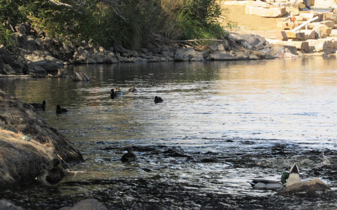


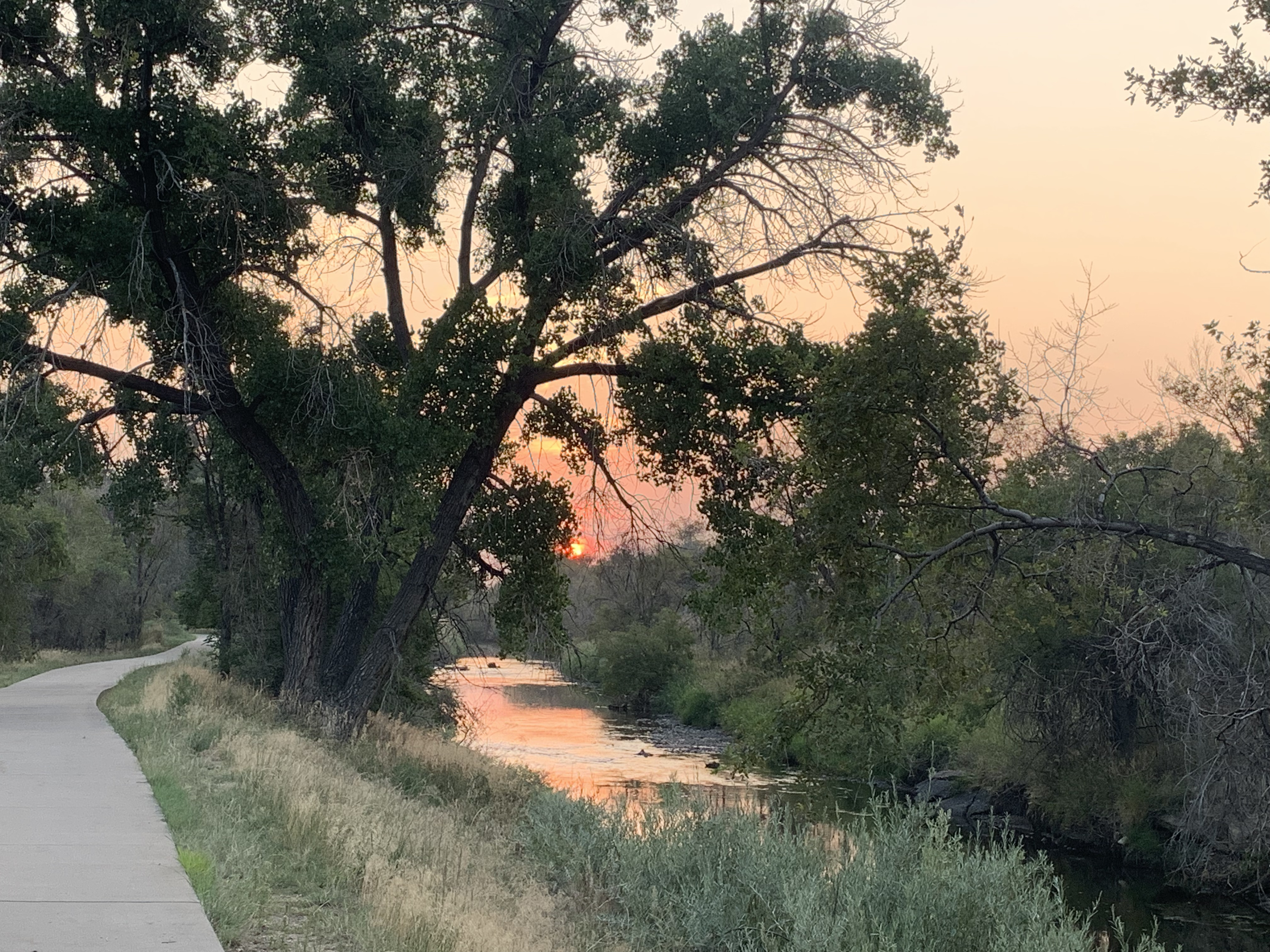

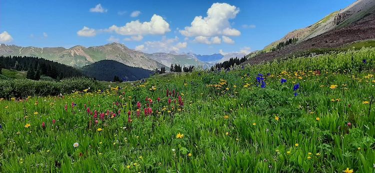

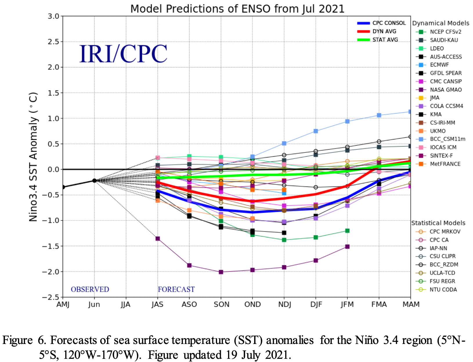


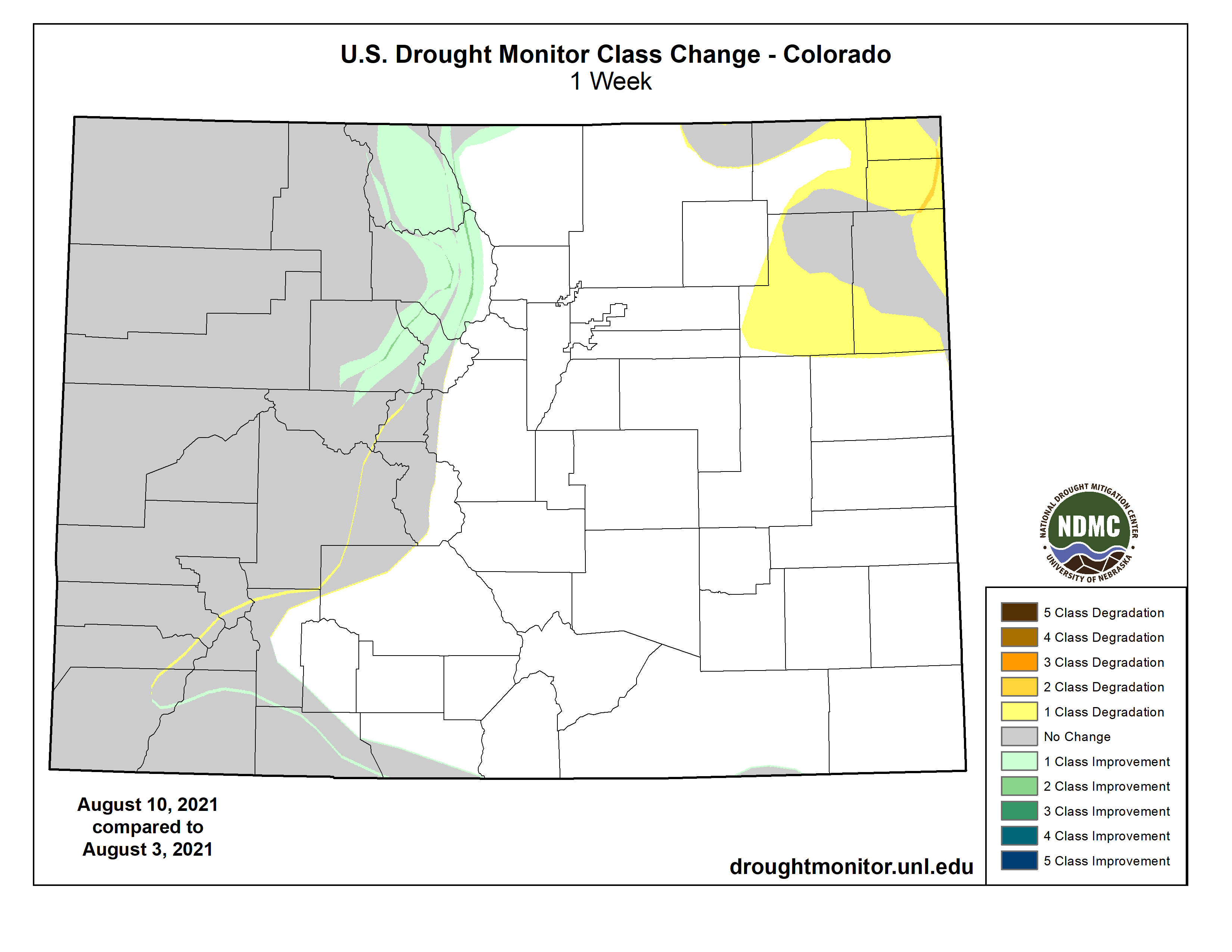


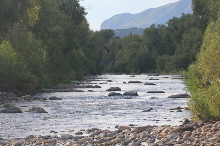
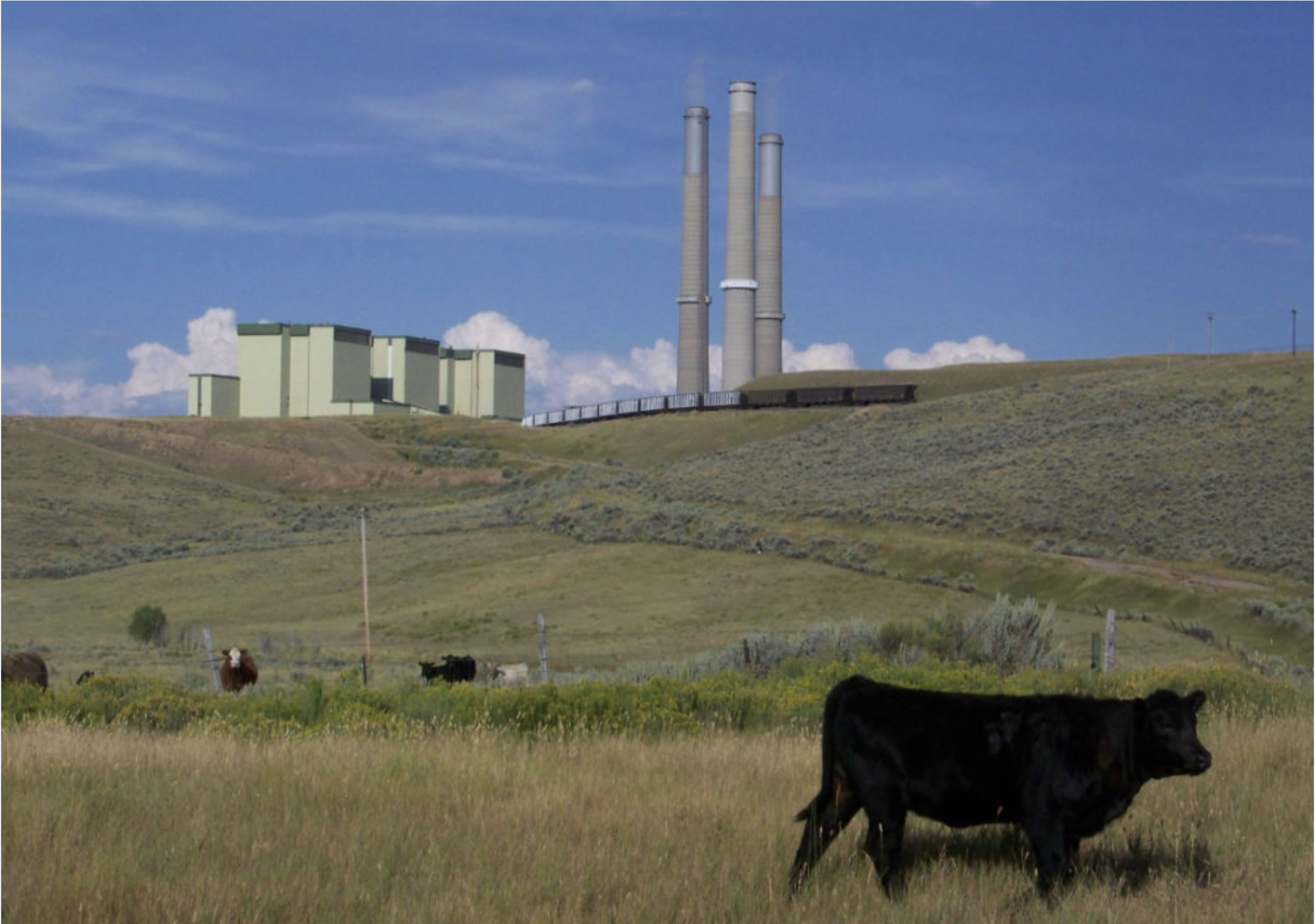

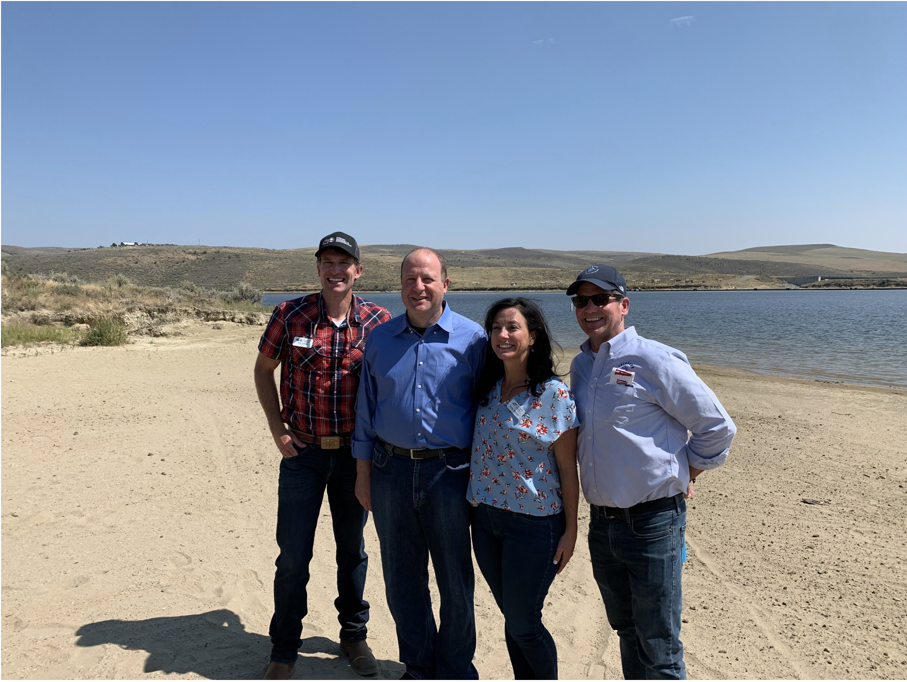
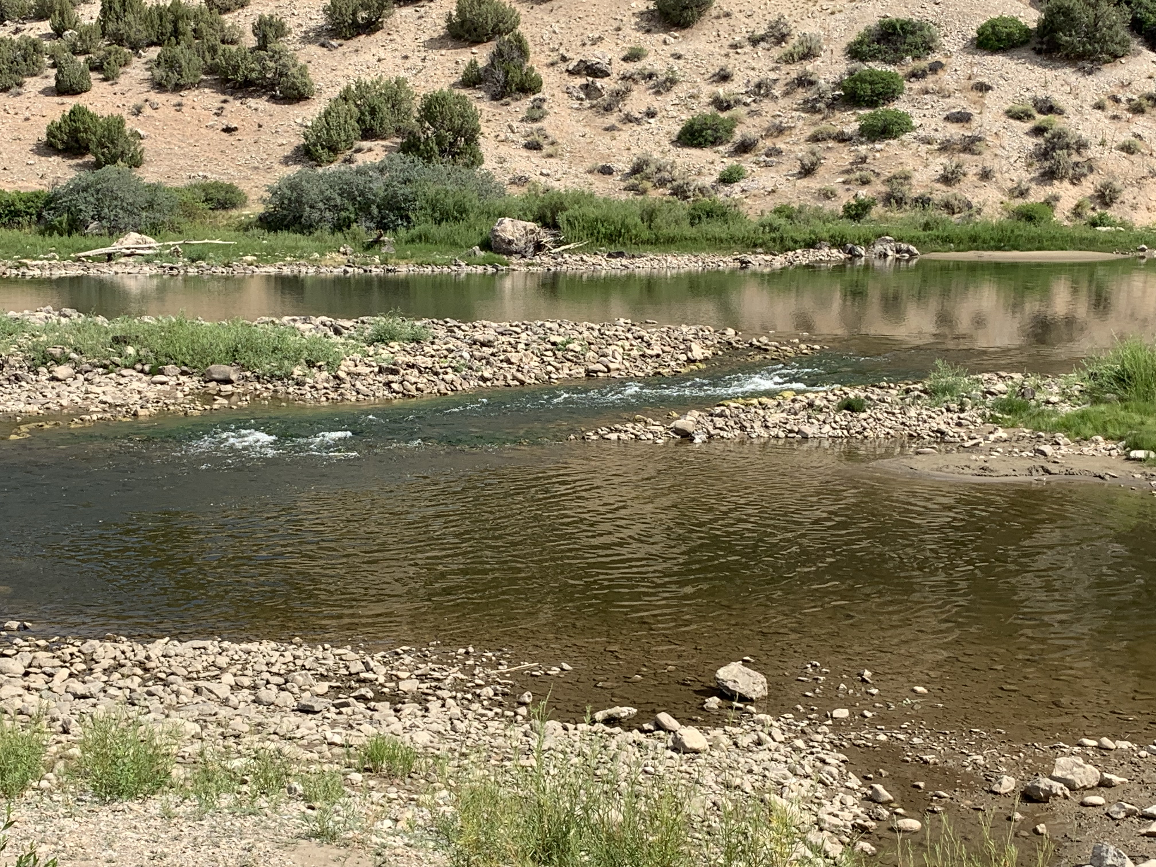


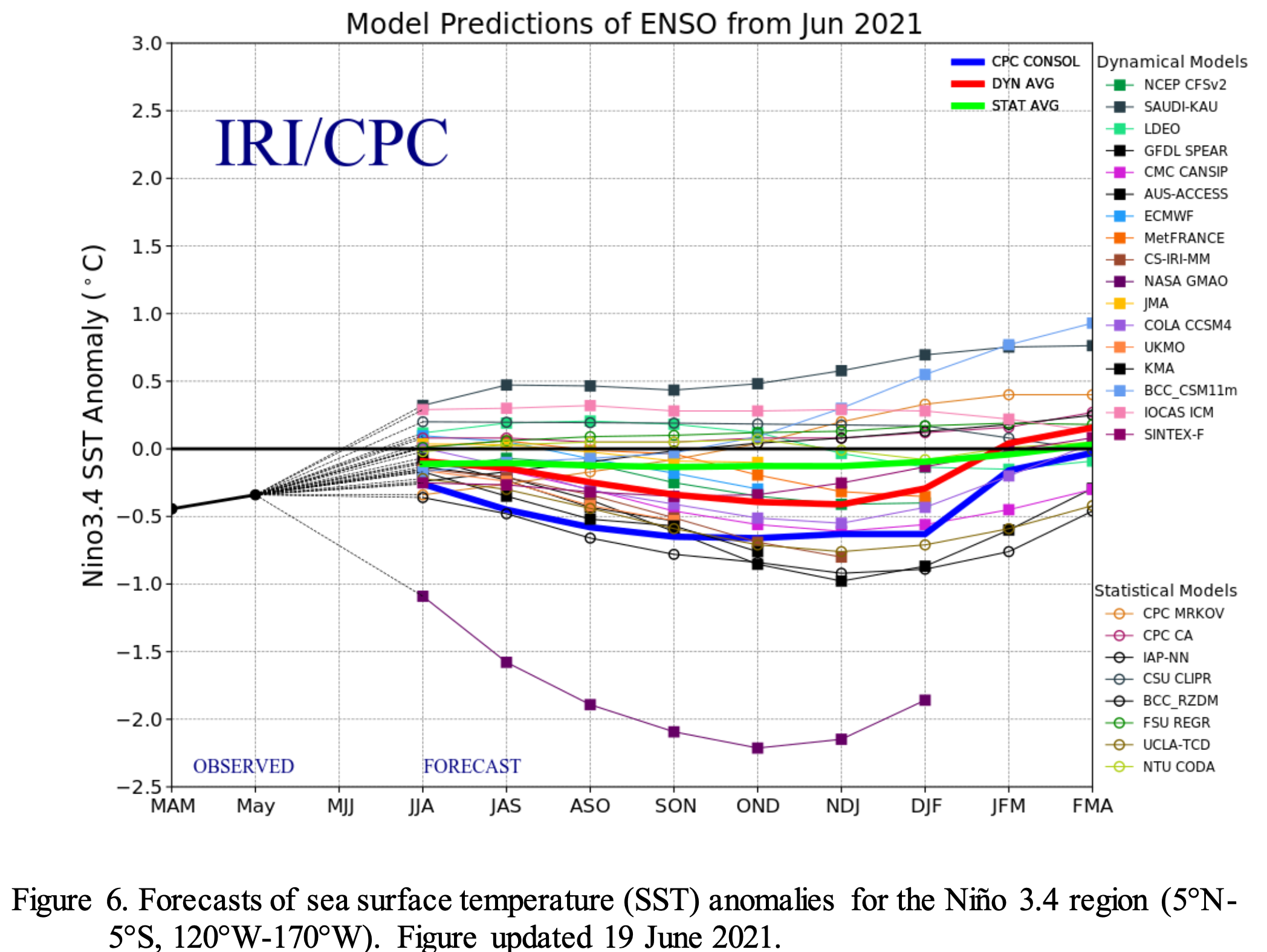

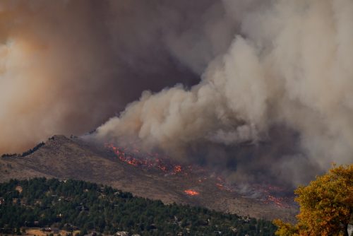
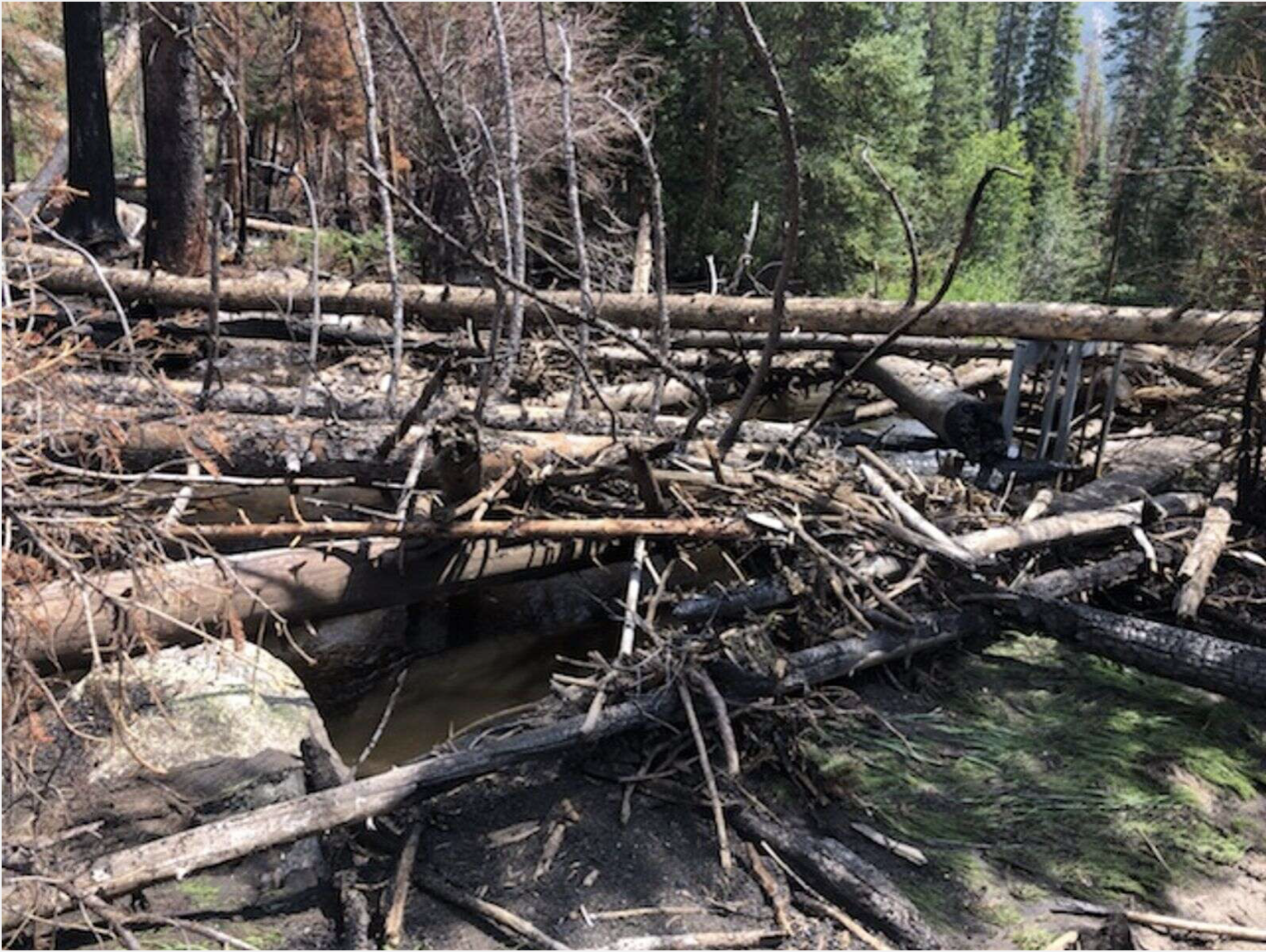
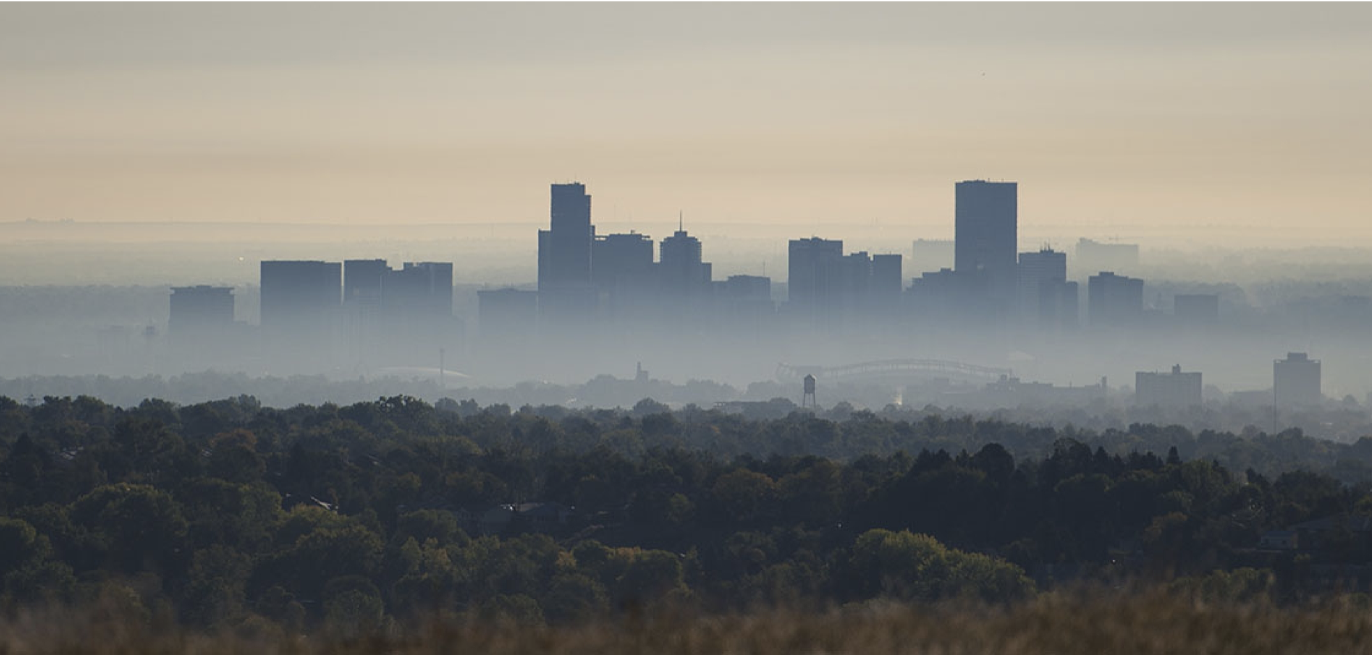
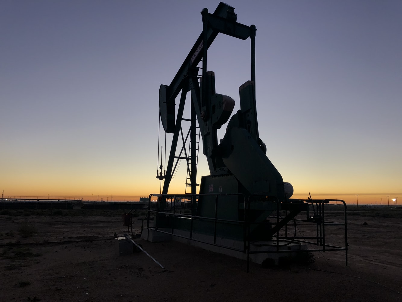
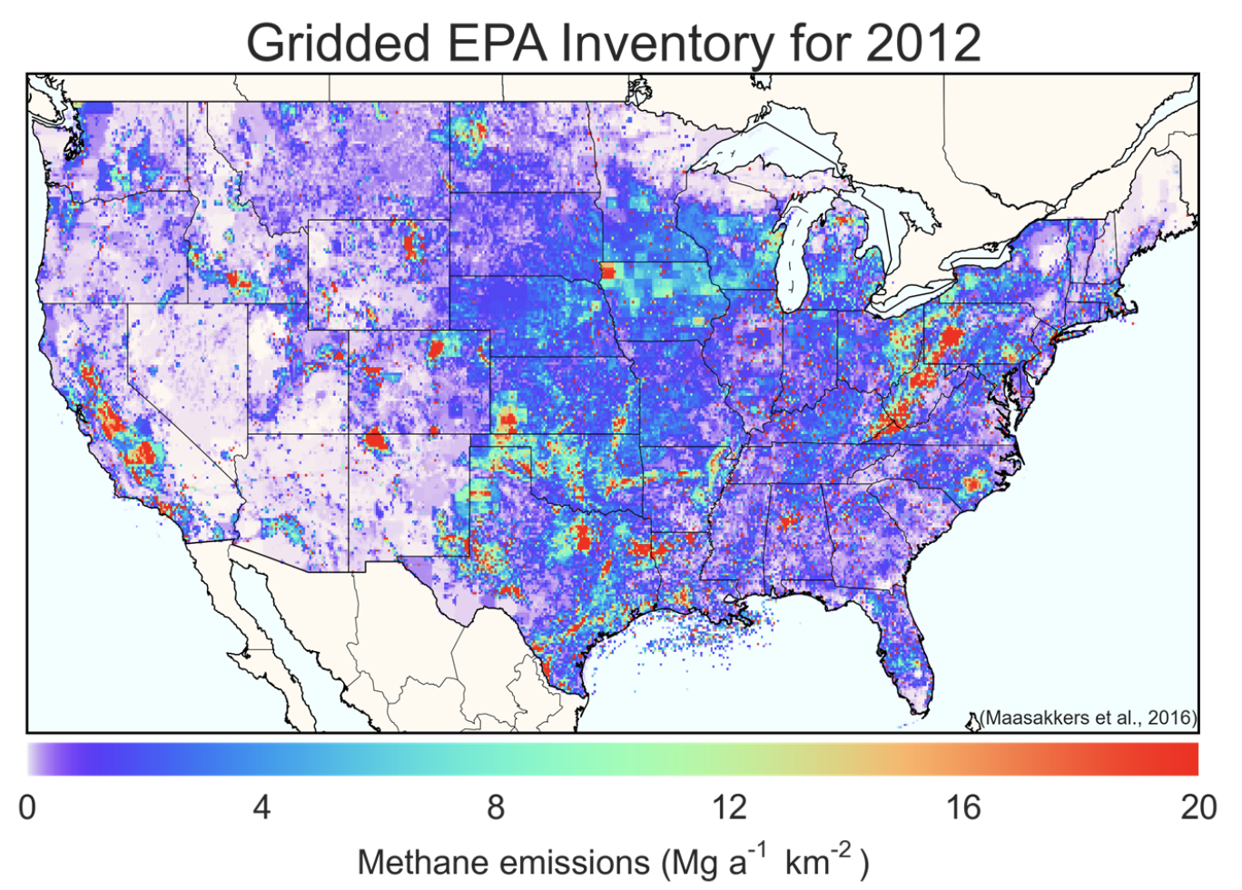

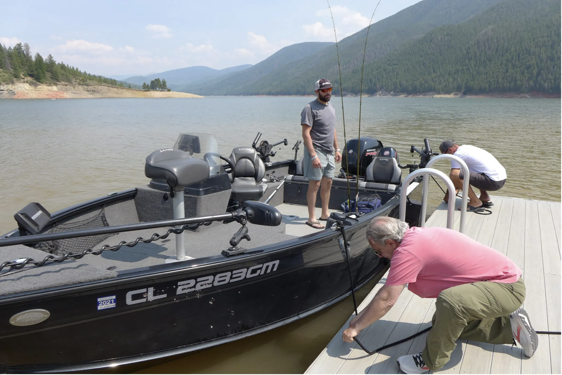

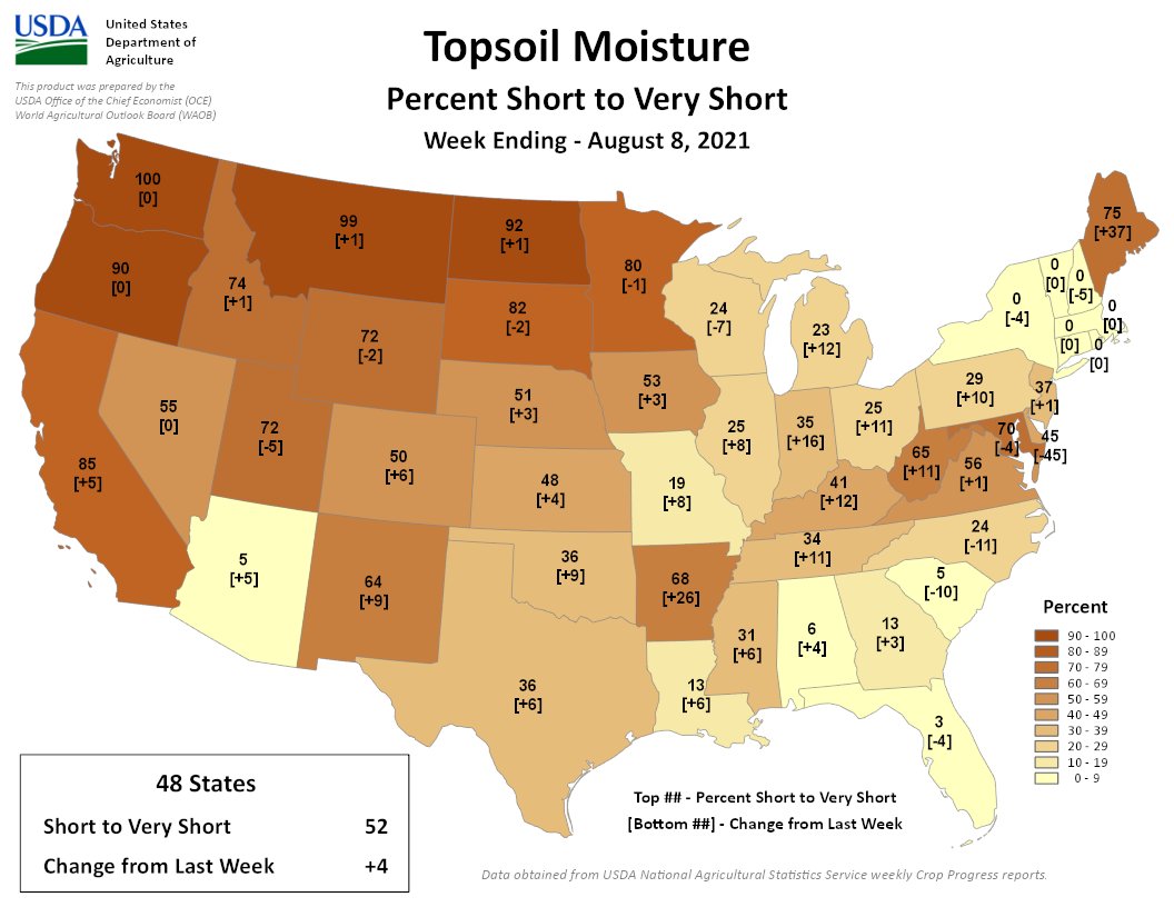

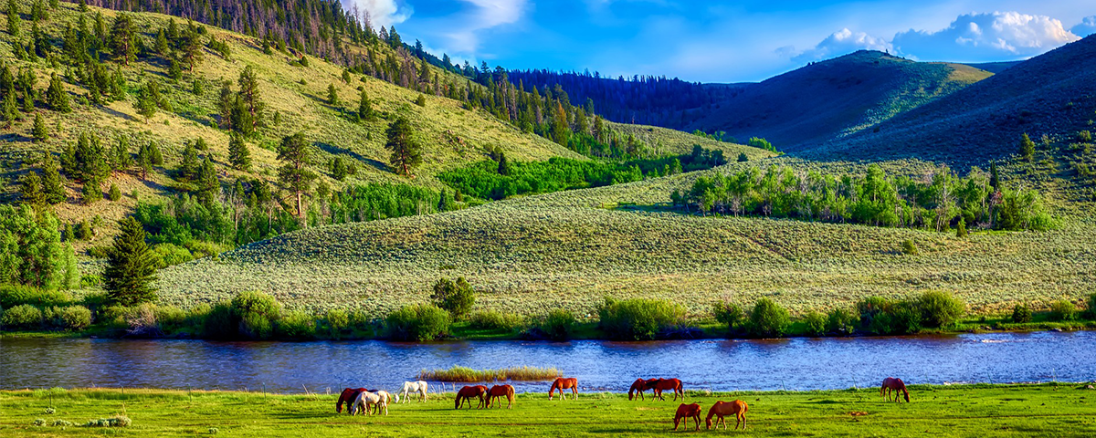
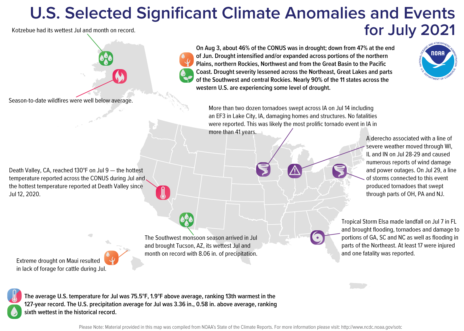
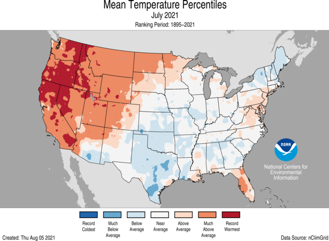

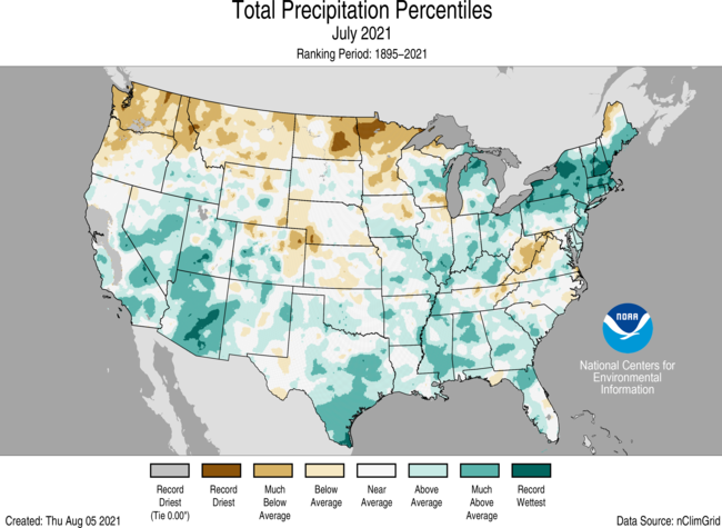
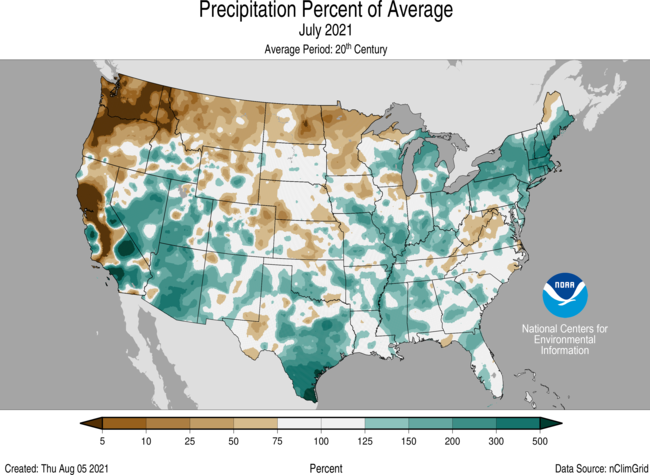
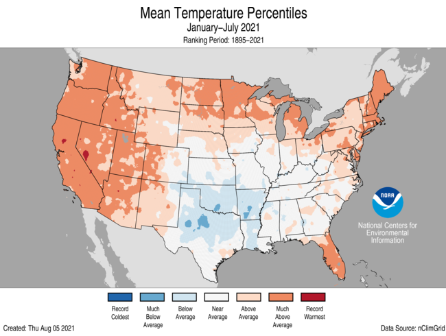

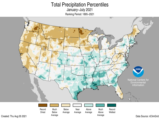
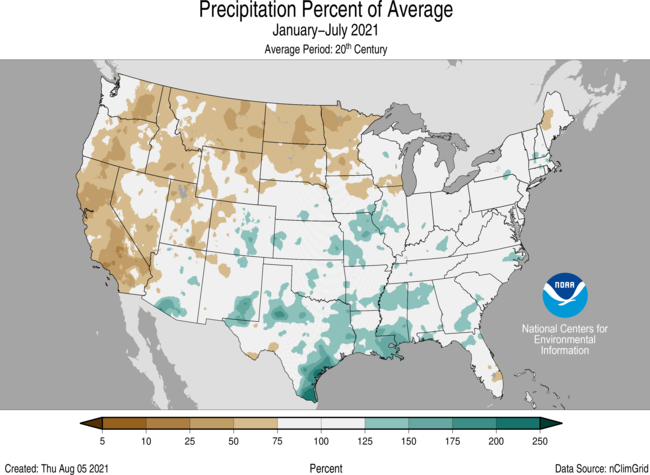
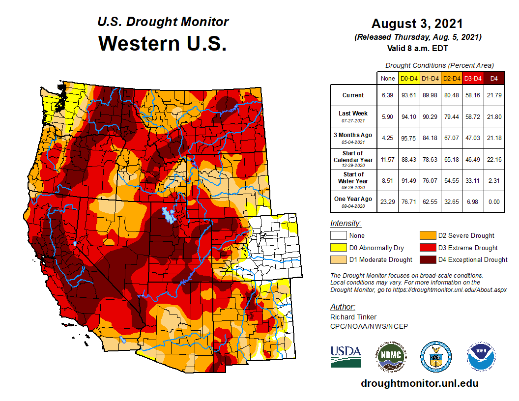
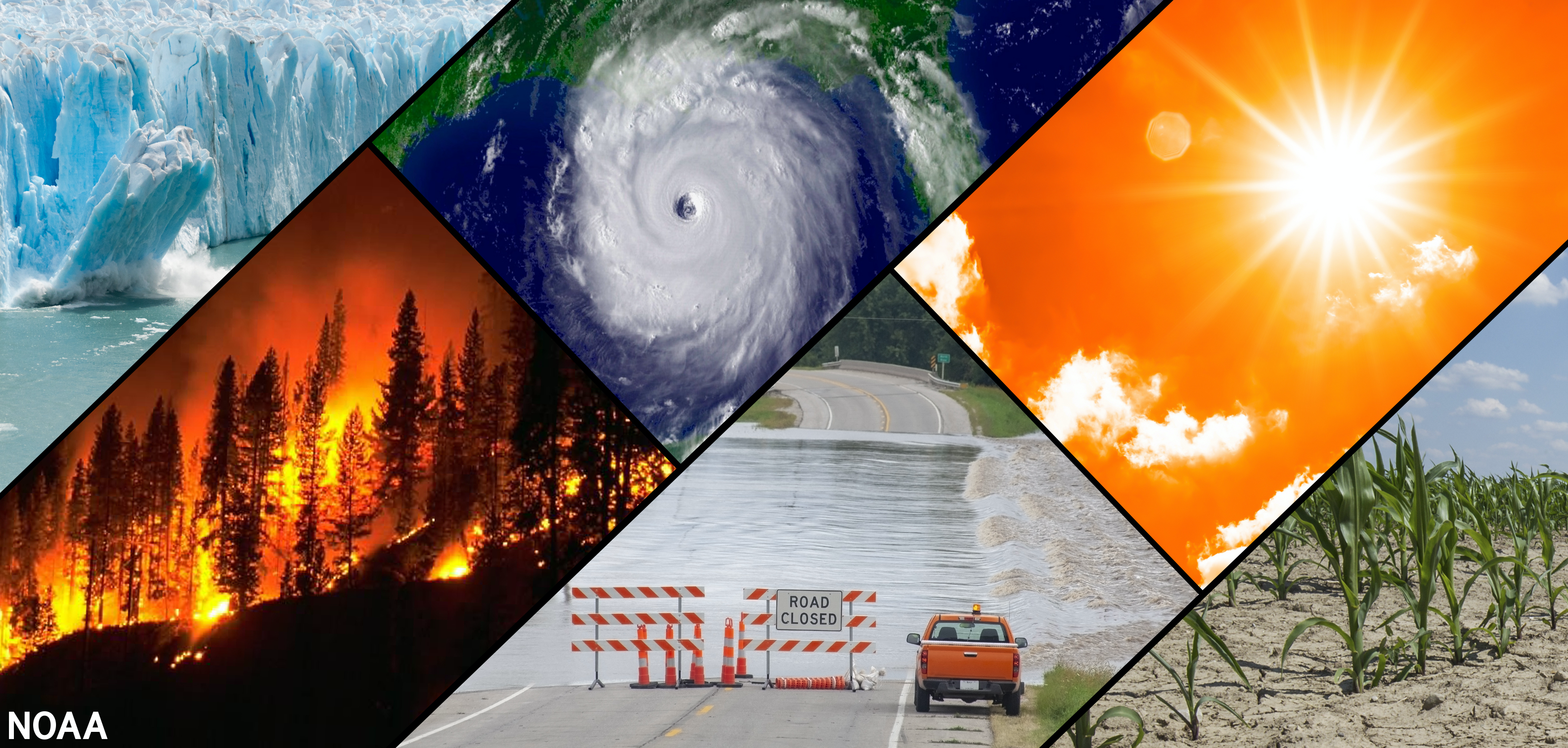
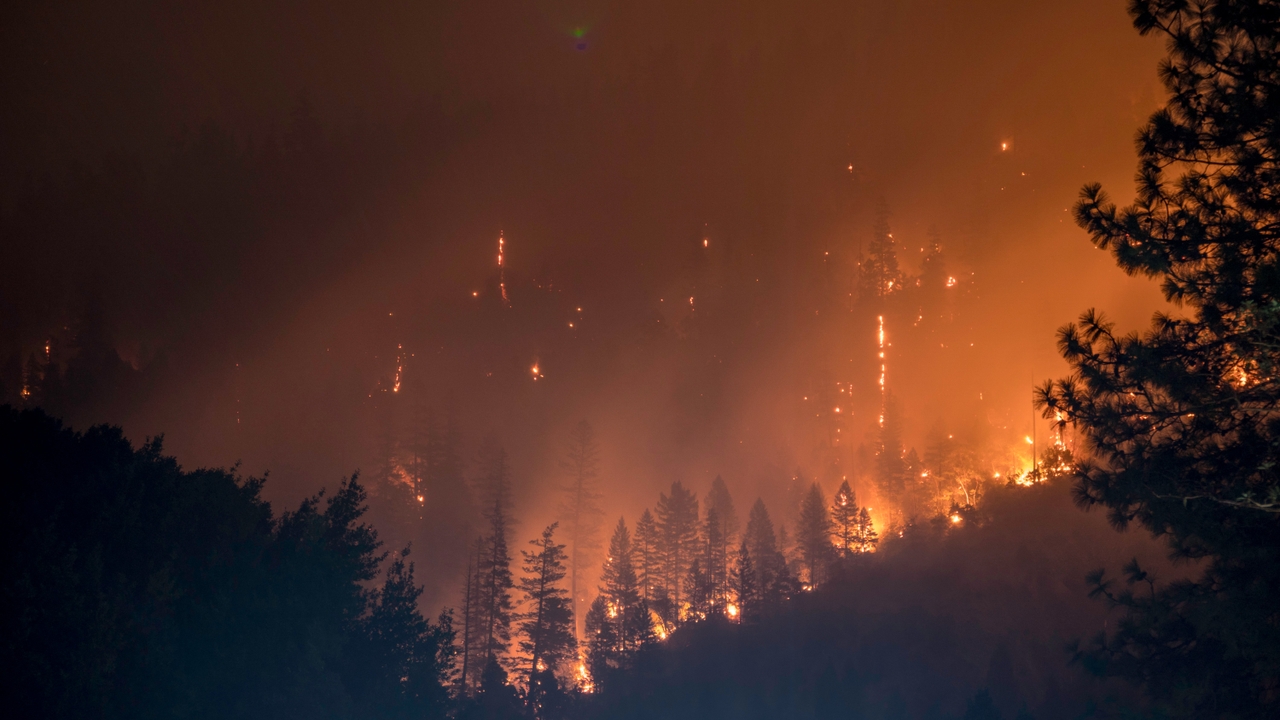

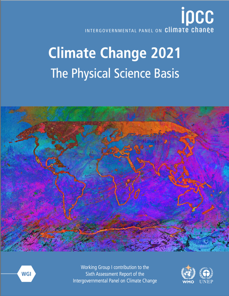


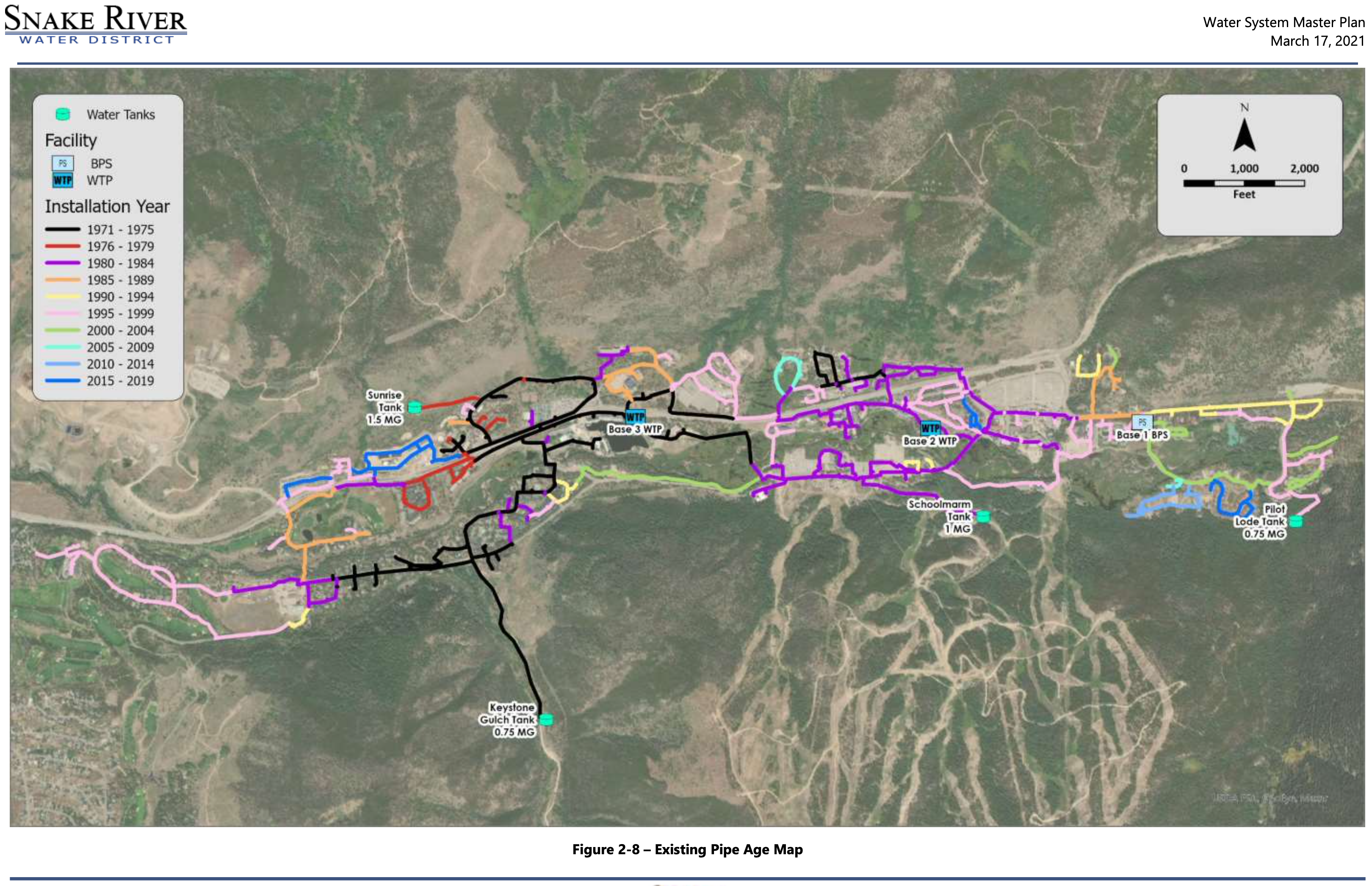


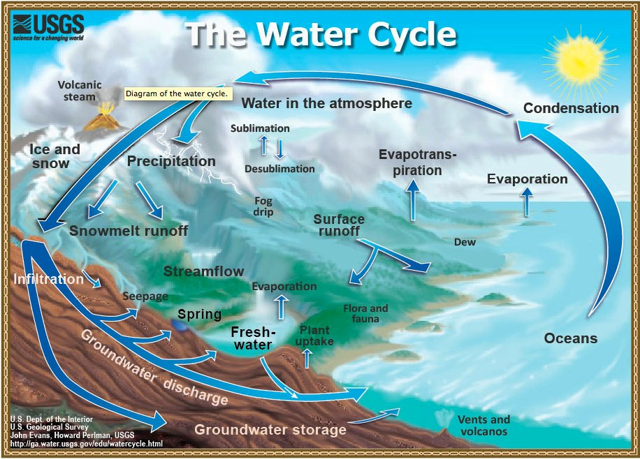
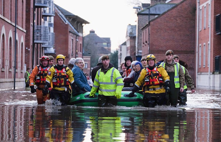
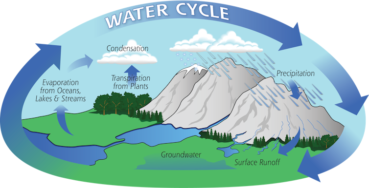
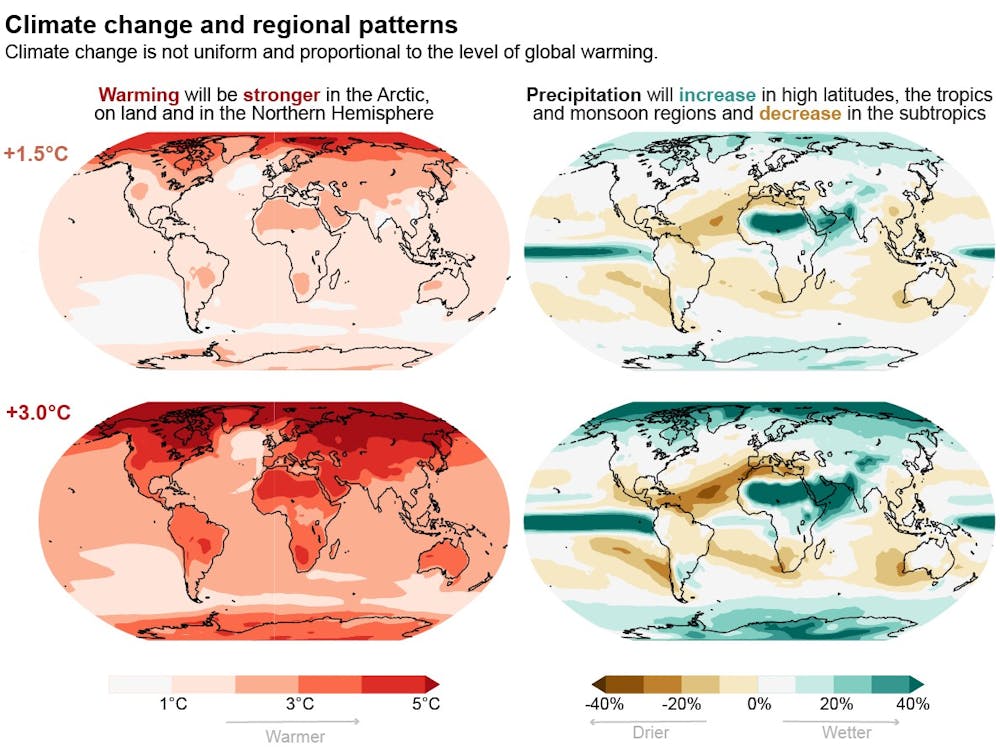

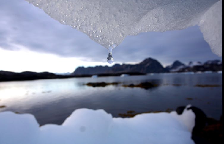
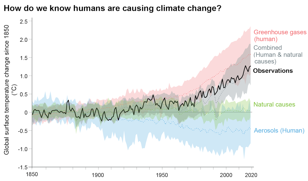
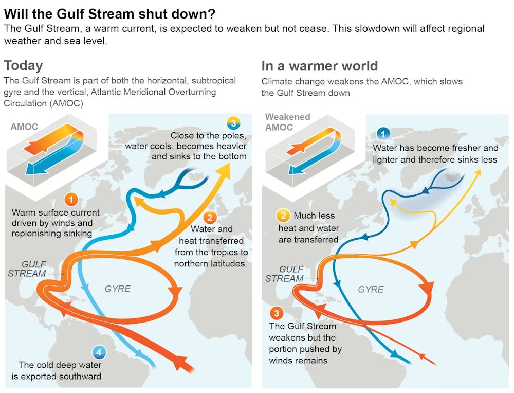
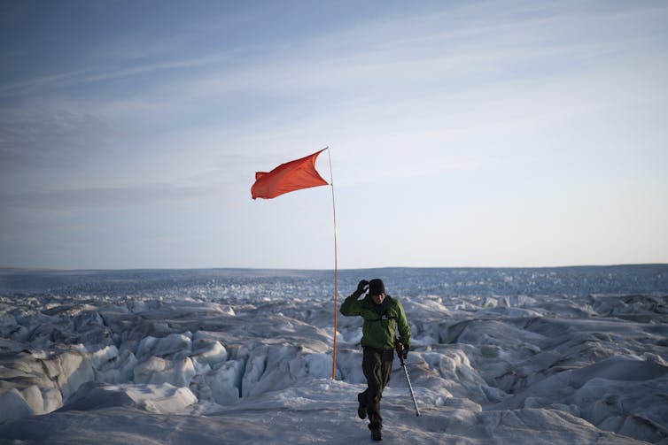
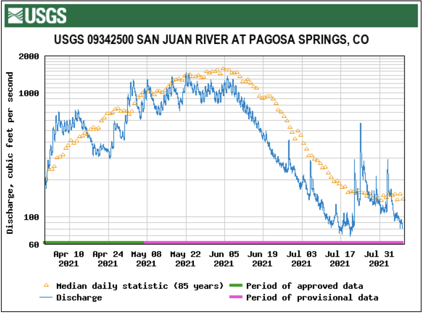
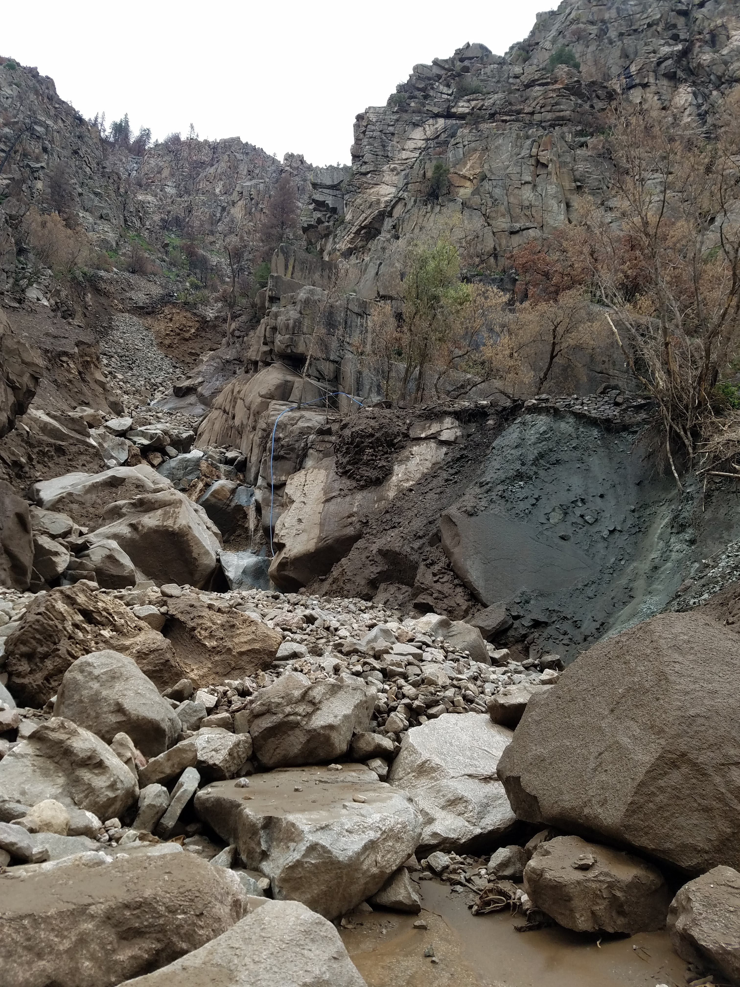


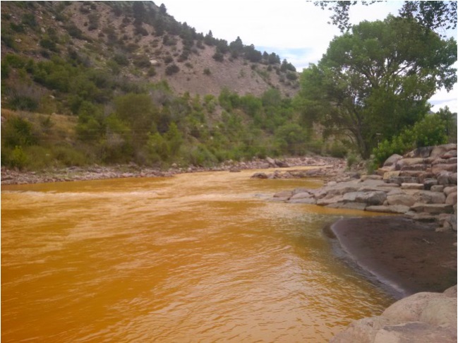
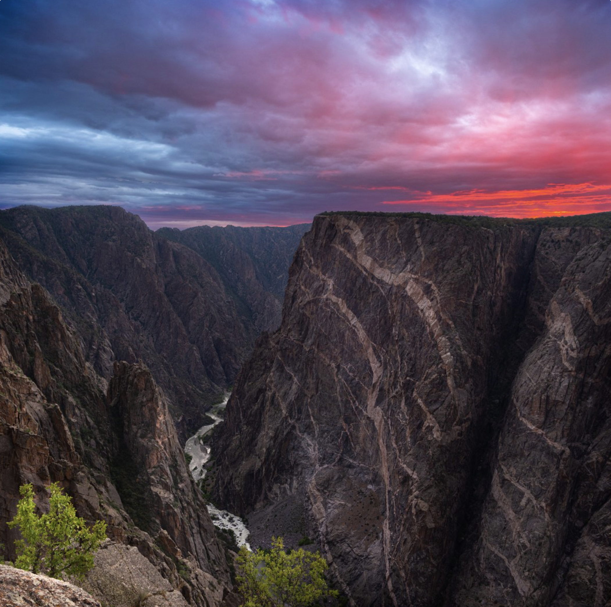

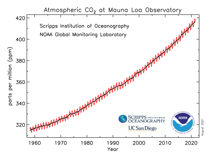

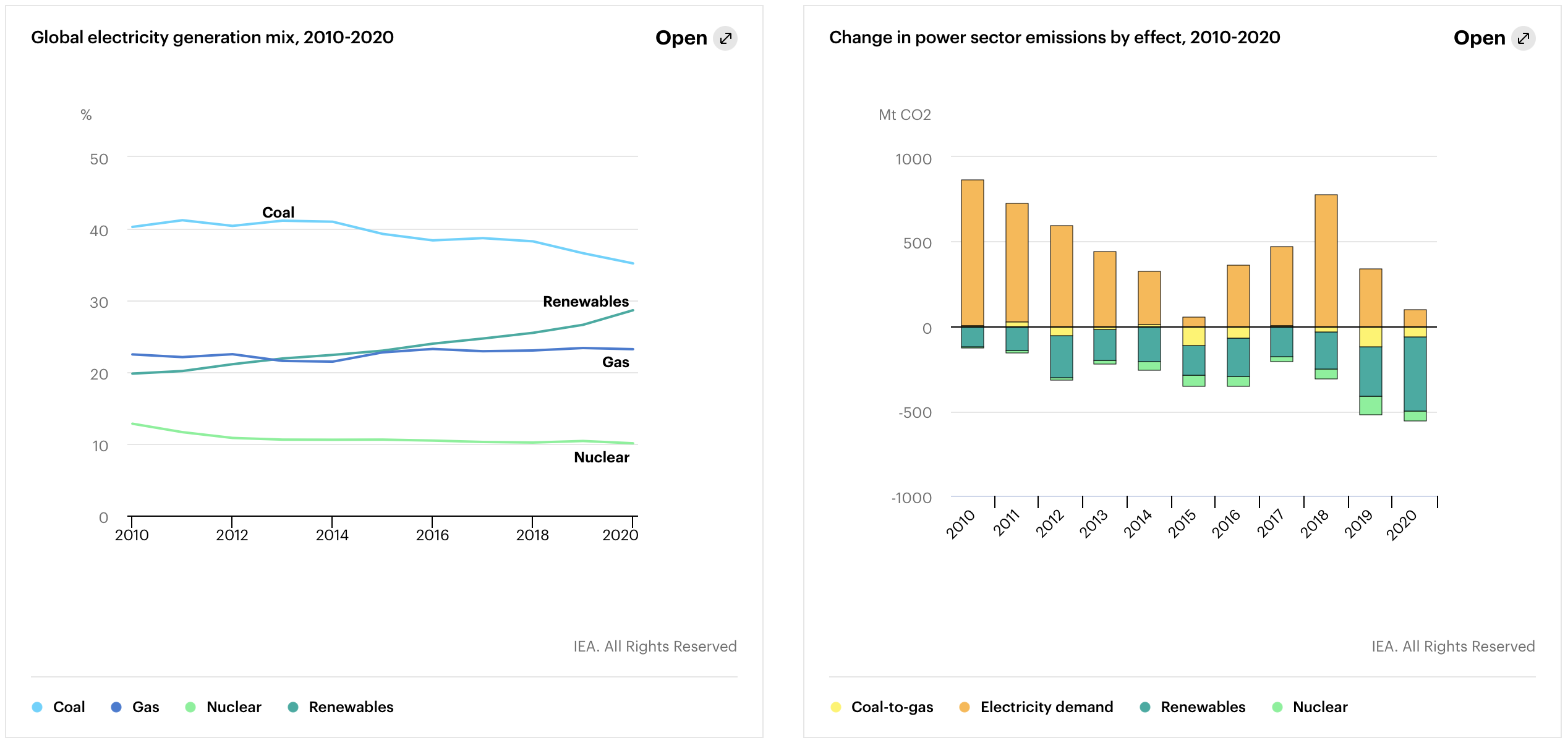
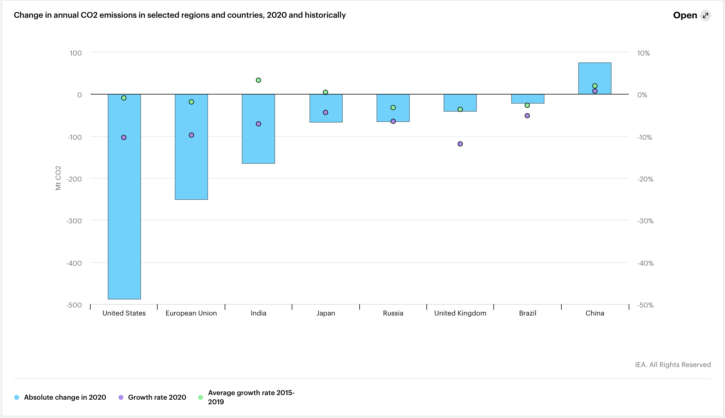
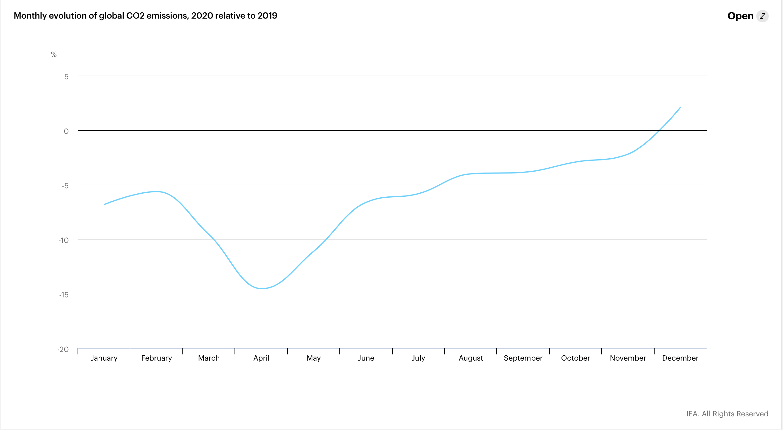
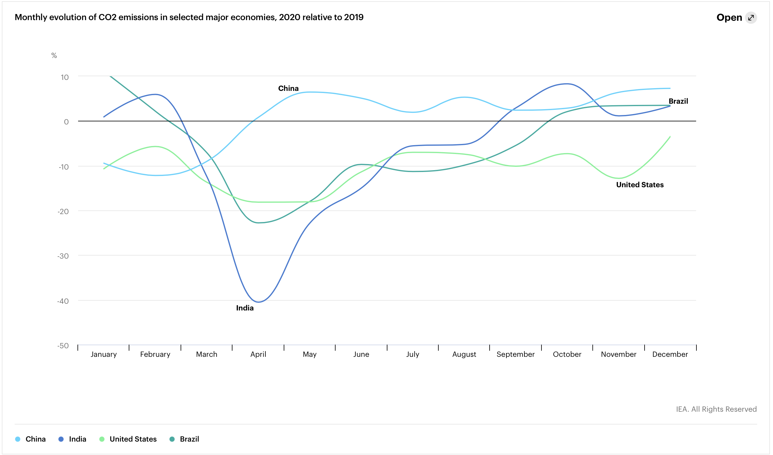
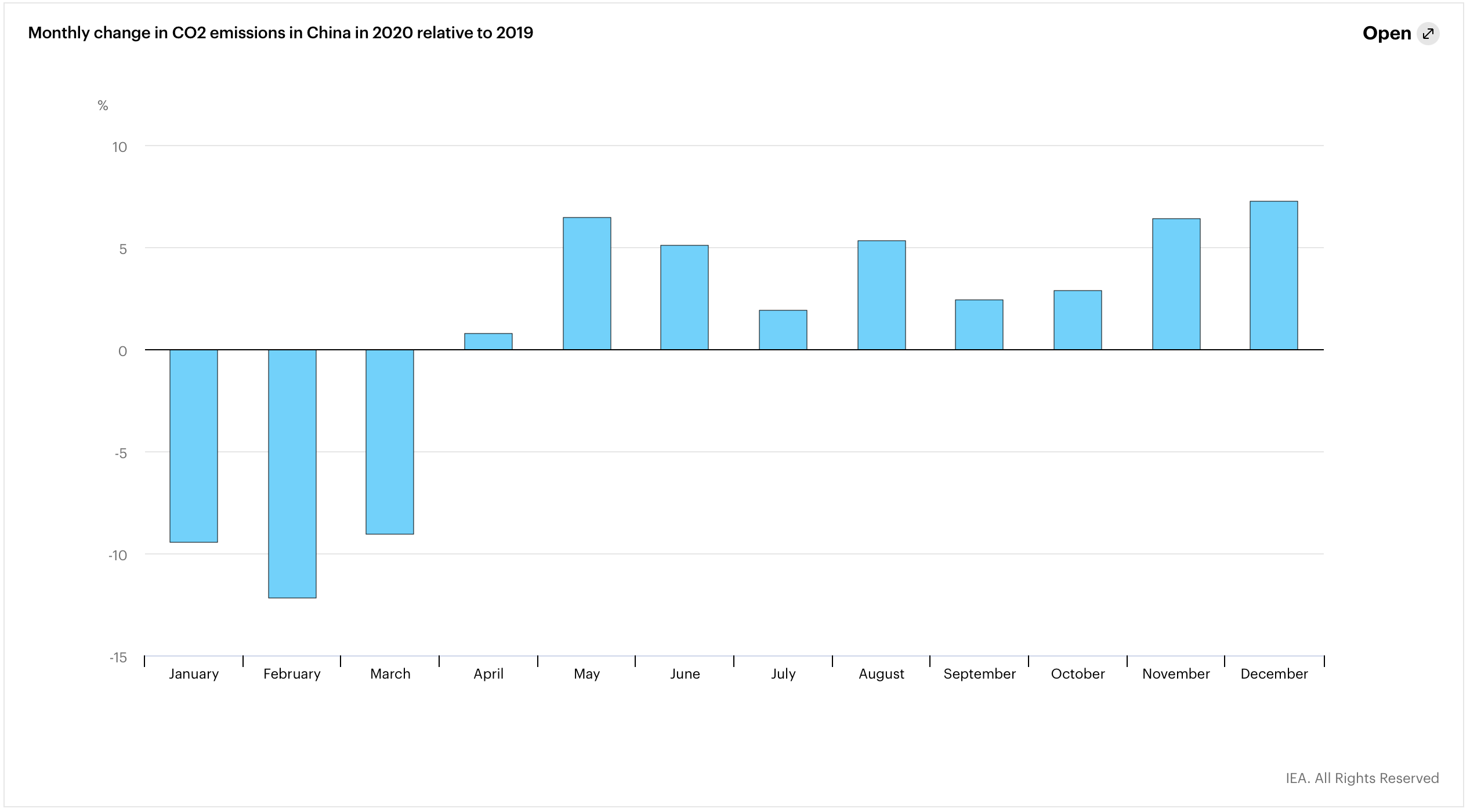
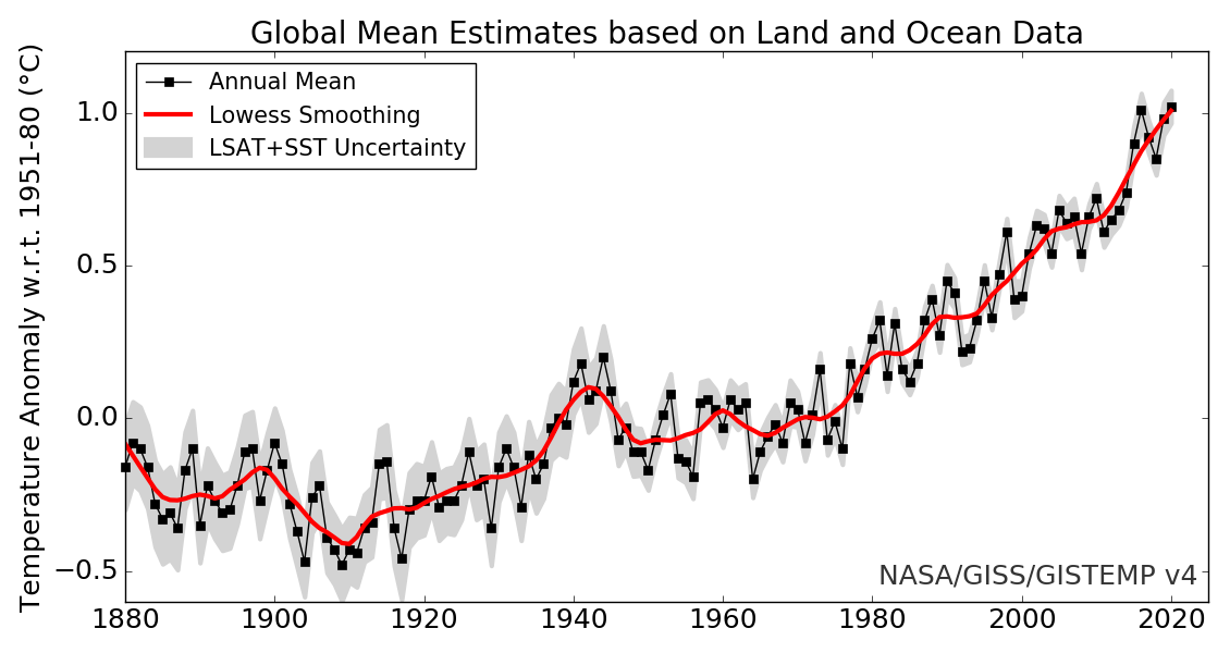
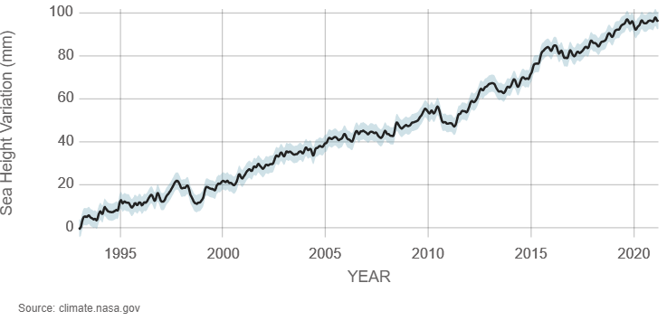
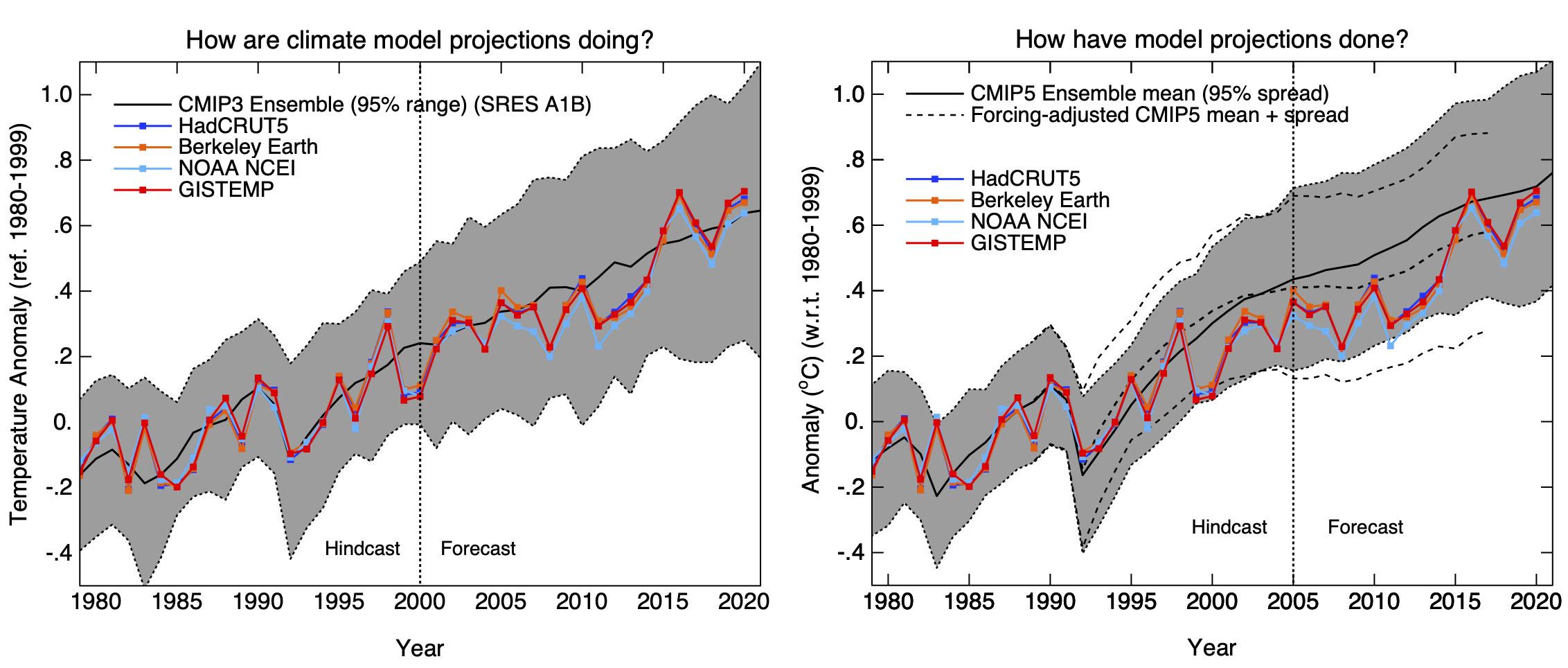


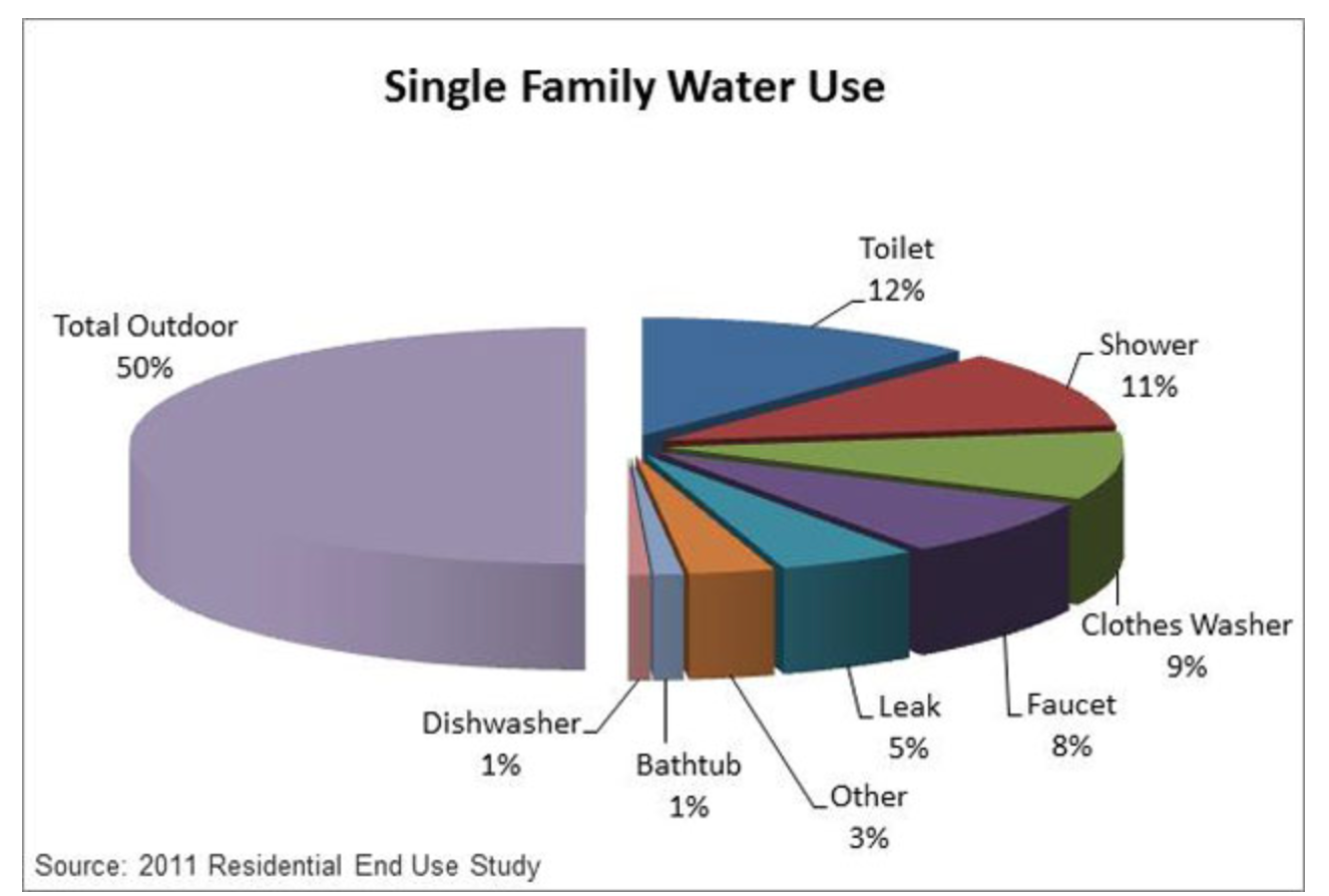


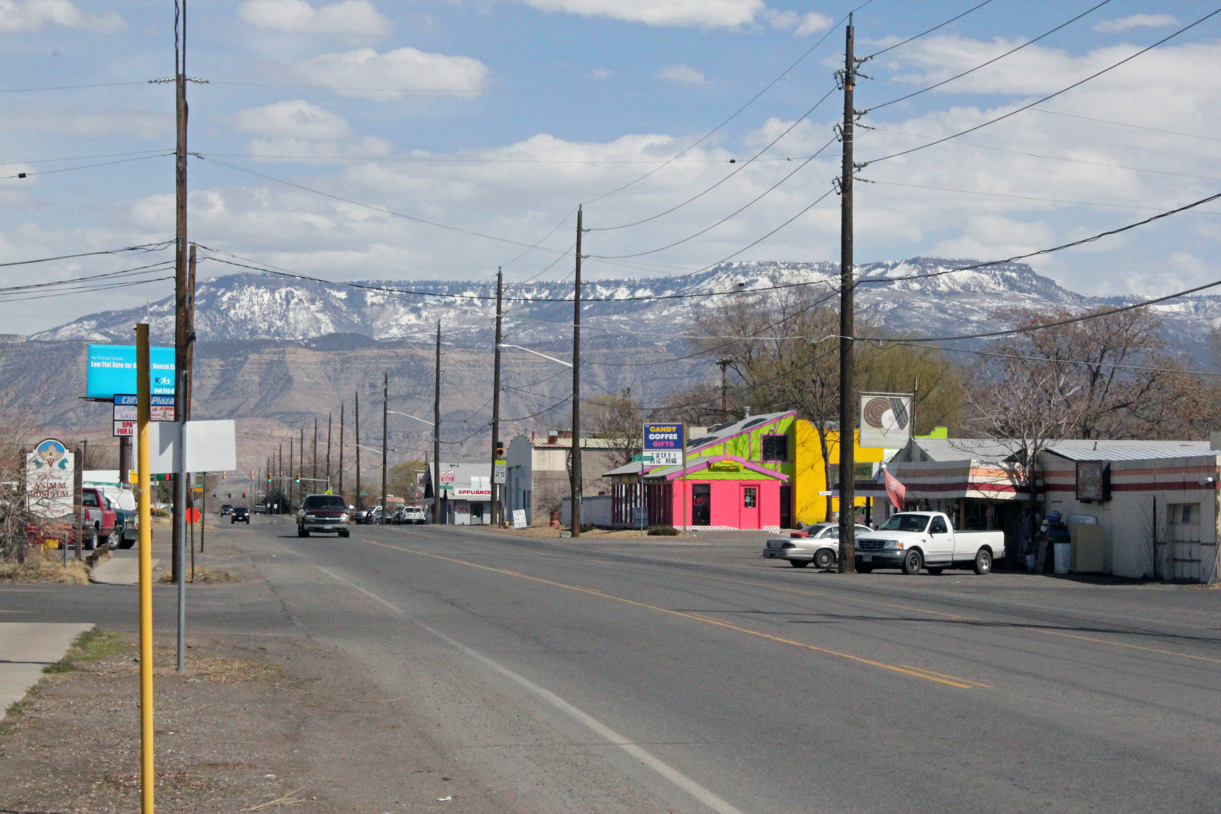


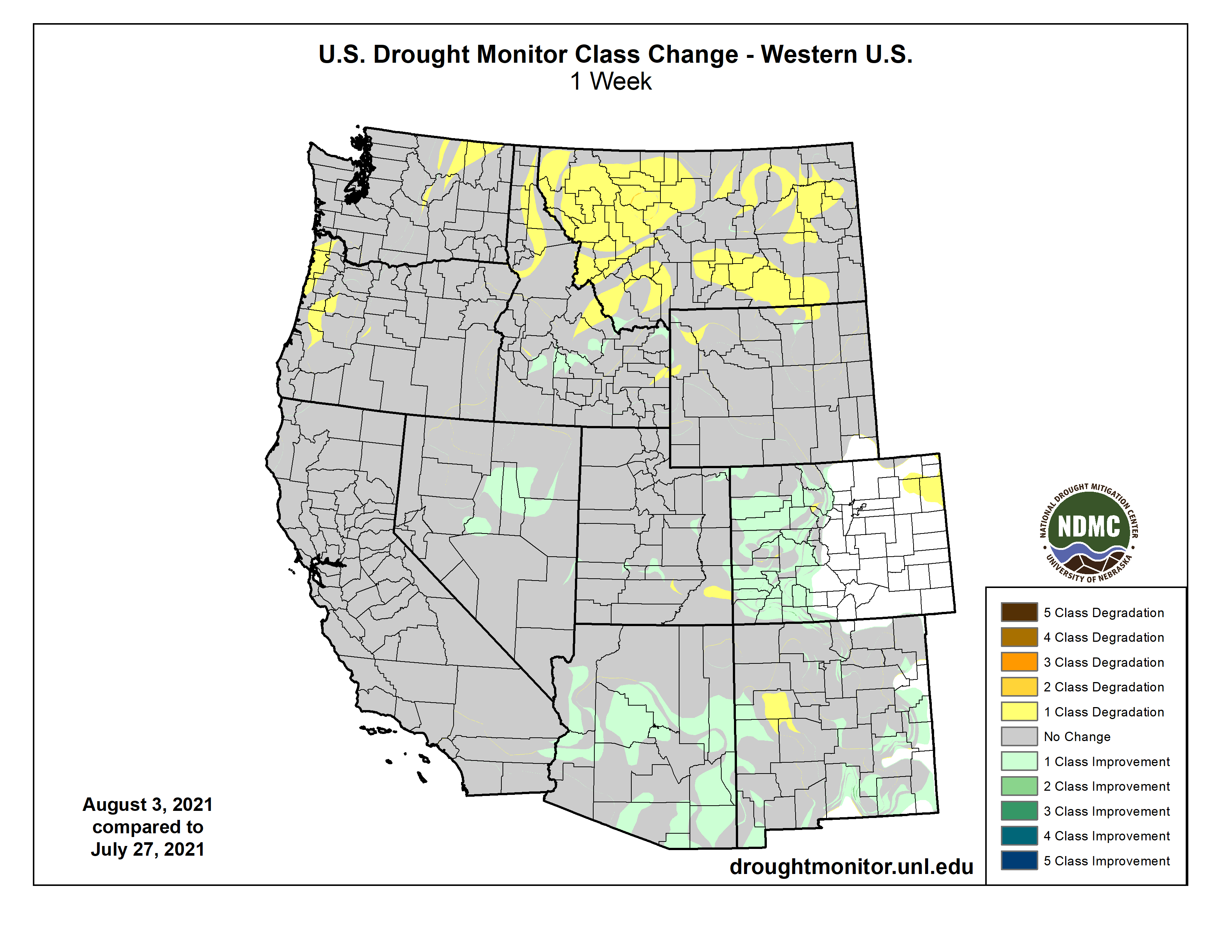
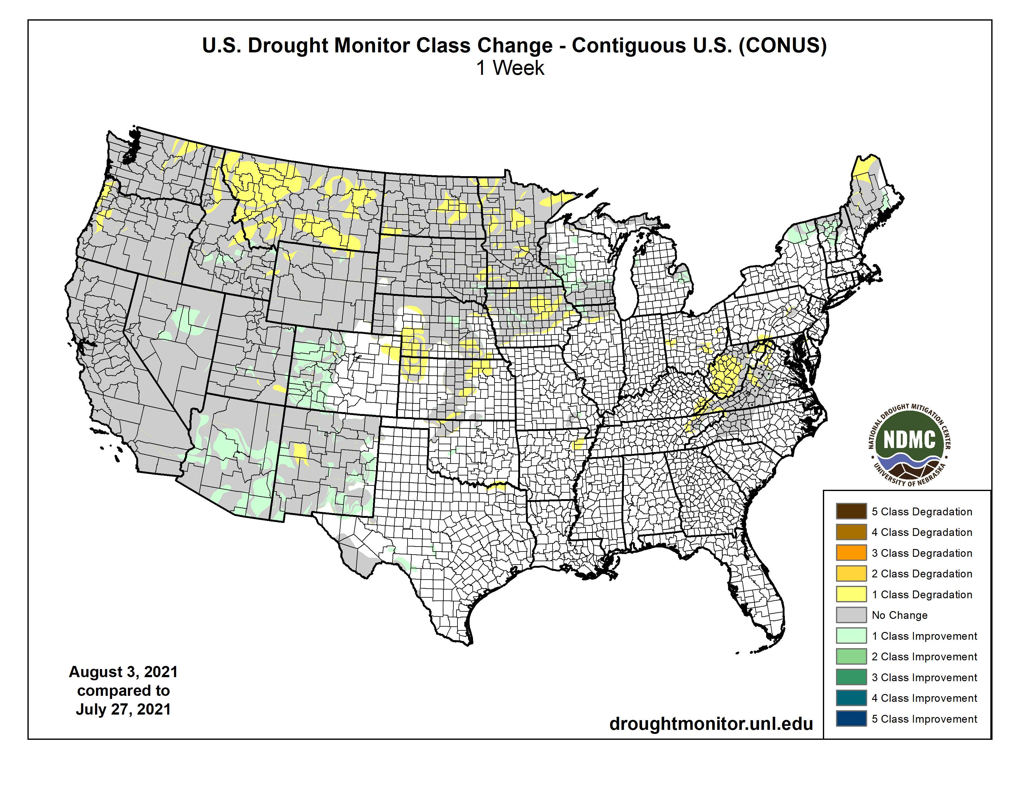
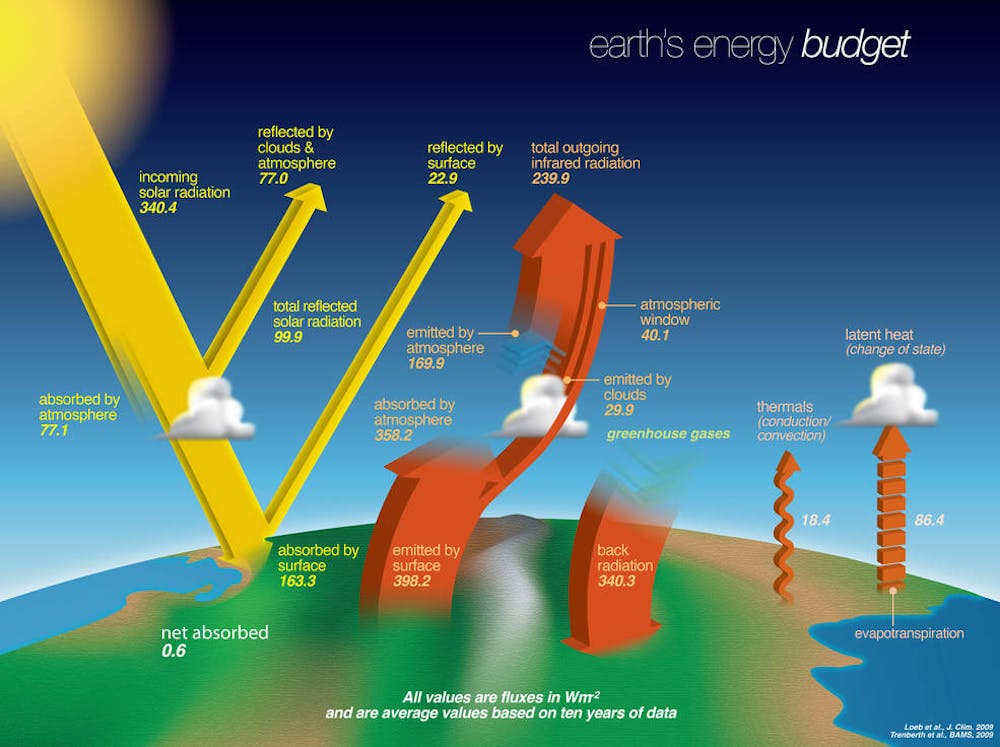
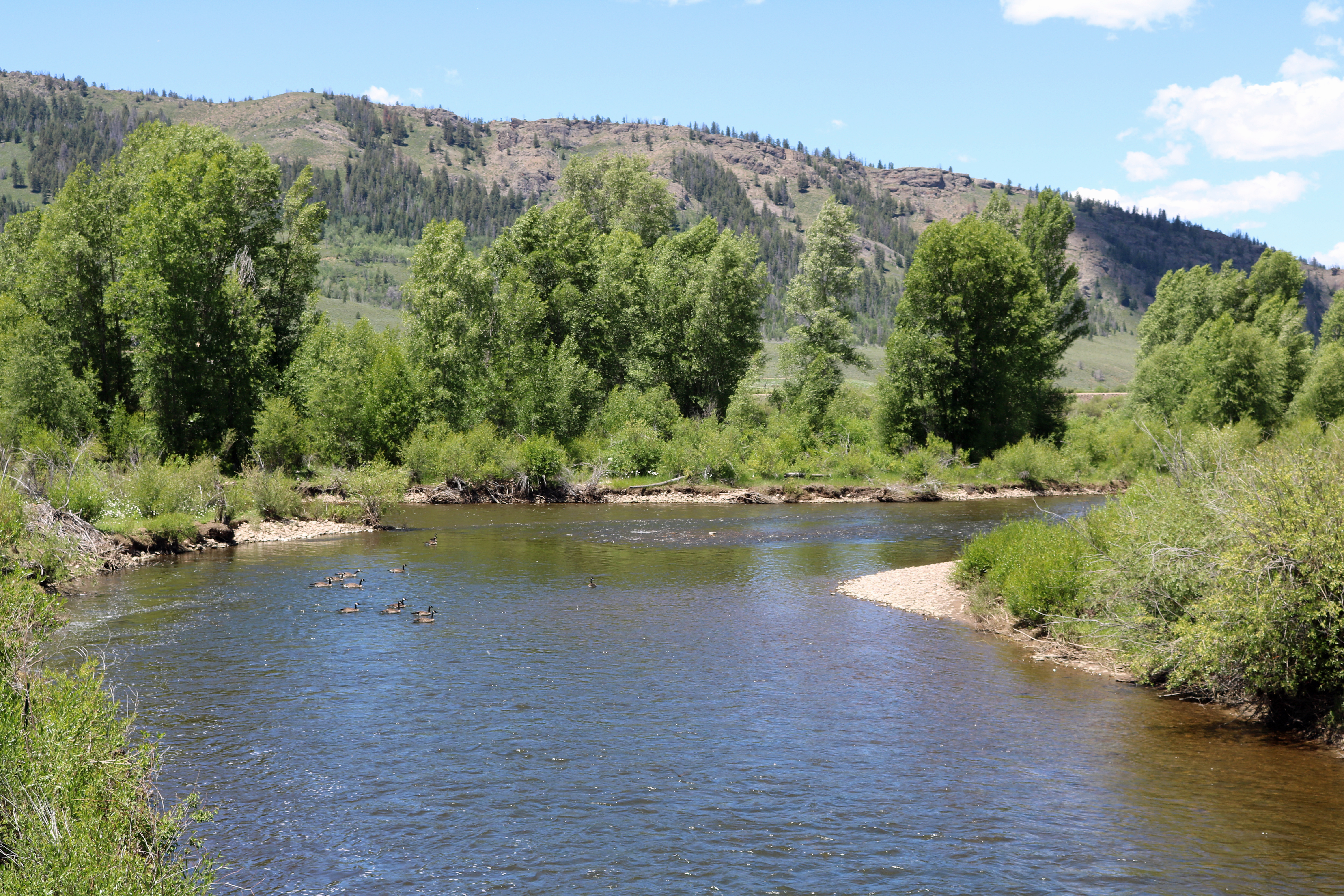