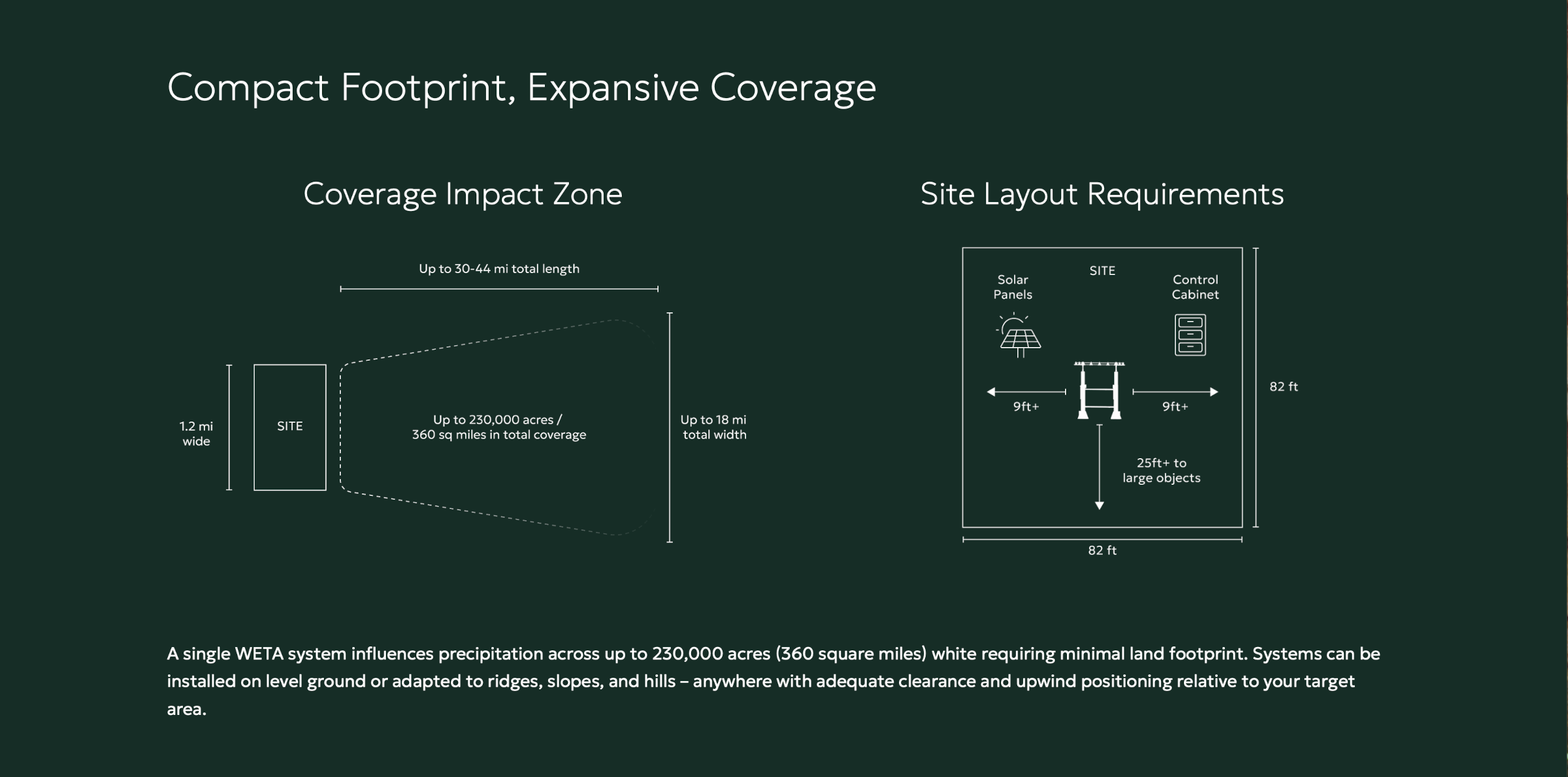
Our WETA (Weather Enhancement Technology Array) systems create negative ions using naturally occurring wind patterns. WETA uses a high voltage DC charge to create corona inception points releasing electrons that ionize passing air particles. These ionized particles are carried up to cloud layers at around 2,000 feet altitude. In the clouds, the charged particles help accelerate the collision and combination of water droplets, causing them to become heavy enough to fall as rain. Credit: Rain Enhancement Technologies
October 21, 2026 — Rain Enhancement Technologies Holdco, Inc. (NASDAQ: RAIN) (“RET” or the “Company”), a leading provider of ionization rain and snowfall generation technology, today announced that its weather enhancement pilot in Colorado’s Upper Yampa River Basin has completed the state’s required public hearing with no objections raised. The hearing, held October 14, 2026, by the Colorado Water Conservation Board (CWCB), is a key step in Colorado’s weather modification permitting process and moves the permit for the one-year pilot to final approval, with operations targeted to begin in November 2026.
The pilot, first announced in July, will deploy the WETA (Weather Enhancement Technology Array), RET’s ground-based, solar-powered ionization system, in the Flat Tops area of Northwest Colorado. The WETA can operate year-round, enhancing snowpack in winter and rainfall from spring through fall. Under a statement of work between RET and the Upper Yampa Water Conservancy District, the CWCB is planning to fund the pilot, with the District serving as fiscal agent. The pilot targets the drainage basin of the Yamcolo Reservoir, one of the District’s primary water supply facilities, with an area of expected impact of up to 192,000 acres. The expanded target area reflects detailed modeling of the final installation site, which showed wider distribution than initially expected after the pilot was first announced.
At the hearing, the RET team, including CEO Randy Seidl, VP of Engineering Scott Morris and members of the Company’s meteorology and data science staff, walked state officials and local stakeholders through how the pilot meets the twelve criteria Colorado requires of weather modification permit applicants, from target area and operating methods to economic benefit, scientific feasibility, risks and safeguards, and environmental impact. The team also outlined the pilot’s operating safeguards, including automatic shutdown when wind speed or direction falls outside set parameters, suspension of operations during National Weather Service watches and warnings, and coordination with local land managers.
“A public hearing with no objections tells us that the people closest to this watershed, from water managers to land managers to local officials, understand what the WETA does and how carefully we operate it,” said Randy Seidl, CEO of Rain Enhancement Technologies. “We appreciate the support of the CWCB, the Upper Yampa Water Conservancy District, Colorado Parks and Wildlife and the Colorado River District in getting us here. With the permit moving forward, we’re preparing to install in November and look forward to giving Colorado independently validated results to evaluate.”
“Beyond the reservoirs downstream, this site gives us a chance to benefit the land right around it,” said Scott Morris, VP of Engineering at Rain Enhancement Technologies. “We’ll be operating to provide some enhancement to Lake Avery, which is right near the site, and we expect more rainfall and snowpack over the surrounding wilderness areas, which should benefit the forests and the wildlife there.”
“Public hearings are an important part of how Colorado permits weather modification programs, giving local communities and agencies a chance to review a proposed operation and raise any concerns before a permit is issued,” said Andrew Rickert, Program Manager for the CWCB’s Weather Modification Program. “The RET team laid out its responses to the state’s permit criteria clearly, and our next step is to finalize the permit so the pilot can begin, and the results can be evaluated.”
Performance will be measured with a network of instruments installed in and around the target area, including snow-melting tipping-bucket rain gauges and Doppler precipitation sensors, alongside existing SNOTEL (Snow Telemetry) and NOAA (National Oceanic and Atmospheric Administration) data. RET’s meteorology and data science team will compare precipitation in the target area against control areas using three independent statistical methods, the same peer-reviewed approach applied to the Company’s winter operations in Utah’s La Sal Mountains, where the WETA delivered a greater than 20% increase in snow water equivalent over the 2025-26 season. The District will receive regular operating reports, and the final seasonal report will be submitted for independent peer review.
Once permitted, the Upper Yampa pilot would become the ninth permitted weather modification program in Colorado and RET’s second in the state, joining its program in Weld County.
About Rain Enhancement Technologies, Inc.
Rain Enhancement Technologies was founded to provide the world with reliable access to water, one of life’s most important resources. To achieve this mission, RET develops, manufactures, and commercializes ionization precipitation generation technology that enhances rainfall and snowpack to address water scarcity challenges. The Company is also developing applications for fog mitigation to expand its weather modification capabilities. RET’s chemical-free, solar-powered technology seeks to transform water resource management for businesses, society, and the planet. To learn more, go to www.rainenhancement.com.
The Colorado Water Conservation Board’s Weather Modification Program issues permits and monitors weather modification activities across the state. This map shows the permitted projects in Colorado as of October 2025. Credit: Colorado Water Conservation Board
The one-year pilot, which is funded by a $100,000 grant from the Colorado Water Conservation Board to the Upper Yampa Water Conservancy District, plans to test a ground-based, solar-powered technology from Rain Enhancement Technologies…Standing at Yamcolo Reservoir just below the Yampa River’s headwaters in August, Andy Rossi, the Upper Yampa district’s general manager, described the technology as “brand new and experimental.”
[…]
Compared to “typical” cloud-seeding technology, which involves injecting tiny particles — most commonly silver iodide crystals — into clouds to enhance their precipitation potential, this ground-based technology uses ionization to target a similar effect. Rain Enhancement Technologies calls it the Weather Enhancement Technology Array. In an October interview, Rossi said the installation will be about 30 feet wide and 20 feet long and resembles a ranch gate, with a large frame and electrified coil. It relies entirely on solar power. According to the statement of work for the pilot, “each station releases electrically charged negative ions into naturally occurring wind flow feeding the cloud with the ‘fuel’ needed to cultivate precipitation.” These charges enter the cloud mass and enhance condensation, causing cloud droplets to “progressively grow” until they are large and heavy enough to fall as precipitation, it adds. Meteorologists and technicians with Rain Enhancement Technology will then track storms remotely, firing up the apparatus “when they see a storm track that is: one, headed in the right direction … and two, it has the right predicted moisture content there,” Rossi said. A test of the technology outside of Moab, Utah, reportedly led the snow-water equivalent to increase by over 20%. Andrew Rickert, Colorado’s weather modification program manager, said in April that more traditional cloud-seeding systems can increase a storm’s snowfall by roughly 8-12% when generators are turned on. The Upper Yampa installation will be located at Colorado Parks and Wildlife’s State Wildlife Area near Lake Avery, with the intent of increasing precipitation in a 200,000-acre area of the Flat Tops and into the basin.
Click the link to read the article on the Ink Stain website (John Fleck):
October 24, 2026
The group chat among my Colorado River posse blew up again this morning as the nerds compared reservoir and stream gage readings resulting from a storm for the ages in the Four Corners.
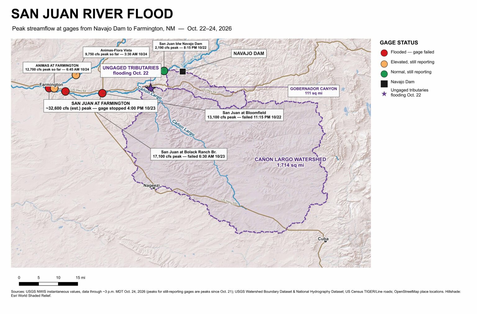
Staring at gages, you can see the wave of water coming down the San Juan. The gage at Bloomfield blew out late Thursday night, reading 13,100 cubic feet per second (cfs) before it failed. Downstream, the wave blew out the gage at the Bolack Ranch Bridge 7 hours later, running at 17,100 cfs. By the time the USGS gage on the San Juan at Farmington blew out Friday afternoon, the river had risen to ~32,600 cfs, the most water recorded there since the 1930s and more than double the biggest peak since Navajo Dam was completed in the early 1960s.
Flooding stretched from Pagosa Springs on the San Juan River in Colorado to Dennehotso on the Navajo Nation, with what appears to be the greatest impact on human communities in the Northwest New Mexico community of Farmington, at the confluence of the Animas and San Juan rivers. (The Tri-City Record seems to be the go-to source for news out of Farmington, also Patrick Lohmann at SourceNM, local and regional journalism FTW.) The reporteveryone keeps citing in news stories, via the National Weather Service, from late morning yesterday (Friday, Oct. 23), cites Farmington-area law enforcement saying “As many as 1500 homes and buildings are estimated to be impacted by flooding.” That’s 24 hours old.
I’m only loosely familiar with the area, and I’m not on the ground up there, but based on the gage readings and reports from emergency managers it looks like most of the water came out of two normally dry tributaries – Gobernador Canyon (a 111-square-mile watershed) and the much larger Cañon Largo (1,714 square miles). This is mostly a process of elimination – the gage below the Bureau of Reclamation’s Navajo Dam peaked at 2,190 cfs Thursday night, which puts an upper bound on the release. Gobernador and Largo are the most plausible ungaged watersheds between the dam and Bloomfield. Also, there was a report of flooding and evacuations in Largo Wash and Gobernador Canyon Thursday evening at 5:39 p.m., less than 6 hours before the Bloomfield gage went dark. The Animas at Farmington was only adding ~8,000 cfs Friday when the gage on the San Juan hit ~32,600 cfs and stopped reporting.
One of the lessons I learned as a young journalist covering earthquakes in California is that the places identified as having the most damage from a natural disaster are not necessarily the worst-hit places. They’re often the places that are the worst hit and still have the ability to communicate. This is sparsely populated Navajo and Jicarilla Apache Country, and I’d assume that the danger and the damage we’re hearing about from the population centers does not tell the full story of the suffering underway in the region.
Climate and flooding
We have three different primary kinds of flooding in the interior arid Southwestern United States: from spring and summer snowmelt; localized flooding from the summer monsoons; and autumn tropical storm remnants. We’re now experiencing a wave of classic tropical storm remnants.
The moisture that hit the Four Corners came from the remnants of Hurricane Trudy, which skirted the west coast of Mexico Oct. 16-19. This is not a visit from the hurricane itself, but rather its remnant moisture being pulled into the storm track, providing massive moisture fuel for what follows.
A group led by Elizabeth Ritchie at the University of Arizona some years back quantified the impact these storms can have:[1]
Although the tropical cyclone–strength winds rapidly diminish upon making landfall, these systems still carry a large quantity of tropical moisture and, upon interaction with mountainous topography, are found to drop up to 30% of the local annual precipitation.
Much like the summer monsoon, the impact of climate change on this kind of storm in the future is challenging to understand because these storms happen at spatial scales that are difficult for General Circulation Models, the big climate models used to understand the effects of rising greenhouse gases, to resolve. The coarse resolution of the GCMs tends to underestimate how much precipitation comes from the biggest storms – this is an issue I wrote about back in my science journalism days in the ’00s. We have new higher resolution GCMs now, but they still seem to struggle with this.[2]
1Ritchie, Elizabeth A., Kimberly M. Wood, David S. Gutzler, and Sarah R. White. “The influence of eastern Pacific tropical cyclone remnants on the southwestern United States.” Monthly Weather Review 139, no. 1 (2011): 192-210.
2Bjarke, Nels R., Ben Livneh, Joseph J. Barsugli, Angeline G. Pendergrass, and Eric E. Small. “Evaluating Large-Storm Dominance in High-Resolution GCMs and Observations Across the Western Contiguous United States.” Earth’s Future 12, no. 6 (2024): e2023EF004289. https://doi.org/10.1029/2023EF004289.
Map of the San Juan River, a tributary of the Colorado River, in Arizona, Colorado, New Mexico and Utah, USA. Made using USGS National Map data. By Shannon1 – Own work, CC BY-SA 4.0, https://commons.wikimedia.org/w/index.php?curid=47456307