[On May 6, 2021] NOAA and federal partners released the Conserving and Restoring America the Beautiful report, a roadmap for a decade-long, inclusive, voluntary and locally-led effort to conserve at least 30% of lands and waters by 2030.
These conservation efforts build on five decades of NOAA’s work connecting people to places by conserving and restoring special marine, coastal and Great Lakes areas for the benefit of all Americans. This important work includes:
NOAA recently tripled the size of the Flower Garden Banks National Marine Sanctuary to protect 14 reefs and banks that are habitat for recreationally important fishing.
NOAA will soon publish a final rule regarding a proposal to designate a new sanctuary, the Wisconsin Shipwreck Coast National Marine Sanctuary in Lake Michigan. When finalized, the designation will expand public and recreational access to the area’s 36 known shipwreck sites.
NOAA and the State of Connecticut are working together to designate a new National Estuarine Research Reserve, expected in January 2022, which will create a “living classroom” for research and education on Long Island Sound.
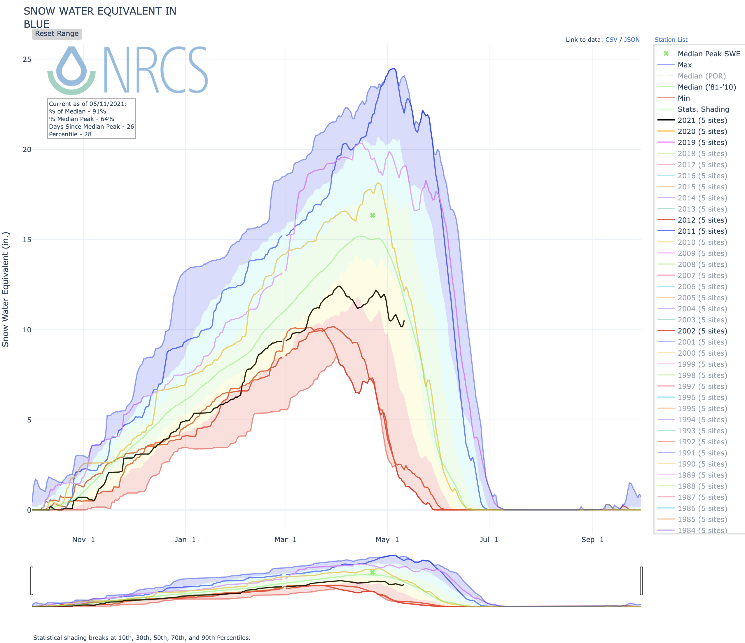
Area snowpack improved in April but is back on a melting trend. According to the latest numbers from the U.S. Department of Agriculture’s measurement sites, the snowpack level at Copper Mountain peaked at the beginning of April at 12.4 inches of snow-water equivalent — the amount of water held in the snowpack. The snow-water equivalent dropped to 10.6 inches in mid-April and increased to 12 inches by Friday, April 30.
The snowpack has declined in May and is currently sitting at 9.8 inches of snow-water equivalent on Copper Mountain, or 82% of the 30-year median. The upper Colorado River basin, which Summit County falls into, is at 65% of normal snow-water equivalent as of May 10.
“Things aren’t looking so good right now,” National Weather Service meteorologist Bernie Meier said. “We’ve melted out about a third of the snowpack already.”
Meier said cool and snowy days like Monday, May 10, slow down the melting process and add a bit to the snowpack, but overall, he expects the snowpack to remain below normal. He said the snowpack usually melts out between June 10 and 20…
According to the National Weather Service’s almanac, only 9 inches of snow was recorded in April at the Dillon Weather Station — almost half the area’s normal April snowfall of 17.3 inches.
So far, May is closer to average with a total of 3 inches as of Monday morning and more on the way with through the remainder of the storm. Through May 10, normal snowfall for the Dillon station is 3.3 inches.
Though not much snow accumulated, drought conditions have improved in Summit County, according to the U.S. Drought Monitor. The county is still in a drought, but the severity has lessened to a severe drought in the northern portion of the county and a moderate drought in the southern portion of the county, according to the Drought Monitor’s severity scale. As of April 27, the northern portion of the county was still in an extreme drought.
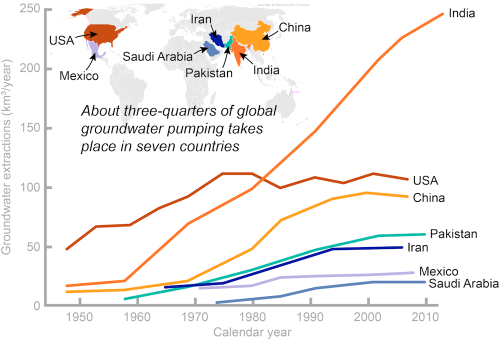
As the drought outlook for the Western U.S. becomes increasingly bleak, attention is turning once again to groundwater – literally, water stored in the ground. It is Earth’s most widespread and reliable source of fresh water, but it’s not limitless.
Wells that people drill to access groundwater supply nearly half the water used for irrigated agriculture in the U.S. and provide over 100 million Americans with drinking water. Unfortunately, pervasive pumping is causing groundwater levels to decline in some areas, including much of California’s San Joaquin Valley and Kansas’ High Plains.
We are a water resources engineer with training in water law and a water scientist and large-data analyst. In a recent study, we mapped the locations and depths of wells in 40 countries around the world and found that millions of wells could run dry if groundwater levels decline by only a few meters. While solutions vary from place to place, we believe that what’s most important for protecting wells from running dry is managing groundwater sustainably – especially in nations like the U.S. that use a lot of it.
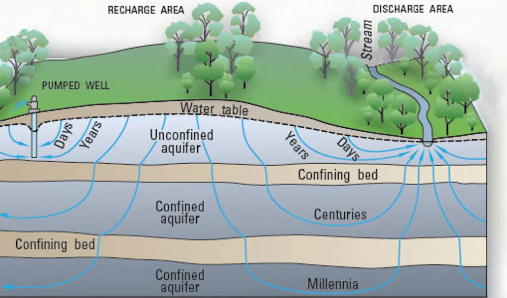
Groundwater flows through tiny spaces within sediments and their underlying bedrock. At some points, called discharge areas, groundwater rises to the surface, moving into lakes, rivers and streams. At other points, known as recharge areas, water percolates deep into the ground, either through precipitation or leakage from rivers, lakes and streams.
Groundwater can remain underground for days to millennia, depending on how deep it sinks, how readily it moves through rock around it and how fast humans pump it to the surface. USGS
Leaky streams are widespread across the United States.
Groundwater depletion can also cause wells to run dry when the top surface of the groundwater – known as the water table – drops so far that the well isn’t deep enough to reach it, leaving the well literally high and dry. Yet until recently, little was known about how vulnerable global wells are to running dry because of declining groundwater levels.
There is no global database of wells, so over six years we compiled 134 unique well construction databases spanning 40 different countries. In total, we analyzed nearly 39 million well construction records, including each well’s location, the reason it was constructed and its depth.
Our results show that wells are vital to human livelihoods – and recording well depths helped us see how vulnerable wells are to running dry.
Millions of wells at risk
Our analysis led to two main findings. First, up to 20% of wells around the world extend no more than 16 feet (5 meters) below the water table. That means these wells will run dry if groundwater levels decline by just a few feet.
Groundwater wells are at risk of running dry around the globe.
Second, we found that newer wells are not being dug significantly deeper than older wells in some places where groundwater levels are declining. In some areas, such as eastern New Mexico, newer wells are not drilled deeper than older wells because the deeper rock layers are impermeable and contain saline water. New wells are at least as likely to run dry as older wells in these areas.
– Sell the property. This is often considered if constructing a new well is unaffordable. Drilling a new household well in the U.S. Southwest can cost tens of thousands of dollars. But selling a property that lacks access to a reliable and convenient water supply can be challenging.
– Divert or haul water from alternative sources, such as nearby rivers or lakes. This approach is feasible only if surface water resources are not already reserved for other users or too far away. Even if nearby surface waters are available, treating their quality to make them safe to drink can be harder than treating well water.
– Reduce water use to slow or stop groundwater level declines. This could mean switching to crops that are less water-intensive, or adopting irrigation systems that reduce water losses. Such approaches may reduce farmers’ profits or require upfront investments in new technologies.
[Over 100,000 readers rely on The Conversation’s newsletter to understand the world.Sign up today.]
– Limit or abandon activities that require lots of water, such as irrigation. This strategy can be challenging if irrigated land provides higher crop yields than unirrigated land. Recent research suggests that some land in the central U.S. is not suitable for unirrigated “dryland” farming.
Households and communities can take proactive steps to protect wells from running dry. For example, one of us is working closely with Rebecca Nelson of Melbourne Law School in Australia to map groundwater withdrawal permitting – the process of seeking permission to withdraw groundwater – across the U.S. West.
State and local agencies can distribute groundwater permits in ways that help stabilize falling groundwater levels over the long run, or in ways that prioritize certain water users. Enacting and enforcing policies designed to limit groundwater depletion can help protect wells from running dry. While it can be difficult to limit use of a resource as essential as water, we believe that in most cases, simply drilling deeper is not a sustainable path forward.
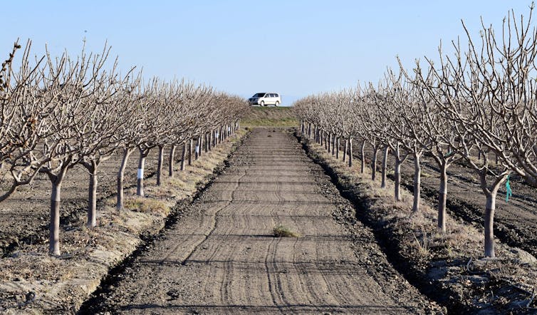
High Plains in eastern Colorado. Photo credit Bob Berwyn.
FromColorado Public Radio (Michael Elizabeth Sakas):
Most ranchers sell their cattle to a meat company for the going price, so there’s often little profit or incentive to invest in significant environmental improvements to their land. Something as simple as planting trees among pastures is expensive, especially across hundreds or thousands of acres.
“These kinds of things are great for biodiversity and take carbon out of the atmosphere and create all this public benefit and conserve water,” said Anthony Myint. “But they can’t sell the beef for an extra dollar.”
Myint is a restaurateur and the co-founder of Zero Foodprint, a nonprofit working with Boulder County to support regenerative agriculture projects that can help fight climate change.
Restore Colorado is a simple idea, but Myint hopes it will have a big impact. Restaurants and other food businesses donate 1 percent of their profits to fund farming and ranching projects that suck carbon from the atmosphere through plants that take in the greenhouse gas and store it in healthy soil. Some see regenerative agriculture as a key way to reduce the amount of CO2 in the air worsening climate change…
Boulder started Restore Colorado through a grant from the U.S. Department of Agriculture and teamed up with Myint, who founded well-known Mission Chinese Food in New York and San Francisco and first started crowd-funding carbon-farming grants in California…
To give farmers extra financial support to invest in climate-friendly agriculture, Myint thinks the food industry should take cues from the energy industry. Electricity customers, for example, can pay a little extra on their utility bills to support clean energy or elect to buy power from a solar farm…
McCauley Family Farm in Longmont is one of the first in Colorado to get a grant from this program. Farm manager Marcus McCauley said one way he will use the money is to create more silvopasture, where trees are grown on grazing land. Those trees can provide a windbreak for the grass, and the protection and shade can help keep moisture in the ground during a drought…
All of these things mean healthier soil on McCauley’s farm. That healthier soil means the trees and grass suck even carbon out of the air. And healthier plants mean McCauley’s pasture-raised chicken and sheep are more nutritious — and they do less damage to the land…
The Colorado Department of Agriculture’s Soil Health Initiative supports regenerative agriculture projects with a five-year, $5 million agreement with the USDA. Cindy Lair, who manages the Colorado State Conservation Board program, said she thinks the Restore Colorado concept would be “cool to take statewide and find more ways to link food consumers to their food.”
“We have such a tendency to be so disconnected from where our food is produced,” Lair said. She sees Restore Colorado as a way to help people make that connection. Lair said the state is paying close attention to the Boulder program and wants to “see if we can help build on it.”
Here’s the release from the NRCS (Brian Domonkos):
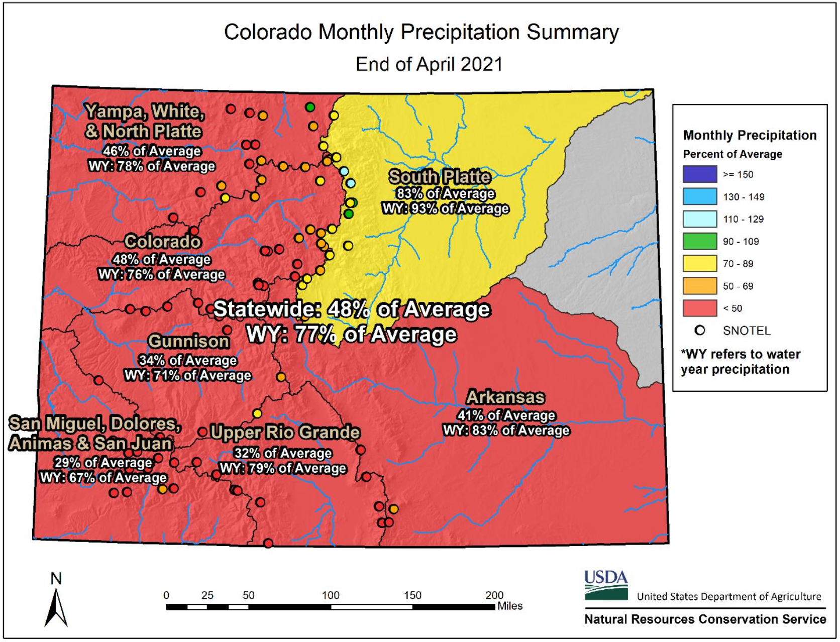
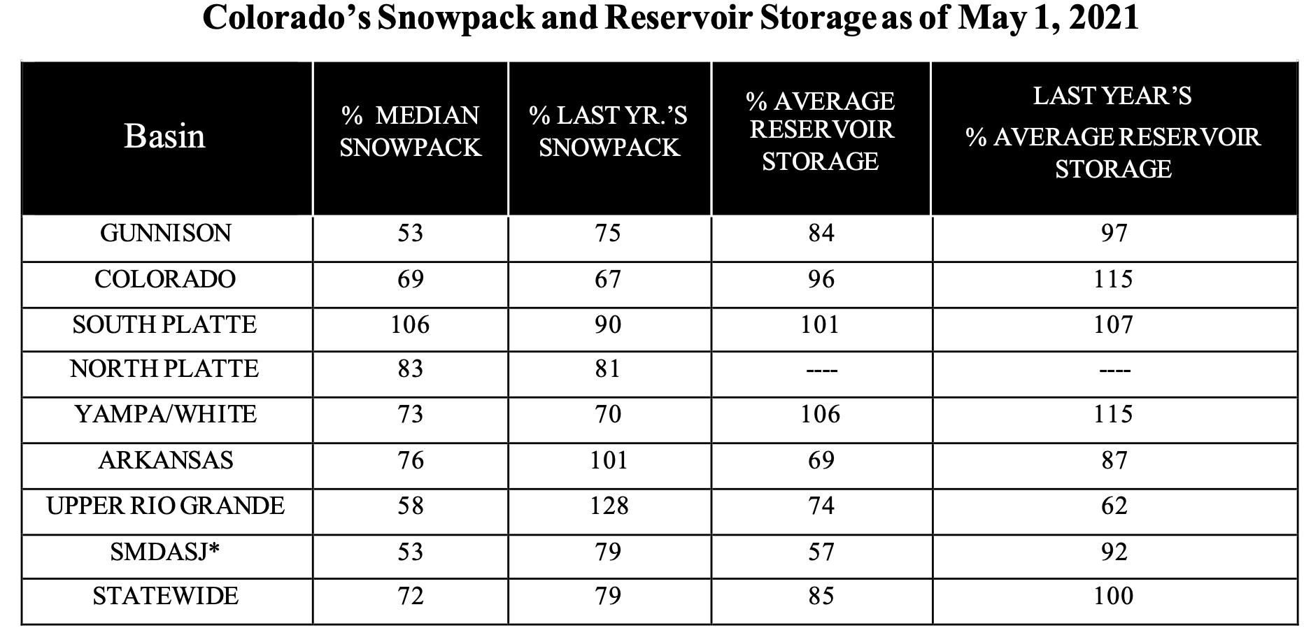
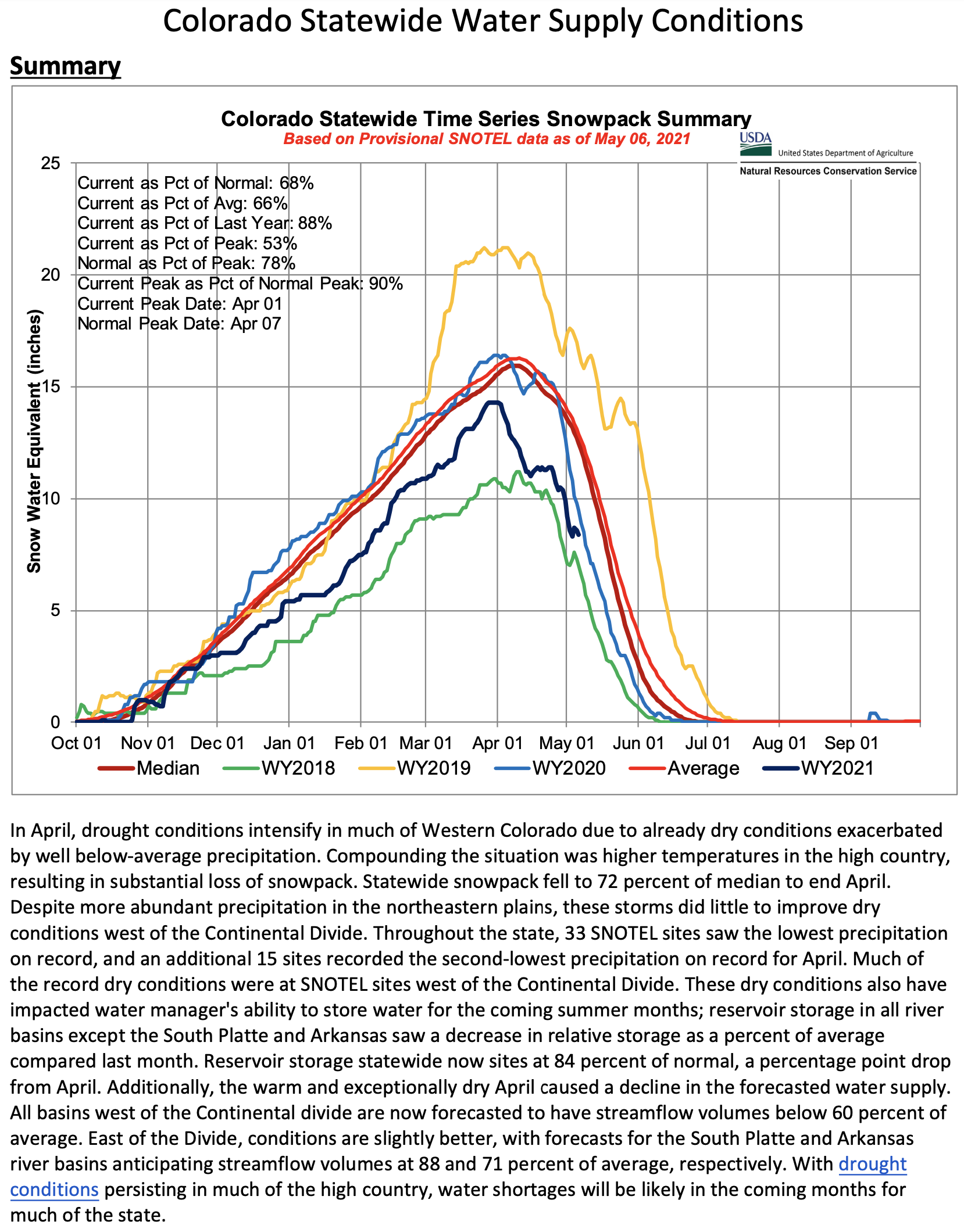
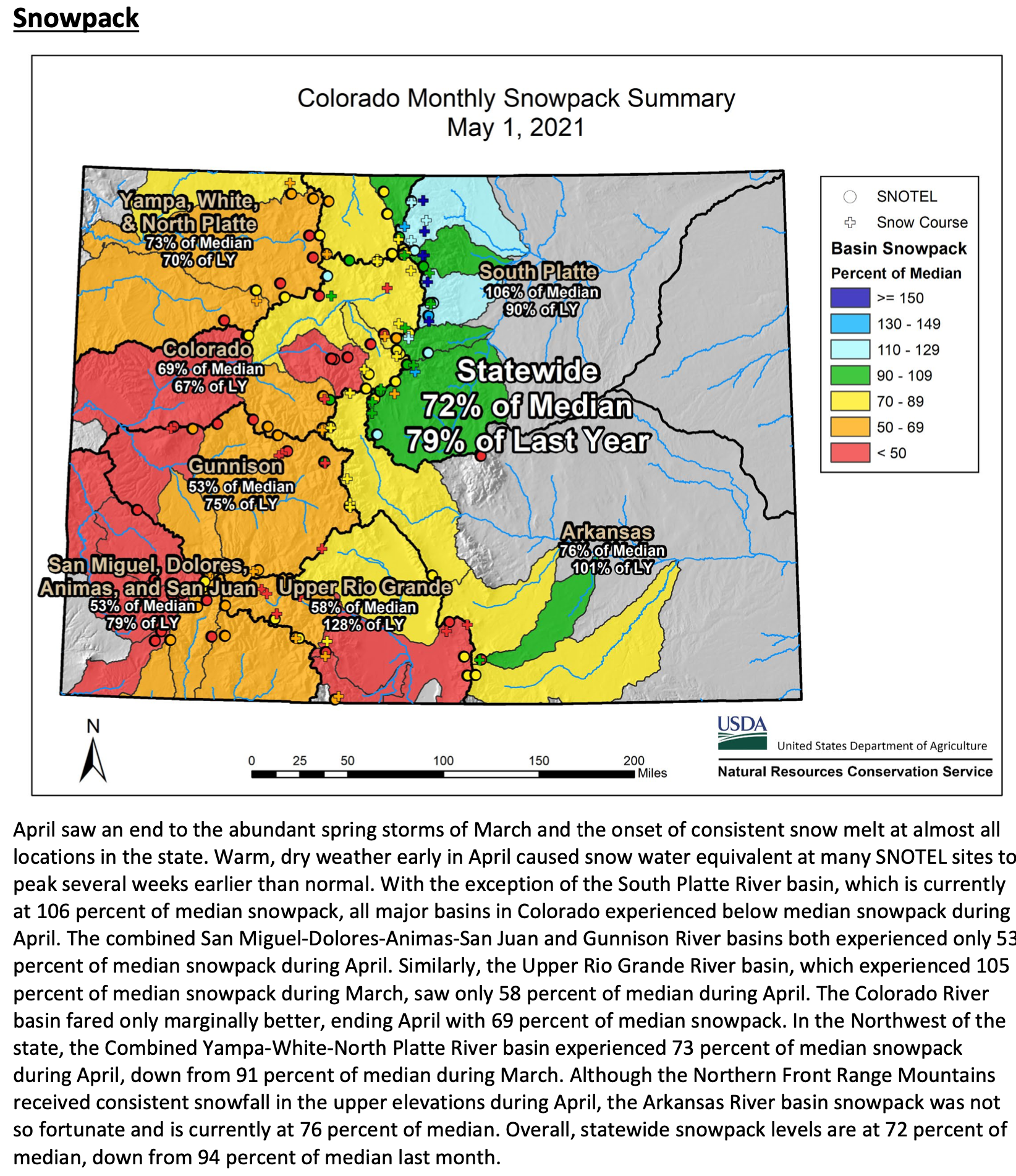
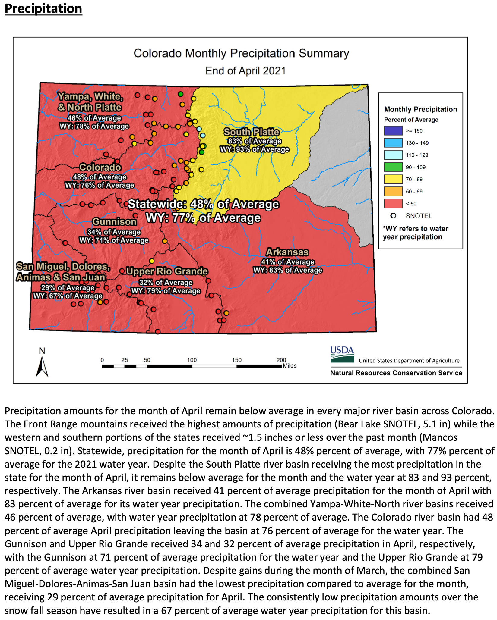
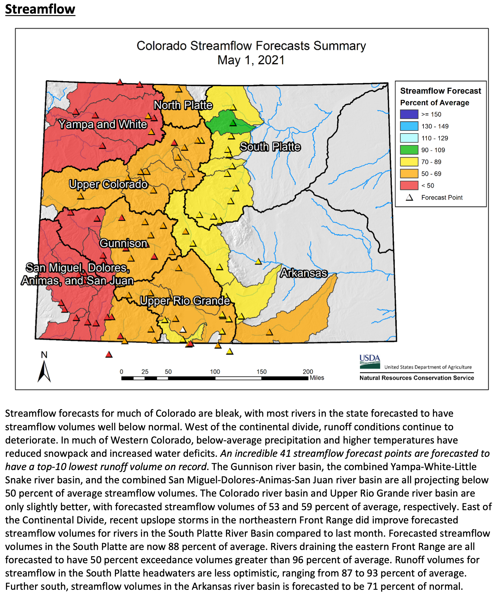
An exceptionally dry April, along with warmer mountain temperature exacerbated already dry conditions in much of Colorado. Precipitation in April ranged from a high of 83 percent of average in the South Platte River Basin to as low as 29 percent of average in the combined San Miguel-Dolores-Animas-San Juan river basin. NRCS Hydrologist Joel Atwood notes, “Many SNOTEL sites reported record low precipitation for April west of the Continental Divide. Snowpack has also declined in all basins except the South Platte, due to higher temperature and below-average precipitation.” As of May 9th, all basins in the state have snowpack below 80 percent of median except the South Platte river basin, which has 102 percent of median snowpack.
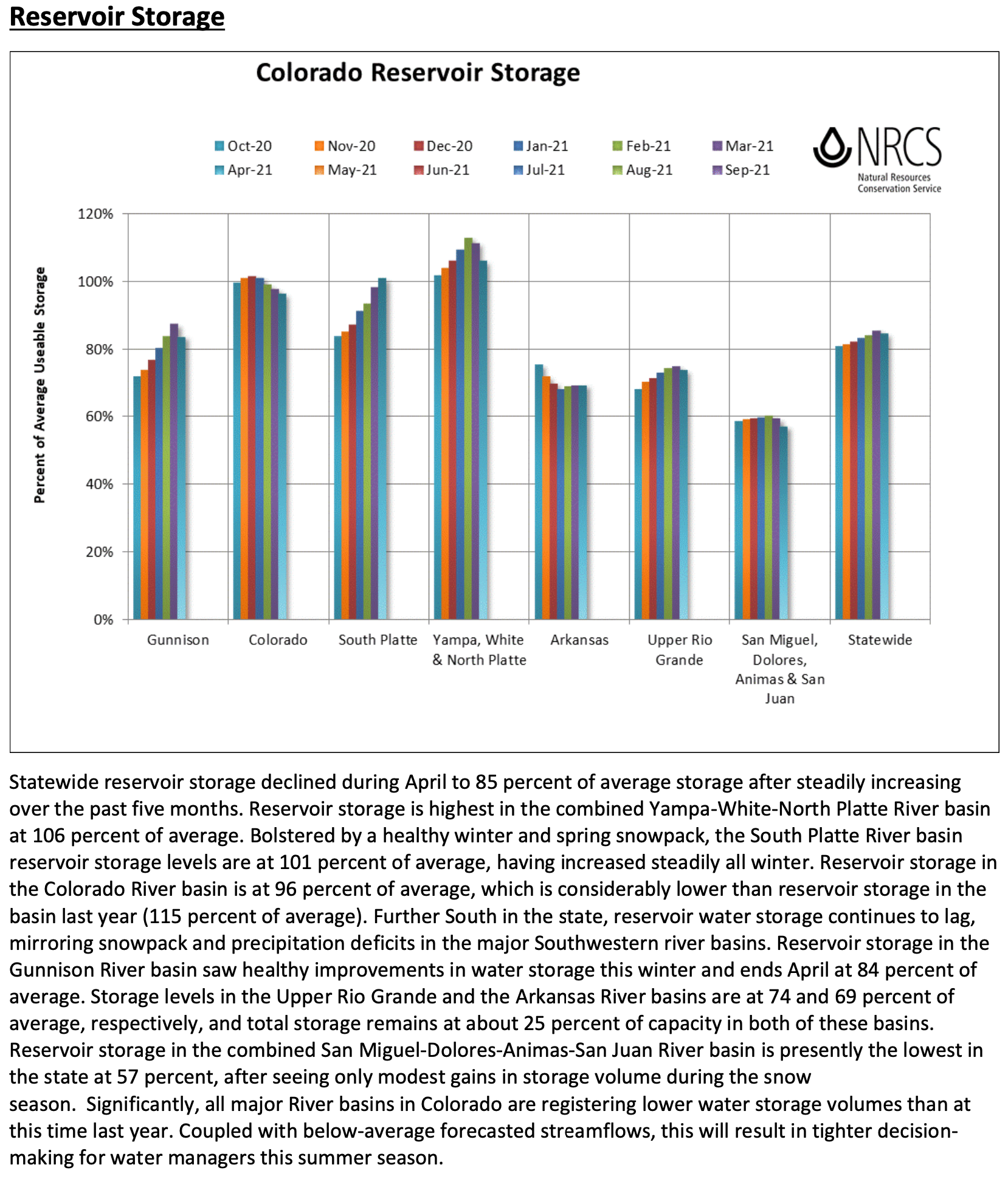
Statewide reservoir storage declined by a percentage point over last month, where all basins except the South Platte river basin saw a decline in relative storage. The combined Yampa-White-North Platte and the South Platte river basins ended April with above-average storage at 106 and 101 percent of average, respectively. On the low end, the combined San Miguel-Dolores-Animas-San Juan and the Arkansas river basins ended April with 57 and 69 percent of average reservoir storage, respectively.
Recent precipitation that has helped improve water supply in the South Platte river basin has had little impact on the rest of the state. Dry conditions have persisted in much of the state since last summer, and a dry April only compounded current drought conditions. NRCS Hydrologist Atwood continued to comment that “With much of the snowpack in many basins already melted out, persistent dry soil conditions, and little hope for substantial precipitation moving into summer, runoff volumes will continue to be meager.” All basins west of the continental divide are forecasted to have streamflow volumes between 34 and 73 percent of average. The South Platte river basin, which has the best water supply outlook in the state, has streamflow volume forecasts range from 90 to 104 percent of average.
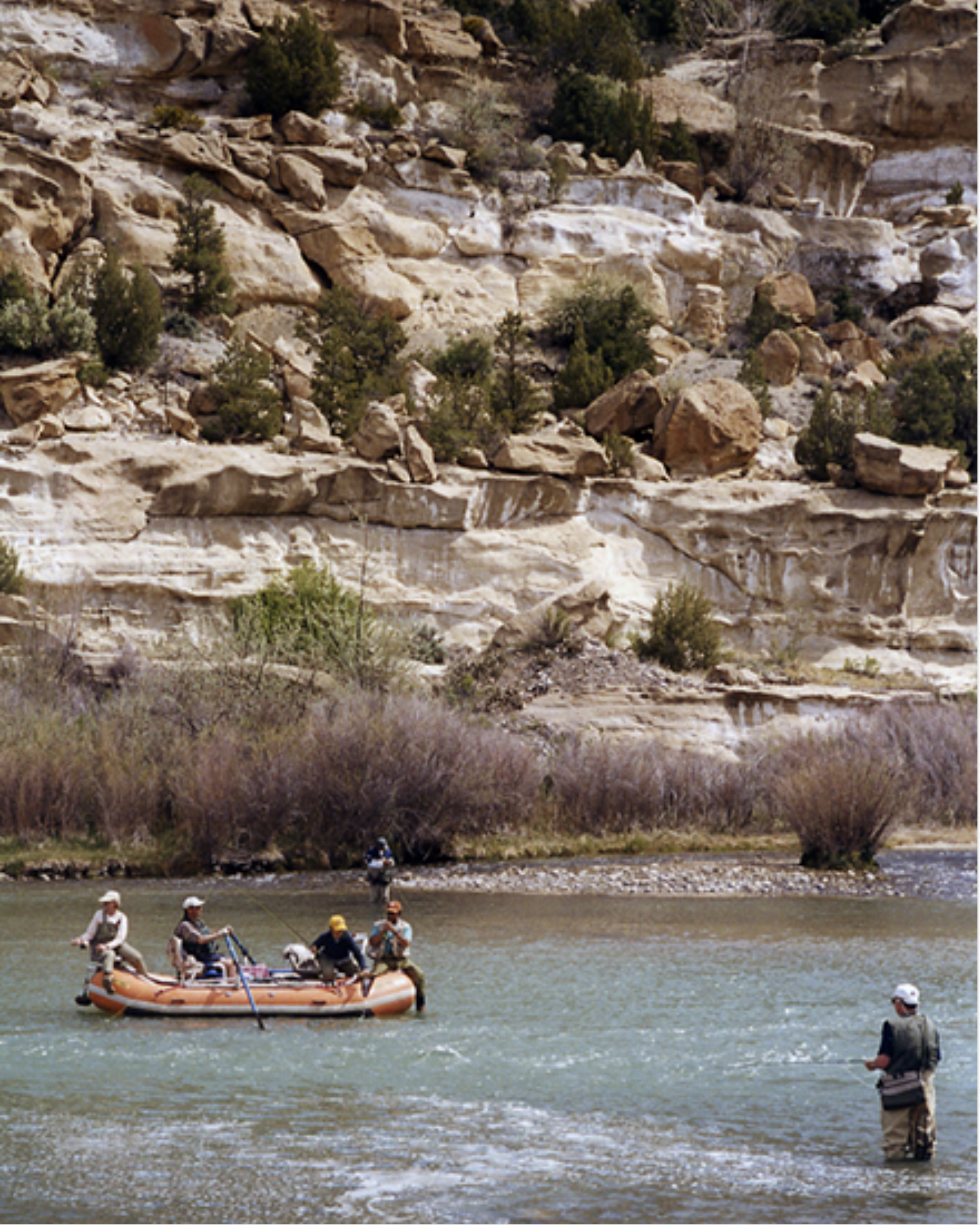
In response to a forecast lull in flows in the critical habitat reach, the Bureau of Reclamation has scheduled a temporary increase in the release from Navajo Dam from 400 cubic feet per second (cfs) to 600 cfs on Tuesday, May 11th, starting at 0400 AM. Releases are made for the authorized purposes of the Navajo Unit, and to attempt to maintain a target base flow through the endangered fish critical habitat reach of the San Juan River (Farmington to Lake Powell).
The San Juan River Basin Recovery Implementation Program recommends a target base flow of between 500 cfs and 1,000 cfs through the critical habitat area. The target base flow is calculated as the weekly average of gaged flows throughout the critical habitat area from Farmington to Lake Powell. Please be advised, due to the dry conditions this year, more release changes than usual may occur.
Fly fishers on the San Juan River below the Navajo Dam.U.S. Bureau of Reclamation