Potential toxicity of pesticides to aquatic life in U.S. rivers is widespread — USGS

Pesticides sprayed on agricultural fields and on urban landscaping can run off into nearby streams and rivers. Here, pesticides are being sprayed on a soybean field in Iowa. (Credit: Eric Hawbaker, Blue Collar Ag, Riceville, IA)

Here’s the release from the USGS (Sarah Stackpoole):

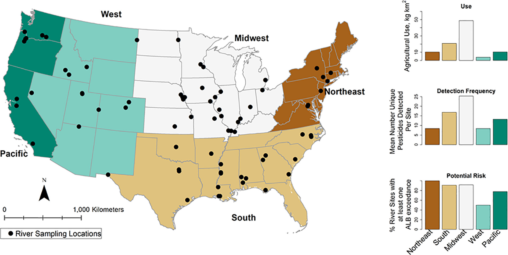
A new USGS study of pesticides in U.S. rivers and streams reports that, on average, 17 pesticides were detected at least once at the 74 river and stream sites sampled 12 to 24 times per year during 2013–2017. Herbicides were detected much more frequently than insecticides and fungicides.

The number of pesticides detected at a site over the study mirrored the intensity of pesticide use in the region where the site was located. Pesticide use intensity was greatest in the Midwest (49 kg/km2), where 25 pesticides were detected, on average, at each site. Herbicides were heavily used in agricultural settings and were consistently detected in surface waters at concentrations >100 ng/L (nanograms per liter). In contrast, insecticides had lower agricultural-use intensities and surface-water detection frequencies at concentrations >100 ng/L were rare.

An Environmental Protection Agency (EPA) chronic aquatic-life benchmark—estimates of the concentrations below which pesticides are not expected to represent a risk to aquatic life—was exceeded at least once at more than half of the stream sites in every region—Midwest, South, Northeast, West, and Pacific. Such exceedances indicate the potential for harmful effects to aquatic life such as fish, algae, and invertebrates like aquatic insects. However, an EPA human-health benchmark was exceeded only four times (1.1% of samples).

Of the 221 pesticides measured, just 17 were responsible for the aquatic-life benchmark exceedances. Many of these 17 were herbicides, which frequently occurred at relatively high concentrations that exceeded benchmarks for fish, invertebrates, and plants. Others were insecticides, which occurred at lower concentrations, but which are much more toxic to aquatic invertebrates than herbicides.

Here’s the abstract from the study (Sarah M.Stackpoole, Megan E.Shodab, Laura Medalie, Wesley W.Stone):

Pesticides pose a threat to the environment, but because of the substantial number of compounds, a comprehensive assessment of pesticides and an evaluation of the risk that they pose to human and aquatic life is challenging. In this study, improved analytical methods were used to quantify 221 pesticide concentrations in surface waters over the time period from 2013 to 2017. Samples were collected from 74 river sites in the conterminous US (CONUS). Potential toxicity was assessed by comparing surface water pesticide concentrations to standard concentrations that are considered to have adverse effects on human health or aquatic organisms. The majority of pesticide use is related to agriculture, and agricultural production varies across the CONUS. Therefore, our results were summarized by region (Northeast, South, Midwest, West and Pacific), with the expectation that crop production differences would drive variability in pesticide use, detection frequency, and benchmark exceedance patterns. Although agricultural pesticide use was at least 2.5 times higher in the Midwest (49 kg km−2) than in any of the other four regions (Northeast, South, West, and Pacific, 3 to 21 kg km−2) and the average number of pesticides detected in the Midwest was at least 1.5 higher (n = 25) than the other four regions (n = 8 to n = 16), the potential toxicity results were more evenly distributed. At least 50% of the sites within each of the 5 regions had at least 1 chronic benchmark exceedance. Imidacloprid posed the greatest potential threat to aquatic life with a total of 245 benchmark exceedances at 60 of the 74 sites. These results show that pesticides persist in the environment beyond the site of application and expected period of use. Continued monitoring and research are needed to improve our understanding of pesticide effects on aquatic and human life.

Graphical abstract

The latest E-Newsletter is hot off the presses from the Hutchins Water Center #ColoradoRiver #COriver #aridification

Click here to read the newsletter. Here’s an excerpt:

RUNOFF FORECASTS DECLINE FURTHER
Each new runoff forecast for Lake Powell brings a lower number, with the May 18 Colorado Basin River Forecast Center forecast discussion predicting unregulated April – July inflows of 1.85 million acre-feet (26% of average), down 2% from the May 1 forecast. Blue Mesa Reservoir has the best runoff forecast for major upper basin reservoirs, with a forecast spring runoff of 50% of average.

First-ever #ColoradoRiver water shortage is now almost certain, new projections show — CNN #COriver #aridification

At full pool, Lake Mead is the largest reservoir in the United States by volume, but two decades of drought have dramatically dropped the water level behind Hoover Dam as can be seen in this photo. (Source: U.S. Bureau of Reclamation)

From CNN (Pedram Javaheri and Drew Kann):

On Tuesday, the water level in Lake Mead — the largest US reservoir, and fed by the Colorado River — fell below the elevation of 1,075 feet. It has hit that mark only a handful of times since the Hoover Dam was finished in the 1930s, but it always recovered shortly after. It may not this time, at least not any time soon.

The US Bureau of Reclamation (USBR) forecasts the lake’s levels to continue to decline, without any sign of recovery through at least the end of 2022. If the next major study in August from the USBR projects water levels in the lake will be below 1,075 feet on January 1, it would trigger the first-ever shortage declaration on the Colorado River, meaning some communities would begin to see their water deliveries cut significantly next year.

Lake Mead and nearby Lake Powell — the two largest reservoirs on the Colorado River — have drained at an alarming rate. Lake Mead has fallen more than 139 feet since January of 2000.

Lake Mead is currently 16 feet below where it was this time last year and the reservoir is only 37% full, while Lake Powell is down 35 feet from last year and sits at just 34% of the lake’s total capacity.

Glen Canyon Dam on the Colorado River in April 2017. The dam is 15 miles upstream from Lees Ferry, Arizona. The Colorado River, which supplies water to more than 40 million people and irrigates millions of acres of farmland, has seen its supply sapped by drought and climate change. Photo by Alexander Stephens/courtesy Bureau of Reclamation.

In addition to dwindling snowpack, which provides most of the river’s water supply, experts say dry, thirsty soils across the basin are soaking up meltwater, meaning that less makes it into the river system…

Climate change is also taking a toll on the river’s water supply. A study by US Geological Survey scientists published in 2020 found that the Colorado River’s flow has declined by about 20% over the last century, and over half of that decline can be attributed to warming temperatures across the basin.

Who would the shortage affect?

With the level of Lake Mead dipping below 1,075 feet on Tuesday and forecast to drop further, it is nearly certain that the Bureau of Reclamation will declare a Tier 1 shortage later this summer.

If a Tier 1 shortage is declared, Colorado River water deliveries would be reduced for Arizona and Nevada as soon as next year, based on the terms of the 2019 drought contingency plan signed by the lower Colorado River basin states.

The looming water cuts will have the greatest impact in Arizona.

As part of the lower basin’s drought contingency plan, the Central Arizona Project would see its water supply slashed by about one third in 2022 due to its junior rights to the river’s water.

While Arizona’s main population centers will be spared, the effects of those water cuts will be felt most acutely on farms in central Arizona, due to their lower priority status in a complex tier system used to determine who loses water first in the event of a shortage.

California’s water deliveries would not be impacted in a Tier 1 shortage, according to the drought contingency plan.

What happens if Lake Mead sinks further?

In the event of a Tier 2 shortage — which the USBR projects could happen as soon as late 2022 — the cuts would impact some cities and tribes in Arizona that receive water from the Central Arizona Project canal.

“I’m definitely concerned that the raw projections continue to go downward and that we are heading towards potentially a Tier 2 [shortage] in 2023,” said Tom Buschatzke, director of the Arizona Department of Water Resources.

#GlenwoodSprings finishes emergency watershed protection project — #Aspen Daily News

The Grizzly Creek Fire jumped Grizzly Creek north of Glenwood Canyon. (Provided by the City of Glenwood Springs)

From The Aspen Daily News (Matthew Bennett):

Shortly after the Grizzly Creek Fire ignited in Glenwood Canyon last August, the city shut off one of its integral water intakes at No Name Creek for nearly a week as firefighting efforts commenced. During that time, the city relied upon its Roaring Fork pump station, which supplied water to its nearly 10,000 residents as the fire raged on in the canyon.

“They were slurry bombing the hillside, and we didn’t want them to accidentally hit the creek and for us to pull slurry into the intakes,” Matt Langhorst, Glenwood Springs public works director, said in an interview Thursday.

According to Langhorst, the city requires roughly 1 million gallons of water a day in the winter. During the summer, when the Grizzly Creek Fire blew up, an influx of tourists combined with irrigation efforts increases the city’s water consumption to approximately 4 million gallons a day.

As a result of the Grizzly Creek Fire, the city had to bulk up its water intakes with steel armoring to protect the critical infrastructure in the event of a debris flow.

Thanks to a grant from the Emergency Watershed Protection Program and the Natural Resources Conservation Service (NRCS), the city hired local contractor Gould Construction, which originally built most of the water infrastructure impacted by the Grizzly Creek Fire.

Evaluating Conserved Consumptive Use in the Upper #ColoradoRiver: A discussion on the initial findings of a groundbreaking research project exploring water conservation in high-altitude ranching operations, June 24, 2021 — @CWCB_DNR #COriver #aridification

Photo credit: Colorado Water Conservation Board

Click here for all the inside skinny and to register:

About this event

Persistent drought and climate change are putting increasing pressure on our limited water supplies, and stakeholders throughout Colorado are exploring solutions to address these challenges in ways that support our economy, our environment, and our way of life. Providing options to temporarily reduce agricultural water use is one potential solution, but significant knowledge gaps exist about how this can work in practice for the high-altitude perennial grasses that make up the majority of the irrigated acreage on Colorado’s Western Slope.

With support from the Colorado Water Conservation Board ,the Colorado Basin Roundtable is leading a multi-year field research project with ag producers in the Kremmling area, researchers from multiple universities, and conservation groups in directly tackling this information gap.

Results from this research project will address three key questions on how ag water conservation can work in practice: How can we accurately and cost-effectively measure water use and water savings at scale? What are the impacts of reduced irrigation on these grass fields and how do they recover under normal irrigation? What does participation in a water conservation project mean for producers’ bottom line and for the ag-based community and economy of the region?

The CBRT and CWCB invite you to join the project partners for a webinar covering results from the first year of the project and the implications for these challenging questions.