Here’s the release from the City of Boulder (Samantha Glavin and Julie Causa):
Due to recent warm weather and increased snowmelt and runoff, Barker Reservoir is expected to start spilling later this week, as early as this Friday, May 28.
This is a normal and expected event that will increase flows in Boulder Creek throughout the city and residents are urged to take caution near the creek during the high flow period, which may last for several weeks.
Each spring as temperatures warm, stream flows increase due to runoff from melting mountain snow. Before peak stream flows occur at lower elevations (like in the city of Boulder), mountain reservoirs must first fill and start spilling.
Barker spill typically occurs between mid-May to late June, with the exact date dependent on weather, snowpack and early spring reservoir levels.
Barker Reservoir has relatively limited storage space, which means that when the reservoir is full, any excess inflow passes over the spillway and continues flowing downstream into Boulder Creek. To provide a sense of scale, the volume of water that flows through Middle Boulder Creek each spring could fill the reservoir multiple times.
FromThe Cortez Journal (Jim Mimiaga) via The Durango Herald:
Irrigators tied to McPhee Reservoir contracts will receive just 5% to 10% of their normal supply, said Ken Curtis, general manager for the Dolores Water Conservancy District.
The shortages affect full-service users in the water district in Montezuma and Dolores counties, the Ute Mountain Ute Farm and Ranch and the downstream fishery.
The water district said no supplemental irrigation supplies will be available to the senior water-rights holders.
Alfalfa farmers are consolidating acreage to try to produce one small crop…
“Financial impacts will be hard on all agriculture producers,” said Dolores Water Conservancy District board president Bruce Smart, in a news release. “The recovery for producers, the Ute Mountain Tribe and the district will take years.”
The tribe’s Farm and Ranch Enterprise reports it will limit employment and cut back on buying farm supplies.
The 7,600-acre farm will only receive 10% of its normal water supply, tribal officials said.
The tribe will limit operations to growing corn for its Bow and Arrow Brand cornmeal mill, and to protect high-value alfalfa fields, said Ute Mountain Ute Tribal Chairman Manuel Heart…
The tribe intends to work closely with the Dolores Water Conservancy District and the U.S. Bureau of Reclamation to protect the continued viability of the Ute Farm and Ranch Enterprise.
Heart notes that the tribe’s participation in the Dolores Project is a result of the Colorado Ute Indian Water Rights Settlement Act. He said the tribe will exercise the settlement rights “in the fullest to protect our Farm and Ranch Enterprise.”
The economic impact of the irrigation water shortage will be widespread, as farmers expect a significant decrease in revenue that will trickle through the local economy, water officials said.
If next year’s supply doesn’t improve “multigenerational farm families may face bankruptcy,” said Curtis.
Unirrigated alfalfa fields will dominate the landscape this summer. Farmers noted that with some rain, the fallow fields can produce enough forage for cattle grazing. Ranchers have been contacting farmers to take advantage of the option, Deremo said.
Curtailed supply for Dove Creek
The town of Dove Creek depends on McPhee Reservoir water for its domestic water supply. The water is delivered via the Dove Creek Canal and into town reservoirs and a water treatment facility. But because of a shortened irrigation season, the canal will not run all summer, as it does during more normal water years.
The water district is working closely with Dove Creek officials to keep the town’s water reservoirs adequately stocked for the winter months, Curtis said.
During normal water years, the Dove Creek Canal runs to the first week in October, allowing Dove Creek to store 100 acre-feet that lasts them until May 1 the next year. This year, the canal is expected to shut off for irrigators before the end of June.
The other large irrigation supplier in the area, Montezuma Valley Irrigation Co., also faces shortages. Customers will receive only half their normal allocation. The irrigation company has the most senior water rights on the Dolores River, and therefore the impact of the water shortage is somewhat less…
Montezuma Valley Irrigation has storage rights in McPhee Reservoir, and owns Narraguinnep and Groundhog reservoirs.
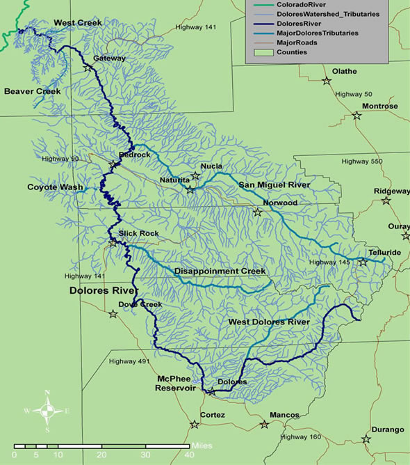
Dolores River watershed
Runoff low in Dolores River
Poor winter snowpack the past two years and no monsoonal rain for the past three years have hurt reservoir levels and depleted soil moisture.
The winter snowpack failed to deliver at historical average, peaking at only 83% of normal snowpack on April 1, then dropping to 25% after another dry, windy and warm spring. Recent rains and snowfall on the high peaks were helpful, but not enough to significantly improve water supply.
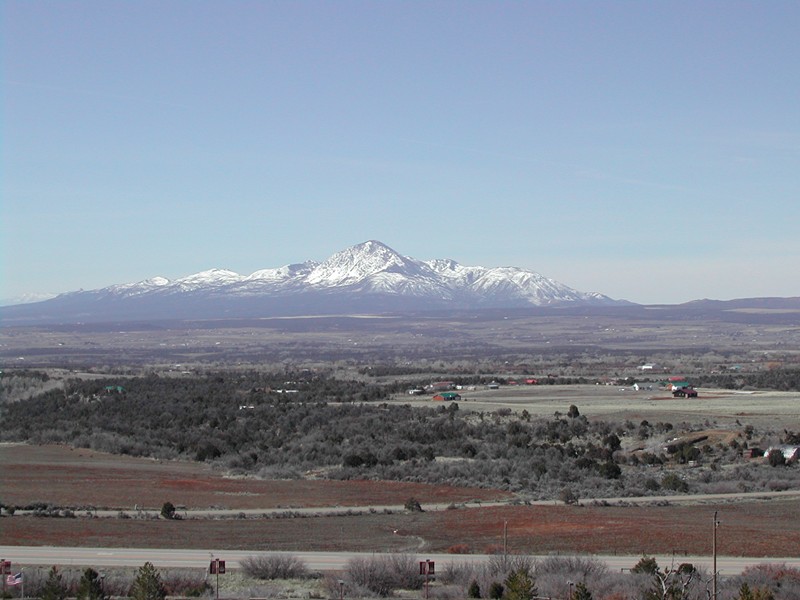
As dry conditions continue, 2021 is shaping up to be the fourth-lowest recorded runoff in the Dolores River, after 1977, 2002 and 2018.
The Dolores River, below Slickrock, and above Bedrock. Photo: Brent Gardner-Smith/Aspen Journalism.
Fish will suffer
As part of the McPhee Reservoir project, the downstream fishery is allocated 32,000 acre-feet of water during normal water years for timed releases downstream to benefit sport and native fish.
This year, the fish pool will receive 5,000 acre-feet of its normal allocation.
The Dolores River below McPhee dam will see flows of 10 cubic feet per second for a few months, then it will drop to a trickle of 5 cfs for eight months until spring.
The river below the dam faces significant trout and native fish population losses, said Jim White, aquatic biologist for Colorado Parks and Wildlife…
Flannel mouth sucker
Bluehead sucker
Roundtail chub
The low flows will also affect native fish in the lower reaches of the Dolores River – the flannelmouth sucker, the bluehead sucker and the roundtail chub. The fish, listed by CPW as species of concern, have adapted to warm water, but they still need pools and flowing water to survive.
Click on a thumbnail graphic to view a gallery of drought data from the US Drought Monitor.
US Drought Monitor map May 25, 2021.
High Plains Drought Monitor map May 25, 2021.
West Drought Monitor map May 25, 2021.
Colorado Drought Monitor map May 25, 2021.
Click here to go to the US Drought Monitor website. Here’s an excerpt:
This Week’s Drought Summary
Much of the western CONUS experienced below-normal average temperatures this week, with many areas across the Great Basin and Northern Rockies observing greater than 6°F negative departures. Above-normal precipitation in the West was limited to the high elevations of the Cascades, the Central Great Basin, Montana, and northern New Mexico. However, improvements were only warranted in western Montana and northern parts of New Mexico, where the heaviest precipitation fell. Elsewhere in the West, degradations were warranted due to declining snowpack, stream flows, and soil moisture. The Southern Plains and Gulf Coast also experienced negative 7-day average temperature departures. However, negative departures along the eastern Gulf Coast were driven by easterly to northeasterly flow early in the week whereas below-normal temperatures along the western Gulf Coast and Southern Plains were driven by above-normal precipitation (1 to 2 inches across the Southern Plains and well in excess of 3 inches through the Ark-La-Tex and along the western Gulf Coast). Heavy rains in the Southern Plains resulted in continued improvements across Texas this week, while high pressure across the Southeast exacerbated 30 to 60-day dryness in Virginia, the Carolinas, and Florida, leading to degradation of abnormally dry (D0) and moderate drought (D1) conditions. From the Central and Northern Plains eastward to the Atlantic Coast, most areas experienced temperatures 6°F to 9°F above-normal. Heavy rains fell across western portions of the High Plains Region, warranting minor improvements across the western Dakotas, while the larger improvements were observed from western Nebraska and Kansas westward to the Front Range. From the eastern High Plains Region to the Great Lakes, improvement and degradations were observed based on where the heaviest precipitation fell. In the Mid-Atlantic and Northeast, below-normal precipitation over the past couple of weeks and above-normal average temperatures this week resulted in D0 expansion from the Great Lakes to New England and into the Mid-Atlantic, with some D1 expansion in Upstate New York. Stream flows and soil moisture continue to rapidly decline across the Northeast, Mid-Atlantic, and portions of the Southeast…
In the High Plains Region, a swath of 1.5 to 3 inches (locally more) of rain fell from western North Dakota southward to eastern Colorado and northwestern Kansas. This resulted in reductions in D0 (abnormally dry) and D1 (moderate drought) coverage in western Nebraska and eastern Colorado, with additional 1-category improvements in the drought depiction across southeastern Colorado. In the Dakotas, where long-term moderate (D1) to exceptional (D4 – South Dakota) drought is entrenched, the heavy rainfall, although beneficial, was only enough for minor reductions in D1 (moderate drought) to D3 (extreme drought) coverage in the western areas. Reports indicate much of this week’s heavy rains was immediately absorbed by the severely dry soils, with no runoff into empty dugouts or ponds. However, in some locations, the rain fell so quickly that it did not allow time for infiltration into the topsoils, resulting in erosion of topsoils. Furthermore, high wind events have increased the potential for evaporative loss of this moisture from the topsoils. Currently, very little vegetative matter is available for grazing, despite some isolated areas of green-up from recent rainfall. In eastern North Dakota, some D3 reduction was warranted in areas receiving more than 1.5 inches of rainfall, diminishing long-term deficits. However, in South Dakota, where above-normal temperatures (9°F to 12°F positive anomalies) and below-normal precipitation (less than 50 percent of normal precipitation), expansion of D0 (abnormally dry), D1 (moderate drought), and D2 (severe drought) coverage were warranted as 30-day SPIs have fallen to D3 to D4 equivalence and 30-day deficits (1 to 3 inches) continue to accumulate…
Most basin snow water equivalent (SWE) percentiles across the Western Region are well below-normal for the period of record (near and below the 65th percentile), especially in the Four Corners region (below the 5th percentile in Arizona and New Mexico). Only parts of the Pacific Northwest and areas of central Montana experienced near and above-normal seasonal snowfall. However, above-normal temperatures over much of the West in recent weeks to months has resulted in rapid snowmelt and, due to dry topsoils, much of the melt water has not made it into the rivers, lakes, and reservoirs. In California, USGS 7-day average stream flows across the coastal ranges around and north of the Bay Area, and extending eastward into the Sacramento River Basin, are rapidly declining having dropped below the 2nd percentile at many locations in the coastal ranges, and below the 10th percentile eastward into the northern Central Valley. CPC soil moisture ranks below the 1st percentile (corroborated by NASA SPoRT 0-200 cm soil moisture percentiles), NASA GRACE indicates severely depleted groundwater, and vegetation indices (VegDRI and VHI) indicate severe vegetation stress. Reports of reduced pasture forage, livestock requiring supplemental feed and/or being sold off are increasing. Additionally, stock ponds are running dry and farmers have been forced to haul water in several locations. There are also reports of increased well drilling in the Sacramento River Valley and groundwater levels have fallen so low near the Sacramento and San Joaquin River deltas that there is an increased risk of salt water intrusion. Given the worsening conditions, D4 (exceptional drought) was expanded eastward into the Sacramento River Basin from the coastal ranges in and around the Bay Area. Farther east, D3 (extreme drought) was expanded into the Lake Tahoe area, as rapid snowmelt has nearly eliminated remaining snowpack, resulting in declining stream flows in that region, which have fallen to below the 10th percentile at several stations. In northeastern California, D2 (severe drought) was expanded into the lower Klamath Watershed, as USGS 7-day average stream flows have fallen below the 10th percentile and groundwater remains severely depleted (D3 to D4 equivalent, per NASA GRACE). Furthermore, the Yurok Tribe Fisheries Department reported diseased juvenile fish during an annual assessment and project a catastrophic fish kill along the Klamath River.
Elsewhere across the Western Region, targeted degradations to D2 (severe) and D3 (extreme) drought in eastern Washington and D1 (moderate) and D2 drought in northeastern Oregon were made. CPC soil moisture indicates widespread soil moisture conditions below the 5th percentile and groundwater is depleted for many areas. These degradations also correspond well with VegDRI, which indicates increased stress on vegetation. Despite the poor soil moisture conditions, 7-day average stream flows remain near and below-normal across many areas east of the Cascades due to the near to above-normal seasonal snowpack leading into the summer months. Conversely, in Montana, above-normal precipitation (7-day accumulations in excess of 2 inches liquid water equivalent) fell across the western half of the state, with locally more than 5 inches falling near Flathead National Forest (per AHPS). The heavy rainfall resulted in targeted improvements in areas experiencing abnormally dry (D0), moderate drought (D1), and severe drought (D2) conditions. However, long-term deficits remain (10 inch liquid water equivalent deficits in some of the higher elevations of western Montana)…
Heavy rainfall and flooding was the main concern for many locations in the Southern Region this week. Across eastern and southern Texas, the Ark-La-Tex, and southwestern Louisiana, many areas received in excess of 3 inches of rainfall this week, in addition to the heavy rainfall observed in recent weeks. Southeastern Texas and southwestern Louisiana were again some of the hardest hit areas, with several areas receiving 8 to 10 inches of rainfall, and more in some locations. The eastern half of Texas, although having become drought free this week, has switched to become excessively wet, with flooding ongoing in several areas. Farther west in Texas, further reductions in D0 (abnormally dry) and drought (D1-D4) coverage were warranted in areas receiving more than 2 inches of rainfall, and some green-up has been indicated across parts of western Texas in recent weeks. From northern Mississippi to central Tennessee, 30-day rainfall deficits are beginning to increase. D0 was introduced in south-central Tennessee, extending across into northwestern Alabama, as 30-day SPIs have fallen into the D0 to D1 range, despite near normal stream flows. This area also shows up well (D0 to D1 equivalent depictions) in the NASA SPoRT 0-100 cm soil moisture…
Looking Ahead
During the next 5 days (May 27 to 31), parts of the Pacific Northwest, much of the Great Plains and Corn Belt, and Mid-Atlantic are favored to remain wet. Some locations in the Central Plains could receive up to 2 to 4 inches of rainfall. Temperatures are forecast to remain below-normal for much of the period across the Central and Southern Plains, with temperatures starting out below-normal across the eastern CONUS before moderating to near-normal during the period. In the West, temperatures are expected to be much above-average, with forecast positive anomalies in excess of 20°F near the end of the 5-day period.
The CPC 6-10 day extended range outlook (valid June 1 to 5) favors enhanced odds for above-normal temperatures and below-normal precipitation across much of the West and Northern Tier to the Great Lakes, with above-normal temperature probabilities extending into the Northeast. Enhanced odds for below-normal temperatures and above-normal precipitation are favored across the Southern Plains and Lower Mississippi Valley, with odds tilting toward above-normal precipitation across the Southeast. In Alaska, above-normal temperatures are predicted across the Southwest Mainland and parts of the Alaska Peninsula, while enhanced odds for below-normal temperatures are predicted over the eastern half of the state. Above-normal precipitation is favored across much of Mainland Alaska, extending to the Panhandle.
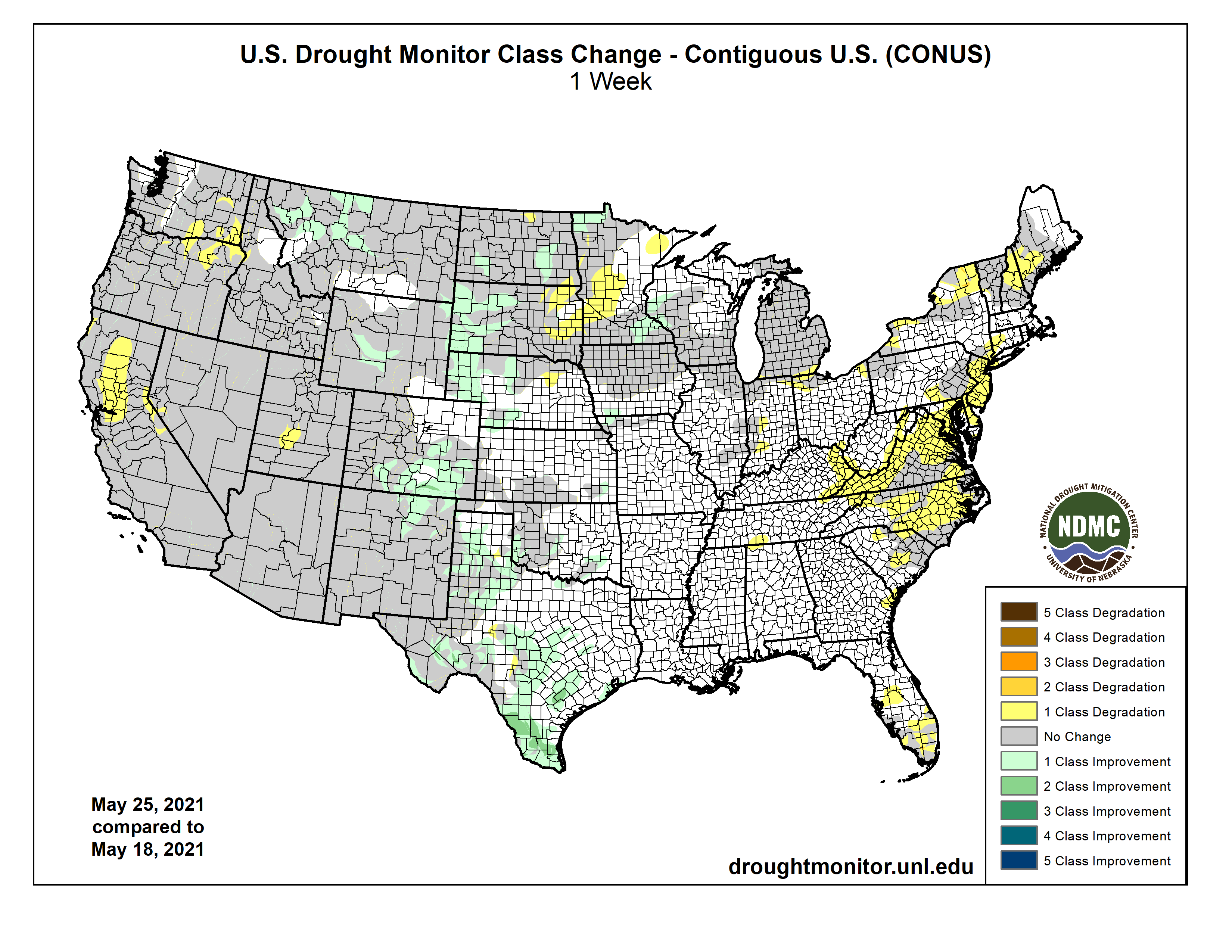
Here’s the US Drought Monitor one week change map ending May 25, 2021.
US Drought Monitor one week change map ending May 25, 2021.
Aerial views of drought-affected Colorado farm lands 83 miles east of Denver on July 21, 2012. Green areas are irrigated, the yellow areas are dryland wheat crops. (Lance Cheung/USDA/Public Domain Mark 1.0)
A drought crisis unfolding across the West will require short-term relief and massive, long-term federal funding to help states weather the effects of climate change, state water managers and lawmakers said at a U.S. House hearing on Tuesday.
Nearly 90% of the West is now experiencing drought conditions, according to the federal U.S. Drought Monitor. The problem is particularly acute in the Southwest.
Arizona, New Mexico, Nevada and Utah just had their driest year in 126 years. Colorado had its fourth-driest year, according to the National Oceanic and Atmospheric Administration.
Snowpack is well below average this year and early snowmelt is raising serious concerns for this summer…
‘No more time to waste’
The drought conditions are part of an ongoing, concerning trend — due in part to climate change.
“Warmer dryer conditions are expected to increase in the future, leading to extended and more severe drought and fire seasons,” said Craig McLean, acting chief scientist for the National Oceanic and Atmospheric Administration.
The Colorado River Basin is experiencing its driest 21-year-period in 100 years of record-keeping, according to the Interior Department. Extreme or exceptional drought is forecast to continue this year for most of the basin.
Reservoirs that the river feeds are already dangerously low. Lake Mead is at 37% capacity and Lake Powell is at 34%, according to the Southern Nevada Water Authority.
If hydrology levels continue, Entsminger said, there is a high probability that Lake Mead could get close to the point in the next decade where the Hoover Dam could no longer deliver water downstream and power production there could come to a halt…
But [John] Entsminger said the problem needs to go beyond what they can do at a state level, with a “focused and robust” federal investment in watershed conservation, water recycling and climate change response.
Biden administration plan
President Joe Biden included drought response in his massive infrastructure proposal, the American Jobs Plan. The proposal includes investment in “nature-based infrastructure” for climate resilience and water efficiency and recycling programs to address the drought crisis.
The Interior Department has also pulled together a favorite federal response, the interagency working group, to address drought relief. The group had its first meeting earlier this month and is working to coordinate funding and programs on drought resilience, according to Klein.
Biden also announced this week he would double the amount of federal funding to help states prepare for natural disasters like hurricanes and wildfires.
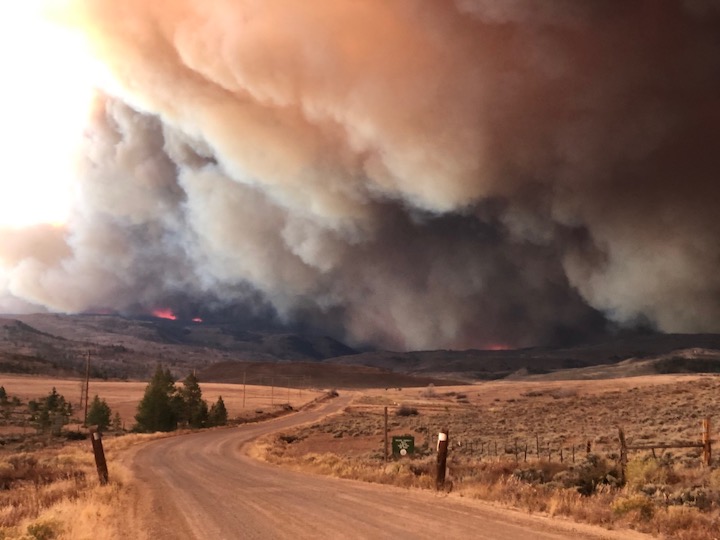
East Troublesome Fire. Photo credit: Brad White via The Mountain Town News
Rep Jared Huffman, (D-Calif.), the chairman of the Water, Oceans, and Wildlife Subcommittee that hosted the hearing, last week reintroduced his drought resiliency bill, H.R. 3404.
It would direct the federal government to invest more than $1 billion for various water projects, including water storage, recycling and desalination efforts…
Idaho’s Craig Foss, state forester at the Idaho Department of Lands, told lawmakers that more aggressive management of dry forests that are prone to wildfire would be one way to help.
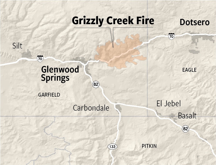
New plating at the Glenwood Springs water intake on Grizzly Creek was installed by the city to protect the system’s valve controls and screen before next spring’s snowmelt scours the Grizzly Creek burn zone and potentially clogs the creek with debris. (Provided by the City of Glenwood Springs)
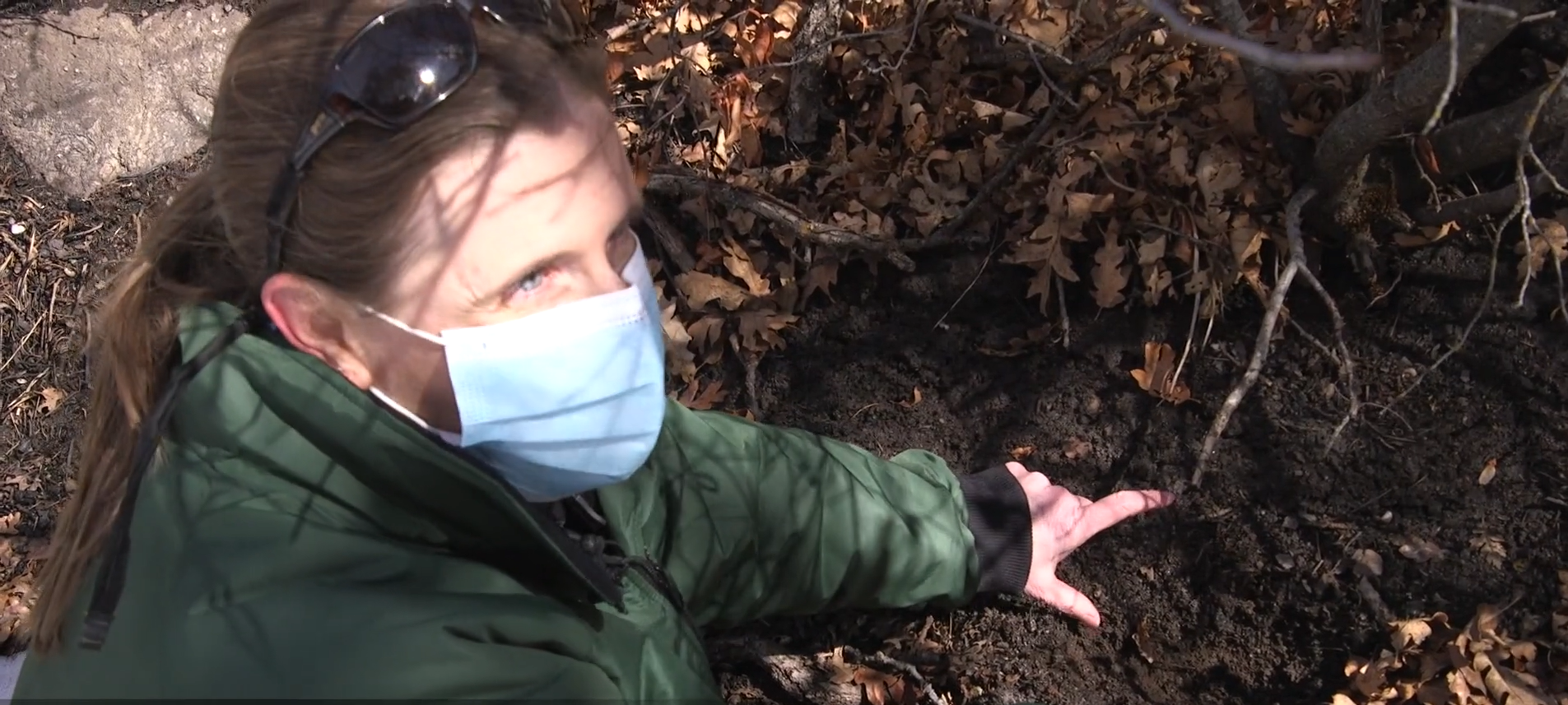
Liz Roberts is digging into snow-soaked dirt just above the banks of Grizzly Creek in western Colorado. With bare fingers she sifts through the dark soil, looking for life amid the ruins of last summer’s devastating Grizzly Creek fire.
When she finds tiny dormant roots, she smiles and exposes more soil to show visitors that this ground, just two or three inches down, is filled with plant matter that will grow and bloom in the summer when the snow melts.
But farther along this same trail, in the White River National Forest just east of Glenwood Springs, there is thick ash beneath the snow, and few dormant roots. This means the soil was so injured by the fire, which burned for more than four months, that it has become disconnected from the mountainside, and the ash lying unrooted above it will be carried into the creek this spring as the water melts.
In unburned forests, the spring snowmelt is a glorious, annual event.
But not this year.
Roberts and other forest experts know that the spring runoff will carry an array of frightening heavy metals and ash-laden sediment generated in the burned soils, posing danger to the people of Glenwood Springs, who rely on Grizzly Creek and its neighbor just to the west, No Name Creek, for drinking water.
Unseen toxins
Raging wildfires…are easy to see. But what is rarely seen is the devastation to the natural mountain collection systems, where water starts as snow before melting in the spring and flowing down into creeks and eventually into water systems for towns and agricultural lands.
As soils burn, naturally occurring substances that would normally be locked in place are released.
“Sometimes we see lead, mercury, cadmium, possibly arsenic,” said Justin Anderson, Roberts’ colleague and a U.S. Forest Service hydrologist. “They can be dangerous, especially in high concentrations.”
Like other Western states, Colorado is in red alert mode this year, in part because these new megafires, triggered by drought and climate change, ravaged not just Glenwood Springs’ water system, but other major systems as well. Northern Water, for example, manages the Colorado Big-Thompson Project, which serves more than 1 million people and hundreds of farms on the northern Front Range and Eastern Plains. Burning at the same time as the Grizzly Creek fire, the Cameron Peak and East Troublesome fires rampaged through the project’s mountain collection system, affecting water supplies for Fort Collins, Greeley, Boulder, Broomfield and Loveland, among others.
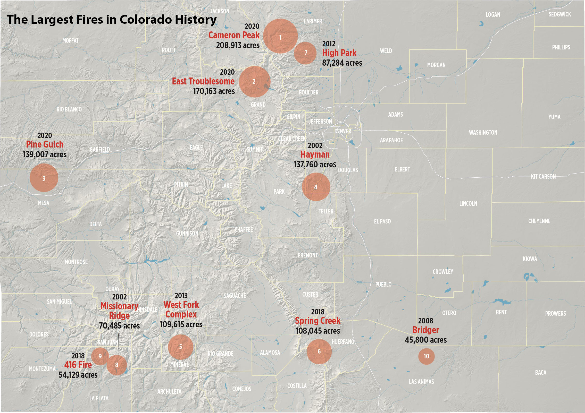
Largest Colorado wildfires as of May 2021. Data Source: Rocky Mountain Area Coordination Center, Graphic by Chas Chamberlin
Even as communities across the state keep their eyes on a 2021 fire season expected to be as bad as that of 2020, when the state saw the largest fires in its history explode, they are racing to create high-tech water treatment programs capable of filtering out the toxins now present in their once-pristine water, and replacing the pipes, intake flumes and grates damaged beyond repair last year.
Esther Vincent, Northern Water’s director of environmental services, expects the agency to spend more than $100 million over the next three to five years, restoring hundreds of thousands of acres of forest in Rocky Mountain National Park, Grand County and along the Front Range in Boulder and Larimer counties. That is nearly triple the agency’s $40 million reserve fund.
Ravaged pipes, reservoirs
“Over half of our major watersheds were affected,” Vincent said. “In some of them 90 percent is burned. Because there is no option to bypass the runoff that is going to come into our system, it will enter our reservoirs and affect all of our infrastructure on the West Slope.”
Restoring forests is an undertaking that requires decades of work and whole new industries to execute effectively.
Mike Lester is Colorado State Forester. Thanks to Colorado’s rapid recovery from the Covid-19 budget crisis and federal relief funds expected later this year, his agency has more money than it’s ever had to help restore forests.
”We’re going to be pretty well supported this year,” Lester said. The state added $6 million this past year for restoration work and it is expecting another $8 million July 1, when the new fiscal year begins.
Colorado has some 24 million acres of forest, most of which is owned by the federal government, and to a lesser extent, private landowners. Roughly 10 percent of those acres are in need of immediate attention to protect towns and homes in the wildland urban interface, Lester said. Colorado’s wildland urban interface, also known as the WUI, has become increasingly populated, creating greater risk to lives and infrastructure and complicating forest management.
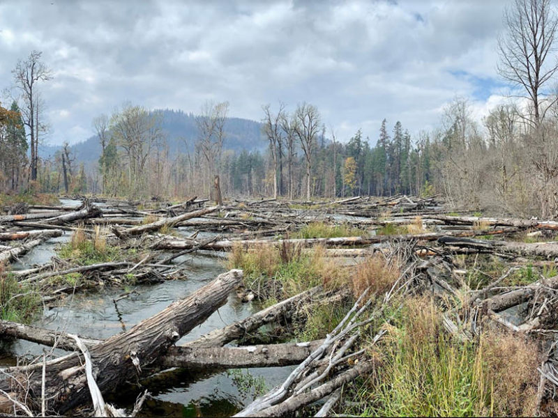
The restored floodplain of the South Fork McKenzie River in Oregon, USA after the 2020 Holiday Farm Fire. Credit: Kate Meyer, USDA Forest Service
Loggers wanted
Repairing the forests, thinning trees so the fires don’t burn with such intensity, and stabilizing hundreds of thousands of scarred mountain slopes requires skilled personnel and methods for utilizing the downed timber.
“We’re way short of resources,” Lester said. “We don’t have a huge amount of logging and professional forestry in Colorado. There is only so much money you can spend well before you run into capacity issues.”
In the short-term communities are focused on doing what they can now to keep their water systems safe.
Matt Langhorst is Glenwood Springs’ director of public works. When the Grizzly Creek fire ignited last August, he could tell almost immediately that the flames were going to engulf the water system’s intake structures in the White River National Forest high above the town at the top of Grizzly and No Name creeks.
“The second I saw the smoke coming over the hill, I knew it was right around our two watersheds. I picked up the phone and called the fire department and said, ’We’re going to have a problem.’”
Map credit: Water Education Colorado
A massive loss
Nine months later, Langhorst and his crews have reworked the high mountain intake structures and they’ve finished a complete rebuild of the town’s small water treatment plant so that it can remove the pollutants expected to contaminate its once-clear waters, and filter out massive sediment loads that are already beginning to come down into the creeks as they enter the Colorado River just east of town along I-70.
“We are expecting it to change the water quality for three to seven years, but it could be longer than that,” Langhorst said. “It is a massive loss.”
And costly. Glenwood Springs Mayor Jonathan Godes said the work needed to repair and rebuild its water system, and create a safe evacuation route if Glenwood Canyon is shut down again as it was last summer, will likely cost three times its annual operating budget of $19 million.
“It’s something we can’t afford,” Godes said. “But we can’t afford not to do it.”
In response, state agencies are rethinking how they provide emergency funds as natural disasters such as these megafires happen more frequently.
Help, please
The Colorado Water Conservation Board (CWCB), last fall, was able to offer Glenwood Springs $8 million in a matter of days so that Langhorst and his crews could get into the high country to do critical construction work before winter snows arrived.
Kirk Russell oversees the CWCB’s loan funds. He said the agency was able to move quickly because it had seen the damage done and the loan delays that occurred after the state’s catastrophic floods of 2013. Back then, federal emergency funds took months to reach devastated Front Range communities and farm irrigation systems that were blown out by powerful flood waters.
“Fast forward to the wildfires that we saw last year and we foresaw there was going to be a need to respond quickly,” Russell said.
Now the agency has new emergency rules that provide for quick approvals on three-year, no-interest loans when water systems are harmed by wildfires.
“Do we need more money and more flexibility? Absolutely,” Russell said.
The state also needs a more cohesive response to managing and restoring forests and the water systems embedded in them. Key to that effort is a two-year-old initiative called the Colorado Forest and Water Alliance, an advocacy group that includes federal and state forest officials, water utilities, logging industries and environmental groups.
Ellen Roberts, a former state lawmaker from Durango, has helped spearhead the fledgling effort and is working on other local initiatives designed to work effectively across city and county boundaries, as well as private, public and federal lands.
Colorado’s lawmakers and the federal government have pledged more than $20 million this year to quickly jumpstart the work.
“I am very encouraged by that,” Roberts said. “A good chunk of the money will need to go to immediate post-fire work, but we need to shift gears soon to put the money in at the front end [to thin the over-grown forests]. Hopefully we will be seeing both with the money that has been set aside. This is not a one-and-done investment. It has to be viewed as being chapter one of a very, very long book.”
Water comes down
Back out in the White River National Forest, the annual snowmelt above Grizzly and No Name creeks has begun.
Liz Roberts, an ecologist with the U.S. Forest Service, examining burned soils in the White River National Forest near Glenwood Springs. March 25, 2021. Credit: Dave Timko, This American Land
And Matt Langhorst is waiting, hoping that the residents of Glenwood Springs, who have enjoyed more than 115 years of clear mountain water, won’t notice any difference in how their water tastes.
He got hundreds of calls last August when the town was forced to shut off its fire-engulfed water system and use an emergency source temporarily.
Each call was roughly the same, he said.
“Everyone wanted to know, ‘What happened to my water?’”
Jerd Smith is editor of Fresh Water News. She can be reached at 720-398-6474, via email at jerd@wateredco.org or @jerd_smith.