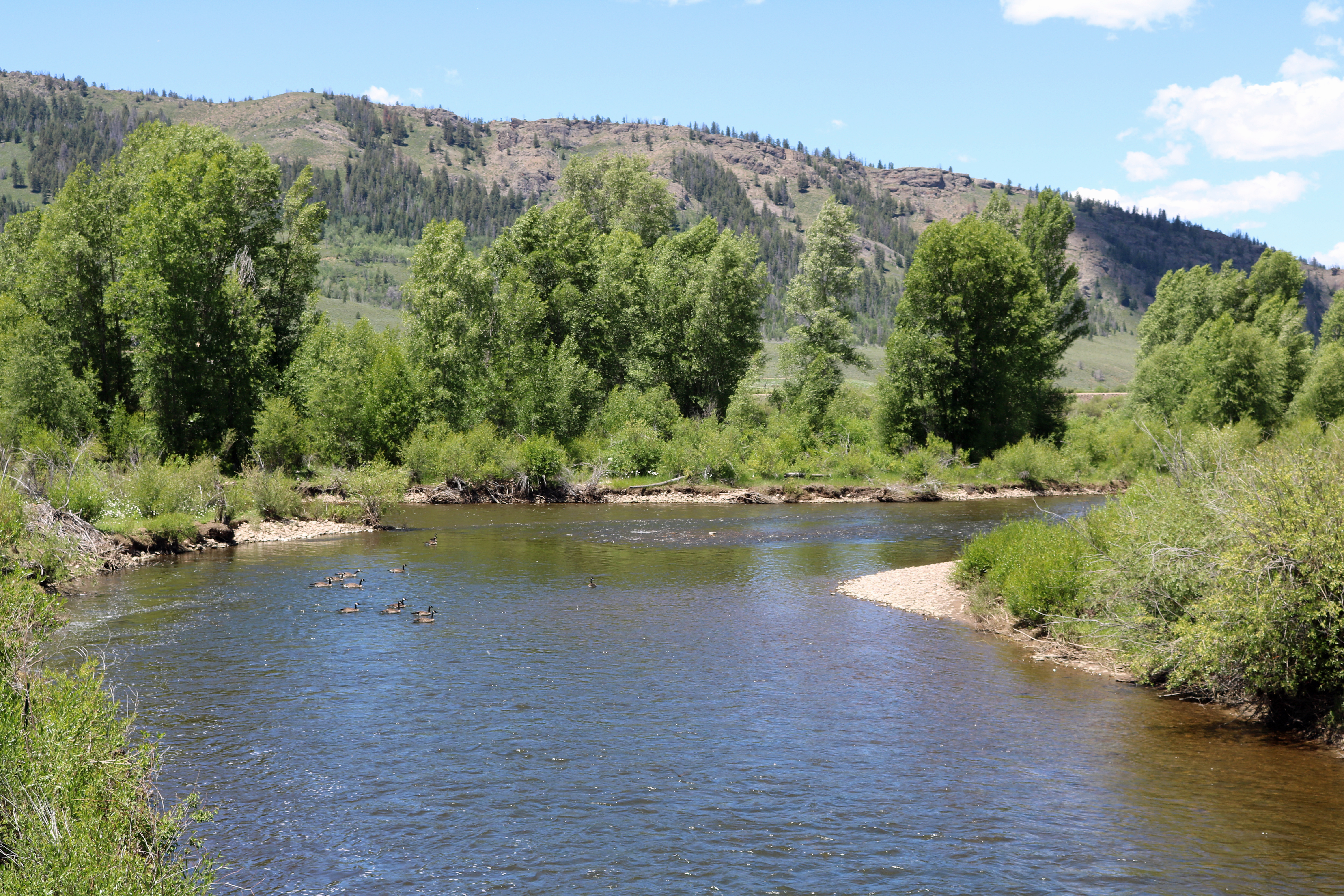
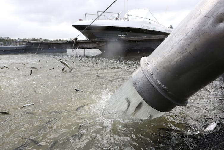
The U.S. Army Corps of Engineers, Omaha District, will conduct its annual sediment flushing exercise at Cherry Creek Reservoir, Colorado, Wednesday, May 26.
Katie Seefus, water manager, Omaha District said that the exercise involves high releases from Cherry Creek Dam, located south of Interstate 225 near Aurora.
“When the gates are opened, the high velocity of the water leaving the reservoir scours the area immediately upstream of the gates and transports sediment with the flow,” she said. “This sediment flush is required to allow proper operation of the outlet gates.”
Cherry Creek Dam will begin releasing 50 cubic feet per second on Tuesday, May 25, at 2:30 p.m. The actual flushing exercise will take place Wednesday, May 26, beginning at 9:00 a.m. and ending at 12:30 p.m. when the release will be set back to normal levels. The exact times are subject to change based on conditions. Each of the five gates will take turns releasing a maximum of 250 cfs. The water’s travel time from Cherry Creek Dam to the streamgage located at the Champa Street Bridge is approximately six hours.
Col. Mark Himes, Omaha District commander asks the public to be aware that high flows will take some time to reach the downtown channel and flows from the last gate opened will not reach the downtown channel until Wednesday evening.
“In the interest of public safety I urge the public not to attempt to cross the stream during this event,” Himes said.
The high flows will cause higher than normal creek levels and potential flooding of bike paths and stream crossings, he added.
We need collaborative, inclusive and community-led solutions for the West’s hardest-working river
In the West, our future is intimately tied to how we choose to manage our rivers and our water resources – especially within the Colorado River Basin.
In the face of growing populations and a rapidly changing climate, the need to create a healthy and sustainable Colorado River Basin has never been more urgent. It sounds simple enough, but creating more effective water management systems will require concerted effort on all sides: public officials and farmers and ranchers who recognize the need for innovative approaches, engaged environmental advocates, business leaders who understand that common-sense conservation is good for business, and journalists committed to keeping the public informed.
We are facing real and dramatic challenges in the Colorado River Basin. The work ahead of us is significant, but we’ve already achieved real successes.
By incentivizing water conservation practices, rather than promoting outdated ideas that encourage water users to “use it or lose it,” we’re laying the groundwork for a cultural shift in how we understand and safeguard our water resources. Similarly, we’re supporting farmers and ranchers across the Colorado River Basin to find collaborative solutions to help sustain the West’s vital agricultural industry and heritage. From the innovative projects at Bruchez Ranch in the headwaters of the Colorado River watershed, down to the Grand Valley Water Users Association conserved consumptive use program near Colorado’s state line, we’re helping to fund creative solutions while mitigating social and environmental impacts.
But the fundamental truth within the Colorado River Basin is that we are going to have to learn to live with less water and more variability in our hydrology.
Without tools to manage this risk, we all stand to lose. The ways we manage the risks facing this basin cannot fall on the backs of any one country, any one basin, any one state or any one sector. Farmers and ranchers, cities, tribes, environmental organizations, state leaders, federal agencies and companies must all come together to help shape the solutions.
As sobering as this future is – we know that, collectively, we can rise to meet this challenge. The foundation is committed to playing our part.
It’s in this spirit that we just unveiled our next five year strategic plan. Over the last five years, our Colorado River work has focused primarily on ensuring that we can stabilize the system by supporting the development of new water conservation approaches.
Colorado River. Photo credit: University of Montana
Over the next five years, we will continue to promote water conservation in the face of climate change, but we are more deliberately focusing on promoting healthy watersheds and improving and protecting flows within the Colorado River Basin.
This means we will:
Elevate the voices of those most affected by water policies – and help bring their perspectives to bear in crafting policy solutions that strengthen environmental and economic outcomes in their communities.
Work with on-the-ground partners to support innovation – including developing, testing and driving the widespread use of nature-based solutions (forest management, flood plain reconnection, etc.) and innovative agricultural practices.
Help to bolster sustainable agriculture throughout the Colorado River Basin by supporting community leaders who are using market demand for sustainably produced products to improve how farmers and ranchers operate.
And lastly, we will work with stakeholders from within and beyond the environmental field. Our work in the Colorado River Basin is driven by the knowledge that those closest to the problem are those closest to the solutions. That’s why our efforts center on working hand in hand with local partners and experts who have been engaged in sustaining this river for decades. Now, we must do more to deepen our support of communities of color, who disproportionately experience the most severe impacts of climate change.
For the past 13 years, we have worked to help ensure a secure and stable supply of water in the West. Today, we are more committed than ever to ensuring the Colorado River Basin, and the people, environments and economies that rely on it, can thrive – for the next five years and beyond.
Click here to read the newsletter. Here’s an excerpt:
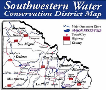
Southwestern Water Conservation District Hires New General Manager
Steven W. Wolff. Photo credit: The Water Information Program
Southwestern Water Conservation District (SWCD) is pleased to announce the hiring of its newest General Manager, Steven W. Wolff.
Board President Jenny Russell expressed the board’s enthusiasm in naming Wolff as General Manager for the Southwestern District. “Steve immediately stood out in an impressive pool of candidates for the GM position,” said Russell.
Wolff is currently Administrator of the Interstate Streams Division within Wyoming’s State Engineer’s Office in Cheyenne. The Interstate Streams Division oversees Wyoming’s rights and responsibilities outlined in the seven interstate water compacts and three interstate water decrees the state is signatory to. Wolff is also responsible for the development of technical and policy recommendations on inter- and intra-state water issues. The Southwestern board was also pleased and impressed with Wolff’s work with river basin planning efforts of the Wyoming Water Development Commission for each of Wyoming’s seven major river basins. He will be winding down his representation of Wyoming over the next month.
Wolff’s interstate experience will be invaluable to the Southwestern District in its involvement in complex interstate negotiations on the Colorado River, state and federal water policy advocacy, local water planning efforts, water education, and other critical, water-related matters.
“I am honored to be offered this opportunity to contribute to the District’s leadership on West Slope water issues and look forward to becoming an active part of the Southwestern community. I thank the board for their confidence in me,” Wolff said. “We are undoubtedly entering a critical period in providing a reliable water supply for all uses, and no place is more significant than the Colorado River basin. Water management is challenging at a local, regional, and national scale. I look forward to working with the Southwestern District board and the many stakeholders to define and implement a vision for sustainable water resources in southwest Colorado,” added Wolff.
Wolff currently serves as gubernatorial appointee representing Wyoming to the Western States Water Council, the Colorado River Basin Salinity Control Forum, and the Glen Canyon Dam Adaptive Management Program. He also currently serves as chair of the Upper Colorado River Commission’s Engineering Committee and the Upper Colorado River Endangered Fish Recovery Program’s Management Committee.
“We look forward to Steve’s long and productive leadership with the Southwestern District,” concluded Russell.
The Southwestern Water Conservation District was created by the Colorado legislature 80 years ago to protect, conserve, and develop the water resources of the San Juan and Dolores River basins and to safeguard for all of Colorado the waters of the Colorado River basin to which the state is entitled.
Wyoming’s Powder, Bighorn and North Platte rivers serve as headwaters of the Missouri River. They begin as trickles in the mountains and rush down into bottomlands as they gain volume. Once, all three ran full with a buffet of warm- and cool-water fish, from the prehistoric, armor-plated shovelnose sturgeon to the shimmery goldeye.
That’s where their similarities end.
Today, the Powder River remains one of the longest free-flowing rivers in the West. The Bighorn River has several dams, but still retains some of its native species. The North Platte River, on the other hand, has been fundamentally altered. What pollution didn’t kill was largely extirpated by dams and irrigation projects…
It’s no surprise then, that the uninterrupted Powder River still retains the same suite of native fish as it had millennia ago. Sauger, plains minnow, sturgeon chub and many other species swim in its waters. The North Platte, meanwhile, transformed slowly over the course of the mid-to-late 1900s into a thriving cold-water fishery with trophy brown and rainbow trout.
But biologists see a future where at least some of those native fish can be restored not only to the Bighorn River, where species have been lost or are struggling, but also to the lower stretches of the North Platte…
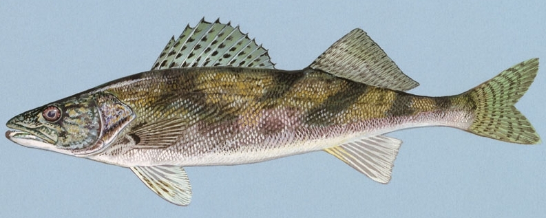
Sauger once ran up and down the North Platte River in such abundance that historical records show they were a major food source for soldiers stationed at Fort Laramie. Sauger are a bit smaller than their nonnative but more popular cousin the walleye, and have telltale black spots on their dorsal fins, said David Zafft, the Wyoming Game and Fish Department’s fisheries management coordinator…
But where sauger struggled in the Platte, they held on in the undammed and relatively untouched Powder River. They can also be found in sections of the Wind River, and have maintained strongholds in the Bighorn River — the same stream by a different name — largely downstream of Worland…
If you wondered what a swimming dinosaur might have resembled, take a look at the shovelnose sturgeon.
The ancient fish is covered in armored plates and has a giant forked tail and long nose used to scoot sand away from river bottoms to find food. Wyoming’s state record is only 10 pounds — big but not notable for a fish in the state — but that record catch measured an impressive 44 inches long…
Unfortunately, the shovelnose sturgeon went the same way as the sauger in the North Platte River. It needs long expanses of uninterrupted running water to spawn and survive, something the Platte lacked once it was developed into a series of reservoirs.
They are doing well in the Powder River, but were largely extirpated from the Bighorn River until reintroduction efforts in the mid-90s, Zafft said. Shovelnose sturgeon were stocked almost every year between 1996 and 2020, when the final batch poured in…
One of the largest channel catfish recorded in the state in its native range came from a fish survey in Glendo Reservoir. Biologists estimated it weighed between 25 and 30 pounds, but an exact measurement proved impossible because it was too big for the scale.
Channel catfish are often associated with southern states, but they were also abundant in the Platte, Powder and Bighorn. Like the others, channel catfish were gone from the Platte by the mid-1900s, but unlike other species, they are now thriving in places like Glendo Reservoir, Zafft said.
There, fisheries biologists have been stocking about 20,000 a year, with another 8,000 stocked in the North Platte River above Glendo. These catfish are not completely the original, though. Native channel catfish are part of a harder-to-obtain northern strain, and biologists have been reintroducing a southern strain imported from Arkansas.
Channel catfish are still sustainably reproducing in the Bighorn and Powder rivers, and are, according to Zafft, one of the state’s “most underutilized game fish.”
[…]
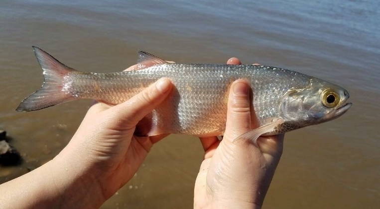
Hiodon alosoides Goldeye. Photo credit: USGS
Goldeye
Somewhere in the slow-moving expanses of the Powder River near the Montana border is a nongame fish that looks like a herring.
The goldeye — a member of the mooneye family — has a compressed body, keeled belly and giant eyes.
They’re not classified as game fish, but they’re aggressive and “fight like crazy,” said Zafft. They also grow to be up to 15 inches long.
They’re gone now from the North Platte, and likely won’t be reintroduced. Biologists say they couldn’t naturally reproduce anymore because of the system of dams and reservoirs.
But goldeye are another fish that still thrives in the strange Powder River system.
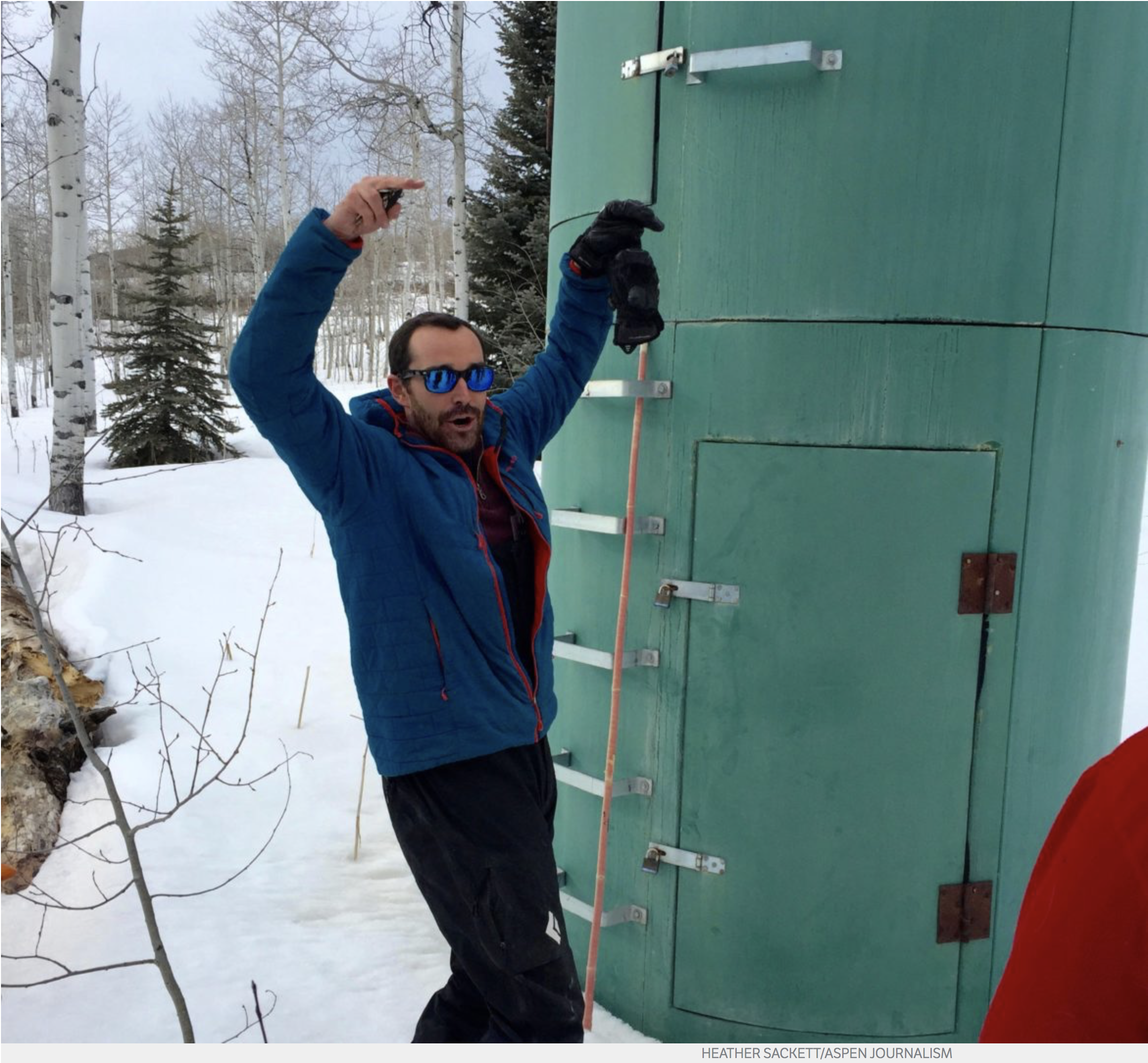
In March of 2018 Karl Wetlaufer, a hydrologist and assistant supervisor with the National Resources Conservation Service Colorado Snow Survey, gestures to indicate how high snowpack has been in past years at the McClure Pass site. Data collectors would have to climb the rungs up to the second, higher door to access the shelter. Photo credit: Heather Sackett/Aspen Journalism
FromColorado Public Radio (Michael Elizabeth Sakas):
Brian Domonkos straps on a pair of cross-country skis and glides through the trees along Mosquito Creek west of Fairplay.
It’s May, but there’s still snow in Colorado’s mountains near the headwaters of the South Platte River.
Domonkos, the Colorado Snow Survey supervisor, gets to work measuring how much snowpack is left from the winter to runoff into streams, rivers and reservoirs this summer. These mountains trap snow in a natural reservoir. As it melts, it becomes the primary source of water for Colorado and much of the West.
Climate change is disrupting this delicate system in multiple ways. The overall trend shows less snowpack accumulation due to warmer temperatures. What does collect melts sooner and faster, which means less snow on the ground and a greater chance for wildfires.
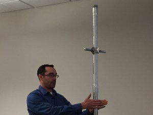
Karl Wetlaufer (NRCS), explaining the use of a Federal Snow Sampler, SnowEx, February 17, 2017.
To measure the snowpack, the total seasonal accumulation of snow on the ground, Domonkos skis to specific points on what’s called a snow course. He then jabs a tall metal pipe into the snow to collect a core sample…
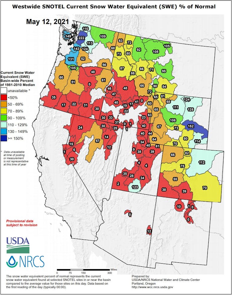
The snowpack at the South Platte’s headwaters is over 110 percent of normal levels for this time of year, but that’s not the case for the rest of the state. In southwest Colorado, it’s less than 40 percent in areas that are already experiencing a historic drought…
Year after year, unusually dry soils from warmer than normal temperatures and a lack of moisture are absorbing a lot of the water that melts from the snowpack. This means a lot of water isn’t making it into rivers and streams, essentially limiting the efficiency of the melting snow.
Even a year with an above-normal snowpack might not push Colorado out of a shorter-term drought, Domonkos said…
Dry soils are taking water
Colorado has also been missing out on its late summer monsoon rains the last few years. Assistant state climatologist Becky Bolinger said that means the soils don’t have a chance to catch up on moisture until the snow melts…
In years that start with a water deficit, like this one, melting snowpack saturates the soil first…
Bolinger said the Colorado Climate Center is working on a project that looks more closely at how much soil moisture plays a role in the snowmelt season…
The effects ripple downstream
Poor snowpack efficiency doesn’t just impact Colorado. Reservoirs Lake Powell and Lake Mead are projected to shrink to historic lows in the coming months, which could trigger the federal government’s first-ever official shortage declaration. That would mean mandatory water cutbacks in Arizona and Nevada.
The Colorado River, which starts in the Rocky Mountains of Colorado, feeds those reservoirs. The snowmelt supplies water to millions of people downstream. The forecast for Lake Powell is just 28 percent of average levels…
From recreation to ranching
Some parts of Colorado rely on snowpack as its central water source. Sonja Chavez manages the Upper Gunnison River Water Conservancy District, where snowpack levels are around half of normal. With less snow melting off quicker, Chavez said it’s shortening the recreational season. If the snowpack was above-average, she said there could be six months of a season on the rivers.
“When you’re in drought like we are right now, that season is concentrated into maybe four months,” she said. Low river flows can mean bad water quality from higher concentrations of metals and other contaminants, she said.
The lack of snow and monsoon rains also has a big impact on ranchers in the area, who are reporting lower hay production and smaller herd sizes…
What it means for fire season
Chavez said there’s a lot of worry about wildfires since the Gunnison River Basin is surrounded by federal lands. Kelly Gleason is an assistant professor of ecohydrology at Portland State University. She’s researched how the effects of climate change on snowpack influence wildfire activity.
Gleason said that snowpack has declined dramatically across the West and other mountain states. When that snow melts earlier, it’s like opening a dam in the spring, she said. The result is less water available in the summer months for both people and ecosystems. Another symptom of snow disappearing from the landscape earlier is an extended drought and fire season, Gleason said.
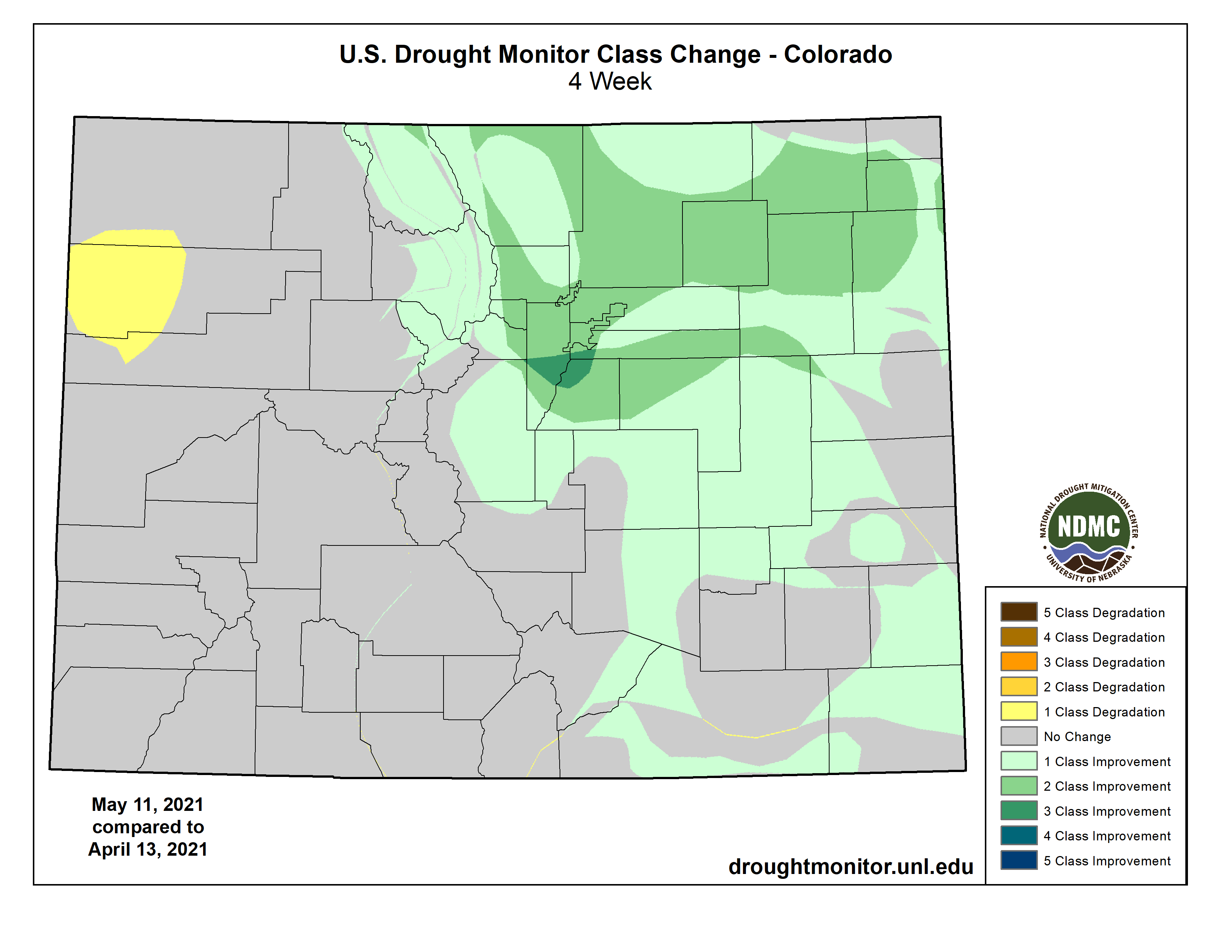
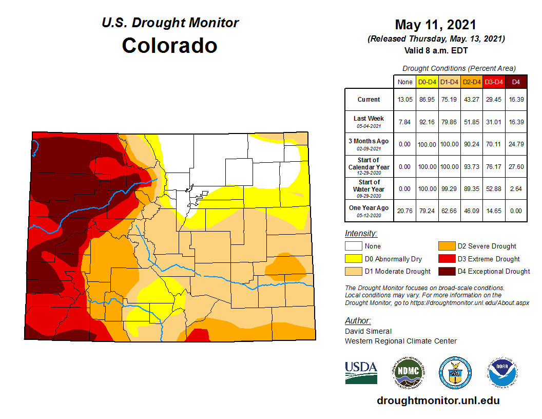
While extreme and exceptional drought continue to plague western Colorado, the northern mountains and eastern plains have seen substantial improvements in conditions over the past four weeks according to the National Drought Mitigation Center.
Recent rain and snow, including storms over the past week with significant moisture, contributed to drought reduction. Much of the northeast is now drought-free or abnormally dry. The greatest improvements are in central Jefferson, northwest Douglas and a small portion of southwest Arapahoe counties, where severe drought has been replaced by drought-free conditions over the past month. Surrounding areas have moved to moderate drought or abnormally dry conditions.
Colorado Drought Monitor map May 11, 2021.
Further south, extreme drought across southern Las Animas and southwest Baca counties has largely moved to severe conditions. A portion of central Kiowa County, which was in exceptional drought at the start of the year and extreme conditions last week, has moved to severe drought. Most of the remaining area in the southeast has shifted to moderate drought, with potential for additional improvement following a series of storms Friday and Saturday which produced as much of four inches of rain in some areas…
Overall, 13 percent of the state is drought-free, up from eight percent last week, with an additional 12 percent in abnormally dry conditions, unchanged from the previous week. Moderate drought covered 32 percent of Colorado, up from 28 percent, while severe drought dropped from 21 to 14 percent. Extreme drought also fell, dropping to points to 13 percent. Exceptional conditions are unchanged at 16 percent.
Just about every indicator of drought is flashing red across the western U.S. after a dry winter and warm early spring. The snowpack is at less than half of normal in much of the region. Reservoirs are being drawn down, river levels are dropping and soils are drying out.
It’s only May, and states are already considering water use restrictions to make the supply last longer. California’s governor declared a drought emergency in 41 of 58 counties. In Utah, irrigation water providers are increasing fines for overuse. Some Idaho ranchers are talking about selling off livestock because rivers and reservoirs they rely on are dangerously low and irrigation demand for farms is only just beginning.
Scientists are also closely watching the impact that the rapid warming and drying is having on trees, worried that water stress could lead to widespreadtree deaths. Dead and drying vegetation means more fuel for what is already expected to be another dangerous fire season.
U.S. Interior Secretary Deb Haaland and Agriculture Secretary Tom Vilsack told reporters on May 13, 2021, that federal fire officials had warned them to prepare for an extremely active fire year. “We used to call it fire season, but wildland fires now extend throughout the entire year, burning hotter and growing more catastrophic in drier conditions due to climate change,” Vilsack said.
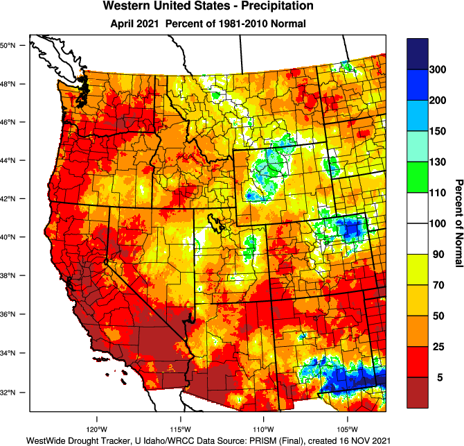
Several types of drought are converging in the West this year, and all are at or near record levels.
When too little rain and snow falls, it’s known as meteorological drought. In April, precipitation across large parts of the West was less than 10% of normal, and the lack of rain continued into May.
Rivers, lakes, streams and groundwater can get into what’s known as hydrological drought when their water levels fall. Many states are now warning about low streamflow after a winter with less-than-normal snowfall and warm spring temperatures speeding up melting. The U.S. Bureau of Reclamation announced it would cut off water to a canal serving farms in the Klamath Project on the Oregon-California border because of low water supplies. It also warned that Lake Mead, a giant Colorado River reservoir that provides water for millions of people, is on pace to fall to levels in June that could trigger the first federal water shortage declaration, with water use restrictions across the region.
These factors can all drive ecosystems beyond their thresholds – into a condition called ecological drought – and the results can be dangerous and costly. Fish hatcheries in Northern California have started truckingtheir salmon to the Pacific Ocean, rather than releasing them into rivers, because the river water is expected to be at historic low levels and too warm for young salmon to tolerate.
Snow drought
One of the West’s biggest water problems this year is the low snowpack.
The western U.S. is critically dependent on winter snow slowly melting in the mountains and providing a steady supply of water during the dry summer months. But the amount of water in snowpack is on the decline here and across much of the world as global temperatures rise.
Several states are already seeing how that can play out. Federal scientists in Utah warned in early May that more water from the snowpack is sinking into the dry ground where it fell this year, rather than running off to supply streams and rivers. With the state’s snowpack at 52% of normal, streamflows are expected to be well below normal through the summer, with some places at less than 20%.
More people are moving into the U.S. West, increasing demand for water and irrigated farmland. And global warming – driven by human activities like the burning of fossil fuels – is now fueling more widespread and intense droughts in the region. These two factors act as additional straws pulling water from an already scarce resource.
As demand for water has increased, the West is pumping out more groundwater for irrigation and other needs. Centuries-old groundwater reserves in aquifers can provide resilience against droughts if they are used sustainably. But groundwater reserves recharge slowly, and the West is seeing a decline in those resources, mostly because water use for agriculture outpaces their recharge. Water levels in some wells have dropped at a rate of 6.5 feet (2 meters) per year.
The result is that these regions are less able to manage droughts when nature does bring hot, dry conditions.
California fish hatcheries have started trucking their salmon to the Pacific Ocean because the rivers they are usually released into are too low and warm. AP Photo/Rich Podroncelli
Rising global temperatures also play several roles in drought. They influence whether precipitation falls as snow or rain, how quickly snow melts and, importantly, how quickly the land, trees and vegetation dry out.
Extreme heat and droughts can intensify one another. Solar radiation causes water to evaporate, drying the soil and air. With less moisture, the soil and air then heat up, which dries the soil even more. The result is extremely dry trees and grasses that can quickly burn when fires break out, and also thirstier soils that demand more irrigation.
Alarmingly, the trigger for the drying and warming cycle has been changing. In the 1930s, lack of precipitation used to trigger this cycle, but excess heat has initiated the process in recent decades. As global warming increases temperatures, soil moisture evaporates earlier and at larger rates, drying out soils and triggering the warming and drying cycle.
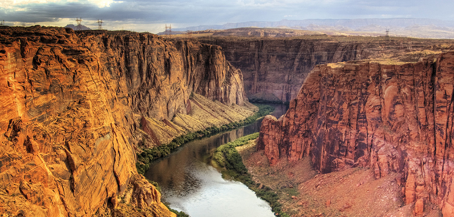
A lifeline in the desert that has not only made human survival possible, but also feeds much of the U.S. and helps fuel a regional economy that would, by some accounts, be the fifth-largest in the world if the Colorado River Basin were a separate nation. Rising in the Rocky Mountains, the Colorado River traverses 1,450 miles of some of the most beautiful and inhospitable territory on earth, flowing through Wyoming, Colorado, New Mexico, Utah, Arizona, Nevada and California before entering the Mexican states of Sonora and Baja California and ultimately emptying into the Gulf of California.
The river forms a common thread through two countries and across diverse range of cultures, and it is a source of both unity and controversy. It has served as an anvil on which debates over the value of free-flowing rivers and the broader modern environmental conscience have been formed. And in the 21st century, it is has become ground zero for addressing challenges such as population growth, drought, food security, social justice, and climate change.
The effort to confront those challenges is breaking down many old barriers and has given rise to an unprecedented sense of collaboration. Yet, taking the river into the next century may demand an even stronger spirit of compromise and sacrifice.
One of the most significant changes reflected on the map—which the Babbitt Center for Land and Water Policy produced in partnership with the Center for Geospatial Solutions—is the inclusion of the river’s entire 1,450-mile route, from its origins in the Rocky Mountains of Colorado to its terminus at the Sea of Cortez in Mexico. Most conventional maps align the Colorado River Basin’s southern edge with the U.S.-Mexico border, a legacy of administrative and engineering decisions made by the U.S. government in the 20th century.
Although Brian Werner has served on the WEco Board of Trustees for just over a year, he was involved with helping found the organization nearly 20 years ago. Now retired from his 38-year career as the Communications Department Manager and Public Information Officer at Northern Water, and still a life-long water historian, Brian has written and given hundreds of presentations on the role of water in the settlement and development of Colorado and the West. We spoke with Brian about Northern Water’s storage, the impacts of fire on water storage, permitting, and more.
How long have you been on the WEco board?
I’ve been involved with WEco since WEco has been around. I was involved with the first couple incarnations of water education efforts in Colorado in the late 80’s and early 90’s, and then I helped when WEco came into being in 2002. I was never on the board, until a couple of years ago. It was something I wanted to do towards the end of my career and I retired just last year in January 2020. Luckily I was appointed to the board and I’ve truly enjoyed it.
What kind of experience do you bring to the group?
I think the fact that I had a 38-year career in the water business with Northern Water is an asset. At Northern Water, I’d established relations with people from all over the state and I also coordinated probably 150 to 200 different children’s water festivals, so clearly I was into education. I’m really a big believer in the trickle up theory of water knowledge. Where if you can educate the kids, that knowledge is going trickle up to mom and dad, and those kids will somebody be parents themselves. Ultimately, I’ve been trying to build that ethic in what I’ve been about for most of my career.
How would you describe your experience being on the board?
I’ve really enjoyed being on the board. I’ve watched it and been very much involved for a long time. Both Nicole Seltzer and Jayla Poppleton worked with me at Northern Water, so I have a personal vested interest in them succeeding, and they really have. Nicole moved the organization in a wonderful direction and Jayla has just been top-notch in where she has taken WEco. It has been really interesting because we have a diverse board, and I have enjoyed getting to know people who I didn’t know previously.
Screenshot of the Colorado-Big Thompson Project boundaries via Northern Water’s interactive mapping tool , June 5, 2019.
I understand you recently retired from Northern Water, can you tell me what your role with them was and maybe what Northern Water does in a general sense?
Northern Water is the largest water conservancy district in the state of Colorado and operates a large Bureau of Reclamation project that is one of the largest in the entire western United States; the Colorado-Big Thompson project. It brings a quarter-million acre-feet a year from the West Slope into Northeastern Colorado to supplement both urban and rural supplies, meaning that it is both a municipal as well as an agricultural water supply. Now there are well over a million people that get a portion of their water supply from that project, but back in 1937, there were only 50,000 people living within Northern Water’s boundaries. So, nobody could have foreseen the growth that occurred since then. This growth has brought all sorts of issues and concerns, but Northern Water is one of the top water agencies in the state and I certainly had a wonderful career there and couldn’t have asked for anything better.
Personally, I was a public information officer for 35 of those 38 years. My role, in essence, was to be the public face of Northern Water and so I talked about Northern Water and its activities all the time. I was able to use my historical training, I have a master’s degree in history, to discuss the historical background of both water development and Northern Water. I focused very much on education, but ultimately, I spent my entire career talking all things water, which was a lot of fun.
I was also the manager of our communications department as we expanded and grew. As we grew, we brought on writers and pushed publications and annual reports, and then we got into the social media craze. So, for some time I managed that department. But really, it was about telling people what Northern Water was all about.
The map above displays estimates of the likelihood of debris flow (in %), potential volume of debris flow (in m3), and combined relative debris flow hazard. These predictions are made at the scale of the drainage basin, and at the scale of the individual stream segment. Estimates of probability, volume, and combined hazard are based upon a design storm with a peak 15-minute rainfall intensity of 24 millimeters per hour (mm/h). Predictions may be viewed interactively by clicking on the button at the top right corner of the map displayed above. Map credit: USGS
Perhaps a topical question, but how have the numerous forest fires affected the work that Northern Water does in trying to ensure water storage?
That is going to be Northern Water’s principal focus this coming year. Both of our major watersheds burned last year, the Upper Colorado with the East Troublesome wildfire, and then the Poudre watershed with the Cameron Peak wildfire. And both of these watersheds are where we get the vast majority of our water. Luckily, Northern Water had been looking at forest water management for years. Northern Water has been working with the U.S. Forest Service, the counties, the Bureau of Reclamation, and the National Parks Service. It wasn’t that these fires hit us and Northern Water had no idea what to do. We learned quite a lot from Denver Water after the Hayman Fire, with all of the issues that they had centering around water quality. Northern Water isn’t pleased, but we are certainly going to see some water quality impacts because of these fires.
We went in with our eyes open and with some plans in place for post-fire activities. We always said, ‘it’s not if, it’s when those fires hit.’
What do these fires mean for water supply and water quality now, as well as moving into the future?
One of the things that we see from these fires is a greater level of awareness in terms of forest management, not just if you have a house in a forest or nearby, but for those people living in major metropolitan areas, too. Those people in Denver, Fort Collins, and Colorado Springs are all paying attention now, because they saw the two largest fires in Colorado history and what it did to our environment. And I think now there will be a lot more attention focused on the post-fire impacts, which obviously include water. People will certainly be paying attention to the water piece of the post-fire mitigation and clean-up. Overall, I think moving into the future we will have a better awareness, which is always a good thing. There is no way around it, it is going to take money, and where we are at with COVID-19 that discussion is not easy, but the state is making a concerted effort to put monetary resources and people into handling the situation.
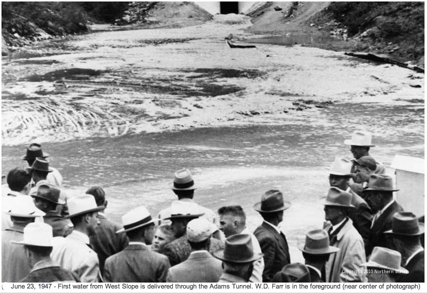
First water through the Adams Tunnel. Photo credit Northern Water.
How the present or future storage planning is different than what the state has done historically?
One thing I would point out is that the Federal government is no longer in the water storage building business. For years Reclamation, which had been established in 1902 helped jumpstart and build water projects, as they did the Colorado-Big Thompson Project in the 1930s, ’40s and ’50s. The Federal government neither has the resources nor are they paying for water storage anymore. Now, water storage is something that is having to be more or less self-funded. Meaning that the growing cities are trying to figure out how they can finance additional water for their future citizens.
We are also now looking at the multiple uses of water. Nowadays, water is being used for environmental purposes, which means that we are looking to make sure that there is enough to release into the rivers to help the aquatic habitat. This is a much larger part of the picture today. At a base level of awareness, we want people to understand why we need storage reservoirs. It is a dry year, and it sure looks like we are only getting drier, and when you have the drier years you better make sure that you store when you have the wetter periods to carry you through. I think we are going to have difficulties trying to match up the storage, which we are going to continue to need, with all the environmental issues and issues surrounding the development of water infrastructure.
Northern Integrated Supply Project (NISP) map July 27, 2016 via Northern Water.
In the past 20 years, Northern has been in permitting so can you talk about that process?
We say water project permitting works at a glacial pace. When I started working on the Northern Integrated Supply Project permitting at Northern Water, I told my wife that I thought we would have a permit in around 5 years … I’m now retired. Northern Water is going on 17 years later, and they still haven’t received that permit. That’s frustrating. This wasn’t for lack of energy; I mean we were really working hard to secure that permit. These things take much longer than you would probably expect. You have to have a lot of perseverance because the process can really drive you crazy, but my hope is that in the future this process will become much better for all parties involved.
The view looking upstream on the Crystal River below Avalanche Creek. A Pitkin County group wants to designate this section of the Crystal as Wild & Scenic. CREDIT: CURTIS WACKERLE/ASPEN JOURNALISM
Colorado water shortage plays role in difficulty of securing designation
According to Crystal River valley resident Chuck Ogilby, there are three ways to protect rivers in Colorado. The first two involve using the state’s water court and water rights system. But the third is the one he places the most faith in.
“Who’s going to look after and be the parents, so to speak, of a free-flowing river? It’s the people,” Ogilby said. “The people of Colorado are the thing that will save our rivers. We have the right to fight for it the way we want, and we can advocate for free-flowing streams.”
Ogilby is one of a handful of river advocates in Pitkin County who are reviving a grassroots effort to secure a federal Wild & Scenic designation on the Crystal. But in a state where the value of water is tied to its use, and landowners’ fear of federal government involvement stokes opposition, a campaign to leave more water in the river for the river’s sake may face an uphill battle.
Proponents want protection of 39 miles of river from the headwaters of both the north and south forks, in the Maroon Bells-Snowmass Wilderness, to the Sweet Jessup headgate, the first major agricultural diversion on the lower end of the river. Advocates have three goals: no dams on the main stem, no diversions out of the basin and protection of the free-flowing nature of the river. As the Crystal is one of the last undammed rivers in Colorado, they want to keep it that way.
“I can’t tell you what the experience of walking up to a river and being on the river, whether I catch fish or not, does to me,” Ogilby said. “I can’t put it into words. It’s, I want to say, a religious experience. It’s very emotional.”
Crystal River Valley resident Chuck Ogilby on the banks of the river near the confluence with Avalanche Creek. Ogilby believes a Wild & Scenic designation on the Crystal is the best way to protect it from dams and out-of-basin diversions. CREDIT: HEATHER SACKETT/ASPEN JOURNALISM
A history of development plans and pushback
The Wild & Scenic River Act of 1968 brings protection from development. For example, new dams cannot be constructed on a designated stretch, and federal water-development projects that might negatively affect the river are not allowed. The National Wild & Scenic Rivers System seeks to preserve rivers with outstandingly remarkable scenic, recreational, geologic, fish and wildlife, historic and cultural values in a free-flowing condition.
There are three categories under a designation: wild, which are sections that are inaccessible by trail, with shorelines that are primitive; scenic, with shorelines that are largely undeveloped, but are accessible by roads in some places; and recreational, which are readily accessible by road or railroad and have development along the shoreline.
The U.S. Forest Service determined that the Crystal, which flows through both Gunnison and Pitkin counties, was eligible for designation in the 1980s and reaffirmed that finding in 2002. There are four segments being proposed: about seven miles of the north fork inside the wilderness boundary would be classified as wild; from the wilderness boundary on the north fork to the junction of the south fork, about two miles, would be classified as scenic; from the headwaters of the south fork through its confluence with the north fork and on to Beaver Lake, about 10 miles, would also be scenic, and from Beaver Lake to the Sweet Jessup headgate, about 20 miles, would be recreational. The outstandingly remarkable values are scenic, historic and recreational.
In 2012, conservation group American Rivers deemed the Crystal one of the top 10 most endangered rivers. This was spurred by plans from the Colorado River Water Conservation District and the West Divide Conservation District to renew their conditional water rights for nearly 200,000 acre-feet worth of storage in the form of Placita and Osgood reservoirs. Osgood would have inundated Redstone.
The dam and reservoir projects were eventually abandoned after they were challenged in water court by Pitkin County, but the memory of the threat lingered for river activists, who decided to actively pursue a Wild & Scenic designation in 2012, with the goal of eliminating the possibility of this type of development in the future.
The group shelved the discussion with the presidential election of Donald Trump in 2016. Some trace the moment they realized they were temporarily defeated to a community meeting in Marble and subsequent opinion piece by former director of the Bureau of Land Management William Perry Pendley. A 2016 column for the conservative Washington Times, which also ran in Western Ag Reporter, titled “When ‘wild and scenic’ spells trouble,” stoked fear among landowners in the town of Marble and Gunnison County that a designation means the federal government has power over private property.
“There were some mistruths spread in Marble that really moved them in the wrong direction from my perspective,” said Matt Rice, director of American Rivers’ Colorado Basin Program.
But the meeting was enough for the opposition to gain ground. If the town of Marble wouldn’t support the designation, neither would Gunnison County. The proposal was dead in the water.
Larry Darien was one of those opponents in 2016. He remains opposed to the Wild & Scenic proposal this time around because he said federal involvement in river management could bring unintended consequences. Darien owns a ranch on Gunnison County Road 3 that borders the Crystal.
“Whatever they come up with probably looks real good until you end up with something you didn’t bargain for,” he said. “I don’t want the federal government having anything to do with my property.”
Darien said he doesn’t want to see dams or reservoirs on the Crystal either, but a federal designation is not the right way to go about preventing that. He would support a designation of the headwaters that flow through the wilderness, but would prefer if private property owners downstream along the river were left out of it.
The Crystal River near the town of Marble forms a wetland area. A Pitkin County group wants to designate this section of the Crystal as Wild & Scenic. CREDIT: CURTIS WACKERLE/ASPEN JOURNALISM
Wild & Scenic Act
While the Wild & Scenic Rivers Act does give the federal government the ability to acquire private land, there are many restrictions on those abilities. Condemnation is a tool that is rarely used. The legislation written for each river is unique and can be customized to address stakeholders’ values and concerns.
White River National Forest Supervisor Scott Fitzwilliams has worked on Wild & Scenic designations in Oregon, where there are more than 65 sections of designated rivers. He said that in the next step of the process, which would be a suitability determination and an Environmental Impact Statement by the Forest Service, the protection of private property rights would be paramount.
“I’ve often said that if they changed the name to ‘leave the river as it is act,’ which is really what it does, people would be less concerned,” Fitzwilliams said.
Although Wild & Scenic supporters initially squabbled about the best way to address opposition — some said engaging staunch opponents was like inviting a wolf into the hen house — most now agree the best way forward is to bring them into the conversation early.
Pitkin County Commissioner Kelly McNicholas Kury is heading up a steering committee, which will decide how to proceed with the campaign. Pitkin County supports Wild & Scenic and commissioners have allocated an additional $100,000 to the Healthy Rivers board to work on getting a designation.
Committee members are tight-lipped about their strategy moving forward, and have not yet laid out a plan for spending the money, but many are eager to not repeat what they view as the mistakes from the first time around. McNicholas Kury stresses that this time the group will engage any and all stakeholders who want to participate in the process, even and especially those who have been vocally opposed to a federal designation. She said the group will probably hire a neutral facilitator to direct the process and bring all the perspectives to the table.
“The challenge will be ensuring we will reach all the interested parties and they will have a meaningful opportunity to contribute to what the final designations and river protections will be,” McNicholas Kury said. “It may require personally knocking on someone’s door and saying, ‘we need to hear from you.’”
Darien said he would be interested in participating in a stakeholder process, but that so far no one from the advocacy group or Pitkin County has reached out to him.
Avalanche Creek flows into the Crystal River north of Redstone near Avalanche Ranch. A group of Pitkin County river advocates are gearing up for another attempt at getting a Wild & Scenic designation on the Crystal. CREDIT: HEATHER SACKETT/ASPEN JOURNALISM
Colorado protective of water use
Despite its renowned river rafting, fishing and scenic beauty, which contribute to the recreation-based economy of many Western Slope communities, Colorado has just 76 miles of one river — the Cache La Poudre — designated as Wild & Scenic. That’s less than one-tenth of 1% of the state’s 107,403 river miles, according to the National Wild and Scenic Rivers System website.
By comparison, Oregon — a state with a contentious history of clashes between ranchers and the federal government over land management — has 110,994 miles of river, of which 1,916.7 miles are designated as wild & scenic—almost 2% of the state’s river miles.
Instead of backing the federal designation on its rivers, the state of Colorado instead funds a program for an alternative designation that carries some of the same protections as Wild & Scenic. In June of 2020, the Bureau of Land Management and the Forest Service approved an alternative management plan on the Upper Colorado River which takes the place of a Wild & Scenic designation. The process took 12 years and involved cooperation between many stakeholders.
Experts say the main reason there is opposition from water managers to Wild & Scenic in Colorado is not fear of a federal land grab, but the shortage of water in an arid state that is only getting drier with climate change. Fitzwilliams called water “the most valuable commodity in Colorado, without question.” A designation would lock up water in the river, making it unavailable for future development.
“In these very, very arid states where we just don’t have the water, we are very protective of making sure that water is available for all public uses,” said Jennifer Gimbel, interim director of Colorado State University’s Water Center and former director of the Colorado Water Conservation Board. “As we try to figure out how to manage the drought, we want to maybe figure out better how to move water from here to there and that Wild & Scenic designation would play a big part in that for better or for worse.”
The two main ways to ensure water stays in the river in Colorado are instream flow rights and recreational in-channel diversion water rights. Instream flow water rights are a minimum streamflow set by the Colorado Water Conservation Board with the goal of preserving the natural environment to a reasonable degree. A recreational in-channel diversion creates a water right for a recreational experience, like the waves in the Basalt whitewater park.
But Ogilby says these state protections don’t go far enough for the Crystal.
“We have to be able to convince people that getting it out of the Colorado adjudication system is the way we are going to ultimately protect it,” he said. “We are not going to save it with Colorado water law. We’ve got to get a (federal) overlay.”
Fears of development have recently returned in response to a study of a back-up water supply plan for the Crystal, undertaken by the same conservation districts who were behind the dam projects. The results aren’t in yet, but the study could find the need for storage to meet the demands of downstream water users in dry years.
A view of the former coal mining village of Placita, with the upper Crystal River winding along the valley floor as seen from from Colorado 133 as it climbs up McClure Pass. CREDIT: BRENT GARDNER-SMITH/ASPEN JOURNALISM
Early indications of support
The next few months will be crucial for the steering committee as they chart a path forward and decide how best to spend the money from Pitkin County. Broad-based local support is critical and there is some evidence the idea of Wild & Scenic is gaining ground.
As part of her capstone project in sustainable studies at Colorado Mountain College, Carbondale resident Monique Vidal is conducting an online survey about recreation on the Crystal River. So far, she has received about 65 responses, about 95% of which support moving forward with Wild & Scenic legislation.
“Our community overwhelmingly so far is supportive,” Vidal said.
Ogilby owns Avalanche Ranch, a small hot springs resort near the Crystal River just north of Redstone. He has spent much of his life advocating for rivers in the Vail Valley and Crystal River valley, and has helped defeat plans for Front Range water providers to take more from the headwaters of the Colorado River. He served for years on the Colorado Basin Roundtable as a representative of Eagle County and is now a member of Pitkin County’s Healthy Rivers board.
“I felt a little frustrated being on the roundtable because our position didn’t always gain ground,” he said. “We were up against the big boys. When I came over here, I feel this is my home. And maybe I can’t change everything about all the rivers in Colorado, but maybe I can make a real difference on the Crystal.”
For Wild & Scenic proponents, the clock is now ticking if they hope to get a designation while there is a Democratic administration under President Joe Biden. Ogilby said he feels a sense of urgency.
“Everybody feels that,” he said. “It feels like, oh my god, we have been blessed so let’s get after it. We are going to be pushing.”
Aspen Journalism covers water and rivers in collaboration with The Aspen Times and Swift Communitications publications. This story ran in the May 17 edition of The Aspen Times.
In response to forecast increasing runoff and flows in the critical habitat reach, the Bureau of Reclamation has scheduled a decrease in the release from Navajo Dam from 400 cubic feet per second (cfs) to 300 cfs on Tuesday, May 18th, starting at 0400 AM. Releases are made for the authorized purposes of the Navajo Unit, and to attempt to maintain a target base flow through the endangered fish critical habitat reach of the San Juan River (Farmington to Lake Powell).
The San Juan River Basin Recovery Implementation Program recommends a target base flow of between 500 cfs and 1,000 cfs through the critical habitat area. The target base flow is calculated as the weekly average of gaged flows throughout the critical habitat area from Farmington to Lake Powell. Please be advised, due to the dry conditions this year, more release changes than usual may occur.


