What shapes our perceptions (and misperceptions) about science? In an eye-opening talk, meteorologist J. Marshall Shepherd explains how confirmation bias, the Dunning-Kruger effect and cognitive dissonance impact what we think we know — and shares ideas for how we can replace them with something much more powerful: knowledge.
This talk was presented to a local audience at TEDxUGA, an independent event. TED’s editors chose to feature it for you.
This year, New Mexican officials have a message for farmers who depend on irrigation water from the Rio Grande and other rivers: Unless you absolutely have to plant this year, don’t.
Years of warming temperatures, a failed rainy season last summer and low snowpack this winter have combined to reduce the state’s rivers to a relative trickle. The agency that controls irrigation flows on the Rio Grande forced the issue. To conserve water, it opened its gates a month later than usual.
Severe drought — largely connected to climate change — is ravaging not only New Mexico but the entire Western half of the United States, from the Pacific Coast, across the Great Basin and desert Southwest, and up through the Rockies to the Northern Plains.
In California, wells are drying up, forcing some homeowners to drill new ones that are deeper and costlier. Lake Mead, on the border of Arizona and Nevada, is so drained of Colorado River water that the two states are facing the eventual possibility of cuts in their supply. And 1,200 miles away in North Dakota, ranchers are hauling water for livestock and giving them supplemental forage, because the heat and dryness is stunting spring growth on the rangelands.
The most significant, and potentially deadly, effect of a drought that is as severe and widespread as any seen in the West is the wildfires that are raging amid hot and dry conditions. And this is well before the full blast of summer’s heat arrives.
California, Arizona and New Mexico have each had two large blazes, unusual for this early in the year. None has been fully contained, including the Palisades Fire, which has burned 1,200 acres on the outskirts of Los Angeles…
…at the root of the drought are warmer temperatures and changing precipitation patterns, which are linked to emissions of carbon dioxide and other greenhouse gases into the atmosphere, where they trap the sun’s heat. The result has been extremely dry conditions that have persisted across much of the Southwest and California for years, and that are spreading throughout the West…
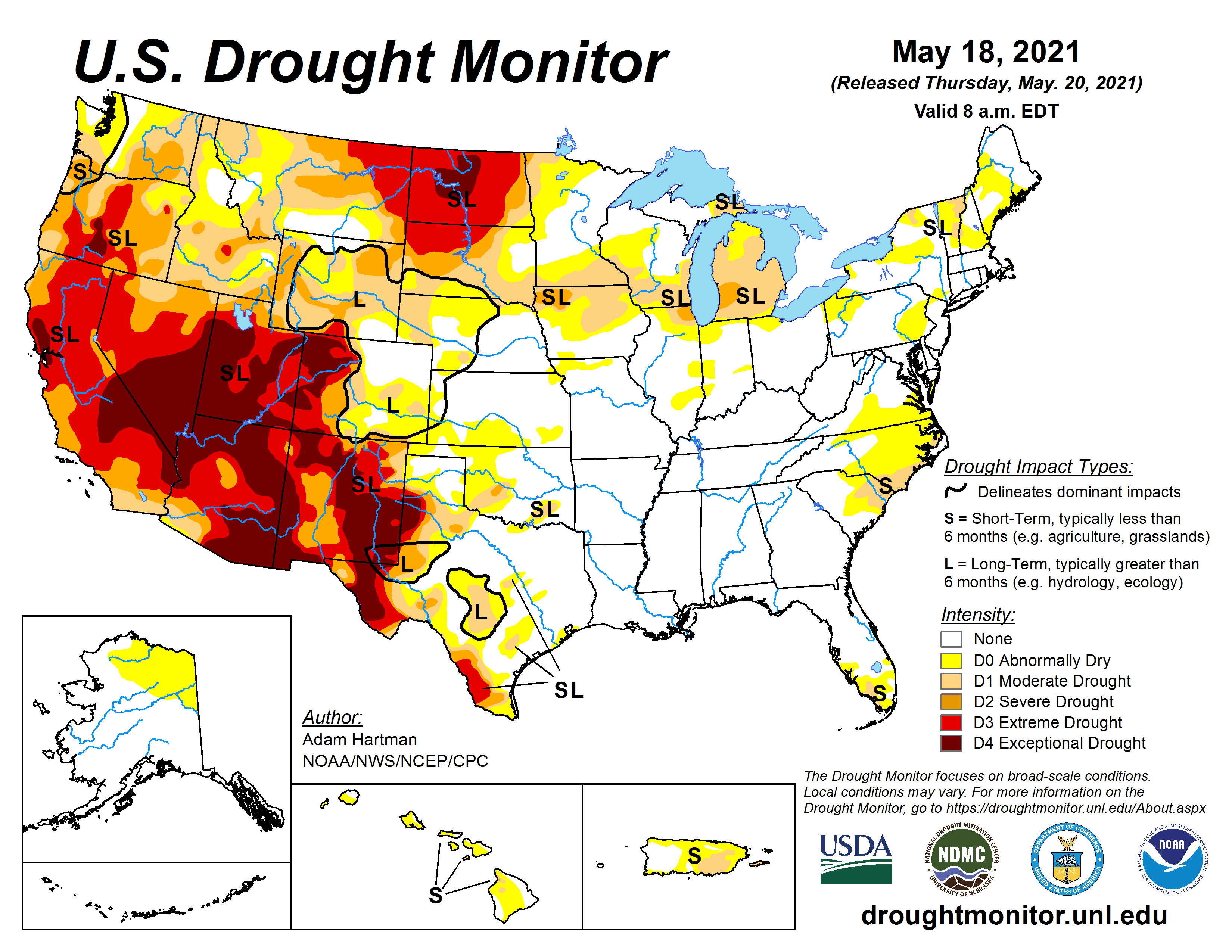
US Drought Monitor map May 18, 2021.
According to the United States Drought Monitor, 84 percent of the West is now in drought, with 47 percent rated as “severe” or “extreme.”
Experts do not see much prospect for improvement, as another hot and dry summer is forecast. Rather, they expect conditions to worsen…
Brad Udall: Here’s the latest version of my 4-Panel plot thru Water Year (Oct-Sep) of 2019 of the #coriver big reservoirs, natural flows, precipitation, and temperature. Data goes back or 1906 (or 1935 for reservoirs.) This updates previous work with @GreatLakesPeck
In the Southwest, especially, the drought has lingered for so long — since 2000, with only a few wet years sprinkled in — that climate scientists now talk of an emerging “megadrought,” one that may rival those that occurred periodically over the past thousand years. Those Southwestern megadroughts, which were discovered by analyzing ancient tree rings, lasted decades — in one case, 80 years.
April 2021 was “exceptionally dry” according to the latest statistics from the USDA’s National Resource Conservation Service. NRCS Hydrologist Joel Atwood noted “Many SNOTEL sites reported record low precipitation for April west of the Continental Divide. Snowpack has also declined in all basins except the South Platte, due to higher temperature and below-average precipitation.”
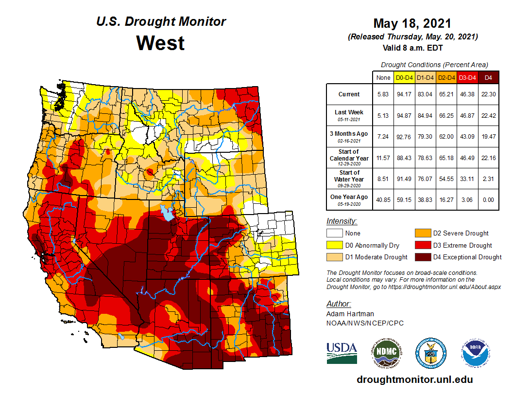
West Drought Monitor map May 18, 2021.
According to the U.S. Drought monitor, the region is experiencing D4 drought level classified as “exceptional drought,” the highest level under extreme (D3), severe (D2), moderate (D1) and abnormally dry (D0).
Despite the well-below-average precipitation levels in the Yampa–White River Basin last month, reservoir storage is sitting at 106% of average. NRCS’ latest report notes however that consistent dry conditions since last summer combined with last month’s lack of precipitation compounded drought conditions. Atwood said, “With much of the snowpack in many basins already melted out, persistent dry soil conditions, and little hope for substantial precipitation moving into summer, runoff volumes will continue to be meager.” Streamflow volumes for all basins west of the Continental Divide are projected between 34 and 73 percent this summer…
Severe to exceptional drought conditions persist across much of the state, with many Western Slope counties seeing the most significant decreases in precipitation and available water in storage. As an example, SNOTEL sites in the San Juan region are reporting just 40% median snowpack.
Statewide, apart from the South Platte River Basin (which has 102% median snowpack), all other basins are reporting less than 80% average snowpack. Snowpack in the Yampa/White River basin is at 73% of median for this time of year.
Every week, the US drought monitor analyzes a week of data through Tuesday, releasing the latest drought levels on Thursday.
And with no surprise, a great improvement was found in the front range and eastern plains this week in Colorado.
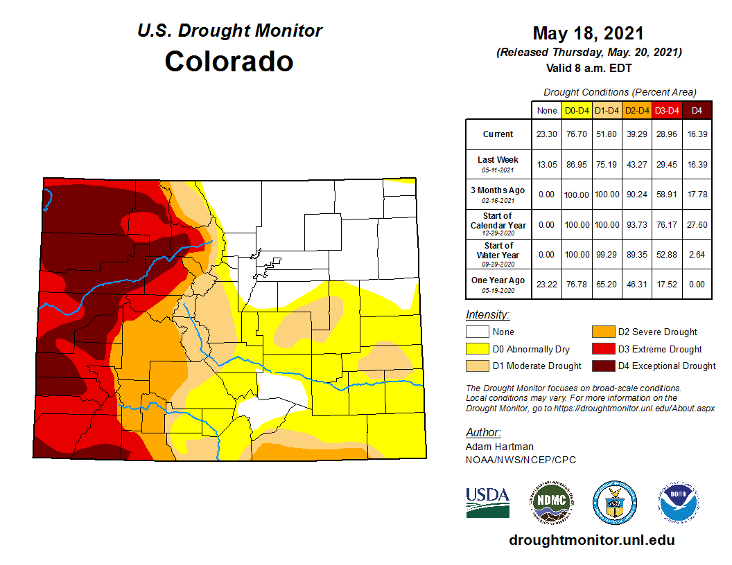
Colorado Drought Monitor map May 18, 2021.
From last week, the percent area of the state under at least abnormally dry conditions dropped from 86.95% to 76.7%. And the percent area of at least D1 drought dropped from 75.19% to 51.8%. And the drought has been completely erased in the northeast corner of the state, including Denver, Boulder, Fort Collins, and Greeley.
Unfortunately, the western slope saw no improvement in the worst drought levels D3 and D4.
As of this month, May 2021, the world has reached 419ppm of atmospheric carbon dioxide — by far the highest levels in the 10,000 years since humans invented agriculture & in the 3+ million years modern humans have existed.
Current Upper Colorado River Basin Reservoir Status May 12, 2021 via the USBR.
Here’s the release from the Upper Colorado River Commission:
On May 14, 2021, the Bureau of Reclamation (Reclamation) released its May 24-Month Study (and accompanying narrative) showing the elevation of Lake Powell declining to 3,525.57 feet as early as March 2022 under the Most Probable hydrology forecast. The 24-Month Study is released monthly and projects Lake Powell elevations 24 months into the future. Lake Powell is currently at an elevation of 3,560.60 feet and is approaching its lowest recorded level since the reservoir began filling in the early 1960s.
Maintaining Lake Powell elevations at or above 3,525 feet promotes the compliance of the states of Colorado, New Mexico, Utah, and Wyoming with a century-old compact and preserves regional benefits derived from hydropower production at Glen Canyon Dam.
Under the 2019 Drought Response Operations Agreement between Reclamation and Colorado, New Mexico, Utah, and Wyoming, the May 24-Month Study signals the need for the parties to begin the development of a drought response operations plan to reduce the likelihood of Lake Powell dropping below 3,525 feet. Such a plan would first consider the operational flexibilities at Lake Powell, consistent with existing legal and operational constraints.
f those flexibilities are unable to prevent Lake Powell elevations from falling below 3,525 feet, the parties will consider releases of water to Lake Powell from the upstream reservoirs of Flaming Gorge, Blue Mesa, and Navajo (“Initial Units” under the Colorado River Storage Project Act). Releases could be made from some or all of the Initial Units and would likely occur in varying quantities and times but consistent with current legal and operational requirements at the facilities. A plan would also include the recovery of water at the participating Initial Units to restore operating elevations at those facilities to their pre-plan levels.
Currently, the parties are beginning the process of developing a drought response operations plan in accordance with the Agreement. However, such a plan will not be finalized until Reclamation’s April 24-Month Study Most Probable forecast shows Lake Powell falling to a target elevation of 3,525 feet or below within a 12-month period and after consultation with the states of Arizona, California, and Nevada. If the Secretary of the Interior determines that there is an imminent need to protect Lake Powell elevations from dropping below 3,525 feet, she has the discretion to take emergency action after consulting with the Colorado River Basin States.
Lake Powell ended the 2020 “water year” at an elevation of 3,596 feet above sea level. That is 104 feet below what is considered Powell’s full capacity. The “water year” is a term used by the U.S. Geological Survey to measure the 12-month hydrologic cycle between Oct. 1 and Sept. 30. The October start date is used to mark when snow begins to accumulate in the mountains. Photo credit: Denver Water
From email from the Colorado Water Conservation Board (Sara Leonard):
Commissioner Mitchell Statement on Lake Powell Elevation Forecast
May 20, 2021 (Denver, CO) – On May 14, the Bureau of Reclamation released its monthly study showing the elevation level in Lake Powell as critically declining.
The study predicts a significant probability that Lake Powell will decline to approximately 3,525.41 feet as early as March 2022. Lake Powell, which currently sits at elevation 3,560.60 feet, is approaching its lowest level since it was filled in the early 1960s.
Statement from Colorado River Commissioner Rebecca Mitchell:
“Our team of Colorado River hydrology experts have been closely monitoring conditions and analyzing the impacts on river operations, and are very aware of the daunting projections. Colorado and all of the Upper Basin states are – and have been – experiencing severe water shortages that affect our industries and our citizens. Colorado stands ready to work with our neighboring Upper Basin states to implement all aspects of the Drought Contingency Plan if conditions warrant. As Colorado River Commissioner tasked with negotiating new river operations on behalf of Colorado, I am mindful of the importance of the Colorado River to more than 40 million people and the $1.4 trillion annual economy it supports. I am committed to engaging with our partners and stakeholders across the state and the Basin to work as efficiently and effectively as possible in order to make informed decisions.”
Scott Hummer, water commissioner for District 58 in the Yampa River basin, checks out a recently installed Parshall flume on an irrigation ditch. Hummer said most water users in the Yampa are complying with a state order issued nearly a year ago that requires measuring devices. Photo credit: Heather Sackett/Aspen Journalism
Click here for all the inside skinny and to register:
CCA’s Ag Water NetWORK is conducting a survey of ag water right holders to better understand producer irrigation infrastructure needs.
The purpose of this survey is to determine what irrigators perceive as their greatest challenges in making desired improvements to their irrigation systems. This includes individual surface and groundwater diverters, and shareholders in incorporated and non-incorporated irrigation water delivery entities.
The aggregate results of this survey will be published in report format. No information will be released that enables identification of a specific survey respondent.
Ag water right holders that complete the 5 minute survey will be eligible to win a $25 or $50 Bass Pro gift card! There will be a total of 6 random drawings during the survey period.