From helping farmers keep an eye on their crops to capturing video footage for business marketing, Barn Owl Drone Services is working to take flight in Southeastern Colorado.
The business launched in August 2017 when Jaron Hinkley, his sister Sarah Hinkley and her husband, Brian Stafford, felt obligated to move “back home” to the La Junta area when their grandparents needed help due to medical issues…
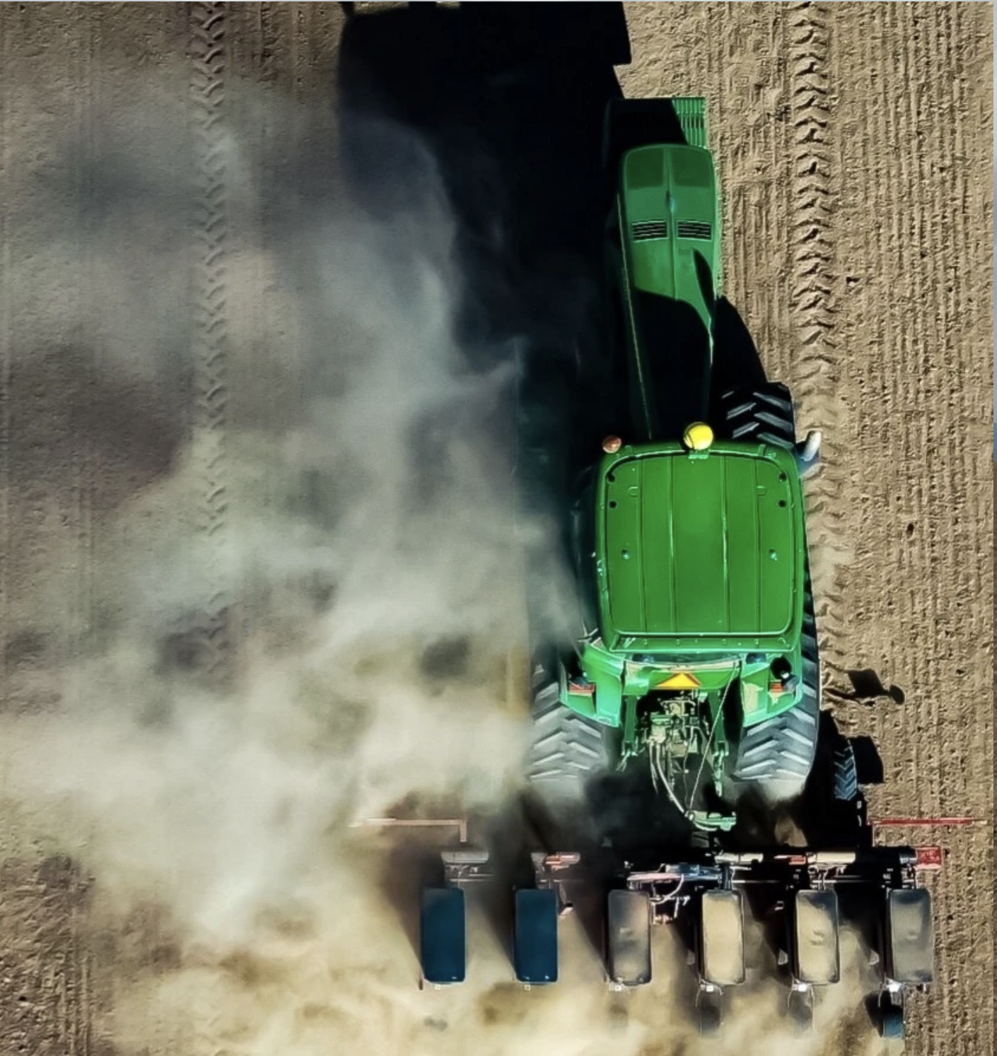
Barn Owl Drone Services launched its drone and robotic services for farmers with the first drone in the air during the growing season of 2018. A fleet of seven drones helps the company’s five employees monitor crops and plant conditions.
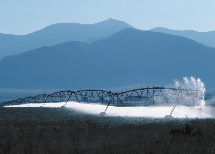
On the robotics end the service uses “owl perches” which are artificial-intelligence supported weather stations, to detect insects and disease. The stations also can measure soil moisture and soil temperatures, to “help our farmers and to help reduce the use of resources like water,” Sarah said…
With hemp farmers the company offers male plant detection and removal. Although the company focuses on farmers, other clients from gravel pits and landfills to feed lots can benefit by having the drones keep tabs on volumes and supplies.
A Colorado Water Plan Scoping Workshop focusing on innovations in on-farm irrigation technology and water management.
About this event
This will be a two-hour, virtual (zoom) session facilitated by Colorado Water Conservation Board and the Irrigation Innovation Consortium (IIC). The focus of this session will be on bringing together knowledgeable stakeholders on innovations in on-farm irrigation technology and water management. The discussion will be centered around specific actions (e.g. programming, public policies, resources, research) to be included in the Colorado Water Plan Update.
Gathered around the campfire one evening during a rafting trip many years ago, the conversation was about classroom education of river guides. I remember it well almost 40 years later because I cracked a joke that got a round of laughter.
To make the educational experience complete, I said, somebody should throw a pail of cold water over those assembled to make it like a real river trip.
That memory was provoked by a recent visit to the Headwaters River Journey, a water-focused exhibit-slash-museum that occupies the ground floor of the Headwaters Center in Winter Park. It doesn’t leave you shivering like you just fell into a cold mountain stream. It does intend for visitors to gain an appreciation for mountain water and the consequences of its loss, in the case of the Fraser Valley to the benefit of metropolitan Denver.
Colorado has 25 ditches, tunnels, and other conveyances that ferry water over and through the Continental Divide, from the Western Slope where 80% of water originates, mostly in the form of snow, to the Front Range cities and the farms beyond, where 85% of Coloradans live. No place has been dewatered so severely as the Fraser Valley, where Winter Park is located.
Diversions that began in 1936 have resulted in 60% of the water from the Fraser Valley being diverted to metropolitan Denver. That percentage will increase to more than 80% if a long-contemplated project by Denver Water gets realized.
Headwaters River Journey seeks to deliver an appreciation for the natural environment of the Fraser and other mountain valleys and the cost to these ecosystems. It does so with an abundance of hands-on experiences.
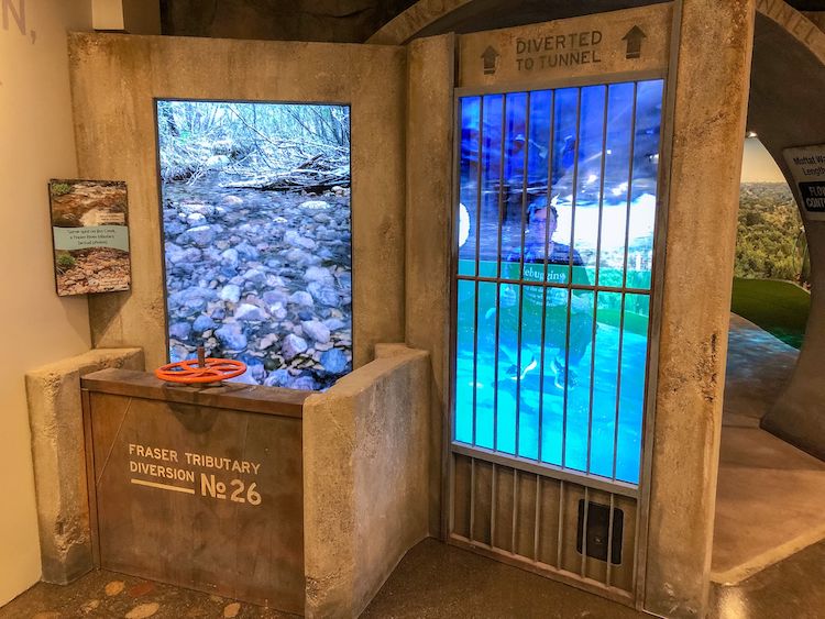
One exhibit allows a literal hands-on demonstration of depletion of Jim Creek, one of the sources of metropolitan Denver’s water, as levels rise in Moffat Tunnel pipeline. Photo/Headwaters Center via The Mountain Town News
The hands-on learning is literal in an exhibit about Denver Water’s diversion from Jim Creek. The creek originates on the flanks of James Peak, across from the Winter Park ski area, meandering through a glacial-carved valley to a confluence with the Fraser River. Or, what’s left of the creek.
The exhibit has you lay hands on an operating wheel that is used to raise or lower a headgate at a diversion point. As you crank the red wheel, as if to divert water into a diversion ditch, a screen on the left shows water levels in the creek dropping. More cranks yet reveal cobbles, a creek nearly without its water. A panel on the right shows corresponding water levels rising in the water pipe in the Moffat Tunnel used by Denver to deliver water to South Boulder Creek, just one relatively minor hump away from Denver’s suburbs.
This was not news to me. I once lived in that valley, proudly wearing a “Dam the Denver Water Board” (as the water agency was formerly called) bumper sticker on my car. Now, I live on the receiving end of that water, in the Denver suburb of Arvada. Here, 78% of water for this city/suburb of 120,000 people comes through the Moffat Tunnel from Jim Creek and myriad other creeks in the Fraser Valley. More yet comes from the adjacent but far more remote Williams Fork Valley, two more tunnels away.
The plumbing before the water arrives at my garden hose is vast, complex, and expensive. The legal system for administration of Colorado’s water may be more byzantine yet.
Headwaters doesn’t dive deep on the history, legal system, or the plumbing. It’s more like a chapter in Colorado Water 101. It is geared to someone who knows relatively little about water.
Still, someone like myself, who has written about Colorado water off and on for more than 40 years, the exhibits can fill in gaps. One of my gaps is biology. One exhibit showed the life stages of stoneflies, an important component of the aquatic ecosystem. Through an interactive exhibit, I swam along a river bottom somewhat like a trout might, looking for food.
Another interactive experience allowed me to flap my arms as if a condor, flying over the geography from Berthoud Pass northward to Longs Peak and west along the Rabbit Ears Range. If a museum can be this much fun for an older guy, I wonder what it would be like to be a 10-year-old.
My companion, Cathy, was most touched by two exhibits that triggered her memories of living for almost 30 years in a very small mountain town in a house above the confluence of a creek and river.
One was a line of the life to be found along a mountain creek, from the bugs to the four-legged critters. She says it was a lovely reminder of “all the friends that I miss” now that she lives, sometimes with regret, a citified life.
The other was a wall-sized video immersion at the beginning of the exhibit that shows the changing of the seasons from one vantage point of a mountain slope. As the snow fell, there was a whoosh of chilled air. As the snow melted, there was the sound of water drops falling.
Colorado’s population has grown rapidly since the early 20th century, as the Headwaters Center exhibit graphically points out. Photo/Allen Best
The exhibit is the creation of Bob and Suzanne Fanch, owners for the last 20 years of the 6,000-acre Devil’s Thumb Ranch, which is 7 or 8 miles down the valley —and, perhaps not incidentally, just below some of Denver Water’s diversions on Ranch Creek. It’s one of the nation’s most high-end cross-country ski destinations.
Kirk Klancke, a neighbor of the Fanches on Ranch Creek and an active member of Trout Unlimited and other water-related causes, describes himself as a technical advisor.
The Fanches, he explains, got the bug for interactive exhibits after visiting a museum in Iceland. “What a great educational tool, and the Fanches have always been interested in the future of the Fraser River,” he says.
The vision was distilled by Suzanne, he says, in a discussion. She took the message from a Trout Unlimited movie about the plight of the river that was called “Tapped Out.” A Boulder couple, Chip and Jill Isenhart, who have a company called ECOS Communications, designed the exhibits.
“We are natural history and environmental storytellers, and our team of content experts and designers has been doing this for more than 30 years in Colorado,” says Chip Isenhart.
“Our passion is partnering with mission-driven clients like the Fanches, and they have done an amazing job creating a world-class exhibit in Grand County.”
Isenhart says the primary task in creating the exhibit was to connect the dots between the Fraser River and the Front Range residential water use. To do this, he and his team needed to see the story through the eyes of the locals.
“We would go out on the river with Kirk Klancke, and folks from CPW, and meet frustrated anglers due to fishing closures at 1 p.m. due to river temperatures being so high from the lack of water,” says Isenhart. “And at the same time we also got to work closely with Front Range water interests to make sure our story was balanced. That was very, very important to ECOS and the Fanches and Trout Unlimited, as this issue is beyond complicated. It’s actually fairly easy to paint a picture that’s more sensational than accurate.”
Once ECOS had the essentials of the story figured out, they set out to create a variety of fun, changeable, and—they hoped—memorable interactive experiences to tell that story.
One of my memories is of the bathroom stall. No opportunity for educational storytelling was missed.
See Headwaters River Journey for hours and location. Photo credit: Allen Best/The Mountain Town News
The take-home message of Headwaters River Journey is about personal responsibility.
“It’s taking the knowledge you’ve learned and actually making a difference using that knowledge and being a participant, rather than a spectator,” says Klancke. “That is what this museum is designed to do.”
The ideal audience would be somebody who lives in metropolitan Denver, a beneficiary of the exported water, or more broadly somebody from the Front Range. As such, it might better be located in Golden, for example, or even along the Platte River near downtown Denver. It was located in Winter Park, at least in part, because the municipality provided the 6 acres of land. Plus, there is an additional benefit. Immediately outside the backdoor of the exhibit is an illustration of beavers, willows and a braided mountain river.
But Isenhart says the exhibit can have value for remote learning, especially for classrooms along the Front Range. “That’s hopefully one of the next steps,” he reports.
I had intended to visit the exhibit in March 2020, on the way back to Denver after a trip to Craig. I was a bit late, and hence the curtain of covid descended the next week. My trip was delayed by 13 months.
It was worth the wait, though. Headwaters River Journey exceeded my expectations. And I’d go back again for a refresher.
This is from Big Pivots, an e-journal that tracks the energy and water transitions in Colorado and beyond. To get copies, go to http://BigPivots.com.
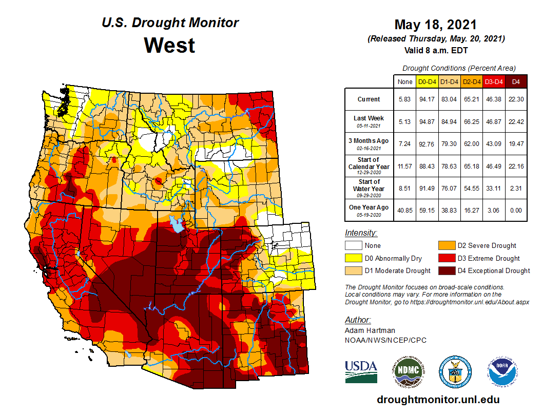
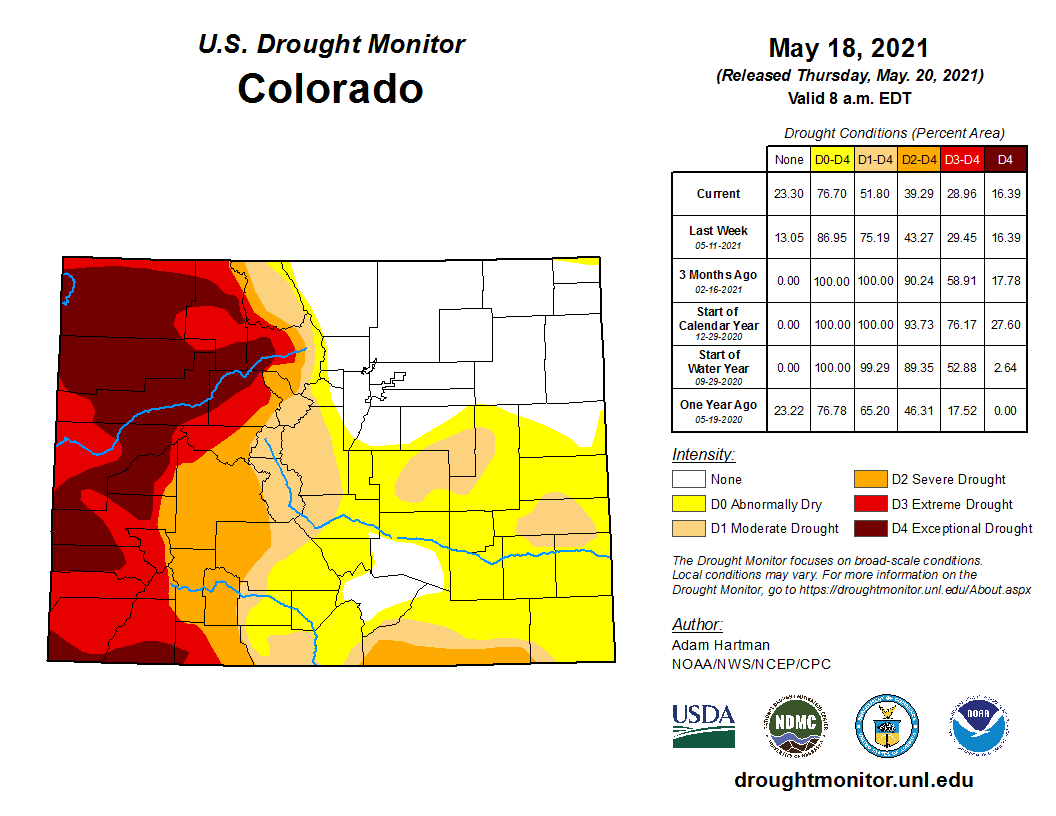
Recent rainfall has been a boon for eastern Colorado. The Front Range has enjoyed abundant precipitation and nearly half of the state’s geographic area has shed drought conditions, according to the U.S. Drought Monitor.
But the Western Slope hasn’t been blessed with the same precipitation levels, leaving a brutal drought and a high risk for fire to worry about.
Assistant state climatologist Becky Bolinger said it’s typical for conditions on one side of the Continental Divide to differ from the other. And western Colorado usually gets more precipitation than the east because of the jet stream…
Bolinger predicts snowpack to the west will melt by the end of the month…
Outlooks from the Climate Prediction Center suggest Colorado is headed for another hot and dry summer. On average, June is the driest time of year for southwest Colorado, where relief won’t come until the onset of the summer monsoon season. Bolinger said thunderstorms can pop up anywhere, even in dry conditions, that could provide some relief.
The latest report from the National Drought Mitigation Center shows that 48 percent of Colorado has shifted to drought-free or abnormally dry conditions since the start of the year. In January, all of the state was in some level of drought, with 77 percent in extreme or exceptional drought – the two worst categories.
Improvements – at least for eastern Colorado – began in mid-March as significant snow brought the first hints of relief. During May, thunderstorms have continued to bring rain to the state’s eastern plains, resulting in drought-free conditions for most northeast counties, with much of the southeast moving to abnormally dry, a step below moderate drought.
The first drought-free area in Colorado since mid-2020 appeared in late April.
Colorado Drought Monitor map May 18, 2021.
Over the past reporting period, between one-half and three inches of rain have fallen across the region, with storms producing higher amounts in localized areas.
Western Colorado continues to be dominated by extreme and exceptional drought. Portions of Moffat, Garfield and Rio Blanco counties have even seen conditions further degrade over the past few months, moving from extreme drought into exceptional.
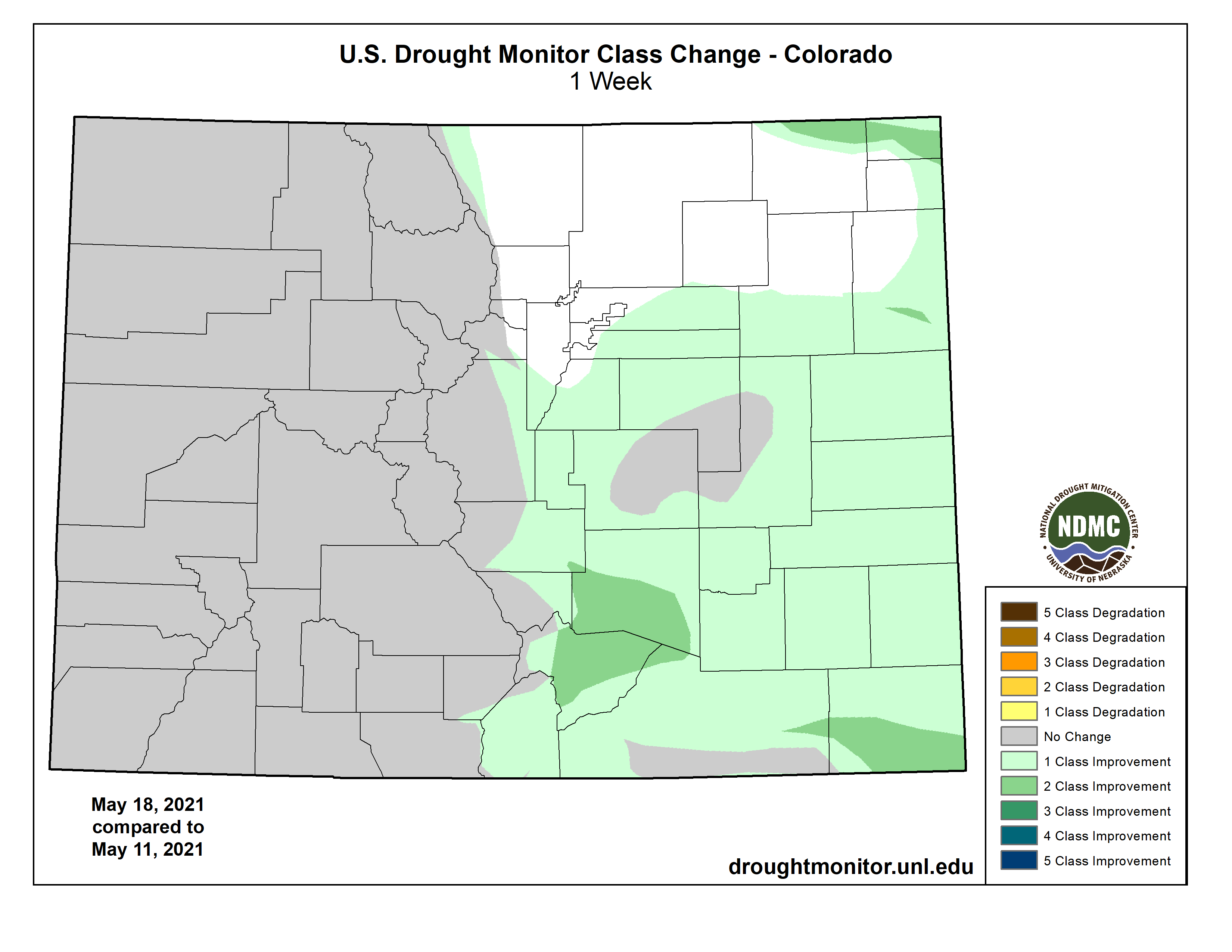
Over the past week, nearly all of the eastern half of the state which had not already shifted to drought-free condition showed at least one category of improvement. Portions of El Paso, Elbert and Lincoln counties remained in moderate conditions, while southern Las Animas County saw severe drought shrink, though a strip remains along the border with New Mexico.
Southern Baca County saw two levels of category improvement, moving from severe to abnormally dry conditions. Much of central Huerfano, southern Pueblo and far north Las Animas counties also shifted by two categories, moving from moderate drought to drought-free. A remaining area of extreme drought in Las Animas County moved to severe conditions.
Colorado Drought Monitor one week change map ending May 18, 2021.
Kiowa County has seen a particularly dramatic improvement since the start of the year. At that time, the bulk of the county was in extreme drought, with a persistent bullseye of exceptional conditions covering the central part of the county for months. With the most recent report, western and eastern Kiowa County are abnormally dry, with the central area in moderate drought, dropping from severe last week.
Overall, 23 percent of the state is drought-free, up from 13 percent last week, with an additional 25 percent in abnormally dry conditions, up from 12 percent in the previous week. Moderate drought covered 13 percent of Colorado, down from 32 percent, while severe drought dropped from 14 to 10 percent. Extreme and exceptional drought were unchanged at 13 and 16 percent, respectively.