Norwood – four horse stage used on Placerville-Norwood route, east of Norwood, Colorado. Credit: Denver Public Library Special Collections, creator Beam, George L. (George Lytle), 1868-1935. Date: 1910?
Norwood Public Works Director Lippert has said the water situation is questionable this year, as many people already know. On Monday, he told The Norwood Post that it didn’t look good.
“We are in extreme drought, and it’s serious,” he said. “It could change in a heartbeat, but today it’s pretty serious. It’s going to affect a lot of people in a lot of ways, from ag to those who want to move here.”
At the town board meeting two weeks ago, Lippert gave an update on the raw water status. Last Monday, the raw water system was turned on, and tap holders who have rights to water lawns and gardens are now able to do so. Raw water is projected to run for 30 days at this point, though Lippert said that may change depending on the weather.
Monsoons, which typically bring summer rains to the Wright’s Mesa area, could help the situation, though the last few years the monsoon season has not produced much precipitation, which is disappointing for raw water customers (and of course those who work as farmers and ranchers.)…
And, Norwood’s first water education day is June 5 from 10 a.m. to 2 p.m. Organized by town trustee Candy Meehan, the event aims to educate the locals about the water situation currently, but also teach the history too.
Many water organizations will come together, including Farmers Water, the Norwood Water Commission, the Lone Cone Ditch Company and others.
Meehan hopes the water day is informative for the public, but also helps with being proactive, rather than reactive, regarding the water issue in Norwood.
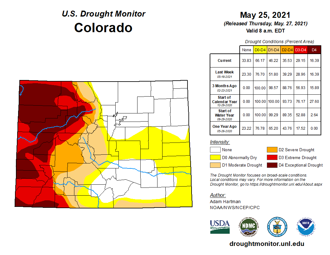
While western Colorado continues to suffer under extreme and exceptional drought, the eastern plains have been rapidly improving to nearly drought-free conditions according to the latest report from the National Drought Mitigation Center.
Thanks to recent spring storms, two pockets of moderate drought impacting portions of El Paso, Elbert, Lincoln, Kit Carson, Kiowa, Bent and Prowers counties have now retreated to abnormally dry conditions.
Along the southern border with New Mexico, moderate drought retreated from Huerfano and Costilla counties. Nearby, severe drought moved to moderate conditions for southern Las Animas and southwest Baca counties.
Colorado Drought Monitor map May 25, 2021.
Drought-free conditions grew further into the San Luis Valley as well as the southeast plains.
Western Colorado has remained largely unchanged for weeks and is mostly covered with extreme and exceptional drought.
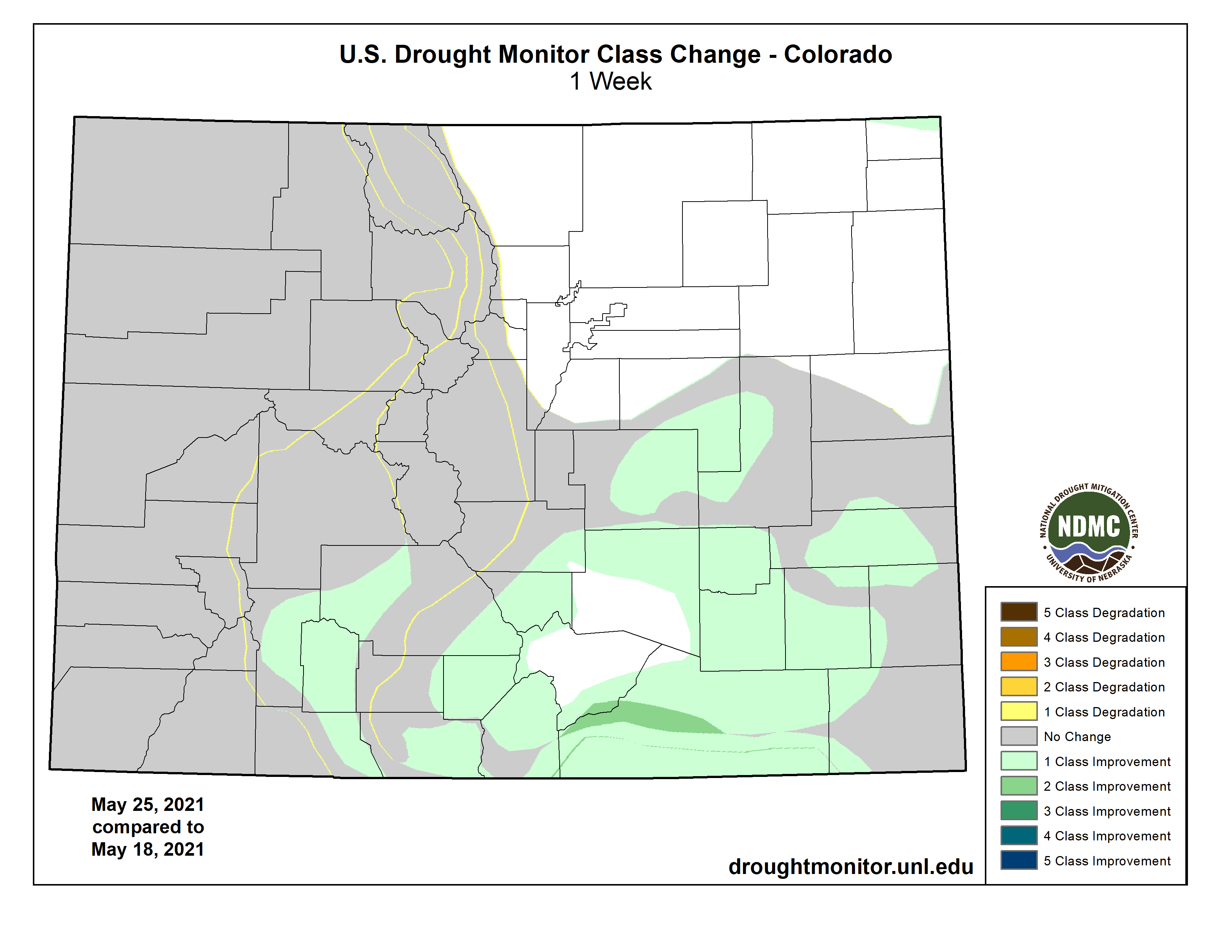
Over the past week, storms have produced as much as three inches of rain – with isolated areas receiving more – on the eastern plains. Hail and tornadoes have accompanied may of the thunderstorms.
Improvements in eastern Colorado began in mid-March as significant snow set the initial stage for relief to the area. During May, thunderstorms have continued to bring rain to the state’s eastern plains, resulting in drought-free conditions for most northeast counties by last week. A remaining strip of abnormally dry conditions in northern Sedgwick County became drought-free with recent rains.
The first drought-free area in Colorado since mid-2020 appeared in late April.
Colorado Drought Monitor one week change map ending May 25, 2021.
Recent rounds of precipitation have improved pasture conditions to northeast counties, as well as better wheat condition in the east central area. Reports from the USDA also showed better pasture conditions in the southeast portion of Colorado.
Overall, 34 percent of the state is drought-free, up from 23 percent last week, with an additional 20 percent in abnormally dry conditions, down from 25 percent in the previous week. Moderate drought covered 11 percent of Colorado, down from 13 percent, while severe drought dropped from 10 to six percent. Extreme and exceptional drought were unchanged at 13 and 16 percent, respectively.
The controversial Gila River diversion project has entered a “closeout” phase.
With no discussion, the New Mexico Interstate Stream Commission on Wednesday approved several line item transfers within the New Mexico Entity of the Central Arizona Project’s 2021 budget, as well as a closing budget for the 2022 fiscal year to pay for a final annual financial audit of the group.
The N.M. CAP Entity’s executive director, Anthony Gutierrez, addressed the ISC before it voted unanimously to approve the two items.
“I know this has been a long process,” he said. “Our members and myself were disappointed with not being able to develop AWSA water, but we certainly respect the decisions that the commission has made in the past few months.”
Gutierrez acknowledged that one of those decisions “was to discontinue the budget for the New Mexico CAP Entity,” which paid for, among other things, his salary. It also covered Entity attorney Pete Domenici’s fees, for which $139,500 was originally budgeted this fiscal year.
Blue Mesa [Reservoir] is at about 345,000 acre feet and sits at 42% full, based on May data, which predict the reservoir will only hit just above 50-percent full — “not very good,” as Bureau of Reclamation hydrologist Erik Knight put it.
“We’re lower than we were at any time in 2020. In 2018, we were below 250,000 acre feet by the end. We’re not projecting to go that low yet, but we’re heading in that direction, that’s for sure,” Knight said Friday.
“The reservoir is pretty low. Runoff hasn’t really kicked into gear, although I think that is starting now,” he added.
Although the Uncompahgre River is a bit bouncier and swelling with some snowmelt, Montrose County and the western side of the state remain locked in drought.
Colorado Drought Monitor map May 25, 2021.
Conditions in the county range from extreme drought to exceptional — the two worst levels — according to US Drought Monitor data.
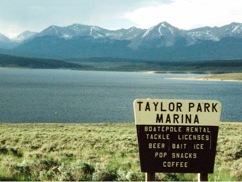
So far, the Uncompahgre Valley Water Users Association, which serves about 3,500 shareholders, has been able to fill its contracts at 70%. The association’s storage “account” at Taylor Park Reservoir — which with Blue Mesa and other reservoirs is part of the BuRec-managed Aspinall Unit — is full, UVWUA manager Steve Anderson said. (Taylor itself is not expected to fill at 100%, but UVWUA anticipates it will receive the full amount to which it is entitled from the reservoir.)
Taylor Park Reservoir
“I expect our account at Taylor to refill,” Anderson added. “We are storing second-fill water in Taylor right now and my expectation is for us to wind up the season with a full reservoir at Taylor. That means a lot to us, but that’s 100,000 acre feet and we need 600,000 acre feet to run the project. But that’s a good start.”
Ridgway Dam via the USBR
The storage account at Ridgway Reservoir is close to full, Anderson also said — of 21,000 acre feet of association water, a bit more than 300 acre feet have been used…
The water picture for the Grand Mesa and North Fork is worse than it is for Montrose, he said, and also pointed to the south, to the Dolores River.
Mcphee Reservoir
McPhee Reservoir, which the river feeds, is well below average and, the Cortez Journal reported Wednesday, irrigators with contracts for its water have been told to expect between 5 and 10% of their ordinary fulfillments.
“The Dolores is just horrible,” Anderson said. Only one-sixth of the water would ordinarily be delivered from McPhee is coming to users, he said. “That’s pretty sad. We’re fortunate in that respect, that we’re not in those kind of dire straits.”
[…]
Lake Powell is seen in a November 2019 aerial photo from the nonprofit EcoFlight. Keeping enough water in the reservoir to support downstream users in Arizona, Nevada and California is complicated by climate change, as well as projections that the upper basin states of Colorado, Utah, Wyoming and New Mexico will use as much as 40% more water than current demand. A recent white paper from a lineup of river experts calls those use projections into question. CREDIT: ECOFLIGHT via Aspen Journalism
[Lake] Powell’s levels are within a whisker or two of being too low to sustain hydropower generation. If Powell drops below 3,490 feet elevation, that’s the danger zone, Anderson said in January. As of May 14, Powell was projected to end the water year at 3,543 feet, according to the Bureau of Reclamation, although the agency also noted “significant uncertainty” at the time…
Flaming Gorge Reservoir July 2020. Photo credit: Utah DWR
Flaming Gorge has enough storage right now that it can bail out Powell in an absolute emergency, as it could release 2 million acre feet, Anderson said…
Back at home, the Aspinall Unit also has drought contingency plans that kick in as needed to maintain baseflows and satisfy the requirements of legal records of decision.
In dry years, flow targets are dropped and that helps keep Blue Mesa and the other reservoirs in the unit from running dry, Knight said.
Crews have started installing a 42-inch welded steel pipeline through portions of northern Colorado with the goal of bringing clean water to Thornton through 2065.
However, even though Thornton legally purchased the water rights from the Cache la Poudre River northwest of Fort Collins in the 1980s, the counties it needs to pump water through are preventing the pipeline from becoming a full reality, for now.
“We got the water in 1985. That is all done. We have the permission to move the water, we just need the facilities to move it,” said Mark Koleber, Water Supply Director for Thornton…
Thornton needs to install more than 80 miles worth of pipes from the river near Ted’s Place all the way to the Denver suburb. However, in Larimer County, they have come across issues getting permits to install the pipeline along roadways…
While Thornton navigates the next steps of building their pipeline through unincorporated Weld and Larimer counties, they have been given permission to start construction through towns like Timnath, Windsor and Johnstown.
Timnath and Windsor have seen a dramatic spike in residents in the past few years, and many homes are being built along WCR-13 in Windsor, right where Thornton planned to build their pipeline…
To avoid the stresses of more disruption, Thornton was granted permission to install their pipeline along the roadway before the neighborhoods were completed.
“We can do that so we can get ahead of the development,” Koleber said. “That is really important for us, to make sure we don’t impact the communities any more than we have to.”
[…]
More than seven miles worth of pipeline have been installed through Windsor and Johnstown. Some of that stretch has already been installed, reclaimed and built over.
The Raindance Community in Windsor has already built homes along the now-hidden pipeline, with sidewalks and landscaping covering where the construction was completed.
Following the state’s orders, Thornton had to develop a plan to cross over two rivers in Northern Colorado without disturbing them.
Koleber’s team dug massive holes on each end of the Poudre and Big Thompson rivers. Then machinery was lowered into the holes. The machinery then dug itself under the rivers, sending back carts full of mud as it continued to burrow. The pipes were then lowered into the holes and slid through the makeshift tunnels, leaving the Poudre and Big Thompson unscathed.
“That will allow us to move the water under the Poudre without disturbing the Poudre at all. We can cross it without touching the Poudre,” Koleber said.
Thornton has engaged in legal action against Larimer County, hoping the courts can help them claim what they legally purchased decades ago. The city has not ruled out taking similar action in Weld County if common ground cannot be reached in a timely manner.
CBS4 contacted Larimer County commissioners for comment on this article. However, multiple commissioners wrote back saying they could not comment on the story due to ongoing litigation.
A) Cross-validated reconstruction skill (R2) using tree-ring records that extend to 800 and 1700 CE (green contour: R2 ≥ 0.5; gray: reconstruction does not extend to 800 CE; yellow box: SWNA). (B) Time-resolved cross-validated R2 of the SWNA regional reconstruction. The inset shows observations versus cross-validated reconstructions during the 1901–1983 calibration interval using tree-ring records extending back to 800 and 1700 CE. (C) Time series of reconstructed (red) and observed (blue) 19-year running-mean standardized SWNA soil moisture (gray: 95% reconstruction confidence interval; blue horizontal line: 2000–2018 mean; pink and green shading: the five drought and pluvial periods with the most-negative and most-positive 19-year soil-moisture anomalies, respectively). (D) Maps of the local rank of the most negative 19-year anomaly to occur during each of the five drought events highlighted in (C). In the maps, the aqua color indicates no negative 19-year anomaly, and numbers in the top left corners indicate the rank of the most negative regionally averaged 19-year anomaly during each drought event.
Click here to access the paper (A. Park Williams, Edward R. Cook, Jason E. Smerdon, Benjamin I. Cook, John T. Abatzoglou, Kasey Bolles, Seung H. Baek, Andrew M. Badger, Ben Livneh):
Here’s the abstract:
Severe and persistent 21st-century drought in southwestern North America (SWNA) motivates comparisons to medieval megadroughts and questions about the role of anthropogenic climate change. We use hydrological modeling and new 1200-year tree-ring reconstructions of summer soil moisture to demonstrate that the 2000–2018 SWNA drought was the second driest 19-year period since 800 CE, exceeded only by a late-1500s megadrought. The megadrought-like trajectory of 2000–2018 soil moisture was driven by natural variability superimposed on drying due to anthropogenic warming. Anthropogenic trends in temperature, relative humidity, and precipitation estimated from 31 climate models account for 46% (model interquartiles of 34 to 103%) of the 2000–2018 drought severity, pushing an otherwise moderate drought onto a trajectory comparable to the worst SWNA megadroughts since 800 CE.
The slag pile left over from a 1900s smelting operation on a wetlands property subject to a unique conservation play that is working its way through various agencies. An analysis by the Colorado Department of Public Health and Environment found that the material does not post a significant health risk if it is fenced off. CREDIT: CURTIS WACKERLE/ASPEN JOURNALISM
You wouldn’t want to put it in your granola, in the words of Crystal Valley Environmental Protection Association President John Armstrong, but a heap of waste material left over from a 1900s smelting operation near the banks of the Crystal River in Marble does not appear to pose enough of an environmental hazard to prevent the donation of 55 acres of otherwise stunning, mostly wetlands terrain to a land conservation organization.
But the road to reach this point has been long for the private owner of the now three contiguous parcels across the river that the owner has been trying since 2016 to see donated and permanently preserved in its natural state. In that time, concerns about potential liabilities associated with the slag pile have held up the initiative.
But support from CVEPA, which agreed to put $1,000 toward an analysis of the material, plus a discussion with the Pitkin County Health Rivers and Streams board about a grant, gave momentum to the effort last year. This spring, the Colorado Department of Public Health and Environment (CDPHE) completed its analysis of the site and determined that contaminant levels in the material are within the range considered to be non-threatening to human health for a day-use recreation site.
In the end, the analysis work was completed pro bono, and proponents hope that funds pledged can be used for materials to fence off the slag heap and put up some interpretive signage explaining the history of the smelter and the slag left behind. This would complement an eventual management framework in which a land-conservation agency holds title to the property and allows passive, non-motorized public access along an existing route following the river.
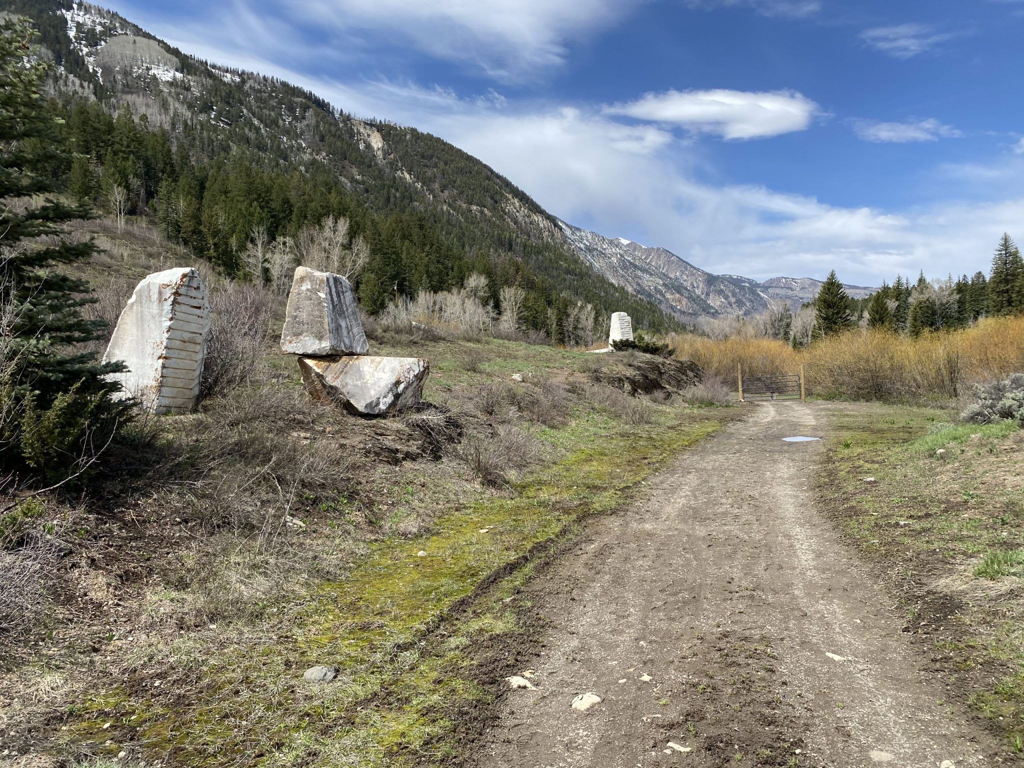
Blocks of marble, likely connected to a historic railroad line running to a quarry, were artistically stacked by a previous owner along what one Marble resident referred to as “The Trail With No Name.” CREDIT: CURTIS WACKERLE/ASPEN JOURNALISM
That would adhere to long-held use patterns on the land, where private owners have allowed the public to hike, bike or Nordic ski. The biodiverse area straddling the river and the wooded hillside, referred to by Marble history museum curator Alex Menard as the Trail With No Name, has been the site of nature walks hosted by the Roaring Fork Conservancy to observe the beaver dams dotting the wetlands. A portion of it near the slag heap is also marked by giant slabs of marble — probably left over from a railroad that used to run through the site to a marble quarry on Treasure Mountain — that a previous owner artistically stacked just off the trail. The trail itself leads to scenic waterfalls on Yule Creek, although the falls are just over the property line on an adjacent parcel controlled by a separate owner.
“This is really a wildlife refuge,” said Menard, who was instrumental in bringing the project to the attention of the CVEPA. “It’s a place where you can see an eagle taking a trout out of water with its talons, then half a mile farther up, there is a moose; walk a little more, there’s a bear, a blue heron. It’s a wild place.”
As noted by Armstrong, it could also be a desirable spot for a “McMansion,” if not for the benevolence of the private donor — an out-of-state woman who also donated the land in town that is becoming Marble Children’s Park. That land is now owned by Aspen Valley Land Trust, which is working with the town and obtaining additional grant funding to spruce up the site.
AVLT is critical to the conservation effort on the wetlands parcel, as well. AVLT staff is completing survey and title work on the property and will soon be proposing action to the land trust’s board. However, the exact shape of that action is still to be determined, according to AVLT director Suzanne Stephens.
“(We) have talked with our lands committee about potentially accepting fee ownership, but we are also investigating potential partnerships and other options for the property, so it’s not a foregone conclusion that we’ll end up with it,” Stephens wrote in an email. “However, we are committed to seeing it protected one way or another.”
Potential partners include Colorado Parks and Wildlife, CVEPA, Pitkin County and other entities, Stephens said.
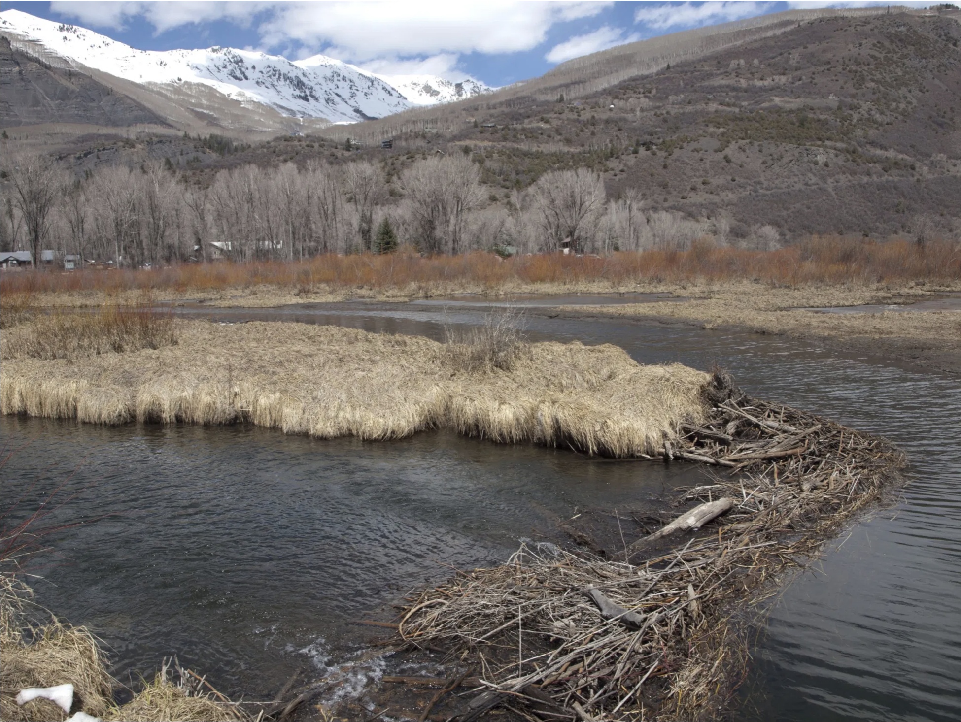
A beaver dam along the Crystal River as it runs through a property that a private owner is seeking to donate for conservation purposes. Also visible in this photo is a Canada goose island nesting site with a large beaver lodge. CREDIT: COURTESY PHOTO BY ALEX MENARD
The site is “unquestionably one of the most important wetlands and riparian parcels in the valley,” Stephens said.
“The fact that it adjoins Beaver Lake and almost the entirety of its acreage is wetland and river make it extremely important from a land and water conservation perspective,” she wrote, referring to the body of water located on a CPW-owned parcel to the north. “The habitat is crucial and threatened across the west, and combined with the proximity to the town of Marble and the fact that the smelter site has historic significance and the parcel offers flat, easy access and a lovely walk make it a rare gem that deserves to be conserved for a multitude of reasons.”
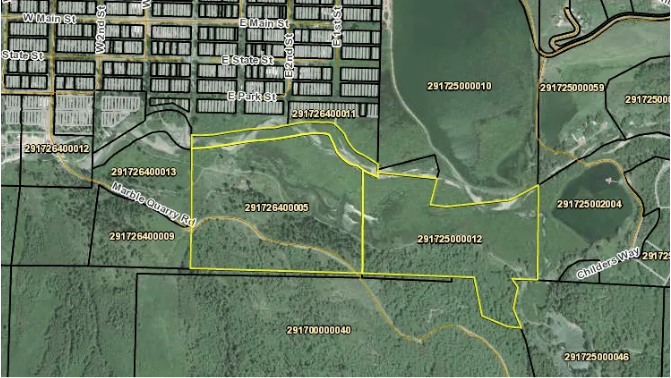
The parcels outlined in yellow across the Crystal River from Marble are subject to a unique conservation effort. Beaver Lake is located on state-owned land abutting one of the parcels to the north. CREDIT: SCREENSHOT VIA GUNNISON COUNTY GIS MAPPING WEBSITE
‘Like a glass blob’
In the early days of industrialization and European settlement in the Crystal River Valley, a smelting and ore-crushing operation known as the Hoffman Smelter was erected on the site, according to Menard’s historical accounting. The site processed silver, lead, zinc and copper ore hauled by mule train from mines around Marble from roughly 1898 until 1911.
The smelter is long gone, but its shadow still hangs over the site. According to Armstrong, initial donation efforts in 2016 and 2017 ran aground on concerns about the slag heap, although proponents have long held that such concerns would ultimately be inconsequential.
A close-up view of the rock-like material that crumbles off the slag heap, left over from a 1900s smelting operation near Marble. CREDIT: CURTIS WACKERLE/ASPEN JOURNALISM
The heap in question — perhaps 50 feet long and 10 feet high and located near the edge of the trail — “looks like something volcanic,” Armstrong said.
The mostly solid mound is, however, shedding pieces the size of small rocks. But there is not a strong presence of dust or other material that could wash away in a rainstorm or become airborne in dry conditions. CVEPA’s hope has been that any toxic material is inert, locked up in the rock.
“I have a strong feeling that it shouldn’t be something that should preclude something from acquisition,” Armstrong said in December, when CVEPA was awaiting the results of a materials analysis involving a private lab and CDPHE.
CDPHE — which was reviewing the site following a grant process where projects are submitted that present a public benefit — has substantially completed its analysis, and its findings line up with Armstrong’s characterization.
“Nothing is alarming,” said Mark Rudolph, an environmental protection analyst and brownfield site coordinator with CDPHE. He referred to the slag material as “like a glass blob.”
Rudolph noted that vegetation around the slag pile is healthy and that water quality in the Crystal River, about 50 yards from the material, meets the highest standards. Lead concentrations in the material fall in the range deemed acceptable for recreation sites, he said, and most of it appears locked up in the rocklike formation.
A final report from CDPHE is pending and will include recommendations on how to manage the site for public use. Those recommendations are likely to include clearing from the road any particles that have come off the slag heap. The road was recently built using a historic easement that allows access to a neighboring property owner, who is developing a home. Other strategies could include reseeding areas around the heap and using crushed marble or some other material to cover the slag particles that are visible on the shoulder of the road.
“It’s going to be a great addition to the town if we can get it all the way through,” Menard said of the conservation effort.
Protecting continued public access to these waterfalls along Yule Creek, just over the property line from a parcel set to be donated to a land conservation agency, is an ongoing priority for the CVEPA. CREDIT: COURTESY PHOTO BY JOHN ARMSTRONG
For Armstong and CVEPA, there is further work to be done to ensure public access to the falls, which are about 1.5 miles in from the beginning of the walk through the wetlands. The falls are on the property owned by the man who recently built the road. He could not be reached for comment.
“The owner of the private property seems amenable to allowing access, as he has placed ‘no trespassing’ signs farther up the road beyond the access to the falls,” the CVEPA wrote in a winter 2020 newsletter article about the Marble wetlands donation initiative.
This story ran in the May 29 edition of The Aspen Times.