Click on a thumbnail graphic to view a gallery of drought date from the US Drought Monitor. (Updated with the change maps that were not available at publishing time.)
US Drought Monitor map May 11, 2021.
West Drought Monitor map May 11, 2021.
High Plains Drought Monitor map May 11, 2021.
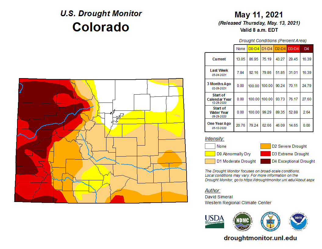
Colorado Drought Monitor map May 11, 2021.
Click here to go to the US Drought Monitor website. Here’s an excerpt:
This Week’s Drought Summary
This U.S. Drought Monitor (USDM) week saw deterioration in drought-related conditions on the map across areas of the West, including California, Oregon, Washington, Utah, and Montana. Moving into dry season, California is expecting drought impacts to intensify during the summer months as snowpack runoff is forecasted to be below normal and reservoir storage levels at the state’s two largest reservoirs (Lake Shasta and Lake Oroville) are at 48% and 41% of average, respectively. In response to the deteriorating conditions, Governor Newsom expanded the coverage of his recent drought emergency declaration to include an additional 39 counties statewide. In the Southwest, Lake Powell is currently 35% full and Lake Mead is 38% full with the total Lower Colorado system at 43% full (compared to 52% full at the same time last year) as of May 10, according to the U.S. Bureau of Reclamation. In New Mexico, the state’s largest reservoir along the Rio Grande is currently at 12% full. In Arizona, the Salt River Project is reporting the Salt River system reservoirs at 79% full, the Verde River system at 32% full, and the total reservoir system at 73% full (compared to 98% full a year ago). In the High Plains, portions of eastern Colorado and Wyoming saw improvement in drought conditions in response to recent rainfall events and improvement in soil moisture levels. In the Midwest and Northeast, beneficial rainfall during the past two weeks has helped reduce areas of drought on the map. In the South and Southeast, heavy rainfall impacted portions of the region during the past several weeks, leading to reductions in areas of drought in response to improved soil moisture and streamflow levels…
On this week’s map, areas of the region—including Colorado and Wyoming —saw improvements, including a reduction in areas of Extreme Drought (D3), Severe Drought (D2), and Moderate Drought (D1) in response to rainfall during the past week and above-normal precipitation during the past 30-to-60-day period. During the past 60 days, the percentage of normal precipitation has been ~150 to 300% of normal. Moreover, NASA SPoRT is showing soil moisture levels (0 to 10 cm depth) ranging from the 70th to the 98th percentile. Conversely, abnormally dry soils and areas of dry vegetation are being observed in far western portions of Colorado and Wyoming. In terms of streamflow activity, 7-day average streamflows are much below normal (<10th percentile) across much of western Colorado, southwestern Wyoming, and northern portions of North Dakota. Average temperatures for the week were mainly below normal (2 to 12 deg F) with the greatest negative departures observed in the Dakotas. According to the latest (May 10) USDA North Dakota Crop Progress and Condition report, topsoil across the state was rated 52% very short and 28% short with subsoil moisture supplies rated 52% very short and 29% short. In Colorado, reservoir storage levels statewide (end of April) are below normal at 85% of average compared to 104% of average last year. Storage levels were notably below normal in the San Miguel, Dolores, Animas, and San Juan Basins at 57% of average compared to 95% of average last year at the same time. In terms of NOAA NCEI’s climatological rankings, North Dakota observed its driest 6- and 9-month periods on record. On a climate-division level, western Colorado’s Climate Division 2 (Colorado Drainage) observed its driest April on record, as well as its driest 12-month period on record…
Colorado Drought Monitor one week change map ending May 11, 2021.
Out West, approximately 84% of the region is currently in drought on the map with 47% in Extreme Drought (D3) or Exceptional Drought (D4). On this week’s maps, drought intensified in areas of California, Oregon, Washington, Montana, and Utah as dry conditions continued this week across most of the region. In California, areas of Exceptional Drought (D4) expanded on the map in the southern and eastern Sierra in response to very poor snowpack conditions during the 2020–2021 Water Year. In the southern Sierra, the Tulare Basin 6-Station Precipitation Index for the Water Year to Date (WYTD) is currently showing its 2nd driest Water Year on record—only slightly ahead of the driest year on record back in the 1976–1977 season. In the central Sierra, the San Joaquin 5-Station Index is currently observing its 3rd driest WYTD on record and in the northern Sierra, the Northern Sierra 8-station Index its 2nd driest WYTD on record. In response to deteriorating conditions across much of California, Governor Newsom expanded the drought emergency declaration to cover 39 additional counties across the state, including counties in the Sacramento and San Joaquin River watersheds. In Arizona, the U.S. Forest Service is reporting a drought-related die-off of juniper trees across portions of central and northern Arizona in Prescott and Kaibab National Forests. In addition, reports are coming in from northern Arizona that ranchers on the Coconino Plateau have been hauling water for cattle and wildlife for the past month because dirt stock tanks are completely dry. In northwestern Oregon, areas of Severe Drought (D2) and Moderate Drought (D1) expanded on this week’s map as streamflow and soil moisture levels continue to degrade. In southwestern Montana, areas of Moderate Drought (D1) expanded on the map in response to below-normal precipitation during the past 30-to-90-day period, low streamflows, and reductions in irrigation allotments. In the Upper Colorado River Basin, May through July streamflow volumes are forecasted to be less than 60% of average and inflow into Lake Powell is forecasted to be 28% of normal. According to NOAA NCEI, the West Climate Region (California and Nevada) had its 6th driest April on record and its 3rd driest October through April period on record. Likewise, the Northwest Climate Region (Idaho, Oregon, and Washington) had its 3rd driest April on record. In the Southwest Climate Region (Four Corners states), the last 12- and 24-month periods were both the driest on record for the region. At the state level, California observed its 6th warmest April on record and Arizona observed its 10th warmest…
Across portions of the region, the active pattern continued with significant rainfall accumulations observed in portions of eastern Texas, Louisiana, and Mississippi where 7-day totals ranged from 2 to 8 inches. According to the U.S. Geological Survey (USGS), 7-day average streamflows were above normal across much of the region—particularly in southeastern Texas and southern Louisiana where streamflow percentiles were greater than the 90th percentile. On the map, isolated rainfall activity (1 to 2 inches) this week led to some minor improvements in southern and north-central Texas, whereas portions of the Texas Panhandle and the Trans-Pecos region of western Texas saw some deterioration in drought-related conditions and an expansion of areas of drought on the map. In west-central and northern Oklahoma, short-term precipitation deficits and areas of below-normal soil moisture led to a slight expansion of areas of Abnormally Dry (D0) on the map. For March and April, precipitation across the South Climate Region was slightly above normal (40th wettest). However, at the state level, Louisiana observed its 8th wettest April on record with the cities of Baton Rouge and New Orleans observing their 2nd and 5th wettest April, respectively…
Looking Ahead
The NWS WPC 7-Day Quantitative Precipitation Forecast (QPF) calls for moderate-to-heavy liquid accumulations ranging from 2 to 4+ inches across the Gulf Coast region of Louisiana and Texas, as well as the eastern halves of Texas, Oklahoma, Kansas, and areas of the lower Midwest. Lesser accumulations (generally <1 inch) are expected across the Southeast, parts of the Mid-Atlantic, and the Northeast. Out West, dry conditions are forecasted with the exception of areas of eastern New Mexico, Colorado, and areas of Wyoming that are expected to receive accumulations of <1.5 inches. The CPC 6-10-day Outlook calls for a moderate-to-high probability of above-normal temperatures across much of the conterminous United States with the exception of Southern California, western Oregon and Washington, and the Southeast where there is a moderate probability of below-normal temperatures. In terms of precipitation, there is a moderate probability of above-normal precipitation across the northern Rockies, the Plains states, and areas of the Upper Midwest. In contrast, below-normal precipitation is expected across the Pacific Northwest, Northern California, portions of the Southwest, and the Eastern Tier.
US Drought Monitor one week change map ending May 11, 2021.
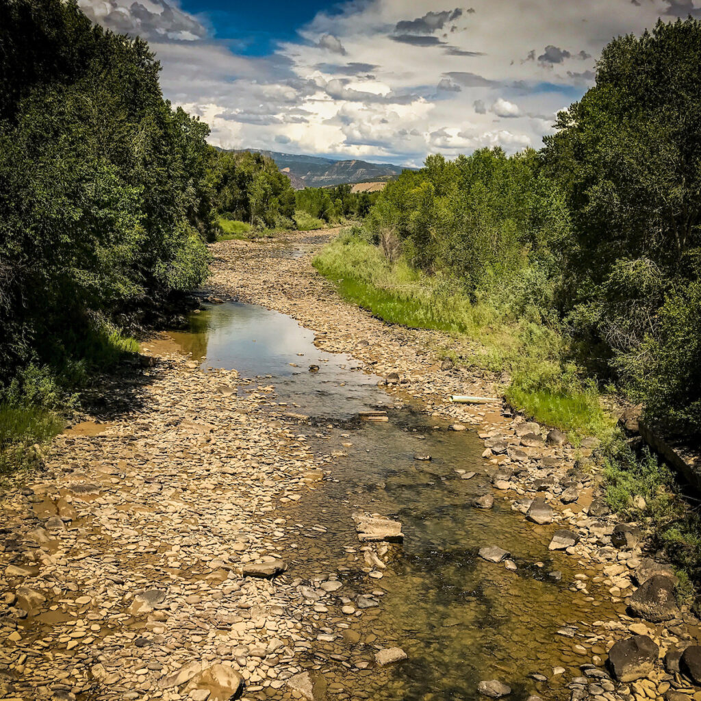
Shot of the North Fork of the Gunnison River, Paonia, Colorado. Photo credit: Sinjin Eberle
Here’s the release from the Center for Biological Diversity (Melissa Hornbein, Taylor McKinnon, Grant Stevens, Brett Henderson, Natasha Léger, Jeremy Nichols):
Conservation groups filed a lawsuit [May 10, 2021] challenging the Bureau of Land Management and U.S. Forest Service’s 2020 approval of a plan that allows fracking across 35,000 acres of Colorado’s Western Slope. The North Fork Mancos Master Development Plan allows 35 new fracking wells in the North Fork Valley and Thompson Divide areas of the Grand Mesa, Uncompahgre and Gunnison national forests.
Today’s lawsuit says federal agencies violated the National Environmental Policy Act and other laws by failing to fully assess the potential for water pollution and harm to the climate, and by refusing to analyze alternatives that would minimize or eliminate harm to the environment. The plan would result in about 52 million tons of greenhouse gas pollution, equivalent to the annual pollution from a dozen coal-fired power plants.
“The Trump administration charted a course to destroy public lands and our shared climate,” said Peter Hart, a staff attorney at Wilderness Workshop. “This master development plan is a 30-year commitment to the disastrous ‘energy dominance’ agenda which ignored significant impacts on the communities and spectacular values of the North Fork. We are determined to hold our federal government accountable to a more sustainable future for Colorado’s public lands, wildlife, people and climate.”
“Fossil fuel development and sustainable public lands don’t mix, especially in the roadless headwaters of the Upper North Fork Valley,” said Brett Henderson, executive director of Gunnison County-based High Country Conservation Advocates. “This project is incompatible with necessary climate change action, healthy wildlife habitat, and watershed health, and is at odds with the future of our communities.”
“We are in a megadrought in the North Fork Valley and the Western Slope. The water used to frack in the watershed risks precious water resources and only exacerbates the climate and the water crisis,” said Natasha Léger, executive director of Citizens for a Healthy Community. “This 35-well project is the beginning of much larger plans to extract a resource which should be left in the ground and for which the market is drying up.”
“This dangerous plan promises more runaway climate pollution in one of the fastest-warming regions in the United States,” said Taylor McKinnon of the Center for Biological Diversity. “We’re suing to force federal agencies to stop ignoring the climate emergency. Like the planet, the Colorado River Basin can’t survive a future of ever-expanding fossil fuel development.”
“It is past time for the federal government to meaningfully consider climate change in its oil and gas permitting decisions,” said Melissa Hornbein, attorney at the Western Environmental Law Center. “Gunnison and Delta Counties have already exceeded 1.5 degrees Celsius of warming; the project failed to meaningfully analyze impacts to climate, roadless areas, and the agriculture and ecotourism centered economies of the North Fork Valley. More drilling is projected to harm Delta County’s tax revenue, not help it. These communities need land management that serves the public interest.”
“This case is about confronting the Trump administration’s complete disregard of law, science and public lands,” said Jeremy Nichols, climate and energy program director for WildEarth Guardians. “We can’t frack our way to a safe climate and we certainly can’t afford to keep letting the oil and gas industry run roughshod over Colorado’s irreplaceable and vital public lands.”
Colorado’s Western Slope is already suffering from severe warming. The Washington Post recently featured the area as the largest “climate hot spot” in the lower 48 states, where temperatures have already risen more than 2 degrees Celsius, reducing snowpack and drying Colorado River flows that support endangered fish, agriculture and 40 million downstream water users.
In January 574 conservation, Native American, religious and business groups sent the then president-elect a proposed executive order to ban new fossil fuel leasing and permitting on federal public lands and waters. In February the Biden administration issued an executive order pausing oil and gas leasing onshore and offshore pending a climate review of federal fossil fuel programs. In June the Interior Department will issue an interim report describing findings from a March online forum and public comments.
Background
Fossil fuel production on public lands causes about a quarter of U.S. greenhouse gas pollution. Peer-reviewed science estimates that a nationwide fossil fuel leasing ban on federal lands and oceans would reduce carbon emissions by 280 million tons per year, ranking it among the most ambitious federal climate-policy proposals.
Oil, gas and coal extraction uses mines, well pads, gas lines, roads and other infrastructure that destroy habitat for wildlife, including threatened and endangered species. Oil spills and other harms from offshore drilling have inflicted immense damage to ocean wildlife and coastal communities. Fracking and mining also pollute watersheds and waterways that provide drinking water to millions of people.
Federal fossil fuels that have not been leased to industry contain up to 450 billion tons of potential climate pollution; those already leased to industry contain up to 43 billion tons. Pollution from the world’s already producing oil and gas fields, if fully developed, would push global warming well past 1.5 degrees Celsius.
The Center for Biological Diversity is a national, nonprofit conservation organization with more than 1.7 million members and online activists dedicated to the protection of endangered species and wild places.
The Western Environmental Law Center uses the power of the law to safeguard the wildlife, wildlands, and communities of the American West in the face of a changing climate. As a public interest law firm, WELC does not charge clients and partners for services, but relies instead on charitable gifts from individuals, families, and foundations to accomplish our mission.
FromThe Grand Junction Daily Sentinel (Dennis Webb):
Conservation groups are suing federal agencies to challenge their approval last year of a proposal by Gunnison Energy to drill 35 oil and gas wells across some 35,000 acres of the upper North Fork Valley.
The groups say the Bureau of Land Management and U.S. Forest Service violated federal laws by failing to properly assess the climate impacts of the project or analyze alternatives that would have minimized environmental impacts.
The suit was brought by the Western Environmental Law Center, on behalf of the Center for Biological Diversity, the Carbondale-based Wilderness Workshop, WildEarth Guardians, Citizens for a Healthy Community in Paonia and High Country Conservation Advocates in Crested Butte.
The project’s location is in Gunnison and Delta counties west of McClure Pass. Some 25,800 acres of the affected acreage is U.S. Forest Service land, 8,648 acres are private and 468 involve BLM land.
The company plans to drill wells down and then out horizontally into the Mancos shale formation from five well pads, three of them new. It has estimated the project could produce up to 700 billion cubic feet of gas over 30 years. That equates to about 2.5% of the gas consumed in the United States last year.
The project also would require about 21 million gallons of water to hydraulically fracture each well, the company has estimated. And conservation groups said in a news release that it would result in about 52 million tons of greenhouse gas pollution, which they said is the same as what a dozen coal-fired power plants emit in a year…
The suit says that in evaluating the project, the BLM and Forest Service failed take a hard look at methane emissions related to the project. Methane is a potent greenhouse gas. The suit also says the agencies failed to use “tools or methods generally accepted in the scientific community to evaluate the impact” of the project’s greenhouse gas emissions, such as the social cost of carbon and global carbon budgeting.
For the first time in a year, the Denver, Boulder and Fort Collins areas are no longer experiencing drought or abnormal dryness.
The return to normal for some of the state’s most populous areas comes after several waves of spring rain and snowstorms.
But the improved conditions come with a big caveat: Much of western Colorado remains in severe and exceptional drought, part of a regional pattern affecting the Southwest.
Conditions have improved in the areas around Colorado Springs and Pueblo as well, receding from severe and extreme drought into only moderate drought…
The precipitation patterns this winter favored the northern areas of the Front Range, she said.
Typical impacts of La Niña on U.S. winter temperature and precipitation. Such impacts have been associated with past episodes, but all impacts aren’t seen with every episode. NOAA Climate.gov drawing by Fiona Martin.
“It’s typical for a La Niña winter,” Bowen said about the winter weather pattern affecting North America this year…
Becky Bolinger, the assistant state climatologist at the Colorado Climate Center, said the drought still affecting the western part of the state fits with a trend over the past two decades…
Forecasts now predict southern Colorado has a higher-than-normal chance for large wildfires through June, [Peter] Goble said, and the same heightened risk of large wildfires for all of western Colorado through July.
Binational Water Conservation Making the Colorado River More Sustainable for People and Birds
**Este artículo se puede encontrar en español**
The Colorado River is flowing again in its delta. This is a big deal for a river that has not flowed through its delta in most years since the 1960s, resulting in an ecosystem that is severely desiccated and devastated.
Thanks to commitments from the United States and Mexico in the Colorado River binational agreement—Minute 323 – 35,000 acre-feet of water (11.4 billion gallons) dedicated to create environmental benefits will be delivered to the river from May 1 to October 11. The expectation is that this will create and support habitat for birds like the Yellow-billed Cuckoo, Yuma Ridgway’s Rail, and Vermilion Flycatcher, and give life to the many plants and animals in this ribbon oasis of green in the midst of the Sonoran Desert.
Cattle Egrets and Snowy Egrets in the Cienega de Santa Clara, the largest remaining wetland in the Colorado River Delta. Photo: Claudio Contreras Koob via Audubon
The last time the two governments cooperated to put water for the environment into the Colorado River was in 2014, when they released a “pulse flow” of water from Morelos Dam (the furthest downstream dam on the Colorado River, located at the U.S. – Mexico border). For eight glorious weeks, the Colorado River was conjured back to life in its final 100 miles. Birds took notice (bird abundance increased 20% from the previous year, and species diversity increased 42%) and local communities celebrated with a spontaneous river fiesta that went on for weeks.
This time, the water will flow for more than five months. Thanks to lessons learned from scientists who studied the 2014 pulse flow, the water will be less likely to infiltrate into the ground, and more likely to fill the river channel providing environmental benefits all the way down to the Gulf of California. System operators are using Mexico’s canal system to bypass Morelos Dam and the driest parts of the channel, delivering the water into the river some 45 river-miles downstream. There it will fill the river where the channel is already wet, maximizing water use efficiency. The scientists’ design optimizes the location and timing of flow to support the hundreds of species of birds that use the delta, and the floodplain habitats they rely on.
Audubon and its partners in Raise the River—the non-governmental organization (NGO) coalition working to restore the Colorado River Delta—are excited to see this sophisticated approach to environmental water delivery. Scientists will study the flow again this year in order to add to our understanding of how to best use the limited supply of water available for the environment.
Roberto Salmon and Edward Drusina at the Minute 323 signing ceremony September 27, 2017. Photo credit .U.S. Bureau of Reclamation.
The agreement that made these flows possible—Minute 323—lasts through 2026. The agreement also commits more than $30 million for water conservation infrastructure in the Mexicali Valley. The water savings will improve local resilience to global warming, increase the water supply stored in Lake Mead, make additional water available to water users in the United States, and create additional water supply for the environment (the coalition of NGOs will also contribute from a local water trust). Minute 323 also ensures that the United States and Mexico conserve Colorado River water and share in shortages when supplies are low. In the context of a drought on the Colorado River that has persisted since 2000, and the expectation of climate change exacerbating drought conditions, these provisions create water supply reliability for both people and nature.
This spring, water for the Colorado River Delta creates a renewed sense of hope. Over the next few months we have the opportunity to see what a small volume of water can do to revive the remnant ecosystem, to nurture its birds, and gift local communities with the return of their river. We can be reassured that, at least in parts of the delta, the Colorado River lives again. In an extraordinarily dry year, deliberate management of water to sustain the environment is the kind of management we will need throughout the Colorado River Basin to ensure that persistent drought and long term impacts of climate change do not lead to the end of river ecosystems in the arid West.
Gila River. Photo credit: Dennis O’Keefe via American Rivers
FromThe High Country News [May 13, 2021] (Sharon Udasin):
Through partnerships and exchanges, the community is ensuring that its members have long-term access to their own resources while helping solve broader water supply problems.
A riverbed that has been parched since the end of the 19th century — a portion of the historic lifeblood of the Gila River Indian Community — is now coursing again with water, luring things like cattails and birds back to its shores.
“You add water and stuff just immediately starts coming back naturally. Birds have returned and it’s just such a different experience,” says Jason Hauter, an attorney and a community member. “It’s amazing how much has returned.”
The revival of this small segment of the 649-mile (1045-kilometer) Gila River, which has served the tribes that make up the Gila River Indian Community — the Akimel O’odham (Pima) and the Pee-Posh (Maricopa) — for roughly 2,000 years, was an added benefit of a grassroots infrastructure overhaul, known as “managed aquifer recharge,” or MAR, which aimed to restore the local groundwater basin. The MAR project has not only secured a water supply for local agriculture, but it has also generated a stable source of income and strengthened the community’s ties to tradition.
“The land started to heal itself, reinvigorate itself,” says Governor Stephen Roe Lewis, who recently began his third term as leader of the Gila River Indian Community.
Hauter credits Lewis and his colleagues for ensuring that community members have long-term access to their own resources while helping solve broader water supply problems in the region through innovative partnerships and exchanges with neighbors.
“They are very thoughtful about future generations, but they also recognize they live in this larger community and that you have to collaborate,” Hauter says. “Encouraging your neighbors to have good water practices, but also helping your neighbors, is good water policy.”
A particularly longstanding claim to water rights
The ins and outs of water management and usage in the West are complex. In a region where every drop is important, questions about water — such as who gets what, how it’s moved from one place to another, and who pays for it — are vital to communities’ capacity to survive and thrive. These decisions are often based on century-plus-old legal doctrines that don’t always fit neatly into a modern, warming world — or address longstanding disregard for Native American tribal nations’ rights.
Western U.S. states adhere to legal doctrines called “prior appropriation” — sometimes referred to as “first in time, first in right” — linked to the mid-19th century Gold Rush and the Homestead Act, through which miners and farmers were able to claim and divert water sources for “beneficial use” — defined by activities such as irrigation, industry, power production and domestic use. A 1908 Supreme Court case ruled that the federal decision to establish Native American reservations inherently meant there would be sufficient water for those reservations. The priority date for water rights on these reservations therefore had to match the date of establishment, meaning that many tribal nations’ water rights took precedence over those of most existing users. During the past few decades, these nations have largely opted for settlements with the relevant federal, state and private bodies, rather than entering extensive and costly litigation to recover their water rights.
These settlements allow tribal nations to take part in the competitive markets that have long ruled water in the West. These markets involve things like selling water rights, getting money for helping mitigate drought and accruing “credit” from the Arizona Water Banking Authority by storing water in underground basins administered by the Arizona Department of Water Resources.
One such pivotal settlement came in 2004: To resolve tribal water rights claims, Congress passed the Arizona Water Settlement Act, which allocates a set amount of water each year to the Gila River Indian Community, drawing that water budget from a variety of sources in Arizona. The community had a particularly longstanding claim to water rights due to its two-millennia history of farming, curtailed when miners and white settlers began diverting water following the Civil War. The governor’s late father, Rodney Lewis, devoted his career as Gila River Tribal Attorney to fighting for a just water settlement.
“It was the theft of our water, so this was a generational historic struggle to regain our water,” Lewis says. “We were and we still are historically agriculturalists, farmers. Our lineage, our ancestors were the Huhugam. And the Huhugam civilization had pretty much cultivated the modern-day Phoenix area in central Arizona.”
Screen shot from episode of “Tom Talks” April 2020.
“They were master builders,” he adds, referring to complex water systems and canals that he says rivaled those of the Nile Valley.
As more and more nations regain control of their water resources, they are securing a critical provision for the long-term financial prosperity of their people and protection of their lands.
Mutually beneficial partnerships
As often occurs in tribal water rights settlements, the 2004 agreement served to restore the Gila River Indian Community’s claims to the river and its tributaries without displacing the descendants “of those who committed the original sin,” says Hauter, a partner at the law firm Akin Gump Strauss Hauer & Feld, which currently serves as outside counsel for the Community.
Toward that end, Hauter says, “really, what’s provided is an alternative supply.”
That alternative supply comes from the Central Arizona Project (CAP), an infrastructural behemoth that conveys about 1.5 million acre-feet (1.85 billion cubic meters; one acre-foot is about 326,000 gallons) of water from the Colorado River to central and southern Arizona each year. Serving as the single largest renewable water supply for the state of Arizona, the 336-mile (540-kilometer) system was authorized by then-President Lyndon B. Johnson in 1968, soon after which construction by the Bureau of Reclamation began. Three years later, the Central Arizona Water Conservation District — a multi-county water district — formed to repay the federal government for the project’s costs and oversee regional water supply.
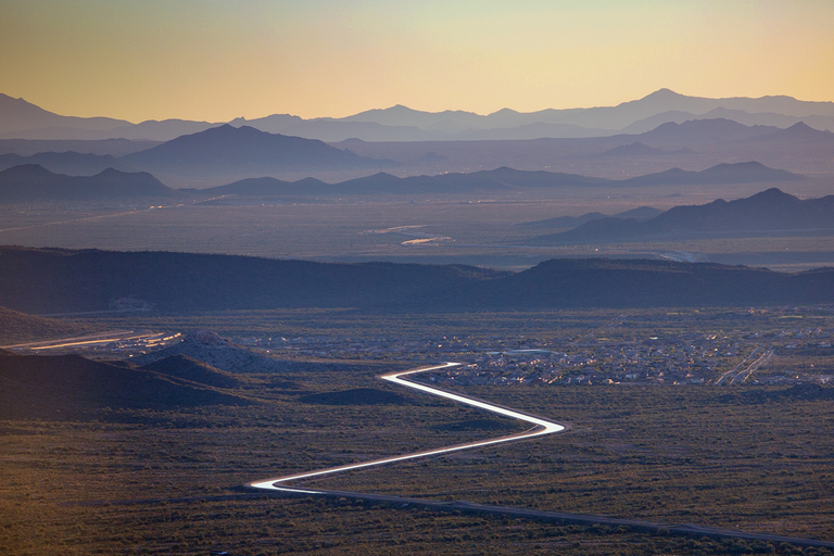
Aerial photo – Central Arizona Project. The Central Arizona Project is a massive infrastructural project that conveys water from the Colorado River to central and southern Arizona, and is central to many of the innovative partnerships and exchanges that the Gila River Indian Community has set up. Public Domain, https://commons.wikimedia.org/w/index.php?curid=326265
Through the 2004 settlement, the Gila River Indian Community has the single largest CAP entitlement — bigger than that of the city of Phoenix — at 311,800 acre-feet (385 million cubic meters), Hauter explains. Finding mutual benefit in helping quench the thirst of the surrounding region, the community entered into various water exchanges and leases that delivered about 60,000 acre-feet (74 million cubic meters) to Phoenix and other municipalities annually and left about 250,000-acre-feet (308 million cubic meters) for its own purposes, according to Hauter.
But this sudden surplus from the CAP actually posed a problem.
Pumping water from the project, community members understood, would eventually become prohibitive due to water transport and associated electricity costs. The Lower Colorado River Basin Development Fund, managed by the U.S. Department of Interior, covers the Fixed OM&R (operation, maintenance and replacement) for certain Arizona tribes with settlements, but funding is only projected to last until 2045, Hauter explains.
The community was using only about 50,000 acre-feet (62 million cubic meters) for irrigation purposes, leaving about 200,000-acre-feet (247 million cubic meters) unused, Hauter says. Because any unused CAP water can be remarketed by the state, Arizonans began counting on the community to not use its full share.
With the legal guidance of Hauter and his team, the community launched a strategic venture to store, share and sell much more of its CAP water in 2010.
This photo shows an outline from 1903 of where Theodore Roosevelt Dam would be built as part of the Salt River Project.
The first such partnership occurred with former water supply rival the Salt River Project, the name of the utilities responsible for providing most of Phoenix’s water and power. Had the community decided to enter litigation to recover its water rights, rather than settling, the Salt River Project could have faced enormous supply losses.
But the former rivals instead became partners, after identifying that the Salt River Project’s underground storage facility (USF), the Granite Reef Underground Storage Project, was an ideal place to store a portion of the CAP allocation the Gila River Indian Community was not currently using. The partnership has enabled the Salt River Project to withdraw water from storage — while maintaining a “safe yield,” or making sure any water that is taken from aquifers is replenished. In return, the community has gained long-term storage credit, Hauter explains. Such storage credit enables the holder to bank CAP water and, when necessary, recover the water for future use.
The community also stores water in groundwater savings facilities (GSF), including one operated by the Salt River Project and another south of the Gila River operated by the Maricopa Stanfield Drainage District. While a USF physically stores water in the aquifer through direct recharge, a GSF is an “indirect” recharge facility that uses CAP water instead of pumping local groundwater.
In what Hauter described as an “in lieu” agreement, the community provides the operators of these GSF facilities with a renewable water supply — another portion of its CAP allocation — and so reduces the Salt River Project and Maricopa District’s need to extract groundwater. In return, the community gets storage credit for the water that can remain in the ground.
“Everything we needed was at the river”
While these external collaborations bolstered the resilience of the community, as well as that of the arid surrounding region, Gila River residents only really saw the revival of their long-lost local waterway when community leaders launched a homegrown storage initiative. Recognizing the value in keeping some unused CAP resources at home, they chose to establish a network of managed aquifer recharge (MAR) sites. This type of underground storage allows for the free flow of water from a naturally permeable area, such as a streambed, into an aquifer, as opposed to “constructed recharge” sites that involve injecting water into percolation basins by means of a constructed device.
Creating a balance of water that’s taken from aquifers and water that replenishes aquifers is an important aspect of making sure water will be available when it’s needed. Image from “Getting down to facts: A Visual Guide to Water in the Pinal Active Management Area,” courtesy of Ashley Hullinger and the University of Arizona Water Resources Research Center
In order to implement these plans, the Gila River Indian Community came to an agreement with Arizona to acquire state regulatory permits for the MAR projects, despite the fact that tribal nations have sovereign control over water management. As a result of this decision, the community has been able to market long-term storage credits in a sort of environmentally friendly banking system that allows more groundwater to stay in the ground.
“They realized they could get multiple benefits from deciding to have their project permitted per the Arizona regulations,” says Sharon Megdal, director of The University of Arizona Water Resources Research Center.
“They voluntarily chose to abide by the regulations for storage and recovery and therefore come under the whole credit accrual and accounting system,” she continues, stressing that not only can credits be used to recover water when needed in the future, but they can also be purchased by outside entities, which creates a revenue stream for the community. “That’s really exciting.”
Three MAR facilities are already operating on the reservation today: MAR-5, the Olberg Dam underground storage facility, permitted in 2018; MAR-1B, the Cholla Mountain underground storage facility, permitted in 2020; and MAR-6B, a western and downstream expansion of MAR-5, which came online a few months ago. Construction of MAR-8, located downstream from MAR-5, will be complete in a few years, according to Hauter.
“You add water and stuff just immediately starts coming back naturally. … It’s amazing how much has returned,” says Jason Hauter. The “managed aquifer recharge,” or MAR, projects have allowed the Gila River Indian Community to achieve river and riparian restoration. Photo credit: Darryl L. Montgomery
Hauter adds that it was only while planning the initial MAR-5 site that community members envisioned the riparian restoration program that served “to recreate the river,” allowing cattails and other plants to blossom and enabling community members to create baskets and traditional medicines. Although the idea of restoring the river was secondary to the storage plans, Hauter says that its flow is intrinsic to the community’s culture.
“The tangible benefit for most members is really having the river back to some degree,” Hauter adds. “It wasn’t something the settlement intended to accomplish, but the settlement gave the community the tools to make it happen.”
Lewis and his father, who had already retired at the time, used those tools to see the first MAR site to fruition. The Lewises and their colleagues understood the benefit in adopting innovative methods for accumulating water at their future storage site.
“He truly saw the MAR-5 as a living testament to our historic tie to the Gila River,” the governor says, adding that his father considered the facility an opportunity to “return the flow of the river.”
With the revived river flow, the riparian habitat quickly began blossoming, including 50 documented species of birds within the first year of MAR-5’s operations, Lewis says. An interpretive trail now weaves through the once arid wetland, providing educational signposts and offering sacred cultural spaces for spiritual practice, Lewis explains. Elders are now taking advantage of the plants and silt available to engage in traditional basket weaving, medicine making and pottery, he adds.
“They still remember the river sometimes flowing and the smell of the water,” Lewis says.
In recent years, before the opening of the MAR-5 site, the channel filled with water only in particularly wet seasons involving floods or heavy snowpack upstream, according to Lewis.
“Everything we needed was at the river,” he adds. “That was our lifeblood.”
Continuing to plan for a drought-ridden future
In conjunction with the opening of the MAR facilities, the community cemented a pivotal agreement in 2019 with the Central Arizona Groundwater Replenishment District (CAGRD), a groundwater replenishment entity operated by the Central Arizona Water Conservation District. Through this agreement, CAGRD leases 18,185 acre-feet (22 million cubic meters) of the community’s CAP water and stores the majority of that water in the MAR sites, while receiving long-term storage credits in return from the Arizona Water Banking Authority. Only if the MAR facilities are full is CAGRD allowed to store the leased water elsewhere, Hauter explains.
Alongside the MAR projects, the community has also been rehabilitating existing wells and building new ones in order to create a backup supply for agricultural use when Gila River flow is minimal. Well water is less expensive than CAP water, since wells can recharge naturally during storms — so much so that such events collectively add at least 100,000 acre-feet (123 million cubic meters) to the community’s annual water supply, according to Hauter.
The community took additional steps to reroute its CAP supplies after the federal government and the seven Colorado River Basin States implemented their drought contingency plans, meant to elevate water levels in Lake Mead, in 2020. As part of that regional effort, Hauter explains, the Community is providing a total of at least 200,000 acre-feet (247 million cubic meters) of water to be stored in Lake Mead from 2020 to 2026, when the drought contingency plans expire. For its contribution, the Community gets money through the Arizona Water Bank and the Bureau of Reclamation.
Only through the community’s creative collaborations and homegrown projects has so much of its CAP entitlement been able to help replenish Lake Mead, Hauter says. Today, the community has reduced its CAP water usage for irrigation to 15,000 acre-feet (19 million cubic meters) per year, while its CAP water storage capacity in the MAR projects is up to about 40,000 acre-feet (49 million cubic meters) per year. After construction of MAR-8 is complete, total CAP water use for storage and irrigation will reach about 75,000 acre-feet (93 million cubic meters), Hauter says.
As the community’s leaders continue to plan for a drought-ridden future, they are evaluating whether it will be necessary to use more of its CAP allocation for their own needs. At the moment, much of the reservation’s agriculture involves water-intensive crops like alfalfa, feed corn and cotton. An overhaul of the farming infrastructure, according to Hauter, would require “changing attitudes about how food is grown” and incorporating more efficient technologies, as well as encouraging farming among younger people.
Overall, Hauter says, “it’s an exciting future for the community, and it will be interesting to see what happens in the next 20 or so years.”
Lewis is confident that the community’s agricultural tradition will remain strong, particularly due to the younger generation’s concerns for social justice, equity and environmental issues.
“We want to provide opportunities for our community members to re-engage in any way in our agricultural heritage,” he says. “We’ve always been innovators, going back to the Huhugam with their amazing engineering.”
In addition to the commercial company Gila River Farms, which is owned by the tribe and employs community members, Lewis says that local family farms continue to thrive. Lewis also says that “there’s a big push” for young people to obtain degrees in agro-business, hydrology, water engineering and other relevant fields that will provide them with a livelihood while working for their community — a place that has become even more special to them during the pandemic year.
“It’s a public health emergency that we’ve been going through,” Lewis adds. “But at the same time, I think this is an opportunity where you see a lot [of] our younger generation that are wanting to learn who it is to be from the Gila River Indian Community.”
“A total win-win”
While the MAR projects and the larger water exchange deals serve to safeguard the community’s water supplies, Hauter says he’s uncertain as to whether neighboring tribal nations could replicate this model. Other tribes, he explains, might have different agricultural interests or economic concerns, as well as varying geological and hydrological conditions.
In Megdal’s opinion, at least one aspect of the community’s strategy could be replicable regardless of geography: the strategic accrual and marketing of long-term storage credits in permitted recharge facilities. The Gila River Indian Community has diversified its portfolio of storage credit and sales through “multiple vehicles,” she explains, including its MAR projects, the Salt River Project partnership, and its transfer of credits to CAGRD.
“They are able to meet their objectives including having riparian benefits and river benefits and sell the credits — because the credits are then recovered elsewhere … For them, it’s like a total win-win,” Megdal says, adding that she considers the community’s achievements to be “a bellwether project.”
Already, she says, the Tucson-region Tohono O’odham Nation has begun selling some credits to CAGRD. Acknowledging that the two cases involve varying geological and legislative circumstances, Megdal stresses that the Gila River Indian Community has demonstrated the benefits of the storage and credit accrual system.
“These long-term storage credits are the most marketable part of the water system,” Megdal says. “It’s an emerging market, and the Gila River Indian Community has emerged as a key leader in that market.”
“I see this example of a tribal nation entering voluntarily into an intergovernmental agreement with the state so that all the parties can develop these mutually beneficial exchanges or marketing transactions in a voluntary way,” she adds. “It’s really a notable innovation.”
Sharon Udasin is a Boulder-based journalist, with specialties in environment, water and energy.
This article, produced jointly by California Health Report and High Country News, is part of a collaboration that also includes the Institute for Nonprofit News, Center for Collaborative Investigative Journalism, Circle of Blue, Columbia Insight, Ensia, New Mexico In Depth and SJV Water. It was made possible by a grant from The Water Desk, with support from Ensia and INN’s Amplify News Project.
This story was supported by a grant from The Water Desk, with support from Ensia and the Institute for Nonprofit News’s Amplify News Project.