Click on a thumbnail graphic to view a gallery of drought data from the US Drought Monitor.
US Drought Monitor map May 18, 2021.
West Drought Monitor map May 18, 2021.
High Plains Drought Monitor map May 18, 2021.
Colorado Drought Monitor map May 18, 2021.
Click here to go to the US Drought Monitor website. Here’s an excerpt:
This Week’s Drought Summary
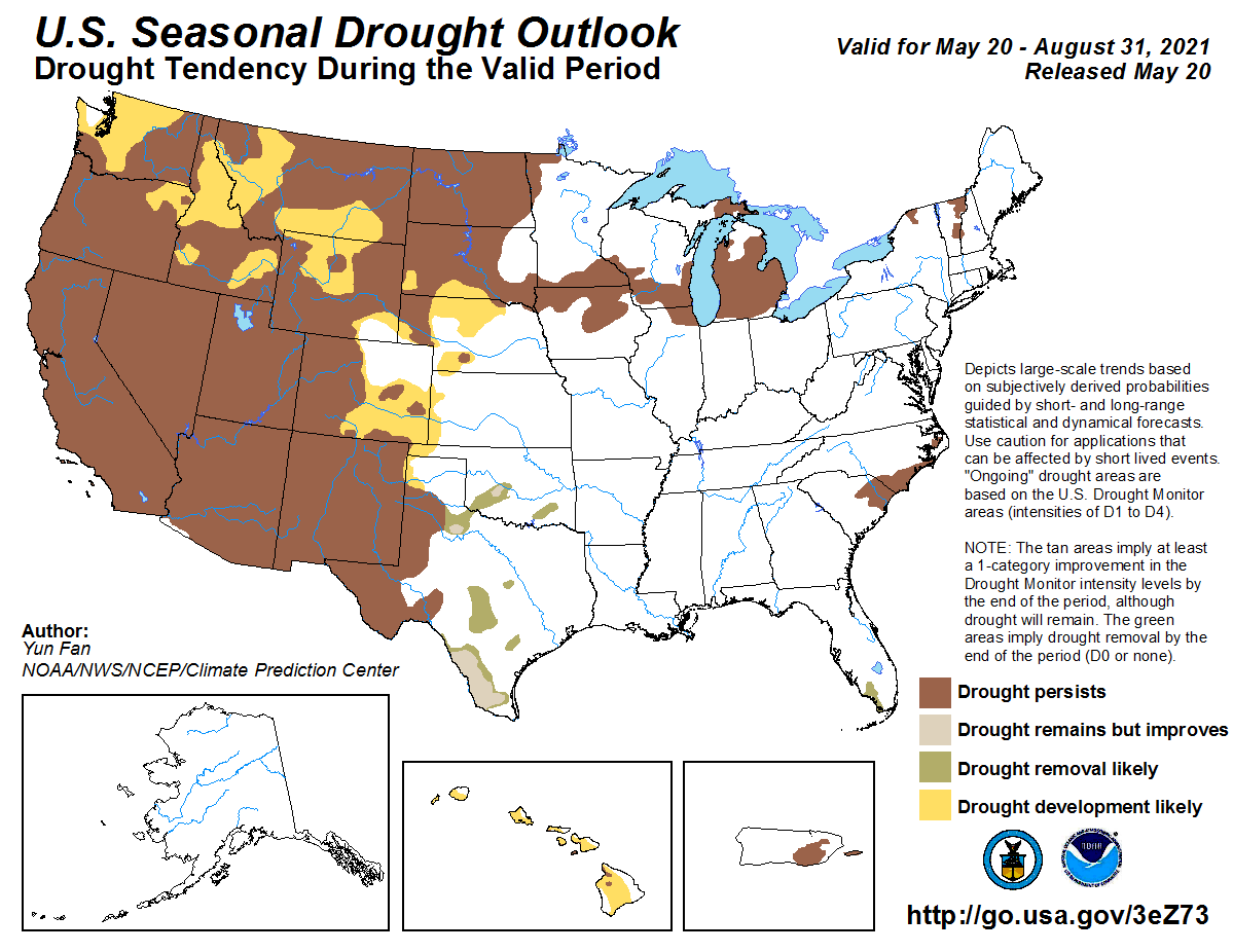
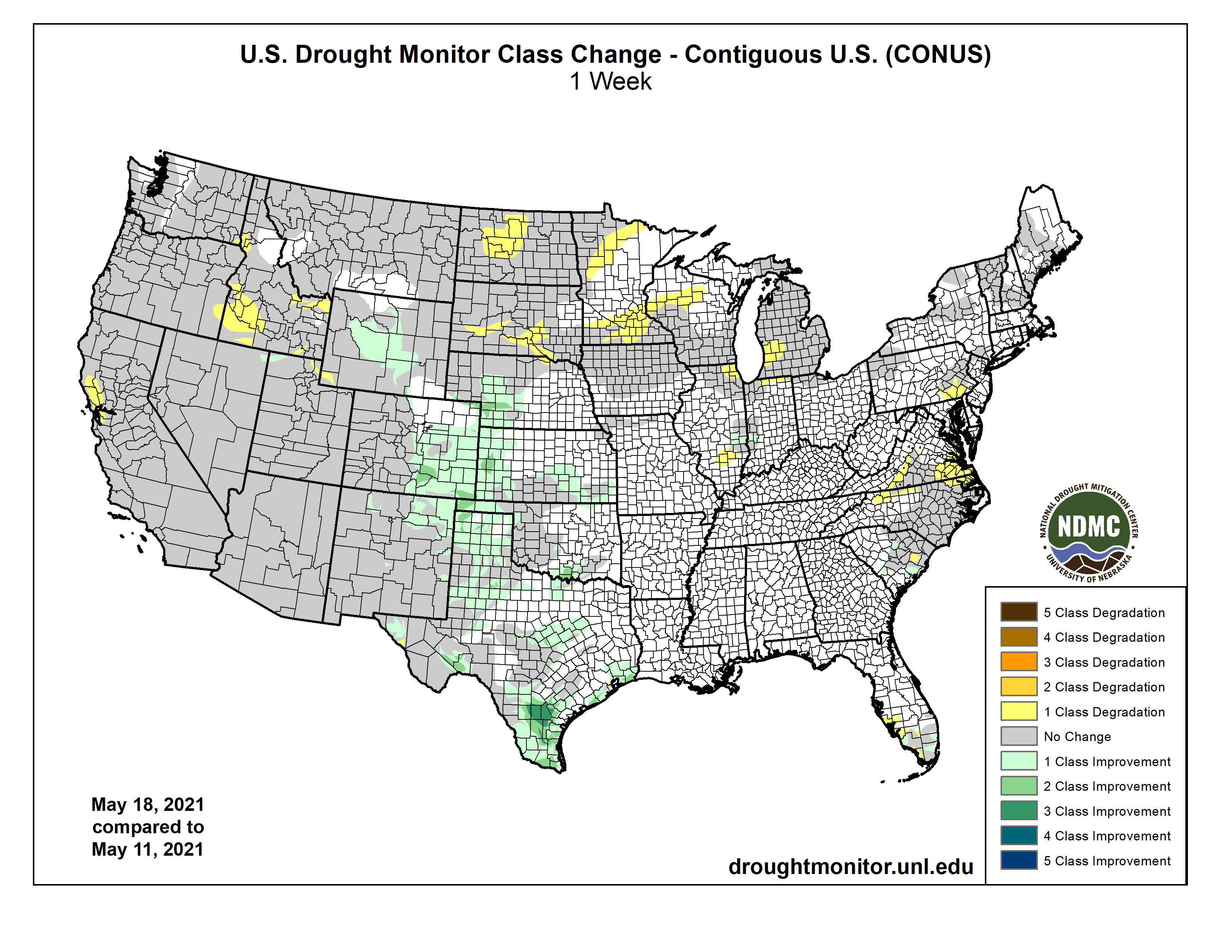
Troughing over the western CONUS and ridging over the East resulted in strong southerly flow over the Southern and Central Plains, leading to widespread heavy rainfall (0.5 to 3 inches, and more) over portions of the Great Plains, Lower Mississippi Valley, and into western areas of the Corn Belt this week. The heaviest precipitation fell over southeastern Texas and southern Louisiana, where some locations received over 10 inches of rainfall. The heavy rainfall resulted in widespread removal and improvement in drought conditions from the Front Range eastward to Nebraska and Kansas, and southward to the Mexico border. Unfortunately, the moisture was unable to make it farther north than Nebraska, resulting in continued degradations across the Northern Plains, Upper Midwest, and Great Lakes. The Northeast experienced below normal precipitation, but due to below normal temperatures and near-normal precipitation over the past 30-60 days across much of the region, only minor changes to abnormally dry (D0) areas were warranted in southeastern Pennsylvania. In the Southeast, portions of Virginia and North Carolina have continued to dry out over the past 90 days, warranting D0 expansion. Locally heavy rainfall (2 inches) also fell over areas experiencing abnormally dry and moderate drought (D1) in South Carolina and Florida, leading to some modifications in those locations based on rainfall 7-day rainfall totals. The La Nina signal in the West was evident in the precipitation totals at the end of the climatological wet season in March. The presence of this antecedent dryness has resulted in much below-normal snowpack throughout much of the West, leading to continued drought deterioration since the region began its transition into a climatologically drier time of year during April…
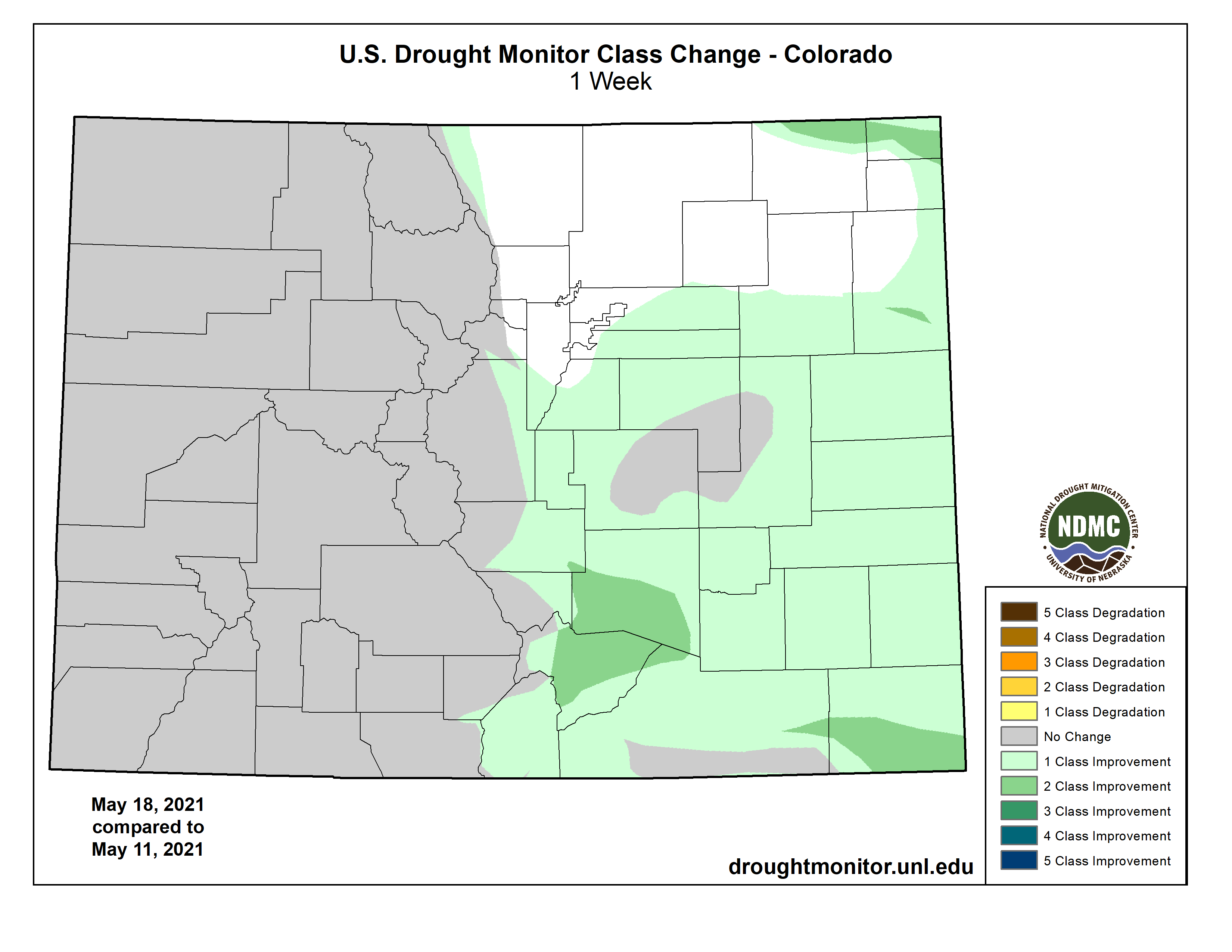
Colorado Drought Monitor one week change map ending May 18, 2021.
The High Plains Region was a tail of two extremes. From Nebraska southward, and westward to the Front Range saw widespread heavy precipitation (0.5 to 3 inches, with locally higher amounts of greater than 5 inches stretching from west to east across Kansas), leading to large reductions in D0 (abnormally dry) to D2 (severe drought) coverage in Colorado, Nebraska, and Kansas, with some D3 (extreme) reduction in southeastern Colorado. Some moderate precipitation also fell across portions of the Front Range of Wyoming also, further improving SWE across the Big Horn Basin. This warranted some improvements from D2 (severe drought) to D1 (moderate drought) along the east-facing slopes of the Absaroka and Wind River Ranges, and D1 was also improved to D0 for interior parts of the basin. In addition, AHPS percent of normal precipitation exceeds 150% for all periods going back at least 90 days, SPIs indicate near to abnormally dry conditions going back 180 days, and USGS 7-day and 28-day average stream flows are near normal. NASA SPoRT and NASA GRACE also show improvements in soil moisture and groundwater, respectively. Across the Dakotas, near to above normal temperatures and below normal precipitation this week warranted some further degradations. Targeted expansions of D1 and D2 drought occurred in South Dakota, as the state continues to fall behind during a climatologically wetter time of year, which are depicted in the 30-90 day SPIs. There are also continued reports of poor water quality in livestock water sources in northwestern parts of the state. In North Dakota, warm (2°F to 4°F positive average temperature anomalies), dry, and windy conditions continued. CPC soil moisture ranks in the bottom 1% across much of the state, USGS 7-day average stream flows are much below normal, and VegDRI and VHI indicate extreme stress on vegetation. As such, D4 (exceptional drought) was introduced for parts of north-central North Dakota. Furthermore, many farmers have been forced to plant in dry soils this year, but erosion and lack of rainfall have resulted in poor and/or a lack of germination. Fire also continues to remain a high risk across the state and most counties have imposed burn restrictions. Since the beginning of the year, there have been more than 1,000 fires reported across North Dakota, with over 100,000 acres burned…
Most basin snow water equivalent (SWE) percentiles across the Western Region are well below normal for the period of record (near and below the 65th percentile), especially in the Four Corners region (below the 5th percentile in Arizona and New Mexico). Only parts of the Pacific Northwest and areas of central Montana experienced near and above-normal seasonal snowfall. However, above-normal temperatures over much of the West over the past 60 days has resulted in rapid snowmelt and, due to dry topsoil, much of the melt water has not made it into the rivers, lakes, and reservoirs. In California, the water level in Lake Tahoe is 2.5 feet lower than this time last year. USGS 7-day average stream flows across the coastal ranges near the Bay Area have dropped below the 2nd percentile. In addition, CPC soil moisture ranks below the 1st percentile, NASA GRACE indicates severely depleted groundwater, and vegetation indices (VegDRI and VHI) indicate severe vegetation stress. There are increasing reports of reduced pasture forage, livestock requiring supplemental feed and/or being sold off, and some reports of livestock mortality. Additionally, stock ponds are running dry and farmers have been forced to haul water in some locations. Given the worsening conditions, drought was deteriorated from D3 (extreme) to D4 (exceptional) in areas along the coastal ranges near the Bay Area. Targeted degradations were also made in portions of Idaho as a result of deteriorating soil moisture conditions (NASA SPoRT 0-10 cm and 0-40 cm depths and CPC soil moisture below the 5th percentile state-wide), supported by widespread D1-D3 30-90 day SPIs. New Mexico was the only state in the Western Region where improvements were warranted, as severe weather along the Front Range of the Rockies resulted in some small improvements in areas experiencing D3 and D4 drought conditions in northern and eastern parts of the state…
Heavy rainfall and flooding was the main concern in many areas of the Southern Region. Across eastern Texas, the Ark-La-Tex, and southern Louisiana, many areas received in excess of 3 inches of rainfall. Southeastern Texas and southern Louisiana were the hardest hit areas, with several locations receiving up to, and exceeding, 10 inches of rainfall. On Monday, the National Weather Service issued flood warnings in the Lake Charles, Louisiana area, where 11 inches of rain fell in a 6-hour period. Near Baton Rouge, Louisiana, locations east, southeast, and south of the city picked up nearly 12 inches of rainfall Monday night into Tuesday. Farther west in Texas, large reduction in drought coverage was warranted in areas receiving over 2 inches of rainfall. Some locations in southern Texas picked up 5 to 10 inches of rain, warranting 2 to 3-category improvements and removal in the drought depiction. From northern Mississippi to central Tennessee, 30-day rainfall deficits are beginning to increase. This area remains drought free this week, but bears watching if deficits continue to increase…
Looking Ahead
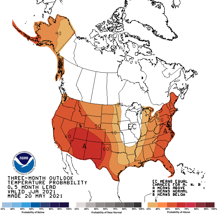
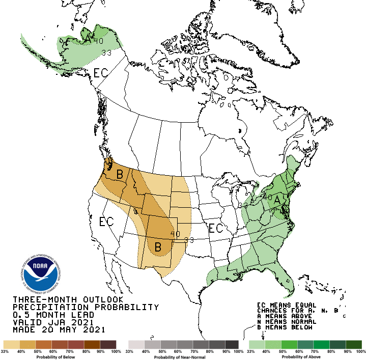
During the next 5 days (May 20 to 24), the Southern and Central Plains, much of the Corn Belt, and Northern Tier states are favored to remain wet. Temperatures are also forecast to remain below-normal for much of the period across the Northern Tier. High pressure is expected to dominate over the eastern U.S., coinciding with little to no rainfall and above-normal temperatures. The Southwest and Coastal California will likely remain dry also. However, temperatures are favored to remain below-normal, moderating to near-normal as the week progresses toward Tuesday.
The CPC 6-10 day extended range outlook (valid from May 25 to 29) favors above normal temperatures across the eastern U.S. and Central and Southern Plains, with enhanced probabilities in the Southeast. Above normal temperatures are also favored over northern and western Mainland Alaska, with above-normal probabilities extending to the eastern Aleutians. Below-normal temperatures are favored from the Pacific Northwest eastward to the Dakotas. Above-normal precipitation is predicted across the Southern and Central Plains, Corn Belt, and Lower Great Lakes. In Alaska, odds tilt toward above-normal precipitation for the Southwest Mainland, Eastern Aleutians, and along the South Coast to the Northwest Panhandle. Below-normal precipitation is favored in the Southeast U.S. and along the East Coast, with enhanced probabilities in the Deep South and Florida. Below-normal precipitation is also favored for the Central Pacific Coast, Great Basin, and Eastern Rockies to the High Plains.
US Drought Monitor one week change map ending May 18, 2021.
A new study conducted by researchers from The University of New Mexico has found that wildfires — which have been increasing in frequency, severity and extent around the globe — are one of the largest drivers of aquatic impairment in the western United States, threatening our water supply.
The research, “Wildfires increasingly impact western U.S. fluvial networks,” was published recently in Nature Communications. Authors include former UNM graduate students Grady Ball (now at the U.S. Geological Service) and Justin Reale (now at U.S. Army Corps of Engineers); former postdoctoral researcher Peter Regier (now at Pacific Northwest National Laboratory); associate professor Ricardo González-Pinzón (Department of Civil, Construction and Environmental Engineering) and research assistant professor David Van Horn (Department of Biology).
The study found that about 6 percent of the length of all the streams and rivers in the western U.S. were directly affected by wildfire disturbances (defined by being located in burned areas) between 1984 and 2014, and that every year there are about 342 new kilometers of them directly affected. When the researchers accounted for the longitudinal propagation of water quality disturbances within and across watersheds, it was estimated that wildfires affect about 11 percent of the total stream and river length.
“More than 10 percent of the rivers in the western U.S. have been impacted by wildfires,” González-Pinzón said. “That’s a lot and puts wildfires as one of the top causes of water impairment in the country. It’s a big deal.”
The authors said that there have been few studies on the impact of wildfires on fluvial (river) networks, so this study is significant because it was the first large-scale analysis to utilize remote sensing of burn perimeter and severity, in-situ water quality monitoring, and longitudinal modeling to determine estimates of stream and river length impacted by wildfires at a continental scale.
“It is distressing to realize how little we know about the impacts of wildfires to rivers,” González-Pinzón said. “Especially because this is relevant to the daily life of those living in the western part of the country and particularly in New Mexico, a state that is currently and commonly experiencing up to 100 percent severe droughts.”
Although the direct impact of wildfires in places such as California has been widely reported, particularly in terms of lives and structures lost (the 2018 California wildfire season claimed 100 lives, damaged 24,000 structures and resulted in $2 billion in insurance claims, the study reports), the direct and extended impacts of wildfires have not been thoroughly quantified.
The study alerts that there is growing evidence that wildfires trigger cascading impacts in river networks. Although wildfires are not specifically mentioned on the U.S. Environmental Protection Agency’s Clean Water Assessment, wildfire disturbances contribute to at least 10 of the top 20 most critical disturbances listed in the assessment, such as elevated sediments, nutrient enrichment, organic enrichment and oxygen depletion, elevated temperature, elevated metal concentrations, habitat alterations, elevated turbidity, flow alterations, elevated salinity and/or total dissolved solids, and changes to pH and conductivity. Since forested watersheds supply drinking water for around two-thirds of those living in the western U.S., the impact is massive, in terms of both economics and water security.
Credit: The University of New Mexico
The authors point out that wildfires impact water flow and quality since they originate on hillslopes and cause decreased infiltration capacity and groundwater recharge, a severely reduced capacity for vegetation to grow on impacted land, and a higher frequency of landslides and avalanches. Also, dangerous substances including metals in levels that exceed the World Health Organization’s safe drinking water standards are found in surface water long after wildfires are extinguished.
Van Horn said one of the motivations for this study was witnessing the impacts of the 2011 Las Conchas wildfire, the second-largest wildfire in New Mexico’s history, resulting in rapid and massive flooding in the burned area and a measurable decrease in the water quality of the Rio Grande near the burned site of hundreds of kilometers downstream.
“We were fortunate in a sense to have the fire in our highly instrumented back yard, where we could study its impacts as it was happening,” he said.
There was a dramatic decrease in oxygen in the water, as well as the transportation of large quantities of ash and sediment that forced a two-month shutdown of the City of Albuquerque’s only surface water intake, which provides about 70 percent of the drinking water to the area.
“Wildfires are impacting fluvial networks in time and spatial scales that we don’t fully understand,” Van Horn said. “Thus, we need to investigate how long and how far they remain an issue in watersheds.”
“What we found was concerning, and there is a huge need for more research to be done,” González-Pinzón said.
In the near future, their team will focus on creating rapid response teams that can conduct research safely, on-demand, soon after wildfires are contained. That research will focus on answering how far downstream can wildfire disturbances propagate in fluvial networks and what are the main controlling factors. Due to climate change and current forest management practices that have allowed fuels to build up instead of naturally burning in smaller fires, wildfires are only predicted to become worse in the future.
“We can’t really engineer an easy solution to this because it occurs at the scale of continents, but we definitely need to improve how we can increase the resilience of aquatic ecosystems and alert people about the impacts of water quality degradation driven by wildfires to their day-to-day lives; that means that we need to acknowledge that wildfires will continue to happen and that we need to learn how to deal with them,” González-Pinzón said.
Funding for this study was provided by the National Science Foundation and the U.S. Army Corps of Engineers’ Upper Rio Grande Water Operations Model.
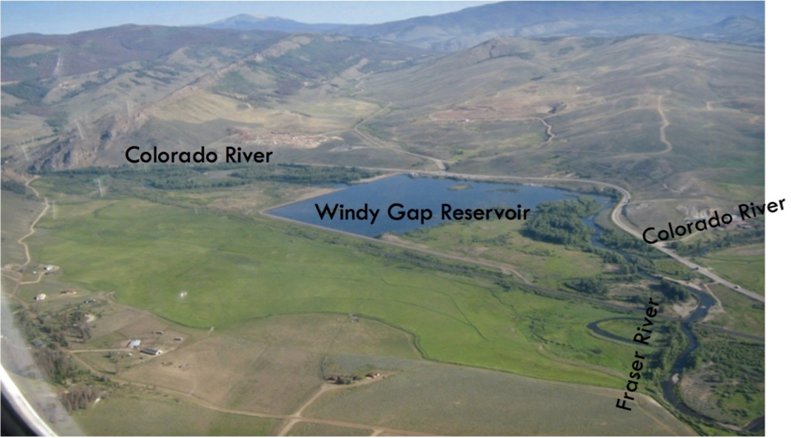
An aerial view of Windy Gap Reservoir, near Granby. The reservoir is on the main stem of the Colorado River, below where the Fraser River flows into the Colorado. Water from Windy Gap is pumped up to Lake Granby and Grand Lake, and then sent to the northern Front Range through the Adams Tunnel. Photo credit: Aspen Journalism
Here’s a guest column from Merrit S. Linke, Jack Buchheister, Kathy Chandler-Henry, and Marti Whitmore that’s running in The Colorado Sun:
As Western Colorado leaders, we congratulate the parties involved in continuing a history of cooperative solutions to benefit water users and choosing collaboration over litigation.
The history of Western Colorado’s water is told in stories of hard-fought wins and losses, of lawsuits and government petitions, of tough negotiations and collaboration.
In Grand County, the history of West Slope water — and Front Range demand for that water — is more visible than in other areas west of the Continental Divide. It is visible at the base of a concrete spillway below Windy Gap Reservoir that disconnects our state’s namesake river; and at the Fraser River’s edge, where visitors see only a fraction of the river that once carved its way downstream.
Top row: Merrit S. Linke, Jack Buchheister. Bottom row: Kathy Chandler-Henry, Marti Whitmore. Credit: The Colorado Sun
But Grand County has also been the backdrop for stories that center on the importance of collaboration and negotiation. Stories of water users coming together to protect and preserve Western Colorado’s water security, communities and local economies.
A recently-announced $15 million settlement between environmental groups and Northern Water’s Municipal Subdistrict is a win for the Western Slope, adding to the nearly $100 million in benefits already secured for water users in Grand County and further downstream.
We commend the parties for reaching this settlement and look forward to partnering with them on projects to further restore and enhance the aquatic environment in Grand County.
The settlement allows the Windy Gap Firming Project to move forward with construction of Chimney Hollow Reservoir near Loveland. It also unlocks the benefits of water, reservoir storage and funding outlined in a nearly 10-year-old agreement and clears the way for the long-promised Colorado River Connectivity Channel to break ground in Grand County.
The enhancements secured by the prior agreement will create a healthier river system and benefit irrigators, communities and people who recreate on Grand County’s rivers.
In 2012, after years of negotiation, the Colorado River District, Grand County, Middle Park Water Conservancy District and the Northwest Colorado Council of Governments signed an intergovernmental agreement with Northern Water that secured hard-fought yet collaborative resolutions to restore and protect the health of our rivers and communities in Grand County.
This agreement provides a secure water supply for Middle Park water users in Grand and Summit counties. It also secures perpetual reservoir releases for the environment, which will improve aquatic habitat and water quality and boost flows for recreation and endangered fish downstream in the Colorado River.
These releases will provide more cool water in the river when it is most needed, alleviating low flow in the hottest, driest portion of summer and early fall. In addition, Grand County residents and visitors will enjoy preserved open space and public access to Willow Creek.
Finally, the agreement supports the Colorado River Connectivity Channel, which will boost river health by reconnecting the Upper Colorado River to its channel around Windy Gap Reservoir. The Connectivity Channel demonstrates how diverse interests can collaborate on solutions that benefit both water supply and watershed health.
Security of our West Slope resources remains at the forefront for Grand County leaders, and the agreement includes important protections barring Northern Water from future water development or water rights acquisitions in Grand County without prior approval from Grand County and the Colorado River District.
Each of these enhancements contribute to better water quality and a healthier river, and they will increase the resilience of our water supply in drought years. This is an achievement for everybody who uses the river.
When the Chimney Hollow Reservoir was first proposed more than a decade ago, West Slope leaders had the foresight to secure these protections for water users.
We congratulate the parties involved in the recent settlement in continuing a history of cooperative solutions to benefit West Slope water users and choosing collaboration over litigation.
Merrit S. Linke is the chair of the Grand County Board of County Commissioners. Jack Buchheister is the president of the Middle Park Water Conservancy District. Kathy Chandler-Henry is the chair of the Northwest Colorado Council of Governments’ Water Quality and Quantity Committee. Marti Whitmore is the president of the Colorado River District Board of Directors.
Northern Colorado is getting its biggest new reservoir in about 70 years, at the cost of diminished Colorado River flows.
Construction of Chimney Hollow Reservoir will begin in August southwest of Loveland, just west of Carter Lake. An April legal settlement between project proponent Northern Water and environmental advocacy groups cleared the way for the project, which began the permitting process in 2003.
The 90,000-acre-foot reservoir is the main component of the Windy Gap Firming Project, a plan to increase the reliability of Colorado River water rights in the Windy Gap Project. The project’s 12 participants include Platte River Power Authority, Loveland, Broomfield, Longmont and Greeley. Construction is expected to take until August 2025, after which it will take about three years to fill the reservoir.
The reservoir’s water will come from the Colorado River, decreasing flows below Lake Granby by an annual average of 15%. Most diversions will take place in May and June.
The 18-year journey toward construction demonstrates the extensive maneuvering required to build new reservoirs in Colorado as rivers become increasingly stressed from climate change and heavy diversions as growing Front Range communities seek to shore up their water supplies. Northern Water won approval from key government agencies and some advocacy groups with a suite of mitigation measures and spending commitments for areas impacted by the project.
Map from Northern Water via the Fort Collins Coloradan.
Northern Water spokesman Jeff Stahla described Chimney Hollow as “in the right place at the right time.” The reservoir site has a few qualities that have helped Northern Water avoid some common setbacks for new water project construction: It’s near existing Colorado Big Thompson Project infrastructure, so Northern Water won’t have to build much new infrastructure for water deliveries, and there are no homes or businesses at the site, which Northern has owned since the 1990s.
“The one assumption you have to make is that water storage is part of the future way that we’re going to provide water,” Stahla said, and he thinks it is. “If you get past the ‘Do we need storage’ question, this ends up being an incredible site that will meet lots of needs, including the ancillary needs of recreation, into the future.”
[…]
Northern Water Engineering Director Jeff Drager acknowledged the new reservoir’s impact on Colorado River flows, but he said the project’s targeted mitigation efforts still offer a major value and are a key reason why it crossed the regulatory finish line.
Restoring a river channel in the Upper Colorado Basin
One of the most significant mitigation measures, known as the Colorado River connectivity channel, will involve shrinking the existing Windy Gap Reservoir in Grand County to about half its current size and building a new channel around it. The Windy Gap dam currently blocks the Colorado River, preventing movement of fish, silt and sediment.
The connectivity channel will allow the river below the reservoir to act more like “a stream without a reservoir on it” when Northern Water’s water rights aren’t in priority, Drager said. The mitigation measures will also open up a mile of stream to public fishing in an area where private landowners possess most of the land adjacent to riverbanks…
During wetter years, Lake Granby can overflow and the water that would’ve been delivered to Windy Gap users flows downstream. During drier years, Northern Water is often unable to divert the full extent of its water right because it is a junior right, meaning more senior water users get access to water first. During the 23-year period between 1985 and 2008, for example, no Windy Gap water was delivered for seven of those years.
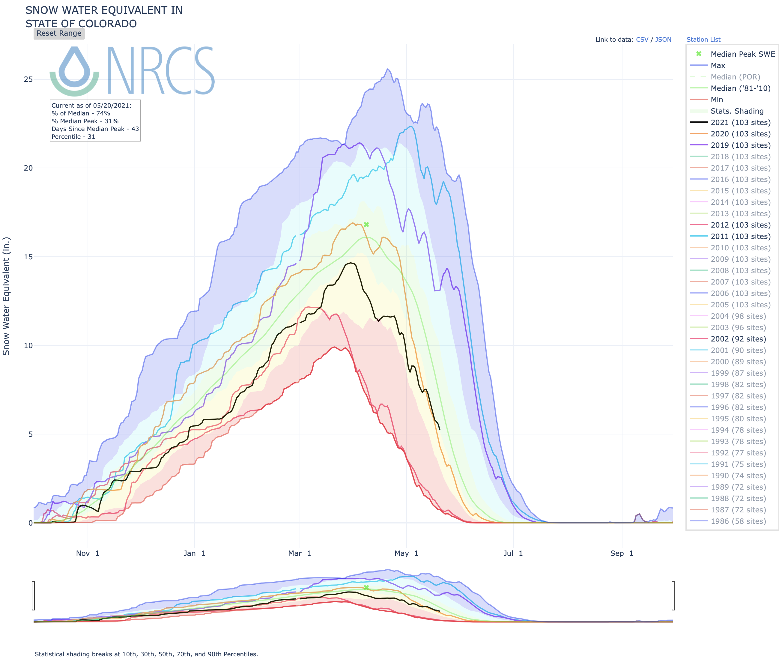
Despite quite a bit of snow that has landed in the state of Colorado throughout May, SNOTEL data shows that the snow water equivalent is well below the to-date median.
Statewide snowpack graph May 20, 2021 via the NRCS.
Statewide, snowpack is at 67 percent of the to-date median, though this number is greatly boosted by lingering snow in the South Platte basin, which includes the area around Estes Park, Boulder, and Denver. The South Platte Basin is at 113 percent of the to-date median.
Elsewhere in the state, snowpack is dwindling fast.
In the southwest corner, the San Miguel, Dolores, Animas, and San Juan River basin is at a very low 27 percent of the to-date median. The nearby Upper Rio Grande basin is at 32 percent.
Despite being adjacent to the above-median South Platte basin, the North Platte basin is at 74 percent of the to-date median and the Colorado basin is at 80 percent of the to-date median. Basins in the northwest corner of the state and the southeast corner of the state are also short on snowpack with the Yampa and White basin in the northwest at 62 percent of the to-date median and the Arkansas basin in the southeast at 58 percent.
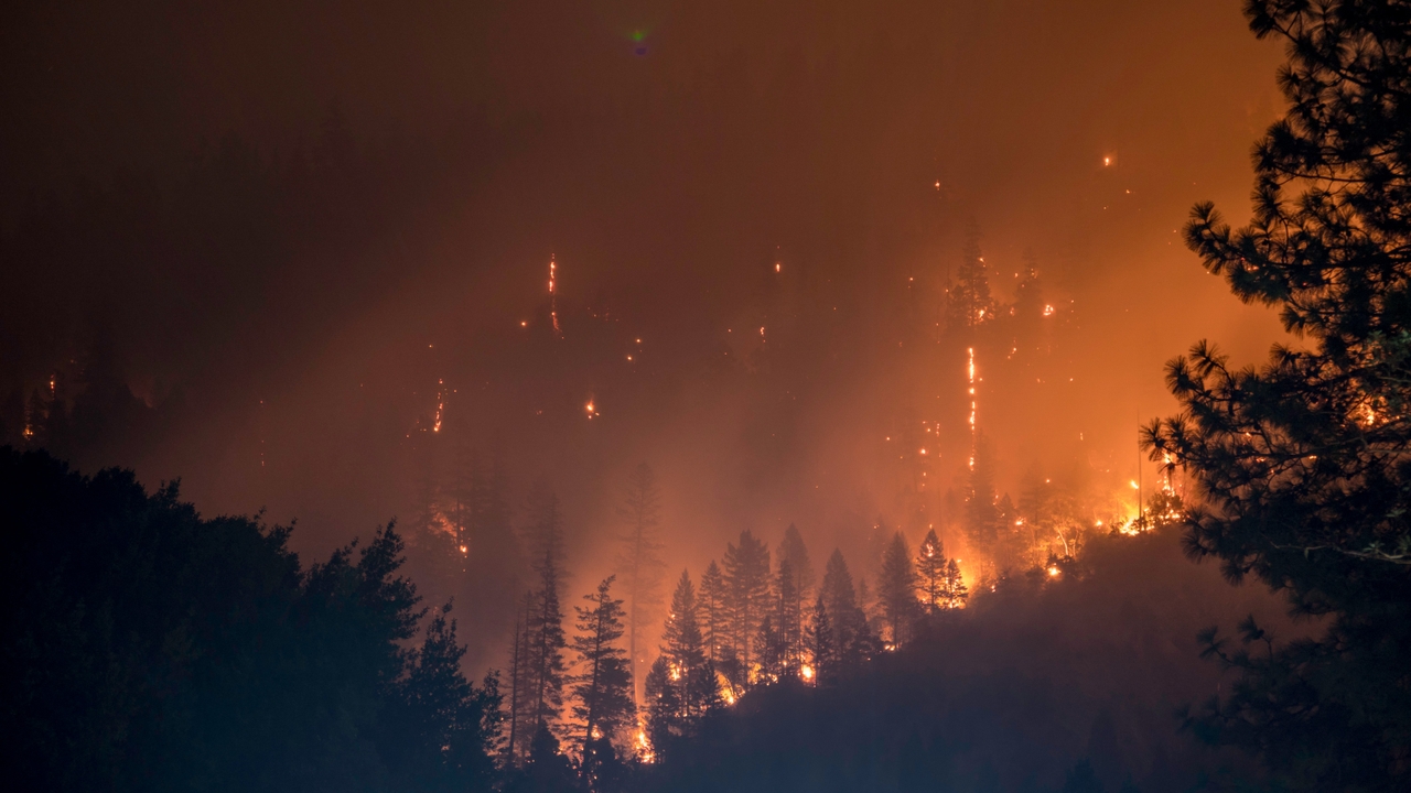
Colorado’s most populated area has been getting quite a bit of snow and rain in recent days and weeks, but this hasn’t been the case elsewhere in the state. As dry conditions continue and snowpack starts to dwindle, Coloradans can expect big fire concerns come summer.
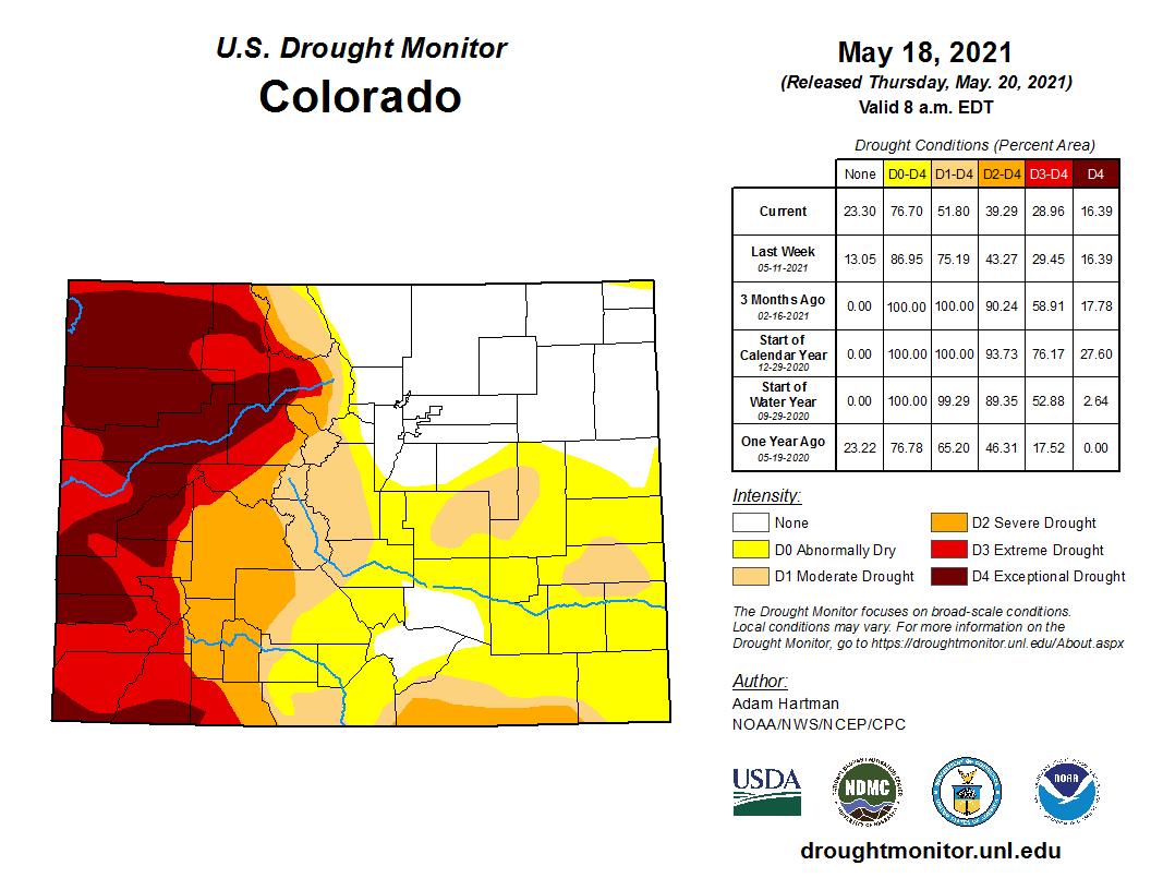
Colorado Drought Monitor map May 18, 2021.
Recent data from the US Drought Monitor shows that around 16 percent of Colorado remains under the most severe level of drought conditions monitored, compared to none of the state on the same date last year.
Colorado has some of the United States’ most ambitious climate goals, targeting 50% remissions reductions in 2030 and 90% emissions reductions by 2050. These goals are bolstered by sector-specific policies enacted in 2019 including legislation requiring the state’s dominant utility Xcel to cut emissions 80% by 2030, along with tax credits and partnerships to build charging stations and accelerate the zero-emission vehicle transition.
But new research shows the state’s existing policies, excluding those that are planned but not enacted as part of the state’s Greenhouse Gas Reduction Roadmap, will only reduce emissions 18% by 2050 – falling far short of Colorado’s climate ambition.
Colorado straddles one of the fastest-warming regions in the U.S. and climate impacts like record wildfires, dwindling snowpack, and severe drought are already harming its economy and communities. With less than a decade left to avoid locking in the worst climate damages, state policymakers must move quickly to cut emissions and transition to a clean energy economy.
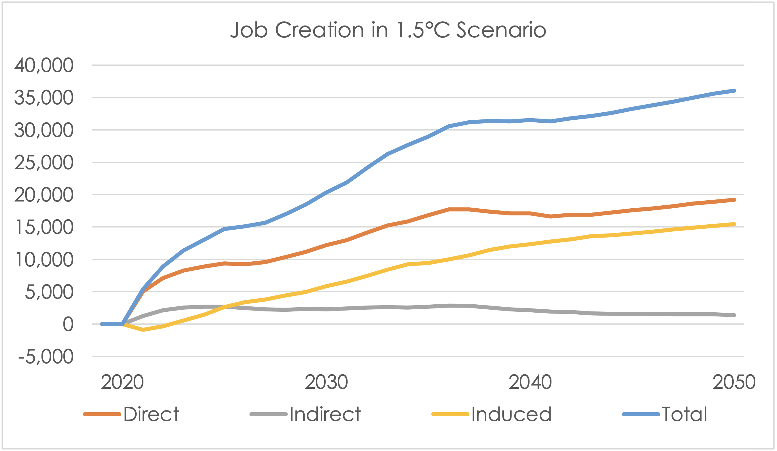
As debate intensifies around Colorado’s next steps on climate policy, new modeling from Energy Innovation and RMI shows implementing stronger policies, many of which are included as part of the state’s GHG Roadmap, can be a climate and economic boon. Ambitious decarbonization of the state’s electricity, transportation, industry, building, and land-use sectors can help limit warming to 1.5 degrees Celsius while adding more than 20,000 new jobs and $3.5 billion in economic activity per year by 2030 – and up to 36,000 jobs and $7.5 billion annually by 2050.
The time between rainfalls has become longer and the rains occurred more erratically in the Southwest during the last 50 years.. Photo credit: The Mountain Town News/Allen Best
Cheap clean energy empowers decarbonization – but policy still needed
Colorado embodies the clean energy transition accelerating across the U.S. – a state where fossil fuels once underpinned energy supply and economic activity, but where fast-falling clean energy prices have made decarbonization the cheapest option.
Those favorable economics have made Colorado’s climate ambition possible, but the state is now embarking on the tougher task of determining how to achieve its emissions reductions goals..
Colorado could reap billions in economic growth from its climate ambition
So how can Colorado meet its climate action goals and build a clean energy economy? New modeling using the Colorado Energy Policy Simulator (EPS) developed by Energy Innovation and Colorado-based RMI outlines a policy package that can decarbonize the state’s economy and put it on a pathway to achieve the Intergovernmental Panel on Climate Change’s recommended target of limiting warming to 1.5°C – while generating sustainable economic growth. Some of these policies overlap with those outlined in the state’s GHG Roadmap.
The free, open-source, peer-reviewed Colorado EPS empowers users to estimate climate and energy policy impacts on emissions, the economy, and public health through 2050 using publicly available data. All model assumptions, key data sources, and scenario development used by the EPS are documented online for full transparency. EPS models have been developed for nearly a dozen countries and several subnational regions, including California, Minnesota, Nevada, and Virginia. The Colorado EPS is one of at least 20 planned state-level EPS models being developed by EI and RMI…
Fortunately, the Colorado EPS finds implementing stronger policies across the state’s electricity, transportation, buildings, industrial, land-use, and agricultural sectors can put it on a 1.5°C -compliant pathway that meets Colorado’s emissions reductions goals. The associated air pollution reductions would also prevent 350 deaths and more than 10,000 asthma attacks per year by 2030, and more than 1,400 deaths and nearly 44,000 asthma attacks per year by 2050 – even with a conservative estimate, these monetized health and social benefits reach $21 billion annually by 2050.
This low-carbon transition would supercharge the state’s economy, generating more than 20,000 new jobs and $3.5 billion in economic activity per year by 2030, and adding nearly 36,000 new jobs and more than $7.5 billion to the economy per year by 2050. These jobs would be created by building new solar and wind projects, retrofitting buildings, installing vehicle charging infrastructure, and more. Increased economic activity would come from new jobs paying wages 25% higher than the national media wage, as well as savings from reduced expenditures on volatile fossil fuel supplies.
Projected changes in jobs relative to BAU in the 1.5°C Scenario
A policy pathway for Colorado to achieve its climate goals
The 1.5°C policy package introduced by the Colorado EPS incorporates all existing state policy that has been enacted into law, legally enforceable power plant retirements, improvements in building and transportation energy efficiency, and electric vehicle adoption; it then goes further to address the state’s unique emissions profile.
While electricity and transportation lead emissions in most states, industry generates the largest percentage of emissions with 32 percent, primarily from oil and gas production. A mix of electrification, energy efficiency, hydrogen fuel switching, and methane leak reduction drive industrial emissions reductions under this 1.5°C Scenario. Several regulations have been proposed and legislation has been introduced in the state legislature to address these sectors, particularly methane leak reduction and beneficial electrification.
Rapid decarbonization of the state’s electricity sector is foundational to reducing emissions across all other sectors as an increasingly clean grid powers electrification of demand from buildings, industry, and transportation. The 1.5°C Scenario implements an 80% clean electricity standard by 2030 which rises to 100 percent by 2035. This would expand Xcel’s 80% emissions reduction target to cover all state utilities, accelerate the target date from 2035, and make the target legally enforceable – in line with Biden administration efforts to implement an 80% by 2030 clean energy standard. Under this scenario battery storage would increase seven-fold over existing state targets, transmission capacity would double, and additional demand response capacity would increase grid flexibility and reliability.
Colorado is already targeting a 40% reduction in transportation emissions by 2030, which would add 940,000 light-duty electric vehicles on the road. The 1.5°C Scenario would go even further, primarily by requiring all new passenger car and SUV sales be electric by 2035 and all new freight truck sales be electric by 2045. These goals align with ambitious zero-emission light-duty vehicle goals adopted by 10 states as well as the multi-state agreement targeting zero-emission medium- and heavy-vehicles signed by 15 states (including Colorado) and the District of Columbia, would add nearly 1.5 million electric vehicles by 2030, and ensure most on-road vehicles are electric by 2050.
Buildings would be transitioned away from fossil fuels through increased efficiency targets for new buildings and deep efficiency retrofits of existing buildings, along with a sales standard requiring all new building equipment sales be fully electric by 2030 to shift gas heating and cooking equipment to highly efficient electric alternatives.
This wedge chart aggregates some policy levers to improve figure readability; a full interactive wedge graph is available on the Colorado EPS
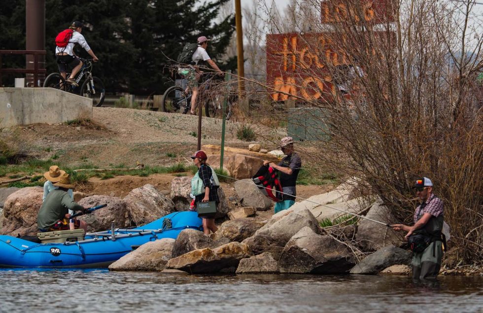
Colorado’s rivers and streams are rising after a year of pandemic quarantine and social distancing, and the anticipation of rafters and kayakers is rising as well. But water resource experts and outfitters are cautioning that the second year in a row of below-average and unseasonably warm spring temperatures will contribute to a short float season.
“We’ve had another dry year. Last year wasn’t that great either,” said Aldis Strautins, hydrologist for the National Weather Service in Grand Junction. “The summer was dry. Fall was dry. Soil moisture is very dry. This doesn’t bode well for rafting and kayaking. Things can change but we’re not seeing any indication of that right now.”
As of last week, Strautins said the moisture content of snowpack remaining in the Upper Colorado River Basin is 79 percent of normal, while the Rio Grande and Yampa basins stand at 78 percent, the Gunnison basin is at 73 percent, and the San Miguel, Dolores and San Juan rivers are at 66 percent.
The exceptions are the Arkansas and South Platte river basins. In the Arkansas, snowpack is at 84 percent of normal, and due to some late winter storms, the South Platte Basin is close to 100 percent of normal.
Kyle Johnson, co-owner of Rocky Mountain Adventures in Fort Collins, said the near-normal snowpack in the South Platte Basin will provide his company with enough snowmelt to keep customers on the Poudre River happy this summer.
“We currently have the best snowpack in the state,” Johnson said. “The Poudre has been at runnable levels for the past three weeks. Although we definitely don’t anticipate high water, we’re looking forward to a nice, even flow season.”
Andy Neinas, owner of Echo Canyon Outfitters in Cañon City, said the COVID-19 pandemic provided a tough learning experience for his operation and other outfitters.
“We’re using 2020 as a North Star. We learned things. We were washing paddles. Now we know that was an unnecessary precaution,” Neinas said.
But the company continues to be vigilant, especially in protecting its workers. “Here at Echo Canyon any team member that wants to be tested or vaccinated can do it on the clock. We’re giving our team members a $100 bonus for getting vaccinated.”
Bob Hamel, executive director of the Arkansas River Outfitters Association, said the his basin’s stored water supplies, though well below normal, are holding up and will help ensure rafters have enough liquid to float. “We’re not going to have any problems with water. It won’t be too high but it’ll be sufficient. We’ve seen a pretty good early start already.”
Coping with COVID-19 in 2020 was one of the greatest challenges in Colorado’s commercial rafting history, according to a new report by the Colorado River Outfitters Association. Commercial river use declined by more than 20 percent in 2020, with visitor spending dropping from nearly $185 million in 2019 to $148 million last year.
“We had a lot of anxiety in the rafting business,” Hamel said. “But once we got going, people were ready to get outside. We saw that everywhere on public lands. Rafting was no surprise. We survived last year and we’re appreciative that we’re still in business.”
Dean Krakel is a photographer and writer based in Almont, Colo. He can be reached at dkrakel@gmail.com.