The health of our waters is the principal measure of how we live on the land — Luna Leopold
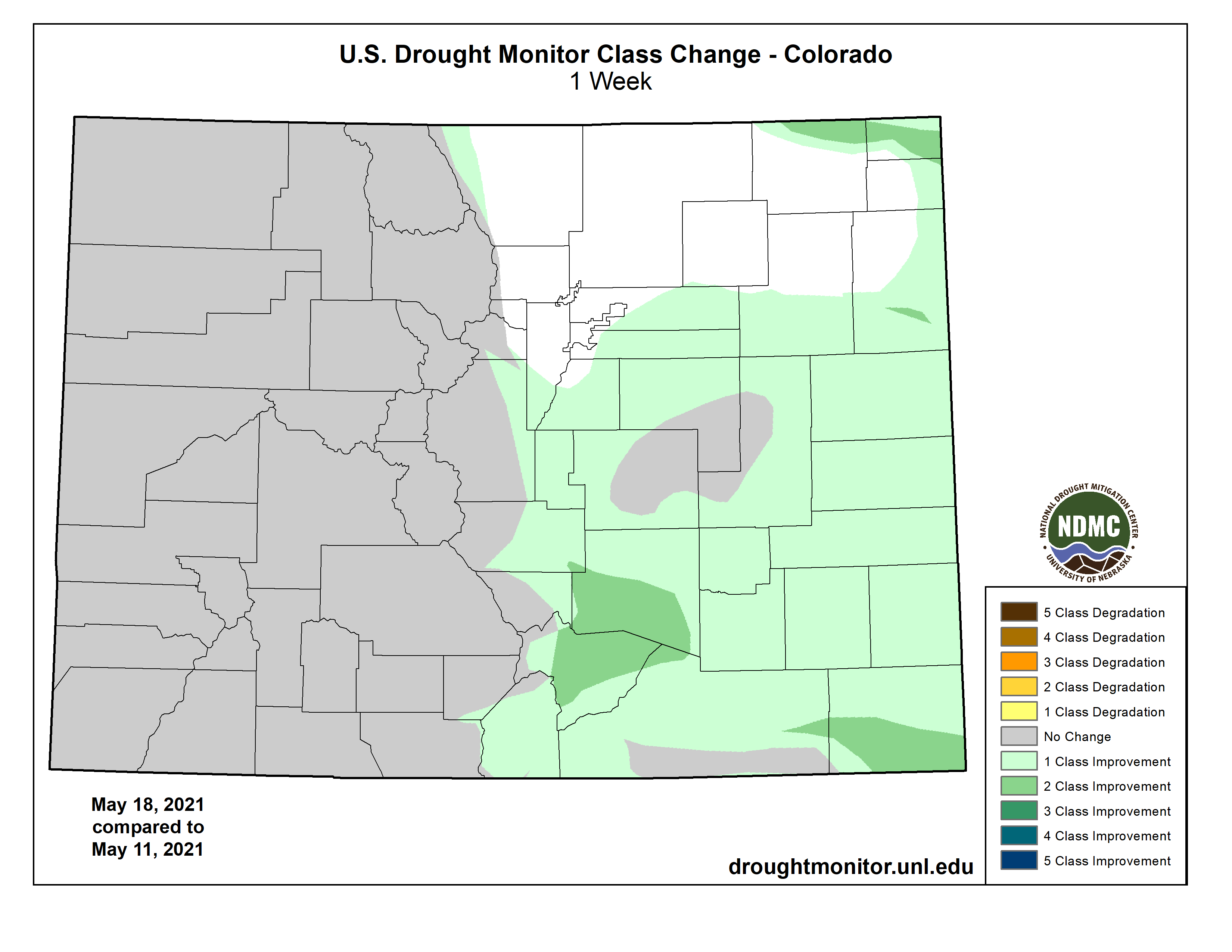
#Drought news (May 20, 2021): Large reductions in D0 (abnormally dry) to D2 (severe drought) coverage in #Colorado, #NE, and #KS, with some D3 (extreme) reduction in southeastern Colorado
Click on a thumbnail graphic to view a gallery of drought data from the US Drought Monitor.
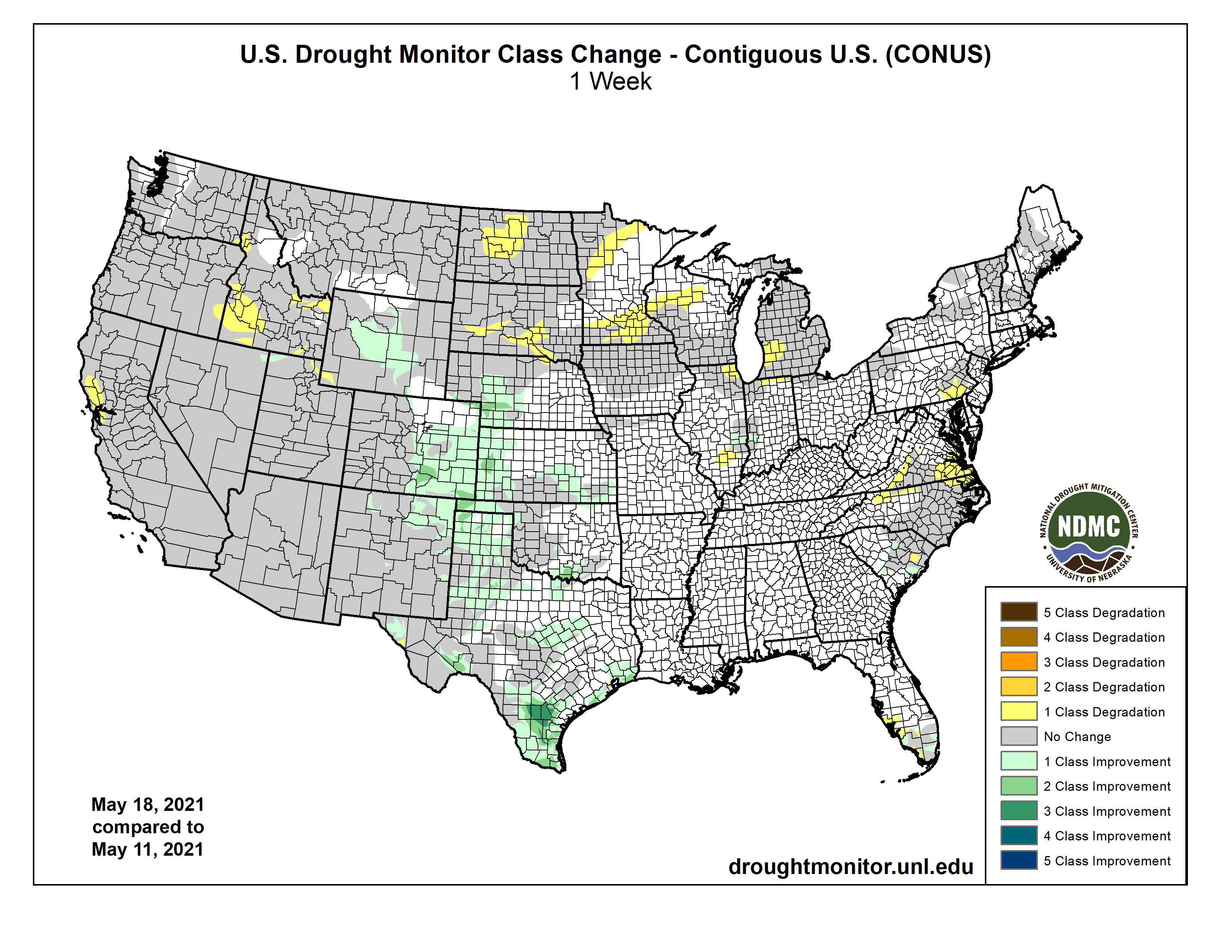
US Drought Monitor map May 18, 2021.
West Drought Monitor map May 18, 2021.
High Plains Drought Monitor map May 18, 2021.
Colorado Drought Monitor map May 18, 2021.
Click here to go to the US Drought Monitor website. Here’s an excerpt:
This Week’s Drought Summary
Troughing over the western CONUS and ridging over the East resulted in strong southerly flow over the Southern and Central Plains, leading to widespread heavy rainfall (0.5 to 3 inches, and more) over portions of the Great Plains, Lower Mississippi Valley, and into western areas of the Corn Belt this week. The heaviest precipitation fell over southeastern Texas and southern Louisiana, where some locations received over 10 inches of rainfall. The heavy rainfall resulted in widespread removal and improvement in drought conditions from the Front Range eastward to Nebraska and Kansas, and southward to the Mexico border. Unfortunately, the moisture was unable to make it farther north than Nebraska, resulting in continued degradations across the Northern Plains, Upper Midwest, and Great Lakes. The Northeast experienced below normal precipitation, but due to below normal temperatures and near-normal precipitation over the past 30-60 days across much of the region, only minor changes to abnormally dry (D0) areas were warranted in southeastern Pennsylvania. In the Southeast, portions of Virginia and North Carolina have continued to dry out over the past 90 days, warranting D0 expansion. Locally heavy rainfall (2 inches) also fell over areas experiencing abnormally dry and moderate drought (D1) in South Carolina and Florida, leading to some modifications in those locations based on rainfall 7-day rainfall totals. The La Nina signal in the West was evident in the precipitation totals at the end of the climatological wet season in March. The presence of this antecedent dryness has resulted in much below-normal snowpack throughout much of the West, leading to continued drought deterioration since the region began its transition into a climatologically drier time of year during April…
Colorado Drought Monitor one week change map ending May 18, 2021.
The High Plains Region was a tail of two extremes. From Nebraska southward, and westward to the Front Range saw widespread heavy precipitation (0.5 to 3 inches, with locally higher amounts of greater than 5 inches stretching from west to east across Kansas), leading to large reductions in D0 (abnormally dry) to D2 (severe drought) coverage in Colorado, Nebraska, and Kansas, with some D3 (extreme) reduction in southeastern Colorado. Some moderate precipitation also fell across portions of the Front Range of Wyoming also, further improving SWE across the Big Horn Basin. This warranted some improvements from D2 (severe drought) to D1 (moderate drought) along the east-facing slopes of the Absaroka and Wind River Ranges, and D1 was also improved to D0 for interior parts of the basin. In addition, AHPS percent of normal precipitation exceeds 150% for all periods going back at least 90 days, SPIs indicate near to abnormally dry conditions going back 180 days, and USGS 7-day and 28-day average stream flows are near normal. NASA SPoRT and NASA GRACE also show improvements in soil moisture and groundwater, respectively. Across the Dakotas, near to above normal temperatures and below normal precipitation this week warranted some further degradations. Targeted expansions of D1 and D2 drought occurred in South Dakota, as the state continues to fall behind during a climatologically wetter time of year, which are depicted in the 30-90 day SPIs. There are also continued reports of poor water quality in livestock water sources in northwestern parts of the state. In North Dakota, warm (2°F to 4°F positive average temperature anomalies), dry, and windy conditions continued. CPC soil moisture ranks in the bottom 1% across much of the state, USGS 7-day average stream flows are much below normal, and VegDRI and VHI indicate extreme stress on vegetation. As such, D4 (exceptional drought) was introduced for parts of north-central North Dakota. Furthermore, many farmers have been forced to plant in dry soils this year, but erosion and lack of rainfall have resulted in poor and/or a lack of germination. Fire also continues to remain a high risk across the state and most counties have imposed burn restrictions. Since the beginning of the year, there have been more than 1,000 fires reported across North Dakota, with over 100,000 acres burned…
Most basin snow water equivalent (SWE) percentiles across the Western Region are well below normal for the period of record (near and below the 65th percentile), especially in the Four Corners region (below the 5th percentile in Arizona and New Mexico). Only parts of the Pacific Northwest and areas of central Montana experienced near and above-normal seasonal snowfall. However, above-normal temperatures over much of the West over the past 60 days has resulted in rapid snowmelt and, due to dry topsoil, much of the melt water has not made it into the rivers, lakes, and reservoirs. In California, the water level in Lake Tahoe is 2.5 feet lower than this time last year. USGS 7-day average stream flows across the coastal ranges near the Bay Area have dropped below the 2nd percentile. In addition, CPC soil moisture ranks below the 1st percentile, NASA GRACE indicates severely depleted groundwater, and vegetation indices (VegDRI and VHI) indicate severe vegetation stress. There are increasing reports of reduced pasture forage, livestock requiring supplemental feed and/or being sold off, and some reports of livestock mortality. Additionally, stock ponds are running dry and farmers have been forced to haul water in some locations. Given the worsening conditions, drought was deteriorated from D3 (extreme) to D4 (exceptional) in areas along the coastal ranges near the Bay Area. Targeted degradations were also made in portions of Idaho as a result of deteriorating soil moisture conditions (NASA SPoRT 0-10 cm and 0-40 cm depths and CPC soil moisture below the 5th percentile state-wide), supported by widespread D1-D3 30-90 day SPIs. New Mexico was the only state in the Western Region where improvements were warranted, as severe weather along the Front Range of the Rockies resulted in some small improvements in areas experiencing D3 and D4 drought conditions in northern and eastern parts of the state…
Heavy rainfall and flooding was the main concern in many areas of the Southern Region. Across eastern Texas, the Ark-La-Tex, and southern Louisiana, many areas received in excess of 3 inches of rainfall. Southeastern Texas and southern Louisiana were the hardest hit areas, with several locations receiving up to, and exceeding, 10 inches of rainfall. On Monday, the National Weather Service issued flood warnings in the Lake Charles, Louisiana area, where 11 inches of rain fell in a 6-hour period. Near Baton Rouge, Louisiana, locations east, southeast, and south of the city picked up nearly 12 inches of rainfall Monday night into Tuesday. Farther west in Texas, large reduction in drought coverage was warranted in areas receiving over 2 inches of rainfall. Some locations in southern Texas picked up 5 to 10 inches of rain, warranting 2 to 3-category improvements and removal in the drought depiction. From northern Mississippi to central Tennessee, 30-day rainfall deficits are beginning to increase. This area remains drought free this week, but bears watching if deficits continue to increase…
Looking Ahead
During the next 5 days (May 20 to 24), the Southern and Central Plains, much of the Corn Belt, and Northern Tier states are favored to remain wet. Temperatures are also forecast to remain below-normal for much of the period across the Northern Tier. High pressure is expected to dominate over the eastern U.S., coinciding with little to no rainfall and above-normal temperatures. The Southwest and Coastal California will likely remain dry also. However, temperatures are favored to remain below-normal, moderating to near-normal as the week progresses toward Tuesday.
The CPC 6-10 day extended range outlook (valid from May 25 to 29) favors above normal temperatures across the eastern U.S. and Central and Southern Plains, with enhanced probabilities in the Southeast. Above normal temperatures are also favored over northern and western Mainland Alaska, with above-normal probabilities extending to the eastern Aleutians. Below-normal temperatures are favored from the Pacific Northwest eastward to the Dakotas. Above-normal precipitation is predicted across the Southern and Central Plains, Corn Belt, and Lower Great Lakes. In Alaska, odds tilt toward above-normal precipitation for the Southwest Mainland, Eastern Aleutians, and along the South Coast to the Northwest Panhandle. Below-normal precipitation is favored in the Southeast U.S. and along the East Coast, with enhanced probabilities in the Deep South and Florida. Below-normal precipitation is also favored for the Central Pacific Coast, Great Basin, and Eastern Rockies to the High Plains.
US Drought Monitor one week change map ending May 18, 2021.