Navajo-Gallup water delay spurs problem solving in arid Southwest — #NewMexico in Depth #SanJuanRiver #ColoradoRiver #COriver #aridification

Survey work begins in 2018 for the Navajo-Gallup Water Supply Project on the Navajo Nation. Photo credit: U.S. Bureau of Reclamation via The High Country News

From New Mexico in Depth (Elizabeth Miller):

Early this year, five of Gallup, New Mexico’s 16 water wells stopped producing water, including two of its biggest. After a few days of maintenance, two worked. The other three were out of commission for more than a month. Had it happened in summer, the city might have asked residents to dramatically reduce use…

The shortage isn’t wholly surprising — 20 years ago, the city decided it could limp along on aging groundwater wells with dropping water levels until a new water project began delivering San Juan River water in late 2024. The project is also connecting nearby Navajo communities, where many residents lack running water, an issue the Navajo Nation says is long past due and in need of a fix. But now a potential four-year delay could force a growing number of people to rely on these strained groundwater sources. A plan to keep taps from running dry will come with a price tag.

The situation highlights how precarious water has become for this city of almost 22,000 in western New Mexico and offers a peek inside the complicated mix of relationships, creativity and familiarity with multiple government agencies that’s required to manage water in the 21st century.

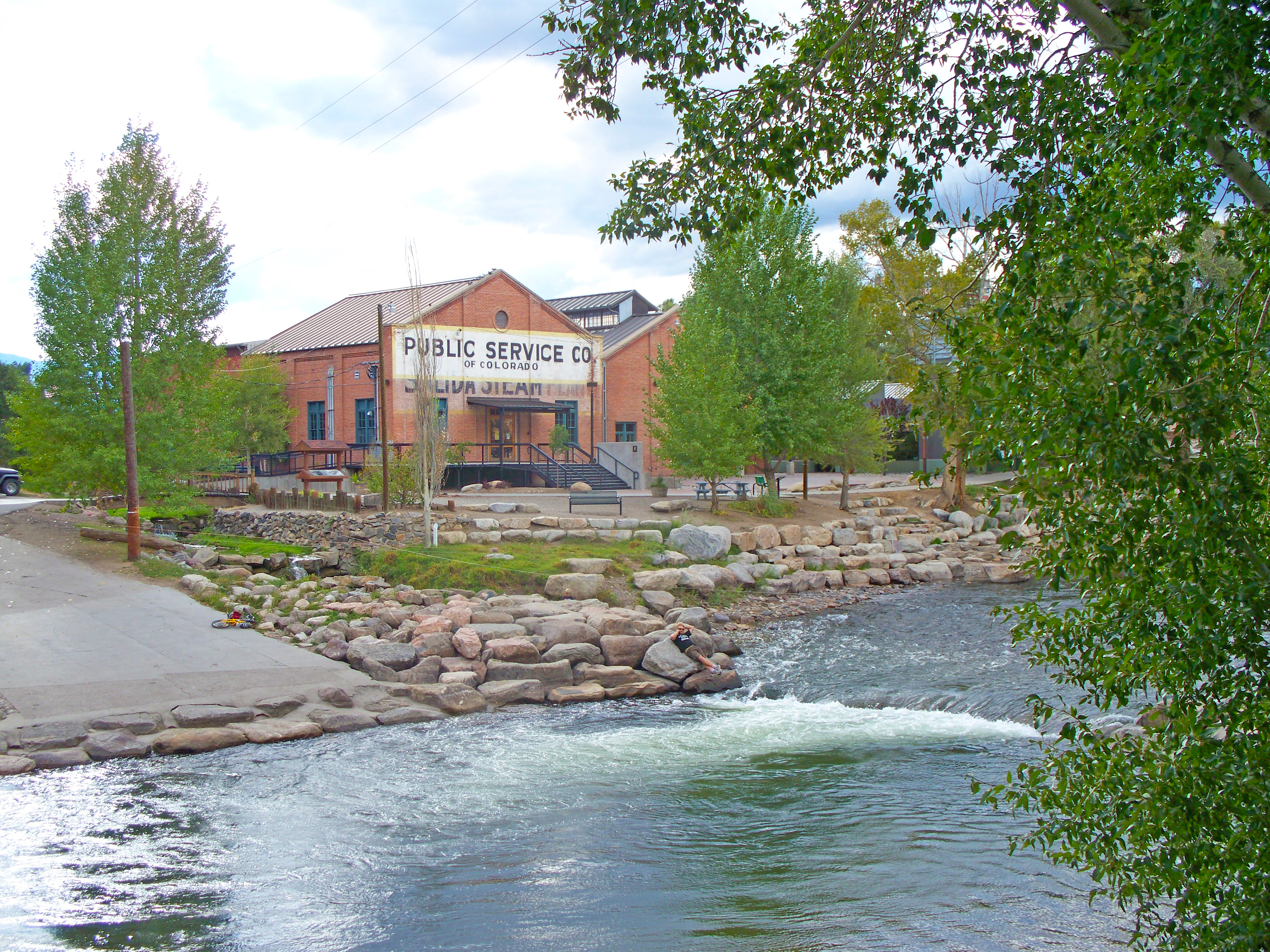
Gallup sits in the high desert along the red sandstone mesas of the Colorado Plateau. For much of its history, it has functioned as an industrial town and a bustling commercial center. Named in 1881 after railroad paymaster David L. Gallup, freight trains and Amtrak still rumble through, in addition to a steady flow of semi-truck traffic around the exits for Interstate-40. Surrounded by the Navajo Nation, on the first weekend of the month the town swells by 100,000 as people stream in for supplies. Those with no running water at home fill water containers. People do laundry, wash cars, go out to eat.

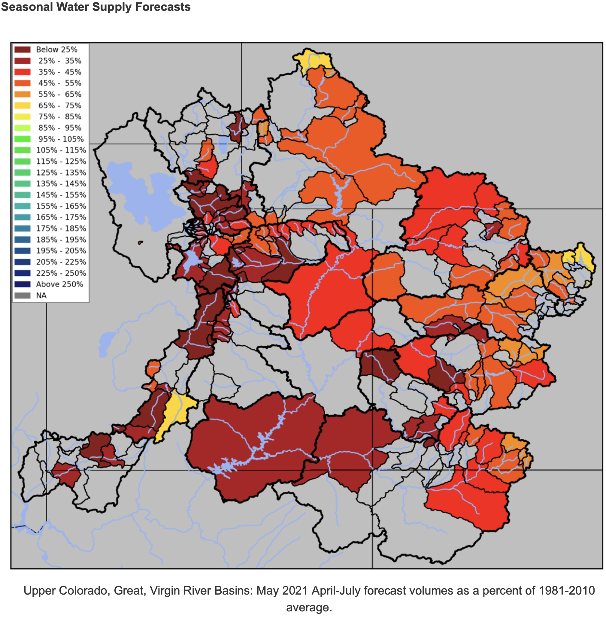
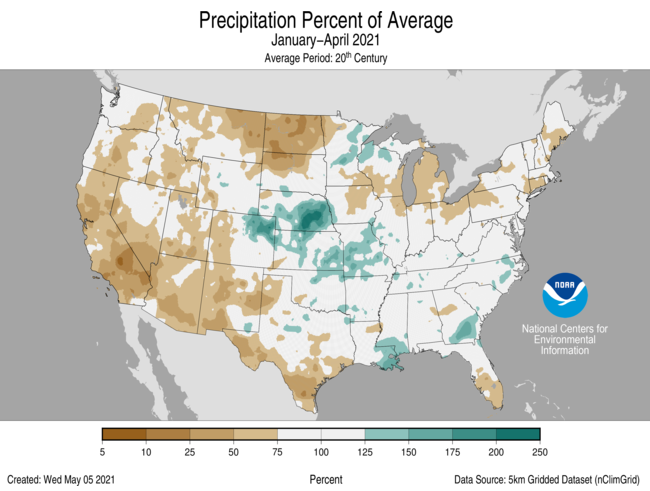
For decades, the Navajo Nation bordertown has relied on groundwater stored in sandstone layers deep underground. With no nearby rivers, wells tapping that water have been the city’s only option. But because annual rain and snowfall don’t replenish the water, levels have dropped over recent decades. In the 1990s, the city projected shortages by as early as 2010.

“Not only was Gallup running out of water, everybody was running out,” said Marc DePauli, owner of DePauli Engineering and Surveying, which the city has hired to work on the water systems. About 20 smaller surrounding water systems had “straws in the same bucket,” all leaning on dwindling reserves.

Help is coming in the form of the Navajo-Gallup Water Supply Project, the result of a historic agreement that settled Navajo Nation claims to water in this arid region of the Southwest after decades of discussions.

Consisting of two major pipelines that run through Navajo communities in western New Mexico, the project will bring water from the San Juan River to within reach of some of the one in three homes without it on the Navajo Nation. One of the pipelines, the Cutter Lateral that branches to northwest New Mexico, is complete. The other, the San Juan Lateral, will move 37,700 acre feet of water each year for 200 miles along the western edge of the state, up to 7,500 acre-feet of which will come as far south as Gallup. In the future, the city will rely largely on water from the San Juan…

The water was supposed to flow by 2024, but a new design proposed by the Bureau of Reclamation will now likely push that date back by three to four years, putting Gallup in a tight spot, monetarily and water-wise. The construction delay coupled with the city shouldering more demand will require new wells to supply everyone until water from the San Juan arrives.

“America the Beautiful” initiative would conserve 30 percent of U.S. lands and waters by 2030 — The Ark Valley Voice

Salida Steam Plant Arkansas River

From The Ark Valley Voice (Jan Wondra):

Thursday morning, Colorado U.S. Senator Michael Bennet released a statement welcoming a new federal initiative that supports a Senate effort he began in 2019. The Biden Administration’s “America the Beautiful” initiative is focused on achieving the conservation goal of conserving 30 percent of U.S. lands and waters by 2030 through locally-led and voluntary efforts.

“Land and water conservation is a critical part of our effort to tackle the climate crisis. This report is a strong start and lays out a vision that aligns with the kind of conservation efforts we know to be successful in Colorado — efforts that take a locally led, collaborative, and inclusive approach and bring into the fold the private landowners, farmers, and ranchers who are already stewards of our natural resources. It’s the same approach that brought together the ranchers, hunters, anglers, and local elected leaders who worked for over a decade to draft the CORE Act.”

Bennet went on to say he was glad to see the administration’s commitment to empowering local communities to drive the process.

Here in Chaffee County, as in many other western counties and states, local conservation efforts have often been the driving force behind conservation efforts. In the past four years, they have also been the voice of local opposition to the opening of public lands to commercial development, and the marring of pristine public land and natural resources.

Another dry year: #Drought affects agriculture, recreation, and hydropower — The Moab Sun News #ColoradoRiver #COriver #DCP #aridification

Utah Drought Monitor Map May 4, 2021.

From The Moab Sun News (Rachel Fixsen):

Last week, Utah State University hosted a webinar for natural resource professionals to discuss a drought reporting network called “Condition Monitoring Observer Reports.” Through a mobile app, Utah citizens can document drought impacts and submit their observations to a database used by state and university drought researchers and scientists. The data can help give scientists a more qualitative, detailed understanding of on-the-ground conditions and impacts of drought. Are farmers’ crops, or ranchers’ grazing areas, being affected? Are recreation areas changing? Photographs showing a location in a wet year and later in a dry year can give helpful comparative references.

Details like these, giving a fuller picture of what it means to be in a condition of drought, are increasingly important to scientists, policy-makers, and citizens of the Southwest as we grapple with the ongoing dry conditions. On March 17, Utah Governor Spencer Cox declared Utah to be in a state of emergency due to drought; 90% of the state is considered to be in “extreme” drought, and the entire state is in at least “moderate” drought. All of Grand County is in the “extreme” category, and some of the county is in the even more severe “exceptional” drought category.

An extreme demonstration of the drought is the current level of Lake Powell, which is nearing historic lows. At the beginning of the 2021 water year, the lake was at 48% of capacity, according to the Bureau of Reclamation. In an April 15 update, the bureau reported that the lake had dipped even further to just 36% of capacity at the end of March.

Lake Powell is seen in a November 2019 aerial photo from the nonprofit EcoFlight. Keeping enough water in the reservoir to support downstream users in Arizona, Nevada and California is complicated by climate change, as well as projections that the upper basin states of Colorado, Utah, Wyoming and New Mexico will use as much as 40% more water than current demand. A recent white paper from a lineup of river experts calls those use projections into question.
CREDIT: ECOFLIGHT via Aspen Journalism

The lake’s current shoreline looks very different than in higher water years; one family of visitors even discovered a shipwrecked boat, now completely emerged from the receded water. Receding waters have stranded boat ramps and drained marinas, however, the low lake levels could have much graver consequences than altered recreation experiences.

The lake level at the end of March, according to the Bureau of Reclamation, was about 3,567 above sea level. If the level drops to 3,525 feet above sea level, normal hydropower production and water releases from the lake are at risk.

The 2019 Colorado River Drought Contingency Plan, agreed upon by the states who rely on the Colorado River for water, dictates that if reservoir levels reach critical lows, Upper Basin states will need to initiate drastic conservation measures to increase those water levels.

Water conservation has been a concern locally, with the Moab City Council holding discussions in recent months about Moab Valley water resources. The Glen Canyon aquifer provides most of Moab’s drinking water, and scientific studies in recent years have raised concerns about “safe yield” levels, or how much water per year it is safe to draw from the aquifer while still allowing it to recharge. Marc Stilson, regional engineer for the Utah Division of Water Rights, gave a presentation at the May 4 Grand County Commission meeting, updating elected officials on the division’s recent work. A six-year study by the U.S. Geological Survey, to which the state Division of Water Rights contributed, attempted to determine how much groundwater is in the valley.

Whitewater race series starts Tuesday — The #Vail Daily #GoreCreek #EagleRiver #ColoradoRiver #COriver

Kayaking Gore Creek via Vail Recreation

Here’s the release from the Vail Recreation District via The Vail Daily:

The 2021 Eagle River Water & Sanitation District Vail Whitewater Race Series is almost here.

The Vail Recreation District offers five events on Gore Creek on Tuesdays from May 11 to June 8. This is a chance to test your paddling skills and compete against others. Register for individual races or the whole series.

For 2021, the Vail Recreation District is excited to introduce a new title sponsor for the series, the Eagle River Water & Sanitation District.

“The Vail Whitewater Race Series is a great example of how our community thrives on water. Whether it’s snow, our rivers, or the safe water we deliver to homes and businesses every day, clean water is vital to our quality of life,” said Eagle River Water & Sanitation District’s Diane Johnson. “As stewards of our rivers, we encourage everyone to reduce their impact on local streams by reducing their outdoor water use.”

The Vail Recreation District also partners with the Town of Vail and Alpine Quest Sports to put on these exciting races, held at the Vail Whitewater Park on Tuesday evenings beginning at 5:30 p.m. The first four races start at the Covered Bridge in Vail Village and end at International Bridge.

The last race on June 8 will start at the Ampitheater Bridge in Ford Park. Overall series prizes will be awarded following the final race.

The races will be divided between three categories including kayak (under 9-feet-6), two-person raft (R2) and stand-up paddleboard (SUP) with different course challenges every week. Open to paddlers ages 16 and up with intermediate to expert abilities, the skills to run Class III whitewater in your chosen craft are required. The two-round format will consist of an individual time trial with results determining the seeding for the second round, a head-to-head race.

Please note that for 2021 the Vail Recreation District has limited rafts for use, so the R2 category will be limited to 15 teams. Preregistration is highly encouraged.

An after-party will also be hosted in Vail Village each week with prizes awarded to the winners of all three categories. For the first race on Tuesday, the after-party will take place at the Altitude Bar & Grill. All race participants over 21 will receive free beer courtesy of New Belgium Brewing Company!

Registration is available at http://www.vailrec.com/register. Series registration for kayak and SUP participants is $60 and series registration for R2 participants is $80 per team.

Individual race registration for kayak and SUP participants is $15 preregistered or $20 day-of, and $20 preregistered or $30 day-of for R2 teams. Preregistration is highly encouraged and ends at 5 p.m. the day before each race. If space is still available, on-site, day-of registration will begin at 4:30 p.m. at the Vail Whitewater Park and all participants should be present at the safety talk at 5:15 p.m.

Every registered participant at each race will be entered to win a $1,000 gift certificate from Hala Gear that can be used towards a board and paddle package of their choice. The winner will be drawn after the final race so make sure you attend that last after-party!

The Vail Recreation District will be following all state and county COVID-19 guidelines for this upcoming race season.

For more information, visit vailrec.com, call the VRD Sports Department at 970-479-2280 or email sports@vailrec.com.

Help protect the Little Colorado River Gorge from development! — From The Earth Studio

Be sure to check out this short, but great video overflight of 3 dam systems that are being proposed to be built within the Little Colorado River Gorge. These dams would significantly impact unique cultural landscapes that are important for several Indigenous tribes, as well as impact critical, natural habitat for the endangered Humpback Chub. […]

Help protect the Little Colorado River Gorge from development! — From The Earth Studio

May 6, 2021 Water Supply Forecast Discussion — Colorado Basin River Forecast Center #ColoradoRiver #COriver #aridification

Click here to read the discussion from the Colorado Basin River Forecast Center. Here’s an excerpt:

The Colorado Basin River Forecast Center (CBRFC) geographic forecast area includes the Upper Colorado River Basin, Lower Colorado River Basin, and Eastern Great Basin.

Water Supply Forecast Summary

Early May water supply volume forecasts are below to much below normal throughout the Colorado River Basin and Great Basin. Upper Colorado River Basin water supply forecasts range between 15-75% of the 1981-2010 historical April-July average. Great Basin water supply forecasts are 10-70% of average. Water supply guidance as a percent of average decreased by 10-20% across the majority of the Upper Colorado River Basin and decreased by 5-15% across the majority of the Great Basin over the past month. Many April-July volume forecasts fall in the bottom (driest) five on record. Water supply forecast ranges (percent of normal) by basin are listed below.

April average temperatures were slightly below normal across the north and slightly above normal across the south. April precipitation was mostly below to well below normal across the Upper Colorado Basin and Great Basin. Several SNOTELs in the San Juan, Gunnison, and Yampa River Basins were below the 10th percentile for April precipitation. Below normal soil moisture and snowpack conditions in addition to below average April precipitation and relatively mild (near normal) April temperatures across the Upper Colorado River Basin and Great Basin lead to mostly below normal and in some cases record low observed April flows (unregulated streamflow volumes) across the region. A number of streamflow sites had record low April flows with many locations falling in the bottom five of their period of record.

Snow water equivalent (SWE) at the majority of SNOTEL stations across the region peaked between 70-85% of the normal peak SWE. Early May SWE conditions are below to much below normal (median) throughout the CBRFC forecast area. Upper Colorado River Basin SWE conditions generally range between 50-75% of the 1981-2010 historical median and Great Basin SWE generally ranges between 30-60% of normal.

April-July unregulated inflow forecasts for some of the major reservoirs in the Upper Colorado River Basin include Fontenelle 380 KAF (52% of average), Flaming Gorge 450 KAF (46%), Green Mountain 150 KAF (55%), Blue Mesa 340 KAF (50%), McPhee 81 KAF (27%), and Navajo 325 KAF (44%). The Lake Powell inflow forecast is 2.0 MAF (28% of average), a 17% decrease from April.

Navajo Dam operations update: Releases = 400 cfs May 8, 2021 #SanJuanRiver #ColoradoRiver #COriver #aridification

From email from Reclamation (Susan Novak Behery):

In response to increasing flows in the critical habitat reach, the Bureau of Reclamation has scheduled a decrease in the release from Navajo Dam from 500 cubic feet per second (cfs) to 400 cfs on Saturday, May 8th, starting at 0400 AM. Releases are made for the authorized purposes of the Navajo Unit, and to attempt to maintain a target base flow through the endangered fish critical habitat reach of the San Juan River (Farmington to Lake Powell).

The San Juan River Basin Recovery Implementation Program recommends a target base flow of between 500 cfs and 1,000 cfs through the critical habitat area. The target base flow is calculated as the weekly average of gaged flows throughout the critical habitat area from Farmington to Lake Powell. Please be advised, due to the dry conditions this year, more release changes than usual may occur.

A boater, John Dufficy, makes his way down the lower end of the San Juan River toward the take-out, in 2014. Photo Credit: Aspen Journalism/Brent Gardner-Smith

April was dry and mild across much of the contiguous U.S.; Preliminary data suggest April had the fewest tornadoes in almost three decades — NOAA

Courtesy of Pixabay.com via NOAA.

Here’s the April 2021 State of the Climate report from NOAA:

During April, the average temperature of the contiguous United States was 51.9°F, 0.9°F above the 20th-century average. This ranked in the middle third of the 127-year period of record. The year-to-date (January-April) average contiguous U.S. temperature was 40.7°F, 1.6°F above average, ranking in the warmest third of the record. The April precipitation total for the contiguous U.S. was 2.03 inches, 0.49 inch below average, and ranked as the 14th-driest April in the 127-year period of record. This was the driest April since 1989. The year-to-date precipitation total was 8.63 inches, 0.85 inch below average and ranked in the driest third of the January-April record.

The preliminary count of 73 tornadoes reported in April was the lowest April total since 53 tornadoes were reported in 1992 and was also nearly half of the April 1991-2010 average of 155 tornadoes.

This monthly summary from NOAA National Centers for Environmental Information is part of the suite of climate services NOAA provides to government, business, academia and the public to support informed decision-making.

April
Temperature

  • Temperatures were above average across much of the West Coast, Southwest, Northeast, Great Lakes and parts of southern Texas and Florida. Maine ranked fifth warmest on record for April.
  • A large portion of the southern Plains and Gulf Coast states experienced below-average temperatures, as did portions of the northern and central Rockies, northern and central Plains and the Tennessee Valley.
  • The Alaska April temperature was 23.6°F, 0.3°F above the long-term average, ranking in the middle third of the 97-year period of record. In general, the interior portions of the state were cooler than average, while the Aleutians experienced above-average temperatures for the month.
    • Despite the mild average, large temperature swings were seen throughout the month as records were set for both coldest temperatures seen so late and warmest temperatures seen so early in the season across portions of Alaska.
  • Bering Sea ice cover for April was 80 percent of average and the highest for April since 2016.

Precipitation

  • A majority of the Lower 48 experienced below-average precipitation during April with four states across the West ranking among their 10-driest Aprils on record. Oregon ranked third driest while California ranked fifth driest on record for April. Precipitation was above average across portions of the northwest Great Lakes, New England, Midwest, southern Plains and Gulf Coast.
  • April is climatologically either the driest or second-driest month of the year across Alaska. For April 2021, precipitation received was above average for the state as a whole. Fairbanks saw significant April snowfall with more than 16 inches reported for the month — its second-highest April total on record.
  • According to the April 27 U.S. Drought Monitor report, 48.4 percent of the contiguous U.S. was in drought, up nearly 4.5 percent since the end of March. Drought conditions intensified and/or expanded across the eastern Great Lakes, Northeast, northern Rockies, northern Plains and the West Coast. Drought intensity and/or severity lessened across portions of the Upper Mississippi Valley, southern Plains and central Rockies.

Year-to-date (January-April)
Temperature

  • Temperatures were above average over much of the West, northern Plains, Great Lakes, Northeast and Southeast. Maine ranked fifth warmest on record for the first four months of the year. Below-average temperatures were primarily found across portions of the southern Plains.
  • The Alaska January-April temperature was 11.1°F, 0.8°F above the long-term average and ranked in the middle third of the record. Temperatures were below average across portions of the Southeast Interior, Northeast Gulf and Cook Inlet regions and above average over much of the Bristol Bay and Aleutian regions.

Precipitation

  • Below-average precipitation extended from the West Coast to the northern Plains and from the southwestern Great Lakes to the Northeast, and across southern Texas. North Dakota ranked driest for this four-month period while Montana and Connecticut ranked seventh and ninth driest, respectively. Above-average precipitation was limited to portions of the central Plains, northwest Great Lakes, central Gulf Coast and parts of the Southeast.
  • Precipitation across Alaska for the January-April period ranked in the wettest third of the 97-year record.