Last week, Utah State University hosted a webinar for natural resource professionals to discuss a drought reporting network called “Condition Monitoring Observer Reports.” Through a mobile app, Utah citizens can document drought impacts and submit their observations to a database used by state and university drought researchers and scientists. The data can help give scientists a more qualitative, detailed understanding of on-the-ground conditions and impacts of drought. Are farmers’ crops, or ranchers’ grazing areas, being affected? Are recreation areas changing? Photographs showing a location in a wet year and later in a dry year can give helpful comparative references.
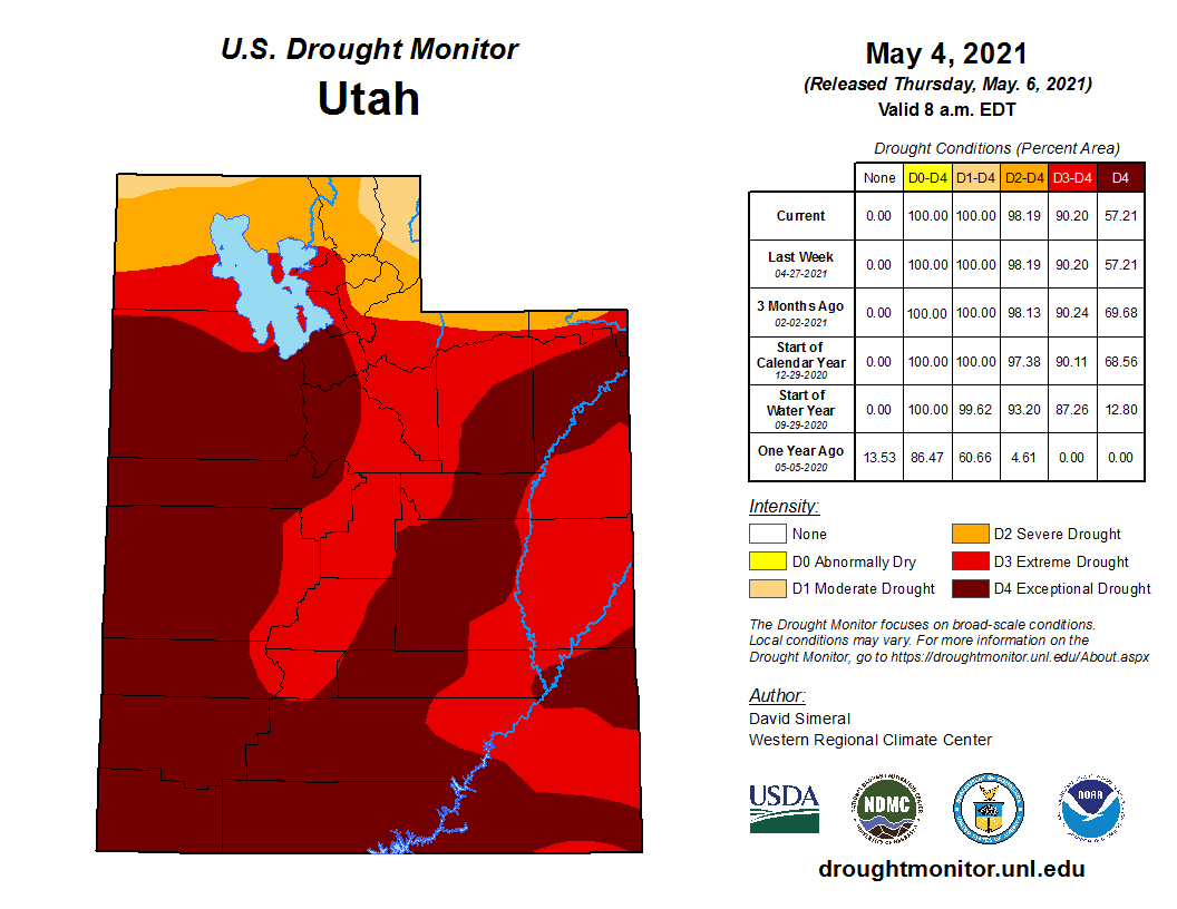
Details like these, giving a fuller picture of what it means to be in a condition of drought, are increasingly important to scientists, policy-makers, and citizens of the Southwest as we grapple with the ongoing dry conditions. On March 17, Utah Governor Spencer Cox declared Utah to be in a state of emergency due to drought; 90% of the state is considered to be in “extreme” drought, and the entire state is in at least “moderate” drought. All of Grand County is in the “extreme” category, and some of the county is in the even more severe “exceptional” drought category.
An extreme demonstration of the drought is the current level of Lake Powell, which is nearing historic lows. At the beginning of the 2021 water year, the lake was at 48% of capacity, according to the Bureau of Reclamation. In an April 15 update, the bureau reported that the lake had dipped even further to just 36% of capacity at the end of March.
Lake Powell is seen in a November 2019 aerial photo from the nonprofit EcoFlight. Keeping enough water in the reservoir to support downstream users in Arizona, Nevada and California is complicated by climate change, as well as projections that the upper basin states of Colorado, Utah, Wyoming and New Mexico will use as much as 40% more water than current demand. A recent white paper from a lineup of river experts calls those use projections into question. CREDIT: ECOFLIGHT via Aspen Journalism
The lake’s current shoreline looks very different than in higher water years; one family of visitors even discovered a shipwrecked boat, now completely emerged from the receded water. Receding waters have stranded boat ramps and drained marinas, however, the low lake levels could have much graver consequences than altered recreation experiences.
The lake level at the end of March, according to the Bureau of Reclamation, was about 3,567 above sea level. If the level drops to 3,525 feet above sea level, normal hydropower production and water releases from the lake are at risk.
The 2019 Colorado River Drought Contingency Plan, agreed upon by the states who rely on the Colorado River for water, dictates that if reservoir levels reach critical lows, Upper Basin states will need to initiate drastic conservation measures to increase those water levels.
Water conservation has been a concern locally, with the Moab City Council holding discussions in recent months about Moab Valley water resources. The Glen Canyon aquifer provides most of Moab’s drinking water, and scientific studies in recent years have raised concerns about “safe yield” levels, or how much water per year it is safe to draw from the aquifer while still allowing it to recharge. Marc Stilson, regional engineer for the Utah Division of Water Rights, gave a presentation at the May 4 Grand County Commission meeting, updating elected officials on the division’s recent work. A six-year study by the U.S. Geological Survey, to which the state Division of Water Rights contributed, attempted to determine how much groundwater is in the valley.