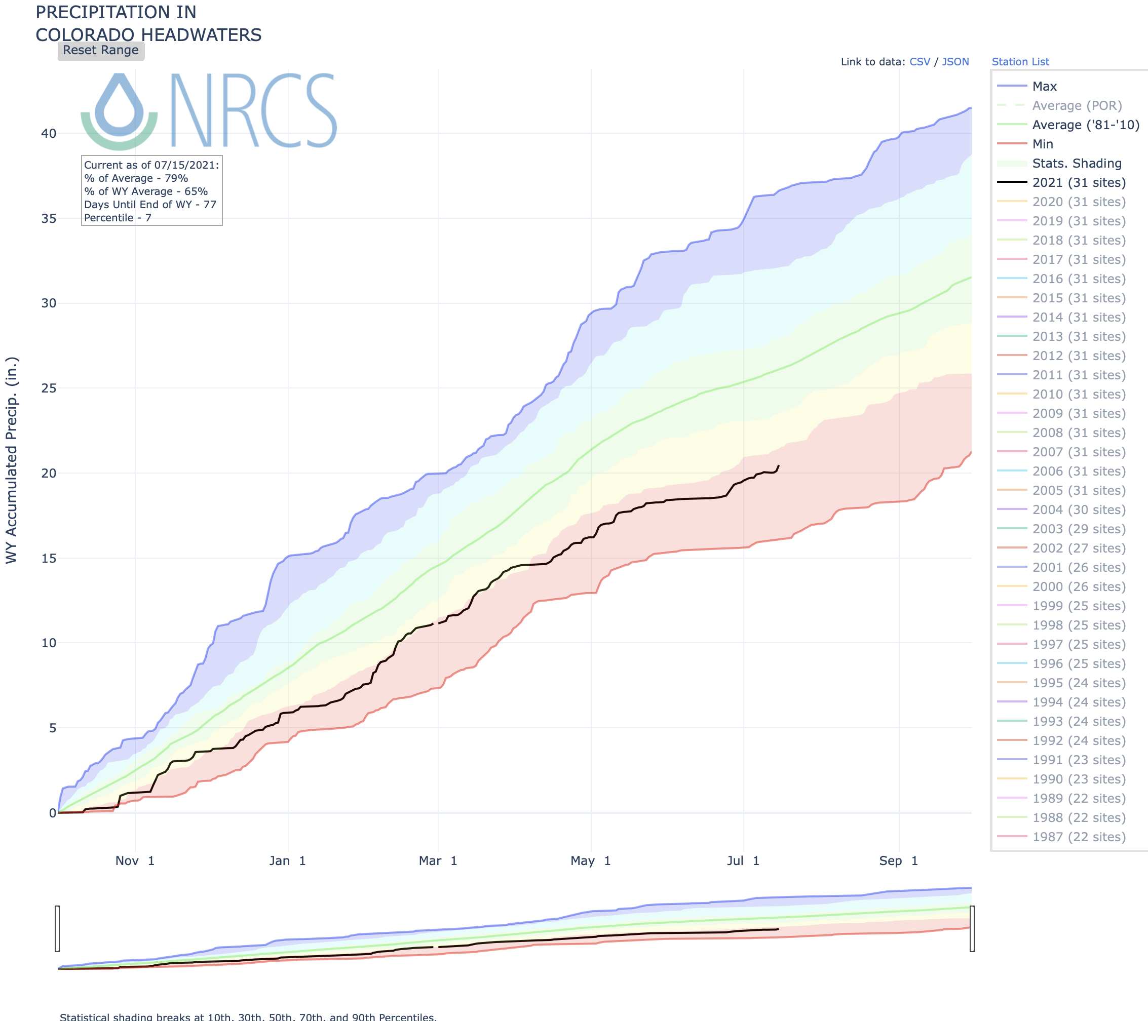
Click here to read the newsletter and to follow the links in the article. Here’s an excerpt:
Drought in the Southwest is a “hot” topic, and its effects wreak havoc on all aspects of life as we know it. The 20-year drought across the US West is taking a major toll on the Colorado River with extreme low flows and high temperatures. Lakes Powell and Mead are at historic lows. The U.S. Bureau of Reclamation warned that Lake Mead is likely to fall to levels in June/July that could trigger the first federal water shortage declaration, with water use restrictions across the region.
We are seeing negative impacts on our fish life, agriculture/ranching water supply, urban water supply, forest, soil and river health, and environmental impacts in general. Trees in Western forests have been dying at an alarming rate over the past two decades due to droughts, high temperatures, pests and fires.
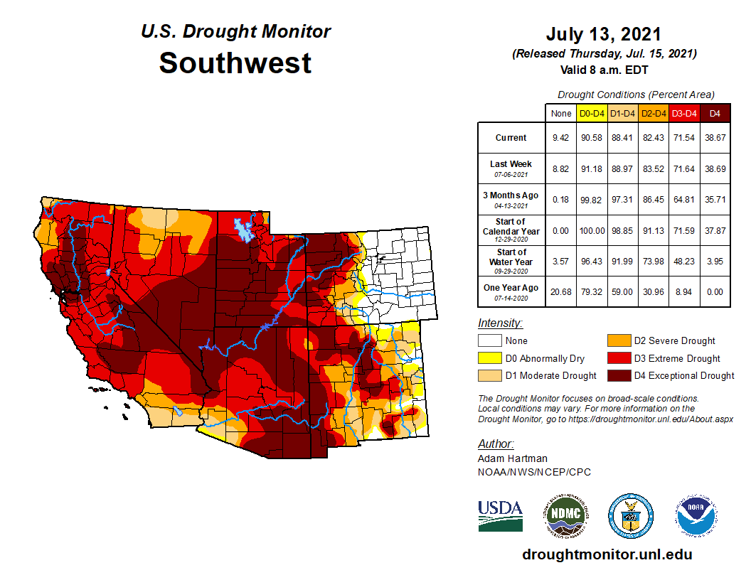
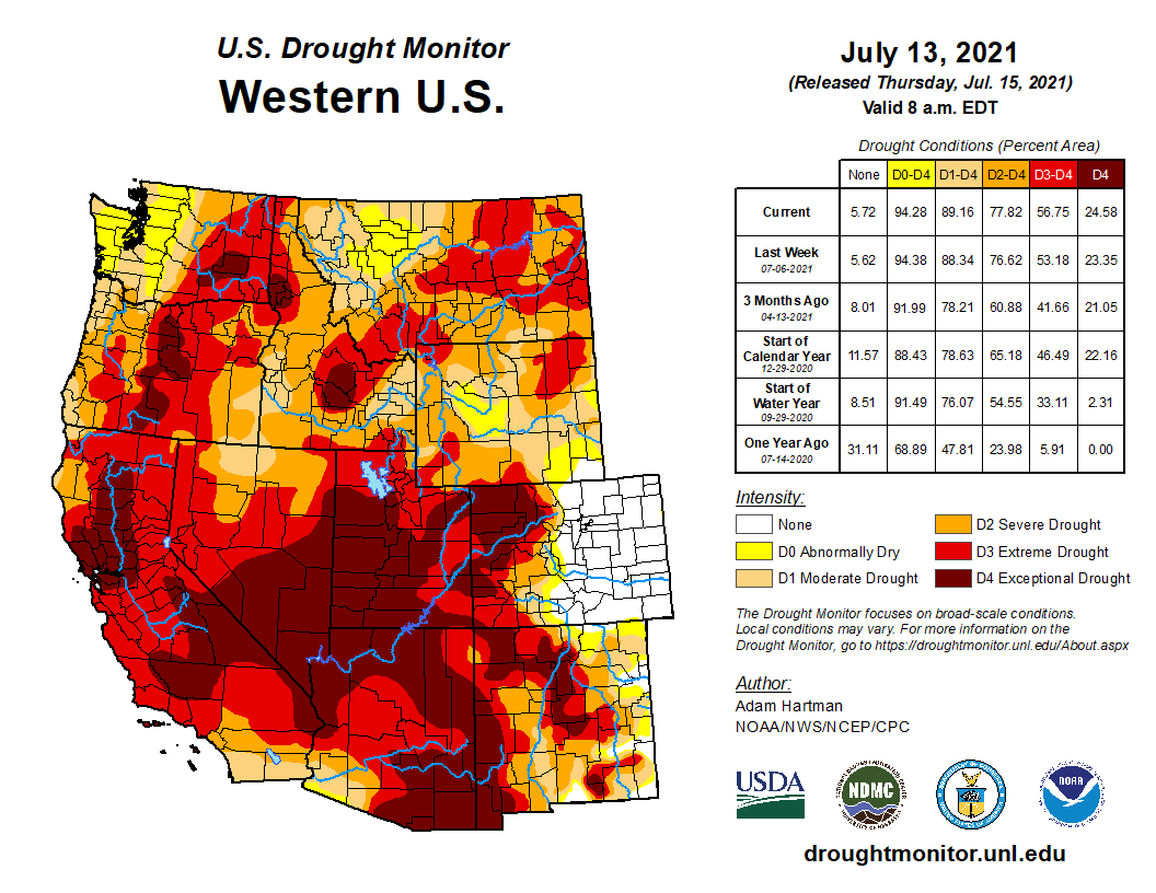
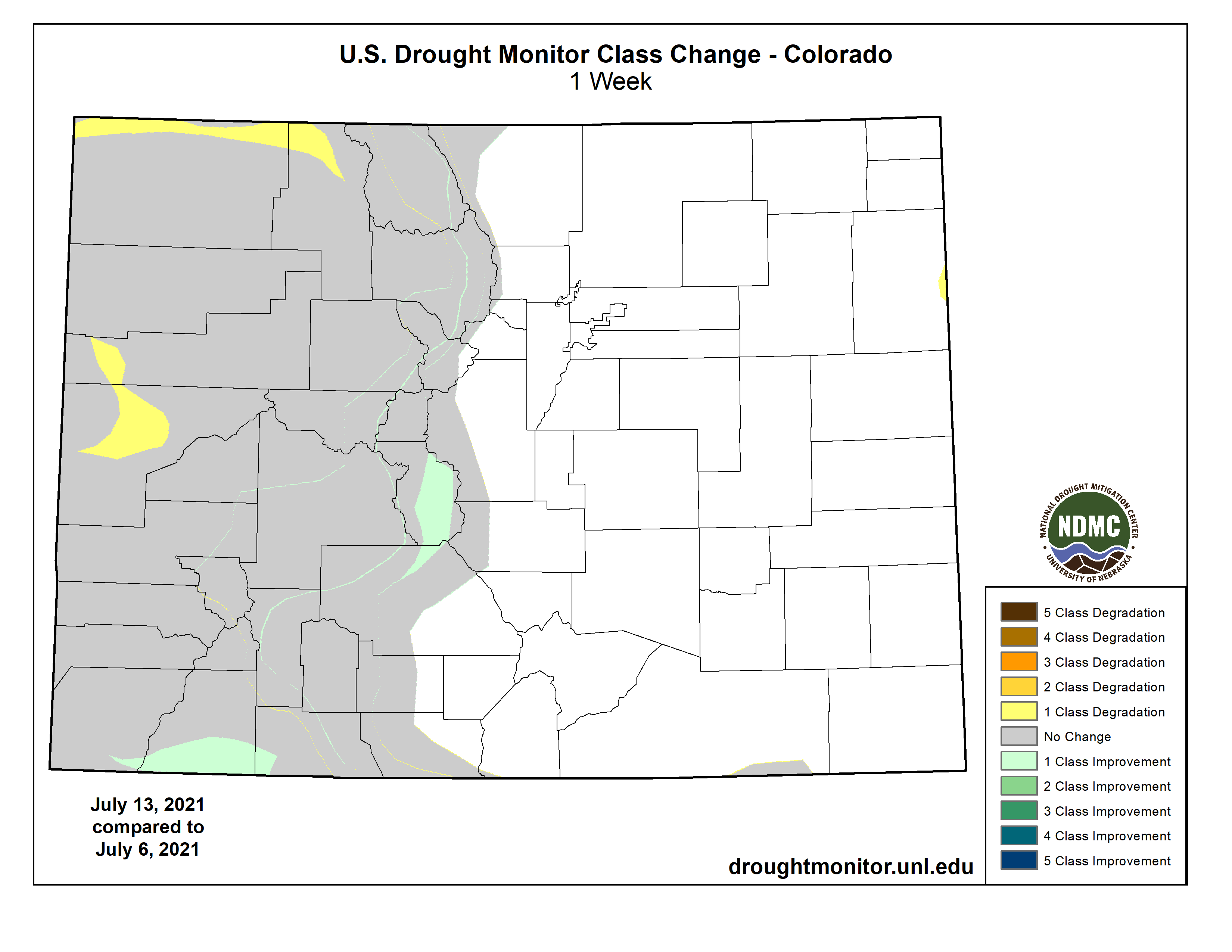
West Drought Monitor map July 13, 2021.
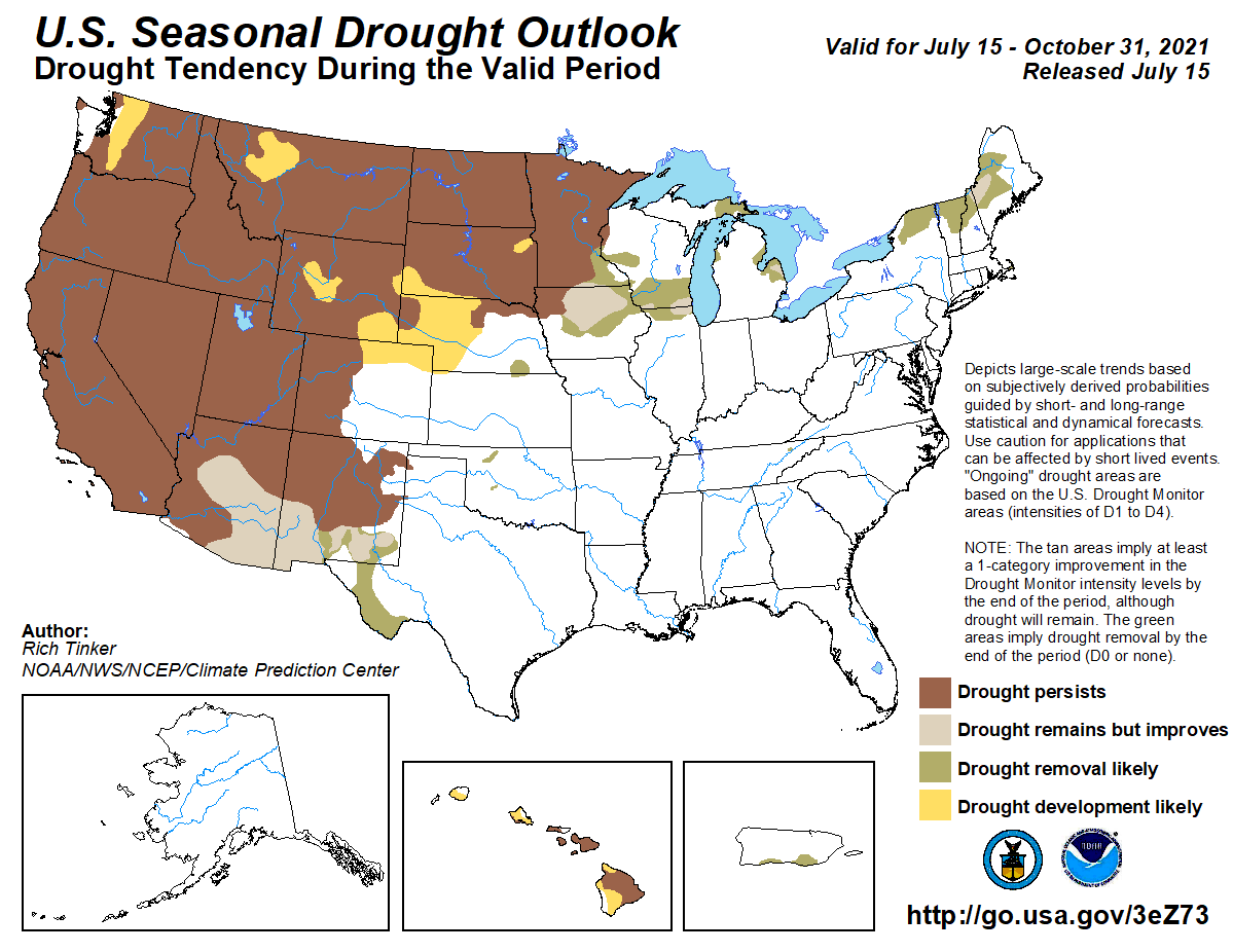
According to the U.S. Drought Monitor, more than 93% of the U.S. West is in drought conditions, and nearly 59% of the area is experiencing extreme or exceptional drought, the two worst conditions, indicating widespread risk of crop loss, fire and water shortages.
While I don’t mean to spout doom and gloom, we are witness to the impacts of climate change and it is a serious situation in the West. The impact that changing drought and fire regimes will have on forests in the future is still unclear.
As continuing greenhouse gas emissions warm the planet and drive moisture loss, increasing the frequency, duration and intensity of droughts, research shows the U.S. will likely witness more widespread forest fires, tree death and water scarcity.
In a new study conducted by researchers from The University of New Mexico, they have found that wildfires — which have been increasing in frequency, severity and extent around the globe — are one of the largest drivers of aquatic impairment in the western United States, threatening our water supply. The research, “Wildfires increasingly impact western U.S. fluvial networks,” was published recently in Nature Communications.
So, what can be done about it?
A variety of government agencies and community advisory groups (CAGS) are actively working on conservation policy and ways to help mitigate some of the water challenges ahead.
Even though the legislature had to cut 3.5 billion from the 2020 budget due to COVID, it was able to restore millions of dollars for a variety of education and infrastructure projects and small business. It also made for considerable amounts of funds to be dedicated to wildfire prevention and mitigation, water education, and Colorado’s Water Plan, including its statewide and basin grant programs.
A few of the water related bills included:
House Bill 1260, which transfers $15 million in state general funds to the Water Plan Implementation Cash Fund to be spent by the Colorado Water Conservation Board on grants to help meet the plan’s goals. HB 1260 moves $5 million into CWCB’s Water Supply Reserve Fund for the state’s basin roundtables.
Senate Bill 240, also takes advantage of stimulus money and transfers $30 million in general fund revenue to the CWCB Construction Fund for grants to restore, mitigate and protect watersheds from wildfire-induced erosion and flooding.
House Bill 1008, helps fund watershed protection efforts by authorizing local governments to band together and form special improvement districts empowered to levy property taxes for wildfire mitigation and forest health projects.
Senate Bill 234 creates the Agriculture and Drought Resiliency Fund in the Colorado Department of Agriculture to help the state prepare for and respond to drought. It transfers $3 million in general fund revenue to the new fund to support agricultural water projects and recovery of grazing lands affected by wildfires
The Colorado Water Conservation Board (CWCB) is continuing to investigate the feasibility of a Demand Management program, which would involve temporary, voluntary and compensated reductions in consumptive use to bank water in Lake Powell as a hedge against future shortfalls on the Colorado River, as one option to ensure that Colorado and the three other upper basin states comply with Colorado River Compact delivery obligations.
Citizens can check out the Water Smart and Water Wise resources and programs, as well as the Water Information Program website. The public can participate in the local basin Roundtable meetings, join a Citizens Advisory Group, and participate in water conservation efforts. If you are not aware of the Colorado Water Plan you can check out the executive summary here. Water Education Colorado and the Statewide Water Education Action Plan (SWEAP) has a lot of great resources for Water Education’s role in achieving sustainable water for Colorado by 2050.
Since mid-May, Woodland Park residents and businesses have confronted Level 2 water restrictions conditions, which can affect their daily and weekly watering habits.
Property owners can only water their lawns so often, and the restrictions impact big commercial users, like the Shining Mountain golf course in Woodland Park. Area linksters will be forced to abide by cart-path-only rules for some time due to the lingering drought and because of the city’s limited availability of H2O…
With all the recent rainfall, locals may be wondering why these restrictions are still in place. The story is complicated, as much of the city’s water supply depends on sources some 200 miles away.
According to drought.gov website, in collaboration with The National Oceanic and Atmospheric Administration, (NOAH) and National Integrated Drought Information System, (NIDIS), no one in Teller are affected by drought at this time. Drought.gov states that May of 2021 was the 24th wettest period in 127 years, at 1.52 inches above normal for Teller County.
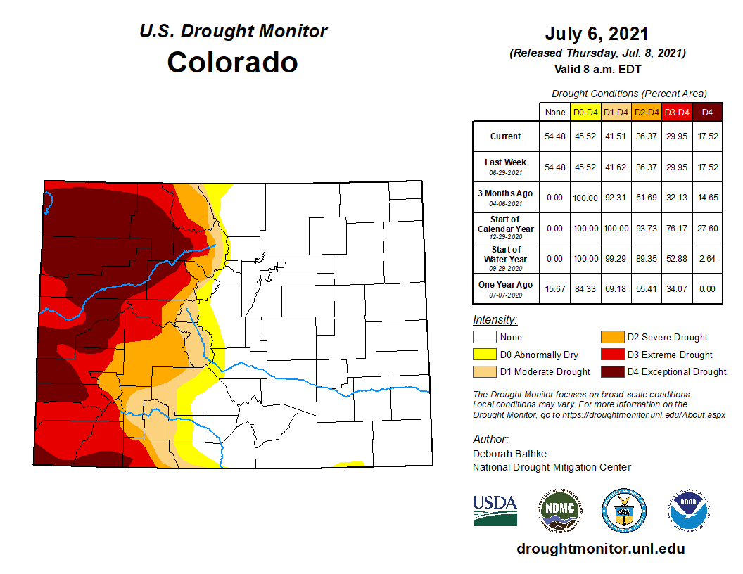
However, drought.gov also states that 36.4-percent of Colorado is under a “severe drought” and 30-percent of the state is under “extreme drought” conditions. The western slope of Colorado is where the majority of these “severe” and “extreme” drought conditions exist. The western slope headwater drainages are the major source of the city’s augmentation water.
As a result of the drought conditions on the western slope, On July 1, a declaration of a drought emergency for Western Colorado by Gov. Jared Polis opened up federal and state dollars to help those most affected by the lack of moisture. As of July 1, the US Drought Monitor lists 18 counties as being in extreme or exceptional drought.
Drought conditions are so bad on the Colorado river, that water storage in Lake Mead is at historic lows. Lake Mead, the largest US reservoir, and fed by the Colorado River — fell below the elevation of 1,075 feet. It has hit that mark only a handful of times since the Hoover Dam was finished in the 1930s, but it always recovered shortly after. It may not this time, at least not anytime soon…
Lake Mead is currently 16 feet below where it was this time last year and the reservoir is only 37-percent full.
The second largest reservoir in the Colorado river basin, Lake Powell, is not faring any better.
Lake Powell is down 35 feet from last year and sits at just 34-percent of the lake’s total capacity…
According to Wiley, “The amount of water in a share varies according to the source. Our shares never get cut off. We always own those shares. It’s the production of those shares (amount per share). The production is controlled by the amount of precipitation and snowpack and then how water rights are allocated. The only thing that happens is in a dry year the yield (amount) is less on those shares.”
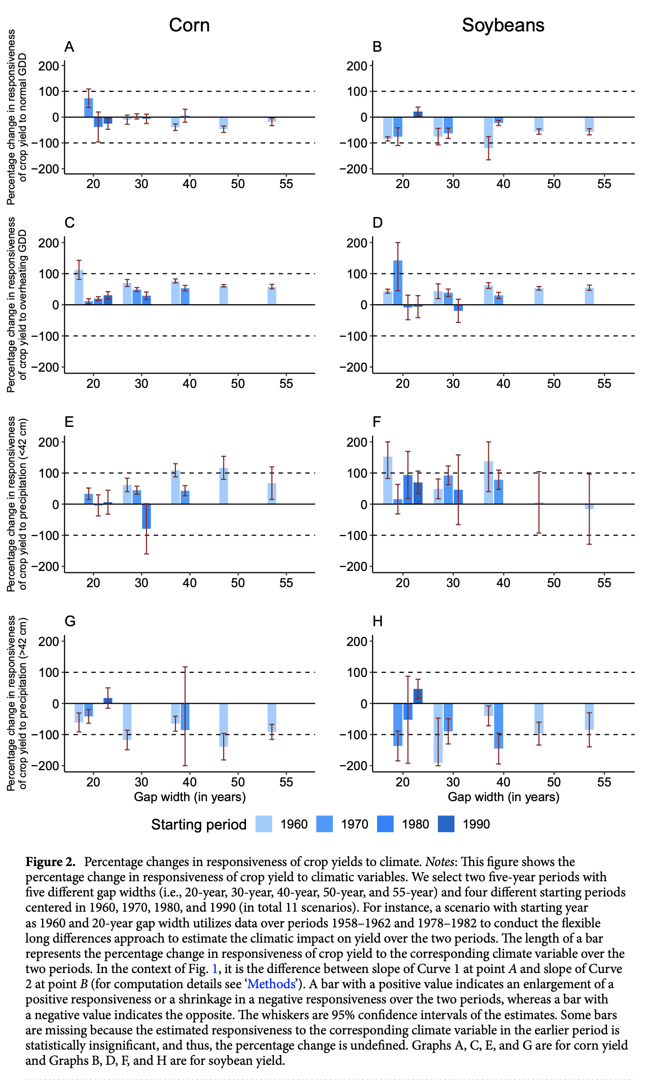
Click here to download the report. Here’s the abstract:
We quantify long-run adaptation of U.S. corn and soybean yields to changes in temperature and precipitation over 1951–2017. Results show that although the two crops became more heat- and drought-tolerant, their productivity under normal temperature and precipitation conditions decreased. Over 1951–2017, heat- and drought-tolerance increased corn and soybean yields by 33% and 20%, whereas maladaptation to normal conditions reduced yields by 41% and 87%, respectively, with large spatial variations in effects. Changes in climate are projected to reduce average corn and soybean yields by 39–68% and 86–92%, respectively, by 2050 relative to 2013–2017 depending on the warming scenario. After incorporating estimated effects of climate-neutral technological advances, the net change in yield ranges from (−)13 to 62% for corn and (−)57 to (−)26% for soybeans in 2050 relative to 2013–2017. Our analysis uncovers the inherent trade-offs and limitations of existing approaches to crop adaptation.
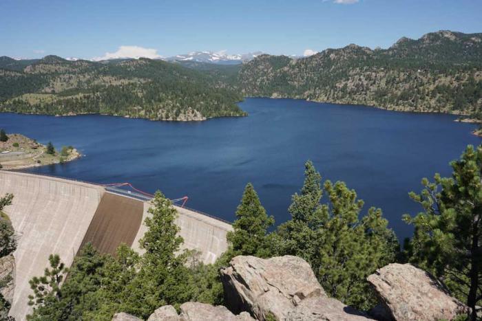
Denver Water is planning to expand Gross Reservoir in Boulder County. The additional storage capacity will create more balance in the utility’s storage and give water planners more flexibility in their operational strategy. Photo credit: Denver Water.
Denver Water today [July 14, 2021] filed a lawsuit in U.S. District Court against Boulder County, asserting the county is overreaching its authority and jeopardizing a federally ordered reservoir expansion critical to a safe and secure water supply for one quarter of the state’s population while risking long-planned benefits for the West Slope environment.
BACKGROUND
For nearly two decades, Denver Water has conducted an exhaustive and comprehensive planning and permitting process at the direction and oversight of six federal and state regulatory agencies. That process culminated last year in a final order to commence expansion of Gross Reservoir from the Federal Energy Regulatory Commission, which has final authority over the expansion project because Gross Reservoir occupies federal lands specifically designated for hydropower production.
For years, Denver Water has also attempted good faith efforts to work with Boulder County to secure county permits, including through two attempts at an intergovernmental agreement, robust engagement with county staff and neighbors, and participation in a local land-use review known as the “1041 process.” Unfortunately, Boulder County has been unreceptive and is using the 1041 process to frustrate the project, extending and delaying its review to the point that it is now placing the entire project at risk.
DENVER WATER STATEMENT ON NEED FOR THE PROJECT
It is hard to overstate the importance of the expansion of Gross Reservoir to the future of the Denver region. It will offer crucial protection to the utility’s water supplies from the urgent threat of catastrophic wildfire and prolonged drought — the same forces that nearly 20 years ago combined to threaten Denver Water’s ability to ensure drinking water to its customers.
This risk to clean water supplies is even higher today, in an era of rapid climate change and increasing periods of extreme weather. Last year’s record wildfire fire season, which generated the three largest forest fires in Colorado history, only just missed triggering major impacts to Denver Water’s supplies. Water providers to the north haven’t been as lucky, unable to treat some supplies running black and brown with ash produced by the Cameron Peak fire. Denver Water must act now to mitigate these risks.
The Gross Reservoir expansion conforms in every way to benchmarks in Colorado’s Water Plan, a plan developed through statewide and bottom-up guidance from eight major river basins over two years and published in 2015. That plan calls for increasing the capacity of existing reservoirs as a key element in creating 400,000 acre-feet of additional storage in the state by 2050.
The State of Colorado, in comments to the U.S. Army Corps of Engineers, expressed its support for the Gross Reservoir expansion and has identified it specifically as fitting within the kind of project defined as necessary in Colorado’s Water Plan: “A significant portion of Colorado’s future needs will be met with the implementation of projects and planning processes that the local water providers are currently pursuing, including the Moffat Collection System Project” (aka Gross Reservoir expansion).
The reservoir expansion also addresses the significant need for additional supplies in the metro region, as referenced in the Water Plan’s 2019 technical update. That update projected metro Denver demand will increase by 134,000 acre-feet to 280,000 acre-feet by 2050 against a 2015 baseline and the area likely will experience a supply shortfall, even accounting for the Gross Reservoir expansion and other water projects, a drop in per-capita use, and further conservation and reuse.
DENVER WATER STATEMENT ON DEVELOPMENT OF THE PROJECT
Denver Water’s diligent and earnest work to build partnerships across the Continental Divide, conduct significant and ongoing environmental mitigation for the project and work closely with regulators since the early 2000s has earned the project the support of major environmental groups, Grand County and each of the last five governors of Colorado. The Colorado Department of Public Health and Environment concluded the project would result in net water quality improvement on both sides of the Continental Divide.
The dam, when built in the 1950s, was designed to be raised. In the 1980s, amid discussion of the Two Forks project southwest of Denver (later vetoed by the EPA) a coalition of environmental groups recommended the expansion of Gross Reservoir as a viable, environmentally stable project. “We feel that additional capacity at Gross Reservoir is an environmentally acceptable and cost-effective way of increasing the overall yield of the system,” the coalition wrote. It included representatives of the Sierra Club, the Environmental Defense Fund and Trout Unlimited, among several other groups.
Denver Water also worked industriously with local governments and citizen groups on the West Slope to address the impacts that putting more water in an expanded Gross Reservoir would have on streams in Grand County. Those talks, often intense, and spanning half a decade, resulted in the Colorado River Cooperative Agreement in 2013, an unprecedented cooperative effort involving 18 signatories and 40 partner organizations that began a new era of collaboration and conflict-resolution between Denver Water and the West Slope.
Expanding Gross Reservoir locks in a key component to that agreement: Denver Water would place a geographic limit on its service area, putting to rest fears the utility would continue to expand its reach to an ever-sprawling suburban ring. The utility also agreed to several measures that would provide more water to West Slope rivers, towns and ski areas and invest in improvements to aquatic habitat. The landmark concord also affirmed that with the Gross Reservoir expansion, Denver Water would benefit from more flexibility in its system, and it would use that flexibility to address stream flow and stream temperature concerns more nimbly and readily in Grand County.
Additionally, Denver Water worked with the cities of Boulder and Lafayette to establish an environmental pool in Gross Reservoir to provide additional water in South Boulder Creek during low-flow periods. Water in that pool would also supplement supplies for those two cities. Many of these commitments, however, depend on the project going forward and are therefore in jeopardy through Boulder County’s actions.
As planning for the expansion moved ahead, the utility undertook a proactive strategy to reduce demand. It deployed a water recycling facility to reduce its dependence on West Slope water supplies, embarked on a conservation program renown nationally for its success — cutting per capita water use by 22% between 2007 and 2016 — and has now undertaken direct efforts at water efficiency that pinpoint savings opportunities at the individual customer level. These are only a sample: The utility remains committed to innovation to drive further savings and expand water reuse as a core part of its strategy, work that will continue to be essential even with an increase in storage at Gross Reservoir.
In short, the effort to build civic and regulatory support for the Gross Reservoir expansion has been persistent, inspired and earnest. The future of the region, its access to clean, safe drinking water, protection of its urban tree canopy and environment, and its economic development rest in large part on the ability of Denver Water to protect water supplies from emerging threats, develop a climate-resilient system and remain prepared for the demands that will result from continued growth within its service area in metro Denver.
DENVER WATER STATEMENT ON BOULDER COUNTY’S PROCESS
Boulder County is endangering the project through delays, repeated and expanding requests for information — information demands that duplicate the already completed federal permitting process in which Boulder County participated — the potential for months of additional hearings and the fact that two of the county’s three commissioners have already publicly stated their opposition to, and desire to stop, the expansion project.
Further, the county’s land use director informed Denver Water on June 29 that the utility — despite over nine months of diligent and painstaking work to respond to Boulder County’s ever-expanding queries — failed to provide sufficient information to county agencies about the project, setting the project up for failure and rendering further involvement with the 1041 process futile.
These actions also put engineering and construction deadlines at risk, threaten to disrupt FERC-ordered timelines and risk other permits and actions necessary for successful completion of the project. A project of this size and complexity requires extensive preplanning, substantial resources and a highly skilled design and construction team. Delays resulting from Boulder County’s refusal to timely process the 1041 application add substantial costs and cause permitting, procurement and logistical issues that seriously disrupt Denver Water’s ability to execute the project.
In summary, the actions of a single local jurisdiction, Boulder County, threaten to derail and undermine a federally permitted and state supported project vital to a safe and secure water supply for one-quarter of Colorado’s population. This presents an unacceptable risk to a critical project spanning nearly 20 years and involving intensive review by environmental agencies at the federal and state levels and the engagement of dozens of organizations and communities across the metro area and the West Slope.
For that reason, Denver Water must seek relief in federal court. The complaint further details Denver Water’s attempts to work with Boulder County, the reasons that federal law preempts Boulder County’s claimed authority over the FERC-licensed expansion project, and the basis for Denver Water’s request that the court prevent Boulder County from further delaying and derailing the project.
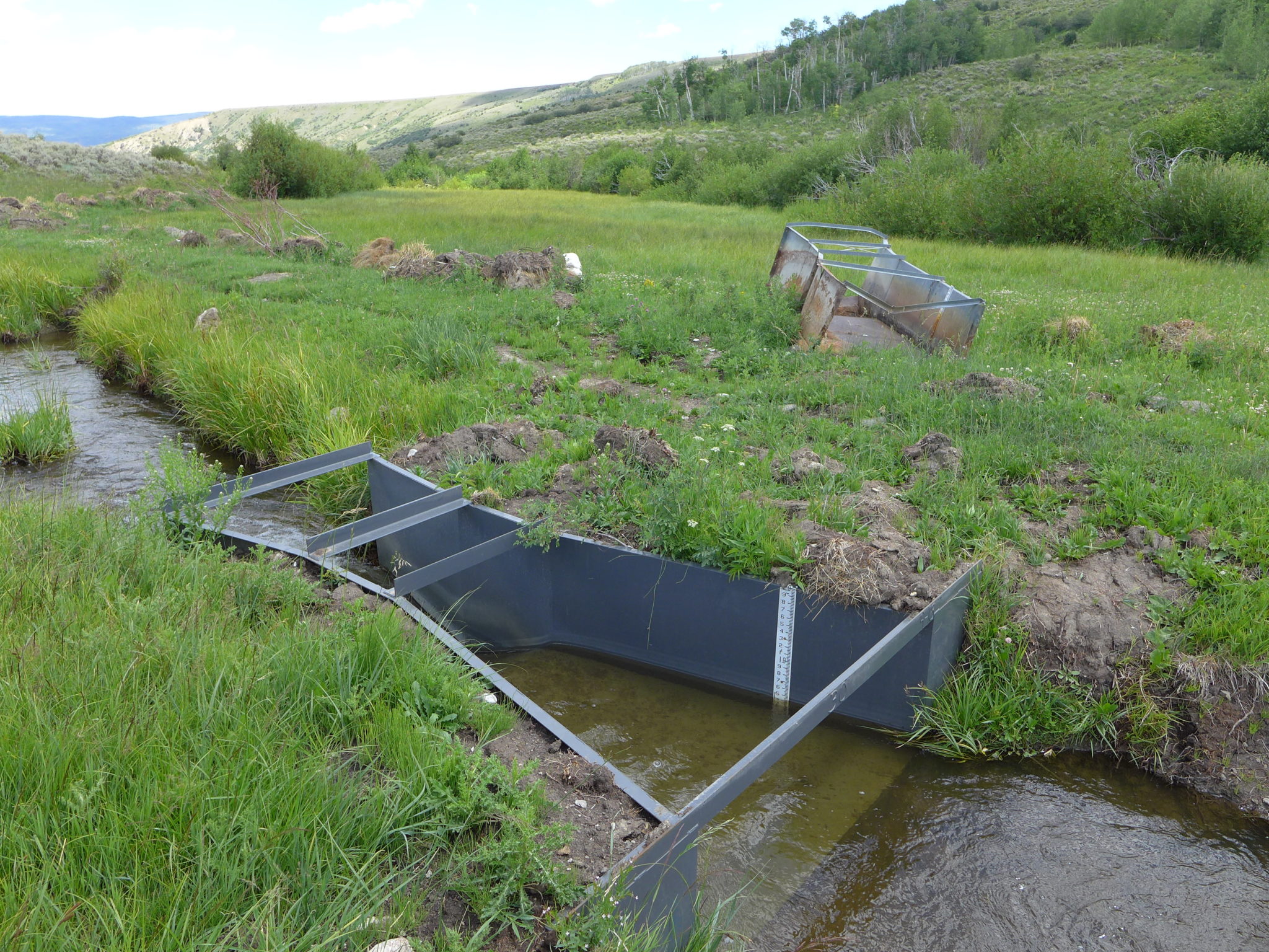
This Parshall flume, which was installed in the Yampa River basin in 2020 and is shown in this August 2020 photo, replaced the old, rusty device in the background. State engineers are developing rules for measuring devices, which would apply to the entire Western Slope. CREDIT: HEATHER SACKETT/ASPEN JOURNALISM
State officials are preparing for a future with less water by developing rules and guidance for water users to measure how much they are taking from streams.
State Engineer with the Colorado Division of Water Resources Kevin Rein is planning a rule-making process on measurement devices that includes stakeholder input. Although state engineers in each water division have the authority to enforce the requirement of measurement devices, Rein said drafting more formal rules through an administrative rule-making process, instead of an ad hoc push like in the Yampa River basin, would affirm that authority. Rules would also include specific technical guidance on the best types of flumes, weirs and meters to use for different types of diversions.
“The idea about rule-making is that we would have consistent guidance across the basin, developed through a formal process,” Rein said. “One thing I’ve found is that when you have stakeholder involvement in the development, then you have stakeholder buy-in during the implementation.”
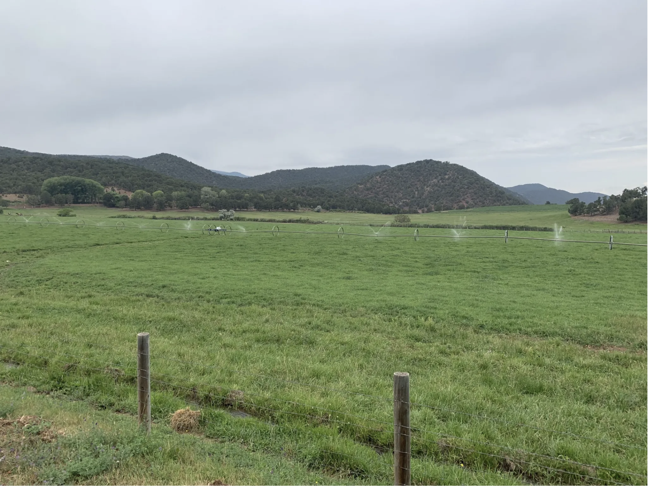
Sprinklers and a ditch irrigate this section of Crystal River Ranch outside of Carbondale on Wednesday. According to state officials, about 95% of diversions in the Crystal and Roaring Fork River basins already have measuring devices. CREDIT: HEATHER SACKETT/ASPEN JOURNALISM
Yampa/White/Green river basin
Division 6 Engineer Erin Light is still taking a lenient stance with water users in the White and Green river basins while the measurement rules are developed. In fall 2019, Light ordered nearly 500 water users in the Yampa River basin to install measuring devices to record their water use and initially received some push-back from agricultural water users unaccustomed to measuring their diversions.
In March 2020, Light issued notices to water users in the White and Green, but decided to delay sending formal orders after the COVID-19 pandemic disrupted the economy. Orders are still on pause while Rein’s office develops the measurement rules, which would apply across the Western Slope.
“It made more sense to wait for the measurement rules to at least get started, maybe not necessarily get completed, but allow Kevin to get out and start doing the stakeholder meetings and encourage these structures to be installed without orders,” Light said.
Compliance is gradually increasing across the basin, but at a slower pace than Light would like. In January 2020, 49% of diversions in the Yampa River basin did not have a measuring device; as of April 2021, 42% were still without one. White River basin compliance has improved from 83% without a measuring device to 68% over the same time period; water users in the Green have gone from 69% to 49%. As a whole, Division 6 has gone from 55% of diversions without measuring devices to 46%.
“I would have hoped that we would have had more compliance at this point,” Light said. “I look at those numbers and think we still have some work in front of us and how are we going to accomplish our goal, which is to assure that all of these structures that we maintain records on have operable headgates and measuring devices.”
In some basins on the Western Slope, nearly all diversions already have measuring devices. For example, in the Roaring Fork and Crystal river basins, about 95% of the structures have devices, according to Colorado Department of Natural Resources Communications Director Chris Arend. That’s because there has traditionally been more demand and competition for water in these basins, he said.
Scott Hummer, water commissioner for District 58 in the Yampa River basin, checks out a recently installed Parshall flume on an irrigation ditch in this August 2020 photo. Compliance with measuring device requirements has been moving more slowly than state engineers would like. CREDIT: HEATHER SACKETT/ASPEN JOURNALISM
Water shortages drive measurement push
The push for Western Slope diverters to measure their water use comes down to impending water shortages. Division 6, in sparsely populated northwest Colorado, has traditionally enjoyed abundant water and few demands, but as climate change tightens its grip on the West, there is less water to go around. Calls by senior water users have gone from unheard of to increasingly common in just the last few years.
“We definitely have systems on call that have never been on call,” Light said of current conditions in the Yampa.
A call occurs when a senior water rights holder is not getting their full amount they are entitled to. They place a call with state engineers, who shut off more junior water rights users so the senior user can get their full amount. Under Colorado’s prior appropriation system, the oldest water rights have first use of the river.
“If you don’t have a measuring device during a call, we are shutting you off, period,” Light said.
As the threat of a Colorado River Compact call and the possibility of a state demand-management program grow, state officials say the need to measure water use grows, too.
A compact call could occur if the upper-basin states — Colorado, Utah, Wyoming and New Mexico — were not able to deliver the 75 million acre-feet of water over 10 years to the lower basin states — California, Arizona and Nevada — as required by the 1922 compact. Colorado water managers desperately want to avoid this scenario, in part because it could trigger mandatory cutbacks for water users.
If a compact call were to play out, measuring devices would be crucial, because as Rein says, you can’t administer what you can’t measure.
“We need to better measure what has been diverted, so having measurement rules and therefore measuring devices in place will be critical to prepare for and implement compact administration, should it happen,” he said.
The state is also currently exploring a potential demand management program, which would temporarily pay irrigators to not irrigate and leave more water in the river. The goal would be to boost water levels in Lake Powell and avoid a compact call. But in order to participate in the voluntary program, feasibility of which is still being evaluated, irrigators need to first measure their water diversions.
“We would have to know how much they were using in the years before, before we can give them credit for not using it,” Rein said.
Sprinklers irrigate this section of Crystal River Ranch outside of Carbondale on July 14, 2021. State engineers are creating rules that will lay out guidelines for water users to install measurement devices for their diversions from the river. CREDIT: HEATHER SACKETT/ASPEN JOURNALISM
Low interest in grant funding
One of the reasons Light originally paused enforcing the measurement device requirement in the White River basin was to give conservancy districts time to secure grant money to help irrigators pay for the potentially expensive infrastructure. But there was not much interest from water users in getting grant money, according to Callie Hendrickson, executive director of the White River & Douglas Creek Conservation Districts.
“We did not proceed with (securing grants),” she said. “We didn’t hear from very many people that they were seeking funding.”
The story was similar on the Yampa. The Upper Yampa Water Conservancy District had a $200,000 pot of money — half of it state grant money and half from the district — to reimburse water users for installing measuring devices. Irrigators can get 50% of their costs covered, up to $5,000 through the first tier of the grant program. According to Public Information and External Affairs Manager Holly Kirkpatrick, despite a very simple application process, the program has doled out just under $40,000 so far for about 20 projects.
“I had certainly hoped to have more interest in the first year of the program,” she said.
As Rein plans for webinars and meetings with water users later this summer and fall, the situation in the Colorado River basin grows more dire. The Bureau of Reclamation this week began emergency releases from Upper Basin reservoirs to prop up levels in Lake Powell to try to maintain the ability to produce hydroelectric power at Glen Canyon Dam.
“I recognize the value in having measurement rules as soon as possible because, yes, they would be extremely helpful if we need to take measures toward compact administration,” Rein said. “Having more data sooner rather than later is important.”
Aspen Journalism covers waters and rivers in collaboration with The Aspen Times. For more, go to http://www.aspenjournalism.org.
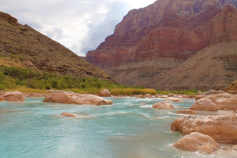
Swim class on the San Juan River. Photo: Brent Gardner-Smith/Aspen Journalism
From the Weminuche Audubon Society (Jean Zirnhelt) via The Pagosa Springs Sun:
The Weminuche Audubon Society invites you to join us for our monthly chapter meeting on Wednesday, July 21, at 6:30 p.m.
The meeting will take place on Zoom and the link may be found on the Events tab of our website, http://www.weminucheaudubon.org.
Water, always an important topic in our area, will be the focus of this month’s meeting. In July, we will learn about the work of the Upper San Juan Watershed Enhancement Partnership (WEP), a local organization working to address the management of this precious resource.
Al Pfister, on behalf of the WEP, will be presenting the results of data collected in Phase II of the WEP’s assessment of the environmental, recreational and agricultural infrastructure needs in the Upper San Juan River. The WEP’s data collection is a part of the implementation of the Colorado Water Plan of 2015 in the development of a Stream Management Plan/Integrated Watershed Management Plan. The WEP’s data collection efforts were done to assess local environmental, recreational and agricultural infrastructure needs in the face of a warming and drying climate.
Pfister is a semi-retired fish and wildlife biologist who has worked in seven western U.S. states dealing with endangered species issues, trying to find a balance between conserving imperiled fish, wildlife, plants, herptiles and invertebrates, while still allowing the various uses (development, recreation, grazing, timber harvest, energy development, etc) to coexist. In addition to his work with WEP, he serves on the board of the Geothermal Greenhouse Partnership and on the board of the San Juan Water Conservancy District. He is a past board member of the Weminuche Audubon Society.
Audubon meetings are open to the public. Please come with your questions about this important management tool. We hope to be able to return to in-person meetings this fall if conditions allow.
The National Integrated Drought Information System (NIDIS) shows 100 percent of Archuleta County is in moderate drought, with almost three-quarters of the county in severe drought and just over the half the county is in extreme drought.
The NIDIS website notes that under a moderate drought stage, dry-land crops may suffer, range- land growth is stunted, very little hay is available and risk of wildfires may increase.
The NIDIS website also notes that 71.17 percent of the county is in a severe drought stage.
According to the NIDIS, under a severe drought stage, fire season is extended.
Additionally, the NIDIS website notes that 51.04 percent of the county is in an extreme drought, mostly in the western portion of the county.
The NIDIS website notes that, under an extreme drought stage, large fires may develop and pasture conditions worsen.
According to the NIDIS, 6.24 percent of the county, in the southwestern portion, is in an exceptional drought stage.
Under an exceptional drought stage, agricultural and recreational losses are large and dust storms and topsoil removal are widespread.
For more information and maps, visit: https://www.drought. gov/states/Colorado/county/ Archuleta.
River report
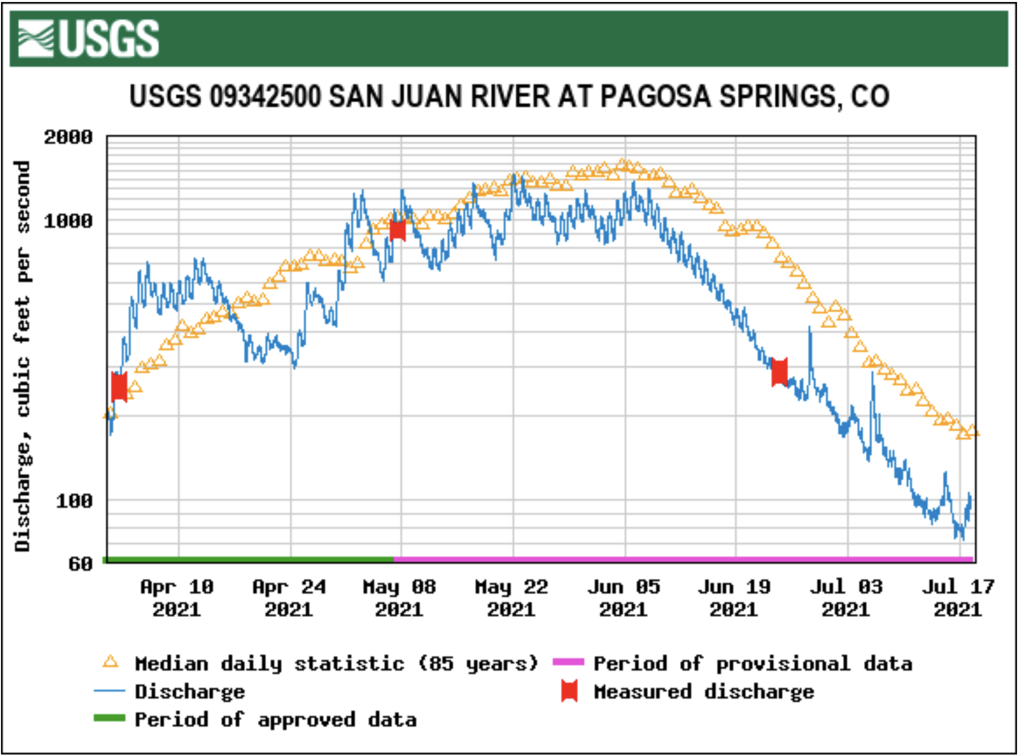
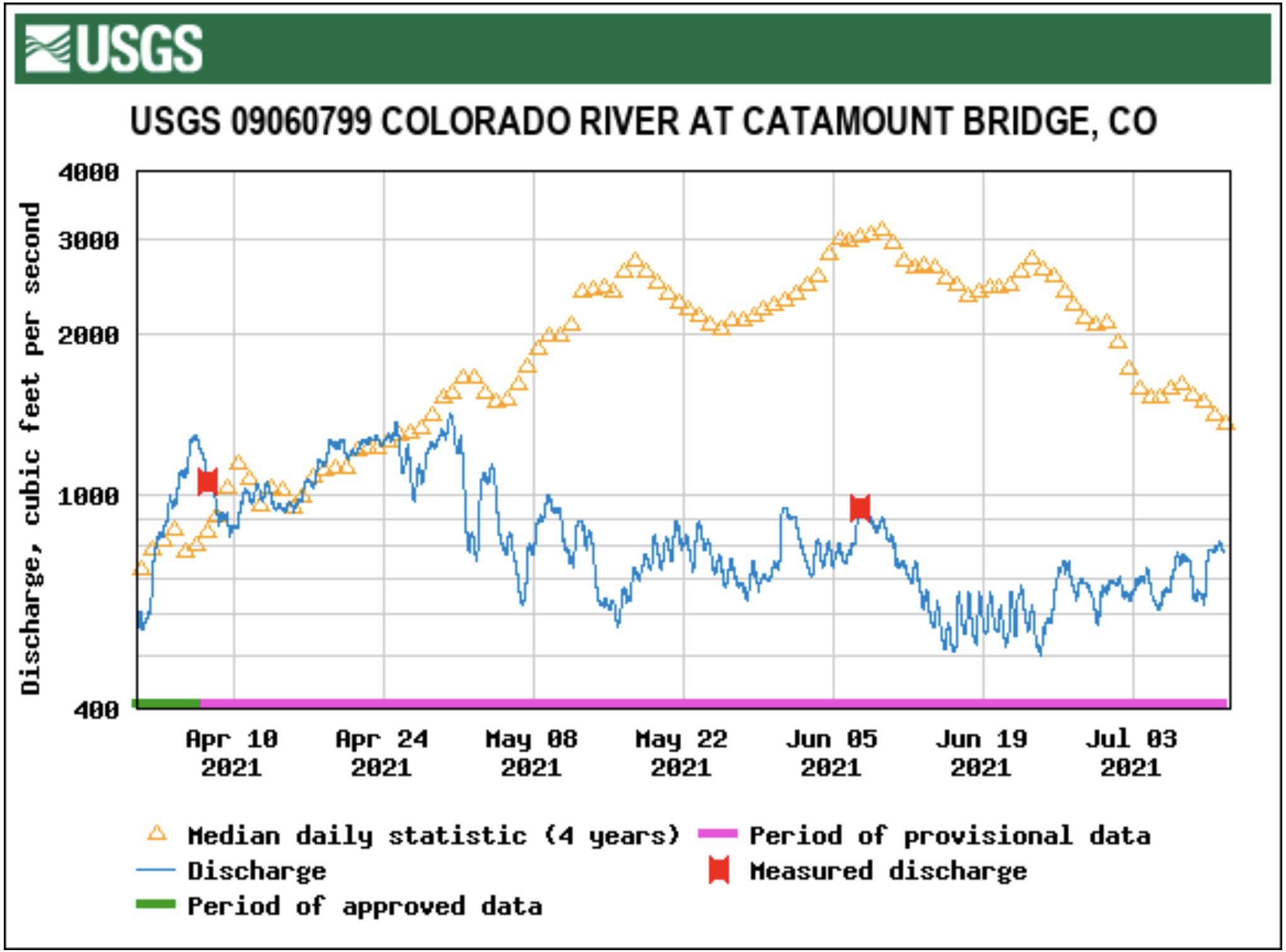
According to the U.S. Geological Survey (USGS), the San Juan River was flowing at a rate of 92.2 cfs in Pagosa Springs as of 11 a.m. on Wednesday, July 14.
Based on 85 years of water records at this site, the average flow rate for this date is 328 cfs.
The highest recorded rate for this date was in 1995 at 1,550 cfs. The lowest recorded rate was 10.9 cfs, recorded in 2002.
As of 11 a.m. on Wednesday, July 14, the Piedra River near Arboles was flowing at a rate of 62.3 cfs.
Based on 58 years of water records at this site, the average flow rate for this date is 266 cfs.
The highest recorded rate for this date was 1,160 cfs in 1979. The lowest recorded rate was 9.44 cfs in 2002.
With federal officials expected to announce a water shortage at Lake Mead next month, this would be an ideal time for Utah officials to kill off that state’s insane plan to divert a huge amount of upstream water to fuel development in the St. George area.
On Thursday, a diverse group of Colorado River stakeholders gathered near Hoover Dam called on Utah to do just that, and pressed for a moratorium on other projects that would divert water from the river.
This wasn’t simply people from other states ganging up on Utah, either. One of the most strident speakers was Zach Frankel from the Utah Rivers Council, who blistered the officials in his state who were backing the pipeline for St. George.
“While the Lower Basin is going on a diet of cutting its water use, we should not allow the Upper Basin to go to an all-you-can-eat buffet of water waste,” Frankel said.
Well put, neighbor.
The Utah pipeline would suck 86,000 acre-feet of water per year from Lake Powell to St. George, where it would be used to grow crops, maintain the grass lawns that are common in the area and to expand development.
Not only is this pipeline unconscionable given the dwindling water supply of lakes Powell and Mead, but the water would be going to a community whose residents are water hogs already. As Frankel pointed out, water usage in Washington County, the home of St. George, averages 306 gallons per person per day — about three times the usage in more water-conscious places like Las Vegas and Phoenix.
Plus, to give some perspective to the amount of water involved in the project, consider that Nevada’s entire annual allotment from Lake Mead is 300,000 acre-feet. (An acre-foot is enough water to cover an acre of ground 1 foot deep, or about 326,000 gallons of water.)
That allotment is all but sure to get a haircut soon, with the looming water shortage declaration by the feds. We’ll lose about 21,000 acre-feet total in mandatory and voluntary cuts. But since Nevada has learned to live with less, we currently use only 256,000 acre-feet per year, meaning we’ll still fall below the 279,000 acre-feet we’ll have after the cutbacks.
Decline of Lake Mead. Graphic credit: Brad Udall via InkStain
Graphic credit: Brad Udall via InkStain
Meanwhile, though, there’s no indication that years of dwindling flow in the Colorado River will reverse themselves anytime soon. To the contrary, long-range forecasts of snowmelt and rain runoff in the Colorado River watershed suggest that what’s happening now shouldn’t be considered a drought but rather a normal condition.
With Lake Mead at just 36% capacity and shrinking, it’s important to note that the Utah pipeline project isn’t the only one of its type. There are more than a dozen proposed dams and diversions upstream of Southern Nevada in the Upper Basin states — Colorado, Utah, Wyoming and New Mexico.
That was another point of emphasis from the group of stakeholders last week at Lake Mead, which included business operators, agricultural interests, Native American advocates and more. They urged all Southwestern states to recognize that their own water projects would affect the entire region and the millions of Americans who rely on the Colorado River.
“No flow, no future,” said Brea Chiodini, tour boat operator and member of the Laughlin-Bullhead City River Flow Committee.
Brad Udall: Here’s the latest version of my 4-Panel plot thru Water Year (Oct-Sep) of 2019 of the #coriver big reservoirs, natural flows, precipitation, and temperature. Data goes back or 1906 (or 1935 for reservoirs.) This updates previous work with @GreatLakesPeck
Putting a moratorium on every current project might be extreme, but at the very least the criteria for approval should be stiffened to reflect the upcoming shortage and the long-term outlook.
One thing is crystal clear, though: The Utah pipeline needs to be shelved. The upcoming water shortage declaration gives officials in the Beehive State an opportunity to terminate the project and save face. If they don’t act on their own, though, it’s a no-brainer that federal officials should put a stake in the heart of this horrible proposal.
It is simply madness that as the Colorado River reaches its lowest levels in recorded history that we’d be proposing a new water diversion upstream,” Frankel said. “At some point, we have to put our foot down and stop this madness.”
Again, a voice of reason from Utah. Frankel’s fellow state residents should listen to him.
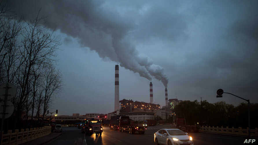
Cars pass the Shanghai Waigaoqiao Power Generator Company coal power plant in Shanghai on March 22, 2016. – Environmental watchdog Greenpeace warned on March 22, 2019 the worlds coal plants are deepening the global water crisis as the water consumed by them can meet the basic needs of one billion people. China, the world’s largest emitter, has promised to reach zero net carbon emissions by 2060. (Photo by JOHANNES EISELE / AFP) via Voice of America
China, the world’s biggest source of greenhouse gas pollution, opened a national carbon emissions trading market on Friday, a long-awaited step aimed at fighting climate change.
The market turns the power to pollute into an allowance that can be bought and sold, and is part of an array of policies that the Chinese government is putting in place as it tries to demonstrate its commitment to significantly reducing carbon dioxide emissions in the coming decades…
These markets work by limiting the amount of carbon dioxide that companies can release, creating competition to encourage them to become more energy efficient and adopt clean technology.
Companies that cut their carbon output can sell their unused pollution allowances; those that exceed their emissions allowance may have to buy more permits or pay fines.
By auctioning allowances and progressively cutting the volume of pollution that companies are allowed to release, governments can push companies into a race to adopt carbon-cutting technologies.
Emissions trading can be a more efficient and flexible tool for cutting emissions than top-down administrative measures, Zhao Yingmin, a Chinese vice minister for the environment, said at a news conference in Beijing on Wednesday.
“It can place responsibility for containing greenhouse gas emissions on businesses, and can also provide an economic incentive mechanism for carbon mitigation,” he said…
To make the market work, regulators must accurately measure emissions from factories and plants, then ensure that those polluters do not cheat by hiding or manipulating emissions data…
But that can be challenging in China, with its sprawling industrial base and relatively poor regulation. A firm from Inner Mongolia, a region of northern China, that is participating in the new market was already fined this month for falsifying carbon emissions data.
The Chinese government initially said the market could cover steel making, cement and other industries, as well as power plants. But it narrowed the scope to cover only coal and gas plants that supply power and heat — a sector that has fewer players and is easier to monitor. Other industries may be brought into the market in coming years…
Even so, China’s coal and gas power sector is so large that the scheme already covers around a tenth of total global carbon dioxide emissions. Some 2,225 power plant operators — many of them subunits of China’s state-owned power conglomerates — were selected to trade on the platform run by the Shanghai Environment and Energy Exchange.
Until now, the biggest carbon emissions market has been Europe’s, followed by one in California. Eventually, these and other emissions trading initiatives may link up, creating a potential global market. For now, though, international investors or financial firms will not be allowed to buy into China’s carbon market…
most experts expect it will take years before China’s program matures into an effective tool for curbing emissions.
Participating power plants have received free pollution permits to get them used to reporting data and trading. The Ministry of Ecology and Environment, which operates the scheme, has said it may introduce auctions for permits later on.
China’s trading program does not put a fixed ceiling on the carbon dioxide that a power producer can release; instead, it sets a limit on the amount of carbon for each unit of power generated. That looser approach means companies face less pressure to cut pollution, at least to begin with.
But the scheme could grow sharper teeth over time, especially if China brings in an emissions cap and steeper fines for exceeding pollution limits.
It’s been said we no longer have fire seasons; we have fire years.
We all remember a year ago when fires ravaged our state and smoke choked the Colorado skies, leading to some of the most unhealthy air quality in the world and making the atmosphere glow red. Many of us remember checking in on friends and family, preparing go-bags in case the unthinkable happened, and watching flames tear through communities and places that had once been peaceful locations for recreation and communal gathering.
The same pattern has begun again.
What might not have been immediately obvious is that those fires have had long-term and damaging impacts on our natural infrastructure — watersheds, rivers, and waterways — hurting native fish populations, sending water quality to dangerously low levels, and weakening local economies. And, before Colorado has even begun to recover from last year’s devastating fire season — which saw the three largest fires in state history — fires have already started this year on the West Slope, forcing evacuations, road closures, and more. The recovery efforts and specter of last year’s blazes are still present as we begin to grapple with another intense and potentially catastrophic year. One bad fire season perpetuates another, and the cycle continues.
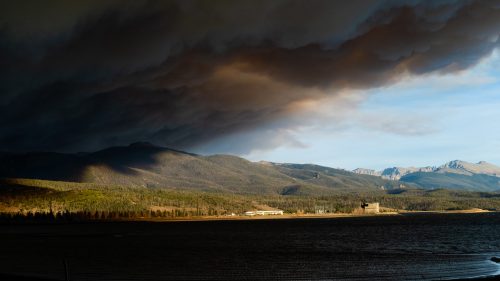
Smoke from the East Troublesome fire looms over Granby Reservoir. Photo credit: Evan Wise via Water for Colorado
Of course, fire is a natural part of a healthy forest ecosystem, and serves an ecological purpose; however, fire severity and frequency has been exacerbated by a combination of historical fire suppression and climate change. Today’s fires behave differently — and more destructively — than the type of fire that’s critical to forests’ ecosystems. This is why drought resilience and preparedness coupled with thoughtful wildfire mitigation and watershed restoration are all essential to prioritize; and why we’re grateful for the upwards of $65 million put towards these issues by the Colorado General Assembly and signed by Governor Polis this year. Moreover, at a recent convening of the Western Governors’ Association, President Joe Biden and Vice President Kamala Harris reinforced the need for — and their support of — greater resilience to climate change, drought, and wildfire. Local, state, and federal lawmakers are increasingly recognizing the urgency of our climate, drought, and fire crises, and understand the urgent need to work together now to address it.
Impacts Far and Wide to Our Rivers and Water
The Grizzly Creek burn scar above Glenwood Canyon and the Colorado River. Photo credit: Ayla Besemer via Water for Colorado
The effects of wildfires go well beyond the local burn scar; they impact entire watersheds and ecosystems, often for years. For example, the recent string of mudslides along the I-70 corridor in Glenwood Canyon and elsewhere throughout the state are the direct result of fire-damaged soil that can’t soak up heavy rains fast enough. The lack of tree root structure combined with dry soil leads to mudslides, causing infrastructure damage and, at its worst, loss of life.
Within streams, rivers, and riparian areas, the debris left behind by fires can impact water quality and fish health. Ash and debris flow into nearby waterways following fires, and often overwhelm water treatment plants, fill reservoirs with sediment, or lead to the need for costly repairs and maintenance. Around 80% of the United States’ freshwater supply flows from forested areas, which means forest fires will leave burn scars, ash, and other contaminants in watersheds, runoff from which will ultimately make its way into water treatment centers that send water to our homes.
In healthy forests, natural infrastructure acts as a filter for sediment and other pollutants that could otherwise wash downstream. In burn scars, where foliage and root systems are either gone or struggling to come back, this nature-based filtration system no longer exists. This puts even more pressure on towns and municipalities to treat contaminated water. (Following the 2002 Hayman Fire over 175,000 trees were planted in the South Platte River watershed to bolster natural infrastructure in the basin. Unfortunately, it wasn’t enough, and the water quality remains below average.)
The Calwood Fire approaches Boulder, CO. Photo credit: Malachi Brooks via Water for Colorado
Fish, too, are dramatically impacted by fires both during and after the acute burn period. When a fire burns near a riverbed, heat causes the water temperatures to rise, oftentimes past the point that fish can reproduce or even survive. Changes to water chemistry during and after fires can cause devastating algal blooms and make the aquatic environment’s pH inhospitable to other life. A scientist studying the aftermath of a fire in alpine lakes discovered that the area’s fish had five times the amount of mercury as fish that weren’t affected by fire. And, the sediment runoff damages fish habitats and hurts the fishes’ ability to feed or reproduce. In 2018, following the 416 Fire, scientists estimated that around 80% of the Animas River’s fish population died off due to flooding and debris.
When fish are impacted by wildfires, the people, industries, and communities that rely on healthy fish populations also suffer. This summer, Colorado Parks and Wildlife asked anglers not to fish along a 120-mile stretch of the Colorado River due to high temperatures, low flows, and sediment runoff from wildfires, all of which are making it more difficult for fish to survive.
Prolonged drought only leads to a greater chance of fire, with dry forests and blistering temperatures. Governor Polis recently declared a State of Emergency in Western Colorado as the area enters its second consecutive year of “exceptional” drought — the highest classification given by the U.S. Drought Monitor — and a long-term megadrought continues to grip the entire Western United States.
What can we do to protect our rivers?
Understanding that fires, rivers, and communities exist within a connected ecosystem is the first step to mitigating the long-term impacts of drought and wildfire. The fires that hurt our towns, agricultural land, and favorite recreation areas also harm our rivers, watersheds, wetlands, and wildlife.
To ensure Colorado is ready to meet the challenges to our rivers and waterways posed by more severe and intense wildfires, we need to:
Work to ensure the Colorado Water Plan 2022 update reflects the need for an inter-connected understanding and management of watersheds, forests, and ecosystems. All of us need clean and reliable water, and for that we need healthy watersheds. Environmental priorities should be considered in every section of the Water Plan, as all other water needs are direct
ly related to water flowing from resilient, healthy, natural systems.
Educate ourselves and our friends, family, and community members about fire safety; and use that knowledge to work conscientiously on our own actions and impacts to reduce the risk of fire in our neighborhood watersheds.
Prioritize funding and continue to urge state, local, and federal lawmakers to increase funding and capacity for wildfire mitigation, prevention, and research and resilience to climate change, ensuring that state programs have the money necessary to develop and implement new strategies to address our ever-expanding wildfire seasons.
Things might seem dire, and they are. We must take action. There are steps we can take right now to reduce the risks wildfires pose to Colorado’s rivers. One such step is visiting the Colorado Water Conservation Board’s website and providing comments on the upcoming 2022 Water Plan update to ensure that environmental needs are met and that the Water Plan treats forests and rivers as the intertwined ecosystem they are.
This need for action and availability of solutions should increase our urgency and inspire us to work diligently towards resilience to climate change to ensure the health of our waters and watersheds now and into the future.
The Calwood Fire approaches Boulder, CO. Photo credit: Malachi Brooks via Water for Colorado
Smoke from the East Troublesome fire looms over Granby Reservoir. Photo credit: Evan Wise via Water for Colorado
Bent lodgepole pine in some areas revealed intensity of the wind. Photo/National Park Service via Big Pivots
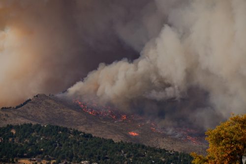
Photo credit: Sylvan Fire Information Facebook page
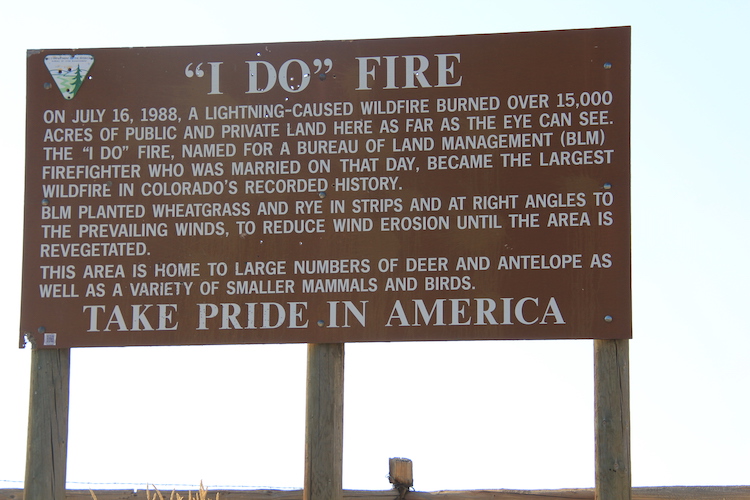
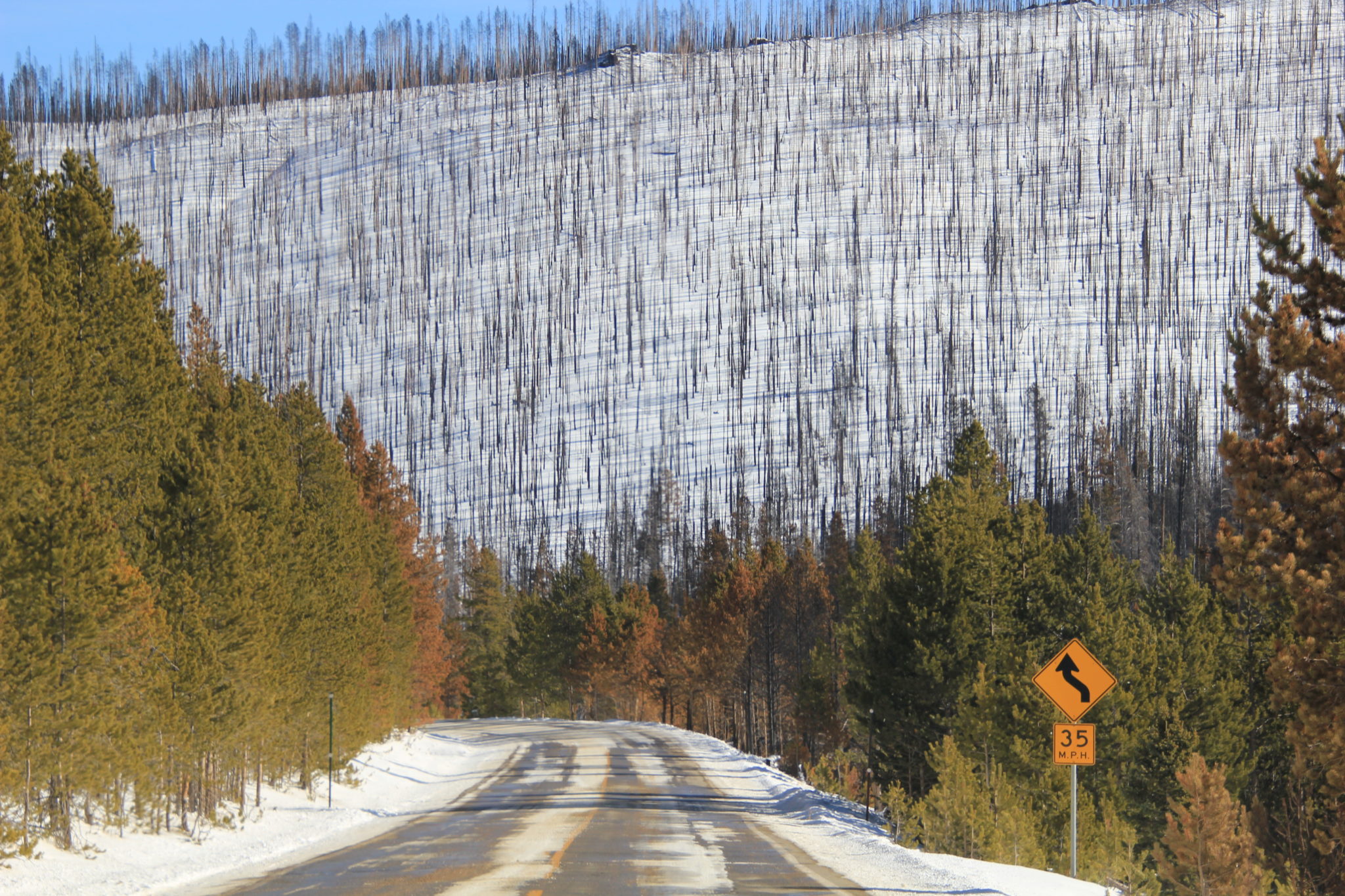
This sign along the highway between Craig and Dinosaur, in northwestern Colorado, tells of a fire in 1988 that burned 15,000 acres, then the most in Colorado’s recorded history. The Cameron Peak Fire in 2020 burned nearly 209,000 acres. Photo credit: Allen Best via Big Pivots
Governor Jared Polis today signed an Executive Order memorializing a verbal disaster declaration from June 23, 2021, for the Muddy Slide Fire in Routt County. The Executive Order enables State agencies to coordinate for fire suppression, response, consequence management, and recovery efforts.
The images that define this drought are etched into the creek beds and hillsides of Summit County, their importance drawn out by experienced eyes that know how the land should look.
For one Summit County rancher whose operations cover vast swaths near Wyoming, the emblem might be the bare creek that’s never run dry this early, or the grass last year that grew so dry and brittle it blew away with the wind.
For a dairyman in Hoytsville, it might be the yellowing field that’s next to a still-green one, the result of hard choices after irrigation water was cut off earlier than in memory.
For a South Summit rancher and water official, it might be the hay they’re harvesting at almost half the yield of what it should be, or the low reservoirs that just keep emptying.
That official, Dave Ure, speaking just after a tour of waterworks facilities in Summit County, put the situation in stark terms.
“We are in the worst drought in the state of Utah’s history right now, and the only thing compared to it is the droughts back in 1895 and 1933,” Ure said.
The Ures have been in South Summit for 135 years. Dave Ure is a former politician and current trustee of the Weber Basin Water Conservancy District, which oversees many of the water sources in Summit County.
Ure said water will still flow from household taps, contending that the situation isn’t close to threatening culinary water, at least for those who are connected to a larger municipal system. Water will be diverted from agriculture users long before that happens, Ure said.
But that doesn’t mean the impacts will be confined to farmers and ranchers. Food prices can be expected to go up, Ure said, and wildfire risk will likely remain elevated. The drought might change the landscape itself, possibly hastening a trend of developing farmland into subdivisions.
Those impacts remain on the horizon, for now, but the impacts on farmers and ranchers are already here…
[Jeff] Young traced the current shortages to last summer. He said the 2019-2020 winter provided good water, but that it stopped raining in June and didn’t start snowing until November. A summer and fall without water was something he hadn’t seen before…
The dryness persisted into the winter, and even though there was a below-average snowpack, the season total was not devastating. But the drought was waiting underneath, with soils as dry as had ever been measured.
Ure said there is normally about 500,000 acre-feet of runoff water in the entire Weber Basin catchment area…
Young said the higher-elevation springs on the ranch are still producing, but that the lower areas are bone dry. He said the drought was already beginning to affect the underground aquifers.
Earlier this season, he went to the creek to fix what he thought was a problem with the water-capturing infrastructure.
“I was naive. I thought I had to fix the diversion, but there was nothing to get,” he said…
The Browns have water stored in a reservoir dug by their ancestors in 1883. But that reservoir was down significantly this year, and once that water is used, their fields will no longer be irrigated.
They won’t be able to grow as much feed for their cattle as they normally can, meaning they’ll have to buy it.
Hay prices have skyrocketed, they said, driven up by the lack of supply as well as the number of people who are in the market for feed.
Mike Brown flipped his phone over and showed a social media post from a friend asking if anyone had hay for sale…
With the drought forcing ranchers across the region to sell off portions of their herds, animals don’t fetch the same prices they once did.
All three said they had or were planning to sell significant portions of their stock.
Mike Brown said he has to call days ahead to reserve an appointment to send animals to slaughter. The packing plants are full, he said.
Liquidating the stock might get the ranchers out of debt, but it might not raise enough capital to restart a ranching or farming operation after the drought passes.
Moving the animals comes with transportation costs and the added challenge of finding areas unaffected by the drought, which stretches across much of the West…
Challenges to come
There aren’t many small ranching operations left in Summit County, Ure and others said, and this drought might just drive them out.
Young said it would likely change who’s in the ranching business, possibly opening the door to larger agriculture operations.
Ranchers could also opt to sell to housing developers…
Farmland that may have been profitable might not be so now, and the real estate market is red hot. Ure said he’d heard of several recent transactions in the Kamas area in which land sold for “outrageous prices.”
Summit County Councilor Chris Robinson, who owns or co-owns hundreds of thousands of acres in Utah and elsewhere, including Ensign Ranches, said one silver lining of what he called the “megadrought” is that it’s putting the appropriate level of scrutiny on water use…
Ure predicted that over the course of the summer, governments would start announcing water-conservation regulations. Some options include reducing the amount of grass installed in new development and incentivizing a switch to drought-resistant landscaping.
Young, Ure and Mike and Glen Brown agreed that if the drought persisted into next year, it would compound the problem to perhaps unmanageable levels.
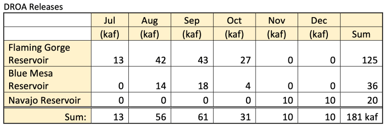
Here’s the release from the Bureau of Reclamation (Patti Aaron):
The Bureau of Reclamation today released the July 24-Month Study, confirming declining hydrologic conditions for the Colorado River system. To protect Lake Powell’s target elevation, the study incorporates the implementation of drought operations under the Upper Basin Drought Response Operations Agreement (DROA).
The July 2021 Operation Plan for Colorado River System Reservoirs 24-Month Study (July 24-Month Study) shows that the Lake Powell water year 2021 predicted unregulated inflow volume has decreased 2.5 million acre-feet in the six-month period between January and July 2021. The current forecast for WY2021 is 3.23 maf (30% of average).
In addition, 5-year projections released by Reclamation last week predicted a 79% chance that Lake Powell would fall below the DROA target elevation of 3,525 feet within the next year. That target elevation provides a 35 vertical-foot buffer designed to minimize the risk of dropping below the minimum power pool elevation of 3,490 feet, and balances the need to protect the infrastructure at Glen Canyon Dam and meet current operational obligations to the Lower Basin States of Arizona, California and Nevada.
Consistent with DROA provisions to protect Lake Powell’s target elevation, the July 24-Month Study includes adjusted releases from the upstream initial units of the Colorado River Storage Project Act to deliver an additional 181 thousand-acre feet of water to Lake Powell by the end of December 2021. The additional releases are anticipated to be implemented on the following schedule:
Upper Basin Drought Response Operations Agreement (DROA) planned releases July 16, 2021. The “Last Flush”. Data credit: USBR
The releases detailed above are in addition to the already established releases determined by operational plans for each of the identified facilities. The additional delivery of 181 kaf is expected to raise Lake Powell’s elevation by approximately three feet. The additional releases from the upstream initial units do not change the annual volume of water released from Lake Powell to Lake Mead in WY2021, as those volumes are determined by the 2007 Interim Guidelines.
Reclamation publishes a 24-Month Study for Colorado River System reservoirs each month. The August 24-Month Study will set the operating conditions for Lake Mead and Lake Powell for the upcoming year. Reclamation will also release an update to the 5-year projections in early September.
Reclamation and the Colorado River Basin states continue to work together cooperatively to closely monitor projections and conditions and are prepared to take additional measures in accordance with the DROA.
Reclamation remains committed to reducing the collective risk of both Lake Powell and Lake Mead falling to critical elevations and will continue to work with entities in the Colorado River Basin to ensure that both facilities continue to function as authorized to meet the natural, municipal and agricultural needs of the basin.
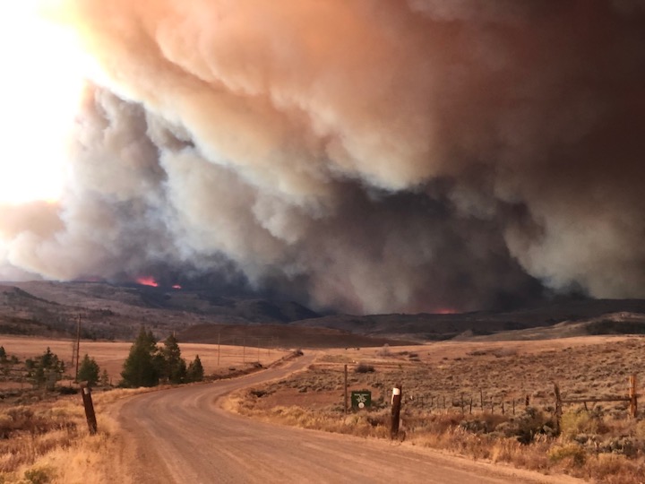
Colorado’s scariest wildfire in 2020 was not its largest. East Troublesome shocked because of its sprint and then its leap. It grew by 87,000 acres in a fiery dash across the headwaters of the Colorado River and past Grand Lake, most of that in just a couple hours. Smoke plumes rose 40,000 feet. The winds, variously estimated at 50 to 100 mph, were strong enough to bend over lodgepole pines.
Then embers vaulted across two miles of treeless tundra at the Continental Divide, raining into the Estes Valley, Red flags early & often
Five red flag warning days had been issued by the National Weather Service in Routt County, reported the Steamboat Pilot in its June 22 issue, compared to 9 in all of 2020.
To the west in Moffat County, 18 red-flag warnings had been issued compared to 25 all of last year.
The Pilot explained that red flag warnings are based on metrics that include humidity, wind, how long conditions are forecast to last and how dry some of the fuels, like grasses, are in an area. When issued, the warnings mean conditions make fires more likely to start and spread at the eastern gate to Rocky Mountain National Park.
Nothing like this had ever occurred in modern Colorado history.
Eight months later, Colorado again had something extraordinary, a record-smashing heat wave in mid-June. Two Colorado towns, Alamosa and Cortez, had six consecutive days of record high temperatures. Leadville, Grand Lake, Dillon, and Del Norte had five straight days of record highs. In Vail, one town employee reported having gone to South Carolina to see a son—and being shocked to find the heat was no worse than that of Eagle County.
It’s not just new temperature records, but the jumps. Grand Junction, for example, shattered an old record by 4 degrees.
In the Pacific Northwest and British Columbia, the margins were even greater. Portland’s all-time high of 107 degrees was obliterated, with a new record of 112 degrees.
More shocking was the heat in British Columbia. “If you were drawing up a list of possible locations for hell on Earth before this week, the small mountain village of Lytton in Canada would probably not have entered your mind,” said the Guardian on July 3. The community of 250 people in the foothills of two mountain ranges registered a high of 121 degrees, surpassing anything ever recorded in Las Vegas and tying the all-time record in Death Valley.
Both phenomena—the East Troublesome Fire and the heat domes of June and early July—are likely manifestations of the warming climate.
It’s going to get worse, warn climate scientists, much worse. Temperatures will rise. Wildfires will become larger, more unpredictable. Welcome to the age of megafires.
In the steps of California
California has been getting megafires and, inevitably, so will Colorado, says Mark Novak, the Vail fire chief. When that happens—most likely in the next 10 to 15 years, he believes—Colorado will look back on East Troublesome and other fires during the shocking 2020 fire season as, well, not so shocking.
“I can’t tell you exactly at what point,” says Novak, “but we will look back and say, ‘Remember when Pine Gulch (a 2020 fire near Grand Junction) and East Troublesome seemed like a really big fire?’”
Before arriving in Vail in 2014, Novak saw a progression during his 30-year career on the West Coast.
“What we’re seeing today in Colorado is very similar to what California was seeing in the early years of the 2000s, from 2003 to 2007,” says Novak. “I believe that in 10 to 15 years we will see the same type of fire that California was seeing in 2017, 2018 and 2020. I think that (East Troublesome) was just the first case of what we will see in the future.”
In November, just weeks after the East Troublesome made its run, Novak told Vail Town Council members their community can someday expect something similar.
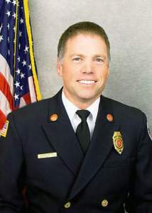
Vail Fire Chief Mike Novak. Photo via Big Pivots
“I am here to tell you that fire burned extremely well and extremely fast through every fuel type,” he said. “It burned literally through aspen groves, it burned through beetle kill, it burned through green stands, it burned through sage (brush). It burned through farmers’ fields that were stubble. This was not necessarily a beetle-kill problem,” he said. “We should not rationalize that this kind of fire would not occur in Vail.”
“You scare me to death every time you speak,” a town council member responded.
Colorado, like California, has been seeing progressively larger fires, but on a different order of magnitude.
As Colorado’s ski areas came of age after World War II, fires were rare. There were fires, such as the one in 1994 west of Glenwood Springs that killed 14 firefighters amid the pinyon and juniper covered hillsides of Storm King Mountain. But in Vail, Aspen, and other headwater communities, wildfires were so distant that little attention was paid to flammability of buildings. In Vail, shake shingles were required. In Summit County, regulations discouraged removal of trees.
Fires in the 21st century have been larger, more frequent, and more destructive.
The year 2002 was a harbinger. A dry winter was followed by a warm and windy spring. In early June, three wildfires broke out almost instantaneously, one of them the Coal Seam Fire in Glenwood Springs. Surveying the state’s forests by planes that first Sunday, Colorado’s governor, Bill Owens, solemnly told reporters, “All of Colorado is on fire.”
The governor was widely ridiculed, but since then most of the state has been on fire. Most damaging were blazes in the foothills along the Front Range urban corridor. The Fourmile Canyon Fire west of Boulder destroyed 172 homes and other structures in 2010, the most destructive wildfire to that time. Then came 2012, hot and dry. High Park Fire killed one person and destroyed 248 homes west of Fort Collins. Days later, the Waldo Canyon Fire killed two people and destroyed 346 homes on the outskirts of Colorado Springs.
Flames have begun to singe Aspen, Vail, and other ski towns. In 2018, the Lake Christine Fire in the El Jebel-Basalt area incinerated 12,588 acres and nearly shut down electrical deliveries to Aspen during the Fourth of July weekend. Another fire, Grizzly Creek, shut down Interstate 70 in Glenwood Canyon for almost six weeks in 2020.
Fires covered fewer than 100,000 acres during the decade of the 1970s. Just last year, 650,000 acres burned in Colorado (and another 176,000-acre fire burned in a border-straddling fire that was mostly in Wyoming).
California covers a third n more ground than Colorado. But the area burned last year, 4.4 million acres, was six times that of Colorado.
Vail’s Novak began his career fighting fires in the San Diego area in 1984. At the time, fires of 5,000 to 10,000 acres were considered large.
In 1990, he relocated to the Lake Tahoe Basin, on the California-Nevada border. The year 2007 was a pivotal one. One of the houses he had grown up in Southern California burned. At Tahoe, a major fire called Angora burned 250 houses within four hours. One of his children’s teachers lost her home, as did firefighters and police officers. Wildfire, more than before, had become personal to Novak.
Angora provoked a shift in attitudes in the Tahoe Basin. Forest thinning, which had been adamantly opposed, became more accepted. That fire now doesn’t make California’s top lists based on size, destruction, or deaths. The largest to date was 2020’s August Complex Fire, which covered more than a million acres, followed by the Mendocino Complex Fire of July 2018 that burned 459,000 acres. Deadliest was later that year. The Camp inferno killed 88 people at Paradise. Many others have killed 10, 15, or 25 at a time.
Hot and dry, off the charts
Fire in Colorado’s Rockies, as in California’s Sierra Nevada, has always been a part of forest ecosystems.
The frequency varies depending upon vegetation. In the foothills above the Front Range urban corridor, forests of Ponderosa pine and Douglas fir evolved with low-intensity, fast-moving fires that occurred every few decades.
On the Western Slope, in places like Aspen and Vail, the fires have historically occurred every 120 to 250 years. Frequency increases in the lower-elevation pinyon and juniper forests. Intervals in the higher-elevation spruce and fir forests lengthen to 400 years or more.
This sign along the highway between Craig and Dinosaur, in northwestern Colorado, tells of a fire in 1988 that burned 15,000 acres, then the most in Colorado’s recorded history. The Cameron Peak Fire in 2020 burned nearly 209,000 acres. Photo credit: Allen Best via Big Pivots
Fires are natural. Even big fires are natural, as charcoal collected from the mud of lakes and the scars of trees demonstrate. What we see now is not natural.
It begins with rising temperatures. The Colorado River Basin—including Aspen and Vail and the location of the East Troublesome Fire—have warmed 2 degrees Fahrenheit since 2000 as compared to the 20th century average. This, according to a report by Western Water Assessment, is likely warmer than at any time in the past 2,000 years.
A 2009 paper by Connie Woodhouse, of the Laboratory of Tree-Ring Research at the University of Arizona in Tucson, and others, compared the 21st century warming with a notably warm period of 1,000 years ago. During that period from 900 to 1300 AD, the Northern Hemisphere was warmer than all but the most recent decades. Drought was a companion. The worst 10-year period was 1146 to 1155. That, perhaps not incidentally, was about the time the ancestral Pueblo – as the Anasazi are now more commonly called—began emigrating from the Four Corners area.
Mike Metcalf, an archaeologist based in Eagle, takes the long view. His work has examined human habitation of Colorado and other Western states since the glaciers rapidly retreated 13,500 years ago. “Somebody who has studied climate tends to be skeptical of simplistic explanations,” he says. “There are so many things, so many variables that control climate.”
But the warming and consequent aridification of the last few decades defy conventional explanations. “The amount of drought in the West is off the charts,” says Metcalf.
A study published in 2020 in the journal Science concluded that climate change has made drought conditions 46% worse between 2000 and 2018.
Drought, as conventionally understood, no longer serves a useful purpose in describing what is being measured. Instead, some are using the word “aridification.” The effect can be seen in the reduced runoffs of the Colorado River into Lake Powell. The river flowed 543,000 acre-feet this year, compared to the May average of 2.34 million acre-feet since Glen Canyon Dam was completed in 1966. In 2020, the winter snowpack was actually pretty good, but the runoff was subpar. This year, with drying soils sopping up more amounts of moisture, the fast-falling levels in the giant reservoirs in Utah, Arizona, and Nevada have become a national story. As Metcalf points out, the trends just keep accelerating.
Now comes new evidence that high-elevation forests in Colorado since 2000 have burned at a rate greater than at any time in the past 2,000 years. To draw this conclusion, the University of Montana’s Philip Higuera, a fire ecologist, and two colleagues waded into the work of paleoecologists who had plumbed the depths of 20 lakes to document the fire history.
Twelve of the lakes were in the Park Range near Steamboat Springs. Others lakes were on the southeast side of Rocky Mountain National Park, near Estes Park.
Comparing the fire record of recent years with that 2,000-year history, Higuera and his co-authors, the University of Wyoming’s Bryan Shuman and University of Montana doctoral candidate Kyra Wolf, came up with a startling conclusion: The frequency of fire in high-elevation forest has shrunk from once every 230 years on average in the last two millennia to about 120 years during the current century.
Warm, dry conditions provide the overarching cause of increased burning in high-elevation forests.
“It isn’t unexpected to have more fire as temperatures rise,” said Wolf, the co-author. “Our records show that fire tracked past variations in climate just as it does today. What’s striking is that temperatures and correspondingly fire are now exceeding the range that these forests have coped with for thousands of years—largely as a result of human-caused climate change.”
This wasn’t necessarily unexpected, although the timing may be. For decades, scientists have predicted that climate warming will increase wildfire activity in high-elevation forests beyond the historical range of experience, said Higuera—who spoke in March at a session sponsored by Carbondale’s Wilderness Workshop.
“It’s sobering to see that it’s clearly happening, and early in the 21st century—not in 2050, not in 2075, but in 2020,” he said.
Very limited tool box
We don’t know exactly how hot it will get. That’s partly because we don’t know whether the atmospheric pollution can be bent down. The rate of accumulating carbon dioxide, the most common greenhouse gas, has not abated in the 21st century even as the science around the risk has solidified.
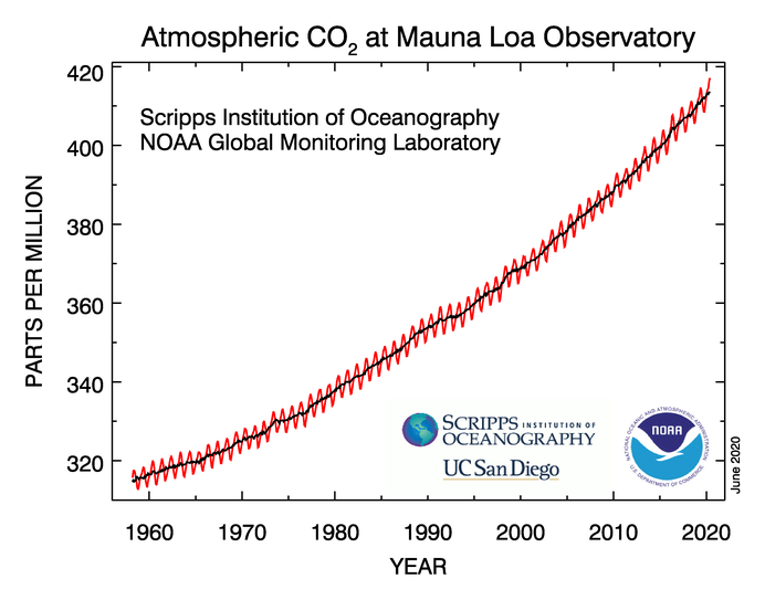
The carbon dioxide data on Mauna Loa constitute the longest record of direct measurements of carbon dioxide in the atmosphere. C. David Keeling of the Scripps Institution of Oceanography began measurements in 1958 at the NOAA weather station. NOAA started its own CO2 measurements in May of 1974, and they have run in parallel with those made by Scripps since then. Credit: NOAA and Scripps Institution of Oceanography.
We’re polluting the sky as if there were no tomorrow. The observatory located at an elevation of 11,135 feet at Hawaii’s Mauna Loa has documented the pollution of carbon dioxide. CO2 levels in 1958 stood at 320 parts per million, a relatively modest increase from pre-industrial times. In 2013 the levels surpassed 400 ppm This year its hit 420.
Staying in this fast lane, what temperatures will that produce in Aspen, Vail, and other ski towns in Colorado? A study expected to be issued later in July will paint a more definitive picture of that future heating in headwater communities.
A 2016 study along the northern Front Range by the Rocky Mountain Climate Organization delivers a glimpse of that hotter future. Fourteen days with temperatures greater than 80 degrees were recorded during the late 20th century at a site in the foothills west of Boulder comparable in elevation to Aspen and Vail. This is projected to more than double in the next decade or two. By the time today’s toddlers reach retirement age, there will be 100 days.
“We will be hotter and we will be drier,” says Stephen Saunders, a former undersecretary in the Department of the Interior who was the lead author of that study. “If you have increased temperature and the same amount of precipitation, you will indeed be drier.”
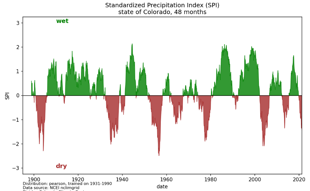
Graphic credit: Russ Schumacher via Big Pivots
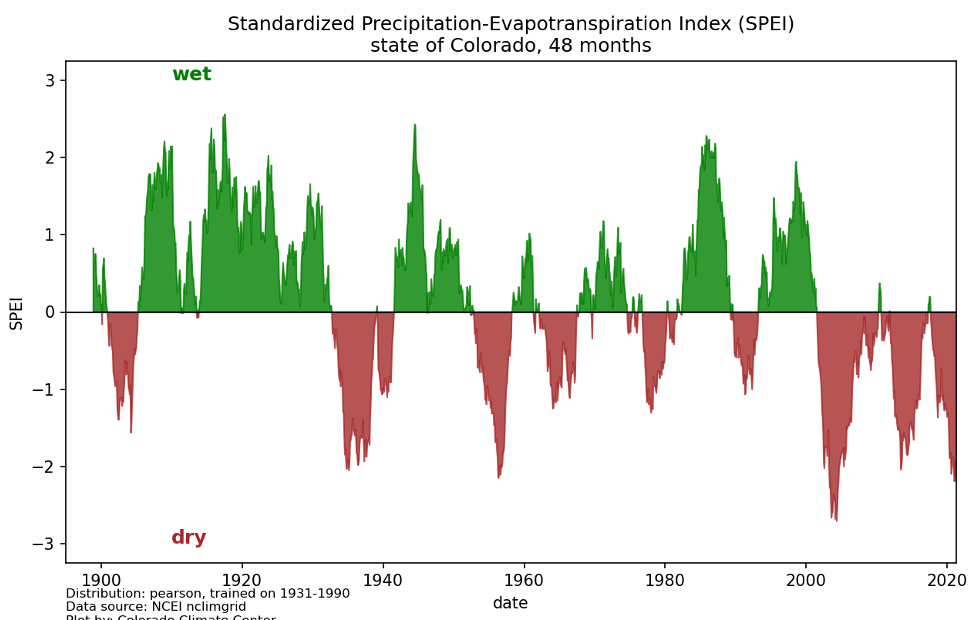
That observation was demonstrated last week in a PowerPoint presentation by Russ Schumacher, the Colorado state climatologist. The first slide shows standardized precipitation index for Colorado since 1900. There are periods of wet and periods of dry—including during the 21st century. But the standardized evaporation-transpiration chart—transpiration is what a plant “exhales” in response to heat—tells a very different story during the 21st century. There are no peaks in the 21st century; only valleys of drought. The warming atmosphere is absorbing moisture from the ground and from vegetation.
Graphic credit: Russ Schumacher via Big Pivots
Measurements conducted by federal agencies at the Garfield County Airport in Rifle, on Hardscrabble Mountain near Eagle and in Summit County bear this out. One measure of the dryness, called the thousand-hour test, showed the moisture content in wood on Hardscrabble dropping from 12% on June 1 to just 8% at mid-month. “From a wildfire behavior standpoint, you don’t necessarily like to see 8%,” said Ryan Hughes, a fuels specialist for the U.S. Forest Service. Five days later after that measurement, the Sylvan Lake Fire broke out south of Eagle.
Tom Veblen, now a professor emeritus of forest ecology at the University of Colorado Boulder, has studied wildfires in Colorado from almost every angle: tree rings, lake deposits, journals of explorers and 19th century newspaper accounts. We know 1847 was a fiery year, and so was 1851.
Also 1879, the year that Vail’s Back Bowls became mostly treeless, the result supposedly of “spite” fires set by Ute Indians, although the evidence is lacking, he says. It was a dry year, the only time fires in high-elevation forests spread, and fires and prospectors were everywhere—including, at that point, in the hamlet that soon became Aspen.
What annoys Veblen most is the phrase “healthy forests.” The metaphor, contained in the title of a 2004 federal law and also a 2021 Colorado law, powerfully draws on an analogy to human health. It also misleads in the context of high-elevation forests, says Veblen, and it was misused, he says, to characterize the East Troublesome Fire.
Areas covered by East Troublesome included large swaths of trees killed by bark beetles during an epidemic of the last 25 years. If bark beetles always have been in a fandango with forests, they came on particularly strong with rising temperatures and drought in the 21st century. The argument has been made that those trees killed by beetles need to be removed, to abate fire danger. Scientific studies in the last decade don’t leave that idea standing. One of them, by Hart and colleagues in 2015, found that prior beetle kill is not causing an increase in the extent or severity of fires of Western states.
“The fuels are the needles,” explains Veblen. “Once needles turn (red) and fall to the ground, to the forest floor, we actually have a decline in the ability of fires to spread through the crowns, through the canopy of the forest,” he says.
“What we are seeing is an increase in fire, yes, and an increase in bark beetle activity, both of which are driven by climate change, both driven by warmer conditions.
“Within the research community and also within the fire management community over the last 5 to 10 years there has been a greater realization how all of those changes are being driven by climate change,” he says. “But there is still a tendency to hold onto some of the old narrative.”
Thinning of forests, he says, has little value except in areas adjacent to communities and structures. “The people in the fire mitigation business are very motivated to use the tools they have, but those tools are very, very limited.”
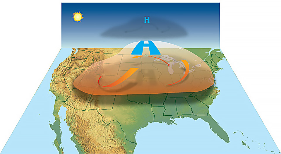
High-pressure circulation in the atmosphere acts like a dome or cap, trapping heat at the surface and favoring the formation of a heat wave. Graphic credit: NOAA
Heat domes and climate change
There’s no escaping the rising temperatures. If the atmospheric emissions ended tomorrow, temperatures will continue rising for decades. “That is baked into our system,” says Veblen.
“It’s just going to get hotter,” says Brad Udall, a climate scientist at Colorado State University who has conducted ground-breaking research on aridification of the Colorado River Basin. His 2016 study with Jonathan Overpeck found that roughly half of the “drought” could be attributed to rising temperatures. “You ain’t seen nothing yet.”
Colorado was hot last August when the Cameron Peak Fire broke out in the Medicine Bow Range, north of Rocky Mountain National Park. Another fire, the Williams Fork, broke out about the same time in the area north of the Eisenhower Tunnel. For a time, those in Winter Park and Fraser worried that the fire might sweep across the Vasquez Range and make a run on their communities.
Another heat wave engulfed Colorado last September, if nowhere near as intense as those of June, either in the Southwest or in the Pacific Northwest.
Stark scenes like this were abundant for those who traveled through the East Troublesome burn area on Christmas Day. Photo/Allen Best
“Increasing frequency and intensity of heat waves are where probably the most robust connection exists between a warming climate and extreme weather,” says Schumacher, the state climatologist. “Numerous studies of heat waves in different parts of the world have shown that they have become much more likely. It takes a particular weather pattern to set up for something like this to happen (in this case, the very strong high pressure or heat dome), but all indications are that these situations are made more likely by climate change.”
Writing in the New York Times last week, former Roaring Fork Valley resident Susan Joy Hassol made the same point in an essay co-authored with climate scientist Michael Mann. “Record-breaking hot months are occurring five times more often than would be expected without global warming,” they wrote.
In Colorado, this shift seems to be playing out by extending the “hot season,” says Schumacher.
The East Troublesome fits in with that pattern of lengthening wildfire season, 75 days longer than in the 1970s. It broke out on Oct. 14, the last day of the first rifle-hunting season. It spread somewhat slowly from a remote area between Kremmling and Grand Lake for almost a week. Then, on Oct. 20, came the winds, hot and fast, by some estimates 100 mph. It’s likely a miracle that only two lives were lost that evening, those of two elderly people who had chosen to shelter in place.
“When you get fire behavior like that, there’s not a whole lot you can do to stop it,” said one firefighter. “That’s equivalent to trying to do something with a Category 5 hurricane.”
The wind and the heat picked up twigs and needles and lofted them across the Continental Divide. Grand Lake, at the west entrance, escaped serious damage, likely the result of mitigation work done over the last decade. But lodgepole pine near the entrance to the national park just a few miles away testify to the heat and the winds, drooping like spaghetti.
Bent lodgepole pine in some areas revealed intensity of the wind. Photo/National Park Service via Big Pivots
Estes Park itself appeared sure to go up in flames as both the Troublesome and Cameron Peak fires approached. Sharon Brubaker, among the 6,700 residents of the community, didn’t wait to find out. She loaded her 2-year-old grandson into her car and fled, despite fears of another threat: covid. “It was a gut reaction,” said Brubaker. “I looked at the sky and I knew that I needed to get out of here.”
Novak, the fire chief in Vail, had been working the Cameron Peak Fire, helping defend homes. When the flames came roaring at them, they abandoned the effort. That, he says, is the philosophy of firefighters in Vail and elsewhere. They will prep and leave, not stay and defend.
Later, talking to his town council, Novak emphasized that Vail could easily see the same congruence of weather that caused East Troublesome’s extreme fire behavior. A fire starting in Eagle or Gypsum could roar up the valley through Vail and across Vail Pass into Summit County. That’s what happens in megafires—or a gigafire, as California’s first million-acre fire has been called.
Paul Cada helped protect the YMCA of the Rockies near Estes Park as the East Troublesome fire roared in. “I saw what extreme fire looks like when it was coming into Estes Park,” he says.
Since 2014, Cada has worked in Vail as the town’s wildland program manager. It has been his job very fundamentally to prepare Vail for fire.
Vail, like other mountain communities, has evolved what it considers a mountain aesthetic. Wooden shake shingles, long a manifestation of that aesthetic, were banned on new housing in 2007. In 2020, the town adopted a new wildfire plan. Newer building codes require masonry exteriors and frown on decks that could be ignited by embers thrown from a mile away, as occurred in East Troublesome.
Vail’s Paul Cada and attainable housing built to resist wildfires. Photo/Allen Best
Some changes have been painful, facing opposition. One of them significantly discourages use of vegetation amid houses, rows of trees—that might catch on fire. Houses need strong fire-resistant berths of 30 to 60 feet.
A former Forest Service ranger likened Vail’s response at one time of wanting to fire-proof the forest so that houses could be put amid the trees. Now, there’s a new approach—one that doesn’t totally preclude fire, but can improve the odds.
“You don’t necessarily have to control extreme fire behavior to prevent significant loss to a community,” he says. “What you do need to do is prepare the community for that, and that’s really the approach we are taking in Vail. We are not necessarily able to stop or even control the extreme fire behavior that we will likely see one day. It’s about making sure our community is prepared to respond to it when it happens but also be able to bounce back as quickly as possible.”
Vail has been aggressively trying to reduce fire risk along its flanks as well as in its subdivisions. Even so, both Cada and Nowak emphasize the limits of their work. It will not preclude extreme fires. The right combination of hot days and drought —well, that’s when megafires happen.
Jerry Fedrizzi and his wife, Jan, have taken the onus of personal responsibility to heart. They grew up in Glenwood Springs, have lived in Eagle since 1968, but have a cabin at about 8,300-foot elevation above Glenwood Springs. The days of 30 below in Eagle have become distant memories, he said on a hot June day while describing his continued work to remove vegetation from around their cabin. A fire official who studied their work gave them a 90% favorable rating, he reported proudly.
The temperature in Eagle was predicted to hit 97 degrees the next day, an unprecedented mark, and the wind was “just awful,” he said.
Not one prone to despair, Fedrizzi was nonetheless troubled. “It’s grim,” he said, “and I don’t know what will happen in the next 10 to 20 years.”
A slightly different version of this story was published in The Aspen Times Weekly. Also in the e-journal were these stories:
6 of 8 hottest years in Colorado since 2012
Six of the eight warmest years in Colorado’s historical record have occurred since 2012.
“What we would have thought as a warm summer 75 years ago is now considered a cool summer in Colorado,” said Russ Schumacher, the Colorado state climatologist, on a webinar sponsored by the AAAS Colorado Local Science Engagement Network.
That temperature increase has quite a bit of impact on water volume, he said.
And warming will continue.
“We have high confidence that (warming) will continue if greenhouse gas emissions continue that course that we are on.” It’s just a question of how much,” he added.
Laurna Kaatz, the climate scientist at Denver Water, made the same point. She described the East Troublesome Fire as having “all the hallmarks of climate change.”
Will forests come back as before?
We have more higher temperatures and more wildfires. What will this mean in the future?
At least in the foothills along the southern Front Range, that’s likely to result in fewer trees. A 2020 University of Colorado Boulder-led study of 22 burned areas dominated by Ponderosa pine and Douglas fir found that they failed to bounce back as compared to regions burned 100 years prior.
“This study and others clearly show that resilience of our forests to fire has declined significantly under warmer, drier conditions,” said Thomas Veblen, now a professor emeritus of forest ecology and a study co-author.
Conclusions of that study do not directly apply to higher-elevation forests such as those found in around Aspen, Vail, and Steamboat Springs—except in this regard: “We can expect to have an increase in fire continue for the foreseeable future,” Veblen said.
Red flags early & often
Five red flag warning days had been issued by the National Weather Service in Routt County, reported the Steamboat Pilot in its June 22 issue, compared to 9 in all of 2020.
To the west in Moffat County, 18 red-flag warnings had been issued compared to 25 all of last year.
The Pilot explained that red flag warnings are based on metrics that include humidity, wind, how long conditions are forecast to last and how dry some of the fuels, like grasses, are in an area. When issued, the warnings mean conditions make fires more likely to start and spread.
Pipes are laid for the Navajo-Gallup Water Supply Project on the Navajo Nation. Photo credit: Northwest New Mexico Council of Governments via The High Country News
Completion of the Navajo-Gallup Water Supply Project is expected to move back a few years since the project intends to use facilities at the San Juan Generating Station for its future water delivery.
Members of a state legislative committee were told this week by a U.S. Bureau of Reclamation official that the bureau decided to use the existing system that intakes water from the San Juan River to help deliver water to the Navajo Nation and the City of Gallup once the pipeline is completed and operational.
Pat Page, manager of the Bureau’s Four Corners Construction Office, explained that among the apparatuses that will be acquired are the diversion dam, pumping plant and reservoir.
The tribe is the primary beneficiary of the project through its water settlement for the San Juan River Basin in New Mexico. The project will also serve Gallup and the Jicarilla Apache Nation – through a separate lateral…
Extension of the project’s completion date from 2024 to 2029 is due to upgrades of existing structures and construction at the site, he explained.
However, it is also viewed as a cost savings because the original plan was to build a new diversion system off an irrigation cancel downstream, Page added.
The bureau is continuing negotiations to acquire the facilities from the power plant’s owners.
San Juan Generating Station. Photo credit: Jonathan Thompson
FromThe Grand Junction Daily Sentinel (Dennis Webb):
Monsoonal moisture in the area this week is helping take the edge off the drought, however so slightly, but also is creating concerns about flash flooding in areas, including the Pine Gulch Fire burn scar north of Grand Junction.
The National Weather Service recorded 0.12 inches of rain Tuesday at the official recording station at the Grand Junction Regional Airport. Jeff Colton, a warning coordination meteorologist for the weather service, said other moisture readings for the day were spotty around the region, ranging from just a trace in Fruita and a tenth of an inch in Palisade to more than a half-inch in Orchard Mesa…
RIVER IMPACTS
Cody Moser, a hydrologist with the Colorado Basin River Forecast Center, said during a conference call with reservoir operators, local irrigation entities and others Wednesday that Tuesday’s precipitation in the region was heaviest in the Roaring Fork Valley…
Colton said the recent moisture is occurring after a strong high-pressure ridge that had brought hot temperatures to the region broke down, allowing monsoon moisture to come up from the south…
The pulses of monsoonal moisture are becoming a bit more frequent, which Colton said is providing hope for Colorado and some other area states in the grip of drought.
STILL BEHIND ON RAIN
Grand Junction had received just 0.14 inches of rain at the airport all month through Tuesday, and just 2.28 inches of precipitation all year, compared to 4.37 inches through the same date in a normal year.
Still, Colton said this summer is starting to feel like the old days, with an active monsoon season developing. The region saw little monsoonal moisture the last few years…
He said the moisture is slowing down fire activity in the state, but has been kind of hit or miss. Northwest Colorado didn’t get as much rainfall Tuesday, and the most critical burn conditions in the region remain there, he said. The Morgan Creek Fire outside Steamboat Springs had burned more than 3,800 acres as of Wednesday, but officials there said Wednesday that precipitation was helping to temper the blaze.
Click on a thumbnail graphic to view a gallery of drought data from the US Drought Monitor website.
US Drought Monitor map July 13, 2021.
West Drought Monitor map July 13, 2021.
High Plains Drought Monitor map July 13, 2021.
Colorado Drought Monitor map July 13, 2021.
Click here to go to the US Drought Monitor website. Here’s an excerpt:
This Week’s Drought Summary
The U.S. experienced the extremes this week, with expansion of drought in the West, a robust Southwest Monsoon in the Southwest, a tropical storm making landfall in the Southeast, and extreme flooding in southeastern Texas. In the West, mid-level ridging has resulted in much above-normal temperatures for the western third of the CONUS, exacerbating drought conditions in the Pacific Northwest, northern Great Basin, Northern Rockies, and along the Front Range. Above-normal temperatures also pushed into the northern High Plains, warranting further deterioration of drought conditions in locations where rainfall remained below-average for the week. The central and eastern Corn Belt was a battle ground of sorts, with some locations seeing improvement with this week’s heavy rainfall, while other locations missed out, warranting some degradation due to antecedent dryness. New Mexico and West Texas saw targeted reductions in drought coverage due to heavy precipitation associated with the robust Southwest Monsoon. In the eastern U.S., Tropical Storm Elsa made landfall and moved up the East Coast leaving in its wake a large swath of more than 2 inches of rainfall, with several locations receiving 5 to 10 inches of rainfall. The extra-tropical transition of Elsa warranted moderate drought (D1) removal along the Virginia/North Carolina border with 1-category improvements elsewhere along Elsa’s path up the East Coast. Frontal activity prior to Elsa’s passage warranted improvements to interior areas of the Northeast. Fire risk remains high across the West…
The western half of the High Plains Region experienced above-normal average temperatures this week underneath a mid-level ridge, while the eastern half experienced below-normal average temperatures, associated with increased cloud-cover and heavy rainfall for several locations. Improvements were mainly designated to the Middle Missouri River basin, encompassing parts of eastern South Dakota and northeastern Nebraska, which received more than 2 inches of rainfall (more than 1 inch above-normal for the week). Elsewhere in the Dakotas, Nebraska, and Kansas, below-normal precipitation coupled with antecedent dryness warranted several 1-category deteriorations. In the western half of the High Plains Region, deteriorations were more a function of above-normal temperatures helping to exacerbate ongoing drought conditions in the Eastern Rockies and along the Front Range. Furthermore, this region is void of snowpack due to the below-normal rainy season in the West leading up to this period of above-normal temperatures since Spring, which has caused further depletion of soil moisture, stream flows, and ground water in many locations…
Colorado Drought Monitor one week change map ending July 13, 2021.
Extreme, record-breaking heat leading up to this week has resulted in rapid deteriorations in drought conditions across the Pacific Northwest, northern Great Basin, and Northern Rockies. Although the largest positive temperature anomalies shifted southward into the Desert Southwest and Four Corners Region this week, above-normal temperatures persisted across in the northwestern CONUS, resulting in continued degradations of drought conditions from the Pacific Northwest eastward to central Montana. A small area of improvement was warranted in northeastern Montana, where 1 to 2 inches of rainfall resulted in modest improvements to soil moisture and short-term SPIs. Farther southward in New Mexico, the robust Southwest Monsoon has resulted in drastic improvements in recent weeks. This week is more of the same, with several 1-category improvement across central and eastern portions of the state. In some cases, moisture has seeped several feet into the soils, at least down to 200 cm (per NASA SPoRT and ground reports). Improved shallow ground water conditions also support the improved depiction this week. However, fire concerns remain across the West as a whole, as there have been nearly 40 new wildfires reported since July 10 (89 as of July 14)…
A localized area of low pressure brought severe flooding to much of southeastern Texas, with many locations in and around the Houston metro area receiving 10 to 15 inches of rainfall. Some of the precipitation associated with this system made it farther westward, resulting in 1-category improvements (D0 and D1) along the Rio Grande. Western Texas, and extending into New Mexico, is experiencing improved ground conditions with this week’s rainfall, but also with antecedent conditions related to the early onset and robustness of the Southwest Monsoon, warranting 1-category improvements in the Trans-Pecos region and western parts of the Panhandle. Farther east in the Tennessee Valley, D0 coverage was reduced for many locations receiving 2 inches or more of rainfall. However, where the heavier amounts were not observed, short-term deficits continue to mount, with parts of northeastern Tennessee experiencing an expansion of abnormally dry (D0) conditions, with a small area deteriorating to moderate drought (D1) conditions, where 90-day deficits have increased to around 6 inches…
Looking Ahead
During the next 5 days (July 15 to 19), the West Coast, much of the Great Basin, and the Northern Rockies are favored to remain dry. Conversely, precipitation associated with the Southwest Monsoon is expected to continue across the Four Corners Region. In the eastern half of the U.S., a frontal boundary extending from the Central Plains to the Great Lakes is expected to move southward toward the Gulf Coast, bringing with it the potential for many areas from the Central Plains and Mississippi Valley to the East Coast to receive more than an inch of rainfall, with the highest amounts (2 inches or greater) extending from the Central Plains to the eastern Great Lakes. Maximum temperature anomalies are expected to increase across the Northern Tier (10°F to 15°F positive anomalies), while the southern half of the CONUS will experience seasonal to below-normal temperatures (less than 10°F negative anomalies).
The CPC 6-10 day extended range outlook (valid July 20 to 25) favors enhanced odds for above-normal temperatures across much of the West and Northern Tier eastward to the Great Lakes, underneath anomalous mid-level ridging. Enhanced odds for below-normal temperatures are favored across much of the Southern Tier of the CONUS and into the Northeast, associated with a weakness in the ridge in the west-central CONUS and troughing in the East. Below-normal precipitation across the Northern Tier is associated with the anomalous ridge over the western-central CONUS, with below-normal precipitation probabilities extending to the Northeast. An enhanced Southwest Monsoon favors increased precipitation chances in the Southwest and large portions of the Great Basin. Above-normal precipitation probabilities along the Gulf Coast and westward into Texas are associated with a mean frontal boundary. In Alaska, mid-level troughing over the Bering Strait increases odds for below-normal temperatures and above-normal precipitation across the Southwest and West Mainland, respectively, and eastern Aleutians. The eastern Alaska Mainland and Panhandle favor above-normal temperatures and below-normal precipitation, respectively, underneath a mean ridge.
US Drought Monitor one week change map ending July 13, 2021.
Release of firefighting foam. PFAS are substances found in firefighting foams and protective gear, as well as many household products, like pizza boxes and rain jackets. Graphic credit: ITRC
Here’s the release from the Environmental Protection Agency:
[July 12, 2021], the U.S. Environmental Protection Agency (EPA) announced Draft Contaminant Candidate List 5 (CCL 5), which provides the latest list of drinking water contaminants that are known or anticipated to occur in public water systems and are not currently subject to EPA drinking water regulations. As directed by the Safe Drinking Water Act, EPA’s CCL 5 identifies priority contaminants to consider for potential regulation to ensure that public health is protected.
“This important step will help ensure that communities across the nation have safe water by improving EPA’s understanding of contaminants in drinking water,” said EPA Assistant Administrator for Water Radhika Fox. “On PFAS, the agency is working with the scientific community to prioritize the assessment and regulatory evaluation of all chemicals as contaminants.”
The Draft CCL 5 includes 66 individual chemicals,12 microbes, and three chemical groups – per- and polyfluoroalkyl substances (PFAS), cyanotoxins, and disinfection byproducts (DBPs). These contaminants have been identified as agency priorities and contaminants of concern for drinking water. PFAS are proposed as a group, with the exception of PFOA and PFOS because the agency is moving forward with national primary drinking water standards for these two contaminants. This action is in keeping with the agency’s commitment to better understand and ultimately reduce the potential risks caused by PFAS.
CCL 5 was developed under an improved process that included new approaches to rapidly screen a significantly larger number of contaminants, prioritizing data most relevant to drinking water exposure and the potential for the greatest public health concern, and better consideration for sensitive populations and children. EPA continues to collect data and to encourage further research on the listed contaminants to better understand potential health effects from drinking water exposure before making any regulatory determinations.
EPA plans to consult with the Science Advisory Board (SAB) on the Draft CCL 5 in the fall of 2021. The agency will consider public comments and SAB feedback in developing the Final CCL 5, which is expected to be published in July 2022. After a final CCL is published, the agency will undertake a separate regulatory determination process to determine whether or not to regulate contaminants from the CCL.
Developing the CCL is the first step under the Safe Drinking Water Act (SDWA) in potentially regulating drinking water contaminants. SDWA requires EPA to publish a list of currently unregulated contaminants that are known or anticipated to occur in public water systems and that may require regulation. EPA must publish a CCL every five years. The CCL does not create or impose regulatory burden on public water systems or state, local, or Tribal governments. EPA has completed four rounds of CCLs since 1996. The last cycle of CCL, CCL 4, was published in November 2016. EPA began the development of the CCL 5 in 2018 by asking the public to nominate chemicals, microbes, or other materials for consideration for the CCL 5. The agency received 89 nominations and evaluated the nominated contaminants and other contaminant data and information in developing the Draft CCL 5.
FromThe Montrose Daily Press (Cassie Knust and Anna Lynn Winfrey):
The City of Montrose welcomed the public to roam around the nearly completed structure, which will hold 1.5 million gallons of water. In lieu of a formal presentation, city officials mingled with the crowd of curious citizens in and around the tower as the sun began its descent on July 12.
To build the water tower, Cory Noles explained that giant pieces of steel were welded together into 8-foot tall rings that were stacked on top of each other. Noles is the general superintendent of Ridgway Valley Enterprises, a commercial contractor on the project.
Despite the 135-foot height, Scott Murphy, the city engineer for Montrose and the project lead, said that the foundation is only 5 feet deep from ground level because the dirt in the area bodes well for a tall structure.
The water that is scheduled to fill the tower this November is sourced from the general city water system, which comes from the Project 7 Water Authority’s treatment plant on the east side of town.
Water towers help stabilize water pressure throughout the city. Murphy said that the tower fills up during lower demand periods, so when demand is high on hotter days, water pressure can stay constant.
The tower, which cost approximately $5 million, addresses the city’s need for water storage and prepares the city for continued growth on the western side of the Uncompahgre river.
In the case of an emergency water break, the tower can hold enough to provide the town with water for up to four days. Murphy said that only one line crosses the Uncompahgre river to the western side of town, so if a disaster struck and the pipe was obliterated, the water tower ensures that people would still have water.
The water tower is slated to sustain another period of growth in Montrose, and the city has made long-term plans to ease the construction of another tower in the future…
The project is scheduled to be completed by November of this year. Some pandemic-related shortages have caused minor delays, but the project is still slated to be completed on time…
The tower will be painted a lighter color to blend into the landscape. Murphy said that the tower will be emblazoned with the logo for the city, but artsier designs may be considered in the future.
It’s going to be difficult for legislators to strengthen Colorado’s already strong water anti-speculation laws, but that’s what a study group is looking at.
Joe Frank, manager of the Lower South Platte Water Conservancy District, told his board’s executive committee Tuesday it will be tough for the study group to come up with viable recommendations to the legislature.
The study group was authorized by Senate Bill 20-048 during the 2020 legislative session. The bill “requires the executive director of the department of natural resources to convene a work group to explore ways to strengthen current anti-speculation law and to report to the water resources review committee by August 15, 2021, regarding any recommended changes.”
Frank said the 18-member working group, which has been meeting since November 2020, is “a pretty diverse group,” and that has caused some concerns about the viability of recommendations that it may propose.
“The hard part, in my mind, is how you distinguish between traditional speculation and investment speculation, and how you protect people’s property rights,” Frank said. “How do you tell a landowner who he can and can’t sell his property to? (Some states have) laws about selling (farmland) to people outside the state, but I’ve talked to some (Colorado) tenants whose out-of-state landowners are really good landlords.”
Water speculation is generally thought of as buying water rights without having an immediate beneficial use for the water, hoping to later sell the water for a profit. The concern is that agricultural water would be taken off the land and sold out-of-state. Current water law requires that anyone buying water shares or buying ag land with a water right must have an immediate beneficial use for the water.
That has led to the practice “buy and dry,” in which cities and utilities buy agricultural land and use the water for their own purposes. One example is when Sterling purchased the Scalva Bros. farm in the early 2000s so it could use the farm’s strong water right to augment pumping for municipal use. Although the water is still being used to irrigate crops on the farm, eventually it will have to be taken off the cropland and the land returned to a natural state.
Board member Gene Manuello said anti-speculation legislation can be a double-edged sword. He referred to a 2009 Colorado Supreme Court decision in which the Pagosa Area Water and Sanitation District and San Juan Water Conservancy District were denied permission to build Dry Gulch Reservoir. Trout Unlimited sued the districts claiming their projections of water needs over the coming 50 years were excessive and amounted to water speculation.
The high court ruled that the Pagosa area water districts, which supply water to nearly all of Archuleta County, had not sufficiently demonstrated a need for the amount of water they claimed, based on projected population growth and water availability over a 50-year planning period…
A report on recommendations from the study group is due in mid-August, Frank said.
In other business Tuesday the executive committee when into executive session to discuss legal and negotiation issues concerning the proposed Fremont Butte project. That project would store excess South Platte River runoff in Prewitt Reservoir and a new reservoir south of there, to later be pumped upstream for use by the Parker Water and Sanitation District.
Ending the use of fossil fuels to heat homes and buildings is a key challenge for cities hoping to achieve net-zero emissions. Nowhere is that more evident than in Philadelphia, where technical and financial hurdles and a reluctant gas company stand in the way of decarbonization.
In 1836, Philadelphians mostly used whale oil and candles to light their homes and businesses. That year, the newly formed Philadelphia Gas Works caused a stir when it lit 46 downtown street lamps with gas made from coal in its plant on the Schuylkill River. By the end of the Civil War, public thoroughfares and private dwellings in the core of most large Eastern cities were illuminated by gas, supplied through cast iron pipes buried beneath the busy streets — and the whale oil lighting industry was nearly dead.
Philadelphia’s own pipe network has expanded over the past 185 years to encompass 6,000 miles of gas mains and service lines. But today, Philadelphia Gas Works (PGW) — the largest municipal gas utility in the country — is the incumbent business staring down existential threats, facing challenges from new technologies, upstart rivals, and a quickening 21st-century energy transition that aims to convert many buildings from gas to electricity.
In recognition of these forces and the city’s own climate action plan, Philadelphia has commissioned a “diversification study” to find a new low-carbon business model for the nation’s oldest gas utility, which delivers natural gas to 510,000 customers.
Earlier this year, Philadelphia announced a target of achieving net-zero greenhouse gas emissions by 2050. “There’s just no way that can happen without PGW changing,” said Tom Shuster, clean energy program director of the Sierra Club’s Pennsylvania chapter, which advocates for wider building electrification. Gas sold by the utility is the single biggest source of the city’s climate-warming pollution, accounting for 22 percent of its greenhouse gas emissions.
Charting a path forward that ensures both PGW’s survival and the city’s carbon neutrality will be a heavy lift, many advocates acknowledge. The task is even more daunting when considered on a national scale. While many cities are adopting or considering rules that require new construction to be all-electric, the much thornier problem is how to get fossil fuels out of existing buildings, which account for about 30 percent of U.S. greenhouse gas emissions.
Of the country’s 120 million households, about 58 percent are heated primarily with natural gas. To zero out carbon emissions from those homes, all of their furnaces, water heaters, and other appliances will have to be fueled with “green molecules” (such as biogas, hydrogen, and synthetic gases) instead of fossil gas, or swapped out for heat pumps and other devices powered by renewable electricity.
Several states have already begun formally planning their long-term transition away from natural gas. Last June, the attorney general of Massachusetts petitioned the state’s utility regulators to investigate how to transition away from natural gas. Spurred by their own climate action goals, California and New York have launched similar efforts. New Jersey’s Energy Master Plan has set a goal of electrifying 90 percent of buildings’ heating and cooling demand by 2050.
The menu for building decarbonization includes heat pumps powered with renewable electricity, geothermal systems, hydrogen fuels, and biogas generated from organic waste. Some of these solutions are in the early stages of development and deployment. Air-source heat pumps are the most mature technology, with decades of use in parts of Europe and Japan, and in the U.S. South, where heat pumps make up more than 20 percent of building heating systems. A few gas utilities are experimenting with blending hydrogen into their gas mix and testing how appliances handle it, in the hopes that “green hydrogen,” created with renewable electricity, will help them wring the carbon out of their operations. And Eversource, New England’s largest energy utility, is partnering with Home Energy Efficiency Team (HEET), a Massachusetts-based nonprofit focused on cutting emissions from the building sector, to build an innovative pilot geothermal district heating and cooling system in the Boston area this summer.
Students flip the switch to turn on rooftop solar installed on a rowhouse as part of the Solarize Philly program in 2018. JARED PIPER/PHLCOUNCIL via Yale Environment 360
In any scenario, a massive transformation of the way we use energy in buildings will be required to meet ambitious city, state, and federal emissions targets. Perhaps nowhere are these challenges as stark as in older cities in the Northeast, which remain heavily reliant on natural gas for heating and have some of the oldest, least energy-efficient housing stock.
In Philadelphia, overhauling PGW entails navigating a thicket of competing imperatives beyond cutting greenhouse gas emissions: plugging dangerous methane leaks, retaining or retraining the utility’s 1,600-strong workforce, and ensuring that the most vulnerable Philadelphians aren’t left carrying the burden of propping up an increasingly expensive gas grid.
Even before the pandemic led to a recent spike in unpaid bills, many Philadelphians faced an energy affordability crisis. Philadelphia has the highest poverty rate of any major U.S. city; roughly one third of PGW’s customers are low-income. To be equitable, any transition for the utility must “make sure every last person reliant on natural gas has a way to keep warm in winter, cook their food, and heat their water,” said Elizabeth Marx, executive director of the Pennsylvania Utility Law Project, which represents the interests of low-income utility customers. “If you’re talking about shifting away from a system that’s been built out with ratepayers for decades, you can’t shift away easily without leaving people behind.”
As more affluent customers abandon gas to install heat pumps and other clean-energy upgrades with higher upfront costs, many advocates for a “just transition” worry that lower-income ratepayers will be left to foot the bill for maintaining PGW’s aging gas infrastructure.
“What you want to avoid is the situation where you have to maintain and spend money on the whole system, even while you sell less gas,” said Mike Henchen, who leads the building decarbonization program at the energy thinktank RMI.
Meanwhile, some of that maintenance can’t wait, for safety and environmental reasons. In December 2019, a leak from a 92-year-old gas main caused an explosion that killed two people and leveled five rowhouses in South Philadelphia. The methane in those leaks is also a potent climate-warming agent; a 2019 study that sampled air over Philadelphia and five other East Coast cities found methane levels 2.5 times higher than suggested by emissions inventories from the Environmental Protection Agency.
“Gas utilities are in a difficult bind,” said Audrey Schulman, the founder and co-executive director of HEET, the nonprofit that initiated the Massachusetts geothermal project. “At the same time that they have to decarbonize, they have to replace these aging gas pipes.”
The larger dilemma for Philadelphia’s officials — and for other municipal leaders around the country — is how long, and how much, to keep spending on gas infrastructure before “leapfrogging” to wider building electrification.
When Philadelphia Gas Works applied for an increase in its base rate to the state’s Public Utility Commission last year, the Sierra Club intervened, claiming that spending on pipe maintenance beyond what’s required by immediate safety concerns is unwise. “You’re asking for money to replace this entire system,” said the Sierra Club’s Shuster, “but in doing so you are likely putting in infrastructure that will not see the end of its useful life before it’s taken offline.”
The city commissioned the diversification study to address those kinds of tough tradeoffs. “There’s no clean silver bullet,” said Christine Knapp, director of Philadelphia’s Office of Sustainability. “It will probably wind up being a piecemeal strategy that gets us to our goals — a certain amount of renewable natural gas, geothermal, electrification, and weatherization, for example, that add up to having a bigger impact.”
Philadelphia Gas Works did not respond to requests for comment. But in testimony at a 2019 City Council hearing about the proposed diversification study, a PGW official emphasized regulatory and legal limits on the utility’s ability to evolve beyond its narrow mission of delivering natural gas. Through its own direct advocacy and its membership in the American Gas Association, an industry trade group, the utility has opposed the updating of building codes that would have encouraged state and city governments to require more efficient appliances and electrification-ready wiring.
In one of the paths being studied, PGW would keep its pipe-based system and simply add more low-carbon gas molecules to its fuel mix. For instance, SoCalGas, the nation’s largest gas utility, has heavily pushed the promise of wider use of biogas (also known as “renewable natural gas”) made from organic waste as a rationale for preserving and expanding gas infrastructure, and for resisting calls to ban the use of gas in new construction. Many other gas utilities have been promoting their nascent efforts to decarbonize by blending biogas and hydrogen into their natural gas supply.
But that path would still mean pumping molecules of climate-warming methane through leak-prone pipes. And there are physical and financial limits on how much hydrogen and biogas could substitute for fossil gas. Various estimates peg the total potential supply of renewable natural gas at anywhere from 2 to 12 percent of total natural gas demand. Renewable natural gas and hydrogen are also still expensive fuels to manufacture.
Several recent studies have found that fully electrifying buildings is a lower-cost way to decarbonize than going the “green molecules” route. In one, researchers estimated that the monthly cost of running a heat pump would range from $34 to $53, whereas running a gas furnace on renewable natural gas would cost $160 to $263. Heat pumps’ appeal to both homeowners and policymakers is on the rise even in the cold Northeast: Maine, for example, has a mandate to install 100,000 heat pumps in homes and businesses by 2025.
But even if operating a heat pump is likely cheaper over the long run than firing a furnace with biogas, the upfront cost of buying and installing one — including upgrading wiring and circuit breakers to handle heavier loads — remains high relative to a conventional gas heater. Those costs are still well beyond what many Philadelphians can afford.
One company is advancing a new way to overcome that hurdle. BlocPower is a Brooklyn-based startup that specializes in energy retrofits of large urban buildings, with a focus on converting affordable housing and multi-family buildings from fossil fuel heating to renewably powered heat pumps. With over 1,000 building retrofits in New York under its belt, BlocPower is expanding to cities across the country, including Los Angeles and Chicago. The company sees Philadelphia as fertile terrain.
“Philadelphia has many pre-war-era walkups and multifamily buildings in dense areas that we deem to be very similar and applicable to the work we’ve been doing to date,” said Ian Harris, BlocPower’s business manager.
Solar panels on a residential building near Philadelphia’s downtown. ARIELLA MARON via Yale Environment 360
BlocPower began working with Philadelphia in 2014, participating in a multi-family housing pilot project led by the Philadelphia Energy Authority. This month it plans to launch BlocMaps Philly, a software tool that helps city planners and individual building owners model the potential for reducing both emissions and energy bills by installing air-source heat pumps and other systems, such as batteries and solar microgrids. Within the next 12 months, the company aims to complete 500 projects in Philadelphia.
BlocPower manages every stage of the project, from design to installation, and offers building owners the option to lease the system. BlocPower’s model seeks to remove the traditional barriers to greening low-income urban housing, including the challenge of securing loans. The company uses algorithms to estimate a building’s potential energy savings, and then uses those projected savings to secure financing from institutions like the New York Green Bank and Goldman Sachs. It aims to demonstrate that investors can earn stable, long-term returns on investments in urban heat pumps, not unlike what they would expect from municipal infrastructure bonds.
“We see a great opportunity to transition as many as people as possible off fossil fuels in Philadelphia,” said Harris.
Others still see a role for pipes in the city’s energy future. This summer, Eversource Gas, the investor-owned private utility in the Boston area, will break ground on the first demonstration of HEET’s innovation. The nonprofit has developed a concept called the GeoMicroDistrict, which would link buildings on a given street or block into a networked geothermal energy system. The system is powered by ground-source heat pumps, extremely energy-efficient devices that use water as a medium for sharing thermal energy between buildings, sending heat where it’s needed and away from where it isn’t. The geothermal districts tap the constant temperature of the ground, and can themselves be further linked together into larger networks.
The biggest upfront costs are associated with installing the system, including the drilling of shallow, six-inch-wide boreholes; after that, operating costs are low. Utilities like PGW could absorb those steep capital costs and spread them out over time and over their wide user base, taking advantage of economies of scale, said Zeyneb Magavi, the co-executive director of HEET. The geothermal pipes could be laid in the same rights-of-way already used for gas pipes. Geothermal systems could also preserve more jobs, she added, leveraging the expertise of utility workers, many of whom are trained to install the same kind of plastic pipes.
“We have to work with the pieces we have,” said Magavi. “The fastest way forward is to flip utilities’ financing mechanisms and customer networks, all these pieces that we can redirect toward building a better energy system.”
Whatever decarbonization path Philadelphia chooses, as a first step Mike Henchen of RMI would like to see PGW identify one segment of the city’s gas network — a neighborhood, a street, a discrete block of buildings — to shut off. “They can work to support every building served by that portion to convert to a carbon-free alternative to gas, and then decommission an actual pipe in the ground,” Henchen said. “Close the valve.”
This kind of strategic abandonment, he argues, would be the most transformative step that PGW could take — one that would acknowledge that a smaller gas delivery system is needed in any likely scenario, and that would signal to city, state, and utility leaders around the country where the future is heading for the entire gas distribution industry. “If they could do that,” said Henchen, “that would really be ground-breaking.”
Reporting for this story was made possible through a grant from the Alicia Patterson Foundation.
FromThe Douglas County News-Press (Thelma Grimes):
As afternoon rainstorms have continued through spring and early summer, officials of the Centennial Water and Sanitation District, the water provider in Highlands Ranch, warn residents that the community is still under a drought watch designation.
“A drought is not just about precipitation,” said Swithin Dick, water rights administrator for Centennial Water. “Precipitation is one part of the equation, but you also have to look at snowpack, water runoff, demand and water supply.”
Centennial Water monitors the water supply for the community daily. On July 7, Centennial Water’s reservoir storage was 8,048-acre feet, or 47% of 17,200 acre-feet total capacity. Centennial Water’s median storage level for July over the past 10 years has been 8,904 acre-feet, or 52% of the capacity…
“Despite the precipitation we have received over the past month, the storage level in our reservoirs has declined,” Dick said. “This is because community water demand has increased, which is offsetting the water we have been able to capture.”
Dick said water supplies are based on water rights priority in the region. Water rights determine who is able to capture the water for use…
Centennial Water has three stages for measuring drought condition. In April, the Centennial Water Board of Directors approved the lowest stage level, drought watch. The drought watch designation is for residents in Highlands Ranch, Solstice, and portions of northern Douglas County.
If drought conditions get worse, the board can approve two new stages, Drought Stage 1 and Drought Stage 2, which would mean higher fees to further encourage residents to practice water conservation.
For instance, a resident who uses between 101% and 120% of the allotted amount, rates would go from $5.52 per 1,000 gallons to $6.95 under a Stage 1 designation. Under a Stage 2 designation, rates would increase to $8.38.
For more information about water conservation and drought conditions in Highlands Ranch, visit http://centennialwater.org.
Lake Mead behind Hoover Dam. Lake Mead last month fell to its lowest level since the Hoover Dam was built in 1936. The shoreline has dropped 45 meters since the reservoir was last full in 2000. Photo by Ken Neubecker via American Rivers
Plummeting reservoir levels at Mead and Powell solidify Arizona cutbacks next year and near-future threats to all the Compact states, from Colorado to California
blunt new report based on June runoff conditions from the Colorado River into Lake Powell and Lake Mead shows the reservoirs fast deteriorating toward “dead pool” status, where stored water is so low it can’t spin the massive hydroelectric power generators buried in the dams, and large swaths of Arizona farmland going fallow.
The enormous, life-sustaining buckets of water in the drought-stricken West are emptying so fast that the Bureau of Reclamation added a new monthly report – on top of three already scheduled this year – to keep up with the dam
The bureau said the loss of water is accelerating, confirming projections that massive water restrictions will begin in 2022 for the three Lower Basin states in the seven-state Colorado River Compact. Conservation groups believe Arizona will lose more than 500,000 acre-feet of water usually delivered by the Colorado in 2022 through voluntary and mandatory cuts, forcing significant reductions to irrigated farming in the desert state. Some, but not all, of Arizona’s share will be replaced in trades using water already “banked” in the reservoirs.
Decline of Lake Mead. Graphic credit: Brad Udall via InkStain
Graphic credit: Brad Udall via InkStain
The bureau’s report for June, added on to previously scheduled reservoir updates for January, April and August, paints a dire picture. As snowpack runoff disappeared into dry ground instead of hitting the reservoirs, engineers calculated a 79% chance Lake Powell will fall below its minimum target water height of 3,525 feet above sea level next year.
That minimum provides only a 35-foot cushion for the minimum water level of 3,490 feet needed to spill water into the electric turbines. The bureau said there is now a 5% chance Lake Powell falls below the minimum needed to generate any power in 2023, and a 17% chance in 2024 — the odds are going up with each new report.
Lake Mead, which feeds the three Lower Basin compact states of Nevada, California and Arizona, is in even worse shape. The compact requires declaration of restriction-triggering “shortage condition” if Mead hits 1,075 feet or lower. Mead is falling now, and the bureau affirmed the shortage declaration will happen in August. Las Vegas, a short drive from Mead and Hoover Dam, hit 117 degrees on July 10, and longtime local users are alarmed at how fast the pool is evaporating into desert skies.
Mead is also in great danger of hitting “critical” elevations of 1,025 feet, a sort of emergency-stop minimum, and the minimum pool for generating power at 1,000 feet, the bureau’s new report said. The chances of draining past the minimum by 2025 are now 58%, and the chances of falling below a power pool that year are 21%.
Weather plus climate change
Long-term climate change is being exacerbated by a short-term drought lasting more than 20 years in the West, scientist and water engineers say. Even with a future snowpack bonanza – not currently in the forecast – the compact reservoirs will remain in deep trouble, said John Berggren, water policy analyst for the nonprofit Western Resource Advocates.
The Colorado River basin’s latest snowpack was just about 100% of normal, Berggren noted, but delivered only 50% of normal runoff into the river and the giant reservoirs. Water is soaking into parched ground or evaporating entirely before it can contribute to stream flows.
“It’s startling how with each new projection, you had thought it can’t possibly get worse,” Berggren said. “Even just a year or two ago, most people would have thought these projections are pretty far away from ever happening.”
Major water cutbacks for the Lower Basin states are now an unavoidable reality, Berggren said. “This just shows that we no longer have the luxury of thinking it’s a decade down the road.”
“The June five-year projections for the Colorado River System reaffirm this is a serious situation,” Wayne Pullan, Upper Colorado Basin regional director for the Bureau of Reclamation, said in a statement about the latest river modeling. “We are actively engaged with the Colorado River Basin states and other partners to respond to changing conditions to avoid critical elevations at Lake Powell.”
The original compact between Upper Basin states – Colorado, New Mexico, Utah and Wyoming – and the Lower Basin was negotiated in 1922. It was given real teeth in 2019 with a Drought Contingency Plan that first penalizes Lower Basin states if levels and inflows into Powell and Mead fall below trigger points.
Lake Mead December 2017. Photo credit: Greg Hobbs
Upper Basin states face future cutbacks in water use as well if they can’t deliver agreed-upon amounts of water to the basin separation point at Lee’s Ferry, Arizona, just above the Grand Canyon. Colorado water engineers, agricultural interests and utilities are in ongoing discussions and experiments on how best to leave more in the Colorado should those downstream treaty calls eventually come.
Mexico is also part of the historic compact. Some states are negotiating with Mexico to build ocean water desalinization plants near the Pacific Ocean, so that Mexico could use that water and the states could keep more river water.
Stagecoach Reservoir. Photo credit Upper Yampa River Water Conservancy District.
Colorado tries to refill the Yampa
Colorado water managers, meanwhile, are working quickly to mitigate some of the intense near-term impacts of recent drought, including along the severely depleted Yampa River in northwest Colorado, which is a tributary of the Colorado River.
On July 8, the Colorado Water Trust bought 1,000 acre-feet of water in Stagecoach Reservoir, with an option to buy 1,000 more, for releases over the rest of the summer into the Yampa to keep fish alive and keep the river basin healthier in hot temperatures. The Water Trust has made similar purchases in other years, but will likely have to release the water far earlier than usual this season in order to prevent high water temperatures and stagnant flow that stress fish and hurt their spawning chances.
After spending about $46,000 on the July purchase, the trust has spent just under $500,000 to buy water from Stagecoach’s reserve since 2012. In announcing the deal, the Upper Yampa Water Conservancy District noted the late-May stream flow into Stagecoach was at less than 10 cubic feet per second, when it should have been more than 100 cfs. The district said it has separately released more than 1,500 acre-feet of its own water from Stagecoach so far this year in order to support river health.
Cash donors to buy the Stagecoach water include the Yampa River Fund, the Yampa Valley Community Foundation and the Tri-State Generation and Transmission Association, among others. Tri-State operates coal-fired electricity generating units down the Yampa to the west of Stagecoach.
An irrigated hayfield along the lower Yampa River. Photo credit: Brent Gardner-Smith/Aspen Journalism
From the Community Agriculture Alliance via The Steamboat Pilot & Today (Libby Christensen):
Many of you reading this article are fortunate to get to call Routt County home. Clearly after this year, word has gotten out, and we have seen an influx of new folks lucky enough to own land in our community. With this incredible opportunity, comes incredible responsibility.
In an effort to assure that everyone is stewarding this limited resource and to reduce potential conflicts, the Community Agriculture Alliance and CSU Extension are teaming up again to offer the 101 Land Stewardship class.
This course is for folks new to Routt County or to owning land in Routt County, real estate agents and anyone interested in learning more about agriculture and land stewardship. The six-week course is offered on Wednesday evenings, beginning on Sept. 15 through Oct. 20.
A wide variety of topics will be covered throughout the course. Participants will be taught how to identify common plants, weeds, grasses, and trees in the area. The course will cover the relationships between humans, soil, plants, and water.
At the end of the course, participants will be more aware of their surroundings and understand how land management decisions impact the land, water, and people around them.
Grazing and Ranching Stewardship will cover ranching in Routt County including a conversation about the impacts of wildlife on livestock and humans and vice a versa. Local experts, who represent multigenerational land stewards in Routt County, will be on hand to teach the class and to provide real world examples of positive ranch stewardship.
The Water Stewardship class will show learners how both nature and man can alter and/or improve waterways. Participants will be introduced to several different types of irrigation systems and how they work. Local experts will also provide an overview of basic Colorado water law.
In Preparing for Fire, instructors will review what steps you can take to prepare yourself, your animals, and your home for wildfire.
Community Stewardship conversations will focus on how to be a good neighbor, covering proper weed management, fence laws, and the Routt County Master Plan.
Wrapping it all together in our last class Stewardship with a Purpose, we will discuss how soil, water, animals, plants and air should all be considered when making plans to manage property.
Land stewardship is a responsibility that we owe not to the generations before us, but to those who come after us. Our forefathers thought enough of us to take care of the land so that we could use it for our benefit, and we have the opportunity to do the same for the generations who follow us.
The Land Stewardship 101 course will help you learn how to become a better steward of your property, benefiting you, your neighborhood, your community, your children, and anyone else who calls or will call our valley home.
For more information on the Land Stewardship 101 class, or to register, check out the Community Agriculture Alliance’s website http://communityagalliance.org/programs or call 970-879-4370.
Libby Christensen is an extension agent with the Routt County CSU Extension.
Sunset over the Yampa River Valley August 25, 2016.
Here’s the release from Colorado Parks & Wildlife (Travis Duncan):
Due to low flows and warm water temperatures, Colorado Parks and Wildlife is asking anglers to voluntarily avoid fishing after noon on sections of the Yampa River that run through the boundaries of CPW’s Yampa River State Park and Yampa River State Wildlife Area, both located just west of Hayden, Colo. CPW is also asking anglers to avoid fishing after noon on the 1.5-mile section of the Elk River that runs through CPW’s Christina State Wildlife Area to the northwest of Steamboat Springs. These voluntary fishing closures go into effect on Tuesday, July 13.
Update to voluntary fishing closure on section of Colorado River
On July 7, CPW placed a full-day voluntary fishing closure on the Colorado River beginning at the Highway 9 bridge in Kremmling downstream to the Highway 13 bridge in Rifle. Environmental conditions have recently improved between Kremmling and State Bridge due primarily to upstream reservoir releases. As a result, CPW is lifting the voluntary, full-day fishing closure in place upstream of State Bridge while the voluntary, full-day fishing closure remains in effect from State Bridge downstream to the Highway 13 bridge in Rifle.
“We are continuing to closely monitor changing environmental conditions, and appreciate anglers’ patience and cooperation relative to implementation and removal of fishing closures,” said CPW Northwest Region Senior Aquatic Biologist Lori Martin. “Other waters that may see closures in the immediate future include sections of the Colorado River upstream of the Williams Fork River confluence, the Fraser River, and the upper Yampa River.”
Anglers should be aware that most of the major rivers on Colorado’s Western Slope are experiencing adverse conditions heading into the hottest days of summer. Follow the Leave No Trace Principle to “Know Before You Go” to the West Slope this summer and check out conditions related to mandatory and voluntary fishing closures: https://cpw.state.co.us/thingstodo/Pages/StatewideFishingConditions.aspx
The opportunities to get involved in the climate fight are endless, and that can be overwhelming. But the beauty of people power is that you don’t have to do everything. “You don’t need to quit your job and become a climate activist,” said Genevieve Gunther, founder of the media-focused group End Climate Silence. “With enough people, one little thing every week, even a tweet, can make a huge difference.”
Some people may read this and believe it is pointless. That we are too late. That none of it matters. The fossil fuel industry knows this is not true. Their fear of a determined, pissed off public is why they promoted campaigns of climate denial and “individual responsibility” in the first place. They knew if people were unsure about the problem, they’d waste time fighting about it instead of mobilizing to fix it. They knew if people were confused about the solution, they’d waste time trying to change themselves and each other instead of the system.
However worse the climate crisis gets now depends on how quickly society transforms. How quickly society transforms depends on how many people demand it. The most harmful lie being spread about climate change today is not that it is fake. It’s that nothing you can do can help save the world.
In Chatfield State Park, restoration work on Plum Creek, which flows into Chatfield Reservoir, has included streambed stabilization, planting and seeding of riparian and wetland vegetation to control erosion and provide habitat, plus a new trail system beside the reclaimed creek. Courtesy Chatfield Reallocation Project via Water Education Colorado
The Chatfield Reservoir south of Littleton was built as a flood control measure after the devastating floods in 1965 and is the centerpiece of a beloved state park. But it now serves a new purpose: providing more water storage for the Front Range without adding a major footprint. After a three-decade planning process, the reservoir level was raised 12 feet and storage space has been reallocated to add 20,600 acre-feet of storage, including an environmental pool of up to 2,100 acre-feet.
“At first blush, this doesn’t sound so complicated. You’re taking water storage that already exists and making it multi-purpose storage without any impacts to the dam itself,” says Charly Hoehn, general manager of the reallocation project. But it was the first project of its kind in the state, so Hoehn’s team had to act as “guinea pigs” on permitting and mitigation issues.
While the project didn’t require new dam construction, it was not without challenges. State park facilities had to be moved, and there were environmental concerns, like the removal of trees and wetlands to accommodate the higher water level. The Audubon Society of Greater Denver unsuccessfully sued to stop construction, citing impacts to birds and the Preble’s meadow jumping mouse. Polly Reetz, the Audubon conservation committee chairperson, says she continues to question “whether this would even work at all” with the project’s relatively junior water rights and doesn’t think it was worth impacting “a very important birding area.”
Other green groups worked with project organizers on a mitigation strategy that placed a value on each piece of land that would be affected (accounting for impacts to wetlands and animals), then found other areas to offset any damage. The result was significant restoration to flows on nearby Plum Creek and bank stabilization primarily upstream on the South Platte River to prevent erosion. The environmental pool will accommodate timed releases to help address some low-flow conditions downstream on the South Platte River. Final approval and the completion of mitigation work in 2020 allowed the new storage to begin, but Hoehn says that the low spring runoff allowed only a “marginal amount” to be stored in its first year.
Here’s the release from Colorado State University (Karina Puikkonen):
Ranches are critical to the Rocky Mountain region, serving as the West’s water towers, food providers, land stewards and hubs of local economies and communities. With ranch managers now in high demand but in short supply, Colorado State University’s new Western Ranch Management and Ecosystem Stewardship program is designed to help fill the gap and preserve this critical role.
The new graduate-level program in the Warner College of Natural Resources builds on the expertise of college researchers, faculty and staff. Warner College professors have worked on sustainability and improving rangelands and the environment with ranchers, farmers and herders around the world, from Colorado to Mongolia.
“CSU and our college provide the perfect starting points for this new program,” said Dean John Hayes. “We have an incredibly strong group of researchers in several departments, including ecosystem science and sustainability, forest and rangeland stewardship and in the Natural Resource Ecology Laboratory in the Warner College. It’s an honor to have been approached by members of the ranching community to launch this program and to partner with them.”
A business, natural resource and place of retreat and respite
Ranch owners view the forests and rangelands on their properties through multiple lenses: as a business growing traditional and non-traditional livestock, as a place offering hunting and fishing opportunities, as a natural resource with forest management and preservation needs, and as a place of retreat for themselves and guests. Managing all these values requires a unique combination of knowledge, skills and experiences.
Photo credit: Paul Evangelista via Colorado State University
Photo credit: Tony Vorster via Colorado State University
The new program features academic and research components across the university, according to CSU Research Scientist Paul Evangelista.
A new Western Ranch Management and Ecosystem Stewardship specialization for the master’s degree in natural resource stewardship is housed in the Department of Forest and Rangeland Stewardship. A second facet fosters research on these working landscapes with the Natural Resource Ecology Laboratory (NREL) at CSU. The third leg is a partnership with CSU Extension and ranching-affiliated organizations to develop an apprenticeship program that builds knowledge and skills for a working ranch manager.
CSU Research Ecologist Paul Evangelista assisted with creating the new program. He said ranchers recognize that today’s values, needs and technologies are different in many ways from those of their grandparents.
“Every rancher knows they have to diversify their operations to live with the land,” said Evangelista, also an assistant professor in the Department of Ecosystem Science and Sustainability. “This program is founded on establishing a basic ecological understanding of the land itself before deciding how to manage for it.”
The additional knowledge and pool of managers this program will produce can ensure that ranching practices continue working in tandem with ongoing changes in the land and in society.
A collaborative approach
The Western Ranch Management and Ecosystem Stewardship program is unique in that it is largely informed by the Rocky Mountain ranching community. Tim Haarmann, a manager at the Banded Peak Ranch near Chromo, Colorado, saw the need for a specially trained Western ranch manager because of the region’s diverse climate, ecology and natural resources.
“Colorado and the surrounding states are unique because of the Rockies,” Haarmann said. “We have a lot of ranches with varied elevations and topographies. These high elevation areas provide a unique set of challenges and opportunities for ranching.”
Haarmann earned a doctoral degree in ecosystems ecology from the University of New Mexico, worked for the federal government as a land manager, operated a personal cattle business and has been a ranch manager for the last 15 years. It’s unlikely that anyone more qualified could have approached Evangelista and CSU Professor Emeritus Bill Romme about organizing a formal program to develop ranch managers with a breadth of knowledge and experience.
This connection between ranchers and scientists became the first step in figuring out how to develop a community-led program that benefitted the landscapes and livelihoods of the ranching community while also fulfilling the university’s land-grant mission.
“CSU is doing an excellent job in providing a hands-on approach to experiential education,” Haarmann said. “Ranchers don’t usually have the resources or ability to conduct the needed training or research and the university can offer this.”
A pilot CSU field course was held in 2019 at eight ranches in southern Colorado and northern New Mexico. Photo courtesy of Paul Evangelista via Colorado State University
The ranching community and CSU have already formed a unique partnership: All members of the program’s steering committee work in or with the ranching community and will provide expertise, offer their land as classrooms, and even help fund the program through private donations, while the university provides the education and training for students.
“That says a lot about how invested the ranching community is with this program in belief and need,” Evangelista said.
A natural resource-ranching experience
Offering the program at the master’s degree level allows students to apply the backgrounds they’ve gained from past ecology, agriculture and natural resource courses and experiences directly on these ranches.
“Ranch management is multifaceted and complex,” said Tony Vorster, a postdoctoral fellow in NREL who helped to develop the program. “It forces you to bring all these different disciplines together. Ranch management and ecosystem stewardship can be intimidating topics, but all backgrounds add knowledge to these conversations and skills to related solutions.”
From Left: Tony Vorster, Rancher George Whitten, Paul Evangelista. Photo courtesy of Paul Evangelista via Colorado State University
Vorster and Evangelista have firsthand experience applying their own scientific expertise while developing ranching skills during the program’s development. This varied from conducting a thorough landscape assessment to learning how to repair broken fences and equipment.
This exchange of knowledge is at the core of how the Western Ranch Management and Ecosystem Stewardship program will develop the modern Western ranch manager. Ranchers, natural resource professionals and academics will all learn something new. Evangelista said these private lands offer new and exciting conservation and management opportunities for land stewardship.
“The ranch owners we are working with are always finding new ways of doing things,” Evangelista said. “It’s a great way for science and management to come together.”
The Tomichi Water Conservation Program involves regional coordination between six water users on lower Tomichi Creek to reduce consumptive use on irrigated meadows as a watershed drought management tool. The project will use water supply as a trigger for water conservation measures during one year in the three-year period. During implementation, participating water users would cease irrigation during dry months. Water not diverted will improve environmental and recreational flows through the Tomichi State Wildlife Area and be available to water users below the project area. Photo credit: Business for Water.
Here’s the release from Colorado Parks & Wildlife (Travis Duncan):
Due to low flows and warm water temperatures, Colorado Parks and Wildlife is asking anglers to voluntarily avoid fishing after noon on the 4-mile section of Tomichi Creek that runs through CPW’s Tomichi Creek State Wildlife Area, located just east of Gunnison, Colo. The voluntary fishing closure is in effect immediately.
“Currently, water temperatures are exceeding 71 degrees fahrenheit consistently,” CPW Aquatic Biologist Dan Brauch said. “The temperatures are tending to spike in the afternoon. Fish that are caught when temperatures are that high may experience increased stress and anglers may find it difficult to release fish safely.”
Brauch said anglers should fish early to avoid the higher water temperatures commonly seen in the afternoon and seek out high-elevation trout lakes and streams, where water temperatures are more suitable.
CPW aquatic biologists will be monitoring temperatures on the creek in the coming weeks to let anglers know when conditions have improved.
Anglers should be aware that many of the major rivers on Colorado’s Western Slope are experiencing adverse conditions heading into the hottest days of summer. Follow the Leave No Trace Principle to “Know Before You Go” to the West Slope this summer and check out conditions related to mandatory and voluntary fishing closures: https://cpw.state.co.us/thingstodo/Pages/StatewideFishingConditions.aspx.
Aerial image of entrenched meanders of the San Juan River within Goosenecks State Park. Located in San Juan County, southeastern Utah (U.S.). Credits Constructed from county topographic map DRG mosaic for San Juan County from USDA/NRCS – National Cartography & Geospatial Center using Global Mapper 12.0 and Adobe Illustrator. Latitude 33° 31′ 49.52″ N., Longitude 111° 37′ 48.02″ W. USDA/FSA, Public domain, via Wikimedia Commons
From email from Reclamation (Susan Novak Behery):
In response to decreasing flows in the critical habitat reach, the Bureau of Reclamation has scheduled an increase in the release from Navajo Dam from 600 cubic feet per second (cfs) to 700 cfs on Tuesday, July 13th, starting at 4:00 AM. Releases are made for the authorized purposes of the Navajo Unit, and to attempt to maintain a target base flow through the endangered fish critical habitat reach of the San Juan River (Farmington to Lake Powell).
The San Juan River Basin Recovery Implementation Program recommends a target base flow of between 500 cfs and 1,000 cfs through the critical habitat area. The target base flow is calculated as the weekly average of gaged flows throughout the critical habitat area from Farmington to Lake Powell.
The Colorado Highway 119 Boulder Canyon permanent flood repair project is complete after two and a half years of construction.
The project spanned from Boulder to Nederland to repair damage from the 2013 floods.
Flood waters saturated the area in September 2013, causing numerous material slides, ditch damage and erosion to the roadway embankment. The floods also washed out the road in several places. Large amounts of debris that fell into the creek led to redirected water flows, which further contributed to erosion of the channel banks, undermining the highway.
Altogether, the project included:
13 miles of repaved highway
2 miles of entirely redesigned and reconstructed highway
Rock blasting to widen roadway in areas where highway was washed out
Rock stabilization to prevent rock slides
Cleaned, replaced or added culverts to convey stormwater drainage under the highway
New highway directional and safety signage
Removal of materials placed during emergency repairs
Repaired slopes where material failed in the storm
Re-established native grass seed and erosion control to slopes that were disturbed during emergency recovery work
New, more effective rumble strips
Concrete islands to improve the roundabout in Nederland
3,500 feet of trail extension in partnership with Boulder County
Recruitment for a large-scale study on the health effects of “forever chemicals” will start in the Fountain Valley this month and its results could help set federal limits on the chemicals in drinking water.
The work is part of the second large-scale study in the country to examine exposure to perfluorinated compounds — a family of manmade chemicals that linger in the body and have earned the nickname “forever chemicals” — and the health risks they pose.
The first large-scale study was done 15 years ago in Ohio and West Virginia and found probable links between the chemicals and conditions including high cholesterol, thyroid disease, kidney and testicular cancers, said epidemiology professor Anne Starling, with the University of Colorado.
This study through the Agency for Toxic Substances and Disease Registry is set to investigate health effects of the chemicals including impacts to the immune system, kidneys, liver and thyroid. It will also help determine if the chemicals change neurobehavioral outcomes in children trough tests of their attention, memory and learning abilities. The study was expected to begin last fall but it was delayed by the pandemic, Starling said.
Researchers plan to study 7,000 adults and 2,100 children exposed to perfluorinated compounds across seven states, including 1,000 adults and 300 children 4 and older in the Fountain Valley…
The study will also be the first to include people with high levels of a chemical found in firefighting foam in their blood, Starling said.
Firefighting foam from used by the military at Peterson Air Force Base contaminated the aquifer that residents in Widefield, Security and Fountain used for drinking water, studies have determined. After the contamination was found in 2016, drinking water providers for all three communities worked to ensure the water was safe. Since then, the Air Force has paid $41 million for three new water treatment plants to bring the level of chemicals down to nondetectable levels.
Researchers will take one-time blood and urine samples to help determine how the chemicals may have affected residents’ kidneys, liver and sex hormones, among other bodily functions. It will not examine whether the chemicals cause cancer.
The urine samples will likely be more indicative of forever-chemicals residents have recently been exposed to, Starling said…
The tests and residential histories should allow researchers to estimate the cumulative lifetime exposure residents have had to the chemicals, according to a news release.
The work will also examine the neurobehavioral effect of the chemicals in children because some smaller studies have suggested that exposure to the forever chemicals early in life may affect children’s development and response to vaccines, but the connection is not yet well established, she said.
The researchers plan to have children complete puzzles and problem-solving tasks, similar to activities they might do in school, as part of the study, she said…
The neurobehavioral tests will not diagnose problems in individual children, she said.
The upcoming study expects to build on a recent study of 220 residents in the Fountain Valley that found the median level of a chemical specific to firefighting foam in residents was 10 times higher than the national median. Some residents had levels of the chemical that were much higher, said Colorado School of Mines Professor Christopher Higgins, a lead researcher on the study…
Scientists don’t know whether the chemical specific to the foam is more or less dangerous than other forever chemicals, Starling said.
The levels of chemicals in residents seem to be dropping and that may be good if some of the health effects are reversible. But some people may still be experiencing long-term health effects…
Study participants will receive individual test results that could be shared with their doctor. The test results may not indicate a problem, but more and more doctors are becoming aware of the potential health effects of forever-chemical exposure, Starling said.
In the long-term, the Environmental Protection Agency and the National Academies of Science could use results from this study to help set enforceable limits on water contamination. No federal maximum limits on forever chemical contamination of drinking water exist, she said.
Recruitment for the study is expected to start later this month and researchers have set up an office in Fountain to meet with residents. Data collection could take 12 to 18 months. The entire study could be completed in 2024, although researchers should have results to share before that, Starling said.
Those interested in participating in the study can find more information at http://co-scope.org. Those interested in participating can email coscope@cuanschutz.edu or call (719) 425-8828.
Once again this summer, rain has been hard to come by in this historic farming valley of southern Colorado. The average annual precipitation in the middle of the San Luis Valley hovers around seven inches — about as low as it gets in all of Colorado, according to the state’s climate center.
And yet farming prevails. It is the lifeblood of Alamosa, the town that rose from a once-bustling railroad and today is often passed by travelers en route to more flashy destinations on the Western Slope. Unlike other rural communities that have swapped mining or energy for tourism, the ruling industry here is and always has been agriculture.
“The hospital, the county and city offices and school district, all of those are important,” said Alamosa Mayor Ty Coleman. “But farming and ranching, that’s it. That’s huge.”
[…]
But by the turn of the 20th century, the Rio Grande was considered over-appropriated. Demand outpaced supply.
“So we’ve always lived in this area where there was this level of stress,” said Heather Dutton, manager of San Luis Valley Water Conservancy District and fifth-generation native.
The difference, she said, is this century’s more dire circumstances.
Fundamental changes
A multi-agency report last year found average annual streamflows to be steadily declining since the 1930s, with drops worsening in the 2000s. Citing climate change, the report warned of that long trusted snowpack in the mountains becoming less dependable.
A farmer uses a center pivot to battle drought on a field in Center, Colo., in the San Luis Valley on Aug. 24, 2020. Credit: Allen Best
Where Simpson’s and Dutton’s grandfathers and fathers didn’t have the Rio Grande to count on, they had groundwater. They joined drilling and pumping that ramped up in the ’30s. The shallow and “unconfined” aquifer and deeper “confined” aquifer, both remnants of an ancient lake, represented turning points for farming.
“But it was also a turning point for what my generation is now grappling with,” Dutton said, “where now we have too many wells, we have too much pumping, and we’re taking more out of the aquifer than we’re putting back in.”
The decades saw agreements for taking and giving back — for digging a hole, filling it with water and thus recharging the unconfined aquifer in hopes of making up for Mother Nature.
“By far, that’s where most of the groundwater withdrawals occur in the valley,” Simpson said. “The potatoes are grown and raised above that unconfined aquifer. Most of the intense irrigation is above that unconfined aquifer.”
Simpson manages the Rio Grande Water Conservation District, which has tracked the aquifer’s storage since 1976. From the mid-’80s to today, charts show a staggering drop: A change amounting to about 1.3 million acre-feet of water.
The severe drought of 2002 started the steep trend of decline. Since then, there have been year-to-year gains of storage — eight years totaling 746,791 acre-feet. But there have been more years of drops, 10 totaling more than 1.7 million acre-feet. Lows this year are on par with record lows following the 2012 drought, data show.
The hope of Simpson and Dutton is to locally regulate before higher powers enforce harsher demands. The state has called on the valley to bring water back up to pre-2000 levels, or else face possible consequences of widespread shutdowns in 2030…
Farmers are taxing themselves to pump, with that money going to other farmers to pump less. Simpson and Dutton have been encouraging creativity, such as less water-needy crops like hemp and quinoa.
But they fear more drastic measures.
“There is a need to physically take land out of production,” Dutton said. “And it’s not like it’s just one person owns everything and we can just say, ‘Hey, can you cut back your farm by 30%?’ There are hundreds of families that farm and ranch here.
“And this is how they make their living, it’s in their blood, they want to do it, they’re proud of it. So trying to get people to cut back or stop farming altogether, it’s a study in psychology and human behavior. It’s really hard.”
And there are broader ramifications to consider when farms close, Simpson said. The well-being of his hometown is at stake when that happens, he said — Alamosa’s school, hospital and small businesses.
The dry bed of the Arkansas River beneath the Second Street Bridge at Dodge City, Kansas. The barricades and barbed wire are to prevent access from city property, but the river bed is public land. File Photo / Max McCoy via The Kansas Reflector
Out past the 100th meridian things get dry damned quick.
The meridian traditionally marks the line where the west begins and agriculture is difficult without irrigation. You can find it easily on a map of Kansas. Just look for Dodge City, in the lower western third of the state. The meridian runs right through town. There’s a marker at the old railway depot, but the line is really a few blocks to the east. An Eagle Scout named Michael Snapp determined the location, with the help of GPS, and in 2007 planted a 600-pound limestone post to mark the spot. It’s on the south side of Highway 50, between avenues L and M.
The Arkansas River also runs through Dodge City. Or at least it used to. It’s been a dry bed now for decades. If you (carefully!) make your way past the wire and barricades at Wright Park you can see what has become of it. The river is nothing but hard-pack sand and tire tracks, from the four-wheelers that tear up and down the old channel. The Arkansas is one of three legally navigable rivers in the state (the other are the Kaw and the Missouri), but you’d have a hard time getting a boat down it now. It’s a legal absurdity that sums up our state’s complicated relationship to water.
I wrote about this in my book, “Elevations: A Personal Exploration of the Arkansas River,” published by the University Press of Kansas. By following the Arkansas River from its headwaters at the Continental Divide above Leadville, Colorado, all the way to the Oklahoma line below Arkansas City, I learned a few things.
The most important lessons came from experts like Rex Buchanan, the former director of the Kansas Geological Survey, who for years has braved January weather to drop steel tapes down sometimes remote wells to physically measure water levels. Because of volunteers like Rex, Kansas has some of the best statistics available, and they go back decades.
I won’t pretend to speak for Rex — he’s articulate and passionate about water, and is among the state’s foremost advocates for water conservation — but I can say that water levels in the High Plains Aquifer have been going steadily down since the 1950s. The explosion of pumping technology after World War II allowed more, and deeper, water to be pumped than ever before, which was a boon to agriculture. The feeling at mid-century was that the Ogallala Aquifer — a shallow aquifer that runs for hundreds of miles below the 100th meridian, from South Dakota down to the Texas panhandle — would provide an inexhaustible supply of water. Not only does the Ogallala irrigate crops, it also provides water for industry and tap water for municipalities like Colby, along Interstate 70 in northwestern Kansas.
The Visitor Center at Colby, Kansas. Water is supplied to this western Kansas town from deep wells drawing from the Ogallala Aquifer. Kansas Reflector / Max McCoy via The Kansas Reflector
The problem is, the aquifer isn’t a uniform depth. Imagine an egg carton, with some deep pockets and other shallow ones, and you have some idea of the Ogallala. Because the aquifer has to be recharged by rainwater — and because things west of Dodge City are, well, arid — some places are in danger of exhausting the water supply quicker than others. Dodge City and Colby are in two of the most critically depleted parts of the aquifer of all, marked by swaths of angry red on most groundwater maps. Colby is in Thomas County, where the Kansas Geological Survey predicts the water will be depleted in less than 25 years.
I had a friend who flew into Denver recently from back east who asked me if all the circles he saw from the window seat of his airliner were some kind of crop circles or navigation aids. No, I said, that’s pivot irrigation — and it’s killing western Kansas.
Drought has hit areas like Dodge City particularly hard in recent years, because the less rain fills, the more water has to be pumped out of the ground to keep the crops growing. Some local water management districts in the state are taking conservation seriously. There are five such districts across the state, governed by local boards. And some of them — particularly toward the Nebraska line — have a chance of achieving sustainability by reducing usage by 20 or 30%. But for places like Dodge City, where demand is high and rain is slow in coming, it would take hundreds of years for the aquifer to recharge, even if all irrigation stopped today. If we drain it, some scientists say, it might take 6,000 years for it to refill naturally.
Right now, the west is experiencing a severe water crisis, with the Colorado River basin experiencing a historic, extended drought. There’s talk of the New Water Wars, with municipalities vying with farms and industries for tap water. At the same time, the heat wave of late June and early July — driven by climate change — broke records in the Pacific Northwest, with Portland hitting a jaw-dropping 116 degrees Fahrenheit.
In Kansas, we’ve so far escaped the worst of the heat wave, and an unusually wet summer has prevented drought. But we are headed into what is traditionally our hottest period, from late July to early August. The record high temperature for the state was recorded July 24, 1936, at Alton, in north central Kansas, at 121 degrees, according to the National Weather Service.
The dry bed of the Arkansas River near the Santa Fe Trail crossing at Cimarron, Kansas. The Ogallala aquifer groundwater levels in much of western Kansas started dropping in the 1950s as pumping increased, according to the Kansas Geological Survey. File Photo / Max McCoy
While researching my book about the Arkansas River, I was interested in not only the natural landscape, but also the history of how human beings have interacted with the river. What I found was disturbing. Because of irrigation and climate change, much of the river has simply dried up between Garden City and Great Bend. This has resulted in the disappearance of cottonwood trees along the riverbed, the desertification of some areas, the loss of ecosystem, and the destruction of one of the state’s most important natural features. The Arkansas is really two unconnected rivers now, the upper and the lower.
I grew up in southeast Kansas, on the edge of the Ozark Plateau. Like much of the eastern third of the state, it is a wet region, with plenty of rainfall and plenty of creeks and rivers. But out past the 100th meridian — the rainfall curtain — it’s a different and in many ways more fragile world.
Rivers of Kansas map via Geology.com
One of the things I remember most about my meeting with Buchanan, that committed soul who actually goes out and measures water levels, was a map he showed me of the historic rivers and creeks in western Kansas. The waterways looked like veins in a leaf, spreading across the high plains. Then he showed me a recent map, and many of those waterways were simply gone, erased from the landscape.
That was a few years ago. The situation has just gotten worse since.
Sign marking the 100th Meridian West at the train depot at Dodge City, Kansas. The actual meridian is a few blocks to the east. File Photo / Max McCoy
To save what is left of the water in western Kansas, we must change our relationship with water. The history of water rights in Kansas has been a troubled one. Since 1945, Kansas has been a “prior appropriation” state, like most western states, which means the right to use is based on “first in time, first in right.” It’s a property right, clear down to the aquifer. This doctrine places an emphasis on legacy water rights and prioritizes recognized “beneficial” uses, which are economic in nature.
Recognizing the hazard posed by water scarcity, Kansas since 1978 has enacted three novel legal strategies to cope with drought and dwindling resources. The first was the ability of the chief engineer — the state’s chief water administrator, at the Kansas Department of Agriculture — to designate some areas as Intensive Groundwater Use Control Areas. The second, in 1991, was to require conservation plans from some water rights applicants. The third, in 2012, gave communities within IGUCAs the authority to voluntarily create, through a public hearing process, a Local Enhanced Management Area with more restrictions. There are currently five LEMAs in the state, with Wichita County (in far western Kansas) being the newest.
But as Caleb Hall pointed out in a 2017 journal article, such efforts are insufficient to combat increased water depletion caused by climate change. Hall is an environmental attorney, a Kansas City native and a University of Kansas School of Law alum.
“IGUCAs allow established, yet still unsustainable, agricultural practices to continue,” Hall writes, “never questioning if water usage is truly beneficial if it is being applied to thirsty corn.”
If the western water rights model does not voluntarily change now, Hall argues, climate change will force it to do so in the future.
The question at the heart of the problem is what is truly beneficial.
Instead of viewing water as a property right to be exploited for personal profit, we must become guardians of that which remains. Twentieth century technology allowed us to use water at a rate far beyond what was sustainable. Climate change has brought the crisis to a head. Nothing is going to bring back the Arkansas River in western Kansas in our lifetimes, but if we start changing our laws now, we just might be able to save what’s left of the Ogallala Aquifer.
The Ogallala aquifer, also referred to as the High Plains aquifer. Source: National Oceanic and Atmospheric Adminstration
Navajo Tribal Utility Authority is asking its customers to get into the habit of conserving the water they pay for and use.
NTUA, the tribal utility enterprise that restricted the amount of water its water-loading stations could take, stated on Wednesday asking its consumers to get into the habit of conserving water.
The reasons: drought and extreme weather events…
While a few areas in the Navajo Nation received nearly an inch of rain, much of the reservation received less than half an inch of precipitation, despite some places getting a heavy downpour, according to data from the Colorado Basin River Forecast Center.
On June 27, water levels in some NTUA tanks dropped 2 feet, Kontz said, because some water-loading station customers are filling their 100- to 200-gallon water tanks repeatedly throughout the day. He said NTUA found one customer took 6,000 gallons of water in two days. The significant drop in water levels prompted the water restriction to be issued.
Kontz said the water-loading stations are connected to the main water supply that provides water to its other water customers with water piping. The over-usage by water-loading station customers caused the water pressure to homes and businesses to drop.
The restriction, Kontz said, has been helping tank levels to recover.
NTUA has approximately 39,000 customers and has 18 water-loading stations that serve an unknown number of additional customers who do not have access to a piped water system.
The tribal utility company provides water for communities along the San Juan River, from Fruitland, N.M. to Teec Nos Pos, Arizona. Those communities get water from the City of Farmington. The city issued a water shortage advisory and sent a letter to NTUA on May 27, informing them it would encourage its customers to reduce their water usage by 10%.
Chris Sypher, the community works director for the City of Farmington, said on June 7, the city uses up to 16 million gallons of water a day, and NTUA has access to up to 6 million gallons of water for its reservation customers during the summer…
NTUA manages and operates the domestic, public water systems providing water for human consumption throughout the Navajo Nation. The Navajo Nation Water Resources Department oversees livestock wells and windmills.
NTUA recommends minimizing water usage by not washing parking lots or driveways, using potable water for construction purposes, watering lawns or gardens less than three times per week, and hauling less than 500 gallons – of potable water for remote home cistern systems – per day.
NTUA also recommends homeowners check for leaky faucets, leaky toilets, turn off the water while brushing their teeth, and taking fewer or shorter showers.
The West has more hydrologic variability — more flood years and drought years per average year — than any other part of the country, Jay Lund, professor of civil and environmental engineering at the University of California, Davis, and the head of the school’s Center for Watershed Sciences told ABC News.
But a study published in Science Magazine in 2020 warned that the West is exiting an unusually wet time in its history and heading toward an unusually dry time that could last years — even centuries.
Some 42% of California’s population is now under a drought emergency — every part of the state except Southern California and the San Francisco Bay Area, California Gov. Gavin Newsom said Thursday. And if some of the most prominent reservoirs in the West are any indication, residents may be in trouble. Last month, water levels in Lake Mead, the largest reservoir in the country, hit historic lows — an alarming notion considering the West is largely dependent on surface water.
Neighboring Lake Powell, the second-largest reservoir in the U.S., is seeing similar patterns. Lake Mead and Lake Powell will likely never refill to previously normal levels, John Berggren, a water policy analyst with conservation organization Western Resource Advocates, told ABC News.
“Climate change is definitely challenging the system,” Berggren said. Population growth is straining the system as well, as increasing amounts of water get diverted to more households.
If the predictions come to fruition, and the recent warm, dry trends persist in coming years, how will the West solve its water crisis?
For years, states and municipalities are already urging residents, and in some cases enacting laws, to protect the water supply. Some regions on the coast, such as Santa Barbara, California, are installing desalination plants, and other inland areas, such as the state of Arizona, are monitoring ground water supplies as major reservoirs and the Colorado River continue to see the water levels dip.
The turquoise waters of the Little Colorado River. Photo credit: Lyle Balequah/From the Earth Studio
Agriculture will be hit the hardest
Farming uses the largest chunk of water supply, accounting for 80% of consumptive water use in the U.S. and more than 90% in many Western states, according to the U.S. Department of AgricultureYour text to link…, and would likely be the first casualty if supply in the West were strained.
In Utah, up to 90% of the water used in the state goes to agriculture, The Salt Lake Tribune reported. In Arizona, a large amount of the water extracted from the Colorado River goes toward agriculture, Erinanne Saffell, acting Arizona state climatologist, told ABC News.
Overall, between 80% and 90% of the water from the Colorado River system is used for agriculture, Berggren said.
In California, about 80% of the water use goes toward irrigated farming, Lund said, but agriculture only accounts for about 5% of the economy…
Alternative solutions like desalination and groundwater aren’t always feasible
As water levels in reservoirs continue to drop, officials are also exploring other options to retrieve water.
In Arizona, groundwater is the state’s largest water supply, Saffell said. Lawmakers passed legislation in 1980 in which municipalities agreed to not overdraw the groundwater.
In the past, when there was not enough surface water and water in reservoirs, states would pump as much groundwater as needed, Cora Kammeyer, a senior researcher at the environmental research nonprofit Pacific Institute, told ABC News. But now, after turning to that solution “over and over again,” they are now seeing both surface water and groundwater shortages, she added.
Depletion of groundwater in the Southwest has been of concern for many years, especially in Arizona. Increased pumping to support population growth near Tucson and Phoenix resulted in water level declines of 300 to 500 feet in the region by the 1980s, according to the U.S. Geological Survey.
The installation of desalination plants, which remove mineral components from saltwater to create sources for drinking and agriculture, along the coast are for “some extreme cases,” Lund said, and with it comes “a whole host of challenges,” Berggren said.
The cost of treating seawater is about $2,000 to $3,000 an acre foot, which is about two or three times the cost of the next cheapest source, which is water conservation, such as buying water from farmers and reusing wastewater, Lund said. Relying on desalination plants would likely double a household water bill, he added.
And while the technology has been around for a while, desalination also presents environmental challenges, such as where to put the salt and sediments left over from the process, which are bad to return to the sea, because all the extra sediment and minerals essentially pollutes the natural seawater. It would also be inefficient to pump the water from the coast to more inland states such as Colorado, Berggren said…
Water management and conservation may be the strongest solutions
Water management and conservation have already proven to be the most effective tactics in maintaining water supplies in the West, experts said.
Arizona water management is well-equipped to ensure supplies to the desert community, Saffell said. The state has been at a Tier Zero level of shortage, the highest classification for a lake shortage, for the past couple of years. It decreases water allotment slightly, but Saffell expects the state to move to an unprecedented Tier One conservation level in 2022, when they will then decrease their draw rom the Colorado River by 8%.
It will be the first Tier One shortage ordered by the U.S. Bureau of Land Reclamation in lower Colorado River basin states such as Arizona, California, Nevada and some states in northern Mexico. Once Lake Mead, which supplies water to about 25 million people in the region, reaches a certain level, each state will have to extract less water, Berggren said…
With every drought in the West, officials have made improvements in water management, Lund said.
And the efforts to conserve have already made great strides in recent decades. in California, cities like Los Angeles and San Francisco are using the same amount of water, or less, as they did 30 years ago, despite substantial increases in population, Heather Cooley, director of research at the Pacific Institute, wrote in 2019.
Currently, per capita water use is 16% lower than 2013 levels, suggesting there has been some permanent behavior change by Californians since the mid-2010’s drought, California Gov. Gavin Newsom told reporters on Thursday…
Conservation mandates are imminent
Officials have already begun to lay down the law on curbing water usage, and additional restrictions are imminent, experts say.
Newsom requested that residents voluntarily use 15% less water after signing an executive order adding nine counties to the state’s drought emergency on Thursday…
On Wednesday, Oregon Gov. Kate Brown issued an executive order mandating that state agencies stop watering lawns and washing windows at state offices and facilities and to stop running fountains that don’t recirculate water. The order also bans the planting of new landscape that requires irrigation.
Synopsis: ENSO-neutral is favored through the Northern Hemisphere summer and into the fall (51% chance for the August-October season), with La Niña potentially emerging during the September-November season and lasting through the 2021-22 winter (66% chance during November-January).
Near-average sea surface temperatures, consistent with ENSO-neutral conditions, were observed across most of the equatorial Pacific Ocean during June. In the last week, most Niño indices were near zero except for the Niño-1+2 index, which was +0.3oC. Subsurface temperature anomalies were slightly positive (averaged from 180-100oW) and remained steady during the month. However, in parts of the eastern Pacific, below-average subsurface temperature anomalies returned near the thermocline. For the month, the low-level and upper-level winds were near average across most of the equatorial Pacific Ocean. Tropical convection was suppressed near the Date Line, while remaining mostly near average elsewhere. Overall, the ocean and atmosphere system reflected ENSO-neutral conditions.
A majority of the models in the IRI/CPC plume predict ENSO-neutral to continue through the fall and winter 2021-22. However, the latest forecast model runs from the NCEPCFSv2, many of the models from the North American Multi-Model Ensemble, and some models from our international partners indicate the onset of La Niña during the Northern Hemisphere fall, continuing into winter 2021- 22. The forecaster consensus favors the semodel ensembles, while also noting the historical tendency for a second winter of La Niña to follow the first. In summary, ENSO-neutral is favored through the Northern Hemisphere summer and into the fall (51% chance for the August-October season), with La Niña potentially emerging during the September-November season and lasting through the 2021-22 winter (66% chance during November-January; click CPC/IRI consensus forecast for the chances in each 3-month period).
Just weeks into the summer season, a heatwave is once again suffocating parts of the Mountain West including areas already grappling with historic drought conditions.
Blistering temperatures in Nevada, Utah and Idaho come on the heels of an analysis by the World Weather Attribution linking extreme heat in the Pacific Northwest to human-caused climate change.
“An event such as the Pacific Northwest 2021 heatwave is still rare or extremely rare in today’s climate, yet would be virtually impossible without human-caused climate change,” the study reads. “As warming continues, it will become a lot less rare.”
Bryan Shuman, a climate scientist at University of Wyoming, was not surprised by the analysis.
“There’s no doubt that as the atmosphere and the ocean absorb more heat, we’re going to have more warm days,” he said. “The Earth is currently absorbing far more heat from the sun than it releases back to space. And so we feel that — it’s like putting on a warm coat around the whole planet.”
Across the Mountain West, Shuman says this summer’s heat is “really unusual, in terms of how incredibly hot it’s been, but it’s also really surprising, I think to many people, how early the heat has come.”
The reality right now, Shuman says, is that extreme warm events, like heatwaves, are becoming the norm. “In fact, we basically have lost our extreme cold events. What would seem like cold events now are actually just normal events — middle of the road, cool weather.”
That is a concern in the Mountain West for multiple reasons. For one, many homes lack air conditioning…
Easing the impacts of the climate crisis hinges on small behavioral shifts, such as flying less, Shuman said. “That’s probably the biggest single way I personally add carbon in the atmosphere and help make things warm.”
But he was careful to point out that large systematic shifts are significantly more impactful. To spur that kind of change, he suggests tapping into economic forces, such as enacting a tax on carbon emissions.
Colorado Parks and Wildlife has asked anglers to voluntarily avoid fishing on the Colorado River between Kremmling and Rifle — and more voluntary closures could be coming.
The closure is in effect until further notice with a possibility of a mandatory emergency closure to all fishing if conditions worsen…
Heat, drought and low water levels are contributing to elevated water temperatures in much of Colorado, depleting oxygen levels and leaving trout vulnerable. Trout are cold-water fish that function best in 50-60 degree waters. When temperatures exceed 70 degrees, they often stop feeding and become more susceptible to disease.
As the aquatic biologist for CPW’s Hot Sulphur Springs office, Jon Ewert has seen already seen the local impact to the fishery firsthand. After a number of public reports of fish mortality along the Colorado River, he recently floated from Radium to Rancho del Rio to verify the issue. On that float, he counted 15 fish carcasses…
River flows have been exceptionally low this year.
The USGS gauge on the Colorado River at Catamount Bridge has been measuring 600-700 cfs, less than half what is historically expected there. The USGS gauge on the Colorado River near Dotsero is running at 1,250 cfs, down from an expected 3,000-4,000 cfs.
Mixed with high temperatures, these conditions spell disaster for the fishery. And it’s not just the Colorado River downstream from Kremmling.
According to Ewert, temperatures for other river sections in Grand are also edging toward dangerous levels for fish…
Ewert explained that these types of voluntary closures on rivers are not unheard of, but the extent of the closures might be…
Around 60% of Grand County’s water is diverted, mostly to the Front Range, with the Denver metro area receiving about 20% of its water from Grand.
In early June, temperatures were already spiking to 70 degrees on the Colorado River near Kremmling. Grand County coordinated with the Colorado River District, Denver Water, Northern Water and other partners to boost water levels where possible…
Denver Water estimated that by early July it will have voluntarily foregone collecting around 11,000 acre-feet of water from Grand County…
Northern Water said it has bypassed more than 6,000 acre-feet or about 2 billion gallons of water this year that has been sent downstream in the Colorado River…
Representatives of the Grand County Learning By Doing Cooperative Effort, the partnership of Front Range and West Slope water stakeholders, said that coordination is underway to release additional flows to mitigate temperatures.
While these voluntary efforts by those with water rights in Grand are helping, the sharp contrast in water use is hard to ignore for those invested in the health of the county’s rivers.
“Here’s what really breaks my heart: The Front Range water diverters filled their reservoirs … they continued to divert as much water as they did in a wet year,” [Kirk] Klanke said. “They don’t seem to feel they have any more wiggle room to leave a little more water in the river …
“Now we’re at the mercy of senior water right calls downstream. As I watch my guide friends become unemployed, I watch Kentucky bluegrass be watered on the Front Range. It’s hard to swallow.”
Wildlife biologist Bill Vetter watches and listens for birds in irrigated fields outside of Kremmling. Vetter is part of an avian monitoring program run by Audubon Rockies that aims to learn more about how birds use irrigated agriculture. CREDIT: HEATHER SACKETT/ASPEN JOURNALISM
In the gray light of dawn, hundreds of swallows darted over a pool of standing water in an irrigated field along the Colorado River. The birds were attracted to the early-morning mosquitos swarming the saturated landscape. Bill Vetter, a wildlife biologist with Wyoming-based Precision Wildlife Resources, methodically counted the birds. For six minutes, he marked down every bird he saw or heard at eight different locations across the ranch, 250 meters apart.
Vetter is part of an avian-monitoring program, headed up by Audubon Rockies, which aims to learn more about how birds use irrigated agricultural lands. In 2020, the fields near Kremmling where Vetter counted purposely did not irrigate as part of a state-grant-funded study on water use in high-elevation pastures. This year, irrigators are back to watering their usual amount and Vetter is tracking the trends in bird species and numbers.
This year, Vetter counted four or five additional species, including the yellow-headed blackbird, white-faced ibis and sora.
“I can say that for sure we got additional species this year that we didn’t have last year, and those species are largely associated with water habitat,” he said.
Across the Western Slope, birds and other wildlife have come to depend on these artificially created wetlands, a result of flood irrigation. But as the state of Colorado grapples with whether to implement a demand-management program, which would pay irrigators to temporarily dry up fields in an effort to send more water downstream, there could be unintended consequences for the animals that use irrigated agriculture for their habitat.
Learning more about how birds use these landscapes is a key first step, according to Abby Burk, Western rivers regional program manager with Audubon Rockies.
“Wetlands are the unsung hero for all the ecological services and functions they provide for wildlife,” she said. “Those low-field wetlands are good habitat for birds, for breeding, for migratory stopovers.”
In 2020, the bird count turned up 1,285 birds, comprising 39 different species, including great blue herons, meadowlarks, red-winged blackbirds, an osprey, a peregrine falcon, and several types of swallows, warblers and sparrows. The numbers are not yet tallied for this year, but the general expectation is that more water means more birds.
“Birds have adapted to how we have created these different habitat types,” Burk said. “We’ve really got to look at the larger effects of how we use water can impact birds and other wildlife. Where there’s water, birds also do thrive.”
This pool of standing water in a field near the Colorado River is a result of flood irrigation. It’s also great habitat for mosquito-loving swallows. CREDIT: HEATHER SACKETT/ASPEN JOURNALISM
Water-use study
The seven ranches where the avian monitoring is taking place are part of a larger water study that is evaluating conserved consumptive use in the upper Colorado River basin. Consumptive use is a measure of how much water is consumed by thirsty plants. Conserved consumptive use is the amount by which consumptive use is reduced as a result of changing irrigation practices.
Researchers from Colorado State University are studying the impacts of using less water on the high-elevation fields in Grand County and how long it takes them to recover once water returns. Researchers hope to fill in a data gap about the impacts of reducing irrigation water on high-elevation pastures.
In 2020, some participating landowners did not irrigate at all and some only irrigated until June 15. This year, landowners reverted to their historical irrigation practices. Remote sensors and ground-based instruments are monitoring the difference in plant and soil conditions, and will continue to do so through 2023. Early results found that the plants used about 45% less water in 2020 compared with the previous four years.
The first phase of the project received a $500,000 grant from the Colorado Water Conservation Board (CWCB) under its Alternative Agriculture Water Transfer Method program, which aims to find alternatives to “buy and dry” water transfers. The CWCB in September will consider another $60,000 grant request for Trout Unlimited to continue to do monitoring with a field technician.
This monitoring station is part of a research project by Colorado State University to track soil and plant conditions in irrigated pastures. The study aims to learn more about how using less water affects high-elevation fields. CREDIT: HEATHER SACKETT/ASPEN JOURNALISM
Demand management
Although the project is not directly related to the state’s demand-management feasibility investigation, the results could have implications for any potential program that the state eventually comes up with.
“We are hoping all this information and research is going to be used down the road if a program does develop,” said Mely Whiting, Colorado water project legal counsel with Trout Unlimited. Trout Unlimited is helping to fund and implement the research project.
At the heart of a demand-management program is paying irrigators on a voluntary and temporary basis to not irrigate and to leave more water in the river in an effort to bolster levels in Lake Powell and help Colorado meet its downstream obligations.
Under the Colorado River Compact, the Upper Basin (Colorado, Wyoming, Utah and New Mexico) must send 7.5 million acre-feet each year to the Lower Basin (California, Arizona and Nevada). Failure to meet this obligation could trigger a “compact call” where junior water users in the Upper Basin would have their water cut off. (An acre-foot is enough water to cover one acre of land one foot deep.)
As rising temperatures due to climate change continue to rob the Colorado River and its tributaries of flows and increase the risk of a compact call, finding solutions to water shortages is becoming more urgent. Lake Powell, the river’s biggest reservoir, is just under 34% full and projected to decline further. Demand management would let the Upper Basin set aside up to 500,000 acre-feet in a special pool in Powell to help avoid a compact call.
Some still-unanswered questions remain: How much of the conserved consumptive water from high-elevation pastures would actually make it downstream to Lake Powell? And how much would local streams benefit from the added flows?
“One critical part of what we’re doing is looking at the stream and saying: Do we see any changes from one year to the next? How much water would actually make it to the stream?” Whiting said. “We are measuring to see if there’s any distinction between the year the conservation practices were applied and the following year.”
Wildlife biologist Bill Vetter and Western Rivers Regional Program Manager with Audubon Rockies Abby Burk walk along an irrigation ditch in Grand County. An avian monitoring program aims to learn more about how birds use irrigated agriculture. CREDIT: HEATHER SACKETT/ASPEN JOURNALISM
Trade-offs
The unintended consequences of different irrigation patterns under a demand-management program could be many and far-reaching. In 2018, the CWCB formed nine workgroups to examine some of these issues, including one that looked at environmental considerations.
In notes submitted to the CWCB last July, the environmental workgroup acknowledged there could be trade-offs, sometimes among species. For example, reducing irrigation and leaving more water in rivers would benefit fish and riparian habitats, but might negatively impact birds or other species that use wetlands created by flood irrigation. And with full irrigation, birds may thrive, but to the detriment of river ecosystems.
David Graf, water-resource specialist with Colorado Parks and Wildlife, participated in the environmental-considerations workgroup. He said irrigated agriculture provides a lot of diversity in forbes, grasses and insects — good sources of protein for birds. But fish need water too. And in the summer and fall, the more, the better. There is an environmental value in irrigated agriculture, but only if the streams aren’t suffering at its expense, Graf said.
“There is a whole bunch of wildlife that is dependent on irrigated agriculture,” he said. “I think we all recognize the value that irrigated agriculture brings to wildlife, but it’s at the expense of fisheries in a lot of cases. There’s a little bit of a trade-off on a local level. I think we get the balance wrong sometimes.”
This pool of standing water in a field near the Colorado River is a result of flood irrigation. It’s also great habitat for mosquito-loving swallows. CREDIT: HEATHER SACKETT/ASPEN JOURNALISM
Birds as indicator
Burk acknowledged that the usefulness of the bird count is limited by the absence of baseline data, because there was no bird monitoring on the fields before 2020. But trends are still important and, like the proverbial canary in the coal mine, birds can be an indicator of what’s happening on a landscape. Burk said she would like to do a bird-monitoring program on a larger scale at different locations around the Western Slope.
“As we learn more about how birds respond to water on the landscape, whether that’s in the river, in the fields, in the wetlands and adjacent habitats, it’s going to help give us a better picture of how the entire landscape and our natural systems are responding,” Burk said.
Colorado River water issues sometimes make for seemingly strange bedfellows. Nonprofit environmental groups such as Audubon are usually focused on keeping more water in the rivers, while irrigators traditionally take it out. In this case, interests align with keeping water on the landscape, with birds as the beneficiaries. Burk said those “us-versus-them” distinctions among water users are evaporating as people realize they are not facing the water crisis alone.
“When we drop the silos, drop the fences and walls between water users, we can see that this is one water — people, wildlife, the environment, the recreation industry — we all depend upon it,” Burk said. “So, how do we keep these natural systems so they can keep doing their job for everyone with reduced water? Water has to go further because there’s less of it.”
This story ran in The Aspen Times and the Craig Press on July 10.
On Wednesday, June 30, Gov. Jared Polis formally declared a drought emergency for 21 counties in the western portion of the state by proclamation.
The proclamation states that Colorado is now in phase 3 activa- tion of the State Drought Plan for 21 counties, including Archuleta, Hinsdale and La Plata counties.
Mineral County was not in- cluded in the governor’s proclamation.
However, a press release from the Colorado Water Conservation Board (CWCB) explains that counties along the Continental Divide in abnormally dry conditions or a moderate drought “will continue to be closely monitored and added to the drought emergency proclama- tion as appropriate.”
The CWCB press release explains that phase 3 is the highest level of activation under the State Drought Plan.
The CWCB press release notes that on June 22, 2020, phase 2 of the State Drought Plan was activated for 40 counties and expanded to all 64 counties by September 2020…
Colorado Drought Monitor map July 6, 2021.
Drought report
According to the National Integrated Drought Information System (NIDIS), as of 10 a.m. on June 29, 100 percent of Archuleta County remains in a moderate drought stage, with more than half of the county in extreme drought.
The NIDIS website notes that under a moderate drought stage, dry-land crops may suffer, rangeland growth is stunted, very little hay is available and risk of wildfires may increase.
The NIDIS website also notes that 71.17 percent of the county is in a severe drought stage.
According to the NIDIS, under a severe drought stage, fire season is extended.
Additionally, the NIDIS website notes that 51.04 percent of the county is in an extreme drought, mostly in the western portion of the county.
The NIDIS website notes that under an extreme drought stage, large fires may develop and pasture conditions worsen.
According to the NIDIS, 6.24 percent of the county, in the southwestern portion, is in an exceptional drought stage…
River report
According to the U.S. Geological Survey (USGS), the San Juan River was flowing at a rate of 149 cfs in Pagosa Springs as of 10 a.m. on Wednesday, July 7.
Based on 85 years of water re- cords at this site, the average flow rate for this date is 482 cfs.
The highest recorded rate for this date was in 1995 at 2,080 cfs. The lowest recorded rate was 17.5 cfs, recorded in 2002.
As of 10 a.m. on Wednesday, July 7, the Piedra River near Arboles was flowing at a rate of 119 cfs.
Based on 58 years of water records at this site, the average flow rate for this date is 372 cfs.
The highest recorded rate for this date was 1,920 cfs in 1975. The lowest recorded rate was 8.05 cfs in 2002.
During a meeting on June 21, members of the San Juan Water Conservation District (SJWCD) board discussed local implications of historically low water levels in Lake Powell.
“The article that came out today just said that there’s a threshold that Lake Powell has to reach for the CWCB (Colorado Water Conservation Board) to enact some legal movements,” said board member Joe Tedder. “Apparently we’re going to hit that, probably by the end of June.”
The threshold Tedder referred to is outlined in the Colorado River Drought Contingency Management and Operations Plan (DCP).
The plan states that if Lake Powell reaches a surface elevation of 3,525 the upper-basin states and the U.S. Bureau of Reclamation (USBR) shall take action to send more water to Lake Powell from reservoirs upstream.
According to the USBR, the surface elevation of Lake Powell was 3,559 feet on July 4. Aside from the drought in 2005, such low water levels have not been seen since the 1960s, when Lake Powell was still filling after the construction of the Glen Canyon Dam was completed in 1963.
Low water levels in Lake Powell have implications for the Colorado River Basin, which includes the San Juan River and Pagosa Springs.
According to a report by the Pacific Institute in 2013, roughly 70 percent of the Colorado River Basin’s water is used to irrigate nearly 5.7 million acres of land for agriculture. The USBR estimates that more than 40 million people depend on the river to support their lives.
Another report prepared by Southwick Associates in 2012 esti- mated that 5.6 million people over the age of 18 use the Colorado River for recreational purposes each year.
The same report totals the value of all spending resulting from such recreational expenditures to be $25.6 billion, generating $1.6 billion in federal tax dollars…
SJWCD board member Doug Secrist outlined provisions in the DCP, stating that in an effort to stabilize Lake Powell, water would be reallocated from reservoirs up- stream, otherwise referred to as initial units…
“I can tell you that PAWSD is senior to all those reservoirs, so PAWSD water is pretty well protected,” SJWCD Board of Directors President Al Pfister said of the Pagosa Area Wa- ter and Sanitation District. “But it is a very intricate and interwoven issue.”
[…]
The National Integrated Drought Information System reports that Archuleta County is experiencing its driest year in over a century, and that the initial units from which water is planned to be supplied to Lake Powell are already low in volume and inflow…
The USBR predicts that the preliminary unregulated flow which supplies the Navajo Reservoir, which presently has a pool elevation 27 feet below the 1981-2010 average, will be 36 percent of the average for the month of July.
For Blue Mesa, which presently rests 43 feet below the 1981-2010 av- erage, is projected to have an inflow volume 40 percent of average.
Flaming Gorge, which rests only 3 feet below its average pool eleva- tion, is projected to have an unregu- lated inflow volume of 42 percent of average.
Gila River. Photo credit: Dennis O’Keefe via American Rivers
FromYale 360 (Jim Robbins). Click through for Ted Wood’s photo gallery:
The Gila was once a vibrant desert river, providing a lifeline for the riparian habitat and wildlife that depended on it in the U.S. Southwest. But population growth, agricultural withdrawals, and, increasingly, climate change have badly diminished the river and threaten its future.
The confluence of the tiny San Pedro River and the much larger Gila was once one of the richest locales in one of the most productive river ecosystems in the American Southwest, an incomparable oasis of biodiversity.
The rivers frequently flooded their banks, a life-giving pulse that created sprawling riverside cienegas, or fertile wetlands; braided and beaver-dammed channels; meandering oxbows; and bosques — riparian habitats with towering cottonwoods, mesquite and willows. This lush, wet Arizona landscape, combined with the searing heat of the Sonoran Desert, gave rise to a vast array of insects, fish and wildlife, including apex predators such as Mexican wolves, grizzly bears, jaguars and cougars, which prowled the river corridors.
The confluence now is a very different place, its richness long diminished. A massive mountain of orange- and dun-colored smelter tailings, left from the days of copper and lead processing and riddled with arsenic, towers where the two rivers meet. Water rarely flows there, with an occasional summer downpour delivering an ephemeral trickle.
On a recent visit, only a few brown, stagnant pools remained. In one, hundreds of small fish gasped for oxygen. An egret that had been feeding on the fish flew off. The plop of a bull frog, an invasive species, echoed in the hot, still air.
Gila River watershed. Graphic credit: Wikimedia
The Gila River, which was listed by the advocacy group American Rivers in 2019 as the nation’s most endangered river, drains an enormous watershed of 60,000 square miles. Stretches have long been depleted, largely because of crop irrigation and the water demands of large cities. Now, a warmer and drier climate is bearing down on ecosystems that have been deprived of water, fragmented, and otherwise altered, their natural resilience undone by human activities.
Other desert rivers around the globe — from the Nile to the Tigris and Euphrates to the Amu Darya in Central Asia — face similar threats. Efforts are underway to restore some integrity to these natural systems, but it is an uphill battle, in part because desert rivers are more fragile than rivers in cooler, wetter places.
Last year was the second-hottest and second-driest on record in Arizona, where heat records are frequently broken. The last two years have seen fewer desert downpours, known locally as monsoons, an important source of summer river flow.
“We’re dealing with a rapidly changing climate that is becoming, overall, more dry and varied and warmer,” said Scott Wilbor, an ecologist in Tucson who studies desert river ecosystems, including the San Pedro. “We are in uncharted territory.”
Born of snowmelt and springs in the mountains of southern New Mexico, the Gila is the southernmost snow-fed river in the United States. It was once perennial, running 649 miles until it emptied into the Colorado River. As the climate warms, scientists predict that by 2050 snow will no longer fall in the Black and Mogollon ranges that form the Gila’s headwaters, depriving the river of its major source of water.
“We’re seeing a combination of long-term climate change and really bad drought,” said David Gutzler, a professor emeritus of climatology at the University of New Mexico. If the drought is prolonged, he said, “that’s when we’ll see the river dry up.”
The Gila River as it nears the Florence Diversion Dam in Arizona was almost dry by May this year. Photo credit: TED WOOD via Yale 360.
The same scenario is playing out on the once-mighty Colorado, the Rio Grande, and many smaller Southwest rivers, all facing what is often called a megadrought. Some research indicates that a southwestern U.S. megadrought may last decades, while other scientists fear the region is threatened by a permanent aridification because of rising temperatures.
Worldwide, said Ian Harrison, a freshwater expert with Conservation International, “pretty much where there are rivers in arid areas, they are suffering through a combination of climate change and development.”
Like the Gila, many of these rivers have high degrees of endemism. “Life is often highly specialized to those particular conditions and only lives on that one river, so the impacts of loss are catastrophic,” he said.
Rivers everywhere are important for biodiversity, but especially so in the desert, where 90 percent of life is found within a mile of the river. Nearly half of North America’s 900 or so bird species use the Gila and its tributaries, including some that live nowhere else in the U.S., such as the common blackhawk and northern beardless tyrannulet. Two endangered birds, the southwestern willow flycatcher and yellow-billed cuckoo, live along the Gila and its tributaries, including the San Pedro and the Salt.
Desert rivers, of course, make life in the desert possible for people, too. Growing crops in the perpetual heat of the desert can be highly lucrative, especially if the water is free or nearly so thanks to subsidies from the federal government. Agriculture is where most of the water in the Gila goes.
A vermillion flycatcher perched near the Gila River in Safford, Arizona. Photo credit: TED WOOD via Yale 360
This spring, photographer Ted Wood and I made a journey along the length of the Gila, from the headwaters in New Mexico to west of Phoenix. In most of Arizona, the Gila is dry. Where it still flows, I was impressed by how such a relatively small river, under the right conditions, can be so life-giving. The trip brought home what desert rivers are up against as the climate changes, and also how much restoration, and what types, can be expected to protect the biodiversity that remains.
Our journey began at the river’s source, where Cliff Dweller Creek spills out of a shady canyon lined with Gambel oak in Gila Cliff Dwellings National Monument. The creek is barely a trickle here. Above the creek, ancestral Puebloans, known as Mogollon, once lived in dwellings wedged into caves, making pottery and tending vegetable gardens. The Mogollon abandoned these canyons in the 15th century, perhaps done in by an extended drought.
From inside a Mogollon cave, I looked out at rolling hills, covered with ponderosa pine, pinyon and juniper trees. The green-hued water gains volume where three forks come together near here. Historically, the mountain snow melts slowly each spring, providing high steady flows through April and May. Flows slow to a trickle in June. In July and August, monsoons pass through and, along with frontal systems, cause flash flooding and a rise in water levels.
Flooding is a “disturbance regime,” not unlike a forest fire, that rejuvenates aging, static ecosystems. A healthy river in the mountains of the West is one that behaves like a fire hose, whipping back and forth in a broad channel over time, flash flooding and then receding, moving gravel, rocks, logs and other debris throughout the system. A flooding river constantly demolishes some sections of a river and builds others, creating new habitat — cleaning silt from gravel so fish can spawn, for instance, or flushing sediment from wetlands. A river that flows over its banks, recharges aquifers and moistens the soil so that the seedlings of cottonwoods, mesquite trees and other vegetation can reproduce. Along healthy stretches of the Gila, birds are everywhere; I spotted numerous bluebirds in the branches of emerald green cottonwoods.
Gila Cliff Dwellings National Monument New Mexico, an ancestral Puebloan ruin at the headwaters of the Gila River. Photo credit: TED WOOD via Yale 360
The riparian ecosystem that lines the 80 or so miles of the New Mexico portion is largely intact because of the protections afforded by federal wilderness areas, the lack of a dam, and the river’s flow not being completely siphoned off for farming. This is an anomaly in a state that has lost many of its riparian ecosystems. “This is the last free-flowing river in New Mexico,” said Allyson Siwik, executive director of the Gila Conservation Coalition.
The future of the New Mexico stretch of the river is uncertain because of the possibility of more water withdrawals and the loss of snowpack. “We’ve seen flows in the last 10 years lower than we’ve ever seen,” Siwik said. This year, she said, set an all-time low on the river, with flow less than 20 percent of normal.
Undammed, the Gila River through New Mexico still floods, refreshing the Cliff-Gila valley, which contains the largest intact bosque habitat in the Lower Colorado River Basin. The valley is home to the largest concentration of non-colonial breeding birds in North America. The river is also a stronghold for threatened and endangered species, such as nesting yellow-billed cuckoos, the Gila chub, Chiricahua leopard frogs and Mexican garter snakes all live there.
At odds with efforts to keep the Gila wild are plans by a group of roughly 200 long-time irrigators in southwestern New Mexico. Each summer they divert water from the Gila to flood-irrigate pastures, which de-waters stretches of the river. The irrigators have been trying to raise money to build impoundments to take even more of their share of water, but so far have been unsuccessful, in part because of opposition from conservation groups.
Severe drought this spring combined with water overuse resulted in the drying of the Gila River in eastern Arizona and the death of the fish population. Photo credit: TED WOOD via Yale 360
Cattle are another threat to the river’s biological integrity here — both unfenced domestic cattle and feral cows. Cattle break down riverbanks, widen the stream and raise water temperatures. They eat and trample riparian vegetation, causing mud and silt to choke the flow, and destroy habitat for endangered species. The Center for Biological Diversity recently sued the U.S. Forest Service to force the agency to take action.
“We’re in a cow apocalypse,” said Todd Schulke, a founder of the Center for Biological Diversity. “They are even in the recovered Gila River habitat. It’s just heartbreaking.”
As the river enters Arizona, the riparian ecology remains largely intact, especially in the 23 miles of the Gila Box National Riparian Area. Here, 23,000 acres of bosque habitat is in full expression, with thick stands of cottonwoods, velvet mesquite trees and sandy beaches. It is one of only two national riparian areas in the country set aside for its outstanding biodiversity; the other is on the San Pedro River.
As the river leaves the riparian area, it undergoes a striking change: massive cotton farms near the towns of Safford, Pima, and Thatcher, first planted in the 1930s, cover the landscape. The dried, brown stalks of harvested cotton plants stand in a field, bits of fluff on top. Growing cotton in the desert — which uses six times as much water as lettuce — has long been seen as folly by critics, made possible only by hefty federal subsidies.
Farmers in Safford, Arizona, pump groundwater near the Gila River to irrigate their fields. Photo credit: TED WOOD via Yale 360
Much of the flood pulse ecology is lost here, as the river is diverted or subject to groundwater pumping. Instead of flooding, the river cuts deeper into its channel, lowering the water table, which many plants can no longer reach. The cottonwood stands and other riparian habitats have disappeared. “You want the groundwater within five feet of the ground, but it’s mostly 8 to 12 feet,” said Melanie Tluczek, executive director of the Gila Watershed Partnership, which has been doing restoration here since 2014.
It is a harsh place for new planting. The river is dry in long stretches. Tamarisk, a pernicious invasive tree also known as salt cedar, needs to be cut down and its stumps poisoned to prevent regrowth. Small willows and Fremont cottonwoods have been planted on barren desert ground. Wire cages over infant trees keep elk, beaver and rabbits from gobbling them up.
Meanwhile, tamarisk grows prolifically, slurping up water, changing soil chemistry and the nature of flooding, robustly outcompeting natives, and increasing the risk of wildfire.
“If you can do restoration here, you can do it anywhere,” Tluczek said. She said the Gila Watershed Partnership has removed 216 acres of tamarisk along the river and planted 90 acres with new native trees. But the Gila here will never look like it did. “We can’t restore the past,” Tluczek said. “We’re going to see a floodplain that has more dryland species and fewer floodplain species.”
The Coolidge Dam in Arizona forms the San Carlos Reservoir, which is now at historic lows. Photo credit: TED WOOD via Yale 360
Downstream, the Coolidge Dam forms a giant concrete plug on the Gila. Built in the 1920s by the federal government, it was the result of irrational exuberance about the amount of water on the Gila and meant to supply farmers with water. Today, however, the reservoir is usually dry. Built to hold 19,500 acres of water, this year the water in the lake covered just 50 acres.
From here to Phoenix and on to the Colorado, water only occasionally flows in the Gila. Yet even the small amount of water that remains is vital to wildlife. “Where there has been water near the surface, animals smell it and will dig down in the sand in the riverbed to free it up,” Wilbor said. “You set up a camera and it’s like an African watering hole, with species after species taking turns to come use the water.”
Will the Gila River through most of Arizona to the Colorado ever be restored to a semblance of the biological jewel it once was? The chances are slim. But two pioneering efforts have brought back elements of the desiccated river.
In 2010, Phoenix completed a $100 million, eight-mile restoration of the long-dewatered Salt River where it joins the Gila and Agua Fria rivers at Tres Rios. Fed by water from the city’s sewage treatment plant across the road, this constructed complex includes 128 acres of wetlands, 38 acres of riparian corridor, and 134 acres of open water. It is thick with cattails and other vegetation, an island of green around a lake amid the sere surrounding desert.
Ramona and Terry Button run Ramona Farms on the Gila River Indian Community, where some water allocated to the tribe is being released into the Gila. Photo credit: TED WOOD via Yale 360
On the nearby Gila River Indian Community, meanwhile, home to the Pima — or the name they prefer, Akimel O’othham, the river people — is something called a managed area recharge. The Akimel O’othham, who share their community with the Maricopa, are believed to be the descendants of the Hohokam, an ancient agricultural civilization with a vast network of irrigation canals that was largely abandoned centuries ago. The Akimel O’othham continued to farm along the Gila in historic times until their water was stolen from them in the late 19th century by settlers who dug a canal in front of the reservation and drained it away.
After a century of the Akimel O’othham fighting for their water rights, in 2004 the Arizona Water Settlement Act provided the tribe with the largest share of Colorado River water from the Central Arizona Project, a share larger than the city of Phoenix’s allotment. The tribe is now water-rich, using much of that water to restore its tribal agricultural past, though with modern crops and methods.
Last year, some of the Colorado River water was released into the Gila to be stored in an underground aquifer and used to create a wetland.
Both of these projects, at Tres Rios and at the reservation, have created oases in a harsh desert landscape, bringing back an array of birds and wildlife, and — in the case of the Akimel O’othham — helping revitalize the cultural traditions of these river people.
“We’re not going to have rivers with native species in the Southwest unless we can protect and restore these systems,” especially with a changing climate, Siwik said. “Protecting the best, restoring the rest — or else we lose these systems that we need for our survival.”
The investigative drilling proposed along Homestake Creek in Eagle County, Colorado could dewater and destroy valuable wetlands. Photo by Marjorie Westermann.
Here’s the release from Wild Earth Guardians (Jen Pelz):
To safeguard irreplaceable wetlands and imperiled species in the headwaters of the Colorado River, a coalition of conservation groups today warned the U.S. Forest Service and U.S. Fish and Wildlife Service that they will file a lawsuit in federal court if the agencies do not complete a comprehensive analysis of the effects of the planned and permitted geotechnical investigation on the greenback cutthroat trout and Canada lynx.
The Forest Service issued a special use permit for the Whitney Creek Geotechnical project on March 22, 2021. The feasibility assessment is the first step by the Cities of Colorado Springs and Aurora to build another large dam and reservoir in the Homestake Valley in the White River National Forest for diversion out of the Colorado River Basin to the Front Range.
“Nature’s bank account is severely overdrawn due to climate change and unsustainable use,” said Jen Pelz, the Wild Rivers Program Director at WildEarth Guardians. “The solution is not to build a bigger bank, but to conserve water, protect land and wildlife, and start living within the river’s means.”
The letter sent by WildEarth Guardians, Colorado Headwaters, Holy Cross Wilderness Defense Fund, Save the Colorado, the Colorado Chapter of the Sierra Club, and Wilderness Workshop details how the agencies failed to consider the effects of the investigative drilling, as well as the forthcoming dam and reservoir project, on listed species in violation of the Endangered Species Act. Listed species identified that exist in or downstream of the project include the threatened Canada lynx, Greenback cutthroat trout, and Ute Ladies’-tresses orchid, and the endangered bonytail chub, Colorado pikeminnow, humpback chub, and razorback sucker.
“After reviewing the record it’s clear that the U.S. Forest Service and the U.S. Fish & Wildlife Service failed to comply with the Endangered Species Act. The real impacts to listed species, including lynx and cutthroat trout, haven’t been adequately considered or disclosed,” said Peter Hart, Staff Attorney at Wilderness Workshop. “Today’s letter puts the agencies on notice of the violations we’ve identified; they now have 60 days to respond. If the issues we’ve raised remain unresolved, we could pursue a legal challenge in federal court.”
In addition to the harm to imperiled species detailed in the notice letter, the investigative drilling proposed along Homestake Creek in Eagle County, Colorado could drain and destroy valuable wetlands. Further, the exploration will lay the foundation for a destructive reservoir that would inundate hundreds of acres in the Holy Cross Wilderness Area while stealing more water from the Colorado River to the thirsty front range for use by the Cities of Colorado Springs and Aurora.
The groups urge the Forest Service and the Fish and Wildlife Service to conduct a comprehensive analysis of the effects of the geotechnical investigation and related activities on threatened and endangered species as required by the Endangered Species Act before any investigatory drilling or other activities are undertaken in the Homestake Valley. If the agencies fail to do so, the groups will file a lawsuit in federal court after the 60-day notice period is complete.
“Colorado has not seen a transmountain diversion in 45 years. With climate change and the Colorado River losing 1% of flows each year, the Aurora and Colorado Springs’ Homestake project will never be built,” said Jerry Mallett, President of Colorado Headwaters…
“It is unfortunate that the U.S. Forest Service has chosen to facilitate the construction of a dam near a wilderness area in order to transfer yet more water from the West Slope to cities in the Front Range. The proposed dam and reservoir would drown wetlands and riparian habitat, which are naturally rare in the arid west comprising just 2 percent of the landscape,” explained Ramesh Bhatt, Chair, Conservation Committee of the Colorado Sierra Club. “Despite their rarity, wetland ecosystems are needed by greater than 80 percent of our native wildlife during some phase of their life cycle. Building this dam would be another devastating blow to Colorado’s biodiversity, which is already in crisis. This action by the Forest Service is not only contrary to its mandate to protect natural areas but is also illegal because the Service chose to cut corners to make its decision.”
“The proposed Whitney Creek project starting with destructive drilling of the irreplaceable Homestake Creek wetlands is an environmental atrocity and must be abandoned. The permit for drilling must be revoked. It is premised on several fallacies: that it will not damage the wetlands, that it will determine that there is no geologic reason not to build the proposed Whitney Creek Reservoir, and that the reservoir will be built. None of these things are true,” said Warren M. Hern, Chairman, of Holy Cross Wilderness Defense Fund. “The permit assumes that Congress will approve a loss of 500 acres from the Holy Cross Wilderness, which we will oppose, which the public will oppose, and which will not be approved by the Congress. Aside from irrevocable destruction of the Homestake Creek wetlands at and downstream from the proposed reservoir, the proposed reservoir is placed over a major geological fault, the Rio Grande Rift, which is a tectonic divergent plate boundary. Placing a reservoir at this site is pure madness and terminal stupidity. It would endanger the lives of those living downstream. We will oppose it by every legal means available.”
Homestake Creek flows from Homestake Reservoir near Red Cliff. A pilot reservoir release to test how to get water to the state line in the event of a Colorado River Compact Call proved hard to track for state engineers. CREDIT: BETHANY BLITZ/ASPEN JOURNALISM
This map shows the location of test holes Homestake Partners plans to drill as part of its geotechnical investigation into the feasibility of a dam site in the Homestake Creek valley. The Forest Service has received more than 500 comments, most of them in opposition to, the drilling and the overall reservoir project. Credit: USFS via Aspen Journalism
These wetlands in the Homestake Creek valley are near the site of the proposed Whitney Reservoir. The Forest Service is considering whether to issue a permit for drilling and a geotechnical study to test whether the site would support a dam. Photo credit: Heather Sackett/Aspen Journalism
These wetlands, located on a 150-acre parcel in the Homestake Creek valley that Homestake Partners bought in 2018, would be inundated if Whitney Reservoir is constructed. The Forest Service received more than 500 comments, the majority in opposition to, test drilling associated with the project and the reservoir project itself. Photo credit: Heather Sackett/Aspen Journalism
A map from Colorado Springs Utilities that shows how tunnels could bring water to Whitney Reservoir from Fall and Peterson creeks, and from the Eagle River. The map also shows the route of a pipeline to pump water from Whitney Reservoir to Homestake Reservoir.
A wetland area along Homestake Creek in an area that would be flooded by a potential Whitney Reservoir. The cities of Aurora and Colorado Springs are looking to develop additional water in Eagle County and divert it to the Front Range. Photo credit: Brent Gardner-Smith/Aspen Journalism
A map prepared by Aurora Water that shows a potential 500-acre adjustment to the Holy Cross Wilderness boundary near the potential Whitney Reservoir on lower Homestake Creek. The map as current as of July 16, 2019.
A view, from the Alternative A dam site, of the Homestake Creek valley. The triangle shape in the distance is the dam that forms Homestake Reservoir. Photo credit: Brent Gardner-Smith/Aspen Journalism
One of four potential dam sites on lower Homestake Creek, about four miles above U.S. 24, between Minturn and Leadville. From this location, the dam that forms Homestake Reservoir higher up the creek can be seen. Photo credit: Brent Gardner-Smith/Aspen Journalism
Homestake Creek, flowing toward the Eagle River, near the Alternative A dam site being studied by Aurora Water and Colorado Springs Utilities, about three miles up Homestake Road from U.S. 24. The photo was taken on July 13, 2019. Photo credit: Brent Gardner-Smith/Aspen Journalism
Lake Mead behind Hoover Dam. Lake Mead last month fell to its lowest level since the Hoover Dam was built in 1936. The shoreline has dropped 45 meters since the reservoir was last full in 2000. Photo by Ken Neubecker via American Rivers
Another dry year has left the waterway that supplies 40 million people in the Southwest parched. A prolonged 21-year warming and drying trend is pushing the nation’s two largest reservoirs to record lows. For the first time this summer, the federal government will declare a shortage.
Climate change is exacerbating the current drought. Warming temperatures are upending how the water cycle functions in the Southwest. The 1,450-mile long river acts as a drinking water supply, a hydroelectric power generator, and an irrigator of crop fields across seven Western states and two in Mexico. Scientists say the only way forward is to rein in demands on the river’s water to match its decline.
#LakePowell is seen in a November 2019 aerial photo from the nonprofit EcoFlight. Keeping enough water in the reservoir to support downstream users in Arizona, Nevada and California is complicated by climate change, as well as projections that the upper basin states of Colorado, Utah, Wyoming and New Mexico will use as much as 40% more water than current demand. A recent white paper from a lineup of river experts calls those use projections into question. CREDIT: ECOFLIGHT via Aspen Journalism
With the river’s infrastructure able to cushion against some of the immediate effects, what manifests is a slow-moving crisis. Water managers, farmers and city leaders clearly see the coming challenges, but haven’t yet been forced to drastically change their uses, always hoping for another wet year to stave off the inevitable.
But with its two biggest buckets — Lakes Powell and Mead — at or below 35% of capacity, and projected to decline even further, a reckoning over the West’s water use appears closer on the horizon.
Extremely dry conditions like the region is experiencing in 2021 make clear that the Colorado River is currently unable to meet all the demands communities in the Western U.S. have placed on it, and it’s up to its biggest users to decide who has to rely on it less.
Denver used to average about five days of 95-degree heat prior to the 1970s; now it’s more than 20 days
At its core, climate change is simply a change in the usual weather that a location experiences over time — the 80218 zip code in Denver, the state of Colorado, the contiguous United States or the entire planet. Thanks to modern technologies and weather tracking systems, scientists are able to visualize the changes in our weather and climate on every scale.
There are numerous reasons for that climate change (NASA’s Climate Change page is a great resource), spanning from the Earth’s distance from the sun to humans burning coal, oil and gas, the gases from which “cause the air to heat up.”
A large chunk of the United States has seen a warming trend in annual temperature (comparing the climate normals from this decade to decades past), most notably in the Western U.S., areas around the Great Lakes, the Northeast and Florida — so, almost everywhere…
Summer warming
The U.S. meteorological summer season, which runs from June 1-Aug. 31, has warmed by at least 2.0 degrees since 1970, according to Climate Central, an independent organization that surveys and conducts scientific research on climate change.
In Denver and Colorado Springs, the summer season has warmed by 2.6 degrees since 1970 — higher than the national average. Grand Junction’s average summer temperature is up by 1 degree, smaller but still notable.
Higher average temperatures increase the number of extreme heat days. Denver used to average about five days of 95-degree heat prior to the 1970s; now it’s more than 20 days. Colorado Springs used to experience 11 days of 90-degree heat in 1970, now the city feels 30 days of intense heat per season. Grand Junction saw an average of four days of 100-degree heat in 1970 and now that number has increased to nine days.
On average, Grand Junction experiences higher temperatures throughout the year because it’s a dry, arid desert climate, so temperature and precipitation extremes are more difficult to reach.
But as we’ve seen as of late, temperatures have had no trouble reaching dangerous levels several times this year already (don’t forget the record-shattering heat wave we experienced before the peak summer heat even set in)…
Summer nights are typically where Colorado cities balance out the daily temperature average due to the fact that they cool off efficiently in normally dry air. But data is showing that even our nighttime temperatures are rising.
In Denver, the average nighttime temperature has risen by 1.8 degrees since 1970; it’s 1.7 degrees warmer in Colorado Springs and 0.3 degrees warmer at night in Grand Junction on average.
RECLAMATION RELEASES ADDITIONAL 5-YEAR PROJECTIONS TO SUPPORT DROUGHT RESPONSE PLANNING EFFORTS IN THE COLORADO RIVER BASIN
As one element of the ongoing implementation of the 2019 Drought Contingency Plans for the Colorado River Basin, the Bureau of Reclamation today released additional 5-year projections on the Colorado River System based on June 2021 conditions.
Five-year projections are typically modeled in January, April and August of each year. The additional June projections will inform the ongoing drought operations planning efforts at key Reclamation reservoirs in the Upper Colorado River Basin. These efforts are ongoing among Reclamation and the Colorado River Basin states under the Upper Basin Drought Response Operations Agreement.
“The June 5-year projections for the Colorado River System reaffirm this is a serious situation,” said Wayne Pullan, Upper Colorado Basin Regional Director. “We are actively engaged with the Colorado River Basin states and other partners to respond to changing conditions to avoid critical elevations at Lake Powell.”
Projections for anticipated runoff in the Upper Colorado Basin have declined over the course of the spring. Using information based on recent hydrology (since 1988 and known as the Stress Test Hydrology), Reclamation notes several key findings for Lake Powell in the June 5-year projections:
A 79% chance that Lake Powell will fall below its target water-surface elevation of 3,525 feet sometime next year.
Lake Powell’s target water-surface elevation of 3,525 feet provides a 35 vertical-foot buffer designed to minimize the risk of dropping below the minimum power pool elevation of 3,490 feet, and balances the need to protect the infrastructure at Glen Canyon Dam and to meet current operational obligations to the Lower Colorado River Division states of Arizona, California, and Nevada.
Beyond 2022, Lake Powell’s chances of falling to critical levels also increased.
There is a 5% chance that Lake Powell will fall below minimum power pool elevation of 3,490 feet in 2023 and 17% in 2024.
In the Lower Basin, the updated projections for Lake Mead continue to affirm the high likelihood of a first-ever shortage condition in the Lower Basin in calendar year 2022. Consistent with the 2007 Interim Guidelines, if Lake Mead’s end-of-calendar-year elevation is projected to be at or below 1,075 feet, Lake Mead would operate in a shortage condition in the upcoming year. The prescribed shortage reductions for Arizona and Nevada would also be coupled with water savings contributions under the Lower Basin Drought Contingency Plan. Mexico would reduce their allotment and make water savings contributions under Minute 323 to the 1944 U.S. Mexico Water Treaty. Consistent with the 2007 Interim Guidelines, the 2019 DCP and Minute 323, operational decisions for 2022 will be made by Reclamation in August 2021.
Reclamation is also concerned with the longer-term projections, which show a higher likelihood of Lake Mead declining to the critical elevations of 1,025 and 1,000 feet by 2025. Based on the June update, the chance of this occurring by 2025 is 58% and 21%, respectively.
Reclamation provides projections using two future hydrology scenarios: The Stress Test Hydrology based on the last 32 years, and the Full Hydrology based on the last 114 years. The Stress Test Hydrology provides more plausible near-term outlooks because it embeds the recent warming trend and current drought period. It is about 11% lower on average compared to the Full Hydrology…