The outflow at the bottom of Navajo Dam in New Mexico. Photo: Brent Gardner-Smith/Aspen Journalism
From email from Reclamation (Susan Novak Behery):
In response to decreasing flows in the critical habitat reach, the Bureau of Reclamation has scheduled an increase in the release from Navajo Dam from 500 cubic feet per second (cfs) to 600 cfs on Monday, July 5th, starting at 4:00 AM. Releases are made for the authorized purposes of the Navajo Unit, and to attempt to maintain a target base flow through the endangered fish critical habitat reach of the San Juan River (Farmington to Lake Powell).
The San Juan River Basin Recovery Implementation Program recommends a target base flow of between 500 cfs and 1,000 cfs through the critical habitat area. The target base flow is calculated as the weekly average of gaged flows throughout the critical habitat area from Farmington to Lake Powell.
Rejection of the NISP pipeline is yet another skirmish in a series of water and pipeline battles playing out in the northern Front Range.
The Fort Collins planning commission on Wednesday rejected an application by Northern Water to run more than three miles of pipeline in a 100-foot-wide construction zone through city parks and neighborhoods as part of the complex Northern Integrated Supply Project.
The 3-to-2 rejection may not stall the massive project for long, as state law allows Northern Water’s own board to override the decision by a two-thirds vote, which it is sure to get. But the unrest in Fort Collins is another skirmish in a series of water and pipeline battles playing out this year in northern Front Range counties.
Water developers say they need supply to meet the demands of growing cities and suburbs, while many residents are objecting to the cost to the environment and to their own wallets.
“What happens during that construction will forever change the activity of wildlife, the patterns of wildlife, and they may never come back to those areas,” Fort Collins planning board member Per Hogestad said before he voted against the NISP pipeline application.
Fort Collins city planners launched the night’s hearing by recommending the board reject the NISP pipeline. Among other objections, city staff said its construction would cut down important riparian cottonwood stands without rebuilding them, and that the plan lacked detailed restoration plans for other areas in the proposed easement…
Northern Water General Manager Brad Wind told the planning commission that the water agency, which serves more than 1 million people in parts of eight counties on the northern Front Range, has made numerous changes to the $1.1 billion NISP to accommodate the steady stream of objections made over more than 10 years. Most importantly, he said, the new system of water buckets and delivery pipes that make up NISP will put a steadier, stronger flow of water into the Poudre River through Fort Collins, improving the health of an overused river that nearly dries up in summer…
Friday morning, Northern Water issued a statement saying in part that it would “look closely at the concerns raised by the City of Fort Collins staff, planning and zoning commissioners and public commenters. We look forward to working with the city to address those concerns while keeping the long-term goal in sight” of building the water delivery project. The board will consider its next steps at a meeting in August, spokesman Jeff Stahla said…
The list of Front Range water fights is long
NISP is one of the longest-running of a growing number of water delivery disputes pitting neighbors against city and county planning boards, and cities and counties against each other.
Thornton wants to build a 74-mile underground pipeline from water it owns in a Larimer County reservoir, through Weld County and onto city treatment plants. After similar years of wrangling, Weld County listened to neighbor and landowner objections and voted against a permit through county space. But Thornton, in Adams County, on Tuesday overrode the decision, which state law allows the applying entity to do when it is financing and building the pipeline.
In Westminster, many residents are furious at city council members for a series of steep increases in domestic water prices, among other planning decisions, and their anger has helped fuel an ongoing series of recalls and marathon voting sessions. Some longtime city residents say the council and city utilities have botched long-term planning for adequate water resources and failed to maintain treatment plants and other infrastructure.
Brighton is also in a series of battles over water use and water prices, including conflicts over power sharing between the city manager and elected officials on water questions.
The Fort Collins planning decision is not likely to be a major hurdle for Northern Water, which is close to breaking ground on the reservoir-and-pipe system that makes up NISP but has more regulatory problems to solve.
The Northern Integrated Supply Project has navigated a tangled route of permits since at least 2004. Fifteen communities that are part of Northern Water want to build new reservoirs called Glade and Galeton, bracketing Fort Collins on the west and east, and connect them through the Poudre and a series of farm water ditches with complex withdrawal and return pipelines.
As part of the overall plan, Northern Water would let about 22 cubic feet per second out of its newly-stored pool in Glade to keep a steady flow in the Poudre through most of Fort Collins, for most of the year. The pipeline under debate Thursday night would then take that water back out of the river and carry it to a separate pipeline that runs on the north side of the project.
Conservationists ridicule that plan, saying Northern Water’s gesture toward the environment would turn the Poudre into a weedy, low-flow “ditch” populated by carp.
The Fort Collins Planning and Zoning Commission denied a development application for the Northern Integrated Supply Project, leaving the ball in Northern Water’s court for a possible overriding vote.
Commission members voted 3-2 on Wednesday to deny the Site Planning Advisory Review (SPAR) application for NISP infrastructure that would be located in Fort Collins city limits.
The components are part of Northern Water’s plan to run a portion of the project’s water deliveries through a 12-mile section of the Poudre River in Fort Collins. A river intake structure at Homestead Natural Area would take the water back out, and a 3.4-mile section of pipeline would shuttle the water southeast to meet up with another pipeline outside city limits.
The decision presents an obstacle to the proposal to take water from the Poudre and South Platte rivers for storage in two new reservoirs, but it isn’t binding…
Commission members who voted against the application — chair Michelle Haefele, vice chair Ted Shepard and member Per Hogestad — agreed with city staff, who recommended denial because of impacts to city natural areas and insufficient detail about several aspects of the project…
Degradation of wildlife and riparian habitat was of particular concern for some of the commission members who voted to deny the application. City staff said the pipeline location would damage restored wetlands and prohibit replanting of cottonwoods the city has worked to restore in riparian corridors. The pipeline route passes through Williams, Kingfisher and Riverbend Ponds natural areas…
Jeff Hansen and Jeff Schneider, the commission members who voted to move the application forward, said they had faith in Northern Water’s ability to address staff feedback. They also wanted to support the agency’s effort to mitigate some of the impacts of NISP by running between 18 and 25 cubic feet per second of water through a portion of the river, which would eliminate some dry-up spots on the river during low flow periods.
“They don’t have to do this pipeline at all,” Schneider said. “They could pull this water out and not even run it through the river. I think there’s some good intent that they’re trying to supply water to the Poudre instead of just pulling it directly out.”
Other points from city staff’s recommendation to deny the application stated that Northern Water didn’t adequately consider protection of natural resources and wildlife when it evaluated alternative routes. Staff also said the application didn’t include enough information about proximity of the NISP pipeline to city-owned utilities; downstream and floodplain impacts of the river intake structure; and how Northern Water will mitigate construction impacts to private property, historic and cultural resources.
Shepard said Northern Water should consider running the water through the river until it intersects with another project pipeline planned for the Larimer-Weld county line.
Brad Yatabe of the city attorney’s office interjected at that point in the meeting to caution commission members against suggesting alternative actions, which he said isn’t in the city’s purview for SPAR.
Northern Water staff described the diversion structure and pipeline as the culmination of a concerted effort to blunt NISP’s impacts on the Poudre through Fort Collins. Northern Water staff picked the diversion point for stability and with a goal of going as far downstream as possible while preserving water quality for drinking, project manager Christie Coleman said…
Northern Water expects that requirements associated with other permits for NISP, including the anticipated record of decision from the U.S. Army Corps of Engineers, will address some of the planning commission’s concerns about environmental impacts, Stahla said. He added that Northern Water will take a closer look at concerns about the construction easement’s impacts to city natural areas.
General currents upstream and downstream from a low-head dam. Graphic via Bruce a. Tschantz
Here’s the release from the Colorado Department of Natural Resources:
The Colorado Department of Natural Resources (DNR) launched a statewide public safety and digital media campaign around low head dams on Colorado rivers and streams.
Low head dams are engineered structures built into and across streams and river channels and represent a serious drowning hazard causing several accidents and fatalities in recent years.
“Led by the Department of Natural Resources, the low head dam initiative is a positive step to increase public safety and awareness around low head dams across Colorado,” said Dan Gibbs, Executive Director of Colorado DNR.
Low Head Dam Safety Campaign Awareness
Designed to educate the public about the presence and necessary safety precautions surrounding low head dams to convey the drowning dangers that low head dams present to river users. Public safety at low head dams is becoming an increasingly important issue as the population of Colorado increases and citizens recreate more and more on waterways within the state.
“Together with our partners, the goal of this campaign is to improve public safety and encourage river users to know their risks before they enter a Colorado waterway,” stated Bill McCormick, P.E., P.G., Chief of the Division of Water Resources Dam Safety Branch and chair of the Colorado Low Head Dam Safety Steering Committee, a multi-agency effort formed in 2019 in the interest of river safety.
The safety campaign takes aim at Colorado’s river recreationists and visitors. It includes radio, digital and social media education and awareness content. Other elements of the effort will include training for first responders who conduct rescues at low head dams and signage at selected low head dam sites to direct river users to safety before going over the dams.
Campaign Launch
The official kick-off was held at River Run Park in Sheridan, CO. It included representatives from the Ditch and Reservoir Company Alliance (Amber Weber), American Whitewater (Hattie Johnson), Mile High Flood District (Laura Kroeger), Public Safety Advocate and former State Legislator (Ruth Wright), Wright Water Engineers (Andrew Earles), and first responders specializing in swift water rescue (Technician Kyle Purdy, Denver Rescue One).
What is a Low Head Dam?
Low head dams are engineered to divert streams and rivers for agricultural, municipal, and industrial uses; to prevent erosion and degradation of stream channels (grade control structure); and in recent years have been engineered to provide recreational amenities for boating, rafting, and tubing. An example of a recently constructed combination grade control and recreational structure is at River Run Park in Sheridan, CO. Diversion structures can be difficult to detect by uneducated river users approaching from upstream. Once river users go over a diversion structure low head dam, they can become trapped, and it can be extremely difficult to get out. Unfortunately, this situation has resulted in many drownings.
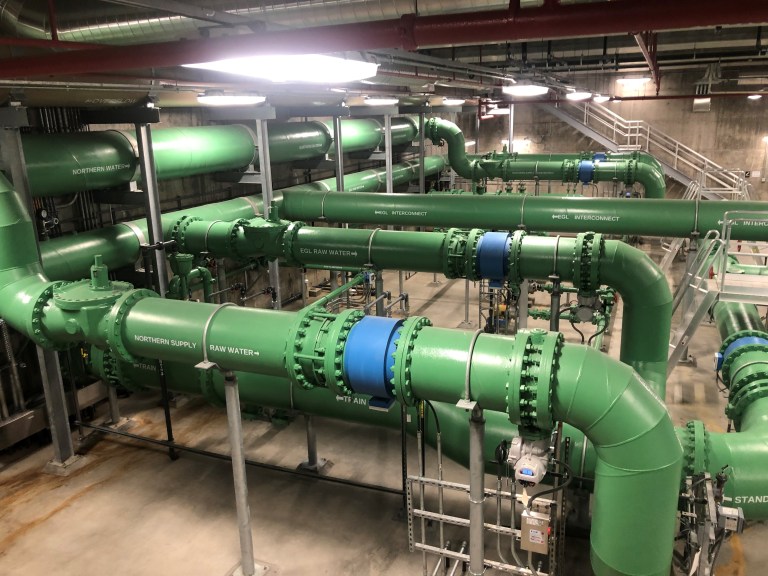
New Thornton Water Treatment plant June 2021. Photo credit: Emily Hunt
Disclaimer: I work for the City of Thornton.
FromColorado Community Media (Liam Adams) via The Colorado Sun:
Thornton can start building a segment of a water pipeline in Weld County, even though the Weld County Board of Commissioners told the city “no” two months ago.
Thornton City Council on Tuesday night unanimously approved a resolution that overrides Weld County’s denial of a permit to build a segment of the Thornton Water Project, and authorized the start of construction.
The 74-mile Thornton Water Project will deliver water from a reservoir near Fort Collins, nearly doubling the city’s current water supply. Twelve miles of the pipeline will run through Larimer County, 34 miles through Weld County, and 5 miles through Adams County. The rest of the pipeline will pass through towns and cities in those counties…
The council was [approved the measure on June 29, 2021]…
Thornton Water Project route map via ThorntonWaterProject.com
Weld County landowners, including Hicks and her daughter, have been influential opponents of Thornton as the city moved through the permit application process. In 2019, the Weld County Planning Commission recommended approval of the project, but landowner protests caused the panel to reverse its recommendation in 2020. Residents’ complaints were also cited by commissioners as a reason for denying the permit at at a hearing on May 5.
The Weld County commissioners also said in a resolution dated June 3 that the pipeline would negatively affect future growth and that it was inconsistent with a new county comprehensive plan.
Some Weld County residents want Thornton to build its pipeline in the right-of-way, or literally underneath a county road, instead of on private land next to the road.
But since the beginning of the process, Thornton has pursued the private-land option, which was supported by Weld County staff.
Building in the right-of-way requires an easement from the county, while building outside of the right-of-way requires easements from private landowners. Thornton has obtained easements from 98% of landowners. Some were obtained through eminent domain proceedings, frustrating specific landowners and further provoking their protest.
The pipeline, which runs from Terry Lake near Fort Collins to just east of Cobb Lake in Weld County and then south to the Wes Brown Water Treatment Plant in Thornton, will be buried and the city will compensate any landowners, especially farmers, whose land and crops are damaged by construction…
City spokesman Todd Barnes confirmed that the city has already reached an agreement with Hicks’ family to construct part of the pipeline on their land…
Weld County negotiated terms with Thornton after the county recognized the city was able to override the denial. The terms still require the city to apply for road construction permits in areas where the pipeline crosses streets, to regularly communicate with county staff about the progress of construction, and to be diligent about dust management.
The city hasn’t said yet when it plans to break ground.
The Thornton Water Pipeline is closer to becoming reality in Weld County following a unanimous vote Tuesday night by Thornton City Council to override the county commissioners’ denial of a use by special review permit to construct the pipeline.
State law allows political subdivisions to override restrictions of county or municipal zoning regulations in certain cases. The board anticipated the city’s ability to override the decision, sending a letter acknowledging as much to Thornton Mayor Jan Kulmann earlier this month.
The letter, signed by Weld County Commission Chairman Steve Moreno, requested that the city council include a commitment to comply with terms and conditions set forth by the county in its override decision. In overriding the county’s decision, the city council agreed to adhere to the terms and conditions.
Commissioner Mike Freeman said the board denied Thornton’s permit for a number of reasons, including being inconsistent with the county’s comprehensive plan and going through multiple Opportunity Zones. Doing so will negatively affect development on those properties, Freeman said.
Thornton included in its resolution a response to the county’s concerns. The city responded that the pipeline and fiber optic cable will be buried so that it is compatible with the existing industrial zoned properties and heavy industrial use. It also worked with property owners to develop a pipeline alignment that would minimize impacts to those properties, according to the resolution. The city also said impacts to industrial properties will be of limited duration during construction.
Freeman said the county found that the permit application didn’t show that all reasonable efforts had been made to avoid irrigated cropland or minimize negative impacts to agriculture. Weld is the state’s leading producer of beef cattle, grain, sugar beets and dairy, according to the county’s website.
Thornton responded that the pipeline will be buried below the plow line to prevent interference with continuing agricultural and estate land uses. Effects on agricultural uses will be temporary during construction and are anticipated to be minimal after construction, according to the city. Thornton also said it worked with property owners to locate the pipeline, including minimizing effects to the operations of irrigation equipment.
Additional measures the city will take include stripping and storing topsoil separately from excavated trench materials and seeding or leaving land fallow in accordance with the property owner’s agreement for reclamation procedures following pipeline construction.
Another finding by the county that led to the commissioners’ unanimous denial of the permit was that the pipeline could have an undue adverse effect on existing and future development in areas along the municipal limits of Dacono, Firestone, Frederick, Johnstown, Platteville, Severance, Timnath and Windsor.
The city reiterated the pipeline will be buried and that impacts will be temporary during construction and are anticipated to be minimal after construction. Property owners are also compensated for any impacts to future residential, commercial and industrial development if that is the highest and best use of their property, the city added.
Finally, the county found that all reasonable alternatives to the proposal hadn’t been adequately addressed and that the pipeline isn’t consistent with the best interests of the people in Weld County. Multiple property owners have expressed opposition to the pipeline, with at least seven appearing at the Board of County Commissioners’ meeting on May 5, when the commissioners denied Thornton’s application.
The city responded that the pipeline will not have long-term impacts to continuing agricultural uses. It noted that two property owners who opposed the pipeline have since agreed Thornton accommodated their requests. For four property owners whose relocation requests weren’t feasible, the city argues the pipeline will not hinder the property owners’ future development plans.
“What we’re supposed to be looking at on applications is, ‘Is the application in the best interest of Weld County citizens?’ and obviously this pipeline doesn’t benefit Weld County at all,” Freeman said. “At the end of the day, this board did not approve an application that wasn’t in the best interest of the citizens of Weld County, but we can’t prohibit Thornton from doing what they did.”
[…]
While the council did not address Weinmeister’s concerns, Kulmann said the city remains committed to working with communities to the north. In a pointed message, she said, “We remain committed to cooperating with you on our project … we do take their concerns seriously.” She also said the city is committed to securing access to water that it bought back in the 1980s and soon will need for its growing population.
Here’s the proclamation from the Governor’s office:
WHEREAS, the State is in Phase 3 activation of the State Drought Plan for twenty-one (21) Colorado counties; and
WHEREAS, Phase 3 of the State Drought Plan advises a “Drought Emergency” be declared by Proclamation of the Governor; and
WHEREAS, the State received a summary of heightened concerns emerging from county commissioners, local emergency managers, and consistent, critical input from the Water Availability, Agriculture Impact, and Municipal Impact Task Forces; and
WHEREAS, the Department of Natural Resource and State Drought Task Force jointly sent a memorandum to the Governor recommending entering a drought emergency for western Colorado counties experiencing impacts from extensive severe (D2), extreme (D3), and exceptional (D4) drought conditions, including Moffat, Routt, Jackson, Rio Blanco, Grand, Garfield, Eagle, Summit, Mesa, Delta, Pitkin, Gunnison, Montrose, Ouray, San Miguel, San Juan, Hinsdale, Dolores, Montezuma, La Plata, and Archuleta; and
WHEREAS, counties impacted along the continental divide in abnormally dry (D0) conditions and moderate (D1) drought will continue to be closely monitored and added to a drought emergency proclamation as appropriate; and
WHEREAS, the severe drought conditions and associated impacts in Colorado constitute a drought emergency;
THEREFORE, I, Jared Polis, Governor of the State of Colorado, do hereby proclaim a drought emergency in Colorado for the following twenty-one (21) western counties: Moffat, Routt, Jackson, Rio Blanco, Grand, Garfield, Eagle, Summit, Mesa, Delta, Pitkin, Gunnison, Montrose, Ouray, San Miguel, San Juan, Hinsdale, Dolores, Montezuma, La Plata, and Archuleta; and
THEREFORE, I further direct the following measures:
The Drought Task Force will continue to meet and monitor evolving conditions;
Unmet and urgent needs from communities and regional liaisons will be reported to the Drought Task Force chairs;
The Agricultural Impact Task Force and Municipal Water Task Force will continue to meet monthly or as needed to recommend opportunities for incident mitigation to minimize potential impacts; and
The need for additional task forces, such as energy or wildlife response teams, will continue to be evaluated as conditions evolve through identified agency representatives.
in the State of Colorado.
GIVEN under my hand and the Executive Seal of the State of Colorado, this thirtieth day of June, 2021 — Jared Polis
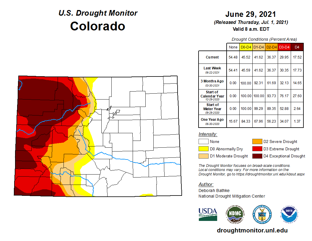
West Drought Monitor map June 29, 2021.
FromHeart of the Rockies Radio (Danny “Dan R” Ridenour):
Governor Jared Polis has formally declared a drought emergency for western Colorado by Proclamation of the Governor as counties continue to face evolving impacts and water shortages from a multi-year, severe drought episode affecting industries and citizens.
On June 22, 2020, Phase 2 of the State’s Drought Mitigation and Response Plan was activated for 40 counties and expanded to all 64 counties by September. As extreme drought and record setting fires expanded across the state, drought response moved into Phase 3 (the highest level of activation) of the State Drought Plan. Spring 2021 precipitation resulted in the stark contrast between significant drought relief for counties east of the continental divide and deepening drought and fire danger for the entire west slope…
While Colorado can face a range of shortages across the state every year, the cumulative impacts of drought stress our landscapes, reservoir storage, wildfire risks, and capacity of many water-dependent economies to rebound from previous year impacts and debts. We continue to work with our neighboring states to implement interstate agreements and consider additional potential solutions.
To stay informed on Colorado drought issues, sign up for the State’s Drought Updates or visit the Colorado Water Conservation Board website.
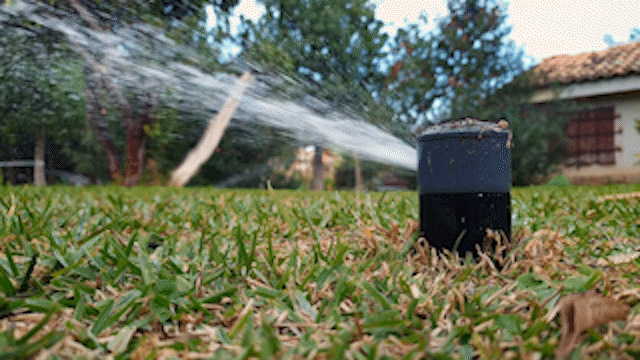
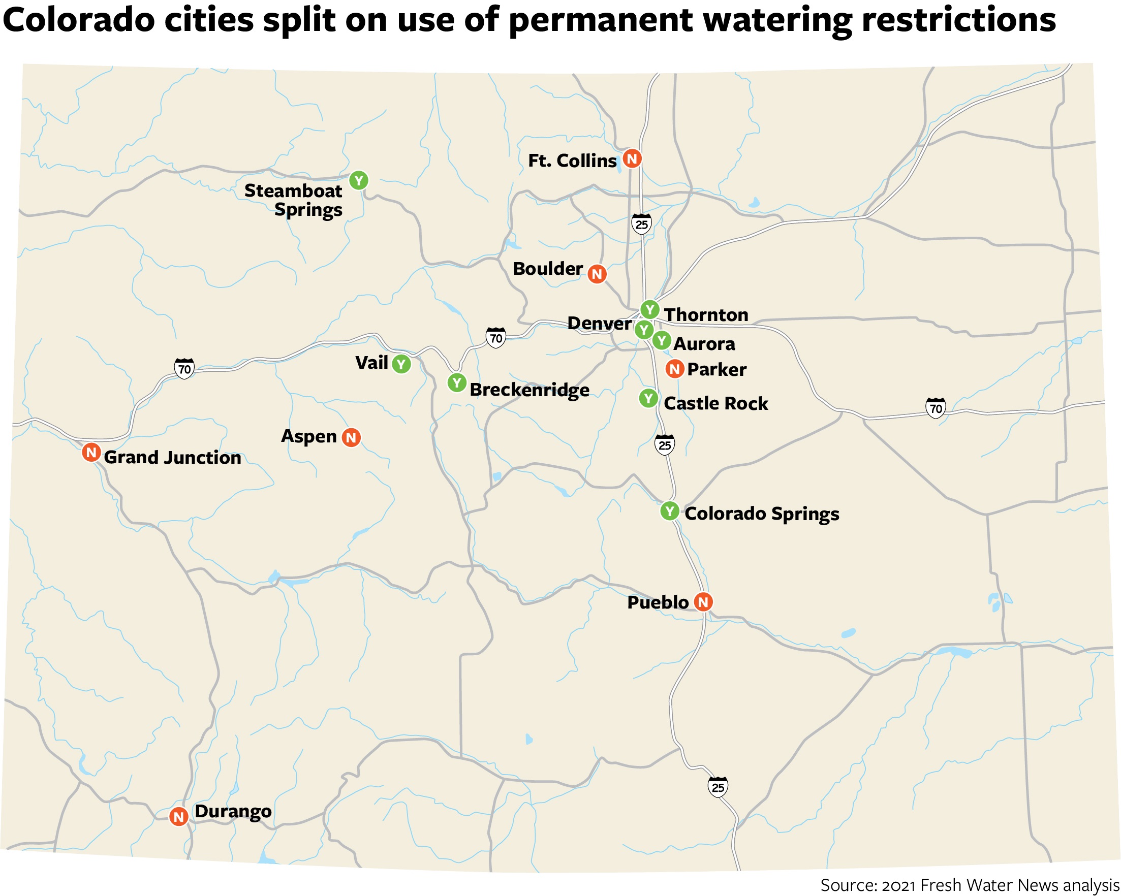
Despite a stubborn, 20-year drought and reservoirs whose supplies are below normal, Colorado communities remain split on whether to impose permanent outdoor watering restrictions, according to a Fresh Water News analysis of local watering rules.
According to the analysis, which examined rules in 15 cities representing the state’s different geographies and major population centers, eight of the cities surveyed have enacted permanent restrictions. Seven cities have not, opting instead to enact variable, temporary watering rules each year.
But when communities do impose permanent rules, rather than adjusting them each spring depending on snowpack and reservoir levels, significant savings occur, with some communities seeing reductions of more than 40 percent in peak summer water demand, according to a recent study by Alliance for Water Efficiency, a nonprofit representing water and wastewater utilities across North America.
Those kinds of statistics helped Steamboat Springs last spring make the move to permanent water restrictions. Steamboat limits customers to watering their lawns three days per week based on the last digit of their address — even numbers can water on Sundays, Tuesdays and Fridays, while odd numbers can water on Mondays, Thursdays and Saturdays. The new rules also limit outdoor watering to between 6 p.m. and 10 a.m.
After years of variable outdoor watering rules that fluctuated depending on drought conditions, Steamboat Springs residents embraced the new permanent schedule right away, according to Kelly Romero-Heaney, the city’s former water resource manager who earlier this month became Assistant Director for Water at the Department of Natural Resources.
“Coloradans are ready to take this step,” said Romero-Heaney. “There really is no reason to water irrigated sod every day, unless it’s getting heavy use like you would see at a soccer field or a community park. It just makes perfect sense. We also recognize that it’s not fair for us to say to the Front Range utilities, ‘You need to conserve more, you need to conserve more, that’s your problem,’ if we’re not conserving ourselves. We wanted to lead by example.”
For its permanent watering rules, Steamboat Springs drew inspiration from the handful of other Colorado cities — both on the Front Range and in the mountains — that have made outdoor watering rules the norm, instead of the exception.
Some city and utility leaders say the watering rules help residents to permanently change their outdoor watering behaviors, given the aridification of the West and the accelerating pace of climate change. Others continue to monitor drought conditions throughout the summer months and adjust their watering rules depending on the current severity.
Permanent watering rules have indeed helped some Colorado cities reduce their outdoor water use, which can represent as much as half of all domestic water use. Castle Rock, for example, has seen a 20 percent reduction in per-person, per-day water use since enacting its permanent watering rules in 1985.
But city leaders also view permanent watering rules as just one tool in a broader water conservation toolbox, along with education and outreach, water-wise landscape and fixture incentives, tiered rate structures, and strict enforcement measures.
Conservation experts agree, noting that permanent watering rules aren’t a silver bullet and that there’s no one-size-fits-all approach to water supply and demand management.
“You can’t prescribe a blanket strategy across every water provider typically,” said Bill Christiansen, director of programs for the Alliance for Water Efficiency. “It’s not fair to say a certain strategy would work for every water provider. You have to do what makes sense for your area.”
Why watering rules?
In the broadest sense, watering rules — both permanent and temporary — help utilities manage peak demand, the period of time when water use is the highest. In most communities, peak demand occurs during the summer, when residential and commercial customers water their lawns and gardens. These rules help ensure that utilities have enough supply to meet the needs of their customers. During drought, when water supply is low, many communities enact or tighten watering rules to help lower the demand for water.
“Outdoor water use can often represent a very large percentage of a water provider’s portfolio, and the capacity of a system is built to meet peak water use,” Christiansen said. “If outdoor water use can be reduced, it can be a very effective way to reduce water consumption. It can also be very helpful if a community is facing the need to expand their capacity — they can lower that peak and avoid or downsize any capacity or expansion projects. That can save ratepayers a lot of money if a large investment can be avoided.”
In a recent study, the alliance found that mandatory watering restrictions of all kinds lead to significant decreases in water demand. Some cities involved in the study saw up to a 42 percent reduction in peak monthly demand. Meanwhile, voluntary watering restrictions produced no statistically significant difference in water demand.
When comparing permanent versus temporary watering rules, the study found that water demand rebounded after cities lifted temporary drought restrictions, while cities that made watering restrictions permanent saw very low levels of rebound. Strong messaging and enforcement, as well as drought surcharges, were also important for reducing demand.
“Increasing rates is often the most effective tool for achieving water savings,” according to the study.
“New” water supply for development
Some growing Colorado cities view permanent watering rules and other conservation measures as a “new” source of water, because these measures help buy them more time before they have to seek out other, often costly new water supplies in advance of future development.
That’s been the case for Aurora since 2002, when the city first enacted its permanent rules limiting residents to watering no more than three days a week and, from May 1 to Sept. 30, to watering before 10 a.m. and after 6 p.m.
But watering rules are just one piece of the puzzle in Aurora. The city also has a tiered rate structure, enforcement measures for violators and many financial incentives for water-conserving landscaping and devices; Aurora also re-uses much of its water through its innovative Prairie Waters system. These and other conservation efforts appear to be working, too. Since the early 2000s, Aurora’s water use has declined 36 percent, resulting in some of the lowest per-person water use on the Front Range.
“Aurora is not fully developed,” said Marshall Brown, general manager of Aurora Water. “We’ve got water supplies that are conservatively or easily able to meet the demand of our existing population. But we do have to continue to acquire supplies to meet future growth and demands that we know are coming our way. So with that, probably the easiest water supply we have is to extend our existing supplies. That’s the least costly option for us.”
“Sustained nutrition”
Other city leaders view permanent watering rules as a way to change their residents’ and businesses’ behaviors. Instead of flip-flopping between various watering schedules and rules throughout the summer, residents simply adapt to the new norm and move forward.
That was one big reason Thornton adopted permanent watering rules in March, where watering is limited to three days per week between 6 p.m. and 10 a.m. At the same time, the city also updated its code to include beefed-up enforcement measures for leaks and other water-wasting behaviors.
“Planning for drought is one thing — we’ve got these short-term strategies where we reduce demand or grab extra water, but one of the real strains on all of our systems is the aridification of the region,” said Emily Hunt, deputy infrastructure director for Thornton Water, which also has a tiered rate structure and various water-wise incentive programs. “We’re becoming progressively drier and warmer and that’s a challenge to plan for. We have to be able to rely on consistent behavior change from our customers and just a consistent ethic and not this, ‘Oh, we’re in a drought we’re in an emergency,’ like the crash-dieting approach. We need more of a sustained nutrition approach.”
The same is true for Colorado Springs, which enacted its permanent watering rules in January 2020. After years of messaging and education around droughts, the city’s customers immediately adapted to the new watering rules, said Julia Gallucci, water conservation supervisor for Colorado Springs Utilities.
“We started communication on May 1 and by the first week in July, we could see by usage that the majority of our customers were all watering no more than three days a week, which was really encouraging,” Gallucci said.
In the first year under the new rules, Colorado Springs saw a 1 percent reduction in commercial irrigation and a 4 percent to 5 percent reduction in residential irrigation, Gallucci said. Those initial numbers were right on target with the city’s goal of contributing 11,000 to 13,000 acre-feet to its supply through conservation over the next 50 years through the watering rules and other measures.
“This is one of the best ways to implement a water conservation ethic across the community, because instead of being really mindful of drought in drought years, we’re mindful of it year after year,” Gallucci said. “Unlike drought response, when you’re trying to manage a dearth in water supply for a shorter period of time, these are planning well out into our future. It was kind of amazing how quickly and supportively our community responded to our water-wise rules last year.”
Storage questions
Of course, if cities are conserving water for future use, they need to have somewhere to store it, Gallucci pointed out. Water storage projects can be expensive and unpopular among some residents, but they’re an important piece of the equation.
“Conservation can only contribute so much to supply,” Gallucci said. “If you use none, you’ll have all of that to use later. But when you curb your water use by 5 percent each year, you have to have the storage to keep that additional water to use later on. Conservation and storage is this really careful and important balance in Colorado. Every large provider is considering different ways to expand their storage as a form of taking care of their supply.”
That’s the main reason Durango has not enacted permanent watering rules, according to Jarrod Biggs, the city’s assistant utilities director.
“We did a pretty thorough and thoughtful evaluation of this when we were developing our drought management plan,” Biggs said. “It seems like a rational exercise, it drives conservation. But we’re a surface supply city, we don’t have significant reservoir space to speak of and so if we enact watering restrictions, we’re just letting the water go by us. There’s the old adage that canals move water in space and reservoirs move water in time. We don’t have enough of that time machine in the City of Durango and we’ve built our policies around that.”
That’s not to say that Durango encourages residents to use water needlessly. In fact, the city has some “pretty punitive” tiered pricing for heavy users, Biggs pointed out. In the meantime, Biggs is pursuing other ways to boost supply in Durango, including using water from Lake Nighthorse, part of the Animas-La Plata Project.
“I’ve got a two-pronged approach,” Biggs said. “Let’s push and strive and discuss and encourage conservation because that will push out the investment that we need to make in additional water supplies, but at the same time, let’s pursue those investments in water supplies because we know they’ll only be more expensive in the future.”
The City of Boulder also continues to make outdoor watering decisions each spring, looking at drought indicators and the city’s water supply status after May 1. Instead of permanent watering rules, the city relies on tiered water prices, customized water budgets for customers, and incentives and education to encourage conservation.
“So far, while current conditions are drier than normal, our snowpack and reservoir levels are looking sufficient enough to not require restrictions,” said Kim Hutton, Boulder’s water resources manager. Still, she said, “Due to drier conditions, we continue to encourage water customers to use water efficiently.”
Looking ahead
Since Colorado communities are at different points in their water conservation journey and are facing their own unique challenges, the path forward will look different for every city.
Some communities are installing automated metering infrastructure systems, which they hope will help water users track and better manage their water use in real-time. Others are providing grants to homeowners’ associations and working with developers to encourage more water-friendly landscaping in neighborhoods.
But according to conservation experts, even those cities with the most robust water-saving initiatives underway must keep working, as a good water year here and there isn’t likely to alleviate the West’s long-term drought.
“All the strategies we have at our disposal for water conservation and efficiency fall along a spectrum,” says Waverly Klaw, director of resilient communities and watersheds for the Sonoran Institute, a Tucson-based conservation organization. “It’s important to keep moving in the same direction of greater and greater water savings. Some communities might have permanent watering schedules and that’s great, and that will save them a certain amount of water, but they should continue to look forward and look at additional opportunities and strategies to go beyond that. One tool or strategy doesn’t solve the whole problem.”
Sarah Kuta is a freelance writer based in Longmont, Colorado. She can be reached at sarahkuta@gmail.com.
Click on a thumbnail graphic to view a gallery of drought data from the US Drought Monitor.
US Drought Monitor map June 29, 2021.
West Drought Monitor map June 29, 2021.
High Plains Drought Monitor map June 29, 2021.
Colorado Drought Monitor map June 29, 2021.
Click here to go to the US Drought Monitor website. Here’s an excerpt:
This Week’s Drought Summary
This week’s U.S. Drought Monitor saw changes to over 30 states this week. Record-breaking heat in the Northwest, Great Basin, and Northeast led to expansions of drought conditions. Meanwhile, multiple rounds of heavy rain across the Central U.S. led to large-scale improvements, and intense rainfall along the Gulf Coast led to the reduction or removal of lingering pockets of abnormal dryness…
The same stalled frontal boundary that affected the Lower Midwest this week also brought widespread rain to the region with the largest totals (2 to 8-plus inches) falling over eastern Kansas and eastern Nebraska. One-category improvements were made in southeast Kansas, eastern and north central Nebraska, and parts of North Dakota as short-term rainfall deficits decreased and streamflow and soil moisture improved. In Colorado, improvements were made to small areas of exceptional (D4) and extreme (D3) drought as recent rainfall has helped chip away at shorter term deficits. Hydrological and ecological drought, which generally occur on longer time scales, remain a concern. In areas which missed out on the heaviest rain, drought continues to impact the region with cattle producers feeling the brunt of the impacts. The USDA reports that 90% of South Dakota and 66% of North Dakota’s topsoil moisture is short to very short, leading to forage shortages. Producers from Wyoming eastward across the Dakotas are having to make tough decisions as to what to do with cattle, with many selling entire herds. In response to the worsening conditions, extreme drought (D3) expanded in South Dakota and parts of Wyoming where supported by increasing rainfall deficits, declining soil moisture and streamflow, and vegetation stress…
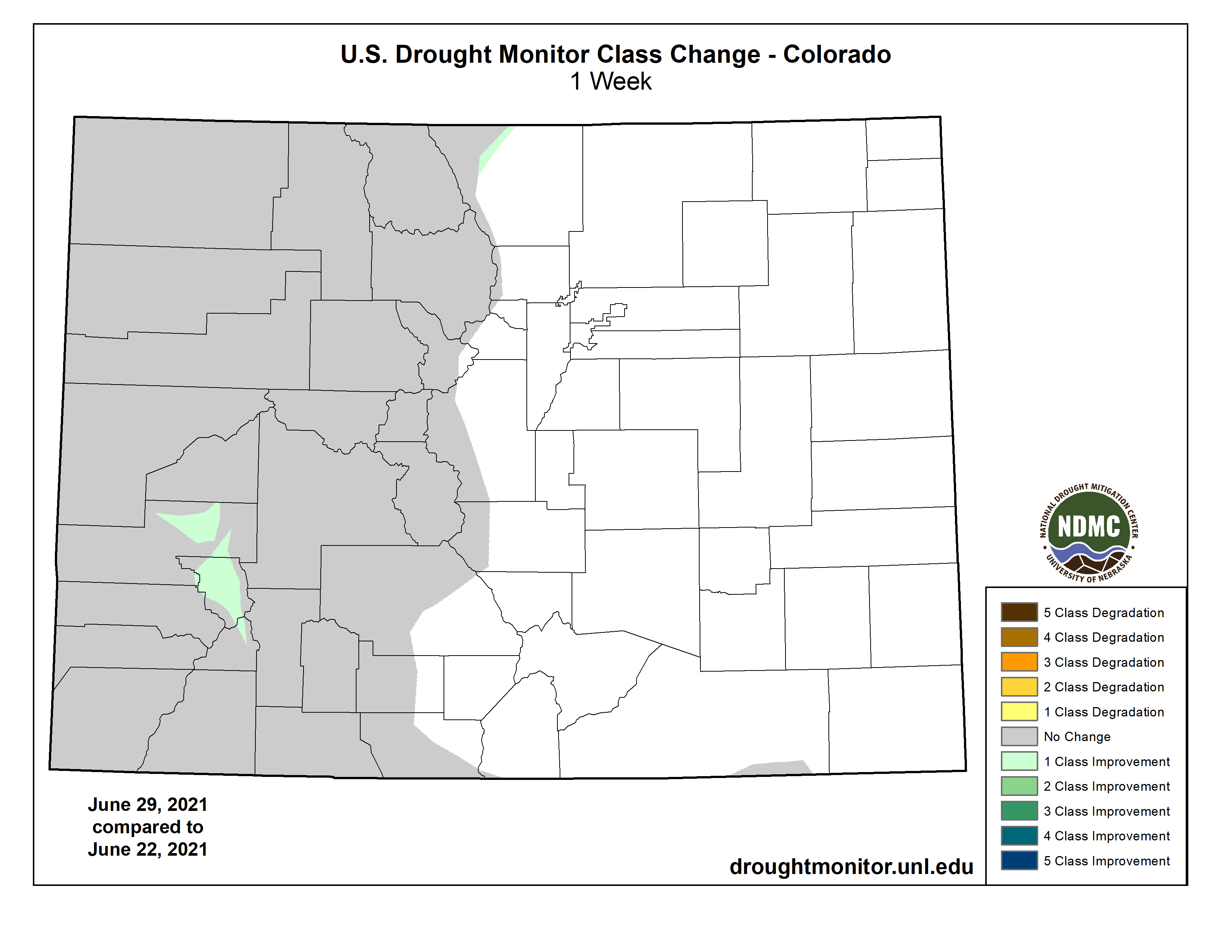
Colorado Drought Monitor one week change map ending June 29, 2021.
Unprecedented heat in the Northwest, combined with another week of dry weather, led to worsening drought conditions across the region. This week, high temperatures ranged from 20 to 30 degrees above normal, breaking multiple records. The excess heat greatly increased evaporative demand, further drying out soils and vegetation, and worsening conditions. Many areas in the Northwest saw one-category degradations, including expansions of severe (D2) and extreme (D3) drought. Conditions in the Southwest remained unchanged, except for the expansion of D3 in central Arizona. Much of the West is classified as severe drought or worse. Notable impacts include increased wildlife encounters in California, Nevada, and Utah, as drought has driven snakes and/or bears in search of food and water into urban areas in those states. In Montana, fishing restrictions have been put in place on many rivers due to low flows and warm waters. Drought-stricken ranchers are selling cattle due to poor forage conditions and a lack of feed. On top of this, grasshoppers have been denuding trees and competing with cattle for food. So far, at least eight national forests in the West now have fire restrictions…
A band of substantial rain (6 to 10-plus inches) fell from West Texas to northeast Oklahoma, leading to large areas of one-category improvements as well as some smaller areas of two-category improvements as short-term rainfall deficits, soil moisture, and streamflow improved. Drought and abnormal dryness remain in areas where indicators still show dryness at longer timescales. A re-evaluation next week will help determine the full effect of the rainfall…
Looking Ahead
The National Weather Service Weather Prediction Center forecast for the next five days (July 1 -4) shows that the prolonged heat wave is expected to continue across the interior sections of the Northwest and Northern Rockies and move into the Northern High Plains. In the East, a cold front is forecast to bring relief from the hot, muggy weather in the Northeast, Mid-Atlantic, and Southeast. As the front moves through the region, these areas can expect moderate to heavy rainfall and an increased chance of severe weather.
Moving into next week, the Climate Prediction Center six-to-10 day outlook (valid July 6-10) favors above normal temperatures across the West, Northern and Central Plains, Midwest, and Northeast. Below normal temperatures are most likely across the South, Southeast, and Alaska. Below normal precipitation is expected to continue across much of the west and Northern Plains, while above normal precipitation is favored across most of the rest of the Lower 48 and Alaska.
US Drought Monitor one week change map ending June 29, 2021.
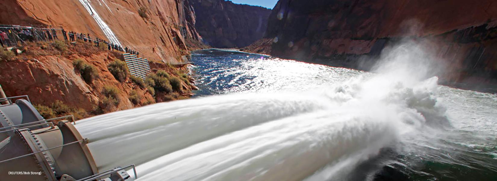
On a spring morning in 1996, then–Interior Secretary Bruce Babbitt stood at Glen Canyon Dam, a concrete bulwark in Arizona that holds back the Colorado River to form Lake Powell. During a live broadcast on the Today show, a popular national TV program, Babbitt opened valves to unleash an unprecedented experimental flood into the Grand Canyon just downstream. As onlookers applauded, water gushed from gaping outlet pipes. Babbitt called the experiment, which was testing one way of restoring Grand Canyon ecosystems damaged by the dam, the start of “a new era” in environmental management.
Jack Schmidt was underwhelmed by the scene. He had spent years helping design the controversial experiment—which cost electric utilities nearly $3 million in lost revenue—and fighting to launch it. But compared with the natural deluges that raged down the canyon before the dam was completed in 1963, he remarked to a Los Angeles Times reporter, “This is a pretty wimpy flood.”
That verdict was typical of Schmidt, a river scientist at Utah State University who thinks big and speaks candidly. During his long research career, he has played a major role in revealing how the Colorado River functions, and how forces—natural and human—are reshaping and often damaging it. Despite his bluntness, Schmidt is a go-to expert for stakeholders and policymakers. He has taken them on river trips to explain key research findings, drawing graphs in the sand. And with other researchers, Schmidt has catalyzed far-reaching changes in how government agencies manage the Colorado River system, a critical source of water shared by seven states and Mexico.
“Jack looms very large in both the science and the policy of the Colorado River,” says Gordon Grant, a hydrologist and geomorphologist with the U.S. Forest Service in Oregon. “He’s not afraid to push back on the water managers and he’s not afraid to push back on the environmental groups,” says Tom Buschatzke, director of the Arizona Department of Water Resources. “He’s willing to use science to try to find practical solutions.”
As a warming climate reduces the river’s flow, Schmidt, 70, is making what could be his most important push to shape the fate of his beloved waterway. He and his colleagues are working to inject a dose of scientific reality into public debate over water resources that, the team says, is too often clouded by wishful or outdated thinking. The biggest delusion: that there will be enough water in a drier future to satisfy all the demands from cities, farmers, power producers, and others, while still protecting sensitive ecosystems and endangered species. The hard truth, according to long-term scenarios produced by Schmidt and his colleagues, is that some users will have to consume less water, and that policymakers will face agonizing choices sure to produce winners and losers.
Those are messages that many players aren’t eager to hear, especially states planning to drain more water from the river to fuel growth. But Schmidt says he and his colleagues simply want everyone to understand the potentially divisive trade-offs. “We ask provocative and uncomfortable questions,” he says.
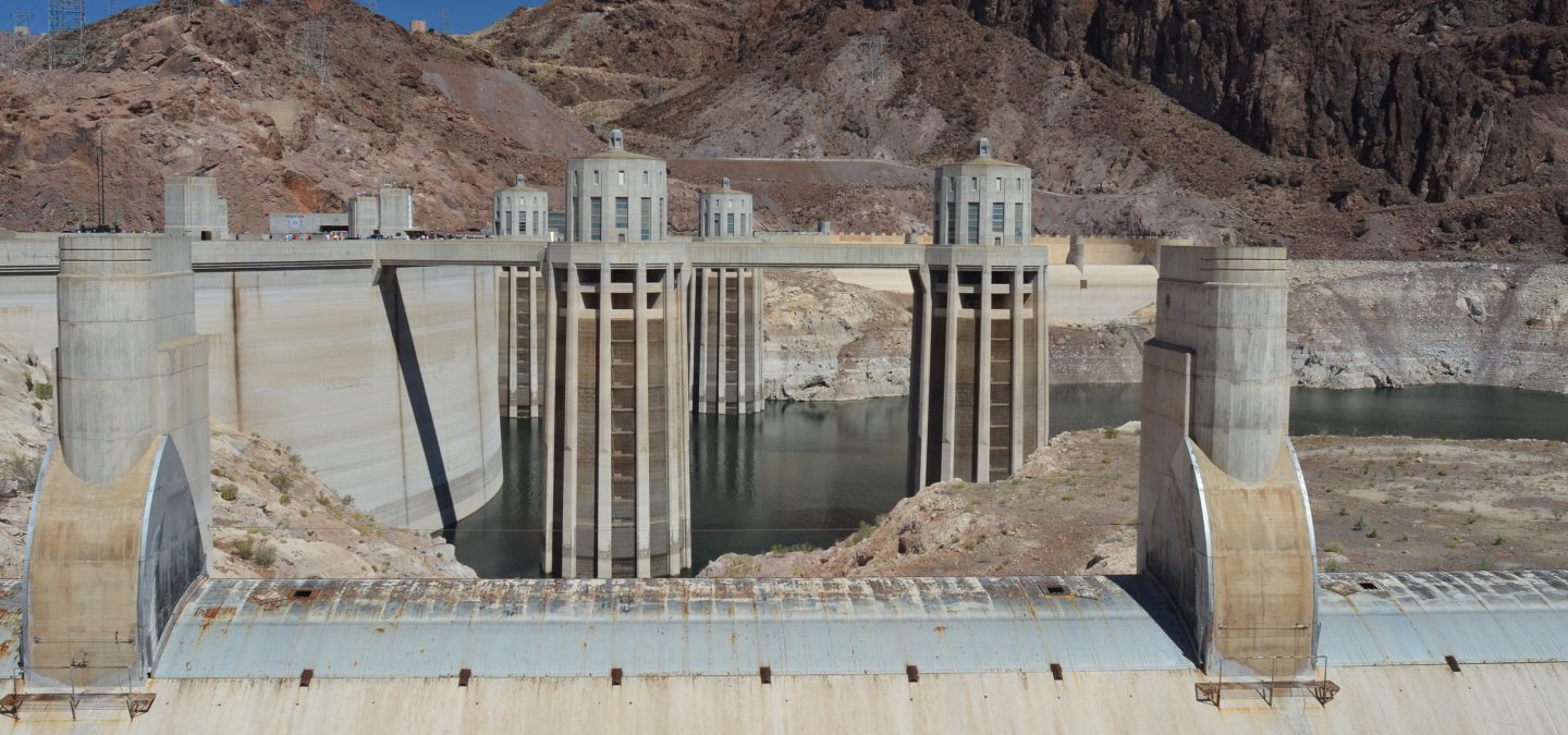
Lake Mead behind Hoover Dam. Lake Mead last month fell to its lowest level since the Hoover Dam was built in 1936. The shoreline has dropped 45 meters since the reservoir was last full in 2000. Photo by Ken Neubecker via American Rivers
The moment is ripe, as a record-breaking drought provides a taste of what more climate change could bring. Last month, Lake Mead, a second massive reservoir downstream from Lake Powell, dropped to its lowest level ever. At the same time, government officials are beginning a 5-year process of renegotiating several key agreements over use and management of the river’s water. They have sought Schmidt’s views. “We had Jack and his team present to our leadership because of the high regard we hold for their research,” says Katrina Grantz, assistant regional director of the Upper Colorado Basin for the federal Bureau of Reclamation, which operates many major dams.
Some see Schmidt’s tell-it-as-it-is approach as critical to developing realistic policies. “Jack is never afraid to speak the truth, according to what the research is saying,” says Mike Fiebig of American Rivers, an environmental group that Schmidt advises. And, he adds, Schmidt will speak “to whoever is listening.”
FOR A CONTINENTAL-SCALE river, the Colorado is not very big, but it has an outsize importance. Rising in the Rocky Mountains, its muddy water has always been crucial to the development of the arid West. In 1936, the Hoover Dam created what is still North America’s largest reservoir, Lake Mead. The dam’s 17 turbines generate electricity that lights Los Angeles, Las Vegas, and other cities, and also powers pumps that lift river water over mountains and into southern California. Engineers built hundreds of kilometers of canals to carry the water to cities and farmers. In Colorado, they constructed numerous tunnels, including one below the continental divide, to deliver water to Denver. Today, more than 40 million people in seven states and many Native American tribes rely on the Colorado River.
The water has long been worth fighting over. In 1922, in a bid to prevent conflicts, states in the watershed divided the rights to nearly 20 cubic kilometers of water, which they assumed was only part of the river’s annual flow. The compact gave half of the water to the lower basin, where cities and farms, especially in California and Arizona, have long used about twice as much water as consumers in the upper basin. The other half was promised to the upper basin, so that states including Colorado and Utah could develop in the future. A follow-on agreement in 1944 gave water to Mexico, where the river’s last drops barely trickle into the sea.
Lawyers and politicians spent decades disputing the terms of the original compact, parts of which remain contested. Meanwhile, it became ever clearer that the compact rested on flawed assumptions, because it was struck when the region was abnormally wet. After the 1930s, the Colorado River carried considerably less water on average for the next 4 decades (see chart, below). The past 2 decades have seen another decline, as the region endures its worst dry spell in 1250 years; flows have been about 19% less than the entire 20th century average. Climate models suggest an additional 30% decline by 2050, as precipitation continues to decrease and the atmosphere warms. The heat dries the soil and causes plants to transpire more, reducing the runoff efficiency—the fraction of precipitation that reaches the river.
The impacts are impossible to miss. From the air, bathtub rings of white stone encircle Lake Mead, which has been less than 40% full since 2015, as well as Lake Powell, which has been below 50% capacity since 2013. Boat ramps have been extended to help keep a large recreational industry afloat. Farmers in multiple states are expecting cutbacks in water deliveries next year. Nevada is launching new conservation measures, including a ban on using Colorado River water to irrigate lawns after 2026.
In some states, the shrinking river has only intensified claims on its flow. “It’s our water,” Utah State Senator Don Ipson (R) proclaimed in March. He was urging his colleagues to support a bill, now awaiting the governor’s signature, that creates a new commission to advocate for the state’s right to develop future water supplies.
Such assertive political jockeying highlights the challenge facing negotiators. They must grapple with key agreements that expire in just 5 years, as well as an inexorably changing climate. “All of that,” says water policy expert Brad Udall of Colorado State University, Fort Collins, “has combined into this slow-moving trainwreck.”
SCHMIDT GREW UP far from the Colorado in suburban New Jersey. He first glimpsed southwestern landscapes in undergraduate geology classes at Bucknell University in Pennsylvania. An encounter with famed river scientist Luna Leopold during his master’s work at the University of California, Berkeley, inspired his passion for natural resource issues. He went on to a Ph.D. at Johns Hopkins University, studying water policy and how rivers reshape landscapes with one of the field’s top experts, Gordon “Reds” Wolman.
Soon he was immersed in a conflict over the Colorado River that had begun in the 1970s, not long after Glen Canyon Dam was completed. The barrier nearly doubled the storage capacity for water, but it dramatically changed river conditions in the Grand Canyon. It cut off supplies of sediment that had created vast sandbars, for example, and released clear, cold water that allowed introduced species, such as trout, to displace native fish adapted to warm, muddy flows. Sudden releases of water to meet electrical demand, an operation called hydropeaking, disturbed wildlife, plants, and thousands of rafters who were floating the canyon each year.
Annual U.S. precipitation changes by percentage from the 1981–2010 U.S. Climate Normals to the newest data in the 1991–2020 Normals, released by NOAA, May 2021. Decreases indicate a drier Southwest, and increases indicate wetter sections of the Northern Plains, Great Lakes region, and Southeast. Courtesy of CISESS.
Environmental groups sued, demanding that the Bureau of Reclamation do more to protect the ecosystem. In response, in 1982 the federal government launched what became a $12 million research program to probe dam impacts. Schmidt was funded to study the Grand Canyon’s sandbars, which river guides complained were shrinking, depriving them of camping spots.
Schmidt’s research helped explain the losses, revealing how swirling water digs up sediment in certain places and drops it elsewhere. The work “really has been foundational for all the thinking about sandbar dynamics since,” says Grant, who was a student alongside Schmidt at Johns Hopkins.
During a chilly rafting trip studying erosion, Schmidt and others discussed what could be done to prevent the losses. By the light of a campfire, they drafted a “beach bill” in his field book, sketching out the kind of federal legislation that could safeguard the canyon’s beaches.
A few years later, Bill Bradley, a Democratic senator from New Jersey, visited Middlebury College, where Schmidt was a faculty member. He and three students handed the senator a report they had written on sandbar erosion. Bradley took it with him when, the next month, he visited the canyon to see the problems for himself.
Bradley and other lawmakers were crafting their own bill, which became the Grand Canyon Protection Act of 1992. It helped set the stage for the experimental floods that began in 1996. The idea, developed by a small group of researchers including Schmidt, was that artificial floods could carry sand downstream. Although Glen Canyon Dam blocks most of the sand that used to wash down the main river channel, tributaries below the dam still supply some. The floods would drop the sediment onto sandbars. Dam operators weren’t eager to cede control to the scientists, though. “Jack had to duke it out,” Grant says.
The experimental floods have proved only modestly successful, in large part because the tributaries don’t deliver enough sediment to make a huge difference. Rich Ingebretsen, co-founder of the Glen Canyon Institute, an environmental group, says the real significance of the first experiment was that dam operators now consider environmental impacts—and not just the needs of electric utilities, farmers, or recreational boaters—in deciding when and how much water to release. “It ushered in a new world,” Ingebretsen says. “Environmentalists were now working with water managers for the first time in the history of the country.”
POLICYMAKERS HAVE BEEN slower to grapple, at least publicly, with a question that extends far beyond the river’s ecosystems and recreational opportunities: the limits of its ability to supply all the water the West wants, now and in the future.
Schmidt remained focused on river dynamics and developing strategies to lessen the impact of dams on ecosystems, first at Utah State and then, starting in 2011, as chief of the U.S. Geological Survey’s Grand Canyon Monitoring and Research Center (GCMRC), which helps guide restoration and management efforts. Martin Doyle, who studies river science and policy at Duke University, says he was skeptical that Schmidt would thrive as a government official, in part based on his frank approach to peer-reviewing papers. “He always signed his reviews and it was always just brutal, because he wasn’t tolerant of sloppy thinking.” But Schmidt had remarkable success boosting his staff ’s morale and conditions for research, Doyle says. “He started to turn the GCMRC from a monitoring center to a science center.”
The new abnormal
For the first third of the 20th century, the Colorado River supplied plentiful water on average, despite large annual fluctuations (top). Then water supply fell to a relatively constant level while use by cities and farms ramped up. Over the past 3 decades, climate change affected supply as rising air temperatures (bottom) increased water loss from soil and plants. Lower runoff efficiency means less rain and melted snow end up reaching the streams that feed the Colorado River.
One research goal was to figure out exactly when an experimental flood would most benefit ecosystems. “Jack had a huge influence,” says Anne Castle, a fellow at the University of Colorado, Boulder, who oversaw water and science policy at the Department of the Interior from 2009 to 2014. “He cares about getting it right, that the river is managed in a way that reflects the best science available.”
The experience at GCMRC also got Schmidt thinking about how regional water supply decisions, often made decades ago, could thwart efforts to improve river management. For example, when his team participated in writing a new plan for operating the Glen Canyon Dam to make sandbars more stable and protect endangered fish such as the humpback chub, it could not consider any changes that were inconsistent with existing water supply agreements. That was frustrating, Schmidt recalls: “Nobody really asked the question: What’s the way to manage the [whole] system that’s the best for Grand Canyon?”
AFTER SCHMIDT LEFT GCMRC to return to Utah State in 2014, he wanted to explore those possibilities—unhindered by political and institutional constraints. He set up an interdisciplinary research center, and 2 years ago pulled together an all-star team of water experts for the effort, called the Future of the Colorado River Project. Among the collaborators: Udall, a veteran of western water policy; Eric Kuhn, retired general manager of the Colorado River Water Conservation District, a planning agency, who provides a practical perspective; and Kevin Wheeler of the University of Oxford, a master of complex hydrological models.
The group has so far released six white papers. Some address technical matters, such as how to improve the models used to develop management policy for reservoirs. Others have scrutinized hot-button proposals, such as prioritizing water storage in Lake Mead and keeping less in Lake Powell. This proposal, called Fill Mead First, could be a first step toward dismantling Glen Canyon Dam and restoring the canyon behind it. (Schmidt’s team concluded the approach wouldn’t save much water and would likely greatly perturb the downstream ecosystem.)
The latest installment, released in February, evaluated for the first time how rising temperatures and declining runoff might jeopardize the regional water supply. The white paper also looked at how demand might change in coming decades. Using the same computer model that the Bureau of Reclamation and state water agencies use, known as the Colorado River Simulation System, the team examined numerous scenarios, including how meager runoff could reduce water storage in Lake Powell and Lake Mead to critical levels. At one threshold dam turbines couldn’t generate electricity. If levels fall even lower, the reservoirs can no longer release water to alleviate downstream shortages, leaving users at nature’s mercy.
Glen Canyon Dam high flow release photo.
The modeling, done by Wheeler, showed reservoirs might dip into the danger zone, perhaps within 2 to 3 decades, assuming the present drought persists. To maintain a degree of water security, the study found that upper basin users would have to cap consumption at a long-term average, and lower basin states might have to cut their use by as much as 40% by the 2050s. “Colorado River outlook darkens dramatically in new study,” ran a headline in the Arizona Daily Star.
That is a “really bold and difficult upshot,” Fiebig of American Rivers says. And although it’s not news to veteran water experts, says Elizabeth Koebele, an environmental social scientist at the University of Nevada, Reno, “bringing that [message] into the broader policy conversation is pretty provocative now.” The results mean the upper basin can’t develop all of its water rights, Schmidt says. Making that scenario “completely transparent forces everybody to deal with it.”
Not surprisingly, some groups argue the study is overly pessimistic. Amy Haas, executive director of the Upper Colorado River Commission, notes the white paper uses “obsolete” water demand forecasts from 2007. The more recent forecast predicts less of an increase, she says. (Schmidt says those numbers don’t change the overall picture.) Average demand for water has not risen in recent decades in the upper basin, Schmidt notes, and it will likely stay flat and shift. More water may become available to citiesas coal-fired power plants close and agricultural practices shift. Other change may be in store if Native American tribes decide to assert their water rights and develop or market them outside of their reservations.
Buschatzke of the Arizona Department of Water Resources says the group’s sobering scenarios are helpful for informing decision-making. “We understand what they’re doing is pushing the envelope, rightly so for academia.” But he says the department must create a water supply plan that is acceptable to diverse parties. Some lower basin groups are likely to oppose any plan that calls for cuts, he says, whereas conservation-minded advocates might push for even larger cuts.
Upper basin states, meanwhile, remain staunchly opposed to any notion of giving up future development. In Utah, which had the nation’s fastest growing population over the past decade, despite having the second driest climate, officials want to build a 225-kilometer pipeline to tap more water from Lake Powell. They shrug off concerns about how that could affect downstream supplies. Critics of Utah’s new water advocacy agency worry it will simply deny the reality of climate change as it attempts to protect the state’s water rights. “The Utah State Legislature is still mired in an era of unreality,” says Daniel McCool, a political scientist at the University of Utah. The state’s recent moves amount to “a declaration of water war, frankly.”
THE NEW ROUND OF NEGOTIATIONS over the Colorado compact will reveal just how far the parties are willing to go in acknowledging the worst case scenarios. “It’s all coming to a head,” Koebele says. “The extreme drought … is really highlighting that we do need to think more creatively.” Some of the big ideas floated by Schmidt’s group include new water accounting methods that span the entire basin, which would allow more flexible dam operations, and expand voluntary water banking and market exchanges of water rights.
Even as Schmidt works to highlight the risks of business as usual, he knows he may have to accept another difficult truth: that, in the end, people might once again decide to sacrifice the Colorado River ecosystems in order to get the water they want for cities, farms, and power.
Currently, environmental management programs—including some he helped design—mitigate some of the most severe impacts of existing dams and other infrastructure. But that won’t suffice as climate change and new water demands take hold. “We can’t solely rely on tweaking small aspects of reservoir operations to protect river ecosystems,” he says. “We also have to consider how much water rivers need to remain healthy.”
Schmidt would like that need to be a larger part of the upcoming negotiations. His own priority is to preserve the flows of rivers in the upper basin, which are wilder than the lower basin’s highly engineered reaches. When pressed, he confesses to an “aesthetic and philosophical wish” for a return to vanishing and long-gone landscapes of the Colorado. He recognizes that it may be impossible.
Still, Schmidt wants officials debating the future of the Colorado to know the region’s vast and growing human presence is not the only thing at stake. Next month, he will lead scientists, water managers, tribal leaders, and other river stakeholders on a raft trip down the Green River, the longest headwaters tributary of the Colorado. During the 5-day trip, organized by his center at Utah State and American Rivers, Schmidt will use sandbars as classrooms, sharing what he and other researchers have learned about the fish, plants, sand, and dams. The goal, he says, is that “when people are sitting in those conference rooms making decisions about water supply, they have in the back of their mind what these rivers are all about.”
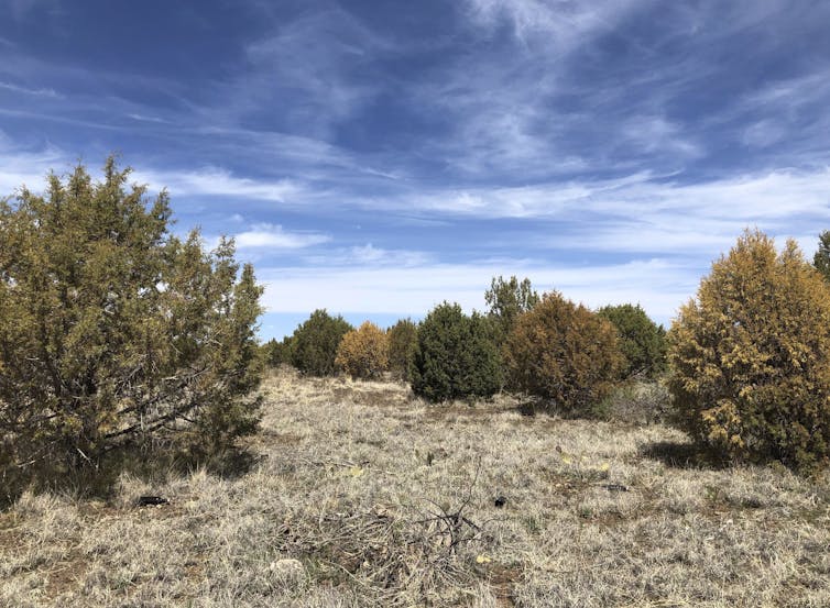
Like humans, trees need water to survive on hot, dry days, and they can survive for only short times under extreme heat and dry conditions.
During prolonged droughts and extreme heat waves like the Western U.S. is experiencing, even native trees that are accustomed to the local climate can start to die.
Central and northern Arizona have been witnessing this in recent months. A long-running drought and resulting water stress have contributed to the die-off of as many as 30% of the junipers there, according to the U.S. Forest Service. In California, over 129 million trees died as a consequence of a severe drought in the last decade, leaving highly flammable dry wood that can fuel future wildfires.
Trees survive by moving water from their roots to their leaves, a process known as vascular water transport.
Water moves through small cylindrical conduits, called tracheids or vessels, that are all connected. Drought disrupts the water transport by reducing the amount of water available for the tree. As moisture in the air and soil decline, air bubbles can form in the vascular system of plants, creating embolisms that block the water’s flow.
The less water that is available for trees during dry and hot periods, the higher the chances of embolisms forming in those water conduits. If a tree can’t get water to its leaves, it can’t survive.
A dyed cross section of a ponderosa pine sapling shows the water transport tissue and conduits. Raquel Partelli Feltrin
Drought stress also weakens trees, leaving them susceptible to bark beetle infestations. During the 2012-2015 drought in the Sierra Nevada, nearly 90% of the ponderosa pines died, primarily due to infestations of western pine beetles.
Fire damage + drought also weakens trees
Although fire is beneficial for fire-prone forests to control their density and maintain their health, our research shows that trees under drought stress are more likely to die from fires. During droughts, trees have less water for insulation and cooling against fires. They may also reduce their production of carbohydrates – tree food – during droughts, which leaves them weaker, making it harder for them to recover from fire damage.
Trees that suffer trunk damage in a fire are also less likely to survive in the following years if drought follows. When trees have fire scars, their vascular conduits tend to be less functional for water transport around those scars. Traumatic damage to the vascular tissue can also decrease their resistance to embolisms.
So, burned trees are more likely to die from drought; and trees in drought are more likely to die from fire.
What does this mean for future forests?
Trees in Western forests have been dying at an alarming rate over the past two decades due to droughts, high temperatures, pests and fires. As continuing greenhouse gas emissions warm the planet and drive moisture loss, increasing the frequency, duration and intensity of droughts, research shows the U.S. and much of the world will likely witness more widespread tree deaths.
The impact that changing drought and fire regimes will have on forests farther in the future is still somewhat unclear, but several observations may offer some insight.
There is evidence of a transition from forests to shrublands or grasslands in parts of the Western U.S. Frequent burning in the same area can reinforce this transition. When drought or fire alone kills some of the trees, the forests often regenerate, but how long it will take for forests to recover to a pre-fire or pre-drought condition after a large-scale die-off or severe fire is unknown.
In the past decade, the Western U.S. has witnessed its most severe droughts in over 1,000 years, including in the Southwest and California. A recent study found subalpine forests in the central Rockies are more fire-prone now than they have been in at least 2,000 years.
If there is no change in greenhouse gas emissions, temperatures will continue to increase, and severe drought stress and fire danger days will rise as a result.