The health of our waters is the principal measure of how we live on the land — Luna Leopold
#Colorado’s #snowpack (January 7, 2022) levels improving on the Western Slope, Front Range after January storms: Only 2 portions of the state remain below normal and they’re catching up, data shows — The #Denver Post
Snowpack levels on the Western Slope continue to climb above normal for this time of the year and thanks to recent winter storms the Front Range is no longer terribly far behind.
That recent snowfall to the west even means that drought conditions are no longer as severe as they were in late December, according to the latest data from the National Drought Mitigation Center.
Climatologists expressed concern at lower snowpack levels earlier in the winter. Snowfall on the Western Slope feeds into the Colorado River, upon which tens of millions of people depend. And abnormally dry conditions to the east exacerbate wildfire risk, seen most recently in the devastating Marshall fire in Boulder County.
Over the last few weeks snowpack levels trended toward those above-average levels.
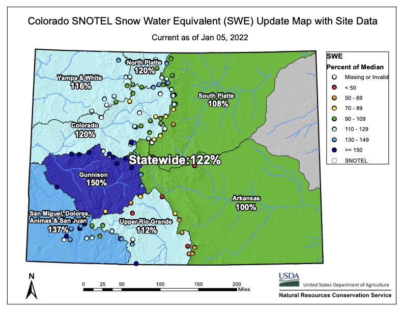
Colorado snowpack basin-filled map January 5, 2022 via the NRCS.
Data collected by the U.S. Department of Agriculture’s Natural Resources Conservation Service shows that as of Thursday snowpack around Gunnison and Ouray sits at 148% of normal levels. Snowpack around Durango also rose to 137% of normal levels.
Similarly levels around Aspen and Glenwood Springs are 124% of normal and the area around Steamboat Springs is at 115% of normal. Even the Front Range, where conditions were previously described as “bleak” is looking better. Snowpack from Denver to Fort Collins sits at 110% of normal. And from Colorado Springs to Pueblo levels are 88% of normal.
Colorado Drought Monitor map January 4, 2022.
With the improving snowpack, some Western Slope areas in Garfield, Gunnison, Mesa and Pitkin counties are now considered to be “abnormally dry,” an improvement over the moderate and severe drought conditions previously noted by the National Drought Mitigation Center.
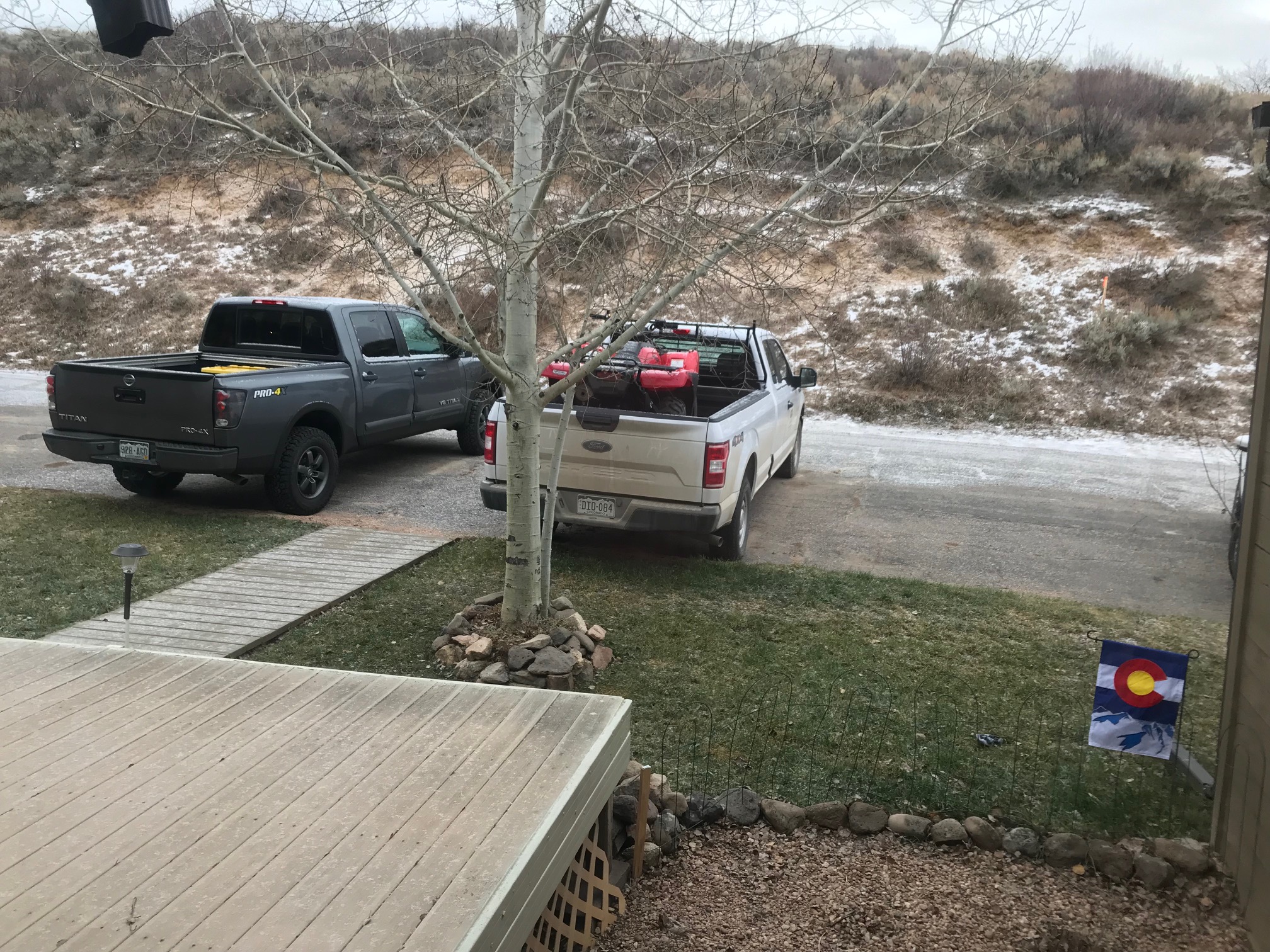
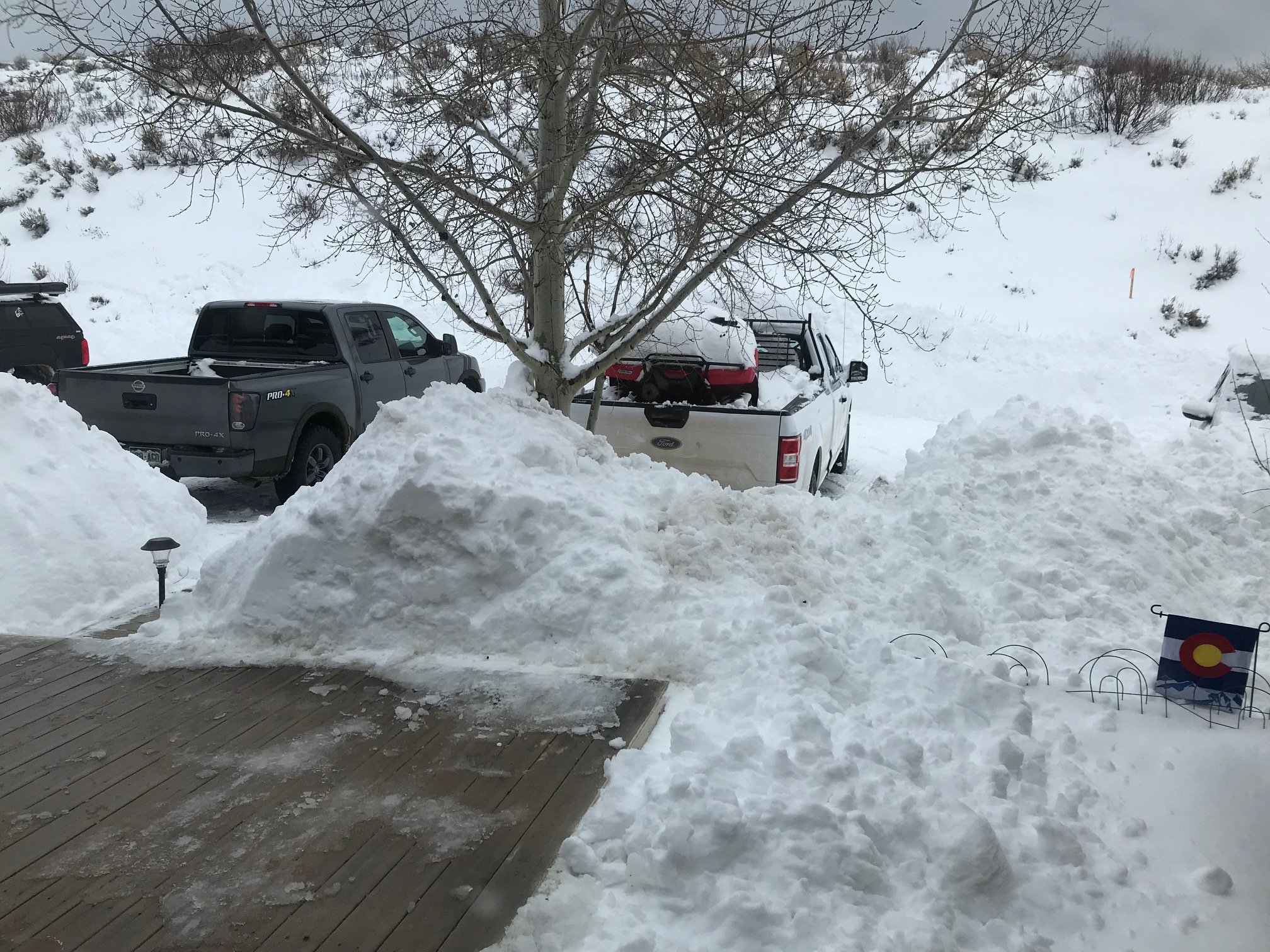
Scott Hummer sent two photographs via email showing how conditions have improved at Stagecoach Reservoir from December to January. From his email, “Thought you’d be interested to see the view of conditions outside my kitchen window…storm last night…quite a change over the past month! Think Snow!”
Stagecoach Reservoir area December 7, 2021. Photo credit: Scott HummerStagecoach Reservoir area January 6, 2022. Photo credit: Scott Hummer
According to SNOTEL reports, most of western Colorado is experiencing above average snowpack with the upper Colorado River watershed, which includes Garfield County, clocking in at about 126% of typical snow water equivalent measurements, the U.S. Department of Agriculture reported…
Sunlight Mountain Resort, on the other hand, measures snow daily, and reported about 60 inches fell from Dec. 24 to Jan. 1.
“Some of the locals have said they haven’t seen a storm cycle like that in decades,” said Troy Hawks, the resort’s sales and marketing manager.
Fresh snow is great for business, and Hawks said the resort set another record for season pass sales this season. Additionally, the resort experienced a record high sales day during the holidays, which includes all sales at the resort — lift tickets, rentals and food sales, he said.