Durango City Council on Tuesday approved a 3% rate increase for all customers who use the city’s sewer infrastructure.
The ordinance passed with a vote of 4 to 1…
[Jarrod] Biggs said that although there is a surplus in the sewer fund, it won’t last with rising costs outpacing sewer revenues…
According to Biggs, inflation in the past year has driven up sewer operations considerably. He said the cost of chemicals used to operate the city’s water treatment facility went up 35% in 2021…
City Manager José Madrigal said the 3% increase will, on average, translate to a $2.22 increase for sewer ratepayers.
Sewer increases are tied to the base rate charges for residential and commercial customers. Those who go over the base rate of usage will not be charged anything more than they normally would for going over.
Base rates are determined by the size of a person’s water meter. Most residential homes have a water meter size of five-eights of an inch; the new base rate for homes with that meter size inside Durango city limits will be $23.71 per month…
Revenue from sewer rates in Durango is about $7.9 million per year, while the operating budget of the city’s sewage infrastructure is $3.6 million. Another $3.4 million is diverted from sewer rate revenue to pay off debt from large projects, such as construction on the Santa Rita Water Reclamation Facility.
Over the past three years, sewage revenues left over to pay for capital expenses have been around $900,000 annually. However, the annual cost of capital expenses for the sewer system has been around $2 million. Capital expenses include projects such as sewer line rehabilitation and manhole replacements, Biggs said.
“If we don’t have adjustments to bring in more revenue, we will have to watch and limit capital improvement projects, and defer maintenance,” he said.
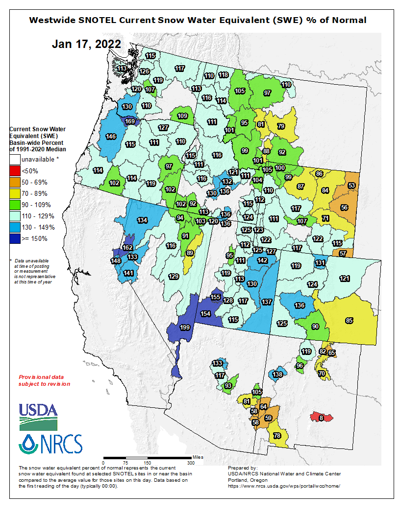
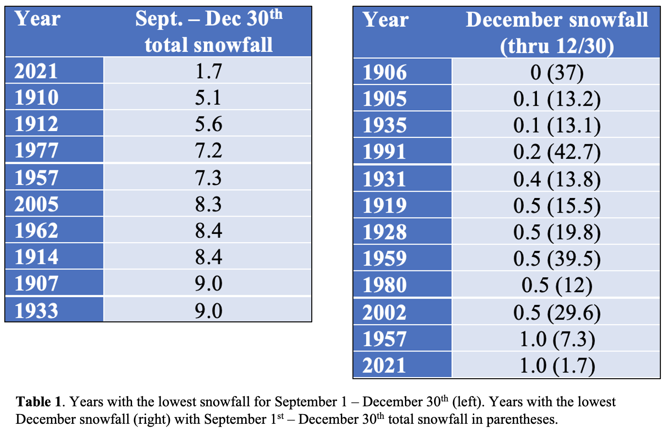
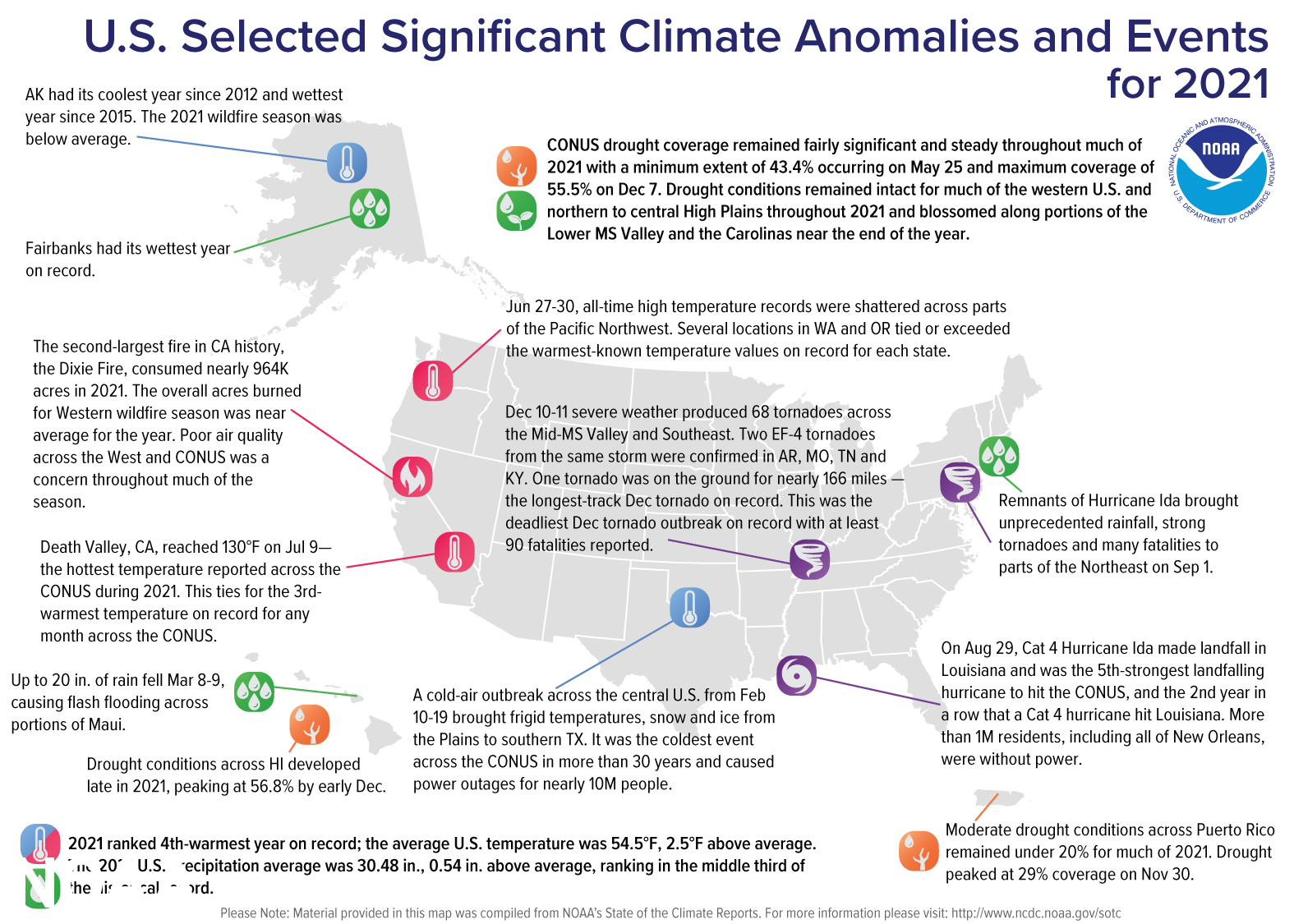
The first major snowstorm of the 2021-22 winter season came late this year, but when it finally rolled into Northern New Mexico on New Year’s Eve, dropping several inches to a couple of feet, depending on elevation, it dramatically changed the picture of what snowpack levels could look like this year.
According to data recorded by the Natural Resources Conservation Service National Water and Climate Center, precipitation levels in Taos County more than doubled from mid-December through Tuesday (Jan. 18), rising from approximately 5.1 inches on Dec. 19 to 11.6 inches as of Jan. 18.
Data from the United States Department of Agriculture shows that the Sangre de Cristos currently have between 65-82 percent of expected snowpack for a typical winter season. That varies depending on location, of course, with the lower spine of the mountain range near Santa Fe seeing about 69 percent, the area near Cimarron at 65 percent and Taos with the highest at 82 percent.
On Jan. 18, Taos Ski Valley reported 38 inches of snow at its base and 54 inches of “packed powder.” Nearly all of its lifts are open, except for two and 76 of its 110 runs are open.
Despite the sudden shift from unusually dry to snowy, historical studies of snowpack levels don’t bode well for the future of snow in the Western United States or for the ski resorts that rely on it to keep their businesses thriving.
A November 2021 study, “A low-to-no snow future and its impacts on water resources in the western United States,” estimated that snow water equivalents are expected to decline by 25 percent by 2050, largely due to persistent greenhouse gas emissions. The study drew its conclusions from what is already known: since the 1950s, snowpack in the Western U.S. has fallen by 20 percent.
The implications of this decline, and the continued reduction in snowpack for the future, predict more serious consequences than resorts suffering or recreationalists missing out on their favorite winter activities.
“Diminished and more ephemeral snowpacks that melt earlier will alter groundwater and streamflow dynamics,” the study reads. “The direction of these changes are difficult to constrain given competing factors such as higher evapotranspiration, altered vegetation composition and changes in wildfire behavior in a warmer world.”
New Mexico has been under varying levels of drought for roughly 20 years, which was part of the motivation behind a cloud seeding operation that was introduced last year by the Roosevelt Soil and Water Conservation District in Southeast New Mexico. Despite evidence that shows cloud seeding can enhance precipitation levels significantly, the application, submitted by Western Weather Consultants of Durango, Colorado, was retracted in November following strong public pushback from opponents who believe cloud seeding can be harmful to the environment and public health.
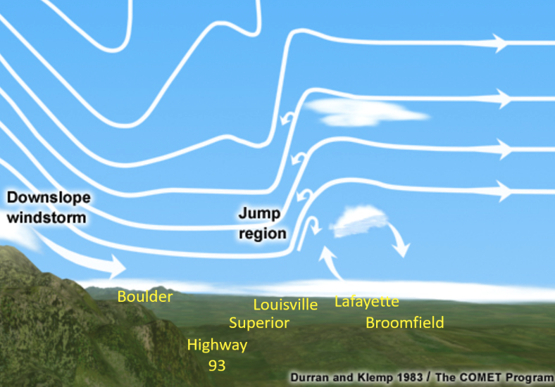
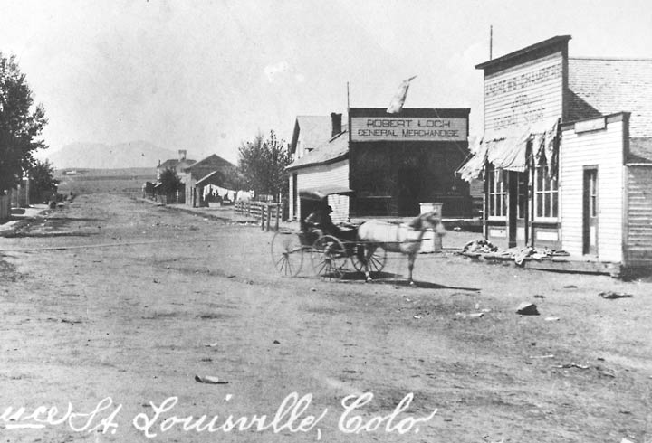
The Marshall Fire that destroyed more than 1,000 structures in Boulder County Dec. 30 has increased the urgency of completing wildfire mitigation projects in the Aspen area and Pitkin County.
The U.S. Forest Service is working with the governments of Aspen and Pitkin County as well as fire districts and homeowners associations to identify places that are the highest priorities for fuels reduction. The private lands on Red Mountain and public lands surrounding the high-end neighborhood are one of the highest priorities…
Richards said the Marshall Fire that swept through parts of Louisville and Superior show the importance of fire mitigation on private lands as well as national forests…
A working group loosely referred to as the Roaring Fork Fuels Collaborative is looking at numerous wildland fire mitigation projects, including one called Sunnyside, which would treat lands adjacent to Red Mountain subdivision. Between 1,000 and 1,500 acres would be targeted, according to Kevin Warner, Aspen-Sopris District Ranger. It would require mechanical treatment of tree and vegetation removal and prescribed burns in areas away from homes. The earliest that project could advance is probably spring 2024, Warner said.
Cooperation from the homeowners would be essential so that land within the subdivision would be treated as well. Aspen Fire Chief Rick Balentine said his department is working on demonstration projects to show homeowners that easing wildfire risk doesn’t mean ruining their property…
The Forest Service led a project in 2016 to treat lands near Red Mountain in the Hunter Creek Valley. Additional work on up to 1,500 acres in Hunter Creek could be undertaken as soon as this spring, according to Gary Tennenbaum, director of the Pitkin County Open Space and Trails program. He credited the Forest Service for leading the successful 2016 project and not causing alarm in Aspen. He also credited the agency for its willingness to propose working close to Red Mountain…
Warner said five wildland fire mitigation projects throughout the region are being planned. The Forest Service and its partners probably don’t have the resources to pursue them all this year, but priorities will be dictated by factors such as moisture levels this spring and the ability to get a permit from the state over air quality.
The contending projects include 2,000 acres in Collins Creek east of the settlement of Woody Creek, 2,000 acres in Braderich Creek west of Redstone, the 1,500 acres in Hunter Creek in Aspen’s backyard, a project in Cattle Creek north of Basalt Mountain in Eagle County and a project in the Seven Castles area in Fryingpan Valley…
Pitkin County has budgeted $300,000 over three years to assist the Forest Service. The highest priority for the county is “where the forest meets homes,” said county emergency manager Valerie MacDonald. The county has collaborated in recent years on several small projects that reduced fuels on federal lands in the Crystal River Valley that are adjacent to private properties, such as Swiss Village, she said.
A project north of Redstone treated 100 acres. “It gives the historic town of Redstone a fighting chance to evacuate safety,” MacDonald said.
Like other speakers at the meeting, she said getting cooperation from private landowners is the key to building resiliency. Pitkin County is 83% public lands, but much of its private property is in what’s known as the wildland-urban interface…
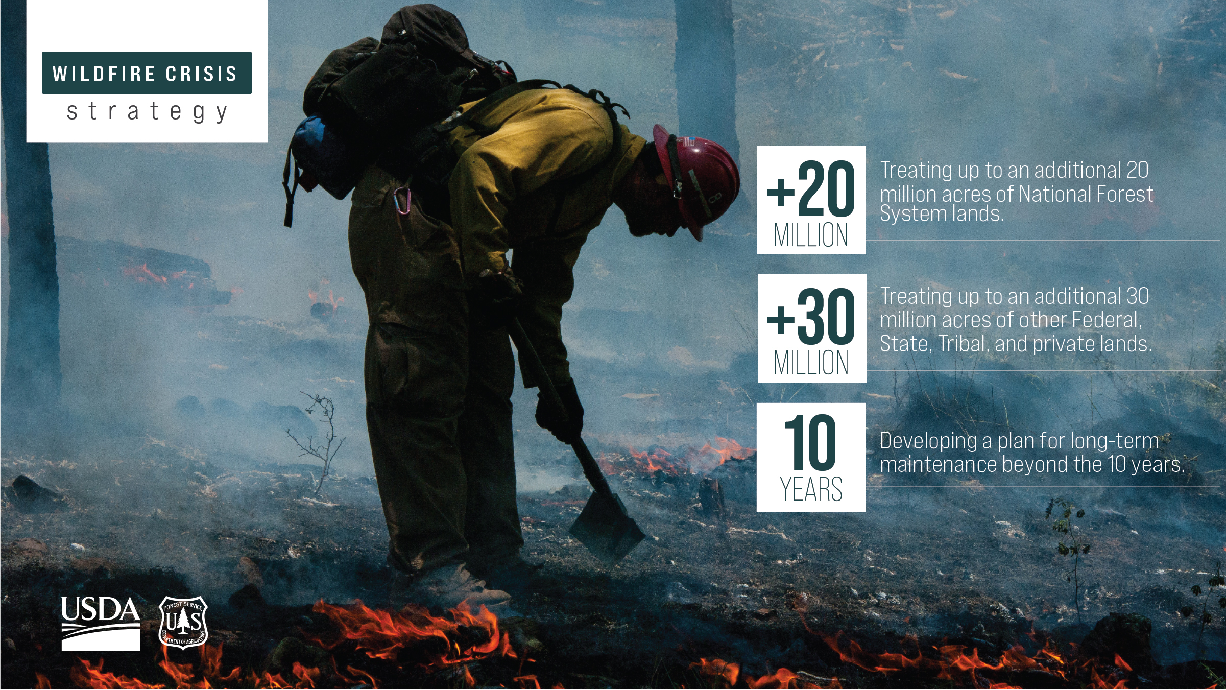
The local planning comes as the U.S. Forest Service released a major new initiative called “Confronting the Wildfire Crisis.” It will target “firesheds” in the Western U.S. — areas 250,000 acres and larger with a high likelihood that an ignition could expose homes, communities and infrastructure to wildfire.
The initiative will target 20 million acres on national forestlands as well as up to 30 million acres on other federal, state and private lands over the next 10 years. It will also come up with a maintenance plan beyond the next decade.
President Joe Biden’s infrastructure bill earmarked $3 billion for the effort beyond regular funding for wildfire mitigation. The strategy is drawing criticism from some environmental groups.
All but $5,000 suspended, as mine reclamation staff says owners of Cross and Caribou mines are making “good faith” efforts to get cleanup online.
The state Mined Land Reclamation Board imposed a $17,000 fine on owners of the Cross and Caribou mines for water quality violations, but suspended all but $5,000 of the penalty as long as Grand Island Resources continues “good faith” efforts to install containment and cleanup equipment.
The state agency’s staff largely endorsed the mining company’s presentation detailing completion of a filtration system for any water emitted from the historic mine above Nederland, and said they would continue on-site review of the improvements and water sampling…
The state board was reviewing a cease and desist order issued late in 2021 that said mine owners failed to make some required pollutant reports in March and April. When the state looked deeper, it found pollutant violations in those months, but also more alleged violations before and after, from December 2020 to last August. Violations included excessive traces of heavy metals, including copper and lead, that can be dangerous to aquatic and human health.
The state’s order charged the mine with violating the Colorado Water Quality Control Act. Water quality officials ordered the owners to build a new containment and cleanup system, and said it would determine the levels of fines in January.
Ed Byrne, an attorney for Grand Island Resources, said the company is satisfied with the outcome of the hearing…
The company will keep working with state and local officials to fully comply with permits, Byrne added.
An attorney for Save the Colorado, a nonprofit environmental group that is monitoring the mine, said the testimony before the board shows the mine appears to have remedied some pollution problems…
Cross and Caribou is not currently producing gold ore, but the company has a permit to build an ore processing facility and says it has been spending millions of dollars rebuilding tunnels and cleaning up past mine operations.
Grand Island said it will also continue to work with Boulder County, City of Boulder and Nederland.
Here’s the release from The Nature Conservancy (Lindsay Schlageter):
Will help address water security in the face of climate change
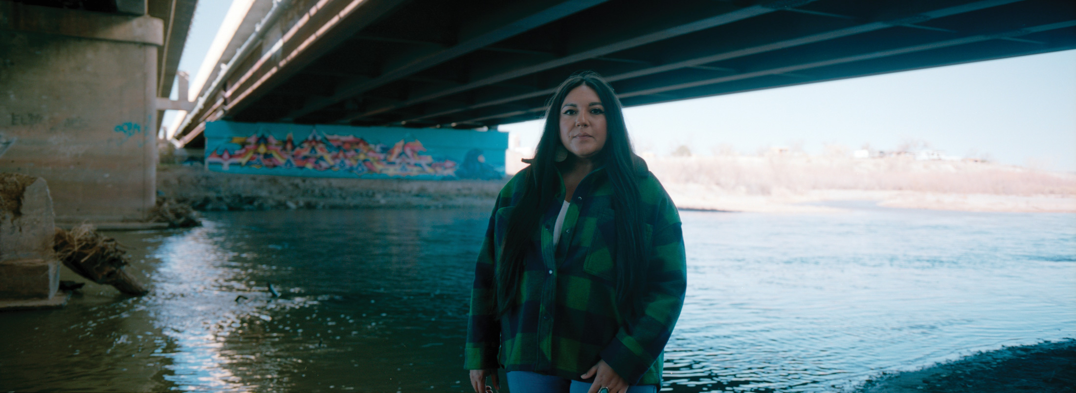
The Jicarilla Apache Nation, the New Mexico Interstate Stream Commission (NMISC), and The Nature Conservancy (TNC) announced today a new agreement to lease water from the Nation to the NMISC. As the western US is facing critical drought and water shortages are occurring throughout the Colorado River Basin, the Nation has worked with the NMISC and TNC to develop and implement this project.
This innovative agreement between a sovereign Tribal Nation, a Colorado River Basin state government, and a conservation organization will allow the NMISC to lease up to 20,000 acre-feet of water per year. This amount will benefit threatened, endangered, and sensitive fish and will increase water security for New Mexico.
“This first-of-its-kind project demonstrates how meaningful sovereign-to-sovereign cooperation, with support from environmental organizations, can lead to creative solutions,” said Daryl Vigil, water administrator for the Jicarilla Apache Nation. “This project should serve as a model for effective tribal collaboration and arms-length negotiations among sovereigns throughout the Colorado River Basin.”
The Jicarilla Apache Nation’s water rights provide access to water for the Nation to conduct cultural practices, provide drinking water to its community, and support economic development. The Nation subcontracts some of its water to users outside the Reservation. Subcontracts can be a source of income to help build the Nation’s economic self-sufficiency while providing water to others that need it.
For the last several decades, the Nation leased water to coal-fired power plants that are now facing closure. This transition presented a new opportunity for the Nation, the NMISC and TNC to work together.
“The Colorado River Basin’s tribal nations are among the most important leaders and partners in efforts to find lasting solutions to the pressing water scarcity and ecological challenges that face the millions of people who rely on this incredible river,” said Celene Hawkins, Colorado and Colorado River tribal engagement program director for The Nature Conservancy.
As many across the Colorado River Basin work to develop projects and solutions to address climate change and drought, the Nation, the NMISC, and TNC hope this innovative water sharing project can serve as a model for water sustainability within the basin. This project demonstrates that the Colorado River Basin’s tribal nations are important leaders and partners in crafting transformative water solutions across the West.
“This agreement is unique for New Mexico as it creates a framework for sovereign-to-sovereign contractual agreements that support and benefit both sovereigns,” said Rolf Schmidt-Petersen, director of the New Mexico Interstate Stream Commission. “It may serve as an example for other Colorado River Basin states and tribal nations that have settled water rights to find collaborative solutions that benefit multiple interests and users of the San Juan and Colorado Rivers.”
At a time when water in the Southwest is becoming increasingly scarce, more than 20 streams in the region are being proposed for protective safeguards in an attempt to preserve the waterways for years to come.
For the past two decades, a prolonged drought driven by climate change has snowpack levels in the Southwest on a continual downward trend. Obviously, that’s not good – less snow means less runoff for rivers and streams, and less water available for use.
As a result, a few years ago, a coalition of environmental groups started a process to locate and identify streams in the high country of Southwest Colorado that would qualify as Outstanding Waters (OW). The designation protects defined reaches of rivers, streams and lakes that have exceptional water quality.
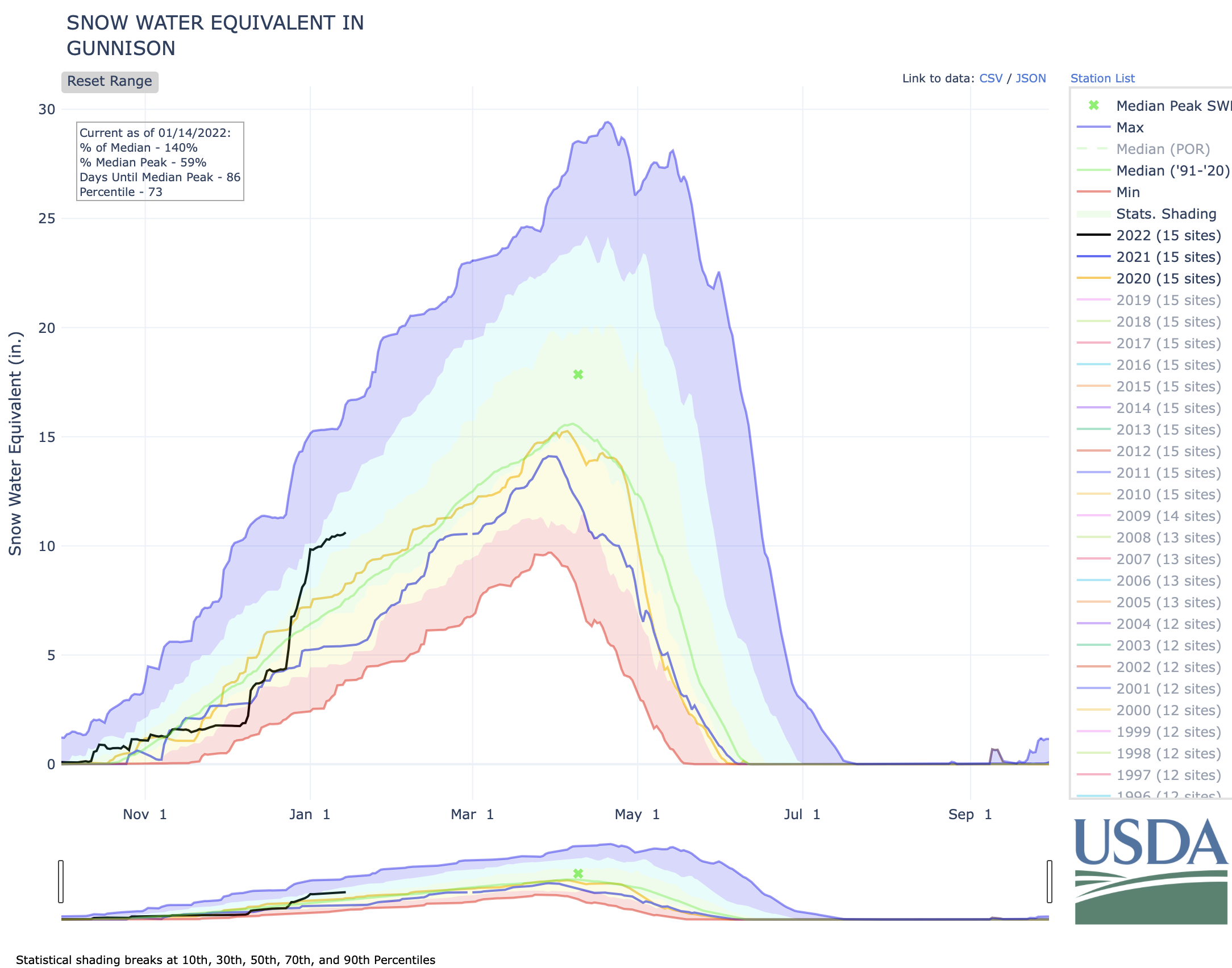
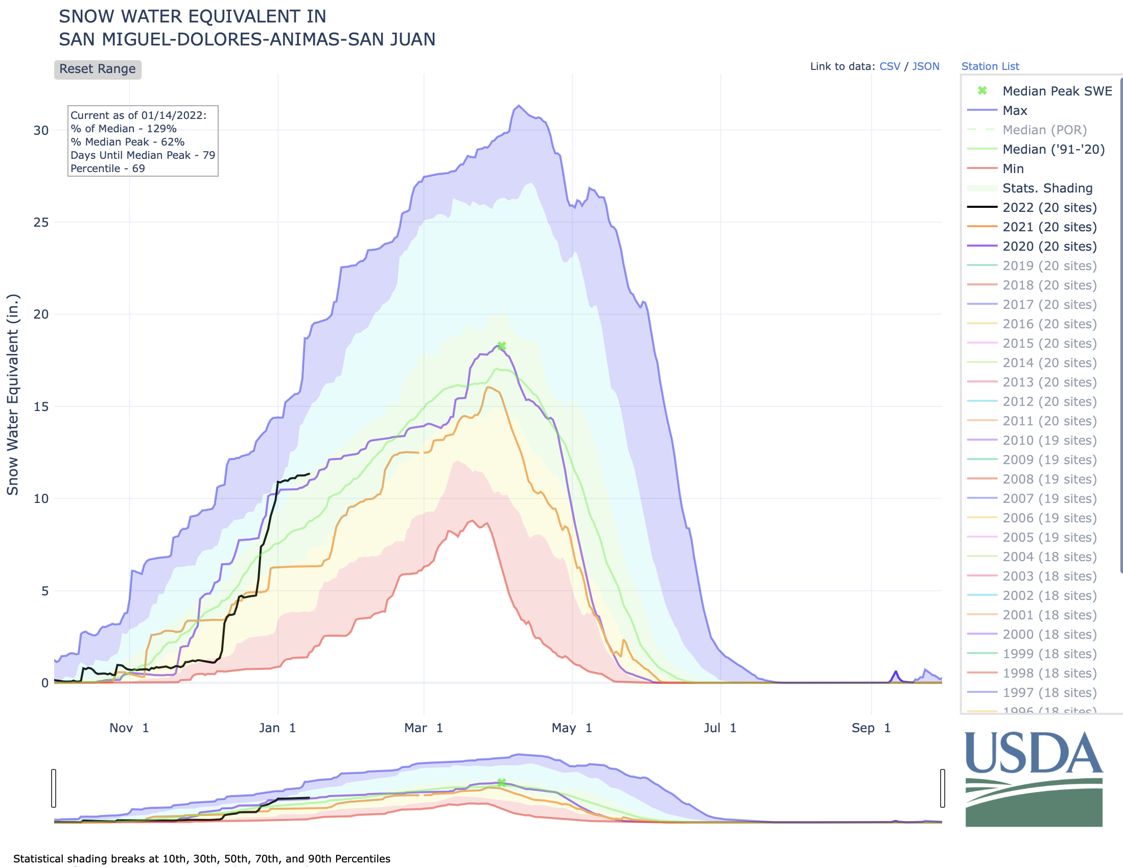
The thinking, environmental groups say, is saving these pristine high-alpine streams in the face of climate change and worsening drought will ensure the long-term protection of tributaries that are vital for the region’s most important rivers, such as the Animas, Dolores, Gunnison, San Juan and San Miguel – which all feed into the Colorado River…
Really special rivers
The Outstanding Waters designation was established as part of the Clean Water Act of 1972. For streams to qualify, they must meet a set of criteria based on water quality and national resource values. And, the streams also must serve as critical habitat for aquatic life and have a component of recreational value, such as fishing or river running. Once designated, the water quality in those streams must be maintained and protected from any future development or use.
The Clean Water Act, however, left it up to states to create a process and specific criteria for streams to qualify as OW. In Colorado, that job falls to the Colorado Department of Public Health and Environment. “We protect every stream in Colorado, but this is the highest level of protection,” Blake Beyea, a water standards unit manager with CDPHE, said. “And it needs to be supported by water quality data, as well as evidence it’s an outstanding resource that requires protections.”
While the designation is somewhat seldom used, as of February 2020, Colorado had an estimated 78 stream segments and bodies of water, covering 5,869 river miles, classified as OWs, mostly located within wilderness areas and national parks. The environmental groups’ proposal – which includes SJCA, Trout Unlimited, American Waters and Pew Charitable Trust, among others – would be unique in terms of the amount of streams proposed and the fact the waterways are located outside wilderness areas, mostly on Forest Service lands…
Setting a standard
Back in 2019, the environmental groups started conversations on what streams might qualify as OWs. They looked at maps for high-altitude waterways that showed the potential for pristine water quality and impeccable habitat for aquatic life, while also escaping historical impacts from uses like mining and development over the years.
In all, nearly 30 streams emerged as potential OW candidates. Then, the next step was to prove it with on-the-ground water testing, an effort led by the Durango-based Mountain Studies Institute. That process lasted two years, with samples taken four times a year from each stream. In the end, the environmental groups ultimately proposed 26 stream segments (five in the Animas; nine in Dolores; seven in Gunnison; three in San Juan; and two in San Miguel).
An OW designation does not affect water rights and would not prohibit future development in these watersheds, Gaztambide said. It would, however, establish a baseline of water quality that cannot be impacted or degraded in the face of that development. And in some circumstances, it’s not just development; the waterways are also protected from things like an increase in recreation, which can result in elevated levels of E. coli.
Essentially, uses and development can change on the landscape; the existing, high-level water quality standards cannot…
Unintended consequences
Gaztambide and the environmental groups are optimistic all the streams they’ve proposed will attain the OW designation. And indeed, there doesn’t seem to be much pushback from other water users in the region, such as agriculture and water districts.
Steve Wolff, manager of the Southwestern Water Conservation District, which represents nine counties in Southwest Colorado, said it’s unlikely the district’s board will take a stance either way for the OW designation. To date, the board has just monitored and asked questions about any possible unintended consequences the listing may have.
One potential concern, Wolff said, is what outside impacts and degradation, like rising water temperatures driven by climate change, would have on the designation and the requirement to maintain those standards. “If that happens, what does that mean from a regulatory aspect?” Wolff said. “We really don’t know yet.”
Since most of the streams are located on Forest Service lands, another question has been raised on the impacts to grazing and logging. A Forest Service representative said Tuesday “we don’t have information to share about the designation at this time” and did not provide comment for this story. Gaztambide, however, said an OW designation does not impact uses like grazing.
A critical time
Peter Butler, who serves as a consultant for SWCD and has worked on water quality issues in the region for years, said he wasn’t aware of too many issues with the OW designation in Colorado over the years. In 2009, Hermosa Creek, for instance, was designated as the first OW outside of a wilderness area or national park, and the situation hasn’t run into any problems or controversy…
To nominate nearly 30 streams in one proposal is a big project, Butler said. But OW, though rarely used, is a way to protect precious water resources at a critical time, in a way that’s more regulatory and doesn’t have to go through a political process. In June, CDPHE’s nine-person Water Quality Control Commission is expected to vote on the proposal…
Gaztambide said the designation will also protect these vital tributaries, which provide a boost of clean water to major rivers should a large event, like the Gold King Mine spill or mudslides from the 416 Fire, seriously impact water quality and threaten drinking water for downstream towns.
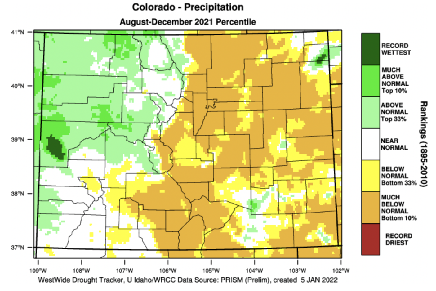
Local lore holds that March is our snowiest, wettest month. That isn’t so.
Recent data from the National Centers for Environmental Information that covers the period between 1991 and 2020 show that, at least in the town of Vail, February is actually the snowiest month, with average snowfall of more than 35 inches. April is actually the wettest month, with an average of just more than 2.4 inches of precipitation.
That actually isn’t much of a change from the previous measured period, from 1981 through 2010.
State Climatologist Russ Schumacher wrote in an email that the change in the numbers is mostly seen in the western part of Eagle County. The wettest months had been in the fall in those lower-elevation areas. That shift is consistent with data across much of northwestern Colorado.
While April is the wettest month in terms of precipitation, that doesn’t necessarily equate to snowfall.
Schumacher noted that spring snow tends to be heavier, because there’s more water in that snow. The snow in mid-winter tends to be lighter, which is better for skiing but not great for accumulating water in the snowpack.
The snow measurement site on Vail Mountain is about halfway toward its peak “snow water equivalent” level. Eagle River Water & Sanitation District/courtesy photo
At the moment, the snowfall measurement station on Vail mountain is right at halfway toward its average peak “snow water equivalent.” That number usually peaks in late April at right around 20 inches. The Jan. 17 measurement was 10.1 inches at that site, 111% of the 30-year average. The other main measurement sites, Copper Mountain, near the headwaters of Gore Creek, and Fremont Pass, near the headwaters of the Eagle River, are in that range.
Aside from the moisture content of snow, does it really matter when it comes?
Diane Johnson, the communications and public affairs manager for the Eagle River Water & Sanitation District, said there’s a lot to consider when pondering when snowfall comes.
Johnson wrote in an email that snowfall’s impact on streamflow — the source of most of the valley’s domestic water — depends on what form precipitation comes. Snow and rain have different impacts. If the snow stays high and temperatures stay low, the spring snowmelt slows, providing more consistent supplies.
“We’ve been seeing earlier melts,” Johnson wrote. That affects streamflows not only in the spring and early summer but through the rest of the season.
Douglas County Commissioners hold work session as they decide on $20 million investment
DOUGLAS County Commissioners were told [January 18, 2022] that there is ample water in the San Luis Valley that can be exported to the Front Range and were shown a preliminary wellfield design for the northern end of the Valley.
Bruce Lytle, engineer for Renewable Water Resources’s proposal to move 20,000-acre feet of water a year to Douglas County, walked the three Douglas County commissioners through the Valley’s complex two-aquifer system and left them with the idea that there is water available for exportation.
“It doesn’t sound like there’s any controversy about the water being there. The water is there,” said Commissioner George Teal.
“I would agree with that,” said Lytle.
While Teal demonstrated interest in Douglas County partnering with Renewable Water Resources, Commissioner Lora Thomas voiced opposition to exporting water from the San Luis Valley. (You can read her letter to The Citizen explaining her position HERE.) That would leave Commissioner Abe Laydon as the deciding vote on whether Douglas County spends $20 million of its federal American Rescue Plan Act money, or COVID relief funds, to push the project forward into state water court.
Laydon said he’s planning to visit the San Luis Valley, including possibly having a community forum in mid-March at Adams State, to hear from Valley residents. RWR is dangling a $50 million community fund as part of its plan, and said it would also make a “$68 million investment to pay local San Luis Valley farmers and ranchers who voluntarily wish to retire their water rights above the market rate,” said spokesperson Monica McCafferty.
Colorado State Deputy Engineer Mike Sullivan offered the Douglas County Commissioners a starkly different picture of the Valley’s water situation.
“There’s no extra water,” Sullivan said, explaining that the groundwater supply is over-appropriated and actual Upper Rio Grande Basin streamflows in decline.
State Engineer Kevin Rein told AlamosaCitizen.com in an earlier story that RWR has misrepresented Douglas County’s reliance on the “Denver Aquifer” and a “proposed rule change” from the state engineer that RWR said would drastically affect Douglas County’s reliance on the Denver Basin.
“The cumulative effect of RWR’s statements is an inaccurate portrayal of the State Engineer’s actions and the facts,” said Rein.
San Luis Valley Groundwater
While Douglas County Commissioners were going through the RWR proposal in Castle Rock, the Rio Grande Water Conservation District Board of Directors was also in session. Board members heard little encouraging news about the Valley’s aquifers heading into the 2022 irrigation season:
The unconfined aquifer is at its lowest point since January 2013, with concerns that it hasn’t recharged as it typically does when there is little irrigation happening in the Valley.
Producers in Subdistrict 5 of the conservation district will likely face another irrigation season where groundwater wells are shut down.
The Great Sand Dunes National Park experienced its fourth hottest year on record and the SNOTEL station that measures the runoff expected from Medano Creek is at 50 percent of normal for the season.
RWR’s proposal neighbors the Great Sand Dunes on the northeastern end of the Valley. Lytle, the engineer for RWR, said they expect to have 22 to 25 groundwater wells pumping, with the well depth at 2,000 feet and wells spaced a mile apart.
The San Luis Creek runs through the middle of the wellfield and Rio Alto Creek through the southwestern side. “The orientation of the project is designed to take advantage of the rim recharge coming off Sangre de Cristos,” said Lytle.
Convinced that there is water available for Douglas County, commissioners Teal and Lytle played out the scenario.
“And so it would be the water court process that determines ‘Is that water available for us?’” said Teal.
“You have to follow the rules. To me, if we follow the rules, then you can get a decree augmentation plan,” said Lytle. “Now, there’s always issues. I’ve been in water court enough to know that nothing is a slam dunk in water court.
“But obviously your best chance of success is if there’s a set of rules, and you follow those rules, then it makes it more difficult for issues to be raised relative to injury.”
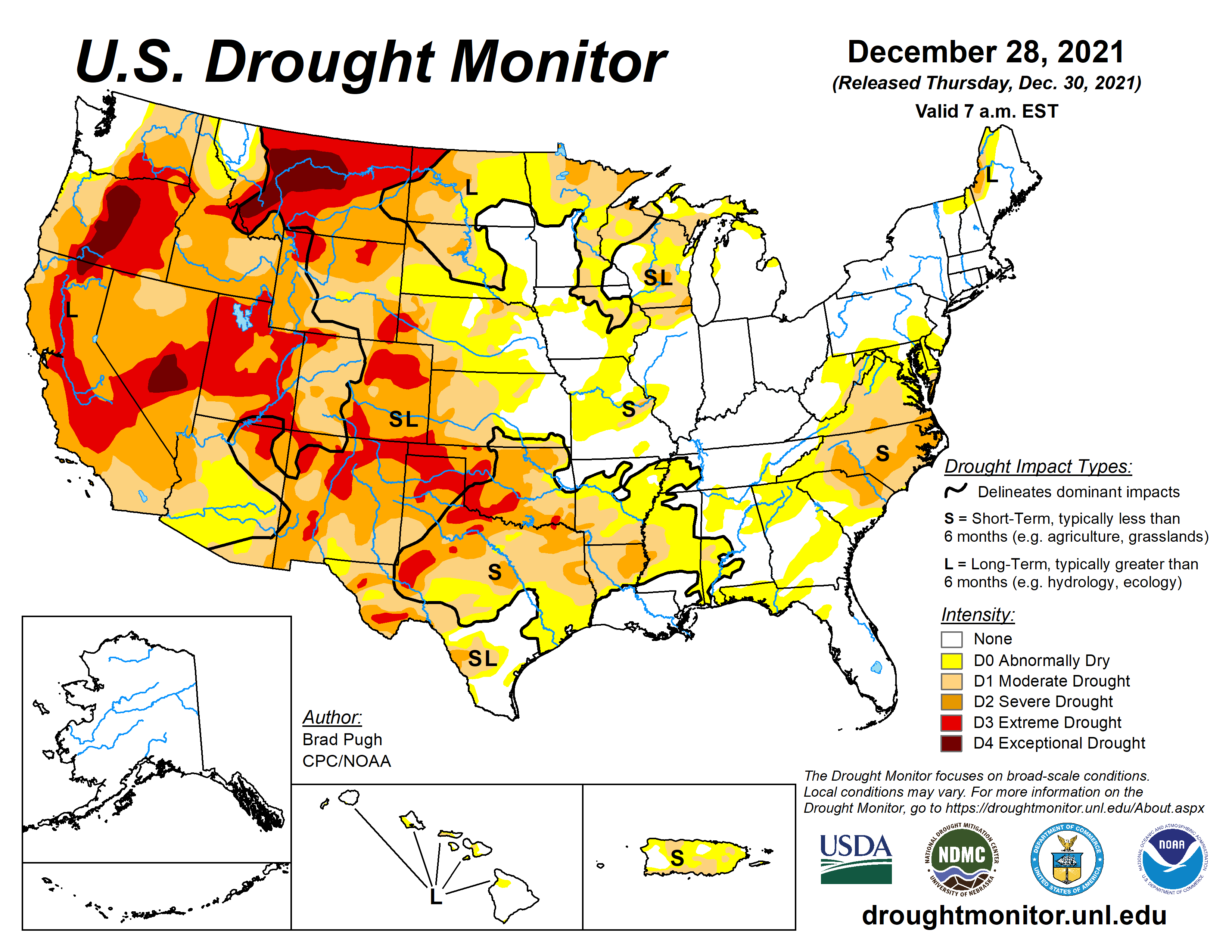
Click on a thumbnail graphic to view a gallery of drought data from the US Drought Monitor.
US Drought Monitor map January 18, 2022.
High Plains Drought Monitor map January 18, 2022.
West Drought Monitor map January 18, 2022.
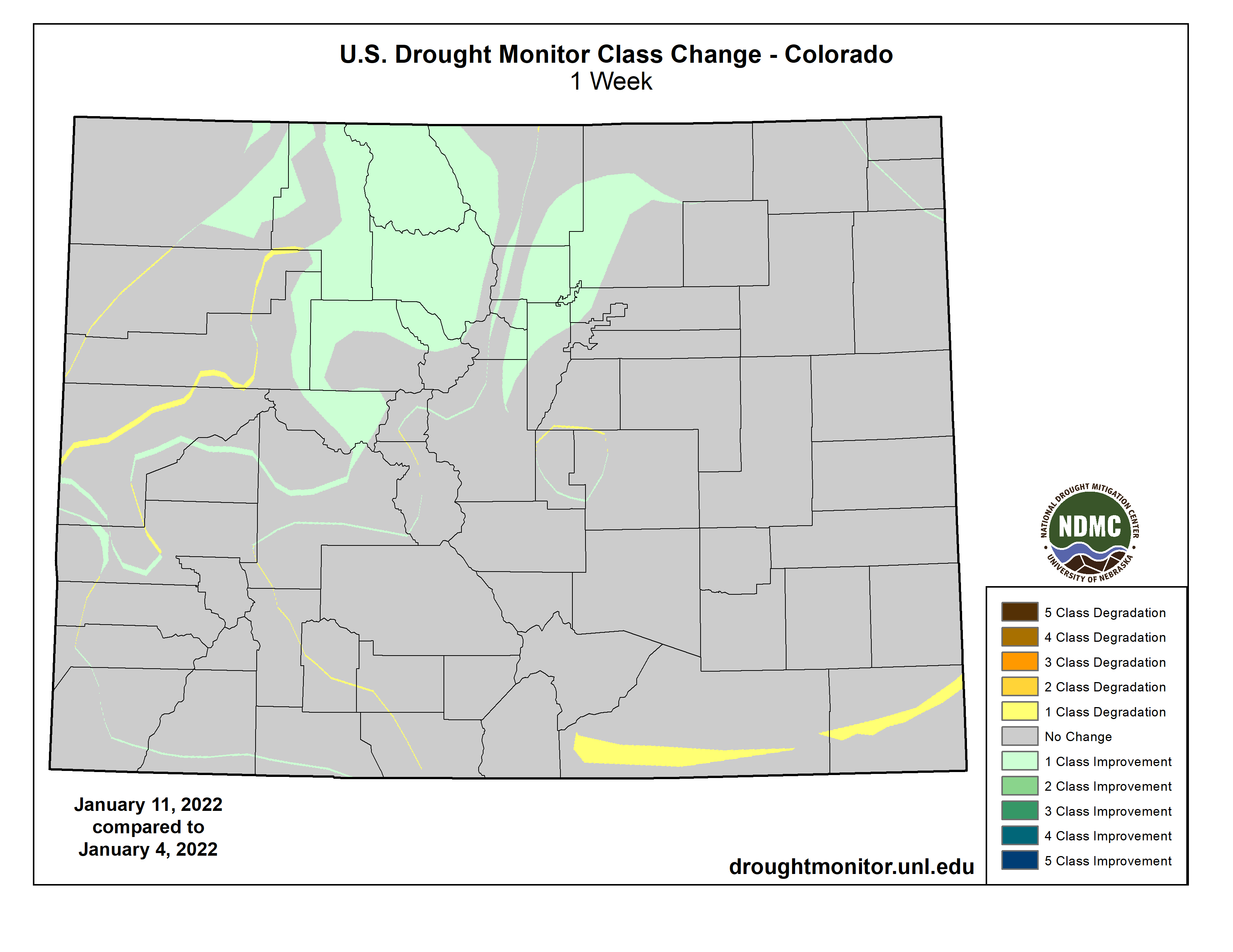
Colorado Drought Monitor map January 18, 2022.
Click here to go to the US Drought Monitor website. Here’s an excerpt:
This Week’s Drought Summary
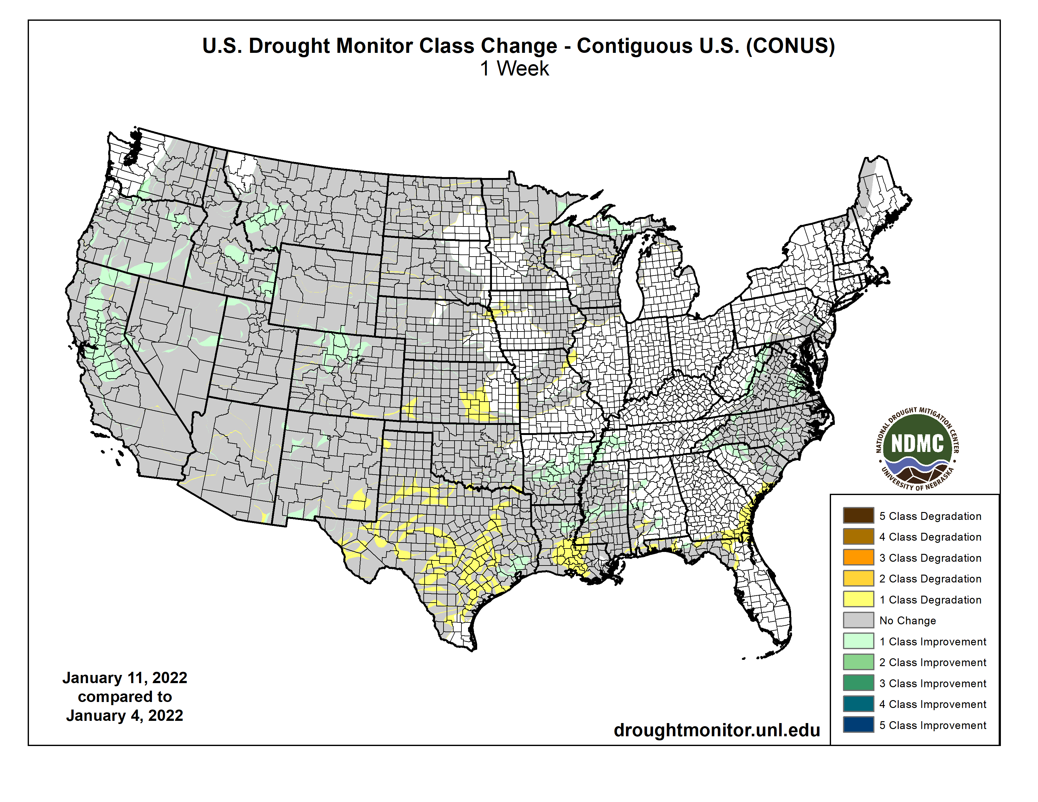
A winter storm impacted areas from the northern Plains, to the Midwest, into the Southeast and then up the east coast during the period. For many areas, this was the first time that heavy snow occurred in these regions as many have brought up “snow drought” in areas of the country where snow has been minimal. From the Missouri River west, there was very little precipitation for the week. Temperatures were warmest over the northern Rocky Mountains and Plains where departures were 10-15 degrees above normal. Cooler temperatures dominated the East as departures were 5-10 degrees below normal…
Warmer than normal conditions dominated the region with areas of the Dakotas recording temperatures that were 10-15 degrees above normal for the week. The same winter storm that impacted portions of the Midwest also brought snow to much of North Dakota, eastern South Dakota and eastern Nebraska. Much of the rest of the area recorded below-normal precipitation for the week. With an ongoing “snow drought” in portions of the western Dakotas, degradation was shown this week in the Black Hills of South Dakota where moderate drought was expanded and in western North Dakota where severe drought was expanded. Some improvements were made to areas of extreme drought this week in southeast Wyoming, western Nebraska, and central Colorado. Many of the improvements were based on a reassessment of the region after the last few weeks brought several precipitation events to these areas…
Colorado Drought Monitor one week change map ending January 18, 2022.
Temperatures were near normal for most of the region this week with areas of Wyoming and Montana having departures of 10-15 degrees above normal. With most of the region recording little to no precipitation for the week, most of the changes in the area were based on an assessment over the last several weeks. Improvements were made to the extreme and exceptional drought in western Montana and eastern Idaho as well as in northwest Wyoming…
Most of the region was dry for the week with only portions of northern Arkansas, Tennessee, and Mississippi recording widespread precipitation, with some areas at 150% of normal or more. Temperatures were near normal to slightly above with departures of 2-4 degrees above normal over the panhandles of Texas and Oklahoma as well as eastern Arkansas. Coastal areas of Texas into the Delta were 2-4 degrees below normal. Degradation continued as most areas have been dry since the fall and temperatures have remained well above normal during this period. In Oklahoma, a new area of exceptional drought was added in the panhandle with extreme drought areas expanded to the east. Severe drought expanded in southern Arkansas and into Louisiana and Mississippi. For Texas, severe and extreme drought expanded in the central and northern portions of the state while moderate and severe drought expanded in south Texas. There was an improvement to moderate drought and abnormally dry conditions in east Texas…
Looking Ahead
Over the next 5-7 days, it is anticipated that cooler than normal conditions will dominate the eastern half of the United States, with the greatest departures along the Canadian border in the Great Lakes region where departures of 12-15 degrees below normal are anticipated. Warmer than normal conditions over the West and northern Rocky Mountains with departures of 6-9 degrees above normal could be observed. Some precipitation is expected over the Pacific Northwest and into the Rocky Mountains. The wettest locations are expected to be in the South and Southeast and into the Mid-Atlantic where up to an inch or more of precipitation could be expected.
The 6-10 day outlooks show the high probability of colder than normal temperatures over the eastern half of the country, especially from the Great Lakes to the Mid-Atlantic into New England. It is anticipated that below normal precipitation will impact much of the country centered on the Great Basin and the Midwest. There are above normal chances for above normal precipitation in much of Alaska, central Rocky Mountains and along the Gulf Coast.
US Drought Monitor one week change map ending January 18, 2022.
The U.S. Department of Agriculture (USDA) Natural Resources Conservation Service (NRCS) is announcing several new and expanded opportunities for climate smart agriculture in 2022. Updates include nationwide availability of the Environmental Quality Incentives Program (EQIP) Conservation Incentive Contracts option, a new and streamlined EQIP Cover Crop Initiative, and added flexibilities for producers to easily re-enroll in the Conservation Stewardship Program (CSP). These improvements to NRCS’ working lands conservation programs, combined with continued program opportunities in all states, are part of the Biden-Harris Administration’s broader effort to support climate-smart agriculture.
“Climate change is happening, and America’s agricultural communities are on the frontlines,” NRCS Chief Terry Cosby said. “We have to continue to support and expand the adoption of conservation approaches to support producers in their work to address the climate crisis and build more resilient operations. We are continuously working to improve our programs to ensure we’re giving farmers and ranchers the best tools to conserve natural resources.”
New Partnership Announced
NRCS is announcing a new partnership with Farmers For Soil Health, an initiative of the United Soybean Board, National Corn Growers Association and National Pork Board. Farmers For Soil Health works to advance use of soil health practices – especially cover crops – on corn and soybean farms. The initiative has a goal of doubling the number of corn and soybean acres using cover crops to 30 million acres by 2030.
“We are pleased to see NRCS announce this new incentive program for cover crops,” said John Johnson, coordinator of Farmers for Soil Health. “Cover crops have great potential to improve soil health, improve water quality, sequester carbon, and make our farms more resilient to severe climate events. We look forward to our partnership with NRCS, working to expand adoption of cover crop practices to help our farmers meet our sustainability goals.”
Other partners include the National Association of Conservation Districts, Soil Health Institute, and The Sustainability Consortium.
EQIP Cover Crop Initiative
To complement the new partnership, NRCS is investing $38 million through the new targeted Cover Crop Initiative in 11 states to help agricultural producers mitigate climate change through the widespread adoption of cover crops. States include Arkansas, California, Colorado, Georgia, Iowa, Michigan, Mississippi, Ohio, Pennsylvania, South Carolina and South Dakota. States were selected for this initial pilot based on their demonstrated demand for additional support for the cover crop practice.
Sign-up dates will be determined at the state-level, and applications will be selected for funding by Feb. 11, 2022.
The initiative is aimed at improving soil health through a targeted, rapid, and streamlined application and contract approval process. NRCS will continue to build on this framework and streamlined application process to support farmers and ranchers across the country.
Crop residue. Photo credit: Joel Schneekloth
Cover crops offer agricultural producers a natural and inexpensive climate solution through their ability to sequester atmospheric carbon dioxide into soils. Cover crops can provide an accelerated, positive impact on natural resource concerns. In fiscal 2021, NRCS provided technical and financial assistance to help producers plant 2.3 million acres of cover crops through EQIP.
EQIP Conservation Incentive Contracts
Conservation Incentive Contracts address priority resource concerns, including sequestering carbon and improving soil health in high-priority areas. Through these contracts, works with producers to strengthen the quality and condition of natural resources on their operations using management practices, such as irrigation water management, drainage water management, feed management and residue and tillage management that target resource concerns, including degraded soil and water quality, available water and soil erosion.
Conservation Incentive Contracts offer producers annual incentive payments to implement management practices as well as conservation evaluation and monitoring activities to help manage, maintain and improve priority natural resource concerns within state high-priority areas and build on existing conservation efforts. Download our “Conservation Incentive Contracts” fact sheet for a list of practices (PDF, 1 MB).
Conservation Incentive Contracts last five years. The 2018 Farm Bill created the new Conservation Incentive Contract option, and it was piloted in 2021 in four states.
CSP Re-Enrollment Option
NRCS updated CSP to allow an agricultural producer to immediately re-enroll in the program following an unfunded application to renew an existing contract. Previously, if a CSP participant did not re-enroll the year their contract expired, they were ineligible for the program for two years.
This ineligibility was imposed on CSP participants even if their failure to sign a renewal contract was due to the unavailability of funds, which is beyond their control. USDA is now waiving this two-year ineligibility restriction for all CSP applications.
This year, producers renewed 2,600 CSP contracts covering 3.4 million acres. Applicants with unfunded fiscal 2022 CSP renewals will receive letters this month, notifying them they are automatically eligible to apply for future CSP funding opportunities, rather than needing to wait two years to reapply.
How to Apply
NRCS accepts applications for conservation programs – including EQIP and CSP – year-round, however producers and landowners should apply by state-specific, signup dates to be considered for each year’s funding. To apply, producers should contact their local USDA Service Center.
More Information
Through conservation programs, NRCS provides technical and financial assistance to help producers and landowners make conservation improvements on their land that benefit natural resources, build resiliency, and contribute to the nation’s broader effort to combat the impacts of climate change. More broadly, these efforts build on others across USDA to encourage use of conservation practices. For example, USDA’s Risk Management Agency (RMA) recently provided $59.5 million in premium support for producers who planted cover crops on 12.2 million acres through the new Pandemic Cover Crop Program. Last week, RMA announced a new option for insurance coverage, the Post Application Coverage Endorsement, for producers who “split apply” fertilizer on corn.
Under the Biden-Harris Administration, USDA is engaged in a whole-of-government effort to combat the climate crisis and conserve and protect our nation’s lands, biodiversity and natural resources including our soil, air, and water. Through conservation practices and partnerships, USDA aims to enhance economic growth and create new streams of income for farmers, ranchers, and private foresters. Successfully meeting these challenges will require USDA and our agencies to pursue a coordinated approach alongside USDA stakeholders, including state, local and Tribal governments.
USDA touches the lives of all Americans each day in so many positive ways. In the Biden-Harris Administration, USDA is transforming America’s food system with a greater focus on more resilient local and regional food production, fairer markets for all producers, ensuring access to safe, healthy and nutritious food in all communities, building new markets and streams of income for farmers and producers using climate smart food and forestry practices, making historic investments in infrastructure and clean energy capabilities in rural America, and committing to equity across the Department by removing systemic barriers and building a workforce more representative of America. To learn more, visit http://www.usda.gov.
Enjoy that snow you see now, because the spring is likely to be warm and dry.
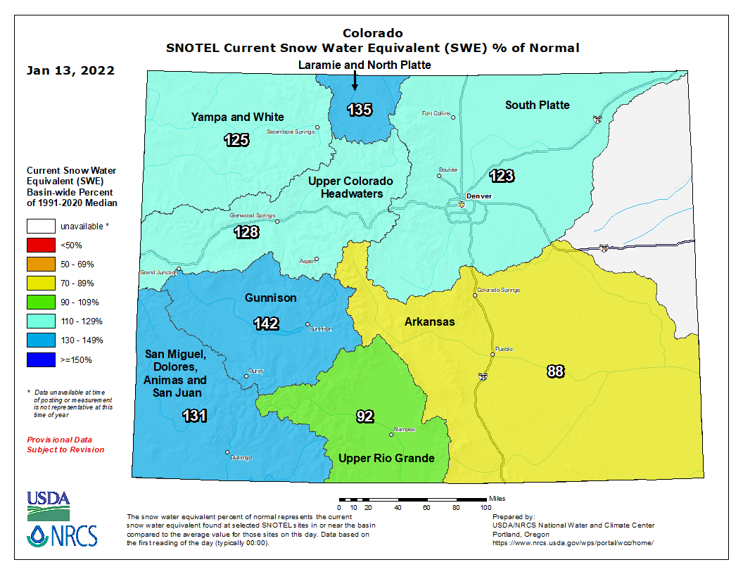
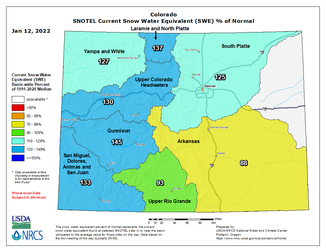
Colorado’s statewide snowpack stands at 119% of average, a welcome break in the state’s prolonged dry spell.
“This is well above what we were seeing last year at this time. It’s awesome,” said Brian Domonkos, snow survey supervisor for the Lakewood-based Natural Resources Conservation Service (NRCS).
Colorado snowpack basin-filled map January 14, 2021 via the NRCS.
Domonkos’ comments came Tuesday at a meeting of the state’s Water Availability Task Force, a group charged with monitoring water supplies and forecasts.
In Colorado, and other Western states, mountain snow levels are closely watched because when they melt in late spring, they supply the majority of water for cities and farms.
Staggered by a 20-year drought cycle, the latest forecasts, despite the recent snow, offer little hope of a break in this historic dry spell, considered by many to be the worst in 1,200 years.
The latest predictions indicate that Colorado is still at the mercy of a weather pattern known as La Niña, which this year, for the second year in a row, is expected to bring dry conditions through March to much of the state, according to Peter Goble, a climate specialist with Colorado State University’s Colorado Climate Center.
“Right now the tilt is toward a drier spring,” Goble said.
Holiday snowstorms delivered welcome relief to mountains with six of the state’s eight major river basins now seeing above-average snowpack. The Rio Grande Basin, in south-central Colorado, and the Arkansas Basin, in the southeastern corner of the state, continue to see below-average snowpacks, registering at 80% and 90% respectively.
But that didn’t dampen the relief among water officials, who’ve been coping with severe, back-to-back drought for much of the past three years.
“It’s great to have some good news for a change,” said Tracy Kosloff, deputy state engineer at the Colorado Division of Water Resources.
Now forecasters and water managers are turning their attention to a relatively new phenomenon, the impact of ultra-dry soils on water runoff forecasts.
Last year, though the statewide spring snowpack measured at 90% of average by late spring, streamflows were dramatically lower, registering below 30% in many of the state’s stream systems, according to the NRCS.
Prior to this 20-year drought cycle, streamflow forecasts closely followed the snowpack, but that link has been severed.
Now dry soils are absorbing melting water at high rates, throwing critical water supply forecasts off.
This year the situation should improve, Domonkos said.
“Our Jan. 1 forecasts are really showing some great potential runoff scenarios. But we’re not going to take this for granted. Things can change if it dries out significantly.”
Jerd Smith is editor of Fresh Water News. She can be reached at 720-398-6474, via email at jerd@wateredco.org or @jerd_smith.
Perhaps no other wild animal has endured the wrath of humans while evoking such genuine heartfelt admiration quite like the coyote. Some people curse their existence; Native Americans consider them to be the smartest animal on earth, calling them “God’s dog”, and many urbanites revel in opportunities to see and hear these vocal predators.
The coyote’s success is attributed to the coyote’s own ability to adapt. Coyotes have adjusted very well to human-disturbed environments, and now thrive in close proximity to people.
Coyotes are opportunistic hunters. They prey on small mammals, domestic pets, livestock, and domestic fowl but will also readily eat carrion and plants. A coyote will adjust its diet depending on the food that is available. In Colorado, coyotes are classified as a game species and may be taken year-round with either a small game or a furbearer license. Landowners may kill coyotes, without a license, on their land if the coyotes threaten their property or livestock.
The Forest Service has launched a robust, 10-year strategy to squarely address this wildfire crisis in the places where it poses the most immediate threats to communities. The strategy, called “Confronting the Wildfire Crisis: A Strategy for Protecting Communities and Improving Resilience in America’s Forests,” combines a historic investment of congressional funding with years of scientific research and planning into a national effort that will dramatically increase the scale of forest health treatments over the next decade.
Though the Forest Service has been working to manage the health of millions of acres of national forests across the American West for decades, the scale and methods of work on the ground have not matched the need. With the support of our partners, states, Tribes and local communities, the Forest Service is collaboratively implementing this new strategy across jurisdictions and landownerships to protect communities, critical infrastructure, watersheds, habitats, and recreational areas.
Overgrown forests, a warming climate, and a growing number of homes in the wildland-urban interface, following more than a century of rigorous fire suppression, have all contributed to what is now a full-blown wildfire and forest health crisis.
The Forest Service will work with partners to focus fuels and forest health treatments more strategically and at the scale of the problem, using the best available science as a guide. The plan calls for the agency to treat up to an additional 20 million acres on National Forest System lands, and up to an additional 30 million acres of other Federal, State, Tribal, and private lands.
The Biden administration will use $3 billion from last year’s infrastructure law to revamp the federal approach to wildfire management, introducing a 10-year plan to deal with the large swaths of the West scientists consider most at risk of destructive blazes.
Agriculture Secretary Tom Vilsack, a former Iowa governor, announced the new strategy in Phoenix, alongside Forest Service Chief Randy Moore and Democratic U.S. Sen. Mark Kelly.
GET THE MORNING HEADLINES DELIVERED TO YOUR INBOX
The Forest Service will focus on using managed fires to reduce natural fuels — flammable material that can feed fires, including trees, grasses, dead leaves and fallen branches, according to a report the U.S. Forest Service released ahead of the announcement.
In prepared remarks, Vilsack highlighted the infrastructure law’s funding to address wildfires.
“It’s fair to say the Forest Service has recognized for some time, the need to dramatically — and I emphasize the word dramatically — increase our ability to treat at a pace and scale that will actually make a difference,” he said.
The law will add $650 million to a roughly $280 million budget to treat forests for fire prevention, a 350% increase.
The Agriculture Department and Forest Service had worked “for many, many years in the traditional budgeting process” to get the scope of funding that experts believed was necessary to reduce the risk of catastrophic wildfires, but did not have the resources until the infrastructure law, Vilsack said.
Kelly said wildfires had reached “a crisis point” that would only worsen with continued climate change.
“We can’t keep doing the same thing under worse conditions and expecting better results,” he said. “We need to be more proactive.”
In more than a century of management focused on fire suppression, forests have grown denser and fuels have built up, putting forests at greater risk of intense fires.
Carbon buildup in the atmosphere has also made matters worse by acting as natural heat traps. Climate change has reduced snow and rainfall in the West and produced hotter, drier weather, which has increased forest flammability, the report says.
The report calls for a “paradigm shift” in preventing fires, shifting away from fire suppression and toward a combination of logging to reduce forest density and prescribed, controlled burns.
“We need to thin western forests and return low-intensity fire to western landscapes in the form of both prescribed and natural fire, working to ensure that forest lands and communities are resilient in the face of the wildland fire that fire-adapted landscapes need,” the report said.
Under the plan, the Forest Service could treat an additional 20 million acres of national forest area, plus 30 million acres of other federal, state and tribal lands over the next 10 years, according to the report.
The first two years of the plan will focus on key “firesheds,” areas of 250,000 acres at risk of large-scale fires.
The scope of the effort — and the funding behind it — position it for success, said Susan Jane Brown, the Wildlands Program director at the environmental nonprofit Western Environmental Law Center.
Thinning forests, reducing fuels and using prescribed burns are established techniques, but the funding for forest management and the landscape-scale approach could make a larger impact, said Brown.
“The sort of scattershot approach, what we call random acts of restoration, simply aren’t working,” Brown said.
“We’ve known for a long time that part of the reason why the agency or service can’t get ahead of the problem is because they didn’t have the funding or the personnel to do the work,” she said. “And now they have the funding and Congress has told them to go hire the personnel.”
Planned projects to address risks in several Western firesheds — including in Arizona, Colorado and Oregon — are ready for work to begin and need only funding, according to the report.
Editor’s note: This story was updated at 7:49 p.m., Jan. 18, 2022, to include details from the announcement of the new fire strategy.
SUPPORT NEWS YOU TRUST.
Colorado Newsline is part of States Newsroom, a network of news bureaus supported by grants and a coalition of donors as a 501c(3) public charity. Colorado Newsline maintains editorial independence. Contact Editor Quentin Young for questions: info@coloradonewsline.com. Follow Colorado Newsline on Facebook and Twitter.
RENEWABLE Water Resources has made an “inaccurate portrayal of the State Engineer’s actions and the facts” in its pitch to Douglas County to partner in exporting water from the San Luis Valley, State Engineer Kevin Rein said.
Rein, in an email response to a series of questions from AlamosaCitizen.com, said RWR misrepresents Douglas County’s reliance on the “Denver Aquifer” and how a “proposed rule change” from the state engineer would drastically affect Douglas County’s relationship with the aquifer.
“The cumulative effect of RWR’s statements is an inaccurate portrayal of the State Engineer’s actions and the facts,” Rein said.
Kevin Rein, Colorado state water engineer, explains why Colorado needs stepped-up measuring of water diversions in the North Park and other rivers in Northwest Colorado while Erin Light, Division 6 engineer, looks on during a meeting in Walden on Oct. 22. Credit: Allen Best
Rein said his office has not taken a position on the RWR proposal because the project, led by former Colorado Gov. Bill Owens, has not been formally submitted for regulatory review to the State Engineer’s Office. RWR is courting Douglas County as an investor in its efforts to export water from the San Luis Valley to Colorado’s Front Range. To move the project to formal review both by Rein’s office and state Division 3 Water Court, RWR needs to identify an end user for its effort to export water from the Valley.
The project has created an uproar, with city officials from Monte Vista the latest to blast it as a “scheme to transport our valuable water resources out of the San Luis Valley.”
“The idea that there is an abundance of water for Douglas County suburbia to continue to sprawl at the San Luis Valley’s expense is shameless,” Monte Vista officials said in a letter to AlamosaCitizen.com. The full letter is here.
Denver Basin Aquifer System graphic credit USGS.
In its pitch, Renewable Water Resources said Douglas County is overly dependent on the Denver Aquifer as its main water supply, and remaining dependent on it threatens the Denver suburb’s property values, economic growth and quality of life.
“Additionally, a proposed rule change could drastically impact Douglas County’s relationship with the Denver Aquifer,” RWR states in its pitch to Douglas County for money. “Colorado’s State Water Engineer recently urged Denver Metro water providers, including those located in Douglas County, to seek renewable sources of water other than the Denver Aquifer. This new guidance will limit the use of the Denver Aquifer and essentially maintain the Aquifer as a ‘preserve.’”
Rein, when asked about the accuracy of RWR’s statements, said, “First, as a matter of hydrogeology, there is one hydrogeologic feature known by scientists and water users as the ‘Denver Basin.’ It stretches from approximately Greeley to Colorado Springs and from the foothills to Limon. Within the Denver Basin is a layering of discrete aquifers that for administration purposes are treated as separate sources. Those aquifers, from the top layer to the bottom layer are: the Dawson Aquifer, the Upper Dawson Aquifer, the Lower Dawson Aquifer, the Denver Aquifer, the Arapahoe Aquifer, the Upper Arapahoe Aquifer, the Lower Arapahoe Aquifer, and the Laramie-Fox Hills Aquifer.
“This information is relevant because the (RWR) report states that ‘Douglas County is currently overly dependent on the Denver Aquifer as its principal water supply…’ However, I know that Douglas County municipal water suppliers and private well owners rely on nearly all of the aquifers I’ve listed, from the Dawson to the Laramie-Fox Hills. Their reliance is not on only the Denver Aquifer.
“Second, the (RWR) Report states, ‘Additionally, a proposed rule change could drastically impact Douglas County’s relationship with the Denver Aquifer.’
“The Report does not cite the claimed ‘rule change.’ For your information, the Division of Water Resources recently proposed amended Statewide Nontributary Ground Water Rules, which rules we regard as consistent with the General Assembly’s statutorily-described allocation of nontributary ground water (see SB73-213; section 37-90-137(4), C.R.S.). To my knowledge, neither RWR nor those Douglas County entities have shown evidence that the State Engineer has ever shown a different application of the General Assembly’s intended allocation. Therefore, I find no support for RWR’s claim that ‘a proposed rule change could drastically impact Douglas County’s relationship with the Denver Aquifer.’ As the State Engineer I believe that RWR should account for this claim since it appears to have no basis.
“In summary, there has been no rule change. If RWR believes the State Engineer’s long-standing application of state statute ‘drastically impacts’ Douglas County, they should also be aware that the State Engineer has not changed its application of the statute in the last 48 years. I am not aware of any evidence to the contrary.”
Renewable Water Resources said it relied on information from a January 2021 environmental law and policy alert on a call for public comment around the proposed amended statewide nontributary groundwater rules.
“Many conversations have and are taking place as to why Front Range cities and towns are going to need to depend less on the Denver Aquifer. And, why water providers in the Front Range are scrambling to find non-Denver aquifer sources,” said spokesperson Monica McCafferty. “This is a known fact in the Front Range and likely to be discussed more in the Douglas County public hearings.”
Rein had a third rebuttal to RWR when the group said in the proposal to Douglas County that Rein had recently urged Denver Metro water providers “to seek renewable sources of water other than the Denver Aquifer,” and called it “new guidance” from the State Engineer.
“I see no basis for this claim,” Rein told Alamosa Citizen. “Since 1996, the State Engineer’s Office has included notes on our correspondence to Douglas County regarding subdivision water supplies that remind the county of the non-renewable nature of the Denver Basin as a water supply. We include the same information on Denver Basin well permits that we issue. We provide this information as a courtesy since we are an agency that knows the science and administrative aspects of the Denver Basin.
“The next statement in the report states that ‘(f)or Douglas County, this ruling is an imminent and practical challenge and catalyst for necessary change.’ The basis of this statement is confusing since there has been no ‘ruling.’ The non-renewable nature of the Denver Basin is the result of hydrogeologic events that occurred millions of years ago. Allocation directives that were put in statute in 1973 reflect that nature of the Denver Basin. Nothing that the State Engineer has done has made the challenge any more ‘imminent.’
“Each of these items may seem small,” Rein said, “but the cumulative effect of RWR’s statements is an inaccurate portrayal of the State Engineer’s actions and the facts.
“I have only commented on the aspects of the letter that portray the State Engineer and our actions in a way that I believe is inaccurate. I will not comment on RWR’s opinions or judgments of Douglas County’s ongoing efforts.”
RWR also misrepresents a Dec. 2018 letter from Rein to the Rio Grande Water Conservation District, Rein said. At that time, Rein had sent correspondence to General Manager Cleave Simpson on the amended Plan of Water Management for Subdistrict 1, and the legal authority he has to curtail groundwater diversions from Subdistrict 1 wells if the conservation district isn’t making progress toward restoring the unconfined aquifer to a sustainable level as ordered by the state water court.
RWR said in its proposal to Douglas County that Rein would shut down wells in the subdistrict for a minimum of three years, boosting its project since its efforts do not rely on the unconfined aquifer.
“Regarding RWR’s reference to my December 2018 letter, if the State Engineer is put in a position of curtailing wells, it would not be ‘…so the objective of the Subdistrict 1 groundwater management plan can be achieved…’ as I read in the proposal. Rather, it would be the result of a regulatory decision that would be necessary due to the fact that the Subdistrict’s Annual Replacement Plan does not meet the objectives of the Rules and the Groundwater Management Plan. This is stated in the December 2018 letter. My letter did not address the amount of time the wells would be curtailed and I don’t know the basis of RWR’s claim that the wells would be curtailed for a minimum of three years.
“As I noted earlier, for RWR’s concept to operate, among other things, they would need to demonstrate through a detailed court approved plan that they would have no impact on the basin as a whole. That is yet to be seen.”
A map shows detour routes motorists can use when the Garfield Harrison Storm Drainage Improvements Project closes First Streets at times during 2022. (Courtesy City of Loveland)
From the City of Loveland via The Loveland Reporter-Herald:
The city of Loveland will begin the first phase of the Garfield Harrison Storm Drainage Improvements Project the week of Jan. 17.
The city has selected Connell Resources as the project contractor and ICON Engineering for project design.
According to a news release, the four-year project is designed to:
Replace and upgrade existing stormwater infrastructure to address existing drainage issues and meet current stormwater standards.
Install 18- to 60-inch diameter storm sewer pipes.
Replace existing waterlines and valves to address aging infrastructure.
Replace pavement where project components are installed.
Rehabilitate and replace concrete as well as add necessary ADA improvements.
Provide stormwater quality treatment measures within the stormwater system.
“Local street flooding will decrease and we can also better clean the stormwater going into our waterways like the Big Thompson Canyon. The quality of the water distribution system will be improved greatly and lead to fewer leaks,” Eric Lessard, city of Loveland civil engineer, said in the release.
The project will have four separate phases; it’s anticipated one phase will be completed per year.
Phase 1 will include sidewalk and road closures for a portion of West First Street from North Taft Avenue to Cleveland Avenue. River’s Edge Natural Area and Centennial Park will remain open to local traffic.
Detours will be in place through the duration of Phase 1, but travelers should be prepared for delays, the release said.
Eastbound detours will direct traffic south on South Taft Avenue to Colo. 402 (14th Street Southwest) and north on Lincoln Avenue to First Street. Westbound detours from West First Street will direct traffic to North Lincoln Avenue to Eisenhower Boulevard and back down North Taft Avenue to First Street.
Typical working hours will be Monday through Friday from approximately 7 a.m. to 5 p.m.
Night and weekend work will be occasional and announced in advance.
The total project budget is approximately $18 million, to be funded by the city’s stormwater, water and power enterprise funds.
Residents can sign up for weekly project updates or contact the project team by email garfieldharrisonstormdrain@gmail.com or by calling the project hotline at 970-716-5155.
South Platte River Storage Study Area. Illustration shows water availability, in blue circles, compared with demand at various places along the South Platte River. The yellow area is the study area. (Illustration by Stantec).
Governor Ricketts is an elected official who I have always thought does a good job – especially for agriculture – and someone that I tend to support. With that said, he blew it earlier this month when he made some bold and inaccurate statements regarding Colorado’s water.
The fact is, Colorado is in compliance with our South Platte Interstate Compact.
Our compact says that we must deliver 120 cubic feet per second to Nebraska between April 1 and October 15. We do that and we do our best to not send them more than is required because of our needs as a state with both populous urban areas and a vital agriculture industry based in rural Colorado.
The compact also says that Colorado has full and uninterrupted use and benefit of the water in the river the rest of the time… except…
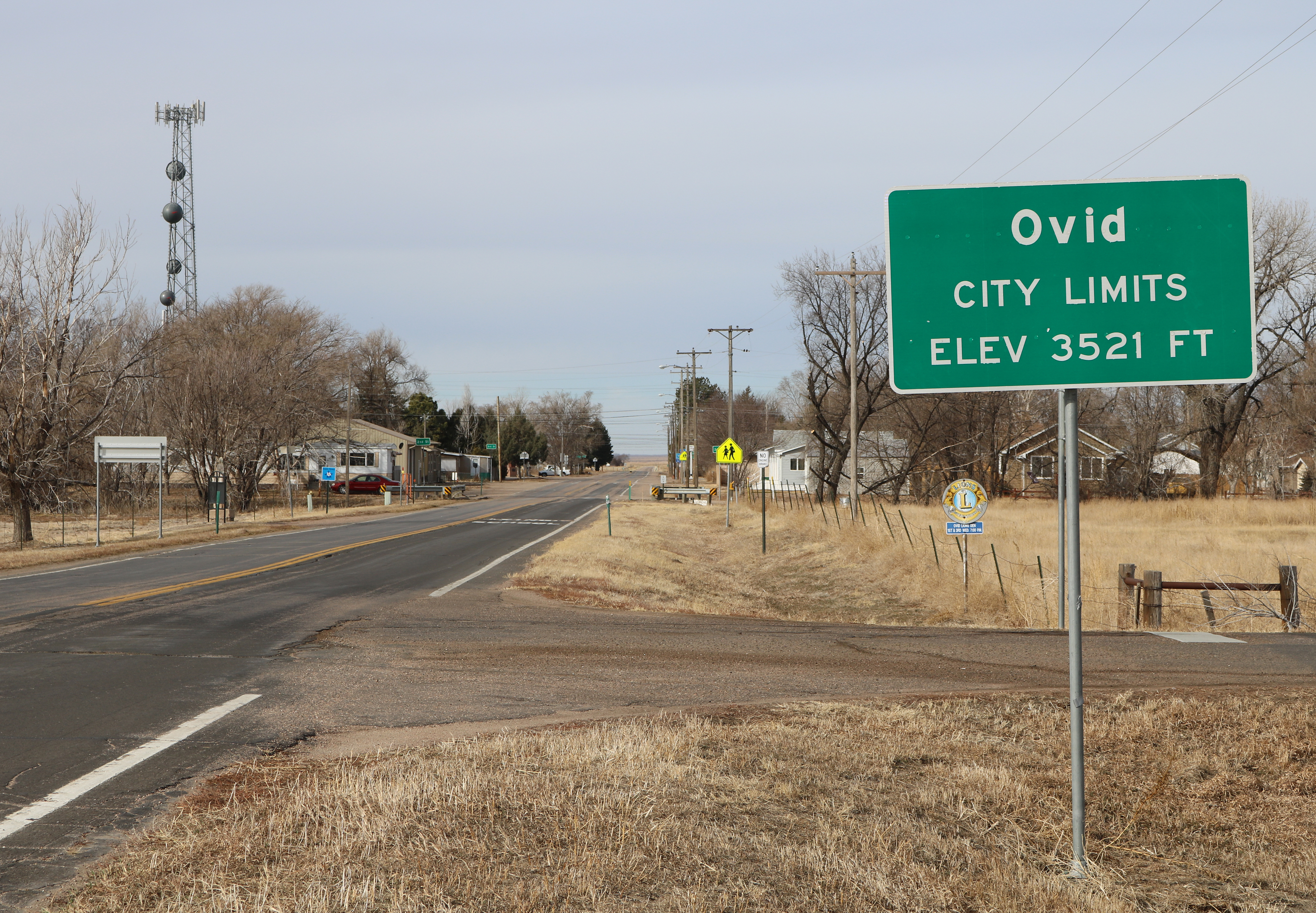
The exception is that 99 years ago there was a potential ditch near Ovid that Nebraska wanted to try to use for additional irrigation but abandoned and they referenced that ditch and future construction in the compact. They can complete that ditch anytime but in order to do so, Nebraska would have to buy land in Colorado, or try to use eminent domain and just take it. Rest assured, that won’t go any better for the Big Red Bureaucrats riding in to Colorado than it would in western Nebraska with any of their own land owners.
Governor Ricketts claims that our plans in Colorado could reduce water flows into his state by as much as 90%. Give me a break. I don’t know where his advisors learned their math but perhaps their schools teach that your answer is never wrong if you feel good about it.
On average over the last couple of decades, Colorado has allowed around 350,000 acre feet annually to leave our state over and above the requirements of the compact. Water that could be used in Colorado by Coloradans.
The consequences of this is that after all the court battles and millions spent on attorneys, if – and it is a big if – Nebraska would win, augmentation would be called out of priority. In other words, much of the farm ground along our South Platte River in Logan and Sedgwick counties would dry up. It would also destroy what Colorado accomplishes to meet our requirements for Endangered Species Protections.
So what is the answer?
We finally have an issue in which all of Colorado can unite behind. Governor Polis in his State of the State address this year vowed to fight Nebraska over their claims. The way we do this is water storage.
The compact says that before Nebraska can take a drop of additional water, all of the water rights have to be satisfied upstream of basically the Prewitt Reservoir which means that if we build a reservoir in Morgan County, we could fill it before downstream uses and then utilize agreements and exchanges to allow our current augmentation to continue.
That same compact also gives Colorado the first 35,000 acre feet of water that passes the gauging station near the Prewitt Reservoir so let’s build a 35,000 acre feet reservoir near the state line.
It is interesting that if Nebraska builds this ditch and diverts water in the winter months, where will they go with it and what will they use it for. They attached a $100 million price tag for the entire project which doesn’t get them much in a consistent source of water.
Screen shot of the site of the Narrows Dam which was proposed to be built on this Weldon Valley land located one-half mile below the Narrows Bridge. (Fort Morgan Times photo)
I have a better idea. We in Colorado will work with Nebraska and partner in the cost of storage along the South Platte so both of us can benefit from a consistent source of water. The average 350,000 acre feet that we lose to Nebraska each year could be stored in Colorado and we can use a large portion of that to relieve the pressures from our urban cousins to dry up farm ground so they can water their lawns.
No matter what the outcome of their bizarre claim, we would be well advised to unite as Colorado residents and build that water storage with or without Nebraska’s help so that Denver, our wildlife that depends on the river and the farmers and ranchers that feed the world, have access to all the water we are entitled to use.
Jerry Sonnenberg represents Senate District 1 in the Colorado Senate.
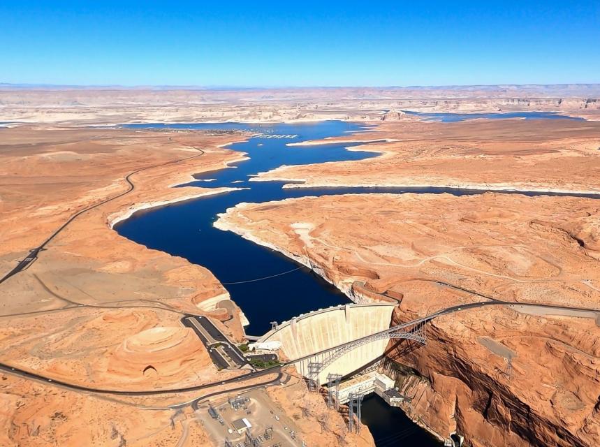
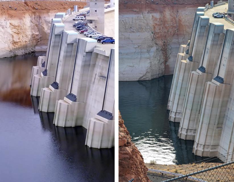
Lake Powell, a key reservoir on the Colorado River, has seen water levels drop precipitously as a result of two decades of drought. (Source: The Water Desk and Lighthawk Conservation Flying)
From The Water Education Foundation (Douglas E. Beeman):
Drought and Climate Change are raising concerns that a century-old compact that divided the river’s waters could force unwelcome cuts in use for the upper watershed
Climate scientist Brad Udall calls himself the skunk in the room when it comes to the Colorado River. Armed with a deck of PowerPoint slides and charts that highlight the Colorado River’s worsening math, the Colorado State University scientist offers a grim assessment of the river’s future: Runoff from the river’s headwaters is declining, less water is flowing into Lake Powell – the key reservoir near the Arizona-Utah border – and at the same time, more water is being released from the reservoir than it can sustainably provide.
Brad Udall: Here’s the latest version of my 4-Panel plot thru Water Year (Oct-Sep) of 2021 of the Colorado River big reservoirs, natural flows, precipitation, and temperature. Data (PRISM) goes back or 1906 (or 1935 for reservoirs.) This updates previous work with @GreatLakesPeck.
Udall’s slides and charts suggest that unless something changes soon, water levels behind Lake Powell’s Glen Canyon Dam on the Arizona-Utah border may fall so low by 2025 or 2026 that no water can get past the dam. That could ultimately leave downstream states like California, Nevada and Arizona short of water promised under the century-old Colorado River Compact that divided the river’s waters between the upper and lower watersheds.
And that has the potential to set up something that many water interests on the river say they want to avoid – a so-called “Compact call.” Such a scenario could force the Upper Basin states – Colorado, New Mexico, Utah and Wyoming – to curtail their own water use to fulfill their Compact obligation to send a certain amount of water to the Lower Basin states of California, Arizona and Nevada.
There has never been a Compact call on the river. But as evidence grows that the river isn’t yielding the water assumed by the framers of the 1922 Colorado River Compact, questions arise about whether a Compact call may be coming, or whether the states and water interests, drawing on decades of sometimes difficult collaboration, can avert a river war that ends up in court. It’s no small matter for a river that serves water to 40 million people from Denver to Los Angeles and irrigates more than 4 million acres of crops. The growing risk and the difficult actions that might be necessary to avoid a Compact call have been hot topics of discussion at several recent Colorado River conferences.
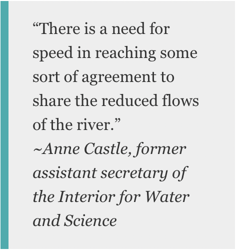
“The temperature, metaphorically, seems to be rising,” Anne Castle, a former assistant secretary of the Interior for Water and Science and a Colorado River veteran, said in an interview. “There is a need for speed in reaching some sort of agreement to share the reduced flows of the river.”
A River in Trouble
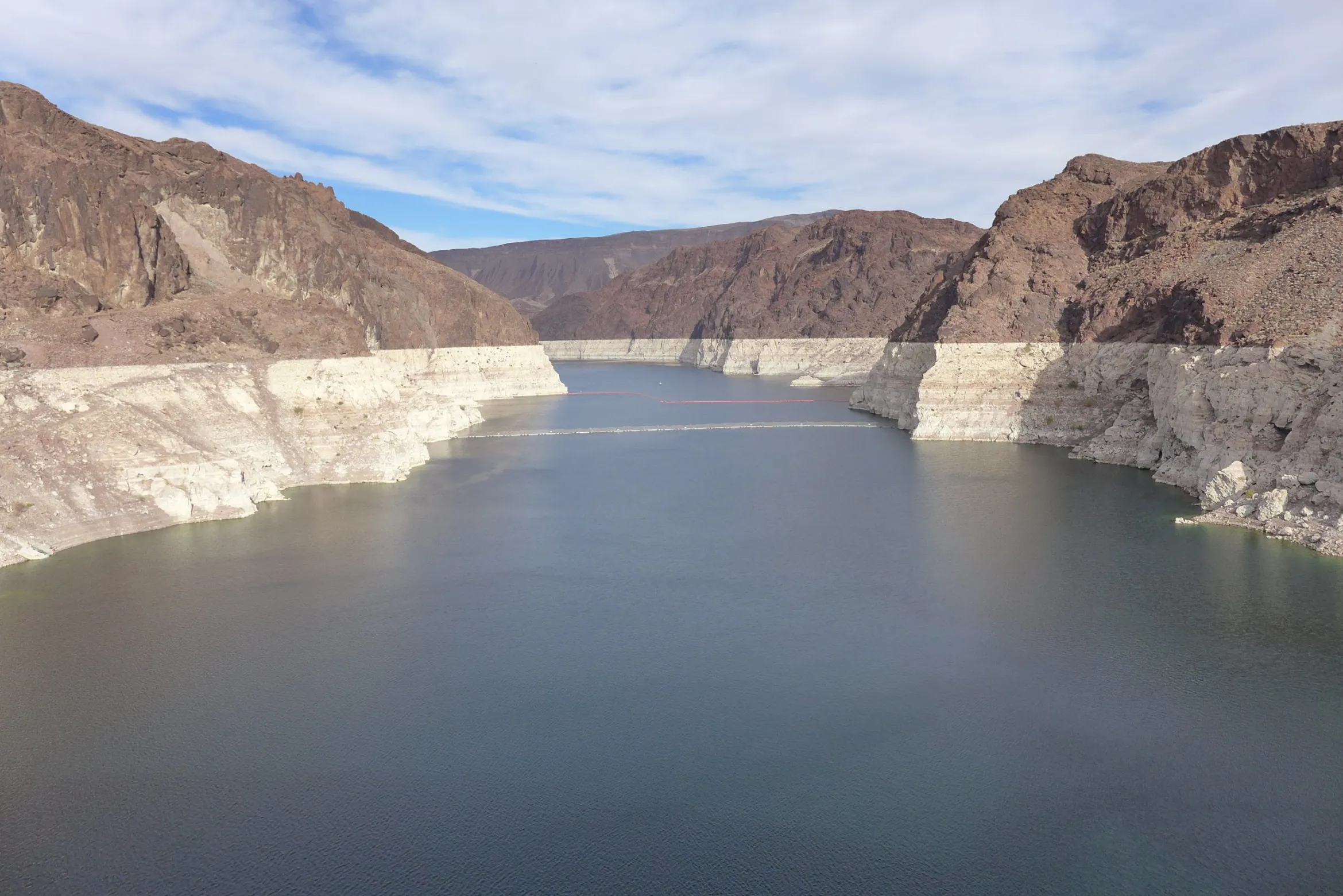
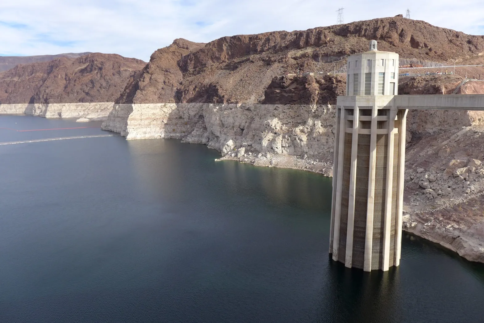
Without question, the Colorado is a river in trouble. After more than two decades of drought, both of the river’s anchor reservoirs – Lake Powell, upstream of Lee Ferry (the dividing point between the Upper and Lower Basins), and Lake Mead, the nation’s largest reservoir located downstream of Lee Ferry near Las Vegas – are only about 30 percent full. The river’s Rocky Mountain watershed has begun to see snow this winter, but many more rich winters of storms would likely be needed to undo 22 years of drought.
In August, the Bureau of Reclamation declared a first-ever shortage for next year, requiring Arizona and Nevada to cut back their annual take of the river by a total of 533,000 acre-feet (a cut of about 17 percent, mostly from Arizona) beginning this month. Based on a 2017 agreement, Mexico also will reduce its draw from the river. The move is intended to prevent already dire water levels from falling further in Lake Mead. Meanwhile, Reclamation’s most recent 24-month operating plan projects that, if hydrology remains extremely dry, the water level in Lake Powell by next September could approach the minimum needed to keep the hydropower turbines running.
Drought in the Colorado River Basin has pushed the water level in Lake Mead, Southern Nevada's main water source, to a historic low. (Source: Southern Nevada Water Authority)
Under a set of river operating guidelines adopted in 2007, the two reservoirs are managed in tandem, with Powell releasing water to help prop up water levels at Lake Mead. That arrangement has sometimes frustrated water interests in the Upper Basin, who have at times complained that the Lower Basin is using too much water and that their own ambitions for developing the river are being stymied.
“The level of Mead dictates in part how much water is released from Powell,” Becky Mitchell, the state of Colorado’s top water official, said at a recent water conference. “It’s important to focus on what’s going out of Lake Mead, because that has the greatest impact on the [Colorado River] system.”
When commissioners from the seven Basin states gathered in 1922 to hammer out the Compact – the foundational document in a growing set of agreements, laws and court cases called the Law of the River – they believed the river routinely carried about 17.5 million acre-feet a year. On that belief, they apportioned 7.5 million acre-feet a year each to the Upper and Lower Basins. They also agreed that any water committed to Mexico by a later U.S. treaty would be supplied equally by the two Basins. Native American tribes, who are now acknowledged to hold substantial rights to the river’s water, were barely mentioned.
Senior water and climate research scientist at Colorado State University and one of the authors of the National Climate Assessment. Photo credit: Colorado State University Water Institute
But more recent Bureau of Reclamation data show river flows averaged just 12.3 million acre-feet annually from 2000 to 2021 as severe drought gripped the river basin. Udall, the veteran Colorado State University climate researcher, said at an October conference that a warming climate that is drying out the Basin is making things worse. From 2000 to 2014, he estimates, hotter temperatures reduced Colorado River flows by about 6 percent. That’s on top of reductions just from less rain and snow. By 2050, Udall said, with a continuation of the current precipitation decline the hotter temperatures could reduce runoff by 30 percent and those losses could reach 45 percent — or more — by 2100.
Udall, speaking at the annual conference of the Getches-Wilkinson Center at the University of Colorado Boulder, said releases from Lake Powell to meet the Upper Basin’s obligation to downriver users coupled with evaporative losses exceed what is flowing into Powell. That, he added, is not sustainable.
“The Upper Basin is headed to a Compact issue with the Lower Basin here at some point in time if those flows continue,” Udall said.
Risks of a Compact Call
The Green and Colorado rivers cut through Utah's Canyonlands National Park. A warming climate is adding to the drought-driven declines in snowmelt and spring runoff across the Colorado River Basin. (Source: LightHawk Conservation Flying/The Water Desk)
No one knows exactly how a Compact call would work or who would set it in motion since it has never happened before. A 1948 agreement — the Upper Colorado River Basin Compact — places the responsibility for deciding how to divide any water use reductions among the states on the Upper Colorado River Commission, made up of representatives from the four Upper Basin states and one federal government representative. The commission’s responsibilities include making sure the Upper Basin meets its obligations under the 1922 Colorado River Compact.
Colorado, considered one of the headwaters states and holding the largest river apportionment in the Upper Basin, would likely feel the greatest pain from any Compact call, said Castle, the former Interior Department official, now a senior fellow at the Getches-Wilkinson Center at the University of Colorado School of Law.
Castle and writer John Fleck, at the University of New Mexico, wrote a 2019 paper looking at the risk of a Compact call, or a “Compact curtailment” as they called it. Their basic conclusions: The risk is substantial, there are options for compromises that could reduce that risk, and a so-called “demand management” program, where willing participants could be compensated for using less water, could lessen the potentially devastating risks that a forced curtailment of Colorado River water would have on users.
Anne Castle, the former assistant Interior secretary and a veteran of Colorado River issues. (Source: Water Education Foundation)
In an interview, Castle said at its worst, a Compact curtailment could pare back Colorado’s water use to levels that existed before the Compact was signed in 1922. Denver, which reaches across the Continental Divide to tap the Colorado River for its residents, could lose half of the city’s supply. That’s unrealistic, Castle said, adding that in that case Denver would likely seek out farmers with higher-priority water rights and cut deals to use their water to meet the city’s needs.
Doug Kenney, a longtime Colorado River researcher at the University of Colorado Boulder, said the Upper Basin is getting caught in a squeeze: As river flows shrink and the Lower Basin continues to draw on its 7.5 million-acre-foot annual apportionment, less water is available for the Upper Basin. A primary objective of the 1922 Colorado River Compact was to equitably divide the river’s waters, Kenney said.
“You cannot talk about Compact calls,” he said, “and be true to the spirit of what the agreement is all about.”
Addressing A Shrinking River
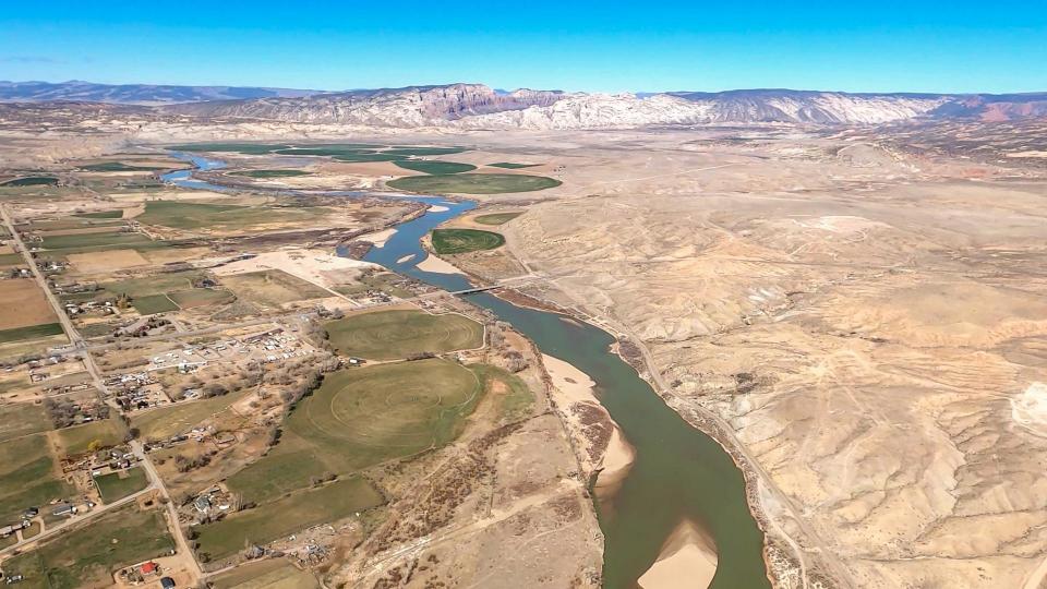
he Green River, one of the drought-stressed tributaries that flows into the Colorado River. (Source: LightHawk Conservation Flying/The Water Desk)
Getting to an agreement to resolve the river’s declining hydrology is unlikely to be easy. As drought and climate change dry the river basin and rob it of runoff, water interests in the Upper Basin states argue that they shouldn’t have to absorb the full impact of those declining river flows. They say Upper Basin states have been absorbing water shortages for years as the upper watershed dries out, while the Lower Basin continues to use water at a rate that’s drying out both major reservoirs. They say those declines should be shared equitably between the Upper and Lower Basins and that the Lower Basin should reduce its use of the river’s water that has contributed to the drawdown of water levels in lakes Powell and Mead.
Mitchell, Colorado’s top water official, argues that the two reservoirs – which are among the nation’s largest – provide the Lower Basin certainty and security for water deliveries. The Upper Basin states don’t have a big reservoir higher up in the watershed to provide the same kind of certainty about their water supplies, she told a Congressional hearing in October. Instead, the Upper Basin states rely primarily on runoff from annual snowpack, she said, and when the snow is thin, the water runs short.
At the same time, some Upper Basin water officials argue that they should be free to develop more projects that could allow them to use more of the water that was apportioned to them by the 1922 Colorado River Compact. Utah, for example, has been pursuing a $2 billion pipeline project to bring water from Lake Powell to fast-growing communities like St. George in southwestern Utah.
In the Lower Basin, state officials and water interests acknowledge that river flows are shrinking and reductions in use are necessary. In recent years, Lower Basin water interests have pared back their take of river water as they’ve watched levels in Lake Mead plummet. In December, they took more action: At the Colorado River Water Users Association meeting in Las Vegas, officials from California, Arizona and Nevada and the Bureau of Reclamation signed a two-year, $200 million agreement that promised to conserve an additional 500,000 acre-feet a year that would remain in Lake Mead. Half of the money would come from the federal government, with the rest split by water agencies in the three states.
But they chafe at the notion of the Upper Basin expanding its draw on the river when shrinking flows suggest more should be done to conserve what remains.
“If the goal is to get the Basin to equilibrium, where our uses are taking out of the river what we can reasonably expect the river to deal us over the next several decades, then reducing overuse while increasing new uses isn’t going to get you to that equilibrium,” John Entsminger, general manager of the Southern Nevada Water Authority, told the audience at the Getches-Wilkinson Center’s conference in October.
A Sense of Urgency
The shrinking hydrology and the simmering tensions between the Upper and Lower Basins come at a precarious time for states and water interests along the Colorado River. The key set of interim guidelines for river management, in place since 2007, are due to expire in 2026. Water-related interests – including water agencies, states, Native American tribes and nongovernmental organizations – are preparing to work out a new set of operating guidelines to guide river management and address shortages. But impacts of drought and climate change may force them to act sooner.
Lake Powell's decline is seen in these photos of Glen Canyon Dam taken a decade apart. On the left, the water level in 2010; on the right, the water level in 2021. (Source: Bureau of Reclamation)
At December’s Colorado River Water Users Association, an annual Las Vegas gathering of key Colorado River water interests, there was a grim sense of urgency to address the river’s needs.
“Climate change is real. We need to take innovative, proactive measures to address the effects here in the Colorado River Basin and throughout the West,” Tanya Trujillo, the Interior Department’s assistant secretary for water and science, told the group.
Although water interests in the Basin have sometimes turned to the courts to resolve disputes, Jeff Kightlinger, the former general manager for Metropolitan Water District of Southern California and a veteran of many of the Colorado River’s complex agreements over two decades, said in an interview that water interests from the Upper and Lower Basins have proven repeatedly that they can find common ground. He cited the 2007 Interim Guidelines that guide river operations, the 2017 Minute 323 agreement with Mexico that included conservation measures, and the 2019 Drought Contingency Plans as examples.
“The best result is when we stop suing each other,” Kightlinger said. “Hopefully we can stick to that model. It’s going to be hard.”
But he acknowledged that finding common ground now is likely to be more difficult given the shrinking river and declining reservoirs. When the drought started in 2000, Lake Powell and Lake Mead were nearly full, so water interests had space and time to work out agreements. “The hard part is there is no cushion anymore,” he said, “so now we’re working without a net.”
The possibility that the courts may be asked to settle how the shrinking river should be shared hangs in the background. Kenney, the veteran Colorado River researcher who recently retired from the University of Colorado Boulder, said there’s been an unwritten understanding that differences in the Basin would be settled in the conference room, not the courtroom. The Upper Basin’s fear, he said, has been that they may end up worse off in court than at the negotiating table. But as their own water resources get squeezed to bolster water levels in Lake Mead, Kenney said, the Upper Basin may decide they’re no worse off making their case in court.
Becky Mitchell, the state of Colorado's top water official. (Source: Colorado Water Conservation Board)
Yet key water managers in the Upper Basin say litigation is an outcome they hope to avoid. Mitchell, the Colorado water manager, said avoiding litigation is among the principles that guide her state’s approach to renegotiating the 2007 river operating guidelines.
Among the other principles, she told the Hutchins Water Center’s virtual November conference in Grand Junction, Colo.: Provide additional water supply security and certainty for Colorado and throughout the river basin, improve operations of lakes Powell and Mead and avoid curtailment of water uses in the Upper Basin.
Meanwhile, Mitchell said, the Upper Basin states are continuing to investigate the feasibility of a conservation effort called demand management that would compensate water users that are willing to temporarily use less water.
Eric Kuhn, a retired Colorado water manager and co-author with John Fleck of a book on the 1922 Colorado River Compact, said that while science is pointing to an accelerated decline in river flows, there are things the Upper Basin can do to have a robust economy and still conserve water. Coal-fired power plants are closing, which should free up water, he told an audience at the Getches-Wilkinson Center conference in October, and reductions in turf – both in cities and on farmland – can add to conservation.
“We can do some really, really good things in this Basin for the economy and our quality of life and still use less water,” he said.
Adapting Intelligently
In the Lower Basin, some water managers and Colorado River veterans believe the water users in Arizona, Nevada and California may have to cut their draw of the river by 1.5 million acre-feet. Entsminger, Southern Nevada’s general manager, said his agency is updating its 50-year water resource plan that anticipates the Colorado River’s annual supply will average just 11 million acre-feet instead of the 15 million acre-feet that was divided between the Upper and Lower Basins by the 1922 Compact.
Chris Harris, executive director of the Colorado River Board of California, the state agency established in 1937 to protect California’s rights and interests on the Colorado River, said water interests throughout the river basin are likely pondering a range of possible river flows. Harris said California and other Basin states will need to be flexible and adapt to whatever the river gives.
“We’ve just got to be better at being able to adapt intelligently,” Harris said.
The Imperial and Palo Verde irrigation districts in Southeastern California hold some of the earliest significant rights to the river’s water along with Native American tribes. While California is protective of its “very senior” water rights, Harris said California water users have demonstrated in the past that through collaborative agreements and partnerships, they can conserve significant water supplies on farms and in cities. And while Upper Basin water officials talk about their own water shortages as they send supplies downriver, Harris said California has been coping with drought and managing water shortages for decades. In response, he said, the state has improved water supply infrastructure and implemented conservation measures to stretch its supply.
“Hydrologic shortages are not an anomaly or an aberration in one basin or the other. They’re occurring in every state,” Harris said. “We are all dealing with a new water supply reality.”
A two-year agreement signed in December by Reclamation and water agencies in California, Nevada and Arizona committed up to $200 million for water conservation measures, including for crop fallowing on farms. Some farm areas are reluctant to embrace fallowing because of its community impacts. (Source: Water Education Foundation)
The two-year agreement signed in December by Reclamation and water agencies in California, Nevada and Arizona that committed up to $200 million for water conservation measures included money for crop fallowing on farms and urban conservation measures. Some of the conservation measures have yet to be identified. The goal is to keep 500,000 acre-feet a year in Lake Mead. Separately, Reclamation signed agreements with Gila River Indian Community and Colorado River Indian Tribes to conserve 134,250 acre-feet of water in Lake Mead. An acre-foot is about 326,000 gallons, or enough water to serve two to three households for a year.
Kightlinger, the former Metropolitan Water District general manager, believes the Lower Basin may have to reduce its draw on the Colorado River by 1.5 million acre-feet a year. Still, he added, it doesn’t all have to be done at once and it might not all involve cuts. Additional ocean desalination or wastewater recycling, he said, could help grow the pot of water. Lower Basin interests may be able to develop a 25-year plan with targeted water savings and benchmarks to measure progress. Such a reduction plan would surely include participation from agricultural water users, he said. “There’s no way to come up with that kind of number absent a strong ag participation,” Kightlinger said.
Metropolitan Water District has done partnerships in the past with agricultural water districts like Imperial and Palo Verde irrigation districts for conservation improvements or compensated land fallowing. In December, the district signed yet another partnership, a seasonal land fallowing agreement with the Quechan Tribe of the Fort Yuma Indian Reservation to conserve up to 3,500 acre-feet of Colorado River water.
Kightlinger said such agreements for farm water conservation can be done in a way that works for farmers and agricultural communities. “There’s more cooperation out there than people realize,” he said.
Tina Shields, Imperial Irrigation District’s water department manager, said her agency generally doesn’t support farmland fallowing because of the economic impacts to the community in lost jobs and support service revenues. But the agency does implement large-scale agricultural and on-farm efficiency-based conservation programs and believes there’s room for expansion. “We’re conserving a half-million acre-feet a year already,” she said.
Tina Shields, Imperial Irrigation District water manager. She said her agency has implemented water efficiency improvements for farms, but does not support fallowing as a conservation measure. (Source: Water Education Foundation)
But there are complications. One is that the district has limited options to store saved water, Shields said. The 1931 agreement that apportioned California’s share of the river gave Metropolitan Water District an exclusive right to store the state’s water in Lake Mead. More recent agreements have given IID the ability to store a modest amount of water in Lake Mead and a somewhat larger amount within Metropolitan’s system off-river, she said, but those savings accounts are full. Imperial is now partnering with Metropolitan to store another 50,000 acre-feet of conserved water in Lake Mead under Metropolitan’s account – still a tiny amount compared to Imperial’s 3.1 million-acre-foot river entitlement – and is discussing partnerships with both Metropolitan and the Bureau of Reclamation to store even more conserved water in the lake.
Another complication, Shields said, is the impact that any additional conservation has on the Salton Sea, California’s largest inland lake. Earlier water-saving agreements resulted in less farm runoff flowing to the sea. The district compensated with mitigation flows to the sea, but since those ended in 2017 the sea has been receding, creating the potential for unhealthy dust clouds from its newly exposed shoreline and rising salinity to levels that can no longer support the sea’s fishery and bird communities. The state of California is working on a 10-year restoration plan for the sea. But any further water conservation effort by Imperial Irrigation District, she said, will need to account for impacts of reduced farm runoff going to the Salton Sea – and require help from state and federal agencies.
Avoiding the Supreme Court
Across the entire Basin, there is an undercurrent of concern that as water interests try to work out an equitable solution between the Upper and Lower Basins, their lawyers are preparing legal arguments in case their interstate differences land them before the U.S. Supreme Court.
Harris, with the Colorado River Board of California, said he believes there’s a willingness and commitment to do anything and everything to avoid going to the Supreme Court.
“If you end up in the United States Supreme Court, isn’t that just a bald-faced acknowledgement of failure?” asked Harris.
At the Getches-Wilkinson Center conference in October, members of a panel titled “Time to Get Real” were asked how the Upper and Lower Basins could get beyond the legal jousting over who should get how much of the river’s waters.
Entsminger, Southern Nevada’s general manager, offered a note of concern over whether water interests in the two basins are up to the challenge of reaching an equitable solution in the face of climate change.
If this winter or the next one is as dry as last year, and the two basins cannot work together to find solutions to the river’s woes, he said, “Mother Nature is going to pick the winners and losers. And she’s going to do it really quick.”
“So we can keep shadow boxing about who’s feeling more pain, or who should have done what over the last 20 years or over the last 100 years,” he added. “Or we can come to the table and come up with a plan to use the amount of water the river’s actually going to give us.”
An irrigation canal in the Palo Verde Valley near Blythe, CA. Photo credit: Bureau of Reclamation
Here’s the release from the Bureau of Reclamation (Robert Manning):
The Bureau of Reclamation today submitted its initial spend plan for fiscal year 2022 funding allocations authorized in the Bipartisan Infrastructure Law to the U.S. Congress. This spend plan represents a blueprint for how Reclamation will invest in communities to address drought across the West as well as greater water infrastructure throughout the country. Reclamation will be provided $1.66 billion annually to support a range of infrastructure improvements for fiscal years 2022 through 2026.
“The Bipartisan Infrastructure Law is the largest investment in the resilience of physical and natural systems in American history,” said Assistant Secretary for Water and Science Tanya Trujillo. “Reclamation’s funding allocation for 2022 is focused on developing lasting solutions to help communities tackle the climate crisis while advancing environmental justice.”
“The Bureau of Reclamation serves as the water and power infrastructure backbone for the American West. The law represents a once-in-a-generation opportunity to improve our infrastructure while promoting job creation,” said Reclamation Commissioner Camille Calimlim Touton. “The funding identified in this spend plan is the first-step in implementing the Bipartisan Infrastructure Law and will bolster climate resilience and protect communities through a robust investment in infrastructure.”
The FY 2022 spend plan allocations include:
$420 million for rural water projects that benefit various Tribal and non-Tribal underserved communities by increasing access to potable water.
$245 million for WaterSMART Title XVI that supports the planning, design, and construction of water recycling and reuse projects.
$210 million for construction of water storage, groundwater storage and conveyance project infrastructure.
$160 million for WaterSMART Grants to support Reclamation efforts to work cooperatively with states, Tribes, and local entities to implement infrastructure investments to increase water supply.
$100 million for aging infrastructure for major repairs and rehabilitation of facilities.
$100 million for safety of dams to implement safety modifications of critical infrastructure.
$50 million for the implementation of Colorado River Basin drought contingency plans to support the goal of reducing the risk of Lake Mead and Lake Powell reaching critically low water levels.
$18 million for WaterSMART’s Cooperative Watershed Management Program for watershed planning and restoration projects for watershed groups.
$15 million for Research and Development’s Desalination and Water Purification Program for construction efforts to address ocean or brackish water desalination.
$8.5 million for Colorado River Basin Endangered Species Recovery and Conservation Programs.
Detailed information on the programs and funding provided in the Bipartisan Infrastructure Law, the FY 2022 BIL Spend Plan and materials from recent stakeholder listening sessions are available at http://www.usbr.gov/bil.
This photo from December 2021 shows the famous “bathtub ring” at Lake Mead due to declining water levels. The lower basin states are planning to save water in the reservoir through the 500 + Plan. CREDIT: HEATHER SACKETT/ASPEN JOURNALISM
Some Colorado River scholars say that a plan by the lower-basin states to leave more water in Lake Mead embodies a principle they explore in a recently published article: Dropping reservoir levels have opened a window of opportunity for water-management policies that move the river system toward sustainability.
In December, water managers from California, Nevada and Arizona signed a memorandum of understanding, or MOU, to spend up to $200 million to add 500,000 acre-feet of water in both 2022 and 2023 to Lake Mead, the nation’s largest reservoir, which has dropped precipitously low due to climate change and drought.
Water managers developed the program, known as the 500+ Plan, in just four months — lightning speed for something that requires the cooperation among — and millions of dollars from — each participant.
Water experts say part of the reason the plan came together so quickly is because it got a push from last year’s record-bad conditions. Water managers have watched reservoir levels in lakes Powell and Mead slowly dwindle for the past two decades, but 2021 was a wake-up call for many. A near-normal snowpack translated to just 31% of normal runoff, which was the second-worst inflow into Lake Powell ever.
“We had no idea how bad 2021 hydrology would be,” said Bill Hasencamp, manager of Colorado River resources for the Metropolitan Water District of Southern California. “We knew it was a dry year, but when it turned out to be 31%, it was an eye-opener.”
It wasn’t until June that water managers realized how bad the situation was, and talks about the 500+ Plan began in August, Hasencamp said. That quick turn-around tracks with the findings of a new article by John Fleck, a writer-in-residence at the Utton Center at the University of New Mexico, and Anne Castle, senior fellow at the Getches-Wilkinson Center at the University of Colorado. Their paper, “Green Light for Adaptive Policies on the Colorado River,” was published in December.
The paper says that frenzied media attention, dramatically dropping reservoirs to their lowest levels ever and the first-ever shortage declaration by federal water managers created an opening for the political will necessary for an innovative solution. Rapidly dropping reservoirs create a “green light” scenario for river management where conditions shift from a situation to be monitored to a problem that needs to be solved.
“That visceral experience we have with low reservoirs and seeing the snowpack not end up in them last year is part of what’s created this moment of opportunity,” Fleck said. “When we look at those reservoirs — which have been our safety for a long time, they have been our security blanket — and they’re gone, you see political leadership lurching to the issue.”
Click the image to go to the interactive Tableau version on Aspen Journalism’s website.
500+ Plan builds on previous work
But since political will can be fickle and fleeting, it’s important that policy solutions — usually the product of years of careful crafting — are ready to be implemented quickly when the timing is right and the “green light” window of opportunity opens. Although formal discussions about the 500+ Plan were only four months long, much of the groundwork had been laid over previous years.
“We know the technocrats behind the scenes, the people working at NGOs and government offices, they are thinking about this stuff and producing policy before we need it so they can attach it onto a problem when a problem arises,” said Elizabeth Koebele, a researcher at the University of Nevada and who studies how government policies get made collaboratively.
The lower basin is taking action after modeling showed that Lake Mead’s surface elevation could drop below 1,030 feet, which is a critical threshold identified in the 2019 Drought Contingency Plan. The reservoir is currently at 1,066 feet elevation.
The basic way the program will work is by municipal water providers paying irrigators to not use water so it can be stored in Lake Mead. It will be funded by $40 million from the Arizona Department of Water Resources; $20 million each from the Central Arizona Project, Metropolitan Water District of Southern California and Southern Nevada Water Authority; and $100 million in matching funds from the federal government.
The 500+ Plan is resonant of the System Conservation Pilot Program, which ran from 2015 to 2018 and paid upper-basin farmers and ranchers to voluntarily fallow fields in order to boost levels in Lake Powell.
“These were ideas they didn’t have to make up from scratch,” Fleck said. “I was amazed at the speed with which (the 500+ Plan) came together. It was very impressive because it built on work that had been going on behind the scenes for a long time.”
This photo from December 2021 shows one of the intake towers at Hoover Dam. California, Nevada and Arizona recently penned a deal to keep 500,000 acre-feet of water in Lake Mead to boost the declining reservoir levels. CREDIT: HEATHER SACKETT/ASPEN JOURNALISM
Upper-basin lessons?
Rebecca Mitchell, director of the Colorado Water Conservation Board and Colorado’s representative to the Upper Colorado River Commission, said in an email that she generally supports the lower basin’s efforts to take less water out of Lake Mead.
She pointed out challenges with shortages and water saving in the upper basin: Water users don’t have large reservoirs on which to rely the way that the lower basin does. Emergency releases from upper basin reservoirs last summer and fall to prop up Lake Powell and preserve the ability to make hydropower have harmed local businesses and left the reservoirs low, she said.
“Given the drastic shortages already occurring in the upper basin, coupled with these emergency releases, it is unclear how much more Colorado can provide,” Mitchell said.
Mitchell said that the upper basin states only use about half of what they are entitled to under the Colorado River Compact and that the lower basin states use far more than their share.
But with climate change continuing to rob the river of flows, the amount of water promised to each basin in the century-old agreement may no longer exist. Fleck said the other reason why the lower basin was able to come up with the 500+ Plan seemingly quickly is because water managers there have been having difficult conversations for years that acknowledge the river’s hugely diminished flows — something upper basin water managers still seem averse to.
“(The upper basin states) have to have those difficult conversations with water users who don’t want to hear it, but they might not get what the compact promised,” he said. “Those are conversations we just need to be having in the upper basin right now, and we are not having them.”
Aspen Journalism covers water and rivers in collaboration with The Aspen Times.
Lees Ferry streamgage and cableway downstream on the Colorado River, Arizona. (Public domain.)
The beginning of 2022 has brought a wonderful gift for our mountains: many feet of snow. While it’s still early in the season, we remain hopeful for more moisture to come, including out to the Plains. Recently, I presented at the Colorado River Water Users’ Association meeting to highlight the ways Colorado’s farmers and ranchers are advancing voluntary stewardship to conserve water and build resilience through dry times.
In addition to the much-needed snow, we are also celebrating the good work accomplished in 2021 by Colorado producers, CDA staff, and many others. We have distributed over $30 million of the $76 million in state stimulus grants across the state to support agricultural events, advance soil health initiatives, increase processing capacity, and help producers build drought resilience. We will continue to distribute stimulus funds in the months ahead, including through another round of Farm to Market processing grants and the launch of the first-ever CDA Revolving Loan Fund that will provide affordable financing to processors as well as beginning and underserved farmers and ranchers.
I was fortunate to hear first-hand the impact of these dollars when I attended Chaffee County’s agriculturally focused community workshop last month. Governor Polis joined us for the entire evening, sharing a meal and listening to producers from across the county. Ag Commission member and local rancher George Whitten was there to hear from folks, as well. This was one of the dozens of field visits I’ve made this year to be sure that the work we do at CDA makes sense out in the field where the work of producing food gets done.
Through all this we are saying goodbye to some incredible staff, and looking for new team members to continue to carry the torch for Colorado agriculture. In particular, I want to thank Deputy Commissioner Steve Silverman for three years of dedicated service to Colorado agriculture and CDA. We couldn’t have made it through this time without him. See below for important job openings at CDA!
The ag community is no stranger to tough times. Despite recent challenges, we keep getting back up, dusting ourselves off, and supporting each other every way we can. That’s what Colorado agriculture is all about.
Kate Greenberg
Colorado Commissioner of Agriculture
Westwide SNOTEL basin-filled map January 17, 2022 via the NRCS.
Amitav Ghosh can clearly remember his first interaction with the climate crisis. It was the early 2000s, and Ghosh, now one of India’s most celebrated authors and winner of its highest literary prize, was researching a novel set in the Sundarbans, a network of islands around the mouth of the Ganges Delta in the Bay of Bengal, which is home to the world’s largest mangrove forest.
Climate change had barely entered into public consciousness back then, but Ghosh clearly remembers “visible signs that something wasn’t right”.
“People spoke of their homes disappearing, of sea water levels rising and salt water erosion, but no one knew what was happening,” he said. “So I began researching. And as the years went on the signs became clearer and clearer.”
Twenty years on, the Sundarbans are widely acknowledged to be one of the world’s most vulnerable areas to the climate crisis. Rising sea levels are eating away at the islands while extreme weather events have decimated the ecology and made the land salty and arid. Drilling for groundwater has only exacerbated the problem as it causes the islands to sink faster. Some predict that in less than a century, the unique biosphere will disappear entirely.
Spanning horrific incidents of European settler colonial violence carried out across Asia, America, Australia, New Zealand and Africa, Ghosh maps out how the pillaging of those lands hundreds of years ago – and the systematic extermination of their indigenous people – laid the foundation for the climate crisis that threatens the world today.
“Why has this crisis come about?” said Ghosh. “Because for two centuries, European colonists tore across the world, viewing nature and land as something inert to be conquered and consumed without limits and the indigenous people as savages whose knowledge of nature was worthless and who needed to be erased. It was this settler colonial worldview – of just accumulate, accumulate, accumulate, consume, consume, consume – that has got us where we are now.”
Yet as Ghosh sat down to write the book in March 2020, he had no idea that the ideas that had begun to take shape in his head would begin to manifest so dramatically off the page. Suddenly the pandemic hit and New York, where he lives, was one of its hardest-hit cities. “That experience really shaped the book, because the pandemic is the most visible aspect of the planetary crisis that’s unfolding us around us,” said Ghosh. “I think the pandemic more than anything else made it perfectly clear that this is a crisis you can’t hide from. Money will not protect you, power will not protect you, we’re in the midst of it already. It gave it a terrific sense of urgency.”
For Ghosh, the survival of our planet hinges on returning to interacting with Earth as a living being to be listened to, understood and respected. “The indigenous peoples of the Americas have been saying for decades that our past is your future and now that’s exactly what’s proving to be the case,” he said.
American Progress (1872) by John Gast is an allegorical representation of the modernization of the new west. Columbia, a personification of the United States, is shown leading civilization westward with the American settlers. She is shown bringing light from east to west, stringing telegraph wire, holding a book, and highlighting different stages of economic activity and evolving forms of transportation. By John Gast – This image is available from the United States Library of Congress’s Prints and Photographs division under the digital ID 09855.This tag does not indicate the copyright status of the attached work. A normal copyright tag is still required. See Commons:Licensing for more information., Public Domain, https://commons.wikimedia.org/w/index.php?curid=373152
Barefoot Dance In The Snow New York, New York March 8, 1916. Girls of the Marion Morgan School of Dance in Los Angeles perform barefoot in the snow in Central Park. Underwood Archives by Underwood Archives
Snow dancing, Ullr calling and deep yearning for more snow this season appear to have paid off! After such a dry fall and early winter, abundant snowfall finally is allowing us to enjoy our sliding recreation — the focus for many of us.
Snow is, of course, also essential to our rivers and water supply. The 40 million people in the Colorado River basin, and the vast agricultural network that we take for granted when we shop for groceries, depend on winter snowpack. Summit snow fills reservoirs with essential spring and summer water.
We hear a lot about how many inches of powder we can expect, and we plan our days around those predictions. But how many snowflakes actually fall in these storms? Many billions of these spectacular crystals create a snowfall. One pound of snow has an average of 22,400 snowflakes. And each snow crystal is an incredible work of science and art.
What is a snowflake? Perhaps you’ve had the pleasure of folding a paper in half, then into thirds and — with good scissors in hand and some careful cutting — created a beautiful replica of one of the unique snow crystals that can be seen without magnification under the right conditions. When we say snowflake, we usually mean snow crystal: a single crystal of ice in which the water molecules line up in a precise way.
Photo via Snowflakes Bentley (Wilson A. Bentley)
How do these spectacular snow crystals form? Snow crystals generally are hexagonal (six-sided) due to the way they form. And they’re not frozen raindrops (those are sleet). Snow crystals appear when water vapor converts directly into ice without going through a liquid state. Water molecules in ice crystals join together in a hexagonal structure because it is the most efficient way. After the crystals form a small hexagonal plate, branches sprout from the six corners as the crystal grows larger and more complex.
Formation depends on the changing temperatures and humidity each crystal experiences on its unique path through the clouds as it forms and falls. This trip through clouds, wind and humidity creates a unique crystal. Indeed, no two snow crystals are alike; each has its own variety of patterns and shapes. Snowflakes are classified as hexagonal and triangular crystals, hollow columns, dendrites and irregular snowflakes. Dendrites are multibranched or tree-like crystals that can be very large, complex and often visible to the naked eye.
The six-fold symmetry in a snow crystal is created by the water molecule arrangement in the ice crystal shape. There are other snowflakes less complex and beautiful. During artificial snowmaking at our ski areas, the compressed air expands and quickly freezes water droplets. The resulting snow is a dense cloud of tiny sleet particles that lack the ornate hexagonal structures of snow crystals.
Once on the ground, snowpack can assume different qualities, depending on temperature, wind and time. Under the right conditions, we can see spectacular fern-like crystal shapes on the ground after snowfall begins to melt and reforms. These are larger than any snowflake and are easily seen without magnification along a trail, especially in wet riparian areas.
As you are gliding on, entranced with the falling snow, you can always ponder with wonder and awe about the intricacies of the amazing physics creating these works of science and art.
So keep on snow dancing. If nothing else, it’s good exercise! We have experienced a fantastic start to the new year with abundant snow. Bring on more beautiful hexagonal crystals!
“Get Wild” publishes on Fridays in the Summit Daily News. Karn Stiegelmeier is the chair-elect of Eagle Summit Wilderness Alliance, an all-volunteer nonprofit that helps the U.S. Forest Service protect and preserve the wilderness areas in Eagle and Summit counties. For more information, visit http://EagleSummitWilderness.org.
The 99-year-old South Platte River compact between the two states does outline plans for such a project, according to Anthony Schutz, an associate law professor at the University of Nebraska Lincoln. But the project was started and abandoned decades ago and the question of starting it up again might have to be decided in a costly and lengthy court battle.
Even if the canal is built, it’s unclear how much extra water it would yield to Nebraska or for what it could be used, Schutz said…
[State] Sen. Jerry Sonnenberg, R-Sterling, said the Nebraska governor must be mistaken. That list of projects comes from a report generated by legislation Sonnenberg helped pass in 2016, the senator said. And it outlines possible water projects around the state, not work that is actively being proposed…
Colorado Gov. Jared Polis said in a statement, Ricketts’ plans “seem to reflect a misunderstanding of Colorado’s locally driven water planning process.”
Officials in Colorado will look to more fully understand Nebraska’s “concerns and goals, as so far those concerns and goals are quite simply hard to make sense of,” Polis continued…
Sonnenberg said that likely means the two states will end up in court to determine whether Nebraska can use eminent domain to build the canal or whether it can take more water out of the South Platte if it’s built…
Currently, Colorado is meeting all its water obligations to Nebraska, said state Engineer Kevin Rein. During the irrigation season, April 1 to Oct. 15, the South Platte must flow at 120 cubic feet per second into Nebraska. That flow is measured at a water gate in Julesburg, just south of the Colorado border, Rein said.
Should flows dry below that threshold, Colorado officials must curtail water use in certain areas for water rights holders whose rights were established after 1897, Rein said. But Colorado has no additional obligation to increase flows.
During the non-irrigation season, there is no such requirement for Colorado and its officials believe the state has uninterrupted water rights for the South Platte, Rein said.
There is no set volume Colorado must allow to flow into Nebraska every year, Rein said.
Compound Hazards and the Marshall Fire (January 13, 2022)
This briefing represents our state of knowledge as it exists January 13, 2022 and is provided as a service to place the disastrous fire into a climate and human context. We acknowledge that more information will come to light as research continues in the months and years on this event and so this should be seen as a ‘first look’ summary and is not intended to be a comprehensive or definitive report. The Western Water Assessment Team expresses our deepest condolences to the families who lost loved ones, pets and their homes in the fire.
During the late-morning of December 30, 2021, the Marshall Fire ignited near the foothills of Boulder County, CO. The fire very quickly spread through dry grasslands and into suburban areas of Superior, then Louisville. The fire’s spread was fueled by a windstorm that produced wind gusts exceeding 100 miles per hour (mph), with sustained winds of over 45 mph for 8 hours. Extreme drought conditions and a very warm and dry August–December primed the area for wildfire. Most of the 1,084 structures (including 991 residential homes and 7 commercial properties) that burned in Superior and Louisville were consumed over a 6-hour period coinciding with the peak of the downslope windstorm. Two fatalities and an estimated $513 million in damages have been attributed to the Marshall Fire, making it the most destructive in Colorado history in terms of cost and structures lost.
Climatic conditions leading to the Marshall Fire
The story of the Marshall Fire began nearly a year before the fire burned. After below-average precipitation during winter, a very wet spring and early summer followed, bringing relief and optimism for reduced fire risk in Boulder County.1 The March through July period in 2021 was the 7th wettest on record in Boulder with 17.14” of precipitation.2 To put that number in perspective, Boulder received 80% of its annual rainfall in five months. The anomalously wet spring supported high growth of grasses in the prairie that covers much of the open space in Boulder County east of the foothills. Grass in Boulder County open space likely continued growing and remained green through July; the bountiful spring of grass growth would subsequently turn into the fuel that allowed the Marshall Fire to spread.
Boulder County began 2021 in severe (D2) drought, but by early June, drought conditions were completely gone from Colorado east of the Continental Divide. Abnormally dry conditions (D0) returned to Boulder County by late September. Drought conditions quickly worsened and by early November, parts of Boulder County including Superior and Louisville were experiencing extreme (D3) drought conditions.1 The rapid emergence and deterioration of drought conditions was caused by low precipitation and extremely warm August–December temperatures. August–December 2021 was the second driest (1.86”) on record in Boulder since 1893.2 August–December was also extremely warm; it ranked as the 7th hottest August–December period and the 3rd hottest November–December period on record in Boulder since 1893.2
US Drought Monitor map December 28, 2021.
Another climate factor necessary for the Marshall Fire to spread from grasslands to structures was a lack of snow. Snow drought also played a significant role in creating conditions suitable for extreme fire behavior. Denver received its latest first snowfall ever in 2021 when it snowed 0.3” on December 10th, breaking the previous record by three weeks. In Boulder, only 1.7” of snow was observed from September 1st to December 30th, 2021, the lowest snowfall total on record for those months (Table 1). December 2021 received the 12th lowest snowfall since 1893.5
On December 30th, Boulder and the surrounding communities were entirely snow-free. Since 1893, there was at least a trace amount of snow on the ground in Boulder on December 30th in 47% of years and at least 1” of snow on the ground in 27% of years.5 If there had been snow cover, even under extreme drought conditions, the fire would likely not have spread across the grasslands east of Superior and Louisville. Even in years when snow cover was absent, wind drifts from previous snowfalls that form in the rolling hills between the foothills and suburban areas could have potentially limited or slowed the spread of the fire. Snow drought, not just drought conditions, was a primary factor in creating the conditions that allowed the Marshall Fire to occur.
Extreme winds on the Front Range
High winds are relatively commonplace in Boulder and along the Front Range due to geography (the Rocky Mountains) and the prevailing westerly flow of storms. The most extreme wind events in Boulder occur as downslope windstorms from the west. These downslope windstorms occur most commonly during winter when a high-pressure weather system sits to the west of the Continental Divide and low pressure is located immediately east of the foothills. As the air mass moves from high to low pressure, westerly winds accelerate as they move down the eastern slope of the mountains and can further accelerate as winds are channeled into canyons with an east-west orientation. During a downslope wind event, wind gusts can exceed 100 mph and last from hours to a day. High winds from downslope windstorms do not typically extend very far into the plains. Since 1970, wind speeds have exceeded 70 mph on an average of 4.8 days per year in the Boulder area; with over 50% of high wind days occurring in December and January.6
Number of days with winds > 70 mph in Boulder. NREL Flatirons Campus M2 Tower data Credi: Western Water Assessment
The size, speed and magnitude of destruction caused by the Marshall Fire was driven by a downslope windstorm that began on the morning of December 30th. Westerly winds were highest from the base of the foothills eastward to Superior and Louisville. Further east in Lafayette and Broomfield, wind speeds rapidly diminished and switched directions to blow from the east.7 This phenomenon is called an atmospheric mountain wave, where winds accelerate down the slope of mountains, extend only a short distance downwind from the mountains, then subside further downwind and blow in the opposite direction, much like the backward flowing current behind a rock in a swift river. Wind gusts peaked between 68–108 mph at weather stations near the fire in Boulder County, with the highest wind speeds closer to the foothills. The windstorm’s peak wind gust of 115 mph was observed south of the Marshall Fire in Arvada, CO.7
Mountain wave over Boulder on 12/20/21, Mario Gori via TwitterAtmospheric mountain wave diagram, NWS Denver/Boulder WFO
Westerly winds intensified in Boulder at 7:30 am and reached peak intensity with a gust of 98 mph at 11:55 am. Five wind gusts exceeding 90 mph and 43 wind gusts exceeding 80 mph were recorded at the NREL Flatirons campus a few miles northwest of the fire ignition area. Sustained winds of more than 45 mph were observed for 8 hours, from 9:00 am to 5:00 pm.6 The fire was presumed to have started near the intersection of Marshall and Eldorado Roads south of Boulder at about 11:30 am, which coincided with the peak intensity of the windstorm. According to a summary by the NWS Denver/Boulder Weather Forecast Office, the area of peak wind intensity shifted eastward over Superior and Louisville between 12:00 and 2:00 pm as the fire moved from grasslands into suburban areas.7
Sustained winded wind gusts on 12/20/21, NREL Flatirons Campus M2 Tower data
Compound Natural and Human Hazards
The Marshall Fire was human-caused, but a series of concurrent and compounding natural and human hazards created the conditions for the fire to scorch 6,200 acres of grassland and suburban landscapes. It is extremely unlikely that a wet spring, drought, snow drought, high temperatures or the downslope windstorm alone could have created the conditions necessary for the Marshall Fire’s ultimate extent and devastation. All five of these natural hazards were required to occur in the sequence they did to create the extreme fire conditions present on December 30th. If any one of these hazards were less severe or happened in a different order, the fire would not likely have spread so quickly and widely. Humans also played a critical role in creating conditions for the disaster. The manner in which communities developed the built environment in Boulder County, the way the land is managed, and how humans relate to hazards were all involved in the outcome.
The Wildland Urban Interface (WUI) is the geographic space where natural ecosystems border the built environment. The WUI is a critical zone in the context of wildfires and how fires interact with human development. Wildfire risk in communities adjacent to or within the WUI is typically highest with forested ecosystems. Communities located within or adjacent to forests in arid regions of the West are typically very aware of the risk wildfires pose and significant efforts are made to make homes and businesses resilient to fire. Adaptation strategies like creating fire-defensible spaces around properties are employed. Residents may be prepared for rapid evacuation, especially during fire season, and know evacuation routes. The Marshall Fire started and burned miles away from the lodgepole pine forests of the foothills. It spread as a grassland wildfire, but ended as an urban and suburban conflagration. Many residents, hazard professionals, and scientists alike did not think a fire could burn so far into suburban areas, especially in December. The Marshall Fire, fueled by compound hazards and climate change, was the second most destructive fire to occur in the United States during December. It should expand the notion of both timing and location of fire risk on the Front Range of Colorado and in similar communities across the West.
A human component important to the Marshall Fire originates from the gap between perception of wildfire risk compared to the actual wildfire risk. The seasonal timing and location of the fire were outside of historical norms and many people did not understand the actual wildfire risk, in part, because climate change is rapidly driving changes in wildfire timing and behavior. In Colorado, fire season was typically considered to span June–September. However, that traditional timing of fire season applies to Colorado forests where cooler temperatures, wetter conditions, and snow greatly reduce fire risk. In Boulder County, December was warm, dry and snow-free. Climate change is projected to cause warmer and drier conditions, which may further expand the length of the fire season, into both the spring and fall. It is possible that fire season may shift so much in some years that fire danger can be high at any time of the year. Additionally, Superior and Louisville are in a WUI dominated by prairie, not forest. Grassland wildfires can have different seasonal timing and characteristics. Grassland fires are unusual in Colorado winter, but not absent from our history. On January 15th, 1950 high winds sparked a fire from smoldering vegetation that burned 32,000 acres of grassland at Fort Carson near Colorado Springs. Nine soldier and volunteer firefighters were killed battling the blaze and 92 buildings on Fort Carson were destroyed.8 More recently, high wind events contributed to grassland fires in Boulder County during the winter in 2006, 2009, 2017, and earlier in December 2021.9 None of these more recent fires grew to large sizes or burned structures, but provide evidence that wildfire risk, even in the dead of winter, remains a concern.
There was no red flag warning issued for heightened fire danger on the morning of December 30th10 and, for a variety of reasons, many residents did not receive emergency alerts to evacuate, prompting emergency managers in the state to review these alert systems.11,12 Additionally, the severity of the fire itself created challenges to both evacuation and fighting the blaze. Extreme wind speeds and smoke prevented aircraft from surveying the geographic area of the fire which severely limited the information available to both first responders and evacuees.
Management of natural landscapes in the Wildland Urban Interface and changes to those management practices are also important human factors related to fire risk. Much of the development in Superior and Louisville near current open space grasslands has occurred in the last 30 years, reflecting a significant change in land use and management. Future management of grasslands in the WUI of Boulder County should consider these factors in an effort to mitigate fire risk to adjacent communities.
Literature cited
1. U.S. Drought Monitor. Historical Data and Conditinos. (2022).
An aide to former Colorado Gov. John Hickenlooper several years ago observed to me that Colorado’s statewide elections are won and lost in the suburbs.
That crystallizes why the Marshall Fire was the biggest climate and energy story of 2021 in Colorado—and likely the biggest story altogether, if such distinctions are admittedly arbitrary and subjective. If this was not the first wildfire in Colorado’s suburbs, it was perceived to be.
That it occurred on the next to last day of the year I believe makes it even more significant. As Senate Majority Leader Steve Fenberg noted in a press conference at the Colorado Capitol on Jan. 10, there is no one separate wildfire season in Colorado any more. The Marshall Fire made it clear that it’s all year long.
It also burned nearly 1,100 homes, the most ever, in what was traditionally–if falsely assumed to be—the safe haven of the suburbs.
Marshall, though, wasn’t actually the first suburban fire in Colorado. In 2012, the Waldo Canyon Fire on the edge of Colorado Springs burned hundreds of homes and killed two people. We’ve had large, large fires on the Great Plains, too, if far enough from the Front Range to barely notice.
This fire occurred in the deep of winter in suburban Boulder [County]. If it can burn in Louisville, might it also happen in Castle Rock, Parker, and Highlands Ranch? This brings wildfire and climate change home in a new way to where 80% to 90% of Coloradans live.
Several national publications made the same point. “How climate is changing which neighborhoods are vulnerable,” is how Inside Climate News headlined its story. The Wall Street Journal had much the same slant: “The Colorado suburbs of Louisville and Superior at the base of the Rocky Mountains were always thought to be safely removed from the wildfires that often burned in the foothills above.”
I am most mesmerized by the scattergram that Russ Schumacher, the Colorado state climatologist, assembled in the hours of the fire. It showed both temperatures and precipitation from June 1 to Dec. 29. In that convergence of hot and dry, 2021 was exceptional. Other years have been hot, others years dry. But this was both, in the top left-hand corner. It was an outlier, but also notable in the scattergrams for Denver, Fort Collins, and Colorado Springs was how frequently the past 20 years showed up in that quadrant of hot and dry.
This week came more news, about just how extraordinarily warm Colordo was from July through December in Colorado. This chart tells that story. exceedingly well.
“Certainly, climate change is never the only part of the story when it comes to wildfires,” Russ Schumacher told me. “That being said, what we see in these fires and have seen in the last couple of years in Colorado, the changing climate is kind of making us expand our imaginations of what types of destructive wildfires are possible.”
The Marshall Fire expanded imaginations immediately. A friend (and Big Pivots subscriber) Robert Youngberg, who lives in Lakewood, reported being unconcerned about previous small fires in the grasslands where the Great Plains erupt into the Rockies. “At no time during these fires did it occur to us that we might be in personal danger,” he wrote. “That perception has now changed forever.”
Arvada, the city of 125,000 people where I live, similarly spans the space between Denver proper and the space where the flattish lands rise into the foothills. “We are still processing this entire event,” responded Mark Deven, the city manager, when I requested an interview. “It is certainly clear that we will need to reevaluate how to build a more resilient community as we adjust to drier conditions, mid-winter fires and other impacts.” He added Arvada was not ready to offer additional comment.
This fire came 14 months after the East Troublesome Fire, which similarly expanded our imagination of wildfire risk in Colorado. It covered 100,000 acres in late October, a time when snow normally has chilled mountain slopes, then leaped across two miles of tundra to threaten Estes Park. That was a California-type fire.
What will be the repercussions? I think – and I’ve had legislators agree – that this puts even stronger winds into several legislative efforts already conceived. It makes the arguments that much stronger, the need more evident.
One set of bills would advance the concept of microgrids. Microgrids are small, local networks of electricity users with a local source of supply that is usually attached to a centralized national grid but is able to function independently.
The best example may be northwest of Fort Collins, where Poudre Valley Electric has assembled a combination of solar and battery storage near Red Feather Lakes. It doesn’t prevent fires, but it does keep the lights and oxygen concentrators on.
The community was threatened in 2020 by the Cameron Peak Fire. The 2018 Lake Christine Fire has motivated Holy Cross Energy to begin plotting microgrids in the Aspen and Vail areas. And microgrids are also a part of the franchise agreement between Boulder and Xcel Energy.
Other bills take aim at buildings, both in highly vulnerable areas called the wildland-urban interface and in rebuilding areas such as Louisville and Superior, the towns ravaged by the Marshall Fire.
Looking towards Boulder at the Marshall Fire December 30, 2021 From 53rd and Stuart in Adams County. Note the atmospheric mountain wave, where winds accelerate down the slope of mountains, extend only a short distance downwind from the mountains, then subside further downwind and blow in the opposite direction, much like the backward flowing current behind a rock in a swift river.
Colorado does not have the statewide code that the federal government requires for grants. That absence has caused Colorado to forgo $70 million in aid that could have assisted in the effort to confront the elevated risk of wildfire, reports State Sen. Chris Hansen, D-Denver. “We have to do a better job of reducing that risk,” he says. And if those who build in the riskiest of places may protest, that’s their decision. He points to the way that insurance spreads risk across broad regions. “Widespread damage spills over into actuarial tables to the whole region.”
Hansen also will propose that Colorado set a new statewide decarbonization goal for 2040. Legislators in 2019 set a goal of 50% decarbonization by 2030 and 90% by 2050. He contends Colorado needs a 2040 goal. “It’s very easy to procrastinate,” he says.
The 20 most damaging wildfires in Colorado have all occurred in the last 20 years, a time also marked by rapidly rising temperatures and, not coincidentally, more frequent drought, part of what some climate scientists call aridification. “I think people increasingly make the connection between these disasters and climate change,” says Hansen.
Rep. Tracey Bernett, D-Longmont, who is sponsoring both building and microgrid bills, says she worries that the sharp images of the Marshall Fire may be dulled by April, when it’s time for legislators to vote. Her district includes Louisville. “My job is to remind them of the devastation in Colorado that will continue to be caused by climate change.”
Early in the Marshall Fire, electrical lines downed by the high winds were believed to be the cause. If that was quickly proven false, I think this fire will result in more undergrounding of electrical lines, despite the great expense. I have read that undergrounding power lines m\ore than triples the cost.
Before the holidays, snowpack in Southwest Colorado was hovering well below the historic average for this time of year, heightening concerns the winter was not off to strong start.
Fortunately, a weeklong series of snowstorms between Christmas and New Year’s dumped several feet on the San Juan Mountains, causing snowpack averages to jump from around 80% to more than 140%, according to data from the National Resource Conservation Service.
Unfortunately, these numbers don’t tell the whole story of Colorado’s snowpack. This year, Colorado, as well as the entire West, is basing snowpack averages on updated numbers that reflect the drier years the West has been experiencing because of climate change-driven drought.
True, the updated snowpack averages are important for researchers and hydrologists in their work to better understand current climate conditions. The problem for some, however, is that by continually calling degraded conditions from climate change “normal,” both scientists and the public adjust their sense of normal to a situation that is anything but.
“It mutes the effects of climate change because we’re constantly shifting the baseline to reflect the new normal,” Michael Remke, a lecturer of biology at Fort Lewis College, said. “If we become normalized to it being dry, and then we have a dry year reported as 120% of normal, then people are like, ‘Great, a wet year.’ But the reality is we’re trending in a dry direction.”
[…]
The National Resource Conservation Service calculates “historic averages” of snowpack based on a 30-year period of record (mostly through SNOTEL stations in the high country). These are updated every 10 years to reflect the most current conditions.
For the past 10 years, however, these averages have been based on snowfall recorded from 1981-2010. But as of this October, the data set was updated to include snowpack averages from 1991-2020. Essentially, the data set switched out the 1980s (considered a wet period) to include the 2010s (a very dry period).
The updated numbers make sense for snow researchers and scientists working in related fields, said Joel Atwood, a hydrologist for NRCS’s Colorado Snow Survey. “It’s important to capture changes as we move forward. When you have 30-year intervals, you can capture some of those changes, and the last chunk of 30 years are more comparable to present conditions.”
One of the most important uses for the data is to monitor and predict runoff in the spring – a critical piece of information to gauge how much water may be available for municipalities, agriculture and other uses…
What’s normal?
The problem, some believe, is that the new snowpack averages are shared through social media or the nightly news, and the full context and nuances of the data is not well understood by the public.
For Southwest Colorado, the baselines from 1981-2010 are below the standards now in effect from 1991-2020. This early in the winter, there’s no great disparity between the two for snowpack averages. But that could change come peak season in April, when the snowpack on Red Mountain Pass is an inch below the water-snow equivalent from previous standards. In other areas, the changes are more drastic…
Snowpack isn’t the only data set updated every 10 years. Various agencies, like the USGS and NOAA, also update things like temperature and precipitation norms every decade. But the wrench of the impacts from climate change are increasingly complicating how to interpret and use all this information…
A shifting baseline
This issue is no new phenomena – in fact it has a name: shifting baseline syndrome.
Also known as SBS, it was first coined in 1995 after a scientist studying what would be a sustainable catch level for commercial fishing found each generation of fishery scientists used the current conditions as their baselines, not taking into account the degradation that had occurred from past over-fishing.
“The shifting baseline syndrome is the situation in which, over time, knowledge is lost about the state of the natural world, because people don’t perceive changes that are actually taking place,” Dr. E.J. Milner-Gulland, who authored a paper on SBS, said in 2009. “In this way, people’s perceptions of change are out of kilter with the actual changes taking place in the environment.”
[…]
Skewing reality
The new snowpack averages are a relatively small piece of the puzzle, but it does warp our reference point, Remke said, because the newer data reflects drier years that are now the new standard. “This is an important issue to be aware of,” he said.
The situation grows ever more complicated when taking into account the tools and technology for measuring snowpack (there’s a lot of variability in numbers, methods, etc.). And with only 700 or so SNOTEL sites across the West, mostly installed in the 1980s, data is limited.
But, according a report in Forbes, some climate scientists are urging agencies to stick with a 30-year time period, rather than update the standards every decade and reinforce shifting baselines. And, a report on SBS said it could be combated by environmental restoration, increased data collection, education and quite simply, having more people interact with nature.
All this is important to think about, Burke said: Basing snowpack data on the past 30 years will likely yield more accurate predictions of next year’s snowpack, and may make us feel better about this year’s numbers. But it will also obscure the seriousness of the drought in which we currently find ourselves.
Although Montrose finished 2021 a bit below normal for overall precipitation — 7.55 inches compared to the “normal year” average of 8.28 inches — December’s monthly precip, at 0.67 inches, was above the 0.46 inches average usually seen.
“There were two significant events in December that were the lion’s share of that,” National Weather Service meteorologist Lucas Boyer said on Jan. 6.
On Dec. 9, a snowstorm brought 0.22 inches of moisture and on New Year’s Eve came another 0.21 inches…
Last week carried 0.8 inches of precip for Montrose, a shade above the normal of 0.7. One week isn’t sufficient to determine how the whole month might go, but it left Montrose “pretty much even” with where it should be…
The Colorado River District isn’t counting anything as a certainty, but is breathing a little easier because of increased snowpack.
The January 10 SNOTEL data show the Gunnison Basin at 146% of normal snow-water equivalent.
In considering the relatively wet year of 2019, [Zane] Kessler said it would take about 10 such years to truly turn things around.
“That’s not a good bet. We’re not likely to see a solution to the structural deficit anytime soon,” he said.
The last round of storms did, however, help, taking extra-parched basins like the San Miguel, Dolores, Animas and San Juan to 134% of average.
Westwide SNOTEL basin-filled map January 14, 2022 via the NRCS.
Green Mountain Reservoir. Photo credit: Colorado Parks & Wildlife
FromThe Denver Post (Conrad Swanson) via The Loveland Reporter-Herald:
The average temperature for the last six months is the hottest recorded in Colorado and the country as a whole, according to data released this week by the National Oceanic and Atmospheric Administration.
The next-highest six-month average temperature peak in Colorado came during the 1930s Dust Bowl era, the data shows.
Colorado, and the rest of the country is unlikely to see an exact repeat of the Dust Bowl because we’re able to manage the land better than during the 1930s, Climatologist Becky Bolinger of Colorado State University said. But there are some similarities in the extreme temperatures, abnormally dry climate and the dust storm that swept from Colorado to the Midwest last month.
“We are currently experiencing climate change,” Bolinger said. “It’s not something that happens in the future. We have it happening now.”
The federal data shows that the average temperature in Colorado between July and December of 2021 reached 53.4 degrees, more than a degree and a half warmer than the same six-month span in 2020.
The next highest six-month average in Colorado came in 1933 at 52.1 degrees, the only other time in the state’s record when that average exceeded 52 degrees, the data shows.
Nationally, the six-month average hit 59.77 degrees last year, more than a full degree higher than during the same period in 2020, the data shows. The next closest peak nationally came in 2015, when the six-month average reached 59.32 degrees. The national July-December average has only exceeded 59 degrees in 1998, 2015, 2016 and last year.
Relatively speaking the average temperature increase, in Colorado and across the country, might appear slight but it makes a large difference, Bolinger said. Higher temperatures lead to more moisture and water lost into dry soils or to evaporation.
Those dry conditions elongate the state’s wildfire season (which many experts now describe as year-round) and increase the amount of fuel that can exacerbate the fires once they start.
Threatened and endangered native fish of the Colorado River need access to the most basic of resources for recovery — adequate natural streamflow, according to new research. (Photo courtesy Nate Cathcart)
Rivers need water — a fact that may seem ridiculously obvious, but in times of increasing water development, drought and climate change, the quantity of natural streamflow that remains in river channels is coming into question, especially in the Colorado River basin. Newly published research from Utah State University poses a tough question in these days of falling reservoir levels and high-stakes urban development: whether the continued development of rivers for water supply can be balanced with fish conservation.
Historically, the Colorado River basin has been highly dynamic with a wide range of streamflow, river temperatures and large sediment loads. Native fish evolved through periods of wet and dry cycles. But water-supply development has depleted the flow of many rivers in the Upper and Lower Colorado River basins, and today’s river habitats are increasingly decoupled from the natural cycle of spring snowmelt, monsoon-season floods and intervening low flows in favor of development and for stocking nonnative sports fish.
The health and recovery of native fish species now depends largely on the public’s willingness to protect rivers that retain some semblance of a natural flow regime as freshwater conservation areas, say authors Casey Pennock, Phaedra Budy, Wally Macfarlane and Jack Schmidt of the Watershed Sciences Department in the S. J. and Jessie E. Quinney College of Natural Resources and colleagues.
“Most people who study or manage fishes know that complex habitat required by native fish is created and maintained by adequate river flows, or a natural flow regime,” said Budy. “Nonetheless, society continues to manage our desert rivers as if we think that fish don’t need water. If we continue down this path, we will watch native fishes, some of which are found nowhere else on Earth, blink off the planet.”
Graphic via Holly McClelland/High Country News.
Dams have changed the natural flow in many rivers in the Colorado River basin, but a more pressing problem is the depletion of flow such that little water remains in the channel. At a regional scale, water in the Colorado River basin is completely consumed and no water reaches the Gulf of California in most years. Even in the Upper Colorado River basin, some streams, such as the Duchesne, Price and San Rafael Rivers are nearly completely depleted of natural flow. If there is not enough flow in the river, other conservation efforts for native fish don’t really matter, say the authors.
Endangered fish recovery programs are designed not to interfere with existing or proposed future water development. The task of recovering endangered native fish populations may be an impossible goal wherever natural streamflow is declining due to a warming climate and wherever consumptive water uses are increasing, according to the authors. Despite decadeslong efforts by state, federal, tribal and private organizations, some native fish can’t maintain self-sustaining populations in the Colorado River basin today, and some species would be extinct without federal stocking programs.
“Managing for the minimum amount of water necessary to sustain native fish during dry spells is a common approach, but there are not many places where this strategy is sufficient to recover and protect native fish. We think conservation of natural flows is critical for long-term conservation of fish,” Pennock said. “In some rivers there have been attempts to recreate the benefits of natural flow with managed releases from large dams to reduce the negative downstream impacts of water development. These kinds of actions can have some localized benefit, but they are not likely to help native fish long-term or large-scale.”
Schmidt, who also directs Utah State’s Center for Colorado River Studies, stressed the importance of action.
“This study reminds us that increasing consumptive water use in an era of declining natural streamflow inevitably jeopardizes one of the Colorado River’s most distinctive attributes — its endemic native fishery,” Schmidt said. “If we care about protecting natural river ecosystems, then we as a society are going to have to care about leaving significant amounts of water in our rivers.”
The Platte River is formed in western Nebraska east of the city of North Platte, Nebraska by the confluence of the North Platte and the South Platte Rivers, which both arise from snowmelt in the eastern Rockies east of the Continental Divide. Map via Wikimedia.
From the CBS Denver Youtube channel:
Colorado’s governor is warning he will “protect and aggressively assert” his state’s water rights after Nebraska Gov. Pete Ricketts announced a plan to spend $500 million on a canal and reservoir project.
FromOmaha World-Herald (Nancy Gaarder) via The Lincoln Journal-Star:
Colorado Gov. Jared Polis said Wednesday that his state would work to protect its water rights in light of Nebraska’s proposal to build a canal in his state to pull water from the South Platte River.
In a statement, Polis said Colorado would “protect and aggressively assert Colorado’s rights under all existing water compacts.”
[…]
Ricketts said the canal is needed because Colorado is planning “nearly 300 projects and over $10 billion of expenditures to ensure no ‘excess’ water leaves its state.”
If those proposals are carried out, Ricketts estimates, there would be a 90% reduction in flows coming into Nebraska.
Polis said Ricketts’ comments reflect a “misunderstanding of Colorado’s locally driven water planning projects.”
[…]
Polis said Colorado has used roundtable discussions to generate grassroots ideas for solutions to Colorado’s water needs. These brainstorming ideas “should not be taken as formally approved projects.”
[…]
Colorado, he said, has complied with the South Platte Compact for its 99 years and continues to respect the agreement. “We hope that our partners in Nebraska will show they share that respect.”
In response, Ricketts issued a statement saying he “welcomes future conversations with Gov. Polis as we move forward to secure Nebraska’s access to water.”
Any project involving U.S. waterways typically faces rigorous scrutiny. Polis said any project by Nebraska in Colorado would have to comply with the compact, private property rights, state and federal laws and regulations, including environmental ones.
This is the oldest known photo of Louisville. In this beautiful image you are looking west on Spruce Steet from Main Street and can see the Flatirons in the hazy distance. This photo provides an amazing feel of how wide open the spaces were between the new cities on the front range. Photo via DowntownLouisville.com.
While neighboring Superior deals with water odor and smell issues, a number of residents in Louisville are reporting no running water at all.
According to a City of Louisville website update on Thursday, a high number of homes within or close to the Marshall Fire burn area were cut off from Louisville’s main water system in order to avoid contamination following the fire.
The city is working alongside the Colorado Department of Public Health and Environment to monitor the water quality level and ensure that when water returns to homes that it’s safe to use.
In order to keep residents up to date on testing measures, the city’s Public Works Department created an interactive map that reflects current water sample testing activity.
Places on the map that read “sample compliant” indicates that the water in the area has tested negative for chlorine, bacteria or volatile organic compounds, and that chlorine residuals in the water are between 0.2 and 4.0 mg/L, which is the national drinking water standard.
While tests are ongoing, the city has provided bulk water tanks for residents to use while water reinstatement is pending. One is located at North Washington Avenue and Arapahoe Circle, with another one at Owl Drive and Pinyon Way. The Recreation Center, located at 900 Via Appia Way, is offering free showers and bottled water to affected residents.
Click on a thumbnail graphic to view a gallery of drought data from the US Drought Monitor.
US Drought Monitor map January 11, 2022.
High Plains Drought Monitor map January 11, 2022.
West Drought Monitor map January 11, 2022.
Colorado Drought Monitor map January 11, 2022.
Click here to go to the US Drought Monitor website. Here’s an excerpt:
This Week’s Drought Summary
Heavy precipitation pelted the northern half of the West Coast again this week. The largest amounts were reported in westernmost Washington and adjacent Oregon, where 6 to 10 inches of precipitation fell. Similar totals – though less widespread – were recorded across the northern half of the Cascades. Amounts decreased moving southward, with coastal areas and higher elevations from central Oregon to northwestern California receiving 2 to locally near 6 inches. Farther east, 2 to 3 inches were common across the Idaho Panhandle and the higher elevations farther south and east, including western Wyoming and north-central Colorado. Farther east, heavy precipitation also pelted the southern Ohio Valley and the lower Mississippi Valley. Generally 2 to 3 inches, with isolated higher amounts, fell on a swath south of the Ohio River, central and northeastern Arkansas, and part of easternmost Texas. Moderate precipitation – 0.5 to 2.0 inches – fell on parts of the Pacific Northwest, the northern Intermountain West, and the central and northern Rockies adjacent to areas with higher amounts. Similar totals also fell on parts of the Great Lakes Region, and in the East from the Ohio River to the Atlantic and Gulf of Mexico coasts. Light to locally moderate precipitation (0.25 to locally over 0.5 inch) dampened most of the Carolinas, Virginia, the interior Northeast, and portions of the central and northern Great Plains. Elsewhere, little if any precipitation fell, including an area from Oklahoma and Texas westward across much of Nevada and southern California. Looking at the 48-states as a whole, there was considerably more improvement than deterioration, as most areas that were dry this week didn’t seem to deteriorate much, if at all…
Substantial precipitation (over 0.5 inch) was generally restricted to higher-elevation areas in Wyoming and Colorado. Farther east in the Plains States, only the northern and southern portions of the region recorded more than 0.2 inch. Some deterioration was introduced in southern Kansas where temperatures were the highest, but other areas from the Dakotas southward remained unchanged. Heavy precipitation has been common across the higher elevations of central and northern Colorado in the past couple of months. Some of these mountains received several inches more than normal precipitation in the last 90 days, resulting in abundant snowpack that prompted drought improvement through this region. Other areas were unchanged…
Colorado Drought Monitor one week change map ending January 11, 2022.
Another week of heavy precipitation affected the Pacific Northwest from the Cascades to the Pacific Coast. Precipitation was greatest in western Washington west of Puget Sound, where some areas recorded up to 10 inches of precipitation. Lesser but still above-normal amounts pelted central Washington and north-central Oregon. The valleys east of the Cascades recorded at least 0.5 inch while much of the northern Intermountain West – including most of Idaho and western Montana – reported just under an inch to nearly 3 inches in spots. Farther south, area near the coast as far south as northern California received multiple inches of precipitation, with totals closer to one inch noted in the higher elevations of northern California, including the northern Sierra Nevada. Moderate precipitation also fell on parts of northern Utah. From the Great Basin and central California southward through the southern Rockies – including the southern half of the Four Corners States – most areas received no precipitation. Based on the abundant precipitation and ample snowpack observed so far this winter, improvement was brought into several areas. Most notably, most of the large D3 area covering interior portions of northern and central California were reduced to D2. To the northeast, a significant portion of the D4 in southwestern Montana was improved to D3 for similar reasons. In addition, smaller areas across central Nevada, southern and eastern Oregon, and some central and southeastern portions of Idaho also saw significant improvement since the water year began…
Moderate to heavy precipitation abetted improvement in the eastern reaches of the region while little or no precipitation fell across Oklahoma, western Arkansas, and all but easternmost Texas. In sharp contrast, only light precipitation fell on areas along the Gulf Coast, and little if any precipitation fell on northwestern Arkansas, Oklahoma, and all but easternmost Texas. Over 2 inches of precipitation ended abnormal dryness across central Arkansas and all of Tennessee, save a small residual D0 area in the western part of the state. Heavy precipitation near the southern reaches of the Louisiana/Texas border also prompted some improvement in extreme eastern Texas. Elsewhere, dryness and drought persisted or deteriorated; this region was the only one to experience considerably more deterioration than improvement. Moderate drought expanded southward through most of Louisiana, and many of the D0 to D3 areas increased in coverage across Texas expanded, thus deterioration covered a large proportion of the state…
Looking Ahead
January 13-17, 2022 should bring more precipitation to parts of the East and Southeast. A broad area from Alabama and Georgia northward through the Carolinas, Virginia, and the Northeastern coastline should get over an inch, with scattered area of up to 2 inches in the southern Appalachians, near the Georgia/Alabama border, and in eastern North Carolina. Meanwhile, moderate precipitation of generally 0.5 to 1.0 inch is forecast across the interior Northeast and New England, and also in a swath from central North Dakota southeastward through Iowa and northern Missouri. Similar totals are expected in the coastal Northwest and the northern half of the Cascades, which will be considerably less than what the region has received for much of the winter. The rest of the 48-states will only see light precipitation at best. Most of the country west of the Appalachians should end up at least somewhat milder than normal for the period, especially from the Great Basin through the northern High Plains and Rockies, where temperatures are expected to average 8 to 16 degrees F above normal. Noticeably subnormal temperatures should be restricted to the Northeast, possibly reaching as far south as the Carolinas.
The Climate Prediction Center’s 6-10 day outlook (valid Jan 18-22, 2022) slightly favors above-normal precipitation across northern portions of the Rockies and Plains, across most of New England, and in the South from the Big Ben of Texas to the Atlantic Coast as far north as southern Virginia. In contrast, odds slightly favor below-normal precipitation in a swath from the central Ohio Valley westward into the south-central Plains. Better odds for drier than normal conditions cover much of the Four Corners States, the Great Basin, and much of the West Coast. Areas from the West Coast through the southern half of the Plains and the lower Mississippi Valley have enhanced chances for above-normal temperatures, but odds favor cooler than normal weather in the northern Plains, Great Lakes Region, Northeast, and Middle Atlantic States.
US Drought Monitor one week change map ending January 11, 2022.
Colorado snowpack basin-filled map January 12, 2022 via the NRCS.
Click here to read the newsletter. Here’s an excerpt:
IT SNOWED!
After a very dry November, a series of December storms significantly boosted the Colorado Basin snowpack. The January 6 Colorado Basin River Forecast Center Water Supply Forecast Discussion has details. It also notes that fall soil moisture levels, which affect runoff efficiency, were better in 2021 than in 2020, although still below average.
Westwide SNOTEL basin-filled map January 13, 2022 via the NRCS.
Hundreds of Denver property owners have failed to respond to requests or have directly refused to allow Denver Water to replace lead service lines leading to homes and businesses, a situation that jeopardizes the city’s efforts to keep lead out of drinking water.
The pipe replacement program, one of the largest in the country, is being done to help the agency comply with the federal Safe Drinking Water Act, which sharply limits lead in drinking water.
Since the program’s approval by the U.S. Environmental Protection Agency and the Colorado Department of Public Health and Environment in 2020, Denver Water has replaced some 10,000 service lines out of 68,000 targeted in the program.
But the agency has yet to decide how to bring reluctant property owners into the fold, according to Alexis Woodrow, Denver Water’s lead reduction program manager.
“Of course we would like to get 100% consent or compliance and we’re continuing to come up with communications to make sure homeowners understand the why behind this work,” Woodrow said.
According to data obtained by Fresh Water News through an Open Records Act request, 534 property owners, roughly 5% of those targeted by the program to date, have either failed to respond to the agency’s request to replace the service lines or have specifically refused to allow the work to be done.
Top reasons for refusing, according to Woodrow, are that homeowners don’t want their landscapes disturbed or they believe their lead service lines have already been replaced.
Denver, which is Colorado’s largest municipal water utility, has known lead was present at the tap in some of its customers’ homes since it appeared in routine sampling in 2013. The levels exceeded the benchmarks set under the Safe Drinking Water Act.
For several years, the utility ran pilot tests and negotiated with CDPHE and EPA over how best to eradicate the harmful metal. Though the amounts of lead found in Denver’s tap water samples varied, no amount of lead is considered safe to ingest, especially for young children.
Though lead isn’t present in the city’s treated water, it shows up at customers’ taps if it is delivered through aging lead service lines, where corrosion allows it to seep into the supply.
Cities across the country, including Pittsburgh, Penn., Newark, N.J., and Washington, D.C., have been dogged by an increase in lead contamination as service lines age and corrode, allowing the lead to comingle with water supplies, eventually reaching taps.
The CDPHE issued an order in 2018 requiring Denver to begin adding phosphorous to its water, one of the most effective ways to reduce corrosion in pipes. But phosphorous is also a pollutant and causes problematic algae blooms in lakes and rivers. Adding it to the municipal drinking water supply would also make it harder for wastewater treatment operators to meet their own obligations to keep phosphorous out of rivers and streams.
Due to those concerns, Aurora, Metro Water Recovery, The Greenway Foundation, and eventually Denver, sued the CDPHE in 2018 to stop the order from taking effect.
The dispute was settled after Denver was able to obtain a rare variance under the Safe Drinking Water Act in exchange for agreeing to invest some $68 million over 15 years to replace lead service lines, offer free water filters to residents as they wait for the new lines to be installed, conduct community education programs, and increase the pH of the water supply to also help reduce corrosion in pipes.
In earlier negotiations the utility had proposed replacing the lines at a much slower rate that would have taken decades to complete.
MaryAnn Nason, CDPHE spokesperson, said the agency is happy that Denver Water has been able to replace so many lines so quickly.
“While we are pleased, our goal is to have everyone participate or use a filter to keep themselves safe,” Nason said via email.
“When Denver Water’s program was approved, a strong outreach component was included. We wanted Denver Water to reach out to the community and provide educational materials about why this is important to do and how it protects public health. We understand the disruption to their lives is significant, but the outreach program is intended to help customers understand the safety and health benefits of replacing their service line,” she said.
Citing state privacy laws, Denver Water declined to identify addresses of properties that had not complied with the replacement requests. But an analysis of the zip codes where the agency has been shut out shows that the largest number, 124, are in 80205, which encompasses an area north and west of City Park and which includes Five Points and the Whittier neighborhoods.
The zip code with the second largest number of non-compliant property owners, 72, is 80220, an area that includes South Park Hill, Montclair and Hilltop.
Though no large apartment complexes have refused to replace lead lines, according to Denver Water, dozens of small multi-family units have yet to agree to have the work done, according to Fresh Water News’ analysis.
Tom Romero, an associate professor of law at the University of Denver and an expert on water equity issues, said the replacement program is critical to providing safe drinking water to everyone in the city.
“I definitely am concerned for all of those residents where you have recalcitrant property owners that are refusing to have these lead pipes replaced,” Romero said.
“This is definitely a public health issue,” he said. “It’s pretty remarkable that they have been able to get a 95% response, but any lead level is putting people at risk. It goes to the duty of Denver Water to provide safe drinking water to us all.”
This year is the third year of program, and is a critical benchmark with the EPA, which will decide later this year whether to allow Denver to continue the work, or use a different strategy.
Denver Water’s Woodrow said the agency is still trying to decide how aggressive to be with reluctant property owners because legally it could access the properties without the owner’s consent.
“We have discussed internally if we could compel the customer,” she said. “But we haven’t gotten there yet in terms of making a decision.”
But that may change.
“When you’re looking at the long-term strategy, we’re going to have to come up with additional tactics to get these lines replaced,” she said.
Jerd Smith is editor of Fresh Water News. She can be reached at 720-398-6474, via email at jerd@wateredco.org or @jerd_smith.
Click here to read the newsletter. Here’s an excerpt:
Can the Law of the Colorado River Adapt to an Increasingly Drier Hydrology?
A Two-Part Article by John McClow, UGRWCD Legal Counsel
The Gunnison River is a major tributary of the Colorado River. The Colorado River Basin has suffered from drought conditions throughout the 21st Century. The two major reservoirs in the Colorado River System – Lake Mead and Lake Powell – are at historic and dangerously low storage levels. Locally, Blue Mesa Reservoir is a stark illustration of the effects of the current dry conditions. Scientists are warning that “drought” is a term that no longer applies because it implies a temporary condition from which the Basin will recover. A more accurate term is “aridification” because the conditions we have experienced during the past 20 years will continue – or worsen – for the foreseeable future, as hotter and drier conditions make matters worse. Recently published projections indicate that river flows may decline 20 percent by midcentury and 35 percent by the end of this century. There is debate about the causes of the decline, but little disagreement that it will continue to happen. Can the Law of the Colorado River – numerous compacts, federal laws, court decisions and decrees, contracts, and regulatory guidelines – founded on a 100-year-old Compact – adapt sufficiently to meet the challenge of aridification?
Brad Udall: Here’s the latest version of my 4-Panel plot thru Water Year (Oct-Sep) of 2021 of the Colorado River big reservoirs, natural flows, precipitation, and temperature. Data (PRISM) goes back or 1906 (or 1935 for reservoirs.) This updates previous work with @GreatLakesPeck.
PART 1: A Brief Summary of the Law of the Colorado River
The foundation of the Law of the River is the Colorado River Compact, signed by the seven Colorado River Basin States and the United States in 1922. The Compact is a contract among the signatories ratified by the seven states and Congress and became state and federal law. The Compact divides the Colorado River Basin into an Upper Basin (Colorado, Wyoming, Utah, New Mexico) and a Lower Basin (Nevada, Arizona, California). It apportions to the Upper and Lower Basins the beneficial use of 7.5 million acre-feet of Colorado River water per year. It requires that the states of the Upper Basin will not cause the flow of the river to be depleted below an aggregate of 75 million acre-feet for any period of ten consecutive years – measured at Lee Ferry, the dividing point between the Basins. It also describes how the Basins will share water delivery to Mexico. The Compact contains no reference to “curtailment” or a “Compact call.”
In the 1928 Boulder Canyon Project Act, Congress authorized construction of Hoover Dam (Lake Mead) and directed that the 7.5 million acre-feet allotted to the Lower Basin under the 1922 Compact be apportioned: California, 4.4 million acre-feet; Arizona, 2.8 million acre-feet; Nevada, 300 thousand acre-feet.
The United States signed a treaty with Mexico in 1944 that guarantees an annual delivery of 1.5 million acre-feet of Colorado River water to Mexico. In 1948, the Upper Basin States signed the Upper Colorado River Basin Compact, which apportions the 7.5 million acre-feet allotted under the 1922 Compact: Colorado, 51.75 percent: Utah, 23 percent; Wyoming, 14 percent; New Mexico, 11.25 percent. The 1948 Compact created the Upper Colorado River Commission (UCRC), consisting of a Commissioner appointed by the Governor of each state and a federal Commissioner appointed by the President of the United States. It also provides that if curtailment of use in the Upper Basin is necessary to maintain the flow at Lee Ferry required by the 1922 Compact, the UCRC will determine each state’s extent and timing of curtailment. It is important to note that neither the 1922 Compact nor the 1948 Compact affect water right administration within the states. In Colorado, that authority remains vested in the State Engineer.
Graphic via Holly McClelland/High Country News.
In 1956, Congress passed the Colorado River Storage Project Act. The Act authorized construction of the reservoirs, dams and power plants of the initial units of the Project: Wayne N. Aspinall (originally the Curecanti Unit), Flaming Gorge, Navajo (reservoir and dam only), and Glen Canyon (Lake Powell), along with numerous participating projects, “making it possible for the States of the Upper Basin to utilize, consistently with the provisions of the Colorado River Compact, the apportionments made to and among them in the Colorado River Compact and the Upper Colorado River Basin Compact, respectively.” The CRSP power plants are an important source of hydropower in the Western United States, and the revenue from the sale of that hydropower supports operation of the Project and important salinity control and endangered fish recovery programs.
The Colorado River Basin Project Act, passed by Congress in 1968, authorized construction of the Central Arizona Project, which can divert 1.5 million acre-feet from the Colorado River to central and southern Arizona. Construction of the CAP allowed Arizona to develop its full apportionment of Colorado River water. The Act confirms California’s senior priority to 4.4 million acre-feet of Colorado River water, meaning that Arizona and Nevada must bear any shortage in the Lower Basin.
Next Issue: PART 2: Adapting the Law of the River for a Dry Hydrology
The Navajo Dam on the San Juan River.Photo credit Mike Robinson via the University of Washington.
From email from Reclamation (Susan Novak Behery):
In response to decreasing flows in the critical habitat reach, the Bureau of Reclamation has scheduled an increase in the release from Navajo Dam from 350 cubic feet per second (cfs) to 400 cfs for Thursday, January 13th, at 4:00 AM.
Releases are made for the authorized purposes of the Navajo Unit, and to attempt to maintain a target base flow through the endangered fish critical habitat reach of the San Juan River (Farmington to Lake Powell). This release change is calculated as the minimum required to maintain the target baseflow.
The San Juan River Basin Recovery Implementation Program recommends a target base flow of between 500 cfs and 1,000 cfs through the critical habitat area. The target base flow is calculated as the weekly average of gaged flows throughout the critical habitat area from Farmington to Lake Powell.
For 2021, the average contiguous U.S. temperature was 54.5°F, 2.5°F above the 20th-century average and ranked as the fourth-warmest year in the 127-year period of record. The six warmest years on record have all occurred since 2012. The December contiguous U.S. temperature was 39.3°F, 6.7°F above average and exceeded the previous record set in December 2015.
There were 20 separate billion-dollar weather and climate disasters in 2021, just two events shy of the record set in 2020. These events caused at least 688 fatalities and scores more injured. Two disasters occurred in December — the Southeast, Central Tornado Outbreak and the Midwest Derecho and Tornado Outbreak.
The annual precipitation total for the contiguous U.S. was 30.48 inches, 0.54 inch above average, ranking in the middle third of the historical record. Despite near-normal precipitation at the national scale, 2021 witnessed several significant events at the regional scale, including an above-average monsoon season across the Southwest and several atmospheric river events along the Pacific Coast. Drought remained extensive across much of the western U.S. throughout 2021.
This annual summary from the NOAA National Centers for Environmental Information is part of the suite of climate services NOAA provides to government, business, academia and the public to support informed decision-making.
A map of the United States plotted with significant climate events that occurred throughout 2021.
Temperature
Most of the contiguous U.S. experienced above-average temperatures during 2021. Maine and New Hampshire both had their second-warmest year on record with 19 additional states across the Northeast, Great Lakes, Plains and West experiencing a top-five year. Temperatures were near average for the year in pockets across the South and Gulf Coast states.
A cold-air outbreak across the central U.S. from February 10-19 brought frigid temperatures, snow, and ice from the Plains to southern Texas and into the Mississippi River Valley. It was the coldest event observed across the contiguous U.S. in more than 30 years and caused power outages for nearly 10 million people as well as other costly impacts across 15 states.
A record-warm June across the contiguous U.S. ended with an unprecedented heat wave across the Pacific Northwest. Approximately 14.6 percent of the contiguous U.S. observed its warmest June on record. This is the largest extent of record warm temperatures on record for the U.S. during June.
A record-warm December across the contiguous U.S. was punctuated by record-warm temperatures across 10 states from the central Plains to the Gulf Coast. An additional 23 states from the Rockies to the East Coast ranked among their top-five Decembers.
The Alaskan statewide average annual temperature was 26.4°F, 0.4°F above the long-term average and was the coldest year since 2012. It was also the second year in a row with near-average annual statewide temperatures in contrast to the pronounced warmth across the state during 2014-2019. Despite the relatively mild year, Kodiak Harbor reported a temperature of 67°F on December 26. This is the highest December temperature on record for the entire state of Alaska, eclipsing the previous record of 65°F reported at Sitka Airport on December 12, 1944.
Precipitation
For the year as a whole, precipitation was above average in pockets from the Gulf Coast to the Great Lakes and into portions of the Northeast. Precipitation was below average across parts of the West, northern Rockies, Plains, western Great Lakes, Mid-Atlantic coast and parts of the Northeast and Florida.
A strong winter storm brought heavy snowfall to the central Rockies and High Plains March 13-14. Denver had its fourth-largest snowstorm on record while Cheyenne reported its heaviest multi-day storm on record. Blizzard conditions and heavy snowfall rates disrupted transportation throughout the region.
The Southwest monsoon season returned in July following two relatively inactive seasons. Tucson reported its wettest July and month on record followed by its wettest August on record. Consequently, flash flooding and fatalities resulting from the heavy rain were juxtaposed with the beneficial rainfall received from these events in the drought-stricken locations across the West and Southwest.
Several strong atmospheric river events from October to December along the West Coast brought ample rainfall and snow to several western states and mountain ranges. Drought intensity and coverage were reduced across some western states and end-of-year snowpack in the Sierra Nevada range broke December records, in excess of 200 percent of average at the end of the calendar year.
It was the wettest year since 2015 for the state of Alaska. Percentage of average precipitation received during 2021 varied by region with the West Coast region ranking wettest on record and the North Slope and interior regions receiving above-average precipitation. Meanwhile, parts of south-central Alaska and the Gulf regions received below-average precipitation for the year. Fairbanks had its wettest year on record with 18.74 inches of precipitation. This exceeded the previous record of 18.52 inches set in 1990.
According to theU.S. Drought Monitor (USDM), drought coverage for the contiguous U.S. remained fairly significant and steady throughout much of 2021 with a minimum extent of 43.4% occurring on May 25 and maximum coverage of 55.5% on Dec 7. Drought conditions remained intact for much of the western U.S. and northern to central High Plains throughout 2021 and blossomed along portions of the Lower Mississippi Valley and the Carolinas near the end of the year. Extreme (D3) and exceptional (D4) drought covered about 26.8 percent of the CONUS on August 17 — the largest extent of D3 and D4 drought in USDM history. Hawaii’s moderate (D1) to exceptional drought extent grew rapidly during the summer months, peaking at 59 percent in July and was most intense in November and early December with extreme and exceptional drought at nearly 11 percent coverage. Mid-December precipitation nearly eliminated drought across the islands by the end of the year. Drought across Puerto Rico ebbed and flowed throughout the year, peaking in November with 29 percent coverage; Alaska was nearly drought free during most of 2021.
Billion Dollar Disasters
Map of the U.S. plotted with 20 separate billion dollar disasters that occurred in 2021. For more, go to https://www.ncdc.noaa.gov/billions/.
During 2021, 20 weather and climate disaster events had losses exceeding $1 billion each across the U.S. These events include eight severe weather events, four tropical cyclone events, three tornado outbreaks, two flooding events, one drought/heat wave event, one winter storm/cold wave event and one wildfire event, that includes the December 30 Marshall Fire in Boulder County, Colorado. This is the second-highest number of events on record and is two events shy of the 2020 annual record of 22 events.
The U.S. disaster costs for 2021 exceeded $145 billion, which is the third-highest cost on record.
Hurricane Ida was the most costly event of the year ($75 billion) and ranks among the top-five most costly hurricanes on record (since 1980).
The historic mid-February winter storm/cold wave was the costliest winter storm on record ($24 billion) — in inflation-adjusted terms, twice as costly as the Storm of the Century in March 1993.
Disasters in 2021 have caused more than twice the number of fatalities than all the events that occurred in 2020 (688 versus 262) and were the highest in a decade for the contiguous U.S.
2021 marks the seventh consecutive year (2015-2021) in which 10 or more separate billion-dollar disaster events have impacted the U.S.
Since records began in 1980, the U.S. has sustained 310 separate weather and climate disasters where overall damages/costs reached or exceeded $1 billion (based on the CPI adjustment to 2021) per event. The total cost of these 310 events exceeds $2.16 trillion. Disaster costs over the last five years (2017-2021) exceeded a record $742 billion, reflecting the increased exposure and vulnerability of the U.S. to extreme weather and climate events.
Other Notable Extremes
During 2021, 21 named storms formed in the North Atlantic Basin. This was the third most-active Atlantic hurricane season on record. Above-average tropical activity across the Atlantic Basin occurred for the sixth year in a row.
Category 4 Hurricane Sam formed during September and was the most intense Atlantic hurricane of the season. Sam maintained Category 4 strength for several days and remained far from land in the central Atlantic Ocean.
On August 29, Category 4 Hurricane Ida made landfall in Louisiana and was the fifth-strongest landfalling hurricane to hit the contiguous U.S., and the second year in a row that a Category 4 hurricane hit Louisiana. More than 1 million residents, including all of New Orleans, were without power. Remnants of Ida merged with a frontal system and brought unprecedented rainfall, strong tornadoes and many fatalities to parts of the Northeast on September 1. Hurricane Ida was the strongest landfalling and most destructive hurricane of the season with end-of-year cost estimates at $75 billion.
It was an active wildfire year across the western U.S. with more than 7.1 million acres consumed, 96 percent of the 10-year average.
The second-largest fire in California history, the Dixie Fire, consumed nearly 964,000 acres in 2021.
Smoke from several large fires created air quality and health concerns across the West and contiguous U.S. throughout much of the season.
Wildfire activity across Alaska was below average and consumed approximately 253,000 acres in 2021 — only 22 percent of the 2011-2020 average.
Snowfall during the 2020-2021 snow season was consistently below average across the Sierra Nevada range and parts of the northern Rockies. Several storm systems in January and the cold-air outbreak in February brought significant snowfall to the Lower 48. By February 16, snow covered 73.2 percent of the contiguous U.S — the highest daily value in the historical record. Additional late-season snowfall occurred in March, bringing record snowfall to portions of the central Rockies and High Plains and in April across the Ohio Valley and Northeast.
The 2021 preliminary tornado count was above average across the contiguous U.S. with 1,376 tornadoes reported. 193 December tornadoes were confirmed by early January 2022 — the greatest number of tornadoes for any December on record and nearly twice the previous record of 97 in 2002.
The most notable events during the year include two outbreaks, with a combined total of about 100 tornadoes, including an EF-4 tornado, on March 17 and March 25 across Dixie Alley, an outbreak in Iowa on July 14, the December 10-11 Mid-Mississippi River Valley Tornado event that spawned two EF-4 tornadoes, and the December 15 Midwest derecho event that produced more than 60 tornadoes across Nebraska and Iowa — the most tornadoes confirmed on any day during 2021. No EF-5 tornadoes were reported during 2021. The most recent tornado classified as an EF-5 occurred in 2013.
Portions of the Northeast, including Pennsylvania, Delaware, New Jersey and New York, experienced a very active tornado season in 2021 with seven days of severe weather producing more than 30 tornadoes across the region.
The Mid-Mississippi River Valley experienced an historic severe weather event on December 10-11 — the Quad State Tornadoes — that produced two long-tracked EF-4 tornadoes across Arkansas, Missouri, Tennessee and Kentucky. The longest tornado track was nearly 166 miles across Kentucky and a small portion of Tennessee. This is a record length for the month of December, the longest-tracked tornado on record in Kentucky and the ninth-longest tornado track on record for the country. Damage estimates are ongoing and are in excess of $3.9 billion.
The U.S. Climate Extremes Index (USCEI) for 2021 was 115 percent above average and ranked third highest in the 112-year record, second highest when taking the tropical cyclone indicator into consideration. Warm extremes in both maximum and minimum temperature across much of the U.S., in addition to dry Palmer Drought Severity Index values and extremes in 1-day precipitation across the U.S., contributed to this elevated USCEI value. The USCEI is an index that tracks extremes (falling in the upper or lower 10 percent of the record) in temperature, precipitation, drought and landfalling tropical cyclones across the contiguous U.S.
To say that Aurora has a prolific portfolio of water rights and reservoirs is apt. Spanning across three water basins, Aurora water is transported 180 miles through a vast and complicated system.
But it hasn’t always been that way…
Aurora was wholly served by the City and County of Denver until 1954, when Denver put into place a “blue line” no longer granting permits for new taps in the ever-growing metropolitan area, leaving parts of Aurora out of Denver’s service region.
In 1957, Aurora purchased the water rights to the Last Chance Ditch and diverted the water that ran through it to be stored near the Cherry Creek Dam.
The completion of phase one of the Homestake Reservoir, which the city shares with Colorado Springs, was in 1967 and with that, Aurora was able to become completely self-reliant when it came to supplying the wet stuff to its residents.
The next 20 years saw rapid growth of Aurora’s water rights acquisitions, including rights in the three major basins being Colorado, Arkansas and South Platte. The city has continued to purchase water rights in areas spanning from Park to Eagle counties.
While the water rights are large in number for Aurora, 95% of the municipality’s water comes from reusable water…
Prairie Waters schematic via Aurora Water.
This is where the Prairie Waters filtration system plays its vital role in supply for the city. Meeting approximately 10% of the demands of the city’s water, the system begins at the South Platte River in southern Weld County, and through a system of 23 wells, water is ushered through hundreds of feet of sand and gravel which serves as a filter to clean out impurities in the water. It is then pumped into basins where it goes through another level of filtration removing even more contaminants. The water is then sent to one of three different pump stations and finally to a purification facility.
UV pretreatment Peter D. Binney Purification Facility.
The Peter D. Binney Purification Facility uses what are some of the most advanced processes of purification in the country, through ultraviolet oxidation, water officials say. With the ability to treat 50 million gallons a day, it’s the largest facility in the nation to use this technology…
With Aurora’s acquired water rights and the Prairie Waters System, Aurora looks to be prepared for the city’s growth.
Aurora Water serves more than 91,000 accounts in a city of more than 386,000 people and that number is rapidly increasing. The population is expected to double in the next 30 to 40 years.
With a bevy of new housing developments popping up on the eastern plains, it’s imperative that Aurora has the water to serve the increasing population with the most recently announced development promising 5,000 new homes.
Aurora water managers have long said that the city is set to provide water to tens of thousands of additional residents for at least another half century. Projections have shown that the city could need more than 40 billion gallons of water a year by 2070, more than double the usage in 2015.
In order to accommodate that amount, there needs to be ample storage, and Aurora has plans for that, too. Aurora currently has 156,000 acre feet of water storage, and enough to provide water to the city for three years, were there not to be another drop.
With 12 current reservoirs along the front range and throughout the mountains, Aurora has plans for three more reservoirs throughout the next 50 years.
One such reservoir has a litany of hurdles to jump, and might even require an act of Congress.
This map shows the location of test holes Homestake Partners plans to drill as part of its geotechnical investigation into the feasibility of a dam site in the Homestake Creek valley. The Forest Service has received more than 500 comments, most of them in opposition to, the drilling and the overall reservoir project. Credit: USFS via Aspen Journalism
The proposed Whitney Reservoir on U.S Forest land in Eagle County would be shared with Colorado Springs. U.S. Forest Service District Ranger Leanne Veldhuis approved the plan this spring allowing the cities to test for possible sites…
With 95% of Aurora’s water being surface, or reusable water, there is always the risk of a low snow-pack, quick evaporation or plain-old drought. The new reservoirs will prevent Aurora having to sell or lease water resulting from not having enough storage.
Wild Horse Reservoir, which looks to be the next reservoir completed, hopefully by decades end, was planned with the purpose of not only providing adequate and better storage, but work in providing better management of exchanged water.
The second half of 2021 was the warmest such period in recorded Colorado history, according to data released Monday by the National Oceanic and Atmospheric Administration.
The national data includes temperature and precipitation statistics from December, which recorded monthly averages that were 7 degrees Fahrenheit warmer and had higher levels of drought than long-term averages recorded since the turn of the century, the data show. The warm and dry weather in the Front Range combined with a powerful wind storm that helped drive the Marshall fire, the most destructive fire in state history…
The average statewide temperature in those six months was 53.4 degrees, more than four degrees higher than long-term averages, the data show. The state had its highest average maximum and minimum temperatures in that period, according to NOAA data.
It was also the driest six-month stretch for the Denver metro, which received just over an inch of rain in that period, Wilkinson said.
Some other statistics from 2021:
It was Colorado’s fourth-warmest year on record. Seven of the 10 warmest years have occurred in the last 20 years, NOAA data show
Unlike 2020, the second-driest year in modern history, 2021 had just an inch less precipitation than average
However, precipitation varied greatly across the Continental Divide in the second half of the year. The Western Slope had above-average precipitation, while the Front Range was much drier. “At the beginning of the year in 2021, we had some monsoon moisture,” Wilkinson said. “When we started going into summer, we just hit a really dry period.”
The Denver metro had less than one-tenth of an inch of precipitation in November and no measurable snowfall. The average for the month is six-tenths of an inch, Wilkinson said
Other western states also had their warmest July to December period on record, including Utah, Wyoming and New Mexico
Warmer, drier weather has become more common in the west due to human-caused climate change, according to meteorologists.
Gov. Pete Ricketts said Tuesday his mid-biennium budget recommendations to the Legislature will include a $500 million appropriation to construct a canal system to ensure Nebraska’s continued access to South Platte River water flowing into the state from Colorado.
“Upon approval, we’ll engage stakeholders on project location and design,” Ricketts wrote in his weekly newsletter.
The governor will address the Legislature on Thursday for his annual State of the State address.
“Given the state’s strong financial position, budget resources are available to undertake this historic project without incurring a penny of debt,” the governor said.
Ricketts first spoke of the proposal during a news conference Monday, but detailed his plans in the newsletter, including his decision to proceed immediately with an appropriation this year of the resources required to complete the project.
“Colorado’s plans to siphon off water from the South Platte River (before it flows into Nebraska) would decrease agricultural water supplies and raise pumping costs for our residents,” the governor said.
“It would jeopardize municipal water supplies for Lincoln, Omaha and other Platte River communities.
“The loss of water would threaten the cooling water supplies for Gerald Gentleman Station, Nebraska’s largest electric-generation facility” and undercut the state’s capacity to generate hydroelectric power while increasing costs and regulatory burdens, Ricketts said.
“Constructing the canal is the primary means for Nebraska to exercise our legal rights to water flows from the South Platte River,” he said.
Ricketts had earlier said Nebraska will exercise its rights under the South Platte River Compact signed in 1923 to waters flowing from the Rocky Mountains through Colorado into the state, acting in the face of plans in Colorado to build projects “to ensure no ‘excess’ water leaves its state.”
That action, undertaken in the form of nearly 300 projects, “threatens to choke off the flow of water into Nebraska,” Ricketts said, with estimates of almost a 90% loss…
Kevin Rein, Colorado’s state engineer and director of the state’s water resources division, told The Associated Press that officials will work with Nebraska to fully understand the proposal and ensure that Colorado’s interests are protected while respecting Nebraska’s rights under the agreement.
Governor Clarence J. Morley signing Colorado River compact and South Platte River compact bills, Delph Carpenter standing center. Unidentified photographer. Date 1925. Print from Denver Post. From the CSU Water Archives
Major Stephen Long described the Plains as the “Great American Desert” when his expedition studied our region in 1820. “It is almost wholly unfit for cultivation, and of course, uninhabitable by a people depending upon agriculture for their subsistence,” wrote his group’s geographer. Fast forward 200 years, and Nebraska has developed into a global powerhouse of agricultural production. We rank #1 in the nation in agricultural cash receipts per capita.
How have Nebraskans transformed the “Great American Desert” into some of the most productive ag land in the world? Through our inventive and responsible use of water resources. While we’ve used these resources wisely, the actions of our neighbors in Colorado threaten to deplete them.
The water we depend on for agriculture, drinking water, and other uses isn’t confined within our state’s borders. The Ogallala Aquifer underlies eight states, and rivers like the Republican River and Platte River flow across state lines in and out of Nebraska. Over the years, we’ve negotiated agreements with surrounding states regarding our shared water resources.
One such agreement is the South Platte River Compact that Nebraska signed with Colorado nearly 100 years ago, in 1923. It regulates the use of the waters of the South Platte River, which originates in the Rockies and flows through Colorado into Nebraska.
Colorado is currently planning nearly 300 projects and over $10 billion of expenditures to ensure no “excess” water leaves its state. This threatens to choke off the flow of water into Nebraska.
The Nebraska Department of Natural Resources (NeDNR)—working with the Attorney General’s Office, natural resources districts (NRDs), and public power districts in our state—has been vigilantly watching developments in Colorado. NeDNR estimates that Colorado’s plans, when fully implemented, will cause a nearly 90% reduction in flows coming into Nebraska from Colorado.
This would dramatically impact Nebraskans. Colorado’s plans to siphon off water from the South Platte River would decrease agricultural water supplies and raise pumping costs for our residents. It would jeopardize municipal water supplies for Lincoln, Omaha, and other Platte River communities. The loss of water would threaten the cooling water supplies for Gerald Gentlemen Station, Nebraska’s largest electric generation facility. The decreased flow would also undercut our capacity to generate hydroelectric power in Nebraska. The reduction in water would almost surely increase costs and regulatory burdens for the State, our NRDs, and water users.
The good news is that the South Platte River Compact entitles Nebraska to construct a canal to ensure access to our fair share of the South Platte River’s water. The agreement specifically provides Nebraska authority over water and land in Colorado for the project.
On January 10th, I announced Nebraska’s intention to construct this canal—pending the Unicameral’s approval—to protect our water users from reduced South Platte River flows. My mid-biennium budget recommendation for the Legislature will include $500 million for the canal project. Upon approval, we’ll engage stakeholders on project location and design.
Constructing the canal is the primary means for Nebraska to exercise our legal rights to water flows from the South Platte River. If we fail to act now, Nebraska could see sharply reduced inflows from the South Platte River. As I already mentioned, this would have a devastating impact on our state. By taking initiative to build the canal, we’re protecting Nebraska’s water rights for our kids, grandkids, and generations beyond. Given the State’s strong financial position, budget resources are available to undertake this historic project without incurring a penny of debt.
Nebraska’s way of life depends on access to our state’s abundant water resources. We’ve been great stewards of our water through the years. For example, we’ve maintained the Ogallala Aquifer, on average, within one foot of where it was in the 1950s. We’ve done all of this while developing into a global leader in agricultural irrigation.
The High Plains Aquifer provides 30 percent of the water used in the nation’s irrigated agriculture. The aquifer runs under South Dakota, Wyoming, Nebraska, Colorado, Kansas, Oklahoma, New Mexico and Texas.
Inventions like the center pivot, the development of drought-resistant hybrid crops, and the use of precision irrigation techniques have optimized our use of water resources. The Daugherty Water for Food Global Institute estimates that crop water productivity for corn and soybeans in Nebraska increased 75% from 1990 to 2014. In other words, our farmers are continuously growing more crops with less water.
All of Nebraska stands to gain when we preserve, protect, manage, and engage in good stewardship of our water supply—and all stand to lose if we fail to do so. Our ag producers are reliant on water supplies as they work to feed the world. Communities from Ogallala to Omaha depend on the Platte River for drinking water. We use water from the Platte River to generate power, and the river is crucial to the quality of our natural environment as well.
I urge the Legislature to act now and protect our water supplies from being irreversibly diminished. You can help by reaching out to your State Senator to make your voice heard. Their contact information is available at http://www.NebraskaLegislature.gov.
If you have questions about the proposed canal, write me at pete.ricketts@nebraska.gov or call 402-471-2244. Let’s seize the moment to make sure future generations of Nebraskans can enjoy the water resources they’re entitled to.
FromThe High Country News [January 1, 2022] (Christine Trudeau and Kalen Goodluck):
On a late November morning, Julia Bernal walked a stretch of riverbank along the Rio Grande in Sandoval County, New Mexico, between Santa Ana and Sandia Pueblo. Bernal pointed out the area between the cottonwood trees and the edge of the Rio Grande, a 30-foot stretch of dry earth covered in an ocean of tiny pebbles intermixed with periodic sandbars, tamarisk and willow shrubs.
“It never used to look like this,” Bernal said. “The reason the cottonwoods look the way that they do is because of the Cochiti Dam — that hyper-channelization of the river did cause this riparian forest to just kind of (disappear) along with it.”
Bernal grew up in the 1990s watching the river shrink every year, even as Sandia Pueblo, where she is enrolled, and other Rio Grande pueblos were left out of the state’s surface-water management process. Knowing that her community’s water, central to its culture, was in danger, Bernal resolved to work in the water sector after she graduated college in 2016, perhaps in the Bureau of Indian Affairs or the U.S. Fish and Wildlife Service. But everything changed later that year.
Bernal, along with the rest of the world, watched as tribal communities came together at Standing Rock to fight the Dakota Access Pipeline. The event galvanized her, forcing her to confront the fact that it was impossible to work on behalf of the Rio and the pueblos without centering the Indigenous environmental justice perspective. The time had come — for Standing Rock, for the pueblos, for all Indigenous communities — to enforce their sovereign right to lead on water policy.
Julia Bernal (Sandia, Taos and Yuchi-Creek Nations of Oklahoma) in Sandoval County in the Middle Rio Grande Valley. “It’s like this concept of landback. Once you get the land back, what are you going to do with it after? It’s the same thing. If we get the water back, what are we gonna do with it after? How are we going to maintain water?” Bernal, the director of the Pueblo Action Alliance, believes that “landback” can’t happen without “water back.” Kalen Goodluck/High Country News
“It was a fight to protect water, but also protect culture, respect treaties,” Bernal said. “It taught me a lot about how any sort of planning initiative is going to include some sort of justice component if you’re dealing with Indigenous peoples.”
Later that year, Bernal helped found the Pueblo Action Alliance, which she directs. The organization, which prioritizes youth involvement, aims to advocate for the pueblos’ water rights and explain their complex history. Bernal is determined, she said, to “ensure that not just tribal nations but communities also have participation in decision-making processes.”
Bernal is not alone — far from it. She is part of an intergenerational group of Pueblo women working, advocating and organizing on behalf of the 19 pueblo nations and their right to be policy leaders when it comes to the future of the Rio Grande. Bernal and her contemporaries fight on several fronts at once: Convincing state and local governments to recognize their legal water rights; getting those rights quantified by the courts; and navigating the reality that pueblo nations have to depend on federal officials to actually enforce the existing water-quality regulations. The state has put the pueblos in a tenuous position regarding water rights, particularly given the two-decade-long drought, and these community leaders are done waiting for the state and federal governments to act.
The Southside Water Reclamation Plant, which treats wastewater sewage from Albuquerque homes before releasing it into the river, sits on the southern edge of the city, just five miles from the boundary of the Pueblo of Isleta. Kalen Goodluck/High Country News
Indigenous water rights are intensely, often frustratingly, shaped by centuries-old colonial law. The disbursement of water within the United States is determined by a process that prioritizes what are known as senior water rights. According to Indian law and civil litigation attorney Richard Hughes, most federally recognized tribes generally have the most senior water rights across the country, secured by a 1908 Supreme Court Decision known as Winters v. United States. The legal precedent for pueblo water rights, however, can also stem from the Mechem Doctrine, from New Mexico v. Aamodt, which holds that the pueblos’ aboriginal water rights were solidified by the Treaty of Guadalupe Hidalgo, signed by the U.S. and Mexico in 1848. Despite their senior status, tribes often wait decades — some for over a century — to have their rights quantified through litigation or settlement with New Mexico and subsequent congressional approval. Whether through Winters or the Mechem Doctrine, this process is particularly cumbersome for the pueblo nations, Hughes says, which are often required to have a documented “precedent for what the tribe would be entitled to were the case to be fully litigated.”
Judge Verna Teller (Isleta Pueblo) in the Middle Rio Grande Valley at the Isleta Lakes, just south of Albuquerque, New Mexico. “Every day, I thank the Creator that our standards haven’t been challenged, and they’re still active and alive today,” said Teller. “They put the onus on the tribe because we have permitting authority, so we have to monitor the river. We have to monitor that they’re maintaining as much as possible.” Kalen Goodluck/High Country News
Thanks to New Mexico’s attitude, the opportunity for such litigation abounds. In 2020, the pueblos of Santa Ana, Jemez and Zia withstood an attempt by the state to diminish their aboriginal water rights along the Jemez River. The case was the latest entry in a decades-long campaign of antagonism by New Mexico — the very environment that taught Judge Verna Teller how to leverage her people’s sovereignty.
Teller, chief justice of Isleta Pueblo, grew up just south of Bernal. And like Bernal, Teller witnessed disconcerting changes in the river. Like other Isleta community members, she was unnerved by the discolored foam in the Rio. After traditional elders had to stop using water in ceremonies in the mid-1980s, they asked Teller to find out what was wrong.
“I just felt obligated to help, because I knew it wasn’t just for them,” said Teller. “It was for the whole community, and for everybody in the future — our children, our babies that weren’t born yet.”
Treated wastewater flows into the Rio Grande from Albuquerque’s Southside Water Reclamation Plant, which treats wastewater sewage, just five miles north of the Pueblo of Isleta’s boundary. Kalen Goodluck/High Country News
Before long, elders realized Teller needed to be in a position of authority to hold local and state agencies accountable. Teller was only 35 when traditional elders asked her to run for governor of Isleta Pueblo, and she faced an uphill battle, given the existing council’s gender-based discrimination. But once in office, she was able to work with various agencies, legal experts and hydrologists to establish a water-quality standard for Isleta. It took a decade of legal tussling with the city of Albuquerque, but under Teller’s guidance, in 1998, Isleta became the first tribal nation to establish water-quality standards under the Clean Water Act.
“It was all spirit,” she said. “I still really get emotional when I think about it, because it was so important to us. As mortals, as humans, we don’t realize sometimes how powerful spirit is. They come to your aid when you need it.”
The Rio Grande flowing underneath a bridge on U.S. 550 in Bernalillo, New Mexico, in late November 2021. Kalen Goodluck/High Country News
Over the years, however, alleged violations by the city have rarely been punished by federal agencies. And as Teller pushes for Isleta’s government to use its regulations to hold New Mexico accountable, others, like Phoebe Suina, also work to ensure that the pueblos keep fighting for their rights to the river and for the Rio’s water quality.
Suina, who hails from the Pueblos of San Felipe and Cochiti, is a hydrologist by training and the owner of High Water Mark, an Indigenous-women-led environmental consulting company that focuses on water-resources engineering. “We really need to address the water quality along with the water quantity in this very rigid, restricted framework,” Suina said. Like Teller and Bernal, Suina is still grappling with the overarching question that has defined every facet of this struggle: Is adjudication — going to court to obtain a more permanent answer on water rights and quantification — the best way to strengthen Indigenous water rights? And if not, what long-term strategy should the Pueblo nations pursue to achieve justice, given the flexibility that climate change is going to demand?
Phoebe Suina (Pueblos of San Felipe and Cochiti) at Alameda Open Space, on the Rio Grande. “Science has said, ‘A majority of what you are made of, a majority of what I am made of, is water.’ So what we’re talking about in terms of water rights, it is you, it is me.” Kalen Goodluck/High Country NewsThe Rio Grande as seen from Albuquerque, New Mexico, in the Middle Rio Grande region. Quantifying water rights through litigation or settlement is a lengthy process, one that could easily outlast our lifetime, according to Richard Hughes, an Indian law and civil litigation attorney. What it could mean, if adjudicated, is that the rights of the Middle Rio Grande pueblos would finally be defined — inarguably — as superior to non-Native entities and governments. “It would completely turn the whole water-rights situation in the basin on its head,” Hughes said. Kalen Goodluck/High Country New
Christine Trudeau, Prairie Band Potawatomi, is a contributing editor for the Indigenous Affairs desk at High Country News, and the Indigenous Investigative Collective’s COVID-19 project managing editor. Follow her on Twitter @trudeaukwe or email her at christine.trudeau@hcn.org.


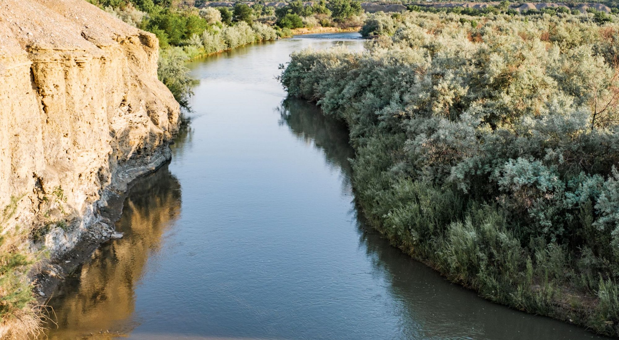
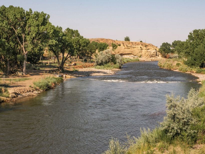
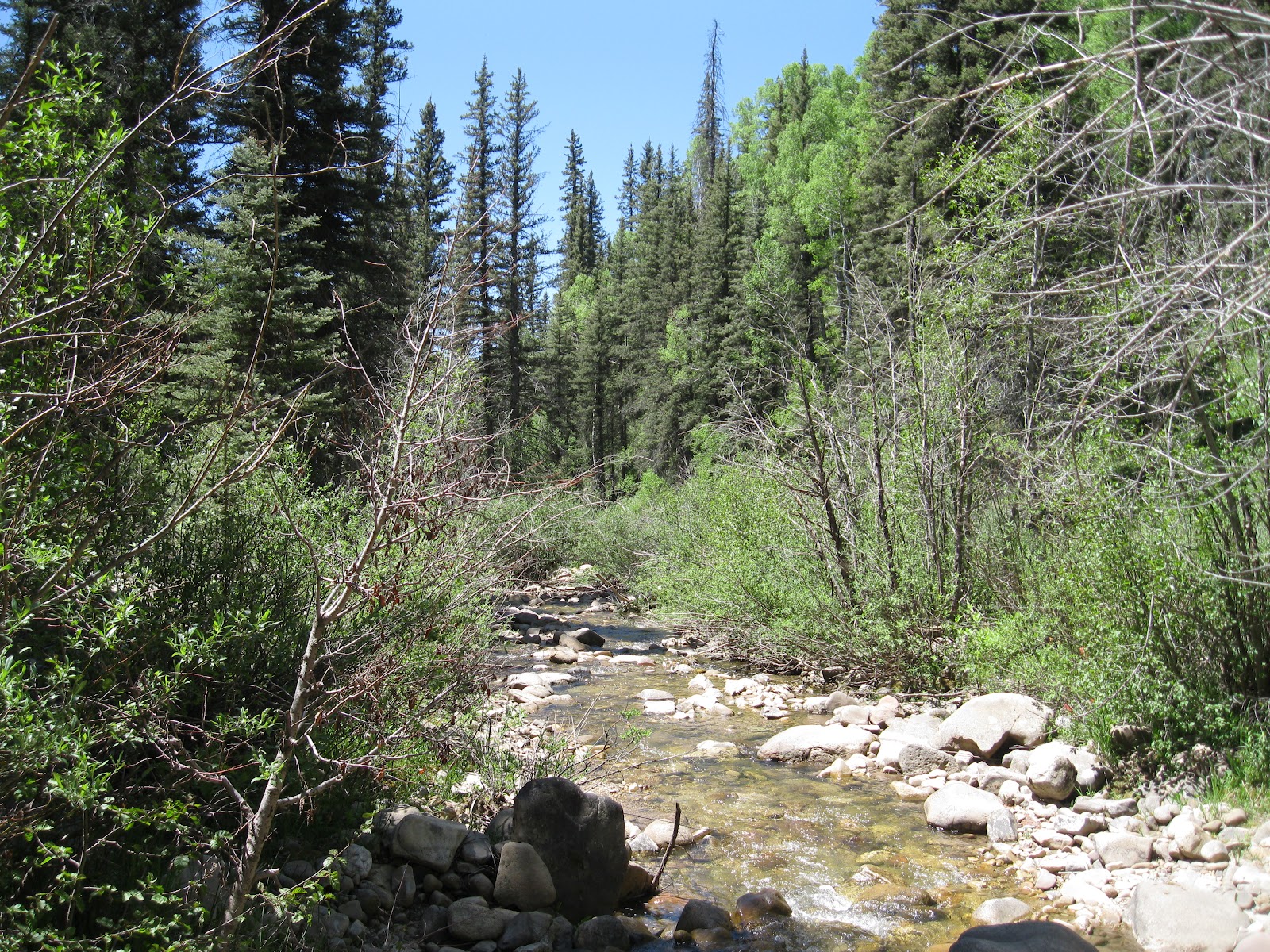


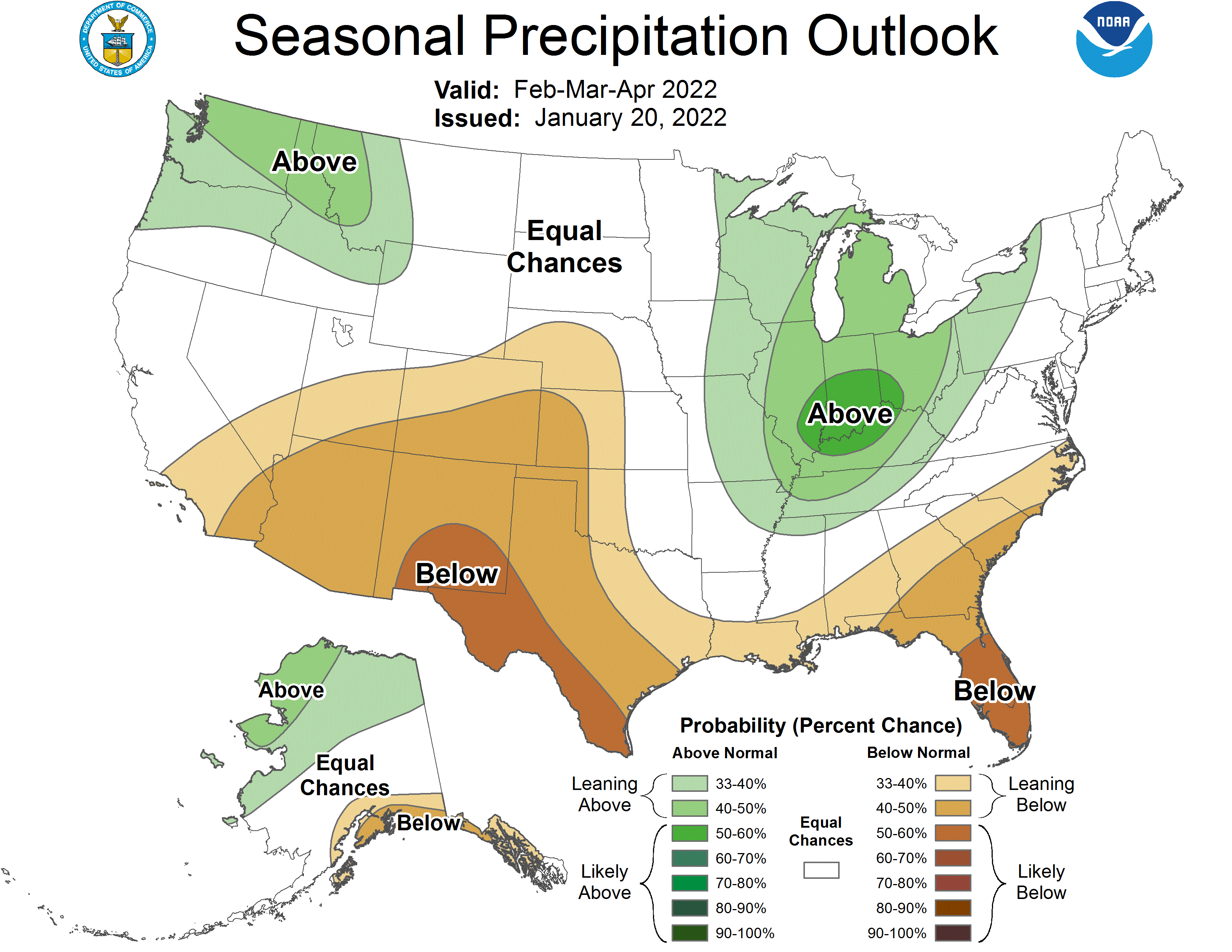
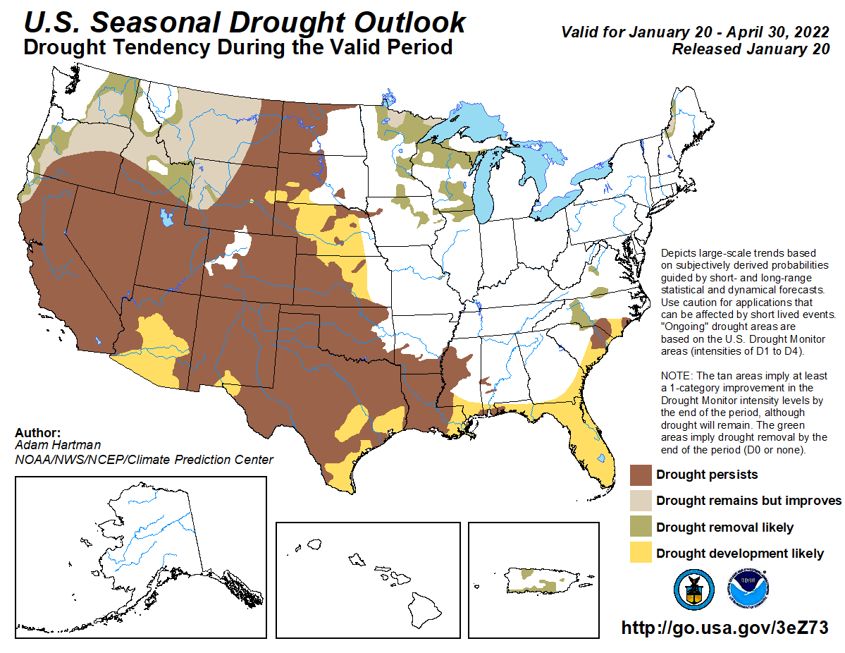


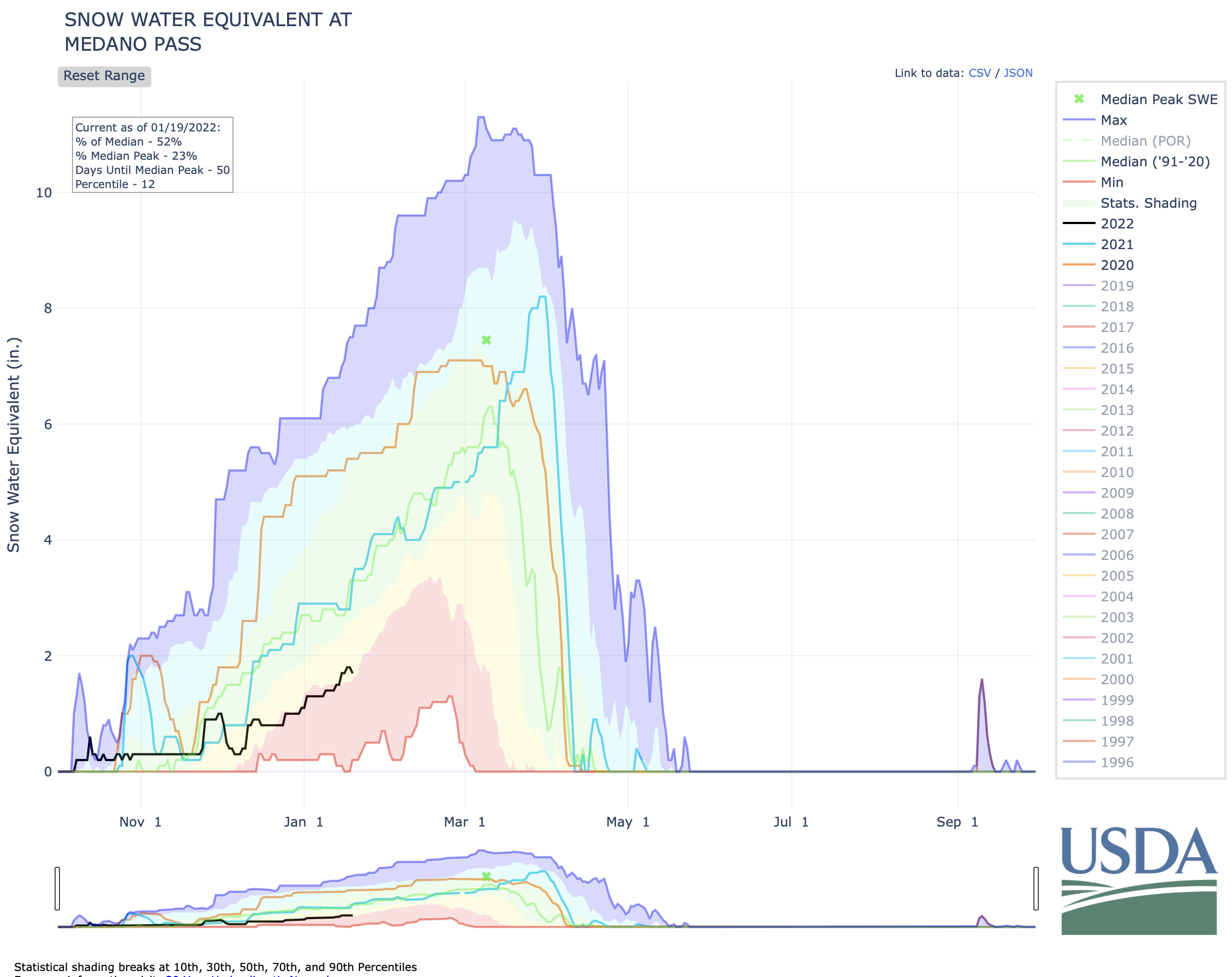


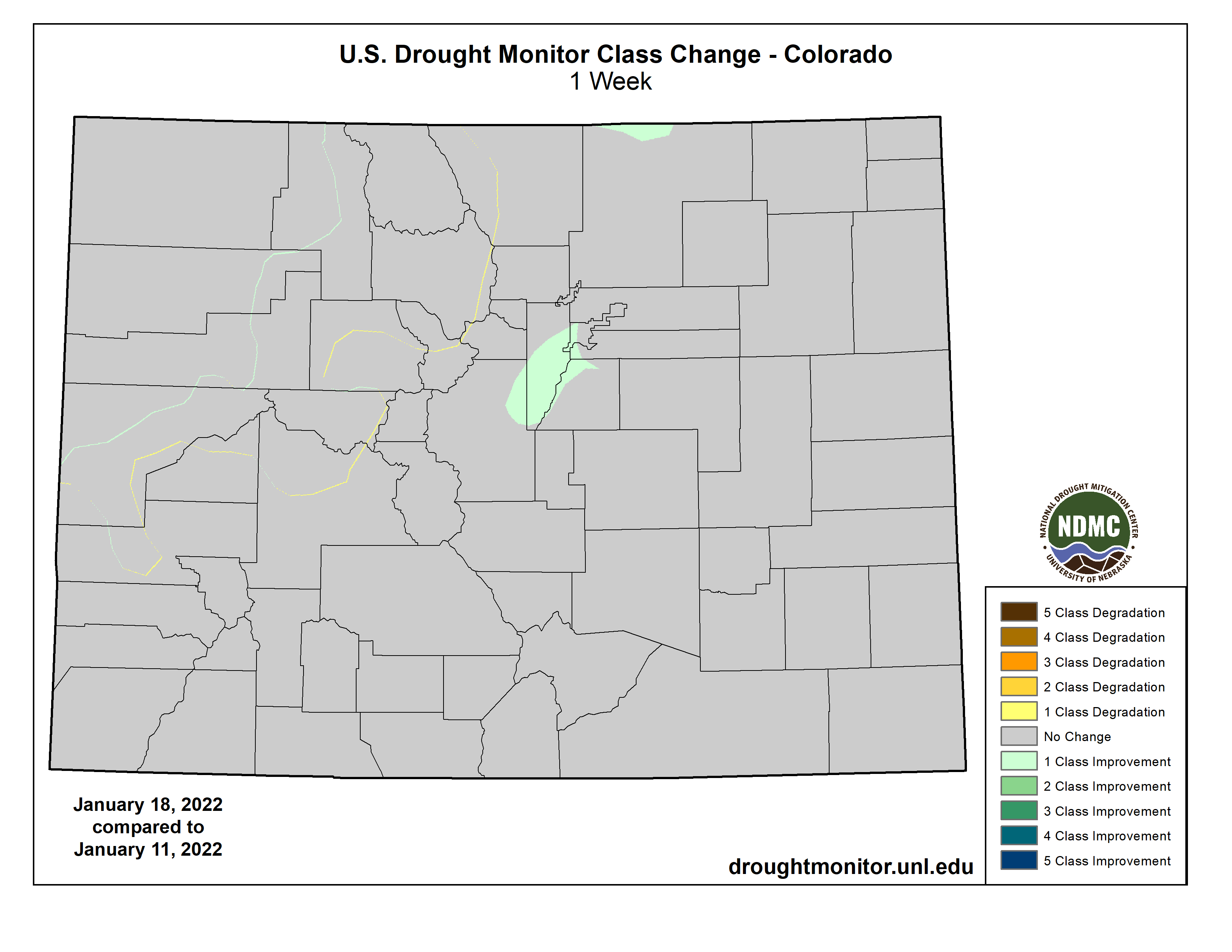
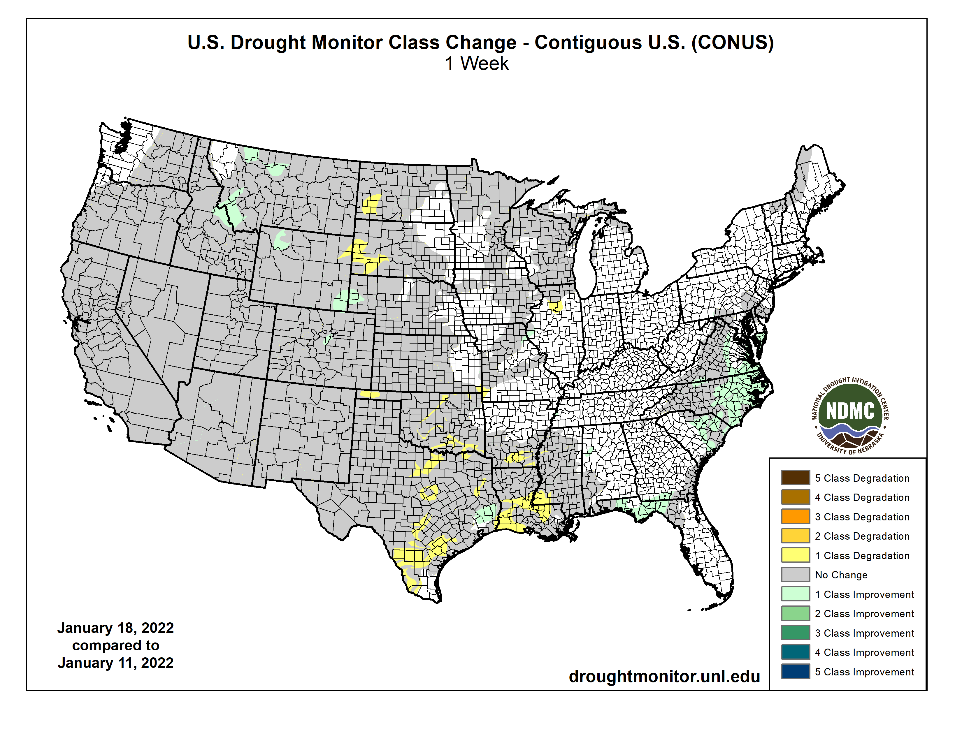
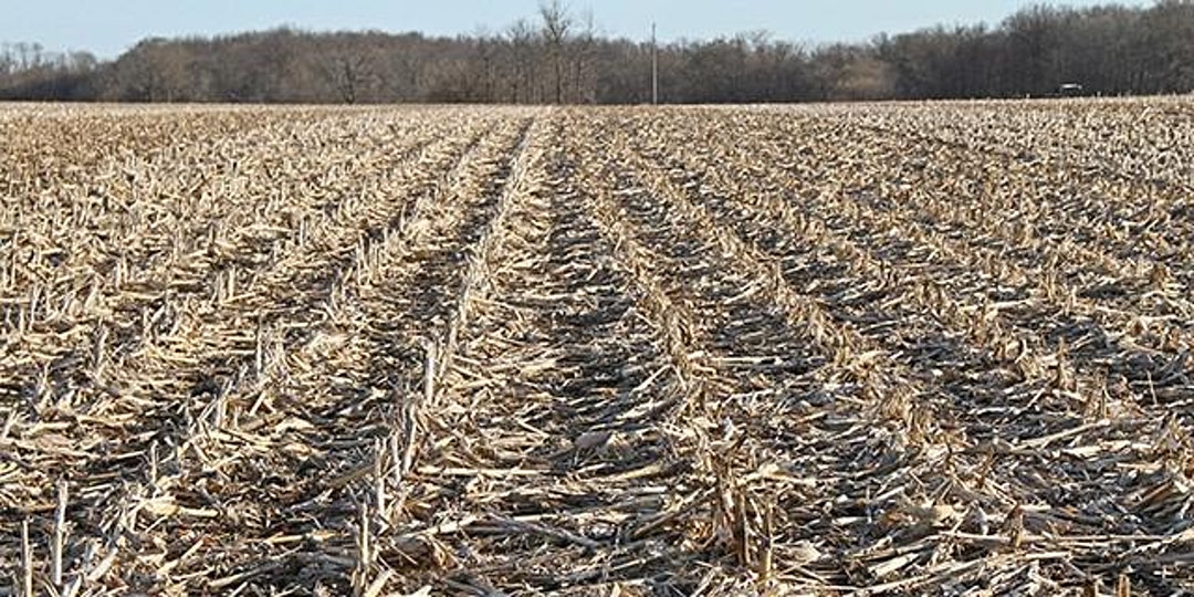

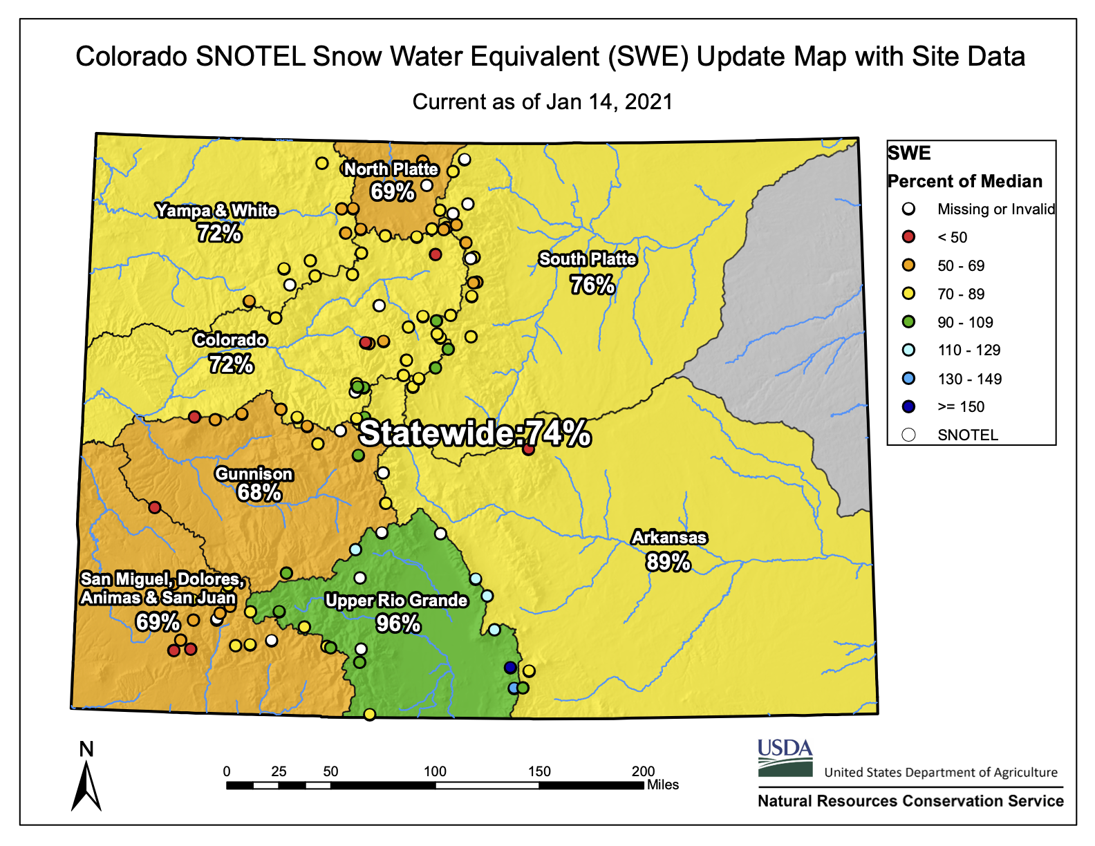
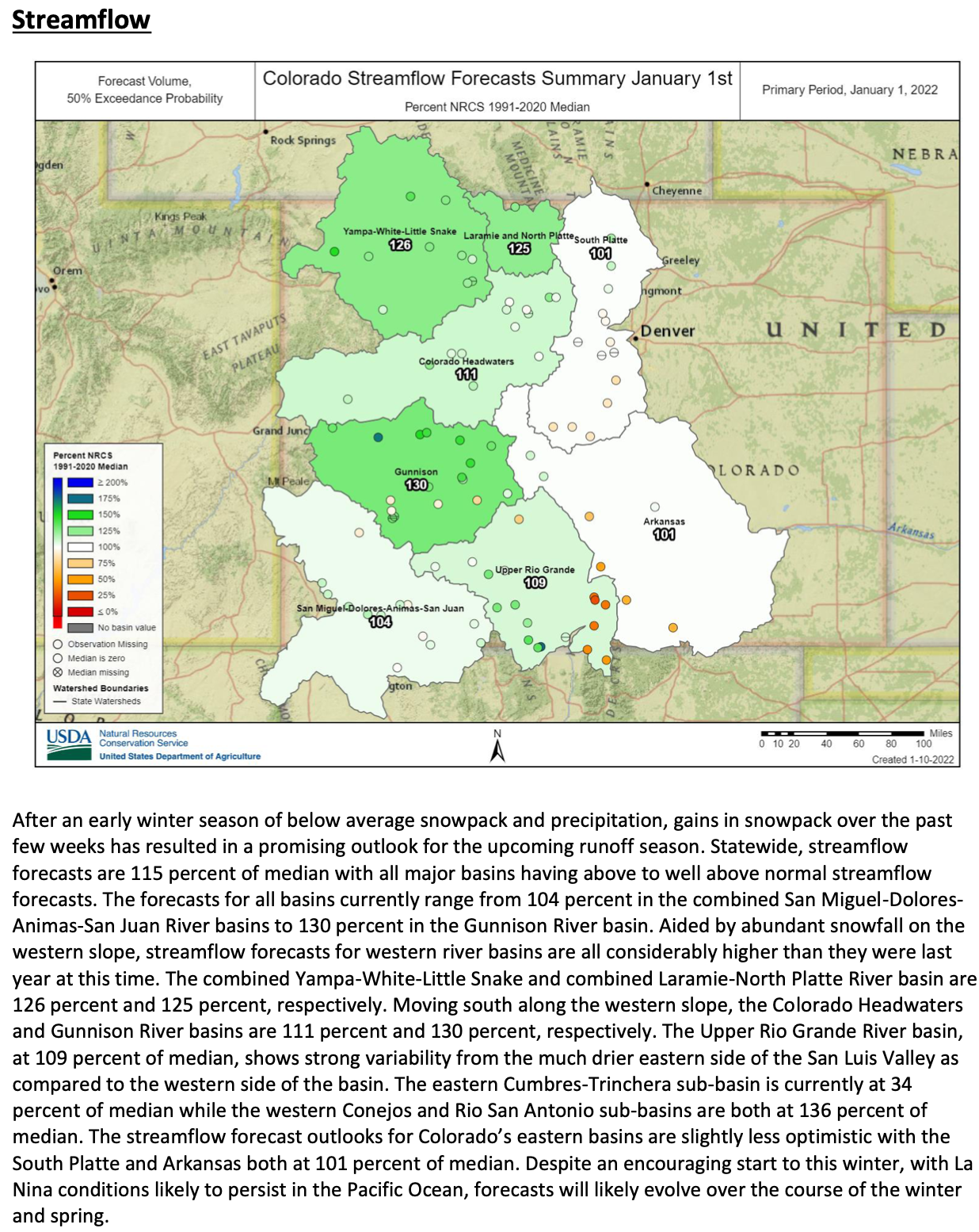
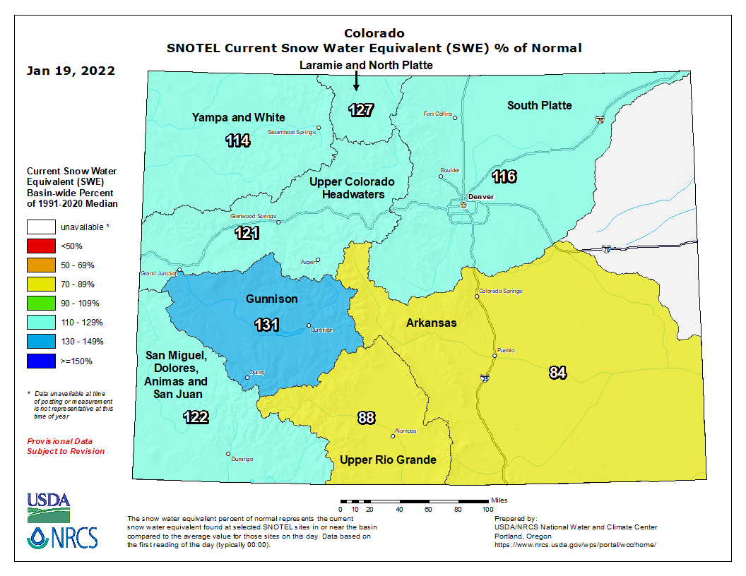
![Coyote Yosemite National Park. Yathin S Krishnappa [CC BY-SA 3.0 (https://creativecommons.org/licenses/by-sa/3.0)]](https://i0.wp.com/coyotegulch.blog/wp-content/uploads/2019/04/2009-coyote-yosemite-wikimedia.jpg?w=549&h=637&ssl=1 "2009-Coyote-Yosemite wikimedia")